I-70 Corridor Enhancement Plan
|
|
|
- Leonard Parrish
- 5 years ago
- Views:
Transcription
1 i - Table of Contents Table of Contents Chapter I Overview Chapter II Bridge and Roadway Improvements Chapter III Landscape Enhancements Chapter IV Riparian Corridors Chapter V Showcase Missouri Plan Chapter VI Community Partnership Opportunities Chapter VII Review and Implementation Process i

2 Overview The Missouri Department of Transportation (MoDOT) and the Federal Highway Administration (FHWA) are proposing to construct improvements to Interstate 70 between the metropolitan areas of Kansas City and St. Louis to meet the current and future transportation needs of this corridor. In compliance with the National Environmental Policy Act, a First Tier Environmental Impact Statement (EIS) was prepared to aid in determining the most appropriate type of improvement concept for I-70. The I-70 Study Corridor was approximately ten (10) miles (16.1 km) wide, five (5) miles (8.0 km) either side of existing I-70, and is 199 miles (320.3 km) in length. The First Tier EIS evaluated an initial seven strategies and this lead to the development of three reasonable strategies carried forward in the study. These were: widen and reconstruct the existing I-70; build a new parallel four-lane freeway; and, build a new four-lane parallel toll road. The Federal Highway Administration (FHWA) approved the selection of the Widen the Existing I-70 Strategy for the I-70 Corridor. (i.e., Preferred Strategy). In the Columbia area and the area of Warrenton, Wright City, and Wentzville, bypass options are a part of the selected strategy. MoDOT is carrying forward a series of second tier studies that were identified as part of the First Tier EIS evaluation process. These second tier studies are necessary to further study and define the improvements to I-70 such that more detailed analysis of the environmental impacts can be performed to more precisely evaluate the impacts of the project. The 199 mile long corridor has been divided into seven sections of independent utility (SIUs) with environmental documentation for each section. The environmental documents include: two environmental impact statements; four environmental assessments, and one categorical exclusion. The seven sections and the type of document being prepared are shown on Figure I-1. What is the Study Management Group and Corridor Enhancement Subcommittee Plan? The First Tier EIS provided guidance on the nature of the improvements and the potential significance of environmental resources and social impact issues potentially impacted by the Preferred Strategy. This guidance provided support for the determination of the appropriate type of second tier study for each SIU. The First Tier EIS further documented the commitments of MoDOT and the FHWA to provide corridor-wide impact coordination, impact mitigation and considerations of corridor enhancements. The document provided agencies and communities assurances, through the development of an enhancement master plan, that corridor-based considerations will be fulfilled and appropriate special considerations will be provided for each of the second tier studies. It is important to understand that "mitigation" is part of the NEPA process and should be thought of as an essential component of the alternatives and impact analysis. Mitigation is required because of a project s impacts. Mitigation consists of avoidance, minimization, and then compensation, once avoidance and minimization have been exhausted. "Enhancement" measures go beyond what is customarily provided as environmental mitigation. Often, enhancement measures include what could be considered to be non-traditional transportation related compensation. This I- 70 Corridor offers an opportunity for joint development and a range of enhancement measures. A Study Management Group, assembled for the First Tier EIS study, met nine times during that nearly two year time period. The team was comprised of the project team and representatives of federal, state, and local resource agencies. Through this team effort, it was recognized that rebuilding the existing I-70 Corridor infrastructure provided an opportunity to incorporate an overall corridor enhancement plan to increase the benefits of the transportation investments to the natural environment and the I-70 travelers. The joint development of the corridor through a collaboration and partnership of a number of federal, state, and local agencies would further enhance the investments of the parties through an aggregation of the investments' individual benefits. Combined and joint development of the corridor could promote the corridor as more than just a transportation link, but a vital part of the state s tourism and recreation resources. The Study Management Group (SMG) has continued for the second tier studies and is again comprised of the project team and local, state, and federal agency management staff. Its role is one of policy-level coordination of the overall corridor improvement program. The Corridor Enhancement Subcommittee, one of Figure I-1 - SIU Diagram 1
3 three subcommittees, is a consortium of the project team and local, state, and federal agency technical staff. This committee s role is to develop appropriate mitigation and an enhancement plan for the overall I-70 Corridor. The SMG and the three subcommittees for the second tier studies are shown on Figure I-2. The enhancement plan will be provided to and will be a reference document to be used by the second tier studies being developed for the seven SIUs. Appropriate enhancement opportunities will be taken from the overall corridor enhancement plan and incorporated into the environmental decision documents for the SIUs. Bicycle and Pedestrian Plan During the I-70 First Tier Draft Environmental Impact Statement (DEIS), pedestrian and bicycle concerns were considered as part of the documentation process. The desire for connectivity to the Figure I-2 - Study Management Group Diagram KATY Trail at the Overton Bottoms area via a new Missouri River Bridge was discussed in the DEIS. The DEIS also contains narratives relating to recreational trail improvements or linear parks as joint development opportunities. Chapter III of the DEIS further explores parkland adjacent to the study corridor, while Chapter IV reiterates the need for a Missouri River crossing for the KATY Trail and this time also discusses connectivity issues between trails and visitor/tourist areas. With respect to the Columbia area, the DEIS calls for connectivity with the City's "Parks, Recreation and Open Space Master Plan," enacted in The First Tier Final Environmental Impact Statement (FEIS) furthered the pedestrian and bicycle discussion by noting once again the Overton Bottoms/KATY Trail connectivity issue as well as recognizing that I-70 sometimes presents barriers to pedestrian and bicycle access. As a direct result of agency comments, specifically the Missouri Department of Natural Resources, the FEIS further directed the Second Tier efforts to address the cross-corridor needs of pedestrians and bicyclists. During the initial stages of the I-70 Second Tier Studies, stakeholders have continued to include non-motorized needs in the project discussions. The Study Management Group and the Corridor Enhancement and Mineola Hill Subcommittees have included such needs in their discussions of the project. A desire has been expressed by some to have a corridor-wide recreational pathway. A good portion of this system currently exists in the form of the KATY Trail. Other issues include the connectivity to the local bicycle/greenway networks in the urban areas and the extension of existing trails to the Kansas City and St. Louis urban cores. A suggestion which was presented during a Mineola Hill Subcommittee meeting was to provide bicycle access via Route 19, which could provide a connection between the KATY Trail and Hermann, which is a Missouri tourist destination, and the Graham Cave State Park. The recommendation of this plan is not to create a new 200-mile trail that runs within in the I-70 Corridor. The focus, instead, will be on providing connectivity to the KATY Trail and other local facilities where possible. There is also a desire to provide for a friendly localized environment for pedestrians and bicyclists by addressing issues related to I-70 as a physical barrier to northsouth movements. Currently the Katy Trail crosses I-70 under the Missouri River bridge near Rocheport and over the interstate near Boonville. This issue of north-south movements may also be addressed at some of the interchanges where new bridges would be built. There are also other areas where connectivity may be appropriate such as trail crossings, local parks, and special areas such as tourist spots and rest areas. Once those issues have been addressed it may be easier to fill the gaps which would provide added connectivity across the corridor. This does not mean providing a new bike lane within the I- 70 right of way. But, it could mean that opportunities are exam- 2

4 ined for shared-use facilities on outer roads or other non-limited access facilities (See Figure I-3). Coordination with other efforts going on around the state will also be important and will continue. The extension of the KATY Trail to Kansas City and St. Louis is an important objective in the Missouri Department of Natural Resources' 1998 KATY Trail State Park Conceptual Development Plan. The Mid-America Regional Council has also investigated the connection of the trail to Kansas City, as well as numerous other non-motorized transportation needs, in the January 2002 MetroGreen initiative and the Transportation Outlook 2030 plan, TrailNet, and its sister group Confluence Greenway, are heavily involved with nonmotorized transportation concerns in the eastern portion of the state. The East-West Gateway Coordinating Council identified a number of non-motorized transportation improvements in a 1994 Parks, Recreation and Open Space Master Plan. Rest Areas An I-70 Rest Area Study was prepared as part of the Second Tier studies, and provides details of the components and general design of proposed rest areas along Interstate 70. The visual appearance of these rest areas should reflect the same character of the corridor enhancement theme and design elements to ensure the architecture, shelters and overall design approach will complement the other I-70 corridor enhancements. What are the goals of the I-70 Corridor Enhancement Plan? The goals of the Enhancement Subcommittee Corridor Enhancement Plan are to create an enhancement concept for the corridor that: - Complements the existing natural environment. - Maintains a sensitivity to the existing context of the corridor. - Provides a sense of consistency along the entire corridor. - Showcases Missouri through enhancements which highlight Missouri history, cultural resources and economy. - Establishes baseline enhancements for the entire corridor and identifies opportunities for additional enhancements by local communities and other partnering agencies. Corridor-Wide Theme Corridor enhancements are based on establishing a common thread throughout the New I-70 Corridor, creating a visual theme and sense of consistency that is rooted in the context of today's 199-mile I-70. Aesthetic consistency is important to strengthen the corridor s sense of place and identity, while also promoting a high-quality image and impression of Missouri to visitors and residents using the corridor. Each overpass and interchange along the corridor will receive integrated enhancements that will visually connect them to each other while supporting the goals identified above. Figure I-3 - Bicycle and Pedestrian Trail Exhibit The design efforts associated with creating a corridor-wide theme should include a significant public involvement component to ensure local community issues and opportunities are identified, incorporated, and addressed. 3
. Several photos are included in this report for visual reference.")


5 Shaping the Vision for the New I-70 Through review, observation, and analysis of the existing corridor conditions, several existing features were identified as foundation elements on which to build a program for aesthetic enhancements (See Figures I-4 to I-10). Several photos are included in this report for visual reference. These features include: - Recurring natural rock outcrops. Pastoral landscapes and native vegetation. Views to extensive farm lands adjacent to the corridor. Naturalistic river and water crossings. Corridor aesthetic treatments and integrated enhancements should compliment the visual importance of these identified features. The program for enhancements should create a unique and recognizable visual theme that incorporates references to these and other key features found along the existing corridor. Figure I-4 - View of Existing Median Native Plantings Figure I-5 - View of Missouri River Bridge from Bluffs Figure I-6 - View of Typical River Crossing and Rock Outcrops Figure I-7 - View of Existing Rock Outcrops Figure I-8 - View of Existing Bluffs and I-70 Figure I-9 - View of Existing Billboards Program for Aesthetic Enhancements The wider cross-section of the New I-70 Corridor will provide a more open feeling, creating a rural visual character due to the large median and sense of separation between the eastbound and westbound lanes. The enhancements seek to visually blend the I-70 improvements into the existing landscape while introducing design treatments to built elements that reduce their sense of scale. The aesthetic program for the corridor will include integrated treatments as baseline enhancements to the following roadway features: - Bridge abutments and piers. Roadway and bridge barriers. Retaining walls. Railings and fencing. Pedestrian walkways and trail connections. Highway signage and lighting. Landscape plantings. The program also anticipates local community interest in pursuing opportunities for additional corridor enhancements beyond those included in the baseline. These are provided and discussed in the Community Partnership Opportunities section of this report. 4

6 Figure I-10 - Existing Aesthetic Conditions 5


7 Enhancement Design Process The corridor enhancements identified provide initial indications of the types of enhancements that are being considered for use throughout the corridor. These enhancement ideas are preliminary in nature, and are intended to identify a general design direction as well as to establish a set of aesthetic goals for improving the New I-70 Corridor. A comprehensive set of corridor enhancement design guidelines will be necessary to further explore and refine the ideas and design concepts identified in this study. These future guidelines will explore in more detail the issues and opportunities throughout the corridor. Specific and unique conditions for areas along the corridor will be identified and addressed in these guidelines. The design efforts associated with creating these guidelines should include a significant public involvement component to ensure issues and opportunities are identified, incorporated, and addressed. These design guidelines should be prepared in conjunction with and incorporated into the design development for the roadway and bridge improvements. Contextual Design Influences The I-70 Corridor provides views to many aspects of Missouri s history as well as it s future - from pristine natural settings and rolling rural farmlands to vibrant urban settings. In reviewing existing aesthetic conditions along the corridor, the aesthetic design team took note of significant features and re-occurring images along the corridor that could influence the aesthetic enhancement design. Several images representing the visual characteristics of the corridor are provided below. Agricultural elements such as fields of corn and other crops, grain silos, farming equipment, and hay bales are prevalent. Geological elements such as rock outcroppings and stratifications, as well as topographical elements such as rolling hills, are also evident within the corridor. The proposed overall design theme for enhancements should compliment the visual context of the corridor. Subtle visual references to this imagery should guide the design of the overall enhancement theme. Specific design guidelines will further refine this theme and the application of these initial concepts to compliment each area throughout the I-70 corridor. Preliminary Aesthetic Enhancement Concept Enhancements are proposed to be systematically applied throughout the entire corridor to create a strong sense of identity and visual consistency. Consistent application of the proposed enhancement elements provides aesthetic benefits to the travelling public through creation of an attractive and recognizable image for the New I-70 Corridor. This approach will also provide economic benefits through consistent treatments and features that can be replicated cost-effectively throughout the corridor. I-70 is to be widened using two different design cross-sections - a wider rural section and a narrower urban section. The differences between these design sections are based on existing conditions in urban areas that create practical difficulties in applying the wider section consistently throughout the corridor. Highway bypass relocation alternatives are still being considered for use in some urban areas. In these instances, the existing I-70 corridor will be enhanced utilizing the urban design elements while the bypass relocation highway improvements will be enhanced utilizing rural design elements as outlined in this plan. Existing conditions in most of these urban areas typically include additional bridge features and roadway elements that address public safety needs such as street lighting, pedestrian sidewalks or trails, and protective pedestrian/bicycle railings. Due to the width of the corridor in urban areas, retaining walls are also anticipated. Due to these conditions, the sense of scale and appearance of these areas will be slightly different (refer to Figure I-11). 6


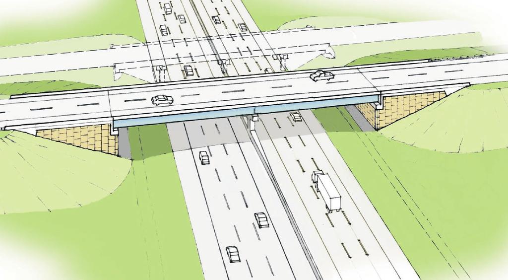
8 Figure I-11 - Corridor Aesthetic Enhancement Diagram 7
Corridor Enhancements
 Corridor Enhancements Safety is MoDOT s first priority in widening and rebuilding I-70 across the state of Missouri. MoDOT also understands that the interstate - and its interchanges and overpasses - are
ELK GROVE GENERAL PLAN VISION
 2-1 CHAPTER 2: 2-2 CREATING OUR The Community Vision for Elk Grove, expressed through a Vision Statement and a series of Supporting Principles, is a declaration of the kind of community that Elk Grove
DOMINION BOULEVARD CORRIDOR STUDY AND ECONOMIC DEVELOPMENT STRATEGIC PLAN A MODEL FOR CHESAPEAKE S FUTURE
 DOMINION BOULEVARD CORRIDOR STUDY AND ECONOMIC DEVELOPMENT STRATEGIC PLAN A MODEL FOR CHESAPEAKE S FUTURE Overview I. Draft Plan Process II. Draft Plan Overview a. Market Analysis b. Master Land Use Plan
V. Vision and Guiding Principles
 V. Vision and Guiding Principles The Master Plan for the Powers Ferry Corridor seeks a foundation in the desires of the community. At times, various elements of the community offered opposing viewpoints,
Atlanta BeltLine Corridor Environmental Study. Scoping Meeting August 2008
 Atlanta BeltLine Corridor Environmental Study Scoping Meeting August 2008 What Will We Be Discussing Today? Study Overview - How Did We Get Here? - What Is the Study About? - Who Is Involved? - Where Is
Potential Green Infrastructure Strategies May 6, 2015 Workshop
 Potential Green Infrastructure Strategies May 6, 2015 Workshop Background The City of Cortland is developing the Tioughnioga Urban Headwaters Green Infrastructure Action Plan with funding from the National
WELCOME! 8 8:30 6: TH STREET IMPROVEMENTS. Open House. Presentation & Q&A
 WELCOME! 168 TH STREET IMPROVEMENTS 6:30 Open House 7 8 Presentation & Q&A 8 8:30 Open House WELCOME Todd Pfitzer City of Omaha Engineer Bob Stubbe City of Omaha Public Works Director Jon Meyer Project
Hockessin Community Redevelopment Plan
 Hockessin Community Redevelopment Plan 3.1 Introduction The Community Redevelopment Plan for the Village of Hockessin is the result of the people s vision for a distinct village center that serves as the
Report to: Development Services Committee Report Date: April 24, 2017
 SUBJECT: Cornell Rouge National Urban Park Gateway - Report on Design Charrette and Next Steps PREPARED BY: Lilli Duoba, MES, MCIP, RPP, Manager, Natural Heritage (ext. 7925) REVIEWED BY: Marg Wouters,
FDOT D4 Complete Streets
 FDOT D4 Complete Streets Context Sensitive Solutions Directs that complete street solutions will complement the context of the community. Collaborative approach to decision making, project development,
NORTH-SOUTH CORRIDOR STUDY EXECUTIVE SUMMARY. Executive Summary
 Executive Summary Background As congestion continues to affect mobility in the region, the Ozarks Transportation Organization (OTO) is particularly concerned with traffic movement. The North-South Corridor
CHAPTER 1. Ms. Guajardo s Class - Central Elementary CH 1 1
 INTRODUCTION CHAPTER 1 Ms. Guajardo s Class - Central Elementary CH 1 1 1.1 SETTING South Centre City is a linear corridor south of Downtown Escondido paralleling Centre City Parkway and South Escondido
The transportation system in a community is an
 7 TRANSPORTATION The transportation system in a community is an important factor contributing to the quality of life of the residents. Without a sound transportation system to bring both goods and patrons
DRAFT Subject to Modifications
 TREASURE COAST REGIONAL PLANNING COUNCIL M E M O R A N D U M To: Council Members AGENDA ITEM 8 From: Date: Subject: Staff May 19, 2017 Council Meeting Florida Department of Transportation Complete Streets
ARLINGTON COUNTY, VIRGINIA. County Board Agenda Item Meeting of January 28, 2017 SUPPLEMENTAL REPORT
 ARLINGTON COUNTY, VIRGINIA County Board Agenda Item Meeting of January 28, 2017 SUPPLEMENTAL REPORT DATE: January 26, 2017 SUBJECT: The Virginia Department of Transportation s Transform I-66 Inside the
Corridor Vision. 1Pursue Minnehaha-Hiawatha Community Works Project. Mission of Hennepin County Community Works Program
 1Pursue Minnehaha-Hiawatha Community Works Project Minnehaha-Hiawatha Community Works is a project within the Hennepin Community Works (HCW) program. The mission of the HCW program is to enhance how the
10.0 Open Space and Public Realm
 10.0 Open Space and Public Realm 10.0 Open Space and Public Realm The Public Open Space System is comprised of: outdoor spaces available for public use that are either publicly owned (e.g., parks and
ARLINGTON COUNTY, VIRGINIA. County Board Agenda Item Meeting of January 28, 2017 SUPPLEMENTAL REPORT-2
 ARLINGTON COUNTY, VIRGINIA County Board Agenda Item Meeting of January 28, 2017 SUPPLEMENTAL REPORT-2 DATE: January 27, 2017 SUBJECT: The Virginia Department of Transportation s Transform I-66 Inside the
Southern Gateway Project and Public Green
 Southern Gateway Project and Public Green Transportation and Trinity River Project Committee May 23, 2016 Purpose of Presentation Provide the history and an overview of the Southern Gateway Project (SGP)
Route 1 Corridor Study
 Route 1 Corridor Study Westbrook, Connecticut A Vision for the Connecticut Shoreline Public Informational Meeting July 28, 2015 Lower Connecticut River Valley Council of Governments Fitzgerald & Halliday,
CHAPTER 7: VISION AND ACTION STATEMENTS. Noble 2025 Vision Statement
 CHAPTER 7: VISION AND ACTION STATEMENTS This chapter presents the vision, policy and action statements that transform the comprehensive planning study, an analysis of Noble s past, future trends and community
Town of Cobourg Heritage Master Plan. Statutory Public Meeting
 Town of Cobourg Heritage Master Plan Statutory Public Meeting April 25 th 2016 Presentation Overview 1. Introduction 2. Project background and schedule overview 3. Review of strategic direction content
Community Sensitive Design: (Context Sensitive Design)
") What is? Community Sensitive Design: (Context Sensitive Design) The process by which urban design, land-use planning and aesthetic enhancements are applied to a project to make it an integral part of the
What is? Community Sensitive Design: (Context Sensitive Design) The process by which urban design, land-use planning and aesthetic enhancements are applied to a project to make it an integral part of the
The Palisades Interstate Parkway and Henry Hudson Drive designated a New Jersey State Scenic Byway, 2005
 The Palisades Interstate Parkway and Henry Hudson Drive designated a New Jersey State Scenic Byway, 2005 What are scenic byways? How Did Scenic Byways Come About? National Scenic Byways Program Administered
HILLSBOROUGH COUNTY Greenways and Trails Plan Update. Executive Summary. Date
 HILLSBOROUGH COUNTY Greenways and Trails Plan Update Executive Summary Date PURPOSE AND PROJECT OVERVIEW The Hillsborough County Greenways Master Plan (1995) and the City of Tampa s Greenways and Trails
SH 199 Corridor Master Plan. Community Meeting No. 2 May 31, 2017
 Community Meeting No. 2 May 31, 2017 Transportation Projects On or Near SH 199 SH 199 from 0.3 miles south of FM 1886 to south end of Lake Worth bridge Construct freeway mainlanes and frontage roads 10-Year
Public input has been an important part of the plan development process.
 Lakewood s Comprehensive Plan recognizes that transportation helps shape the community, and that the way the community provides for the safe and efficient movement of people affects the character of the
PROJECT BACKGROUND. Preliminary Design Scope and Tasks
 PROJECT BACKGROUND Preliminary Design Scope and Tasks The purpose of this Study is the development of preliminary designs for intersection improvements for Trunk Highway (TH) 36 at the intersections of
Comprehensive Plan ADOPTED APRIL 2014
 Comprehensive Plan ADOPTED APRIL 2014 8 8. Outstanding Recreational & Cultural Opportunities We are proud of our community s parks and recreation system. Our community will ensure that the legacy of our
Scope of Services. River Oaks Boulevard (SH 183) Corridor Master Plan
 Corridor Master Plan") Scope of Services River Oaks Boulevard (SH 183) Corridor Master Plan PROJECT AREA The project area consists of the River Oaks Boulevard (SH 183) corridor bounded by SH 199 at the northern end and the Trinity
Scope of Services River Oaks Boulevard (SH 183) Corridor Master Plan PROJECT AREA The project area consists of the River Oaks Boulevard (SH 183) corridor bounded by SH 199 at the northern end and the Trinity
Executive Summary. NY 7 / NY 2 Corridor
 Executive Summary NY 7 / NY 2 Corridor Transportation and Land Use Study December 2005 Prepared for: Town of Colonie Capital District Transportation Committee Prepared by: Introduction: Land use decisions
CHAPTER 8 ISSUES, CONCERNS, CONSTRAINTS AND OPPORTUNITIES
 CHAPTER 8 ISSUES, CONCERNS, CONSTRAINTS AND OPPORTUNITIES Introduction This River Conservation Plan was developed during a time of tremendous activity and effort in planning the transformation of the Delaware
State Highway 121 Southwest Parkway. Fort Worth s Transportation Success Story in Design and Cooperation
 State Highway 121 Southwest Parkway Fort Worth s Transportation Success Story in Design and Cooperation Greater Fort Worth Association of Realtors October 24, 2007 Presented by: Dan Lamers, P.E. North
Mississippi Skyway Preliminary Engineering Report
 EXECUTIVE SUMMARY Mississippi Skyway Preliminary Engineering Report CITY OF RAMSEY, MINNESOTA DECEMBER 2014 City of RAMSEY EXECUTIVE SUMMARY Project Need and Intent The Mississippi Skyway pedestrian bridge
THEMES, VISION, + PRINCIPLES
 CHAPTER 2: THEMES, VISION, + PRINCIPLES This page intentionally left blank. 20 VISION DRAFT AUGUST 2018 2 2 THEMES, VISION, + GUIDING PRINCIPLES The Key Themes, Vision, and Guiding Principles presented
Parks, Trails, and Open space Element
 Parks, Trails, and Open space Element Parks, Trails, and Open Space element Parks, Recreation, and Open Space are important components of the quality of life desired by the residents of Elk Grove. This
The Illinois Department of Transportation and Lake County Division of Transportation. Route 173, including the Millburn Bypass
 The Illinois Department of Transportation and Lake County Division of Transportation welcome you to this Public Hearing for U.S. Route 45 from Illinois Route 132 to Illinois Route 173, including the Millburn
DRAFT SECTION 4(f) EVALUATION INTERSTATE 73 FEIS: I-95 to I-73/I-74 in North Carolina
 EVALUATION INTERSTATE 73 FEIS: I-95 to I-73/I-74 in North Carolina") DRAFT SECTION 4(f) EVALUATION INTERSTATE 73 FEIS: I-95 to I-73/I-74 in North Carolina 1.0 INTRODUCTION Section 4(f) of the Department of Transportation Act of 1966, 49 U.S.C. 303, requires that prior to
DRAFT SECTION 4(f) EVALUATION INTERSTATE 73 FEIS: I-95 to I-73/I-74 in North Carolina 1.0 INTRODUCTION Section 4(f) of the Department of Transportation Act of 1966, 49 U.S.C. 303, requires that prior to
CHAPTER 1 Introduction
 CHAPTER 1 Introduction From sea to summit, Lane County covers almost 4,800 square miles of diverse Oregon landscape. Stretching from the Pacific Ocean through the Coastal Range, the Willamette Valley to
Community Open House March 26 th, 2018
 Community Open House March 26 th, 2018 Open House Agenda 1. Overview of Planning Process What we heard 2. Future Land Use Policy 3. Priority Growth Areas 4. Plan Elements Making it happen What is a Comprehensive
July 12, Columbus City Council City Hall 90 West Broad Street Columbus, OH RE: I-70/71 Columbus Crossroads Project
 OHIO DEPARTMENT OF TRANSPORTATION DISTRICT 6 400 EAST WILLIAM STREET DELAWARE, OHIO 43015 800.372.7714 Columbus City Council City Hall 90 West Broad Street Columbus, OH 43215-9015 RE: I-70/71 Columbus
REGIONAL ACTIVITY CENTER
 DRAFT REGIONAL ACTIVITY CENTER 70 EAST BENCH MASTER PLAN DRAFT 06 Introduction The East Bench Regional Activity center is comprised of large educational, research, medical, and employment centers. These
Honorable Members of the Mobility Solutions, Infrastructure and Sustainability Committee
 Memorandum DATE January 23, 2019 CITY OF DALLAS TO Honorable Members of the Mobility Solutions, Infrastructure and Sustainability Committee SUBJECT I-30 East Project Update On Monday, January 28, 2019,
This Review Is Divided Into Two Phases:
 Semiahmoo Town Centre Review The purpose of this review: To review the Semiahmoo Town Centre Concept Plan, originally approved in 1993, to ensure that this centre will continue to serve the needs of South
Midtown Greenway Land Use and Development Plan Executive Summary
 Midtown Greenway Land Use and Development Plan Executive Summary Introduction The Midtown Greenway Land Use and Development Plan sets policy direction for land use and development in the Midtown Greenway
APPENDIX D: Visual and Aesthetic Conditions for NCCU Station Refinement. Durham-Orange Light Rail Transit Project
 APPENDIX D: Visual and Aesthetic Conditions for NCCU Station Refinement Durham-Orange Light Rail Transit Project October 2016 1. Introduction The Combined FEIS/ROD summarizes the effects of the D-O LRT
1.0 INTRODUCTION 1.1 TH 14 WEST STUDY AREA Project Description Functional Classification Purpose of the Project
 1.0 INTRODUCTION 1.1 TH 14 WEST STUDY AREA 1.1.1 Project Description The Trunk Highway (TH) 14 West Corridor is a two-lane roadway approximately 22 miles in length. Located in Nicollet County, the corridor
Office of Greenways & Trails Providing Statewide Leadership and Coordination. Southeast Greenways and Trails Summit October 1-3, 2017
 Office of Greenways & Trails Providing Statewide Leadership and Coordination Southeast Greenways and Trails Summit October 1-3, 2017 1 Office of Greenways and Trails The Office of Greenways and Trails
PSRC REVIEW REPORT & CERTIFICATION RECOMMENDATION
 PSRC REVIEW REPORT & CERTIFICATION RECOMMENDATION KITSAP COUNTY COUNTYWIDE PLANNING POLICIES July 2, 2012 BACKGROUND A major emphasis of the Washington State Growth Management Act (GMA) is the need to
Transportation Improvements
 Transportation Improvements 0 0 Volume II of the Final EIS for the DHS Headquarters consolidation at St. Elizabeths includes analysis to transportation improvements for the DHS Headquarters Consolidation
Preliminary Plan Framework: Vision and Goals
 Preliminary Plan Framework: Vision and Goals Draft: May 2015 Introduction Since the Town of Milliken s comprehensive plan was last updated in 2010, the community was heavily impacted by the 2013 flood,
Great Rivers Greenway CLEAN GREEN CONNEC TED T RAILS
 Great Rivers CLEAN GREEN CONNEC TED T RAILS Great Rivers (GRG) was established in 2000 to create a clean, green, connected St. Louis region. Today, many new and exciting projects demonstrate the social,
Small Area Plan. South Gateway
 Small Area Plan Adopted May 12, 2008 South Gateway Purpose. The South Gateway Small Area Plan defines the City s expectations for the future of the southern entrance to the City at Interstate 85 and Highway
RECREATION, OPEN SPACE AND GREENWAYS ELEMENT GOALS, OBJECTIVES, AND POLICIES
 RECREATION, OPEN SPACE AND GREENWAYS ELEMENT GOALS, OBJECTIVES, AND POLICIES GOAL R-1: DEVELOP A RECREATION, OPEN SPACE AND GREENWAYS SYSTEM AS AN INTEGRAL COMPONENT OF AN OVERALL, COUNTY-WIDE ECONOMIC
Chapter 5: Recreation
 Chapter 5: Recreation Introduction and Setting Recreational opportunities within Nevada County are varied, ranging from public parks with intensively used active recreational facilities, to vast tracts
CHAPTER FIVE COMMUNITY DESIGN
 CHAPTER FIVE COMMUNITY DESIGN CHAPTER FIVE - COMMUNITY DESIGN Assumptions Frazier Park and Lebec have historically developed according to different patterns of spatial form. While both communities are
4- PA - LD - LIVELY DOWNTOWN. LD - Background
 4- PA - LD - LIVELY DOWNTOWN LD - Background The downtown has been the service centre for the community since the city s inception and the area continues to supply people with their personal services,
SECTION ONE North East Industrial Zone Design Guide Palmerston North City Council June 2004
 SECTION ONE North East Industrial Zone Design Guide Palmerston North City Council June 2004 young heart easy living 1 Preface Industrial areas are a very important component of the economic well-being
Northwest Rail Corridor and US 36 BRT Development Oriented Transit Analysis 4.4 STATION AREA FINDINGS
 4.4 STATION AREA FINDINGS Each station is different, and each one requires a separate set of recommendations based on the vision for the site. This section outlines an initial TOD strategy and recommendations
38 Queen s University Campus Master Plan Part 1
 38 Queen s University Campus Master Plan Part 1 46 The Campus at the City Scale Chapter 4 The Campus at the City Scale 39 Queen s is an urban University centrally located in Kingston. Decisions made by
CHAPTER 3 VISION, GOALS, & PLANNING PRINCIPLES. City of Greensburg Comprehensive Plan. Introduction. Vision Statement. Growth Management Goals.
 CHAPTER 3 VISION, GOALS, & PLANNING PRINCIPLES Introduction The Greensburg Comprehensive Plan is intended as a working community document. A combination of long and short-term goals, this document is intended
Parks, Trails, and Open Space Element
 P arks, Recreation, and Open Space are important components of the quality of life desired by the residents of Elk Grove. This Element of the General Plan addresses the City s goals, policies, and actions
Urban Design 9Identity
 Urban Design 9Identity URBAN DESIGN IDENTITY Urban design is about connecting people to their places through the built environment, nature, and overall urban form. Done well, it creates a memorable space
Phase 1 : Understanding the Campus Context. Phase 2 : APPROACHES - Alternates & Preferred Plan
 Introduction MASTER PLAN PURPOSE WHY A CAMPUS MASTER PLAN? The purpose of the Master Plan at the University of Illinois at Chicago is to translate UIC s strategic goals and objectives into a compelling
Sherri Ferguson. President/CEO Portland Chamber of Commerce. Tennessee Certified Economic Developer Capstone Project
 Sherri Ferguson President/CEO Portland Chamber of Commerce Tennessee Certified Economic Developer Capstone Project Strategic Plan Development for the North Gateway of Portland, Tennessee The New Gateway
Beckett Bridge PD& E Study. Presentation to: Board of County Commissioners
 Beckett Bridge PD& E Study Presentation to: Board of County Commissioners October 22, 2013 Introduction Study Began January 2012 Alternatives Presented to Commission October 2013 Alternatives Presented
Mendota-Lebanon Hills Greenway Master Plan Executive Summary. August draft for more information visit
 Mendota-Lebanon Hills Greenway Master Plan Executive Summary August 2013 draft for more information visit www.hkgi.com/projects/dakota INTRODUCTION The Mendota-Lebanon Hills Greenway Master Plan portrays
HE VISION. Building a Better Connected Place
 HE VISION Building a Better Connected Place WALK INTO THE FUTURE. Life in Cranberry, 2030 Here s what our residents told us they wanted to see in their community by 2030: The Cranberry of 2030 is a place
3.0 master plan concept
 3.0 master plan concept 3.1 introduction The purpose of the Huron Church Road Master Plan Concept is to provide an overview of the Master Plan design process, identify preliminary streetscape installations
SAN RAFAEL GENERAL PLAN 2040 INTRODUCTION AND OVERVIEW
 SAN RAFAEL GENERAL PLAN 2040 INTRODUCTION AND OVERVIEW Steering Committee Presentation February 14, 2018 Purpose of General Plan Guide land use and development decisions Coordinate transportation, infrastructure,
This page left intentionally blank.
 July 2012 This page left intentionally blank. Table of Contents Appendix A : Project Development Checklist Appendix B: At-Grade Rail Crossings Appendix C: Maintenance and Operations Examples Appendix D:
Chapter 2: Vision, Goals and Strategies
 Chapter 2: Vision, Goals and Lake Elmo Today & Tomorrow Comprehensive Plan 2040 2 VISION, GOALS & STRATEGIES - DRAFT 4-6-2018 INTRODUCTION Comprehensive Plan Purpose Perhapse the most important objective
Mendota Heights 2040 Comprehensive Plan Draft Vers
 4 Parks and Trails The City of Mendota Heights boasts a variety of recreational and open space opportunities. Few cities can claim access to regional trails, riverside and lakeside parks, scenic bluffs
Ivywild On The Creek PRELIMINARY CREEK DISTRICT MASTER PLAN
 Ivywild On The Creek PRELIMINARY CREEK DISTRICT MASTER PLAN Introduction: Rejuvenating an extraordinary Creekside neighborhood THE CREEKSIDE DISTRICT The Ivywild On The Creek Neighborhood District Master
DRAFT MAJOR CORRIDORS 48 EAST BENCH MASTER PLAN
 DRAFT MAJOR CORRIDORS 48 EAST BENCH MASTER PLAN DRAFT 05 Introduction Foothill Drive, Parley s Way, Sunnyside Avenue and 1300 East serve as thoroughfares into the City and are important pieces in the regional
Dyersville Downtown Plan. Open House October 24, 2017
 Dyersville Downtown Plan Open House October 24, 2017 What is a Comprehensive Plan? - Vision - Guidance for decisions - Basis for regulations What is a Downtown Plan? - Understand priorities - Identify
DRAFT Civic Center Station Area Plan. Executive Summary
 DRAFT Civic Center Station Area Plan Executive Summary This project is funded in part through the Metropolitan Transportation Commission s Station Area Planning Program. The preparation of this report
STREETSCAPE MANUAL ONLINE TRAINING SESSION 1: Background
 TRAINING SESSION 1: The Urban Design Streetscape Manual is a reference tool developed to help implement City policy and guide the design, construction and maintenance of streetscape improvements in Toronto.
EXECUTIVE SUMMARY DRAFT CHAPTER 1 INTRODUCTION EXECUTIVE SUMMARY
 CHAPTER 1 EXECUTIVE SUMMARY INTRODUCTION Through the joint efforts of the City of Tulsa planning staff and the Land Services division of Indian Nations Council of Governments (INCOG), the Berryhill Land
HOLLERING PLACE MASER PLAN Concept for Development
 HOLLERING PLACE MASER PLAN Concept for Development Current Status of the Historic Hollering Place Development Project The city did not receive a responsive proposal for the Historic Hollering Place Development
BROOKHILL NEIGHBORHOOD MODEL ZONING MAP AMENDMENT PREFACE TO APPLICATION
 BROOKHILL NEIGHBORHOOD MODEL ZONING MAP AMENDMENT PREFACE TO APPLICATION June 15, 2015 Revised: August 1, 2016 I. VISION Brookhill is a proposed community based upon the principles of Albemarle County
1INTRODUCTION. Purpose of the Truckee Railyard Master Plan
 1INTRODUCTION Purpose of the Truckee Railyard Master Plan The purpose of the Truckee Railyard Master Plan is to capture and describe the Town s vision for the Railyard Area and to guide its future redevelopment.
Project Overview. Get Involved. Public Information Meeting. Contact Information
 Get Involved VDOT representatives will review and evaluate information received as a result of this meeting. Please fill out the comment sheet provided in this brochure if you have any comments or questions.
New York Avenue Streetscape and Trail Project Public Meeting #1 Summary
 New York Avenue Streetscape and Trail Project Public Meeting #1 Summary I. King Jordan Student Academic Center (SAC) Gallaudet University, Washington, DC February 23, 2017 Table of Contents 1.0 Introduction...
COLVER ROAD INDUSTRIAL CONCEPT PLAN
 COLVER ROAD INDUSTRIAL CONCEPT PLAN A CONCEPTUAL LAND USE AND TRANSPORTATION PLAN FOR TA-4 AN URBAN RESERVE AREA OF THE CITY TALENT City of Talent Adopted by City Council Resolution No., June, 2015 PART
Implementation Guide Comprehensive Plan City of Allen
 Implementation Guide 2030 Comprehensive Plan City of Allen DRAFT 2015 Implementation Guide Allen 2030 Comprehensive Plan INTRODUCTION The Comprehensive Plan serves as a guide for the growth and development
Applicant Name Phone / Fax / Address City State Zip Code . Property Owner Phone / Fax / Address City State Zip Code
 Master Development Plan Application Community Development Department City of Redmond 411 SW 9 th Street Redmond, Oregon 97756 541-923-7721 541-548-0706 FAX Master Development Plan Fee $38,862.52 File Number
6:00 8:00 PM I-95 FROM EXIT 57 TO EXIT 60 PROJECT
 PUBLIC INFORMATIONAL MEETING TUESDAY, APRIL 27, 2010 AT NEWBURYPORT CITY HALL, AUDITORIUM 60 PLEASANT STREET NEWBURYPORT, MASSACHUSETTS 6:00 8:00 PM FOR THE PROPOSED WHITTIER BRIDGE / I-95 IMPROVEMENTS
Chapter 1: Introduction
 Chapter 1: Introduction The Penn Avenue Community Works Corridor Vision and Implementation Framework presents an integrated communitybased vision and a coordinated, long-term implementation framework for
WELCOME TO THE CHOUTEAU GREENWAY DESIGN, DEVELOPMENT AND CONSTRUCTION WORKING GROUP!
 WELCOME TO THE CHOUTEAU GREENWAY DESIGN, DEVELOPMENT AND CONSTRUCTION WORKING GROUP! Chouteau Greenway Steering Committee and Working Groups Overview Overview January 9, 2019 Chouteau Greenway will transform
RZC Public View Corridors and Gateways
 RZC 21.42 Public View Corridors and Gateways 21.42.010 Purpose 21.42.020 Scope and Authority 21.42.030 Administration 21.42.040 Gateways Design 21.42.050 Unidentified Public Views 21.42.060 Identification
SPRINGHILL LAKE TRANSIT VILLAGE
 Greenbelt Metro Area Sector Plan - Subarea Design Policies and Guidelines - Springhill Lake Transit Village 113 SPRINGHILL LAKE TRANSIT VILLAGE Residential Neighborhood and Village Center CONCEPT Springhill
Town Center (part of the Comprehensive Plan)
") Town Center (part of the Comprehensive Plan) Mercer Island Town Center Looking North (2014) In 1994, a year-long process culminated in a set of design guidelines and code requirements for the Town Center
Town Center (part of the Comprehensive Plan) Mercer Island Town Center Looking North (2014) In 1994, a year-long process culminated in a set of design guidelines and code requirements for the Town Center
Whitemarsh Comprehensive Plan Update: Housing & Land Use. Public Workshop #3: September 20, 2018
 Whitemarsh Comprehensive Plan Update: Housing & Land Use Public Workshop #3: September 20, 2018 Agenda Welcome Process Recap What We ve Heard The Plan Framework Review of Recommended Actions Land Use Housing
Open House RIVER DES PERES GREENWAY: LANSDOWNE SHREWSBURY METROLINK TO FRANCIS R. SLAY PARK
 Open House 10.12.16 RIVER DES PERES GREENWAY: LANSDOWNE SHREWSBURY METROLINK TO FRANCIS R. SLAY PARK MEETING AGENDA Great Rivers Greenway and Project Partners River des Peres Greenway Overview Project
PLANNING ADVISORY BOARD AGENDA OCTOBER
 ! City of Langley PLANNING ADVISORY BOARD AGENDA OCTOBER 1, 2014 3-5pm LANGLEY CITY HALL - 112 2 nd Street, Langley WA 1) Call to Order and Roll Call 2) Approval of the Minutes September 10, 2014 3) Public
Transportation. Strategies for Action
 Transportation A major priority for the Overlake Neighborhood is to develop a multimodal transportation system. To achieve this system, a balance has to be found among travel, circulation and access needs;
The University District envisions, in its neighborhood
 Envisioning the University District Link Light Rail in Seattle s neighborhoods CIY OF SEALE CONCEP-LEVEL SAION AREA PLANNING RECOMMENDAION RESOLUION # 30165 EXHIBI L Vision 08.2000 he University District
Arlington, Virginia is a worldclass
 EXECUTIVE S U M M A RY Arlington maintains a rich variety of stable neighborhoods, quality schools and enlightened land use policies, and received the Environmental Protection Agency s highest award for
SQUAMISH 2010 AND BEYOND COMMUNITY VISION
 Our plan has been imagined and created to be both pragmatic and visionary. At the core of the strategy is a consideration of the highway s role and its impact on the community. First and foremost in creating