1 PURPOSE AND NEED 1.1 PURPOSE OF THE PROPOSED ACTION 1.2 NEEDS FOR THE PROPOSED ACTION
|
|
|
- Frederick Curtis
- 5 years ago
- Views:
Transcription
1 1 PURPOSE AND NEED The Federal Highway Administration (FHWA) and the District Department of Transportation (DDOT), in cooperation with the National Park Service (NPS), are proposing the rehabilitation of the 1.7-mile segment of Oregon Avenue, NW, between Military Road and Western Avenue along the northwestern border of Rock Creek Park (see Figure 1-1). FHWA has oversight responsibility for the Federal-aid program and is participating in the funding of the project. The existing two-lane Oregon Avenue lies almost entirely within DDOT right-of-way and is maintained by DDOT. The eastern edge of roadway borders Rock Creek Park, which is owned and maintained by the National Park Service. This Final Environmental Assessment (EA) addresses the range of viable alternatives considered for improvements to the roadway and the selection of the Preferred Alternative. Each of the Candidate Build Alternatives was developed to address deficiencies in the existing roadway infrastructure and stormwater management systems; improve the safety of motorists, pedestrians, and bicyclists; and enhance linkages with respect to serving pedestrian and bicycle travel. With minor exceptions, the proposed improvements for each alternative would occur within the existing DDOT right-of-way. The EA has been prepared in accordance with the National Environmental Policy Act of 1969 (NEPA), Council on Environmental Quality (CEQ) regulations (40 CFR ), FHWA's Environmental Impact and Related Procedures (23 CFR 771), FHWA s Technical Advisory Guidance for Preparing and Processing Environmental and Section 4(f) Documents (T6640.8A), DDOT s Environmental Policy and Process Manual, and NPS Director s Order #12: Conservation Planning, Environmental Impact Analysis, and Decision-making. The project also included the evaluation of potential effects to cultural resources in accordance with Section 106 of the National Historic Preservation Act. 1.1 PURPOSE OF THE PROPOSED ACTION The purpose of the proposed action is to rehabilitate Oregon Avenue to satisfy operational, safety, and multi-modal transportation needs. Context sensitive solutions will take into account the adjoining land uses - residential developments to the west and Rock Creek Park to the east. 1.2 NEEDS FOR THE PROPOSED ACTION The needs for improvements to Oregon Avenue relate primarily to deficiencies in the existing roadway infrastructure and stormwater management system; the safety of motorists, pedestrians, and bicyclists; and linkages with respect to serving pedestrian and bicycle travel. 1-1

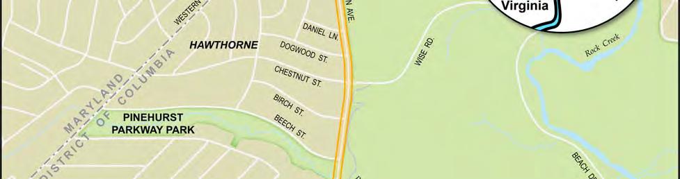
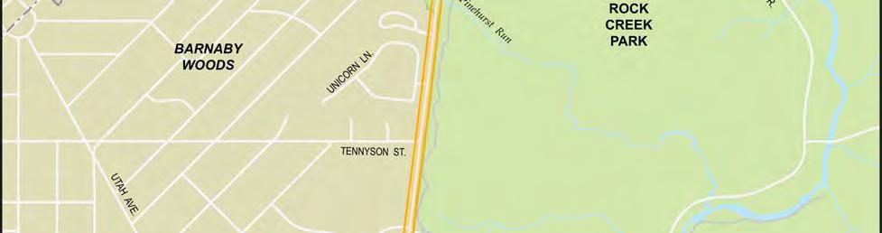
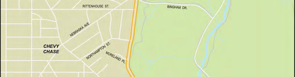
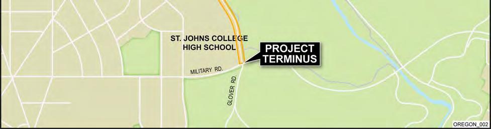
2 Final Environmental Assessment of Oregon Avenue NW Figure 1-1. Project Location 1-2


, a problem exacerbated by stormwater drainage issues.")

3 Purpose and Need INFRASTRUCTURE DEFICIENCIES There are a number of deficiencies with respect to the current physical condition of Oregon Avenue, including deteriorating pavement and substandard roadway geometry, inadequate stormwater drainage, and aging and inadequate structures, as described further below. ROADWAY PAVEMENT AND GEOMETRY With respect to its physical condition, the existing Oregon Avenue roadway is deteriorated and crumbling in many locations (see Figure 1-2), a problem exacerbated by stormwater drainage issues. The existing roadway has an apparent failed base, inadequate pavement, and roadway width less than required by current roadway design standards. Asphalt curb is provided sporadically along the roadway, and a sidewalk is currently available only in front of a few homes on the west side of the roadway near Moreland Place. The pictures in Figure 1-2 illustrate the deteriorating pavement, side-slope erosion, steep roadway slopes, and the impact of ponding runoff due to inadequate stormwater management. Figure 1-2. Deteriorated Infrastructure along Oregon Avenue 1-3
 with a posted speed limit of 25 mph (DC Department")

4 Final Environmental Assessment of Oregon Avenue NW The majority of Oregon Avenue is classified as a collector roadway. Based on roadway design standards developed to provide for safe travel, the minimum design speed for a collector roadway is 30 miles per hour (mph) with a posted speed limit of 25 mph (DC Department of Transportation Design and Engineering Manual). While Oregon Avenue is currently posted for 25 mph, the roadway geometrics at two locations require speed reductions (to either 20 mph or 15 mph). In addition, four of 16 vertical curves 1 on Oregon Avenue do not meet the minimum requirements for this design speed and afford limited sight distance. The geometrics of the roadway reflect the topography within the study area, which is dominated by rolling hills. STORMWATER DRAINAGE The existing stormwater drainage system includes several storm sewer systems collecting runoff from the highlands to the west of the project; these systems flow to existing outfall channels that flow through Rock Creek Park to the east. Other upland areas to the west drain directly to the roadway. The roadway drainage system consists of a few catch basins in the areas where there are existing storm sewer systems, and these basins discharge into the park via existing outfalls. The remainder of the roadway runoff, and off-site runoff from upstream parcels on the west side of the roadway, drains along the roadside cut-slopes, across the pavement, and then ultimately flows into Rock Creek Park. This uncontrolled runoff has contributed in large part to the deterioration of the roadway and the slopes of Rock Creek Park adjacent to Oregon Avenue. The current conditions are unsafe because of these drainage issues; the lack of adequate stormwater management combined with the topography results in areas along the roadway where ponding often occurs and where ice sheets form in the winter (in particular, at the intersections with Moreland Place and Western Avenue). Figure 1-3 shows some examples of stormwater runoff and ponding within the roadway corridor. Figure 1-3. Examples of Drainage Issues 1 A vertical curve is a civil engineering term used to describe the smooth curve that is inserted between two sections of a road that are at different slopes in order to avoid an abrupt transition in passing from one to the other. 1-4
.")

5 Purpose and Need ROADWAY STRUCTURES Oregon Avenue crosses over Pinehurst Run on a single-cell concrete box culvert that is aging and substandard in terms of condition and its ability to convey floodwaters from major periodic storms (see Figure 1-4). An inspection of the culvert conducted in 2003 found the structure to be in poor condition with deficiencies in the outlet headwall and abutments due to scour and aging, deterioration of concrete parapets, failed guardrails, and a need for in-stream stabilization (Wilbur Smith Associates, 2003). Figure 1-4. Pinehurst Run Culvert SAFETY Oregon Avenue can generally be characterized as a low-speed roadway (posted at 25 miles per hour) with a mix of straight and curved roadway sections. Rolling topography and steep grades play a role with respect to both the vertical geometrics of the roadway itself as well as adjacent lands, resulting in areas with limited sight distances that adversely affect the safety of motorists, pedestrian, and bicyclists. As a result, several locations on the roadway have advisory speed limits of 15 miles per hour in order to allow vehicles to safely navigate the curves in the roadway and minimize incidences of running off the road or suddenly coming upon pedestrians, bicyclists, or other vehicles using the roadway. Poor lighting within the roadway corridor also reduces available reaction time for the motorists, bicyclists, and pedestrians. Safety is a primary concern on Oregon Avenue due to the lack of separate facilities for pedestrians and bicycles and due to speeding along the roadway, as reported by local residents. The lack of both sidewalks and areas for bicycles to travel means that the roadway is shared by motorized vehicles, bicycles, and pedestrians. Pedestrians walking within the project area (for exercise and recreation; to bus stops, schools, and Rock Creek Park; or to visit neighbors) must 1-5
6 Final Environmental Assessment of Oregon Avenue NW walk within the roadway. The fact that users of each mode must be aware of two other types of users within a constrained roadway corridor exacerbates safety concerns substantially. The topography of the area also creates safety issues on Oregon Avenue with respect to drainage and the accommodation of stormwater. While pooling of water does not present a major concern for the relatively slow-moving vehicles on Oregon Avenue, it does present safety concerns to motor vehicles when the water freezes during winter months and to bicyclists yearround SYSTEM LINKAGE As a roadway that is designated as a collector over most of its length, Oregon Avenue serves its intended function of providing access to residences along the roadway. In addition, daily commuters also use Oregon Avenue as a cut through route: Nebraska Avenue to Oregon Avenue to Wise Road (through Rock Creek Park). Additional vehicular linkages or capacity are neither needed nor intended for this roadway. The roadway, however, does not provide needed linkages for both pedestrians and bicycles. With the exception of a very short stretch of sidewalk north of Moreland Place, Oregon Avenue currently lacks amenities to serve pedestrians and bicycles. As shown in Figure 1-1, an offstreet multi-use path parallels Oregon Avenue on the east side of the road, between Wise Road and Military Road within the boundaries of Rock Creek Park. The trail has limited connectivity to Oregon Avenue due to differences in vertical elevation between the roadway and the trail. In addition, along most of its length, the trail is over 50 feet to the east of the roadway, which limits its use for day-to-day activities. Oregon Avenue is included in the DC Bicycle Master Plan as an on-street bicycle route that provides for needed linkages for bicycle travel within this portion of the District. Improvements to enhance its ability to safely carry bicycles are needed to support the viable use of Oregon Avenue as a key linkage in the overall bicycle system. Other than crosswalks and stop signs connecting Tennyson Street to Rock Creek Park, there are no internal linkages or crosswalks for pedestrians to the parks, schools, and residential areas adjacent to Oregon Avenue, nor are there pedestrian connections to serve those who ride the Metrobus E-6 route, which serves seven bus stops in the northern portion of the roadway LEGISLATION As described in FHWA Technical Advisory T6640.8a, federal, state, and local government mandates are appropriate elements of the need for a proposed action. A key piece of local legislation related to the need for improvements to Oregon Avenue is the District of Columbia s Priority Sidewalk Assurance Act of 2010 (Law #L ) enacted on July 7, 2010 and effective September 24, This law requires the installation of sidewalks to ensure a safe and accessible environment for pedestrians and persons with disabilities. The law requires that, for roadways with no sidewalks on either side of the roadway, reconstruction shall include installation of a sidewalk. It further states that, for roadways that are missing sidewalks, but are not undergoing major construction, sidewalk installation shall be prioritized for the following areas: (1) Missing sidewalks in school areas; (2) Routes that provide access to parks and recreational facilities; (3) Transit stops; (4) Locations where the absence of a sidewalk 1-6
7 Purpose and Need creates substantial pedestrian safety risks; and (5) Roadway segments for which residents petitioned to have sidewalks. Oregon Avenue meets the criteria for prioritization based on considerations 1, 2, 3, and 4. A copy of the Act is presented in Appendix K. 1.3 PROJECT OVERVIEW BACKGROUND The rehabilitation of Oregon Avenue was originally placed on DDOT s schedule of planned improvements because of the apparent needs for roadway repair and the desire for a safer facility. The roadway is unsafe because of drainage issues, as well as poor lighting and the tendency for drivers to exceed the posted speed limit. The uncontrolled runoff from elevated parcels to the west of the roadway has contributed in large part to the deterioration of this two-lane roadway. The large volume of stormwater has also had detrimental effects on the adjacent streambeds in Rock Creek Park. Extensive erosion at culvert outfalls as well as at streambeds of the receiving waterways has been attributed to the high, erosive powers of the stormwater. The need for a total solution involving improvements on national park properties has resulted in the NPS serving as a Cooperating Agency in the development of the EA. Other notable environmental issues associated with this project include Section 106 (cultural resources), Section 4(f) resources (cultural resources and parklands), habitat concerns (fish and wildlife), water quality, and residential concerns (noise and visual intrusion and bike/pedestrian safety). Aging infrastructure has contributed to the deficiencies in the roadway corridor. The culvert carrying Oregon Avenue over Pinehurst Run has been found to be in poor condition with deficiencies in the outlet headwall and abutments due to scour and aging, deterioration of concrete parapets, failed guardrails, and a need for in-stream stabilization (Wilbur Smith Associates, 2003). Improvement opportunities for this bridge culvert will be addressed as a part of the upgrades planned for Oregon Avenue. The District Department of the Environment (DDOE) is currently working with the NPS in conducting stream restoration projects within Rock Creek Park in the vicinity of Oregon Avenue DESCRIPTION OF THE PROJECT AREA Oregon Avenue is a two-lane roadway located in northwest Washington, DC, extending from Military Road to the Maryland state line at Western Avenue, a distance of approximately 1.7 miles. As shown in Figure 1-1, Rock Creek Park (owned by NPS) is located immediately east of Oregon Avenue over its entire length, which creates a bucolic or rural-like setting in the project area, as shown in Figure 1-5. Rock Creek Park is one of the largest forested urban parks in the United States, nearly a mile wide in some places, and contains a wide variety of natural, historical, and recreational features in the midst of Washington, DC. It is this rural-like context within an otherwise urbanized area that residents suggest make this roadway very unique. 1-7


8 Final Environmental Assessment of Oregon Avenue NW Figure 1-5. Rural-like Setting of Roadway Corridor Areas to the west of Oregon Avenue include the neighborhoods of Chevy Chase, Barnaby Woods, and Hawthorn; St. John s College High School; the Knollwood retirement community; and a short section of NPS property on the south side of Beech Street. At its southernmost point, Oregon Avenue intersects with Military Road at a signalized intersection. South of Military Road, the roadway continues as Glover Road. St. John s College High School is located in the northwest quadrant of the intersection, and Rock Creek Park lies to the northeast and continues along the length of the roadway corridor. North of St. John s College High School is the residential neighborhood of Chevy Chase. Nebraska Avenue, one of the streets in this neighborhood that continues into Rock Creek Park as Bingham Drive, was recently upgraded to include an updated intersection with Oregon Avenue, which features two rain gardens for stormwater mitigation. Knollwood, a military retirement residence, is located in the northeast corner of Chevy Chase on Oregon Avenue between Nebraska Avenue and Tennyson Street. 1-8
9 Purpose and Need The neighborhood of Barnaby Woods is situated in the center of the project corridor, north of Tennyson Street. It is bordered on the north by Pinehurst Valley, an arm of NPS land that extends west from Rock Creek Park. The northern end of the project area serves as the eastern edge of Hawthorn. The main eastwest roadway in this neighborhood is Chestnut Street, which originates in Maryland as Winnett Road and continues through Rock Creek Park as Wise Road. The northern limit of the project and this neighborhood is Western Avenue, after which Oregon Avenue continues as Daniel Road in Maryland. 1.4 PROJECT GOALS Project goals were established by the study team to aid in the development of improvement concepts for Oregon Avenue. These goals were developed by considering the purpose and need, agency/public comments, and project area constraints. The goals for the Oregon Avenue project are listed below: Create a safe facility for all users of the roadway (motorists, pedestrians, bicyclists, etc.) Effectively manage stormwater runoff Avoid/minimize use of parkland by staying within the DDOT right-of-way to the extent possible Preserve and protect environmental resources both man-made and natural and retain the current context of the corridor (i.e., visual aesthetic, using context-sensitive solutions in the design phase of the project) Provide improved access to Rock Creek Park Utilize environmentally sensitive materials and practices In addition to the project goals, the proposed improvements for Oregon Avenue consider design criteria outlined in the American Association of State and Highway Transportation Officials (AASHTO) Guide for the Development of Bicycle Facilities (AASHTO, 1999); DDOT Design and Engineering Manual, Chapter 28 (DDOT, 2009b); DDOT Bicycle Master Plan (Toole Design, 2005); DDOT Bicycle Facility Design Guide (DDOT, 2005a); DDOT Environmental Policy and Process Manual; the Manual on Uniform Traffic Control Devices (MUTCD) Traffic Controls for Bicycle Facilities, Part 9 (FHWA, 2003); District of Columbia Pedestrian Master Plan (DDOT, 2009e); AASHTO Guide for the Planning, Design, and Operation of Pedestrian Facilities, (AASHTO, 2009); and other design guidance. 1.5 DESIGN CONSIDERATIONS Based on data collection, field observation, and input from the project s stakeholders, the study team formulated an array of considerations to help with the development of concepts and options for the proposed improvements to Oregon Avenue. Field reviews were conducted with DDOT and NPS staff to gain first-hand knowledge about issues in the roadway corridor. Stakeholder input was gathered at agency and public scoping meetings. Finally, data collection and research, as documented by the environmental conditions and considerations presented in 1-9
10 Final Environmental Assessment of Oregon Avenue NW Chapter 3, were used to best address necessary Oregon Avenue improvements while incorporating community needs and resource preservation. The following considerations led to the formation of concepts and alternatives that were carried forward for detailed study or dismissed (see Chapter 2 for a discussion of the Proposed Action and Alternatives) ROADWAY CONSIDERATIONS Roadway improvements consist of reconstructing the roadway subgrade, repaving, and realigning to improve sight distances as necessary. The width of the roadway s travel surface varies depending on the inclusion of various elements. These elements include: Varying lane widths 10, 11, and 12 feet Travel lanes with and without shoulders, curbs and gutter Shared travel lanes that include bike lanes BICYCLE AND PEDESTRIAN CONSIDERATIONS In order to accommodate other modes of transportation, consideration was given to bicyclist and pedestrian facilities. Bike lanes on and off the travel lanes Sidewalks and walking trails Shared-use paths for walking and biking STORMWATER MANAGEMENT CONSIDERATIONS Stormwater runoff can be controlled by a series of improvements that are located on or adjacent to the roadway. Within the roadway, curb and gutter can be incorporated to convey waters to storm sewers. Adjacent to the roadway, the project may implement Low Impact Development (LID) principles and practices so that water can be managed in a way that reduces the impact of built areas and promotes the natural movement of water within the ecosystem and watershed. There are many practices that can be used to adhere to these principles and include, but are not limited to, the following: Vegetated grass swales Tree Boxes Planting Strips Bioretention cells or swales Rain gardens 1.6 RELATIONSHIP TO OTHER PLANS AND STUDIES The project is consistent with the District s planning documents and projects, including the following. 1-10
11 Purpose and Need DISTRICT OF COLUMBIA BICYCLE MASTER PLAN The DDOT 2005 Bicycle Master Plan includes several core goals and recommendations in order to establish a world-class bicycle transportation system in the District of Columbia. Several strategies are named to increase bicyclist safety and security while improving the connectivity and accessibility of destinations and activity centers within the District of Columbia. The proposed improvements to Oregon Avenue, which will enhance pedestrian and bicycle facilities along the roadway, is consistent with the first goal of the plan: to provide more and better facilities DISTRICT OF COLUMBIA PEDESTRIAN MASTER PLAN The proposed improvements to Oregon Avenue are consistent with the District of Columbia Pedestrian Master Plan, which seeks to reduce the number of pedestrian/motor vehicle crashes and increase pedestrian activity by making walking a comfortable and accessible mode of travel throughout all parts of the District. The Plan also encourages improved facilities and policies to promote the benefits of walking for transportation, recreation, and health. The project will add pedestrian facilities along the entire length of the roadway to ensure a safe and accessible environment for pedestrians and persons with disabilities ROCK CREEK TRAIL PROJECT DDOT and NPS are developing plans to rehabilitate the Rock Creek Multi-Use Trail and Rose Park Trail in Rock Creek Park from M Street, NW on the south end to Broad Branch Road/Beach Drive on the north end, including a spur trail along the Piney Branch Parkway. The design plan will address several key elements, including development of new trail connections. The proposed improvements to Oregon Avenue would provide improved access to and from the multi-use trail system in Rock Creek Park ROCK CREEK WATERSHED IMPLEMENTATION PLAN The District Department of the Environment (DDOE) Watershed Protection Division (WPD) operates under a mission to conserve the soil and water resources of the District of Columbia and to protect its watersheds from nonpoint source pollution. Consistent with that mission, WPD has prepared a Rock Creek Watershed Implementation Plan (DDOE, 2010). The plan states that (t)he Watershed Implementation Plan is an effort to create a watershed-based non-point source pollution control plan that meets EPA s requirements for acceptance while providing a realistic and adaptable guide for agencies responsible for the restoration of Rock Creek at the local level. The proposed improvements to Oregon Avenue are consistent with the District s goals of improving water quality and managing nonpoint source pollution. An important component in addressing these issues is managing the large quantities of uncontrolled and untreated stormwater runoff flowing into Rock Creek due to impervious surfaces. Stormwater management for this project would support the goals set forth in the Rock Creek Watershed Implementation Plan by following its recommendations, including implementation of low impact development projects, bioretention measures, erosion and sediment control, restoration of eroded stream banks, and tree plantings. 1-11
12 Final Environmental Assessment of Oregon Avenue NW MILITARY ROAD/MISSOURI AVENUE TRANSPORTATION STUDY The proposed improvements to Oregon Avenue are consistent with the Military Road/Missouri Avenue Transportation Study s recommendations to reduce the speed of vehicles traveling west along Military Road exiting Rock Creek Park. The speed limit is reduced in this area and slower traffic in the school zone is important for safety COMPREHENSIVE PLAN OF THE NATIONAL CAPITAL The Comprehensive Plan of the National Capital, which was first adopted in 1984 and 1985 and is updated periodically, is a general policy document that provides overall guidance for future planning and development of the city. The plan is comprised of two parts, the District Elements and the Federal Elements, which are adopted by the DC Council and the National Capital Planning Commission (NCPC), respectively. The proposed improvements to Oregon Avenue support the Comprehensive Plan of the National Capital: District Elements 13 citywide elements that provide goals, objectives, and policies for land use issues that impact the whole city, e.g., transportation, environment, parks and open space, historic resources, cultural resources, arts, and culture. The plan contains recommendations for maintaining these goals including: Increasing investment in bus and rail transit, pedestrian and bicycle facilities, and other modes of travel to solve the region s traffic problems and sustain economic growth; Promoting natural resource conservation and environmental sustainability by protecting, restoring, and enhancing earth, water, air, and biotic resources of the District; Protecting, maintaining, and improving social, economic, historic, and physical qualities of residential neighborhoods; Improving the connections between different transportation modes, improving traveler safety and security, and increasing system efficiency; Improving connections to the city s celebrated spaces, such as Rock Creek Park; Retaining historic and unique qualities of Washington s streetscapes; and, Encouraging land use patterns and land uses that reduce air pollution and facilitate pedestrian and bicycle travel. The proposed improvements to Oregon Avenue are consistent with each of these plan goals ROCK CREEK PARK GENERAL MANAGEMENT PLAN The Rock Creek Park General Management Plan is a comprehensive and integrated plan that guides the management of Rock Creek Park and the Rock Creek and Potomac Parkway in a way that best meets diverse demands on park resources. The approved alternative, Improved Management of Established Park Uses, retains the current scope of visitor uses while improving visitor safety, better controlling traffic volumes and speeds through the Park, enhancing interpretation and education opportunities, and improving the use of park resources, especially cultural resources. The proposed improvements to Oregon Avenue are consistent with the goals of the General Management Plan in that they would improve the safety of 1-12
13 Purpose and Need pedestrian, bicycle, and roadway linkages to the Park while not detracting from the use of park resources REGENERATIVE STORMWATER CONVEYANCE PROJECT The DDOE is coordinating the design and construction of a regenerative storm water conveyance (RSC) pilot project for two intermittent streams, Bingham Run and Milkhouse Run, which empty into Rock Creek. A RSC is an open-channel storm water design that utilizes a series of shallow aquatic pools, riffle weir stone grade controls, native vegetation, and underlying sand/compost filter to treat and convert storm water flows to groundwater. Installing RSCs in the Rock Creek watershed will improve water quality by reducing nutrient and sediment pollution from erosion, caused by fast-flowing storm water. The proposed stormwater management improvements for Oregon Avenue would contribute toward the improvement of water quality within the Rock Creek watershed. Selected techniques included in the RSC project, such as sand seepage berms, will be incorporated into the design of the project where practicable. 1-13
S SUMMARY S.1 PREFACE S.2 PURPOSE AND NEED S.3 PROJECT BACKGROUND
 S SUMMARY S.1 PREFACE The Federal Highway Administration (FHWA) and the District Department of Transportation (DDOT), in cooperation with the National Park Service (NPS), are proposing the rehabilitation
2 ALTERNATIVES AND OPTIONS
 2 ALTERNATIVES AND OPTIONS This chapter documents the process used to develop improvement concepts for Oregon Avenue and describes the resulting project alternatives and options, which were developed in
Potential Green Infrastructure Strategies May 6, 2015 Workshop
 Potential Green Infrastructure Strategies May 6, 2015 Workshop Background The City of Cortland is developing the Tioughnioga Urban Headwaters Green Infrastructure Action Plan with funding from the National
COMPLETE GREEN STREET CHECKLIST
 COMPLETE GREEN STREET CHECKLIST This document was developed to dissect the structure of an urban street and explore opportunities to make our streets more complete while also integrating green street strategies.
When planning stormwater management facilities, the following principles shall be applied where possible.
 2.0 Principles When planning stormwater management facilities, the following principles shall be applied where possible. 2.0.1 Drainage is a regional phenomenon that does not respect the boundaries between
1.0 Circulation Element
 5/9/18 1.0 Circulation Element 1.1 Introduction As growth and development occur in Apache County, enhancements to its circulation system will be necessary. With time, more roads will be paved and air and
Berkshire Regional Planning Commission Clearinghouse Review Report
 August 19, 2013 SUBJECT: Reconstruction of Housatonic Street, Dalton, MA EOEA#: 15083 LOCATION: Dalton ESTIMATED COST: $8.1 million REVIEW TYPE: ENF PROPONENT: MassDOT and Town of Dalton COMMENTS DUE:
Mendota Heights 2040 Comprehensive Plan Draft Vers
 4 Parks and Trails The City of Mendota Heights boasts a variety of recreational and open space opportunities. Few cities can claim access to regional trails, riverside and lakeside parks, scenic bluffs
Public Meeting May 20, 2014
 Public Meeting May 20, 2014 Overview Study Purpose Study Area Overview Strategies Potential Opportunities Implementation and Discussion Skeo Solutions Raleigh Walkable Watershed Pilot 2 Purpose Develop
7.0 SOCIAL, ECONOMIC, AND ENVIRONMENTAL ISSUES
 7.0 SOCIAL, ECONOMIC, AND ENVIRONMENTAL ISSUES The following list of social, economic, and environmental issues have been identified based on a preliminary inventory of resources in the project area, an
9 th Street Sub Area Plan
 9 th Street Sub Area Plan In the 1990 s, when the Township prepared the last Master Plan, the 9 th Street corridor was studied as part of a larger 9 th Street Focus Area that included the West Main Street
Transportation. Strategies for Action
 Transportation A major priority for the Overlake Neighborhood is to develop a multimodal transportation system. To achieve this system, a balance has to be found among travel, circulation and access needs;
THREE-YEAR CAPITAL IMPROVEMENT PLAN FY
 THREE-YEAR CAPITAL IMPROVEMENT PLAN FY2016 2018 Annual CIP Development Process Public Works & Engineering Divisions Prepare List of Capital Needs and Recommended Deferred Maintenance Public Works & Engineering
Chapter 1 - General Design Guidelines CHAPTER 1 GENERAL DESIGN GUIDELINES
 CHAPTER 1 GENERAL DESIGN GUIDELINES 1.0 INTRODUCTION This Publication has been developed to provide current, uniform procedures and guidelines for the application and design of safe, convenient, efficient
The Illinois Department of Transportation and Lake County Division of Transportation. Route 173, including the Millburn Bypass
 The Illinois Department of Transportation and Lake County Division of Transportation welcome you to this Public Hearing for U.S. Route 45 from Illinois Route 132 to Illinois Route 173, including the Millburn
Asbury Chapel Subdivision Sketch Plan
 Asbury Chapel Subdivision Sketch Plan PART 1: PROJECT SUMMARY Applicant: NVR Inc. Project Size: +/- 76.13 acres Parcel Numbers: 02101112,02116101,02116112, 02116113 Current Zoning: Transitional Residential
WELCOME! 8 8:30 6: TH STREET IMPROVEMENTS. Open House. Presentation & Q&A
 WELCOME! 168 TH STREET IMPROVEMENTS 6:30 Open House 7 8 Presentation & Q&A 8 8:30 Open House WELCOME Todd Pfitzer City of Omaha Engineer Bob Stubbe City of Omaha Public Works Director Jon Meyer Project
5. LOW IMPACT DEVELOPMENT DESIGN STANDARDS
 5. LOW IMPACT DEVELOPMENT DESIGN STANDARDS Low Impact Development (LID) requires a shift in stormwater management away from conveying runoff to a small number of downstream points through hydraulically
The West Vaughan Employment Area Secondary Plan Policies
 Part 2: The West Vaughan Employment Area Secondary Plan Policies 2.1 General Policies It is the policy of Council: 2.1.1. That the West Vaughan Employment Area (the WVEA), identified on Schedule 1, will
Town of Vershire Road Erosion Inventory Report
 Town of Vershire Road Erosion Inventory Report Taylor Valley Road. Photo taken by TRORC staff. Prepared by: 128 King Farm Road Woodstock, VT 05091 Inventory and report funded by the Vermont Agency of Transportation
4-Town Comprehensive Plan DRAFT 7/30/07
 4-Town Comprehensive Plan DRAFT 7/30/07 Acknowledgements ning Committee Town of Harrisburg Norman Roof Randy Nicol Town of Martinsburg Terry Thisse Paul Kelly Town of Montague Jan Bagdanowicz Wendy Perry
Chapter 5: Natural Resources and Environment
 NATURAL RESOURCES AND ENVIRONMENT 5-1 5 Chapter 5: Natural Resources and Environment BACKGROUND AND INTENT Urban expansion represents the greatest risk for the future degradation of existing natural areas,
I-494 Rehabilitation Project SP (I-394 to Fish Lake Interchange) June 2014 Section 4(f) De Minimis Determination
 June 2014 Section 4(f) De Minimis Determination") I-494 Rehabilitation Project SP 2785-330 (I-394 to Fish Lake Interchange) June 2014 Section 4(f) De Minimis Determination State Project Number 2785-330 Federal Project No. NHPP-I494 (002) Trunk Highway:
I-494 Rehabilitation Project SP 2785-330 (I-394 to Fish Lake Interchange) June 2014 Section 4(f) De Minimis Determination State Project Number 2785-330 Federal Project No. NHPP-I494 (002) Trunk Highway:
LOUISIANA STATE UNIVERSITY COMPREHENSIVE & STRATEGIC CAMPUS MASTER PLAN. APPENDIX G - Stormwater Study Findings & Stormwater Solutions
 LOUISIANA STATE UNIVERSITY COMPREHENSIVE & STRATEGIC CAMPUS MASTER PLAN APPENDIX G - Stormwater Study Findings & Stormwater Solutions LSU: MP Narrative July 2017 3.5 Open Space Existing Conditions The
SPRINGHILL LAKE TRANSIT VILLAGE
 Greenbelt Metro Area Sector Plan - Subarea Design Policies and Guidelines - Springhill Lake Transit Village 113 SPRINGHILL LAKE TRANSIT VILLAGE Residential Neighborhood and Village Center CONCEPT Springhill
Gold Line Bus Rapid Transit Transit Oriented Development (BRTOD) Helmo Station Area Plan
 Helmo Station Area Plan") Appendix F Gold Line Bus Rapid Transit Transit Oriented Development (BRTOD) Helmo Station Area Plan Introduction and Purpose of the Plan The Gold Line Bus Rapid Transit facility is an eleven-mile dedicated
Appendix F Gold Line Bus Rapid Transit Transit Oriented Development (BRTOD) Helmo Station Area Plan Introduction and Purpose of the Plan The Gold Line Bus Rapid Transit facility is an eleven-mile dedicated
St. Clair Avenue West Area Transportation Master Plan
 1 (Between Keele Street and Old Weston Road) Public Information Centre 1 December 2, 2015 2 Welcome Welcome to the first Public Information Centre for the St. Clair Avenue West Area. The panels will present
Town of Portola Valley General Plan. Nathhorst Triangle Area Plan
 Town of Portola Valley General Plan Amended December 10, 1997 Table of Contents Introduction... 1 Planning Area... 1 Objectives... 2 Principles... 2 Standards... 4 Description... 4 Community Commercial...
HAZARD MITIGATION GOALS AND OBJECTIVES
 SEWRPC Community Assistance Planning Report No. 282, 2nd Edition CITY OF MILWAUKEE ALL HAZARDS MITIGATION PLAN UPDATE Chapter IV HAZARD MITIGATION GOALS AND OBJECTIVES [NOTE: Throughout this plan update
STORMWATER MANAGEMENT CODES ANALYSIS RICHLAND COUNTY, SC SITE PLANNING ROUNDTABLE
 STORMWATER MANAGEMENT CODES ANALYSIS RICHLAND COUNTY, SC SITE PLANNING ROUNDTABLE Codes analyses for each subcommittee were completed to assist participants of the Richland County Site Planning Roundtable.
INFRASTRUCTURE EXISTING INFRASTRUCTURE A. Circulation B. Signals C. Drainage D. Utilities
 7.01. EXISTING INFRASTRUCTURE A. Circulation B. Signals C. Drainage D. Utilities 7.02. PROPOSED INFRASTRUCTURE A. Overall Concept B. Circulation C. Signals D. Drainage 7.03. INFRASTRUCTURE MAP A. Key Infrastructure
Green Streets. Sustainable Stormwater Solutions for Greener Communities and a Cleaner Bay
 Green Streets Sustainable Stormwater Solutions for Greener Communities and a Cleaner Bay As the Bay Area continues to grow through development of roads, revitalization of neighborhoods, and construction
Leduc Industrial Outline Plan SE W4
 Leduc Industrial Outline Plan SE 1-50-25-W4 Within the North Leduc Industrial ASP Prepared for: Leduc Energy Park Ltd. Prepared by: Stantec Consulting Ltd. File No. 1161 104655 V5 Table of Contents 1.0
Route 1 Corridor Study
 Route 1 Corridor Study Westbrook, Connecticut A Vision for the Connecticut Shoreline Public Informational Meeting July 28, 2015 Lower Connecticut River Valley Council of Governments Fitzgerald & Halliday,
The transportation system in a community is an
 7 TRANSPORTATION The transportation system in a community is an important factor contributing to the quality of life of the residents. Without a sound transportation system to bring both goods and patrons
BROOKHILL NEIGHBORHOOD MODEL ZONING MAP AMENDMENT PREFACE TO APPLICATION
 BROOKHILL NEIGHBORHOOD MODEL ZONING MAP AMENDMENT PREFACE TO APPLICATION June 15, 2015 Revised: August 1, 2016 I. VISION Brookhill is a proposed community based upon the principles of Albemarle County
Public Information Centre. Welcome
 Transportation Improvements from the Beaver Creek Bridge to the Entrance of Santa s Village District of Muskoka Municipal Class Environmental Assessment Welcome Please sign in Take a comment sheet Staff
APPENDIX A. Proposed Guidance and LID checklists for UConn and Town of Mansfield
 APPENDIX A. Proposed Guidance and LID checklists for UConn and Town of Mansfield 22 Guidance Document for Low Impact Development Best Management Practices for UConn June, 2011 In 2007, the Connecticut
The open space system should provide connective elements, relate to natural resources, and enhance the suburban character of the landscape..
 The open space system should provide connective elements, relate to natural resources, and enhance the suburban character of the landscape.. Mixed-use and infill development should maintain or enhance
CONFORMED AGREEMENT INCORPORATED REVISIONS PER AMENDMENT DATED: APRIL 2, 2013 FOR REFERENCE
 CONFORMED AGREEMENT INCORPORATED REVISIONS PER AMENDMENT DATED: APRIL 2, 2013 FOR REFERENCE CITY STREETS AS PART OF STATE HIGHWAYS GUIDELINES REACHED BY THE WASHINGTON STATE DEPARTMENT OF TRANSPORTATION
Ten Mile Creek Planning Area
 PLANNING AREA POLICIES TEN MILE CREEK Ten Mile Creek Planning Area Location and Context The Ten Mile Creek Planning Area ( Ten Mile Creek area ) is located south of the current Boise AOCI, generally south
Chapter 3 Site Planning and Low Impact Development
 CHAPTER 3 Site Planning and Low Impact Development Chapter 3 Site Planning and Low Impact Development 3.0 Introduction The City of Charleston requires that major residential, large commercial (>1 acre),
Red Fox Commercial Outline Plan
 Red Fox Commercial Outline Plan City of Cold Lake, Alberta Prepared by Durrance Projects Ltd and Ross W. Sharp & Associates Ltd October 2014 Rupert 1 Table of Contents 1. PURPOSE...3 1.1. Location...4
AESTHETIC APPEARANCE. Design Guidelines for Grade-Separated Pedestrian, Cyclist and Equestrian Structures
 III. AESTHETIC APPEARANCE The aesthetic qualities of a grade-separated structure are as important as the specific design criteria. For example, a structure may be constructed to the exact criteria set
VALLEY COUNTY MINIMUM STANDARDS FOR PRIVATE ROAD DESIGN AND CONSTRUCTION
 MINIMUM STANDARDS FOR PRIVATE ROAD DESIGN AND CONSTRUCTION Adopted November 28, 2005 TABLE OF CONTENTS DEFINITION OF TERMS...II I. DESIGN CRITERIA... 1 A. GENERAL DESIGN CRITERIA... 1 B. ROADWAY CLASSIFICATION...
ST. MARY S SOIL CONSERVATION DISTRICT (SMSCD) AND DPW&T CONCEPT EROSION AND SEDIMENT CONTROL AND STORMWATER MANAGEMENT GUIDELINES AND CHECKLIST
 AND DPW&T CONCEPT EROSION AND SEDIMENT CONTROL AND STORMWATER MANAGEMENT GUIDELINES AND CHECKLIST") St. Mary s Soil Conservation District 26737 Radio Station Way, Suite B Leonardtown, MD 20650 Phone: 301-475-8402 ext. 3 Fax: 301-475-8391 www.stmarysscd.com St. Mary s County Government Department of Public
St. Mary s Soil Conservation District 26737 Radio Station Way, Suite B Leonardtown, MD 20650 Phone: 301-475-8402 ext. 3 Fax: 301-475-8391 www.stmarysscd.com St. Mary s County Government Department of Public
This page left intentionally blank.
 July 2012 This page left intentionally blank. Table of Contents Appendix A : Project Development Checklist Appendix B: At-Grade Rail Crossings Appendix C: Maintenance and Operations Examples Appendix D:
Description of Preferred Alternative
 Chapter 2 Description of Preferred Alternative 2.1 Introduction This chapter of the programmatic Sammamish Town Center Sub-area Plan Final EIS provides a more detailed description of the Preferred Alternative
2.4 FUTURE LAND USE ELEMENT Goals, Objectives and Policies
 GOAL 1: To create developmental patterns that direct future growth to appropriate areas on campus, in a manner that promotes the educational mission of the University, the protection of environmentally
3. VISION AND GOALS. Vision Statement. Goals, Objectives and Policies
 Vision Statement Queen Creek s interconnected network of parks, trails, open spaces and recreation opportunities provide safe and diverse activities and programs that sustain its unique, small town, equestrian
TRANSPORTATION ELEMENT GOALS, OBJECTIVES, AND POLICIES
 TRANSPORTATION ELEMENT GOALS, OBJECTIVES, AND POLICIES GOAL 2 The City shall provide a safe, convenient, effective, and energy efficient multimodal transportation system which is coordinated with the Future
The Vision. Photo provided by The Minervini Group. 46 Vision, Objectives & Strategies
 Vision, Objectives & Strategies The is the public framework and guide for future development of the Grand Traverse Commons. The establishes public polices for infrastructure, the preservation of natural
FDOT D4 Complete Streets
 FDOT D4 Complete Streets Context Sensitive Solutions Directs that complete street solutions will complement the context of the community. Collaborative approach to decision making, project development,
Kittson Parkway / Watershed Park Parking Lot
 Kittson Parkway / Watershed Park Parking Lot Date Constructed: Summer 2005 Site Location / Description: Kittson Parkway, North Delta, British Columbia. Permeable parking lot adjacent to Watershed Park;
ADOPTED CAPITAL IMPROVEMENT PROGRAM BUDGET ARROYO PROJECTS
 ADOPTED CAPITAL IMPROVEMENT PROGRAM BUDGET ARROYO PROJECTS HAHAMONGNA FY 212-216 Capital Improvement Program Priority Description Total Estimated Costs Appropriated Through FY 211 Adopted FY 212 FY 213
CHAPTER 7: Transportation, Mobility and Circulation
 AGLE AREA COMMUNITY Plan CHAPTER 7 CHAPTER 7: Transportation, Mobility and Circulation Transportation, Mobility and Circulation The purpose of the Transportation, Mobility and Circulation Chapter is to
Putting a LID on Stormwater Pollution. Michele Loudenback, RPES Stormwater Enforcement Water Quality Division
 Putting a LID on Stormwater Pollution Michele Loudenback, RPES Stormwater Enforcement Water Quality Division Outline Brief Regulatory History Conventional vs. Green Practices LID/GI Controls in Use Clean
Long Branch Sector Plan
 June 2012 Long Branch is one of Montgomery County s most affordable, older communities and has served as a gateway community, especially for newly arriving immigrants, since the 1960s. Many within this
CAMPUS PLANNING COMMITTEE STAFF REPORT SAMARITAN SPORTS MEDICINE INSTITUTE AT OSU 10/21/2013
 Office of Capital Planning and Development; 130 Oak Creek Building; Corvallis, Oregon 97331-2001 CPC STAFF REPORT: SAMARITAN SPORTS MEDICINE INSTITUTE AT OSU CAMPUS PLANNING COMMITTEE STAFF REPORT SAMARITAN
Hockessin Community Redevelopment Plan
 Hockessin Community Redevelopment Plan 3.1 Introduction The Community Redevelopment Plan for the Village of Hockessin is the result of the people s vision for a distinct village center that serves as the
CARVER COUNTY DIVISION OF PUBLIC WORKS LANDSCAPE POLICY. Adopted by the Carver County Board of Commissioners March 3, 2015
 CARVER COUNTY DIVISION OF PUBLIC WORKS LANDSCAPE POLICY Adopted by the Carver County Board of Commissioners March 3, 2015 Policy Statement Goals It is the goal of Carver County Public Works to provide
CHAPTER 8 ISSUES, CONCERNS, CONSTRAINTS AND OPPORTUNITIES
 CHAPTER 8 ISSUES, CONCERNS, CONSTRAINTS AND OPPORTUNITIES Introduction This River Conservation Plan was developed during a time of tremendous activity and effort in planning the transformation of the Delaware
Title 11 Streets and Sidewalks
 Chapter 11.01 - Definitions Title 11 Streets and Sidewalks Low Impact Development (LID) - A stormwater and land use management strategy that strives to mimic predisturbance hydrologic processes of infiltration,
VEHICULAR AND PEDESTRIAN CIRCULATION
 This perspective sketch communicates the intended character and quality of a proposed streetscape design. Locate benches near a major intersection where people tend to gather. Seating and lighting provide
City of Hermosa Beach Administrative Policy #
 City of Hermosa Beach Administrative Policy # SUBJECT: Living Streets Policy Date: Approved by: City Council Authority: Public Works Department & Community Development Department Mayor, PURPOSE The City
FY Capital Improvement Program Arroyo Projects
 FY 219-223 Capital Improvement Program FY 218 FY 219 FY 22 FY 221 FY 222 FY 223 1 2 3 4 5 6 7 8 9 1 Hahamongna - Implement Master Plan - Oak Grove Area Improvements (7756) Hahamongna - Implement Master
Creating Complete Roadway Corridors:
 Creating Complete Roadway Corridors: The AASHTO Guide to Transportation Landscape Architecture and Environmental Design NCHRP Project 15-33 Status Report AASHTO Standing Committee on Design Technical Committee
Toronto Complete Streets Guidelines
 Toronto Complete Streets Guidelines 108 110 7.1 Green Infrastructure Design Principles 112 7.2 Context-Sensitive Green Streets 114 7.3 Key Green Street Elements Green infrastructure refers to natural and
Your town s subdivision or land use ordinance standards should reference the following street standards, for example:
 Your town s subdivision or land use ordinance standards should reference the following street standards, for example: Streets shall be designed to move traffic safely and in a way that minimizes environmental
Improving Communities Through the Arroyo Seco Sustainability Campaign and Watershed Assessment
 Improving Communities Through the Arroyo Seco Sustainability Campaign and Watershed Assessment Arroyo Seco Headwaters in the San Gabriel Mountains Major tributary to the Los Angeles River 44 square mile
2016 WORKSHOP LVR Field Trip
 2016 WORKSHOP LVR Field Trip ***Note*** Many of the sites on this tour were NOT related to, or funded by, the DGLVR program. They are being shown to encourage discussion about the kinds of projects that
Storm Water Quality and Shoreline Restoration Improvements - Grant Funding Request City of Mound Carlson Park Bolton & Menk Project No.
 September 15, 2016 Brett Eidem Cost Share Grant Administrator Minnehaha Creek Watershed District 15320 Minnetonka Boulevard Minnetonka, MN 55345 RE: Storm Water Quality and Shoreline Restoration Improvements
Executive Summary. NY 7 / NY 2 Corridor
 Executive Summary NY 7 / NY 2 Corridor Transportation and Land Use Study December 2005 Prepared for: Town of Colonie Capital District Transportation Committee Prepared by: Introduction: Land use decisions
MONTGOMERY COUNTY PLANNING DEPARTMENT THE MARYLAND-NATIONAL CAPITAL PARK AND PLANNING COMMISSION
 MONTGOMERY COUNTY PLANNING DEPARTMENT THE MARYLAND-NATIONAL CAPITAL PARK AND PLANNING COMMISSION MCPB Item No. Date: 12-10-15 Leisure World Clubhouse II Addition Fitness Center, Limited Site Plan Amendment
Proposed FY 2004 TRANSPORTATION CAPITAL PROGRAM New Jersey Department of Transportation Projects
 Carteret Industrial Road 98547 This project will address the upgrade of Carteret Industrial Road. The federal Transportation Equity Act for the 21st Century (TEA-21) provided funding for this project under
1.0 INTRODUCTION 1.1 TH 14 WEST STUDY AREA Project Description Functional Classification Purpose of the Project
 1.0 INTRODUCTION 1.1 TH 14 WEST STUDY AREA 1.1.1 Project Description The Trunk Highway (TH) 14 West Corridor is a two-lane roadway approximately 22 miles in length. Located in Nicollet County, the corridor
Glenn Highway MP DSR. Landscape Narrative
 Glenn Highway MP 34-42 DSR Landscape Narrative Project Landscape Goals The Glenn Highway MP 34-42 Project extends through a variety of landscape types typical to the Matanuska-Susitna Valley. In general,
Street Flooding Mitigation Plan KYOVA Interstate Planning Commission. Presented to AMPO National Conference October 18, 2017
 Street Flooding Mitigation Plan KYOVA Interstate Planning Commission Presented to AMPO National Conference October 18, 2017 Saleem Salameh, Ph.D., P.E., M.ASCE Chet Parsons, AICP CTP Agenda: Background
Municipal Class EA Study Public Information Centre No. 1 December 13, :00 pm 7:00 pm. Please sign in so we can keep you updated on this study
 Reconstruction of Regional Road 45 (Creek Road) Between Regional Road 27 (River Road) and Regional Road 63 (Canborough Road) in the Township of Wainfleet Municipal Class EA Study Public Information Centre
Working Group Meeting
 April 4,, 2017 Parks Operations Bldg Working Group Meeting Arts Districts Overview Stormwater/RPA/Stream Considerations First Principles Agenda 7:00pm 7:05pm 7:10pm 7:40pm 8:30pm 9:40pm 9:45pm Welcome
New York Avenue Streetscape and Trail Project Public Meeting #1 Summary
 New York Avenue Streetscape and Trail Project Public Meeting #1 Summary I. King Jordan Student Academic Center (SAC) Gallaudet University, Washington, DC February 23, 2017 Table of Contents 1.0 Introduction...
North Branch of Cypress Creek Ecological Restoration: A Comprehensive Approach to Stream Restoration
 North Branch of Cypress Creek Ecological Restoration: A Comprehensive Approach to Stream Restoration Rocky Powell Clear Creeks Consulting, LLC Keith D. Tate, P.E. BayLand Consultants & Designers, Inc.
ADDENDUM TO BIOLOGICAL SCOPING SURVEY REPORT, BOTANICAL SURVEY AND WETLAND DELINEATION
 ADDENDUM TO BIOLOGICAL SCOPING SURVEY REPORT, BOTANICAL SURVEY AND WETLAND DELINEATION FOR AVALON INN (APN 069-241-27 & -04) 1201 & 1211 NORTH MAIN STREET FORT BRAGG, CA MENDOCINO COUNTY prepared for:
SDOT DPD. SDOT Director s Rule DPD Director s Rule DCLU DR SED DR of 7 CITY OF SEATTLE
 SDOT SDOT Director s Rule 2-07 DPD Applicant: CITY OF SEATTLE Page 1 of 7 Supersedes: DCLU DR 11-93 SED DR 93-4 Seattle Department of Transportation (SDOT) Department of Planning and Development (DPD)
Public Information Centre # 2 Coronation Park Drainage Improvements Town of Oakville Municipal Class Environmental Assessment
 November 26, 2014 Public Information Centre # 2 Coronation Park Drainage Improvements Town of Oakville Municipal Class Environmental Assessment Study Area & Drainage System Legend Coronation Project Park
Atlanta BeltLine Corridor Environmental Study. Scoping Meeting August 2008
 Atlanta BeltLine Corridor Environmental Study Scoping Meeting August 2008 What Will We Be Discussing Today? Study Overview - How Did We Get Here? - What Is the Study About? - Who Is Involved? - Where Is
Parks, Trails, and Open space Element
 Parks, Trails, and Open space Element Parks, Trails, and Open Space element Parks, Recreation, and Open Space are important components of the quality of life desired by the residents of Elk Grove. This
USF System Campus Master Plan Updates Goals, Objectives and Policies
 2015-2025 USF System Campus Master Plan Updates Goals, Objectives and Policies Tampa Goals, Objectives, and Policies Table of Contents Executive Summary 2015 2025 USF Campus Master Plan Update Introduction
DRAFT Subject to Modifications
 TREASURE COAST REGIONAL PLANNING COUNCIL M E M O R A N D U M To: Council Members AGENDA ITEM 8 From: Date: Subject: Staff May 19, 2017 Council Meeting Florida Department of Transportation Complete Streets
Planning Districts INTRODUCTION
 INTRODUCTION To facilitate detailed examination of development prospects for all areas of the community, Delano has been divided into 14 planning districts. The location of these planning districts is
Existing Transportation System 5-1
 5-1 The Jackson County transportation system is served by several modes of transportation including streets and highways, multi-modal, non-motorized, rail, and aviation. While the focus of the transportation
Tentatively Selected Plan within Harlem River, East River and Western Long Island Sound Planning Region. First Level Costs. Federal Non-Federal Total
 HARLEM RIVER, EAST RIVER AND WESTERN LONG ISLAND SOUND PLANNING REGION Flushing Bay and Creek Ecosystem Restoration Source Feasibility Study Background Study Resolution (1994), Reconnaissance Report (1996),
Transportation Research Center
 Increasing Design Flexibility in the AASHTO Green Book Your Department Name Presentation to AASHTO Subcommittee on Design Doug Harwood, MRIGlobal July 2017 Transportation Research Center Resolution of
Community Workshop. City of Richmond. January 25, 2011 SF Bay Trail Connection - Castro St to Richmond-San Rafael Bridge
 Community Workshop City of Richmond 1 City of Richmond Lead Agency BPAC Richmond Community ABAG Design and Process Funding Partner Caltrans Environmental; Process Review Design Process State and Federal
Clay Street Bridge Replacement Project
 Clay Street Bridge Replacement Project Frequently Asked Questions (FAQs) No. 2 April 4, 2018 The project is located in downtown Placerville on Clay Street between US Highway 50 and Main Street and Cedar
CHAPTER VIII Implementation
 CHAPTER VIII Implementation VIII. Implementation The vision for the Marlboro Pike Corridor will require that a variety of participants work together to make it a reality. The following action steps outline
FOSTER COMPREHENSIVE PLAN UPDATE CIRCULATION
 5.8.1 INTRODUCTION CIRCULATION The Circulation Element of the Comprehensive Plan studies the routes and modes of travel. The circulation network of the town affects the ease of movement through Foster
1. Parks & Recreation Neighborhood Parks Community Parks Special Use Sites 2. Open Space 3. Trails
 Appendix A: Park Classifications The intent of parks and recreation classifications is to aid in making acquisition and design decisions for park sites, facilities and the organization of recreation space
RZC Public View Corridors and Gateways
 RZC 21.42 Public View Corridors and Gateways 21.42.010 Purpose 21.42.020 Scope and Authority 21.42.030 Administration 21.42.040 Gateways Design 21.42.050 Unidentified Public Views 21.42.060 Identification
Town of Corinth Road Erosion Inventory Report
 Town of Corinth Road Erosion Inventory Report Grist Mill Road. Photo taken by TRORC staff. Prepared by: 128 King Farm Road Woodstock, VT 05091 Inventory and report funded by the Vermont Agency of Transportation