Programmatic Implementation of ABC: Module 5 Public Outreach/ABC Results
|
|
|
- Milton Pierce
- 5 years ago
- Views:
Transcription

1 Programmatic Implementation of ABC: Module 5 Public Outreach/ABC Results


2 2
3 Presentation Outline: Public Outreach ABC Results Cost, schedule and customer satisfaction data Questions 3

4 ABC Advantages to the Public Reduced Design and Construction durations Construction Durations: Construction Start to Final Inspection Off site detour 165 days Phased Construction 289 days Temporary Bridge 369 days 4
 Emergency Response Mobility Concerns of the Traveling Public Complexity and $ of Conventional Project We have not imposed road closures Rely on consensus building and public outreach")
5 VTrans Road Closure Policy Many factors are used to evaluate potential road closures Traffic (vehicles per day and % trucks) Detour Distance Duration of Closure Community effect (positive and negative) Emergency Response Mobility Concerns of the Traveling Public Complexity and $ of Conventional Project We have not imposed road closures Rely on consensus building and public outreach Closure durations are based on mobility and need 5


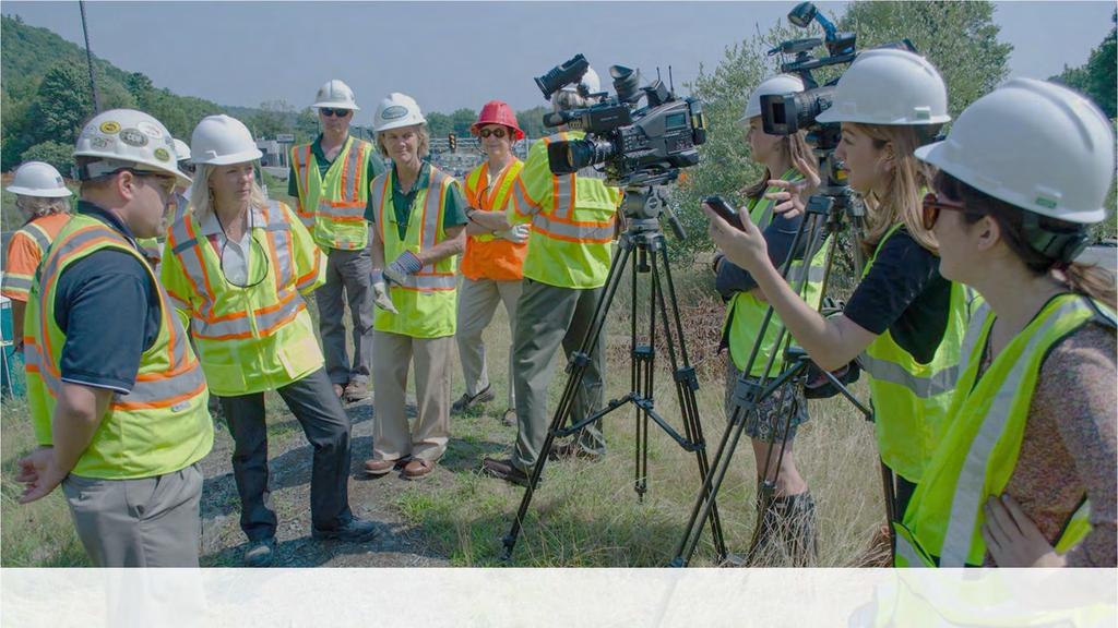
6 Chester Country Store Public Outreach Critical to success of all ABC projects Business communities have high influence Important to consider loss of business in choosing closure times/durations Share early success stories Garner stakeholder support 6
7 Partnering with Local Communities Public input through community Questionnaires Polling Clickers used to gain input at public meetings Stakeholder meetings Act 153 for Town Highway Bridge Projects Local Bypass Mitigation State Bridges 7
8 Act 153 Town Highway Bridge Projects 100% 90% 80% 2012: Legislation is passed 50% Reduction in local share if the Town closes the bridge during construction 5% local share for Bridge Replacement 2.5% local share for Bridge Rehabilitation % of Towns Taking Advantage of Act 153 How many Towns are taking advantage of Act 153? Number of Towns Taking Advantage of Act Act 153 is passed % 60% 50% 40% 30% 20% 10% 0% Highly successful at propelling widespread adoption of ABC Very popular and many towns have elected to close roads since legislation Encourages Lower Costs, Faster Project Development, and Reduced Environmental Impacts 8
9 ABC Closure Durations 90% of the ABC projects are the work horse bridge Road closure duration must fit the project need Most common closure duration is days Mobility maintained through local road systems Emergency services able to maintain response time Contractors able to maintain safe sustainable work pace Vermont ABC Closure Statistics: 22% = hour closure 18% = 7-14 day closure 45% = day closure 15% = Greater than 28 day closure Now that our library of successes has been built, we are relaxing on closure durations 9

10 Short Term Road Closures Number of Projects Utilizing Maintenance of Traffic Option Offsite Detour Temporary Bridge Phased 10

11 Structures & Hydraulics Website 11

12 Branding Stickers ABP Banner Shirts 12


13 Project Fact Sheets 13

14 Public Facing Project External Website Plans and presentations (Link sent to stakeholders)

15 ABP Promotional Videos Planned Road Closure Map Getting the Word Out 15
16 Providing Project Alerts During Construction updates, Front Porch Forum postings, and project websites 16
17 Public Involvement Plan


18 Accelerated Bridge Program Highlights Six Years of Proven Performance June 25,


19 85 ABC projects Delivered since % of all Projects In Structures 98% on time Bridge openings 19


20 Customer Survey Results How satisfied were you with ABC? 397 Responses from 9 projects 9% 5% 0% 1% 85% Very Satisfied Somewhat Satisfied Neither Satisfied nor Dissatisfied Somewhat Dissatisfied Very Dissatisfied 20
 US")

21 Woodstock Village BF 020-2(43) US Route 4 Bridge #51 over Kedron Brook 21
22 Woodstock, VT Project ABC projects can work in various locations and site constraints!! ABC was the ideal method for the Woodstock Village Downtown area High level of public involvement Alternative Presentation Meeting Historic Railing Type Determination Meeting Meeting at Final Plans Stage Pre-Construction Meeting Town recognizes key stakeholders for project Businesses heavily involved throughout process 22

23 Location Map 23


24 Project Location Interview Question What was the major concern of the Town Select board for the reconstruction activities of bridge 51? Construction Impacts to businesses 24


25 Looking East Over Bridge Existing Conditions Bridge #51 Roadway Classification Principal Arterial on NHS (Class 2 TH) Bridge Type 34 Long Concrete T-Beam Bridge Constructed in 1935 Ownership Village of Woodstock 25


26 Looking West Over Bridge Interview Question Did you have a specific time of year that worked better to minimize impacts to businesses? Early Spring Existing Conditions Bridge #51 Bridge and approach are narrow Parking meters and signs are located within clear zone 26
27 Interview Question Was there a length of closure period that was acceptable? 21 days was voted on at the alternatives presentation meeting 27


28 Interview Question What benefit did the public meetings have on the Community? Opportunity to express concerns


29 Precast Solid Slabs Interview Question Woodstock Bridge #51 Superstructure Replacement Project What was the overall reaction to the Varied span length impacts of Construction on the Precast solid slabs Community? i.e. receive a lot of complaints? Specified 21 Day Closure Period Met Expectations opened 4 days early! 29


 park")
30 Resource Constraints Existing Conditions - Bridge #51 Historic Bridge ornamental hexagonal concrete railings typical of 1930 s Located within the Woodstock Village Historic District Section 4(f) park property located in southwest quadrant Aquatic Organism Passage 30


 park")

31 Resource Constraints Existing Conditions - Bridge #51 Historic Bridge ornamental hexagonal concrete railings typical of 1930 s Located within the Woodstock Village Historic District Section 4(f) park property located in southwest quadrant Aquatic Organism Passage 31

32 Bridge Open! 32
33 VTrans Structures Website For More Information ACT 153 Legislation %20Enacted.pdf ABP Promotional Videos VTrans Public Involvement Guide lvementguide2017.pdf Woodstock Village Project SharePoint Site 33
34 Questions? Public Outreach/ABC Results
Middlebury RS 0174(8)
") Middlebury RS 0174(8) Preferred Alternative Meeting VT 125 Bridge #13 over Middlebury River August 6, 2012 Presented to Presented by Town of Middlebury VTrans & VHB Introductions: Jennifer Fitch VTrans
Middlebury RS 0174(8) Preferred Alternative Meeting VT 125 Bridge #13 over Middlebury River August 6, 2012 Presented to Presented by Town of Middlebury VTrans & VHB Introductions: Jennifer Fitch VTrans
Southern Windsor County RPC Transportation Project Priorities Methodology January 2016
 Southern Windsor County RPC Transportation Project Priorities Methodology January 2016 The Southern Windsor County Regional Planning Commission (the RPC) has been evaluating and prioritizing transportation
Southern Windsor County RPC Transportation Project Priorities January 2015
 Southern Windsor County RPC Transportation Project Priorities January 205 The Southern Windsor County Regional Planning Commission (the RPC) has been evaluating and prioritizing transportation projects
WELCOME TO PUBLIC INFORMATION CENTRE #2. Please Sign In
 WELCOME TO PUBLIC INFORMATION CENTRE #2 Replacement of Oxtongue Lake Narrows Bridge & Oxtongue River Bridge, Highway 60 (G.W.P. 93-89-00 & G.W.P. 5550-04-00) Class Environmental Assessment (Group B) Please
MADRID MINING LANDSCAPE Western Planner/Nevada APA Conference. A New Mexico Abandoned Mine Land (AML) Program Community-Based Planning Project
 Program Community-Based Planning Project") MADRID MINING LANDSCAPE 2013 Western Planner/Nevada APA Conference A New Mexico Abandoned Mine Land (AML) Program Community-Based Planning Project Presented by: Ken Romig, ASLA Associate, Dekker/Perich/Sabatini
MADRID MINING LANDSCAPE 2013 Western Planner/Nevada APA Conference A New Mexico Abandoned Mine Land (AML) Program Community-Based Planning Project Presented by: Ken Romig, ASLA Associate, Dekker/Perich/Sabatini
Victoria Bridge Municipal Class EA Civic Works Committee
 Municipal Class EA John Pucchio, P. Eng., Project Manager June 19 2018 Introduction Existing Conditions Municipal Class EA Proposed Bridge Proposed Road Reconstruction Proposed Improvements Construction
Chapter 10 Route window W17 Middlegreen Road, St Mary s Road and Trenches bridges. Transport for London
 Chapter 10 Route window W17 Middlegreen Road, St Mary s Road and Trenches bridges Transport for London MIDDLEGREEN ROAD, ST MARY S ROAD AND TRENCHES BRIDGES 10 Route window W17 Middlegreen Road, St Mary
Kankakee River Bridge & Track Improvements Supplemental Environmental Assessment. May 5, 2016
 Kankakee River Bridge & Track Improvements Supplemental Environmental Assessment May 5, 2016 1 History: Chicago-St. Louis Corridor Since 1980 s IDOT has been looking at this corridor for high-speed service
WELCOME TO THE PUBLIC INFORMATION CENTRE. Please Sign In
 WELCOME TO THE PUBLIC INFORMATION CENTRE Replacement of Oxtongue Lake Narrows Bridge & Oxtongue River Bridge, Highway 60 (G.W.P. 93-89-00 & G.W.P. 5550-04-00) Class Environmental Assessment (Group B) Please
ONLINE PUBLIC INFORMATION CENTRE
 ONLINE PUBLIC INFORMATION CENTRE County Road 17 Bridge Replacements Detail Design and Environmental Assessment GWP 4203-15-00 The Ministry of Transportation Ontario (MTO) has retained CH2M Hill and Dillon
Municipal Class EA Study Public Information Centre No. 1 December 13, :00 pm 7:00 pm. Please sign in so we can keep you updated on this study
 Reconstruction of Regional Road 45 (Creek Road) Between Regional Road 27 (River Road) and Regional Road 63 (Canborough Road) in the Township of Wainfleet Municipal Class EA Study Public Information Centre
BRIDGE REHABILITATION ANALYSIS AND FEASIBILITY REPORT
 BRIDGE REHABILITATION ANALYSIS AND FEASIBILITY REPORT SR 0016-037 Main Street Bridge Project Memorial Bridge over the West Branch of Little Antietam Creek in Waynesboro Borough and Washington Township
St. Clair Avenue West Area Transportation Master Plan
 1 (Between Keele Street and Old Weston Road) Public Information Centre 1 December 2, 2015 2 Welcome Welcome to the first Public Information Centre for the St. Clair Avenue West Area. The panels will present
TRANSPORTATION COMMITTEE
 TRANSPORTATION COMMITTEE CITY OF OTTAWA Ministry of Transportation Detailed Design Assignment G.W.P.# 4058-01-00 Highway 417 (Ottawa Queensway) Widening & Rehabilitation from Maitland Avenue to Island
Transport Planning And Design Manual Volume 2 Chapter 3
 Transport Planning And Design Manual Volume 2 Chapter 3 Chapter 300 Design Documentation, Approval, and Process Review 120-2. Transportation Improvement Programs. 120-3. Linking Planning and Programming
GLEN ROAD PEDESTRIAN BRIDGE ENVIRONMENTAL ASSESSMENT STUDY PUBLIC INFORMATION CENTRE #2 OCTOBER 24, 2017
 GLEN ROAD PEDESTRIAN BRIDGE ENVIRONMENTAL ASSESSMENT STUDY PUBLIC INFORMATION CENTRE #2 OCTOBER 24, 2017 Glen Road Pedestrian Bridge Class Environmental Assessment 1 WELCOME! Welcome to the second Public
Inform you of the purpose and scope of the study for PTH 100 and a proposed future St. Norbert Bypass;
 WELCOME The intent of today s Open House is to: Inform you of the purpose and scope of the study for PTH 100 and a proposed future St. Norbert Bypass; Review highway crossing locations, future access closures
Project Purpose. Project Need
 Project Purpose The purpose of the project is to implement a bridge improvement solution that corrects the existing safety problem at the Strasburg Pike Bridge. The project will provide a structurally
Chapter 1 - General Design Guidelines CHAPTER 1 GENERAL DESIGN GUIDELINES
 CHAPTER 1 GENERAL DESIGN GUIDELINES 1.0 INTRODUCTION This Publication has been developed to provide current, uniform procedures and guidelines for the application and design of safe, convenient, efficient
Highway 417 Expansion East
 Highway 417 Expansion East Nicholas Street to Ottawa Road 174 GWP 4091-07-00 & GWP 4320-06-00 Outline Project Overview Highway 417 Widening Bridge Rapid Replacements Traffic & Incident Management Project
Bridge Type Assessment and Evaluation
 16M-01410-01 (3216026) Glen Road Pedestrian Bridge EA Study Bridge Type Assessment and Evaluation Factor Group/Criteria Alternative 1: Steel girder with two inclined steel legs Alternative 2: Steel girder
Urban Development Area (UDA) Process in Virginia: History & Requirements
 Process in Virginia: History & Requirements") Urban Development Area (UDA) Process in Virginia: History & Requirements J. Kelli Nash Office of Intermodal Planning and Investment VDOT Coordinating Transportation & Land Use Forum Thursday, June 2, 2016
Urban Development Area (UDA) Process in Virginia: History & Requirements J. Kelli Nash Office of Intermodal Planning and Investment VDOT Coordinating Transportation & Land Use Forum Thursday, June 2, 2016
Rappahannock- Rapidan Regional Commission
 Rappahannock- Rapidan Regional Commission Last Updated July 2008 RAPPAHANNOCK-RAPIDAN REGIONAL TRANSPORTATION PLAN The Virginia Department of Transportation (VDOT) and the Rappahannock-Rapidan are partnering
District of Muskoka Transportation Study
 District of Muskoka Transportation Study January 18, 2017 EPW Committee Presentation Study Purpose 2 1 Road Rationalization Review 2 Road Classification Review 3 Road Standards Review 4 Transportation
Spring 2018 Construction Update
 Spring 2018 Construction Update Ward 3 Southwest Engineering Department Locust Street Bridge over the Des Moines River The Locust Street Bridge over the Des Moines River project is being let through the
Active Neighbourhoods Canada SUMMARY REPORT
 Prepared by the Toronto Centre for Active Transportation JUNE 2017 Active Neighbourhoods Canada SUMMARY REPORT OF 4 ONTARIO PROJECTS Sharing participatory methods in Ontario Active Neighbourhoods Canada
WHAT IS THE PURPOSE OF THE OPEN HOUSE?
 WHAT IS THE PURPOSE OF THE OPEN HOUSE? OPEN HOUSE PURPOSE The purpose of the open house is to provide an update on the study process and introduce the preliminary concept alternatives. The open house provides
ROAD CONSTRUCTION. 36 June 2014 ROADS&BRIDGES
 ROAD CONSTRUCTION 36 June 2014 ROADS&BRIDGES Young is full of life Recent expansion completes continuous, multilane arterial By Donald Hammack, P.E. Contributing Author The Florida Department of Transportation
Century Highfield Sub Area Plan
 Century Highfield Sub Area Plan The Century Highfield Sub Area Plan provides an opportunity to re evaluate the vision that was set forth for this area when the Township conducted a similar planning exercise
Local Municipal Forecast. OPAC Partners in Quality Road Tour Ottawa April 19, 2018
 Local Municipal Forecast OPAC Partners in Quality Road Tour Ottawa April 19, 2018 1 2018 Tonnage Survey 2 Survey - Background 2018 Municipal Asphalt Paving Tonnage Survey Circulated to all Ontario municipalities
Chapter 1.0 Introduction
 Chapter 1.0 Introduction 1.1 Background The North Metro commuter rail line is part of the RTD FasTracks regional transit system expansion program to build more than 100 miles of rail transit throughout
Municipal Heritage Bridges Cultural, Heritage and Archaeological Resources Assessment Checklist Revised April 11, 2014
 Municipal Heritage Bridges Cultural, Heritage and Archaeological Assessment Checklist Revised April 11, 2014 This checklist was prepared in March 2013 by the Municipal Engineers Association to assist with
Creating Complete Roadway Corridors:
 Creating Complete Roadway Corridors: The AASHTO Guide to Transportation Landscape Architecture and Environmental Design NCHRP Project 15-33 Status Report AASHTO Standing Committee on Design Technical Committee
Overall Map. Chicago. St. Louis. Summit. Joliet. Dwight. Pontiac. Bloomington-Normal Lincoln. Springfield. Carlinville. Alton EXPERIENCE IT YOURSELF.
 Overall Map Summit Chicago Bloomington-Normal Lincoln New Station Planned New Station Planned Dwight Pontiac Joliet Pedestrian overpass and second platform planned Higher speed service began in this section
I. DESCRIPTION OF PROPOSED ACTION... 1 A. General Description... 1 B. Historical Resume and Project Status... 2 C. Cost Estimates...
 PROJECT COMMITMENTS SUMMARY... S-1 1. Type of Action... S-1 2. Description of Action... S-1 3. Summary of Purpose and Need... S-1 4. Alternatives Considered... S-2 5. NCDOT Alternatives Carried Forward...
Chapter 1: General Program Information
 Chapter 1: General Program Information 1.1 Introduction The Montgomery County Stormwater Management Resolution (#03-1-5) was adopted by the County Board of Commissioners on January 22, 2003. The purpose
The Ambassador Bridge/ Gateway Project
 The Ambassador Bridge/ Gateway Project Connecting Neighbors & Driving the Economy 2008 Ohio Conference on Freight Given by the Toledo Metropolitan Area Council of Governments, National Association of Regional
West Dennis Center: Bass River to Old Main Street. West Dennis Business District: Old Main Street to Dennis Commons
 West Dennis Center: Bass River to Old Main Street West Dennis Business District: Old Main Street to Dennis Commons Dennisport Center: Dennis Commons to Division Street Main Street Project Goals Project
Local Municipal Forecast. OPAC Partners in Quality Road Tour Sudbury April 17, 2018
 Local Municipal Forecast OPAC Partners in Quality Road Tour Sudbury April 17, 2018 1 2018 Tonnage Survey 2 Survey - Background 2018 Municipal Asphalt Paving Tonnage Survey Circulated to all Ontario municipalities
HS2 Environment. Protecting the environment
 HS2 Environment Protecting the environment Approach to mitigation EIA Regulations require an ES to include a description of the measures envisaged in order to avoid, reduce and, if possible, remedy significant
A1 Scotswood to North Brunton Public Information Exhibition Executive Summary
 A1 Scotswood to North Brunton Public Information Exhibition Executive Summary Introduction The A1 Scotswood to North Brunton scheme is proposed on the A1 Newcastle Gateshead Western Bypass (NGWB) between
I-90 Mississippi River Bridge & Interchange Project
 I-90 Mississippi River Bridge & Interchange Project Presentation Outline I. Background: Context & Need for Project II. Preferred Alternative Overview III. Project Development IV. Project Management Tools
The Village of Sugar Grove, in partnership with Kane County, the Illinois Department of Transportation, and the Illinois Tollway welcomes you to the
 The Village of Sugar Grove, in partnership with Kane County, the Illinois Department of Transportation, and the Illinois Tollway welcomes you to the first Public Meeting for the proposed interchange improvement
Chapter 7 Route window W20 Dover Road and Leigh Road bridges. Transport for London
 Chapter 7 Route window W20 Dover Road and Leigh Road bridges Transport for London ROUTE WINDOW W20 7 Route window W20 Dover Road and Leigh Road bridges Transport for London 7.6 7.7 7.8 Baseline conditions
Expo Line Transit Project. Project Status Update Meeting West End Corridor Segment C
 Exposition Light Rail Transit Project Project Status Update Meeting West End Corridor Segment C Culver City Senior Center November 18, 2010 Phase 1 Project Description Phase 1 from Downtown Los Angeles
Introduction to the Project
 Chapter 1 Introduction to the Project 1.1 Project Introduction The New Hampshire Department of Transportation (NHDOT) and the Federal Highway Administration (FHWA) have prepared this Environmental Assessment/Draft
Bucks Bar Road Bridge Project Public Informational Meeting Wednesday, January 6, 2010
 PRESENTED BY: Bucks Bar Road Bridge Project Public Informational Meeting Wednesday, January 6, 2010 Matthew Smeltzer, P.E. Deputy Director of Engineering, DOT Supervisor Ray Nutting El Dorado County, District
Urban Planning and Land Use
 Urban Planning and Land Use 701 North 7 th Street, Room 423 Phone: (913) 573-5750 Kansas City, Kansas 66101 Fax: (913) 573-5796 Email: planninginfo@wycokck.org www.wycokck.org/planning To: From: City Planning
Mavis Road Class Environmental Assessment
 Mavis Road Class Environmental Assessment Public Information Centre #2 Wednesday November 9, 2016 6:00 to 8:00 p.m. Please sign in and complete a comment sheet Review the displays on your own or join in
ROANOKE STREET IMPROVEMENTS CHRISTIANSBURG, VIRGINIA VDOT PROJECT # U R24 UPC #:
 ROANOKE STREET IMPROVEMENTS CHRISTIANSBURG, VIRGINIA VDOT PROJECT # U000-154-R24 UPC #: 108868 VICINITY MAP This project is to be constructed in accordance with the Virginia Department of Transportation
PROJECT BACKGROUND. Preliminary Design Scope and Tasks
 PROJECT BACKGROUND Preliminary Design Scope and Tasks The purpose of this Study is the development of preliminary designs for intersection improvements for Trunk Highway (TH) 36 at the intersections of
Blackfriars Bridge Municipal Class Environmental Assessment. Public Information Centre #1 November 19 th, 2014
 Blackfriars Bridge Municipal Class Environmental Assessment Public Information Centre #1 November 19 th, 2014 Why are you here tonight? To determine the future requirements of the river crossing at Blackfriars
Supporting our communities. Bridges
 Supporting our communities Bridges 1,000+ We ve partnered with thousands of owners/clients to inspect, analyze, design, and manage their bridges, providing lasting community connections. We design bridges
Highway 15 Project - Hutchinson
 Highway 15 Project - Hutchinson Agenda What are we going to talk about today? Goals and benefits of the project Details about the proposed work Project schedule and costs Any questions you may have about
Proposed Comprehensive Plan Strategies DRAFT for discussion June 28, 2017
 Proposed Comprehensive Plan Strategies DRAFT for discussion June 28, 2017 Land Use Rural Areas Refine the Farm and Forest area (FF) Update FF boundaries to account for existing lots less than five acres
MARINA BAY NEIGHBORHOOD PRESENTATION. City of Richmond Officer Bradley A. Moody Memorial Underpass. April 11, 2012
 MARINA BAY NEIGHBORHOOD PRESENTATION City of Richmond Officer Bradley A. Moody Memorial Underpass April 11, 2012 TEAM INTRODUCTIONS Project Oversight and Approval City of Richmond Formally Richmond Community
Lesson 6. Corridor Planning
 Lesson 6 Corridor Planning 1 Learning Outcomes Identify land use strategies and solutions that can be incorporated into multimodal transportation corridor plans Identify land use stakeholders and describe
Public input has been an important part of the plan development process.
 Lakewood s Comprehensive Plan recognizes that transportation helps shape the community, and that the way the community provides for the safe and efficient movement of people affects the character of the
1.0 INTRODUCTION 1.1 TH 14 WEST STUDY AREA Project Description Functional Classification Purpose of the Project
 1.0 INTRODUCTION 1.1 TH 14 WEST STUDY AREA 1.1.1 Project Description The Trunk Highway (TH) 14 West Corridor is a two-lane roadway approximately 22 miles in length. Located in Nicollet County, the corridor
State Project No Heroes Tunnel
 Public Scoping Meeting State Project No. 167-108 Bridge No. 00773 Heroes Tunnel Route 15 Wilbur Cross Parkway Through West Rock Ridge Towns of Hamden, Woodbridge City of New Haven Agenda Show Project Location
Project Advisory Committee
 Project Advisory Committee March 1, 2006 Meredith US 3/NH 25 Improvements Transportation Planning Study A Changing New Hampshire Source: Society for the Protection of NH Forests, 2005. Meredith US 3/NH
2.0 PURPOSE AND NEED. 2.1 Purpose. 2.2 Need Traffic Congestion in and around Downtown Derry
 2.0 PURPOSE AND NEED Taking into consideration agency and public input, the purpose and need for the Project was identified early in Project planning. As noted in Appendix A, for purposes of meeting the
EXECUTIVE SUMMARY. Introduction
 Introduction EXECUTIVE SUMMARY The Urban Service Area Fort McMurray (hereafter referred to as the Urban Service Area) is currently experiencing a variety of development pressures. Unprecedented population
ORDINANCE AN ORDINANCE TO ADD A NEW SECTION 4.N. IN THE ZONING CODE FOR THE TOWN OF MIDDLETOWN, RELATING TO MIXED-USE DEVELOPMENT
 Introduced: November 5, 2018 Approved: ORDINANCE 18-11-01 AN ORDINANCE TO ADD A NEW SECTION 4.N. IN THE ZONING CODE FOR THE TOWN OF MIDDLETOWN, RELATING TO MIXED-USE DEVELOPMENT BE IT ENACTED BY THE MAYOR
The MSII reports for the bridge indicate that the Annual Average Daily Traffic at the bridge is 100. The road can be considered a low volume road.
 Page 1 1 INTRODUCTION 1.1 Background The Bronk Road Bridge is located on Bronk Road about 0.2 km north of Thrasher Road and spans Parks Creek, a tributary of the Moira River. Bronk Road is the road allowance
foi"#'.w County Road Needs Report i*"-i"s;a,i=?;;,#'1 County udges' Association of Arkansas 20L7 Annual Winter Meeting le0isrtnet tta shsl201-7
 FLOOD PLAIN SERVICES County Road Needs Report County udges' Association of Arkansas 20L7 Annual Winter Meeting Thomas F. Black, P.E., CFM shsl201-7 i*"-i"s;a,i=?;;,#'1 tta le0isrtnet foi"#'.w Flood Plain
Fall 2017 Construction Update
 Fall 2017 Construction Update Ward 4 Southeast Engineering Department Riverwalk Red Multi-Use Trail Bridge Rehabilitation The Riverwalk Red Multi Use Trail Bridge was awarded to Cramer and Associates,
THE GARDEN CITY PLAN. City of St. Catharines Official Plan. City of St. Catharines
 THE GARDEN CITY PLAN City of St. Catharines Official Plan City of St. Catharines August 2010 APPROVAL INFORMATION This Official Plan of the City of St. Catharines Planning Area, known as the Garden City
Elm Street Business District: Streetscape and Signage Plan
 Elm Street Business District: Streetscape and Signage Plan VILLAGE OF WINNETKA DOWNTOWN MASTER PLAN VILLAGE COUNCIL MEETING Final Streetscape & Signage Planning Teska Associates 04 June 2018 WHY WE RE
Final Design Meeting. September 25, Creating Bridges As Art. Welcome & Introductions. Terry Ward - Project Manager
 Final Design Meeting September 25, 2014 Creating Bridges As Art 1 Welcome & Introductions Terry Ward - Project Manager 2 VQRC Final Design Meetings Meeting Date Items for Discussion Final Design Meeting
ALTERNATIVES. NCDOT made an early decision to first determine how to build the project (construction method) followed by what to build (alternatives).
 followed by what to build (alternatives).") III. ALTERNATIVES A. CONSTRUCTION METHOD ALTERNATIVES NCDOT made an early decision to first determine how to build the project (construction method) followed by what to build (alternatives). One of the
III. ALTERNATIVES A. CONSTRUCTION METHOD ALTERNATIVES NCDOT made an early decision to first determine how to build the project (construction method) followed by what to build (alternatives). One of the
FY 2018 TRANSPORTATION CAPITAL PROGRAM New Jersey Department of Transportation Projects
 Schooleys Mountain Bridge Rehabilitation Project ID Numbers: N1707 / 173470 Schooleys Mountain Road Bridge was built in 1920 and widened in 1937. The project is a replacement of the bridge structure and
WELCOME NEIGHBORS! April 11, 2019
 District of Columbia Water and Sewer Authority David L. Gadis, CEO and General Manager Clean Rivers Project Northeast Boundary Tunnel Tunnel Forum Meeting WELCOME NEIGHBORS! April 11, 2019 0 Welcome! 1
New Stanton Project Update July 3, 2012
 New Stanton Project Update July 3, 2012 The Needs BACKGROUND INFO I-70 Geometric Concerns Substandard Horizontal & Vertical Clearance at Center Ave. Bridge (The Center Avenue Bridge is Replaced in all
The Canterbury Society and the Alliance of Historic Cathedral Cities and Towns. Jan Pahl and John Walker
 The Canterbury Society and the Alliance of Historic Cathedral Cities and Towns Jan Pahl and John Walker SE Historic Environment Forum 15 November 2017 Aims of the presentation Our aim today is to: Introduce
FutureVU Pop-Up Events Fall Spring 2018
 FutureVU Pop-Up Events Fall 2017- Spring 2018 Completed Pop-Up Projects: Park(ing) Day September 15, 2017 Vanderbilt participated for the first time in this internationally recognized event in which parking
APPENDIX A: Willamette River Bridge Survey
 APPENDIX A: Willamette River Bridge Survey The Oregon Department of Transportation is in the final phase of completing the Environmental Assessment which outlines the potential environmental impacts of
National Register of Historic Places Continuation Sheet
 NPS Form 10-900-a (Rev. 8/2002) OMB No. 1024-0018 (Expires 5-31-2012) United States Department of the Interior National Park Service National Register of Historic Places Continuation Sheet Bridge No. 5721
Clay Street Bridge Replacement Project
 Clay Street Bridge Replacement Project Frequently Asked Questions (FAQs) No. 2 April 4, 2018 The project is located in downtown Placerville on Clay Street between US Highway 50 and Main Street and Cedar
WELCOME TO OPEN HOUSE TWO November 28, 2018
 Langstaff Road Weston Road to Highway 7 Class Environmental Assessment Study WELCOME TO OPEN HOUSE TWO November 28, 2018 Please sign in and join our mailing list Study Overview York Region is conducting
CHAPTER 7: Transportation, Mobility and Circulation
 AGLE AREA COMMUNITY Plan CHAPTER 7 CHAPTER 7: Transportation, Mobility and Circulation Transportation, Mobility and Circulation The purpose of the Transportation, Mobility and Circulation Chapter is to
Blood Alley Square/Trounce Alley Redesign
 June 216 Kick-Off Events Questionnaire and Engagement Summary Background The City of Vancouver is redesigning Blood Alley Square and Trounce Alley, important public spaces in the heart of Gastown, which
Lake Hazel/Gowen Relocation Alignment Study Report
 Lake Hazel/Gowen Relocation Prepared for 3775 Adams Street Garden City, Idaho 83714 And City of Boise 150 North Capitol Blvd. Boise, Idaho 83702 Prepared by Parametrix 7761 W. Riverside Dr. Suite 201 Boise,
2017 Canadian Consulting Engineering Awards
 2017 Canadian Consulting Engineering Awards Northeast Anthony Henday Drive DBFO Edmonton, Alberta Four years of detours, traffic snarls, varying speed limits, and stop-and-start driving has come to an
LANDSCAPE SERVICE USE DISCUSSION
 LANDSCAPE SERVICE USE DISCUSSION Board of County Commissioners January 25, 2018 Zoning Division What is a Landscape Service Use? Definition: An establishment engaged in the provision of landscape maintenance
Chapter V-Transportation
 Town of Vernon 2026 Smart Growth Plan Chapter V-Transportation DEVELOPMENT OBJECTIVES Transportation System Objective - To provide an integrated transportation system which, through its location, capacity,
Environmental Statement Review for Infrastructure
 Environmental Statement Review for Infrastructure Temple s added value Temple is one of the UK s leading independent infrastructure and property consultancies, specialising in environment, planning and
WELCOME! 8 8:30 6: TH STREET IMPROVEMENTS. Open House. Presentation & Q&A
 WELCOME! 168 TH STREET IMPROVEMENTS 6:30 Open House 7 8 Presentation & Q&A 8 8:30 Open House WELCOME Todd Pfitzer City of Omaha Engineer Bob Stubbe City of Omaha Public Works Director Jon Meyer Project
Table L-1 Summary Action Strategy. Action Item Timing Status Responsible Agency
 CHAPTER 4: CIRCULATION ELEMENT ISSUE #1: MAJOR THOROUFARES AND TRANSPORTATION ROUTES A balanced transportation system for Fontana is provided that meets the mobility needs of current and future residents
NORTH-SOUTH CORRIDOR STUDY EXECUTIVE SUMMARY. Executive Summary
 Executive Summary Background As congestion continues to affect mobility in the region, the Ozarks Transportation Organization (OTO) is particularly concerned with traffic movement. The North-South Corridor
AASHTO SUBCOMMITTEE ON DESIGN. June 15, 2006 MARK ROBINSON, P.E. DISTRICT 5 INTERSTATE PROGRAM MANAGER FLORIDA DEPARTMENT OF TRANSPORTATION
 AASHTO SUBCOMMITTEE ON DESIGN June 15, 2006 MARK ROBINSON, P.E. DISTRICT 5 INTERSTATE PROGRAM MANAGER FLORIDA DEPARTMENT OF TRANSPORTATION CENTRAL FLORIDA INTERSTATE 4 FACTS Trucks and Others 12% Tourist
Honorable Members of the Mobility Solutions, Infrastructure and Sustainability Committee
 Memorandum DATE January 23, 2019 CITY OF DALLAS TO Honorable Members of the Mobility Solutions, Infrastructure and Sustainability Committee SUBJECT I-30 East Project Update On Monday, January 28, 2019,
Anderson Memorial Bridge Rehabilitation Project Boston/Cambridge
 Anderson Memorial Bridge Rehabilitation Project Boston/Cambridge MEPA Meeting, EEA#14702 Wednesday, March 2, 2011 6:30 PM Dr. Martin Luther King, Jr. School 100 Putnam Avenue, Cambridge, MA Rendering by:
Welcome to the Sellwood Bridge Project Pre-Construction Open House
 Welcome to the Sellwood Bridge Project Pre-Construction Open House 5:30 7:30 p.m. Please sign in here Information stations and project staff are located throughout the room. Goals for Tonight s Meeting
Emery Village Road 2A Municipal Class Environmental Assessment Study
 PW12.11 STAFF REPORT ACTION REQUIRED Emery Village Road 2A Municipal Class Environmental Assessment Study Date: March 30, 2016 To: From: Wards: Reference Number: Public Works and Infrastructure Committee
Corridor Management Committee. September 29, 2017
 Corridor Management Committee September 29, 2017 1 Today s Topics Chair s Update Proposed Corridor Protection Wall Aesthetic Design Overview Public Outreach Environmental Review Civil Construction Update
FIRE AND RESCUE. Intent
 FIRE AND RESCUE Intent The Fire and Rescue Plan is designed to maintain Prince William County as a safe community, reducing loss of life, injury, and property from fire and/or accident. The mission of
Low Level Road Project. Canadian Consulting Engineers Award 2016
 Low Level Road Project Canadian Consulting Engineers Award 2016 A local resident enjoys a forested section of the Spirit Trail, which connects to Moodyville Park near the east abutment of the Woodland
Land Use & Infrastructure Master Plan City of Orlando Council Work Session
 DOWNTOWN ORLANDO Community Venues Land Use & Infrastructure Master Plan City of Orlando Council Work Session Prepared By: Glatting Jackson Kercher Anglin Lopez Rinehart, Inc. May 1, 2006 AGENDA Community
SR Year Transportation & Land Use Plan Update NEW CASTLE COUNTY COUNCIL LAND USE COMMITTEE, AUGUST 30, 2016
 SR 141 20-Year Transportation & Land Use Plan Update NEW CASTLE COUNTY COUNCIL LAND USE COMMITTEE, AUGUST 30, 2016 Project background Route 141 is a major arterial which links the City of New Castle to