TRIALOGUE PROCESSES IN LANDSCAPE DESIGN
|
|
|
- Brianna Anderson
- 6 years ago
- Views:
Transcription
1 TRIALOGUE PROCESSES IN LANDSCAPE DESIGN 1. INTRODUCTION This paper looks at strategic urban projects focusing specifically on planning and design of open spaces, acknowledging their multiple roles in promoting cultural and environmental sustainability. It focuses on a strategic urban project named Municipal System of Green and Leisure Areas (SMAVL) put forward to the municipality of Santo André, located at São Paulo Metropolitan Region, Brazil. A trialogue as a process for constructing an urban project is proposed, relating simultaneously issues regarding the nature of the landscape site, mainly through its vegetation and water system, with issues related to cultural values, including a program of participation of local population in the decision making processes. The open spaces approach is so addressed from the analysis of three main structures: the green system, which is the whole of the vegetated areas; the blue system, which is the watershed basis of the landscape; and the system of culture, which comprises the values and meanings ascribed to landscape from local people, including public authorities, decision-makers, planners and private sectors. From this perspective, decision making concerning design and planning would be a consequence of physical and cultural structure based on these systems, whether being at a neighbourhood, city or metropolitan scales. The paper is organized as follows. Initially it discusses the theoretical basis of the proposed trialogue. This is followed by a discussion on Santo André strategic urban project, the guidelines of the SMAVL and methodological procedures. Then the paper discusses the establishment of some of the SMAVL elements. It concludes arguing the importance of the trialogue approach in the landscape and urban design towards a better urban environment. 2. THE MAKING OF THE TRIALOGUE PROCESS Landscape architects have played an important role in the construction of an interdisciplinary conceptual basis which acknowledges landscape values in planning and urban design. In fact, one of the main contributions of landscape architecture in its interplay with architecture and planning is the concept of open spaces system and its role in the quality of urban life. Back in the 19th century, the American landscape architect Frederick Law Olmsted was already concerned with nature preservation issues. He was one of the forerunners who approached the preservation of green natural areas considering also human uses, as in his proposal for Yosemite Park (Spirn 1996). At the same time, he was also one of the first to put forward the idea of green spaces as a system, rather than isolated features in the urban fabric. On this matter, Olmstead was in fact following some European ideas, as for example the English architect John Nash, who establishes an open space system to the north London area, and the 1
2 French Mayor Haussman for Paris, who for the first time conceives a comprehensive open space system for the city as a whole. By the second half of the 20th century, the American landscape architect Ian McHarg (1969) added a new conceptual and methodological approach to these first ideas. With his seminal book Design with Nature, he acknowledged the roles played by natural processes in landscape and urban design, as well as regional planning. McHarg's proposal had a strong international influence, and had influenced many studies for the years to come (see, for instance Spirn 1984 and Hough 1995). We have learned from them, thus, that the green system plays an important role in the construction of urban sustainability. As pointed out by Platt (1994), "the city green", regarded as one of the ways to protect and restore biological processes and phenomenons, is one of the basis of urban sustainability, providing ecological balance to the cities environment. Besides the existing natural and recovered areas, it is also possible to create new ones from the inclusion of vegetation in parks, squares and avenues. This would provide better connections among the different green system elements, as well as better quality and definitions of leisure spaces and other activities. The values of green system have been recognized by different cities around the world and attempts to incorporate the concept in development strategies has occurred from time to time (see for example GLA 2002). On the same token, the green system is of fundamental importance to the maintenance of the watercourses structure within the urban landscape. For this reason, the blue and the green systems are closely related and interdependent. The watershed structure presented in the urban tissue, compounded mainly by streams, rivers and lakes, needs to be connected and visible in the urban landscape. For this end, the physical support provided by the green system is more than important to allow the watershed structure to actively participate of the urban landscape experience. (Hough 1995; Spirn 1984; Linehan e Gross 1998). Acknowledging landscape as a cultural construction, which reflects the values and meanings people ascribe it along time (Cosgrove 1984), it is easy to grasp that the maintenance and the articulation of the green and the blue systems are strongly related with the culture system. Local people ways of living, as well as their ways of seeing the world have, therefore, a direct influence on landscape quality. Here we have, then, the third part of the trialogue concept put forward for the elaboration of a strategic urban project: the active participation of the different society groups all along the conception and implementation process. The next section presents and discusses the experience of the urban project put forward to Santo André municipality, as one of the Brazilian examples, which addressed the urban project issue from these three perspectives. 3. SANTO ANDRE STRATEGIC URBAN PROJECT 3.1 About Santo André Santo André, situated at São Paulo Metropolitan Region, has around inhabitants. It had a distinguished participation in the developing of the Brazilian industry established from 1950 to Together with the municipalities of São Bernardo e São Caetano, Santo André 2
3 compounds the so-called "ABC region", one of the country's most important industrial areas along the Santos-Jundiaí Railroad, within the Tamanduateí river valley (fig. 1). From 1980 onwards, the city faced a decreasing process of industrialization, presenting a number of socio-environmental problems. Economic and political situation had brought strong changes, which in turn were reflected in urban transformations. This decreasing process of industrialization occurred in all ABC region. This situation led to the creation of the ABC Chamber, compounded by region s municipalities, aiming to find solutions for regional growth. Besides, by the end of the 1980s Santo André had a series of municipal governments seeking democratic and participative administrations, which was a different attitude concerning urban interventions. Within this process, in 1993 it was established in Santo André a municipal program named Participative Budget (OP Orçamento Participativo). This program provided to the population the rights to get actively involved in the definitions and discussions over the use and application of public financial resources. For this end, the municipality was divided in OP regions through geographic and cultural criteria. The OP program has been since then a powerful instrument in bringing about public consciousness on the importance of the exercise of public rights. At the same time, local population also got involved in the implementation of a number of other municipal programmes, with the aim of creating in Santo André a set of public spaces related to leisure, environmental, sports, educational and cultural issues. Some public parks created within these programmes are now examples of innovative public initiatives, which brought about a better quality of life for local people, contributing to the construction of a new city image and to its social and economical growth. Santo André s Participative Master Plan i, approved in 2004, was developed through a comprehensive public participation process. It involved a great deal of work, reflection and negotiation among the municipality s representatives and technicians, and the organized civil society s representatives (social movements, industries, non-governmental organizations and technical, academics and research institutions). The Plan defined two macrozones in the municipality (fig.1): the Urban Macrozone, situated at the north area, and the Environmental Protection Macrozone, situated at the south area. Within this context, the Master Plan determined the creation of the Municipal System of Green and Leisure Areas (SMAVL) ii (fig.2), acknowledging the existence of squares, parks and other leisure spaces typologies which were intensively used and valued by local people, but at the same time were also insufficient due to unbalanced quantity and distribution throughout the city. It was not, therefore, a connected and structured system. These spaces have been used by Santo André s dwellers for a variety of reasons. From nature appreciation to cultural, sport and cultural activities, they have been providing opportunities for social relations of several kinds, and therefore hosting urban diversity different age groups and social classes. The SMAVL aimed to answer local people requests for the creation of new green areas and the improvement of the existing ones, which were incorporated to the plan. This incorporation represented an important project issue, with the valuing of the well succeed spaces such as the Parque Celso Daniel and the Parque Escola. The plan also emphasized these areas potentialities and characteristics, defining their connections with other open spaces and their role concerning the system and the city. 3
4 From this proposal, a number of activities were organized aiming to endure SMAVL establishment. These activities led to a participative process involving several groups from public authorities and civil society, interacting in discussions, seminars, meetings, workshops and research. In short, this process sought to conceptualize the system and its meanings for the social and economical developing and for the improvement of the life quality in Santo André. The proposal was discussed and approved by the Municipal Chamber of Urban Politics, compounded by the municipality staff and members of popular organizations, labor unions, Non Governmental Organizations, professional and industry representatives. Concerning relevant environmental aspects, Santo André's Urban Macrozone is very dense and compact at northern, western and eastern areas, having its limits with São Paulo, São Bernardo do Campo, São Caetano do Sul and Mauá municipalities. Turning south, it finds environmental and physical restrictions to its expansion. The region suffers a process of population increase of density, with a great demand for public equipments and its consequent significative impacts in urban environmental conditions, indicating thus the intensification of the situation for the near future. In fact, the region presents common problems related to highly urbanized areas: polluted and saturated watershed, therefore generating discomfort and devaluing nearby environments; soil, air, visual and sonorous pollution; lack of green and leisure areas; and heat islands. The Urban Macrozone also presents several flooding points due to the Tamanduateí river overflow, bringing nuisance to many neighbourhoods. The Environmental Protection Macrozone, on its turn, is mainly a Protection and Spring Recovering Area. It presents a rich watercourse that is rather persevered, due to low population density and good vegetal covering. The vegetal covering guarantees, in fact, protection to the water collection in its different environmental situations. 3.2 Plan guidelines The SMAVL allows an addressing of Santo André both from the open space system and the watershed structure. It acknowledges the city s physical and spatial characteristics and its landscape potentials; its association to the urban structure and the relations to the cultural system, incorporating the population process of conscientization and participation. As a structured, connected and continuous whole, the SMAVL is integrated to the urban structure as a part of the urban tissue itself, bringing solutions for the need of leisure and green spaces for Santo André considering issues of quantity, quality, distribution and accessibility. The main objectives of the plan could be summarized as follows: - Guarantee and reinforce the participative process in the projects definitions, in the execution of the project and in the management of SMAVL elements; - reinforce Santo André s environmental and landscape characteristics, improving its capacity of dealing with rain water, of temperature control, of biodiversity maintenance, and local flora and fauna protection; - contribute to public space qualification, to their values and meanings, and to the preservation of collective memory, bringing into play the beauty and diversity of the natural resources preserved in the urban environment; 4
5 - guarantee use diversity and suitable appropriation of public space, according to local cultural values. 3.3 Methodology In 2006, coordinated by the Master Plan Department from the Urban Development and Housing Secretariat, a team work was designated to regulate the SMAVL.This team work was compound by an external consultant and staff from different sectors of the municipality. Initially, the methodological process included a conceptual debate over open space system and typologies. This was important as a support to the structure to be proposed, leading to views to be considered in the specific case of Santo André. This was followed by evaluation, mapping and categorization of spaces administrated by the Parks and Green Spaces Department; spaces which could be potentially destinated to the SMAVL; spaces along streams and springs; spaces with significative vegetation, specially trees; and areas designated as of permanent protection (APP), checking their land ownership situation and existing projects. It was also carried out a research on public demands for green and leisure spaces that came out from the OP meetings, among a number of other procedures. From this point onwards, studies were developed considering the connections among the system elements, land ownership situation and viability studies. Several meetings, seminars and workshops were organized, having the participation of members of the Municipal Chamber of Urban Politics, staff from different sectors of the municipality and representants of popular organizations. From these meetings, the system was enriched with the proposals of new elements, of connections between the new and the existing ones, of indications of streets and avenues for urban treeing, among many other issues. The SMAVL acknowledged the regions defined by the OP, which were regarded as system subareas. The system is, therefore, conceived at two project scales: one encompasses the system as a whole, and the other considers the OP region System structure The SMAVL is structured from a number of elements distributed all over the municipality. They have specific characteristics and use criteria, and are organized around three categories: urban public parks, urban open space and conservation areas. Public parks are green areas inserted in the urban fabric, and present a number of different functions - environmental, aesthetics, leisure, cultural, educational, sport, to name but a few. They are enclosed areas, with defined opening times, security, specific set of rules concerning uses, administrative equipment, and addressing issues of universal mobility and accessibility. The different types of public park differ from each other due to catchment area, space characteristics, as well as leisure, culture, sports and educational features they offer. The Vicinity Park is one example, considering mainly local population and offering a reduced set of 5
6 features. The Neighbourhood Park expands its catchment area to the surrounding population, nearby neighbourhoods, offering a better diversity of features. The Regional Park presents an area and features able to attract users ranging from local people to other nearby cities. And finally, the forth type of urban park is the Linear Park. It is characterized by being linked to the watershed structure, presenting a unique typology, and a long and extensive form. The Linear Park addresses the protection and recovering of ecosystems along watercourses, preventing flooding and connecting other SMAVL components. The second system group is the Urban Public Open Spaces. These are areas inserted in the urban fabric, with the objective of holding educative leisure practices and promoting social values in open spaces. They are also compound by different typologies. The Square is mainly destinated for social gatherings of all kinds, being easily accessed by city dwellers. Traffic Squares are roundabouts, and all sorts of open spaces that were left over the traffic system. The next typology is named Urban Infra-structure Open Spaces, which are large continuous areas, usually linear ones, which could be incorporated to the SMAVL with some restrictions concerning public use and high vegetation. Finally, Green Spaces Associated to Public Services and Institutions, which could be open to the public, and Green Vias and Corridors, which are streets and avenues with continuous vegetation, working as a connection among the different system components, as well as being agreeable promenades for pedestrian and bikers. The Green Vias are conexions in a light and local traffic structure, while the Green Corridors relate to conexions in an intense traffic structure, inter-regional. The third group the Conservation Areas are privileged places concerning nature protection and bio-diversity. The antropic charge, especially cultural, leisure and recreational uses, will be controlled according to environmental legislation in different levels. This group is part of the Environmental Protection Macrozone and, as mentioned above, will be established in the future, and therefore is not the focus of this paper. 4. THE ESTABLISHING OF THE PLAN: SUCCESS AND CONFLICTS The establishing of the SMAVL features has, in a general way, been very successful, involving dwellers and public authorities in participative processes aiming the valuing of squares and green spaces. The discussions over the OP were important as instruments to reveal community life histories, their habits, their culture, as well as bringing them the opportunity to expose their needs and demands. This was important to the whole process of design, which sought the materialization of popular values in the city space. Next, the paper will look at particular issues concerning the SMAVL establishment. 4.1 Collective work One of the alternatives for the establishment of an open space project when local community do not succeed in having their demands approved at the OP discussions is the so called mutirão voluntary and non paid collective work. Local dwellers contribute with their work, therefore reducing the costs, and in this sense the Parks and Gardens Department accomplishes the creation of a number of squares larger than the municipal budget would allow. The mutirões begin with the definition of the better uses for the void space, which are usually used for irregular placing of solid litter. Then, there is a collective discussion and elaboration of the project 6
7 guidelines, followed by the construction organization through a mutirão work, and finally the management options are collectively defined either volunteers, councils, a mixed composition, among other. As an example, the paper discusses two of these areas: the Praça Maria Quitéria and the Pesqueiro da Rua Jundiaí. Praça Maria Quitéria (fig. 3) is located today in a place where, a long time ago, there were clean water springs. These clean waters sprouted at houses backyards, and they were used by local women for clothes washing and children bathing. With the increasing urbanization process, streets received curbs, the backyards were walled and water springs were landfilled with waste materials, both by local people and public authorities. During the OP public discussions, the challenge of recovering the springs and establishing a leisure area strongly appeared. It was established, then, a partnership between local people and public authorities aiming to build a square through mutirão, which brought back the water to community enjoyment. Another mutirão that was put into practice brought into being the Pesqueiro da Rua Jundiaí (Fishing place) (fig. 4). At the beginning of drainage works, nearby an estuary stream, with the aims of preventing floods that used to damage local people s houses, springs had emerged forming a small lagoon. In this process, local dwellers proposed to public authorities some changes in the original scheme, taking advantage of the lagoon as a leisure area. Their suggestion was accepted, and from then a lasting partnership was established. The park programme was modified and new uses were incorporated, as for instance the creation of a fishing pond with a special area for catched fishes, the planting of fruit trees, urban furniture, and also the establishment of management procedures for the area. 4.2 Recovery of environmental and historical heritage The Parque Celso Daniel (fig.5), an existing park that was incorporated into the system, is situated in a city area having shopping centers, hotels and former industries. Its creation was due a demand from local merchants and dwellers for the establishment of a public park in an area of former small farms, with special trees protected by the Heritage Department, as well as several springs. Discussions over the project led to a different programme, allowing the park to be used 24 hours a day. This program included special assistance for women, children and elderly people, breastfeeding area, first aid emergency assistance, municipal guards station, among other features. It is the only 24 hours public park in São Paulo Metropolitan Region. This park plays an important role in connecting the green and the blue systems, either environmentally recovering the spring area or highlighting the existing landscape through the vegetation. The creation of Parque Celso Daniel adds a value to an area with historical characteristics, promoting a closer contact between city dwellers and the old trees, which hold vestiges of the urban landscape evolution. For these reasons, the park represents a more effective preservation attitude towards natural and cultural landscape, from the disclosing of its importance and the possibility of its enjoyment. In this way, city dwellers are able to understand that, in order to keep park values and landscape characters, it is necessary that its environmental attributes are preservated. Parque Central (fig. 6), on its turn, brings a meaningful experience concerning environmental recovery: a stream was deschannnelized. This procedure is not common considering the usual urban drainage practices in Brazilian cities, where watercourses have been channelized with no consideration of their landscape, environmental or cultural meanings (see Costa 2006). During 7
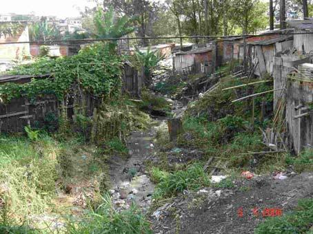
8 expanding and improvement works carried out this year, several springs that were hidden due to litter deposit over the years were restored. Parque do Norio (fig.7) is another interesting experience concerning environmental recovery. It is a small park, and it was established with the objective of recovering part of a stream and its springs. Despite its small size, it counted with the constant participation of local dwellers, who were already taking care of the area, protecting it against the irregular litter deposit, which used to come even from nearby cities. 4.3 Environmental education Another important existing area incorporated to SMAVL, named Parque Escola, has an important role to play as an information center related to environmental issues in the municipality and in the ABC region. It develops a successful educational program including gardening courses, solid residues recycling, and rainwater re-use, among others. It also holds a rich fauna and flora, orchid gardens, irrigation with collected rainwater, auditorium and library. Also, the Parks and Gardens Department, in charge of the establishment and managing of the SMAVL, is located at Parque Escola. 4.4 Linear Parks Linear parks are fundamental parts of the system. They are examples of features were the integration between the green system and the blue system occur. Their conception is related to the creation of a green area along a stream or a river. For this reason it presents a linear structure, which is also appropriate for its use as a connection element of the system. In some cases, the connection is even favored from the continuity of linear parks with green corridors. The Parque Linear do Córrego Itrapoá, for example, is connected with the Green Corridor made by the avenues Giovanni Battista Pirelli, Santos Dumont e José Caballero, establishing an eastwest axis in the city. The establishment of linear parks involves both environmental and cultural benefits. From the environmental aspect, it recovers the riparian vegetation wherever possible, keeping soil permeability, protecting riverbanks and diminishing flood risks. And from the cultural aspect, it represents an improvement of landscape experience for the population, who can enjoy these leisure spaces. During the decision-making design process, there was a permanent effort to keep a reference, sometimes at least symbolic, to the rivers in the public landscape. The Parque Linear over the stream Apiaí presents several interruptions, with the river appearing and disappearing from the landscape. A landscape reference to the stream was incorporated in the Praça Cristo Redentor, in a pedestrian path over the stream, with a blue ceramics paving, symbolically retrieving its presence in the landscape. The connection of this park to the Green Corridor of Avenida dos Estados, an important metropolitan highway axis situated along rio Tamanduateí, the main region river, allows a north-south connection in the city of Santo André. 4.5 Conflicts As any intervention in a public space, it seems inevitable the conflicts generated by the conflict of different values and interests from different groups. As expected, conflicts were many and were collectively solved in through dynamic and passionate processes. In the Parque Maria 8
9 Quitéria, for instance, there were many differences concerning the project conception. The realization of mutirões has brought several problems concerning the construction on a daily basis, such as night surveillance of the work material and the scheduling of weekend work. These generated long debates among local community and public authorities in order to come to a consensus. On the other hand, the establishment of linear parks involved difficulties related to irregular occupation of environmental protected areas along watercourses and springs (fig.8). These areas are protected by federal legislation, but even so they have been transformed in lowincome irregular settlements, where dwellers run the risks of sliding and flooding. The collective and interdisciplinary planning, among the public sector in charge of urban drainage, low income housing department and SMAVL management have been an important space for negotiating conflicts. The SMAVL establishment has also turned to be an educative and awareness process. There are still conflicts due to design concepts that put forward either avenues along rivers and streams valleys instead of linear parks, or flood prevention through the creation of pools instead of the maintenance of soil permeability and other environmental solutions. 5. FINAL COMMENTS Over the last years a number of studies have been pointing out the importance of the realization of urban and landscape projects together. The conception of the green and blue systems addressing the urban project structure acknowledges both totality of open urban spaces, as well as the basis of natural landscape topography, vegetation groups, watersheds and watercourses structure. And the cultural system, being contemplated in the projects development and establishment, is important to guarantee the integrity of the whole, which in turn provides physical support to social and spatial relations established in the landscape. This support brought by the understanding of the importance of landscape structure to urban projects is fundamental for its developing. The elaboration of the green system and the blue system can bring a contribution for an enrichment of the urban space and improvement of the urban experience of its inhabitants, providing leisure areas and better environments for different human activities. The presence of flora, fauna, water collections, and original geomorphologic aspects less modificated by antropic intervention has been focus of interest and value for urban environments. Degraded areas such as woods and streams can in fact be recovered and incorporated to the green and leisure city spaces system. It is necessary to avoid the vision that it is not possible to conciliate urban development and protection of natural resources, and that the late ones should only be preserved in confined areas such as zoos and botanical gardens. Santo André strategic plan turned to be a fertile case study, where these issues were observed from their daily practice, linked to an effective participative process. This process considered both environmental and social issues, stressing an understanding that these are complementary aspects and should not be considered separately. The results observed from SMVAL highlighted a changing of scale in the communities demands, who began to place themselves not only concerning their street or neighbourhoods, 9
10 but extended their concern to the city, its regional interfaces and environmental issues of the Metropolitan Region. It was possible to perceive an awareness of the municipality s role in the preservation and recovering of the spring s protection areas, and that flora, fauna, watercourses, the rain, the wind and the sun are natural components presented, necessarily, in the urban environment. For this reason they should be considered in any kind of project which aims to contribute to the requalification of human habitat. Santo André s SMVAL has shown that inhabitants participation, either during the project and decision making process or during establishment, as it is the case of the mutirões, is one of the most effective forms of involving the population in the conservation of public spaces. Values for these spaces are created not only through use, but also as a result of their demands and collective effort. The rich experience of closely relating green and blue systems has created spaces intensively valued in environmental terms, and which have much to reveal about the city landscape, as it has happened on linear parks and on squares where springs were recovered. Therefore the proposal of this trialogue appears to be one of the possible ways for the relationship between the environment and the urbanized human being. Santo André s experience was then an interesting case study to discuss the interplay between natural and cultural systems in landscape design and planning, on a democratic basis. Having these systems valued in planning and design, cities could find the lost link with its landscape identity, hallmark their potentialities and guarantee their environmental and cultural quality. 6. ACKNOWLEDGEMENTS This research has been supported by UFRJ, CNPq, FAPERJ and CAPES, to whom the authors would like to thank. We would also like to thank Patricia Hartmann for the maps graphic design. 7. REFERENCES COSGROVE, D. (1984) Social Formation and Symbolic Landscape, London: Croom Helm. COSTA, L.M.S.A. (org) (2006) Rios e Paisagem Urbana em Cidades Brasileiras, Rio de Janeiro: Vianna & Mosley / PROURB. GLA Greater London Authority (2002) The Draft London Plan: draft spatial strategy for Greater London, London: Greater London Authority. HOUGH, M. (1995) Cities and Natural Process, Londres: Routledge. LINEHAN, J.R. e GROSS, M. (1998) "Back to the future, back to basics: the social ecology of landscapes and the future of landscape planning", Landscape and Urban Planning, 42, pp MCHARG, I. (1969) Design with city nature, New York: Natural History Press. PLATT, R. (1994) The Ecological City: Introduction and Overview. In: PLATT, R.; ROWNTREE, R.; MUICK, P. (ed.) The Ecological City: Preserving and Restoring Urban Biodiversity, Massachusetts: The University of Massachusetts Press. pp
 The Granite Garden: urban nature and human design, New York: Basic Books. Figures: Fig.1: Santo André s Macrozones Source: modified from SMAVL archives. 11")
11 SPIRN, A.W. (1996) Constructing Nature: The Legacy of Frederick Law Olmsted. In: CRONON, William (ed.) Uncomnon Ground: Rethinking the Human Place in Nature, New York / London: W.W. Norton & Company. pp SPIRN, A.W. (1984) The Granite Garden: urban nature and human design, New York: Basic Books. Figures: Fig.1: Santo André s Macrozones Source: modified from SMAVL archives. 11

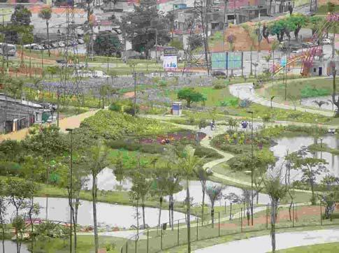
12 Fig.2: SMAVL General Map. Source: modified from SMAVL archives 12


13 Fig.3: Parque Maria Quitéria Source: Santo André Municipal Mayorship Fig..4: Pesqueiro da Rua Jundiaí Source: Santo André Municipal Mayorship Fig.5: Parque Celso Daniel. Source: Santo André Municipal Mayorship Fig.6: Parque Central. Source: Santo André Municipal Mayorship. Fig.7 : Parque Norio. Source: Santo André Municipal Mayorship Fig.8: Irregular occupation along rio Taioca. Source: Santo André Municipal Mayorship 13
14 Professional team in charge for the conception and establishment of the SMAVL program: Cláudia Virgínia Cabral de Souza, Architect, head of Master Plan Coordination. Ricardo da Silva Kondratovitch, Engineer, head of Park and Green Spaces Department. Caio Boucinhas, landscape architect, consultant. Lucia M.S.A. Costa, Ivete M. C. Farah, Caio Boucinhas PROURB FAU/UFRJ (Programa de Pós-graduação em Urbanismo da Faculdade de Arquitetura e Urbanismo da Universidade Federal do Rio de Janeiro) i In Brazil, from the Act from 10/07/2001, a Master Plan is mandatory for cities with more than inhabitants. ii Sistema Municipal de Áreas Verdes e de Lazer. The SMAVL is yet to contemplate the municipality as a whole. At the moment, it was defined only for the Urban Macrozone. 14
PARQUE DOM PEDRO II Category: Urban Plan Location: São Paulo, Brazil Surface: N/A Project Year: 2011
 UNA Arquitetos est. 1996 Cristiane Muniz Fábio Valentim Fernanda Barbara Fernando Viégas São Paulo, Brazil PARQUE DOM PEDRO II Category: Urban Plan Location: São Paulo, Brazil Surface: N/A Project Year:
BLOK BADEL ZAGREB. Competition for the urban-architectural concept design for the BADEL SITE redevelopment COMPETITION NUMBER: ZG-UA
 BLOK BADEL ZAGREB Competition for the urban-architectural concept design for the BADEL SITE redevelopment COMPETITION NUMBER: 136-12-ZG-UA 1.0 DESCRIPTION AND EXPLANATION OF THE OVERALL CONCEPT The Badel
Cooperative Research in Water Management
 Proceedings of the 8 th International Conference on Applied Informatics Eger, Hungary, January 27 30, 2010. Vol. 1. pp. 273 281. Cooperative Research in Water Management Margit Horosz-Gulyás, Katalin Katonáné
Welcome. /The Design Companion 4. /Planning London 7. /Getting Homes Built 8. /Transport & Streets 10. /Tech & The City 12
 Welcome With the draft publication of the London Plan and the Mayor s Transport Strategy (MTS) this year s events programme will examine both documents in detail with a wide range of seminars, debates
Arlington, Virginia is a worldclass
 EXECUTIVE S U M M A RY Arlington maintains a rich variety of stable neighborhoods, quality schools and enlightened land use policies, and received the Environmental Protection Agency s highest award for
Project for the New Lisbon Congress Centre in Parque Eduardo VII. Architecture
 Project for the New Lisbon Congress Centre in Parque Eduardo VII Extended Abstract Ana Cláudia de Sousa Ramos Project Report to obtain the Master of Science Degree in Architecture Supervisor: Professora
10.0 Open Space and Public Realm
 10.0 Open Space and Public Realm 10.0 Open Space and Public Realm The Public Open Space System is comprised of: outdoor spaces available for public use that are either publicly owned (e.g., parks and
Intervention in the historical center of São Paulo
 EXTENDED ABSTRACT Intervention in the historical center of São Paulo Place Between Places João Infante Lisbon November 2013 The present work was developed within the project subjects performed during the
STEWARDSHIP OF LONG ISLAND SOUND S ECOLOGICAL AND RECREATIONAL RESOURCES
 STEWARDSHIP OF LONG ISLAND SOUND S ECOLOGICAL AND RECREATIONAL RESOURCES Robin Kriesberg, Save the Sound, Inc. Thomas Halavik, US Fish and Wildlife Service Coastal Program An Initiative to Identify, Protect
CHAPTER 8 ISSUES, CONCERNS, CONSTRAINTS AND OPPORTUNITIES
 CHAPTER 8 ISSUES, CONCERNS, CONSTRAINTS AND OPPORTUNITIES Introduction This River Conservation Plan was developed during a time of tremendous activity and effort in planning the transformation of the Delaware
Cities and Situations
 Cities and Situations after 20 years a new Plan for Bologna Twenty years after the last general urban plan, Bologna has commenced the programme for the approval of a new instrument governing the territorial
URBAN PROJECT CARNIDE AV. LUSÍADA BENFICA
 URBAN PROJECT CARNIDE AV. LUSÍADA BENFICA Infrastructure, Public Space, Urban Continuity José Rafael Garcia dos Santos Rosa Capelão Extended Abstract ARQUITECTURE October 2012 01 INTRODUCTION 01.01 Aims
The Landscape in the revision of the municipal master plans: Guidelines for the implementation of the European Landscape Convention
 The Landscape in the revision of the municipal master plans: Guidelines for the implementation of the European Landscape Convention Marta Afonso - Directorate General for Territory (PT) Rosário Oliveira
Rio de Janeiro - Brazil. Urban Regeneration & Climate Change
 Rio de Janeiro - Brazil Urban Regeneration & Climate Change 2017 Rio de Janeiro - Brazil introduction slide 1 BRASIL 204.5 million inhabitants RIO DE JANEIRO STATE 16.5 million inhabitants RIO DE JANEIRO
Cotswolds AONB Landscape Strategy and Guidelines. June 2016
 Cotswolds AONB Landscape Strategy and Guidelines June 2016 Cotswolds AONB Landscape Strategy and Guidelines Introduction The evolution of the landscape of the Cotswolds AONB is a result of the interaction
Complete Neighbourhood Guidelines Review Tool
 Complete Neighbourhood Guidelines Review Tool Prepared By: City of Regina Planning Department October 2014 Page 1 of 14 Community Development Review Checklist for Secondary Plans and Concept Plans The
Toronto Complete Streets Guidelines
 Toronto Complete Streets Guidelines 108 110 7.1 Green Infrastructure Design Principles 112 7.2 Context-Sensitive Green Streets 114 7.3 Key Green Street Elements Green infrastructure refers to natural and
Slum Upgrading in Brazil during the 1990s: an evaluation using Census data
 Slum Upgrading in Brazil during the 1990s: an evaluation using Census data Rute Imanishi Rodrigues rute@ipea.gov.br Setsu Kanto setsukanto@hotmail.com Paper presented at the World Bank Fourth Urban Research
Design Strategies + Planning Tools for Integrated Stormwater Management
 ELKE KRUSE Design Strategies + Planning Tools for Integrated Stormwater Management Department Sustainable Urban and Infrastructure Planning How can we use the transformation process of our drainage system
Chapter 27: Urban Environments
 Chapter 27: Urban Environments City Life In the past, the emphasis of environmental action has most often been natural landscapes outside cities. Now it is time to turn more of our attention to city environments.
Belo Horizonte s new Master Plan Nature, Resilience and Sustainability-based solutions
 Belo Horizonte s new Master Plan Nature, Resilience and Sustainability-based solutions Maria Fernandes Caldas Secretary of Urban Policies Belo Horizonte City Council Minas Gerais - Brazil July, 2018 Belo
The ACTION PLAN OBJECTIVES, POLICIES, ACTIONS
 The ACTION PLAN OBJECTIVES, POLICIES, ACTIONS Responsible actors Key actors Funds needed and funding sources available OBJECTIVE 1 Strengthening the governance and the social capital through the development
10/23/18. Science informed regional planning: opportunities for better outcomes. Seeking Better Outcomes for Our Regions
 SEGRA 2018: Beyond the Boom: opportunities for growth and vitality Acknowledge the Traditional Owners of the country where we are meeting today Science informed regional planning: opportunities for better
PRESENTATION ON JOHANNESBURG S BIODIVERSITY PROGRAMME
 PRESENTATION ON JOHANNESBURG S BIODIVERSITY PROGRAMME Member of Mayoral Committee: Cllr Prema Naidoo Environmental Management & Johannesburg City Parks PRESENTATION OVERVIEW Jo burg Overview & Context
STUDY OF URBAN SMART GROWTH APPROACH BASED ON THE PRINCIPLES AND GUIDELINES FOR NEW PLANNING
 www.arpapress.com/volumes/vol23issue2/ijrras_23_2_05.pdf STUDY OF URBAN SMART GROWTH APPROACH BASED ON THE PRINCIPLES AND GUIDELINES FOR NEW PLANNING Abbas Matloubi Technical and constructive assistant,
Spatial planning instruments in Portugal: plans as regeneration tools
 Spatial planning instruments in Portugal: plans as regeneration tools Portuguese Local Spatial Planning Tools Local Development Plan (municipality) Urban(isation) Plan (territory within the urban perimeter)
Appendix A. Planning Processes. Introduction
 1 Planning Processes Introduction This appendix outlines a number of planning processes which are used in the Auckland Region to support the effective management of development in the region s rural and
PROPOSED RESIDENTIAL DEVELOPMENT LAND AT GREEN LANE, YARM
 PROPOSED RESIDENTIAL DEVELOPMENT LAND AT GREEN LANE, YARM PUBLIC CONSULTATION YOUR VIEW MATTERS TO US LOCATION PLAN Thank you for taking the time to read this information leaflet regarding a proposed residential
The Dreispitz in Basel / Switzerland: New economy on old sites
 The Dreispitz in Basel / Switzerland: New economy on old sites 1. Introduction At 50.000m 2 Dreispitz is currently the largest and most ambitious development project in Basel, the second biggest town in
SQUAMISH 2010 AND BEYOND COMMUNITY VISION
 Our plan has been imagined and created to be both pragmatic and visionary. At the core of the strategy is a consideration of the highway s role and its impact on the community. First and foremost in creating
The urban block as a potential for sustainable urban design
 The Sustainable City X 69 The urban block as a potential for sustainable urban design M. Oikonomou Department of Urban Planning and Regional Development, Aristotle University of Thessaloniki, Greece Abstract
A Vision For Miami s Twenty-first Century Parks And Public Spaces
 1 A Vision For Miami s Twenty-first Century Parks And Public Spaces Parks and Public Spaces in Miami 21 An urban renaissance is remaking the City of Miami as new residents, new visitors, and new investment
Patrick Levy, Commercial Specialist U.S. Commercial Service - Rio de Janeiro, Brazil
 Patrick Levy, Commercial Specialist U.S. Commercial Service - Rio de Janeiro, Brazil 2 nd largest commercial export promotion network in the world 5 offices 35 bilingual professionals with industry expertise
A Study on Landscape Design Paradigm from the Perspective of Visual Impact and Experience
 2017 3rd International Conference on Social Science, Management and Economics (SSME 2017) ISBN: 978-1-60595-462-2 A Study on Landscape Design Paradigm from the Perspective of Visual Impact and Experience
Lecture: Landscape Ecology
 Borderland: Border Landscapes Across Europe 2013 Lecture: Landscape Ecology Dr Iwona Markuszewska Department of Landscape Ecology iwmark@amu.edu.pl Presentation schedule: Landscape ecology as a scientific
Town of Peru Comprehensive Plan Executive Summary
 Town of Peru Comprehensive Plan Executive Communities that plan grow by choice, not by chance. A plan makes growth thoughtful, understandable, and predictable. A plan shows that a community is managing
Cultural Functions and Perceptions of Waller Creek Among the University of Texas at Austin Community
 Cultural Functions and Perceptions of Waller Creek Among the University of Texas at Austin Community Maria Coronado Graduate Student School of Architecture mc.coronadoc@utexas.edu Lauren Tuttle Graduate
The West Vaughan Employment Area Secondary Plan Policies
 Part 2: The West Vaughan Employment Area Secondary Plan Policies 2.1 General Policies It is the policy of Council: 2.1.1. That the West Vaughan Employment Area (the WVEA), identified on Schedule 1, will
Resolution XII NOTING also that with the increasingly rapid urbanization, wetlands are being threatened in two principle ways:
 12 th Meeting of the Conference of the Parties to the Convention on Wetlands (Ramsar, Iran, 1971) Punta del Este, Uruguay, 1-9 June 2015 Resolution XII.10 Wetland City 1 Accreditation of the Ramsar Convention
6 Growth Management Challenges and Opportunities
 6 Growth Management Challenges and Opportunities The Town has established a goal of attaining a 50% participation rate with respect to employment opportunities versus residential population. The Town s
Hampton Park Charleston, SC Designing coherent and acceptable spaces for cultural and social events that also honor the site s history.
 Hampton Park Charleston, SC Hampton Park: Design with Culture James L. Ward, Registered Landscape Architect & Assistant Professor at the College of Charleston Historic Preservation and Community Planning
THAT the attached Terms of Reference for the Thornhill Centre Street Study be approved.
 COMMITTEE OF THE WHOLE AUGUST 18, 2003 THORNHILL CENTRE STREET STUDY PLANNING FILE: 15.92 Recommendation The Commissioner of Planning recommends: THAT the attached Terms of Reference for the Thornhill
SHORELINE, FLOOD AND COASTAL DEFENCE MANAGEMENT PLANS
 These plans may provide opportunities as well as concern for recreational boating. They are currently being revised and consulted on. This document explains how we can engage in the process. Shoreline,
Official Plan Review: Draft Built Form Policies
 PG.30.1 REPORT FOR ACTION Official Plan Review: Draft Built Form Policies Date: May 15, 2018 To: Planning and Growth Management Committee From: Chief Planner and Executive Director, City Planning Division
Phase 1 : Understanding the Campus Context. Phase 2 : APPROACHES - Alternates & Preferred Plan
 Introduction MASTER PLAN PURPOSE WHY A CAMPUS MASTER PLAN? The purpose of the Master Plan at the University of Illinois at Chicago is to translate UIC s strategic goals and objectives into a compelling
Living with World Heritage in Africa
 INTERNATIONAL CONFERENCE Living with World Heritage in Africa [26 26-29 September 2012] South Africa BACKGROUND DOCUMENT The Government of the Republic of South Africa, in collaboration with the African
URBAN PROJECT OF THE BENFICA STATION SURROUNDING AREA
 URBAN PROJECT OF THE BENFICA STATION SURROUNDING AREA José Miguel Camilo de Matos Santos Pereira Extended Abstract INTRODUCTION The purpose of this report is to expose the strategies drawn to answer the
Draft Resolution XII.10
 12 th Meeting of the Conference of the Parties to the Convention on Wetlands (Ramsar, Iran, 1971) Punta del Este, Uruguay, 1-9 June 2015 Ramsar COP12 DR10, Rev. 2 21:45, 8 June Draft Resolution XII.10
THE NEW LISBON CONGRESS CENTRE ARCHITECTURE
 THE NEW LISBON CONGRESS CENTRE PARQUE EDUARDO VII Extended Abstract João Miguel Caramujo Ramos Endrenço Project Report to obtain the Master of Science Degree in ARCHITECTURE Supervisor: Teacher Teresa
elbridge Core Strategy
 C elbridge Core Strategy Celbridge is designated as a Moderate Growth Town in the RPGs. The County Development Plan reinforces this designation in its settlement strategy. Moderate Growth Towns within
Urban development, planning and real estate market at a peripheral metropolis
 Urban development, planning and real estate market at a peripheral metropolis Gilberto Corso Pereira Inaiá Carvalho UFBA - Universidade Federal da Bahia Federal University of Bahia Salvador/Brasil corso@ufba.br
SUSTAINABLE CONSERVATION SYSTEMS FOR PRESERVATION OF MONUMENTS, SITES IN THEIR SETTINGS
 SUSTAINABLE CONSERVATION SYSTEMS FOR PRESERVATION OF MONUMENTS, SITES IN THEIR SETTINGS Staneva Hristina / Bulgarian National Correspondent of the HEREIN Project Associated member of the ICVA This paper
HAZARD MITIGATION GOALS AND OBJECTIVES
 SEWRPC Community Assistance Planning Report No. 282, 2nd Edition CITY OF MILWAUKEE ALL HAZARDS MITIGATION PLAN UPDATE Chapter IV HAZARD MITIGATION GOALS AND OBJECTIVES [NOTE: Throughout this plan update
Curitiba: Integrated Urban Planning
 Institute for Research and Urban Planning of Curitiba Curitiba: Integrated Urban Planning Urban Planning and Regeneration: Key to Tackling Climate Change Dundee, March 18th, 2008 Arch. Liana Vallicelli
CULTURAL IDENTITY AND SPATIAL SEGREGATION IN THE PUBLIC SPACES OF LISBON
 CULTURAL IDENTITY AND SPATIAL SEGREGATION IN THE PUBLIC SPACES OF LISBON CRITERIA FOR THE EVALUATION OF PUBLIC SPACES FERNANDO NUNES DA SILVA (1) FRANCISCO M. SERDOURA (2) JOÃO PEDRO COSTA (3) ABSTRACT
The European Landscape Convention And National Landscape Strategy. Tony Williams Irish Landscape Institute
 The European Landscape Convention And National Landscape Strategy As a reflection of European identity and diversity, the landscape is our living natural and cultural heritage, be it ordinary or outstanding,
Design is the process of planning, initiating and / or laying out a new product, service,
 Design (and ecodesign) Definition Design is the process of planning, initiating and / or laying out a new product, service, piece of equipment, landscape, building, plan, policy or the like, typically
Western Sydney Parklands Australia s Largest Urban Park
 Western Sydney Parklands Australia s Largest Urban Park 37 WLA 1 MAGAZINE 21 38 WESTERN SYDNEY PARKLANDS AUSTRALIA S LARGEST URBAN PARK Large urban parks have dual roles to play in meeting the demands
Christchurch City Council Civic Offices 53 Hereford Street Christchurch. Submission on: The Draft Annual Plan 2014/15
 City Council Civic Offices 53 Hereford Street Submission on: The Draft Annual Plan 2014/15 Response by: Avon-Ōtākaro Network 9 Stable Way Belfast The Avon-Ōtākaro Network [AvON], is a network of individuals
Network of Urban Parks and Green Corridors in the City of Braga, Portugal
 Network of Urban Parks and Green Corridors in the City of Braga, Portugal MARTINHA E. R. R. ROCHA 1, RUI A. R. RAMOS 2 Department of Civil Engineering, C-TAC Centre for Territory, Environment and Construction
1. MAKING CHOICES. What kind of city will Toronto be in the 21st century?
 1. MAKING CHOICES Toronto is a great city! It has evolved into a special place that people care about deeply. It is a wonderful city in which to live, offering a diversity and richness of urban life that
New-Cast Mixed-use Development Proposal King Street West, Newcastle, Ontario
 URBAN DESIGN BRIEF New-Cast Mixed-use Development Proposal King Street West, Newcastle, Ontario TABLE OF CONTENTS: 1.0 Executive Summary 2.0 Creating Vibrant and Sustainable Urban Places: Excerpts from
SECTION UNIFIED DEVELOPMENT ORDINANCE SECTION Part 1 Ordinance. ARTICLE 1 Zoning Districts
 SECTION 1-100 UNIFIED DEVELOPMENT ORDINANCE SECTION 1-300 Part 1 Ordinance SECTION 1-100. Introduction. ARTICLE 1 Zoning Districts Crystal Lake strives to maintain a balance of various land uses for a
GREEN NETWORK APPLICATIONS IN ESTONIA
 GREEN NETWORK APPLICATIONS IN ESTONIA Kalev Sepp, Tuuli Veersalu, Martk Külvik Estonian University of Life Sciences 1 WHY? BACKGROUND - POLITICAL By adopting the Pan-European Biological and Landscape Diversity
GUIDELINES FOR ECOLOGICAL PERFORMANCE
 3 Landscape........................................... 3.2 Stormwater Management................................... 3.3 Hardscape........................................... 3.4 Streetscape..........................................
systems is available on the Colorado Wetland Information Center (CWIC) website.
 website.") Colorado Natural Heritage Program Wetland Program Plan -- Dec 2015 Status Update and Addendum -- The Colorado Natural Heritage Program (CNHP) developed a Wetland Program Plan (WPP) in 2010 for the planning
Colorado Natural Heritage Program Wetland Program Plan -- Dec 2015 Status Update and Addendum -- The Colorado Natural Heritage Program (CNHP) developed a Wetland Program Plan (WPP) in 2010 for the planning
EXTENDED ABSTRACT URBAN PROJET IN VILA VIÇOSA ARCHITECTURE, HERITAGE AND LANDSCAPE IN THE CONTEXT OF PAÇO DUCAL ANA CATARINA DA SILVA ANTUNES
 EXTENDED ABSTRACT URBAN PROJET IN VILA VIÇOSA ARCHITECTURE, HERITAGE AND LANDSCAPE IN THE CONTEXT OF PAÇO DUCAL ANA CATARINA DA SILVA ANTUNES CHAIRPERSON: PROFESSOR MARIA ALEXANDRA DE LACERDA NAVE ALEGRE
Rochford District Council Allocations Development Plan Document: Discussion and Consultation Document Sustainability Appraisal
 Option SWH1 Balanced Communities Option SWH1 1 To ensure the delivery of high quality sustainable communities where people want to live and work Will it ensure the phasing of infrastructure, including
2011 ASLA Design Awards. Westside Creeks Restoration Plan Merit Award AECOM, Fort Collins. Planning & Urban Design
 2011 ASLA Design Awards Westside Creeks Restoration Plan Merit Award AECOM, Fort Collins Planning & Urban Design Project Fact Sheet Category of Entry: Rotating Specialty Award: 2011 2011 ASLA Colorado
Results and Expectations of the Megacity Project LiWa
 Presentation Results and Expectations of the Megacity Project LiWa Innovative Urban Planning Aspects - Context and Special Significance of Water Issues Dr.-Ing. Irene Wiese-von Ofen Member of the BMBF
PROJECT FOR THE NEW CONGRESS CENTER OF LISBON IN PARQUE EDUARDO VII
 PROJECT FOR THE NEW CONGRESS CENTER OF LISBON IN PARQUE EDUARDO VII EXTENDED ABSTRACT Maria Catarina Ramos dos Santos Fuzeta da Ponte Student in Architecture, Instituto Superior Técnico, Lisbon, Portugal
2 Vision. Master Plan
 19 2 Vision Master Plan 20 Chapter 2 MASTER PLAN VISION 2.1 Master Plan Organization Lake Calhoun/Bde Maka Ska and Lake Harriet are places where complex human and natural systems intersect and converge.
UNIVERSITY OF MUMBAI
 AC 6/6/2012 Item No. 4.80 UNIVERSITY OF MUMBAI Syllabus for the Master of Architecture Programme : M.Arch. Course :Urban Design (As per Credit Based Semester and Grading System with effect from the academic
CENTURY CITY URBAN DESIGN FRAMEWORK
 CENTURY CITY URBAN DESIGN FRAMEWORK REVISION 1 OCTOBER 2005 PLANNING PARTNERS : CENTURY CITY URBAN DESIGN FRAMEWORK October 2005 REVISION 1 ACKNOWLEDGEMENT This document has been prepared for Century City
LAND EAST OF SUDBURY ROAD, HALSTEAD PUBLIC CONSULTATION. Proposed Residential Development
 LAND EAST OF SUDBURY ROAD, HALSTEAD PUBLIC CONSULTATION Proposed Residential Development YOUR VIEW MATTERS TO US PROPOSED RESIDENTIAL DEVELOPMENT AREA Thank you for taking the time to read this information
A study on the regional landscape planning framework on the relationships between urban and rural areas: case study of Tokachi region, Hokkaido, Japan
 A study on the regional landscape planning framework on the relationships between urban and rural areas: case study of Tokachi region, Hokkaido, Japan K. Yamagishi & H. Kobayashi Laboratory of Urban Planning
Report to: Development Services Committee Report Date: April 24, 2017
 SUBJECT: Cornell Rouge National Urban Park Gateway - Report on Design Charrette and Next Steps PREPARED BY: Lilli Duoba, MES, MCIP, RPP, Manager, Natural Heritage (ext. 7925) REVIEWED BY: Marg Wouters,
SOUTH AFRICA S PREPARATIONS FOR HABITAT III COMMON AFRICAN POSITION FOR HABITAT III. Habitat III Urban Breakfast 5 October 2016
 SOUTH AFRICA S PREPARATIONS FOR HABITAT III COMMON AFRICAN POSITION FOR HABITAT III Habitat III Urban Breakfast 5 October 2016 Context and Background 1. Africa intends actively shaping the New Urban Agenda,
1. EXPLORE A CAREER PLAN IN DESIGN AND MERCHANDISING
 21 st Century Learning Interior Design and Merchandising High School Interior Design and Merchandising is an elective that focuses on creating beauty, comfort and convenience in rooms and homes. The principles
Specification of urban planning regulation in a sustainable city
 Sustainable Development and Planning III 165 Specification of urban planning regulation in a sustainable city E. Salehi Faculty of Environment, University of Tehran, Iran Abstract The city form is shaped
3. VISION AND GOALS. Vision Statement. Goals, Objectives and Policies
 Vision Statement Queen Creek s interconnected network of parks, trails, open spaces and recreation opportunities provide safe and diverse activities and programs that sustain its unique, small town, equestrian
Paseo Civico Metropolitano Alameda Providencia Corridor
 Groundlab est. 2008 Jose Alfredo Ramirez London, UK New York, U.S. Paseo Civico Metropolitano Alameda Providencia Corridor Category: parks / plazas Location: Santiago, Chile Surface: N/A Project Year:
Yorkshire Sculpture Park Historic Landscape Management Plan. Volume I. July 2010
 Yorkshire Sculpture Park Historic Landscape Management Plan Volume I July 2010 T: 01904 691630 www.landscapeagency.co.uk enquiries@landscapeagency.co.uk Contents 3 Volume I Historic Landscape Management
THE SPATIAL PLAN AND THE LANDSCAPE IN CZECH REPUBLIC
 THE SPATIAL PLAN AND THE LANDSCAPE IN CZECH REPUBLIC 13th ELC Conference, 2 3 October, Cetnjie, Montenegro Ing. Igor Kyselka CSc., Institute for spatial development, Jakubské náměstí 3, 60200 Brno, tel.:
LET'S FILL STREETS WITH LIFE Establishing Superblocks in Barcelona
 LET'S FILL STREETS WITH LIFE Establishing Superblocks in Barcelona Barcelona aims to establish a new way of organising the city which reverses the current distribution of public areas between vehicles
THE OPEN SPACE CONTRIBUTING TO NEIGHBORHOOD SUSTAINABILITY THROUGH PUBLIC EVENTS: A CASE FROM AKARA, TURKEY. Bahar Gedikli Charleston, October 2010
 THE OPEN SPACE CONTRIBUTING TO NEIGHBORHOOD SUSTAINABILITY THROUGH PUBLIC EVENTS: A CASE FROM AKARA, TURKEY Bahar Gedikli Charleston, October 2010 Sustainable urban development?! Sustainable urban development
An Ambitious Plan: Transforming the blighted South Platte River and surrounding environment into Denver s greatest natural resource.
 CONNECTING THE PEOPLE TO THEIR RIVER SOUTH PLATTE RIVER VISION IMPLEMENTATION PROGRAM: GRANT-FRONTIER PARK TO OVERLAND POND PARK REACH The South Platte River Vision Implementation Program (River Vision)
Scottish Natural Heritage. Better places for people and nature
 Scottish Natural Heritage Better places for people and nature Contents Summary... 3 SNH approach... 5 Place-making in policy and practice... 6 Developing the contribution of the natural heritage to place-making...
THE CITY, THE FOREST AND THE CENTER: MANAUS CONFIGURATIONAL ANALISYS
 THE CITY, THE FOREST AND THE CENTER: MANAUS CONFIGURATIONAL ANALISYS Authors: Graciete Guerra da Costa Valério Augusto Soares de Medeiros Universidade de Brasília UnB/BRASIL e-mail: gdacosta@terra.com.br
 Health Sciences City The available land area, although limited, combined with the unique partnership between the primary institutions and the supporting partnerships of the development interests within
Norwich (United Kingdom), 9-10 September 2004
, 9-10 September 2004") THE CONGRESS OF LOCAL AND REGIONAL AUTHORITIES Council of Europe F 67075 Strasbourg Cedex Tel : +33 (0)3 88 41 20 00 Fax : +33 (0)3 88 41 27 51/ 37 47 http://www.coe.int/cplre COLLOQUIES, SEMINARS, FORUMS
THE CONGRESS OF LOCAL AND REGIONAL AUTHORITIES Council of Europe F 67075 Strasbourg Cedex Tel : +33 (0)3 88 41 20 00 Fax : +33 (0)3 88 41 27 51/ 37 47 http://www.coe.int/cplre COLLOQUIES, SEMINARS, FORUMS
OPEN SPACE CHAPTER 7: OVERVIEW. Preserve open space to protect natural resources, enhance character and provide passive recreation opportunities
 CHAPTER 7: OPEN SPACE OVERVIEW Ridgefield has made tremendous progress permanently preserving areas of town as open space. Open space preservation can serve many important purposes, including: protect
Describing the Integrated Land Management Approach
 Describing the Integrated Land Management Approach ISBN No. 978-0-7785-8902-0 (Online Edition) Pub No. I/422 What is Integrated Land Management? Integrated land management (ILM) is the strategic, planned
Brampton. Secondary Plan. Review. Bram West. A New Direction in Planning & Public Consultation
 Brampton Bram West Secondary Plan Review A New Direction in Planning & Public Consultation Introduction The Bram West Secondary Plan Review offers an important opportunity for the community to define a
Regional Context Statement
 Regional Context Statement REGIONAL CONTEXT STATEMENT 3. REGIONAL CONTEXT STATEMENT In 1995, the Provincial Government passed into law the Growth Strategies Act. The purpose of this provincial initiative
Expert Group Meeting. NUP Framework for A Rapid Diagnostic. Mainstreaming Climate Change into National Urban Policies. Themba R.
 Expert Group Meeting Mainstreaming Climate Change into National Urban Policies Themba R. Phakathi NUP Framework for A Rapid Diagnostic United Nations Conference Centre, Bangkok, Thailand, 17-18 March 2015
2040 LUP is a part of the Comprehensive Plan and carries the same legal authority. Economic Challenges
 1.1. Guiding Anchorage s Growth Where will new residents settle over the next two decades? Where will people work, shop, and play? Will there be enough room to grow? How will Anchorage look? Will growth
CHAPTER 5: GUIDING PRINCIPLES
 CHAPTER 5: GUIDING PRINCIPLES The following 10 principles were developed based on public consultation, planning policy and the background analysis conducted during Phase 1. The Guiding Principles significantly
City of Kingston. North King s Town Secondary Plan Open House + Workshop #1 February 28, 2018
 City of Kingston North King s Town Secondary Plan Open House + Workshop #1 February 28, 2018 1 event agenda 30 min Panel Review + Discussion 30 min Presentation + Q&A 75 min Workshop Session 15 min Report
Corridor Plans: An Opportunity to Develop Low Carbon Open Spaces Network-The Case Study in Tehran, Iran
 Corridor Plans: An Opportunity to Develop Low Carbon Open Spaces Network-The Case Study in Tehran, Iran 1. Introduction We are on verge of an urbanized world. At the same time urban areas are the world