THE WAY WE GROW TERMS OF REFERENCE FOR THE PREPARATION AND AMENDMENT OF NEIGHBOURHOOD STRUCTURE PLANS IN EDMONTON S URBAN GROWTH AREAS APRIL 2014
|
|
|
- Mae Murphy
- 6 years ago
- Views:
Transcription

1 THE WAY WE GROW TERMS OF REFERENCE FOR THE PREPARATION AND AMENDMENT OF NEIGHBOURHOOD STRUCTURE PLANS IN EDMONTON S URBAN GROWTH AREAS APRIL 2014
2 TABLE OF CONTENTS 1. INTRODUCTION Goal of Terms of Reference Application of the Terms of Reference 1 2. WHAT IS A NEIGHBOURHOOD STRUCTURE PLAN NSP Definition Authority and Policy Alignment Boundaries Initiation of NSPs Authorization Process and Integrated Infrastructure Management Planning 4 3. PLAN CREATION PROCESS Pre application Pre application Meetings Consultation with Neighbourhood Stakeholders Submission and Review of the NSP Document Initial Review Circulation Public Involvement During Application Review City Council Consideration CONTENT REQUIREMENTS Overarching Requirements Images, Photos and Maps Clear, Concise Policy Identification of Key Statistics Sample Table of Contents Required Figures AMENDING AN EXISTING NSP Process Amendment Submission Requirements 30 APPENDIX 1: Formal Submission Requirements 32 APPENDIX 2: Statistical Calculations 34 APPENDIX 3: References and Technical Requirements 35 GLOSSARY 38

3 1. INTRODUCTION The art and practice of creating and developing a community in the City of Edmonton is an exciting and challenging prospect. It is about building communities that are healthy, vibrant and sustainable. It is about developing neighbourhoods that respect the natural environment, honour local history and context, and establish a compelling vision for the future. However, it is also about reconciling provincial statutes, business practices, and municipal Bylaws, policies and procedures, with City Council, citizen and industry expectations. Neighbourhood Structure Plans provide a framework for the future development of lands and provide an intermediate link between an Area Structure Plan and future rezonings and subdivisions. A great Neighbourhood Structure Plan (NSP) achieves a balance between showcasing the vision for a neighbourhood, meeting stakeholder interests, and adhering to sustainable planning principles, and policy and Bylaws. The Terms of Reference will guide the preparation of great Neighbourhood Structure Plans. 1.1 GOAL OF TERMS OF REFERENCE Any new neighbourhood can be a great neighbourhood and there are many ways to achieve success. At the foundation of this document is a clear understanding that no two neighbourhoods are alike, nor should they seek to be, yet there are fundamental principles that are a part of every great neighbourhood. Demand for new housing, services and amenities, and the particular neighbourhood forms designed to meet the needs of our growing population, are as varied as our current and future residents. A NSP should be both a document describing the vision for a neighbourhood and a practical decision making tool to guide development. In order to achieve this goal, the Terms of Reference will define the process, content and format requirements for new NSPs and amendments in the urban growth areas. 1.2 APPLICATION OF THE TERMS OF REFERENCE This document applies to the preparation of new NSPs and amendments to NSPs in Urban Growth Areas, which are identified for future growth in Edmonton s Municipal Development Plan (MDP), The Way We Grow. These areas are identified in green in Figure 1. Where information requirements and standards change over time, this Terms of Reference will be updated as required by Current Planning. FIGURE 1: 1
4 2. WHAT IS A NSP? 2.1 NEIGHBOURHOOD STRUCTURE PLAN DEFINITION Neighbourhood Structure Plans (NSPs) describe the general pattern of development and subdivision in a new residential neighbourhood by: defining a design vision; designating the type and location of land uses; establishing a transportation network; identifying the pedestrian network, the bicycle network, and top of bank walk/roadways (if applicable); identifying location size and configuration of schools, parks, open space systems and natural areas; providing general servicing schemes and a staging pattern for development; providing information on population sizes and densities; identifying the location and size of neighbourhood facilities; identifying expected population and capacity; and addressing any other matters that City Council or the Province deems necessary. The policies of NSPs guide subsequent stages of neighbourhood development such as zoning, subdivision, infrastructure design and construction. 2.2 AUTHORITY AND POLICY ALIGNMENT The Municipal Government Act (MGA) provides for the preparation of Area Structure Plans (ASP) and their adoption by Bylaw. Neighbourhood Structure Plans (NSP) are not directly authorized under the MGA, but by City Council through the intents of the ASP and the Municipal Development Plan (MDP). Neighbourhood Structure Plans are approved by Bylaw of City Council as an amendment to the parent ASP document. A NSP shall be consistent with the parent ASP and the City s Strategic Plans The Ways, as well as all other plans and policies approved by City Council. The seven Ways are: The Way Ahead, Strategic Plan The Way We Grow, Municipal Development Plan; The Way We Move, Transportation Master Plan; The Way We Green, Environmental Plan; The Way We Live, People Plan; The Way We Finance, Financial Sustainability Plan; and The Way We Prosper, Economic Development Plan. The ASP and the NSP are in a hierarchical relationship with the NSP expanding upon the detail of the "parent" ASP (see Figure 2). ASPs provide planning direction for groups of neighbourhoods and address future growth, land use patterns and development, intermunicipal co operation, transportation, and municipal services (see Municipal Government Act, section 632). NSPs further refine the development framework established under the ASP within the context of one neighbourhood. NSPs must comply with existing provincial and municipal policy and meet servicing expectations and standards. 2
. DNN is a performance based guidelines document that establishes a collective vision for Edmonton s future residential communities.")
5 FIGURE 2: The Sequence of Neighbourhood Planning and Development NSPs in must incorporate the outcomes and principles of Designing New Neighbourhoods: Guidelines for Future Residential Communities (DNN). DNN is a performance based guidelines document that establishes a collective vision for Edmonton s future residential communities. This vision is comprised of twelve desired outcomes (see Figure 3), each of which is accompanied by a set of principles that are intended to be applied with flexibility to the planning and design of new neighbourhoods. New NSPs must clearly demonstrate how all outcomes will be achieved, and each principle addressed, through planning and design policies specific to the neighbourhood. Although all outcomes and principles must be addressed in the NSP, placing more emphasis on certain principles is acceptable in order to highlight the context and uniqueness of a specific neighbourhood. FIGURE 3: DESIGNING NEW NEIGHBOURHOOD OUTCOMES Outcome 1 Neighbourhoods are connected. Outcome 2 Neighbourhoods are unique and inviting. Outcome 3 Neighbourhoods are inclusive. Outcome 4 Neighbourhoods provide residents with convenient access to a full range of transportation options. Outcome 5 Neighbourhoods support viable uses, services and facilities. Outcome 6 Neighbourhoods are cost effective. Outcome 7 Neighbourhoods conserve and enhance ecosystems and biodiversity. Outcome 8 Neighbourhood amenities and facilities support the social and recreational needs of residents. Outcome 9 Neighbourhoods embrace all seasons. Outcome 10 Neighbourhoods are safe and secure. Outcome 11 Neighbourhoods are flexible and adaptable. Outcome 12 Resources are used efficiently and responsibly in neighbourhoods. 3
6 2.3 BOUNDARIES A neighbourhood is a logical subarea within an ASP whose population supports a range of housing, services and amenities to make a complete residential community, and is considered to be an integrated planning unit by either natural or created boundaries. For example the practical land area of an NSP may be affected by topographic or environmental constraints, or the location of major utility corridors, transportation corridors or rights of way. The minimum size of the land area within the NSP shall be approximately 60 ha (148 ac.) to a maximum of approximately of 400 ha (988 ac.), or as deemed appropriate by Current Planning. 2.4 INITIATION OF NSPS New neighbourhood plans may be initiated by landowners and developers in the private sector and prepared in cooperation with the City s Administration and other agencies and service providers. NSPs are initiated by a majority land owner in the plan area, or at the discretion of Sustainable Development. The Current Planning Branch of Sustainable Development takes a leadership role on behalf of the City of Edmonton s Administration to coordinate and facilitate the preparation of new NSPs. The Branch also enables coordinated and consistent decision making within the Corporation and advances plans for City Council approval. Alternatively, NSPs may be prepared by the City of Edmonton as deemed appropriate. When NSPS are prepared by the City of Edmonton, the Current Planning Branch of Sustainable Development will still take a leadership role in coordinating preparation of the NSP and advancing the plan for City Council approval. Planning a great new neighbourhood requires the collaboration and investment of many organizations and agencies engaged in city building. Multiple stakeholders will be involved in the creation of an NSP. 2.5 AUTHORIZATION PROCESS AND INTEGRATED INFRASTRUCTURE MANAGEMENT PLANNING Proponents of a new Neighbourhood Structure Plan will seek Council s authority to prepare the Plan. City Administration will prepare a report for Council that includes information from the proponent and City Administration to satisfy the requirements of The Way We Grow and the Growth Coordination Strategy. As per section of The Way We Grow, the following information is required for pre authorization to prepare a NSP: existing infrastructure and the funded/unfunded commitment for the sector; current population capacity; availability and timing of supportive city infrastructure; relationship of proposed NSP to transit; and significant environmental impacts. Provision of the required information on population and development allows Council to see where new growth is proposed and ensure it is in accordance with Council s Vision and approved policies. Also presented to Council is information about required infrastructure for development and the timing of this infrastructure, the relationship between existing and proposed funded and unfunded infrastructure and any implications of development for the City s future capital operations. NSPs in the Urban Growth Area must be authorized by Council prior to preparation of the Plan. 4
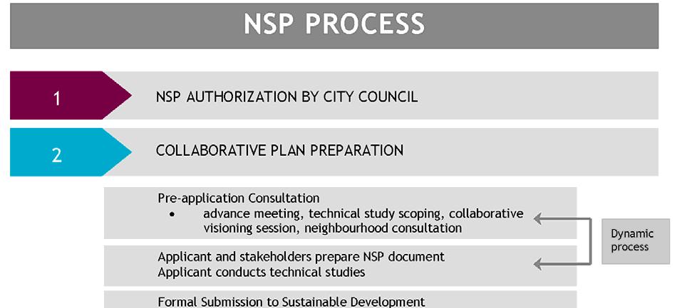
7 3. PLAN CREATION PROCESS New NSPs should be prepared through a collaborative process with all stakeholders. Collaboration will foster the development of creative design approaches, as well as shared ownership of the NSP, which will help to realize the unique and adaptable neighbourhoods that the DNN guidelines seek to achieve. Proponents are encouraged to share information in the pre application stage (e.g. technical studies), initiate early consultation, and provide opportunities for a range of stakeholders to participate in the plan making process. The plan creation process is made up of three major stages: pre application, submission and review of the NSP, and Council consideration (see NSP Process Diagram). 5
8 6
9 3.1 PRE-APPLICATION Applying a performance based approach to the planning and design of new neighbourhoods requires the City, landowners, and other stakeholders (including the development industry) to work closely together to prepare plans. These city builders are encouraged to take advantage of the flexibility that the performance based approach affords to achieve desired neighbourhood outcomes and respond to the unique context and vision of a new neighbourhood. The results of pre application consultation must be discussed within the NSP document and should be used to formulate the approach and policies of the neighbourhood plan. Before submission of an NSP application, at least one internal pre application meeting, and a minimum of two pre application meetings attended by the proponent are required. The purpose of each meeting and the stakeholders involved is outlined below. At each stage of pre application consultation the proponent should provide a map of the existing features of the plan area and should be prepared to discuss the following: land ownership, including delineation of Crown ownership and participating lands within the plan area; plan rationale, policy context, public involvement (consultation to date and planned stakeholder involvement approaches during the NSP creation process) and vision for area; applicable development considerations concerning the plan area and interface with surrounding lands, related to: Ecology environmentally sensitive/significant natural areas, ecological connections/corridors, existing water bodies wetlands and uplands, riparian system and top of bank, woodlots, wildlife passages, and determination of environmental reserve and Crown land ownership; Environment soil, air, and water quality and conservation, contaminated land, abandoned and existing oil and gas facilities from an environmental and a land use compatibility perspective as per the City of Edmonton s Oil and Gas Policy (C515), existing pipelines and their location, status and contents; Social/Cultural historic areas (including archeology), buildings, sites or landscapes, protected farmland, the range of housing forms and/or commercial developments to be provided for a variety of income levels and household types (e.g. market, affordable, low income, social, special needs housing), and inter municipal governance and cooperation; Economic economic growth, market trends and forecasts, availability of serviced lands, and land absorption rate; and Infrastructure / Urban Service infrastructure; transportation (e.g. roadways, rail and transit service, walkability), servicing (e.g. water, sanitary, sewer, stormwater), utility access and serviceability, and community services (including access to health care, protection/emergency services, school park sites and open space). Current Planning will provide a summary of each meeting to the stakeholders in attendance and the NSP proponent. 7
10 PRE-APPLICATION MEETINGS 1. Internal Civic Department and Review Agency Advance Meeting Prior to external consultation, Current Planning will schedule an internal meeting with Civic Departments and affected review agencies including (as required) EPCOR Water, the Province and inter municipal partners. This meeting does not include the NSP proponent/applicant. This meeting is an opportunity to discuss: opportunities and constraints to development in the neighbourhood; the history and evolving development context of the area; and policy implementation at the neighbourhood level. At this meeting Current Planning will summarize the relevant policies of the parent ASP and the current context of the neighbourhood and surrounding area. Each civic department and review agency will provide a summary of the conclusions of the technical studies submitted that informed the ASP and discuss any relevant policy implementation to be incorporated into the development of the neighbourhood. 2. Technical Study Scoping Meeting The technical studies requested will support decision making for the reviewing agencies at the NSP stage. This meeting is an opportunity to tailor the technical study requirements and expected level of report detail as determined by reviewing agencies for the review of non standard servicing or development schemes. At this meeting, stakeholders will outline the criteria of a formal and complete NSP application. The meeting should include: the proponent, senior decision makers with representatives from Sustainable Development, and other Civic Departments (e.g. Transportation Services, Drainage Services, Fire Rescue Services), Alberta Energy Regulator (AER). As necessary, the meeting should also include Alberta Utilities Commission (AUC), mineral rights (lease) holders, oil, gas, pipeline and public utility operators (e.g. EPCOR), and necessary Provincial and Federal agencies. After the meeting, Current Planning will provide the proponent with a summary of all technical study requirements that must be provided at formal submission. 3. Collaborative Visioning Session The DNN guidelines do not prescribe a set method for including the 12 outcomes and associated principles in a new neighbourhood. The document instead includes a sampling of design ideas to offer some tangible examples of how the DNN principles could be addressed. These design ideas are intended to serve as a starting point to generate discussion as plans are collaboratively developed. The City and plan proponent(s) will work together to determine what specific design features and approaches are most desirable and appropriate for a given new neighbourhood in a collaborative visioning session. At this meeting, City staff will summarize the findings of the Integrated Infrastructure Management Plan (IIMP) and authorization process. The proponent should summarize the relevant policies of the ASP and the existing context of the plan area and surrounding areas. The proponent should also provide a high level presentation that describes a preliminary vision for the development of the neighbourhood, and illustrate how the outcomes of the DNN guidelines can be addressed in the plan area. The meeting will be attended by the proponent, City staff and review agencies, who are all expected to contribute to discussion of the neighbourhood development vision and the approach to achieving the DNN outcomes. Stakeholders are encouraged to approach the collaborative visioning session with an open mind and a willingness to look at innovative approaches to planning in the NSP area. 8
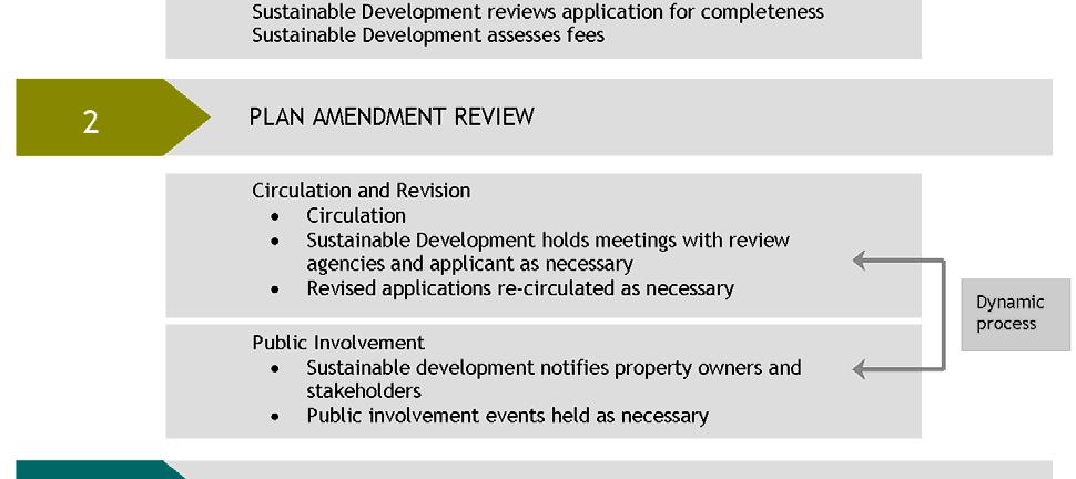
11 CONSULTATION WITH NEIGHBOURHOOD STAKEHOLDERS Stakeholder consultation is an important step in understanding the unique and desirable aspects of a neighbourhood. Proponents will notify, by letter, all owners of property within and surrounding the study area and may contact other affected stakeholders, including adjacent municipalities if the NSP area borders the City of Edmonton boundaries. In the letter proponents will state their intention to prepare an NSP and they will provide contact information regarding the project. It is best planning practice to consult early with all stakeholders who may be impacted by the NSP. The methods of consultation prior to formal application submission shall be determined by the proponent with input from Current Planning. Stakeholders are all local landowners, Edmonton School Boards, Ward Councilors, community leagues and community associations in the plan area. Local landowners include (as necessary): residents in the plan area or surrounding neighbourhoods, Alberta Health Services, EPCOR, Canadian National Railway, Canadian Pacific Railway and applicable Provincial and Federal agencies. Stakeholders may include the broader public across Edmonton or adjacent municipalities, particularly as some may be future residents of the NSP area. 3.2 SUBMISSION AND REVIEW OF THE NSP DOCUMENT Formal submission of the NSP document to Current Planning will provide all content, format, and technical study requirements specified within this Terms of Reference and at the pre application meetings. All formal submission requirements (Appendix 1) must be completed prior to the City of Edmonton s acceptance and circulation of an NSP application. Once formal submission requirements and conditions have been met, and the application is accepted, the application will be assessed Land Development Application (LDA) fees INITIAL REVIEW Before initial review a portion of the LDA fees must be received. The application will then be sent to Civic Departments and review agencies to review for completeness, not content. Agencies are asked to provide comment on the initial review within 2 weeks. The objective of the initial review is to ensure completeness of the plan and technical studies and to ensure the application is suitable for further, more detailed, review through the standard circulation process. Applications will not be considered ready for full circulation if, in the opinion of Current Planning: there are major land use conflicts that may affect the design of the neighbourhood; and/or information is missing from, or is of poor quality, in the formal submission package that is imperative for the review as outlined in this Terms of Reference and at the pre application meetings; and/or recommendations of technical studies are not reflected in the plan. Current Planning shall arrange a meeting with review agencies within this 2 week period to discuss the application components and ensure that competing interests are managed at an early stage. In the event that the application is deemed ready for circulation after the initial review, a standard circulation will be initiated (see below). Documentation will be circulated to the various departments and agencies for a full review and an notification will be sent to the applicant. 9
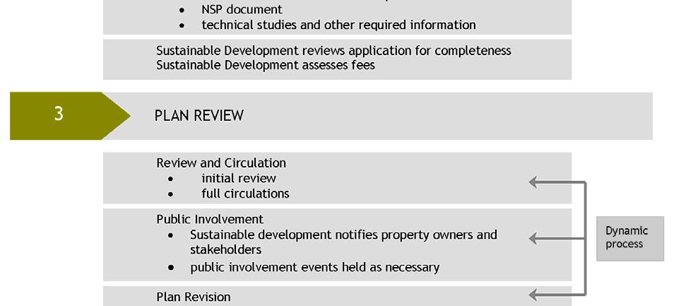
12 In the event that the application is not ready for circulation, Current Planning will provide an notification of the deficiencies to the applicant and the application will be returned for revisions until such a time as the required materials have been received. Applications will not proceed to full circulation until all aforementioned requirements have been met CIRCULATION Once the application is ready for a full review of content, and the full amount of LDA fees are received, it will be circulated to appropriate Civic Departments and review agencies. Any NSP application that touches the City s boundaries must be circulated to adjacent municipalities for review. Review agencies are asked to provide comments in response to an application within 6 weeks. At the conclusion of the full circulation, Current Planning shall hold a meeting with the applicant and affected reviewing agencies to discuss review comments and collaborate on desired outcomes. Plan creation is an iterative process, during circulation of the plan application the NSP document may be further modified, updated or amended. Any changes to the document shall conform to the content requirements identified in these Terms of Reference and be completed prior to finalization of the NSP. During the circulation process Current Planning will monitor the status of review agency responses, advise applicants accordingly, and call meetings as necessary to create agreement on any technical issues or file complexities. The number of circulations is dependant on file complexity and the quality of submission materials. As comments can vary greatly in scale, Current Planning will determine the number and duration of subsequent circulations that are needed for an application. Before the revised application will be circulated, Current Planning will assess the application to ensure that all department and review agency comments have been addressed. The applicant is asked to provide a cover letter with the revised submission, which discusses how each review comment has been addressed. Prior to finalization of the document and Current Planning s report to Council for Public Hearing, necessary consultations shall be held with involved stakeholders, and technical studies shall be completed PUBLIC INVOLVEMENT DURING APPLICATION REVIEW Applicants and Current Planning are responsible for consulting with stakeholders and providing opportunities for public involvement throughout the planning process, in accordance with urban planning best practices and legislative requirements (e.g. MGA, City of Edmonton Public Involvement Policy C513). In addition Current Planning will use the Land Development Application (LDA) Public Involvement Plan (PIP) to guide public involvement for each planning application. Current Planning will schedule a public involvement event and invite property owners and other Civic Departments as required, including land owners in adjacent municipalities if the application touches the City s boundaries. The event will be an opportunity to provide information about the NSP and solicit public input into the plan prior to advancement to Council and Public Hearing. A minimum of one public involvement event is required at an appropriate time in the process (e.g. after the six week standard circulation). Additional public involvement events (e.g. open house information session, charette) may be required depending on the nature of the NSP or if significant changes have been made to the plan since the initial public involvement event. 10
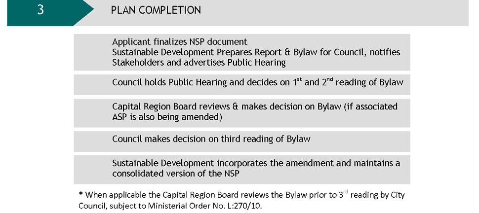
13 3.3 CITY COUNCIL CONSIDERATION Current Planning will summarize how the NSP, or NSP amendment, achieves all 12 DNN outcomes in the Report to Council. The NSP is referred to City Council for Public Hearing for consideration of the plan and in some cases (as per Ministerial Order No. L:270/10), to the Capital Region Board (CRB). Where the NSP does not require review and a decision by the CRB, Council may adopt the plan with or without amendment, reject the plan, or postpone the decision. Where the NSP must be referred to the CRB, this will be done prior to Third Reading of the plan Bylaw. Administration will present the proposed Bylaw to the Capital Region Board for its review and decision. The CRB may approve or reject the plan or plan amendment. Once a decision has been reached, the proposed NSP Bylaw may be forwarded to City Council for consideration of Third Reading at Public Hearing. Council may adopt the plan with or without amendment, reject the plan, or postpone the decision. Should the NSP be adopted, the City Clerk s Office will hold an official original hard copy of the complete NSP documentation along with an electronic copy as approved by City Council. A copy of the final City Council approved NSP will be posted on the Sustainable Development website for public access and information. Current Planning will maintain a consolidated version of the NSP as amendments occur over time. 11
14 4. CONTENT REQUIREMENTS 4.1 OVERARCHING REQUIREMENTS It is critical that new NSPs demonstrate alignment with the Way We Grow (MDP) and the Designing New Neighbourhoods Guidelines (DNN). An NSP must communicate how the plan addresses the DNN principles and helps achieve the DNN outcomes. As the DNN states, one of an NSP s primary functions is to clearly communicate the intent of subsequent planning stages and to set the stage for implementation by: building a shared understanding of how a neighbourhood responds to planning policy; providing a focus for discussions between city builders during plan preparation and review; providing a strong basis to effectively champion new approaches together; helping city builders to monitor neighbourhood development trends, understand the demographic and land use implications of an NSP, and make informed decisions related to future public investments; and guiding neighbourhood development after the adoption of an NSP. A NSP shall align with other City policies and the parent ASP, and clearly communicate the vision for the new neighbourhood by including images, clear policies, and key statistics IMAGES, PHOTOS AND MAPS A plan will include images, photographs and maps to help communicate the proposed character of the neighbourhood and illustrate key design features and concepts. The use of images will build a shared understanding of how principles may be translated on the ground through the implementation of plan policies. All images and figures shall directly relate to policy and/or implementation strategies and should be referred to directly in the plan text. All NSP maps and images shall be considered conceptual. Furthermore, NSP map symbols, locations and boundaries shall be interpreted as approximate unless otherwise specified within the plan CLEAR, CONCISE POLICY The performance based approach to the preparation of a new NSP described in the DNN Guidelines does not mean a regulation or standard free approach to new neighbourhood design. It means a commitment to plan preparation that is focused on the achievement of common outcomes, through the application of principles, in support of the unique vision of a neighbourhood. To achieve this, NSP s shall: reflect the recommendations of technical reports and consultation in the vision, policy and implementation actions; illustrate the intent of the development vision through policy, avoiding numerical representations, such as exact percentages of low to medium residential development within policy statements; demonstrate in text and images how proposed policies meet the DNN objectives and the NSP vision be written as performance based, providing ways to measure plan implementation over time where possible; 12
15 clearly address the five questions: what (context) why (vision/approach), where, when, and how (policy, implementation and design ideas), in each subsection of the plan; and take into account and communicate existing conditions, but write the plan as forward looking, highlighting unique contexts and relevant information IDENTIFICATION OF KEY STATISTICS A statistical summary of key land use and population statistics shall be provided in an NSP, along with a brief written analysis of the data it contains. The purpose of the summary is to provide critical at a glance information about a new neighbourhood, and for population forecasting. The written analysis facilitates a deeper understanding of this raw data. The statistical summary for NSP applications shall use the template provided in Appendix 2. Some of the neighbourhood plan statistics that can be calculated and reported at the NSP stage, and which are meaningfully aligned with the progress measures identified in The Ways (including requirements of section 3.1 of The Way We Grow) and the principles of the DNN Guidelines, include: projected development densities; land use mix; housing mix; amount of natural area conserved; provision of Municipal Reserve; and percentage of the neighbourhood s population in proximity to a variety of destinations and amenities. Note: All new plans shall meet the Capital Region Plan density guidelines. Anticipated student generation is to be determined in consultation with the Joint Use Agreement. The following Sample NSP Table of Contents provides more detail on the required content of NSPs. 13
16 4.2 SAMPLE NEIGHBOURHOOD STRUCTURE PLAN TABLE OF CONTENTS The following Table of Contents provides a list of components to consider and potentially include in an NSP document. Applicants should examine all sections and sub sections described in this NSP Table of Contents for their applicability to a particular plan area. The final Table of Contents for an NSP shall be determined through discussion with Current Planning. The applicant should be prepared to justify the exclusion of any content described in this Table of Contents from an NSP, based on the specific site context or development concept for a plan area. Innovative or unique approaches to organizing the NSP are encouraged, as long as all pertinent information is included and all of the Designing New Neighbourhood outcomes and principles are addressed. For example, it is possible to organize the NSP land use and urban design policies around smaller geographically based precincts within the plan area. 1. Introduction 1.1 Planning Framework and Plan Area 1.2 Authorization 1.3 Stakeholder Consultation Summary 1.4 Amendment Process 2. Neighbourhood Development Concept 2.1 General Plan Context 2.2 Neighbourhood Vision and Development Concept 3. Public Realm 3.1 Context and Approach 3.2 Historic and Cultural Resources 3.3 All Weather Design 3.4 Landscaping 3.5 Focal Points/Town Centre 4. Land Use 4.1 Context and Approach 4.2 Commercial and Employment 4.3 Residential 4.4 Mixed Use 4.5 Institutional 5. Ecology, Parks and Amenities 5.1 Context and Approach 5.2 Natural Areas 5.3 Parks 5.4 Open Space 5.5 Urban Agriculture 6. Infrastructure and Servicing 6.1 Context and Approach 6.2 Sanitary and Stormwater Drainage 6.3 Water Distribution 6.4 Shallow Utilities 6.5 Infrastructure and Land Use Integration 6.6 Energy Efficiency 6.7. Staging 7. Transportation 7.1 Context and Approach 7.2 Active Transportation 7.3 Road Network 7.4 Transportation and Land Use Integration Appendices Completed Technical Studies Additional Information 14
17 EXPANDED NEIGHBOURHOOD STRUCTURE PLAN TABLE OF CONTENTS The following terms found in this Expanded NSP Table of Contents refer to the components of a plan from background information to implementation. It should be noted that planning outcomes and principles for Urban Growth Areas are already identified in the Designing New Neighbourhoods Guidelines. The approach, policy and implementation statements in an NSP describe how the DNN outcomes will be achieved in the context of a specific plan area. Context: The background information and existing site conditions that inform the approach and subsequent policy and implementation of an NSP. Approach: The general planning intent or purpose for a particular NSP topic, which provides the overall rationale for subsequent NSP policy statements and implementation actions. Policy: a formalized idea for a particular NSP topic that provides specific direction for achieving the NSP vision and aligns with the associated approach for an NSP topic. Implementation: a definable step that helps achieve the approach and policy for a specific NSP topic. Implementation actions identify the decisions or design ideas that will be incorporated during the rezoning and subdivision stages of development to ensure NSP policies are realized in the plan area. 1. INTRODUCTION 1.1 Planning Framework and Plan Area Define NSPs and describe how they fit into the planning framework, including the Municipal Government Act authority for the preparation of Area Structure Plans (ASP), and the authorization for NSPs by Council and the intents of the ASP and the MDP. Provide an overview of the associated Area Structure Plan and how the NSP aligns. Describe succinctly the plan area and boundaries, including how the plan area relates to surrounding neighbourhoods. 1.2 Authorization Provide a brief description of the authorization process, referencing authorization and information requirements outlined in Edmonton s Municipal Development Plan ( ) and Growth Coordination Strategy. Include Council s date of Authorization Approval. 1.3 Stakeholder Consultation Provide a brief description of the pre application consultation process, outlining the findings and outcomes of the pre application meetings with internal City departments and other affected stakeholders (see Section 3.1). Make note of the public involvement events that were held, and provide a summary of comments from the public. Describe, if applicable, how public input was incorporated into specific NSP objectives. For example, note the retention of an existing green space identified and used by residents in the NSP area or connections that will be made to bike paths identified by individuals in an adjacent neighbourhood. 15
18 1.4 Amendments Briefly describe the process for amending NSPs. 2. NEIGHBOURHOOD DEVELOPMENT CONCEPT 2.1 General Plan Context Provide a figure(s) identifying the general context of the plan area, including important features in adjacent areas that relate to development of the NSP. On the figure, make note of any important existing elements of the plan area that impact the development concept and objectives of the neighbourhood, such as: agricultural soils capability; geotechnical and hydrological characteristics (i.e. floodplain, top of bank etc.); existing vegetation, water bodies, all natural areas and ecological connections/corridors; existing infrastructure (storm, drainage, water and sanitary facilities); archeological features, historical areas, landscapes, sites or buildings; landscape character, unique vistas, and views; existing development and subdivisions; utility corridors and registered rights of way; transportation roadways, railways, public transit routes and facilities and external connections; abandoned, suspended, existing and proposed petroleum and gas well sites, pipelines, storage, extraction, processing or operation facilities, lease areas and access roads; abandoned, existing and proposed sand, gravel or mine lands, extraction, processing or operation facilities any other areas requiring further investigation (e.g. telecommunications aerial / cellular towers, contaminated lands and potentially contaminated lands such as farmsteads, historical landfill features/activities); and boundaries or locations of any restricted area or indications of areas which may be affected by any government regulation (e.g. areas covered by environmental protection legislation, the North Saskatchewan River Valley Area Redevelopment Plan Bylaw, restricted development areas, First Nations lands, airport Noise Exposure Forecast (NEF) areas and crash hazard zones). Provide a brief summary of the existing context of the plan area, highlighting key constraints. Note that not all site context must be provided in this section as more detailed and specific context information shall be provided in appropriate subsequent sections. 2.2 Neighbourhood Vision and Development Concept Provide a short description of the vision for the neighbourhood. The emphasis of a NSP vision statement should be on the area s unique elements and features and the expected sense of place desired in the plan area. The vision statement shall: express a long term perspective; be no more than one paragraph (but may include images or diagrams); be unique to the neighbourhood; help achieve the policies of the parent ASP and the Municipal Development Plan; and clearly relate to the policy statements and implementation actions outlined in the NSP. 16
19 Provide an executive summary of the NSP, which expands on the Vision Statement, describes the concept for the neighbourhood, and explains the application of the Designing New Neighbourhoods guidelines to the unique context of the plan area. This section is an opportunity to discuss the approach and policy outlined in the NSP in a holistic manner and provide an overall picture of how the neighbourhood will develop. The Neighbourhood Concept should acknowledge the interrelated and interdependent aspects of the different policy statements in the NSP. The format of the Neighbourhood Concept is flexible, however, the Concept shall: be concise and constitute a summary; comply with and expand on the Neighbourhood Vision Statement; highlight the defining elements of the NSP and demonstrate how the NSP approach and policy achieve the 12 DNN outcomes; and reference the Development Concept Figure and the NSP Land Use Statistics Table. 3. PUBLIC REALM 3.1 Context and Approach Provide any specific context that affects the public realm policies for the neighbourhood, such as: historical buildings or resources; cultural sites or other socially significant features; natural or environmental features; and/or applicable overlays in the Zoning Bylaw, such as the Major Commercial Corridors Overlay, or the Airport Protection Overlay. Outline the approach to public realm and historic resources in the plan area, focusing on how the design policies and implementation actions outlined in the NSP will foster a unique identity and sense of place for the neighbourhood. Consider strategies for age friendly design, Crime Prevention Through Environmental Design, and reducing the carbon footprint of the plan area. 3.2 Historic and Cultural Resources Outline policy and implementation for addressing historic and cultural resources, focusing on: respecting and building on the local character found in the plan area; incorporating, where possible, existing historical and cultural features into the neighbourhood; maintaining view corridors to historic, cultural and natural features; and using historic, cultural and natural resources to create distinct gathering places or nodes in the plan area, having regard for the animation of public spaces. 3.3 All Weather Design Outline policy and implementation for creating an adaptable neighbourhood that embraces all seasons, and accommodates all mobility levels. Address the goals of the Winter City Strategy. Examples of how to address this topic at the NSP level include: orientating streets and buildings to protect from north winds and to capitalize on solar exposure, which will also contribute to energy efficient neighbourhoods; planning public spaces and parks for activity all year round, such as shared use paths that accommodate biking in summer and cross country skiing in winter; and 17
20 ensuring the maintenance and operation of infrastructure takes into account different seasons. 3.4 Landscaping Outline policy and implementation regarding landscaping in the plan area. Consider the use of landscaping to: frame and shelter public spaces (eg. all weather design); support urban agriculture (e.g. edible landscaping); reduce energy requirements by using trees to control micro climates; create a unique identity for the neighbourhood; all weather design; and support low impact development (e.g. landscaping designs which support the provision of native landscaping, or help to support on site stormwater management). 4. LAND USE 4.1 Context and Approach Provide specific background information that affects the development of the neighbourhood, such as: topography; connections to land uses in adjacent neighbourhoods ; findings from market assessments that provide information about commercial needs in the area; and transit stations, commercial nodes, or other connections that affect the density and type of development in the plan area. Describe the overall approach to development in the neighbourhood, focusing on how different land uses will interact and complement one another in support of the DNN outcomes and principles, including walkability and convenient access to services and facilities. Note some land uses may be more prominent in the neighbourhood, and there may be more policy and implementation dedicated to certain land uses depending on the neighbourhood context and approach. 4.2 Commercial and Employment Outline policy and implementation for commercial development and employment areas. Include information about the: location, general size, and function (e.g. retail, office, live work, industrial) of commercial and employment areas; scale, format and design of commercial uses (e.g. neighbourhood commercial, community/major commercial, highway commercial corridors); connections/interface with surrounding land uses and the public realm; facilitation of multi modal access to commercial nodes, which is appropriately tailored to the specific design, scale and format of use; provision and availability of commercial services including employment opportunities; the location and size of any urban agriculture uses, such as functioning farms and markets; minimizing energy use and requirements in commercial areas; 18
21 justification of commercial uses within the NSP based on population to be served, size of the area, Commercial Market Needs Assessment, mixed use areas in the NSP, or distribution of commercial sites and trade areas outside the immediate plan boundary; and general separation distances and transitional areas between any industrial and commercial development and other land uses. 4.3 Residential Outline policy and implementation for housing in the neighbourhood. Include information about the: location, pattern and design of a mix of residential typologies with the plan area; relative walking distance and access from residential areas to public transit, commercial nodes, park and natural areas and amenities in surrounding neighbourhoods; and provision of a range of housing forms to accommodate a variety of income levels and household types in response to a continuum of housing need (e.g. market, affordable, aging in place, low income and special needs housing). 4.4 Mixed Use/Town Centre Outline policy and implementation for mixed use development in the plan area. Include information on the: location, size, function and design of mixed use and town centre development (e.g. compatibility, integration of uses), including the rationale for mixed use development based on demographic and economic forecasts; strategies for transit oriented development at appropriate locations, describing the focused mix of residential, retail and employment growth around LRT stations and transit centres; land use efficiencies that can be achieved through the joint use of space in mixed use areas (e.g. shared parking facilities between residential and commercial development); unique urban design character of focal areas (e.g. integration with heritage resources, streetwall/building lines, public and private interfaces, visual linkages, innovative parking strategies, public art and architectural themes); accessibility to mixed use/town centres and facilitation of multi modal connections to employment in the NSP area and nearby neighbourhoods; and general design ideas to indicate the quality of connecting paths (e.g. landscaping, safety, streetscaping, connection to other land uses in the plan area and surrounding neighbourhoods). 4.5 Institutional Outline policy and implementation for institutional development in the neighbourhoood, including: Schools provide information on the need for and location of educational facilities (elementary, junior/senior high and post secondary). Institutional/Urban Services provide information on institutional and urban service uses within the neighbourhood, such as health care facilities, religious facilities, daycares, assisted living buildings, libraries, ambulance, fire and police stations, cemeteries, or service yards. 19
22 5. ECOLOGY, PARKS AND AMENITIES 5.1 Context and Approach Provide any background information that affects the ecology and open space in the neighbourhood, such as: relevant conclusions from technical studies such as the Environmental Overview, the Parkland Impact Assessment, Geotechnical Study, Top of Bank Walk, Phase II Ecological Network Report, and/or Community Knowledge Campus Needs Assessment; and existing natural areas, tree stands, natural connections, wetlands and other waterbodies in the plan area and how these natural areas relate to adjacent land uses and the larger ecological network in surrounding neighbourhoods, the City and the region. Outline the approach to ecology, parks and amenities in the NSP area. 5.2 Natural Areas Outline policy and implementation pertaining to the conservation of natural areas within the interconnected ecological network in the plan area, including: determination of Environmental Reserve claimed by the Crown for participating lands within the plan area through the legal survey of water features in conjunction with Alberta Environment and Sustainable Resource Development; and determination of Environmental Reserve for participating lands within the plan area (as per MGA and the Guidelines for Determining Environmental Reserve (ER) Dedication for Wetlands and Other Water Bodies). Identify the preservation, conservation, and enhancement strategies that support a functioning ecological network including: natural areas and systems; waterbodies, all wetlands, drainage courses, watershed management (including relevant subwatershed studies) within an integrated and connected system; Top of Bank, including information from the the River Valley Area Redevelopment Plan Bylaw and/or geotechnical findings; wildlife (i.e. terrestrial and aquatic) habitat (e.g. woodlots, streams) and movement (e.g. wildlife passage, elimination of perched culverts), and potential habitat of significant (e.g. threatened or endangered) species; rare/unique landforms with historical or aesthetic significance; hydrological findings from the Neighbourhood Design Report to ensure the sustainability of retained natural areas; potential restoration areas; and conservation tools. 5.3 Parks Outline policy and implementation for parks and associated amenities in the NSP. Include information on: Municipal Reserve dedication for parks and schools; the location, size, distribution, and configuration of parks, schools, recreation centres and community league sites, having regard for the role and function of these parks and for the distribution of similar type sites outside the immediate plan boundary; 20
23 potential designation of any additional parkland on the basis of environmental conditions, residential density, historical or aesthetic significance, following the provisions of the Municipal Government Act, the Municipal Development Plan, the River Valley Area Redevelopment Plan Bylaw, and the Urban Parks Management Plan; and the overall role of park space in the plan area, the balance of parks for different recreational functions and the complementary nature of natural areas and programmed park spaces. Have regard for a range of park types (as per the Urban Parks Management Plan) including: City and District parks; neighbourhood parks natural areas; greenways; and River Valley parks. 5.4 Open Space Outline policy and implementation for open spaces, including: corridors; utility rights of ways; pipelines; boulevards; stormwater management facilities; and naturalization and restoration areas. Outline policy and implementation for passive green spaces, including how open space complements more traditional park spaces in the neighbourhood, and contributes to the ecological network in the plan area and surrounding neighbourhoods. 5.5 Urban Agriculture Outline policy and implementation for encouraging urban agricultural opportunities in the NSP area, such as community garden sites and pop up produce markets, including land designation where applicable. For more information, please consult Fresh: Edmonton s Food and Urban Agriculture Strategy. 6. INFRASTRUCTURE AND SERVICING 6.1 Context and Approach Provide background information that impacts the infrastructure and servicing scheme for the neighbourhood, such as: existing rail lines; abandoned, suspended, existing and proposed petroleum and gas well sites, pipelines, storage, extraction, processing or operation facilities, lease areas and access roads; areas of potential contamination; relevant findings from the Environmental Overview; existing drainage or servicing constraints and opportunities (including existing wetlands); and findings from a Geotechnical Study, Top of Bank Walk and/or a Phase II Ecological Network Report. Describe the approach to infrastructure and servicing in the neighbourhood, including opportunities for low impact development and efficient and adaptable servicing. 21
24 Consider the efficiency and effectiveness of the infrastructure and potential off site impacts, including taking sources of risk into account. Identify connections to infrastructure in adjacent neighbourhoods or municipalities. 6.2 Sanitary and Stormwater Drainage Outline policy and implementation for drainage in the neighbourhood, including the planned development and staging of: neighbourhood sub unit storm, sanitary and water utilities; sanitary pumping stations; stormwater management facilities; catchment areas; and hydrologic flow requirements for tree stands and natural areas. Where possible consider low impact development opportunities to manage stormwater runoff and improve water quality such as the use of: naturalized drainage ways; bioretention areas; and bioswales. Consider opportunities to integrate low impact development with natural areas and the open space network. 6.3 Water Distribution Outline policy and implementation for water distribution in the NSP area, including: water mains; water looping; booster stations; fire flows; and water reservoirs. 6.4 Shallow Utilities Outline policy and implementation for additional utilities in the neighbourhood, such as power, gas and telecommunication services. 6.5 Infrastructure and Land Use Integration Outline policy and implementation steps for integrating: existing rail lines; abandoned, suspended, existing and proposed petroleum and gas well sites, pipelines, storage, extraction, processing or operation facilities, lease areas and access roads (note that the field verification of exact oil/gas facility locations early in the planning process is beneficial); areas of potential contamination; and relevant findings from the Environmental Overview. Include policy and implementation actions on: the treatment of these facilities within and surrounding the plan area as per City Policy C 515; required buffers or setbacks to sensitive land uses to mitigate risk and how these recommendations will be implemented through rezoning and/or subdivision applications; and how transitional land uses will be addressed (ex. contaminated sites). 22
25 6.6 Energy Efficiency Outline policy and implementation for addressing energy efficiency in the plan area, such as: alternative energy sources and systems (e.g. renewable energy projects, or promotion of micro generation/community amenity renewable energy); carbon reduction strategies; and possibilities for the use of emerging technologies and adaptation to climate change. 6.7 Staging Outline policy and implementation relevant to the progression and timing of development in the neighbourhood, including major information from the Integrated Infrastructure Management Plan (IIMP) report, such as planned interchange construction that impacts the staging of the NSP. Describe the rationale for the proposed staging based on the logical servicing of the area, population and infrastructure funding models, and the approach to neighbourhood development in the NSP area, and in the context of other neighbourhoods within the parent ASP. 7. TRANSPORTATION 7.1 Context and Approach Provide background information that affects the transportation network in the NSP area, such as: existing and surrounding roadways, transit services and major pedestrian/cycling facilities; city wide modal priority networks within and surrounding the plan area; rationale for the road network from a Traffic Impact Assessment or other Traffic Studies; existing utility rights of way and pipelines; and the ecological and open space network related to shared use paths. Outline the approach to the transportation and mobility network in the neighbourhood, including how: the network connects to surrounding neighbourhoods and municipalities, and the River Valley where applicable (all modes); transportation and land use are integrated in the NSP area (destinations and links, and grid permeability); the Complete Streets principles are incorporated into the transportation and mobility network; and modal priorities are identified for the roadway network. 7.2 Active Transportation and Transit Outline policy and implementation for transit, including: routing information; provision of convenient public transit facilities and routes to reflect a maximum walking distance to public transit of 400m or to the satisfaction of Edmonton Transit; and the location of future LRT, even if unfunded, and if LRT can be accommodated within the roadway. Outline policy and implementation for cyclists, including: types of bike paths, including on street, divided and/or shared use paths; connections to bike paths in adjacent neighbourhoods; and the provision of trip end facilities. 23
26 Outline policy and implementation for creating a walkable, pedestrian friendly neighbourhood, including: shared use path system, including connections to surrounding neighbourhoods; access to amenities and general pedestrian connectivity (within and to the neighbourhood); and universal design so that all individuals can safely use sidewalks and other pedestrian facilities. 7.3 Road Network Outline policy and implementation for the road network to support efficient movement for all modes, having regard for the City of Edmonton Transportation Master Plan) including: expressways; freeways; arterials (recognizing the Arterial Roadway Assessment Bylaw); major collector roadways; truck routes; Dangerous goods routes within the NSP area or adjacent neighbourhoods; emergency accesses; and snow clearance and removal. Include information and policies for the support of regional transportation systems including rail. Identify opportunities to provide more sustainable roadways, through paving materials, narrower streets, shared use of road space between modes or other approaches. Identify wildlife passage requirements (see the Wildlife Passage Engineering Design Guidelines). 7.4 Transportation and Land Use Integration Outline policy and implementation relating to transportation and land use integration, including: Transit Oriented Development and future LRT; noise attenuation; garbage/recycling collection and/or snow management in unique situations; street furniture and interaction between buildings and the street; landscaping; the timing and process that will be used to identify street type within the plan area, as per the Complete Streets Guidelines; and the different functions streets will perform, and the types of users that will be accommodated in certain areas of the neighbourhood depending on adjacent planned land uses, including grid permeability. APPENDICES The details of what should be included in the appendices will be determined by the applicant, in consultation with Current Planning, and shall include: a complete list of technical studies conducted for preparation of the NSP and any background information that is helpful for stakeholders using the plan. 24
27 4.3 REQUIRED FIGURES 1. Boundaries of ASP area and the NSP area. 2. Diagram of how NSPs fit into the sequence of planning and development, from city wide plans and policies to ASPs, NSPs, rezonings and subdivisions (see Figure 2 in this Terms of Reference). 3. Neighbourhood context map identifying existing site opportunities and constraints over an orthophotograph of the plan area. Potential elements to show, based on the plan context, include: geotechnical and hydrological characteristics (i.e. floodplain, top of bank etc.); existing vegetation, water bodies, all natural areas and ecological connections/corridors; existing infrastructure (storm, drainage, water and sanitary facilities); archeological features, historical areas, landscapes, sites or buildings; existing development and subdivisions; utility corridors and registered rights of way; transportation roadways, railways, public transit routes and facilities and external connections; abandoned, suspended, existing and proposed petroleum and gas well sites, pipelines, sour gas facilities, storage, extraction, processing or operation facilities, lease areas and access roads; abandoned, existing and proposed sand, gravel or mine lands, extraction, processing or operation facilities; any other areas requiring further investigation (e.g. telecommunications aerial / cellular towers, contaminated lands and potentially contaminated lands such as farmsteads, historical landfill features/activities); and boundaries or locations of any restricted area or indications of areas which may be affected by any government regulation (e.g. areas covered by environmental protection legislation, the North Saskatchewan River Valley Area Redevelopment Plan Bylaw, restricted development areas, First Nations lands, airport Noise Exposure Forecast (NEF) areas and crash hazard zones). 4. Development Concept map illustrating the distribution of: applicable neighbourhood level ecological features; retained local historical resources; special urban design areas/districts/nodes; residential, commercial and mixed use land uses; natural areas, parkland, recreational facilities and schools; institutional / urban service; major transportation information (i.e. arterial and collector roadways); stormwater management facilities; and applicable special use areas. 5. Land Use Statistics table in standard template (see Appendix 2). 25
28 6. Ecological Network map showing an orthophotograph overlaid with an outline of the proposed development concept identifying: existing natural areas (uplands and wetlands) and water bodies; ecological connections/corridors; riparian system and drainage courses; naturalized stormwater management facilities; location of top of bank; development setbacks/buffers; and semi natural areas. 7. Ecology, Parks and Amenities map showing the proposed park concept including the location, size and distribution of city, district, community and neighbourhood level education and recreational facilities; community league sites; natural areas (wetlands and uplands); ecological network; wildlife passage; top of bank roadway / walkway (where applicable); corridors; connectivity (i.e. multi use trail, pedestrian and parkland connections); and open spaces (stormwater management facilities, utility rights of way). 8. Infrastructure, Servicing and Staging concept identifying: the conceptual location of the major water network required to serve the area and connection points into the existing system (i.e. transmission mains, booster stations, reservoirs); the overall permanent storm servicing plan involving the major trunk sewers, stormwater management facilities, outfalls and connection points, top of bank setback and low lying areas restrictions, and outlining existing and future catchment areas outside the neighbourhood; the overall permanent sanitary servicing plan involving the major trunk sewers, pump stations/force mains and the special servicing needs of low lying areas, and outlining existing and future contributing areas outside the neighbourhood; the location of any existing, interim or permanent utility installation (electrical substation(s), electrical distribution line(s), telecommunication conduit, switching stations and towers, high pressure gas line distribution line(s) and gate stations) required to serve the area; and identifying roadway infrastructure and facilities staging required to support the ASP (e.g. roads, interchanges, estimated general completion time). 26
29 9. Transportation Network map showing the location and design of the neighbourhood transportation pattern and facilities including: city wide modal priority networks in the neighourhood and surrounding areas to show transportation connections outside of the plan boundaries; top of bank roadway/walkway (where applicable); freeways, interchanges, and arterial and collector roadways; primary transit route(s), High Speed Transit (HST), park and ride facilities, and transit centres; major access points to Provincial controlled highways; any creek and ravine crossing(s); wildlife passages; and shared use paths, pathways, connections and bike routes. 10. Modal Priority map showing street type, transit routes and stations, and cycling and pedestrian routes, overlaid on the land use concept. This map should indicate nodes and links, 200m and 400m buffers around transit routes and stations, and areas which require a unique approach to land use and transit integration. General Images Additional illustrative images and maps are encouraged as long as they clearly relate to policy and implementation in the NSP. Zoom ins of any of the above maps inserted into the text of the NSP, in order to focus on a particular area or policy, is also acceptable. Some examples of types of images that could be used are: inspiration photos demonstrating a policy/implementation action; drawings of design ideas; and figures or maps that help demonstrate policy and implementation actions 27
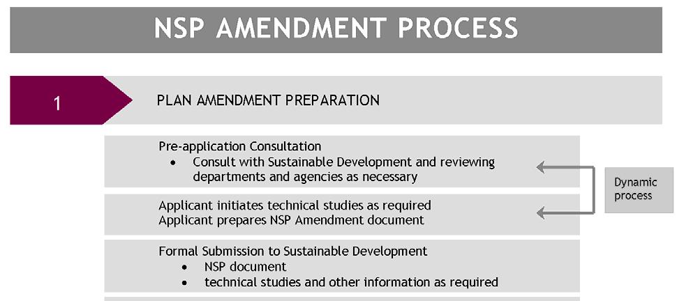
30 5. AMENDING AN EXISTING NSP WITHIN URBAN GROWTH AREAS As new communities grow, neighbourhood populations rapidly increase and then may slow, decrease or even rise again over the decades. Lifestyles and public priorities also change over time, as do markets, economies and technologies. If, in the opinion of Current Planning or City Administration, a specific development proposal does not conform to an existing plan, then a plan amendment is required. Amendments are assessed for their compliance with the intent of the policies and vision of the parent ASP and NSP, their compliance with the Designing New Neighbourhood Guidelines, and their support of other relevant Provincial or City policy documents and guidelines, servicing requirements and best management practices. The amendment process is shown in the NSP Amendment Process Diagram and described in more detail in the following sections. The amendment process may be tailored to the complexity of the specific amendment. 28
31 29
TERMS OF REFERENCE FOR THE PREPARATION AND AMENDMENT OF RESIDENTIAL AREA STRUCTURE PLANS
 Attachment 3 TERMS OF REFERENCE FOR THE PREPARATION AND AMENDMENT OF RESIDENTIAL AREA STRUCTURE PLANS Prepared by: Planning and Development Department Version 5 (2010) TABLE OF CONTENTS 1 INTRODUCTION
DESIGN NG. New Neighbourhoods Guidelines for Edmonton s Future Residential Communities THE CITY OF
 ! DESIGN NG New Neighbourhoods Guidelines for Edmonton s Future Residential Communities THE CITY OF Document Overview About the Document This performance-based guidelines document establishes a collective
SECTION E. Realizing the Plan
 SECTION E Realizing the Plan 60 DESIGN REGINA - OFFICIAL COMMUNITY PLAN SECTION E Realizing the Plan Design Regina has been an ambitious plan-making exercise, with a high level of community, stakeholder,
Complete Neighbourhood Guidelines Review Tool
 Complete Neighbourhood Guidelines Review Tool Prepared By: City of Regina Planning Department October 2014 Page 1 of 14 Community Development Review Checklist for Secondary Plans and Concept Plans The
TOWN OF BRUDERHEIM Report to the capital region board
 TOWN OF BRUDERHEIM Report to the capital region board Introduction to the Town of Bruderheim Municipal Development Plan amendment and Relation to the CRB Evaluation Criteria 02 march 2017 1 Introduction
LAND USE AMENDMENT CORNERSTONE (WARD 3) 60 STREET NE AND COUNTRY HILLS BOULEVARD NE MAP 26NE BYLAW 22D2017
 60 STREET NE AND COUNTRY HILLS BOULEVARD NE MAP 26NE BYLAW 22D2017") Page 1 of 14 EXECUTIVE SUMMARY This Land Use Amendment application covers an area of 43.76 hectares ± (108.14 acres ±) located in northeast Calgary, bound by Country Hills Boulevard NE to the south and
Page 1 of 14 EXECUTIVE SUMMARY This Land Use Amendment application covers an area of 43.76 hectares ± (108.14 acres ±) located in northeast Calgary, bound by Country Hills Boulevard NE to the south and
CITY OF VAUGHAN EXTRACT FROM COUNCIL MEETING MINUTES OF NOVEMBER 15, 2016
 Item 11, Report No. 38, of the Committee of the Whole, which was adopted without amendment by the Council of the City of Vaughan on November 15, 2016. Regional Councillor Di Biase declared an interest
THAT the attached Terms of Reference for the Thornhill Centre Street Study be approved.
 COMMITTEE OF THE WHOLE AUGUST 18, 2003 THORNHILL CENTRE STREET STUDY PLANNING FILE: 15.92 Recommendation The Commissioner of Planning recommends: THAT the attached Terms of Reference for the Thornhill
CITY OF CHARLOTTESVILLE, VIRGINIA CITY COUNCIL AGENDA
 CITY OF CHARLOTTESVILLE, VIRGINIA CITY COUNCIL AGENDA Agenda Date: December 16, 2013 Action Required: Adoption of Resolution Presenter: Staff Contacts: Title: James E. Tolbert, AICP, Director of NDS James
THE GARDEN CITY PLAN. City of St. Catharines Official Plan. City of St. Catharines
 THE GARDEN CITY PLAN City of St. Catharines Official Plan City of St. Catharines August 2010 APPROVAL INFORMATION This Official Plan of the City of St. Catharines Planning Area, known as the Garden City
4 Sustainability and Growth Management
 4 Sustainability and Growth Management Introduction Traditionally, has assumed growth and development with limited consideration for the long-term negative social, environmental or economic impacts on
LAND USE AMENDMENT CORNERSTONE (WARD 3) COUNTRY HILLS BOULEVARD AND STONEY TRAIL NE BYLAW 9D2017
 COUNTRY HILLS BOULEVARD AND STONEY TRAIL NE BYLAW 9D2017") Page 1 of 12 EXECUTIVE SUMMARY This Land Use Amendment application covers an area of 54.92 hectares ± (135.71 acres ±) located in northeast Calgary, bound by Country Hills Boulevard NE to the north and
Page 1 of 12 EXECUTIVE SUMMARY This Land Use Amendment application covers an area of 54.92 hectares ± (135.71 acres ±) located in northeast Calgary, bound by Country Hills Boulevard NE to the north and
ADMINISTRATION RECOMMENDATION 2016 November 03. That Calgary Planning Commission recommends APPROVAL of the proposed Land Use Amendment.
 Page 1 of 12 EXECUTIVE SUMMARY This Land Use Amendment application covers an area of 75.76 hectares ± (187.20 acres ±) located in northeast Calgary, bound by Stoney Trail NE to the north, 128 Avenue NE
CITY COUNCIL AGENDA REPORT
 CITY COUNCIL AGENDA REPORT Subject: COUNCIL MOTION LRT ALIGNMENT REMOVAL FROM THE TRANSPORTATION MASTER PLAN On February 10, 2016 Councillor Hughes provided notice in accordance with Section 23 of Procedure
ARTICLE 6: Special and Planned Development Districts
 ARTICLE 6: Special and Planned Development Districts 6-10 Traditional Neighborhood Development (TND) District 6-10.10 Purpose and Intent The Traditional Neighborhood Development (TND) District provides
Official Plan Review
 Official Plan Review Summary Report - The Built Environment August 2014 Part 1: Introduction Planning for a healthy, prosperous and sustainable community is an important goal for our municipality. From
1.0 Purpose of a Secondary Plan for the Masonville Transit Village
 Report to Planning and Environment Committee To: Chair and Members Planning & Environment Committee From: John M. Fleming Managing Director, Planning and City Planner Subject: Masonville Transit Village
GATEWAY AREA STRUCTURE PLAN
 CHESTERMERE GATEWAY AREA STRUCTURE PLAN COMMUNITY OPEN HOUSE SEPTEMBER 22 nd, 2015 PLAN AREA ± 512 hectares (± 1,265 acres) GATEWAY LOCATION UNDEVELOPED LANDS PRESENT AGRICULTURAL USE REGIONAL LAND USE
AMENDMENT NO. 30 TO THE OFFICIAL PLAN OF THE TOWN OF MILTON
 AMENDMENT NO. 30 TO THE OFFICIAL PLAN OF THE TOWN OF MILTON Subject: Boyne Survey Secondary Plan and Related Official Plan Amendments The following text and schedules constitute Amendment No. 30 to the
JASPER PLACE. Area Redevelopment Plan
 JASPER PLACE Area Redevelopment Plan Executive Summary Jasper Place is an established community where people live, work and play. The Jasper Place Area Redevelopment Plan (ARP) provides a tool to help
9 CITY OF VAUGHAN OFFICIAL PLAN AMENDMENT NO BOCA EAST INVESTMENTS LIMITED
 9 CITY OF VAUGHAN OFFICIAL PLAN AMENDMENT NO. 631 - BOCA EAST INVESTMENTS LIMITED The Planning and Economic Development Committee recommends the adoption of the recommendations contained in the following
SUBJECT: Waterfront Hotel Planning Study Update TO: Planning and Development Committee FROM: Department of City Building. Recommendation: Purpose:
 Page 1 of Report PB-23-18 SUBJECT: Waterfront Hotel Planning Study Update TO: Planning and Development Committee FROM: Department of City Building Report Number: PB-23-18 Wards Affected: 2 File Numbers:
Tāhuhu whakaruruhau ā-taone The sheltering ridge pole
 B2. Tāhuhu whakaruruhau ā-taone - Urban growth and form B2.1. Issues Tāhuhu whakaruruhau ā-taone The sheltering ridge pole Auckland s growing population increases demand for housing, employment, business,
MAYFIELD WEST SECONDARY PLAN PHASE 2
 MAYFIELD WEST SECONDARY PLAN PHASE 2 Public Open House #3 February 25, 2010 Draft Preferred Land Use Scenario TOWN OF CALEDON PLANNING & DEVELOPMENT DEPARTMENT Open House Agenda TOWN OF CALEDON 1. Welcome
Welcome. Walk Around. Talk to Us. Write Down Your Comments
 Welcome This is an information meeting introducing the applications for proposed redevelopment of the Yorkdale Shopping Centre site at 3401 Dufferin Street and 1 Yorkdale Road over the next 20+ years,
3. Endorse the LRT vision in transforming Surrey into Connected-Complete-Livable communities, and more specifically, the official vision statement:
 CORPORATE REPORT NO: R038 COUNCIL DATE: February 20, 2017 REGULAR COUNCIL TO: Mayor & Council DATE: February 16, 2017 FROM: General Manager, Engineering FILE: 8740-01 SUBJECT: Surrey Light Rail Transit
Municipal Development Plan Update Urban Service Area and Hamlets
 ENCLOSURE 1 Municipal Development Plan Update Urban Service Area and Hamlets Priorities Committee January 24, 2017 MUNICIPAL DEVELOPMENT PLAN UPDATE SHAPING OUR FUTURE MDP Update - Agenda MDP Update Public
PSRC REVIEW REPORT & CERTIFICATION RECOMMENDATION
 PSRC REVIEW REPORT & CERTIFICATION RECOMMENDATION KITSAP COUNTY COUNTYWIDE PLANNING POLICIES July 2, 2012 BACKGROUND A major emphasis of the Washington State Growth Management Act (GMA) is the need to
6 Growth Management Challenges and Opportunities
 6 Growth Management Challenges and Opportunities The Town has established a goal of attaining a 50% participation rate with respect to employment opportunities versus residential population. The Town s
1 Introduction. Chapter. In this chapter:
 Chapter 1 Introduction In this chapter: 1.1 A Snapshot of the Region 1.2 Towards a Sustainable Region 1.3 The Provincial Context 1.4 Purpose and Organization The Regional Municipality of York Official
Land Use Amendment in Southwood (Ward 11) at and Elbow Drive SW, LOC
 at and Elbow Drive SW, LOC") 2018 November 15 Page 1 of 10 EXECUTIVE SUMMARY This land use amendment application was submitted by Rick Balbi Architect on 2017 August 31 on behalf of Sable Developments Ltd, and with authorization from
2018 November 15 Page 1 of 10 EXECUTIVE SUMMARY This land use amendment application was submitted by Rick Balbi Architect on 2017 August 31 on behalf of Sable Developments Ltd, and with authorization from
~!VAUGHAN NOV Z November 21, Mr. Denis Kelly, Regional Clerk The Regional Municipality of York Yonge Street Newmarket, ON L3Y 6Z1
 ~!VAUGHAN NOV Z 5 2016 November 21, 2016 Mr. Denis Kelly, Regional Clerk The Regional Municipality of York 17250 Yonge Street Newmarket, ON L3Y 6Z1 Dear Mr. Kelly: RE: NEW KIRBY GO STATION IN BLOCK 27
Westwind Developments Ltd. PIONEER LANDS AREA STRUCTURE PLAN - PROPOSED AMENDMENT
 FEBRUARY 2013 TABLE OF CONTENTS 1.0 BACKGROUND... 1 1.1 Amendment... 1 2.0 LOCATION & CONTEXT... 2 2.1 Land Ownership... 2 3.0 POLICY CONTEXT... 3 3.1 Municipal Development Plan... 3 3.2 Capital Region
Municipal Development Plan 2013
 UNIQUELY STONY PLAIN: Municipal Development Plan 2013 Quick Reference Guide What is a Municipal Development Plan (MDP)? The Town s highest-level planning document Sets the long-term vision and key themes
URBAN DESIGN BRIEF URBAN DESIGN BRIEF 721 FRANKLIN BLVD, CAMBRIDGE August 2018
 URBAN DESIGN BRIEF URBAN DESIGN BRIEF 721 FRANKLIN BLVD, CAMBRIDGE August 2018 DESIGN BRIEF CONTENTS PART A 1.0 INTRODUCTION 2.0 DESCRIPTION & ANALYSIS OF SITE CONTEXT 3.0 DESIGN CONSTRAINTS AND OPPORTUNITIES
The protection of the agricultural resources of the Province;
 PART II INTRODUCTION An Official Plan is a policy document, which is intended to serve as the basis for making land use decisions and managing change in any municipality in Ontario. According to the Planning
Edward R. Sajecki Commissioner of Planning and Building
 Corporate Report Clerk s Files Originator s Files CD.03.POR DATE: TO: FROM: SUBJECT: Chair and Members of Planning and Development Committee Meeting Date: February 27, 2012 Edward R. Sajecki Commissioner
Figure 1- Site Plan Concept
 Figure 1- Site Plan Concept Parking will be provided underground on three levels at rate of 1.0 space/ unit; this rate includes all visitors parking. MMM Group has prepared a parking assessment (April,
PART 1. Background to the Study. Avenue Study. The Danforth
 The Danforth 1.1/ Study Purpose & Key Municipal Goals 1.2/ The Local Advisory Committee 1.3/ The Project Team 1.4/ Study Process/Summary of Method 1.5/ Summary of Consultation 1.1 Study Purpose and Key
FORMER CANADIAN FORCES BASE (CFB) ROCKCLIFFE SECONDARY PLAN. Official Plan Amendment XX to the Official Plan for the City of Ottawa
 ROCKCLIFFE SECONDARY PLAN. Official Plan Amendment XX to the Official Plan for the City of Ottawa") FORMER CANADIAN FORCES BASE (CFB) ROCKCLIFFE SECONDARY PLAN Official Plan Amendment XX to the Official Plan for the City of Ottawa 1 INDEX THE STATEMENT OF COMPONENTS PART A THE PREAMBLE PAGE Purpose...
FORMER CANADIAN FORCES BASE (CFB) ROCKCLIFFE SECONDARY PLAN Official Plan Amendment XX to the Official Plan for the City of Ottawa 1 INDEX THE STATEMENT OF COMPONENTS PART A THE PREAMBLE PAGE Purpose...
The West Vaughan Employment Area Secondary Plan Policies
 Part 2: The West Vaughan Employment Area Secondary Plan Policies 2.1 General Policies It is the policy of Council: 2.1.1. That the West Vaughan Employment Area (the WVEA), identified on Schedule 1, will
Gold Line Bus Rapid Transit Transit Oriented Development (BRTOD) Helmo Station Area Plan
 Helmo Station Area Plan") Appendix F Gold Line Bus Rapid Transit Transit Oriented Development (BRTOD) Helmo Station Area Plan Introduction and Purpose of the Plan The Gold Line Bus Rapid Transit facility is an eleven-mile dedicated
Appendix F Gold Line Bus Rapid Transit Transit Oriented Development (BRTOD) Helmo Station Area Plan Introduction and Purpose of the Plan The Gold Line Bus Rapid Transit facility is an eleven-mile dedicated
Public Open House. Overview of the Downtown Plan Official Plan Amendment April 23, 2018
 Public Open House Overview of the Downtown Plan Official Plan Amendment April 23, 2018 1 A 25-Year Plan for Downtown To ensure growth contributes positively to Toronto s Downtown as a great place to live,
Attachment 1 TOWN OF NEW TECUMSETH. Manual for the Preparation of an Urban Design Report
 Attachment 1 TOWN OF NEW TECUMSETH Manual for the Preparation of an Urban Design Report July 2010 TABLE OF CONTENTS Background, Policy Framework and the Preparation of Urban Design Reports 1. Introduction
Section 4 BUILDING THE MASTER PLAN
 The Master Plan 33 Section 4 BUILDING THE MASTER PLAN Figure 4:1. A collaborative effort characterized the two design workshops sponsored by DISC to create hypothetical Master Plans for the Towers Property
Regional Context Statement
 Regional Context Statement REGIONAL CONTEXT STATEMENT 3. REGIONAL CONTEXT STATEMENT In 1995, the Provincial Government passed into law the Growth Strategies Act. The purpose of this provincial initiative
CHAPTER 12 IMPLEMENTATION
 CHAPTER 12 IMPLEMENTATION The 2010 Town of Denton Comprehensive Plan is intended to capture a vision of the future of Denton. As such, it provides a basis for a wide variety of public and private actions
Urban Design Manual PLANNING AROUND RAPID TRANSIT STATIONS (PARTS) Introduction. Station Study Areas
 Introduction. Station Study Areas") 111111 PLANNING AROUND RAPID TRANSIT STATIONS (PARTS) Introduction The ION rapid transit system will link Waterloo, Kitchener and Cambridge through a central transit corridor (CTC). There are a number
111111 PLANNING AROUND RAPID TRANSIT STATIONS (PARTS) Introduction The ION rapid transit system will link Waterloo, Kitchener and Cambridge through a central transit corridor (CTC). There are a number
Chapter 2: Vision, Goals and Strategies
 Chapter 2: Vision, Goals and Lake Elmo Today & Tomorrow Comprehensive Plan 2040 2 VISION, GOALS & STRATEGIES - DRAFT 4-6-2018 INTRODUCTION Comprehensive Plan Purpose Perhapse the most important objective
The Way We Grow. Draft Municipal Development Plan. Reference Consolidation of approved and proposed amendments to draft Bylaw
 Attachment 1 Appendix 1 The Way We Grow Draft Municipal Development Plan Reference Consolidation of approved and proposed amendments to draft Bylaw 15100 October 23, 2009 Prepared by the Planning & Development
Scope of Services. River Oaks Boulevard (SH 183) Corridor Master Plan
 Corridor Master Plan") Scope of Services River Oaks Boulevard (SH 183) Corridor Master Plan PROJECT AREA The project area consists of the River Oaks Boulevard (SH 183) corridor bounded by SH 199 at the northern end and the Trinity
Scope of Services River Oaks Boulevard (SH 183) Corridor Master Plan PROJECT AREA The project area consists of the River Oaks Boulevard (SH 183) corridor bounded by SH 199 at the northern end and the Trinity
Official Plan Review: Draft Built Form Policies
 PG.30.1 REPORT FOR ACTION Official Plan Review: Draft Built Form Policies Date: May 15, 2018 To: Planning and Growth Management Committee From: Chief Planner and Executive Director, City Planning Division
ROAD CLOSURE AND LAND USE AMENDMENT SILVER SPRINGS (WARD 1) NORTHEAST OF NOSEHILL DRIVE NW AND SILVER SPRINGS ROAD NW BYLAWS 2C2018 AND 29D2018
 NORTHEAST OF NOSEHILL DRIVE NW AND SILVER SPRINGS ROAD NW BYLAWS 2C2018 AND 29D2018") Page 1 of 19 EXECUTIVE SUMMARY This application proposes redesignating two parcels in the community of Silver Springs from Special Purpose Future Urban Development (S-FUD) District and undesignated road
Page 1 of 19 EXECUTIVE SUMMARY This application proposes redesignating two parcels in the community of Silver Springs from Special Purpose Future Urban Development (S-FUD) District and undesignated road
The Five Components of the McLoughlin Area Plan
 The Five Components of the McLoughlin Area Plan This documents contains the complete language of the five components of the McLoughlin Area Plan: The Vision Statement The Values The Guiding Principles
LAND USE AMENDMENT DOWNTOWN COMMERCIAL CORE (WARD 7) MACLEOD TRAIL SE AND 5 AVENUE SE BYLAW 254D2017
 MACLEOD TRAIL SE AND 5 AVENUE SE BYLAW 254D2017") Page 1 of 10 EXECUTIVE SUMMARY This Land Use Amendment application seeks to redesignate a full downtown block (currently the YWCA site) from a Direct Control based on the CM-2 District (Land Use Bylaw
Page 1 of 10 EXECUTIVE SUMMARY This Land Use Amendment application seeks to redesignate a full downtown block (currently the YWCA site) from a Direct Control based on the CM-2 District (Land Use Bylaw
ONTARIO MUNICIPAL BOARD
 PL 120483 ONTARIO MUNICIPAL BOARD Applicant/Appellant: 2124123 Ontario Limited Subject: OPA, Rezoning and Draft Plan of Subdivision Municipal Address: 3940 Highway 7 East Municipality: City of Markham
Municipal Development Plan. Summer Village of ROCHON SANDS. Bylaw #241-18
 Municipal Development Plan Summer Village of ROCHON SANDS Bylaw #241-18 TABLE OF CONTENTS PART ONE: BACKGROUND AND PURPOSE 3 SECTION 1: BACKGROUND 3 SECTION 2: GOALS AND POLICIES 3 PART TWO: PHYSICAL ENVIRONMENT
Appendix 1 Structure plan guidelines
 Appendix 1 Structure plan guidelines This appendix forms part of the regional policy statement [rps]. 1.1. Introduction Structure plans are an important method for establishing the pattern of land use
Welcome to the Oakridge Centre Open House
 Welcome to the Oakridge Centre Open House Why is the City hosting this event? This open house is to inform you of a rezoning application submitted to the City of Vancouver to amend the existing CD-1 (Comprehensive
Plan Modification to Chapter B2 of the Auckland Unitary Plan(AUP) Operative in part (15 November 2016)
 Operative in part (15 November 2016)") UNITARY PLAN UPDATE REQUEST MEMORANDUM TO FROM Phill Reid Linley Wilkinson DATE 25 September 2018 SUBJECT Plan Modification to Chapter B2 of the Auckland Unitary Plan(AUP) Operative in part (15 November
UNITARY PLAN UPDATE REQUEST MEMORANDUM TO FROM Phill Reid Linley Wilkinson DATE 25 September 2018 SUBJECT Plan Modification to Chapter B2 of the Auckland Unitary Plan(AUP) Operative in part (15 November
CITY COUNCIL AGENDA REPORT
 CITY COUNCIL AGENDA REPORT Subject: DESIGNATED FLOOD LINE CARROT CREEK Recommendation(s) That Administration bring forward a Land Use Bylaw amendment in October 2014 establishing the Designated Flood Line
SECTION D. Citywide Policies
 SECTION D Citywide Policies 24 25 PART A - CITYWIDE PLAN - CITYWIDE POLICIES SECTION D Citywide Policies THIS SECTION PROVIDES POLICY DIRECTION BY TOPIC AREA: D1: Regional Context D2: Environment D3: Transportation
FOUR MILE RUN VALLEY WORKING GROUP AND CHARGE
 FOUR MILE RUN VALLEY WORKING GROUP AND CHARGE Adopted April 16, 2016 Amended July 19, 2016 Overview of Integrated Effort The overall goal of the Four Mile Run Valley (4MRV) initiative is to develop a comprehensive
Outline Plan in Belvedere (Ward 9) at Street SE, LOC (OP)
 at Street SE, LOC (OP)") 2018 October 04 Page 1 of 12 EXECUTIVE SUMMARY This outline plan application was submitted by B&A Planning Group on 2016 July 15, on behalf of Tristar Communities Inc. for 50.14 hectares (123.89 acres)
2018 October 04 Page 1 of 12 EXECUTIVE SUMMARY This outline plan application was submitted by B&A Planning Group on 2016 July 15, on behalf of Tristar Communities Inc. for 50.14 hectares (123.89 acres)
CITY CLERK. Parkland Acquisition Strategic Directions Report (All Wards)
") CITY CLERK Clause embodied in Report No. 10 of the, as adopted by the Council of the City of Toronto at its meeting held on November 6, 7 and 8, 2001. 10 Parkland Acquisition Strategic Directions Report
CITY CLERK Clause embodied in Report No. 10 of the, as adopted by the Council of the City of Toronto at its meeting held on November 6, 7 and 8, 2001. 10 Parkland Acquisition Strategic Directions Report
DRAFT MAP AMENDMENT FLU 04-4
 DRAFT MAP AMENDMENT FLU 04-4 SW 24 TH AVENUE ROADWAY CORRIDOR The University of Florida participates with the Metropolitan Transportation Planning Organization (MTPO) in its responsibilities for the continuing,
Town of Cobourg Heritage Master Plan. Statutory Public Meeting
 Town of Cobourg Heritage Master Plan Statutory Public Meeting April 25 th 2016 Presentation Overview 1. Introduction 2. Project background and schedule overview 3. Review of strategic direction content
Local Growth Planning in North Central Green Line Communities
 2018 April 30 Page 1 of 6 EXECUTIVE SUMMARY This report outlines a high-level scope for local growth planning for north central Green Line communities. The catalyst for this review is the significant investments
Phase I Ecological Network Report Terms of Reference
 Phase I Ecological Network Report Terms of Reference INTRODUCTION In 2007, the City of Edmonton created a new Natural Area Systems Policy (C-531) and a strategic plan, Natural Connections. Together, these
DRAFT Subject to Modifications
 TREASURE COAST REGIONAL PLANNING COUNCIL M E M O R A N D U M To: Council Members AGENDA ITEM 8 From: Date: Subject: Staff May 19, 2017 Council Meeting Florida Department of Transportation Complete Streets
I. STAFF POLICY RECOMMENDATIONS. The following RMP policy strategies are proposed by staff in support of a Scenic Resource Protection Program:
 Policy Consideration: Scenic Resource Protection Program Status: For Consideration by the Highlands Council at September 14, 2006 Work session Date: September 12, 2006 I. STAFF POLICY RECOMMENDATIONS The
A Growing Community Rural Settlement Areas
 Town of Huntsville Official Plan Review - POLICY BACKGROUND PAPER A Growing Community Rural Settlement Areas BACKGROUND: In addition to the fully municipally-serviced Urban Settlement Area and the Hidden
Introduction. Chapter 1. Purpose of the Comprehensive Plan Plan Organization Planning Process & Community Input 1-1
 Chapter 1 Introduction Lakewood 2025: Moving Forward Together Purpose of the Comprehensive Plan Plan Organization Planning Process & Community Input 1-1 Purpose of the Comprehensive Plan The Comprehensive
13 THORNHILL YONGE STREET STUDY IMPLEMENTATION CITY OF VAUGHAN OPA 669 AND TOWN OF MARKHAM OPA 154
 13 THORNHILL YONGE STREET STUDY IMPLEMENTATION CITY OF VAUGHAN OPA 669 AND TOWN OF MARKHAM OPA 154 The Planning and Economic Development Committee recommends the adoption of the recommendations contained
Town of Peru Comprehensive Plan Executive Summary
 Town of Peru Comprehensive Plan Executive Communities that plan grow by choice, not by chance. A plan makes growth thoughtful, understandable, and predictable. A plan shows that a community is managing
Planning, Property and Development Department Report. To the Riel Community Committee
 Planning, Property and Development Department Report To the Riel Community Committee Date: October 30, 2006 File: SP 5/2006 Subject: Waverley West Northeast Neighbourhood Area Structure Plan Location:
NEW REGIONAL OFFICIAL PLAN HIGH LEVEL PROCESS & FRAMEWORK
 NEW REGIONAL OFFICIAL PLAN HIGH LEVEL PROCESS & FRAMEWORK Why A New Official Plan Originally the role of Regionally Planning and content of Regional Official Plan (1970s) primarily focused on protecting
ADMINISTRATION RECOMMENDATION(S) 2018 January 25. That Calgary Planning Commission recommend APPROVAL of the proposed Land Use Amendment.
 2018 January 25. That Calgary Planning Commission recommend APPROVAL of the proposed Land Use Amendment.") Page 1 of 9 EXECUTIVE SUMMARY This land use amendment proposes to redesignate a parcel from DC Direct Control District to Multi-Residential Contextual Grade-Oriented (M-CG) District to allow for multi-residential
Page 1 of 9 EXECUTIVE SUMMARY This land use amendment proposes to redesignate a parcel from DC Direct Control District to Multi-Residential Contextual Grade-Oriented (M-CG) District to allow for multi-residential
Miami Valley Regional Planning Commission Regional Land Use Planning
 Miami Valley Regional Planning Commission Regional Land Use Planning This document provides an overall approach on the region-based land use planning process, outlining the major tasks and work elements
Phase 1 : Understanding the Campus Context. Phase 2 : APPROACHES - Alternates & Preferred Plan
 Introduction MASTER PLAN PURPOSE WHY A CAMPUS MASTER PLAN? The purpose of the Master Plan at the University of Illinois at Chicago is to translate UIC s strategic goals and objectives into a compelling
Ten Mile Creek Planning Area
 PLANNING AREA POLICIES TEN MILE CREEK Ten Mile Creek Planning Area Location and Context The Ten Mile Creek Planning Area ( Ten Mile Creek area ) is located south of the current Boise AOCI, generally south
Parks, Trails, and Open space Element
 Parks, Trails, and Open space Element Parks, Trails, and Open Space element Parks, Recreation, and Open Space are important components of the quality of life desired by the residents of Elk Grove. This
COMMUNITY SUSTAINABILITY AND ENVIRONMENTAL MASTER PLAN IMPLEMENTATION UPDATE
 Attachment 1 COMMUNITY SUSTAINABILITY AND ENVIRONMENTAL MASTER PLAN IMPLEMENTATION UPDATE Priorities and Key Initiatives Committee May 2013 Page E-1 How we grow Goal 2: To ensure sustainable development
Chair and Members of the Planning, Public Works and Transportation Committee. Tara Buonpensiero, Senior Planner Policy, MCIP, RPP
 REPORT TO: REPORT FROM: Chair and Members of the Planning, Public Works and Transportation Committee Tara Buonpensiero, Senior Planner Policy, MCIP, RPP DATE: April 9, 2018 REPORT NO.: RE: PLS-2018-0027
CITY OF LANGLEY OFFICIAL COMMUNITY PLAN BYLAW, 2005, NO APPENDIX II - REGIONAL CONTEXT MAP
 CITY OF LANGLEY OFFICIAL COMMUNITY PLAN BYLAW, 2005, NO. 2600 APPENDIX II - REGIONAL CONTEXT MAP ± Legend Agricultural Mixed Employment Industrial Conservation & Recreation Regional City Centre Urban Containment
5 TOWN OF MARKHAM OFFICIAL PLAN AMENDMENT NO. 144 MILLIKEN MAIN STREET SECONDARY PLAN
 5 TOWN OF MARKHAM OFFICIAL PLAN AMENDMENT NO. 144 MILLIKEN MAIN STREET SECONDARY PLAN The Planning and Economic Development Committee recommends the following: 1. The communication from Brendan O Callaghan,
2040 LUP is a part of the Comprehensive Plan and carries the same legal authority. Economic Challenges
 1.1. Guiding Anchorage s Growth Where will new residents settle over the next two decades? Where will people work, shop, and play? Will there be enough room to grow? How will Anchorage look? Will growth
1.0 PLANNING MARKHAM S FUTURE CONTENTS
 1-1 Planning Markham s Future 1.0 PLANNING MARKHAM S FUTURE CONTENTS 1.1 THE PURPOSE OF THE OFFICIAL PLAN 1.2 THE MARKHAM CONTEXT 1.3 THE REGULATORY CONTEXT 1.3.1 Province of Ontario 1.3.2 York Region
3. VISION AND GOALS. Vision Statement. Goals, Objectives and Policies
 Vision Statement Queen Creek s interconnected network of parks, trails, open spaces and recreation opportunities provide safe and diverse activities and programs that sustain its unique, small town, equestrian
Executive Summary.. 1. Introduction
 Executive Summary.. 1. Introduction 1.1. Park and Open Space Development... 1 1.2. Park and Open Space Designations and Zones.... 2 1.3. Types of Parks... 2 1.4. Types of Open Spaces... 3 1.5. Who Should
North Oakville East Parks Facilities Distribution Plan. November, 2009
 North Oakville East November, 2009 POLICY CONTEXT 1) Purpose a) The purpose of this document is to be a guide for the location, configuration, design and development of the parks system for the North Oakville
Plan Overview. Manhattan Area 2035 Reflections and Progress. Chapter 1: Introduction. Background
 Plan Overview The Manhattan Urban Area Comprehensive Plan (the Comprehensive Plan) is a joint planning initiative of the City of Manhattan, Pottawatomie County, and Riley County. The 2014 Comprehensive
Streets for People, Place-Making and Prosperity. #TOcompletestreets
 COMPLETE STREETS FOR TORONTO Streets for People, Place-Making and Prosperity COMPLETE STREETS: A NEW APPROACH A Complete Streets design approach considers the needs of all users people who walk, bicycle,
Plano Tomorrow Vision and Policies
 Plano Tomorrow Vision and Policies PLANO TOMORROW PILLARS The Built Environment The Social Environment The Natural Environment The Economic Environment Land Use and Urban Design Transportation Housing
HORSE HILL AREA STRUCTURE PLAN
 HORSE HILL AREA STRUCTURE PLAN Office Consolidation September 2015 Prepared by: Current Planning Branch Sustainable Development Department City of Edmonton Bylaw 16353, as amended, was adopted by Council
Comprehensive Plan. Faribault, Minnesota. Hoisington Koegler Group Inc. Claybaugh Preservation Architecture Inc. Howard R. Green Company Bonz/REA
 Comprehensive Plan Faribault, Minnesota Adopted by the Faribault City Council July 8, 2003 prepared for: prepared by: Hoisington Koegler Group Inc. Claybaugh Preservation Architecture Inc. Howard R. Green
Purpose of the Master Plan
 Purpose of the Master Plan 4 Master Plan Purpose The Master Plan is a policy framework for decisions that affect the physical, social and economic environment of the Town. The Parker 2035: Master Plan
Arlington, Virginia is a worldclass
 EXECUTIVE S U M M A RY Arlington maintains a rich variety of stable neighborhoods, quality schools and enlightened land use policies, and received the Environmental Protection Agency s highest award for
COLVER ROAD INDUSTRIAL CONCEPT PLAN
 COLVER ROAD INDUSTRIAL CONCEPT PLAN A CONCEPTUAL LAND USE AND TRANSPORTATION PLAN FOR TA-4 AN URBAN RESERVE AREA OF THE CITY TALENT City of Talent Adopted by City Council Resolution No., June, 2015 PART
MAYFIELD WEST SECONDARY PLAN PHASE 2
 MAYFIELD WEST SECONDARY PLAN PHASE 2 Council Information Workshop February 16, 2010 Draft Preferred Land Use Plan TOWN OF CALEDON PLANNING & DEVELOPMENT DEPARTMENT Workshop Agenda TOWN OF CALEDON 1. Welcome