Project Description June 24, DESCRIPTION OF THE PROPOSED ACTION. 2.1 Introduction
|
|
|
- Ashley Black
- 6 years ago
- Views:
Transcription
1 2.0 DESCRIPTION OF THE PROPOSED ACTION 2.1 Introduction This Draft Environmental Impact Statement (DEIS) has been prepared in response to a Positive Declaration issued by the Town of Bedford Planning Board in connection with an application by Cosimo Tripi, James P. Murphy and Adelaide V. Murphy for approval of a residential subdivision on a acre property located on Harris Road and New Street in the Town of Bedford, Westchester County, New York. The Positive Declaration and the SEQRA Full Environmental Assessment Form, upon which the Planning Board s determination of significance was based, are included in Appendix A. This Draft Environmental Impact Statement examines the potential environmental effects that may result from a residential development, known as the Tripi Subdivision. Initially, the applicant submitted site plan drawings and a DEIS for a 19 lot conventional subdivision. Following consultation with the Planning Board, the applicant has prepared a 23 lot conservation subdivision plan that meets the Town Code requirements for Conservation Subdivision, consistent with Chapter Conservation Subdivisions. This DEIS describes the potential environmental impacts of both the Conventional Plan and the Conservation Plan. The Conservation Plan is the plan preferred by the Lead Agency and by the applicant. The DEIS has been prepared in accordance with the State Environmental Quality Review Act (SEQRA) and Part 617 of the implementing regulations. The scope of the DEIS was established by a scoping outline developed by the Town Planning Board, acting as the SEQRA lead agency, in cooperation with all other involved agencies. The Planning Board adopted the Scope for a DEIS at a public scoping meeting on March 14, Additional information to be included in the scoping outline was required by the Planning Board and submitted to the design engineer, April 4, This Scope is included in this document in Appendix A. The applicant submitted drafts of the DEIS on May 8, 2007, December 5, 2008 and November 10, Following consultation with the Planning Board, a Conservation subdivision plan was prepared and is described, herein. This chapter summarizes the layout, site plan and benefits of both the Conventional Plan and the Conservation Plan. Chapters 3.1 through 3.9 provide analysis of the project s potential impacts and mitigation measures, for specific resources or environmental concerns. Evaluation is provided for both of the Site Plan concepts. The traffic analysis has been completely revised from the previously submitted traffic study, since traffic access and distribution is completely different between the two plans. In the Conventional Plan a through road would be provided between Harris and New Street, and in the Conservation Plan, the only point of entrance and egress would be via New Street. These differences in traffic warranted a revised study (see Section 3.5 Traffic and Transportation). In addition, the fiscal analysis provided in Section 3.8 Socioeconomic has been updated with 2010 tax rates and school budget information. A summary of potential project impacts is provided in Table 2-1 Tripi Subdivision Impact Comparisons. As shown in the Table, the Conservation Subdivision Plan would result in less overall land development impacts, including grading and construction disturbance, which would result in the retention of more existing vegetation on the property. The Conservation Plan would result in 4 additional residential units, compared to the Conventional Plan, given that two affordable residential units will be provided. The additional residential units in the Conservation 2-1
2 Plan would result in a slightly higher overall development population, including school age children, when compared to the Conventional Plan. The fiscal impact to the Town and specifically to the Katonah-Lewisboro School District are comparable for the two plans, since the Conservation Plan would generate higher taxes than the Conventional Plan, given the additional residential units. Table 2-1 Tripi Subdivision Impact Comparisons Areas and Potential Impacts Conventional Plan (19 Residential Lots) Conservation Plan (23 Residential Lots) Natural Resource Impacts (acres) Total Construction Disturbance Steep Slope Disturbance >15% Developed Area (acres) Impervious Surfaces (buildings and paved surfaces) Lawn and Landscaping (includes stormwater facilities) Woods (existing vegetation) undisturbed Road Length Community Resources Number of residential lots Number of affordable residences Population School Age Children * Water Demand (gpd) Sewage Flow (gpd) Revenues to School District Revenues to Westchester County Revenues to Town of Bedford Traffic Traffic Generation ±2, ,400 11,400 $393,214 $72,488 $33,924 Total AM Peak Hour Trips/ 23 Total PM Peak Hour Trips/ ,258 (emergency access ,700 11,750 $381,128 $70,260 $32,881 Total AM Peak Hour Trips/ 25 Total PM Peak Hour Trips/ Source: Tim Miller Associates, Inc. and Petruccelli Engineering and Surveying, P.C., 2008 and 2010 Note: * - The estimates of school age children are based upon Residential Demographic Multipliers - Estimates of the Occupants of New Housing, Rutgers University, June Project Purpose, Public Need and Benefits History of Project Site The project site is acres and is mostly vacant, except for an existing home owned by James P. Murphy and Adelaide V. Murphy located at the entrance to the site on Harris Road. The Murphy property is 1.84 acres in size and was purchased in 1995 (tax parcel: Section 60.7, Block 2, Lots 8.1 and 8.2). The Murphy property was subdivided from the larger Bailey Hall (now Tripi) property by metes and bounds description only and no formal subdivision plat was filed for the property. The Tripi subdivision will include the Murphy parcels and create 2-2
3 a new lot (Lot 19). The entire property is comprised of four tax parcels: Section 60.7, Block 2 and Lots 8, 8.1, 8.2 and 9 as shown on the Town of Bedford tax maps. No structures or buildings related to the Bailey Hall School remain on the property. In the mid 19th century the land within the project area was owned by J. Birdsall. A former dwelling from this period was located on historic maps from the period, but is no longer on the site. In the early twentieth century the property, which had previously been two parcels, became one parcel owned by the Florence Nightingale Holding Corporation and was used for the Florence Nightingale School which later was known as Bailey Hall. The Bailey Hall school operated under a succession of owners from 1918 until In its beginnings it was co-educational but evolved into a vocational school for boys. The school formerly contained a residence, barns, workshops, a school building and summer cottages. Further details regarding the historical use of the site is provided in the Phase 1A Literature Review and Sensitivity Analysis prepared by Citi/Scape: Cultural Resource Consultants (see Appendix G). The property is included in two residential zoning districts -- approximately acres in the R-1/2A district and 6.94 in the R-1/4A district. Based on a review of the title for the property, four easements are connected with the site. Copies of the Title and easements are attached in Appendix B, Correspondence. The easements are related to providing access to a former spring and for access to utility poles on the property. There are no stone walls existing on the property. Public Need and Community Objectives The objective of the applicant is to construct quality market-rate single-family detached residences that would appeal to households seeking to reside in the Town of Bedford. Housing in the Town of Bedford, is presently dominated by single family detached dwellings. Almost 71 percent of the total units in the Town of Bedford are single family detached homes. As indicated in the Town s Comprehensive Plan, the character of the existing residential development with particular reference to the prevailing low density will be maintained. The project would provide an appropriately scaled, community-friendly development in close proximity to the Town s retail and commercial uses, transportation facilities and elementary school. This project will address the need for housing in a location that is accessible using the existing local and regional road system. The existing roadway network would provide access to the site without the need for extensive improvement, as indicated in the Town of Bedford Comprehensive Plan. The project site is located approximately one mile from the Bedford Hills train station and less than one mile from the Katonah station, both stations on the Metro North Harlem line. Pedestrian access is an issue valued by the local community and the Planning Board. Although on-site sidewalks are not for the Conventional Plan, sidewalks would be provided in the Conservation Plan. With either plan, the nearby Katonah Elementary School and local retail locations would be accessible by pedestrians from the project site, although, as described below, off-site continuos sidewalks are not provided to either the school or retail locations. 2-3
4 It should be noted that the existing streets that surround the project including Harris Road, New Street, West View Drive and Sunrise Avenue do not have sidewalks. Current residents of the neighborhood must utilize the roadway edges when using a bicycle, walking or jogging on certain streets or portions of streets. Huntville Road, which is located north of the site and accessed by New Street, does have sidewalks for a majority of its length. Pedestrians from the Tripi subdivision could walk along the edge of New Street to Huntville Road and then walk on a sidewalk west to the Katonah Elementary School. The school is located approximately one-half mile from the site using this route. Pedestrians seeking to shop at the A&P supermarket located on Bedford Road would walk north on New Street to Huntville Road, east along Huntville Road using a sidewalk and then south on Bedford Road to the A&P. The A&P is located slightly more than one-half mile using this route. A further discussion of sidewalks and pedestrian access in the vicinity of the site is provided in Section Potential Impacts - Build Condition Traffic. The applicant s project will reinforce the objectives and policies of the Town s Comprehensive Plan adopted in July, 2002 by: providing a development within the community that preserves and reinforces the Town s basic residential character, continues the existing pattern of density and will help ensure that the Town maintains an adequate supply and range of housing stock. The project intends to address the public and community objectives by accomplishing the following: Increase the Town's housing stock and help satisfy the high demand for single family residences in the Town of Bedford and in Northern Westchester County. Create a project that is compatible with the character of the community and the long range plans by the community for the area. Achieve a balance between development that will result in new community members and the cost of community services to support that development. There also exists a desire to accommodate seniors aged 55 and above with smaller sized residences and single level living. Objectives of the Applicant The Applicant, Cosimo Tripi, intends to create a community of high quality single family homes consistent with the residential character of the Town of Bedford, in an attractive, wooded setting. This objective would be achieved with either the conventional subdivision plan or the Conservation subdivision plan. The project responds to a continued demand for 3-4-, and 5- bedroom housing in the Town of Bedford and Northern Westchester County. This particular project is of a low density (approximately 1 to 2 acres per dwelling unit) and is expected to support housing developed in conformance with the Town s Zoning Ordinance and Comprehensive Plan which designate this area for low density/single family residential use. An overview of the two project plans, is summarized as follows: Conventional Subdivision Plan The conventional plan would include the construction of 18 new market rate single-family homes, averaging 3,500 square feet (gross floor area) with three, four and five bedrooms (four bedrooms on average). One existing single family home was 2-4
5 considered in the overall environmental review. The new market rate home sites are anticipated to sell for between $1,000,000 and $1,500,000. The anticipated selling price is comparable to existing new construction in the Town of Bedford, for homes with approximately 3,500 square feet and four bedrooms. The Multiple Listing Service for houses in Katonah and vicinity shows comparable new 4 bedroom houses generally priced above $1,000,000, and houses in the Katonah Lewisboro School District on properties over one acre sold in December 2008 for $900,000 and above. 1 The conventional subdivision will involve a total of 19 lots, which includes the subdivision of an existing home located on Harris Drive, and the construction of eighteen (18) new homes. A total of 2,420 linear feet of roadway is to be offered for dedication to the Town (no private roads). The internal roads would be constructed with 24 feet in pavement width, within a 50-foot right-of-way, per Town of Bedford roadway regulations. The roads would be constructed with 6 inches asphaltic concrete and 8 inches gravel subbase. Access to all the nineteen residences will be off of the internal access road. The Applicant proposes to pay a recreation fee of $10,000 per approved lot to the Town for the purpose of funding community recreation programs and facilities that would be available to the future residents of this project. No active recreation facilities are in this subdivision. The project would result in approximately 8.44 acres of the existing vegetation and land (34 percent of the site) remaining undisturbed. Vegetation would be retained during construction by the installation of fencing at the limits of construction. Projected population in the Conventional development is 70 persons, consisting of 20 school aged children and a mixture of persons 18 years and older and younger than five. Municipal water will be provided to the project. Water service connections will connect the project to existing services located in Harris Road and in New Street. The Conventional project is not connected to a municipal sewer and each lot will have its own septic system. Conservation Subdivision Plan The Conservation subdivision will involve a total of 23 lots, which includes the subdivision of two existing lots (one existing home), located on Harris Drive, and the construction of twenty-two (22) new homes. Two of the 22 new homes will be affordable. The 20 new market-rate single-family homes, will range from approximately 2,500 to 3,500 square feet (gross floor area) with three and four bedrooms. The market rate homes are anticipated to sell for between $750,000 and $1,250,000. The anticipated selling price is comparable to existing new construction in the Town of Bedford, for homes of comparable size and four bedrooms. The two affordable homes will be priced at approximately $385,000, consistent with the Town of Bedford affordability requirements (Section ). The Conservation Subdivision will include a public looped access road, approximately 2,230 feet in length. Access to the development will be limited to New Street at the north
6 side of the property. A 12 foot wide emergency access road will be provided from Harris Road, to the loop road. The looped roadway is to be offered for dedication to the Town (no private roads). The internal road would be constructed with 30 feet in pavement width, within a 50-foot right-of-way, per Town of Bedford roadway regulations. The 30 foot width would allow on-street parking in the event of private parties or gatherings at individual residences. The roads would be constructed with 6 inches asphaltic concrete and 8 inches gravel subbase. The Applicant proposes to pay a recreation fee of $10,000 per approved lot to the Town for the purpose of funding community recreation programs and facilities that would be available to the future residents of this project. No active recreation facilities are in this subdivision. The project would result in approximately acres of the existing vegetation and land (47 percent of the site) remaining undisturbed. Vegetation would be retained during construction by the installation of fencing at the limits of grading. Projected population in this new development is 75 persons, consisting of 18 school aged children and a mixture of persons 18 years and older and younger than five. These population estimates may be subject to the design of specific residences, particularly for one level living. Municipal water will be provided to the project. The Conservation Plan project proposes a community septic system located in the central portion of the site. The community septic system is subject to review and approval by the Westchester County Department of Health and the NYC Department of Environmental Protection. Under either plan, the project will provide a modern residential neighborhood for persons seeking to live in the Town of Bedford, and would produce a modest, sustainable use of land that is currently underutilized. Benefits of the Project Development of new housing in Bedford will provide social benefits to the local area and the region by increasing its workforce and the available pool of civic minded residents. Additionally, new homeowners who will reside at Tripi Subdivision will utilize area retail, personal service, and other commercial services. It is estimated that this development would generate revenues to businesses on retail goods and services. A portion of these expenditures would be made at local area restaurants, supermarkets, convenience stores, apparel and household goods stores, and service businesses. Some of the benefits of the project are the following: Provides new housing stock to meet the continuing demand and ownership opportunities for housing in the Town of Bedford and Northern Westchester County. Provides low density residential project consistent with the Town's long range development objectives. The Conventional Plan would provide lots ranging from 0.6 to 2.75 acres in size. The Conservation Plan would provide a majority of lots (21 of 23 lots) approximately acres in size. 2-6
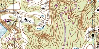
7 Provides an estimated 37 person-years of short-term employment for construction, including secondary employment resulting from the construction. Local construction contractors and building materials will be utilized whenever possible. Projected annual revenue to the Town of Bedford including municipal services would be $94,072 for the Conventional Plan and $91,180 for the Conservation Plan (2010 estimates. See Section 3.8 for further discussion). Projected annual revenue to the Katonah-Lewisboro School District would be $393,214 for the Conventional Plan and $381,128 for the Conservation Plan. This revenue is projected to be a net benefit to the school district. (2010 estimates. See Section 3.8 for further discussion) The Conventional Plan would retain approximately 8.44 acres of existing vegetation (33 percent of the site) through the use of construction fencing and adherence to the construction plans. The Conservation Plan would retain approximately acres existing vegetation (48 percent of the site). The limits of disturbance are shown Figure Grading Plan and in the attached full sized drawings. 2.3 Site Location and Vicinity The project site is located north of Harris Road and south of New Street, in the northwestern corner of the Town of Bedford. The project site is located east of Westview drive and west of Sunrise Avenue, in the northwestern portion of the Town of Bedford. The property has approximately 900 feet of road frontage on Harris Road, a local road. The south end of the New Street, also a local road, ends at the northern property line of the project site. Sunrise Avenue ends to the east of the project site. The regional and local settings of the site are shown in DEIS Figures 2-1 and 2-2. The project site comprises four tax parcels: Section 60.7, Block 2 and Lots 8, 8.1, 8.2 and 9 as shown on the Town of Bedford tax maps. The lot is acres in size. The subject property consists of mostly vacant wooded land, located in the R-1/2A and R1/4A Single-Family Residential zoning districts. An existing single-family home (Murphy residence) is located on Harris road in the southern portion of the property. The property is irregularly shaped, with its frontage on Harris Road and a secondary access from New Street towards the north. Single family development is located on all sides of the property. DEIS Figure 2-3 shows the existing conditions of the project site shown on a 2004 aerial photograph. Locations of existing structures on adjacent properties are illustrated in Figure 2-3. Access Conventional Plan Primary access to the Tripi subdivision would be provided from Harris Road and New Street (see Figure 2-4 Proposed Conventional Subdivision Plan). The subdivision would have a primary through road, and a side road accessing two cul-de-sacs in the western portion of the site. The through road labeled Road "A" on the Site Plans is approximately 1,700 feet in length and is an extension of New Street. A side road (Road B) extends to the west and is approximately 300 feet in length. Two (2) cul-de-sacs (Roads "C" and "D" are approximately 200 feet in length). The new roads would be constructed to Town specifications and 2-7
8 would be 24 feet in width. Alternative road widths, such as 18 or 20 feet would need a variance from the Town Board. the title deeds for the property, four easements are connected with the site. Those easements are further described in Section 2.2 Project Purpose, Public Need and Benefits. Alternative road widths would allow the installation of sidewalks on one side of the roads without increasing the area of impervious surface. The applicant is not proposing sidewalks in the conventional development plan. No sidewalk connections currently exist on streets adjoining the site, including New Street, Harris Road, Sunrise Avenue and Westview Drive. Existing sidewalks and pedestrian access in the vicinity of the site are described in Chapter 3.5 Transportation. Future pedestrian access following development is discussed in Section Potential Impacts - Build Condition Traffic. Eight residences (including the existing residence) will have access off of the 1,700 feet new Town roadway extending from Harris Road in the South to New Street on the North. The central access road will be 24 feet in width connecting from the main access road. The eleven other lots are to gain access via this central access road and two cul de sacs. The new roadways that would serve the site has been designed to meet Town of Bedford road specifications and will be offered to the Town upon completion. Conservation Plan A public looped access road connecting to New Street, is for the Conservation Plan. Twenty-one of the new homes would be accessed from the loop road and New Street, while a single new home and the existing Murphy residence would have access Harris Road. Based upon the steepness of the existing grade from Harris Road into the central portion of the site, a through street was not considered viable by the Planning Board and Town consulting engineer. A 12-foot wide emergency access road connecting Harris Road and the new looped access road is. The future homeowners association would be responsible for the winter maintenance (snow plowing) of this emergency access road. A letter has been sent to the Katonah Fire Department to elicit their comments on the emergency access. Following coordination with the Department, their recommendations will be incorporated into the plan. The looped access road would be approximately 2,230 feet in length and would have 30 feet of pavement width within a 50 foot right-of-way. The 30 foot width would allow on-street parking in the event of private parties or gatherings at individual residences. The new road has been designed to meet Town of Bedford road specifications and will be offered to the Town after completion. Land Use and Zoning The site vicinity is predominantly zoned for residential use of medium to low densities. The property is included in two single-family residential zoning districts, with approximately acres in the R-1/2A district and 6.94 in the R-1/4A district. The R-1/2A is a One-Half-Acre Residential District whereas the R-1/4A is a One-Quarter-Acre Residential District. The Village Apartment District (VA) borders the subject property to the south. The larger portion of the property falls in the One-Half-Acre Residential district where 16 single family homes are, under the Conventional Plan. The remaining three homes are in the 2-8
9 One-Quarter District (R-1/4A). In the Conservation Plan, 7 lots are fully within the R-1/4 acre district and 4 lots straddle the district line. Eleven lots are fully within the R-1/2 acre district. Present R-1/2A zoning allows single family dwellings. The R-1/2A residential zoning district cuts through the project site in the northern portion and extends off-site to the west. Properties fronting Bedford Road are generally excluded from this zoning district. The R-1/4A zoning allows single family dwellings. The R-1/4A residential zoning district line cuts through the project site in the northern portion and extends off-site to the north. Natural Features The project site is located in a section of the Town characterized by upland, hilly topography, and is approximately acres in size. The central and western portion of the site contain gently sloping topography (slopes less than 10 percent) with steeper slopes along the northern, eastern and southern edges of the property. Approximately 6.39 acres (25 percent of the site) has slopes in excess of 25 percent; of those areas approximately 1.84 acres would be impacted by grading activities. The Tripi Subdivision site primarily consists of successional woodlands and overgrown fields. The property contains mature trees, as well as smaller trees and brush. A single occupied residence, occupies the property. There are no wetlands, watercourses or water bodies on the project site. 2.4 Project Design and Layout Existing Environmental Characteristics The site is located off of Harris Road and New Street in the Town of Bedford, Westchester County, New York. The property is located in the New York City Department of Environmental Protection regulated Muscoot Watershed. The project is designed around the physical constraints of the property and attempts to minimize impacts to areas of steep slopes and existing vegetation that crosses the southern to eastern portion of the property. The northern and western portions of the site have generally more level grades. Approximately 6.39 acres or 25 percent of the project site consists of slopes 25 percent or greater. In order to minimize impacts to the areas with steep slopes, the roads and residential lots have been located to avoid these sensitive areas to the greatest extent practicable. Disturbance to slopes and erosion control measures are further described in Section 3.1 Geology, Topography, Soils. Conventional Plan The Conventional plan will have 19 lots ranging in size from 0.6 acres (26,251 square feet) to 2.75 acres (119,954 square feet). Of the 19 homes, 16 home sites will meet the zoning requirements of the R-1/2 A district and 3 home sites will meet the requirements of the R-1/4 A district. The R-1/2 A and R-1/4 A zoning districts allow one-family dwellings on 10,000 and 20,000 square feet lots, respectively. Tables 2-2 and 2-3 below lists the various bulk requirements applicable to the project. 2-9
10 Lot Area (Square feet) 20,000 Effective Square Side (Feet) 100 Table 2-2 Compliance with Bulk Requirements for R-1/2A Required Minimum Required Maximum Front Yard (Feet) 35 Lesser Side (Feet) 20/45 Rear Yard (Feet) 50 Building Height 2 1 / 2 stories or 35 feet Impervious Surface 30% Building Coverage 15% The Conventional homes are planned to average 3,500 square feet of gross floor area with three, four and five bedrooms. Footprints shown on the project plans average about 2,000 square feet in size. This house size is comparable to the newer existing single family houses in the immediate vicinity of the project site. Lot Area (Square feet) 10,000 Effective Square Side (Feet) 75 Table 2-3 Compliance with Bulk Requirements for R-1/4 A Required Minimum Required Maximum Front Yard (Feet) 35 Lesser Side (Feet) 15/35 Rear Yard (Feet) 40 Building Height 2 1 / 2 stories or 35 feet Impervious Surface 40% Building Coverage 20% The development has been designed to comply with the provisions of the Town Subdivision Regulations ( 107 of the Town Code). The overall subdivision plan is shown in DEIS Figure 2-4 and in the full size engineering drawing included in the rear of this document. The plan provides for new single family homes on upland areas of the site to preserve areas of steep slope, and existing vegetation to the greatest extent practicable. The project construction would result in the disturbance of approximately acres, or approximately 67 percent of the site. Approximately 8.44 acres (33 percent) of the site is to remain undisturbed, on individual lots. 2-10
11 Table 2-4 Changes in Surface Cover (Acres) Tripi Subdivision Cover Type Existing Conditions Post Development Woods/ overgrown fields Impervious Surface Pavement and buildings Landscaping (includes septic and stormwater facilities) Totals Source: Petruccelli Engineering, 2008, TIm Miller Associates, Inc. Upon completion, new impervious surfaces, including homes, paved roads and driveways, will cover approximately 3.44 acres (13 percent) of the project site. Disturbed areas that are not paved or otherwise built upon will be restored with lawns and landscaping, covering some (54 percent) of the site. This landscaped area includes the landscaped areas surrounding each home, stormwater treatment facilities and individual septic fields. As indicated above, approximately 8.44 acres of the site is to remain undisturbed, on individual residential lots. Sizable areas of undisturbed existing vegetation are anticipated at the rear of lots 9, 10, 13, 14, 18 and 19. The drawings provided show the footprints of potential homes, driveways, septic fields, and the areas of disturbance to construct these features on each lot. The limits of grading are provided on the plans and will be maintained during construction with fencing. While permitted, no accessory buildings or structures, such as swimming pools or tennis courts, are with the Proposed Action, and given the constraints of septic fields, stormwater management facilities and steep slopes, there is little available area for pools or tennis courts on each lot (see Figure Grading Plan). Should future homeowners want to construct accessory buildings (sheds decks, pools or tennis courts), the proper plans and permits would need to be obtained by those private parties. Any future plans would need to comply with Town Code requirements, including, but not limited to: Chapter 125 Zoning for building permits, Chapter 112 Tree Preservation, for the removal of trees, and Chapter 102 Steep Slopes for any grading or tree removal on steep slopes. As there is no active recreation lot in this subdivision, the Applicant proposes to pay the Town s recreation fee of $5,000 per newly-subdivided lot. Conventional Plan Project Design and Natural Features The project site plan was designed in using good design principals and is compatible with the natural features of the site. The project site has generally level topography in the north and west and slopes steeply towards the southeast, towards. Due to topography and surrounding development and road frontage, the project site has only two access points: at Harris Street in the south and at New Street in the north. The through road (Road A) was design to utilize existing access points to the property, including New Street at the north and an existing driveway on Harris Street at the south (the project entrance was shifted somewhat from the driveway to allow better sight 2-11
12 distance). The internal roads are laid out to minimize the required grading and site disturbance. Existing driveways through the property, which generally follow existing topography and avoid rock outcrops, provide the location of the access road (Road A). Residential sites are located in the most level portion of the site (north-central and western) to minimize impacts to steep slopes. Residential septic fields are also located on level areas with appropriate soils in keeping with good engineering design practice. Existing rock outcrops were also avoided for home sites, roads and driveways, to the extent possible to avoid costly rock removal. Areas of steep slope were specifically avoided for the placement of homes, driveways and septic field, as shown in Figure Steep Slopes Disturbance Map. The figure illustrates how steep slopes were avoided in the placement of future homes and septic fields. Existing vegetation on the property, including mature trees will be retained, outside the designated limits of disturbance. The drawings provided show the footprints of potential homes, driveways, septic fields, and the minimum areas of disturbance to construct these features on each lot. The requirement to provide individual septic systems on suitable level soils on each lot increased the necessary site disturbance and vegetation removal. The limits of grading are shown in Figure Grading Plan and are designated on the Site Plan drawings. These limits of disturbance will be maintained during construction with fencing. Conservation Subdivision Plan Design and Layout A Conservation Subdivision plan was initially developed as an alternative, during the preparation of the DEIS. The Conservation Plan was prepare to address the Conservation Development regulations in the Town Code (Chapter ). Following discussions with the Planning Board and Town Planner, the Planning Board indicated its preference for Conservation (cluster) Plan. The Conservation Plan was then modified and updated, based upon comments from the Planning Board. The Conservation Plan has been designed consistent with the Town Code, and according to the Code this plan is subject to review and approval by the Town Board. The Conservation Plan would include a total of 23 residential lots. The Plan would provide for 21 new single family residences designed around a looped road with access onto New Street. The design and layout of Conservation Plan is shown in Figure 2-5 Proposed Conservation Subdivision Plan. A community septic system would be located in the cental portion of the development, inside the looped road. One (1) new residence (Lot 22) and the existing Murphy home (Lot 23) would have access to Harris Road from the existing Murphy Driveway. An emergency access road, unpaved and 12 feet in width, would extend from the Murphy driveway to the main loop road between Lots 16 and 17. Two of the lots would be marketed as affordable per Chapter Affordable Housing of the Town Code. Lot Count The total number of lots or lot count was determined by the project engineer, in consultation with the Planning Board. The Town Code addresses conservation or cluster development in two locations: Subdivision regulations (Chapter ) and in the Zoning Code (Chapter Conservation Development). The Conservation Subdivision code (Chapter ) permits the Town Board to authorize the Planning Board to modify the applicable zoning standards in order to create conservation 2-12
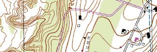
13 subdivisions. The intent of the Conservation Subdivision code is preserve unique natural features or to create useful open spaces to serve the residents of the subdivision or the Town. The Conservation Development Code (Zoning Chapter to ) allows conservation development with multi-family buildings in single family zones, and it also references conservation development of detached one family dwellings. The section addressing density requires that the number of lots or dwellings not exceed what could be reasonably developed on the parcel under a conventional plan, consistent with the Zoning Code. The code requires the applicant to provide a basis for this determination with a sketch layout of a conventional plan. The Code also provides a density incentive of not more than 25 percent if the applicant constructs the units as middle income units for sale or rent consistent with the Town s affordable housing requirements. The applicant and project engineer initially demonstrated the potential development of 19 residential lots with the Conventional Plan. Given that the Conservation plan will result in smaller homes on smaller lots when compared to the original 19 lot plan (with a reduction in land and home values), the applicant developed a conventional 21 lot subdivision plan as a basis for a Conservation Subdivision (see Figure Lot Conventional Plan). That plan meets all of the bulk and density requirements of the Zoning Ordinance, as required by Chapter (B)(1). In addition to the 21 residences, two (2) additional affordable homes are to take advantage of the density incentive. In this regard, the 23 lot Conservation subdivision would meet the Town Codes density requirements (Chapter (B)(1)), takes advantage of the density incentives (Chapter (C)) and would meet the Town s affordable housing requirements for new subdivisions (Chapter ). The community septic system and modification of certain setbacks allows the applicant to develop an attractive, marketable subdivision of 23 lots. The Conservation layout addresses the goals of the Town in providing two affordable housing units, as well as preserving areas of open space on the property. Project Layout Lots 1 through 21 would be 12,000 square feet or acres in size. Lot 22, adjacent to Harris Road, would be 33,229 sf or acres in size. As shown in the plans, the area within the looped road will be utilized as a community septic area, including an expansion area. Portions of the site not included in individual residential lots will be common lands, owned and maintained by a property owner s association. These common areas include the community septic system and reserve areas and much of the southeastern portion of the site. Existing vegetation on steep slopes in the southeastern portion of the site will be retained. The north western corner of the site will be commonly owned and the existing vegetation there retained. A strip of common land, 25 feet in width will be provided along the western property line, in the vicinity of West View Drive. This area is shown in Figure 2-5 Proposed Conservation Plan. No development is for this common land and existing vegetation will be preserved. Common open space land not utilized by common infrastructure (septic system, stormwater management facilities, and the emergency access road), will be permanently preserved, through the filing of appropriate covenants, deed restrictions, or easements. 2-13
14 New Urbanism The Conservation Subdivision was designed in consultation with members of the Planning Board and the Town s Planner to include professional planning design elements into the project, including New Urbanism and smart growth principals. New Urbanism is a planning movement intended to promote more livable communities that encourage pedestrians, provide a range of residential building types, and community open space 2. The following New Urbanism design elements have been incorporated into the project: 1) Common open space. Clustering the residential development in suitable (more level) portions of the site and preserving existing woods and vegetation on the site. Homes are placed on smaller lots facing an interior open area. 2) A mix of housing types. Two units of affordable housing will be provided. Certain homes will allow single level living which will attract seniors. Larger homes will be attractive to younger families resulting in a mixed community. 3) Sidewalks. ows pedestrian traffic and a common area for children to meet and play. 4) Homes are situated close to the street and have porches. This design encourages contact between neighbors. 5) Garages mostly provided at the side or rear of homes. This design provides a more attractive streetscape with less emphasis on the automobile. 6) Landscaping. Street trees and landscaping will provide an attractive stereoscope that can be shared by residents. Community Septic System The community septic system was sized and designed according to WCDOH standards and will serve the 21 homes located on the looped access road. The preliminary layout of the septic system is shown in Sheet 8 - Utility Plan of the Site Plan drawings. The system will be a forced main system, with individual pumps at each residence pumping wastewater to one of four distribution boxes. The distribution boxes are located at the center of the sewage disposal area and will discharge to the septic fields via gravity. The primary treatment area is to be approximately 1.33 acres in size with the required 100 percent expansion area (1.33 acres) located both north and south of the primary area. As shown in the grading plan, the grades of the community septic system will be similar to existing grades. The community septic system is subject to review by the Westchester County Department of Health (WCDOH) and the New York City Department of Environmental Protection (NYCDEP). The WCDOH provides the formal approval of wastewater treatment systems. A transportation corporation will need to be established for the long term maintenance of the community septic system. The transportation corporation will require approval from the Town Board and from the New York State Department of State. 2 Charter of the New Urbanism, Congress for New Urbanism,
15 Engineering Plans The two full size sets of engineering drawings provided with this document depict the layout of the road and lots and grading for the project, for both the Conventional Plan and for the Conservation Plan. The plan sets includes road profile. The maximum depth of cut to achieve the designed road grades is approximately 7½ feet; maximum depth of fill is approximately seven feet. The project is designed to balance earth cuts and fills so that no import or export of material is anticipated to construct the project. Disturbance of areas steep slopes and woods are shown on the full size project plans and figures in later sections of this document. Materials stockpile areas requiring protection during construction are depicted on the full size Erosion Control plans included in the engineer s plan set. Temporary soil stockpile areas are shown in several locations around the site where they will serve the area of development in their immediate vicinity. These stockpiles are shown to be protected by sedimentation controls (silt fence and/or staked haybales). For fire protection, there are fire hydrants in this subdivision, to be spaced approximately 500 feet apart along the road right-of-way. The utility plan included in the plan set show the water lines, septic facilities and related fixtures to accommodate the project development. Site Utilities The water supply to the project site is provided by the Bedford Consolidated Water District # 1. This District serves approximately 7,000 people with 1,847 residential and 288 commercial customers. The system includes 32 miles of water mains, 2 storage tanks, 3 active groundwater supply wells, 325 fire hydrants and 420 valves. On an average day, the system uses 800,000 gallons of water. The system is served by two water storage tanks: one on Lily Pond Lane and one on Fieldwood Drive. The water system includes three active wells located on Jay Street, Harris Road, and Haines Road. Currently the District has a capacity of 1.2 million gallons per day (mgd), according to Mr. Kevin Winn, PE Commissioner of Public Works. 3 The Town is in the process of developing a connection to the New York City Department of Environmental Protection (NYCDEP) Delaware Aqueduct to ensure a long term supply of high quality water for the District. Until this additional supply is obtained, the District would be unable to meet maximum demands in the event that the largest supply well was out of service. Currently the District has a capacity of 1.2 million gallons per day, according to Commissioner Winn. The project would be connected to the Town s water supply system through existing water mains located on Harris Road and in New Street. The water connections at two locations would provide a looped water system. The Tripi Subdivision development will create an additional need of 11,400 gallons of water per day, for the Conventional Plan and 11,700 GPD for the Conservation Plan. Although the number of units in the Conservation Plan is greater than the Conventional Plan the bedrooms per unit are lower and therefore the estimated water demand for the two plans are comparable. The water supply to the Tripi Subdivision development represents 3 Mr. Kevin Winn, P.E. Town of Bedford Commissioner of Public Works, communication, March 5,
16 approximately 1.4 percent of the 800,000 gallons per day currently supplied by Bedford Consolidated Water District # 1 to its service area. Based on information provided by the Town of Bedford Water Department to the project engineer, fire hydrant number 130 is located at the end of New Street. The hydrant flow is 1005 gallons per minute (gpm), the static pressure is 78 psi, and the residual pressure is 20 psi. The engineer has prepared hydraulic calculations showing that there would be sufficient water pressure and volume at the highest elevation of the project. The project site does not have connection to public sewer. The Conventional subdivision will have individual septic systems for sewer treatment. The Conservation Plan would be serviced by a community septic system, as described above. A single lot (Lot 22) adjacent to Harris Road would have an individual septic system and the existing Murphy home (Lot 23) would continue to use its individual septic system. Electric service for the project area would be provided by New York State Gas and Electric (NYSEG) from its facilities located along Harris Road 4 and the existing facilities are adequate to provide service to the project. Gas service would be provided by Con Edison. An existing gas main, located on Harris Road would be adequate to provide service to the project. The existing gas main may be extended to provide service to all homes in the project. Con Edison does not anticipate any problems accommodating the projected gas demands created by the development 5. Local telephone service in the project area is provided by Verizon and cable services by Cablevision. Stormwater Pollution Prevention Plan The Proposed Action would involve the temporary disturbance of acres of the acre Tripi Subdivision site for the construction of the Conventional Subdivision Plan and acres for the Conservation residences. A complete stormwater analysis and SWPPP was prepared for the Conventional Subdivision Plan and was submitted to the Planning Board in previous draft versions of the DEIS. An updated SWPPP has been prepared for the preferred Conservation subdivision Plan and is attached in Appendix C-1. The Stormwater management program for the Conservation Plan involves less stormwater management facilities and has a smaller footprint than for the Conventional Plan and is attached in Appendix C-2. Stormwater management and the updated SWPPP is described in Section 3.2 Water Resources. Stormwater Management for Conventional Plan Currently, stormwater flows from higher portions of the site (central and western) to lower portions of the site and eventually off-site to the north east and south. Following construction, stormwater from the project site will continue to discharge off-site and ultimately enter the Muscoot Reservoir. To offset potential impacts associated with stormwater runoff from the Tripi Subdivision site, a project specific SWPPP was developed in accordance with all applicable New York State Department of Environmental Conservation (NYSDEC), and New York City Department of Environmental Protection (NYCDEP) regulations and guidelines, including those in the Manual and the New York Guidelines for Urban Erosion and Sediment Control. Specific attention has 4 Phone Conversation with Mr. Michael Milano from NYSEG on March 30, Phone conversation with Mr. Bill Cook from Con Edison on 28 June,
17 been paid to generally maintaining existing project site drainage divides, to attenuating post development increases in peak stormwater discharge rates and volumes, and to meeting NYSDEC and NYCDEP stormwater quality treatment criteria. Treatment methods include only natural processes; no chemical treatment of the runoff is or permitted. treatment methods would comply with NYSDEC and NYCDEP stormwater treatment criteria. Following construction, the site would remain as five distinct drainage areas with sub-basins within the developed portion of the Property being routed through the Stormwater Management facilities. Stormwater from the site would be collected and discharged to these treatment basins, that would control post-development rate and volume of discharge and would decrease pollutant loads. The drainage basins would detain stormwater resulting in flow rates to off-site discharge points that are less than current conditions. Neighboring properties are not expected to be adversely impacted by the stormwater basins, based upon the design and studies completed for the SWPPP. The drainage patterns would remain generally the same between existing conditions and conditions. This includes off-site drainage to areas near Sunrise Avenue that are down slope of the drainage basin in that area. Stormwater Management for Conservation Plan A site specific SWPPP has been prepared for the Conservation Plan in accordance with the requirements of the NYSDEC and NYCDEP. As indicated above, the Conservation Plan involves 4.09 acres of less disturbance than the Conventional Plan. Adequate area and soils are available on the site to detain and treat the stormwater from developed portions of the site. In the Plan, stormwater would be collected and discharged to two basins; one in the northeastern portion of the site, near New Street and a second on the slope near Lot 16 (see Figure 2-5 Proposed Conservation Plan). The basins, as designed, will not contain standing water under typical conditions, but rather only briefly after substantial storm events. The Conservation Plan will maintain or decrease stormwater flow rates to off-site discharge points, consistent with NYSDEC requirements. 2.5 Construction Schedule Construction of the subdivision would commence after approvals and permits are secured from the various agencies listed in Section 2.6 of this DEIS. It is anticipated that construction would commence in 2012 and be completed by Construction period and potential impacts would be similar for both the Conventional Plan and the Conservation Plan. Construction and Subsequent Maintenance The developer intends to subdivide the parcel and construct and install all roads, utilities, and homes on the project site. It is anticipated that construction of the roads and utilities will start upon Town approval, with the completion of all homes within five years of project approval. This project will be developed in a number of phases. The planned period of construction is approximately 60 months, with construction scheduled to start in 2012 and the project to be completed in The following schedule of construction is anticipated: Establish erosion controls, establish and prepare construction entrance, clearing and grubbing, establish staging areas: month one Excavate roads, mass grading: months two to three 2-17
18 Install utilities and stormwater systems, months four to five Pave road base course, stabilize graded areas: month six Residential lot and house construction: months six to thirty six Final paving course following construction of all homes: Month thirty six. Construction traffic will consist primarily of construction equipment arriving at the beginning of the construction period, trucks periodically delivering materials, and daily trips of construction workers. Construction workers typically arrive and depart the work site prior to peak hours of traffic as will the initial construction equipment. Once foundations are set, it is estimated that one to two trucks delivering building materials can be expected to arrive and leave the site during each day of the construction period. Trucks delivering fill material for the Conventional Plan (soil and crushed stone) would add an estimated 2 to 3 trucks per day during the first six months of construction when a majority of grading will occur. Therefore, an estimated three to five trucks per day can be expected during the busiest periods of construction (see discussion of construction vehicles in Section 3.1 Geology, Topography, Soils). The Conservation Plan would involve a balanced site with minimal fill material imported into the site. This modification would reduce the estimated truck traffic by approximately half or two to three trucks per day during the busiest periods of construction. Harris Road is a local residential street, but does accommodate delivery trucks, such as UPS trucks, furniture delivery trucks and construction vehicles. Currently, the project site can be accessed by Harris Road on the south, and by New Street on the North. The applicant proposes to utilize both Harris Road and New Street as construction access points for both the Conventional Plan and for the Conservation Plan. While Harris Road provides the shortest distance to Route 117, the required entrance road and utility construction at New Street will neccessitate using it as a construction entrance. A discussion of construction traffic and traffic routing is provided in Section 3.5 Transportation. Any damage to Harris Road or to New Street by construction vehicles will be the responsibility of the applicant, and/or the holder of the building permit for the project. As described above, a construction bond will be posted with the Town of Bedford for any damage to Town property resulting from project construction. The applicant recognizes the importance of avoiding conflicts between construction traffic and school bus traffic. Due to the low estimated volume of construction traffic under the Conservation Plan, project construction traffic is not anticipated to affect school bus safety. If conditions warrant, such as utility work in the existing roadways, a flagman will be provided on Harris Road, New Street, or Huntville Road to allow safe traffic flow. Flagmen would be utilized anytime construction would necessitate the closing of an existing shoulder or travel lane. Once construction machinery reaches the site, it is likely to remain on site until the completion of grading and excavation. Site construction activities would comply with Town local laws with regard to restrictions on construction activities including adherence to limitations on the time periods within which construction is permitted. Construction-generated dust will be controlled by the following procedures: 1) minimizing the extent of soil that is left unvegetated at any one time; 2) the use of fast-germinating seed with mulch or other temporary soil cover 3) spraying water on unpaved areas and construction vehicles, when needed; and, 4) covering loads when transporting soil by construction vehicles. 2-18
19 Soil erosion and sedimentation control plans have been prepared for construction as recommended by the Westchester County Best Management Practices Manual. No more than five acres of land will be disturbed at any one time, prior to being stabilized with either temporary or permanent seeding. The applicant will post construction performance bonds with the Town of Bedford, per the requirements of the Town of Bedford Planning Board, as part of its land development approvals. These performance bonds will ensure that the sediment and erosion control measures are adequately installed and maintained during construction. Monitoring and maintenance of the stormwater management facilities during construction and after construction prior to acceptance by the Town will be the responsibility of the project developer. Funding and enforcement of monitoring and maintenance activities will be the responsibility of the developer as a part of the cost of construction. Actual costs to be incurred by the Town of Bedford in maintaining the roads, water mains and stormwater features after acceptance are not known, however, any such costs will be offset to a degree by property tax revenues generated by the future homeowners at the subject site. The NYSDEC, pursuant to SPDES, has jurisdiction to enforce stormwater maintenance activities on the subject site after project completion. The project roads, water supply infrastructure, and stormwater management facilities will be offered for dedication to the Town following construction. Ownership and responsibility for year-round maintenance of the roads and infrastructure (including snow and ice control and water lines, and stormwater facilities) will remain the project developer s until these facilities are accepted by the Town. Thereafter, operation and maintenance of the project road system, water supply infrastructure, and stormwater management facilities will be the responsibility of the Town of Bedford Highway Department. The project plans show the right-of-way lines and easement lines within which these facilities are located to allow Town access and control. 2.6 Approvals Required The action will require approvals from the following agencies: Town Planning Board Subdivision Approval (Chapter 107) Steep Slopes Permit (Chapter 102) SWPPP Approval (Chapter 103) Tree Removal Permit (Chapter 112) Town Board Special Use Permit (for Conservation Subdivision Plan only) Transportation Corporation for Community Septic Town of Bedford - Water Department Water Connections Town of Bedford - Highway Road Permit Department Westchester County Department Sanitary System Approval Of Health Water Service Connection Realty Subdivision 2-19
20 NYS Department of Environmental Coverage under SPDES General Permit # Conservation GP for Construction Activities NYC Department of Environmental Community Septic System Protection Stormwater Pollution Prevention Plan NYS Department of State Transportation Corporation for Community Septic NYS Office of Parks Recreation and Coordinated Review associated with NYSDEC Historic Preservation SPDES Permit. Mailing addresses for these agencies are provided below: Bedford Planning Board 425 Cherry Street Bedford Hills, NY Bedford Water Department 425 Cherry Street Bedford Hills, NY Bedford Highway Department 301 Adams Street Bedford Hills, NY Westchester County Department of Health 118 North Bedford Road Mount Kisco, NY NYS Department of Environmental Conservation Region 3 21 South Putt Corners Road New Paltz, NY NYC Department of Environmental Protection 465 Columbus Avenue, Suite 350 Valhalla, NY

 265-4400 Fax")
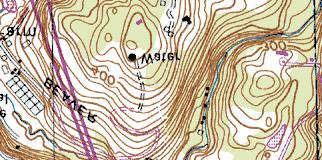
21 Site Figure 2-1: Regional Setting Tripi Subdivision Town of Bedford, Westchester County, New York Source: Geographia, Inc. Scale: Graphic File /02/07 JS:\06055\ Tim Miller Associates, Inc.,10 North Street, Cold Spring, New York (845) Fax (845)


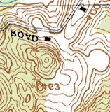
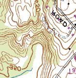

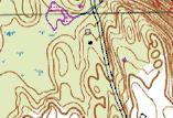
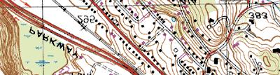

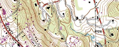

22 Site Site Property Boundary Figure 2-2: Local Setting Tripi Subdivision Town of Bedford, Westchester County, New York Source: NYSDEC 7.5-minute Topographic Map, Mount Kisco Quad Scale: 1 = 2,000 File /02/07 JS:\06055\ Tim Miller Associates, Inc.,10 North Street, Cold Spring, New York (845) Fax (845)

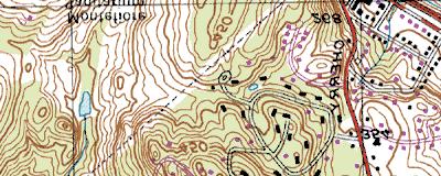
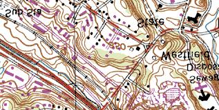
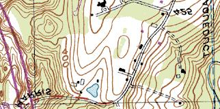
23 ingale Night Road Ne ws tre et e nu ve ea is nr W es tv ie w Dr iv e Su Harr is R o ad ad d or f ed B w Sa Site Property Boundary Ro ll P Mi y wa k ar Figure 2-3: Site on Aerial Photograph Tripi Subdivision Town of Bedford, Westchester County, New York Source: NYS GIS Clearinghouse, 2004 Aerial Photo Approx. Scale: 1 = 300 File /02/07 JS:\04031\ Tim Miller Associates, Inc.,10 North Street, Cold Spring, New York (845) Fax (845)
Appendix I. Checklists
 Appendix I Checklists Town of Greenwich Drainage Manual Department of Public Works - Engineering Division Town Hall - 101 Field Point Road, Greenwich, CT 06836-2540 Phone 203-622-7767 - Fax 203-622-7747
Advance Engineering & Surveying PLLC
 Advance Engineering & Surveying, PLLC Consulting in: Civil & Environmental Engineering Land Surveying Land Development 11 Herbert Drive Phone: (518) 698-3772 Latham, N.Y. 12110 Email:ncostape@gmail.com
Major Subdivision Sketch Plan Checklist
 This checklist provides specific requirements that are apart of the Sketch process. The entire process is described by the Huntersville Subdivision Review Process which details all the submittal and resubmittal
PLANNED UNIT DEVELOPMENT & SUBDIVISION STAFF REPORT Date: May 18, 2017
 & PUD-0000102-2017 PLANNED UNIT DEVELOPMENT & SUBDIVISION STAFF REPORT Date: May 18, 2017 NAME SUBDIVISION NAME Dauphin Creek Estates Subdivision Dauphin Creek Estates Subdivision LOCATION CITY COUNCIL
PepsiCo R & D Facility Expansion Town of Mount Pleasant, Westchester County, NY Draft Environmental Impact Statement Scoping Outline
 PepsiCo R & D Facility Expansion Town of Mount Pleasant, Westchester County, NY Draft Environmental Impact Statement Scoping Outline 10-17-2016 This document identifies the issues to be addressed in the
EXHIBIT B PROJECT NARRATIVE POULSBO MEADOWS
 EXHIBIT B PROJECT NARRATIVE POULSBO MEADOWS Name of Project: Poulsbo Meadows; A Planned Residential Development (PRD)/Plat Applicants Name: PBH Group LLC/Byron Harris PO Box 1010 Silverdale, WA 98038 Description
USA Addition of South & East Side Residential Parcels. USA Deletion of a Town of Christiana Parcel. Conversion from USA to Limited Service Area
 Village of Rockdale Village of Rockdale 148 Water Street Cambridge, WI 53523 Phone 608.423.1497 Fax 608.423.9694 Urban Service Area (USA) Amendment USA Addition of South & East Side Residential Parcels
Town of Windham. Planning Department 8 School Road Windham, ME voice fax
 Town of Windham Planning Department 8 School Road Windham, ME 04062 voice 207.864-5960 fax 207.892.1916 MEMO DATE: TO: Staff Review Committee FROM: Amanda Lessard, Planner Cc: Ellen Rathbone, St. Germain
WATERS EDGE AT DOBBS FERRY DRAFT ENVIRONMENTAL IMPACT STATEMENT VOLUME I
 WATERS EDGE AT DOBBS FERRY DRAFT ENVIRONMENTAL IMPACT STATEMENT VOLUME I Atilda, Fairlawn and Constance Avenues Village of Dobbs Ferry Town of Greenburgh Westchester County, New York Tax Lot Numbers Section
ARTICLE 6: Special and Planned Development Districts
 ARTICLE 6: Special and Planned Development Districts 6-10 Traditional Neighborhood Development (TND) District 6-10.10 Purpose and Intent The Traditional Neighborhood Development (TND) District provides
CITY OF ZEELAND PLANNING COMMISSION
 APPLICATION FOR SITE PLAN REVIEW AND SPECIAL LAND USE Date City Official App. Filing Fee Rec'd ($350) NOTE TO APPLICANT: Please submit this application for Site Plan Review along with twenty (20) copies
Essential Skills: Reading and Interpreting Maps and Plans
 Essential Skills: Reading and Interpreting Maps and Plans Prepared for: NYS Tug Hill Commission Local Government Conference March 31, 2016 Prepared by: Peter G. Vars, P.E. BME ASSOCIATES Stages of Plan
STORMWATER GREEN INFRASTRUCTURE AND PLANNING/ZONING BOARDS
 STORMWATER GREEN INFRASTRUCTURE AND PLANNING/ZONING BOARDS Source: Center for Watershed Protection, 2007 Southern Tier Central Regional Planning & Development Board Chemung County Stormwater Team OUTLINE
APPENDIX A SIMPLIFIED APPROACH TO STORMWATER MANAGEMENT FOR SMALL PROJECTS. In West Sadsbury Township, Chester County, Pennsylvania
 APPENDIX A SIMPLIFIED APPROACH TO STORMWATER MANAGEMENT FOR SMALL PROJECTS In West Sadsbury Township, Chester County, Pennsylvania TABLE OF CONTENTS I. Introduction 3 II. Importance of Stormwater Management
12 January 12, 2011 Public Hearing APPLICANT: TAILWIND DEVELOPMENT GROUP,LLC PROPERTY OWNER: CITY OF VIRGINIA BEACH
 12 January 12, 2011 Public Hearing APPLICANT: TAILWIND DEVELOPMENT GROUP,LLC PROPERTY OWNER: CITY OF VIRGINIA BEACH STAFF PLANNER: Faith Christie REQUEST: Conditional Change of Zoning (from PD-H1 Planned
Section 9 NEIGHBORHOOD DESIGN
 Section 9 NEIGHBORHOOD DESIGN City of Lancaster Comprehensive Plan D u n k i n, S e f k o & A s s o c i a t e s, I n c. NEIGHBORHOOD DESIGN INTRODUCTION There are many ways in which a neighborhood can
4 January 11, 2012 Public Hearing APPLICANT:
 . 4 January 11, 2012 Public Hearing APPLICANT: MID-ATLANTIC AUTO PROPERTY OWNER: DZR, LLC STAFF PLANNER: Leslie Bonilla REQUEST: Conditional Use Permit (truck rental, automobile service, and automotive/bulk
CITY OF CYPRESS 5275 Orange Avenue Cypress, California (714) DESIGN REVIEW COMMITTEE PERMIT PROCESS
 DESIGN REVIEW COMMITTEE PERMIT PROCESS") CITY OF CYPRESS 5275 Orange Avenue Cypress, California 90630 (714) 229-6720 DESIGN REVIEW COMMITTEE PERMIT PROCESS 1. Discuss project with Planning staff to determine zoning regulations, any unusual characteristics
CITY OF CYPRESS 5275 Orange Avenue Cypress, California 90630 (714) 229-6720 DESIGN REVIEW COMMITTEE PERMIT PROCESS 1. Discuss project with Planning staff to determine zoning regulations, any unusual characteristics
R E S O L U T I O N. Single-Family Residence/ Church. 2,488 sq. ft. 2,488 sq. ft. Area Parking Required: Church
 R E S O L U T I O N WHEREAS, the Prince George s County Planning Board is charged with the approval of Detailed Site Plans pursuant to Part 3, Division 9 of the Zoning Ordinance of the Prince George s
CASE NUMBER: 16SN0701 APPLICANT: Hanky, LLC
 STAFF S ANALYSIS AND RECOMMENDATION Planning Commission (CPC) Public Hearing Date: MAY 17, 2016 CPC Time Remaining: 100 DAYS Applicant s Agent: DANIEL L. CASKIE (804-569-7060) Applicant s Contact: MICHAEL
Town of Portola Valley General Plan. Nathhorst Triangle Area Plan
 Town of Portola Valley General Plan Amended December 10, 1997 Table of Contents Introduction... 1 Planning Area... 1 Objectives... 2 Principles... 2 Standards... 4 Description... 4 Community Commercial...
GENERAL INFORMATIONaaaaaaaaaaaaaaaaaaaaaaaaaaaaaaaa
 To: Planning and Zoning Commission From: City Staff Date: November 15, 2016 Re: Case #16026 Raymore Activity Center Site Plan GENERAL INFORMATIONaaaaaaaaaaaaaaaaaaaaaaaaaaaaaaaa Applicant/ Property Owner:
Improve Neighborhood Design and Reduce Non Point Source Water Pollution
 HOW TO Planning Guide Improve Neighborhood Design and Reduce Non Point Source Water Pollution This document was funded by a grant from the New Hampshire Coastal Program with funding from the National Oceanic
Asbury Chapel Subdivision Sketch Plan
 Asbury Chapel Subdivision Sketch Plan PART 1: PROJECT SUMMARY Applicant: NVR Inc. Project Size: +/- 76.13 acres Parcel Numbers: 02101112,02116101,02116112, 02116113 Current Zoning: Transitional Residential
SYRINGA VALLEY SPECIFIC PLAN NARRATIVE
 SYRINGA VALLEY SPECIFIC PLAN NARRATIVE Introduction With this application, Pleasant Valley South LLC ( Pleasant Valley ) seeks the City of Boise s approval of a new Specific Plan Ordinance to be added
McDonald s Restaurant - Purcellville Town of Purcellville Special Use Permit Statement of Justification July 24, 2014
 Introduction / Written Statement McDonald s Restaurant - Purcellville McDonald s Corporation is proposing to redevelop the existing McDonald s eating establishment with a drive-through located at 121 N
APPENDIX J PERFORMANCE STANDARDS FOR GRAVEL MINE, PIT MINE, OR QUARRY
 APPENDIX J PERFORMANCE STANDARDS FOR GRAVEL MINE, PIT MINE, OR QUARRY A. Purpose: 1. Regulatory Requirement and Use Mitigation: The purpose of this appendix is to provide a regulatory context (standards)
MONTGOMERY COUNTY PLANNING DEPARTMENT
 MONTGOMERY COUNTY PLANNING DEPARTMENT THE MARYLAND-NATIONAL CAPITAL PARK AND PLANNING COMMISSION MCPB Item No.: Date: 5-03-18 Pike and Rose, Phase I: Site Plan Amendment No. 82012002D Rhoda Hersson-Ringskog,
SUBMITTAL REQUIREMENTS
 WHEN PROCESS TYPE III IS USED References to Process Type III applications are found in several places in the Milton Municipal Code (MMC), indicating that the development, activity, or use, is permitted
PART 1: PROJECT SUMMARY. The application is Attachment A. The site plan is Attachment B.
 Belleterre Subdivision Sketch Plan Town Board 8.7.17 Belleterre Subdivision Sketch Plan PART 1: PROJECT SUMMARY Applicant: Bowman Development Project Size: +/- 20.85 acres Parcel Number: 01115104 and 01115121
E. RURAL COMMERCIAL/INDUSTRIAL PARK MODEL
 E. RURAL COMMERCIAL/INDUSTRIAL PARK MODEL 1. PURPOSE The purpose of the Rural Commerce/Industrial Park Model is to provide parameters within which a grouping of business buildings with parking, loading
Exhibit A. 8:9 Scuffletown Rural Conservation District
 Exhibit A 8:9 Scuffletown Rural Conservation District 8:9.1 Intent and Purpose The Scuffletown Rural Conservation (SRC) District is intended to provide for residential development that supports the development
OP Council Resolution June 16, Planning and Development Services
 OP-08-01 Council Resolution June 16, 2008 Planning and Development Services Kingsgate Landing Outline Plan Table of Contents 1.0 Introduction 1 1.1 Purpose of Plan 1 1.2 Plan Area Location 1 1.3 Ownership
9 th Street Sub Area Plan
 9 th Street Sub Area Plan In the 1990 s, when the Township prepared the last Master Plan, the 9 th Street corridor was studied as part of a larger 9 th Street Focus Area that included the West Main Street
M E M O R A N D U M. Chair and Members of North West Planning Advisory Committee
 Item 9.1.1 PO Box 1749 Halifax, Nova Scotia B3J 3A5 Canada M E M O R A N D U M TO: FROM: Chair and Members of North West Planning Advisory Committee Stephanie Salloum, Planner II DATE: June 26, 2017 SUBJECT:
KANATA CENTRUM 255 KANATA AVENUE OFFICIAL PLAN AMENDMENT ZONING BY-LAW AMENDMENT
 KANATA CENTRUM 255 KANATA AVENUE OFFICIAL PLAN AMENDMENT ZONING BY-LAW AMENDMENT JUNE 2015 PREPARED BY: FOTENN Consultants Inc. 223 Mcleod Street Ottawa, ON K2P OZ8 (613) 730-5709 PREPARED FOR: Kanata
VILLAGE OF CLEMMONS PLANNING BOARD DRAFT STAFF REPORT
 VILLAGE OF CLEMMONS PLANNING BOARD DRAFT STAFF REPORT PETITION INFORMATION Docket # C-226 Staff Megan Ledbetter Petitioner(s) JBJH Properties, LLC Owner(s) JBJH Properties, LLC Subject Property 5892-49-1766
Metropolitan Area Planning Council 60 Temple Place, Boston, Massachusetts fax
 Metropolitan Area Planning Council 60 Temple Place, Boston, Massachusetts 02111 617-451-2770 fax 614-482-7185 www.mapc.org Serving the 101 Cities Towns in the Metropolitan Boston Region MEMORANDUM TO:
Checklists. Project Name: Location: File Number: Date of Submittal: Reviewer: Date: Applicant: Contact Name: Phone Number:
 Applicant: Contact Name: Phone Number: Email: Project Name: Location: File Number: Date of Submittal: Reviewer: Date: Concept Plan Requirements: I. General Project Information 1. Address or parcel number
CITY OF PORTSMOUTH PLANNING DEPARTMENT. MEMORANDUM To: From:
 CITY OF PORTSMOUTH PLANNING DEPARTMENT MEMORANDUM To: From: Subject: Date: Planning Board Juliet T.H. Walker, Planning Director Jillian Harris, Planner 1 Staff Recommendations for the August 23, 2018 Planning
Approved: CITY OF ARDEN HILLS, MINNESOTA PLANNING COMMISSION WEDNESDAY, AUGUST 5, :30 P.M. - ARDEN HILLS CITY HALL
 Approved: CITY OF ARDEN HILLS, MINNESOTA PLANNING COMMISSION WEDNESDAY, AUGUST 5, 2015 6:30 P.M. - ARDEN HILLS CITY HALL PLANNING CASES A. Planning Case 15-016; Final Planned Unit Development Arden Plaza;
4-Town Comprehensive Plan DRAFT 7/30/07
 4-Town Comprehensive Plan DRAFT 7/30/07 Acknowledgements ning Committee Town of Harrisburg Norman Roof Randy Nicol Town of Martinsburg Terry Thisse Paul Kelly Town of Montague Jan Bagdanowicz Wendy Perry
TOWNSHIP OF LOGAN SOIL & FILL IMPORTATION AND PLACEMENT APPLICATION SUBMITTAL CHECKLIST
 TOWNSHIP OF LOGAN SOIL & FILL IMPORTATION AND PLACEMENT APPLICATION SUBMITTAL CHECKLIST Applications: 5 copies of application - Applicant will reproduce the copies at his/her costs. The Township Clerk
Gold Line Bus Rapid Transit Transit Oriented Development (BRTOD) Helmo Station Area Plan
 Helmo Station Area Plan") Appendix F Gold Line Bus Rapid Transit Transit Oriented Development (BRTOD) Helmo Station Area Plan Introduction and Purpose of the Plan The Gold Line Bus Rapid Transit facility is an eleven-mile dedicated
Appendix F Gold Line Bus Rapid Transit Transit Oriented Development (BRTOD) Helmo Station Area Plan Introduction and Purpose of the Plan The Gold Line Bus Rapid Transit facility is an eleven-mile dedicated
Silver Line CPAM UPDATE. Transportation and Land Use Committee October 14, 2016
 Silver Line CPAM UPDATE Transportation and Land Use Committee October 14, 2016 Purpose Recap Project History and Map Changes Provide Overview of CPAM Components Discuss Transportation Impacts Discuss Fiscal
that the Town Board of the Town of East Greenbush will hold a public hearing on April 11,
 TOWN OF EAST GREENBUSH NOTICE OF PUBLIC HEARING PLEASE TAKE NOTICE that the Town Board of the Town of East Greenbush will hold a public hearing on April 11, 2018, at 5:45 p.m. at the East Greenbush Town
ARTICLE IV: DEVELOPMENT STANDARDS 404 MASTER PLANNING
 IV 13 404 MASTER PLANNING Master Planning through the Site Analysis (Master Planning Site Analysis) or Planned Development (Master Planning Planned Development) is provided to encourage development which
Duplex Design Guidelines
 Duplex Design Guidelines Adopted by Council May 29, 2006 Prepared By: Table of Contents 1.0 Application and Intent 1 2.0 Areas of Application 2 3.0 Design Principles 3 4.0 Design Guidelines 4 4.1 Site
PLANNED UNIT DEVELOPMENT STAFF REPORT Date: June 2, 2016
 # 9 ZON2016-01032 PLANNED UNIT DEVELOPMENT STAFF REPORT Date: June 2, 2016 DEVELOPMENT NAME JJT Properties LLC LOCATION 1147 & 1151 East I-65 Service Road South and 1180 Sledge Drive (Southeast corner
ARTICLE V PLANNED UNIT DEVELOPMENT DISTRICT
 ARTICLE V PLANNED UNIT DEVELOPMENT DISTRICT A. Purpose and Objective The Planned Unit Development (PUD) procedure provides a flexible land use and design regulation through the use of performance criteria
VILLAGE OF CLEMMONS PLANNING BOARD DRAFT STAFF REPORT. Single Family Residential, Townhomes
 VILLAGE OF CLEMMONS PLANNING BOARD DRAFT STAFF REPORT PETITION INFORMATION Docket # C-212 Staff Megan Ledbetter Petitioner(s) Peacehaven Development LLC Owner(s) Larry Jarvis, William Alexander and Peacehaven
Urban Planning and Land Use
 Urban Planning and Land Use 701 North 7 th Street, Room 423 Phone: (913) 573-5750 Kansas City, Kansas 66101 Fax: (913) 573-5796 Email: planninginfo@wycokck.org www.wycokck.org/planning To: From: City Planning
NEW CASTLE COUNTY S ZONING DISTRICTS
 NEW CASTLE COUNTY S ZONING DISTRICTS This is general information about New Castle County s zoning districts. The information included is by no means exhaustive or complete. Before designing plans to develop
FORMER CANADIAN FORCES BASE (CFB) ROCKCLIFFE SECONDARY PLAN. Official Plan Amendment XX to the Official Plan for the City of Ottawa
 ROCKCLIFFE SECONDARY PLAN. Official Plan Amendment XX to the Official Plan for the City of Ottawa") FORMER CANADIAN FORCES BASE (CFB) ROCKCLIFFE SECONDARY PLAN Official Plan Amendment XX to the Official Plan for the City of Ottawa 1 INDEX THE STATEMENT OF COMPONENTS PART A THE PREAMBLE PAGE Purpose...
FORMER CANADIAN FORCES BASE (CFB) ROCKCLIFFE SECONDARY PLAN Official Plan Amendment XX to the Official Plan for the City of Ottawa 1 INDEX THE STATEMENT OF COMPONENTS PART A THE PREAMBLE PAGE Purpose...
Holmberg & Howe, Land Surveyors and Civil Engineers Zoning District: R-35
 Development Impact Statement Name of Project: Red Tail Drive Acreage: 13.5 Acres± Type of Project: Residential Subdivision Owner: 96 East Street Development, LLC Location: rear of 112 East Street Parcel
2. Would the proposed project comply with the Land Use map? 3. Would the proposed project require a rezoning? 4. What is the proposed zoning district?
 TOWN OF CHAPEL HILL Planning and Sustainability Department 405 Martin Luther King Jr. Blvd. Chapel Hill, NC 27514 www.townofchapelhill.org phone (919) 968 2728 Concept Plans are intended to be an opportunity
The subject site plan amendment proposes the following revisions to the approved site plan:
 PROPOSED AMENDMENT The subject site plan amendment proposes the following revisions to the approved site plan: 1. The building footprint was modified to accommodate the revised architectural design. 2.
DRAFT SCOPE FOR THE DRAFT ENVIRONMENTAL IMPACT STATEMENT FOR HUDSON HIGHLANDS RESERVE TOWN OF PHILIPSTOWN, NEW YORK June 5, 2018
 DRAFT SCOPE FOR THE DRAFT ENVIRONMENTAL IMPACT STATEMENT FOR HUDSON HIGHLANDS RESERVE TOWN OF PHILIPSTOWN, NEW YORK June 5, 2018 Project Name: Project Location SEQRA Classification of Project: Lead Agency:
Note: Staff reports can be accessed at Zone: I-3. Tier:
 The Maryland-National Capital Park and Planning Commission Prince George s County Planning Department Development Review Division 301-952-3530 Note: Staff reports can be accessed at www.mncppc.org/pgco/planning/plan.htm.
REQUEST Current Zoning: O-15(CD) (office) Proposed Zoning: TOD-M(CD) (transit oriented development mixed-use, conditional)
 (office) Proposed Zoning: TOD-M(CD) (transit oriented development mixed-use, conditional)") Rezoning Petition 2016-117 Zoning Committee Recommendation January 4, 2017 REQUEST Current Zoning: O-15(CD) (office) Proposed Zoning: TOD-M(CD) (transit oriented development mixed-use, conditional) LOCATION
Rezoning Petition 2016-117 Zoning Committee Recommendation January 4, 2017 REQUEST Current Zoning: O-15(CD) (office) Proposed Zoning: TOD-M(CD) (transit oriented development mixed-use, conditional) LOCATION
Town of Malta Planning Board 2540 Route 9 Malta, NY (518) Fax: (518)
 Fax: (518)") William Smith - Chairman Dave Bowman Kyle Kordich Roger Laime Jean Loewenstein John Viola David Wallingford Joseph Lopez (Alt) Town of Malta Planning Board 2540 Route 9 Malta, NY 12020 (518) 899-2685 Fax:
William Smith - Chairman Dave Bowman Kyle Kordich Roger Laime Jean Loewenstein John Viola David Wallingford Joseph Lopez (Alt) Town of Malta Planning Board 2540 Route 9 Malta, NY 12020 (518) 899-2685 Fax:
SECTION 1 CLEARING /GRADING PERMIT APPLICATION:
 PLEASE REFER TO THE CLEARING & GRADING PERMIT CHECKLIST BELOW FOR SUBMITTAL REQUIREMENTS. SECTION 1 CLEARING /GRADING PERMIT APPLICATION: PROJECT ADDRESS (Street, Suite #): Parcel(s) #: Total Site Area
Net Land Area (NLA): Area within zoning lot boundaries NLA= sq. ft. a) Credited Street Area (total adjacent frontage) x ½ width of public rightof-way
: Area within zoning lot boundaries NLA= sq. ft. a) Credited Street Area (total adjacent frontage) x ½ width of public rightof-way") PROJECT FACT SHEET Section A: Project Information Application type: Date: Project Name: Use Type: (check/list all that apply) Office/Institutional Residential Mixed-Use Other: Overlay District: (check
PROJECT FACT SHEET Section A: Project Information Application type: Date: Project Name: Use Type: (check/list all that apply) Office/Institutional Residential Mixed-Use Other: Overlay District: (check
D1 September 11, 2013 Public Hearing APPLICANT:
 D1 September 11, 2013 Public Hearing APPLICANT: BEACH MUNICIPAL FEDERAL CREDIT UNION PROPERTY OWNER: SISTERS II, LLC STAFF PLANNER: Karen Prochilo REQUEST: Conditional Change of Zoning (AG-2 Agriculture
APPENDIX G: TOWN ORDINANCE REVIEW
 APPENDIX G: TOWN ORDINANCE REVIEW TYLin (225740) Woodard & Curran SWMP January 2013 Stormwater LID strategies, ranked for Zoning Bylaw and Site Plan Review Standards Dimensional Requirements Permit the
4.1.3 LAND USE CATEGORIES
 4.1.3 LAND USE CATEGORIES a. City Center District The City Center District incorporates the existing character and mix of uses in downtown Belmont to encourage redevelopment and new development in keeping
City of Grande Prairie Development Services Department
 City of Grande Prairie Development Services Department ROYAL OAKS NORTH OUTLINE PLAN OP-07-03 NW 35-71-6 W6M May 7, 2007 Royal Oaks North Outline Plan TABLE OF CONTENTS 1.0 INTRODUCTION........ 3 1.1 Purpose
14 October 10, 2012 Public Hearing APPLICANT: MPB, INC
 14 October 10, 2012 Public Hearing APPLICANT: MPB, INC PROPERTY OWNER: MUNDEN & ASSOCIATES, LP STAFF PLANNER: Karen Prochilo REQUEST: Conditional Change of Zoning (AG-1 & AG-2 to Conditional O-2) ADDRESS
Chapter 3 Site Planning and Low Impact Development
 CHAPTER 3 Site Planning and Low Impact Development Chapter 3 Site Planning and Low Impact Development 3.0 Introduction The City of Charleston requires that major residential, large commercial (>1 acre),
APPLICATION BRIEFING Prepared For: Submitted by: Date: Subject:
 Planning & Development APPLICATION BRIEFING Prepared For: Submitted by: Date: Subject: Planning Advisory Committee Jason Fox, Director of Planning & Development Development Agreement application by Godfrey
I539. Smales 2 Precinct
 I539. Smales 2 Precinct I539.1. Precinct Description The Smales 2 Precinct applies to a 4.8 hectare block of land located on the southern side of Northcote Road and fronting Lake Pupuke, Takapuna. The
COMMUNITY DESIGN. GOAL: Create livable and attractive communities. Intent
 COMMUNITY DESIGN Intent An attractive, well-designed County will attract quality development, instill civic pride, improve the visual character of the community, and create a strong, positive image for
R E S O L U T I O N. Designation: R-2A (1-Family, 2-acre Minimum Lot Size)
") PLANNING BOARD Arthur Adelman, Chair TOWN OF NORTH CASTLE WESTCHESTER COUNTY 17 Bedford Road Armonk, New York 10504-1898 R E S O L U T I O N Telephone: (914) 273-3542 Fax: (914) 273-3554 www.northcastleny.com
PLANNING BOARD Arthur Adelman, Chair TOWN OF NORTH CASTLE WESTCHESTER COUNTY 17 Bedford Road Armonk, New York 10504-1898 R E S O L U T I O N Telephone: (914) 273-3542 Fax: (914) 273-3554 www.northcastleny.com
5. LOW IMPACT DEVELOPMENT DESIGN STANDARDS
 5. LOW IMPACT DEVELOPMENT DESIGN STANDARDS Low Impact Development (LID) requires a shift in stormwater management away from conveying runoff to a small number of downstream points through hydraulically
Drexel, Barrell & Co.
 Drexel, Barrell & Co. December 21, 2018 Engineers/Surveyors Boulder Colorado Springs Greeley 3 South 7 th Street Colorado Springs, Colorado 80905-1501 719 260-0887 719 260-8352 Fax El Paso County Planning
ARTICLE 17 SITE PLAN REVIEW
 ARTICLE 17 SITE PLAN REVIEW 17.01 INTENT AND PURPOSE The intent of this section is to provide for consultation and cooperation between the applicant and the township planning commission so that the applicant
F. The following uses in the HR District: attached single-family dwellings, condominiums, and institutional uses; and
 1102 DESIGN REVIEW 1102.01 PURPOSE AND APPLICABILITY Section 1102 is adopted to provide standards, criteria, and procedures under which design review may be approved. Design review is required for: A.
AWH REPORT OF THE PLANNING AND DEVELOPMENT DEPARTMENT FOR APPLICATION FOR REZONING ORDINANCE TO PLANNED UNIT DEVELOPMENT
 AWH REPORT OF THE PLANNING AND DEVELOPMENT DEPARTMENT FOR APPLICATION FOR REZONING ORDINANCE TO PLANNED UNIT DEVELOPMENT MAY 8, 2014 The Planning and Development Department hereby forwards to the Planning
Michael D, Harvey, Current Planning Supervisor. This project was originally approved in 2012 by the BOCC and is summarized as follows:
 PLANNING & INSPECTIONS DEPARTMENT Craig N. Benedict, AICP, Director Current Planning (919) 245-2575 (919) 644-3002 (FAX) www.orangecountync.gov 131 W. Margaret Lane Suite 201 P. O. Box 8181 Hillsborough,
CHAPTER 22 Rural Open Space Community Developments
 CHAPTER 22 Rural Open Space Community Developments Section 22.1 Description and Purpose The intent of this Chapter is to offer property owners an alternative to traditional zoning requirements for rural
UNIVERSITY OF MICHIGAN:
 Chapter Eight UNIVERSITY OF MICHIGAN: North Campus I. Introduction The University of Michigan currently owns approximately 800 acres of land in the northeast section of Ann Arbor. North Campus refers to
Description of Preferred Alternative
 Chapter 2 Description of Preferred Alternative 2.1 Introduction This chapter of the programmatic Sammamish Town Center Sub-area Plan Final EIS provides a more detailed description of the Preferred Alternative
6.1. INTRODUCTION AND SUMMARY OF FINDINGS
 Chapter 6: Stormwater Management 6.1. INTRODUCTION AND SUMMARY OF FINDINGS A Stormwater Pollution Prevention Plan (SWPPP) has been prepared for the Proposed Project in accordance with the requirements
Request for Statement of Interest in Implementation of the Roosevelt Road Redevelopment Plan
 425 Hillside Avenue Request for Statement of Interest in Implementation of the Roosevelt Road Redevelopment Plan I. INTRODUCTION The is seeking the services of a qualified consulting firm to prepare plans
Planned Development Review Revisions (Project No. PLNPCM )
") Planned Development Review Revisions (Project No. PLNPCM2014-00139) Standard residential development Planned Development Example: Smaller lot sizes than what is allowed to create open space amenity. What
Planned Development Review Revisions (Project No. PLNPCM2014-00139) Standard residential development Planned Development Example: Smaller lot sizes than what is allowed to create open space amenity. What
Mitchell Ranch South MPUD Application for Master Planned Unit Development Approval Project Narrative. Introduction
 Mitchell Ranch South MPUD Application for Master Planned Unit Development Approval Project Narrative Introduction Mitchell Ranch South is a proposed single family (detached) residential development on
Analysis of Environs of 1000 New York Street, German Methodist Episcopal Church
 Item No. 3: L-14-00028 p.1 Analysis of Environs of New York Street, German Methodist Episcopal Church Step One Historical Significance and Context According to the application for Historic Landmark Designation,
IV. Development in the Rural Overlay District
 Intracoastal Waterway Route 17 Route 168 Great Dismal Swamp VIRGINIA NORTH CAROLINA IV. Development in the Rural Overlay District IV-1 Route 17 in Chesapeake s Rural Overlay District affords distant views
Chapter 13: Implementation Plan
 Implementation A. Introduction The Implementation Plan, in table form on the following pages, provides a summary of all the Action Items recommended in Chapters 2 through 12. The table also indicates which
SPECIFIC PLAN Requirements
 CITY OF LANCASTER PLANNING DEPARTMENT 44933 Fern Avenue, Lancaster, California 93534 (661) 723-6100 SPECIFIC PLAN Requirements Purpose The purpose of a specific plan is to provide for the logical development
Community Development Rezoning Report REZ14-006
 Community Development Rezoning Report REZ14-006 Planning Commission Board of Supervisors March 4, 2014 March 26, 2014 Applicant M & N Real Estate, LLC Tax Map Id 125-(A)- L20E,125-(A)- L20E1, portion of
SUPPORTING DOCUMENT STORMWATER POLLUTION PREVENTION PLAN (SWPPP) NARRATIVE
 NARRATIVE") SUPPORTING DOCUMENT STORMWATER POLLUTION PREVENTION PLAN (SWPPP) NARRATIVE Please complete this narrative form and submit with your SWPPP drawings. Refer to Kitsap County Stormwater Design Manual Vol.
SUPPORTING DOCUMENT STORMWATER POLLUTION PREVENTION PLAN (SWPPP) NARRATIVE Please complete this narrative form and submit with your SWPPP drawings. Refer to Kitsap County Stormwater Design Manual Vol.
TOWN OF NORTH CASTLE WESTCHESTER COUNTY 17 Bedford Road Armonk, New York R E S O L U T I O N
 PLANNING BOARD John P. Delano, Chair TOWN OF NORTH CASTLE WESTCHESTER COUNTY 17 Bedford Road Armonk, New York 10504-1898 R E S O L U T I O N Telephone: (914) 273-3542 Fax: (914) 273-3554 www.northcastleny.com
Ten Mile Creek Planning Area
 PLANNING AREA POLICIES TEN MILE CREEK Ten Mile Creek Planning Area Location and Context The Ten Mile Creek Planning Area ( Ten Mile Creek area ) is located south of the current Boise AOCI, generally south
October 7, City of Thornton 9500 Civic Center Drive Thornton, CO (303) RE: Maverik Thornton, CO - Drainage Report
 RE: Maverik Thornton, CO - Drainage Report") October 7, 2016 City of Thornton 9500 Civic Center Drive Thornton, CO 80229 (303) 538-7295 RE: Maverik Thornton, CO - Drainage Report As per your request, we are submitting to you the drainage report and
October 7, 2016 City of Thornton 9500 Civic Center Drive Thornton, CO 80229 (303) 538-7295 RE: Maverik Thornton, CO - Drainage Report As per your request, we are submitting to you the drainage report and
CONTENTS 8.0 LAND USE 8.1 GENERAL LAND USE 8.2 RESIDENTIAL 8.3 MIXED USE 8.4 COMMERCIAL 8.5 EMPLOYMENT LANDS
 8-2 Land Use 8.0 LAND USE CONTENTS 8.1 GENERAL LAND USE 8.1.1 Uses provided for in all Land Use Designations 8.1.2 Uses prohibited in Hazardous Lands, Hazardous Sites and Special Policy Areas 8.1.3 Uses
The Maryland-National Capital Park and Planning Commission Prince George's County Planning Department Development Review Division
 The Maryland-National Capital Park and Planning Commission Prince George's County Planning Department Development Review Division 301-952-3530 Note: Staff reports can be accessed at www.mncppc.org/pgco/planning/plan.htm.
CHAPTER 12 IMPLEMENTATION
 CHAPTER 12 IMPLEMENTATION The 2010 Town of Denton Comprehensive Plan is intended to capture a vision of the future of Denton. As such, it provides a basis for a wide variety of public and private actions
Red Fox Commercial Outline Plan
 Red Fox Commercial Outline Plan City of Cold Lake, Alberta Prepared by Durrance Projects Ltd and Ross W. Sharp & Associates Ltd October 2014 Rupert 1 Table of Contents 1. PURPOSE...3 1.1. Location...4
KASPER. City of Georgetown, Texas PUD Planned Unit Development. December 30, 2015 Revised January 27, 2016
 KASPER City of Georgetown, Texas PUD Planned Unit Development December 30, 2015 Revised January 27, 2016 Applicant: Sentinel Land Company, LLC 4910 Campus Drive Newport Beach, CA Prepared by: SEC Planning