City of Lafayette Staff Report
|
|
|
- Carmella Bailey
- 6 years ago
- Views:
Transcription
1 City of Lafayette Staff Report For: By: Design Review Commission Greg Wolff, Senior Planner Meeting Date: September 26, 2011 Subject: L06-11 SIGNATURE DEVELOPMENT GROUP (APPLICANT), JACK & AUDIE DUDUM (OWNERS), C-1 ZONING: Request for (1) Land Use Permit, (2) Design Review, (3) Variance, (4) Grading Permit, (5) Tree Permit, and (6) Major Subdivision to demolish the existing Hungry Hunter restaurant and construct 23 townhomes (for sale) with a maximum height of 35-ft. and gross floor area ~45,000 sq. ft., requiring the removal of 32 protected trees and ~4,000 cu.yds of grading, located at 3201 Mt. Diablo Blvd. (southwest corner of Mt. Diablo Blvd. and Pleasant Hill Road) APN Statutory Deadline: March 21, 2012 (for adoption of environmental review and action on the project in accordance with CEQA) EXECUTIVE SUMMARY The formal application for this proposed 23-unit town home project was initially considered by the Design Review Commission on August 8, The project had previously been seen by the Commission at multiple study sessions. The staff report and minutes from the August 8 meeting are attached to this report. This report follows on the August 8 report and generally does not repeat the same information. Staff finds overall site planning and building design to be in conformance with City standards, zoning ordinance and the applicable goals of the General Plan. Staff recommends that the Commission review the changes made in response to the Commission s earlier comments and forward a recommendation of approval to the Planning Commission. COMMISSION COMMENTS & APPLICANT RESPONSE At the August 8, 2001 public hearing, the Commission was generally pleased with the evolution of the project design and was complimentary of the site planning and architecture. The Commission found the project was designed sensitively to the site in terms of layout, circulation, height, massing, style, colors and materials. The applicant has prepared revised plans in response to following Commission comments from the August 8, Enhance the connection between the units south & west of the driveway and the village green. The Commission asked the application to consider emphasizing the front entries, more generous trellises, and paving treatment to visually narrow the street, to make it appear more pedestrian oriented and less of an apparent vehicular thoroughfare. The plans show additional (raised) connections across the driveway, but not the full extent of stamped concrete suggested by one Commissioner.
2 Design Review Commission September 26, 2011 Staff Report L06-11 Signature Development 2. Will there be a project / subdivision sign? No sign is proposed, which would announce the entrances to the project or otherwise identify it as a discreet private development. A new street name sign will be placed at each driveway entrance (private street name TBD, e.g. Hunter Lane ). 3. Location for Public Art The Commission concluded that a significant piece of public art, drawing attention to the corner of Mt. Diablo Boulevard and Pleasant Hill Road, was not consistent with the intent of the project, which is to largely blend in and disappear behind the existing evergreen trees. The Commission was favorable toward leaving the corner as a more natural landscape element. The applicant will work with staff to develop potential options for on-site or off-site public art, which will be reviewed by the Public Art Committee. The outcome of that review will be reported to the Design Review Commission and as informational item. 4. Landscaping Develop the plan to the next level. The Commission asked the applicant to take the landscape design to the next level of detail. The plans show revised supplemental planting, corrected tree canopies locations, screen planting and fencing at the south perimeter, along with cross sections and details. The plans further reconcile and illustrate decorative landscaping with stormwater facilities (bioswales, bioretention areas, etc.) grading, and drainage (roof and surface runoff) details. 5. Existing Trees Long Term Outlook The Commission asked the applicant about the long term viability and estimated life span of the existing redwood trees slated for retention, and for the project arborist to develop a long term management plan. A supplement from the project arborist addressing those questions is attached to this report. A condition of approval will require the arborist to develop a detailed tree protection plan for inclusion in the construction drawings, and an annual management for the homeowners association to execute. The Commission also asked the applicant to review the condition of Tree 53 for possible retention. Tree #53 is considered of poor health with significant dieback. We concur with the plan to remove this tree especially in the location adjacent to the new driveway and utility corridor. The tree characteristics of the site would be better served by planting new redwood trees in this area as proposed. Arborist Supplemental Analysis, HortScience, 9/12/2011 PUBLIC COMMENTS Property owners within 300 ft. of the subject property, the Lafayette Chamber of Commerce, the Lafayette Homeowner s Council and four homeowners associations in the area were mailed a notice of public hearing, and the immediate area was posted at least ten days prior to the August 8, 2011 public hearing. No comments were received prior to the August 8, 2011 meeting; two individuals spoke at the hearing. 2 of 3
3 Design Review Commission September 26, 2011 Staff Report L06-11 Signature Development No additional public comment has been received as of the publication of this report. Any comments that are received after publication and prior to the meeting will be forwarded to the Commission via and hard copies will be made available to the Commission and public at the meeting. AGENCY RESPONSE The proposal was referred to the following agencies / organizations for review and comment. Responses received to date (underlined) are summarized below and/or attached to this report. City Engineer City Landscape Consultant Circulation Commission Staff City Traffic Consultant Central Sanitary District East Bay Municipal Utility District CCC Fire Protection District CCC Building Inspection Department CCC Lamorinda Building Inspection HOA Circle Creek HOA Lafayette Pointe (condos) HOA Lafayette Hills (condos) HOA Pleasant Hills & Valleys Lafayette Homeowners Council AT&T Comcast PG&E Lafayette Chamber of Commerce CA Department of Transportation (CalTrans) SF Bay Regional Water Quality Control Board CCC Building Inspection Department / Lamorinda Building Inspection No comments on this project. Forwarded to the head grading inspector for his review, too. - Thom Huggett, SE, Principal Structural Engineer Central Sanitary District No comments on this project. The property is already receiving sanitary sewer service and the wastewater flow from the proposed residential units would not produce a significant added burden on the wastewater system beyond the prior use. - Russell B. Leavitt, Engineering Assistant III STAFF RECOMMENDATION Staff recommends that the Commission review the changes made in response to the Commission s comments and forward a recommendation of approval to the Planning Commission. ATTACHMENTS 1. August 8, Meeting Minutes 3. August 8, 2011 Staff Report 4. Arborist Report Supplemental Analysis HortScience 9/12/ Referral Agency Comments a. City Engineer/Transportation Planning Staff b. City s Landscape Consultant InsideOut Design c. County Fire District 6. Example podium project prepared at the request of the DRC March Project Plans Received September 19, of 3
4 CITY OF LAFAYETTE DESIGN REVIEW COMMISSION Minutes EXCERPT LAFAYETTE LIBRARY & LEARNING CENTER August 8, 2011 Arts & Sciences Discovery Room 7:00 p.m Mt. Diablo Blvd. Lafayette, CA 1. The meeting was called to order at 7:00 p.m. by Commission Chair Bob Cleaver. 2. Commissioners present: Commission Chair Cleaver, Commissioners Andre Ptaszynski, and Bill Marquand. Planning Commission Liaison Karen Maggio joined the meeting at 8:15 p.m. Excused: Commissioners Eve Nichelini and Ken Hertel Staff: Greg Wolff, Senior Planner; Niroop K. Srivatsa, Planning and Building Services Manager 3. ADOPTION OF AGENDA: Commissioner Ptaszynski moved to approve the agenda. Commissioner Marquand seconded the motion, which carried by unanimous consent. (3-0-0) 4. PUBLIC COMMENT: None 5. CONSENT CALENDAR: None 6. STUDY SESSIONS: None 7. SIGNS: None 8. CONTINUED PUBLIC HEARINGS None 9. NEW PUBLIC HEARINGS: A. L06-11 SIGNATURE DEVELOPMENT GROUP (APPLICANT), JACK & AUDIE DUDUM (OWNERS), C-1 ZONING: Request for (1) Land Use Permit, (2) Design Review, (3) Variance, (4) Grading Permit, (5) Tree Permit, (6) Rezoning to Planned Development, and (7) Major Subdivision to demolish the existing Hungry Hunter restaurant and construct 23 townhomes (for sale) with a maximum height of 35-ft. and gross floor area ~45,000 sq. ft., requiring the removal of 32 protected trees and ~4,000 cu.yds of grading, located at 3201 Mt. Diablo Blvd. (southwest corner of Mt. Diablo Blvd. and Pleasant Hill Road) APN Recommendation: Conduct public hearing; take public comments; provide feedback and direction to the applicant; continue the matter to a future date to allow the applicant make design revisions addressing the Commission s comments. Project Planner: Greg Wolff Mr. Wolff reported that the subject site is the Hungry Hunter site with an existing restaurant building (approx. 7,000 sq.ft.) and 98 parking spaces. The project s development and design team has presented the project to the Design Review Commission in four previous study sessions to receive early feedback on different design options. This is the first of several public hearings on the formal application for a land use permit. The review process will include this Commission, the Downtown Street Improvement Page 1 of 11
5 Design Review Commission August 8, Master Plan Committee (DSIMPIC), Circulation Commission, and Public Art Committee with the Planning Commission taking final action. Mr. Wolff advised of ongoing discussions about whether a rezoning will be necessary, and if so, the City Council will be the final acting body. At this point there does not seem to be a need for rezoning. The subject site is located at the southwest corner of Mt. Diablo Blvd. and Pleasant Hill Road. The General Plan allows for up to 35 dwelling units per acre, or a total of 52 units for this site. The applicants proposal is well below that number at 23 units. The site is relatively flat, gently sloping from the northwest to southeast. The site has existing perimeter vegetation and a few trees within the parking lot area. The property is bounded on all four sides by public rights of way and vehicular travel lanes. Mr. Wolff reviewed the requested approvals. The applicants request a land use permit to develop residential units in a commercial zone (C-1). Within the C-1 zone any new construction or exterior modifications require design review. The C-1 zone allows for a third story but requires the third story be set back a minimum of 50 feet from the street line. The applicant is requesting a variance to allow the third story to be less than 50 feet from the property line. Grading in excess of 200 cu.yds. requires a grading permit; the proposal includes approximately 4,000 cu.yds. total combined cut and fill. Within the C-1 zone trees of any size and species are protected. The applicants propose removal of 32 trees mostly in the interior of the site, leaving the existing trees in the northeast corner. The proposal will create a major subdivision with 23 individual for-sale town home dwelling units. Mr. Wolff stated that the project has evolved very well with changes in both circulation and architecture. The project complies with all the C-1 development standards, with the exception of the third story setback for which the applicant is requesting a variance. Public notification has been sent out to properties within 300 feet of the subject property, four homeowner s associations in the vicinity and the Lafayette Homeowner s Council. No public comment has been received to date for this meeting. The application has been referred to the standard referral agencies and the City Engineer. Comments were received from the Contra Costa County Building Department indicating no comment at this time. The Central Sanitary District commented that the project would not overburden the existing sanitary system serving the site. Mr. Wolff commented that this is the first of a series of meetings in the review process. He asked the Design Review Commission to review the overall site planning and overall architecture, focusing on the bigger issues at this meeting, and articulating the Commission s comments and concerns. Planning staff presumed the matter would be continued to a second Design Review Commission hearing to allow the applicant to address the Commission s comments. Commissioner Marquand asked for a summary of the Planning Commission s comments from the joint study session. Mr. Wolff stated that the discussion related in large part to the appropriateness of a residential/multi-family use to this site, which the Planning Commission found to be a good use. Tom Quaglia, project manager, of Signature Properties, was present at the meeting with project architect Dan Hale, of Hunt Hale Jones Architects, and other members of the development/design team. Mr. Quaglia there are 12 open parking stallswith a total of 76, versus 40 parking spaces required by Page 2 of 11
6 Design Review Commission August 8, code. He stated that the code allows for up to 52 units on the subject property; the proposal is for 23 units. Mr. Quaglia recalled their dialogue in earlier meetings with the Design Review Commission and Planning Commission that included comments as follows: They should look at a large podium building, for more density, and something that really holds the corner and both street frontages The question was raised about the benefit of the project to both the City and the project s residents The project is a focal point to the City and how should it appear The location is a transition point both as entry to downtown and to lower density residential areas behind The architectural style needed to be more conducive to Lafayette s character The design should be customized to respond to the opportunities and constraints of the site In response, Mr. Quaglia stated that the proposal is uniquely designed and not an off-the-shelf product. In response to directions from previous meetings, Mr. Quaglia presented an exhibit of a podiumdesigned building. He stated its intent would be to create a strong statement at the corner with a very strong streetscape. The building would have a parking garage on the ground floor with a multi-story building to hold the corner. In order to do a podium building, the applicants would have to maximize the density under the current zoning. This type of building requires substantial grading and removal of almost all of the trees. It also requires more construction time. As a result, the applicants rejected this type of design. Moving to their current proposal, Mr. Quaglia reviewed the site plan stating that the plan mimics the existing conditions with the new buildings along Pleasant Hill Road sitting lower in the ground in the same fashion as the existing restaurant building. A village green lies in the center of the project benefitting the residents, while the City benefits from the retention of the treed corner and public art. The buildings along Pleasant Hill Road will be down about 6-7 feet from street level going toward the driveway where it levels out. Responding to other Design Review Commission comments, the applicants have pushed the rear buildings back, resulting in larger and more varied setbacks. The units will have the garage door and front door on the same plane. Mr. Quaglia stated that the concept of the village green mimics Lafayette Plaza, at Mt. Diablo Boulevard and Moraga Road, in terms of design and size, and would include area with picnic benches, barbeque area and green space. Reviewing the building elevations, Mr. Quaglia explained that the first floor of the buildings would be depressed down into the ground as it relates to Mt. Diablo Blvd. and Pleasant Hill Road making them 2-1/2 stories from the street, and 3 stories from the interior. Decks would face into the village green as well. The roofs would have a nice gable feature. Mr. Quaglia stated that the materials used were taken from Lafayette s Town Center apartments and the Landmark project in Palo Alto; however, he noted they departed from those projects in making the colors non-monochromatic. There will be a mix of some siding and some shingles as well as the wood detailing. The units will have composition shingle roofs. Mr. Quaglia felt the land plan and architecture were essentially where they need to be with the finer details to be provided at subsequent meetings, if needed. He presented a storyboard of projects in Page 3 of 11
7 Design Review Commission August 8, Lafayette, Palo Alto and San Francisco that were used in creating the current design. Mr. Quaglia reported they have been meeting with the neighbors throughout the design process and will continue to do so as the project progresses. Commissioner Ptaszynski asked about the projections of the exterior of the buildings. Mr. Hale responded that the horizontal projections are about 2 feet on the outside. The inside has more depth with the decks, etc. Commissioner Ptaszynski asked if the applicants considered the possibility that the driveway would be used as a cut-through for traffic from Mt. Diablo Blvd. to Pleasant Hill Road. Mr. Quaglia said in their experience in other, similarly situated projects, was there has rarely been that type of traffic cut-through. Commissioner Marquand asked the applicant to review the parking counts and requirements. Mr. Quaglia responded that code requirement is approximately 40 stalls. Mr. Wolff noted that the requirement for a 3-bedroom unit is 1.5 spaces per unit and 1 guest space for every 5 units. The total requirement if all units were 3-bedroom would be 40 spaces. The applicants provide 46 spaces just for the units with 12 guest parking spaces, for a total of 58. The guest stalls are located around the village green area. Mr. Quaglia noted the design of the village green is to provide a seamless transition. Commissioner Marquand asked about the design plan for the plaza. Mr. Quaglia recalled an early question from the Design Review Commission regarding the benefits for both the City and for the project s future residents. In creating the current design, he noted that the City benefits from increased housing while retaining the look of the site at the entry to the City. The future residents benefit from the village green as a scenic gathering space. He stated that a similar village green feature was used in a project in Mountain View that is used by the residents because it contains elements such as a gazebo, benches and barbeque area. Commission Chair Cleaver asked about pedestrian access from outside, other than the sidewalk shown along the access road. Mr. Quaglia said there is no pedestrian penetration other than from the two driveway entries. Commission Chair Cleaver asked about trash collection areas. Mr. Quaglia said it would be individual for each unit, so the garages are oversized to allow for trash and recycling bin storage. Commission Chair Cleaver noted that the exteriors of the buildings are relatively flat, and asked if there could be more movement in the buildings. Mr. Hale explained that the articulation, colors and materials of the buildings were designed so they would blend in and go away behind the trees. Mr. Quaglia also noted that the lower floors of the buildings are buried into the ground. Commission Chair Cleaver asked about the location of utilities and mail boxes. Mr. Quaglia said that mail boxes would be addressed in future meetings. He indicated that irrigation boxes would be included in future landscape plans. Water meters and things of that nature will be located in the aprons as appropriate. PG&E utility boxes would be located at either end of the project. They are planning for individual water meters and a common gas meter. Mr. Quaglia added that the perimeter fencing at the rear of the property would also be addressed at a future meeting. The hearing was opened to public comment. Guy Atwood, a Springhill Road resident, posed the following questions: How will the applicants address the concern about cut-through traffic through the property? Page 4 of 11
8 Design Review Commission August 8, Have the applicants considered something else, such as a pool, instead of a lawn? Have the applicants considered adding more trees at the rear of the property for privacy from freeway exit and neighbors beyond who are above the property? Mr. Atwood liked that the project is not a podium building. He felt the parking provided is quite adequate. Mr. Atwood preferred a softer entrance to the City and did not feel the project needed to make a stronger statement at the corner of Mt. Diablo Boulevard and Pleasant Hill Road. Michael Walker, a Lafayette resident, stated that he had reviewed the project materials on-line and came to the meeting with concerns about the variance request and the height of the buildings at the street. Following the applicant s presentation of the latest design iteration, Mr. Walker felt the applicants have done a remarkable job in bringing the project to its current state. He found the project very subtle and not at all the eyesore he anticipated. Mr. Walker commented that the design review process works and appreciated the time and effort of the applicants. Responding to public comment, Mr. Quaglia felt the issue of traffic drive through, should it become a problem, could be addressed by the homeowners association. Noting the whole idea is to make the project transparent; he commented that speed bumps or gates could be added to the driveway entries if needed. With regard to pools, Mr. Quaglia said that the market has moved away from pools and toward more outdoor active spaces. He noted that the area proposed is not a soccer field but a gathering space. Mr. Quaglia noted that some supplemental planting has been indicated on the plans and that more would be added as the landscape plan is further developed. He appreciated Mr. Walker s positive comments and felt that the Design Review Commission has directed them in the right direction in terms of planning and design. Commissioner Marquand noted that the existing trees are an important element and asked about their health and estimated lifetime, particularly the trees along Pleasant Hill Road. Mr. Quaglia responded that in the beginning of the development process the irrigation was off. Concerned that the health of the trees was beyond repair, they had them reviewed by arborists HortScience, Inc., and convinced the property owner to turn the irrigation back on. HortScience determined that the trees are healthy and will survive. Mr. Quaglia added that because the big grading was essentially done back when the Hungry Hunter was built, the trees along the Pleasant Hill Road edge should be in great shape. Commissioner Marquand asked if it was possible to retain the trees proposed for removal at the northwest corner of the site. Mr. Quaglia said that one tree (#54) is in the wrong location and cannot be accommodated and that tree #52 is dead. He thought tree #56 would most likely stay and indicated they would review the status of tree #53. Commissioner Marquand felt that a pool would be used and enjoyed by the residents and questioned how the village green could be utilized by the residents. He noted that Lafayette Plaza is a nice green visual element but was uncertain how comfortable a space it is due to its public nature and the volume of traffic passing by the site. Mr. Quaglia described the village green use for activities such as family barbeques. Commissioner Marquand asked about the sun level on the village green. Mr. Quaglia was uncertain because of the existing and proposed trees. Commission Chair Cleaver asked about a subdivision sign. Mr. Quaglia indicated that was a detail that could be addressed at the next meeting. Mr. Wolff advised that Planning staff would have concerns about a subdivision sign, preferring that it not be called out as a separate project but allowing it to appear as part of the fabric of Lafayette. Mr. Quaglia indicated they would make a presentation in this regard at the next meeting. Page 5 of 11
9 Design Review Commission August 8, Commissioner Ptaszynski noted an area of concern for him was the quality of the link between the units along the back edge of the property and the village green. To that end, he posed the following suggestions for the applicants to consider: More emphasis on the front entries More generous trellises Add crosswalks to the street or narrow the apparent width with a change of materials to diminish the raceway effect of the street, slow traffic and connect the rear units to the plaza Mr. Quaglia thought there could be a change in material at the driveway entry/exit, some added walkways that are slightly raised to slow traffic. Commission Chair Cleaver closed the public hearing and called for Commission comment. Commissioner Ptaszynski was delighted and pleased with the progress made. He loved the architecture commenting that it is modest and not overdesigned. He liked the delicacy of the color scheme with its slight color modulation. He felt it would be a perfect backdrop for the trees. Commissioner Ptaszynski had no problem with the building heights, especially given the existing trees. He noted that the trees will remain the dominant feature of the site. Commissioner Ptaszynski found the street frontage to be well defined and not a cookie cutter kind of scheme. He preferred the village green over a pool. Overall, Commissioner Ptaszynski was extremely pleased with the project at this point. Commissioner Marquand liked the project as well and was pleased with the applicants changes. He appreciated the flexibility and openness of the applicants in addressing the comments and concerns of the Design Review Commission. Commissioner Marquand liked the colored elevation and thought the project would ingratiate itself into the community when complete. While the project will be substantially taller than the existing building, Commissioner Marquand felt it has been sensitively designed. Commissioner Marquand wished he had more experience with regard to the interior design as to design intent and actual use. He liked the idea of a village green but was concerned that it will not be used as such. Commissioner Marquand thought there might be more parking asphalt surface than would be good for that center space, and wished there was a more generous feel to the green. He noted that the green would be surrounding by gleaming metal autos and asphalt and suggested the one area that might be improved is to consider how to make the green more prominent. Commissioner Marquand supported Commissioner Ptaszynski s comments regarding use of different paving materials for the roadway and tying the green more to the individual units. He commented that the term village green harkens ancient gathering spaces and the use of cobblestones and a pedestrian oriented streetscape, and recommended the applicants look to creating a nice marriage of the village green and the units. Commission Chair Cleaver supported Commissioner Ptaszynski s comments about not creating too much contrast in building colors and keeping in the color palette more subtle. Commissioner Ptaszynski commented that the color rendering of sheet A3 provided a nice visual description of the color palette. Commission Chair Cleaver also supported Mr. Atwood s comments about the southern edge of the project, commenting that the southern exposure will be important. He noted that the existing Oleanders and other plan materials on CalTrans property may already provide some screening. Commission Chair Cleaver commented that going forward the applicants plans needs to show actual Page 6 of 11
10 Design Review Commission August 8, tree canopies to determine what needs to be done. He would like to see better coordination of the tree protection plan and an ongoing management plan for the trees. Commission Chair Cleaver noted that the existing redwood trees are not in good shape, with the tops of some of the trees dying. The reason for this is related to irrigation and the fact that some of the redwoods are split trunks. Commission Chair Cleaver noted that the core of good redwood trees are located at the corner of the property and commented that the utmost care should be taken to preserve those trees over all of the others. Moving forward he would like to see a more detailed plan of what the applicants are trying to accomplish. Commission Chair Cleaver liked the idea of a village green because it is clean and simple. However, he needed to understand the finer details of the bioswales and bioretention areas, the grading and drainage, and types of plantings proposed. Commission Chair Cleaver would also like to see how the site will handle roof and pavement water. Commission Chair Cleaver loved the architecture. He asked his fellow Commissioners to comment on his question about whether the individual units should be shifted to create more articulation in the buildings exteriors. Commissioner Ptaszynski was comfortable with the design as proposed, commenting that the 2-foot projections were enough. He said that he was not looking for a sense of front to the buildings on Mt. Diablo Blvd. and Pleasant Hill Road, and that it was appropriate for the buildings to turn their back to the street edge. The Commission further agreed that the street edge of the buildings is appropriate as a planted barrier to the project. Planning Commission liaison Maggio joined the meeting. Commission Chair Cleaver liked the design of the interior of the project, and commented that he would not be opposed to the use of artificial turf. With regard to the question of public art, Commission Chair Cleaver thought it is important for the Design Review Commission to offer opinion as to how the corner is presented (public art, structured vs. more natural landscaping) and also the southern edge of the property. Commission Chair Cleaver thought the interior landscape could be left to what the applicants deemed most appropriate to the success of the project. However, with regard to the plant list, Commission Chair Cleaver would like to see more detail on how the proposed plant palette will be used. He offered comments on various plants on the list and concerns about the areas in which they would best be planted. Commission Chair Cleaver would like to see more detail about the treatment of the public zone and the south side. He was less concerned with the landscape treatment for the inner areas of the project. Commissioner Marquand asked for Commission Chair Cleaver s opinion about the condition of the evergreens along Pleasant Hill Road. He felt the variance for the third floor is critical to the health of those trees. Commission Chair Cleaver noted the more sacred redwoods are located toward the corner. Below those trees along Pleasant Hill Road are a Liquidambar, a Canary Pine and the split trunk redwoods. He commented that none of the split redwoods would become 200 feet tall and sacred; these split trees are not particularly strong. These trees are the most wind damaged, with sparse tops and the last tree next to the entry drive is in very bad shape. While the arborist report states that the trees can be preserved, Commission Chair Cleaver believes they will need a proactive proper management plan. Commissioner Marquand asked if succession planting should be considered. Commission Chair Cleaver felt HortScience could take the issue to another level and create a long-term management plan. Commissioner Ptaszynski asked for his fellow Commissioner s opinions about public art. He felt the project should stay away from public art at the corner, commenting that it is not a public plaza where such art would be appropriate. Commission Chair Cleaver agreed commenting that the project should Page 7 of 11
11 Design Review Commission August 8, be away from the street and not feel like it is connected to Mt. Diablo Blvd. and Pleasant Hill Road while creating a special jewel inside for the property owners. Commission Chair Cleaver reviewed for the benefit of Planning Commission liaison Maggio the Commission s discussion and public comment previous to her arrival at the meeting. Planning Commission liaison Maggio felt the traffic concern was a relevant point but one that could be easily resolved. She commented in developing the design it is best to think of yourself as a day-to-day resident and its functionality on a daily basis. Planning Commission liaison Maggio felt the applicants were doing a good job in that regard. With regard to public art, she noted the formation of a Public Art Committee who will consider this element. Mr. Wolff felt it would be informative for the Design Review Commission to offer comments whether such art should be directed toward the community at the corner or be internal to the project. The Design Review Commission s comments thus far lean toward keeping the corner a more natural landscape element, with any art being located either at the entrances or internal to the site. Planning Commission liaison Maggio supported the renderings which show the corner as more lush and organic. Planning Commission liaison Maggio said there has been a lot of discussion at the Planning Commission level about the existing redwood trees and that because of their size and history they are considered historic trees. However, she understood Commission Chair Cleaver s comments about the bifurcated trees and their weaknesses and felt this was a good opportunity to evaluate those trees and keep only those that are desirable. Planning Commission liaison Maggio is in favor of the common green space, which provides the residents with a connection to the outdoors. She also liked the balconies. Overall, Planning Commission liaison Maggio felt the applicants were taking the project in the right direction. She noted the City s general consensus that housing is the right solution for this property. Planning Commission liaison Maggio commented that one of the Planning Commission s concerns could be the creation of units without stairs. She noted an increasing demand from those who wish to downsize their homes but cannot handle stairs, of which Lafayette has very little stock. Mr. Quaglia responded that there are no single story units in the proposal, and with a 1.5 acre site it is really not feasible to incorporate such units into the design. Planning Commission liaison Maggio acknowledged those limitations but noted that it might be a point of discussion at the Planning Commission level. She thought it would be great if the applicants could look into design elements that would address this need. Planning Commission liaison Maggio applauded the changes to the project to date, commenting that the project is starting to present the right look from the street and the gateway to the City. She also supported the Design Review Commission s comments regarding color palettes. Commissioner Ptaszynski moved to continue L06-11 to September 26, 2011, to allow the applicant time to address the comments and recommendations of the Commission. Commissioner Marquand offered the applicants a sketch of how to address the street, its treatment and connection to the village green for their consideration. Commissioner Marquand seconded the motion, which carried by unanimous consent. (3-0-0) 10. COMMISSIONERS ACTIVITY REPORT: Page 8 of 11
12 City of Lafayette Staff Report For: By: Design Review Commission Greg Wolff, Senior Planner Meeting Date: August 8, 2011 Subject: L06-11 SIGNATURE DEVELOPMENT GROUP (APPLICANT), JACK & AUDIE DUDUM (OWNERS), C-1 ZONING: Request for (1) Land Use Permit, (2) Design Review, (3) Variance, (4) Grading Permit, (5) Tree Permit, (6) Rezoning to Planned Development, and (7) Major Subdivision to demolish the existing Hungry Hunter restaurant and construct 23 townhomes (for sale) with a maximum height of 35-ft. and gross floor area ~45,000 sq. ft., requiring the removal of 32 protected trees and ~4,000 cu.yds of grading, located at 3201 Mt. Diablo Blvd. (southwest corner of Mt. Diablo Blvd. and Pleasant Hill Road) APN Statutory Deadline: March 21, 2012 (for adoption of environmental review and action on the project in accordance with CEQA) EXECUTIVE SUMMARY This staff report provides an overview of the proposed 23-unit town home project and the design components which will be of concern to the Design Review Commission. More detailed analysis of the parking, circulation, public improvements, proposed land use, and environmental review will be provided in subsequent reports before the Circulation and Planning Commissions, DSIMPIC and the City Council (please refer to the Review Process table below). Staff finds overall site planning and building design to be in conformance with City standards and the applicable goals of the General Plan. Some refinement of the design is anticipated as a result of the design review process. Staff recommends that the Commission provide feedback and direction to the applicant and continue the matter to a future date to allow the applicant make design revisions addressing the Commission s comments. PROJECT OVERVIEW Signature Development proposes to demolish the existing 6,840 sq.ft. Hungry Hunter restaurant building and 98 space parking lot and construct 23 townhomes in five separate 3-story buildings surrounding a central open space. The permitted density under the General Plan land use designation (East End Commercial) is 35 dwelling units per acre, resulting in a maximum yield of 52 units on the 1.5-acre site. The project site is a single lot of record bounded on four sides by vehicular travel lanes of Mt. Diablo Boulevard, Pleasant Hill Road and the Highway 24 off-ramp. A central driveway is proposed and would provide right-turn-only ingress and egress onto Mt. Diablo Boulevard and Pleasant Hill Road.
13 Design Review Commission August 8, 2011 Staff Report L06-11 Signature Development PROJECT SITE Location General Plan Zoning Topography Development Vegetation Lot Size Southwest corner of Mt. Diablo Boulevard and Pleasant Hill Road East End Commercial 35-dwelling units per acre maximum residential density General Commercial 1 (C-1) Within the Redevelopment Project Area (RDA) Gently sloping from the NW to the SE ~13-ft. of change over 400- ft. (3 % slope) Former Hungry Hunter restaurant building (6,840 sq.ft.) 98 space parking lot Mature, largely evergreen trees at the perimeter. Few internal parking lot trees. 1.5 Acres (65,340 sq.ft. per tax records) SURROUNDING LAND USES North South East West Immediately Adjacent Mt. Diablo Boulevard (7+ lanes) Highway 24 off-ramp (2 lanes) Pleasant Hill Road (7+ lanes) Highway 24 off-ramp (1+ lane) Within 300-ft. of the property Highway 24 / Pleasant Hill Road on-ramp / off-ramp cloverleaf Multiple-family residential Single-family residential Commercial Single-family residential Multiple-family residential Commercial / Office TRIGGERS FOR REVIEW Trigger Yes No Trigger Yes No Within a protected ridgeline setback? Within 100-ft. of a ridgeline setback? In the Hillside Overlay District? SFR Over 17-ft. in height to ridge? SFR Development > 6,000 sq.ft.? In Redevelopment Area? Grading > 50 cu.yds.? DR required as condition of approval? In a commercial or MFR zone? Variance requested? Tree Permit Requested? Subject to Public Art Ordinance? 2 of 9
14 Design Review Commission August 8, 2011 Staff Report L06-11 Signature Development REQUESTED APPROVALS 1. Land Use Permit To establish residential units in the General Commercial 1 (C-1) zone 2. Design Review To construct new buildings in the General Commercial 1 (C-1) zone 3. Variance To allow the third story of residential to be set back less than 50-ft. from the property line 4. Grading Permit To grade in excess of 200 cubic yards (~4,000 cu.yds grading proposed) 5. Tree Permit 6. Rezoning To remove 32 protected trees (trees of any size / any species are protected in the multiple-family residential and commercial zones) To rezone the property from C-1 to a Planned Development (P-1) (to allow flexibility in design standards from the underlying zoning) 7. Major Subdivision To create 23 parcels (town homes) for sale, with a common area REVIEW PROCESS Hearing Body Role Scope of Review 1. Design Review Commission Referral body Design and aesthetics, site planning, architecture 2. DSIMPIC Referral body Sidewalk / landscape improvements along the public streets 3. Public Art Committee Referral body Public art component of the project 4. Circulation Commission Referral body Circulation, traffic impacts, street parking 5. Planning Commission Referral body 6. City Council Acting body Land use, design, circulation, parking, environmental analysis, rezoning, subdivision Land use, design, circulation, parking, environmental analysis, rezoning, subdivision PROJECT HISTORY The applicant has had multiple study session to get feedback from the Design Review Commission and Planning Commission and incorporate changes into the project before formal submission of the entire package. Study sessions were on the following dates. June 28, 2010 Design Review Commission November 8, 2010 Design Review Commission January 10, 2011 Design Review Commission February 7, 2011 Design Review Commission & Planning Commission The staff report and minutes from the most recent joint study session are attached to this report. 3 of 9
15 Design Review Commission August 8, 2011 Staff Report L06-11 Signature Development C-1 ZONING REQUIREMENTS Use Setbacks Requirement Land use permit required to establish residential units 10 ft. landscaped setback from any street line 3rd Floor setback 50 ft. from the right-of-way (residential only for 3rd floor) Proposal Land use permit requested for 23 town homes where up to 52 are permitted (35 du/a x 1.5 A = 52 units) Buildings are set back at least 10-ft. from each property line. Variance requested to allow third story residential to be set back less than 50-ft. Height 35 ft. max 35 ft. max Density Inclusionary Housing Parking Public Art Tree Protection Maximum density is 35 dwelling units per acre (maximum of 52 units on this 1.5-acre site) Within the RDA 15% of for-sale units (9% moderate; 6% very low income) Maximum Total Required: 40 (1.5 spaces x 23 units = 35) + (1/5 = 5 guest) Required for construction totaling 10,000 sq. ft. or more (affordable housing area is exempt) Artwork to cost 1% of construction cost A tree of any size or species within a commercial zoning district is a protected tree. 23 units proposed Final project will have affordable units (2 moderate units; 1 very low income) Total Provided: 55 (2 spaces x 23 units = 36) + (9 guest) Project will be required to dedicate minimum 1% of project cost to public art, to be reviewed by the Public Art Committee 32 protected trees to be removed replacement trees to be provided on site CEQA Planning staff is the process of reviewing the project in accordance with the California Environmental Quality Act (CEQA) and is preparing an initial study to determine whether the project may have the potential to have an adverse impact on the environment. The findings of the initial study will be brought to the Commissions and Council before any action is taken on the project. PUBLIC RESPONSE Property owners within 300 ft. of the subject property, the Lafayette Chamber of Commerce, the Lafayette Homeowner s Council and four homeowners in the area were mailed a notice of public hearing, and the immediate area was posted at least ten days prior to the scheduled public hearing. No comments have been prior to the publication of this report. Any comments that are received after publication and prior to the meeting will be forwarded to the Commission via and hard copies will be made available to the Commission and public at the meeting. AGENCY RESPONSE The proposal was referred to the following agencies / organizations for review and comment. Responses received to date are summarized below. 4 of 9
16 City Engineer City Landscape Consultant Circulation Commission Staff City Traffic Consultant Central Sanitary District East Bay Municipal Utility District CCC Fire Protection District CCC Lamorinda Building Inspection HOA Circle Creek HOA Lafayette Pointe (condos) HOA Lafayette Hills (condos) HOA Pleasant Hills & Valleys Lafayette Homeowners Council AT&T Comcast PG&E Lafayette Chamber of Commerce CA Department of Transportation (CalTrans) SF Bay Regional Water Quality Control Board Building Inspection Department No comments on this project. Forwarded to the head grading inspector for his review, too. - Thom Huggett, SE, Principal Structural Engineer Central Sanitary District No comments on this project. The property is already receiving sanitary sewer service and the wastewater flow from the proposed residential units would not produce a significant added burden on the wastewater system beyond the prior use. - Russell B. Leavitt, Engineering Assistant III ANALYSIS AND COMMENTS PURPOSE: The purpose of the Design Review Commission s consideration of the project at this time is to focus on the design and aesthetics of the project, including the site planning, height, bulk & mass, architecture, and landscaping (essentially the entirety of the design of the project). The level of review will be to address larger issues on site and building design and massing. Since the Planning Commission has previously indicated that the proposed multiple-family residential land use is appropriate for this site, staff recommends that all aspects of the design be resolved and endorsed by the Design Review Commission prior to the project moving forward to the Planning Commission. APPLICANT S RESPONSE TO THE STUDY SESSION: The applicant has prepared revised plans in response to the Commissions feedback at the four study sessions held to date, most recently in February of this year. The through-driveway has been relocated to be further from the intersection of Mt. Diablo Boulevard and Pleasant Hill Road and closer to the Highway 24 off-ramp. The architecture of the buildings has been revised to not appear too repetitive in terms of exterior forms (one comment from the study sessions was concern about not having a cookie cutter appearance). The current plans show buildings in a modern Craftsman style with medium-to-dark earth tone colors. The plans also incorporate a greater level of detail with respect to grading, drainage, landscape, colors, materials and architectural treatment. LOCATION AND CONTEXT: As discussed above, and shown on the context map, the site is surrounded by vehicular travel lanes on all sides (ranging from 1-7 and any given location around the parcel). These roadways, along with significantly higher topography to the west / southwest, provide a significant buffer to the existing land uses beyond, which range from single-family residential and multiple-family residential, to commercial and office. Staff, the Design Review Commission and the Planning Commission have
17 Design Review Commission August 8, 2011 Staff Report L06-11 Signature Development previously indicated support for a higher-density residential land use on this site, in part because it is an island and impacts on surrounding residential uses will be minimized. SITING The five three-story buildings are sited at the perimeter of the site, meeting or exceeding the 10-ft. minimum landscaped setback on all sides; buildings 1 & 2 front Mt. Diablo Boulevard and Pleasant Hill Road, respectively, and buildings 3,4 & 5 parallel the Highway 24 off-ramp to the west and south. The most prominent existing vegetation is a somewhat linear grove of redwood trees at the northeast corner of the site, effectively screening the interior of the site from the intersection of Mt. Diablo Boulevard and Pleasant Hill Road. This grove of redwoods is retained under the design of the project. Beyond this grove, the site is largely re-graded and thus the remaining trees are slated for removal. Significant vegetation exists on the Caltrans right-of-way for the off-ramp, which benefits the project significantly, along with the topographic change at this location. The layout of the buildings provides for adequate landscaped setbacks from all property line, retains the exiting important redwood trees, provides for an interior communal open space, and mitigates noise to the interior of the site for the benefit of the residents. ARCHITECTURE: The architectural design of the project has evolved as a function of the prior study sessions held with the Design Review Commission and Planning Commission. The applicant has taken cues from the site and broader community, in terms of design style, and the team has produced drawings as well as an image board showing the design intent. Staff finds that the design team has listened intently to the Commissions comments at the study sessions and has responded accordingly. The massing is articulated, but not overly so, recognizing the building type. The appearance of the town homes side by side, in up to 6-unit buildings, is not overly repetitive ( cookie cutter ). The variety of forms, colors and materials does a good job of avoiding what could be a very monotonous, repetitive appearance. The proposed earth tone colors and natural / natural appearing materials are appropriate to the design style and to the site, helping the buildings recede into the broader landscape of the East End. LANDSCAPE: One of the positive elements of the project is the central square, which serves as communal open space for outdoor activities. A good sized panel of lawn, picnic tables and a barbeque area are provided for the use and enjoyment of the residents and their guests. The design team has indicated that they looked at Lafayette Plaza for inspiration on the central square. PARKING: The parking standards, set forth in LMC, for residential units in the C-1 zone are as follows: (1) One-bedroom units, 1.0 space per unit; (2) Two-bedroom units, 1.2 spaces per unit; (3) Units with three or more bedrooms, 1.5 spaces per unit. (4) In addition, one guest parking space shall be provided for each five dwelling units. A minimum of one parking space per unit shall be covered. The project includes two covered parking spaces for each unit, and a total of 9 guest parking spaces, where only five guest spaces are required. The maximum number of parking spaces required for the project is 40, and the project currently includes 55 spaces. 6 of 9
18 Design Review Commission August 8, 2011 Staff Report L06-11 Signature Development REQUIRED FINDINGS Findings required for a land use permit. 1. Is not detrimental to the health, safety, and general welfare of the city; 2. Will not adversely affect the orderly development of property within the city; 3. Will not adversely affect the preservation of property values and the protection of the tax base within the city; 4. Is consistent with the general plan and each element of it and will not adversely affect the policies and goals set forth in the general plan; 5. Will not create a nuisance or enforcement problem within the neighborhood; 6. Will not encourage marginal development within the neighborhood; and 7. Is consistent with the purpose section of the zoning district in which it is located Findings required for design review. 1. Every provision of this chapter is complied with; 2. The approval of the plan is in the best interest of the public health, safety and general welfare; 3. General site considerations, including site layout, open space and topography, orientation and location of buildings, vehicular access, circulation and parking, setbacks, height, walls, fences, public safety and similar elements have been designed to provide a desirable environment for the development; 4. General architectural considerations, including the character, scale and quality of the design, the architectural relationship with the site and other buildings, building materials, colors, screening of exterior appurtenances, exterior lighting and signing and similar elements have been incorporated in order to ensure the compatibility of this development with its design concept and the character of adjacent buildings; and 5. General landscape considerations, including the location, type, size, color, texture and coverage of plant materials, provisions for irrigation, maintenance and protection of landscaped areas and similar elements have been considered to ensure visual relief, to complement buildings and structures and to provide an attractive environment for the enjoyment of the public Findings required for a variance 1. Because of special circumstances concerning the subject property including size, shape, topography, location or surroundings, the strict application of the zoning regulations deprives the property of privileges enjoyed by other properties in the vicinity and in the same land use district; and 2. The variance will not constitute a grant of special privilege which is not generally available to other property in the vicinity and in the same land use district; and 3. The variance substantially complies with the intent and purpose of the land use district in which the property is classified Findings required for approval of grading exceeding 200 cubic yards 1. The grading will not endanger the stability of the site or adjacent property or pose a significant ground movement hazard to an adjacent property. The decision making authority may require the project 7 of 9
19 Design Review Commission August 8, 2011 Staff Report L06-11 Signature Development geotechnical engineer to certify the suitability of the project supported by appropriate technical studies, including subsurface investigation; 2. The grading will not significantly increase erosion or flooding affecting the site or other property and will not cause impacts to riparian habitats, stream channel capacity or water quality that cannot be substantially mitigated; 3. The grading, when completed, will result in a building site that is visually compatible with the surrounding land; 4. The grading is sensitive to the existing landforms, topography and natural features on the site; and 5. The design of the project preserves existing trees on the site and trees on adjoining property to the extent possible & Protected tree removal associated with a development application In acting on the application, the manager, or committee, commission or city council, shall consider the following factors: 1. Health, condition and form of the tree; 2. Number, size and location of other trees to remain in the area; 3. Relationship of the property to riparian corridors, a scenic or biological resource area or a restricted ridgeline area; 4. Role of the tree in a tree grove or woodland habitat; 5. Value of the tree to the neighborhood in terms of visual effect, wind screening and privacy; 6. Damage caused by the tree to utilities, streets, sidewalks or existing private structures or improvements; 7. Role of the tree in mitigating drainage, erosion or geologic stability impacts; and 8. Health and condition of the area within the protected perimeter. 9. Necessity for the pruning or removal in order to construct a required improvement on public property or within a public right-of-way or to construct an improvement that allows reasonable economic enjoyment of private property; 10. Extent to which a proposed improvement may be modified to preserve and maintain a protected tree; and 11. Extent to which a proposed change in the existing grade within the protected perimeter may be modified to preserve and maintain a protected tree. FINDINGS FOR REZONING TO PLANNED UNIT DISTRICT (P-1) ( LMC) In approving and adopting the rezoning application with the preliminary development plan, and subsequently the final development plan, the planning commission and/or the city council, as the case may be, shall find the following: 1. That the applicant intends to start construction within two and one-half years from the effective date of zoning change; 2. That the proposed planned unit development substantially conforms to the general plan; 3. That, in the case of residential development, such development will constitute a residential environment of sustained desirability and stability, and that it will be in harmony with the character of the surrounding neighborhood and community; 8 of 9
20 Design Review Commission August 8, 2011 Staff Report L06-11 Signature Development 4. That, in the case of commercial development, such development is needed at the proposed location to provide adequate commercial facilities of the type proposed; that traffic congestion will not likely be created by the proposed use, or will be obviated by presently projected improvements and by demonstrable provisions in the plan for proper entrances and exits, and by internal provisions for traffic and parking; that said development will be attractive and efficient and will fit harmoniously into and will have no adverse effects upon the adjacent or surrounding development; 5. That, in the case of proposed industrial development, such development is fully in conformity with the applicable performance standards, and will constitute an efficient and well-organized development, with adequate provisions for truck access service and necessary storage; and that such development will have no adverse effect upon adjacent or surrounding development; 6. That the development of a harmonious, integrated plan justifies exceptions from the normal application of this title. FINDINGS FOR APPROVAL OF A SUBDIVISION ( GOV T CODE) The Planning Commission may approve a vesting tentative map if it can make the following findings: 1. That the proposed map is consistent with applicable general and specific plans. 2. That the design or improvement of the proposed subdivision is consistent with applicable general and specific plans. 3. That the site is physically suitable for the type of development. 4. That the site is physically suitable for the proposed density of development. 5. That the design of the subdivision or the proposed improvements are not likely to cause substantial environmental damage or substantially and avoidably injure fish, wildlife or habitat. 6. That the design of the subdivision or type of improvements is not likely to cause serious public health problems. 7. That the design of the subdivision or the type of improvements will not conflict with easements, acquired by the public at large, for access through or use of, property within the proposed subdivision. STAFF RECOMMENDATION Staff recommends that the Commission provide feedback and direction to the applicant on the design and aesthetics of the project, and continue the matter to a future date to allow revisions addressing the Commission s comments. ATTACHMENTS 1. Maps and Aerials Photos 2. Study Session Staff Reports & Minutes 3. Application Forms 4. Arborist Report 5. Project Plans & Photo Simulation 9 of 9
21

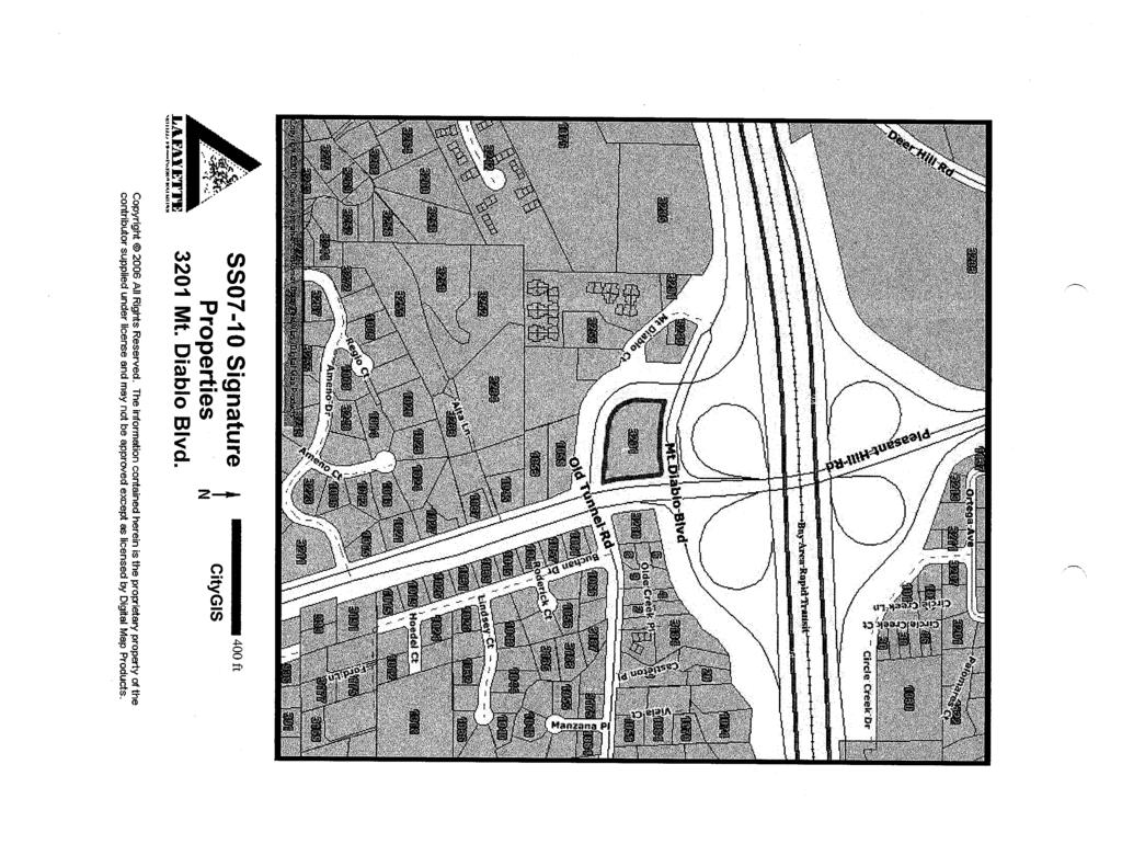
22 Mt. Diablo Blvd. CityGIS 400 ft

23 Mt. Diablo Blvd. CityGIS 100 ft

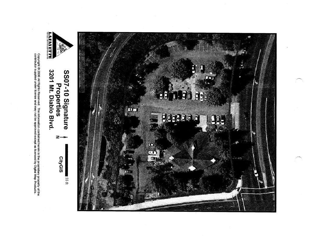
24 Mt. Diablo Blvd. CityGIS 55 ft

25 L06-11 Signature Development Looking North

26 L06-11 Signature Development

27 L06-11 Signature Development Looking East

28 L06-11 Signature Development Looking West
29
30
31
32
33
34
35
36
37
38
39
40 HORT!CUL TURE I ARBOR!CUL TURE! URBAN FORESTRY SCIENCE September 12, 2011 Greg Wolff Senior Planner City of Lafayette 3675 Mt. Diablo Blvd Lafayette, Ca RE: Arborist Supplemental Analysis Hungry Hunter Site Dear Mr. Wolff, Background Additional analysis was requested of the Signature Development Group at the August 8, 2011 Design Review Committee. The following is intended to expand on and supplement the previous Arborist Report, HortScience Inc., dated June Specifically the ORe members asked for information on the following 4 items: Q: What is the long term prognosis for the existing redwood tree grove that is located on the subject site regardless of the new development: A: Overall the numerous trees to be retained are in good health and do not display any major defects or weaknesses that would endanger any future occupants of the site (subject to proper maintenance). The removal of the selective trees identified in the report will not result in any adverse affects on the remaining grove. The recent resumption of the onsite irrigation was a benefit to the ongoing health of the trees. We have determined that those trees identified for retention should last another 50 years baring any unforeseen abuse or unknown disease. While redwoods are very common in the Lafayette area, they are not native to the inland valley and are dependent on supplemental irrigation. As shown on the most recent revised landscape plan, proper ground cover planting and irrigation are being proposed under and around the existing redwood grove to retain the overall health and longevity of the trees. The effort to retain the trees is worthwhile both in the short and long term. Q: Please expand on the proposed tree protection plans for the site; A: We have worked closely with both the landscape architect and the developer to insure that the future building layout and anticipated utilities will allow for the retention of the significant tree grove identified in our report. Utilizing the existing cuts of the submerged building foundation, will limit the amount of cuufili grading typically associated with infill sites. Replacing the new building in the old, previous location will allow for retention of the existing trees with minimal impacts. Meticulous onsite monitoring and protection fencing will be incorporated into the future grading operation. HortSeienee, Inc. I 325 Ray SI. I Pleasanton, CA phone I fax I
41 City comment response letter HortScience, Inc. Signature Development Group, Hungry Hunter, Lafayette Page 2 Q: Expand upon the irrigation and planting requirements under the redwood trees to remain; A: The landscape architect has specified appropriate ground cover species and irrigation under and around the existing redwood trees to compliment their continued long term health. We do not see any conflicts with the direction of the proposed planting plan. In areas along the Mt Diablo Road and Pleasant Hill Road frontages where existing Redwood trees do not exist, new Redwood trees are proposed. The placement of these new compatible trees will only enhance the veiled look of the site and provide diversity of age for the overall grove going forward. Q: Please address tree #53; A: Tree #53 is considered of poor health with significant dieback. We concur with the plan to remove this tree especially in the location adjacent to the new driveway and utility corridor. The tree characteristics of the site would be better served by planting new redwood trees in this area as proposed. Q: What is the anticipated long term maintenance efforts required for the redwood grove; A: The proposed development will have an overall homeowner's association which will maintain all of the building exteriors, site improvements and most importantly the existing and proposed landscaping and irrigation. A detailed maintenance manual will be produced to insure that the onsite irrigation and plantings are managed per industry standards. Typically this set of checks and balance is very successful for such an infill site at this. Included in the manual will be annual efforts to care for the existing and new site trees. Annual pruning, cleaning out of crowns, removal of die back, etc. will be performed on the redwood trees. Regular repair of the irrigation systems are also included in the manual. Overall, annual upkeep and survey of the redwood trees as opposed to set efforts results in the best survival and maintenance of the trees. Conclusion Overall the proposed tree retention plan is well thought out and was conceived in conjunction with the developments inception. We look forward to working on the site and are available if there are any other questions.. ce '~'. o n ~ H Science, Hort5cience, Inc. I 325 Ray 51. I Pleasanton, CA phone I fax I
42 City of Lafayette Memorandum To: Greg Wolff, Senior Planner From: Tony Coe, Engineering Services Manager Leah C. Greenblat, Transportation Planner Date: September 2, 2011 Subject: Initial Comments on L06-11 Signature Development Group Application for Former Hungry Hunter Site This memo is intended to summarize our initial comments on the proposed development of 23 town homes on the southwest corner of Mt. Diablo Boulevard. and Pleasant Hill Road. The comments below represent our preliminary review of the drawings dated June 10, Some of our comments will require additional drawing details; others require some traffic analysis. Both may result in additional comments upon further staff review. Please feel free to contact us if you have any questions regarding our comments. We have the following comments on this referral: 1. We understand that a project traffic study may be underway. Please consult the generic scope of work provided to ensure that certain key elements are included in the study. Study intersections should include Mt. Diablo Boulevard at Carol Lane, Mt. Diablo Boulevard at Mt. Diablo Court and Pleasant Hill Road (PHR), PHR at Deer Hill and Old Tunnel Road. The study may also wish to preemptively address other traffic-related comments listed in this memo. We may have additional comments after we receive the traffic study for this project. 2. This project will be subject to the Lamorinda Fee and Finance Authority Transportation Mitigation Fee. This fee is calculated based on land use type. See the City s Fee Schedule to determine the fee amount. 3. The internal street layout creates a potential for cut through traffic seeking to avoid the traffic signal at Mt. Diablo Boulevard and PHR. Additionally, staff foresees future complaints on this issue from residents of the new development, resulting in additional traffic enforcement and/or requests for engineering services to address the situation once the project is occupied. Consider traffic calming features or similar design features to reduce potential for short-cutting through traffic.
43 4. Both project driveway entrances should have pavement treatments and signs to alert and slow drivers that they are about to cross the path of travel for pedestrians and bicycles. 5. Due to the likely increase in pedestrian usage, the pedestrian heads of the traffic signals at PHR/Mt. Diablo Boulevard and PHR/Old Tunnel Road should be upgraded to have countdown pedestrian heads. Additionally, the push button on the northeast corner of PHR and Mt. Diablo Boulevard should be relocated closer to the path of travel. A larger pedestrian refuge should be explored at the southeast corner pork chop island at Pleasant Hill Road and Mt. Diablo Boulevard. Retrofit curb ramps and pedestrian landings at this intersection to include tactile dome warning strips. Modify the pedestrian push button in the south leg median of PHR intersection at Mt. Diablo Blvd. to face south, rather than north, so it will be more accessible to pedestrians. 6. The project should install frontage improvements consistent with the Downtown Streetscape Improvement Plan. This includes an enhanced high-visibility crosswalk at the PHR and Mt. Diablo Boulevard Intersection, and providing landscaping, irrigation, and street lighting in the median on Mt. Diablo Boulevard between PHR and the eastbound off-ramp overpass. 7. Replace/repair sections of existing sidewalk along the south side of Mt. Diablo Boulevard that are uplifted or otherwise damaged along the project frontage. Future residents of the project should have a non-motorized mode of travel to connect to downtown amenities and destinations, which are all within walking and biking distance. For this purpose, the project should construct a gap closure segment of sidewalk on the south side of Mt. Diablo Boulevard connecting the project to the existing sidewalk terminus near the Lafayette Park Hotel. 8. Confirm grade of sidewalk in vicinity of Unit 14 is compatible with handicapped access. 9. Show on-site lighting if it is proposed. 10. Consider the design of garages so that power sources are conveniently located to facilitate electric vehicle battery charging. 11. Provide details for any special entrance features where the project s private driveway intersects Mt. Diablo Boulevard and PHR, such as signing, lighting, stone work, etc. Designate 50 feet of curb length as no-parking west of project driveway at Mt. Diablo Boulevard to create good sight distance between eastbound traffic and exiting right-turns. 2
44 12. Install a No Parking, Bike Lane sign along the west side of PHR between Mt. Diablo Boulevard and the EB off-ramp from Route 24 as a frontage improvement. The following comments relate to specific drawing sheets and are grouped by drawing numbers. C2 Site Plan 13. Create a new plan for existing conditions clearly showing driveways, sidewalk, bike lanes, signing along project frontage and more clearly show adjacent roadway features such as striping, medians, crosswalks, etc. Show on-street curb parking and no-parking zones along the south side of Mt. Diablo Boulevard. 14. Number on-site parking spaces to facilitate reference in review and comments. 15. The handicap space west of Unit 22 is shown as 8 feet wide, which is nonstandard. It is also on the west side of the dead-end driveway which makes access awkward for a driver to get the vehicle in and out of the parking space and also for the driver or passenger to physically get in and out of the vehicle. Relocate and resize this space. 16. Add a legend to sheet C2 Site Plan to denote the meaning of the blue crosshatched areas. 17. A vehicle in the southerly parking space east of Unit 11 would extend into the private roadway around the curve, thereby potentially narrowing the northbound travel way. Redesign to correct this situation. Confirm that other parking spaces across from Units 5, 6 and 7, when occupied by a vehicle, do not encroach into the travel way. 18. Buildings 1 and 2 should have sidewalk connections to Mt. Diablo Boulevard and Pleasant Hill Road. Add connections adjacent to the driveways. Sheet C2 shows a bio-retention area, but sheet A1 indicates a sidewalk on the west side of Unit 15/Building 1. It should be a sidewalk. Additionally, establish a connection between Buildings 1 and 2 to the southwest corner of Mt. Diablo Boulevard and Pleasant Hill Road to shorten the walking distance for the majority of the development s residents. 19. Add a short section of yellow, centerline on the portions of the driveway close to Mt. Diablo Boulevard and Pleasant Hill Road to facilitate positioning of exiting and entering vehicles. 20. Add stop signs, Right-Turn Only and Watch for Pedestrians signs facing exiting vehicles at driveways. 3
45 C3 Context Plan/ C4 Grading and Drainage Plan 21. Context plan is missing. 22. Locate all fire hydrants along existing street frontage, as well as any planned onsite. 23. Develop Construction Traffic/Parking Plan as well as dust mitigation specifications and details to be included in permit drawings. 24. See Storm Water Control Plan review comments transmitted separately. Drainage system should be shown in detail to illustrate how on-site system is interconnected, and how it connects to downstream street system. A1 Streetscapes; A2-A5 Buildings 1-5; and A10 Site Sections 25. Cross section of driveway design conflicts with Site Plan. 26. Provide a raised curb or similar design measures to separate pedestrians from the travelled way on the west and south sides of the private driveway where the most vehicle traffic is expected. Review all building elevations and site sections to ensure that there are raised curbs of some sort separating the travelled way and walkway areas. L1 Preliminary Landscape Plan 27. The minimum width of sidewalk adjacent to the trellis area at the entry to units must be 4 feet. 28. Clearly illustrate access routes for handicapped persons to reach the central lawn plaza from within the development. 29. Redesign bio-retention areas which appear to prevent access to the central lawn area, particularly the bio-retention area adjacent to the steps adjacent to the lawn area. 30. To maintain adequate sight distance, the landscape materials used where the through private drive meets public right-of-way at Mt. Diablo Boulevard and PHR must be no more than 30 inches in mature height with minimal maintenance Similarly, the large redwood tree on the southwest corner of Mt. Diablo Boulevard/PHR should be pruned back so eastbound drivers approaching the intersection can see the near-side, west facing 12 inch signal head. l:\engineering\development review\development review 2011\l06-11 signature development-hungry hunter initial gardens.docx 4
46 September 7, 2011 Greg Wolff, Senior Planner City of Lafayette 3675 Mt Diablo Blvd Lafayette, California Re: L06-11 SIGNATURE DEVELOPMENT GROUP (APPLICANT), JACK & AUDIE DUDUM (OWNERS), C-1 ZONING, Account #2104 Greg, We have reviewed the submitted set of plans, dated June 10, 2011, for the demolition of the existing Hungry Hunter restaurant and the construction of 23 townhomes at 3201 Mt Diablo Boulevard. The proposed subdivision at the 1.5 acre site includes removing a number of protected trees. Also reviewed was an arborist report prepared by HortScience, dated June, A site visit was made on August 18, Site Observations and Recommendations The project site is located at the southwest corner at the intersection of Mt Diablo Boulevard and Pleasant Hill Road. The existing Hungry Hunter restaurant (no longer open for business) occupies the northeast corner of the lot, and surface parking is located throughout the interior and periphery. The proposed townhouse land use appears appropriate for the arterial-bordering site: Mt Diablo Boulevard bordering the northern property line; Pleasant Hill Road bordering the eastern property line; and the Highway 24 off ramp bordering the western and southern property lines. Any potential view impacts that would result due to the proposed site improvements appear to be minimal. Inside Out Design, Inc Harwood Avenue Oakland, CA T F aboutinsideout.com
47 Arborist Report, Existing Trees and Recommended Mitigation Measures Preface Per the city of Lafayette s Tree Protection Ordinance, a protected tree qualifies as the following: a tree of any species within a commercial zoning district. Based on an initial site visit, it appeared one tree was overlooked by the project arborist. In the following table, this tree has been denoted by a letter following the numeric ID (i.e. 24A). All replacement tree counts for protected trees removed from the property are calculated by the following formula stated in the city of Lafayette s Tree Protection Ordinance: Replacement trees of two (2) 15 gallon species for each 6 of the diameter, or fraction thereof, of the tree to be removed. The diameter of a multi-trunked tree is the sum of the diameters of its component trunks. Tree Inventory and Assessment Table per HortScience / Additional Comments by City Landscape Consultant / Mitigation Measures per the City of Lafayette s Tree Ordinance at Signature Development Site # Species Dia. Traverso Tree Service comments / City Save / Standard Recommended Landscape Consultant comments (in Remove Replacement Replacement italics) trees Trees* 52 Coast redwood, Sequoia sempervirens 53 Coast redwood, Sequoia sempervirens 24 Remove, in decline. Tree is dead. We recommend no mitigation measures be assessed. 30 Remove, impacted Tree diameter measures 32 Remove 8 0 Remove Coast redwood, Sequoia sempervirens 56 Coast redwood, Sequoia sempervirens 25 Remove, impacted Remove Remove, impacted Remove
48 57 Sweet gum, Liquidambar 7, 7 Remove, impacted Remove 6 4 Proposed site improvements require removal. We suggest tree assessment be based on the Guide for Plant Appraisal, 9 th edition rather than the Ordinance s sum of all trunks. (Multi-trunk correlates to 10 diameter tree) 58 Coast redwood, Sequoia sempervirens 36 Remove, impacted Remove Canary island date palm, Pinus canariensis 18 Remove, provide space for redwood development. If removed, we suggest tree replacement value be 50% due to benefit of neighboring trees. Remove Coast redwood, Sequoia sempervirens 15 Remove, impacted Remove Sweet gum, Liquidambar 12 Remove, impacted Remove Sweet gum, Liquidambar 13 Remove, impacted Remove Coast redwood, Sequoia sempervirens 24 Remove, impacted Remove Coast redwood, Sequoia sempervirens 26, 10 Remove, impacted Remove Blue atlas cedar, Cedrus atlantica Glauca 75 Coast redwood, Sequoia sempervirens 14 Remove, impacted remove Remove, impacted Remove Coast redwood, Sequoia sempervirens 26, 14 Remove, impacted Remove Italian stone pine, Pinus pinea 14 Remove, impacted Remove Lombardy poplar, Populus nigra Italica 14 Remove, impacted Tree is nearly dead. Due to extreme decline, we suggest no mitigation measures be assessed. Remove Ash, Fraxinus uhdei 14 Remove, impacted Remove Ash, Fraxinus uhdei 18 Remove, impacted Remove
49 82 Ash, Fraxinus uhdei 12 Remove, impacted Remove Ash, Fraxinus uhdei 9 Remove, impacted Remove Ash, Fraxinus uhdei 10 Remove, impacted Remove Ash, Fraxinus uhdei 12 Remove, impacted Remove Ash, Fraxinus uhdei 12 Remove, impacted Remove Ash, Fraxinus uhdei 12 Remove, impacted Remove Ash, Fraxinus uhdei 19 Remove, impacted Remove Chinese elm, Ulmus parvifolia 7 Remove, impacted Remove Chinese elm, Ulmus parvifolia 9, 8, 7 Remove, impacted Remove Sweet gum, Liquidambar 12 Remove, impacted Remove Chinese elm, Ulmus parvifolia 10, 9, 7 Remove, impacted Remove Chinese elm, Ulmus parvifolia 10 Remove, impacted Remove A Chinese elm, Ulmus 5 Tree not documented by arborist (tagged by Remove 2 -- parvifolia city landscape consultant). Proposed site improvements require removal. *Reduced Multi-trunked calculation (based on the Council of Tree & Landscape Appraisers Guide for Plant Appraisal, 9 th edition) subject to the review and approval of the Planning Commission and City Staff. Suggested reduction in tree replacement value due to extreme decline in health (subject to the review and approval of the Planning Commission and City Staff) The total Tree Replacement (15 gallon) count may range between the following: Typical Tree Replacement Counts: Two hundred twenty (220) Suggested Tree Replacement Counts: One hundred eighty-nine (189) 4
50 Due to site constraints, the new development will not be able to accommodate the quantity of 15 gallon replacement trees. As an alternative, at the City s discretion, inlieu of on-site replacement trees, the applicant may make payments set forth by the city council for each 15-gallon replacement tree. The in-lieu payment shall be used by the city for a tree education or a tree planting program. Recent values for each 15 gallon replacement tree have equaled $260/tree. Additionally, the applicant may utilize the following substitution chart to satisfy tree mitigations: Two (2) 15 gallon replacement trees in exchange for the planting of one (1) 24 box sized tree Four (4) 15 gallon replacement trees in exchange for the planting of one (1) 36 box sized tree Eight (8) 15 gallon replacement trees in exchange for the planting of one (1) 48 box sized tree Sixteen (16) 15 gallon replacement trees in exchange for the planting of one (1) 60 box sized tree Thirty-two (32) 15 gallon replacement trees in exchange for the planting of one (1) 72 box sized tree If trees greater than 24 box sized containers are planted on the subject property or adjacent property, we suggest that the city and/or project arborist inspect each prior to planting. We also highly recommend that the project arborist be on-site to properly prepare rootball and planting pit at the time of planting. Additional Recommendations 1. Three mature existing Eucalyptus trees (not documented) are located south of the site, north of the Highway 24 off-ramp. The trees canopies extend into the property and will likely require minor clearance pruning at the proposed buildings along the southern property line. Please tag and identify trees. Retain project arborist to perform all clearance pruning. 5
51 Recommendations for Sheet L-1, Preliminary Landscape Plan The Preliminary Landscape Plan is an illustrative plan that shows proposed tree locations, a limited plant list and community amenities. 2. In an effort to achieve the effect of a tree lined street, consider incorporating more trees along the interior vehicular loop. Consider the following: a. Along the northern shoulder: i. Locate two to three additional trees at the botts dots parking area. ii. Specify the same species of tree along the corridor. It appears Red maple (Acer rubrum) is identified as such. Substitute the two smaller trees at the eastern entry for one maple; specify a red maple at the southwestern corner of building group 1. b. Along the southern shoulder: i. Provide bulb outs to incorporate tree locations (there appears to be areas of the drive where the width of the roadway increases to accommodate this feature). ii. Stagger units to provide additional landscape areas. This appears feasible at building group 4 to potentially incorporate two additional trees while respecting setbacks along the property line. 3. The proposed red maple is specified as Acer rubrum Bloodgood. Please verify cultivar. ( Bloodgood is associated with Japanese maples and plane trees). If space is limited along the interior loop, consider specifying a columnar or medium sized cultivar. 4. To achieve a more unified tree palette along Mt Diablo Boulevard (at least five different species are proposed), consider limiting the tree species to two additional species beyond the existing redwoods. 5. For the proposed central lawn area, consider specifying a variety of grass (i.e. tall dwarf fescue) that is less water intensive than other varieties of grass. 6
52 6. As the project progresses, greater detail regarding the proposed site improvements will be warranted, some of which may include the following: a. Proposed grades. b. Specification/identification of the proposed smaller trees, shrubbery and groundcovers. c. Type of proposed retaining wall, or facing of proposed walls. d. Greater detail of the central common area, trellis features, and unit entry areas. Please contact us if you have questions or need additional information. Sincerely, INSIDEOUT DESIGN, INC Pennell Phillips City Landscape Consultant Landscape Architect, CLA 5602 Certified Arborist, WE 6608A 7
53
54
55
56
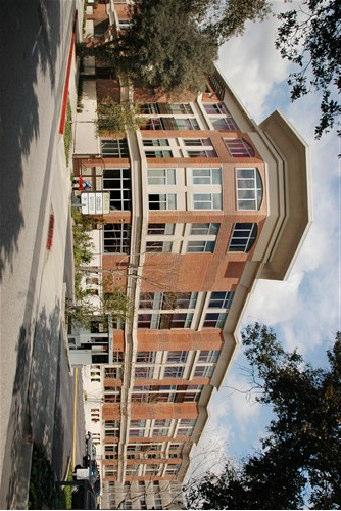
57
City of Lafayette Study Session Project Data
 City of Lafayette Study Session Project Data For: Design Review Commission By: Michael P. Cass, Senior Planner Date: August 24, 2015 Property Address: 954 Mountain View Drive APN: 243-070-011 Zoning District:
City of Lafayette Study Session Staff Report Design Review Commission
 ++ City of Lafayette Study Session Staff Report Design Review Commission Meeting Date: January 08, 2018 Staff: Subject: Chris Juram, Planning Technician SS12-17 Miramar Homebuilders, R-20 Zoning: Request
City of Lafayette Study Session Staff Report Design Review Commission
 City of Lafayette Study Session Staff Report Design Review Commission Meeting Date: April 24, 2017 Staff: Payal Bhagat, Senior Planner Subject: HDP18-15 & HDP31-15 Ramesh Patel & Melcor Development (Owners),
City of Lafayette Staff Report
 City of Lafayette Staff Report For: By: Design Review Commission Greg Wolff, Senior Planner Meeting Date: April 27, 2015 Subject: SS03-15 Gundi & Peter Younger (Owners), R-40 Zoning: Request for a Study
Planning Commission Staff Report June 5, 2008
 Owner/Applicant Taylor Village Sacramento Investments Partners, LP c/o Kim Whitney 1792 Tribute Road #270 Sacramento, CA 95815 Staff Recommendation Planning Commission Staff Report Project: File: Request:
PLANNING COMMISSION AGENDA REPORT NOVEMBER 15, 2012
 PLANNING COMMISSION AGENDA REPORT NOVEMBER 15, 2012 TO: FROM: Members of the Planning Commission Michael Klein, Associate Planner FILE NO.: 120000890 PROPOSAL: APPLICANT: Request for an Administrative
5.1.1 The streetscape along US Highway 64 (Brevard Road); and, The built environment within new residential developments; and,
; and, The built environment within new residential developments; and,") Article 5. Landscaping 5.1 Purpose The Town of Laurel Park s landscape standards are designed to create a beautiful, aesthetically pleasing built environment that will complement and enhance community
Article 5. Landscaping 5.1 Purpose The Town of Laurel Park s landscape standards are designed to create a beautiful, aesthetically pleasing built environment that will complement and enhance community
WINDSOR GLEN DESIGN GUIDELINES
 WINDSOR GLEN DESIGN GUIDELINES Adopted by Council, 2006 WINDSOR GLEN REDEVELOPMENT DESIGN GUIDELINES August 2006 1.0 Master Plan Organization For this area of the Coquitlam Town Centre, a mix of high,
Infill Residential Design Guidelines
 Infill Residential Design Guidelines Adopted March 23, 2004 Amended September 10, 2013 City of Orange Community Development Department Planning Division Phone: (714) 744-7220 Fax: (714) 744-7222 www.cityoforange.org
PLANNING COMMISSION AGENDA REPORT SEPTEMBER 1, 2016
 PLANNING COMMISSION AGENDA REPORT SEPTEMBER 1, 2016 TO: Members of the Planning Commission FROM: Michael Klein, Planner FILE NO.: 150000780 PROPOSAL: APPLICANT: RECOMMENDATION: A request for a Site Plan
Policies and Code Intent Sections Related to Town Center
 Policies and Code Intent Sections Related to Town Center The Town Center Vision is scattered throughout the Comprehensive Plan, development code and the 1994 Town Center Plan. What follows are sections
CITY OF MERCER ISLAND DESIGN COMMISSION STAFF REPORT
 CITY OF MERCER ISLAND DESIGN COMMISSION STAFF REPORT Agenda Item: 2 March 9, 2011 Project: Description: Applicant: DSR11-004 The applicant is requesting approval to replace the existing exterior wood framed
Approved: CITY OF ARDEN HILLS, MINNESOTA PLANNING COMMISSION WEDNESDAY, AUGUST 5, :30 P.M. - ARDEN HILLS CITY HALL
 Approved: CITY OF ARDEN HILLS, MINNESOTA PLANNING COMMISSION WEDNESDAY, AUGUST 5, 2015 6:30 P.M. - ARDEN HILLS CITY HALL PLANNING CASES A. Planning Case 15-016; Final Planned Unit Development Arden Plaza;
DESIGN REVIEW COMMITTEE AGENDA ITEM
 DESIGN REVIEW COMMITTEE AGENDA ITEM AGENDA DATE: AUGUST 2, 2017 TO: THRU: FROM: SUBJECT: Chair Imboden and Members of the Design Review Committee Anna Pehoushek, Assistant Community Development Director
Site Design (Table 2) Fact Sheet & Focus Questions:
 Fact Sheet & Focus Questions:") Site Design (Table 2) Fact Sheet & Focus Questions: BACKGROUND WHAT IS SITE DESIGN? Site design refers to the arrangement of buildings and open spaces on adjacent sites to maximize the shared benefits
Site Design (Table 2) Fact Sheet & Focus Questions: BACKGROUND WHAT IS SITE DESIGN? Site design refers to the arrangement of buildings and open spaces on adjacent sites to maximize the shared benefits
DESIGN REVIEW COMMITTEE AGENDA ITEM
 DESIGN REVIEW COMMITTEE AGENDA ITEM AGENDA DATE: DECEMBER 16, 2015 TO: THRU: FROM: SUBJECT: Chair McCormick and Members of the Design Review Committee Leslie Aranda Roseberry, Planning Manager Kelly Christensen
14825 Fruitvale Ave.
 REPORT TO THE PLANNING COMMISSION Meeting Date: August 26, 2015 Application: PDR14-0017 Location/APN: 14825 Fruitvale Ave. / 397-18-028 Applicant/Owner: Staff Planner: Sin Yong Michael Fossati 14825 Fruitvale
RESIDENTIAL PLANNED UNIT DEVELOPMENT / SUBDIVISION AND REZONING CONCEPT AND DEVELOPMENT STAGE PLAN SUBMITTAL NARRATIVE
 RESIDENTIAL PLANNED UNIT DEVELOPMENT / SUBDIVISION AND REZONING CONCEPT AND DEVELOPMENT STAGE PLAN SUBMITTAL NARRATIVE DEVELOPMENT TEAM DONEGAL SOUTH Maple Grove, Minnesota March 27, 2017 Applicant/Developer/Builder:
SMALL LOT DESIGN STANDARDS. An Illustrated Working Draft for Test Implementation
 SMALL LOT DESIGN STANDARDS An Illustrated Working Draft for Test Implementation SMALL LOT DESIGN STANDARDS ILLUSTRATED WORKING FOR TEST IMPLEMENTATION OVERVIEW SMALL LOT CODE AMENDMENT & POLICY UPDATE
DESIGN REVIEW COMMISSION AGENDA COEUR D ALENE PUBLIC LIBRARY LOWER LEVEL, COMMUNITY ROOM 702 E. MULLAN THURSDAY JANUARY 25, :00 pm
 DESIGN REVIEW COMMISSION AGENDA COEUR D ALENE PUBLIC LIBRARY LOWER LEVEL, COMMUNITY ROOM 702 E. MULLAN THURSDAY JANUARY 25, 2018 12:00 pm 12:00 P.M. CALL TO ORDER: ROLL CALL: Ives, Ingalls, Lemmon, Messina,
The meeting convened at 7:30 p.m. in the City of San Mateo Council Chambers and was called to order by Chair Massey, who led the Pledge of Allegiance.
 CITY OF SAN MATEO PLANNING COMMISSION MINUTES OF THE REGULAR MEETING MAY 25, 2010 The meeting convened at 7:30 p.m. in the City of San Mateo Council Chambers and was called to order by Chair Massey, who
Land Use Amendment in Southwood (Ward 11) at and Elbow Drive SW, LOC
 at and Elbow Drive SW, LOC") 2018 November 15 Page 1 of 10 EXECUTIVE SUMMARY This land use amendment application was submitted by Rick Balbi Architect on 2017 August 31 on behalf of Sable Developments Ltd, and with authorization from
2018 November 15 Page 1 of 10 EXECUTIVE SUMMARY This land use amendment application was submitted by Rick Balbi Architect on 2017 August 31 on behalf of Sable Developments Ltd, and with authorization from
CHAPTER FIVE COMMUNITY DESIGN
 CHAPTER FIVE COMMUNITY DESIGN CHAPTER FIVE - COMMUNITY DESIGN Assumptions Frazier Park and Lebec have historically developed according to different patterns of spatial form. While both communities are
Mark-up of the effect of the proposed Bronte Village Growth Area OPA No.18 on the text of section 24, Bronte Village, of the Livable Oakville Plan
 Mark-up of the effect of the proposed Bronte Village Growth Area OPA No.18 on the text of section 24, Bronte Village, of the Livable Oakville Plan Notes: This document is provided for information purposes
14 October 10, 2012 Public Hearing APPLICANT: MPB, INC
 14 October 10, 2012 Public Hearing APPLICANT: MPB, INC PROPERTY OWNER: MUNDEN & ASSOCIATES, LP STAFF PLANNER: Karen Prochilo REQUEST: Conditional Change of Zoning (AG-1 & AG-2 to Conditional O-2) ADDRESS
MEMO 1. INTRODUCTION PURPOSE & PROCESS REQUEST
 MEMO Date: August 22, 2017 To: Board of Commissioners From: Jason Burdette, Planning Director Re: Davidson Commons East Hotel Stakeholder Feedback 1. INTRODUCTION PURPOSE & PROCESS This memorandum summarizes
September 30, 2014 Ms. Lorraine Weiss Department of Community Development City of San Mateo 330 West 20th Avenue San Mateo, CA
 ARCHITECTURE PLANNING URBAN DESIGN September 30, 2014 Ms. Lorraine Weiss Department of Community Development City of San Mateo 330 West 20th Avenue San Mateo, CA 94403-1388 RE: Station Park Green Dear
DATE: PLANNING COMMISSION MEETING OF FEBRUARY 24, 2016
 DATE: PLANNING COMMISSION MEETING OF FEBRUARY 24, 2016 TO: FROM: SUBJECT: THE PLANNING COMMISSION LISA COSTA SANDERS, TOWN PLANNER REQUEST FOR A SPECIAL STRUCTURES PERMIT FOR A POOL IN THE SIDE YARD AND
The subject site plan amendment proposes the following revisions to the approved site plan:
 PROPOSED AMENDMENT The subject site plan amendment proposes the following revisions to the approved site plan: 1. The building footprint was modified to accommodate the revised architectural design. 2.
B L A C K D I A M O N D D E S I G N G U I D E L I N E S for Multi-family Development
 B L A C K D I A M O N D D E S I G N G U I D E L I N E S for Multi-family Development Adopted June 18, 2009 This section of the Design and focuses on site planning and design guidance for new multi-family
ARLINGTON COUNTY, VIRGINIA
 ARLINGTON COUNTY, VIRGINIA County Board Agenda Item Meeting of October 23, 2004 DATE: October 6, 2004 SUBJECT: SP #106-3 Site Plan Amendment for changes to façade, plaza deck, landscaping, number of units,
Request Alternative Compliance to the prescribed criteria of the Oceanfront Resort District Form-Based Code. Staff Planner Kristine Gay
 Applicant/Owner Ocean Rental Properties, LLC Public Hearing April 13, 2016 City Council Election District Beach Agenda Item 1 Request Alternative Compliance to the prescribed criteria of the Oceanfront
URBAN DESIGN BRIEF URBAN DESIGN BRIEF 721 FRANKLIN BLVD, CAMBRIDGE August 2018
 URBAN DESIGN BRIEF URBAN DESIGN BRIEF 721 FRANKLIN BLVD, CAMBRIDGE August 2018 DESIGN BRIEF CONTENTS PART A 1.0 INTRODUCTION 2.0 DESCRIPTION & ANALYSIS OF SITE CONTEXT 3.0 DESIGN CONSTRAINTS AND OPPORTUNITIES
EXISTING COMPREHENSIVE PLAN
 EXISTING COMPREHENSIVE PLAN Town Center Land Use Element: V. LAND USE POLICIES Town Center Mercer Island's business district vision as described in "Your Mercer Island Citizen-Designed Downtown" was an
ATTACHMENT A. SILVERDALE DESIGN STANDARDS Amendments to the Waaga Way Town Center Chapter
 ATTACHMENT A SILVERDALE DESIGN STANDARDS Amendments to the Waaga Way Town Center Chapter Chapter 10. Waaga Way Town Center 10.1 Physical Identity Elements & Opportunities The Waaga Way Town Center includes
Future Five. Design/ Development Guidelines. January 2008 Amended June 08 per City Council motion
 Future Five Design/ Development Guidelines January 2008 Amended June 08 per City Council motion 5-Points Design Guidelines Table of Contents I. Introduction 3 II. Area boundaries 4 III. Review Process
SECTION TWO: Overall Design Guidelines
 SECTION TWO: Overall Design Guidelines This section provides overall design principles and guidelines for the Gardnerville Mixed-use Overlay. They provide criteria for mixed-use places consisting of residential,
Project phasing plan (if applicable) 12 copies of site plan
 12 copies of site plan") SITE PLAN REVIEW PERMIT APPLICATION City of Grand Haven, 11 N. Sixth Street, Grand Haven, MI 49417 Phone: (616) 847-3490 Fax: (616) 844-2051 Website: www.grandhaven.org 1. Project Information Address/location
SITE PLAN REVIEW PERMIT APPLICATION City of Grand Haven, 11 N. Sixth Street, Grand Haven, MI 49417 Phone: (616) 847-3490 Fax: (616) 844-2051 Website: www.grandhaven.org 1. Project Information Address/location
Steve, Following are our notes from the first two meetings with Montgomery County Planning Group:
 To Steve Hatch Fax No. Telephone No. From Mike Stanley Date 10/16/17 Subject Minutes from Montgomery County Meetings File Distribution This is page 1 of 5 Memorandum/Discussion/Observations Steve, Following
KEY MAP DEVELOPMENT PERMIT AREA MAP. Sunnymede North Sub-Area Plan
 Richmond Official Community Plan BROADMOOR AREA SUNNYMEDE NORTH SUB-AREA PLAN Bylaw 7100 Schedule 2.6C SUNNYMEDE NORTH SUB-AREA PLAN SUNNYMEDE NORTH SUB-AREA PLAN SUNNYMEDE NORTH SUB-AREA PLAN KEY MAP
280 Manse Road - Official Plan Amendment, Zoning Amendment, Draft Plan of Subdivision Applications - Preliminary Report
 STAFF REPORT ACTION REQUIRED 280 Manse Road - Official Plan Amendment, Zoning Amendment, Draft Plan of Subdivision Applications - Preliminary Report Date: March 11, 2014 To: From: Wards: Reference Number:
II. SINGLE FAMILY RESIDENTIAL
 II. SINGLE FAMILY RESIDENTIAL Castle Rock is made up of numerous individually built houses and subdivision tracts that have been developed during the past century. Some of the tracts are diverse in architectural
Town of Portola Valley General Plan. Nathhorst Triangle Area Plan
 Town of Portola Valley General Plan Amended December 10, 1997 Table of Contents Introduction... 1 Planning Area... 1 Objectives... 2 Principles... 2 Standards... 4 Description... 4 Community Commercial...
URBAN DESIGN BRIEF REPORT
 URBAN DESIGN BRIEF REPORT PREPARED FOR 2568401 ONTARIO INC NEW GASBAR, CONVENIENCE STORE & CARWASH DEVELOPMENT @ 1509 FANSHAWE PARK ROAD WEST LONDON, ONTARIO GAMA ENGINEERING INC. PROJECT NUMBER 1669 PREPARED
Workshop 3. City of Burlington Waterfront Hotel Planning Study. September 14, The Planning Partnership
 Workshop 3 City of Burlington Waterfront Hotel Planning Study September 14, 2017 The Planning Partnership The Waterfront Hotel Planning Study 01 The Brant & Lakeshore Planning Study will establish a Strategic
City of Lafayette Staff Report Design Review Commission
 City of Lafayette Staff Report Design Review Commission Meeting Date: February 13, 2017 Staff: Subject: Niroop K. Srivatsa DR13-14DDII Lennar Homes (Applicant), C-Zoning: Request for: (1) Review of Phase
COMPLIANCE CHECKLIST HILLSIDE RESIDENTIAL DESIGN GUIDELINES MANUAL
 COMPLIANCE CHECKLIST HILLSIDE RESIDENTIAL DESIGN GUIDELINES MANUAL The following checklist summarizes development guidelines and standards. See the appropriate section for a complete explanation of the
Urban Planning and Land Use
 Urban Planning and Land Use 701 North 7 th Street, Room 423 Phone: (913) 573-5750 Kansas City, Kansas 66101 Fax: (913) 573-5796 Email: planninginfo@wycokck.org www.wycokck.org/planning To: From: City Planning
PLANNING COMMISSION AGENDA REPORT APRIL 7, 2016
 PLANNING COMMISSION AGENDA REPORT APRIL 7, 2016 TO: FROM: Members of the Planning Commission Talyn Mirzakhanian, Senior Planner FILE NO.: 160001710 PROPOSAL: APPLICANT: RECOMMENDATION: A request for a
REQUEST FOR COUNCIL ACTION 6A AGENDA ITEM
 DATE REQUEST FOR COUNCIL ACTION 6A AGENDA ITEM ORIGINATING DEPT. AGENDA ITEM CITY ADMINISTRATOR APPROVAL Community Development PUD Concept & Development Stage Plan Preliminary Plat & Final Plat PREVIOUS
TOP TEN LIST OF COMMUNITY CONCERNS REGARDING PROPOSED AMENDMENTS TO CHAPTER 42
 TOP TEN LIST OF COMMUNITY CONCERNS REGARDING PROPOSED AMENDMENTS TO CHAPTER 42 1. Extend the urban area to Beltway 8 in stages, over say a three-year period, prioritizing development in transit and declining
New-Cast Mixed-use Development Proposal King Street West, Newcastle, Ontario
 URBAN DESIGN BRIEF New-Cast Mixed-use Development Proposal King Street West, Newcastle, Ontario TABLE OF CONTENTS: 1.0 Executive Summary 2.0 Creating Vibrant and Sustainable Urban Places: Excerpts from
GENERAL PLAN CONSISTENCY ANALYSIS
 GENERAL PLAN CONSISTENCY ANALYSIS Prepared by Planning Staff 10/28/2013 APPLICABLE GOALS, POLICIES AND PROGRAMS FROM the LAND USE CHAPTER Goal LU-1 Policy LU-1.1 Policy LU-1.2 Goal LU-2 Protect the character
Jordan Harrison, Planner III, San Francisco Recreation and Park Department
 Date December 8, 2015 To: Through: From: Subject: Recreation and Park Commission Philip A. Ginsburg, General Manager Dawn Kamalanathan, Director, Capital & Planning Division Jordan Harrison, Planner III,
City of Farmington. Downtown Plan. Amendment to the 1998 Master Plan Adopted October 11, 2004
 City of Farmington Amendment to the 1998 Master Plan Adopted October 11, 2004 Introduction Planning Background 1 Scope and Components of the Plan Amendment 2 Concept Introduction 3 Plan Concepts 3 Conceptual
CITY PLANNING COMMISSION AGENDA. ITEM NO(s): C.1 C.3 STAFF: STEVE TUCK
: C.1 C.3 STAFF: STEVE TUCK") Page 34 CITY PLANNING COMMISSION AGENDA ITEM NO(s): C.1 C.3 STAFF: STEVE TUCK FILE NOS: CPC ZC 12-00035 QUASI-JUDICIAL CPC NV 12-00036 QUASI-JUDICIAL AR DP 12-00039 QUASI-JUDICIAL PROJECT: APPLICANT: OWNER:
Page 34 CITY PLANNING COMMISSION AGENDA ITEM NO(s): C.1 C.3 STAFF: STEVE TUCK FILE NOS: CPC ZC 12-00035 QUASI-JUDICIAL CPC NV 12-00036 QUASI-JUDICIAL AR DP 12-00039 QUASI-JUDICIAL PROJECT: APPLICANT: OWNER:
Landscaping Standards
 CHAPTER 29 ARTICLE 403 29.403 Landscaping Standards Purpose: The purpose of this section is to protect and promote the public health, safety and general welfare by requiring landscaping in relation to
Town Center (part of the Comprehensive Plan)
") Town Center (part of the Comprehensive Plan) Mercer Island Town Center Looking North (2014) In 1994, a year-long process culminated in a set of design guidelines and code requirements for the Town Center
Town Center (part of the Comprehensive Plan) Mercer Island Town Center Looking North (2014) In 1994, a year-long process culminated in a set of design guidelines and code requirements for the Town Center
CITY OF ESCONDIDO. Planning Commission and Staff Seating AGENDA PLANNING COMMISSION. 201 North Broadway City Hall Council Chambers. 7:00 p.m.
 CITY OF ESCONDIDO Planning Commission and Staff Seating JEFF WEBER Chairman DON ROMO Commissioner BOB McQUEAD Vice-Chair VACANT Commissioner OWEN TUNNELL Principal Engineer BILL MARTIN Deputy Planning
THE CORPORATION OF THE CITY OF NORTH VANCOUVER
 THE CORPORATION OF THE CITY OF NORTH VANCOUVER Meeting of the Held at City Hall, 141 West 14th Street, North Vancouver, B.C. in Conference Room A on Wednesday, July 20,2005 M I N U T E S Present: Staff:
FRUITVALE TRANSIT VILLAGE (Phase 2) Residential Project
 Residential Project") FRUITVALE TRANSIT VILLAGE (Phase 2) Residential Project DEVELOPER: SIGNATURE PROPERTIES ARCHITECT: HKIT ARCHITECTS April 23, 2010 TABLE OF CONTENTS 3 Vision 4 Description of Site 5 Guiding Concepts 6
FRUITVALE TRANSIT VILLAGE (Phase 2) Residential Project DEVELOPER: SIGNATURE PROPERTIES ARCHITECT: HKIT ARCHITECTS April 23, 2010 TABLE OF CONTENTS 3 Vision 4 Description of Site 5 Guiding Concepts 6
SECTION V: DESIGN GUIDELINE EXAMPLES
 SECTION V: DESIGN GUIDELINE EXAMPLES Introduction The Syracuse Town Center is envisioned as an area that creates a sense of place, a community downtown. As such, the Town Center Committee recommended the
R E S O L U T I O N. Single-Family Residence/ Church. 2,488 sq. ft. 2,488 sq. ft. Area Parking Required: Church
 R E S O L U T I O N WHEREAS, the Prince George s County Planning Board is charged with the approval of Detailed Site Plans pursuant to Part 3, Division 9 of the Zoning Ordinance of the Prince George s
12 January 12, 2011 Public Hearing APPLICANT: TAILWIND DEVELOPMENT GROUP,LLC PROPERTY OWNER: CITY OF VIRGINIA BEACH
 12 January 12, 2011 Public Hearing APPLICANT: TAILWIND DEVELOPMENT GROUP,LLC PROPERTY OWNER: CITY OF VIRGINIA BEACH STAFF PLANNER: Faith Christie REQUEST: Conditional Change of Zoning (from PD-H1 Planned
The open space system should provide connective elements, relate to natural resources, and enhance the suburban character of the landscape..
 The open space system should provide connective elements, relate to natural resources, and enhance the suburban character of the landscape.. Mixed-use and infill development should maintain or enhance
Standards (R-3) Figure B-11: R-3 Residential Standards Exhibit
 Figure B-11: R-3 Residential Standards Exhibit") Avila Ranch Avila Ranch Specific Plan Development Standards High Medium Density - High Residential Density Residential Lot and Building Lot and Standards Building (R-3) Standards (R-3) EXAMPLES These sketches
Avila Ranch Avila Ranch Specific Plan Development Standards High Medium Density - High Residential Density Residential Lot and Building Lot and Standards Building (R-3) Standards (R-3) EXAMPLES These sketches
Architectural Review Board Report
 Architectural Review Board Report Architectural Review Board Meeting: February 3, 2014 Agenda Item: 7.9 To: From: Subject: Architectural Review Board Steve Traeger, Principal Urban Designer Scott Albright,
PLANNING COMMISSION AGENDA REPORT FEBRUARY 1, Maureen Tamuri, Community Development Director, AICP Michael Klein, Senior Planner
 PLANNING COMMISSION AGENDA REPORT FEBRUARY 1, 2018 TO: FROM: Members of the Planning Commission Maureen Tamuri, Community Development Director, AICP Michael Klein, Senior Planner FILE NO.: 170001064 PROPOSAL:
CHAPTER 3. Design Standards for Business, Commercial, Industrial, Recreational and Institutional Uses
 CHAPTER 3 Design Standards for Business, Commercial, Section Number Title Ordinance Number Date of Ordinance 16-3-1 Applicability 2006-11 2008-04 07-01-08 16-3-2 Uniform Standards for Architectural Design
Sierra Springs Regional Commercial Master Site Plan Airdrie, Alberta Hopewell Development Corporation Project No May 26, 2010
 Sierra Springs Regional Commercial Master Site Plan Airdrie, Alberta Hopewell Development Corporation Project No. 205-077 May 26, 2010 TABLE OF CONTENTS Purpose... 2 Master Site Plan Guidelines... 3 Overall
4. INDUSTRIAL 53 CASTLE ROCK DESIGN
 4. INDUSTRIAL 53 CASTLE ROCK DESIGN CASTLE ROCK DESIGN 54 4. INDUSTRIAL Overview Well-designed and attractive industrial centers are the product of blending economic realities with both functional and
INSTITUTIONAL USE DESIGN COMPATIBILITY TECHNIQUES
 INSTITUTIONAL USE DESIGN COMPATIBILITY TECHNIQUES INTRODUCTION Community institutions are an important part of the character and vitality of neighborhoods in Forsyth County. Institutional uses include
PUBLIC RIGHT-OF-WAY IN THIS CHAPTER PUBLIC REALM
 PUBLIC RIGHT-OF-WAY This section provides design guidelines for improvements in the public right-of-way. The public right-of-way refers to streets, sidewalks, non-vehicular thoroughfares, parks and greenways
REZONING APPLICATION MPD SUPPLEMENT
 REZONING APPLICATION MPD SUPPLEMENT For Staff Use Only: DATE/TIMESTAMP: ZA# RECEIVED BY: The intent of the Master Planned District (MPD) designation is to allow flexibility in the design and construction
LOS ANGELES CITY PLANNING DEPARTMENT STAFF REPORT
 LOS ANGELES CITY PLANNING DEPARTMENT STAFF REPORT LOS ANGELES CITY PLANNING COMMISSION CASE NO: CPC 2006-9374 CRA CEQA: Exempt DATE: December 21, 2006 Location: Valley Plaza and Laurel Plaza TIME: after
DESIGN REVIEW COMMITTEE AGENDA ITEM
 DESIGN REVIEW COMMITTEE AGENDA ITEM AGENDA DATE: OCTOBER 17, 2012 TO: Chair Woollett and Members of the Design Review Committee THRU: FROM: SUBJECT: Leslie Aranda Roseberry, Planning Manager Daniel Ryan,
Request Alternative Compliance to the prescribed criteria of the Oceanfront Resort District Form-Based Code. Staff Recommendation Approval
 Applicant & Property Owner Public Hearing February 8, 2017 City Council Election District Beach Agenda Item D1 Request Alternative Compliance to the prescribed criteria of the Oceanfront Resort District
599 Kennedy Road - Official Plan Amendment and Zoning Amendment Application - Preliminary Report
 STAFF REPORT ACTION REQUIRED 599 Kennedy Road - Official Plan Amendment and Zoning Amendment Application - Preliminary Report Date: March 7, 2017 To: From: Wards: Reference Number: Scarborough Community
Architectural Review Board Report
 Architectural Review Board Report To: From: CC: Subject: Architectural Review Board Architectural Review Board Meeting: May 21, 2018 Agenda Item: 8-A Grace Page, Senior Planner Stephanie Reich, AIA, LEED
Gold Line Bus Rapid Transit Transit Oriented Development (BRTOD) Helmo Station Area Plan
 Helmo Station Area Plan") Appendix F Gold Line Bus Rapid Transit Transit Oriented Development (BRTOD) Helmo Station Area Plan Introduction and Purpose of the Plan The Gold Line Bus Rapid Transit facility is an eleven-mile dedicated
Appendix F Gold Line Bus Rapid Transit Transit Oriented Development (BRTOD) Helmo Station Area Plan Introduction and Purpose of the Plan The Gold Line Bus Rapid Transit facility is an eleven-mile dedicated
City of Vaughan Urban Design Guidelines for Infill Development in Established Low-Rise Residential Neighbourhoods
 City of Vaughan Urban Design Guidelines for Infill Development in Established Low-Rise Residential Neighbourhoods DRAFT - September 2016 Contents 1. Introduction 1 2. Policy Context 3 3. Characteristics
THAT the attached Terms of Reference for the Thornhill Centre Street Study be approved.
 COMMITTEE OF THE WHOLE AUGUST 18, 2003 THORNHILL CENTRE STREET STUDY PLANNING FILE: 15.92 Recommendation The Commissioner of Planning recommends: THAT the attached Terms of Reference for the Thornhill
APPENDIX C. Architectural and Environmental Design Standards. Environmentally sensitive areas should be protected.
 APPENDIX C Architectural and Environmental Design Standards Environmentally Sensitive Areas Goal A. Environmentally sensitive areas should be protected. Development, such as roads, houses, and other structures,
Architectural and Site Control Commission March 12, 2010 Special Field Meeting, 330 and 340 Golden Hills Drive, Klope
 Architectural and Site Control Commission March 12, 2010 Special Field Meeting, 330 and 340 Golden Hills Drive, Klope Chair Warr called the special field meeting to order at 2:00 p.m. on the terrace of
MULTIFAMILY RESIDENTIAL DESIGN PRINCIPLES Site Plan and Design Review Principles Checklist
 MULTIFAMILY RESIDENTIAL DESIGN PRINCIPLES Site Plan and Design Review Principles Checklist Applicant s Name: Project Address: Phone: Email: Applicant shall fill out the design guidelines checklist for
COMMUNITY DEVELOPMENT SERVICES PLANNING AND BUILDING DEPARTMENT PLACERVILLE OFFICE:
 COMMUNITY DEVELOPMENT SERVICES PLANNING AND BUILDING DEPARTMENT http://www.edcgov.us/devservices/ PLACERVILLE OFFICE: LAKE TAHOE OFFICE: 2850 Fair Lane Court, Placerville, CA 95667 924 B Emerald Bay Rd.
4.0 Design Guidelines For The Village Centre. South fields Community Architectural Design Guidelines Town of Caledon
 4.0 Design Guidelines For The Village Centre 4.0 Design Guidelines for the Village Centre The Village Centre is the focal point of the entire South Fields Community and is designed as a traditional commercial
Planning Commission Staff Report March 15, 2007
 Planning Commission Staff Report Project: Request: Madeira East Tentative Subdivision Map, Design Review for Subdivision Layout & Abandonment of Easements Location: Phase IV of the Laguna Ridge Specific
Development Services Staff Report for Design Review Committee
 Development Services Staff Report for Design Review Committee To: Design Review Committee From: DS Staff: Erika Akin Subject: Proposed Addition to J s Car Wash File: DSRFY2016-1 Date: January 19, 2016
PC RESOLUTION NO ARCHITECTURAL CONTROL (AC)
") PC RESOLUTION NO. 16-07-26- ARCHITECTURAL CONTROL (AC) 15-035 A RESOLUTION OF THE PLANNING COMMISSION OF THE CITY OF SAN JUAN CAPISTRANO, CALIFORNIA APPROVING ARCHITECTURAL CONTROL (AC) 15-035, INN AT
PC RESOLUTION NO. 16-07-26- ARCHITECTURAL CONTROL (AC) 15-035 A RESOLUTION OF THE PLANNING COMMISSION OF THE CITY OF SAN JUAN CAPISTRANO, CALIFORNIA APPROVING ARCHITECTURAL CONTROL (AC) 15-035, INN AT
Note: Staff reports can be accessed at Zone: I-3. Tier:
 The Maryland-National Capital Park and Planning Commission Prince George s County Planning Department Development Review Division 301-952-3530 Note: Staff reports can be accessed at www.mncppc.org/pgco/planning/plan.htm.
Staff Report to the North Ogden City Planning Commission
 Staff Report to the North Ogden City Planning Commission SYNOPSIS / APPLICATION INFORMATION Application Request: Concept review on a legislative application to rezone land located at approximately 1750
ROLL CALL Member Anthony, Member Avdoulos, Member Greco, Member Lynch, Member Maday, Chair Pehrson
 CALL TO ORDER The meeting was called to order at 7:00 PM. PLANNING COMMISSION ACTION SUMMARY CITY OF NOVI Regular Meeting July 11, 2018 7:00 PM Council Chambers Novi Civic Center 45175 W. Ten Mile (248)
4 Residential and Urban Living Zones
 4 Residential and Urban Living Zones Refer to Chapters 11 to 20 for additional rules that may apply to these zones. 4.1 OBJECTIVES AND POLICIES Objective Res1 Policy 1 Policy 2 Policy 3 Policy 4 Policy
Gateway commercial MIXED USE MASTER SITE PLAN. CITILAND AIrDRIE GATEWAY VENTURE INC. airdrie GATEWAY COMMERCE CENTRE. airdrie, ALBERTA FEBRUARY 2012
 Gateway commercial MIXED USE MASTER SITE PLAN 1914 CENTRE STREET NORTH CALGARY, AB CANADA T2E 2S8 T. 403.264.7177 F. 403.264-7175 WWW.CITILAND.CA CITILAND AIrDRIE GATEWAY VENTURE INC. airdrie GATEWAY COMMERCE
Staff Report and Recommendation
 Community Planning and Development Planning Services 201 W. Colfax Ave., Dept. 205 Denver, CO 80202 p: 720.865.2915 f: 720.865.3052 www.denvergov.org/cpd TO: City Council Neighborhoods and Planning Committee
PALO ALTO HIGH SCHOOL Palo Alto Unified School District MEETING NOTES. DATE: 21 September Palo Alto HS Update
 PALO ALTO HIGH SCHOOL Palo Alto Unified School District MEETING NOTES DATE: 21 September 2010 SUBJECT: Landscape Subcommittee Meeting Palo Alto HS Update The purpose of the meeting was to update the Landscape
COMMERCIAL DESIGN REVIEW APPLICATION
 CITY OF LACEY Community Development Department 420 College Street Lacey, WA 98503 (360) 491-5642 COMMERCIAL DESIGN REVIEW APPLICATION OFFICIAL USE ONLY Case Number: Date Received: By: Related Case Numbers:
ARTICLE 3 LANDSCAPING AND SCREENING REQUIREMENTS
 ARTICLE 3 CHAPTER 4 LANDSCAPING AND SCREENING REQUIREMENTS SEC 3.401 SEC 3.402 (D) (E) PURPOSE: The purpose of this Chapter is to establish minimum standards for the design, installation, and maintenance
URBAN DESIGN BRIEF 181 Burloak Drive, Oakville
 URBAN DESIGN BRIEF 181 Burloak Drive, Oakville February 2017 Our File: 1730B 230-7050 WESTON ROAD / WOODBRIDGE / ONTARIO / L4L 8G7 / T: 905 761 5588/ F: 905 761 5589/WWW.MHBCPLAN.COM TABLE OF CONTENTS