BARRATT HOMES September 2017 LAND OFF ENGINE ROAD NAILSEA LANDSCAPE AND VISUAL IMPACT ASSESSMENT
|
|
|
- Delphia Wilkins
- 6 years ago
- Views:
Transcription
1 0
2 CONTENTS PAGE 1.0 INTRODUCTION DESCRIPTION OF DEVELOPMENT & LANDSCAPE STRATEGY BASELINE SURVEY AND ASSESSMENT ASSESSMENT OF LANDSCAPE EFFECTS ASSESSMENT OF VISUAL EFFECTS CONCLUSION 50 APPENDIX A GLVIA METHODOLOGY APPENDICES 1. LOCATION PLAN 2. AERIAL PHOTOGRAPH 3. ILLUSTRATIVE MASTERPLAN 4. METHODOLOGY 5. LANDSCAPE CHARACTER ASSESSMENT 6. TOPOGRAPHY 7. VEGETATION 8. ZONE OF THEORETICAL VISIBILITY PLAN 9. DEFINITIVE FOOTPATH PLAN 10. PHOTOGRAPH LOCATION PLAN 11. PHOTOGRAPHIC RECORD 12. LANDSCAPE ASSESSMENT PLAN 1
3 1.0 INTRODUCTION 1.1 Tisdall Associates has been retained by Barratt Homes to undertake a Landscape and Visual Impact Assessment (LVIA) in relation to land off Engine Lane Nailsea. A Location Plan of the site is included as Appendix 1, an Aerial Photograph as Appendix 2. The Illustrative Masterplan is enclosed as Appendix The methodology for this assessment has been drawn from the Guidelines for Landscape and Visual Impact Assessment, third edition (2013) (GLVIA). published jointly by The Landscape Institute and the Institute of Environmental Management & Assessment. This sets out broad principles for the assessment of impact, drawing upon professional judgment as to their application and subsequent assessment of impacts. An overview of this methodology is included as Appendix 4, and an overview of the methodology included as Appendix A, at the end of this report. This assessment is also mindful of the Photograph and Photomontage in landscape visual impact assessment LI Advice Note 01/11. This study complies with that guidance insofar as it can be directly applied to this study. This includes the use of a digital camera with a 50mm Focal Length; photographs were taken from a viewing height of 1.5m above the ground)). In providing representative photographs of the site and its environs, this study notes the advice of the Guidance which states on Page 2: It is essential to recognise that: Two-dimensional photographic images and photomontages alone cannot capture or reflect the complexity underlying the visual experience, and should therefore be considered an approximation of the three-dimensional visual experience that an observer would receive in the field; As part of a technical process, impact assessment and considered judgements using photographs and/or photomontages can only be reached by way of a visit to the location from which the photograph is taken The assessment of the impact from various viewpoints was undertaken from site, and the photographs are provided as a useful reference. It is also the case that it is not possible to assess every potential viewpoint from each residence, footpath or road, as such locations have been selected which are Representative from within each of the visual receptors identied within GLVIA. 1.3 The assessment includes a desk top study and site survey. It assesses the suitability of the site for development within the context of its current landscape and visual character, and in terms of the potential impact upon that baseline character resulting from the development proposals. It ascertains the landscape and visual impacts, by assessing the change in the nature and extent of impact upon landscape receptors and related to this to changes in the landscape character of the site. It also assesses and impact upon visual receptors from representative viewpoints identified within the Zone of Theoretical Visibility. 2
4 1.4 Planning Context The site is a proposed draft allocation in the emerging Site Allocations Plan. As such it is deemed suitable for development. In undertaking this LVIA and developing the landscape strategy this report has been mindful of relevant Policies and Guidance. These are however addressed through the Planning Statement prepared by Lichfields, and will not be referred to directly in this document to avoid duplication. 1.5 Methodology As noted above the methodology used to undertake the landscape and visual assessment was drawn from the Guidelines for Landscape and Visual Impact Assessment, third edition (2013) (GLVIA). published jointly by The Landscape Institute and the Institute of Environmental Management & Assessment. The steps in assessing landscape and visual effects of development are identified in Appendix A of this document. Note is made here to the different components of an impact assessment between those which are to be included in an EIA, and those which are not. (See GLVIA Table 3.1 pg. 27) This LVIA is undertaken outside the scope of an EIA. Whilst current guidance does not seek to develop prescriptive methodologies for landscape and visual impact assessment, GLVIA provides guidelines which provide a basis for assessment which relies principally upon professional judgment; this is particularly the case with regard to assessing the significance of impact. GLVIA Par 2.25 (p 21) states Even with qualified and experienced professionals there can be differences in the judgments made. This may result from using different approaches or different criteria, or from variation in judgments based upon the same approach and criteria. GLVIA does however set out an overall systematic approach for a landscape assessment, being mindful of the fact that In Para 5.55 (p 92) GLVIA states There are no hard and fast rules about what makes a Significant effect, and there cannot be a standard approach since circumstances vary with the location and landscape context and with the type of proposal For this reason, the assessment undertaken seeks to be clear in terms of (i) its approach, (ii) the criteria selected for assessment, and (iii) the bases for its conclusions, drawing from the guidelines in GLVIA Ed Limitations of Assessment: The site survey was undertaken in summer conditions, between the months of June and August It is clear that in winter vegetation provides less screening, the implications of which are considered in this report. 3
5 2.0 DEVELOPMENT PROPOSALS AND LANDSCAPE STRATEGY 2.1 The Illustrative Masterplan is included as Appendix 3, along with the Redline Plan and Illustrative Landscape Plan for the central POS and Play Area. The proposed development provides opportunity for the provision some 183 dwellings. Architecturally the proposals will reflect but enhance the local vernacular established by local relatively modern development along Engine Lane. 2.2 From a landscape perspective, key to the development are the following proposals: 1. Retention of Existing Features: The retention of the strong central area of woodland, pond and treed hedgerows as they extend across the site in a SE/NW direction. In addition, the development will ensure the retention of surrounding boundaries, including mature native hedgerow and stone walls. The development proposals ensure the retention of the majority of the stone walls with the exception of those removed to allow circulation. 2. Landscape and Open Space The site s existing landscape resource of tree cover and hedgerows has been retained and protected where appropriate to provide the framework for the open space network. Additional tree and hedgerow planting has been proposed to complement this. Through the development of the conceptual masterplan a strong landscape framework has been established creating a network of linear greenways connecting into the wider environment and main central open space offering a number of informal and formal recreational opportunities for all ages and providing excellent accessibility. The scheme provides two plays areas; the first to the central open space that is a designated as a LEAP (Local Area for Equipped Play). This play area will be designed to cater for junior play offering a mix of formal and natural play elements with associated seating facilities. To the south, a smaller less formal LAP (Local Area for Play) is proposed. This will be designed to cater for the needs of toddlers with an emphasis on natural play. 3. Biodiversity and Habitat Creation: The landscape strategy seeks to protect and enhance biodiversity within the site and associated open space. This is combined with the SuDs strategy to enhance the ecological and bio-diversity of the site, creating important new habitats incorporating native woodland species, meadow grassland and wetland provided in conjunction with the Sustainable Drainage Scheme (SUDS). Conclusion 2.3 These proposals provide a sound basis for the creation of an attractive and sustainable development and the integration of the development into its context. 4
6 3.0 BASELINE SURVEY AND ASSESSMENT 3.1 Baseline Landscape Assessment: The assessment as set out in GLVIA Ed 3 explores the baseline condition of the proposals in landscape terms to assess the Significance of the landscape effects. Significance is here seen as a judgement as to the sensitivity of the landscape receptors and the magnitude of the effect. The Baseline will also have assessed the Value of the Landscape Receptors. These landscape receptors are: (i) Landscape character (ii) Landscape elements (iii) Aesthetic and Perceptual Aspect 3.2 Value The site has no landscape designation upon it. As such it remains only of Local Value. It is acknowledged in GLVIA that even local land may be perceived as having value, even though undesignated. GLVIA identifies a number of criteria which can be used to identify the value of undesignated local land. Table 1 below identifies the criteria and assesses the site against those criteria. TABLE 1: UNDESIGNATED LAND: VALUE CRITERIA CRITERION DEFINITION SITE ASSESSMENT Landscape Quality A measure of the physical state of the land in terms of intactness of the landscape and the condition of typical elements The site comprises a number of fields each put down to grazing. Important landscape elements are retained within the proposals, and as such its landscape framework will remain intact. Scenic Quality Landscape which appeal primarily to the senses, especially visual As a site on the urban edge and affected by the proximity of the housing along Engine Lane to the east, Gaul acre Cottage on its northwestern boundary and the urbanising influence of the Nailsea and Blackwell Rugby Club to the north. As such it has of itself no special visual appeal or unified character Rarity The presence of rare elements or features in the landscape or the presence of a rare Landscape The site lies within a broad landscape type with no rare elements or features Character Type Representativeness Whether the landscape contains a particular character and/or features or elements which are considered particularly important examples Landscape elements include a central area of woodland with existing waterbody and hedgerows. These are to be retained and have the opportunity to be enhanced. Conservation value The presence of features, earth science or The site has no identified cultural value archaeological or historic and cultural interest which can add weight to the value of the land Recreational Value Evidence the at the land is valued for recreational activity The site has a degree of public access along the southern, western and northern 5
7 Perceptual Aspects (Wilderness/ Tranquility) Cultural Associations Wilderness or tranquility There may be association with artists, writers, historical events which contribute to the sense of natural beauty boundaries. There is no Public Access to the development site itself. These boundary paths will remain unaffected by the development proposals and continue to allow access to the wider countryside. Located adjacent to the edge of the settlement the site generates no particular perceptual quality or sense of tranquility There is no known cultural association with the land. On the basis of this assessment, the site is undesignated, and of Low Local value, unexceptional in terms of the above criteria. 3.3 Landscape Character Within the Natural England National Character Area Profile the site lies on the eastern edge of Character Area 118, the Bristol, Avon Valley and Ridges, but above and to the east of Somerset Levels and Moors. This Area is described as a Mixed landform, low-lying shallow valleys contrasting with limestone ridges. Wooded scarps with high open downland ridges. More locally, the site lies within the North Somerset Landscape Character. It is categorised as K1: Nailsea Farmed Coal Measures with Undulating land down to grazing. 3.4 Landscape Elements Topography The site lies to the east of the Nailsea Moor. It comprises an area of undulating land consistent with the Landscape Character Type, before dropping to the Levels. Whilst the site lies generally at c 25 AOD its high point lies in the south-east corner at c 27 m AOD. From here the land falls towards the north and also from this point towards the south. Whilst the central area of the site lies at c 25m AOD a ridgeline extends from the south west corner of the site, running towards the south west. This rises to some 29m AOD to the south of Nursebatch Farm c 500m to the west. This creates a natural visual barrier between the site and land to the west. Beyond Nursebatch Farm the land falls to c10m AOD before rising again to 26m AOD in the vicinity of Myrtle Farm. This undulation provides local areas from which the site cannot be seen. As a result of the ridge dividing the site, land to the north of the ridge falls towards the Levels to the North, whilst to the south the land falls towards a local stream and Bizley Farm. The extent of visual influence generated by the site is greatly reduced. (Appendix 6) Vegetation and Drainage The site is currently put down to grass. A central area of copse and mature trees with small pond are located in the centre of the site. Fields are divided by stone walls and hedgerows with the land laid down to grazing; all features representative of this landscape Type. As noted in the Ecological 6
8 Survey, the site comprises a mosaic of amenity grassland sports fields, and predominantly sheep and cattle grazed species poor semi improved and improved grassland. The site is bounded by hedgerows, fences and ditches. These are also areas of marshy grassland, dense scrub, bracken and several ponds. In terms of condition, as Priority Habitats the ponds and hedgerows are of particular value, and to be retained. The remaining habitats of low to moderate ecological value. The Habitat Map is enclosed as Appendix Aesthetic and Perceptual qualities Whilst the site has within it a range of landscape features identified above, it has no particular Aesthetic or Perceptual Aspects which render it of particular merit. It is affected by urbanising elements on three sides. To the east, it is defined by the housing along Engine Lane. To the north, it is enclosed by Nailsea and Blackwell Rugby Club at West End Park with its club house and ancillary facilities. To the south the site is enclosed by the existing properties of Gaul Acre, and with the riding stables and dressage arena in the vicinity of Battens Farm. Only to the west is the land more open to the countryside. Baseline Assessment Visual Assessment 3.6 Scope of the assessment: The assessment for landscape and visual impact has been undertaken within the area extending up to c 2KM from the site. In landscape terms, clearly national and regional character areas can extend beyond this area. Visually it is accepted that from a distance of 1.5-2Km it is difficult to differentiate objects in sufficient detail to make a judgement as to potential impact. 3.7 Visual Character and Context As part of the base line assessment, photographs of the site and surrounding areas were taken to identify the visual character of the site and area, and to assess visual impact. The visual character of the site can be seen from the aerial photographs (Appendix 2) and Photographs P1-P17 (Appendix 10). As noted, the site lies adjacent to the existing urban edge and within the context of surrounding properties and urbanising features; These includes Gaul Acre and the stables and equestrian features to the south, and the Rugby Club to the north. 3.8 Zone of Theoretical Visibility and Visual Assessment In order to provide a basis for the assessment of landscape and visual impact, an area of assessment must be determined. This is described as the Zone of Theoretical Visibility (ZTV). It has been identified through desk study and site investigation and is represented in Appendix 8. Based upon the ZTV, representative viewpoints were identified through desktop assessment and site survey. In order to ascertain the potential visual influence of development, a visual assessment was undertaken from over 40 potential viewpoints from within the ZTV. Many of these did not 7
9 provide views for the site. The visual characteristics of each viewpoint along with a summary of each of the visual receptors are outlined below. These receptors include local residents with views from their homes; those working outdoors and other workers; those travelling through the area including pedestrians and motorists, and recreational users of the surrounding landscape such as walkers, cyclists and those otherwise engaged in the pursuit of leisure activities within the principal visual envelope of the site. 3.9 Value As stated in GLVIA, value can be related to views associated with Heritage Assets or planning designations. Views identified in Tourist Guides with parking and interpretation boards may also be significant. In this case the site meets none of these requirements, and as such Value as such it is judged to be of Low Value Visual Receptors The following Categories of Visual Receptor are set out in GLVIA and for the purposes of this LVIA have been defined as follows. High Sensitivity Visual Receptors: (i) Residential properties with open views of land proposed for development providing permanent views from living rooms during waking hours and hours of daylight (See GLVIA par 6.36 pg.114). (ii) Recognised public viewing points and centres of particular public interest or heritage identified as providing such views. Medium Sensitivity Visual Receptors: (i) Upper (non-living) rooms of residential properties used temporarily. (ii) PROW, providing passing views of development, usually in one direction e.g. towards the site or on one side of the path. Low Sensitivity Visual Receptors (i) Fleeting views from passing traffic, (ii) Places of work or activities which do not require an appreciation of the view i.e. where the focus is on function rather than the view. Within the categories, the following Receptors were identified. Each is identified as a Representative Viewpoint (VP1), which identifies views from key locations and identifies the key receptors within those views. Where appropriate the PROW are identified by number next to the Viewpoint, and identified in Appendix 9. The locations of the Photographs are identified in Appendix 10 whilst the Photographs themselves are identified as eg (P4) Appendix 11. 8
10 The identified Viewpoints are as follows: High/ Medium Sensitivity Visual Receptors: Residential VP1-3: Properties along Engine Lane (P11-P15) VP4: Properties viewing the site at an oblique angle: The Bramleys (P16) VP5: Properties viewing the site at an oblique angle: Worcester Gardens (P17) VP6: Properties viewing the site at an oblique angle: Allington Gardens (P18) VP7: Gaul Acre (UP2 & P10) (NB No Overlooking Windows) VP8: Battens Farm House (P20/21) VP9: Four Gables (P27) VP10: South Common Farm (P26) VP11: Netherton Wood (P28) VP12: Properties backing towards the site from the vicinity of Myrtle Farm (P29) Medium Sensitivity Visual Receptors PROW VP13: LA13/2/20 (P1, P2) VP14: LA13/6/20 (P3) VP15: LA13/4/30 (P4, P5) VP16: LA13/4/40 (P7, P8) VP17: LA13/4/50 (P9) VP18: LA13/2/40 (P19, P20, P21) VP19: LA13/2/30 (P22) VP20: LA13/3/20 (P23) VP21: LA13/3/20 (P24) VP22: LA13/2/10 (P25, P26) VP23: LA13/2/10 (P30) VP24: LA13/7/10 (P31-P33) VP25: LA13/4/20 (P34, P35) VP26: LA13/5/10: (P36) VP27: LA13/4/30: (P37) VP28: LA16/25/10. (P47) Low Sensitivity Visual Receptors: Roads VP29: Junction St Mary s Grove & Engine Lane (P10) VP30: Engine Lane (P12/13/14) VP31: The Bramleys (P16) VP32: Worcester Road (P17) 9
11 VP33: Allington Gardens (P18) VP34: Netherton Wood Lane (P42-P46) VP35: West End Lane (P39-P40) VP36: Nailsea Wall (P41) Public Facilities VP37: Nailsea & Blackwell Rugby Club The visual impact assessment from each Viewpoint is addressed below The visual assessment identified some 36 viewpoints. The significance of visual impact from each is addressed below. In general terms, however, the Assessment has demonstrated a constrained ZVI close to the site. Beyond this the combination of landform and vegetation restricts views, before isolated viewpoints again becoming possible at a distance. The actual zone of high impact is therefore limited. All views also include the existing urban edge and as such the visual context mitigates the perception of impact from these identified views; new development bring seen as a natural extension of the existing visual context. The Visual Assessment Plan is enclosed as Appendix Limitations of Assessment The visual survey was undertaken in July Visual assessment in the winter months will indicate greater visibility. 10
12 4.0 ASSESSMENT OF LANDSCAPE EFFECTS 4.1 For the purposes of this study, assessment is made with reference to the following Landscape Receptors The effect on the overall landscape character identified as the Landscape Character Type The effect on elements and features within the site The effect Specific Aesthetic or Perceptual Aspects (Visual Context and Amenity) The Significance of effect is ascertained from the Sensitivity of the receptor and of impact. 4.2 Effects during and after Construction In addition to assessing the significance of impact, the effects both during and after Construction are noted. Construction activity will typically involve temporary road works, highway realignments and new highway works, and associated traffic management. This will involve heavy machinery, including earthworking equipment and cranes. The construction workforce will occupy temporary site accommodation during working hours. The works will be organized under a Construction and Environment Management Plan which will be agreed with the local planning authority as part of the detailed application. The period of construction will be determined by the rate of sale and cannot be estimated here. By the end of construction all landform changes will have been completed. The development will be occupied and no further changes will be required. The existing trees and hedgerows, along with watercourses and ponds which are proposed for retention will be managed to optimise their landscape contribution and value. This retains a strong landscape setting for the development. In addition, the proposals will be supported by extensive landscape and biodiversity enhancement, including new hedgerows, woodland and copse and grassland habitats. These will also be well maintained as make an increasing contribution to the development. 4.3 Landscape Effects: Sensitivity Receptor (i): Landscape Character/ Type Susceptibility to Change: In terms of landscape character, the site represents a small area of land within the within NE Character Area 118, the Bristol, Avon Valley. The broad landscape type is not sensitive to change through small scale development. The North Somerset Landscape Character Assessment identifies the site within the Landscape Type K: Farmed Coal Measures, and the K1: Nailsea Farmed Coal Measures. This landscape type is described as a distinct upstanding Island rising from surrounding levels. The Landscape Guidelines seek to maintain elements of the Key Characteristics; namely: To Conserve the remote and rural nature of pastoral landscape. Encourage traditional methods of land management 11
13 Maintain key local landscape features including distinctive drystone walls and stone buildings Minimise impact of the urban edge and encroachment of visually intrusive land uses through design guidance and appropriate land management Recognise routes to the wetland resources In identifying key susceptibilities, those potentially impacted by development would be: The maintenance of key local landscape features including drystone walls, and Minimise encroachment of visually intrusive land uses on the urban edge. As an island of reducing extent the Landscape Character Area could be seen to have inherent Susceptibility to Change. However, given the small scale of development this could be judged to be Low. Value: In terms of landscape character, at the most local LCA level the site has been described as an island. As such it can be deemed to have value. However, the loss of this land compared with the wider area is minimal. As land on the urban edge affected by numerous urbanising elements it is not overtly characteristic of the wider landscape type. In addition, it has no landscape designation. Based upon the criteria for valuing land which is not designated, this land was judge to be Low in terms of Value. Sensitivity: Based upon this assessment the Sensitivity is judged to be Low : Scale or size of effect: In that the introduction of development will not affect any of the key characteristics which represent the character of the broad landscape type, the is considered to be Low. Geographical Extent: Given the localised nature of the impact upon the Landscape Type compared to the broad landscape type the geographical extent of impact is judged to be Negligible The duration of impact will be short term (0-5 yrs.), and the result will be permanent; mitigation and enhancement will increase as the landscape proposals mature. On the basis of this assessment, is judged to be Low Significance: On the basis of this assessment in which all the dimensions are at the low end of their ranges, the significance of impact on the Landscape Type is judged to be Low. 12
14 4.3.2 Receptor (ii): Landscape Elements Susceptibility to Change: The proposals ensure the retention of the central copse and pond, and the boundary hedgerows to the south and west and the majority of the drystone walling. The introduction of services required the removal and replacement of the hedge along the eastern boundary. With the exception, therefore of the removal of hedgerows for access, and the introduction of services along the eastern boundary, landscape features will be retained and protected. The eastern hedgerow will be replaced, restoring his element and its benefits to the site. Protection for all features will accord with BS 5837: 2012 Trees in relation to design, demolition and construction- Recommendations. As demonstrated by the Illustrative Master Plan, the site has further opportunity for enhancement and creation of the following landscape features and habitats. These are based upon the following principles: To retain some existing hedgerows The reinforcement of existing hedgerows with additional planning as appropriate To establish areas of woodland and native copse planting To introduce grassland meadow To provide amenity open space with tree planting To provide wetland for marginal habits associated with the SUDS scheme To introduce new tree and shrub planting within the development which provides for both amenity and selected species to support wildlife Whilst development necessarily requires the loss of an area of grassland, as the proposals mature they will result in an enhancement in terms new habitats, landscape features and elements. On this basis, the site can withstand change and its Susceptibility to Change is judged to be Low Value: The surrounding trees and hedgerows are individually representative of their type, and together contribute to the overall landscape character. These are to be retained. As noted, in addition, the introduction of new native planting along the eastern boundary and enhancement within the development will increase the diversity and value of these elements. In terms of value these individual elements are judged to vary from Medium to Low. Based upon this assessment the Sensitivity is judged to be Low 13
15 : Landscape Elements Scale or size of effect: The development will result in the removal of areas of grassland and the reintroduction of the native hedge along Engine Lane. The retention and strengthening of boundary landscapes elements and the introduction of new landscaping and habitats represent a positive enhancement. The development will provide opportunity to reinstate and reinforce natural tree and hedgerow planting around the site, to introduce a range of distinct and well managed habitats, and to provide a landscape scheme which will enhance the amenity of the development and provide species which will encourage wildlife. Scale is judged as Low Geographical Extent: Impacts upon landscape elements are restricted to within the site and on its boundary. Development will have no effect on elements outside the site. The magnitude is therefore judged to be at a site level/ localised. The duration of immediate impact will be short term (0-5 yrs.), and the result will be permanent; mitigation and enhancement will increase as the landscape proposals mature. Given the retention and protection of important landscape elements, the of impact is judged to be a Low. Significance: In considering the overall significance of impact for Landscape Elements, given the limited loss of existing elements and the introduction of significant landscaping associated with new development, the significance of effect is judged to be Low Landscape Receptor (iii): Aesthetic and Perceptual Aspects (Visual Context and Amenity) As noted above, the site demonstrates no Aesthetic or Perceptual Aspects. It forms part of a draft allocation which extends westwards from the existing urban edge at Engine Lane, and is influenced by urbanising features to south, east and north. Public access in the vicinity of the site will remain unaffected during the Construction Phase, and allow ongoing access to land to the west post development. There will be impact on the aesthetic and perceptual aspects of the site. During the Construction Phase this will include the removal of hedging along Engine Lane which will open the site to view. Ongoing build will therefore be open. As the development is completed however the aesthetic quality will be restored. Sensitivity: Susceptibility to Change: The current site lies on the urban edge with urbanising elements on three sides. As such development, will be introduced into the urban edge and will not be out of keeping with this existing context in terms of its aesthetic and perceptual aspects. Based upon this assessment the sensitivity of land on the urban edge with numerous urbanising features, is judged to the medium reducing to low. 14
16 Value: The value of the site from an aesthetic perspective is urban fringe. It has no features and elements which would identify it as being unique or special, an observation reinforced by its lack of designation, and its proximity to the urbanising influence along Engine Lane. On this basis, the land is judged to be of Low value aesthetically. Based upon this assessment the Sensitivity is judged to be Low Scale or size of effect: The introduction of the development will alter its visual characteristics from urban fringe to urban. Given its context this is judged to represent a Medium scale of effect. Geographical Extent: Development is restricted to within the site. The visual assessment has indicated that whilst its visual influence extends beyond its immediate boundaries; this is restricted by intervening vegetation and undulating landform. The visual assessment identifies that the ZTV is restricted by urban edge, vegetation and topography; as such the extent of visibility is limited. Given the visual characteristics of the area local is change in the geographical extent of influence in terms of is judged to be Low. The duration of impact will be short term (0-5 yrs.), and the result will be permanent; mitigation and enhancement will increase as the landscape proposals mature. Given the retention and protection of important landscape elements, the of impact is judged to be a Medium reducing to Low. Significance Based upon this assessment the significance on completion of the development is judged to be Medium reducing to Low. 4.4 In determining the overall significance of landscape effects the following Table has been compiled Lndp SENSITIVITY MAGNITUDE SIGNIFICANCE Receptor High/Medium/Low/Neg High/Medium/Low/Negligible Susceptibility Value Sensitivity Scale Extent Duration/ to Change Reversibility Lndp Type Low Low Low Neg Local Short Term/ Permanent Low/Neg Not Significant Lndp Elements Low Low Low Low Positive Local Short Term/ Permanent Low Low Positive Aesthetic Aspects Low Low Low Medium/ Low Low Short Term/ Permanent Medium/Low Med/Low Table 2: Significance of Landscape Effects 15
17 4.5 Overall Significance: The assessment of Significance and identifies the site on the urban fringe and with existing built form on three sides of the site. Development will form a natural extension to the existing urban edge reflecting the character of the adjacent land and development along Engine Lane. Based upon this overall assessment the significance of impact is judged to be Not Significant in terms of impact upon Landscape Type/Character, Low positive in terms of Landscape Elements representing an enhancement in landscape and biodiversity, and Medium/Low in terms of Aesthetic Perception. This is judged to represent overall a Low Level of significance of landscape impact. 16
18 5.0 ASSESSMENT OF VISUAL EFFECTS 5.1 Introduction As noted above the assessment of visual impact is set against a visual baseline. These include The area over which the development may be visible (Zone of Theoretical Visibility) Groups of people who may experience views of development (Visual Receptors) The viewpoints from which the site can be seen (Representative) and How the views with the new development differ from the baseline at Completion (Year 1) and at Year 15. In judging the significance of impact Glia identifies the following criteria for consideration Sensitivity: Susceptibility of visual Receptor to change (Residents/ PROW/ Roads etc) Value of the View: (Designation/ Heritage or cultural/ Tourist attraction) Size or Scale (Scale in the change in the view/ Contrast with context/ Time allowed for the view and if full, partial or glimpse) Geographical Extent (Angle of view/ Distance from Viewpoint/ Extent of visual effect) Duration and reversibility of visual effects (Short term, medium or long term/ Temporary/Permanent) The significance of impact is judged from the sensitivity of the visual receptor and magnitude of the change in view. Representative viewpoints have been identified above, and these form the basis for this assessment. 5.2 Assessment of Viewpoints As noted in the Methodology, the significance of impact upon visual receptors is identified in terms of the sensitivity of the visual receptors and the magnitude of the visual effects. Based upon sensitivity and magnitude the significance of impact for the identified representative viewpoints are set out below in Table 2 The following representative viewpoints were identified: 17
19 5.3 Views from residential properties on the edge of development The following representative views have been identified and are indicated on the Visual Assessment Plan in Appendix 11. The assessment of their sensitivity, magnitude and significance of impact is provided below High Sensitivity Visual Receptors: Residential VP1-3: Properties along Engine Lane (P11-P15) Sensitivity Susceptibility to Change: These viewpoints are representative of residential properties facing the site along Engine Lane. Sensitivity is High. Value: The existing view is not recognised as being particularly important locally vis-à-vis heritage assets, through planning designation or cultural or historic association. (Low). Sensitivity: On this basis Sensitivity is judged to be High (Low) The Scale or Size of the change: The existing views include views of adjacent residential development. Perceptions will be affected by the presence of existing houses on the urban edge. Open views across the countryside will however be lost. The scale of change is judged to be High reducing to Medium as the native hedge and planting associated with the development matures. The Geographical extent: Views of new properties will spread across this view. On this basis, the geographical extent is judged to be High Duration of the visual effects: The duration of impact during construction will be short term (0-5 yrs.), and the result will be permanent; mitigation and enhancement will increase as intervening landscape proposals mature. Reducing by Year 15. Reversibility: As with all new development it is accepted that the change will be permanent creating a new view. Once development is completed the site will form part of the new and attractive street scene and be visually related to other urban elements, whilst mitigation and enhancement will increase as the proposals mature. is judged to be High/Medium Significance: On the basis of sensitivity and magnitude, the significance of effect is considered to be Major/ Moderate Adverse, reducing to Moderate Adverse by Year
20 VP4: Properties viewing the site at an oblique angle: The Bramleys (P16) Sensitivity: Susceptibility to Change: As residential properties, these Receptors are judged to be High susceptibility to change. Value: The existing view is not easily visible nor recognised as being particularly important locally vis-à-vis heritage assets, through planning designation or cultural or historic association. It is however a view of adjacent countryside (Low). Sensitivity: On this basis Sensitivity is judged to be High (Low) The Scale or Size of the change: The existing views includes views of residential development. The scale of change is judged to be Medium reducing to Low as the native hedge and planting associated with the development matures. The Geographical extent: Views of new properties will be limited and oblique. On this basis, the geographical extent is judged to be Low Duration of the visual effects: The duration of impact during construction will be short term (0-5 yrs.), and the result will be permanent; mitigation and enhancement will increase as intervening landscape proposals mature. Reducing by Year 15. Reversibility: As with all new development it is accepted that the change will be permanent creating a new view. Once development is completed the site will form part of the new and attractive street scene and be visually related to other urban elements, whilst mitigation and enhancement will increase as the proposals mature. is judged to be Medium Significance: On the basis of sensitivity and magnitude, the significance of effect is considered to be Moderate Adverse, reducing to Low Adverse by Year
21 VP5: Properties viewing the site at an oblique angle: Worcester Gardens (P17) Sensitivity: Susceptibility to Change: As residential properties, these Receptors are judged to be High susceptibility to change. Value: The existing view is not readily visible, nor recognised as being particularly important locally vis-à-vis heritage assets, through planning designation or cultural or historic association. It is however a view of adjacent countryside (Low). Sensitivity: On this basis Sensitivity is judged to be High (Low) The Scale or Size of the change: The existing views includes views of residential development. The scale of change is judged to be Medium reducing to Low as the native hedge and planting associated with the development matures. The Geographical extent: Views of new properties will be limited and oblique. On this basis, the geographical extent is judged to be Low Duration of the visual effects: The duration of impact during construction will be short term (0-5 yrs.), and the result will be permanent; mitigation and enhancement will increase as intervening landscape proposals mature. Reducing by Year 15. Reversibility: As with all new development it is accepted that the change will be permanent creating a new view. Once development is completed the site will form part of the new and attractive street scene and be visually related to other urban elements, whilst mitigation and enhancement will increase as the proposals mature. is judged to be Medium Significance: On the basis of sensitivity and magnitude, the significance of effect is considered to be Moderate Adverse, reducing to Low Adverse by Year
22 VP6: Properties viewing the site at an oblique angle: Allington Gardens (P18) Sensitivity: Susceptibility to Change: As residential properties, these Receptors are judged to be High susceptibility to change. Value: The existing view is not recognised as being particularly important locally vis-à-vis heritage assets, through planning designation or cultural or historic association. It is however a view of adjacent countryside (Low). Sensitivity: On this basis Sensitivity is judged to be High (Low) The Scale or Size of the change: The existing views includes views of residential development. The scale of change is judged to be Medium reducing to Low as the native hedge and planting associated with the development matures. The Geographical extent: Views of new properties will be limited and oblique. On this basis, the geographical extent is judged to be Low Duration of the visual effects: The duration of impact during construction will be short term (0-5 yrs.), and the result will be permanent; mitigation and enhancement will increase as intervening landscape proposals mature. Reducing by Year 15. Reversibility: As with all new development it is accepted that the change will be permanent creating a new view. Once development is completed the site will form part of the new and attractive street scene and be visually related to other urban elements, whilst mitigation and enhancement will increase as the proposals mature. is judged to be Medium Significance: On the basis of sensitivity and magnitude, the significance of effect is considered to be Moderate Adverse, reducing to Low Adverse by Year
23 VP7: Gaul s Acre (UP2 & P10) Sensitivity Susceptibility to Change: This property lies adjacent to the south west corner of the site. This Receptor has a high susceptibility to change. Value: The existing view is not recognised as being particularly important locally vis-à-vis heritage assets, through planning designation or cultural or historic association. It is however an open view of adjacent countryside (Low). Sensitivity: On this basis Sensitivity is judged to be High (Low) The Scale or Size of the change: The existing views includes views of residential development. Although perceptions will be affected by the presence of existing houses on the urban edge. The scale of change is judged to be High reducing to Medium as the scheme matures from Year 1 to Year 15. native hedge and planting associated with the development matures. The Geographical extent: Views of new properties will spread across this view. On this basis, the geographical extent is judged to be High Duration of the visual effects: The duration of impact during construction will be short term (0-5 yrs.), and the result will be permanent; mitigation and enhancement will increase as intervening landscape proposals mature. Reducing by Year 15. Reversibility: As with all new development it is accepted that the change will be permanent creating a new view. Once development is completed the site will form part of the new and attractive street scene and be visually related to other urban elements, whilst mitigation and enhancement will increase as the proposals mature. is judged to be High/Medium Significance: On the basis of sensitivity and magnitude, the significance of effect is considered to be Major Adverse, reducing to Moderate Adverse by Year
24 VP8: Batten s Farm House (P20/21) Sensitivity Susceptibility to Change: This property lies some 100m from the site to the south of the southern boundary. The property faces the site and this Receptor has a High susceptibility to change. Value: The existing view is not recognised as being particularly important locally vis-à-vis heritage assets, through planning designation or cultural or historic association. It is however a view of adjacent countryside restricted by intervening buildings and views of the urban edge. (Low). Sensitivity: On this basis Sensitivity is judged to be High (Low) The Scale or Size of the change: The existing views from living room windows are restricted by landform, local vegetation and farm buildings. These restrict views of the new development. On this basis, the scale of change is judged to be Medium reducing to Low as the scheme matures from Year 1 to Year 15. native hedge and planting associated with the development matures. The Geographical extent: Views of new properties will spread across this view. On this basis, the geographical extent is judged to be Low Duration of the visual effects: The duration of impact during construction will be short term (0-5 yrs.), and the result will be permanent; mitigation and enhancement will increase as intervening landscape proposals mature, reducing by Year 15. Reversibility: As with all new development it is accepted that the change will be permanent creating a new view. Once development is completed the site will form part of the new and attractive street scene and be visually related to other urban elements, whilst mitigation and enhancement will increase as the proposals mature. is judged to be Medium Significance: Based on sensitivity and magnitude, the significance of effect is judged to be Moderate Adverse, reducing to Minor Adverse by Year
25 VP9: Four Gables (P27) Sensitivity Susceptibility to Change: As a residential property, this Receptors are judged to have a High susceptibility to change. Value: The existing view is not recognised as being particularly important locally vis-à-vis heritage assets, through planning designation or cultural or historic association. It is however a view over agricultural land unrestricted by intervening buildings or affected by views of the urban edge. (Low). Sensitivity: On this basis Sensitivity is judged to be High (Low) The Scale or Size of the change: The existing views include isolated views of residential development, which are greater in winter months. Although perceptions will be affected by the presence of existing houses on the urban edge. The scale of change is judged to be High reducing to Medium as the scheme matures from Year 1 to Year 15. native hedge and planting associated with the development matures. The Geographical extent: Glimpses of new properties will spread across this view. On this basis, the geographical extent is judged to be High Duration of the visual effects: The duration of impact during construction will be short term (0-5 yrs.), and the result will be permanent; mitigation and enhancement will increase as intervening landscape proposals mature, reducing by Year 15. Reversibility: As with all new development it is accepted that the change will be permanent creating a new view. Once development is completed the site will form part of the new and attractive street scene and be visually related to other urban elements, whilst mitigation and enhancement will increase as the proposals mature. is judged to be High/Medium Significance: On the basis of sensitivity and magnitude, the significance of effect is considered to be Major Adverse, reducing to Moderate Adverse by Year
26 VP10: South Common Farm (P26) Sensitivity Susceptibility to Change: As a residential property, this Receptors are judged to have a High susceptibility to change. Value: The existing view is not recognised as being particularly important locally vis-à-vis heritage assets, through planning designation or cultural or historic association. As such it is judged to be of Low value. (Low). Sensitivity: On this basis Sensitivity is judged to be High (Low) The Scale or Size of the change: The existing but views include isolated and limited views of residential development, which are greater in winter months. Although perceptions will be affected by the presence of existing houses on the urban edge. The scale of change is judged to be Medium reducing to Low as the scheme matures from Year 1 to Year 15. And planting associated with the development matures. The Geographical extent: Glimpses of new properties will be seen as dotted across a proportion of the view. On this basis, the geographical extent is judged to be Low Duration of the visual effects: The duration of impact during construction will be short term (0-5 yrs.), and the result will be permanent; mitigation and enhancement will increase as intervening landscape proposals mature, reducing by Year 15. Reversibility: As with all new development it is accepted that the change will be permanent creating a new view. Once development is completed the site will form part of the new and attractive street scene and be visually related to other urban elements, whilst mitigation and enhancement will increase as the proposals mature. is judged to be Medium/Low Significance: On the basis of sensitivity and magnitude, the significance of effect is considered to be Moderate Adverse, reducing to Minor Adverse by Year 15. VP11: Netherton Wood (P28) There are no views of the site from Netherton Wood due to intervening properties, vegetation and landform. 25
27 VP12: Properties backing towards the site from the vicinity of Myrtle Farm (P29/30) Sensitivity Susceptibility to Change: This property lies some 1000m to the south of the site. The property faces the site looking over agricultural land. However, all these properties have limited views to the north and towards the site. As such this viewpoint has a Medium susceptibility to change. Value: The existing view is not recognised as being particularly important locally vis-à-vis heritage assets, through planning designation or cultural or historic association. As such the Value is judged to be Low. Sensitivity: On this basis Sensitivity is judged to be High (Low) The Scale or Size of the change: The existing but views include isolated and limited views of residential development, which are greater in winter months. Although perceptions will be affected by the presence of existing houses on the urban edge. The scale of change is judged to be High reducing to Medium as the scheme matures from Year 1 to Year 15. And planting associated with the development matures. The Geographical extent: Glimpses of new properties will be seen as dotted across a proportion of the view. On this basis, the geographical extent is judged to be Medium Duration of the visual effects: The duration of impact during construction will be short term (0-5 yrs.), and the result will be permanent; mitigation and enhancement will increase as intervening landscape proposals mature, reducing by Year 15. Reversibility: As with all new development it is accepted that the change will be permanent creating a new view. Once development is completed the site will form part of the new and attractive street scene and be visually related to other urban elements, whilst mitigation and enhancement will increase as the proposals mature. is judged to be Medium Significance: On the basis of sensitivity and magnitude, the significance of effect is considered to be Moderate Adverse, reducing to Minor Adverse by Year 15 26
28 5.3.2 Medium Sensitivity Visual Receptors PROW VP13: LA13/2/20 (P1, P2) Sensitivity Susceptibility to Change: Whilst currently crossing Playing Fields, with views of the urban edge and wider countryside after development, this PROW will lie within the site. As a PROW, this receptor is judged to have a Medium susceptibility to change. Value: The existing view is not recognised as being particularly important locally vis-à-vis heritage assets, through planning designation or cultural or historic association. It is a view over agricultural land unrestricted by intervening buildings and affected by views of the urban edge. (Low). Sensitivity: On this basis Sensitivity is judged to be Medium (Low) The Scale or Size of the change: The existing views the existing urban edge and proposed site. As such perceptions, will be affected by the presence of existing houses on the urban edge. The scale of change is judged to be High reducing to Medium as the scheme matures from Year 1 to Year 15. The Geographical extent: The development will affect the full possible extent of visibility. On this basis, the geographical extent is judged to be High Duration of the visual effects: The duration of impact during construction will be short term (0-5 yrs.), and the result will be permanent; mitigation and enhancement will increase as intervening landscape proposals mature, reducing by Year 15. Reversibility: As with all new development it is accepted that the change will be permanent creating a new view. Once development is completed the site will form part of the new and attractive street scene and be visually related to other urban elements, whilst mitigation and enhancement will increase as the proposals mature. is judged to be High/ Medium Significance: On the basis of sensitivity and magnitude, the significance of effect is considered to be Major Adverse, reducing to Moderate Adverse by Year 15 27
29 VP14: LA13/6/20 (P3) Sensitivity Susceptibility to Change: This PROW will lie adjacent to the western boundary of the site., but is not enclosed by the site. As a PROW, this receptor is judged to have a Medium susceptibility to change. Value: The existing view is not recognised as being particularly important locally vis-à-vis heritage assets, through planning designation or cultural or historic association. It is a view over agricultural land unrestricted by intervening buildings and affected by views of the urban edge. (Low). Sensitivity: On this basis Sensitivity is judged to be Medium (Low) The Scale or Size of the change: The existing views from the PROW include the existing urban edge, but with wider views to adjacent countryside which will be unaffected by the development. Development will draw housing closer to the PROW. The scale of change is judged to be High/Medium reducing to Low as the scheme matures. The Geographical extent: The development will affect a proportion of current extent of visibility. On this basis, the geographical extent is judged to be Medium Duration of the visual effects: The duration of impact during construction will be short term (0-5 yrs.), and the result will be permanent; mitigation and enhancement will increase as intervening landscape proposals mature, reducing by Year 15. Reversibility: As with all new development it is accepted that the change will be permanent creating a new view. Once development is completed the site will form part of the new and attractive street scene and be visually related to other urban elements, whilst mitigation and enhancement will increase as the proposals mature. is judged to be Medium/High Significance: On the basis of sensitivity and magnitude, the significance of effect is considered to be Major Adverse, reducing to Moderate Adverse by Year 15 28
30 VP15: LA13/4/30 (P4, P5) Sensitivity Susceptibility to Change: This PROW lies adjacent to the southern boundary and will continue as a defined route through the POS. As a PROW, this receptor is judged to have a Medium susceptibility to change. Value: The existing view is not recognised as being particularly important locally vis-à-vis heritage assets, through planning designation or cultural or historic association. It is a view over agricultural land unrestricted by intervening buildings and affected by views of the urban edge. (Low). Sensitivity: On this basis Sensitivity is judged to be Medium/Low The Scale or Size of the change: The existing views from the PROW include the existing urban edge, but with wider views to adjacent countryside which will be unaffected by the development. Development will draw housing closer to the PROW. The scale of change is judged to be Medium reducing to Low as the landscaping within the development matures. The Geographical extent: The development will affect a large proportion of current extent of visibility. On this basis, the geographical extent is judged to be High Duration of the visual effects: The duration of impact during construction will be short term (0-5 yrs.), and the result will be permanent; mitigation and enhancement will increase as intervening landscape proposals mature, reducing by Year 15. Reversibility: As with all new development it is accepted that the change will be permanent creating a new view. Once development is completed the site will form part of the new and attractive street scene and be visually related to other urban elements, whilst mitigation and enhancement will increase as the proposals mature. is judged to be Medium Significance: On the basis of sensitivity and magnitude, the significance of effect is considered to be Major Adverse, reducing to Moderate Adverse by Year 15 29
31 VP16: LA13/4/40 (P7, P8) Sensitivity Susceptibility to Change: This PROW lies adjacent to the southern boundary and will continue as a defined route through the POS. As a PROW, this receptor is judged to have a Medium susceptibility to change. Value: The existing view is not recognised as being particularly important locally vis-à-vis heritage assets, through planning designation or cultural or historic association. It is a view over agricultural land unrestricted by intervening buildings and affected by views of the urban edge. (Low). Sensitivity: On this basis Sensitivity is judged to be Medium/Low The Scale or Size of the change: The existing views from the PROW include the existing urban edge, but with wider views to adjacent countryside which will be unaffected by the development. Development will draw housing closer to the PROW. The scale of change is judged to be Medium reducing to Low as the landscaping within the development matures. The Geographical extent: The development will affect a large proportion of current extent of visibility. On this basis, the geographical extent is judged to be High Duration of the visual effects: The duration of impact during construction will be short term (0-5 yrs.), and the result will be permanent; mitigation and enhancement will increase as intervening landscape proposals mature, reducing by Year 15. Reversibility: As with all new development it is accepted that the change will be permanent creating a new view. Once development is completed the site will form part of the new and attractive street scene and be visually related to other urban elements, whilst mitigation and enhancement will increase as the proposals mature. is judged to be Medium Significance: On the basis of sensitivity and magnitude, the significance of effect is considered to be Major Adverse, reducing to Moderate Adverse by Year 15 30
32 VP17: LA13/4/50 (P9) Sensitivity Susceptibility to Change: This PROW lies off the south-east corner of the site and includes views of existing development in much of the view and context. As a PROW, this receptor is judged to have a Medium susceptibility to change. Value: The existing view is not recognised as being particularly important locally vis-à-vis heritage assets, through planning designation or cultural or historic association. It is a view over agricultural land unrestricted by intervening buildings and affected by views of the urban edge. (Low). Sensitivity: On this basis Sensitivity is judged to be Medium/Low The Scale or Size of the change: The introduction of new development into the existing context will be of Low scale. The Geographical extent: The existing views from the PROW include the existing urban edge but with framed views to the site. Development will place new housing within a small sector of the view. On this basis, the geographical extent is judged to be Negligible Duration of the visual effects: The duration of impact during construction will be short term (0-5 yrs.), and the result will be permanent; mitigation and enhancement will increase as intervening landscape proposals mature, reducing by Year 15. Reversibility: As with all new development it is accepted that the change will be permanent creating a new view. Once development is completed the site will form part of the new and attractive street scene and be visually related to other urban elements, whilst mitigation and enhancement will increase as the proposals mature. is judged to be Low/Negligible Significance: On the basis of sensitivity and magnitude, the significance of effect is considered to be Minor Adverse, reducing to Not Significant by Year 15 31
33 VP18: LA13/2/40 (P19, P20, P21) Sensitivity Susceptibility to Change: This PROW lies to the south of the site and includes views of farm buildings and existing development in much of the view and context. As a PROW, this receptor is judged to have a Medium susceptibility to change. Value: The existing view is not recognised as being particularly important locally vis-à-vis heritage assets, through planning designation or cultural or historic association. It is a view over agricultural land unrestricted by intervening buildings and affected by views of the urban edge. (Low). Sensitivity: On this basis Sensitivity is judged to be Medium/Low The Scale or Size of the change: The introduction of new development into the existing context will be of Medium scale. The Geographical extent: The existing views from the PROW include the existing urban edge, and with wider views to adjacent countryside to the south. These will be unaffected by the development. Development will place new housing within some 40% of the view. On this basis, the geographical extent is judged to be Medium Duration of the visual effects: The duration of impact during construction will be short term (0-5 yrs.), and the result will be permanent; mitigation and enhancement will increase as intervening landscape proposals mature, reducing by Year 15. Reversibility: As with all new development it is accepted that the change will be permanent creating a new view. Once development is completed the site will form part of the new and attractive street scene and be visually related to other urban elements, whilst mitigation and enhancement will increase as the proposals mature. is judged to be Medium Significance: On the basis of sensitivity and magnitude, the significance of effect is considered to be Moderate Adverse, reducing to Minor Adverse by Year 15 32
34 VP19: LA13/2/30 (P22) Sensitivity Susceptibility to Change: This PROW lies to the south of the site and includes views of farm buildings and existing development in much of the view and context. As such this Receptor has a Medium susceptibility to change. Value: The existing view is not recognised as being particularly important locally vis-à-vis heritage assets, through planning designation or cultural or historic association. It is a view over agricultural land unrestricted by intervening buildings and affected by views of the urban edge. (Low). Sensitivity: On this basis Sensitivity is judged to be Medium/Low The Scale or Size of the change: Given the location and contribution of landform and existing buildings, the introduction of new development into the existing context will be of Low/ Negligible scale. The Geographical extent: The existing views from the PROW include the existing urban edge, and with wider views to adjacent countryside to the south. These will be unaffected by the development. Development will place new housing within some a small sector of the view. On this basis, the geographical extent is judged to be Low Duration of the visual effects: The duration of impact during construction will be short term (0-5 yrs.), and the result will be permanent; mitigation and enhancement will increase as intervening landscape proposals mature, reducing by Year 15. Reversibility: As with all new development it is accepted that the change will be permanent creating a new view. Once development is completed the site will form part of the new and attractive street scene and be visually related to other urban elements, whilst mitigation and enhancement will increase as the proposals mature. is judged to be Low/Negligible Significance: On the basis of sensitivity and magnitude, the significance of effect is considered to be Minor Adverse, reducing to Not Significant by Year 15 33
35 VP20: LA13/3/20 (P23) Sensitivity Susceptibility to Change: This PROW lies to the south of the site and includes views of farm buildings and the existing urban edge. New development will slightly increase views of rooflines over and above farm buildings. As such this Receptor has a Medium susceptibility to change. Value: The existing view is not recognised as being particularly important locally vis-à-vis heritage assets, through planning designation or cultural or historic association. It is a view over agricultural land unrestricted by intervening buildings and affected by views of the urban edge. (Low). Sensitivity: On this basis Sensitivity is judged to be Medium (Low) The Scale or Size of the change: Given the location and contribution of existing buildings and vegetation the introduction of new development into the existing context will be of Low/Negligible scale. The Geographical extent: The existing views from the PROW include the existing urban edge, and with wider views to adjacent countryside to the south. These will be unaffected by the development. Development will place new housing within some a small sector of the view. On this basis, the geographical extent is judged to be Low Duration of the visual effects: The duration of impact during construction will be short term (0-5 yrs.), and the result will be permanent; mitigation and enhancement will increase as intervening landscape proposals mature, reducing by Year 15. Reversibility: As with all new development it is accepted that the change will be permanent creating a new view. Once development is completed the site will form part of the new and attractive street scene and be visually related to other urban elements, whilst mitigation and enhancement will increase as the proposals mature. is judged to be Low/Negligible Significance: On the basis of sensitivity and magnitude, the significance of effect is considered to be Minor Adverse, reducing to Not Significant by Year 15 34
36 VP21: LA13/3/20 (P24) Sensitivity Susceptibility to Change: This PROW lies to the south of the site and includes views of farm buildings and the existing urban edge. Views of new development will be restricted by the landform, vegetation and the farm buildings. Development will very slightly increase views of housing in this view. As such this Receptor has a Medium susceptibility to change. Value: The existing view is not recognised as being particularly important locally vis-à-vis heritage assets, through planning designation or cultural or historic association. It is a view over agricultural land unrestricted by intervening buildings and affected by views of the urban edge. (Low). Sensitivity: On this basis Sensitivity is judged to be Medium (Low) The Scale or Size of the change: Given the location and contribution of existing buildings and vegetation the introduction of new development into the existing context will be of Low/Negligible scale. The Geographical extent: The existing views from the PROW include the existing urban edge, and with wider views to adjacent countryside to the south. These will be unaffected by the development. Development will place new housing within some a small sector of the view. On this basis, the geographical extent is judged to be Low Duration of the visual effects: The duration of impact during construction will be short term (0-5 yrs.), and the result will be permanent; mitigation and enhancement will increase as intervening landscape proposals mature, reducing by Year 15. Reversibility: As with all new development it is accepted that the change will be permanent creating a new view. Once development is completed the site will form part of the new and attractive street scene and be visually related to other urban elements, whilst mitigation and enhancement will increase as the proposals mature. is judged to be Low/Negligible Significance: On the basis of sensitivity and magnitude, the significance of effect is considered to be Minor Adverse, reducing to Not Significant by Year 15 35
37 VP22: LA13/3/10 (P25, P26) Sensitivity Susceptibility to Change: This PROW lies to the south of the site and includes glimpses of the existing urban edge. Views of new development will be largely restricted by the landform and vegetation. As such this Receptor has a Medium susceptibility to change. Value: The existing view is not recognised as being particularly important locally vis-à-vis heritage assets, through planning designation or cultural or historic association. It is a view over agricultural land unrestricted by intervening buildings and affected by views of the urban edge. (Low). Sensitivity: On this basis Sensitivity is judged to be Medium (Low) The Scale or Size of the change: Given the location and contribution of existing buildings and vegetation the introduction of new development into the existing context will be of Low/Negligible scale. The Geographical extent: The existing views from the PROW include the existing urban edge, and with wider views to adjacent countryside to the south. These will be unaffected by the development. Development will place new housing within some a small sector of the view. On this basis, the geographical extent is judged to be Low Duration of the visual effects: The duration of impact during construction will be short term (0-5 yrs.), and the result will be permanent; mitigation and enhancement will increase as intervening landscape proposals mature, reducing by Year 15. Reversibility: As with all new development it is accepted that the change will be permanent creating a new view. Once development is completed the site will form part of the new and attractive street scene and be visually related to other urban elements, whilst mitigation and enhancement will increase as the proposals mature. is judged to be Low/Negligible Significance: On the basis of sensitivity and magnitude, the significance of effect is considered to be Minor Adverse, reducing to Not Significant by Year 15 36
38 VP23: LA13/2/10 (P30) Sensitivity Susceptibility to Change: This PROW lies to the south of the site. As a PROW, this Receptor has a Medium susceptibility to change. Value: The existing view is not recognised as being particularly important locally vis-à-vis heritage assets, through planning designation or cultural or historic association. It is a view over agricultural land unrestricted by intervening buildings and affected by views of the urban edge. (Low). Sensitivity: On this basis Sensitivity is judged to be Medium (Low) The Scale or Size of the change: Existing views include glimpses of the existing urban edge. Views of new development will be largely restricted by the landform and vegetation. The introduction of new housing will have little effect on the scale of the change, given the limited views of the site. As such the Scale of the Change is judged to be Low/Negligible. The Geographical extent: The existing views from the PROW will be largely unaffected by the development. Development will place new housing within some a small sector of the view. On this basis, the geographical extent is judged to be Low Duration of the visual effects: The duration of impact during construction will be short term (0-5 yrs.), and the result will be permanent; mitigation and enhancement will increase as intervening landscape proposals mature, reducing by Year 15. Reversibility: As with all new development it is accepted that the change will be permanent creating a new view. Once development is completed the site will form part of the new and attractive street scene and be visually related to other urban elements, whilst mitigation and enhancement will increase as the proposals mature. is judged to be Low/Negligible Significance: On the basis of sensitivity and magnitude, the significance of effect is considered to be Minor Adverse, reducing to Not Significant by Year 15 37
39 VP24: LA13/7/10 (P31, P32, P33) Sensitivity Susceptibility to Change: This PROW lies to the south of the. As a PROW, this Receptor has a Medium susceptibility to change. Value: The existing view is not recognised as being particularly important locally vis-à-vis heritage assets, through planning designation or cultural or historic association. It is a view over agricultural land unrestricted by intervening buildings and affected by views of the urban edge. (Low). Sensitivity: On this basis Sensitivity is judged to be Medium (Low) The Scale or Size of the change: The site cannot be seen from these locations. As such the Scale of the Change is judged to be Negligible. The Geographical extent: The existing views from the PROW will be largely unaffected by the development. Development will place new housing within some a small sector of the view. On this basis, the geographical extent is judged to be None Duration of the visual effects: The duration of impact during construction will be short term (0-5 yrs.), and the result will be permanent; mitigation and enhancement will increase as intervening landscape proposals mature, reducing by Year 15. (No Impact) Reversibility: As with all new development it is accepted that the change will be permanent creating a new view. Once development is completed the site will form part of the new and attractive street scene and be visually related to other urban elements, whilst mitigation and enhancement will increase as the proposals mature. is judged to be None Significance: On the basis of sensitivity and magnitude, the significance of effect is considered to be No Impact 38
40 VP25: LA13/4/20 (P34, P35) Sensitivity Susceptibility to Change: This PROW lies to the west of the site. As a PROW, this Receptor has a Medium susceptibility to change. Value: The existing view is not recognised as being particularly important locally vis-à-vis heritage assets, through planning designation or cultural or historic association. It is a view over agricultural land unrestricted by intervening buildings and affected by views of the urban edge. (Low). Sensitivity: On this basis Sensitivity is judged to be Medium (Low) The Scale or Size of the change: Views from this Viewpoint includes views of the existing urban edge and Rugby Club. The introduction of new housing will not alter the character of the view (urban edge), although houses will be seen closer to the viewpoint. On this basis, the Scale of the Change is judged to be Low. The Geographical extent: Development will place new housing within a similar proportion of the view, and will only be seen approaching the site. On this basis, the geographical extent is judged to be Low Duration of the visual effects: The duration of impact during construction will be short term (0-5 yrs.), and the result will be permanent; mitigation and enhancement will increase as intervening landscape proposals mature, reducing by Year 15. Reversibility: As with all new development it is accepted that the change will be permanent creating a new view. Once development is completed the site will form part of the new and attractive street scene and be visually related to other urban elements, whilst mitigation and enhancement will increase as the proposals mature. is judged to be Low Significance: On the basis of sensitivity and magnitude, the significance of effect is considered to be Moderate Adverse, reducing to Minor Adverse by Year 15 39
41 VP26: LA13/5/10: (P36) Sensitivity Susceptibility to Change: This PROW lies to the west of the site. As a PROW, this Receptor has a Medium susceptibility to change. Value: The existing view is not recognised as being particularly important locally vis-à-vis heritage assets, through planning designation or cultural or historic association. It is a view over agricultural land unrestricted by intervening buildings and affected by views of the urban edge. (Low). Sensitivity: On this basis Sensitivity is judged to be Medium (low) The Scale or Size of the change: Views from this Viewpoint includes views of the existing urban edge and Rugby Club. The introduction of new housing will not alter the character of the view (urban edge), although houses will be seen closer to the viewpoint. On this basis, the Scale of the Change is judged to be Medium. The Geographical extent: Development will place new housing within a similar proportion of the view, and will only be seen approaching the site. On this basis, the geographical extent is judged to be Medium Duration of the visual effects: The duration of impact during construction will be short term (0-5 yrs.), and the result will be permanent; mitigation and enhancement will increase as intervening landscape proposals mature, reducing by Year 15. Reversibility: As with all new development it is accepted that the change will be permanent creating a new view. Once development is completed the site will form part of the new and attractive street scene and be visually related to other urban elements, whilst mitigation and enhancement will increase as the proposals mature. is judged to be Medium Significance: On the basis of sensitivity and magnitude, the significance of effect is considered to be Moderate Adverse, reducing to Minor Adverse by Year 15 40
42 VP27: LA13/4/30: (P37) Sensitivity Susceptibility to Change: This PROW lies to the west of the site. As a PROW, this Receptor has a Medium susceptibility to change. Value: The existing view is not recognised as being particularly important locally vis-à-vis heritage assets, through planning designation or cultural or historic association. It is a view over agricultural land unrestricted by intervening buildings and affected by views of the urban edge. (Low). Sensitivity: On this basis Sensitivity is judged to be Medium (Low) The Scale or Size of the change: Views from this Viewpoint includes the existing urban edge and Rugby Club. The introduction of new housing will not alter the character of the view (urban edge), although houses will be seen closer to the viewpoint. On this basis, the Scale of the Change is judged to be High. The Geographical extent: Development will place new housing within an increasing proportion of the view, and will only be seen approaching the site. On this basis, the geographical extent is judged to be Medium Duration of the visual effects: The duration of impact during construction will be short term (0-5 yrs.), and the result will be permanent; mitigation and enhancement will increase as intervening landscape proposals mature, reducing by Year 15. Reversibility: As with all new development it is accepted that the change will be permanent creating a new view. Once development is completed the site will form part of the new and attractive street scene and be visually related to other urban elements, whilst mitigation and enhancement will increase as the proposals mature. is judged to be High/Medium Significance: On the basis of sensitivity and magnitude, the significance of effect is considered to be Major Adverse, reducing to Moderate Adverse by Year 15 41
43 VP28: LA16/25/10. (P47) Sensitivity Susceptibility to Change: This PROW lies to the west of the site. As a PROW, this Receptor has a Medium susceptibility to change. Value: The existing view is not recognised as being particularly important locally vis-à-vis heritage assets, through planning designation or cultural or historic association. It is a view over agricultural land unrestricted by intervening buildings and affected by views of the urban edge. (Low). Sensitivity: On this basis Sensitivity is judged to be Medium (Low) The Scale or Size of the change: Views from this Viewpoint includes very distant views of the existing urban edge and glimpse of the Rugby Club. The introduction of new housing will not alter the character of the view (urban edge) or, due to intervening landform and vegetation, significantly the extent of housing in the view. On this basis, the Scale of the Change is judged to be Negligible. The Geographical extent: Development will place new housing within a similar proportion of the view, and on this basis, the geographical extent is judged to be Negligible Duration of the visual effects: The duration of impact during construction will be short term (0-5 yrs.), and the result will be permanent; mitigation and enhancement will increase as intervening landscape proposals mature, reducing by Year 15. Reversibility: As with all new development it is accepted that the change will be permanent creating a new view. Once development is completed the site will form part of the new and attractive street scene and be visually related to other urban elements, whilst mitigation and enhancement will increase as the proposals mature. is judged to be Negligible Significance: On the basis of sensitivity and magnitude, the significance of effect is considered to be Not Significant 42
44 5.3.3 Low Sensitivity Visual Receptors: Roads One characteristic of this landscape is the high hedges which define the roads. Whilst views of the gaps appear for most of the year views from cars, set below the hedge height, are limited. The following assessment has been based upon a worst-case scenario, either at gaps, gates, or immediately after hedge cutting. VP29: Junction St Mary s Grove & Engine Lane (P10) Sensitivity Susceptibility to Change: This road lies at the south-eastern corner of the site. As a road with passing traffic this Receptor has a Low susceptibility to change. Value: The existing view is not recognised as being particularly important locally vis-à-vis heritage assets, through planning designation or cultural or historic association. It is a view over agricultural land unrestricted by intervening buildings and affected by views of the urban edge. (Low). Sensitivity: On this basis Sensitivity is judged to be Low The Scale or Size of the change: Views from this Viewpoint includes views of Gaul s Acre, and the housing along Engine Lane. The introduction of new housing will not alter the character of the view (urban edge). On this basis, the Scale of the Change is judged to be Low. Whilst initially the removal of the hedge along Engine Lane will open up the site, once replanted and maturing, the site will be increasingly hidden by the maturing vegetation. The Geographical extent: Development will place new housing within a slightly increased proportion of the view, and will only be seen approaching the site. On this basis, the geographical extent is judged to be Low Duration of the visual effects: The duration of impact during construction will be short term (0-5 yrs.), and the result will be permanent; mitigation and enhancement will increase as intervening landscape proposals mature, reducing by Year 15. Reversibility: As with all new development it is accepted that the change will be permanent creating a new view. Once development is completed the site will form part of the new and attractive street scene and be visually related to other urban elements, whilst mitigation and enhancement will increase as the proposals mature. is judged to be Low Significance: On the basis of sensitivity and magnitude, the significance of effect is considered to be Minor Adverse, reducing to Not Significant by Year 15 43
45 VP30: Engine Lane (P12/13/14) Sensitivity Susceptibility to Change: Engine Lane runs along the eastern boundary of the site. As a road with passing traffic this Receptor has a Low susceptibility to change. Value: The existing view is not recognised as being particularly important locally vis-à-vis heritage assets, through planning designation or cultural or historic association. It is a view over agricultural land unrestricted by intervening buildings and affected by views of the urban edge. (Low). Sensitivity: On this basis Sensitivity is judged to be Low The Scale or Size of the change: Views from this Viewpoint includes views of Gaul s Acre, and the housing along Engine Lane. The introduction of new housing will not alter the urban character of the view (urban edge), but will increase the extent of housing within the view. Given the reinstatement of the native hedge direct views of housing will be limited to access points. On this basis, the Scale of the Change is judged to be Medium/Low. Whilst initially the removal of the hedge along Engine Lane will open up the site, once replanted and established, the site will be increasingly hidden by the maturing vegetation. The Geographical extent: Development will place new housing within increased the proportion of housing in the view, although as the re-instated hedge matures this will decline. On this basis, the geographical extent is judged to be Medium Duration of the visual effects: The duration of impact during construction will be short term (0-5 yrs.), and the result will be permanent; mitigation and enhancement will increase as intervening landscape proposals mature, reducing by Year 15. Reversibility: As with all new development it is accepted that the change will be permanent creating a new view. Once development is completed the site will form part of the new and attractive street scene and be visually related to other urban elements, whilst mitigation and enhancement will increase as the proposals mature. is judged to be Medium Significance: On the basis of sensitivity and magnitude, the significance of effect is considered to be Moderate Adverse, reducing to Minor Adverse by Year 15 44
46 VP31: The Bramleys (P16) VP32: Worcester Road (P17) VP33: Allington Gardens (P18) Sensitivity: Susceptibility to Change: As roads, these Receptors are judged to be Low susceptibility to change. Value: The existing view is not recognised as being particularly important locally vis-à-vis heritage assets, through planning designation or cultural or historic association. It is however a view of adjacent countryside (Low). Sensitivity: On this basis Sensitivity is judged to be Low The Scale or Size of the change: The existing views includes residential development. The removal of the hedge along Engine Lane will initially open up the site to view. These will reduce once the hedge is re-instated and matures. The scale of change is judged to be Medium reducing to Low as the native hedge and planting associated with the development matures. The Geographical extent: Views of new properties will be limited. On this basis, the geographical extent is judged to be Low Duration of the visual effects: The duration of impact during construction will be short term (0-5 yrs.), and the result will be permanent; mitigation and enhancement will increase as intervening landscape proposals mature. Reducing by Year 15. Reversibility: As with all new development it is accepted that the change will be permanent creating a new view. Once development is completed the site will form part of the new and attractive street scene and be visually related to other urban elements, whilst mitigation and enhancement will increase as the proposals mature. is judged to be Low Significance: On the basis of sensitivity and magnitude, the significance of effect is considered to be Moderate Adverse, reducing to Low Adverse by Year
47 VP 34: Views from along Netherton Wood Lane Netherton Wood Lane (P27, P28, P42) Netherton Wood Lane. Between Bitten s Farm and Four Gables (P43) Netherton Wood Lane. Nr Junction with Chelvey Road (P44) Netherton Wood Lane. Between South Common Farm and Netherton Wood (P45) Netherton Wood Lane. Between Baytree Farm and Myrtle Farm (P46) As noted above, Views from many local roads are restricted by tall roadside hedges. Cars are at a height below the level of the hedges, and any glimpses between gaps are fleeting. There are no footpaths along this road, and as such pedestrian usage will be limited. In addition, when they are available, views from Netherton Wood Lane are also restricted by intervening vegetation and landform. Where glimpse views are possible depending on season and location the following assessment can be made: Sensitivity: Susceptibility to Change: As roads, these Receptors are judged to be Low susceptibility to change. Value: The existing view is not recognised as being particularly important locally vis-à-vis heritage assets, through planning designation or cultural or historic association. It is however a view of adjacent countryside (Low). Sensitivity: On this basis Sensitivity is judged to be Low The Scale or Size of the change: The existing views when available are at a distance and include existing residential development. The scale of change is judged to be Low/ Negligible/ Non-Existent. The Geographical extent: Views of new properties will be limited and extend across a small proportion of the view. On this basis, the geographical extent is judged to be Low Duration of the visual effects: The duration of impact during construction will be short term (0-5 yrs.), and the result will be permanent; mitigation and enhancement will increase as intervening landscape proposals mature. Reducing by Year 15. Reversibility: As with all new development it is accepted that the change will be permanent creating a new view. Once development is completed the site will form part of the new and attractive street scene and be visually related to other urban elements, whilst mitigation and enhancement will increase as the proposals mature. is judged to be Low Significance: On the basis of sensitivity and magnitude, the significance of effect is considered to be Minor Adverse, reducing to Not Significant by Year
48 VP35: Wood End Road (P38, P39,) Views of the site are precluded by intervening hedgerows and landform VP 36: Nailsea Wall (P41) Views of the site are precluded by intervening hedgerows and landform Public Facilities: VP37 Facilities Nailsea & Blackwell Rugby Club (UP4, P1): Sensitivity: Susceptibility to Change: As a Public Facility, but not functioning as a result of the View, this receptor is judged to have a Low susceptibility to change. Value: The existing view is not recognised as being particularly important locally vis-à-vis heritage assets, through planning designation or cultural or historic association. It is however a view of adjacent countryside (Low). Sensitivity: On this basis Sensitivity is judged to be Low The Scale or Size of the change: The existing views includes residential development along Engine Lane, as well as Gaul s Acre and Bitten s Farm buildings. The Rugby Club House itself has an urbanising effect on this context. Based upon this context the scale of change is judged to be Medium. The Geographical extent: Views of new properties will be seen, partly against a backdrop of existing housing, but also extending across the boundary with the development site. On this basis, the geographical extent is judged to be Medium Duration of the visual effects: The duration of impact during construction will be short term (0-5 yrs.), and the result will be permanent; There is however limits mitigation proposed along this boundary. As such, impact will reduce minimally over time, other than through residents getting used to the new housing site. Reversibility: As with all new development it is accepted that the change will be permanent creating a new view. Once development is completed the site will form part of the new and attractive street scene and be visually related to other urban elements, whilst mitigation and enhancement will increase as the proposals mature. is judged to be Medium Significance: On the basis of sensitivity and magnitude, the significance of effect is considered to be Moderate Adverse, remaining as Minor Adverse at Year
49 TABLE 3: SIGNIFICANCE OF VISUAL IMPACT Viewpoint Sensitivity Significance of Effects at Year 1 Significance of Effects at Year 15 Residential VP1: Engine High High Major Adverse Moderate Adverse Lane (P11-15) VP2: Engine High High Major Adverse Moderate Adverse Lane (P11-15) VP3: Engine High High Major Adverse Moderate Adverse Lane (P11-15) VP4: The High Medium Moderate Adverse Low Adverse Bramleys (P16) VP5 Worcester High Medium Moderate Adverse Low Adverse Road (P17) VP6: Allington High Medium Moderate Adverse Low Adverse Gardens (P18) VP7: Gaul s Acre High High Major Adverse Moderate Adverse (UP2 & P10) VP8: Battens High Medium Moderate Adverse Minor Adverse Farm (P20/21) VP9: Four Gables High High Major Adverse Moderate Adverse (P27) VP10: South High Medium Moderate Adverse Minor Adverse Common Farm (P26) VP11: Netherton High Nil No Impact No Impact Farm (P28) VP12: North of High Medium Moderate Adverse Minor Adverse Myrtle Farm (P29) PROW VP13: LA13/2/20 Medium High/Medium Major Adverse Moderate Adverse (P1, P2) VP14: LA13/6/20 Medium Medium Major Adverse Moderate Adverse (P3) VP15: LA13/4/30 Medium Medium/ High Major Adverse Moderate Adverse (P4, P5) VP16: LA13/4/40 Medium Medium/High Major Adverse Moderate Adverse (P7, P8) VP17: LA13/4/50 Medium Low/Negligible Minor Adverse Not Significant (P9) VP18: LA13/2/40 (P19, P21) Medium Medium Moderate Adverse Minor Adverse 48
50 VP19: LA13/2/30 (P22) VP20: LA13/3/20 (P23) Medium Low/Negligible Minor Adverse Not Significant Medium Low/Negligible Minor Adverse Not Significant VP21: LA13/3/20 (P24) VP22: LA13/3/10 (P25, P26) VP23: LA/13/2/10 (P30) VP24: LA/13/2/10 (P31-33) VP25: LA/13/4/20 (P34,35) VP26: LA/13/5/10 (P36) VP27: LA/13/4/30 (P37) VP28: LA/16/25/10 (P47) ROADS VP 29 St Marys Grove (P10) VP30: Engine Lane (P12-14) VP31: The Bramleys (P16) VP32: Worcester Road (P17) VP33: Allington Gardens (P18) VP 34: Netherton Wood Lane (P42-46) VP35: Wood End Lane (P32,33) VP36: Nailsea Wall (P39,40) Medium Low/Negligible Minor Adverse Not Significant Medium Low/Negligible Minor Adverse Not Significant Medium Low/Negligible Minor Adverse Not Significant Medium No Views None None Medium Low Moderate Adverse Minor Adverse Medium Medium Moderate Adverse Minor Adverse Medium High/Medium Major Adverse Moderate Adverse Medium Negligible Not Significant Not Significant Low Low Minor Adverse Not Significant Low Medium/Low Moderate Adverse Minor Adverse Low Low Moderate Adverse Minor Adverse Low Low Moderate Adverse Minor Adverse Low Low Moderate Adverse Minor Adverse Low Low Minor Adverse Not Significant Low No Views None None Low No Views None None 49
51 PLACE OF WORK VP37: Rugby Club Low Medium Moderate Adverse Minor Adverse As noted by this table, it is apparent that, as would be expected, the highest impact is close to the boundaries of the site. What however is also of note, is the limited visibility in areas which could be described as Middle Distance. The falling landform and vegetation precludes views just beyond the boundary. Beyond this the land rises again some 1 Km from the site, and beyond. From these distances, however the site is seen as a small area set against the backdrop of the wider extent of Nailsea, and as such offers limited visual impact. 6.0 CONCLUSION 6.1 This assessment has examined the potential landscape and visual effects of development on land west of Engine Lane Nailsea based upon the guidance of GLVIA Ed 3. From this it is possible draw the following conclusions. 6.2 Compliance with Policy and Guidance The site is a proposed allocation in the emerging Site Allocations Plan. As such it is deemed suitable for development. The validity of this decision is borne out by the findings of this assessment. 6.3 Landscape Character From a landscape character perspective, the assessment has found that the site is of low Value. The site represents an area of land on the existing urban edge of Nailsea. It is not subject to any national or local landscape designations. Development will represent a negligible impact on the broad surrounding landscape type, and will provide positive enhancement in terms landscape elements, amenity and biodiversity. Impacts upon perceptual aspects of the site are low. In view of the proposed mitigation and enhancement, the significance of landscape impact is judged to be Low/Neutral. In addition, the proposals are supported by a Masterplan which demonstrates a positive approach to the retention of landscape elements, and the enhancement of the POS area in terms of amenity and biodiversity. 6.4 Visual assessment: The Zone of Theoretical Visibility was ascertained from desk study and field work. The visibility of the site was assessed on the ground from over 45 potential viewpoints, from which 37 were selected as representative. This concluded that due to the combination of topography, vegetation and urban edge, views of the site were possible from a limited number of locations. It is of note that, as with any site on the urban edge, that the visual impact upon existing properties, whilst it can be mitigated, cannot be completely removed. In addition, the proximity of PROW along the northern, western and 50
52 Southern boundaries necessarily provide closer views of the urban edge that currently exist. Notwithstanding this the landform, and vegetation provide the site with a natural seclusion, removing middle distant views, and only allowing longer distant views from the south and southwest. And from across the flood plain from Tickenham. The site is thus visually enclosed with what is in practice a very limited Zone of Visual Influence. 6.5 Conclusion: This study has included a base line assessment of landscape and visual character. The impact assessment was undertaken against accepted LVIA methodology which has allowed an objective assessment of development proposals against defined criteria. From this it is possible to conclude with the decision to make this site a draft allocation is well founded, and in terms of landscape and visual impact there are no reasons why this land is not suitable for development. 51
53 APPENDIX A 1.0 METHODOLOGY 1.1 As noted above the methodology used to undertake the landscape and visual assessment was drawn from the Guidelines for Landscape and Visual Impact Assessment, third edition (2013) (GLVIA). published jointly by The Landscape Institute and the Institute of Environmental Management & Assessment. The steps in assessing landscape and visual effects of development are identified in Appendix 4. Note is made here to the different components of an impact assessment between those which are to be included in an EIA, and those which are not. (See GLVIA Table 3.1 pg. 27) This LVIA is undertaken outside the scope of an EIA. Whilst current guidance does not seek to develop prescriptive methodologies for landscape and visual impact assessment, GLVIA provides guidelines which provide a basis for assessment which relies principally upon professional judgment; this is particularly the case with regard to assessing the significance of impact. GLVIA Par 2.25 (p 21) states Even with qualified and experienced professionals there can be differences in the judgments made. This may result from using different approaches or different criteria, or from variation in judgments based upon the same approach and criteria. GLVIA does however set out an overall systematic approach for a landscape assessment, being mindful of the fact that in Para 5.55 (p 92) GLVIA states There are no hard and fast rules about what makes a Significant effect, and there cannot be a standard approach since circumstances vary with the location and landscape context and with the type of proposal For this reason, the assessment undertaken should be clear (i) in terms of its approach, (ii) the criteria selected for assessment, and (iii) the bases for its conclusions. In this case, drawing from the guidelines in GLVIA Ed3, in this assessment the following issues are addressed. 1.2 Description of the Proposals To describe the development proposals for the site including the landscape strategy; this guides both the disposition of development and the detailed proposals within it, providing both mitigation and enhancement. 1.3 Landscape Assessment As noted in GLVIA An assessment of landscape effects deals with the effects of change and development on landscape as a resource (P70). The stages in Landscape Assessment are identified in Fig
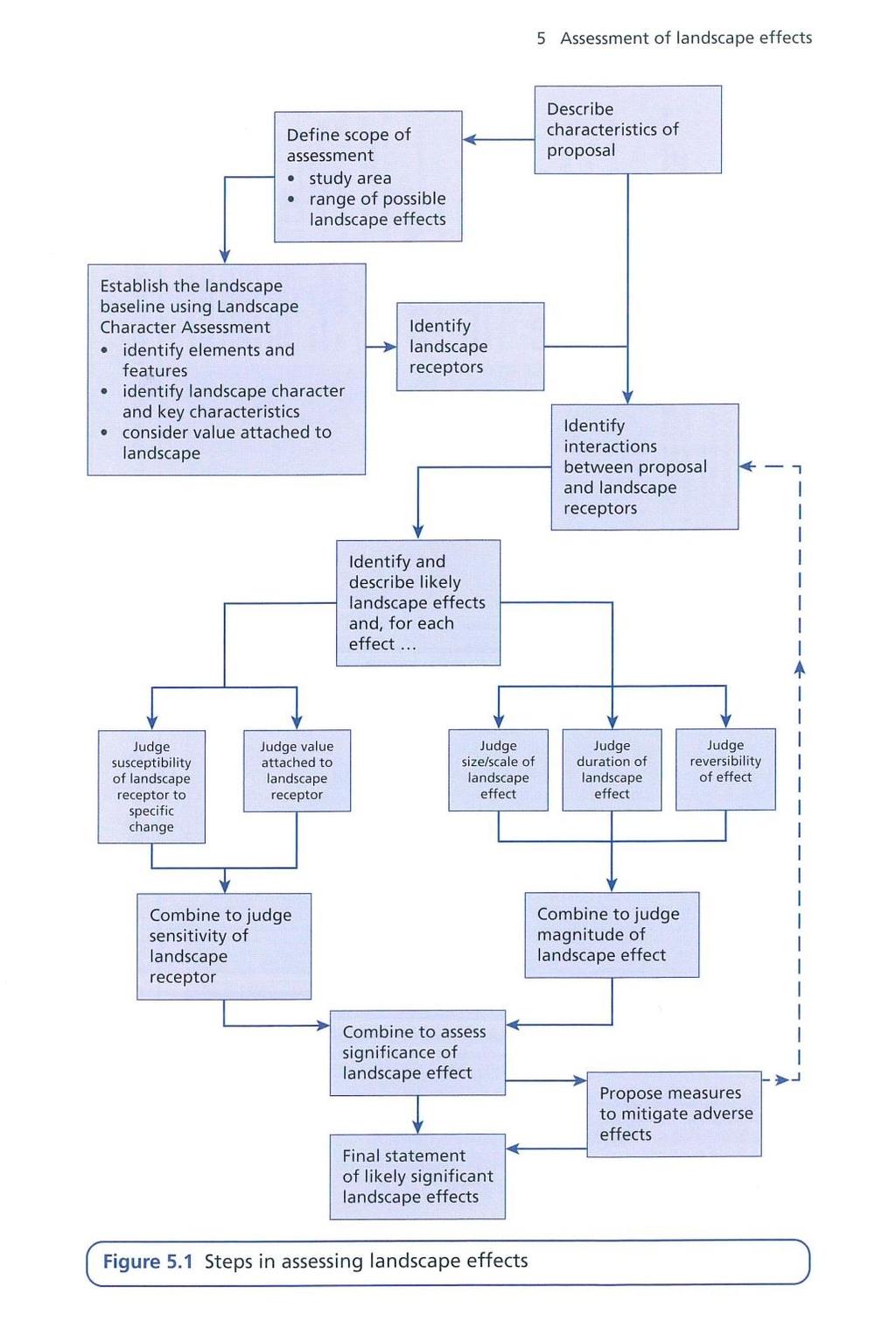
54 53
55 In overview GLVIA sets out the following steps for the landscape assessment: (i) Scope: Identify the Scope of the assessment (GLVIA P70): i.e. to identify the area of the landscape which needs to be covered in assessing landscape effects. This will be that appropriate to the scale of the proposals, this will include the National, and Regional landscape character assessment of land covering the site and that within the Zone of Theoretical Visibility (ZTV). In this case landscape effects are limited to the site itself and the surrounding area, defined here as the ZTV. This is normally assumed to be between 1500 and 2000m; a distance at which detail for a housing development becomes difficult to differentiate. (ii) Baseline Assessment for the assessment (GLVIA P70): The Baseline studies for assessing landscape effects should include the character of the landscape, the character of the elements and aesthetic and perceptual factors which contribute to it (GLVIA 5.3). The Baseline is to include a) Value: Identify the value of the site in terms of is International, National, Local Designations, or whether the land is undesignated local land. If the land is undesignated the following criteria and definitions are used to assess its Value. CRITERION Landscape Quality Scenic Quality Rarity Representativeness Conservation value Recreational Value Perceptual Aspects (Wilderness/ Tranquility) Cultural Associations DEFINITION A measure of the physical state of the land in terms of intactness of the landscape and the condition of typical elements Landscape which appeal primarily to the senses, especially visual The presence of rare elements or features in the landscape or the presence of a rare Landscape Character Type Whether the landscape contains a particular character and/or features or elements which are considered particularly important examples The presence of features, earth science or archaeological or historic and cultural interest which can add weight to the value of the land Evidence the at the land is valued for recreational activity Wilderness or tranquility There may be association with artists, writers, historical events which contribute to the sense of natural beauty 54
56 b) Landscape Character Type to be identified c) Landscape Elements and features within the site to be identified (Topography, Vegetation, Drainage and Visual Context; its aesthetic and perceptual qualities ), indicating the condition of individual features as appropriate (iii) Predicting and Describing Landscape Effects Step 1: In assessing landscape impact judgments are made regarding the following Landscape Receptors The effect on the overall landscape character identified as the Landscape Character Type The effect on elements and features within the site The effect Specific Aesthetic or Perceptual Aspects (Visual Context and Amenity) Step 2: To identify interactions between landscape receptors and the components of the development process through the stages of the development. In the case of a housing development these are judged to be Construction and Operation (or Completed Development), there is no Decommissioning or Restoration/ Reinstatement Assessment of Impact 1.4 In assessing the potential impact on the landscape receptors, a judgment is made regarding the Sensitivity of the landscape, and the of the impact. The Sensitivity is made up of: (i) the land s susceptibility to change defined as The ability of the landscape receptor to accommodate the proposal without undue consequences for the maintenance of the baseline conditions, (GLVIA 5.40) and (ii) The Value of the landscape receptor (see above) (GLVIA 5.44). The of the landscape effects comprises its: (i) The Size or scale (loss or gain in landscape features or elements), (ii) The Geographical Extent of the area influenced i.e. the impact at site level within the immediate setting and the impact at the scale of the Landscape Type or Character Area. (iii) Its Duration and Reversibility. The duration of impact is assessed over the short (0-5 yrs.), medium (5-10 yrs.) and long term (10-25 yrs.). Given the duration of impact, smaller developments will be built out in a short term, within 5 years; larger sites may take longer 5-10 yeas) In considering reversibility, residential development is deemed to be permanent, it is also the case that as landscape proposals develop and mature, the landscape impact is mitigated and the retained 55
. As stated in GLVIA 5.")
57 landscape enhanced. In recognizing this progressive enhancement, the assessment of magnitude in this regard acknowledges the benefit of the mature landscape. 1.5 Assessment of the Significance of Impact Significance is seen as the combination of Sensitivity and (GLVIA P99). As stated in GLVIA 5.56 There are no hard and fast rules about what makes a significant effect, and there cannot be a standard approach since circumstances vary with the location and the type of proposal In practice significance is seen as somewhere in a continuum between: Major loss or irreversible negative effects over an extensive area, on elements and /or aesthetic and perceptual aspects, key to the character of nationally valued landscapes. And Reversible negative effects of short duration, over a restricted area, on elements and/or aesthetic and perceptual aspects that contribute but are not key characteristics of the character of landscapes of community value which are judged to be not significant. As noted in GLVIA, Par 3.27, In assessing the identified effects against these criteria, two key principles should normally be applied ; Numerical scoring, which is not recommended, and Word Scales. These can be expressed on a progressive scale of High/ Medium/ Low or Negligible/Not significant (N/S) as appropriate to the criteria. In this study the Word Scale is utilized for each criteria and an informed judgment made about the significance of effect based upon a progressive scale of More significant to Less significant. This scale is expressed in GLVIA Fig 5.10 (P92) a copy of which is provided below. 56

58 1.5 Assessment of Visual Impact As noted in GLVIA An assessment of visual effects deals with the effects of change and development on the views available to people and their visual amenity (GLVIA 6.1 Pg. 98) Steps in assessing visual effects are below. 57
University Park, Worcester Non Technical Summary December 2011
 University Park, Worcester Non Technical Summary December 2011 Introduction UW Wrenbridge LLP, a Joint Venture Company of the University of Worcester and Wrenbridge Land Ltd (the Applicants ) intend to
7. The Landscape. 7.1 Introduction. Environmental Impact Statement (EIS) Scoping Report
 Scoping Report") 7. The Landscape 7.1 Introduction The purpose of this section of the EIS Scoping Report is to describe the scope of work and methods to be applied in the identification and assessment of landscape and
7. The Landscape 7.1 Introduction The purpose of this section of the EIS Scoping Report is to describe the scope of work and methods to be applied in the identification and assessment of landscape and
Definition of Cumulative Landscape and Visual Effects
 SECTION 5: GUIDANCE FOR ASSESSING CUMULATIVE LANDSCAPE AND VISUAL EFFECTS 5.1 Although this landscape sensitivity and capacity study has identified that parts of the National Park may be able to accommodate
Tables of Criteria and Matrices for Landscape Assessment (LSCA & LVIA)
") Carly Tinkler CMLI Environmental, Landscape and Colour Consultancy 46 Jamaica Road, Malvern, Worcestershire WR14 1TU Tel +44 (0)7711 538854 carlytinkler@hotmail.co.uk Tables of Criteria and Matrices for
Carly Tinkler CMLI Environmental, Landscape and Colour Consultancy 46 Jamaica Road, Malvern, Worcestershire WR14 1TU Tel +44 (0)7711 538854 carlytinkler@hotmail.co.uk Tables of Criteria and Matrices for
3. Highway Landscaping Assessment
 Guidelines for Highway Landscaping 3-1 3. Highway Landscaping Assessment 3.1 Introduction This section outlines the steps necessary to assess the highway landscaping component of a state highway construction
Carterton Construction Ltd is bringing forward plans for up to 85 new family homes and extra care facilities on land east of Burford.
 Welcome Carterton Construction Ltd is bringing forward plans for up to 85 new family homes and extra care facilities on land east of. We are at the early stages of designing our proposals and have a number
8.0 Design and Form of Development 43/
 42/ 8.0 Design and Form of Development 43/ Rothwells Farm, Golborne/ Development Statement Figure 7. Site Constraints Key 44/ Site Boundary 360 Bus Route/Stops Existing Trees Underground Water Pipe Sensitive
Project Title: Deephams Sewage Works Upgrade. Figure Title: Viewpoint 8. For Information Only. Figure 13.4
 Project Title: Deephams Sewage Works Upgrade Figure Title: Viewpoint 8 For Information Only Figure 13.4 June 2014 13.9 Visual Impact Assessment 13.9.1 Likely visual effects are assessed for significance
Replacement Golf Course Facilities and Residential Development, Churston. Environmental Statement Non-Technical Summary
 Replacement Golf Course Facilities and Residential Development, Churston Environmental Statement Non-Technical Summary July 2011 Reproduced from the Ordnance Survey s map with the permission of the Controller
Cotswolds AONB Landscape Strategy and Guidelines. June 2016
 Cotswolds AONB Landscape Strategy and Guidelines June 2016 Cotswolds AONB Landscape Strategy and Guidelines Introduction The evolution of the landscape of the Cotswolds AONB is a result of the interaction
Welcome to our Public Consultation
 About our development This exhibition gives you the chance to view and comment on our emerging plans for a proposed residential development located on land to the West of Alwyn Road, Rugby. Welcome to
APPENDIX 7.1: LANDSCAPE AND VISUAL IMPACT ASSESSMENT METHODOLOGY
 APPENDIX 7.1: LANDSCAPE AND VISUAL IMPACT ASSESSMENT METHODOLOGY 1.0 Introduction 1.1 Landscape and Visual Impact Assessment (LVIA) is a tool used to systematically identify and assess the nature and significance
Genex Kidston Connection Project: Draf t Environmental Assessment Report Powerlink Queensland
 : Draf t Environmental Assessment Report Powerlink Queensland Chapter 14 \\autsv1fp001\projects\605x\60577456\6. Draft Docs\6.1 Reports\4. Compiled draft 17 September\Covers\Chapters\Ch 14.docx Rev ision
Toddington Central Bedfordshire Stage 3 Green Belt Study December 2017
 Toddington Central Bedfordshire Stage 3 Green Belt Study December 2017 Site: ALP086 - Middle Lakes, Toddington Site size (ha): 2.83 Site: ALP086 - Middle Lakes, Toddington Site size (ha): 2.83 Site description
LANDSCAPE AND VISUAL ASSESSMENT
 Hertfordshire County Council LAND AT BALDOCK SITE 3 LANDSCAPE AND VISUAL ASSESSMENT JULY 2008 Jon Etchells Consulting Barn A, Dixies High Street Ashwell Herts SG7 5NT 01462 744662 HERTFORDSHIRE COUNTY
WELCOME GYPSY LANE. Wider Site Location plan. Proposals for the development of LAND OFF FOXLYDIATE LANE WEBHEATH. Proposals for the development of
 WELCOME The developers are preparing an outline planning application for a residential led development and need the community s views in order to develop the proposals further WHAT IS PROPOSED? A high
South Whitehaven, Cumbria EIA
 South Whitehaven, Cumbria EIA Environmental Statement - Non Technical Summary June 2013 in association with 1. Introduction Story Homes is applying to Copeland Borough Council (CBC) for a new residential
LANDSCAPE AND VISUAL IMPACT ASSESSMENT
 HARE STREET ROAD BUNTINGFORD LANDSCAPE AND VISUAL IMPACT ASSESSMENT Prepared by ACD Chartered Landscape Architects for Written By: SJD Checked By: JS Date: Document File Ref: TWNT18550lvia Revision: A-
VOLUME 2 APPENDIX 3.2. Scoping Opinion from Brecon Beacons National Park Authority
 C A N T R E F A D V E N T U R E F A R M L U G E E N V I R O N M E N T A L S T A T E M E N T VOLUME 2 APPENDIX 3.2 Scoping Opinion from Brecon Beacons National Park Authority Mr Wynne Davies Cantref Adventure
Neighbourhood Plan Representation
 Date: 10 th November 2017 Neighbourhood Plan Representation Land to the east of Callow Hill Road, Alvechurch Introduction This representation has been prepared by RPS Planning and Development on behalf
Grantham Southern Quadrant Link Road Environmental Statement
 Grantham Southern Quadrant Link Road Environmental Statement Non Technical Summary Introduction Lincolnshire County Council (LCC) is submitting a planning application for the proposed implementation of
Neighbourhood Planning Local Green Spaces
 Neighbourhood Planning Local Green Spaces Introduction... 2 1. Why green space is important... 4 2. Neighbourhood plans and green space... 6 3. Evidence... 8 Statutory designations... 9 Green space audit...
Garden Bridge Planning Application
 Planning Application Additional Verified photomontages and assessment September 2014 Contents Page 1 Visual assessment 2 1.1 Introduction 2 1.2 Baseline 2 1.3 Potential effects and good environmental
Land East of Cromwell Lane
 Land East of Cromwell Lane VISION DOCUMENT AUGUST 2016 The proposals for Land East of Cromwell Lane will be defined by existing landscape features, ensuring that the development offers a quality place
Public Consultation. Land at Monks Farm, North Grove. Welcome
 Welcome Welcome to our public exhibition for development on Land at Monks Farm, orth Grove. Gallagher Estates and Gleeson Strategic Land are preparing an outline planning application for new homes, open
9 Archaeology & Cultural Heritage
 High Clachaig Wind Farm Scoping Report Page 56 9 Archaeology & Cultural Heritage 9.1 Introduction Cultural heritage in this context means the above- and below-ground archaeological resources, built heritage,
Request for a Scoping Opinion by Provectus. Proposed Surface Mining of Coal on Land west off the A61, Hill Top Farm, Clay Cross, Derbyshire
 Request for a Scoping Opinion by Provectus Proposed Surface Mining of Coal on Land west off the A61, Hill Top Farm, Clay Cross, Derbyshire January 2012 Contents 1 Introduction & Background... 1 2 Site
LAND AT WEST YELLAND. Environmental Statement Non-Technical Summary Welbeck Strategic Land LLP
 LAND AT WEST YELLAND Environmental Statement Non-Technical Summary Welbeck Strategic Land LLP May 2014 Quality Management Issue/revision Issue 1 Revision 1 Revision 2 Revision 3 Remarks Draft FINAL Date
NON-TECHNICAL SUMMARY
 Proposed Sand and Gravel Extraction and Associated Processing Operations with Restoration to a Mixture of Agriculture and Nature Conservation including Areas of Shallow Water at Hedgeley, Northumberland
LANDSCAPE CHARACTER ASSESSMENT
 THE COUNTY DURHAM LANDSCAPE CHARACTER ASSESSMENT FOREWORD The landscape of County Durham is one of great contrast and diversity. From the North Pennines in the west to the Durham Coast in the east it contains
Oxford Green Belt Study. Summary of Final Report Prepared by LUC October 2015
 Oxford Green Belt Study Summary of Final Report Prepared by LUC October 2015 Project Title: Oxford Green Belt Study Client: Oxfordshire County Council Version Date Version Details Prepared by Checked by
Longbridge Town Centre Phase 2 Planning Application
 Longbridge Town Centre Phase 2 Planning Application Non-Technical Summary of the Environmental Statement December 2013 Introduction A full application for Planning Permission has been submitted to Birmingham
INTRODUCTION. Land south of Bishopswood Lane, Tadley
 0 INTRODUCTION THE SITE Introduction Gladman Developments Ltd. has successfully invested in communities throughout the UK over the past 0 years, developing high quality and sustainable residential, commercial
Land at Rampton Road. Cottenham
 Land at Rampton Road Cottenham Introduction TEP is preparing an outline planning application for 54 dwellings on 6.9 hectares of land adjacent to Rampton Road, Cottenham on behalf of the owners Cambridgeshire
HeritageCollectiveLLP
 Appendix C, Review of Archaeology and Cultural Heritage Assessment Introduction 1. This information (SEI) addresses the likely significant impacts of a six-turbine development in which T6 is removed from
BREEDON NORTHERN LIMITED
 Non Technical Summary CONTENTS 1 INTRODUCTION... 1 2 SITE DESCRIPTION... 1 3 DESCRIPTION OF THE DEVELOPMENT... 6 4 NEED FOR THE DEVELOPMENT... 8 5 KEY ISSUES CONSIDERED IN THE ENVIRONMENTAL IMPACT ASSESSMENT...
Lower Sensitivity. VS Classification Level 2: Hills, Lower Plateau & Scarp Slopes (74%)/ Lowland Valleys (17%) / Exposed Upland/Plateau (7%)
/ Lowland Valleys (17%) / Exposed Upland/Plateau (7%)") S06 Coedwig Gwydyr Reproduced from the Ordnance Survey map with the permission of Ordnance Survey on behalf of the Controller of Her Majesty s Stationery Office, Crown copyright Licence No. 100023387 Location
S06 Coedwig Gwydyr Reproduced from the Ordnance Survey map with the permission of Ordnance Survey on behalf of the Controller of Her Majesty s Stationery Office, Crown copyright Licence No. 100023387 Location
Everton s Neighbourhood Plan. Site Allocation - Assessment Criteria
 Everton s Neighbourhood Plan Site llocation - ssessment Criteria Introduction 1.1 This report assesses all the sites identified through the emerging Neighbourhood Plan for Everton and their potential for
Rochford District Council Allocations Development Plan Document: Discussion and Consultation Document Sustainability Appraisal
 Option SWH1 Balanced Communities Option SWH1 1 To ensure the delivery of high quality sustainable communities where people want to live and work Will it ensure the phasing of infrastructure, including
Viewpoint 1. Location: View from Murch Road on the north eastern boundary of Application Site. Viewing south / southwest.
 Application Site (eastern field) Former site of St. Cyres Lower School Murch Road 1 Location: View from Murch Road on the north eastern boundary of Application Site. Viewing south / southwest. Baseline
LANDSCAPE AND VISUAL ASSESSMENT
 Hertfordshire County Council LAND AT BALDOCK SITE 2 LANDSCAPE AND VISUAL ASSESSMENT JULY 2008 Jon Etchells Consulting Barn A, Dixies High Street Ashwell Herts SG7 5NT 01462 744662 HERTFORDSHIRE COUNTY
Land at BROOK STREET PROPERTIES TENCREEK FARM, LISKEARD. Environmental Statement: Non-Technical Summary
 BROOK STREET PROPERTIES TENCREEK FARM, LISKEARD Land at Environmental Statement: Non-Technical Summary Introduction Brook Street Properties is applying to Cornwall Council for outline planning permission
5.0 Landscape and Visual Impact
 5.0 Landscape and Visual Impact 5.1 Introduction 5.1.1 WYG is instructed by Biffa Waste Management Ltd (Biffa) to prepare this Landscape and Visual Impact Assessment (LVIA) which relates to proposed small-scale
LEEDS SITE ALLOCATIONS PLAN MATTER 3 GREEN BELT KCS DEVELOPMENT AUGUST 2017
 LEEDS SITE ALLOCATIONS PLAN MATTER 3 GREEN BELT KCS DEVELOPMENT AUGUST 2017 Smith Limited Suite 9C Joseph s Well Hanover Walk Leeds LS3 1AB T: 0113 2431919 F: 0113 2422198 E: planning@peacockandsmith.co.uk
E16: MAINTENANCE OF LANDSCAPED AREAS
 HIGH SPEED TWO INFORMATION PAPER E16: MAINTENANCE OF LANDSCAPED AREAS This paper outlines the proposed approach to the maintenance of landscaped areas created for HS2 Phase One. It will be of particular
Application and Proposals. Part 211
 Application and Proposals Part 211 Site Location and Context The application site comprises two distinct land parcels totalling some 135 hectares. The site is bisected eastwest by Churchlands Development.
Summary Note on Landscape and Visual Impact and Mitigation
 East Anglia TWO Offshore Windfarm Appendix 4.4 Summary Note on Landscape and Visual Impact and Mitigation Preliminary Environmental Information Volume 3 Document Reference EA2-DEVWF-ENV-REP-IBR- 000799_004
CHAPTER 13 LANDSCAPE AND VISUAL
 CHAPTER 13 LANDSCAPE AND VISUAL 13.1 Introduction and Key Issues 13.1.1 This chapter describes the likely landscape and visual effects arising from the construction and operation of the Upgrade. Assessment
Chapter 11 Landscape and Visual Effects
 Chapter 11 Landscape and Visual Effects CONTENTS 11. Landscape and Visual... 3 11.1 Introduction... 3 11.2 Changes since the 2014 PEIR... 3 11.3 Legislation, policy and guidance... 4 11.4 Methodology...
Warwickshire County Council. Upper and Lower Brailes. Landscape Study
 Warwickshire County Council Upper and Lower Brailes Landscape Study Produced by WCC Landscape Architects March 2016 Landscape Assessment of Potential Development Sites within the parish of Brailes 1.0
SITE ASSESSMENT FORM
 Appendix 2 SITE ASSESSMENT FORM 1. Site information Settlement: Colwall Main Village Site name: SITE 1 Part of vacated Colwall school site and adjacent area Site address: Walwyn Road Site area (hectares):
LandscapeCollective. Dorothy House, Winsley. Landscape and Visual Appraisal. On behalf of Dorothy House Hospice Care.
 Project Ref: LC/00043 Project Number: 00043A Authored by: Stuart Hocking Reviewed by: Stephen Wadsworth Date: August 2016 Document version P:\Landscape Collective\Admin\Templates\LC Report Template Jan
LANDSCAPE CHARACTER AND VISUAL CAPACITY STUDY
 LANDSCAPE CHARACTER AND VISUAL CAPACITY STUDY PROPOSED RESIDENTIAL ALLOCATION BARHAM COURT FARM BARHAM, KENT REF. NO. 3046_ RP_001 STATUS: INFORMATION REVISIONS DOCUMENT CREATED: 10/04/32014 REVISION A
3. Neighbourhood Plans and Strategic Environmental Assessment
 1. Introduction This report sets out a draft Screening Determination for the Preston Parish Council s Neighbourhood Plan and has been prepared by rth Hertfordshire District Council. The purpose of the
Section 6A 6A Purpose of the Natural Features and Landscapes Provisions
 Section 6A 6A Purpose of the Natural Features and Landscapes Provisions This Chapter addresses the protection and management of natural features and landscapes within the City. The City has a number of
Guidance for Wind Turbine Development in the Dorset AONB
 Photo 1: Rew Manor Farm, West Dorset, chalk downland landscape (Planning application ref: 1/D/09/001280 1 ) Scale & siting: 12m to hub / 16m to blade tip. A well sited small scale turbine, grouped with
2014/0590 Reg Date 26/06/2014 Chobham
 2014/0590 Reg Date 26/06/2014 Chobham LOCATION: PROPOSAL: TYPE: APPLICANT: OFFICER: ASCOT PARK POLO CLUB, WESTCROFT PARK FARM, WINDLESHAM ROAD, CHOBHAM, WOKING, GU24 8SN Erection of a two storey detached
Wind energy development in the South Pennines landscape
 Wind energy development in the South Pennines landscape Programme for today Background Policy context South Pennines landscape Impacts of wind energy development The South Pennines Wind Energy Landscape
CHAPTER 18 - Strategy Area: Dundry and River Valleys
 This south-eastern part of the Community Forest is a complex area with a wide variety of different landscapes close together, including the Chew Valley, the southern part of the Avon Valley and the eastern
DUNSFOLD NEIGHBOURHOOD PLAN Site Selection Policies
 DUNSFOLD NEIGHBOURHOOD PLAN Site Selection Policies The criteria for assessing sites for future housing and business development in Dunsfold are set out below. (Development criteria, covering what it is
LAND AT HOWES LANE, BICESTER ENVIRONMENTAL STATEMENT NON-TECHNICAL SUMMARY. March 2017 Our Ref: Q70433
 LAND AT HOWES LANE, BICESTER ENVIRONMENTAL STATEMENT NON-TECHNICAL SUMMARY March 2017 Our Ref: Q70433 Contents 1 INTRODUCTION AND SITE DESCRIPTION... 1 2 EIA METHODOLOGY... 5 3 ALTERNATIVES... 6 4 DESCRIPTION
Cardiff International Sports Village Waterfront Development Volume IV : Non-Technical Summary of the Environmental Statement
 Greenbank Partnerships Ltd October 2012 Cardiff International Sports Village Waterfront Development Volume IV : Non-Technical Summary of the Environmental Statement Environmental Statement - Non Technical
CALA Homes is preparing a planning application for a development of up to 36 new homes, including a mix of properties to meet local demand.
 WELCOME Welcome to this public consultation event for our proposed development on land to the south of Twelve Leys in Wingrave. Thank you for taking the time to come along today. Homes is preparing a planning
Welcome to our exhibition
 Welcome to our exhibition The Homes & Communities Agency (HCA) welcomes you to this public exhibition explaining our proposals for the redevelopment of the former Lea Castle Hospital site. About the Homes
VALLEY PARK, DIDCOT. Non-Technical Summary. December On behalf of Taylor Wimpey UK Limited, Persimmon Homes and Hallam Land Management Ltd.
 VALLEY PARK, DIDCOT Non-Technical Summary December 2014 On behalf of Taylor Wimpey UK Limited, Persimmon Homes and Hallam Land Management Ltd. CONTENTS 1 Introduction... 2 2 The Proposed Development...
Settlement Boundaries Methodology North Northumberland Coast Neighbourhood Plan (August 2016)
") Introduction This background paper sets out a methodology for the definition of settlement boundaries in the North Northumberland Coast Neighbourhood Plan. The neighbourhood plan is planning positively
Introduction This background paper sets out a methodology for the definition of settlement boundaries in the North Northumberland Coast Neighbourhood Plan. The neighbourhood plan is planning positively
WELCOME. Olney Road, Lavendon INTRODUCTION. The Site. The Application. The Need for Housing. A Sustainable Location LAVENDON TURVEY OLNEY ROAD
 0 WELCOME INTRODUCTION Gladman Developments Ltd have successfully invested in communities throughout the UK over the past 0 years, developing high quality and sustainable residential, commercial and industrial
LONGDEN VILLAGE DEVELOPMENT STATEMENT
 LONGDEN VILLAGE DEVELOPMENT STATEMENT 2017-2027 1 Longden Development Statement 2017-2027 15/01/18 1. Background 1.1 Longden Village Longden village is a very rural and traditional community first mentioned
3.1 This evidence is based on the landscape and visual impact assessment included in Chapter 10 and Appendix I of the EIS.
 LANDSCAPE & VISUAL 1 QUALIFICATIONS AND EXPERIENCE 1.1 My name is Raymond Holbeach and I am a Regional Director for RPS Planning & Environment with full responsibility for management of the RPS Belfast
Guidance for Wind Turbine Development in the Dorset Area of Outstanding Natural Beauty
 DRAFT January 2012 Guidance for Wind Turbine Development in the Dorset Area of Outstanding Natural Beauty Photo 1: Rew Manor Farm, West Dorset, chalk downland landscape (Planning application ref: 1/D/09/001280
Lower Sensitivity. VS Classification Level 2: Exposed Upland/Plateau
 S02 Y Carneddau Reproduced from the Ordnance Survey map with the permission of Ordnance Survey on behalf of the Controller of Her Majesty s Stationery Office, Crown copyright Licence No. 100023387 Location
Newcourt Masterplan. November Exeter Local Development Framework
 Newcourt Masterplan November 2010 Exeter Local Development Framework Background The Exeter Core Strategy Proposed Submission sets out the vision, objectives and strategy for the development of Exeter up
DEVELOPMENT MANAGEMENT REPORT
 ITEM A08-1 DEVELOPMENT MANAGEMENT REPORT TO: BY: DATE: DEVELOPMENT: SITE: WARD: APPLICATION: APPLICANT: Development Management Committee Development Manager Proposed live/work unit in connection with existing
WELCOME. Land North of STEVENAGE. We would like to thank you for attending our public exhibition today.
 WELCOME We would like to thank you for attending our public exhibition today. The purpose of this event is to share our proposals and hear your thoughts on our ideas. Members of the project team are on
Cranbrook EXPANSION ENVIRONMENTAL STATEMENT: NON-TECHNICAL SUMMARY PRODUCED BY DAVID LOCK ASSOCIATES
 Cranbrook EXPANSION ENVIRONMENTAL STATEMENT: NON-TECHNICAL SUMMARY PRODUCED BY DECEMBER 2014 CRANBROOK EXPANSION AREAS ENVIRONMENTAL STATEMENT NON TECHNICAL SUMMARY Submitted in support of Outline Planning
ABBEY MANOR GROUP/SAINSBURY S SUPERMARKETS LTD
 ABBEY MANOR GROUP/SAINSBURY S SUPERMARKETS LTD Mixed Use Development including Business Park and Foodstore Land at Bunford Park, Bunford Lane, Yeovil Environmental Statement: Non-Technical Report June
Landscape Character and Capacity Study
 Landscape Character and Capacity Study Doncaster Metropolitan Borough Council Further Investigations - Employment and Housing Sites June 2010 Golder Associates (UK) Ltd Golder House Tadcaster Enterprise
Welcome to our exhibition
 Welcome to our exhibition housing development A46 Wildmoor Alcester Road Canal Quarter A422 Town Centre housing development Warwickshire-based IM Properties, one of the UK s largest privately owned property
Statement of Community Involvement LAND OFF SOUTHDOWN ROAD HORNDEAN, HAMPSHIRE
 LAND OFF SOUTHDOWN ROAD HORNDEAN, HAMPSHIRE CONTENTS Page 1. Introduction 3 2. Pre-application Discussions 4 3. The Consultation Process 5 4. Consultation Feedback 7 5. Responses to Consultation Feedback
NON-TECHNICAL SUMMARY
 Hybrid outline/detailed planning application comprising an outline planning application for 196 residential dwellings, landscaping, open space, estate roads and infrastructure, plus 4 permanent gypsy and
Longhorsley Neighbourhood Plan
 Site Assessment 1. The availability of the site 1.1 Is the land owner willing for their site to be made available for development? 1.2 If yes, do you have any written evidence to back this up? Planning
Schedule of Planning Applications Committee Date: 23 May Reference: 06/17/0726/F Parish: Hemsby Officer: Mr J Beck Expiry Date:
 Schedule of Planning Applications Committee Date: 23 May 2018 Reference: 06/17/0726/F Parish: Hemsby Officer: Mr J Beck Expiry Date: 22-05-2018 Applicant: Proposal: Site: Mr Gillett Change of use to the
16 LANDSCAPE AND VISUAL IMPACT
 16 LANDSCAPE AND VISUAL IMPACT 16.1 Introduction The term landscape refers primarily to the visual appearance of an area, including its shape, form and colour and the interaction of these elements to create
Sustainability Statement. Whitby Business Park Area Action Plan
 Sustainability Statement Whitby Business Park Area Action Plan November 2014 Contents Page 1. Introduction 1 2. Scoping 3 3. Sustainability Appraisal of Options 6 4. Assessment of Draft Area Action Plan
A payment of 1080 is due in this instance, for a meeting and follow up written response, and will be made by card over the phone.
 JPPC ref: AG/6002 18 th September 2014 Planning Services Vale of White Horse District Council Benson Lane Crowmarsh Gifford Wallingford OX10 8ED Dear Sir/Madam REQUEST FOR PRE-APPLICATION ADVICE RE: RESIDENTIAL
M7 Naas to Newbridge Bypass Upgrade Scheme. Landscape and Visual Impact Assessment Brief of Evidence
 M7 Naas to Newbridge Bypass Upgrade Scheme Landscape and Visual Impact Assessment Brief of Evidence Presented by Richard Butler, Cunnane Stratton Reynolds Landscape Architect: BL Arch (University of Pretoria,
Bloor Homes Stubbocks Walk North Hertfordshire ENVIRONMENTAL STATEMENT NON-TECHNICAL SUMMARY
 Bloor Homes Stubbocks Walk North Hertfordshire ENVIRONMENTAL STATEMENT NON-TECHNICAL SUMMARY December 2016 Environmental Statement: Non-Technical Summary Stubbocks Walk, North Hertfordshire J S Bloor
Former RAF Sealand Site EIA
 Praxis (Holdings) Ltd. Former RAF Sealand Site EIA Environmental Statement - Non Technical Summary February 2012 in association with P a g e 1 1. Introduction Praxis (Holdings) Ltd. is applying to Flintshire
Welcome. Site/11/04. Site/11/03. Proposed Site. 11,400 new homes needed in east Cambs
 Welcome Welcome to our consultation on our proposals for new homes on land north east of Soham Road, Fordham. Members of the project team are available to answer any questions you have and listen to feedback.
New Homes at Winton East
 View toward Winton East from Caerketton Hill Aerial photograph of South Edinburgh: Winton East Site Location Indicative proposal Welcome Thank you for coming to the Winton East public exhibition. We would
Introduction. Welcome to this consultation regarding the draft redevelopment proposals for the former CeramTec factory on Sidmouth Road, Colyton.
 Introduction Welcome to this consultation regarding the draft redevelopment proposals for the former CeramTec factory on Sidmouth Road, Colyton. We are currently considering options for the mixed-use redevelopment
Introduction. Grounds of Objection
 Planning application ref. number 18/04496/APP Planning application to Aylesbury Vale District Council for the erection of 17 dwellings and associated works to the South of Hogshaw Road Granborough. Granborough
EIA Scoping Opinion Land at West Kingsford (North of the A944 Road)
") EIA Scoping Opinion Land at West Kingsford (North of the A944 Road) Page EIA Scoping Report page 10 page 13 Section 4.2.3 Cumulative Impacts 5. Proposed Scope AWPR, Prime four and other development areas
EIA Scoping Opinion Land at West Kingsford (North of the A944 Road) Page EIA Scoping Report page 10 page 13 Section 4.2.3 Cumulative Impacts 5. Proposed Scope AWPR, Prime four and other development areas
ROCHFORD LOCAL DEVELOPMENT FRAMEWORK: Sustainability Appraisal/ Strategic Environmental Assessment. Rochford Core Strategy Preferred Options Document
 ROCHFORD LOCAL DEVELOPMENT FRAMEWORK: Sustainability Appraisal/ Strategic Environmental Assessment Non Technical Summary Rochford Core Strategy Preferred Options Document October 2008 SUSTAINABILITY APPRAISAL
Tāhuhu whakaruruhau ā-taone The sheltering ridge pole
 B2. Tāhuhu whakaruruhau ā-taone - Urban growth and form B2.1. Issues Tāhuhu whakaruruhau ā-taone The sheltering ridge pole Auckland s growing population increases demand for housing, employment, business,
Development in the setting of the Cotswolds AONB
 COTSWOLDS CONSERVATION BOARD POSITION STATEMENT Development in the setting of the Cotswolds AONB.1. Introduction Areas of Outstanding Natural Beauty (AONBs) are designated by the Government for the purpose
WALES ONLY INTERIM ADVICE NOTE 135/10 (W) LANDSCAPE AND VISUAL EFFECTS ASSESSMENT
 LANDSCAPE AND VISUAL EFFECTS ASSESSMENT") Interim Advice Note 135/10 (W) Landscape and Visual Effects Assessment INTERIM ADVICE NOTE 135/10 (W) LANDSCAPE AND VISUAL EFFECTS ASSESSMENT WALES ONLY Summary This Interim Advice Note provides instructions
Interim Advice Note 135/10 (W) Landscape and Visual Effects Assessment INTERIM ADVICE NOTE 135/10 (W) LANDSCAPE AND VISUAL EFFECTS ASSESSMENT WALES ONLY Summary This Interim Advice Note provides instructions
Test Valley Borough Council Southern Area Planning Committee 8 January 2019
 ITEM 11 APPLICATION NO. 18/02218/FULLS APPLICATION TYPE FULL APPLICATION - SOUTH REGISTERED 23.08.2018 APPLICANT Rugby Football Union SITE The Trojans Club, Stoneham Lane, Eastleigh, SO50 9HT, CHILWORTH
METHODOLOGY FOR IMPACT ASSESSMENT ON HERITAGE ASSETS IDENTIFICATION OF THE RECEPTOR ASSESSMENT OF THE RECEPTOR S IMPORTANCE
 METHODOLOGY FOR IMPACT ASSESSMENT ON HERITAGE ASSETS The determination of impacts on heritage assets follows the standard procedures applied to all Environmental Impact Assessment. This entails the identification
LANDMAP Methodology Overview
 LANDMAP Methodology Overview June 2017 Jill Bullen, Senior Landscape Specialist jill.bullen@cyfoethnaturiolcymru.gov.uk 0300 065 4706 (Please note this is an information document and not a training presentation)