Wessex Archaeology. Land West of Egley Road, Woking, Surrey. Archaeological Desk-based Assessment. Ref:
|
|
|
- Imogene Douglas
- 6 years ago
- Views:
Transcription


1 Wessex Archaeology Land West of Egley Road, Woking, Surrey Archaeological Ref: March 2007
2 LAND WEST OF EGLEY ROAD, WOKING, SURREY Archaeological Prepared for Lennon Planning Ltd 4 King Street Lane Winnersh Berkshire RG41 5AS On behalf of William Bocking by Wessex Archaeology Unit 113 The Chandlery 50 Westminster Bridge Road London SE1 7QY Report reference: March 2007 Wessex Archaeology Limited 2007 all rights reserved Wessex Archaeology Limited is a Registered Charity No
3 LAND WEST OF EGLEY ROAD, WOKING, SURREY Archaeological Summary Acknowledgements Contents 1 INTRODUCTION Project Background Landscape and Geology Historic Landscape Characterisation 1 2 METHODOLOGY Scope Research Legislative and Planning Background ARCHAEOLOGICAL AND HISTORICAL BACKGROUND EXISTING AND POTENTIAL ARCHAEOLOGICAL IMPACTS Potential Impacts Existing Impacts RESULTS Introduction Legislative and Planning Constraints Archaeology CONCLUSIONS AND RECOMMENDATIONS Summary of Archaeological Constraints Further Works and Mitigation REFERENCES APPENDIX 1- GAZETTEER OF SITES AND FINDSPOTS...21 i.01
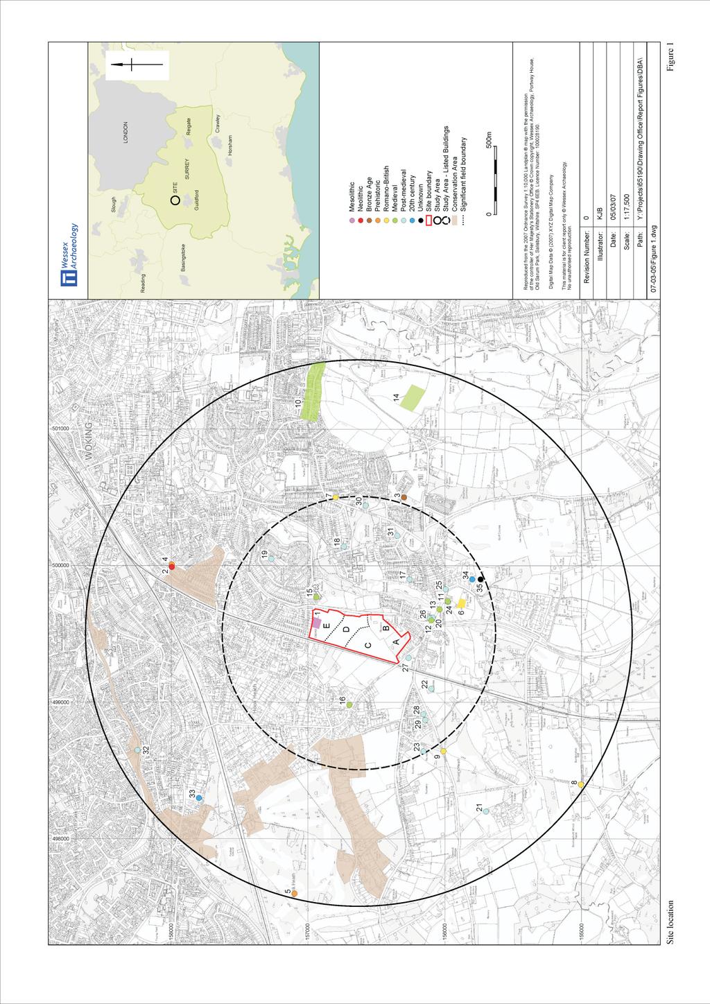
4 List of Figures Figure 1 Figure 2 Site outline showing Study Area and WA Nos. Map Regression. A. Rocque s Map, B. 1 Ordnance Survey Map, 1816 C. Tithe Map, 1840 D. First edition 25 Ordnance Survey Map, 1871 E. 6 Ordnance Survey Map, F. 6 Ordnance Survey Map, 1913 List of Plates Plate 1 Plate 2 Plate 3 Plate 4 Plate 5 Plate 6 Plate 7 Plate 8 View across Area C. Looking North. Hardstanding at North-east corner of Area D View across Area E. Looking East. View across nursery at Area B. Looking South-west Site of Mesolithic findspot (WA 1). Looking North-west. Bank defining line of historic track, field boundary between Area D and E. Looking North-west. Field boundary defining Areas C and D. Looking North-west. View along Egley Road showing remains of village green along verge. Looking South. ii.01
5 LAND WEST OF EGLEY ROAD, WOKING, SURREY Archaeological Summary Wessex Archaeology was commissioned by Lennon Planning Ltd on behalf of William Bocking to undertake an archaeological desk-based assessment of lands west of to support a site representation made to the Woking Local Development Framework. The Site, centred at Grid Reference (NGR) /156630, covers an approximate area of 17.7 hectares and lies under the jurisdiction of Woking Borough Council. At the time of writing, mixed use development of the Site is envisaged. A circular Study Area extending for 2km from the Site centre (1km for Listed Buildings) has been considered in order to provide an archaeological and historical context for interpretation. Human activity has been quantified across the Study Area from the early prehistoric period to the 20 th century with an emphasis on medieval agriculture and associated dispersed settlement. Romanised settlement is also notable to the south-east of the Site at Beech Close. Assessment of the Site suggests that there has been a low level of previous ground intrusion, largely comprising land management activity associated with farming and horticulture. Archaeology Overall, a low-moderate potential for the existence and survival of archaeological deposits within the Site footprint and the Study Area has been identified. Predicted archaeology at the Site is likely to be limited to evidence of Post-medieval land enclosure and use including evidence for horticultural exploitation. This assessment has highlighted one Area of High Archaeological Potential within the Site boundary, the area defines a single unassociated findspot of Mesolithic date. Mesolithic finds are rarely found in groups or in association with an archaeological context unless related to a prominent location such as a fording point or stone working site. No additional finds or features of comparative date or typology have been identified within the Study Area. The findspot may represent a single Artefact or a Mesolithic flint scatter. Without archaeological investigation within the Area of High Archaeological Potential, the potential of the site is unknown. Given the general archaeological potential and the Area of High Archaeological Potential, it is anticipated that limited archaeological works at the Site in the form of mitigation strategy are likely to be required by the Assistant County Archaeologist for Woking Borough Council This may include some level of field investigation of the Mesolithic findspot to the north of the Site. This judgement is made following assessment of criteria outlined in Policy BE16 of the Local Borough Plan concerning Areas of Archaeological Potential. Built heritage The closest Listed Building lies 80m south of the southern Site boundary and is not currently visible from the interior. In order to retain the visual integrity of the built iii.01
6 environment, a programme of strategic planting may be required at points around the periphery of the Site. Historic environment Two significant field boundaries have been identified within the Site boundary through cartographic and visual interpretation. These boundaries, visible on the 1840 Tithe Map and surviving today as substantial tree lined banks are considered to be important under criteria set out in the 1997 Hedgerows Regulations. Given the surviving nature and antiquity of identified field boundaries, partial or total retention of hedgerows with a view to their incorporation into future design proposals may be required. Any future archaeological work in the form of a mitigation strategy that may be required would be secured, on the advice of the Assistant County Archaeologist for Woking Borough Council. iv.01
7 LAND WEST OF EGLEY ROAD, WOKING, SURREY Archaeological Acknowledgements Lennon Planning Ltd. Wessex Archaeology was commissioned by Lennon Planning Ltd on behalf of William Bocking to undertake an archaeological desk-based assessment of land west of. Wessex Archaeology would like to thank Emily Brants, SMR Officer for Surrey County Council, Gary Jackson, Assistant Surrey County Archaeologist, the staff of the Surrey History Centre, Woking, Paul Bocking of Woking Nursery and Laura Cowie of Lennon Planning for their guidance and assistance in the compilation of this report. This report was researched and compiled by Katharine Barber and the illustrations were prepared by Kitty Brandon. The Site visit was undertaken by Katharine Barber. The project was managed for Wessex Archaeology by Lawrence Pontin. v
8 LAND WEST OF EGLEY ROAD, WOKING, SURREY Archaeological 1 INTRODUCTION 1.1 Project Background Wessex Archaeology was commissioned by Lennon Planning Ltd to undertake an archaeological desk-based assessment of land west of Egley Road, Woking, Surrey to support a site representation made to the Woking Local Development Framework (Figure 1; hereafter the Site). The Site lies under the jurisdiction of Woking Borough Council centred on National Grid Reference (NGR) / At the time of writing, mixed use development of the Site is envisaged. This is likely to necessitate ground intrusion across the Site comprising at a minimum, building foundations, surface, infrastructure and access road construction. The Site covers an area of approximately 17.7 hectares For ease of reference, the Site has been divided into 5 areas indicated as Areas A to E on Figure Landscape and Geology The Site is situated to the south of the modern town of Woking (south-west of Old Woking) to the immediate north-west of the village of Mayford. The site itself is currently occupied by enclosed pasture (uneven and waterlogged underfoot; Areas C,D and E; Plates 1-3), horticultural land (Area B; Plate 4) and a small area of unmanaged woodland (Area A). The Site is bound to the north and south by modern residential housing, to the east by the line of Egley Road and to the west by the London and South-Western Railway The Site is situated on pasture which rises to the west and north towards raised heathland. The eastern and southern parts of the Site (those being the lowest) are subject to waterlogging The geology of the Site comprises Bagshot Sand beds dating from the Eocene period. Alluvium defines the path of the River Wey which runs west of the Woking to Guildford Road (A320) (BGS Aldershot, Sheet rd edition). 1.3 Historic Landscape Characterisation The majority of the Site (Areas C, D and E) are characterised as medium rectangular fields with straight boundaries of Parliamentary enclosure type (Surrey Historic Landscape Characterisation report, Volume 2, 25). These enclosures date largely from the 18 th and 19 th centuries and were implemented as a consequence of private agreement or through an Act. 1
9 1.3.2 Areas A and B are defined by the Surrey Historic Land Characterisation Report as of horticultural use in reference to the 19 th and 20 th century nursery development of the area. This land type is usually characterised by areas of large rectangular glass houses (not noted historically at the Site), associated buildings and small paddocks and enclosures. They are often found in association with Parliamentary enclosures as is the case at Egley Road. 2.0 METHODOLOGY 2.1 Scope The aim of this assessment is to detail the known information relating to archaeology and the historic environment and to assess the potential for the presence of previously unknown elements that may be impacted by the proposed development The archaeological resource within a 2km circular Study Area (Figure 1) of the Site centre has been considered in order to provide a context for the discussion and interpretation of the known and potential resource. Listed Buildings and other aspects of cultural heritage within 1km of the Site centre have also been included in order to assess the visual impact of development upon the built environment A brief summary of the sources consulted is given below. 2.2 Research Various publicly accessible sources of primary and synthesised information were consulted. Surrey (SSMR) Sites and Monuments Record Surrey County Council maintains a record of all recorded archaeological sites, findspots and archaeological events within the county including Listed Buildings, and Scheduled Monuments. Sites, findspots and areas within the Study Area have been assigned a number prefixed with WA and are discussed in Section 3 below and illustrated on Figure 1. Full details of all records are presented in the gazetteer in Appendix SMR s are not a record of all surviving elements of the Historic Environment but a record of the discovery of a wide range of archaeological and historical components of the Historic Environment. The information held within them is not complete and does not preclude the subsequent discovery of further elements of the Historic Environment that are at present unknown. Legislative and Planning Documents The Woking Borough Local Plan (Woking Borough Council ) remains valid until the publication of the Local Development Framework due by the end of The plan was consulted to inform of any existing development controls relating to the historic environment. This document has been prepared in accordance with national guidelines including Planning Policy Guidance (PPG) Notes 15 and 16. 2
10 2.2.6 The results of a review of this legislation and where relevant details of any statutory designations such as Listed Buildings and Scheduled Monuments are included in Section 3 of this report. Documentary Sources A search of other relevant primary and secondary sources was carried out at The Surrey Sites and Monuments Record, at the Surrey History Centre, Woking, digitally and in Wessex Archaeology s own library. The sources consulted are listed in the References (Section 7). Cartographic Sources A search of historic manuscripts and Ordnance Survey maps was undertaken. The study of maps and other associated historical sources helps to clarify the archaeological potential of the Study Area in two ways. Firstly, it suggests aspects of the medieval and later land-use prior to its modern development. Secondly, it pinpoints areas within the Study Area which, as a result of that development, are likely to have become archaeologically sterile. The maps relevant to the Site are listed in the References section (Section 7). Aerial Photographs Under certain conditions sub-surface archaeological features can be visible on Aerial Photographs (AP's). Aerial photographic material concerning the Site was assessed at the Surrey History Centre and through images provided by the client. Site Visit The Site was visited on Wednesday 28 th February The aim of the visit was to assess the general aspect, character, condition and setting of the Site and to identify any potential impacts not evident from sources. A photographic record of the visit was made and is held in the project archive, selected images are included in the report (Plates 1-8). Best Practice Guidance This assessment has been carried out in accordance with the Institute of Field Archaeologists Standards and Guidance for Archaeological Desk-Based Assessment (IFA 1994 revised September 2001). Assumptions The SSMR data consists of secondary information derived from varied sources, only some of which have been directly examined for the purposes of this Study. The assumption is made that this data, as well as that derived from other secondary sources, is reasonably accurate. The SMR data concerning Listed Buildings has been cross referenced with information from English Heritage Listed Buildings Online. The information is available to registered users and is stated to be complete, but has not yet been fully assured. 3
11 2.3 Legislative and Planning Background Lennon Planning Ltd. National Legislation and Planning Guidance Archaeology The main legislation concerning the protection of important archaeological sites is the Ancient Monuments and Archaeological Areas Act 1979 (as amended). This act provides for nationally important archaeological sites to be statutorily protected as Scheduled Monuments (SM's). Under this act Scheduled Monument Consent (SMC) must be sought for any works which may affect a designated Scheduled Monument The principal national guidance on the importance, management and safeguarding of the archaeological resource within the planning process is Planning Policy Guidance Note 16: Archaeology and Planning (PPG 16) issued by the Department of the Environment in November The underlying principle of this guidance is that archaeological resources are nonrenewable, stating that: Where nationally important archaeological remains, whether scheduled or not, are affected by proposed development there should be a presumption in favour of their physical preservation. (Para. 8) Paragraph 19 states: In their own interests prospective developers should in all cases include as part of the research into the development of a site an initial assessment of whether the site is known or likely to contain archaeological remains Paragraph 22 adds: Local Planning Authorities can expect developers to provide the results of such assessments as part of their application for sites where there is good reason to believe there are remains of archaeological importance. In addition paragraph 25 advises: Where planning authorities decide that the physical preservation in situ of archaeological remains is not justified in the circumstance of the case it would be entirely reasonable for the planning authority to satisfy itself, before granting planning permission, that the developer has made appropriate and satisfactory provision for the excavating and recording of the remains. Such excavation and recording should be carried out before the development commences, working to a project brief prepared by the planning authority and taking advice from archaeological consultants. Conservation Areas and Listed Buildings Conservation Areas and Listed Buildings are given statutory protection through the Planning (Listed Buildings and Conservation Areas) Act This protection is achieved by the inclusion of suitable buildings within the lists of buildings of special architectural and historic interest (Listed Buildings) and the designation of Conservation Areas. 4
12 2.3.6 Sections 16 and 66 of the Act [(Planning (Listed Buildings and Conservation Areas) Act 1990)], require.authorities considering applications for planning permission or listed building consent for works which affect a listed building to have special regard to certain matters, including the desirability of preserving the setting of the building Guidance on the identification and protection of historic buildings, conservation areas, historic parks and gardens and other elements of the historic environment is provided by Planning Policy Guidance Note 15: Planning and the Historic Environment (PPG 15) issued by the Department of the Environment in September Historic parks and gardens are a fragile and finite resource: they can easily be damaged beyond repair or lost forever. In order to recognise the existence of those sites which are of particular historic importance, English Heritage is enabled by Section 8C of the Historic Buildings and Ancient Monuments Act 1953 (inserted by section 33 of, and paragraph 10 of Section 4, to the National Heritage Act 1983) to compile the Register of Parks and Gardens of special historic interest in England Although inclusion on the register does not offer statutory protection PPG15 states that local planning authorities should ensure the protection of registered parks and gardens when preparing development plans and in determining planning applications: The effect of proposed development on a registered park or garden or its setting is a material consideration in the determination of a planning application (PPG15 paragraph 2.24). County Planning Guidance Surrey County Council (SCC) has statutory development control responsibilities as Local Planning Authorities (LPA s). The LPA s have adopted planning policies and management plans informed by statutory advice from the national guidelines outlined above (PPG15 and PPG16). These plans seek a balance between necessary development and the protection of the historic environment. Sections of these Plans relevant to the Site are summarised below. Surrey Structure Plan The Surrey Structure Plan was adopted by Surrey County Council in 2004 and includes policies relevant to the treatment of the historic environment within the planning and development control process. Policy SE5 Protecting the Heritage states: Surrey s valuable cultural heritage of buildings, sites and landscapes will be conserved and enhanced. Heritage resources are irreplaceable and development affecting them will only be permitted where it has been clearly demonstrated that there is an overriding need for the proposal which outweighs the need to protect the heritage interest, and that no alternative is possible Prior archaeological assessment, and if necessary evaluation, will be required on all development of sites over 0.4 hectares or within areas of high 5
13 archaeological potential. Where important archaeological remains are found, there will be a preference for their preservation in situ. A record will be required of any features discovered, removed or altered. Local Planning Guidance The Woking Borough Local Plan ( , in use until publication of Local Development Framework in 2007) sets out detailed policies and specifications for development and land use. Under the current Woking Core Strategy Submission Document (October 2006), the Site is designated as Green Belt (Policy GB1). Policies outlined in the Local Plan are rehearsed comprehensively below. Policy BE12 concerns the Setting of Listed Buildings Development will not be permitted which would adversely affect the setting of a listed building by reason of its design, form, height, proximity to the building or impact on significant views of the building The council is required to have special regard to the desirability of preserving the setting of listed buildings. The setting of a listed building is often an essential part of its character, especially if a garden or grounds have been laid out to complement its design or function. The setting may also extend beyond the obviously ancillary land to adjacent buildings or open spaces and further afield to proposed buildings some distance away which impact upon views. In some cases, setting can only be defined by an historical assessment of the building's surroundings. Policy BE15 concerns Scheduled Ancient Monuments Development will not be permitted which would adversely affect a scheduled ancient monument and/or its setting. Ancient monuments are shown on the proposals map. Opportunities will be taken to conserve ancient monuments and enhance their settings These monuments are of national importance. Although the Secretary of State's consent is required before any work affecting them is undertaken, the Council will assist in protecting them and, where appropriate, enhance their settings. On appropriate sites the Council will, in consultation with English Heritage, encourage the management and interpretation of ancient monuments to develop their educational, recreational and wildlife importance. Policy BE16 concerns Areas of Archaeological Potential Development will not be permitted in areas of high archaeological potential (of which there are four within the Study Area, one of which lies within the Site boundary), unless the following criteria are complied with: (i) A developer will be required to commission an archaeological assessment and where necessary evaluation of the site so that sufficient information is available for the determination of the planning application. 6
14 (ii) Lennon Planning Ltd. Priority will be given to the preservation of remains in situ. Where the council is satisfied that this is not justified a developer will be required to make suitable arrangements for a full archaeological investigation of the site and record of the remains prior to development On all development sites of over 0.4 hectares (1 acre) an archaeological evaluation and investigation in accordance with criteria (i) and (ii) will be necessary if, in the opinion of the county archaeologist, an archaeological assessment demonstrates that the site has archaeological potential Where development affecting a known site of archaeological potential is permitted, the Council will, in consultation with the County Council and other specialist agencies, require that suitable arrangements are made, for a satisfactory archaeological investigation of the site and recording of the finds. The Council will expect the developer to pay for any necessary archaeological work in accordance with Government advice (PPG 16). Policy BE17 concerns Historic Parks, Gardens and Nurseries Development will not normally be permitted which would have an adverse effect on the character or setting of parks, gardens and nurseries of historic interest in the borough. Where appropriate, encouragement will be given to their sensitive restoration Where other sites are identified by the County Council or come to light during the development process the Borough Council will seek to ensure that their character, appearance and setting are not destroyed by insensitive development and that views into and out of them are protected. Particular emphasis will be placed on the need to secure the preservation of those gardens which are considered to be the most valuable by virtue of their contribution to the national heritage and their scarcity. Hedgerow Regulations Under the Hedgerow Regulations 1997, hedgerows are deemed to be important if they are documented to be of pre-enclosure date, which for the purposes of the Regulations, is currently taken (by case law precedent) to mean pre-1845 (the earliest Act of Enclosure recorded in the Small Titles Act of 1896). Decisions regarding consent or denial for the removal of Important Hedgerows, or significant parts thereof, is granted by local planning authorities in response to an application Although originally framed to identify and preserve pre-enclosure landscapes and boundaries, the established date of 1845 actually post-dates the great majority of parish tithe maps, which in themselves often document fully or predominantly enclosed landscapes It is generally taken that hedgerows are deemed Important under the Hedgerow Regulations 1997 if they can be demonstrated to exist on the appropriate parish tithe map. 7
15 3.0 ARCHAEOLOGICAL AND HISTORICAL BACKGROUND Prehistoric (500,000BC-43AD) 3.1 Prehistoric activity is commonly focused at prominent geographical locations eg. on rising or higher ground either side of river flood plains, hunting grounds, hill tops, well trodden trade/transport routes or on higher ground in proximity to flint/stone beds. The Site is situated on infertile sand west of the alluvial plain associated with the River Wey. To the north the land rises steadily to heathland occupying the plateau. The site is located towards the base and lower slope of this rise. 3.2 Prehistoric activity within the Study Area is recorded at five locations, all represent isolated findspots and the majority are poorly provenanced. However findspots do serve at the very least as an indicator of transient human activity at a time when more comprehensive archaeological evidence is sparse. 3.3 The earliest prehistoric activity recorded in the Study Area dates from the Mesolithic period ( BC) and is referenced within the Site boundary adjacent to the northern boundary of Area E. The record concerns an axe (WA 1; Plate 5) found in 1957 of mottled grey unpatinated flint. One face has been dressed fairly flat and the other has a median ridge formed by the removal of a few large flakes. The findspot is described in the SMR and in the Surrey Archaeological Collections as quarter of a mile from Hoestream, a tributary of River Wey on the Lower Bagshot sand (1967, 160). 3.4 The Surrey Archaeological Society Bulletin records the findspot on the site of Jackmans Nursery, now a housing estate (1967, no. 58). Jackman s or Woking Nursery is shown to occupy Area E and land to the north of the Site on the and 1913 editions of the 6 Ordnance Survey Ma (Figure 2E and F). A further flint axe (WA 2) dating from the Neolithic Period ( BC) was recovered from Bagshot beds approximately 1.5km north of Site. No further detail is given. 3.5 Bronze Age activity ( BC) is recorded at a Gravel pit at Westfield 1km east of the Site. Fragments of a Late Bronze Age urn and a stone slab (WA 3) were recovered in 1928 during gravel extraction works and may represent a cist burial. 3.6 The last two findspots are allocated a general prehistoric provenance and concern a flint square butt axe (WA 4) found in 1938 approximately 1.5km north of the Site and an epidiorite stone axe (WA 5) found at Hook Heath 2km west of the Site. Romano-British (43AD-410AD) 3.7 There has been little evidence for fully Romanised settlement in the Woking area to date. Beyond the Study Area, archaeological investigation has identified Romanised native farmsteads at Woking Park Farm south of Old Woking (Crosby 2003, 4) and reused Romano-British material is notable in the fabric of the extant church at Old Woking. 8
16 3.8 A series of archaeological investigations approximately 750m to the southeast of the site at Black Close, Mayford (WA 6) undertaken in the 1970 s revealed evidence for Romanised occupation. Recorded features included a U-shaped ditch containing a large number of rim and other sherds of various Romano-British type. A small amount of possible building material as well as blackened stone and burnt wood were also suggestive of occupation. Excavation revealed post holes and a ditch possibly associated with part of a timber building. The site does not appear to have been occupied after the first and second centuries AD. Significantly the site is located in proximity to a river as is often the case with such settlements and near the road junction at the river crossing. 3.9 Evaluation undertaken in at Westfield County First School 1km east of the Site revealed a Romano-British pottery sherd (WA 7) and an undated narrow gully and pit km s South-west of the Site archaeological investigations along the projected line of a Romano-British road (WA 8) running from Worplesdon to Bagshot and the Romano-British military station at Farley Heath were undertaken in the 1960 s. Evidence for a cambered surface and gravel and sand metalling to a depth of 3 feet were noted. In the wider area Romano- British roads also centred on the ford at Guildford. Locke suggests that a road ran from Guildford to Old Woking fording the river at Mayford south-east of the Site (1975, 5). The projection of this road would have followed a path east of the Site and the modern A A single Sestertius coin of Hadrian (WA 9) is recorded from the vicinity of Saunders Lane 1km south-west of the Site in Saxon (AD ) to Medieval (AD ) 3.12 Settlement within the Study Area during the early historic period was situated at the site of Old Woking (WA 10) south-east of the modern town and 2km east of the Site. The placename is likely to derive from the name Wocc or Wocca and translates as people of Wocca suggesting an early pre- Christian settlement at the location (Palmer 1991). Early variations of the name include Woccingas and Uuocchingas. The pre-christian Ingas in a place name meaning people of often came to refer to settlements where there was a religious centre in Christian times (Smith 2005, 84) which was the case with Woking (Refer paragraph 3.15) Mayford has been translated as The Ford of the Mayweed (Crosby 2003, 5), or alternatively as Meaga s Ford (Surrey Place name society 1934, 158). The settlement has been known under numerous variations including Mayeford ( ), Mainford (1250) and Meyford (1255; ibid) Egley (as in Egley Road) is first mentioned in 1005 in the Red Book of Thorney as Egceanlaea, it was known as Eynsham (Eggele) in 1354 and Egly in The name is likely to be a derivative of Ecga s Clearing (English Place Names Society 1934, 157) 3.15 The earliest written reference to Woking comes from a letter from Pope Constantine to Cuthbald s Abbey at Petersborough (Medchamstead) around 710. It related to two other monasteries dependant upon Peterborough at 9
17 Verundesi (Bermondsey) and Wocchingas (Woking; Crosby 2003, 7). In 780 a land grant of King Offa of Mercia confirms 20 hides of land to the church at Woking in which place the monastery is situated. The monastery was almost certainly at the site of the present St Peters Church (Crosby 2003, 7) Following the Norman Conquest, William the Conqueror gave the church and manor of Woking to the Norman Osbern and Mayford to William Malet. There is one confirmed entry for Woking in the Domesday Book undertaken in At this time Woking comprised 33 villagers, 9 smallholders with 20 ploughs and a church held by Osbern also included was a meadow, 32 acres and woodland at 133 pigs (Palmer 1991) Mayford is returned as containing 90 acres and containing nothing assessible (Locke 1975, 13) The parish of Woking was initially divided into 9 tithings. Mayford is not mentioned in association with Woking until the early 13 th century when Geoffrey de Pourton held Mayford in chief of the king (Survey of Woking referenced in VCH 1911, ) The Manor of Mayfield is speculated from Post-medieval cartographic evidence to have been situated on the east side of Mayford Bridge, southeast of the Site at the site of a farm complex (WA 11) unnamed on Rocque s map (1762; Figure 2A) and also recorded on the Tithe Map (1840, Figure 2B). This is speculated purely on the strength of its geographical location However, there are further indications of a focus of medieval activity in the vicinity that may go some way to strengthen this theory. Investigations undertaken during construction works associated with the Mayford roundabout in the 1970 s recorded Medieval pottery (WA 12). The convergence of several roads at Mayfield Bridge (WA 13) also suggests the location has been a fording point from early times Slightly further a field, a Medieval moated site (WA 14) is projected from field name and cartographic information to south-east of Westfield approximately 1.8km east of the Site Furthermore, there is documentary evidence for two medieval farms in the locality. These comprise Egley Farm (WA 15), 80m north-east of the Site first mentioned in 1280 and Hook Farm (WA 16) referred to as La Hok Mor in 1280 situated approximately 380m west of the Site. Hook Farmhouse is still extant, but Egley farm survives only as a Victorian building known as Egley Cottages fronting onto the east side of Egley Road. Post-Medieval (AD ) 3.22 Due to Mayford s relative historic isolation from Woking, the village retained its rural aspect throughout the Post-medieval period and indeed well into the 20 th century. Historically, it has represented one of the most rural parts of the parish. In the Woking parish registers dating from , over 80 percent of the population of Mayford was involved in agriculture. This contrasts with the statistics for Woking itself where the figure is only 17 percent (Crosby 2003, 2) Many of the medieval farmsteads noted in the previous section continued in use through the Post-medieval period as indicated by their inclusion on 10
18 historic mapping. In addition to these, localised settlement expanded with additional farms and dwellings dispersed across the landscape many of which are still extant and in use today. Farm complexes of Post-medieval date include Ellis Farm (WA 17) 500m south-east, still extant and now afforded Listed Building status, Bonsey farm (WA 18) approximately 700m to the east and Barnsbury Farm (WA 19) approximately 900m north-east A further unnamed farm complex is recorded to the east of Mayford roundabout approximately 200m south-east of the Site (WA 20). The site is shown on the Tithe Map dating from 1840 but not by Rocque. However the fabric of the extant farmhouse is noted to comprise 16 th century material Further Post-medieval sites in the Study Area include the location of 2 lime kilns, the first at Smarts Heath, 1.75km to the south-west (WA 21) was archaeologically investigated in 1969 and a location identified on the Tithe Map in Great Lime Kilns Field at Saunders Lane/Smarts Heath (WA 22) 300m to the south-east Listed Buildings within a 1km radius of the Site have been considered in the course of the assessment in order to assess the impact of development upon the visual integrity of the historic environment. The study has highlighted nine Listed Buildings of Post-medieval origin within this area. These can be interpreted to highlight various themes such as population patterns, building and farming techniques and the economic climate of a locality. Listed Buildings are all valued at Grade II and comprise Dunmore Nursery Home on Goose Lane (WA 23), Gabriel Cottage (WA 24), The Old Cottage (WA 25) and Hunts Farm House and Barn (WA 26) on Guildford Road, Sunhill House (WA 27) on Hook Hill Lane, Broom Cottage (WA 28) and Ivy Cottage (WA 29) on Smarts Heath, The Old Cricketers and Cricketers Cottage, Westfield Common (WA 30) and Walnut Tree Cottage on Highlands Road (WA 31) The closest Listed Building is Sunhill House which lies 80m south of Area A. Buildings are depicted at this location from at least 1762 when a cluster of structures are depicted on Rocque s Map (Figure 2A) The final Post-medieval site is a Scheduled Ancient Monument known as Goldsworth Bridge (WA 32) which lies almost 2km north-west of the Site. The bridge dating from c is thought to be one of the original bridges over the Basingstoke Canal. 18 th century-present Day 3.29 From the second half of the 18 th century, the history of the Site can be traced cartographically. In 1762, John Rocque (Figure 2A) shows the Site under pasture at the base of the ridge defining the heathland to the north and west. The farming estates at Egley, east of the Site and Hook Hill to the west are in place. No features are marked within the Site boundary. 50 years later, the 1 Ordnance Survey Edition (Figure 2B) reflects an unchanged landscape with the exception of a trackway running along the modern boundary between Areas D and E. The track is accessed from Egley Road and terminates on open heathland north-west of the Site. The field inspection noted this boundary to be retained as a mature tree line delineated by a raised earthen bank. No trace of the associated track was visible. These impressive and long established field boundaries are discernible at various locations across 11
19 the Site (eg defining Areas C and D [Plate 7], B and C, and D and E) and are often flanked by ditches The London and Southampton railway (now known as the London and South Western Railway) which defines the western boundary of the Site was sanctioned in 1834 and opened as far as Woking in The Woking to Southampton extension was opened on 11 th May 1840 (Palmer 1991) and served by a station on open heathland around which the modern town of Woking developed. Following the opening of the railway, Mayford Road became heavily congested as a result of traffic travelling to and from the station. Inspite of this most of Mayford and its farming estates stayed intact until the 1920 s Village greens as in many areas of the English countryside are characteristic of the Woking area. Most in the locality do not represent the classic central village green but were areas of elongated rough grassland bounding the road used for grazing livestock (Crosby 2003, 38). Cartographic analysis notes the remnants of Mayford village green in patches of common land bounding either side of Egley Road retained as roadside verges (Refer Figure 2; Plate 8) The Tithe Award Map (Figure 2C) and Apportionment Books dating from 1840 give the first large scale detailed view of land division and ownership. The map shows the line of the railway which defines the western extent of the Site illustrating the detachment of the Site from associated lands west of the railway. The Tithe Apportionment book (1843) show Areas A and B to be known as Outer and inner Hook and owned by Richard Egley. The lands are occupied by Thomas Newman. The field names point to an earlier association with Hook Hill Farm (WA 15) Area D is listed as arable land known as Hock Hill and Close owned by John Gaiment and occupied by William Woodhatch. The field name here would again suggest an association with Hook Hill Farm. Area C is under the same owner and occupier. Area E, separated from the rest of the Site by the trackway is known as Upper and Lower Knapp listed under the ownership of Thomas Ennell and occupied by Joseph Chilly All land use is listed as arable with the exception of a small strip of land at the eastern extent of Area E which is listed as pasture. This strip is likely to have been part of the elongated village green (Refer paragraph 3.32) The First Edition of the 25 Ordnance Survey Map dating from 1871 (Figure 2D) shows the post-railway landscape. The Site has been completely disassociated with previously adjoining land on the west side of the railway, this is reflected in the differing land use. Parts of Area C and D are under cultivation at this date possibly of a horticultural nature. A series over evenly spaced depressions (approximately 5m apart) were noted in Area C during the site visit (Plate 1). Consultation with the landowner revealed that this area had been subject to 20 th century ploughing associated with farming or horticultural use (Pers comm. Paul Bocking). The line of the trackway between Areas D and E now terminates at the railway line and has become obsolete although the extension to Hook Heath west of the railway is still apparent. No features or structures are shown within the Site boundary. 12
20 3.36 A shift in land use is notable by the close of the 19 th century (Figure 2E, 6 OS Edition, ). Areas A, B and E area are occupied by nurseries. At this date, the Woking area had become renowned for its nurseries. The sandy soils which hampered agricultural productivity were ideal for horticulture. The rise of the Arts and Crafts Movement, suburbanisation and standards of living resulted in an increased demand for ornamental garden species. Railway development meant that nurseries formally based in London were able to relocate to open countryside while retaining their trade links with the city. By the 1850 s, the Woking area was one of the most important nursery centres in western Europe Area E was occupied by Woking Nursery (owned by William Jackman [ ] and his sons Henry and George) from at least the 1890 s into the 20 th century as shown on the 1913 edition of the 6 Map (Figure 2F). Areas A and B occupied by a nursery in the 1890 s are still home to Woking Nursery in the present day Cartographic analysis does not provide evidence for the existence of any structure or potential archaeological feature within the Site footprint th century archaeology is notable within the Study Area at three locations, two of these concern World War II anti-invasion defence sites. The first location comprises a Pill Box, Cone and Cylinder (WA 33) located approximately 900m north-west of the Site. Pill boxes are among the most numerous military structures of World War II, at least 14, 163 examples were standing by 8 th October They provided infantry and military defence of linear systems, beaches and nodal points of all kinds and were very diverse in size, form, construction and function. Most were built during a 20 month period prior to February 1942 (Council for British Archaeology 1996, 157) The second location concerns an Anti Tank Block (WA 34; now destroyed located 900m east of the Site at Beech Hill. Undated evidence 3.41 In addition to the sites already outlined in Section 3 of the report, there is one location within the Study Area of undetermined date. Undetermined sites largely comprise unexcavated locations recorded through methods of above ground observation. A cluster of linear features (WA 35) noted on the flat top of Beech Hill were identified through aerial photographic analysis. The site lies 1km south-east of the Site and may represent activity associated with the large estate of Stony Yarrows to which the land once belonged. Aerial Photography 3.42 Under certain conditions sub-surface archaeological features can be visible on Aerial Photographs. Aerial photographs dating from 1966 were consulted at the Surrey History Centre. No features of a possible archaeological nature were identified. The interior of the Site was noted to be heavily cultivated particularly in Areas C and D. The site inspection confirmed signs of heavy modern cultivation in these areas now under pasture. 13
21 Cultural Heritage Lennon Planning Ltd The Site does not lie within a Conservation Area. Two conservation areas lie partially within the 1km historic environment Study. All Conservation Areas within 2km of the Site centre are shown on Figure There are four Areas of Archaeological Potential within the 2km Study Area (Refer Figure 1), these comprise the Mesolithic findspot (WA 1) located within the Site boundary, the Romano-British occupation Site (WA 6) 420m south east of the Site at Black Close, Mayford, the medieval moated site (WA 13) 1.8km east of the Site at Westfield and the western extension of Old Woking High Street 1.6km east of the Site (Refer Figure 1) There are no Historic Battlefields or Registered Parks and Gardens within the Study Area. Policy BE17 of the Woking Borough Local plan concerns historic parks, gardens and nurseries. The Site occupies land formally associated with a nursery, however it is not identified as a protected nursery site on the Woking Borough Local Plan proposals map There is one Scheduled Monument within the Study Area, that being Goldsworth Bridge (WA 31) approximately 2km north-west of the Site (Refer Figure 1) There are 10 Listed Buildings within 1km of the Site. The closest Listed Building is Sun Hill House (WA 26) approximately 80m south of the Site. No Listed Buildings were noted to be visible from the Site at the time of the field inspection A number of field boundaries identified on the Tithe Map remain in situ today. Of these two are of particular significance (those defining Areas C and D and Areas D and E; refer Figure 1) and should be considered important under Hedgerow Regulations Legislation,
22 4 EXISTING AND POTENTIAL ARCHAEOLOGICAL IMPACTS 4.1 Potential Impacts Development activities which may impact upon the Historic Environment resource, are: Excavation, ground disturbance and ground compaction as a result of building, access, surfacing, service installation and landscaping measures. Temporary landtake during construction phase including compounds, stockpiling, storage and temporary site access These activities could lead to the following effects on the Historic Environment resource: Permanent complete or partial loss of an archaeological feature or deposit as a result of ground excavation. Permanent or temporary Loss of the physical and/or visual integrity of a feature, monument, building or group of monuments. Damage to resources as a result of ground excavation. Damage to resources due to compaction, desiccation or water-logging. Damage to resources as a result of ground vibration caused by construction traffic All ground intrusive activity proposed at the Site beyond made ground will pose threats to any surviving archaeological deposits or features that survive in situ. 4.2 Existing Impacts Knowledge of the recorded historic environment resource can assist in the prediction of buried archaeological remains that may also be present, but as yet undiscovered. However, the potential for the survival of such remains depends partly on the impacts that previous land use may have had on any remains that may be present With the exception of Area B (now occupied by the Woking Nursery), the Site has retained green field status (as pasture, arable or horticultural use) through to the modern day and consequently has been subject to limited ground intrusion associated with land management The current field pattern largely reflects that illustrated on the Tithe Map dating from The site inspection and aerial photographic analysis revealed evidence for modern ground cultivation. Farming activity may damage or truncate in situ archaeological remains, but would not necessarily remove them completely Area B has been subject to surfacing works to accommodate nursery construction and car parking. There is also evidence for the excavation of drainage ditches largely along the lines of the existing field boundaries and particularly along boundaries closer to the nursery site. One area of hard standing was noted at the north-east corner of Area D where access is 15
23 gained to the field from Egley Road. The area is currently overgrown and partially waterlogged To surmise, existing impacts at the Site include: Post-medieval and modern drainage efforts identified along field boundaries at the time of the field inspection. Possible previous service installation (e.g. gas, electricity, water). Nursery building and surface construction in Area B. Previous horticultural/agricultural ground cultivation across the site Overall, considering the low level and relatively superficial nature of previous ground interference at the Site, conditions for the survival of potential buried archaeological remains are considered to be moderate to high. 16
24 5.0 RESULTS Lennon Planning Ltd. 5.1 Introduction This section of the report details the archaeological constraints in terms of the proposed development and is based on information derived from the sources listed in the Methodology, taking into account the likely effects of previous land use on the preservation of potential remains. 5.2 Legislative and Planning Constraints For ease of reference details of any statutory and/or local planning designations are detailed separately below. Scheduled Monuments There is one Scheduled Monument within the Study Area, that being Goldsworth Bridge (WA 31) approximately 2km north-west of the Site. There would be no direct or indirect impact upon the fabric or setting of this monument as a result of development at the Site. Areas of Archaeological Potential There are four Areas of Archaeological Potential within the 2km Study Area, one of which lies within the Site boundary (Refer Figure 1). These comprise a Mesolithic findspot (WA 1) located within the Site boundary, a Romano- British occupation Site (WA 6) at Black Close, Mayford, the medieval moated site (WA 13) at Westfield and the western extension of Old Woking High Street (Refer Figure 1). Under Policy BE16 of the Woking Local Borough Plan, development will not be permitted in an Area of High Archaeological Potential unless an archaeological assessment and where necessary investigation of the site has been undertaken The Area of Archaeological Potential within the Site boundary concerns a single Mesolithic findspot. No archaeological features or deposits are recorded in association and the precise provenance is not known. The distribution of stray finds, particularly from an early prehistoric era is wholly unpredictable and the occurrence of a single artefact does not necessarily pre-suppose further findspots in the immediate vicinity. Furthermore the low lying sandy geology of the Site does not commonly lend itself to the recovery of prehistoric artefacts which are more traditionally found in association with alluvial or gravel deposits or in proximity to stone based geologies and more prominent geographical locations The findspot may represent a single Artefact or a Mesolithic flint scatter. Without archaeological investigation within the Area of High Archaeological Potential, the potential of the site is unknown. Historic Parks and Gardens and Nurseries and Historic Battlefields There are no Historic Battlefields or Registered Parks and Gardens within the Study Area. The Site occupies land historically and currently associated with a nursery. This land is not however identified as a protected nursery site on the Woking Borough Local Plan proposals map. 17
25 Conservation Areas The Site does not lie within a Conservation Area. Two Conservation Areas lie partially within the 1km historic environment Study. There would be no impact upon the visual integrity of any Conservation Area as a result of development at the Site. Listed Buildings There are no Listed Buildings within the Site footprint. There are 10 Listed Buildings within 1km of the Site. The closest Listed Building is Sun Hill House (WA 26) approximately 80m south of the Site. The site inspection noted that views from and to Sun Hill House are completely obscured from the Site by housing fronting onto Hook Hill Lane and the raised bridge on the Lane crossing the railway line. It is therefore considered that there would be no impact upon the fabric, setting or visual amenity of any Listed Building as a result of Site development. Field Boundaries A number of field boundaries identified on the Tithe Map survive in situ within the Site boundary. The field inspection noted two boundaries (those defining Areas C and D and Areas D and E) to survive largely untouched as tree topped banks. Sections of the boundary separating Areas A and B from C was also noted to be of similar type although their visual and historic integrity has previously been compromised as a result of drainage excavations. 5.3 Archaeology Broadly speaking, the wider Study Area reflects human habitation from the early prehistoric period through to the present day with an emphasis of evidence from the Medieval Period particularly associated with the Medieval farming and associated settlement patterns. Also significant is the concentration of Romanised activity to the south-east of the Site at Black Close. It is considered that a moderate level of recorded archaeology is represented within the Study Area With the exception of the Mesolithic findspot (WA 1) to the north of the Site and the significance of certain field boundaries, specific archaeological activity has not been identified within the Site boundary. 18
26 6 CONCLUSIONS AND RECOMMENDATIONS 6.1 Summary of Archaeological Constraints Overall, a low-moderate potential for the survival of archaeological deposits within the Site footprint has been identified. Predicted archaeology at the Site is likely to be limited to evidence of Post-medieval land enclosure and use including evidence for horticultural exploitation. 6.2 Further Works and Mitigation Sub-surface remains Given the general archaeological potential of the Site and Study Area and the designated Area of High Archaeological Potential within the Site boundary, it is anticipated that limited archaeological works at the Site in the form of mitigation strategy are likely to be required by the Assistant County Archaeologist for Woking Borough Council. This may include some level of field investigation of the Mesolithic findspot to the north of the Site. This judgement is made following assessment of criteria outlined in Policy BE16 of the Local Borough Plan concerning Areas of Archaeological Potential. Standing remains There are no Listed Buildings within the Site footprint. The closest Listed Building lies 80m south of the Site and is currently protected from view by tree coverage and housing. In order to retain the visual integrity of the built environment, a programme of strategic planting may be required at points around the periphery of the Site Two field boundaries within the Site footprint have been identified as significant under the terms of Hedgerow Regulations Policy, Given the surviving nature and antiquity of these boundaries, partial or total retention of these boundaries with a view to their incorporation into future design proposals may be required. The potential impact of development on field boundaries will also be addressed by the Landscape and Ecology consultants Any future archaeological work in the form of a mitigation strategy that may be required would be secured, on the advice of the Assistant County Archaeologist for Woking Borough Council. 19
27 7 REFERENCES Lennon Planning Ltd. Cartographic Sources Rocque s Map, Ordnance Survey Map, 1816 Surrey Tithe Map, 1840 First edition 25 Ordnance Survey Map, Ordnance Survey Map, Ordnance Survey Map, 1913 British Geological Survey, 1952 (3 rd edition), Aldershot Sheet 285. Aerial Photographic Sources Surrey County Council Planning Department CC547/2/8-9, 1966 Written Sources Council for British Archaeology th Century Fortifications in England, Volume II Anti-Invasion Defences of World War II. Crosby, A A History of Woking. West Sussex. English Place Names Society 1934, Placenames of Surrey. Surrey. Institute of Field Archaeologists (2001) Standards and Guidance for Archaeological Desk-Based Assessment (IFA). Locke, A A Short History of Woking. Woking. Palmer, M 1991 Surrey Investigations-Woking. Surrey County Council. Smith, G 2005 Surrey Placenames. Loughborough. Surrey Archaeological Society Bulletin no. 28, April Surrey Archaeological Collections Vol. LXIV 1967 Surrey County Council 2004 Surrey Structure Plan. Victoria County History 1911 A History of the County of Surrey, Volume 3. Woking Local Borough Council 1999 The Woking District Local Plan. Woking Borough Council 2006 Woking Core strategy, Submission Document, October 2006-Proposals Map. Digital Sources Listed Building information Secondary source material Historic Landscape Characterisation 20
28 . 8 APPENDIX 1- GAZETTEER OF SITES AND FINDSPOTS ON FIGURE 1 WA No. SMR No. LB no. Address Description Type Easting Northing Period Old Jackman's Nursery, Egley Road Mesolithic flint axe found in may 1957 at the nursery by mr Lucas of Egley Road. Mottled grey unpatinated flint. One face dressed fairly flat, the other has a median ridge formed by the removal of a few large flakes. Cutting edge of tranchet type is chipped. Found quarter of a mile from the Hoe Stream on Lower bagshot sand Woking locality Flint axe found in bagshot beds. Exact findspot not known Gravel pit, Westfield, Old Woking Fragments of a Late Bronze Age urn possibly associated with a stone slab found in 1928 in a gravel pit in Westfield, Old Woking. Artefacts now held at the British Museum. Likely to represent the site of a cist burial. Site destroyed and now built over. No further traces of gravel working in the vicinity but are visible at Downview avenue Woking locality A flint square butt axe or gouge of Scandinavian type with nearly parallel sides and a curved cutting edge. Found in Exact findspot not known Hook Heath An epidiorite stone axe found at Hook Heath, now in Guildford Museum Findspot Mesolithic Findspot Neolithic Findspot Bronze Age Findspot Findspot Prehistoric Prehistoric 21
29 Line of A320 Black Close, Beech Hill, Mayford Westfield County First School, Woking Initial field walking undertaken in 1973Romano- British pottery and occupational debris found during archaeological evaluation ( ). Recorded features include a U-shaped ditch containing a large number of rim and other sherds of different Romano-British type. A small amount of possible building material as well as blackened stone and burnt wood were also recovered suggestive of occupation. Excavation revealed post hole possible part of a timber building possible destroyed by fire since burnt daub was found in the ditch. The site does not appear to have been occupied after the first and second centuries AD Narrow gully and pit of unknown antiquity, Romano- British pottery sherd. Area now built over. Found during archaeological evaluation in 1994/5. Area grid reference given only Worplesdon, Farley Heath-Bagshot, Road saunders Lane, Mayford, Woking Romano-British Road. Excavation undertaken along projected line in order to establish existence. Cambered section comprising layers of gravel, pebbles and sand mettalling up to a depth of 3 feet with side ditches was recorded. Sestertius coin of Hadrian found in 1963 at Saunders Lane 10 Old Woking Location of Old Woking, established since early medieval times, probably pre christian in origin. Designated an Area of High Archaeological Potential Farm complex, east of Mayford Bridge Farm Complex shown on Woking Tithe Map (1840) and Rocque (1765). The farm is unnamed but may represent the site of Mayford manor east of Mayford manor which is mentioned in the 13th century. 22 Lennon Planning Ltd.. Field walking/ Evaluation/ Excavation Romano-British Evaluation Romano-British Excavation Romano-British Findspot Romano-British Settlement Medieval Manor site Medieval
30 Mayfield Green Roundabout Medieval pottery found during construction of Mayfield roundabout in Finds include the handle of a pipkin I the adjacent field along the proposed course of the A320, 2 rim sherds of late medieval pottery were found during topsoil stripping by road contractors Mayford Bridge Several roads converge to cross the Hoe Stream Bridge shown by Rocque in Mayford was first recorded in Medieval fording point and Postmedieval bridge Westfield. Woking Medieval moated site. Location speculated from field name and map evidence. Condition not known Egley Farm Farm complex shown on the Woking Tithe map and Rocque survey. Eggele is first mentioned in Only surviving remainder of Egley Farm is a Victorian house named Egley Cottages which may or may not be related to the farm. Rest of site covered by modern housing Hook Lane Farm complex shown by Rocque and Tithe Map. It Ellis Farm, Ellis Farm Close lay at the top pf Hook Hill Lane on the edge of Hook Heath, which was known as 'La Hok Mor' in The lands may have been La Hoke mentioned in The farmhouse survives. Farm complex shown on the Tithe Map and Rocque survey. Parts of the present building are of 16th and 17th century date, site may be associated with William Elys mentioned in Surviving brick and timber framed farmhouse is enclosed by a brick wall in Ellis Farm Close. The house dates from the 17th century and comprises a timber frame encased in brick. 23 Lennon Planning Ltd.. Findspot Medieval Archaeolo gical Site Medieval Archaeolo gical site Medieval Farm Site Medieval Farm site/ Building Medieval Farm site/grade II Listed Farm house Post-medieval
31 Bonsey Farm (No longer extant) Barnsbury Farm (No longer extant) Farm complex shown on the Tithe Map and Rocque survey. Site probably associated with Edmond Bonsey mentioned in Bonsey farm now built over by modern housing. Approximate grid reference given. Farm complex shown on the Tithe Map and Rocque survey. May be the site of Barns Farm mentioned in Barnsbury Farm now built over by modern housing estate. Approximate grid reference given Close to Mayford Bridge Farm complex shown on the Tithe Map but not by Rocque in Although fabric of extant buildings is of 16th century date Smarts Heath, mayford Lime kiln found in 1969 during archaeological excavation found on heathland in bagshot beds Saunders Lane/ Smarts Heath Road Lime kiln shown on Tithe Map Great Lime kilns field lies immediately south of the location and is now covered by a commercial nursery Dunmore Nursery Home, Goose lane Gabriel Cottage, Guildford Road The Old Cottage, Guildford Road 16th century with 19th century extensions timber framed to rear white washed brick infill. 2 storey's, irregular fenestration House, now 2 cottages. C17 and C18. Red and blue brick, plain tile roofs with ridge stack to left and to rear of right hand cross wing. T plan with gable front cross wing to right. 16th century timber framed whitewashed rendered exterior 2 storey. Timber frame visible inside. 24 Lennon Planning Ltd.. Farm Site Post-medieval Farm Site Post-medieval Farmsite/ Building Post-medieval Excavation Post-medieval Archaeological site Post-medieval Grade II Listed Building Grade II Listed Building Post-medieval Post-medieval Grade II Listed Building Post-medieval
32 / Hunts Farm House and Barn, Guildford Road Sunhill House, Hook Hill Lane Hunts Farm House and barn 15 yards South-East of the farmhouse. 16th century barn timber framed on brick plinth weatherboarded exterior 3-4 bays inside, Queen post construction. 16th century timber framed house with 19th century additions. Encased in brick and partially rendered. 16th century with late 19th century front. Timber framed with brick in fill. 2 storeys three bays to front Broom Cottage, 24, Smarts Heath Road Timber framed 16th century with 20th century addition to right end. White washed brick frontage 2 storeys. Interior, Queen post construction visible on first floor with remains of original mullion window Ivy Cottage, 30, Smarts Heath Road 16th century cottage timber framed rendered infill. 2 storeys 19th century casement windows The Old Cricketers and Cricketers Cottage, Westfield Common Previous use as Inn, shop and house. Timber framed building brick exterior 2 storeys and attic under flat roof. 20th extension to the rear Walnut Tree Cottage, Highlands Road Timber framed 16th century 19th and 20th century extensions. Brick exterior original house to left 2 storey's 32 Goldsworth Bridge Goldsworth (Langman bridge). Scheduled ancient monument /6 264/63 56 Close to Basingstoke Canal, West of Woking Anti Invasion Defence sites- Pill box, cone and cylinder. Cone destroyed, condition of cylinder and pill box not known. Area grid reference given Beech Hill, Mayford Anti Invasion Defence site: Anti tank block. Destroyed Beech Hill Cluster of linear features of short length on the flat top of Beech Hill noted from aerial photographs 100m south of a large house.. 25 Grade II Listed Building Grade II Listed Building Grade II Listed Building Grade II Listed Building Grade II Listed Building Grade II Listed Building Bridge Archaeolo gical Site Archaeolo gical Site Linear feature Lennon Planning Ltd Post-medieval Post-medieval Post-medieval Post-medieval Post-medieval Post-medieval Post-medieval th century th century Unknown
33
34


35 Plate 1. View across Area C. Looking north Plate 2. Hardstanding at north-east corner of Area D Wessex Archaeology Date: Path: 01/10/06 Illustrator: KJB Y:\PROJECTS\65190\Drawing Office\Report Figures\DBA\07_03_05\Plates_A4.cdr Plates 1 & 2


36 Plate 3. View across Area E. Looking east Plate 4. View across nursery at Area B. Looking south-west Wessex Archaeology Date: Path: 01/10/06 Illustrator: KJB Y:\PROJECTS\65190\Drawing Office\Report Figures\DBA\07_03_05\Plates_A4.cdr Plates 3 & 4


37 Plate 5. Site of Mesolithic findspot (WA1). Looking north-west Plate 6. Bank defining line of historic track, field boundary between Area D and E. Looking north-west Wessex Archaeology Date: Path: 01/10/06 Illustrator: KJB Y:\PROJECTS\65190\Drawing Office\Report Figures\DBA\07_03_05\Plates_A4.cdr Plates 5 & 6


38 Plate 7. Field boundary defining Areas C and D. Looking north-west Plate 8. View along Egley Road showing remains of village green along verge. Looking south Wessex Archaeology Date: Path: 01/10/06 Illustrator: KJB Y:\PROJECTS\65190\Drawing Office\Report Figures\DBA\07_03_05\Plates_A4.cdr Plates 7 & 8
Land adjacent to Dingle Dock, Front Street, East Garston
 Land adjacent to Dingle Dock, Front Street, East Garston An Archaeological Watching Brief for Dr J Davies by Jo Pine Thames Valley Archaeological Services Site Code DEG99/82 January 2000 Summary Site name:
Epsom Water Works, East Street, Epsom, Surrey
 Epsom Water Works, East Street, Epsom, Surrey An Archaeological Desk-Based Assessment for St James Homes Ltd by Steve Ford Thames Valley Archaeological Services Site Code ESE99/85 December 1999 Epsom Water
Archaeology and Planning in Greater London. A Charter for the Greater London Archaeology Advisory Service
 Archaeology and Planning in Greater London A Charter for the Greater London Archaeology Advisory Service THE PURPOSE OF THE CHARTER This Charter sets out how English Heritage will provide archaeological
Historic England Advice Report 26 August 2016
 Case Name: Kingsland Castle Case Number: 1435892 Background Historic England has been asked to review the scheduling for Kingsland Castle. The land on which the monument lies is understood to be for sale.
Archaeological Investigation in advance of Development at 2 Palace Cottages, Charing Palace, Charing, Kent
 Archaeological Investigation in advance of Development at 2 Palace Cottages, Charing Palace, Charing, Kent Site Code CHAR-EV-14 NGR 95412 49439 Date of Report 18/12/2014 Swale and Thames Archaeological
Meales Farm, Sulhamstead, West Berkshire
 Meales Farm, Sulhamstead, West Berkshire An Archaeological Watching Brief For Mr. Robert Astor by Steve Ford Thames Valley Archaeological Services Ltd Site Code CHH02/29 May 2002 Summary Site name: Meales
Chitty Farmhouse Extension, Wall Lane, Silchester, Hampshire
 Chitty Farmhouse Extension, Wall Lane, Silchester, Hampshire An Archaeological Watching Brief For In Touch by Andrew Mundin Thames Valley Archaeological Services Ltd Site Code CFS 08/52 May 2008 Summary
Settlement Boundaries Methodology North Northumberland Coast Neighbourhood Plan (August 2016)
") Introduction This background paper sets out a methodology for the definition of settlement boundaries in the North Northumberland Coast Neighbourhood Plan. The neighbourhood plan is planning positively
Introduction This background paper sets out a methodology for the definition of settlement boundaries in the North Northumberland Coast Neighbourhood Plan. The neighbourhood plan is planning positively
Archaeological Evaluation and Assessment of Land at Minnis Beeches, Canterbury Road, Swingfield, Dover, Kent
 Archaeological Evaluation and Assessment of Land at Minnis Beeches, Canterbury Road, Swingfield, Dover, Kent NGR: TQ 6307 1545 Site Code: MB-EV-10 (Planning Consent Y10/0311/SH) Report for Thorndene Ltd.
9 Archaeology & Cultural Heritage
 High Clachaig Wind Farm Scoping Report Page 56 9 Archaeology & Cultural Heritage 9.1 Introduction Cultural heritage in this context means the above- and below-ground archaeological resources, built heritage,
Ivol Buildings, Woodcote Road, South Stoke, Oxfordshire
 Ivol Buildings, Woodcote Road, South Stoke, Oxfordshire An Archaeological Watching Brief For Christ Church, Oxford by Pamela Jenkins Thames Valley Archaeological Services Ltd Site Code IBSS 04/03 March
Archaeological Evaluation and Assessment of Land at Kent Cottage, 19 Chapel Street, Hythe, Kent
 Archaeological Evaluation and Assessment of Land at Kent Cottage, 19 Chapel Street, Hythe, Kent Planning Application Y13/0463/SH Date of Report: 29/04/2015 Report for Marc Carney SWAT. ARCHAEOLOGY Swale
2014/0590 Reg Date 26/06/2014 Chobham
 2014/0590 Reg Date 26/06/2014 Chobham LOCATION: PROPOSAL: TYPE: APPLICANT: OFFICER: ASCOT PARK POLO CLUB, WESTCROFT PARK FARM, WINDLESHAM ROAD, CHOBHAM, WOKING, GU24 8SN Erection of a two storey detached
Bridge House, Ham Island, Old Windsor, Berkshire
 Bridge House, Ham Island, Old Windsor, Berkshire An Archaeological Watching Brief for Mr A Chadwick by Alan Ford Thames Valley Archaeological Services Site Code BHHI98/55 August 1998 Bridge House, Ham
Archaeological evaluation at Willowdene, Chelmsford Road, Felsted, Essex
 Archaeological evaluation at Willowdene, Chelmsford Road, Felsted, Essex August 2013 report prepared by Ben Holloway on behalf of Mr Anthony McGurren Planning reference: UTT/13/0235 CAT project ref.: 13/07g
GUILDFORD BOROUGH GREEN BELT AND COUNTRYSIDE STUDY
 GUILDFORD BOROUGH GREEN BELT AND COUNTRYSIDE STUDY Volume II - Addendum On behalf of Guildford Borough Council PPG Ref : BNL.0287 April 2014 COPYRIGHT The conents of this document must not be copied or
13.0 ARCHAEOLOGY AND CULTURAL HERITAGE
 13.0 ARCHAEOLOGY AND CULTURAL HERITAGE Introduction 13.1 This chapter of the ES assesses the likely significant effects of the Overall Development in terms of archaeology and cultural heritage and is supported
an Inspector appointed by the Secretary of State for Communities and Local Government
 Appeal Decision Site visit made on 6 November 2017 by Rachel Walmsley BSc MSc MA MRTPI an Inspector appointed by the Secretary of State for Communities and Local Government Decision date: 19 th January
High Speed Rail (London- West Midlands)
") High Speed Rail (London- West Midlands) Draft Environmental Minimum Requirements Annex 3: Draft Heritage Memorandum November 2013 ESA 4.4 High Speed Rail (London- West Midlands) Draft Environmental Minimum
High Speed Rail (London- West Midlands) Draft Environmental Minimum Requirements Annex 3: Draft Heritage Memorandum November 2013 ESA 4.4 High Speed Rail (London- West Midlands) Draft Environmental Minimum
INTRODUCTION CURRENT APPLICATION
 05/01805/FUL & 05/01807/LBC ERECTION OF A SINGLE DWELLING HOUSE WITH ANCILLARY ACCOMMODATION AT Flamingo Zoological Gardens, Olney Road, Weston Underwood FOR Mr A J Crowther (as amended by letter dated
Garage Site, Foots Cray High Street, Sidcup, Kent, London Borough of Bexley
 Garage Site, Foots Cray High Street, Sidcup, Kent, London Borough of Bexley An Archaeological Evaluation for Mizen Design Build by Andy Taylor Thames Valley Archaeological Services Ltd FOC 07 September
Replacement Golf Course Facilities and Residential Development, Churston. Environmental Statement Non-Technical Summary
 Replacement Golf Course Facilities and Residential Development, Churston Environmental Statement Non-Technical Summary July 2011 Reproduced from the Ordnance Survey s map with the permission of the Controller
ARCHAEOLOGICAL EVALUATION AT THE FORMER WATTON GARDEN CENTRE, NORWICH ROAD, WATTON, NORFOLK OCTOBER 2003 (Accession number WAT)
") NORTHAMPTONSHIRE ARCHAEOLOGY NORTHAMPTONSHIRE COUNTY COUNCIL NOVEMBER 2003 (Planning Application No: 3PL/1997/048/0 ARCHAEOLOGICAL EVALUATION AT THE FORMER WATTON GARDEN CENTRE, NORWICH ROAD, WATTON, NORFOLK
NORTHAMPTONSHIRE ARCHAEOLOGY NORTHAMPTONSHIRE COUNTY COUNCIL NOVEMBER 2003 (Planning Application No: 3PL/1997/048/0 ARCHAEOLOGICAL EVALUATION AT THE FORMER WATTON GARDEN CENTRE, NORWICH ROAD, WATTON, NORFOLK
UTT/17/2075/FUL - (BERDEN) (Referred to Committee by Councillor Janice Loughlin. Reason: In the Public Interest)
 (Referred to Committee by Councillor Janice Loughlin. Reason: In the Public Interest)") UTT/17/2075/FUL - (BERDEN) (Referred to Committee by Councillor Janice Loughlin. Reason: In the Public Interest) PROPOSAL: LOCATION: APPLICANT: Amendments to the design of a scheme for a 49.99MW battery
UTT/17/2075/FUL - (BERDEN) (Referred to Committee by Councillor Janice Loughlin. Reason: In the Public Interest) PROPOSAL: LOCATION: APPLICANT: Amendments to the design of a scheme for a 49.99MW battery
Centre for Archaeological Fieldwork Evaluation/Monitoring Report No Monitoring Report No. 201
 Monitoring Report No. 201 Land adjacent to 58 Drumreagh Road Drumreagh Ballygowan Co. Down LICENCE NO.: AE/10/91E BRIAN SLOAN 1 Site Specific Information Site Name: Land adjacent to 58 Drumreagh Road,
About 10% of the Borough's population lives in the seven rural parishes. Population figures from the 1991 census are given below:-
 8. THE DISTRICT VILLAGES 8.1 Population About 10% of the Borough's population lives in the seven rural parishes. Population figures from the 1991 census are given below:- Village No. of Persons Cottingham
LONGDEN VILLAGE DEVELOPMENT STATEMENT
 LONGDEN VILLAGE DEVELOPMENT STATEMENT 2017-2027 1 Longden Development Statement 2017-2027 15/01/18 1. Background 1.1 Longden Village Longden village is a very rural and traditional community first mentioned
Examination of South Cambridgeshire Local Plan
 Matter SC6A - Policy SS/5 Waterbeach New Town Historic England( formerly English Heritage) 874 Rep Nos 59748, 60250, 60253 Examination of South Cambridgeshire Local Plan Historic England, Hearing Statement
Northbury Farm, Castle End Road, Ruscombe, Berkshire
 Northbury Farm, Castle End Road, Ruscombe, Berkshire An Archaeological Watching Brief For Sir Colin and Lady Southgate by Danielle Milbank Thames Valley Archaeological Services Ltd Site Code NFR 07/120
Oxford Green Belt Study. Summary of Final Report Prepared by LUC October 2015
 Oxford Green Belt Study Summary of Final Report Prepared by LUC October 2015 Project Title: Oxford Green Belt Study Client: Oxfordshire County Council Version Date Version Details Prepared by Checked by
Neighbourhood Planning Local Green Spaces
 Neighbourhood Planning Local Green Spaces Introduction... 2 1. Why green space is important... 4 2. Neighbourhood plans and green space... 6 3. Evidence... 8 Statutory designations... 9 Green space audit...
Plumpton Neighbourhood Development Plan Revised Pre Submission Document - Regulation 14 Consultation
 REPRESENTATIONS... Plumpton Parish Council Plumpton Neighbourhood Development Plan Revised Pre Submission Document - Regulation 14 Consultation Representations submitted on behalf of: Cala Homes (South
Archaeological Monitoring of Land at 29 Royal Pier Road, Gravesend, Kent
 Archaeological Monitoring of Land at 29 Royal Pier Road, Gravesend, Kent Site Code ROY/WB/15 Report for Dr Maxted Date of report 06/10/2015 SWAT ARCHAEOLOGY Swale and Thames Archaeological Survey Company
an Inspector appointed by the Secretary of State for Communities and Local Government
 Appeal Decision Site visit made on 14 July 2015 by I Radcliffe BSc(Hons) MCIEH DMS an Inspector appointed by the Secretary of State for Communities and Local Government Decision date: 18 August 2015 Appeal
ROCHFORD LOCAL DEVELOPMENT FRAMEWORK: Sustainability Appraisal/ Strategic Environmental Assessment. Rochford Core Strategy Preferred Options Document
 ROCHFORD LOCAL DEVELOPMENT FRAMEWORK: Sustainability Appraisal/ Strategic Environmental Assessment Non Technical Summary Rochford Core Strategy Preferred Options Document October 2008 SUSTAINABILITY APPRAISAL
Merrowdene, Earleydene, Sunninghill, Berkshire
 Merrowdene, Earleydene, Sunninghill, Berkshire An Archaeological Watching Brief For Mr and Mrs Jackson by Andy Taylor Thames Valley Archaeological Services Ltd Site Code MES 05/88 January 2006 Summary
Designations protecting the historic designed landscape
 Historic Landscape Project Designations protecting the historic designed landscape A. Key national designations affecting the historic environment: 1. Listed buildings 2. Scheduled Monuments (generally
SPG 1. * the northern and western sections which are open fields used for pasture and grazing;
 SPG 1 1.0 INTRODUCTION This development brief is based on the allocation of the Priors Hall site for employment and countryside recreational purposes in the Corby Borough Local Plan. The brief is intended
An Archaeological Evaluation at Granta Cottages, Newmarket Road, Great Chesterford, Essex. August 2015
 An Archaeological Evaluation at Granta Cottages, Newmarket Road, Great Chesterford, Essex August 2015 by Pip Parmenter and Ben Holloway on behalf of Mr G Elmer and Mrs L King CAT project ref.: 15/06a NGR:
National Character Area 70 Melbourne Parklands
 Summary The are a landscape of rolling farmland, parkland and woodland on the northern flanks of the ridge between Burton upon Trent and Swadlincote. The land slopes down to the River Trent, which borders
ABOUT CALA HOMES CALA HOMES
 WELCOME Welcome to this public consultation event for our proposed development on land to the east of Salisbury Road, in Hungerford. Thank you for taking the time to come along today. Homes and Wates Developments
MONITORING REPORT: No. 283
 MONITORING REPORT: No. 283 Dunluce Castle Visitor Centre Option Site D Magheracross Co. Antrim AE/14/109E Dermot Redmond List of Contents Site Specific Information 1 Account of the Monitoring 2 Discussion
Neighbourhood Planning Guidance Local Green Spaces
 Neighbourhood Planning Guidance Local Green Spaces Introduction This guidance note has been produced for communities preparing neighbourhood plans in North Dorset to help them to identify, assess and designate
Site Assessment Technical Document Appendix A: Glossary
 Central Bedfordshire Council www.centralbedfordshire.gov.uk Site Assessment Technical Document Appendix A: Glossary July 2017 1.1.11-1 - ii Appendix A: Glossary Term Agricultural Land Classification AONB
LEEDS SITE ALLOCATIONS PLAN MATTER 3 GREEN BELT KCS DEVELOPMENT AUGUST 2017
 LEEDS SITE ALLOCATIONS PLAN MATTER 3 GREEN BELT KCS DEVELOPMENT AUGUST 2017 Smith Limited Suite 9C Joseph s Well Hanover Walk Leeds LS3 1AB T: 0113 2431919 F: 0113 2422198 E: planning@peacockandsmith.co.uk
SOUTH CAMBRIDGESHIRE DISTRICT COUNCIL. Planning and New Communities Director
 SOUTH CAMBRIDGESHIRE DISTRICT COUNCIL REPORT TO: Planning Committee 9 January 2013 AUTHOR/S: Planning and New Communities Director S/2270/12/FL FEN DRAYTON 850m long flood defence embankment ranging in
DONCASTER METROPOLITAN BOROUGH COUNCIL. PLANNING COMMITTEE - 15th October Expiry Date:
 DONCASTER METROPOLITAN BOROUGH COUNCIL PLANNING COMMITTEE - 15th October 2013 Application 3 Application Number: 13/01158/FUL Application Expiry Date: 31st July 2013 Application Type: Full Application Proposal
University Park, Worcester Non Technical Summary December 2011
 University Park, Worcester Non Technical Summary December 2011 Introduction UW Wrenbridge LLP, a Joint Venture Company of the University of Worcester and Wrenbridge Land Ltd (the Applicants ) intend to
EVALUATION REPORT No. 300
 EVALUATION REPORT No. 300 Southwest of 2A Cloughey Road, Portaferry, Co. Down Licence No.: AE/135/85E Sapphire Mussen Report Date: 14 th May 2015 Site Specific Information Site Name: [Southwest of 2a]
NAA SITE REF: HG2-22 CHURCH STREET, BOSTON SPA LEEDS LDF SITE ALLOCATIONS PLAN PRE-SUBMISSION CHANGES (FEBRUARY 2017) HERITAGE REPRESENTATIONS
 HERITAGE REPRESENTATIONS") NAA LEEDS LDF SITE ALLOCATIONS PLAN PRE-SUBMISSION CHANGES (FEBRUARY 2017) HERITAGE REPRESENTATIONS Northern Archaeological Associates Ltd. Marwood House Harmire Enterprise Park Barnard Castle Co. Durham
NAA LEEDS LDF SITE ALLOCATIONS PLAN PRE-SUBMISSION CHANGES (FEBRUARY 2017) HERITAGE REPRESENTATIONS Northern Archaeological Associates Ltd. Marwood House Harmire Enterprise Park Barnard Castle Co. Durham
Draft Hailey Neighbourhood Plan
 Persimmon Homes (Wessex) Draft Hailey Neighbourhood Plan Representations to West Oxfordshire District Council s Regulation 16 Consultation December 2018 2 Copyright 2018 Persimmon Homes Ltd. All rights
Land at Rampton Road. Cottenham
 Land at Rampton Road Cottenham Introduction TEP is preparing an outline planning application for 54 dwellings on 6.9 hectares of land adjacent to Rampton Road, Cottenham on behalf of the owners Cambridgeshire
New Swimming Pool,West Meon House, West Meon, Hampshire
 New Swimming Pool,West Meon House, West Meon, Hampshire An Archaeological watching brief and building recording for Mr and Mrs Younger by Danielle Milbank Thames Valley Archaeological Services Ltd Site
Site ref: AS06 Site Name or Address: Murreys Court, Agates Lane
 Site ref: AS06 Site Name or Address: Murreys Court, Agates Lane Proposed Land Use: Total Site Area (Ha): Housing 1.85 Ha Description: It is understood that the owner has no plans to dispose of the site
Newcombe House & Kensington Church Street
 Newcombe House & Kensington Church Street Archaeological Evaluation September 2017 Summary Site name: Newcombe House, Kensington Church Street, Notting Hill, London Grid reference: TQ 25318 80372 Site
LETTER OF OBJECTION LAND TO THE SOUTH WEST OF FORGE GARAGE, HIGH STREET, PENSHURST, KENT, TN11 8BU
 Senior Planning Officer Andrew Byrne Sevenoaks District Council Community & Planning Services PO Box 183 Argyle Road Sevenoaks Kent TN13 1GN 04 November 2011 Your Ref: 11/02258/FUL For the attention of
New horse training area, Manor Farm, Great Kimble, Buckinghamshire
 New horse training area, Manor Farm, Great Kimble, Buckinghamshire An Archaeological Watching Brief For Redwing Structures (Marlow) Limited by Andy Taylor Thames Valley Archaeological Services Ltd Site
Proposed Retirement Village Cole Green Way, Hertford. Archaeology Statement
 RETIREMENT LIVING MADE BETTER Proposed Retirement Village Cole Green Way, Hertford Archaeology Statement Woodlands Retirement Village RETIREMENT LIVING MADE BETTER Retirement Living Made Better Archaeology
12 TH ANNUAL CHILTERNS AONB PLANNING CONFERENCE ENGLISH HERITAGE: HISTORIC ENVIRONMENT GOOD PRACTICE ADVICE
 12 TH ANNUAL CHILTERNS AONB PLANNING CONFERENCE ENGLISH HERITAGE: HISTORIC ENVIRONMENT GOOD PRACTICE ADVICE MARTIN SMALL HISTORIC ENVIRONMENT PLANNING ADVISER ENGLISH HERITAGE Policy ENGLISH HERITAGE GOOD
BREEDON NORTHERN LIMITED
 Non Technical Summary CONTENTS 1 INTRODUCTION... 1 2 SITE DESCRIPTION... 1 3 DESCRIPTION OF THE DEVELOPMENT... 6 4 NEED FOR THE DEVELOPMENT... 8 5 KEY ISSUES CONSIDERED IN THE ENVIRONMENTAL IMPACT ASSESSMENT...
ARCHAEOLOGICAL S E R V I C E S. Hurley Manor, High Street, Hurley, Berkshire. Archaeological Evaluation. by James McNicoll-Norbury
 T H A M E S V A L L E Y ARCHAEOLOGICAL S E R V I C E S Hurley Manor, High Street, Hurley, Berkshire Archaeological Evaluation by James McNicoll-Norbury Site Code: HMH14/51 (SU 8252 8378) Hurley Manor,
Cotswolds AONB Landscape Strategy and Guidelines. June 2016
 Cotswolds AONB Landscape Strategy and Guidelines June 2016 Cotswolds AONB Landscape Strategy and Guidelines Introduction The evolution of the landscape of the Cotswolds AONB is a result of the interaction
ENVIRONMENTAL AND LANDSCAPE MAPPING
 APPENDIX IV : Environmental and Landscape Mapping ENVIRONMENTAL AND LANDSCAPE MAPPING Calveley Neighbourhood Plan November 2016 ENVIRONMENTAL AND LANDSCAPE MAPPING Calveley Neighbourhood Plan Calveley
11. ISLINGTON ROUTE SECTION ENVIRONMENTAL BASELINE AND ASSESSMENT OF IMPACTS OVERVIEW OF ISLINGTON ROUTE SECTION... 2
 11. ISLINGTON ROUTE SECTION ENVIRONMENTAL BASELINE AND ASSESSMENT OF IMPACTS... 2 11.1 OVERVIEW OF ISLINGTON ROUTE SECTION... 2 11.2 POLICIES RELEVANT TO ALL WORKSITES IN ISLINGTON... 3 11.3 FARRINGDON
Ebbsfleet Development Corporation
 Title of Paper Planning and Housing Delivery Report September 2018 Presented by Sub-Committee Mark Pullin, Chief Planning Officer Planning Committee Purpose of Paper and Executive Summary This paper provides
1 The development hereby permitted shall be carried out in accordance with the following approved plans:
 Location 59 Greenway Close London N20 8ES Reference: 16/00011/HSE Received: 30th December 2015 Accepted: 7th January 2016 Ward: Totteridge Expiry 3rd March 2016 Applicant: Mr Ankit Shah Proposal: Part
Introduction. Grounds of Objection
 Planning application ref. number 18/04496/APP Planning application to Aylesbury Vale District Council for the erection of 17 dwellings and associated works to the South of Hogshaw Road Granborough. Granborough
Warwickshire County Council. Upper and Lower Brailes. Landscape Study
 Warwickshire County Council Upper and Lower Brailes Landscape Study Produced by WCC Landscape Architects March 2016 Landscape Assessment of Potential Development Sites within the parish of Brailes 1.0
Archaeological evaluation at Stables, Hatch Farm, Fen Lane, Bulphan, Essex, RM14 3RL
 Archaeological evaluation at Stables, Hatch Farm, Fen Lane, Bulphan, Essex, RM14 3RL November-December 2016 by Laura Pooley figures by Ben Holloway and Emma Holloway fieldwork by Ben Holloway and Alec
11/04/2016. NPPF Paragraph 128. NPPF Paragraph 128. NPPF Paragraph 128. NPPF Paragraph 128. NPPF Paragraph 128
 Good practice in the preparation and understanding of NPPF-compliant heritage assessments/statements Stephen Bond, Heritage Places 1 NPPF Paragraphs 133-135 133: Where a proposed development will lead
Stanwick Neighbourhood Plan
 Stanwick Neighbourhood Plan Heritage Audit Stanwick Neighbourhood Plan Steering Group August 2015 Purpose of the Heritage Audit It is a core planning principle within National Planning Policy Framework
UTT/16/1466/DFO GREAT DUNMOW MAJOR
 UTT/16/1466/DFO GREAT DUNMOW MAJOR PROPOSAL: LOCATION: APPLICANT: AGENT: Reserved matters approval for the accesses to the site and principal roads within the site including spine road following outline
Public Consultation. Land at Monks Farm, North Grove. Welcome
 Welcome Welcome to our public exhibition for development on Land at Monks Farm, orth Grove. Gallagher Estates and Gleeson Strategic Land are preparing an outline planning application for new homes, open
SOUTH CAMBRIDGESHIRE DISTRICT COUNCIL. Executive Director (Operational Services) Corporate Manager (Planning and New Communities)
 Corporate Manager (Planning and New Communities)") SOUTH CAMBRIDGESHIRE DISTRICT COUNCIL REPORT TO: Planning Committee 12 January 2011 AUTHOR/S: Executive Director (Operational Services) Corporate Manager (Planning and New Communities) Notes: S/1848/10
SOUTH CAMBRIDGESHIRE DISTRICT COUNCIL REPORT TO: Planning Committee 12 January 2011 AUTHOR/S: Executive Director (Operational Services) Corporate Manager (Planning and New Communities) Notes: S/1848/10
LANDSCAPE CHARACTER ASSESSMENT
 THE COUNTY DURHAM LANDSCAPE CHARACTER ASSESSMENT FOREWORD The landscape of County Durham is one of great contrast and diversity. From the North Pennines in the west to the Durham Coast in the east it contains
Environmental and Landscape Mapping
 Environmental and Landscape Mapping In support of the Calveley Neighbourhood Plan November 2016 Project Name and Number: Calveley Neighbourhood Plan 16-025 Document Name and Revision: Environmental and
The analysis of key visual characteristics and attributes that contribute to variations in the
 15.0 CHIGWELL/CHIGWELL ROW 15.1 Overview 15.1.1 Chigwell and Chigwell Row settlements are situated in the south of Epping Forest District, to the south of Abridge and southwest of Stapleford Abbotts. Both
Planning and Regulatory Committee 20 May Applicant Local Councillor Purpose of Report
 Planning and Regulatory Committee 20 May 2014 7. APPLICATION FOR PLANNING PERMISSION FOR THE CARRYING-OUT OF DEVELOPMENT PURSUANT TO PLANNING PERMISSION REFERENCE NUMBER 603451 DATED 28 FEBRUARY 2007 WITHOUT
Joint Core Strategy Rushden Sustainable Urban Extension
 Date Page 1 of 18 Report Originator Title Planning Manager Joint Core Strategy Rushden Sustainable Urban Extension 1. PURPOSE OF REPORT 1.1 To consider representations received on the emerging Joint Core
DUNSFOLD NEIGHBOURHOOD PLAN Site Selection Policies
 DUNSFOLD NEIGHBOURHOOD PLAN Site Selection Policies The criteria for assessing sites for future housing and business development in Dunsfold are set out below. (Development criteria, covering what it is
ARCHAEOLOGICAL S E R V I C E S. Manor Farm, Launton, Bicester, Oxfordshire. Archaeological Watching Brief. by Aiji Castle. Site Code: LBO13/220
 T H A M E S V A L L E Y ARCHAEOLOGICAL S E R V I C E S Manor Farm, Launton, Bicester, Oxfordshire Archaeological Watching Brief by Aiji Castle Site Code: LBO13/220 (SP 6035 2285) Manor Farm, Launton, Bicester,
Departure from the Development Plan. Town Council objection to a major application. DETERMINE
 Item No. 9 APPLICATION NUMBER CB/17/01642/OUT LOCATION Land rear of 43 to 91 Silver Birch Avenue South of Alder Green and Aspen Gardens, Aspen Gardens, Stotfold PROPOSAL Outline application for up to 95
49 Broughton Avenue London N3 3EN
 Location 49 Broughton Avenue London N3 3EN Reference: 17/3448/RCU Received: 30th May 2017 Accepted: 1st June 2017 Ward: Finchley Church End Expiry 27th July 2017 Applicant: Mr P Atwal Proposal: Erection
Cookham Parish Council s Response to The Draft Local Borough Plan
 Cookham Parish Council s Response to The Draft Local Borough Plan As Agreed at the Planning Committee Meeting on 10 th January 2017. Designation of Poundfield as a Local Green Space The Parish Council
Perth and Kinross Council Development Management Committee 20 February 2013 Report of Handling by Development Quality Manager
 Perth and Kinross Council Development Management Committee 20 February 2013 Report of Handling by Development Quality Manager 4(4)(iii) 13/81 Erection of sports hall, associated changing facilities, offices
Newcourt Masterplan. November Exeter Local Development Framework
 Newcourt Masterplan November 2010 Exeter Local Development Framework Background The Exeter Core Strategy Proposed Submission sets out the vision, objectives and strategy for the development of Exeter up
Land at Downsview Avenue, Storrington, West Sussex
 Land at Downsview Avenue, Storrington, West Sussex An Archaeological Evaluation for Bellwinch Homes Limited by Andy Taylor Thames Valley Archaeological Services Ltd Site Code DAS 04/21 March 2004 Summary
Chapter 8: Cultural Heritage Assessment
 Chapter 8: Cultural Heritage Assessment Cultural Heritage Assessment 8. Cultural Heritage Assessment... 2 8.1 Introduction... 2 8.2 Baseline Assessment... 2 8.3 Results / Assessment Findings... 3 8.4 Mitigation...
Elm Park, Station Road, Ardleigh, Essex, CO7 7RT: archaeological watching brief on installation of new water pipe
 Elm Park, Station Road, Ardleigh, Essex, CO7 7RT: archaeological watching brief on installation of new water pipe November 2015 report prepared by Howard Brooks BA FSA MCIfA on behalf of Partnerships in
1. Listed Building and Conservation Area considerations 2. Protection of Known Archaeological Remains 3. Parking
 08/01222/FUL ERECTION OF SINGLE STOREY SIDE EXTENSION TO CHURCH TO PROVIDE FOR PARISH HALL (RESUBMISSION OF 08/00206/FUL) AT St Mary And St Giles Church, Church Street, Stony Stratford FOR Rev R Northing
Archaeological monitoring at Clintons, Bury Green, Little Hadham, Hertfordshire April 2008
 Archaeological monitoring at Clintons, Bury Green, Little Hadham, Hertfordshire April 2008 report prepared by Ben Holloway on behalf of Charles Britton Equestrian Construction CAT project ref.: 08/3b NGR:
Neighbourhood Plan Representation
 Date: 10 th November 2017 Neighbourhood Plan Representation Land to the east of Callow Hill Road, Alvechurch Introduction This representation has been prepared by RPS Planning and Development on behalf
Planning Appraisal. Land Adjacent to Norton House Hotel, Edinburgh. May 2017
 Planning Appraisal Land Adjacent to Norton House Hotel, Edinburgh May 2017 Clarendon Planning and Development Ltd Introduction Clarendon Planning and Development Ltd have been requested to provide a summary
SOUTH CAMBRIDGESHIRE DISTRICT COUNCIL. Planning and New Communities Director
 SOUTH CAMBRIDGESHIRE DISTRICT COUNCIL REPORT TO: Planning Committee 5 June 2013 AUTHOR/S: Planning and New Communities Director S/0747/13/FL HISTON Construction of Car Park at Histon Baptist Church, Station
Pinnocks Wood Equestrian Centre, Burchett s Green, Maidenhead, Berkshire
 Pinnocks Wood Equestrian Centre, Burchett s Green, Maidenhead, Berkshire An Archaeological Watching Brief For Mr David Eyles by Andrew Mundin Thames Valley Archaeological Services Ltd Site Code POB 08/69
3. Neighbourhood Plans and Strategic Environmental Assessment
 1. Introduction This report sets out a draft Screening Determination for the Preston Parish Council s Neighbourhood Plan and has been prepared by rth Hertfordshire District Council. The purpose of the
Sustainability Statement. Whitby Business Park Area Action Plan
 Sustainability Statement Whitby Business Park Area Action Plan November 2014 Contents Page 1. Introduction 1 2. Scoping 3 3. Sustainability Appraisal of Options 6 4. Assessment of Draft Area Action Plan
Tandridge Local Plan Assessing the Ecological Suitability of 183 sites considered for development Tandridge District Council, Surrey
 Tandridge Local Plan Assessing the Ecological Suitability of 183 sites considered for development Tandridge District Council, Surrey PLANNING I DESIGN I ENVIRONMENT 1.0 INTRODUCTION TEP conducted Site
Land East of Cromwell Lane
 Land East of Cromwell Lane VISION DOCUMENT AUGUST 2016 The proposals for Land East of Cromwell Lane will be defined by existing landscape features, ensuring that the development offers a quality place
an Inspector appointed by the Secretary of State for Communities and Local Government
 Appeal Decision Site visit made on 23 January 2017 by Gareth Wildgoose BSc (Hons) MSc MRTPI an Inspector appointed by the Secretary of State for Communities and Local Government Decision date: 6 February