List of Amendments ADOPTION DATE. dated 6 February The preliminary approval took effect on 6 February 2001.
|
|
|
- Morris Daniels
- 6 years ago
- Views:
Transcription
1 List of Amendments AMENDMENT NO. 1 2 TITLE Planning Scheme Policy No. DC1 - Water Supply Infrastructure and Sewerage Infrastructure Supplementary Table of Development Assessment, Planning Area No. 1 Maroochydore, Precinct 3 Sunshine Plaza ADOPTION DATE COMMENCEMENT DATE 9 August August 2000 n/a 31 August Round 1 Amendments 24 April May Development Contributions (DC) Policies 24 September December Retail and Commercial Centres Hierarchy 22 December January Development Contributions (DC) Policies Unit Charge and Fees and Charges provisions New Development Contributions (DC) Policies DCA, DC2,DC3, DC4, DC5 and DC6 DC4, DC5 and DC6 Planning Scheme Policy DC1 - Water Supply and Sewerage Infrastructure Round 2 Amendments (Planning Scheme Policies) Round 2 Amendments (Volumes 1 to 4), Short Term Amendments and Minor Amendments (Peregian South) Development Contributions (DC) Policies Indexation Amendments Development Contribution (DC) Policies DCA, DC1, DC2, DC3, DC4, DC5 and DC6 22 December February June July July July September August July August November December October November Planning Scheme Policies Nos. 5, 6, 7 and 9 24 October April & Order No & 16 Planning Scheme Policies 4, 5, 6, 12, 13 & 14 Development Contribution (DC) Policies DCA, DC1, DC2, DC3, DC4, DC5 and DC6 Sippy Downs Towns Centre Master Plan New Planning Scheme Policy No. 11 Planning Scheme Policy 5 Operational Works Water and Sewer component Amendment relating to 9 Nye Avenue, Buderim Lot 1 on RP New Erosion and Sediment Control Code, Revised Standards for Bushfire Prone Areas, new standards for Car Parking in Centre Precincts and Other Amendments 21 August September June June December February October November November 2009 (Order in Council) 27 November 2009 (Date notice published in Gazette) 6 October October This notation refers to a preliminary approval overriding the planning scheme pursuant to a Court Order dated 6 February The preliminary approval took effect on 6 February Maroochy Plan 2000 Amendment 22
 and replaces maps in Maroochy Planning Scheme 2000.")
2 Palmview Structure Plan Consequential Amendment Maroochydore Structure Plan 22 Yandina East Industrial Amendments to Chancellor Park South (Precinct Class=Precinct Class Master Planned Community) and removes Sippy Downs Canelands (Precinct Class=Sustainable Canelands) and replaces maps in Maroochy Planning Scheme Numerous changes across Volumes 1 to 3 to reflect the adoption of the Maroochydore Principal Activity Centre Structure Plan. Inclusion of Volume 5 Structure Plans, including the Maroochydore Principal Activity Centre Structure Plan. In the Appendices, the Maroochydore Principal Activity Centre Structure Plan has been adopted as Planning Scheme Policy No.15. Changes precinct class on certain land in Yandina East from Sustainable Cane Lands to Business and Industry. Introduce a new Local Area Code 7.6. Changes to Volume November November December December January 2011 Maroochy Plan 2000 Amendment 22
3 VOLUME 1 Table 4.1 Table of Development Assessment for Rural Precincts 3 4 Column 1 Column 2 Column 3 Purpose Circumstances under which Circumstances under which Applicable Codes 6 material change of use is self material change of use is assessable 5 code assessable Sustainable Cane Lands Agriculture Where other than turf farming Where being turf farming Where self assessable: Code for Agriculture and Animal Husbandry (if not being sugar cane production - A1, A3, A4, A5.1, A5.2 and A5.3; or if being sugar cane production - A3 and A4) Where code assessable: Code for Agriculture and Animal Husbandry Code for Integrated Water Management Operational Works Code Code for Nature Conservation and Biodiversity (if the site includes an area listed in (a) to (f), or adjoins land listed in (a) to (e), in the definition of Environmentally sensitive areas) Code for Waterways and Wetlands (if the site includes, or is located either partially or wholly within 50m of a Waterway or Local Wetland, or within 100m of a Significant Coastal Wetland shown on Figure ) Heritage Conservation Code (The Purpose and Elements 1 and 2) Code for Erosion and Sediment Control (P3 and A3.1) Yandina East Industrial Local Area Code if in Planning Area 24, Precinct 9 Animal husbandry All Development listed in Column 1, if the Acceptable Measures applicable to self assessable development are not able to be complied with Code for Agriculture and Animal Husbandry (A3, A4, A5.1, A5.2 and A5.3) Yandina East Industrial Local Area Code if in Planning Area 24, Precinct 9 Aquaculture Where Aquaculture (minor impact) Development listed in Column 1, if the Acceptable Measures applicable to self assessable development are not able to be complied with Code for Development and Use of Intensive Animal Industries and Aquaculture (Element 2: A1.1). Yandina East Industrial Local Area Code if in Planning Area 24, Precinct 9 3 Development may be affected by Division 2 of the Regulatory Provisions of the South East Queensland Regional Plan Material changes of use not referred to in this Table is (subject to the provisions of the Act ) impact assessable (refer section 4.1(2) of this Volume). 5 Self assessable development that does not comply with the applicable acceptable measures is to be taken to be code assessable (refer section 4.1(4) of this Volume). 6 Relevant assessment criteria for impact assessable development may include these codes and other relevant provisions of this Planning Scheme in accordance with s3.5.5 of the Act Administration and Assessment Requirements Amendment 22 35
4 4. ASSESSMENT OF MATERIAL CHANGE OF USE IN PRECINCT CLASSES Purpose Column 1 Column 2 Column 3 Circumstances under which Circumstances under which Applicable Codes 6 material change of use is self material change of use is assessable 5 code assessable Bed and breakfast Where: (a) contained within an existing Detached house; and (b) providing no more than 4 guest bedrooms; and (c) involves no building work or only minor building work Where involving no more than 6 guest bedrooms either within a Detached house or in guest cabins, provided the total number of cabins does not exceed 2 Where self assessable: Code for Bed and Breakfast Accommodation (Element 1: A2; Element 2: A1.1, A2, A3.1, A3.2, A6.1, A6.2 and A6.3; Element 4: A1 and A2) Where code assessable: Code for Bed and Breakfast Accommodation Code for Integrated Water Management Code for Landscaping Design Operational Works Code Code for Transport, Traffic and Parking Code for Nature Conservation and Biodiversity (if the site includes an area listed in (a) to (f), or adjoins land listed in (a) to (e), in the definition of Environmentally sensitive areas) Code for Waterways and Wetlands (if the site includes, or is located either partially or wholly within 50m of a Waterway or Local Wetland, or within 100m of a Significant Coastal Wetland shown on Figure ) Heritage Conservation Code (The Purpose and Elements 1 and 2) Code for Erosion and Sediment Control Yandina East Industrial Local Area Code if in Planning Area 24, Precinct 9 Detached house Where: (a) not a removal house; and (b) no more than one Detached house per lot; and (c) (i) building height is not more than 8.5 metres and not more than 2 storeys if on a site having a slope less than 15% as shown on Steep Land Regulatory Map 1.3 (2 of 2) or as determined by a slope analysis prepared by a surveyor; or (ii) building height is not more than 10 metres and not more than 2 storeys if on a site having a slope of 15% or more as shown on Steep Land Regulatory Map 1.3 (2 of 2) or as determined by a slope analysis prepared by a Where: (a) a removal house; and (b) no more than one Detached house per lot; and (c) (i) building height is not more than 8.5 metres and not more than 2 storeys if on a site having a slope less than 15% as shown on Steep Land Regulatory Map 1.3 (2 of 2) or as determined a slope analysis prepared by a surveyor; or (ii) building height is not more than 10 metres and not more than 2 storeys if on a site having a slope of 15% or more as shown on Steep Land Regulatory Map 1.3 (2 of 2) or as determined by a slope analysis prepared by a surveyor Where self assessable: Code for the Development of Detached Houses and Display Homes (Elements 1-9 and 11-19) Where code assessable: Code for the Development of Detached Houses and Display Homes 36 Amendment 22 Administration and Assessment Requirements
5 VOLUME 1 Purpose Column 1 Column 2 Column 3 Circumstances under which Circumstances under which Applicable Codes 6 material change of use is self material change of use is assessable 5 code assessable surveyor Forestry Where Plantation forestry Where Native forest harvesting Where self assessable: Code for Establishing Forestry Activities (Element 1: A1.1, A1.2, A1.10 and A1.11 and Element 2: A ) Where code assessable: Code for Establishing Forestry Activities Code for Integrated Water Management Operational Works Code Code for Transport, Traffic and Parking Code for Nature Conservation and Biodiversity (if the site includes an area listed in (a) to (f), or adjoins land listed in (a) to (e), in the definition of Environmentally sensitive areas) Code for Waterways and Wetlands (if the site includes, or is located either partially or wholly within 50m of a Waterway or Local Wetland, or within 100m of a Significant Coastal Wetland shown on Figure ) Heritage Conservation Code (The Purpose and Elements 1 and 2) Code for Erosion and Sediment Control (P3 and A3. Yandina East Industrial Local Area Code if in Planning Area 24, Precinct 9 1) Home-based business Where the use does not involve any of the following uses/activities: any form of vehicle repair/service; panel beating; vehicle detailing; spray painting; engine reconditioning or repair; wood working/manufacture involving the use of power tools; furniture manufacture; metal working; or welding. Development listed in Column 1, if the Acceptable Measures applicable to self assessable development are not able to be complied with Code for Home-Based Business Local utility None 7 On land which abuts a State Controlled Road Code for Integrated Water Management Code for Landscaping Design Operational Works Code Code for Transport, Traffic and 7 Local utilities are exempt in all circumstances other than those identified in Column 2 (refer section 2.5 of this Volume) Administration and Assessment Requirements Amendment 22 37
6 4. ASSESSMENT OF MATERIAL CHANGE OF USE IN PRECINCT CLASSES Purpose Roadside stall Column 1 Column 2 Column 3 Circumstances under which Circumstances under which Applicable Codes6 material change of use is self material change of use is assessable5 code assessable Parking Code for Waste Management in Commercial and Community Developments Design Code for Community Safety and Security Code for Erosion and Sediment Control Yandina East Industrial Local Area Code if in Planning Area 24, Precinct Where not on land which abuts a State Controlled Road Other than as referred to in Column 1 Stable All Development listed in Column 1, if the Acceptable Measures applicable to self assessable development are not able to be complied with Telecommunicati ons facility (Medium Impact) 9 Where self assessable: Code for Agriculture and Animal Husbandry (A3, A4, A5.1, A5.2 and A5.3) Where code assessable: Code for Agriculture and Animal Husbandry Code for Integrated Water Management Code for Landscaping Design Operational Works Code Code for Transport, Traffic and Parking Code for Erosion and Sediment Control Yandina East Industrial Local Area Code if in Planning Area 24, Precinct 9 Code for Agriculture and Animal Husbandry (A3, A4, A5.1, A5.2 and A5.3) None All Code for Telecommunications Facilities Code for Landscaping Design Code for Integrated Water Management Operational Works Code Code for Transport, Traffic and Parking Design Code for Community Safety and Security Code for Nature Conservation and Biodiversity (if the site includes an area listed in (a) to (f), or adjoins land listed in (a) to (e), in the definition of Environmentally sensitive areas) Code for Waterways and Wetlands (if the site includes, or is located either partially or wholly within 50m of a Waterway or Local Wetland, or within 100m of a Significant Coastal Wetland shown on Figure ) Heritage Conservation Code 38 Amendment 22 Administration and Assessment Requirements
7 VOLUME 1 Purpose Column 1 Column 2 Column 3 Circumstances under which Circumstances under which Applicable Codes6 material change of use is self material change of use is code assessable5 assessable (The Purpose and Elements 1 and 2) Code for Erosion and Sediment Control Yandina East Industrial Local Area Code if in Planning Area 24, Precinct 9 Sustainable Horticultural Lands Agriculture Where other than turf farming Where being turf farming Where self assessable: Code for Agriculture and Animal Husbandry (A1, A3, A4, A5.1, A5.2, and A5.3) Where code assessable: Code for Agriculture and Animal Husbandry Blackall Range Local Area Code (if in the Blackall Range Planning Area) Code for Integrated Water Management Operational Works Code Code for Nature Conservation and Biodiversity (if the site includes an area listed in (a) to (f), or adjoins land listed in (a) to (e), in the definition of Environmentally sensitive areas) Code for Waterways and Wetlands (if the site includes, or is located either partially or wholly within 50m of a Waterway or Local Wetland, or within 100m of a Significant Coastal Wetland shown on Figure ) Heritage Conservation Code (The Purpose and Elements 1 and 2) Code for Erosion and Sediment Control (P3 and A3.1) Animal husbandry Aquaculture All Where Aquaculture (minor impact) Bed and breakfast Where: a) contained within an existing Detached house; and b) providing no more than 4 guest bedrooms; and c) involves no building work or only minor building work Development listed in Column 1, if the Acceptable Measures applicable to self assessable development are not able to be complied with Development listed in Column 1, if the Acceptable Measures applicable to self assessable development are not able to be complied with Where involving no more than 6 guest bedrooms either within a Detached house or in guest cabins, provided the total number of cabins does not exceed 2 Code for Agriculture and Animal Husbandry (A3, A4, A5.1, A5.2 and A5.3) Code for Development and Use of Intensive Animal Industries and Aquaculture (Element 2:A1.1). Where self assessable: Code for Bed and Breakfast Accommodation (Element 1: A2; Element 2: A1.1, A2, A3.1, A3.2, A6.1, A6.2 and A6.3; Element 4:A1 and A2) Where code assessable: Code for Bed and Breakfast Accommodation Administration and Assessment Requirements Amendment 22 39
8 4. ASSESSMENT OF MATERIAL CHANGE OF USE IN PRECINCT CLASSES Purpose Detached house Column 1 Column 2 Column 3 Circumstances under which Circumstances under which Applicable Codes6 material change of use is self material change of use is code assessable5 assessable Code for Integrated Water Management Code for Landscaping Design Operational Works Code Code for Transport, Traffic and Parking Code for Nature Conservation and Biodiversity (if the site includes an area listed in (a) to (f), or adjoins land listed in (a) to (e), in the definition of Environmentally sensitive areas) Code for Waterways and Wetlands (if the site includes, or is located either partially or wholly within 50m of a Waterway or Local Wetland, or within 100m of a Significant Coastal Wetland shown on Figure ) Heritage Conservation Code (The Purpose and Elements 1 and 2) Code for Erosion and Sediment Where: a) not a removal house; and b) no more than one Detached house per lot; and c) (i) building height is not more than 8.5 metres and not more than 2 storeys if on a site having a slope less than 15% as shown on Steep Land Regulatory Map 1.3 (2 of 2) or as determined by a slope analysis prepared by a surveyor; or d) (ii) building height is not more than 10 metres and not more than 2 storeys if on a site having a slope of 15% or more as shown on Steep Land Regulatory Map 1.3 (2 of 2) or as determined by a slope analysis prepared by a surveyor Where: a) a removal house; and b) no more than one Detached house per lot; and c) (i) building height is not more than 8.5 metres and not more than 2 storeys if on a site having a slope less than 15% as shown on Steep Land Regulatory Map 1.3 (2 of 2) or as determined by a slope analysis prepared by a surveyor; or d) (ii) building height is not more than 10 metres and not more than 2 storeys if on a site having a slope of 15% or more as shown on Steep Land Regulatory Map 1.3 (2 of 2) or as determined by a slope analysis prepared by a surveyor Forestry Where Plantation forestry Where Native forest harvesting Control Where self assessable: Code for the Development of Detached Houses and Display Homes (Elements 1-9 and 11-19) Where code assessable: Code for the Development of Detached Houses and Display Homes Where self assessable: Code for Establishing Forestry Activities (Element 1: A1.1, A1.2, A1.10 and A1.11 and Element 2: A ) Where code assessable: Code for Establishing Forestry Activities 40 Amendment 22 Administration and Assessment Requirements
9 VOLUME 1 Purpose Column 1 Column 2 Column 3 Circumstances under which Circumstances under which Applicable Codes4 material change of use is self material change of use is code assessable3 assessable Any of the following: General industry Landscape supplies Light industry Major utility Rural service industry Sales or hire yard Service station Storage yard Vehicle depot Vehicle repair workshop Warehouse Where in premises which require no building work or only minor building work to accommodate the use Other than as referred to in Column 1 Wetlands (if the site includes, or is located either partially or wholly within 50m of a Waterway or Local Wetland, or within 100m of a Significant Coastal Wetland shown on Figure ) Heritage Conservation Code (The Purpose and Elements 1 and 2) Code for Erosion and Sediment Control Where self assessable: Code for Industries in Urban Areas (Element 4: A1(a), (b) and (c), A4.1; Element 5: A2.2; Element 6: A2(a); and Element 8: A1.1 and A1.2) Code for Service Stations and Car Washing Stations (if a service station - A3, A4, A5 and A6) Code for Transport, Traffic and Parking (Element 7 A1.1 and A2.1) Where code assessable: Code for Industries in Urban Areas Code for the Development and Use of Rural service Industries (if a Rural service industry) Code for Service Stations and Car Washing Stations (if a service station) Code for Integrated Water Management Code for Landscaping Design Operational Works Code Code for Transport, Traffic and Parking Design Code for Community Safety and Security Code for Nature Conservation and Biodiversity (if the site includes an area listed in (a) to (f), or adjoins land listed in (a) to (e), in the definition of Environmentally sensitive areas) Code for Waterways and Wetlands (if the site includes, 3 Self assessable development that does not comply with the applicable acceptable measures is to be taken to be code assessable (refer section 4.1(4) of this Volume). 4 Relevant assessment criteria for impact assessable development may include these codes and other relevant provisions of this Planning Scheme in accordance with s3.5.5 of the Act Administration and Assessment Requirements Amendment


10 VOLUME 1 Purpose Column 1 Column 2 Column 3 Circumstances under which Circumstances under which Applicable Codes6 material change of use is self material change of use is code assessable5 assessable Business and Industry Agriculture On a site having an area of at least 4 hectares Development listed in Column 1, if the Acceptable Measures applicable to self assessable development are not able to be complied with or is located either partially or wholly within 50m of a Waterway or Local Wetland, or within 100m of a Significant Coastal Wetland shown on Figure ) Heritage Conservation Code (The Purpose and Elements 1 and 2) Code for Erosion and Sediment Control Code for Agriculture and Animal Husbandry (A1, A3,A4, A5.1, A5.2 and A5.3) Yandina East Industrial Local Area Code if in Planning Area 24, Precinct 9 Caretaker s residence Where in premises which require no building work or only minor building work to accommodate the use Other than as referred to in Column 1 Where self assessable: Code for Caretaker s Residence (Element 1: A1, A2, A3.1, A3.2 and A4.1; Element 3: A1.1, A1.2, A1.3) Where code assessable: Code for Caretaker s Residence Code for Industries in Urban Areas Code for Integrated Water Management Code for Landscaping Design Operational Works Code Code for Transport, Traffic and Parking Design Code for Community Safety and Security Code for Nature Conservation and Biodiversity (if the site includes an area listed in (a) to (f), or adjoins land listed in (a) to (e), in the definition of Environmentally sensitive areas) Code for Waterways and Wetlands (if the site includes, or is located either partially or wholly within 50m of a Waterway or Local Wetland, or within 100m of a Significant Coastal Wetland shown on Figure ) Heritage Conservation Code (The Purpose and Elements 1 5 Self assessable development that does not comply with the applicable acceptable measures is to be taken to be code assessable (refer section 4.1(4) of this Volume). 6 Relevant assessment criteria for impact assessable development may include these codes and other relevant provisions of this Planning Scheme in accordance with s3.5.5 of the Act 140 Amendment 22 Administration and Assessment Requirements
11 VOLUME 1 Purpose Column 1 Column 2 Column 3 Circumstances under which Circumstances under which Applicable Codes76 material change of use is self material change of use is code assessable75 assessable Community meeting hall Home-based business Where in premises which require no building work or only minor building work to accommodate the use Where the use does not involve any of the following uses/activities: any form of vehicle repair/ services; panel beating; vehicle detailing; spray painting; Where in premises which require building work (other than minor building work) to accommodate the use and which have a height of not more than 8.5 metres and 2 storeys Development listed in Column 1, if the Acceptable Measures applicable to self assessable development are not able to be complied with and 2) Code for Erosion and Sediment Control Yandina East Industrial Local Area Code if in Planning Area 24, Precinct 9 Where self assessable: Code for Industries in Urban Areas (Element 4: A1(a), (b) and (c), A4.1; Element 5: A2.2; Element 6: A2(a); and Element 8: A1.1 and A1.2) Where code assessable: Code for Industries in Urban Areas Code for Integrated Water Management Code for Landscaping Design Operational Works Code Code for Transport, Traffic and Parking Design Code for Community Safety and Security Code for Nature Conservation and Biodiversity (if the site includes an area listed in (a) to (f), or adjoins land listed in (a) to (e), in the definition of Environmentally sensitive areas) Code for Waterways and Wetlands (if the site includes, or is located either partially or wholly within 50m of a Waterway or Local Wetland, or within 100m of a Significant Coastal Wetland shown on Figure ) Heritage Conservation Code (The Purpose and Elements 1 and 2) Code for Transport, Traffic and Parking Code for Erosion and Sediment Control Yandina East Industrial Local Area Code if in Planning Area 24, Precinct 9 Code for Home-Based Business Administration and Assessment Requirements Amendment
12 VOLUME 1 Purpose Column 1 Column 2 Column 3 Circumstances under which Circumstances under which Applicable Codes76 material change of use is self material change of use is code assessable75 assessable engine reconditioning or repair; wood working/ manufacture involving the use of power tools; furniture manufacture; metal working; welding; dance studio/classes; or martial arts coaching. Local utility None 7 On land which abuts a State Controlled Road Code for Industries in Urban Areas Code for Integrated Water Management Code for Landscaping Design Operational Works Code Code for Transport, Traffic and Parking Design Code for Community Safety and Security Code for Erosion and Sediment Control Yandina East Industrial Local Area Code if in Planning Area 24, Precinct 9 Any of the following: Car washing station Telecommunications facility (Medium Impact) None All Code for Telecommunications Facilities (if a telecommunications facility) Code for Service Stations and Car Washing Stations (if a car washing station) Code for Integrated Water Management Code for Landscaping Design Operational Works Code Code for Transport, Traffic and Parking Design Code for Community Safety and Security Code for Nature Conservation and Biodiversity (if the site includes an area listed in (a) to (f), or adjoins land listed in (a) to (e), in the definition of Environmentally sensitive areas) Code for Waterways and Wetlands (if the site includes, or is located either partially or wholly within 50m of a Waterway or Local Wetland, or within 100m of a Significant Coastal Wetland shown on Figure ) Heritage Conservation Code 7 Local utilities are exempt in all circumstances other than those identified in Column 2 (refer section 2.5 of this Volume) 142 Amendment 22 Administration and Assessment Requirements
13 VOLUME 1 Purpose Column 1 Column 2 Column 3 Circumstances under which Circumstances under which Applicable Codes76 material change of use is self material change of use is code assessable75 assessable Any of the following: Funeral parlour Garden centre Landscape supplies Light industry Rural service industry Sales or hire yard Service station Storage yard Vehicle depot Vehicle repair workshop Warehouse Where in premises which require no building work or only minor building work to accommodate the use Other than as referred to in Column 1 (The Purpose and Elements 1 and 2) Code for Erosion and Sediment Control Yandina East Industrial Local Area Code if in Planning Area 24, Precinct 9 Where self assessable: Code for Industries in Urban Areas (Element 4: A1(a), (b) and (c), A4.1; Element 5: A2.2; Element 6: A2(a); and Element 8: A1.1 and A1.2) Code for Service Stations and Car Washing Stations (A3, A4, A5 and A6 - if a service station) Code for Transport, Traffic and Parking (Element 7 A1.1 and A2.1) Where code assessable: Code for Industries in Urban Areas Code for the Development and Use of Rural Service Industries (if a Rural service industry) Code for Service Stations and Car Washing Stations (if a service station) Code for Integrated Water Management Code for Landscaping Design Operational Works Code Code for Transport, Traffic and Parking Design Code for Community Safety and Security Code for Nature Conservation and Biodiversity (if the site includes an area listed in (a) to (f), or adjoins land listed in (a) to (e), in the definition of Environmentally sensitive areas) Code for Waterways and Wetlands (if the site includes, or is located either partially or wholly within 50m of a Waterway or Local Wetland, or within 100m of a Significant Administration and Assessment Requirements Amendment
14 VOLUME 1 Purpose Column 1 Column 2 Column 3 Circumstances under which Circumstances under which Applicable Codes76 material change of use is self material change of use is code assessable75 assessable Coastal Wetland shown on Figure ) Heritage Conservation Code (The Purpose and Elements 1 and 2) Code for Erosion and Sediment Control Yandina East Industrial Local Area Code if in Planning Area 24, Precinct Amendment 22 Administration and Assessment Requirements
15 VOLUME 1 Column 1 Column 2 Column 3 Column 4 Circumstances under which development is Self- Code Assessment Impact Assessment Applicable Codes 26 Assessable 25 (Precinct 9); - South-Western Gateway (Precinct 10); - South-Eastern Gateway (Precinct 10); - Jubilee Drive Area (Precinct 12); In Planning Area No. 16 (Yandina): - Old Gympie Road (Precinct 6); - Yandina North (Precinct 7); In Planning Area No. 15 (Woombye): - Tanton s Road (Precinct 5); In Planning Area No. 17 (Eumundi): - Eumundi North (Precinct 3); - Eumundi West (Precinct 4); - Eumundi East (Precinct 5); In Planning Area No. 18 (Kenilworth): - Kenilworth North (Precinct 3) OR (b)if creating a lot through volumetric subdivision, where not associated with an existing or approved building Centre Precincts None All other than as referred to in Column 3 If creating a lot through volumetric subdivision, where not associated with an existing or approved building Code for Reconfiguring Lots Code for Integrated Water Management Operational Works Code Code for Transport, Traffic and Parking Blackall Range Local Area Code (if in the Blackall Range Planning Area) Buderim Local Area Code (if in the Buderim Planning Area, Precincts 1A or 1B) Code for Nature Conservation and Biodiversity (if the site includes an area listed in (a) to (f), or adjoins land listed in (a) to (e), in the definition of Environmentally sensitive Administration and Assessment Requirements Amendment
16 VOLUME 1 Column 1 Column 2 Column 3 Column 4 Circumstances under which development is Self- Assessable 25 Code Assessment Impact Assessment Applicable Codes26 Industrial Precincts None All other than as referred to in Column 3 Master Planned Community Precincts None Where in accordance with a plan of development approved by Council prior to the date of the Planning Scheme coming into effect, in the following precincts: If creating a lot through volumetric subdivision, where not associated with an existing or approved building Where any of the following apply: Creating one or more additional lots 32 ; Creating a lot through areas) Code for Waterways and Wetlands (if the site includes, or is located either partially or wholly within 50m of a Waterway or Local Wetland, or within 100m of a Significant Coastal Wetland shown on Figure ) Heritage Conservation Code (The Purpose and Elements 1 and 2, and if in a Precinct listed in section 7.4(2) of this volume Element 3) Code for Erosion and Sediment Control Code for Reconfiguring Lots Code for Integrated Water Management Operational Works Code Code for Transport, Traffic and Parking Code for Nature Conservation and Biodiversity (if the site includes an area listed in (a) to (f), or adjoins land listed in (a) to (e), in the definition of Environmentally sensitive areas) Code for Waterways and Wetlands (if the site includes, or is located either partially or wholly within 50m of a Waterway or Local Wetland, or within 100m of a Significant Coastal Wetland shown on Figure ) Heritage Conservation Code (The Purpose and Elements 1 and 2) Code for Erosion and Sediment Control Yandina East Industrial Local Area Code if in Planning Area 24, Precinct 9 Code for Reconfiguring Lots Code for Integrated Water Management Operational Works Code Code for Transport, Traffic and 32 That is, creation of one or more lots other than by way of a realignment of existing boundaries where the total number of lots is not increased. 172 Amendment 22 Administration and Assessment Requirements
17 VOLUME To Encourage the Design of Buildings and Landscapes which Relate to their Physical Context and are User Friendly Building design can produce a more livable building if the design has regard to local climate, effective use of passive (low energy) design principles, the appropriate use of native landscapes and the physical relationship to adjoining buildings or potential buildings. The visual character of the building is important if it is to be reflective of the Sunshine Coast and respect the immediate amenity in which it is to be located. The building design must not lose sight of its purpose and its accessibility to its users. Implementation (1) Development is designed to be in accordance with Council s Planning Scheme codes to ensure that: Site layouts, including building and landscape designs address local climate, and topography including such issues as the use of space, effective use of passive (low energy) design principles and site excavation; Landscape works appropriately incorporate the use of endemic and non-native species, and shade planting; and Pedestrian, disabled and vehicular access, vehicle parking and service areas are adequate, functional and do not unduly compromise other aspects of the development. (2) Council in assessing applications will have regard to the visual character of a development to ensure that the intended character and Statements of Desired Precinct Key Character Elements (in Volume 3) of the particular Planning Area, the immediate amenity and the historical and cultural character of the area in which it is located, have been considered. The visual character of a development will also integrate any associated infrastructure which must be designed as part of the total visual presentation. Strategic Plan Amendment 22 25
18 VOLUME 2 5. INDUSTRY 5.1 EXPLANATION Industry embraces the physical acts of fabricating, repairing or servicing a product adding value in the process. 5.2 KEY ISSUES The key issues dictating the planning strategy relating to the Shire s industry include: a shallow but broad industrial base which includes agricultural, fishing, manufacturing, service, tourism and cottage industries; a lack of large, adequately serviced and suitably located land available for new industrial areas or the expansion of existing ones; a need to address the impacts of development on amenity and the environment including building design, road design and layout, signage, working conditions and visual and spatial separation; a need to curb industry along the Shire s arterial roads, particularly in rural areas, which tends to fragment productive agricultural land, to be isolated from the populations which it serves and to detract from the Shire s generally attractive rural character; the fundamental changes occurring in the areas of employment growth, work practices and demographic and social characteristics which indicate a need to encourage finer integration and mix of land uses and to provide greater opportunities for the establishment of new small businesses; and the need to address effects of State controlled road and rail network, including visual impacts and the impacts of traffic noise, dust and vehicle emissions. 5.3 INDUSTRY STRATEGY The following elements comprise the strategy for planning the Shire s identified industry areas and its industry generally The Strategic Plan Map identifies areas suited to new industrial areas or the consolidation of existing ones. Provision is made for a new area at Chevallum and the expansion of the existing estates at Coolum, Pacific Paradise, Fishermans Road, Maroochydore and Nambour The Strategic Plan Map identifies areas for future investigation for industrial purposes. These areas of investigation relate to predicted industrial growth and the future role the Shire will play to provide for industry in the region. The locations provide an indication of the amount of industrial land that will be required in the Shire for the life of this Planning Scheme and are based on Council s Business and Industry Location Study (Stage 1, October 1998). The results of the study will assist Council in fulfilling its obligations to the Regional Growth Framework of SEQ2001 to identify and protect future strategically important industrial areas Some industrial activity close to the Maroochydore Principal Activity Centre is encouraged to adopt a commercial character and function to support that centre It is intended to minimise the incidence of development for non-industrial uses in identified industrial areas to ensure the efficient use of limited resources Additional industrial use along the Shire s rural arterial roads is to be discouraged It is intended to allow some industry to establish within the urban fabric and within retail and commerce areas where it can be shown to be both non-intrusive and supportive of the surrounding land uses and the community Development in all industrial areas and of all industry is to be cognisant of its aesthetic, environmental and amenity impacts and is to meet best environmental management practice Encourage the development of industrial uses which will complement and consolidate future activity nodes generally and in particular the Sunshine Coast Airport locality Appropriate Planning Area and Precinct provisions and Planning Scheme codes have been formulated to reflect the above elements of Council s Industry Strategy. 5.4 PREFERRED DOMINANT LAND USE Industry Major industrial areas have been indicated on the Strategic Plan Map. These cover existing and new centres. Ancillary activities which are complementary and compatible with industry and provide direct services to industrial firms and their employees will be encouraged to co-locate within identified industrial areas Areas Under Investigation for Industry An area for future investigation for industrial purposes has been identified by the Strategic Plan Map. This location is based on Stage 1 of the Business and Industry Location Study (October 1998) and provides an indication of the amount of industrial land that will be required in the shire for the life of this Planning Scheme. 26 Amendment 22 Strategic Plan
19 VOLUME Planning Area No. 24 Yandina Creek Valley Location and Role This Planning Area includes lands within the catchment area of Yandina Creek. It includes valuable cane and other rural land, significant rural residential areas as well as areas of State Forest. A small area designated as business and industry is located in the south western corner of the precinct adjoining part of the Yandina Gateway Industrial precinct. The Planning Area provides a very attractive rural and vegetated landscape in close proximity to coastal urban areas. The Bruce Highway forms the western boundary of this Planning Area. The capacity, functions and rural setting of the Highway are intended to be protected. Mt Ninderry is a significant element in the Planning Area's landscape and the natural forested appearance of its elevated lands is to be maintained. The area's State Forests and patches of remnant vegetation provide the only possible viable ecological connection between the upland forests of the Mapleton State Forest and coastal lowland forests around the Maroochy River. This broad corridor of vegetation fragments should be protected and strengthened by maintaining and restoring connectivity Vision Statement (1) It is intended that: cane lands within the Yandina Creek Valley be protected for commercial rural production, with the steeper lands of the Ninderry Range accommodating environmentally sensitive and sustainable rural residential use and State Forest activities; and business and industry land with the Yandina Creek Valley provides local economic and employment opportunities. (2) This will be achieved by: (a) generally preventing the fragmentation or other alienation of good quality agricultural land; (b) providing for further sustainable rural residential development on suitable lands along the Ninderry Range; (c) allowing for the ongoing working of identified extractive resources in the area in ways which are environmentally responsible; (d) providing for the ongoing management of State Forest lands for sustainable forestry and related secondary uses; (e) seeking development and use in accordance with best available land, and other environmental, management practices; and (f) protecting the amenity of the towns of Yandina and Eumundi; (g) providing a limited amount land for the purpose of industrial development Key Character Elements (1) Rural Landscape (a) This Planning Area is intended to retain its key rural and open space characteristics supporting sustainable cane growing and other rural activities. (b) The State Forest lands are to be managed for sustainable forestry purposes and for other compatible purposes which would not prejudice the forestry activities. (c) Any extractive industry should be carried out in accordance with best management practices, including effective rehabilitation of disturbed areas. (d) It is preferred that any intensive animal, or other high potential impact rural, industries be located away from Yandina and Eumundi, on sites where any significant adverse environmental impacts can be effectively managed. (e) Industrial development is to protect the scenic amenity of the rural landscape and view corridors to Mount Ninderry and be setback from rural lands with the provision of landscaped amenity buffers. (2) Settlement Pattern (a) Further rural residential development (at Ninderry) should be sensitive to and in keeping with the locality's high natural environmental values, particularly areas of dense vegetation, steep topography and high visibility. (b) Development for urban purposes is not intended in this Planning Area, except for land within the Business and Industry Precinct. (3) Environmental Values (a) Development should avoid treed ridgelines or ensure buildings and other structures remain below the vegetation canopy where on steeper (and especially more visible) lands. Roadside and major drainage line vegetation should be retained as much as possible. (b) The extraction of sand and gravel resources should be carried out in accordance with best management practices, including effective rehabilitation of disturbed areas. (c) An acceptable quality of water entering Yandina Creek and the Maroochy River is sought by Council. This will require development and use to control erosion and sedimentation and manage stormwater runoff. (d) Some parts of the Planning Area are either in or adjacent to a declared Fish Habitat Area. These Fish Habitat Areas are located along major waterways in the Shire and are declared by the State government as being critical breeding and feeding areas for fish. The values of Fish Habitat Areas are to be protected, and any development that could affect any such area is to meet State government requirements. (e) Development within the Business and Industry Precinct should not adversely impact on local drainage, the floodplain and the conveyance of flood waters, from the North Maroochy River or the unnamed waterway. (f) Development in the Business and Industry Precinct should protect, rehabilitate and connect waterways and riparian corridors. Planning Areas, Precincts and Precinct Classes Amendment
20 VOLUME Statements of Desired Precinct Character (1) Yandina Valley Canelands (Precinct Class = Sustainable Cane Lands) Description This precinct contains coastal lowlands within the floodplains of the North Maroochy River, to the east of the Bruce Highway between Eumundi and Yandina, and along Yandina Creek south to the Maroochy River. These lowlands are predominantly under sugar cane production. Much of the area has been identified as having "good quality agricultural land" which is indicated on the Strategic Plan map. Little fragmentation of land holdings has occurred. Some remnant vegetation areas along and around the North Maroochy River and its tributaries, provide an opportunity to protect and strengthen an ecological link between the State Forest areas of Mapleton in the west and North Arm in the east. The precinct includes land which is part of or adjacent to a declared Fish Habitat Area. Fish Habitat Areas are declared by the State government as critical for fish breeding and feeding. It is important that the sustainability and values of the Fish Habitat Area be retained. Council may investigate an area in the northern portion of this precinct for a sporting reserve facility to address the future active recreational needs of the district. An area in the south west of the precinct adjoins the Business and Industry Precinct. It is unlikely that during the life of this planning scheme that further industrial development will occur within this precinct. Intent The land in this precinct is intended to be used predominantly for cane and other agricultural production. The precinct adjoins rural residential and urban areas and there is the potential for land use conflicts to arise. It is intended that such conflict potential be addressed through use of best land management practices and through buffering measures incorporated in any new rural residential or urban development in the adjoining precincts. Preservation of the visual corridors and scenic amenity when viewed from the Bruce Highway and Yandina Coolum Road should receive special consideration when developing land within this precinct. No further significant fragmentation of land holdings is intended in this precinct. Any new development should provide for the protection of the environmental values of the floodplain, waterways, riparian corridors and significant remnant vegetation communities in the precinct. This is intended to include providing for acceptably high standards of water draining from farmlands, prevention or minimisation of sedimentation and erosion, maintenance of sustainable vegetation corridors along the waterways and major drainage lines, and protection of areas of ecologically significant vegetation communities from disturbance or other adverse impacts. Development is to have regard to the declared Fish Habitat Area within, or close to, the precinct. Development over or near the declared area is to protect the area's ecological integrity and comply with the relevant requirements of the State government. Land Adjoining Business and Industry Precinct The south western corner of this precinct adjoins Business and Industry Precinct 9. This section of sustainable cane lands and the Business and Industry Precinct is subject to the Yandina East Industrial Local Area Code 7.6. Development of land to which the Yandina East Industrial Local Area Code applies is to be undertaken in an integrated and coordinated manner that provides for the outcomes sought for both the Business and Industry Precinct and the Sustainable Cane Lands Precinct to be achieved conjointly and consistent with the Yandina East Industrial Local Area Code (7.6) and Preferred Development Outcomes Map (Figure 7.6.1). The lots subject to this code have both Business and Industry and Sustainable Cane Lands Precinct Class designations applying to them. The sites are in part subject to flooding constraints however, the Sustainable Cane Lands Precinct class largely includes much of the land subject to inundation. Development within the Sustainable Cane Lands Precinct is to protect the floodplain, rehabilitate waterways and riparian corridors, provide landscaped amenity buffers to surrounding rural land, and provide opportunities for limited open space to service the needs of employees of the industrial area. Preferred and Acceptable Uses Preferred uses within this precinct are those referred to in the Table of Development Assessment (refer Vol 1) for the Sustainable Cane Lands precinct class, provided they are undertaken in a manner which avoids or minimises land use conflicts and retains or enhances the area's environmental values. Neither urban nor rural residential uses are considered consistent with the intent and desired character of this precinct. (2) Upper Yandina State Forest (Precinct Class = Special Purpose) Description This precinct comprises the State Forest off the Eumundi- Noosa Road at Verrierdale to the east of the township of Eumundi. It is intended that forestry activities continue in ways which respect and maintain the important biodiversity and other environmental values of the area. This State forest area provides opportunities for ecologically linkages to the larger State forests to the west and to areas of remnant vegetation in the adjoining Noosa Shire and on the coastal lowlands around the Maroochy River to the north and east respectively. Intent It is intended that the State forest lands be managed in accordance with the intent and provisions of the State Government's Management Plans for Forestry Reserves and the provisions of relevant legislation, principally the Forestry Act (or any subsequent equivalent Act). 316 Amendment 22 Planning Areas, Precincts and Precinct Classes
21 VOLUME 3 It is further intended that the conservation values of the remnant native vegetation communities be protected through management measures that include avoiding clearing of native vegetation having core environmental value, using a conservative fire regime and minimising other forms of disturbance. Preferred and Acceptable Uses Preferred uses within this precinct are those uses referred to in the Table of Development Assessment (refer Vol 1) for the Special Purpose precinct class, in this case State forestry and nature conservation. (3) Yandina Valley Uplands (Precinct Class = General Rural Lands) Description This precinct contains a mosaic of remnant forest with some residual commercial farming. Small areas of "good quality agricultural land" (suited to sugar cane growing) and an extractive resource area have been identified in the southern part of the precinct and are indicated on the Strategic Plan map. Fragmentation of land holdings has occurred throughout the precinct. The precinct contains significant, if somewhat fragmented, areas of remnant lowland forest, including rainforest and blackbutt areas. The preservation and longer term restoration of this vegetation mosaic would strengthen the broad corridor linkage between the State Forest areas in the west and the coastal lowland areas around the Maroochy River in the east. This represents a broad-scale connectivity for fauna movement and representation of the different vegetation communities across the Shire. Intent While most of the land in this precinct is relatively remote from urban areas, the land holdings within the precinct are probably too extensively fragmented to allow for commercial rural production of any significance. It is intended to allow for a wide range of rural activities within this precinct, while favourable consideration could be given to other "broadhectare" activities that are compatible with a rural setting and do not require urban services and infrastructure. Any new development should provide for the protection of rainforest and blackbutt areas, and the maintenance and/or enhancement of the existing diversity of vegetation types and desired ecological linkages. Extractive industry activities are allowed for where the workings are, or are proposed to be, in relation to a sitespecific resource that is proven to be commercially and environmentally suitable for exploitation and is carried out in accordance with an approved programme of works and restoration. In assessing any application for development for such purposes, particular consideration will be given to the intended method of working, the measures to be used to limit adverse environmental impacts to acceptable levels. Proposals to develop land surrounding known extractive industry resources, and along existing or likely future haul routes, will be assessed having regard to the compatibility of the proposed development and use with extractive industry activities. Preferred and Acceptable Uses Preferred uses within this precinct are those referred to in the Table of Development Assessment (refer Vol 1) for the General Rural Lands precinct class, provided they are undertaken in a manner which respects or enhances the environmental values of the area. Extractive industry may also be an acceptable use of land in this precinct where a community benefit and acceptable environmental impacts can be demonstrated by the proponent to Council's satisfaction. (4) Ninderry Plains (Precinct Class = General Rural Lands) Description This precinct includes land in and around the foothills of the northern end of the Ninderry Range adjoining State Forest lands at North Arm to the east of the Bruce highway. The precinct contains significant, if somewhat fragmented, areas of remnant lowland forest, including rainforest and blackbutt areas. The preservation and longer term restoration of this vegetation mosaic would strengthen the broad corridor linkage between the State Forest areas in the west and the coastal lowland areas around the Maroochy River in the east. This represents a broad-scale connectivity for fauna movement and representation of the different vegetation communities across the Shire. Intent While most of the land in this precinct is relatively remote from urban areas, the land holdings within the precinct are probably too extensively fragmented, or used for quarrying, to allow for commercial rural production of any significance. It is intended to allow for a wide range of rural activities within this precinct, while favourable consideration could be given to other "broadhectare" activities that are compatible with a rural setting and do not require urban services and infrastructure. Any new development should provide for the protection of the environmental values of the North Maroochy River. This is intended to include preservation of the quality of water in and entering the river, preservation of the river banks from erosion, and maintenance of a sustainable vegetation corridor along the river. Any development of premises within the vicinity of the Bruce Highway should set any buildings and structures well back from the road and maintain the Highway's generally rural setting. Where vehicle access is to be sought from the Highway, the approval of the relevant State government department will need to be obtained. Any new development should provide for the maintenance and/or enhancement of the existing diversity of vegetation types and desired ecological linkages. It should also provide for the protection of the environmental and resource values of the adjoining State Forest through the preservation of a high quality of water discharging from the land, retention of sustainable areas of remnant native vegetation, effective management of declared and other environmental weeds, and bushfire management measures. Planning Areas, Precincts and Precinct Classes Amendment
22 VOLUME 3 Extractive industry activities are allowed for where the workings are, or are proposed to be, in relation to a sitespecific resource that is proven to be commercially and environmentally suitable for exploitation and is carried out in accordance with an approved programme of works and restoration. In assessing any application for development for such purposes, particular consideration will be given to the intended method of working, the measures to be used to limit adverse environmental impacts to acceptable levels. Proposals to develop land surrounding known extractive industry resources, and along existing or likely future haul routes, will be assessed having regard to the compatibility of the proposed development and use with extractive industry activities. Preferred and Acceptable Uses Preferred uses within this precinct are those referred to in the Table of Development Assessment (refer Vol 1) for the General Rural Lands precinct class, provided they are undertaken in a manner which respects or enhances the environmental values of the area. Extractive industry may also be an acceptable use of land in this precinct where a community benefit and acceptable environmental impacts can be demonstrated by the proponent to Council's satisfaction. (5) Ninderry State Forest (Precinct Class = Special Purpose) Description This precinct comprises the State Forest around the North Arm-Yandina Creek Road at North Arm to the south east of the township of Eumundi. It is intended that forestry activities continue in ways which respect and maintain the important biodiversity and other environmental values of the area. This State forest area provides opportunities for ecologically linkages to the larger State forests to the west and to areas of remnant vegetation on the coastal lowlands around the Maroochy River to the east. Intent It is intended that the State forest lands be managed in accordance with the intent and provisions of the State Government's Management Plans for Forestry Reserves and the provisions of relevant legislation, principally the Forestry Act (or any subsequent equivalent Act). It is further intended that the conservation values of the remnant native vegetation communities be protected through management measures that include avoiding clearing of native vegetation having core environmental value, using a conservative fire regime and minimising other forms of disturbance. Preferred and Acceptable Uses Preferred uses within this precinct are those uses referred to in the Table of Development Assessment (refer Vol 1) for the Special Purpose precinct class, in this case State forestry and nature conservation. (6) Yandina Valley Lowlands (Precinct Class = General Rural Lands) This precinct includes coastal lowlands in the south-eastern corner of the precinct. Existing quarrying operations in the northern part of the precinct have been recognised and are indicated on the Strategic Plan map.this precinct also includes a Council landfill site located at Toolborough Road. While adjoining cane lands, the lands in this precinct are low lying and support extensive areas of remnant native vegetation, or are used for quarrying. The remnant vegetation areas in the precinct are in core conservation areas that contain highly restricted vegetation communities including mangrove, riparian and paperbark forest. These are mainly associated with the Maroochy River corridor and provide a diverse habitat for fauna, contribute to waterway health and support aquatic species. The precinct includes land which is part of or adjacent to a declared Fish Habitat Area. Fish Habitat Areas are declared by the State government as critical for fish breeding and feeding. It is important that the sustainability and values of the Fish Habitat Area be retained. Intent It is intended to provide for the continuation of the existing level of use of land in this precinct. This precinct is intended to remain largely in native forest cover, with the area's environmental values protected. Any development for should be sensitively integrated into its environmental and landscape setting. Development is to have regard to the declared Fish Habitat Area within, or close to, the precinct. Development over or near the declared area is to protect the area's ecological integrity and comply with the relevant requirements of the State government. Extractive industry activities are allowed for where the workings are, or are proposed to be, in relation to a sitespecific resource that is proven to be commercially and environmentally suitable for exploitation and is carried out in accordance with an approved programme of works and restoration. In assessing any application for development for such purposes, particular consideration will be given to the intended method of working, the measures to be used to limit adverse environmental impacts to acceptable levels. Proposals to develop land surrounding known extractive industry resources, and along existing or likely future haul routes, will be assessed having regard to the compatibility of the proposed development and use with extractive industry activities. Preferred and Acceptable Uses Preferred uses within this precinct are those referred to in the Table of Development Assessment (refer Vol 1) for the General Rural Lands precinct class, provided they are undertaken in a manner which respects or enhances the environmental values of the area. Development of transfer station on the existing refuse land site is considered consistent with the intent of the precinct. Extractive industry may also be an acceptable use of land in this precinct where a community benefit and acceptable environmental impacts can be demonstrated by the proponent to Council's satisfaction. Description 318 Amendment 22 Planning Areas, Precincts and Precinct Classes
23 VOLUME 3 Neither urban nor rural residential uses are considered consistent with the intent and desired character of this precinct. (7) Ninderry Range (Precinct Class = Rural Residential) Description This precinct comprises a proportion of the Ninderry Range, as bounded generally by the Yandina-Coolum Road, Valdora Road and North Arm-Yandina Creek Road, and includes a mixture of rural, cane and rural residential type uses. The Ninderry Range forms a distinctive geological, landscape and cultural heritage landmark in the Shire and the Sunshine Coast. The range is visible from the Bruce Highway and from the northern plains and it provides an important vegetated backdrop to the coastal and hinterland plains in the northern part of the Shire. The northern part of the range provides a fractured but identifiable ecological link north to the North Arm State Forest and remnant vegetation around Eumundi, and into Noosa Shire. The precinct is almost completely surrounded by cane and rural lands. This accentuates its visual landscape qualities and also creates the need for careful management of development and use of land at the edges of the precinct. The closest urban services and facilities are provided at Yandina township. Intent 1 It is expected that the lower slopes of the precinct will be progressively converted from fragmented rural and cane farming activities to semi-rural living in a bushland setting. The intent for the area is that it remain predominantly used for rural residential purposes in ways that are sustainable in terms of the area's environmental values and physical capacities. This requires consideration of issues of: environmentally sustainable waste and effluent management; protection of sensitive habitats; minimisation of landform alteration, potential for groundwater contamination, bushfire hazard, vegetation clearing, and erosion; and management of declared and other environmental weeds. It is intended that the character and amenity associated with the precinct's semi-rural lowlands and forested upper slopes be retained and reinforced. Particular emphasis will be given to protection of the vegetation on the range and associated ridgelines. The precinct adjoins existing and preferred cane farming lands. As a result, there is a potential for land use conflicts to arise. It is intended that such conflicts be avoided or minimised through the incorporation of adequate buffering measures in development which creates additional lots or new premises on land adjoining productive rural land. 1 Development may be affected by Division 2 and 3 of the Regulatory Provisions of the South East Queensland Regional Plan Preferred and Acceptable Uses Preferred uses within the Precinct are those referred to in the Table of Development Assessment (refer Vol 1) for the Rural Residential precinct class. Detached housing and ancillary uses, including domestic-scale rural activities, on lots generally without reticulated water and sewerage, are expected to predominate. Urban and intensive rural uses are not considered consistent with the intent and desired character of this precinct because of their potential for unacceptable impacts on landscape values and rural residential amenity. A limited range of rural activities may be considered in the precinct, where they are undertaken: on larger lots to maintain rural residential amenity and avoid land use conflicts, and in accordance with best management practices. Some local community and convenience shopping uses serving day-to-day needs of the local community and visitors may be appropriate in the precinct subject to any use being compatible with or complementary to the local character and amenity, fulfilling a community need at a conveniently accessible location and being environmentally sustainable. Landscape and Built Form The location, siting and design of premises should provide for the ecologically sustainable development and use of land by providing that: Environment development is sympathetic to the characteristics and capacity of the physical and natural environment through environmentally sensitive design and construction techniques, development occurs as much as possible in existing cleared areas and minimises further fragmentation of remnant native and other mature vegetation, rainforest areas and locally native species at and around the Mt Ninderry summit are protected, significant areas of remnant and habitat vegetation are retained as far as practical, particularly on steep slopes, slip prone areas and along ridgelines, roadways and waterways, fragmented vegetated communities are progressively restored; Amenity and Character semi-rural and rural residential amenity is maintained, the area's scenic and natural forested character is respected for its landscape and cultural heritage values, development remains subordinate to the natural landscape and unobtrusive when viewed from major roads and prominent public vantage points, landscape treatment to major access roads screens development and retains the bushland character currently experienced along these scenic routes, colours and building materials minimise visual contrast and reflectivity; Planning Areas, Precincts and Precinct Classes Amendment
24 VOLUME 3 Hazard Management adequate measures are incorporated in the design and construction of lots, buildings and roads, to avoid or minimise the risk of bushfire, development on lands with slopes of more than 20% or otherwise prone to erosion and landslip is limited to that established as sustainable by competent geotechnical and engineering assessments, earthworks are minimised, and erosion and sediment controls prevent unacceptable off-site impacts, effective visual buffering, noise attenuation and other separation measures are used to minimise the impact of nearby major roads, incompatible uses, and sensitive landscapes and environments; Access and Servicing any new roads contribute to achieving a safe and efficient road network that is respectfully set within the landscape, wastewater and runoff treatment and disposal is by way of on-site or communal systems which are environmentally sustainable, provision is made for a reliable potable water supply with adequate reserves for fire fighting purposes, power and telecommunication services are provided to premises, preferably underground. (8)Mount Ninderry Park (Precinct Class = Special Purpose) Intent This precinct comprises the Mount Ninderry Park which forms part of the Ninderry Range, a distinctive geological landscape and cultural heritage landmark within the Sunshine Coast region. This precinct provides a visible vegetated backdrop to the coastal and hinterland plains in the northern part of the Shire. It is intended that this park be retained to preserve the regionally significant environmental, visual and cultural values of Mount Ninderry and the surrounding range. Council may support future development when it facilitates ecotourism or cultural interpretation of the significant values inherent to the precinct. Preferred and Acceptable Uses Preferred uses within this precinct are those referred to in the Table of Development Assessment (refer Vol 1) for the Special Purpose precinct class, in this case public parkland. Landscape and Built Form The existing character and qualities of the park are to be maintained and enhanced. Development within the precinct must promote innovative environmental practices. (9)Yandina East Industrial Area (Precinct Class = Business and Industry) This precinct is located approximately 300 metres east of the Bruce Highway and accessed off Yandina Coolum Road. It is dissected and surrounded by sustainable cane land to the north, east and south, and core industry to the west. The North Maroochy River is situated to the north and east and an unnamed waterway traverses the area. This Business and Industry precinct adjoins, and is a value adding, extension of the Yandina core industrial area. Intent This precinct is intended to extend and value add to the existing core industrial precinct in Yandina and provide for local economic and employment opportunities. Development of land to which the Yandina East Industrial Local Area Code applies is to be undertaken in an integrated and coordinated manner that provides for the outcomes sought for both the Business and Industry Precinct and the Sustainable Cane Lands Precinct to be achieved conjointly and consistent with the Yandina East Industrial Local Area Code (7.6) and Preferred Development Outcomes Map (Figure 7.6.1). The lots subject to this code have both Business and Industry and Sustainable Cane Lands Precinct Class designations applying to them. The sites are in part subject to flooding constraints however, the Sustainable Cane Lands Precinct class largely includes much of the land subject to inundation. Industrial uses within this precinct should have regard to the environmental constraints on the land, scenic and landscape amenity of the adjoining rural land, and views to Mount Ninderry. The North Maroochy River and an unnamed waterway are located in close proximity to this precinct. Development will be assessed having particular regard to potential adverse impacts on the quality of water entering or likely to enter the river and waterway and any measures proposed to avoid or minimise such impacts. Some land within the precinct has been identified as being subject to flooding. This land may be filled subject to operational works approval, to provide flood immunity for public safety, to avoid potential waterway pollutants and to protect infrastructure. However, no filling is to be placed outside the developable area. Particular consideration will also be given to the maintenance of the hydraulic and environmental capacity of the river, and its environmental values. Development must not adversely impact on the flood plain or the conveyance of flood waters. Development must protect, rehabilitate waterways and riparian corridors. An infrastructure agreement is required between the developer and Council prior to development approval being granted. The infrastructure agreement must contain provision for any technical investigations required to identify infrastructure requirements and the costs associated with providing the necessary infrastructure to support the development of the land including water, sewerage, roads, stormwater, rehabilitation of riparian buffers, open space and bicycle facilities consistent with the local area code. Description 320 Amendment 22 Planning Areas, Precincts and Precinct Classes
25 VOLUME 3 Preferred and Acceptable Uses Preferred uses within this precinct are those referred to in the Table of Development Assessment (refer Vol 1) for the Business and Industry precinct class. Landscape and Built Form New development should achieve a high standard of siting, design and effective buffering where adjoining sustainable cane lands. Such buffering may include landscaping and/or screen fencing that has regard to visual amenity, privacy, noise impacts, odours and light spill. New development should consider the rural landscape and not adversely impact on the scenic amenity of Mount Ninderry when viewed from the Bruce Highway or Yandina Coolum Road, through appropriate use of building bulk and scale. Stormwater drainage needs to be well managed, both for construction works and for on-going use of the land, to prevent sedimentation and other pollutants from entering the nearby North Maroochy River. Development must provide amenity buffers to surrounding rural lands and at the entrance to Paulger Flat Road. These areas should be designated as public open space and designed in a manner that ensures encroachment/impacts on the buffer are avoided. Planning Areas, Precincts and Precinct Classes Amendment a
26 VOLUME 3 This page is intentionally left blank. 320b Amendment 22 Planning Areas, Precincts and Precinct Classes
27 VOLUME FOUR Planning Scheme Codes 1. Introduction Use of the Codes Presentation Codes are Applicable to Ongoing Uses General Land Use and Development Codes Environmental Management Codes Code for Nature Conservation and Biodiversity Code for Waterways and Wetlands Code for Assessment and Management of Acid Sulfate Soils Code for Development on Steep or Unstable Land Code for Development in Water Resource Catchment Areas Code for Development in Bushfire Hazard Areas Code for Development in the Vicinity of the Airport Code for the Protection of Extractive Resources Design Code for Community Safety & Security Code for Landscaping Design Code for Transport, Traffic and Parking Operational Works Code Heritage Conservation Code Code for Integrated Water Management Code for Erosion and Sediment Control Codes for Rural Development and Use Code for Agriculture and Animal Husbandry Code for Development and Use of Intensive Animal Industries and Aquaculture Code for Development and Use of Rural Service Industries Code for Establishing Forestry Activities Codes for Residential Development and Use 171 and Use of Motels Code for Home-Based Business Code for Bed and Breakfast Accommodation Code for Caretaker s Residences Code for Retirement Villages and Residential Care Facilities Codes for Commercial and Community Development and Use Code for Town and Village Centres Code for Local Centres and General Stores Code for Child Care Centres Code for Outdoor Dining Areas Code for Markets Code for Mixed Use Premises Code for Waste Management in Commercial and Community Uses Codes for Industrial Development and Use Code for Industries in Urban Areas Code for Service Stations and Car Washing Stations Code for Extractive Industry Local Area Codes Blackall Range Local Area Code Buderim Local Area Code Code for Development in the Sippy Downs Town Centre Yandina East Industrial Local Area Code..398ca 8. Code for Reconfiguring Lots Other Codes Code for the Siting and Design of Advertisements Code for Telecommunications Facilities Code for the Development of Detached houses and Display Homes Code for Development and Use of Dual Occupancy Code for Low-rise Multi-unit Residential Premises Code for Multi-storey Residential Premises Code for the Development and Use of Caravan and Relocatable Home Parks Code for the Development Maroochy Plan 2000 Amendment 22
28 MAROOCHY PLAN MAPS VOLUME 4 Title Reference Number Relevant Scheme Reference Nature Conservation Strategy Figure Section Waterways Figure (a) Section Wetlands and Fish Habitat Areas Diagrammatic Representation of the Defining Bank Figure (b) Section Figure (c) Section Building Setbacks Figure (a) Section Designated Bushfire Prone Areas for Building Detached Houses (siting diagrams) Side & Rear Boundary Building Setback Removal Houses: Examples of Architectural Styles Removal Houses: Examples of Elements and Detailing Blackall Range Figures (small diagrams/photos) Buderim Diagrams (small diagrams) Buderim Building Envelope (2 pages) Figure Section Figure (a) to (b) Section 4.1 Element (1) Figure (g) Section 4.1 Element (8) Figure (h) Section 4.1 Element (10) Figure (i) Section 4.1 Element (12) Figures 1-27 Section 7.1 BVMP 1-19 Section 7.2 Figure 7.3A Section 7.2 Element (5) Buderim Village Master Plan Figure (a) Section 7.2 Element (7) Sippy Downs Town Centre Streets Functional Layout Advertising signs diagrams/photos Figure (a) and (b) Section 7.3 figures & photos Section 9.1 Planning Scheme Codes Maroochy Plan 2000 Amendment 22
29 7. LOCAL AREA CODES 7.6 Yandina East Industrial Local Area Code PURPOSE Development of land to which the Yandina East Industrial Local Area Code applies is to be undertaken in an integrated and coordinated manner that provides for the outcomes sought for both the Business and Industry Precinct and the Sustainable Cane Lands Precinct. This is to be consistent with the Yandina East Industrial Local Area Code (7.6) and Preferred Development Outcomes Map (Figure 7.6.1). The purpose of this code is to achieve the following overall outcomes: an extension and consolidation of the core industrial precinct in Yandina, providing for growth in available land for industrial uses and employment growth; business and industry development is restricted to areas free of environmental constraints and occurs within the area identified on Preferred Development Outcomes Map (Figure 7.6.1).; the sustainable cane land precinct provides protection of, and buffers to, Maroochy River and the unnamed waterway; areas with significant riparian and biodiversity values are protected, rehabilitated and connected; the floodplain is protected and the conveyance of flood waters is not restricted by development; development does not adversely impact on the scenic amenity of Mount Ninderry when viewed from the Bruce Highway; the local movement network is enhanced, including safe and efficient new pedestrian and bicycle paths and roads; development is serviced by the provision of adequate infrastructure including road networks, open space to service employee needs, connection to a reticulated water supply and sewerage service networks; development is provided with appropriate telecommunication infrastructure and services; and development demonstrates best practice sustainability in design and operation. The provisions in the code apply to land within both the Business and Industry Precinct class and the Sustainable Cane lands Precinct, unless otherwise specified. Planning Scheme Codes Amendment ca
30 7. LOCAL AREA CODES (1) Element: Land Use and Development PERFORMANCE CRITERIA YANDINA EAST INDUSTRIAL AREA BUSINESS AND INDUSTRY PRECINCT ACCEPTABLE MEASURES A1.1 No acceptable measures. P1 Development in the Yandina East Business and Industry Precinct is consistent with the Preferred Development Outcomes Map (Figure 7.6.1) and: (a) contains land uses consistent with the Business and Industry Area Precinct 9 intent; and (b) is consistent with the Yandina East Industrial Area precinct intent; and (c) is consistent with the Code for Industries in Urban Areas; and (d) protects, rehabilitates and connects the riparian waterway corridors; and (e) does not adversely impact on the floodplain and the conveyance of flood waters, North Maroochy River or the unnamed waterway; and (f) does not adversely impact on the scenic amenity of Mount Ninderry when view from the Bruce Highway and Yandina Coolum Road; and (g) is sited and designed to reduce impacts associated with noise, visual amenity, privacy, odours and light spill to surrounding rural land; (h) has adequate vehicular access; and (i) provides high quality visual amenity through built form, setbacks and landscaping to all roads. SUSTAINABLE CANE LAND PRECINCT A2.1 No acceptable measures. P2 Development in the Sustainable Cane Land Precinct is consistent with the Preferred Development Outcomes Map (Figure 7.6.1) and: (a) is consistent with the Yandina valley Canelands Precinct 1 intent; and (b) protects, rehabilitates and connects the riparian waterway corridors; and (c) provides a buffer between the Business and Industry Precinct and nearby rural precincts, the North Maroochy River and the unnamed waterway; and (d) provides for land to add to the protection of important scenic amenity corridors and opportunities for open space and recreation linkages; and (e) does not impact on the conveyance of flood waters; and (f) does not adversely impact on the scenic amenity of Mount Ninderry when viewed from the Bruce Highway and Yandina Coolum Road. (g) Rehabilitates the floodplain/drainage area with plantings at a density and type which does not adversely impact on the conveyance of flood waters or local drainage. 398cb Amendment 22 Planning Scheme Codes
31 7. LOCAL AREA CODES (2) Element: Environment PERFORMANCE CRITERIA ACCEPTABLE MEASURES WATERWAYS, RIPARIAN AND LANDSCAPED AMENITY BUFFERS A1.1 No acceptable measures. P1 Development protects and rehabilitates the North Maroochy River and the unnamed waterway and is consistent with the Preferred Development Outcomes Map (Figure 7.6.1) and provides: (a) a 50 metre riparian buffer to Maroochy River, measured from the top of the high bank to, or beyond (where applicable), the property boundary of existing Lots 262 RP & Lot 263 C and is to be rehabilitated in accordance with Planning Scheme Policy 3 Rehabilitation Plans; (b) a metre riparian buffer to the unnamed waterway, measured from the top of the high bank on Lot 265 C and Lot 266 RP is to be rehabilitated in accordance with Planning Scheme Policy 3 Rehabilitation Plans. P2 Development protects adjoining rural lands from visual and acoustic impacts of industrial development consistent with the Preferred Development Outcomes Map (Figure 7.6.1) and provides; (a) a 60 metre landscaped amenity buffer to Banyandah Street North is provided for Lot 263 C311499; (b) a 20 metre landscaped amenity buffer to Yandina Coolum Road and to the rear property boundary is provided from Lot 4 SP A2.1 No acceptable measures. BIODIVERSITY A3.1 No acceptable measures. P3 Development ensures that the nature conservation and biodiversity values are protected and enhanced by conserving areas identified within the Special Management Area Regulatory Map 1.1 & 1.2, relevant codes and Preferred Development Outcomes Map (Figure 7.6.1) Planning Scheme Codes Amendment cc
32 7. LOCAL AREA CODES PERFORMANCE CRITERIA ACCEPTABLE MEASURES FLOODING P4 Development within the Flood Prone Land on Regulatory Map 1.5 (Flood Prone and Drainage Constraint Areas) achieves the following outcomes; (a) consistency with Preferred Development Outcomes Map (Figure 7.6.1); (b) filling is restricted to the Proposed Development area as shown on 100 year ARI Flood Hazard Map (Figure 7.6.2); (c) for flood events up to and including 100 year ARI, development (including filling) does not adversely impact on the conveyance of flood waters or local drainage (d) the floodplain is protected and enhanced with the provision of rehabilitated riparian buffer corridors to the Maroochy River and the unnamed waterway; and (e) provides adequate resilience to future climate change for the life of the infrastructure. A4.1 Building floor levels within the Proposed Development Area as shown on 100 year ARI Flood Hazard Map (Figure 7.6.2) are at least 900 mm above the current 100 year ARI flood level estimates. (3) Element: Connectivity and Movement PERFORMANCE CRITERIA ROAD LAYOUT ACCEPTABLE MEASURES A1.1 No acceptable measures. P1 Development improves the local road network to provide for safe, efficient pedestrian, bicycle, public transport and vehicular movement by providing: (a) the road network consistent with Preferred Development Outcomes Map (Figure 7.6.1) and 100 year ARI Flood Hazard Map (Figure 7.6.2); and (b) for safe pedestrian and bicycle movements in the street network; and (c) for the ability for adequate bus movements and stops to service the Business and Industry Precinct; and (d) new local roads where required that improve the permeability and safety of the road network. 398cd Amendment 22 Planning Scheme Codes
33 7. LOCAL AREA CODES (4) Element: Infrastructure PERFORMANCE CRITERIA INFRASTRUCTURE AGREEMENT ACCEPTABLE MEASURES A1.1 No acceptable measures. P1 An infrastructure agreement is to be entered into by the developer and Council to fund the necessary infrastructure to service the development prior to development approval being granted. P2 An infrastructure agreement is to contain infrastructure items including water supply, sewerage, open space, stormwater, bicycle facilitates, road networks and the rehabilitation and maintenance of the riparian buffers consistent with this code and the Preferred Development Outcomes Map (Figure 7.6.1). P3 Development facilitates and does not delay or compromise the efficient, effective, timely and sustainable provision of infrastructure. P4 Development does not adversely impact on existing or planned infrastructure and services networks. P5 Development provides infrastructure and services which achieves the following:- (a) meets the standards at the least whole of life costs, including avoiding unnecessary duplication; (b) is robust and fit for the purpose and intended period of operation; (c) is easily maintained without unnecessarily requiring specialist expertise or equipment; (d) is comprised of components and materials that are as readily accessible and available as reasonably practicable; (e) is readily integrated with the existing infrastructure and service networks and facilitates the orderly provision of future infrastructure and service networks. A2.1 No acceptable measures. A3.1 No acceptable measures. A4.1 No acceptable measures. A5.1 No acceptable measures. WATER AND SEWER A6.1 No acceptable measures. P6 Development provides for connection to reticulated water supply and sewerage service networks. P7 Development must demonstrate capacity and desired levels of services in the sewerage network system from source to treatment and disposal. A7.1 No acceptable measures Planning Scheme Codes Amendment ce
34 7. LOCAL AREA CODES PERFORMANCE CRITERIA P8 Development provides adequate provision of stormwater and drainage and is appropriately treated to remove coarse sediments and gross pollutants. P9 Development minimises stormwater inflow and infiltration to the wastewater collection systems. OPEN SPACE P10 Development is to provide or contribute to the provision of an area of open space to serve the needs of employees of the Business and Industry Precinct generally in the location identified in the Sustainable Cane land Precinct on the Preferred Development Outcomes Map (Figure 7.6.1)and; ACCEPTABLE MEASURES A8.1 No acceptable measures. A9.1 No acceptable measures. A9.1 No acceptable measures. P11 Development is to provide or contribute to the provision of seating and shelters generally as indicated on the Preferred Development Outcomes Map (Figure 7.6.1). A10.1 No acceptable measures. 398cf Amendment 22 Planning Scheme Codes
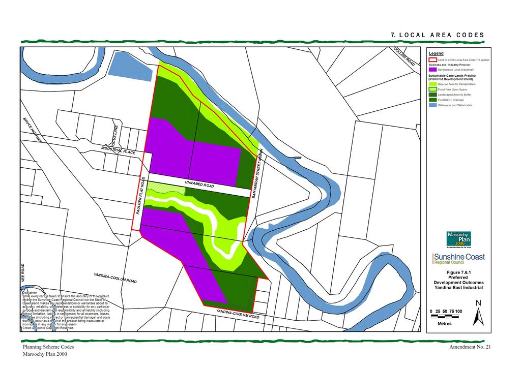
35
3. STATEMENTS OF DESIRED CHARACTER FOR PLANNING AREAS AND PRECINCTS
 3.30 Planning Area No. 30 Mary River Valley 3.30.1 Location and Role This Planning Area encompasses rural lands in the western part of the Shire. These lands are located within the catchment area of the
VOLUME Planning Area No. 21 Eudlo Creek Valley Location and Role Vision Statement
 3.21 Planning Area No. 21 Eudlo Creek Valley Note: (Ministerial Advice Amendment No. 20) Whilst the Maroochy Plan is deemed compliant with State Planning Policy 1/03 Mitigating the Adverse Impacts of Flood,
Part 10 Other plans
 Contents of Part 10 Part 10 Other plans... 10-1 10.1 Preliminary... 10-1 10.2 Palmview Structure Plan... 10-2 10.2.1 Preliminary... 10-2 10.2.2 Master Strategic Framework... 10-6 10.2.3 Master Precincts
Contents of Part 6. Part 6 Zones
 Contents of Part 6 Part 6 Zones... 6-1 6.1 Preliminary... 6-1 6.2 Zone codes... 6-3 6.2.1 Low density residential zone code... 6-3 6.2.1.1 Application... 6-3 6.2.1.2 Purpose and overall outcomes... 6-3
Local Area Key Issues Paper No. 11: Extractive industry - Yandina Creek and Browns Creek Road
 Draft Sunshine Coast Planning Scheme Review of Submissions Local Area Key Issues Paper No. 11: Extractive industry - Yandina Creek and Browns Creek Road Key Issue: No. of submissions: Sites identified
Amendments to the Palmview Structure Plan (amended text)
") Appendix A Amendments to the Palmview Structure Plan (amended text) Part 10 Other Plans 10.3 Palmview Structure Plan 10.3.1 Preliminary 10.3.1.1 Introduction This Part comprises the Palmview Structure
Appendix A Amendments to the Palmview Structure Plan (amended text) Part 10 Other Plans 10.3 Palmview Structure Plan 10.3.1 Preliminary 10.3.1.1 Introduction This Part comprises the Palmview Structure
Division 13 Local Business and Industry Buffer Zone: Assessment Criteria and Assessment Tables
 Division 13 Local Business and Industry Buffer Zone: Assessment Criteria and Assessment Tables 4.13.1 Local Business and Industry Buffer Zone The provisions in this division relate to the Local Business
SEQ Strategic Stabling Investigation Working paper: Northern corridor site selection - Town planning assessment
 SEQ Strategic Stabling Investigation Working paper: Northern corridor site selection - Town planning assessment July 2012 Department of Transport and Main Roads Parsons Brinckerhoff Australia Pty Limited
Section 3b: Objectives and Policies Rural Environment Updated 19 November 2010
 Page 1 of Section 3b 3b RURAL ENVIRONMENT 3b.1 Introduction The Rural Environment comprises all the land outside of the Residential, Town Centre and Industrial Environments. Most land within the District
6.6.2 Emerging Community Zone Code Application Purpose and overall outcomes. s6 Zone Codes Emerging Community and Township Zone Codes
 6.6.2 Emerging Community Zone Code 6.6.2.1 Application This code applies to assessable development:- (1) within the Emerging Community Zone as identified on the zoning maps contained within Schedule 2
SCHEDULE 10 TO THE URBAN GROWTH ZONE. Shown on the planning scheme map as UGZ10. Truganina Precinct Structure Plan. 1.0 The Plan
 SCHEDULE 10 TO THE URBAN GROWTH ZONE Shown on the planning scheme map as UGZ10 Truganina Precinct Structure Plan 1.0 The Plan Map 1 shows the future urban structure proposed in the Truganina Precinct Structure
9.3.7 Extractive industry code
 9.3.7 Extractive industry code 9.3.7.1 Application (1) This code applies to assessable development identified as requiring assessment against the Extractive industry code by the tables of assessment in
7.2.9 Eudlo local plan code
 7.2.9 local plan code 7.2.9.1 Application (1) This code applies to assessable development:- (a) within the local plan area as shown on Map ZM29 contained within Schedule 2 (Mapping); and (b) identified
Queensland Coastal Plan. Presented by John Lane Director Environment Planning
 Queensland Coastal Plan Presented by John Lane Director Environment Planning Queensland Coastal Plan - Status Released 7 April 2011, but NOT YET IN EFFECT Formatting & operational amendments required Yet
4.3 Dudley Area Plan. Introduction. History and Existing Character. Desired Future Character for Dudley
 4.3 Dudley Area Plan Introduction The suburb of Dudley has developed as a result of various circumstances including its topography, history and mineral resources. Dudley development has been identified
Draft Ada Street Cardiff Area Plan
 Draft Ada Street Cardiff Area Plan (Draft Amendment to Lake Macquarie Development Control Plan 2014) Exhibition: The draft Area Plan is on public exhibition from 29 February 2016 to 29 March 2016. Submissions:
Wetland Design Manual. A1: Vision, core outcomes and aspirational outcomes
 Wetland Design Manual A1: Vision, core outcomes and aspirational outcomes Table of contents Introduction 5 Vision 6 Core outcomes 7 Effective pollutant removal and flow management... 7 Community safety...
Planning Proposal Concurrent DA/LEP Amendment for Belmont North Pharmacy Amendment No. 24 to Lake Macquarie Local Environmental Plan (LMLEP) 2014
 2014") Planning Proposal Concurrent DA/LEP Amendment for Belmont North Pharmacy Amendment No. 24 to Lake Macquarie Local Environmental Plan (LMLEP) 2014 Local Government Area: Name of Draft LEP: Subject Land:
Planning Proposal Concurrent DA/LEP Amendment for Belmont North Pharmacy Amendment No. 24 to Lake Macquarie Local Environmental Plan (LMLEP) 2014 Local Government Area: Name of Draft LEP: Subject Land:
6 PORT SYDNEY SETTLEMENT AREA
 Section 6 Port Sydney Page 61 6 PORT SYDNEY SETTLEMENT AREA 6.1 Basis and Principles Village of Port Sydney Waterfront Community Existing Services 6.1.1 Port Sydney is an historic settlement that has developed
MERIDAN PLAINS SAND RESOURCE AREA
 MERIDAN PLAINS SAND RESOURCE AREA INFORMATION SHEET October 2010 BACKGROUND The Meridan Plains Extractive Resource Area is located on the western fringe of the coastal urban communities of Caloundra West
Wingecarribee Shire Council
 Connell Wagner Pty Ltd ABN 54 005 139 873 2 Palmer Street North Parramatta New South Wales 2151 Australia Telephone: +61 2 8896 4100 Facsimile: +61 2 9890 3558 Email: cwpar@conwag.com www.conwag.com Moss
Tāhuhu whakaruruhau ā-taone The sheltering ridge pole
 B2. Tāhuhu whakaruruhau ā-taone - Urban growth and form B2.1. Issues Tāhuhu whakaruruhau ā-taone The sheltering ridge pole Auckland s growing population increases demand for housing, employment, business,
MASTER PLAN N0. 76 (SITE DEVELOPMENT PLAN DETAILED PLANNING AREA 12 PRECINCT 13) 2013
 2013") MASTER PLAN N0. 76 (SITE DEVELOPMENT PLAN DETAILED PLANNING AREA 12 PRECINCT 13) 2013 TABLE OF CONTENTS 1.0 ADMINISTRATION... 5 1.1 Preliminary... 5 1.2 Location and Description... 6 1.3 Zoning Map Description...
MASTER PLAN N0. 76 (SITE DEVELOPMENT PLAN DETAILED PLANNING AREA 12 PRECINCT 13) 2013 TABLE OF CONTENTS 1.0 ADMINISTRATION... 5 1.1 Preliminary... 5 1.2 Location and Description... 6 1.3 Zoning Map Description...
TIDAPA Structure Plan
 TIDAPA Structure Plan Prepared by Tract Consultants 28 MARCH 2017 0217-0074 Table of Contents 01 STRATEGIC CONTEXT Executive Summary Regional Context Page 3 Page 4 02 LOCAL CONTEXT Aerial Photograph Local
RURAL ZONE - POLICY. Rural Zone Policy. Issue: Rural Environment. Ruapehu District Plan Page 1 of 8
 Rural Zone Policy RU2 RURAL ZONE - POLICY RU2.1 Introduction The natural resources of the rural environment in the Ruapehu District provide the basis for the existing and potential character, intensity
H7 Open Space zones. (a) provide for the needs of the wider community as well as the needs of the community in which they are located;
 provide for the needs of the wider community as well as the needs of the community in which they are located;") H7. Open Space zones H7.1. Background The majority of land zoned as open space is vested in the Council or is owned by the Crown. However some areas zoned open space are privately owned. While the open
H7. Open Space zones H7.1. Background The majority of land zoned as open space is vested in the Council or is owned by the Crown. However some areas zoned open space are privately owned. While the open
SECTION ONE North East Industrial Zone Design Guide Palmerston North City Council June 2004
 SECTION ONE North East Industrial Zone Design Guide Palmerston North City Council June 2004 young heart easy living 1 Preface Industrial areas are a very important component of the economic well-being
Appendix 1 Structure plan guidelines
 Appendix 1 Structure plan guidelines This appendix forms part of the regional policy statement [rps]. 1.1. Introduction Structure plans are an important method for establishing the pattern of land use
Plan Modification to Chapter B2 of the Auckland Unitary Plan(AUP) Operative in part (15 November 2016)
 Operative in part (15 November 2016)") UNITARY PLAN UPDATE REQUEST MEMORANDUM TO FROM Phill Reid Linley Wilkinson DATE 25 September 2018 SUBJECT Plan Modification to Chapter B2 of the Auckland Unitary Plan(AUP) Operative in part (15 November
UNITARY PLAN UPDATE REQUEST MEMORANDUM TO FROM Phill Reid Linley Wilkinson DATE 25 September 2018 SUBJECT Plan Modification to Chapter B2 of the Auckland Unitary Plan(AUP) Operative in part (15 November
Chapter 3: Natural Environment. Proposed Waikato District Plan Stage 1. (Notified version)
") Chapter 3: Natural Environment Proposed Waikato District Plan Stage 1 Page 2 of 7 Contents Chapter 3: Natural Environment... 3 3.1 Indigenous Vegetation and Habitats... 3 3.1.1 Objective Biodiversity and
Chapter 3: Natural Environment Proposed Waikato District Plan Stage 1 Page 2 of 7 Contents Chapter 3: Natural Environment... 3 3.1 Indigenous Vegetation and Habitats... 3 3.1.1 Objective Biodiversity and
I539. Smales 2 Precinct
 I539. Smales 2 Precinct I539.1. Precinct Description The Smales 2 Precinct applies to a 4.8 hectare block of land located on the southern side of Northcote Road and fronting Lake Pupuke, Takapuna. The
COMMUNITY DESIGN. GOAL: Create livable and attractive communities. Intent
 COMMUNITY DESIGN Intent An attractive, well-designed County will attract quality development, instill civic pride, improve the visual character of the community, and create a strong, positive image for
I611. Swanson North Precinct
 I611. Swanson North Precinct I611.1. Precinct Description Swanson North is located in the north eastern foothills of the Waitakere Ranges. It is outside the Waitakere Ranges Heritage Area Act and the Waitakere
North Oakville East Parks Facilities Distribution Plan. November, 2009
 North Oakville East November, 2009 POLICY CONTEXT 1) Purpose a) The purpose of this document is to be a guide for the location, configuration, design and development of the parks system for the North Oakville
AMENDMENTS. Date Effective. Amendment No. Council. DCP 14 Davidson St, Greenacre Page 2
 AMENDMENTS Amendment No. Description Adopted by Council Date Effective DCP 14 Davidson St, Greenacre Page 2 TABLE OF CONTENTS 1.0 INTRODUCTION... 4 1.1 NAME OF THIS PLAN... 4 1.2 COMMENCEMENT OF DEVELOPMENT
Background Information for. Public Parks Network for the. Sunshine Coast Council. Local Government Infrastructure Plan. March 2017
 Background Information for Public Parks Network for the Sunshine Coast Council Local Government Infrastructure Plan March 2017 Version 1.2 March 2017 1.0 Preliminary This report provides the background
Mollers Lane, Leopold, Victoria Significant Landscape Overlay Re-assessment
 XURBAN Mollers Lane, Leopold, Victoria Significant Landscape Overlay Re-assessment For: TGM Group November 2016 Final Mollers Lane, Leopold, Victoria Significant Landscape Overlay Re-assessment Client
I615. Westgate Precinct
 I615. Westgate Precinct I615.1. Precinct Description The Westgate Precinct is located approximately 18km west of the Auckland city centre. There are seven Sub-precincts in the Westgate Precinct: Sub-precinct
Planning Proposal Toronto Road, Booragul. Amendment to Lake Macquarie Local Environmental Plan (LMLEP) 2014
 2014") Planning Proposal Toronto Road, Booragul Amendment to Lake Macquarie Local Environmental Plan (LMLEP) 2014 Local Government Area: Name of Draft LEP: Subject Land: Land Owner: Applicant: Folder Number:
Planning Proposal Toronto Road, Booragul Amendment to Lake Macquarie Local Environmental Plan (LMLEP) 2014 Local Government Area: Name of Draft LEP: Subject Land: Land Owner: Applicant: Folder Number:
MASTER PLAN NO. 60 (SITE DEVELOPMENT PLAN EASTBANK/REGATTA NORTH PRECINCTS 2 4) 2008
 2008") Page 2 TABLE OF CONTENTS PAGE 1 PRELIMINARY... 5 1.1 CITATION... 5 1.2 TYPE OF MASTER PLAN... 5 1.3 LEGAL REQUIREMENT FOR MASTER PLAN... 5 1.4 LEGAL EFFECT OF THE MASTER PLAN... 5 2 DESCRIPTION OF LAND...
Page 2 TABLE OF CONTENTS PAGE 1 PRELIMINARY... 5 1.1 CITATION... 5 1.2 TYPE OF MASTER PLAN... 5 1.3 LEGAL REQUIREMENT FOR MASTER PLAN... 5 1.4 LEGAL EFFECT OF THE MASTER PLAN... 5 2 DESCRIPTION OF LAND...
GREENBANK DEVELOPMENT MASTERPLAN
 DEVELOPMENT MASTERPLAN POTENTIAL TRAIN STATION COMMUNITY CENTRE Greenbank will be a connected masterplanned community providing easy access to local and surrounding amenity. Affordable quality homes, green
POLICY SRT/D4 STORMWATER MANAGEMENT
 POLICY SRT/D4 STORMWATER MANAGEMENT BACKGROUND Increasing population, decreasing rainfall and increasing community expectations regarding environmental issues have led to increasing recognition of the
Planning Proposal Charlestown Swim and Leisure Centre LEP Amendment
 Planning Proposal Charlestown Swim and Leisure Centre LEP Amendment Amendment No. 4 to Lake Macquarie Local Environmental Plan 2014 (PP_2014_LAKEM_005_00) Local Government Area: Name of Draft LEP: Lake
The lands identified as Residential Areas on Schedule A1, Urban Structure, represent the areas that provide for stable residential communities.
 Livable Oakville Part D: Land Use Designations and Policies 11. RESIDENTIAL 11.1 General The lands identified as Residential Areas on Schedule A1, Urban Structure, represent the areas that provide for
Regional Context Statement
 Regional Context Statement REGIONAL CONTEXT STATEMENT 3. REGIONAL CONTEXT STATEMENT In 1995, the Provincial Government passed into law the Growth Strategies Act. The purpose of this provincial initiative
Part 10 Other plans
 Contents of Part 10 Part 10 Other plans... 10-1 10.1 Preliminary... 10-1 10.2 Maroochydore Principal Regional Activity Centre (PRAC) Structure Plan... 10-2 10.2.1 Preliminary... 10-2 10.2.2 Master Strategic
URBAN DESIGN BRIEF URBAN DESIGN BRIEF 721 FRANKLIN BLVD, CAMBRIDGE August 2018
 URBAN DESIGN BRIEF URBAN DESIGN BRIEF 721 FRANKLIN BLVD, CAMBRIDGE August 2018 DESIGN BRIEF CONTENTS PART A 1.0 INTRODUCTION 2.0 DESCRIPTION & ANALYSIS OF SITE CONTEXT 3.0 DESIGN CONSTRAINTS AND OPPORTUNITIES
and services The protection and conservation of environmentally significant and sensitive natural heritage features and functions.
 6. Land Use 6.0 Preamble A healthy and livable city is one in which people can enjoy a vibrant economy and a sustainable healthy environment in safe, caring and diverse neighbourhoods. In order to ensure
Table of Contents. Part 6 - Table of Contents
 Part 6 - Table of Contents Table of Contents Division 1 Preliminary... 6-1 6.1 Regionally Significant Business Enterprise and Industry Areas Provisions... 6-1 Division 2 General Provisions for Assessment
SPG 1. * the northern and western sections which are open fields used for pasture and grazing;
 SPG 1 1.0 INTRODUCTION This development brief is based on the allocation of the Priors Hall site for employment and countryside recreational purposes in the Corby Borough Local Plan. The brief is intended
REMARKABLES PARK ZONE
 .10 Remarkables Park Zone.10.1 Resources, Activities and Values The Remarkables Park Area comprises approximately 150 hectares of perimeter urban land in the vicinity of Frankton and occupies a strategic
2A District-wide Policies
 2A Introduction This Chapter contains policies which are relevant to subdivision, use and development activities occurring across all zones and areas of the District. The policies in this Chapter implement
MAYFIELD WEST SECONDARY PLAN PHASE 2
 MAYFIELD WEST SECONDARY PLAN PHASE 2 Public Open House #3 February 25, 2010 Draft Preferred Land Use Scenario TOWN OF CALEDON PLANNING & DEVELOPMENT DEPARTMENT Open House Agenda TOWN OF CALEDON 1. Welcome
DRAFT MAP AMENDMENT FLU 04-4
 DRAFT MAP AMENDMENT FLU 04-4 SW 24 TH AVENUE ROADWAY CORRIDOR The University of Florida participates with the Metropolitan Transportation Planning Organization (MTPO) in its responsibilities for the continuing,
PART 1 STRATEGIC PLAN
 PART 1 STRATEGIC PLAN Gazetted 17 December, 1993 and Subsequent Amendments TABLE OF CONTENTS PAGE Division 1 - INTRODUCTION 1 Division 2 - PREFERRED DOMINANT LAND USES AND SUPPORTING PLAN ELEMENTS 2 Division
Part 1 About the planning scheme
 Contents of Part 1 Part 1 About the planning scheme... 1-1 1.1 Introduction... 1-1 1.2 Planning scheme components... 1-3 1.3 Interpretation... 1-7 1.3.1 Definitions... 1-7 1.3.2 Standard drawings, maps,
HAZARD MITIGATION GOALS AND OBJECTIVES
 SEWRPC Community Assistance Planning Report No. 282, 2nd Edition CITY OF MILWAUKEE ALL HAZARDS MITIGATION PLAN UPDATE Chapter IV HAZARD MITIGATION GOALS AND OBJECTIVES [NOTE: Throughout this plan update
Appendix A. Planning Processes. Introduction
 1 Planning Processes Introduction This appendix outlines a number of planning processes which are used in the Auckland Region to support the effective management of development in the region s rural and
4 RESIDENTIAL ZONE. 4.1 Background
 4 RESIDENTIAL ZONE 4.1 Background The residential areas within the City are characterised by mainly lowrise dwellings sited on individual allotments. Past architectural styles, settlement patterns and
Page 1 of 19 URBAN DESIGN FRAMEWORK FOR BOLTON STREET WATERFORD
 Page 1 of 19 URBAN DESIGN FRAMEWORK FOR BOLTON STREET WATERFORD 1.0 Introduction: The relocation of the City Council stores and depot from Bolton Street creates an exciting opportunity for development
Wingecarribee Shire Council
 Connell Wagner Pty Ltd ABN 54 005 139 873 2 Palmer Street North Parramatta New South Wales 2151 Australia Telephone: +61 2 8896 4100 Facsimile: +61 2 9890 3558 Email: cwpar@conwag.com www.conwag.com Moss
Northern Territory Compact Urban Growth Policy
 Northern Territory Compact Urban Growth Policy A Reference Policy Document to clause 2.7 (Reference to Policy) of the NT Planning Scheme May 2015 Table of Contents 1 Policy Setting... 3 1.1 Context for
Town of Peru Comprehensive Plan Executive Summary
 Town of Peru Comprehensive Plan Executive Communities that plan grow by choice, not by chance. A plan makes growth thoughtful, understandable, and predictable. A plan shows that a community is managing
Western Sydney Parklands Australia s Largest Urban Park
 Western Sydney Parklands Australia s Largest Urban Park 37 WLA 1 MAGAZINE 21 38 WESTERN SYDNEY PARKLANDS AUSTRALIA S LARGEST URBAN PARK Large urban parks have dual roles to play in meeting the demands
Proposed Southland District Plan 2012 Appeal Version October 2016
 S e c t i o n 3. 5 - F i o r d l a n d / R a k i u r a Z o n e The Fiordland/Rakiura Zone encompasses the Fiordland and Rakiura National Parks and part of Mt Aspiring National Park. It also includes areas
The Mill at Moreton Bay Priority Development Area Interim Land Use Plan
 The Mill at Moreton Bay Priority Development Area Interim Land Use Plan September 2016 Contents 1.0 Preliminary... 1 1.1 Introduction...1 1.2 Economic Development Act...1 1.3 Purpose of the ILUP...1 1.4
11. BALLANTRAE-MUSSELMAN LAKE AND ENVIRONS SECONDARY PLAN
 11. BALLANTRAE-MUSSELMAN LAKE AND ENVIRONS SECONDARY PLAN 11.1 PURPOSE The Ballantrae-Musselman Lake and Environs Secondary Plan Area includes two small existing settlement areas, Ballantrae and Musselman
A Growing Community Rural Settlement Areas
 Town of Huntsville Official Plan Review - POLICY BACKGROUND PAPER A Growing Community Rural Settlement Areas BACKGROUND: In addition to the fully municipally-serviced Urban Settlement Area and the Hidden
Rural (Urban Expansion) Environment
 Environment") RUEE.1 Rural (Urban Expansion) Environment Index RUEE.1 RUEE.1.1 RUEE.1.2 RUEE.1.3 RUEE.1.4 RUEE.2 RUEE.2.1 RUEE.2.2 RUEE.2.3 RUEE.2.4 RUEE.3 Rural (Urban Expansion) Environment Description and Expectations
RUEE.1 Rural (Urban Expansion) Environment Index RUEE.1 RUEE.1.1 RUEE.1.2 RUEE.1.3 RUEE.1.4 RUEE.2 RUEE.2.1 RUEE.2.2 RUEE.2.3 RUEE.2.4 RUEE.3 Rural (Urban Expansion) Environment Description and Expectations
APPENDIX K WINDSOR OFFICIAL PLAN
 CEAA ENVIRONMENTAL ENVIRONMENTAL IMPACT ASSESSMENT AMBASSADOR BRIDGE ENHANCEMENT PROJECT Replacement Span and Plaza Expansion APPENDIX K WINDSOR OFFICIAL PLAN Avalon Consulting Professionals of Ontario,
H1. Residential Large Lot Zone
 H1. Residential Large Lot Zone H1.1. Zone description The Residential Large Lot Zone provides for large lot residential development on the periphery of urban areas. Large lot development is managed to
AWH REPORT OF THE PLANNING AND DEVELOPMENT DEPARTMENT FOR APPLICATION FOR REZONING ORDINANCE TO PLANNED UNIT DEVELOPMENT
 AWH REPORT OF THE PLANNING AND DEVELOPMENT DEPARTMENT FOR APPLICATION FOR REZONING ORDINANCE TO PLANNED UNIT DEVELOPMENT MAY 8, 2014 The Planning and Development Department hereby forwards to the Planning
open space environment
 This section updated August 09 GUIDELINE TO THE RULES The Open Space Environment Rules apply to activities on sites within the Open Space Environment as shown on the Human Environments Maps. Most of the
SECTION II SECTION II STATEMENT OF GOALS, OBJECTIVES, PRINCIPLES, ASSUMPTIONS, POLICIES AND STANDARDS
 STATEMENT OF GOALS, OBJECTIVES, PRINCIPLES, ASSUMPTIONS, POLICIES AND STANDARDS 1 2 STATEMENT OF GOALS, OBJECTIVES, PRINCIPLES, ASSUMPTIONS, POLICIES AND STANDARDS INTRODUCTION The New Jersey Municipal
Schedule of Planning Applications Committee Date: 23 May Reference: 06/17/0726/F Parish: Hemsby Officer: Mr J Beck Expiry Date:
 Schedule of Planning Applications Committee Date: 23 May 2018 Reference: 06/17/0726/F Parish: Hemsby Officer: Mr J Beck Expiry Date: 22-05-2018 Applicant: Proposal: Site: Mr Gillett Change of use to the
Rural (Urban Expansion) Environment
 Environment") RUEE.1 Rural (Urban Expansion) Environment Subsequent to the receipt of appeals, a 'marked up' version of the Proposed District Plan was prepared. The provisions of the Proposed Version of the Plan subject
RUEE.1 Rural (Urban Expansion) Environment Subsequent to the receipt of appeals, a 'marked up' version of the Proposed District Plan was prepared. The provisions of the Proposed Version of the Plan subject
NEW CASTLE COUNTY S ZONING DISTRICTS
 NEW CASTLE COUNTY S ZONING DISTRICTS This is general information about New Castle County s zoning districts. The information included is by no means exhaustive or complete. Before designing plans to develop
Complete Neighbourhood Guidelines Review Tool
 Complete Neighbourhood Guidelines Review Tool Prepared By: City of Regina Planning Department October 2014 Page 1 of 14 Community Development Review Checklist for Secondary Plans and Concept Plans The
TOWN PLANNING REPORT
 TOWN PLANNING REPORT DEVELOPMENT PERMIT FOR MATERIAL CHANGE OF USE PROPOSED HOTEL, SHOP, MUSEUM AND ENTERTAINMENT & RECREATION (OUTDOORS) 1780-1820 BRIBIE ISLAND ROAD, SANDSTONE POINT LOT 6 ON SP199926
Planning Proposal Wangi Power Station Complex Administrative Amendment Lake Macquarie Local Environmental Plan 2014
 Planning Proposal Wangi Power Station Complex Administrative Amendment Lake Macquarie Local Environmental Plan 2014 (Post Exhibition Version) Local Government Area: Name of Draft LEP: Subject Land: Land
Official Plan Review
 Official Plan Review Summary Report - The Built Environment August 2014 Part 1: Introduction Planning for a healthy, prosperous and sustainable community is an important goal for our municipality. From
OFFICE CONSOLIDATION SECONDARY PLAN AREA 22 THE BRAMALEA SOUTH INDUSTRIAL SECONDARY PLAN
 OFFICE CONSOLIDATION SECONDARY PLAN AREA 22 THE BRAMALEA SOUTH INDUSTRIAL SECONDARY PLAN November 2010 EXPLANATORY NOTES (Secondary Plan Area 22) General (pertaining to all secondary plan office consolidations)
Division 7 Character Areas Housing Zone: Assessment Criteria and Assessment Tables
 Division 7 Character Areas Housing Zone: Assessment Criteria and Assessment Tables 4.7.1 Character Areas Housing Zone The provisions in this division relate to the Character Areas Housing Zone as follows
4 Residential and Urban Living Zones
 4 Residential and Urban Living Zones Refer to Chapters 11 to 20 for additional rules that may apply to these zones. 4.1 OBJECTIVES AND POLICIES Objective Res1 Policy 1 Policy 2 Policy 3 Policy 4 Policy
Memorial Business Park Site. Proposed Future Development. Design guidelines. August
 Memorial Business Park Site Proposed Future Development Design guidelines August 2014 www.designenvironment.co.nz 0064 3 358 3040 Contents 1.0 Background 1.1 Introduction 3 1.2 Objectives 4 2.0 Context
I403 Beachlands 1 Precinct
 I403. Beachlands 1 I403.1. Precinct Description Beachlands is a rural and coastal village located on the eastern side of Auckland, adjoining the Tamaki Strait coastline. The original Beachlands village
The West Vaughan Employment Area Secondary Plan Policies
 Part 2: The West Vaughan Employment Area Secondary Plan Policies 2.1 General Policies It is the policy of Council: 2.1.1. That the West Vaughan Employment Area (the WVEA), identified on Schedule 1, will
Settlement Boundaries Methodology North Northumberland Coast Neighbourhood Plan (August 2016)
") Introduction This background paper sets out a methodology for the definition of settlement boundaries in the North Northumberland Coast Neighbourhood Plan. The neighbourhood plan is planning positively
Introduction This background paper sets out a methodology for the definition of settlement boundaries in the North Northumberland Coast Neighbourhood Plan. The neighbourhood plan is planning positively
I602. Birdwood Precinct
 I602. Birdwood Precinct I602.1. Precinct description The Birdwood Precinct applies to an area west of Don Buck Road and south of Red Hills Road in west Auckland. It incorporates subdivision and development
QUEEN-RIVER SECONDARY PLAN
 34 QUEEN-RIVER SECONDARY PLAN 34. QUEEN RIVER SECONDARY PLAN 1. INTRODUCTION The Queen-River area is approximately 6.4 hectares and is located at the eastern edge of the Downtown as shown on Map 34-1.
Design Specifications & Requirements Manual
 11 PARKS & OPEN SPACES 11.1 DEFINITIONS... 1 11.1.1 Neighbourhood Parks... 1 11.1.2 District Parks... 1 11.1.3. Sport Parks... 1 11.1.4 Urban Parks... 1 11.1.5 Civic Spaces... 1 11.1.6 Open Space System...
Planning Proposal. Rockdale Local Environmental Plan Two storey residential development in the R2 and R3 zones
 Planning Proposal Rockdale Local Environmental Plan 2011 Two storey residential development in the R2 and R3 zones 16 October 2014 Contents Part 1 Part 2 Part 3 Part 4 Part 5 A statement of the Objectives
[PLANNING RATIONALE] For Site Plan Control and Lifting of Holding Zone By-Law 101 Champagne Avenue. May 23, 2014
![[PLANNING RATIONALE] For Site Plan Control and Lifting of Holding Zone By-Law 101 Champagne Avenue. May 23, 2014](/thumbs/75/71599615.jpg "[PLANNING RATIONALE] For Site Plan Control and Lifting of Holding Zone By-Law 101 Champagne Avenue. May 23, 2014") [PLANNING RATIONALE] For Site Plan Control and Lifting of Holding Zone By-Law 101 Champagne Avenue May 23, 2014 Contents 1.0 Introduction... 2 2.0 Site Context... 2 2.1 Adjacent Uses... 2 Figure 1: Site
[PLANNING RATIONALE] For Site Plan Control and Lifting of Holding Zone By-Law 101 Champagne Avenue May 23, 2014 Contents 1.0 Introduction... 2 2.0 Site Context... 2 2.1 Adjacent Uses... 2 Figure 1: Site
Lake Macquarie City. A copy of the published amendment including the instrument and maps, is provided in Attachment 7 of this report.
 Planning Proposal Amendment No. 77 to Lake Macquarie Local Environmental Plan 2004 and proposed Amendment to Draft Lake Macquarie Local Environmental Plan 2013 Minor Zone Boundary Adjustment - Pasminco
Guidelines for Planning Authorities and Part V of the Planning and Development Act 2000: December 2000
 Slide 1 Slide 2 Slide 3 Slide 4 As a planner in practice, whether within the Local Authority, private practice or An Bord Pleanala, due regard must be given to the guidance provided by the Department in
11.3 SPECIAL CHARACTER ZONE HAWKE S BAY REGIONAL SPORTS PARK
 11.3 SPECIAL CHARACTER ZONE HAWKE S BAY REGIONAL SPORTS PARK 11.3.1 INTRODUCTION The availability of sports and recreation activities and facilities is important for the maintenance and enhancement of
PLANNED UNIT DEVELOPMENT Date: April 5, 2018
 PLANNED UNIT DEVELOPMENT Date: April 5, 2018 DEVELOPMENT NAME SUBDIVISION NAME LOCATION Robert Myers Robert Myers 2955 and 2989 Dauphin Street (Southeast corner of Dauphin Street and Sage Avenue) CITY
Subdivision Design Criteria. Penihana North GUIDELINES TO THE RULES
 Created September 2013 Penihana North Subdivision Design Criteria GUIDELINES TO THE RULES This part of the Plan sets out the design criteria for subdivision in Penihana North. The criteria will be considered
YONGE STEELES CORRIDOR SECONDARY PLAN. Young + Wright / IBI Group Architects Dillon Consulting Ltd. GHK International (Canada) Ltd.
 Ltd.") PART A: PREAMBLE 1.0 PURPOSE The purpose of this Secondary Plan is to provide a development framework for intensification of the Yonge/ Steeles corridor including the north side of Steeles Avenue West
PART A: PREAMBLE 1.0 PURPOSE The purpose of this Secondary Plan is to provide a development framework for intensification of the Yonge/ Steeles corridor including the north side of Steeles Avenue West
2.4 FUTURE LAND USE ELEMENT Goals, Objectives and Policies
 GOAL 1: To create developmental patterns that direct future growth to appropriate areas on campus, in a manner that promotes the educational mission of the University, the protection of environmentally