Table of Contents. Part 6 - Table of Contents
|
|
|
- Wilfrid Sims
- 6 years ago
- Views:
Transcription
1 Part 6 - Table of Contents Table of Contents Division 1 Preliminary Regionally Significant Business Enterprise and Industry Areas Provisions Division 2 General Provisions for Assessment Tables Assessment Categories for Zones Relevant Assessment Criteria for Self Assessable Development and Assessable Development in Each Zone Uses Consistent or Inconsistent with the Outcomes Sought for a Zone Division 3 Overall and Specific Outcomes for the Regionally Significant Business and Industry Areas Compliance with the Regionally Significant Business and Industry Areas Code Overall Outcomes for the Regionally Significant Business and Industry Areas Specific Outcomes for the Regionally Significant Business and Industry Areas Division 4 Regional Business and Industry Zone: Assessment Criteria and Assessment Tables Regional Business and Industry Zone Overall Outcomes for the Regional Business and Industry Zone Effects of Development General Effects of Development Within Sub Areas Consistent and Inconsistent Uses, Use Classes and Other Development Division 5 Regional Business and Industry Investigation Zone: Assessment Criteria and Assessment Tables Regional Business and Industry Investigation Zone Overall Outcomes for the Regional Business and Industry Investigation Zone Effects of Development General Effects of Development Within Sub Areas Consistent and Inconsistent Uses, Use Classes and Other Development Division 6 Regional Business and Industry Buffer Zone: Assessment Criteria and Assessment Tables Regional Business and Industry Buffer Zone Overall Outcomes for the Regional Business and Industry Buffer Zone Effects of Development General Effects of Development Within a Sub Area Consistent and Inconsistent Uses, Use Classes and Other Development Division 7 Special Uses Zone: Assessment Criteria and Assessment Tables Special Uses Zone Overall Outcomes for the Special Uses Zone Effects of Development General Effects of Development within Sub Areas Consistent and Inconsistent Uses, Use Classes and Other Development Division 8 Business Park Zone: Assessment Criteria and Assessment Tables Business Park Zone Overall Outcomes for the Business Park Zone Effects of Development General Consistent and Inconsistent Uses, Use Classes and Other Development Division 9 Recreation Zone: Assessment Criteria and Assessment Tables Recreation Zone Overall Outcomes for Recreation Zone Effects of Development General Effects of Development Within Sub Areas Consistent and Inconsistent Uses, Use Classes and Other Development November i
2 Part 6 - Table of Contents Figures Figure 6.7.1: Swanbank New Chum Land Use Concept Master Plan Figure 6.7.2: Swanbank Precincts Figure : Ebenezer Willowbank Precincts Tables Table 6.1: Swanbank Precincts Existing Approved Uses Table 6.2: Assessment Categories and Relevant Assessment Criteria for Regional Business and Industry Zone Making a Material Change of Use Table 6.3: Assessment Categories and Relevant Assessment Criteria for Regional Business and Industry Zone Other Development Table 6.4: Assessment Categories and Relevant Assessment Criteria for Regional Business and Industry Investigation Zone Making a Material Change of Use Table 6.5: Assessment Categories and Relevant Assessment Criteria for Regional Business and Industry Investigation Zone Other Development A Table 6.6: Assessment Categories and Relevant Assessment Criteria for Regional Business and Industry Buffer Zone Making a Material Change of use Table 6.7: Assessment Categories and Relevant Assessment Criteria for Regional Business and Industry Buffer Zone Other Development A Table 6.8: Special Uses Zone Existing Approved Uses for Sub Areas Table 6.9: Assessment Categories and Relevant Assessment Criteria for Special Uses Zone Making a Material Change of Use Table 6.10: Assessment Categories and Relevant Assessment Criteria for Special Uses Zone Other Development Table 6.11: Assessment Categories and Relevant Assessment Criteria for Business Park Zone Making a Material Change of Use Table 6.12: Assessment Categories and Relevant Assessment Criteria for Business Park Zone Other Development Table 6.13: Assessment Categories and Relevant Assessment Criteria for Recreation Zone Making a Material Change of Use Table 6.14: Assessment Categories and Relevant Assessment Criteria for Recreation Zone Other Development ii June 2010
3 Part 6 Regionally Significant Business Enterprise and Industry Areas PART 6 REGIONALLY SIGNIFICANT BUSINESS ENTERPRISE AND INDUSTRY AREAS Division 1 Preliminary 6.1 Regionally Significant Business Enterprise and Industry Areas Provisions (1) The following provisions in this part comprise the Regionally Significant Business and Industry Areas Code compliance with the Regionally Significant Business and Industry Areas Code (division 3, section 6.5); overall outcomes for the Regionally Significant Business and Industry Areas (division 3, section 6.6); specific outcomes for the Regionally Significant Business and Industry Areas (division 3, section 6.7); assessment criteria for each zone in the Regionally Significant Business and Industry Areas as follows Regional Business and Industry Zone (division 4, sections 6.8 to 6.12); Regional Business and Industry Investigation Zone (division 5, sections 6.13 to 6.17); Regional Business and Industry Buffer Zone (division 6, sections 6.18 to 6.22); Special Uses Zone (division 7, sections 6.23 to 6.27) Business Park Zone (division 8, sections 6.28 to 6.31) Recreation Zone (division 9, sections 6.32 to 6.36) (2) The following provisions in this part relate to the assessment tables for the zones in the Regionally Significant Business and Industry Areas general provisions (division 2); assessment tables for each zone (divisions 4-9, Tables 6.2 to 6.7 and Tables 6.9 to 6.14). Division 2 General Provisions for Assessment Tables 6.2 Assessment Categories for Zones The assessment categories 1 are identified for development in each zone in column 2 of tables 6.2 to 6.7 and Tables 6.9 to 6.14 as follows tables 6.2, 6.4, 6.6, 6.9, 6.11 and 6.13 making a material change of use 2 for a defined use, or another use in a defined use class, listed in column 1; or tables 6.3, 6.5, 6.7, 6.10, 6.12 and 6.14 other development 3 listed in column 1, including (iv) (v) (vi) (vii) carrying out building work not associated with a material change of use; minor building work; placing an advertising device on premises; clearing of vegetation, not associated with a material change of use; earthworks, not associated with a material change of use; reconfiguring a lot; carrying out operational work for reconfiguring a lot or in association with a material change of use. 6.3 Relevant Assessment Criteria for Self Assessable Development and Assessable Development in Each Zone (1) The relevant assessment criteria in each zone are referred to in column 3 of tables 6.2 to 6.7 and Tables 6.9 to (2) For self-assessable development and development requiring code assessment, the relevant assessment criteria are applicable codes. 1 Information about assessment categories is provided in the Ipswich Planning Scheme User s Guide. 2 Works associated with an application for a material change of use may be assessed together with the material change of use. Also, see Ipswich Planning Scheme Explanatory Notes giving examples that explain the type of development involved in different proposals. 3 See Ipswich Planning Scheme Users Guide 2 for examples that explain the type of development involved in different proposals. July
4 Part 6 Regionally Significant Business Enterprise and Industry Areas 6.4 Uses Consistent or Inconsistent with the Outcomes Sought for a Zone (1) In accordance with section 6.12, 6.17, 6.22, 6.27, 6.31 and 6.36, as applicable, a defined use, use class or other development that is inconsistent with the outcomes sought for a zone is noted in column 1 of table 6.2, 6.4, 6.6, 6.9, 6.11 and 6.13, as applicable to that zone. (2) If a defined use, use class or other development is not noted as inconsistent in column 1 of the applicable table, it is a consistent or potentially consistent use, use class or other development in accordance with section 6.12, 6.17, 6.22, 6.27, 6.31 and 6.36, as applicable. Division 3 Overall and Specific Outcomes for the Regionally Significant Business and Industry Areas 6.5 Compliance with the Regionally Significant Business and Industry Areas Code Development that in the local government s opinion, is consistent with the specific outcomes for the Regionally Significant Business and Industry Areas, as a whole in section 6.7 and the specific outcomes for the relevant zone, complies with the Regionally Significant Business and Industry Areas Code. 6.6 Overall Outcomes for the Regionally Significant Business and Industry Areas (1) The overall outcomes are the purpose of the Regionally Significant Business and Industry Areas Code. NOTE 6.6A Sub-section (1) provides the link between the overall outcomes sought for the code and the IPA code assessment rules which refer to the purpose of the code [see IPA s (2)]. (2) The overall outcomes sought for the Regionally Significant Business and Industry Areas are the following Overall Vision Regionally significant business enterprise and industry nodes are created and maintained, which enjoy sustained economic growth, good design and ecological sustainability. Amenity Pleasant and safe working environments are created. (d) There is a high standard of amenity in regionally significant business and industry areas and uses in these areas are generally compatible. A land use pattern is created for each area where there is a transition from lower impact uses on the edge to higher impact activities towards the centre, with buffer areas on the periphery to separate incompatible or sensitive uses. Environmental Management and Greenspace (e) (f) (g) (h) Where possible, the areas maintain or develop an overall greenspace setting, inclusive of active and passive recreation uses and pedestrian and cycle trails. Principal conservation areas are conserved and where possible, linked via riparian, or other wildlife corridors. Degraded or contaminated sites (including former mining sites and overburden stock piles) are rehabilitated and used in an appropriate manner. Uses and works are located and designed to minimise risks and nuisance to people and property. Buffers are created between incompatible uses to ensure that there are no discernible amenity or environmental impacts which affect adjacent sensitive land uses. Infrastructure Efficiency (j) Uses and works support the efficient provision or extension of infrastructure, including both physical infrastructure and human services and facilities. (k) (l) Infrastructure requirements are developed in an orderly manner which allows the efficient provision of necessary infrastructure. Sustainable water usage is facilitated, particularly where relating to water sensitive design and the use of recycled water. NOTE 6.6B Development which does not encourage the orderly and efficient provision of infrastructure may be refused. (m) Transport and Access An integrated efficient, safe and attractive transport network is provided for a range of transport modes including motor vehicles, freight vehicles, public transport, pedestrians and cyclists. 6-2 July 2012
5 Part 6 Regionally Significant Business Enterprise and Industry Areas (n) Pedestrian, cycle and vehicle connectivity and ease of mobility are provided between neighbourhoods, major centres, employment areas and public transport interchanges. (o) Conflict between freight, local and through traffic and between pedestrians, cyclists and vehicles is minimised. Economic Development (p) (q) (r) (s) (t) (u) Zones (v) A range of business and industry uses and other employment opportunities are provided particularly regionally significant business enterprise and industry lands; investigation areas for future development; and some high impact difficult to locate activities in appropriate areas. Uses reasonably associated with industrial operations (e.g. the sale of goods resulting from operations, office and administration functions, courier services, storage facilities), or those directly serving the day to day needs of workers (including food establishments, recreational facilities, personal services, general stores and child care centres) are established. Non industrial uses and facilities are consolidated in identifiable local centres that are conveniently accessible to surrounding industrial uses. Non industrial uses and facilities are generally located on principal transport routes in the vicinity of major entries to business and industry estates. Uses which attract high levels of visitation, or which create conflict with business and industry operations and traffic are avoided. A range of passive or active recreation or other non-industrial uses are provided on land which is generally unsuitable for business and industry activities owing to geotechnical or other land use constraints. The overall outcomes for each zone within the regionally significant business and industry areas are stated in the following sections Regional Business and Industry Zone section 6.9; Regional Business and Industry Investigation Zone section 6.14; Regional Business and Industry Buffer Zone section 6.19; (iv) Special Uses Zone section 6.24; (v) Business Park Zone section 6.29; and (vi) Recreation Zone section Specific Outcomes for the Regionally Significant Business and Industry Areas NOTE 6.7A The specific outcomes which are sought to apply generally throughout the Regionally Significant Business and Industry Areas are set out below. (1) Transport and Access Specific Outcomes (d) A strategic transport network is provided, as outlined in Map 4 in Schedule 7. Carparking is provided in accordance with the demand generated by uses or works, and may include shared parking and access arrangements. The design and layout of parking facilities is integrated (particularly for adjoining carparks); located to minimise disruption to traffic flow; and located and designed to minimise pedestrian and vehicle conflicts. Service and delivery areas provide safe and efficient access to sites; are combined, where possible with adjoining uses; minimise disruptions to local traffic; and (iv) reduce pedestrian/vehicular conflicts. (2) Environmental Management Specific Outcomes The quality of stormwater runoff from a use or site is similar to or better than the established water quality standards for the receiving waters or lawful point of discharge. Uses and works are designed to support integrated catchment management, including protection and rehabilitation of natural drainage patterns and riparian vegetation; environmentally acceptable effluent and runoff management systems or techniques which prevent pollution of water sources; and appropriate buffering along any adjoining major watercourses. November
6 Part 6 Regionally Significant Business Enterprise and Industry Areas Uses and works with the potential for material or serious environmental harm, establish and implement a site specific Environmental Management Plan, which describes the measures to be used to avoid or minimise adverse impacts, and how such measures are to be implemented during the life of the development. (3) Visual Framework NOTE 6.7B The planning scheme seeks to enhance the overall visual quality of the Regionally Significant Business and Industry Areas by appropriate treatments along the main approach routes and gateways; high quality in the design, construction and landscaped treatment of new buildings, with particular attention to details which are easily viewed by passers by; and the development of new landmark buildings and structures in appropriate locations. Specific Outcomes Uses and works which adjoin a Designated Road, are designed to enhance the overall visual impression of the City; and the character of the particular area in which the site is located. Uses and works which adjoin a gateway entry into Regionally Significant Business and Industry Areas are designed to enhance the sense of arrival and the overall character of the particular area in which the site is located. (4) Swanbank New Chum Preferred Development Outcomes NOTE 6.7C (1) The Swanbank New Chum area is located in close proximity to major road infrastructure (the Centenary Highway, Cunningham Highway, Warrego Highway and Ipswich Motorway) which provides excellent opportunities for the development of road transport reliant activities. (2) The area is constrained by: extensive and significant impacts from mining; key resource areas and mining leases; land containing notifiable activities recorded on DEHP s Environmental Management Register; (d) high voltage electricity transmission lines; (e) major water pipelines; (f) threatened flora and fauna species; NOTE 6.7C cont. (g) difficult topography; (h) flooding and overland flow paths; and existing and planned residential areas to the east, west and south. (3) Where buildings are sought to be erected, the proposal is to be supported by detailed geotechnical investigations. (4) The lands surrounding the Swanbank Power Station, provide particular advantages for industrial uses that require land extensive areas, high energy uses, good access to road and rail networks and which are well separated from residential areas. (5) The area also provides significant opportunities for appropriate difficult to locate industries, and recreational pursuits reliant on large expanses of land and relatively natural settings. (6) Waste recycling or treatment activities are discouraged unless it can be demonstrated with a high degree of certainty that such activities will not adversely affect any nearby residential areas (either existing or proposed). (7) Transport infrastructure issues requiring resolution include: the realignment of Redbank Plains Road; a north-south major road link between Redbank Plains Road and the South West Regional Transport Corridor; and a connection between the Centenary Highway and the Swanbank Interchange in conjunction with an east-west link to the Cunningham Highway via Swanbank Road. (8) Effluent treatment and disposal may include the possibility of effluent reuse, particularly in conjunction with the power station and other industrial activities. Overall Outcomes for Swanbank New Chum Overall Vision (A) Swanbank New Chum is a flagship example of effective sustainable development integrated into the surrounding emerging communities of Ipswich City. (B) Swanbank New Chum is a major contributor to employment and economic development within Ipswich City, South East Queensland and the State as a whole. 6-4 December 2013
7 Part 6 Regionally Significant Business Enterprise and Industry Areas (C) Swanbank New Chum is a centre of excellence for a range of industries and is renown for research and technology development. (D) Development is of the highest environmental standards and occurs in a fully master planned and landscaped setting. (E) The setting is attractive for the location of supporting activities in designated centres, and the establishment of tourism opportunities based on the region s rich mining heritage. (F) Swanbank New Chum is embraced by the adjoining communities not only as a major generator of employment, but also through capacity building that has been stimulated in the community, by way of industrial training, technical education, research and development programs. (G) Development will progressively lead to the rehabilitation of areas degraded by past mining activities and the integration of these areas within a network of green spaces. (H) Green spaces include environmental buffers and corridors as well as active and passive recreation areas. (I) The Swanbank New Chum green space network is a regional resource, linking with the green spaces of surrounding communities and offering a wide range of recreational and environmental opportunities. Development Themes Employment and Economic Development (A) Swanbank New Chum is a key driver of employment generation and economic development for Ipswich, South East Queensland and the State as a whole. (B) Investment in business and industry is attracted to Swanbank New Chum by its unique combination of strategic location, site opportunities and commitment to a high quality master planned environment. (C) The attraction of investment provides a wide range of employment, education, training, research and development opportunities directly benefiting the communities of Ipswich and the wider region. (D) Guiding principles for Employment and Economic Development are: (I) suitable land is available for a wide range of industrial and related uses; (II) buffers provide separation between business and industry uses and sensitive receptors; (III) business and industry areas are linked by an internal transport network to the interregional and interstate highway system; and (IV) local centres provide a range of non-industrial land uses and a focal point for services and facilities. An Efficient and Effective Transport and Movement system (A) The integrated transport network provides strategic advantages for the movement of goods and materials to the Region, Queensland and Interstate particularly through Brisbane Airport and the Port of Brisbane. (B) The internal movement network segregates heavy traffic from local traffic while also providing for linkages to connect the surrounding communities. (C) Pedestrians and cyclists are catered for by a network of trails integrated within the green space system and linking surrounding communities. (D) An integrated public transport system supports Swanbank New Chum and surrounding communities and provides transport choice. (E) The guiding principles for an efficient and effective transport and movement system are: (I) where possible the road network facilitates through traffic movement and provides separation of local and industrial traffic; December
8 Part 6 Regionally Significant Business Enterprise and Industry Areas (II) direct frontage access is avoided from all major thoroughfares particularly the Cunningham Highway and Centenary Highway; (III) the intersection at Redbank Plains Road and Swanbank Boulevard (the north south arterial through the site linking to the Centenary Highway) is designed to achieve the safety and efficiency of Redbank Plains Road and the nearby Cunningham Highway/Redbank Plains interchange and the capacity requirements of Swanbank New Chum; and (IV) a pedestrian/cyclist and recreation trail network is provided throughout Swanbank New Chum linking industrial and commercial Sub Areas to adjoining communities, the Dinmore Railway Station, and existing pedestrian and cycle trails. (iv) Quality Efficient Infrastructure Services (A) Swanbank New Chum is a leading example of sustainable industrial development. (B) Energy and water efficient design is a feature of development in Swanbank New Chum. (C) The adoption of integrated urban water management principles achieves an overall reduced water consumption and reduced impact on natural waterways. (D) Infrastructure contributes to the evolution of an industrial ecology where the by products and wastes of one industry are recycled as inputs to another. (E) Business and industry embraces alternative energy options. (F) Swanbank New Chum provides for the local everyday needs of the workforce with the road and public transport networks providing access to other services in Ipswich City. (v) (G) Guiding principles for quality efficient infrastructure services are: (I) water, sewerage, recycled water and stormwater management services within Swanbank New Chum are designed within the context of an Integrated Water Management Strategy which includes adoption of water sensitive urban design techniques; (II) incorporation of energy efficient infrastructure and climate responsive design; (III) the establishment of Emergency Services and Community Infrastructure in local centres; and (IV) integration with the solid waste industry. Visual Amenity, Landscape Character and Placemaking (A) Swanbank New Chum is identified as a benchmark in high quality business and industrial master planning. (B) Swanbank New Chum conserves intrinsic natural features such as knolls, ridges, waterways and native vegetation types. (C) The built form, private landscaping, streetscape design and green spaces, enhance the character and contribute to the creation of a safe healthy and attractive employment environment that caters to a range of business and industrial uses. (D) Guiding principles for visual amenity, landscape character and placemaking are that development: (I) creates a high quality business park environment that is distinct from traditional industrial areas; 6-6 December 2013
9 Part 6 Regionally Significant Business Enterprise and Industry Areas (II) provides a visually appealing backdrop to the Ripley Valley Urban Core, Ripley Valley Secondary Urban Centre East, Redbank Plains residential areas and all other interfaces with surrounding residential areas to eliminate negative amenity impacts (e.g. noise, odour etc.); (III) creates legible local commercial centres that integrate with the public realm; (IV) acknowledges the inherent values of surrounding natural environments and do not adversely impact on them; and (V) enhances the existing and future green space environments. (vi) Integrated Green Spaces (A) Swanbank New Chum is shaped by natural features that integrate and complement existing and proposed green space in adjoining areas. (B) Areas of environmental significance are protected in the green space network and new habitats are created through the rehabilitation of some degraded mining areas. (C) Swanbank New Chum includes active and passive recreation areas. (D) Guiding principles for Integrated Green Spaces are: (I) retention of extensive, treed green space areas; (II) preparation and implementation of a rehabilitation strategy for areas disturbed by past mining and landfill and opportunities for inclusion of suitable areas within the overall green space network; (III) retention of remnant vegetation where possible, to buffer future industry uses from any nearby sensitive noise receptors e.g. residential areas; (IV) adoption of bushland and fauna sensitive urban design techniques; (V) native tree and shrub planting programs run in association with local environmental groups and local residents transform the existing scarred landscape into an attractive urban and natural landscape; (VI) retention of extensive open space areas enhance the bush land character, sense of openness and setting for developments; (VII) areas indicated for rehabilitation are transformed into green space areas; (VIII) existing stands of native vegetation are enhanced with native tree and shrub planting throughout the open space, recreational and streetscape network; and (IX) preparation and implementation of a rehabilitation Strategy for Bundamba, Oakey and Six Mile Creeks. (vii) Environmental Management (A) Integration of natural systems with adjoining residential areas minimise the environmental footprint of business and industry lands to make Swanbank New Chum a leading example of balanced and sustainable development. (B) Guiding principles for Environmental Management are: (I) retention of environmental corridors and buffers; (II) preparation and implementation of an Integrated Water Management Strategy; and (III) the rehabilitation and repair of the hydrological network and the riparian ecology of Bundamba, Oakey and Six Mile Creeks and to a lesser extent the secondary tributaries to each of these creek systems. November
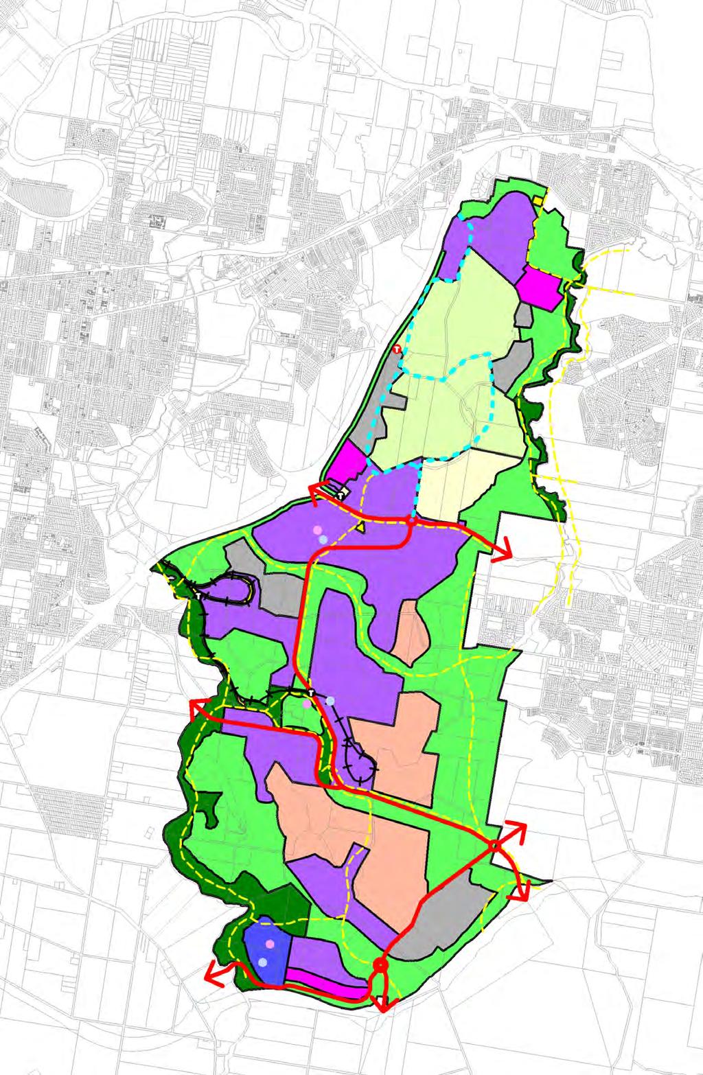
10 Part 6 Regionally Significant Business Enterprise and Industry Areas (5) Swanbank New Chum Preferred Pattern of Development NOTE 6.7D (1) The Land Use Concept Master (LUCMP) for the development of the Swanbank New Chum is shown on Figure (2) The LUCMP provides an indicative footprint for future development. (3) The LUCMP is the long term planning guide for development within the Swanbank New Chum area and shows indicative land use designations and structural elements. (4) The LUCMP is not intended to prescribe the precise boundary of the indicative land use designations, and it is not intended that the LUCMP prescribe with complete accuracy the final location of uses within the broad conceptual land use designations. (5) The LUCMP incorporates the overall framework for transport and open space networks. (6) The structural elements are shown conceptually, based on the present level of knowledge and planning for constraints, and for these reasons the locations must not be regarded as absolutely definitive. (7) With further detailed flooding, drainage, threatened native flora and fauna, and mining (geotechnical) assessments, final locations of structural elements and land use patterns will be determined. Development Concepts Specific Outcomes The Swanbank New Chum area accommodates the following uses and works (A) clay extraction within Key Resource Areas; (B) intensive business enterprises; (C) land-extensive, business enterprises; (D) waste recycling and future rehabilitation areas; (E) environmental buffers; (F) recreation areas; (G) local service centres; (H) major transport corridors and inter suburban links; and tourist destinations. The uses and works within the Swanbank New Chum area are located and relate to each other in ways that (C) (D) (E) (F) (G) (A) create an urban structure which uses land efficiently and provides high levels of accessibility to transport, employment opportunities, open space and recreational opportunities; (B) create a sense of place through appropriate landscaping, streetscaping, urban design and building design; achieve a high standard of amenity with particular regard to minimising environmental and amenity impacts on existing and proposed residential areas and promoting overall visual attractiveness; protect important areas of ecological significance and develop an overall greenspace setting through the protection of remnant native vegetation and supplementary planting on the visually prominent hillsides, ridgelines and creeklines; provide necessary infrastructure as development proceeds; facilitate sustainable water usage, particularly where relating to water sensitive design and the use of recycled water; and provide access for workers and adequate freight connections to the Regional Transport Network. 6-8 December 2013
11 Part 6 Regionally Significant Business Enterprise and Industry Areas General Business and Industry (Medium Impact) NOTE 6.7E (1) The land is extensively affected by past undermining activities. (2) Owing to the more intensive nature of activities located in these areas, water cycle infrastructure and industrial standard road access are required. (3) Development within this area is to ensure there is no significant adverse amenity impacts on the use of the Schedule 2 listed homestead known as Cooneana for tourism and community uses. (4) It is intended that this land be included within the Regional Business and Industry Zone Medium Impact Sub Area. Specific Outcomes Uses situated within close proximity to the power generation plant are designed to benefit from co-generation activities. Uses such as brick making which have synergies with clay extraction within a Key Resource Area are generally supported, subject to satisfactorily addressing any relevant environmental or amenity impacts. Where necessary, infrastructure services and building foundations are designed to withstand subsidence events. (iv) New uses or works are connected to a sewer system or an appropriate on-site effluent treatment and disposal system. (v) Uses or works which have significant environmental impacts including air, water, noise, odour, dust and vibration emissions outside of the designated Business and Industry areas, are avoided. (vi) Iconic/landmark buildings feature on prominent gateway and corner sites. (vii) Degraded lands are rehabilitated or repaired. (viii) Uses fronting the Cunningham Highway incorporate an adequate screening buffer or present quality building facades and associated landscape treatment where readily seen from the transport corridor. General Business and Industry (Low Impact) NOTE 6.7F (1) The General Business and Industry (Low Impact) Area is the interface between urban and residential development in the Ripley Valley to the west and south and the General Business and Industry Zone to the north. (2) It is intended that this land be included within the Regional Business and Industry Zone Low Impact Sub Area. Specific Outcomes The General Business and Industry (Low Impact) Area is a primary job generator for the residents of Ripley Valley. Development is of a high quality with:- (A) service and delivery vehicle access generally to the rear of buildings; (B) parking is generally located to the rear of buildings, not the street frontage; (C) well defined and legible pedestrian entries are provided to the street frontage; (D) large expanses of roof visible from adjoining residential areas are generally avoided. (E) Iconic/landmark buildings feature on prominent gateway and corner sites Low rise, well landscaped uses and works exhibit a high quality of urban design particularly to street frontages, with building complexes generally characterised by a mix of tenancies and opportunities for shared access and parking. (iv) A mix of business and industry activities are provided which do not generate emissions/impacts and safety risks unacceptable in an area close to residential or other sensitive land uses. (v) Uses are predominantly conducted in buildings with suitable noise emission attenuation and are sited, designed and constructed to ameliorate the adverse impacts on the amenity of nearby land. (vi) Particular attention is given to mitigating potential noise impacts for nearby residents on the periphery of the Sub Area. (vii) Emission generating activities and outdoor storage areas are orientated away from residential areas. (viii) Appropriate measures may include (A) minimal to no openings in building walls facing residences; (B) enclosure or other suitable acoustic mitigation treatments for machinery; (C) placement and screening of outdoor storage and work areas; and (D) provision of adequate physical separation and appropriate landscaped treatment including establishing planted buffer areas and vegetated acoustic mounds or fencing. (ix) Heavy vehicular access via the Ripley Valley Urban Core and Secondary Urban Centre East is avoided so as not to adversely impact on the amenity of nearby residential areas. December
12 Part 6 Regionally Significant Business Enterprise and Industry Areas (d) (x) Desirable uses include- (A) business and industry training establishments; (B) clean manufacturing and high technology industries (e.g. computer, laser, robotics, electronics, medical and communications technology); (C) equipment hire; (D) indoor recreation; (E) general industries; (F) outdoor sales and storage yards; (G) research and laboratories; (H) service trades uses; (I) small scale repair and maintenance premises; (J) storage areas; (K) support business, commercial and community services/activities; (L) trade sales, fitting, servicing and repairs; (M) transport depots; (N) vehicle sales premises and automotive parts sales, fitting, servicing and repairs; and (O) warehousing and distribution. Business Park NOTE 6.7G (1) This land is generally not significantly affected by past undermining activities, however the land surface may be partially affected by surface mining operations. (2) Owing to the nature of activities located in these areas, water cycle infrastructure and industrial standard road access are required. (3) This land is the Regional Business and Industry interface with the Ripley Valley Urban Core and Secondary Urban Centre East. (4) It is intended that the land be included in the Business Park Zone. Specific Outcomes Uses or Works which have significant environmental impacts including air, water, noise, odour, dust and vibration are avoided. Infrastructure services and buildings are designed to withstand potential subsidence and flooding events. New uses or works are connected to a sewer system. (iv) New uses and works present a high standard of visual amenity with regard to their built form and landscaped setting. (v) Iconic/landmark buildings feature on prominent gateway and corner sites. (vi) Access is from the internal road network, not the Centenary Highway Extension. (e) Land-Extensive, Business Enterprises NOTE 6.7H (1) This land is generally constrained by past underground or surface (open cut) mining operations. (2) In some cases the land is still being utilised for clay extraction or has been identified as a future clay resource for brick, tile and paver manufacture. (3) The land is generally not serviced by the Local Government s water cycle infrastructure. (4) Existing road infrastructure is generally not of an industrial standard. (5) The land contains pockets of remnant native vegetation. (6) It is intended that this land be included within the Regional Business and Industry Investigation Zone (refer Part 6, Division 5). Specific Outcomes Sites maintain a broad acre, greenspace setting, with the retention, where possible, of remnant native vegetation together with supplementary planting to enhance visual amenity. Outdoor recreational pursuits such as adventure sports and off road vehicle parks are generally supported where safe and do not cause conflict with industrial uses. Uses such as brick making which have synergies with clay extraction within a Key Resource Area are generally supported, subject to satisfactorily addressing any relevant environmental or amenity impacts. (iv) Buildings and structures are generally of a light weight construction and capable of adjusting footings and bracings to accommodate subsidence events. (v) Plant, equipment and storage areas are located or screened so that (A) materials and products are not visible from a road or public right of way or nearby residential area (either existing or proposed); and (B) environmental and amenity impacts are contained within the designated business and industry area. (vi) Building facades are of a high visual standard where viewed from- (A) a public thoroughfare; or (B) a nearby residential area (either existing or proposed). (vii) Infrastructure services are designed to withstand subsidence events. (viii) New uses or works are connected to a sewer system or an appropriate on-site effluent treatment and disposal system December 2013
13 Part 6 Regionally Significant Business Enterprise and Industry Areas (f) (ix) Uses or works which have significant environmental impacts including air, water, noise, odour, dust and vibration emissions outside of the designated business and industry areas are avoided. (x) Degraded lands are rehabilitated or repaired. (xi) Suitable road infrastructure is provided to support industrial land uses. Waste Recycling/Future Rehabilitation Area NOTE 6.7I (1) This land is generally constrained by past underground or surface (open cut) mining operations. (2) In some cases the land is still being utilised for clay mining or has been identified as a future clay resource for brick, tile and paver manufacture. (3) The land is generally not serviced by the Local Government s water cycle infrastructure. (4) Existing road infrastructure is generally not of an industrial standard. (5) The land contains pockets of remnant native vegetation. (6) Land fill sites are to be progressively rehabilitated and form part of the open space network. (7) Land fill sites that are suitably rehabilitated may be utilised for appropriate industrial activities. (8) It is intended that this land be included within the Regional Business and Industry Investigation Zone (refer Part 6, Division 5). Specific Outcomes Sites maintain a broad acre, greenspace setting with the retention where possible, of remnant native vegetation together with supplementary planting to enhance visual amenity. Buildings and structures are generally of a light weight construction and capable of adjusting footings and bracings to accommodate subsidence events. Plant, equipment and storage areas are located or screened so that (A) materials and products are not visible from a road or public right of way or nearby residential area (either existing or proposed); and (B) environmental and amenity impacts are contained within the designated business and industry area. (iv) Infrastructure services are located and designed to withstand subsidence, collapse, fire or flooding. (g) (v) New uses or works are connected to a sewer system or an appropriate on-site effluent treatment and disposal system. (vi) Uses or works which have significant environmental impacts including air, water, noise, odour and vibration emissions outside of the designated business and industry areas are avoided. (vii) Degraded lands are rehabilitated or repaired. (viii) Land fill operations do not compromise the future rehabilitation and repair of the site for open space uses. (ix) Voids may be used for the disposal or recycling of waste products and the generation of soil conditioners and commercial gases provided it can be demonstrated with a high degree of certainty that such activities will not cause adverse environmental impacts or significantly affect the amenity of nearby residential areas, either existing or proposed. (x) suitable road infrastructure is provided to support industrial land uses. Regional Business and Industry Investigation Areas NOTE 6.7J (1) Land within the Investigation Areas may have the potential for intensification of land uses. (2) These areas are subject to extensive and significant impacts from mining and are further constrained by flooding and existing and planned residential areas to the east, west. north and south. (3) Where buildings are sought to be erected, the proposal is to be supported by detailed geotechnical investigations. (4) It is intended that comprehensive Concept Plans be prepared to provide for the integrated development of Regional Business and Industry Investigation Areas in a progressive and coordinated manner with appropriate interface between land use activities. (5) Such plans will assist in the clarification of development issues for the proponent/developer, land owners, the local community, the local government and relevant state agencies (if any). (6) These plans may be dealt with under the IDAS process as a preliminary approval under Section of IPA. (7) The Concept Plans may be prepared by landowners, groupings of landowners, developers with the permission of landowners, or by Council. (8) Concept Plans should include as supporting information December
14 Part 6 Regionally Significant Business Enterprise and Industry Areas (h) Note 6.7J cont. a transport impact assessment; a mining subsidence assessment; a townscape and visual amenity appraisal; (d) a native flora and fauna assessment; (e) an acoustic assessment; (f) a hazard and risk assessment; (g) an infrastructure works assessment; and (h) an open space and recreation needs assessment. [For further information also refer to Planning Scheme Policy 2 Information the Local Government May Request.] (9) A Concept Plan incorporates and address the relevant provisions relating to the specific Sub Area see Section 6.15(15). (10) The preparation of Concept Plan(s) for the Swanbank New Chum Sub Area, gives particular regard to the provisions contained within section 6.7(4). Specific Outcomes Development occurs in accordance with the provisions of Part 6, Division 5 Regional Business and Industry Investigation Zone. Special Opportunity NOTE 6.7J (1) This area supports current and future local government operations. (2) The area may provide opportunities for a broad range of business and industry uses, depot, animal management centre and plant nursery. (3) Land in the western portion of this area contains the Ipswich Historical Society and the Schedule 2 listed homestead Cooneana. Specific Outcomes Primary access to premises should be avoided from Redbank Plains Road where possible. Uses and works maintain visual amenity where readily viewed from Redbank Plains Road. Buffer/Greenspace NOTE 6.7K (1) The primary intent of the buffer/greenspace areas is to separate business and industry uses from other sensitive uses, particularly nearby residential areas (both existing and proposed); and retain significant areas of existing native vegetation and undertake supplementary planting, where necessary, to NOTE 6.7K cont. enhance buffer and screening effects; and secure riparian and other wildlife corridors. (2) New uses and works may be provided where they are able to demonstrate that they will have minimal impact on nearby sensitive use areas, are compatible with nearby existing or proposed business and industry activities and are generally land extensive or low yield activities having minimal building requirements. (3) It is intended that this land be included within the Regional Business and Industry Buffer Zone (Part 6, Division 6). Specific Outcomes Existing vegetation is retained and, where necessary, enhanced with supplementary planting, preferably of local native vegetation, to (A) enhance buffer and screening effects; and (B) provide riparian and other wildlife corridors. Densely planted buffers are provided to (A) nearby sensitive use areas; (B) designated roads; and (C) designated watercourses. Uses and works maintain visual amenity and protect and enhance important landscape elements having regard to (A) boundary clearances and the provision of space around buildings; (B) noise attenuation; (C) vegetation protection within buffer areas; (D) appropriate landscape treatment of buffer areas and street frontages or where adjoining sensitive land uses; and (E) the form, scale, bulk, style, siting, orientation, roof lines, materials and detailing of buildings. (iv) Uses and works are located and designed to minimise risk and nuisance to people and property. (v) Degraded or contaminated sites are rehabilitated and used for broad hectare recreational, environmental and land extensive business enterprises where there is generally no impact on nearby residential uses. (vi) In addition to the buffering function, the areas 6-12 December 2013
15 Part 6 Regionally Significant Business Enterprise and Industry Areas (j) (A) conserve (I) places or features of particular habitat significance; (II) the diversity of habitats for flora and fauna; (III) land which acts as wildlife corridors; and (IV) natural areas of particular importance in terms of scenic amenity; and (B) provide pedestrian and cycle paths connecting (I) the Brisbane River, Riverview, Collingwood Park and Redbank Plains to Six Mile Creek and the White Rock Nature Reserve; and (II) Blackstone and the Ripley Valley to Bundamba Creek, Daly s Lagoon and the White Rock Nature Reserve. (vii) Uses and works within the Buffer Areas are located, designed and managed to (A) conserve the natural features of the land; (B) minimise soil erosion, landslip and siltation of watercourses; (C) maintain, and where possible, enhance the scenic value and visual quality of particularly prominent ridgelines; (D) maintain the safety of people, buildings and works; and (E) avoid significant adverse effects on the natural environment. (viii) New uses or works are connected to a sewerage system or an appropriate on-site effluent treatment and disposal system. Recreation NOTE: 6.7L (1) The open space setting of the Swanbank New Chum Area presents important opportunities to- conserve the greenspace frame/setting provided by the creeks, gullies and ridgelines; and develop an integrated open space network focussed on the main drainage corridors and creeks (Bundamba, Six Mile and Oakey Creeks). (2) The recreation designation includes- a mix of active and passive recreational activities and facilities; linear parkland and open space movement and drainage corridors; (k) NOTE 6.7L cont. a mix of formal, informal and natural settings; (d) mostly public owned land, but may include privately owned and operated recreational facilities and other community facilities; and (e) key wildlife corridor linkages. (3) It is intended that the areas will be protected and enhanced for their environmental values, particularly as wildlife habitats and important linkages. (4) The recreation designation along Bundamba Creek serves the Ripley Valley, providing Citywide and local level functions. (5) It is intended that this land be included in the Recreation Zone (refer Part 6, Division 8). Specific Outcomes An open space network is established as outlined within Figure which- protects the greenspace setting and overall visual framework for the industrial areas; provides form and identity, and a sense of place ; protects significant ecosystems; and (d) provides an integrated network, catering for a wide range of recreation pursuits for workers and visitors. Local Service Centres NOTE:6.7M (1) Local Service Centres provide local employment opportunities and services (commercial and retail) for industrial areas, primarily in the form of service uses and community facilities. (2) The local service centres network is intended to provide services only to the industrial estate. (3) The location of the local service centres are: indicative and not fixed at this stage, final positions will be confirmed during more detailed site planning; generally located at the junction of major transport corridors; and highly accessible to users (particularly employees) of industrial areas. (4) The Local Retail and Commercial Zone (refer Part 4, Division 10) should be used for comparison purposes to assist with planning and interpretation. Specific Outcomes Local service centres are distributed in locations accessible to the local workers which they are intended to serve. December
16 Part 6 Regionally Significant Business Enterprise and Industry Areas (l) (m) The centres are a major focus for the immediately surrounding local industrial areas and are reinforced with the co-location of other relevant land use activities such as parks and community facilities (such as child care centres). The local service centres incorporate enhanced landscaped treatment, urban design and building design in order to reinforce a distinctive sense of place. (iv) The individual size of each neighbourhood centre does not exceed 2000m 2 for Business Uses, General Store or a Shopping Centre. Transport and Movement System Specific Outcomes An efficient north-south connection links Chum Street to Redbank Plains Road and Redbank Plains Road to the Centenary Highway. Where possible heavy industrial and local traffic are separated. The internal road network provides convenient connections for local traffic movements. (iv) A strategic pedestrian/bicycle network is provided as set out in Figure (v) The main approach and circulation routes are developed as distinctive tree planted boulevards, rather than simply as transport conduits. (vi) Buffers are maintained to highways, regional transport corridors and other major roads to protect and enhance the visual amenity for transport users and other adjacent sensitive land uses by (A) the retention of existing vegetation and supplementary planting to create or enhance a screening effect; (B) locating uses and works to provide the maximum separation possible to transport corridors, including provision of larger lot sizes to increase separation between the transport corridor and buildings and activities on new lots, or other screening measures recommended as a result of a detailed visual assessment; and (C) the minimisation of signage. Tourist Facilities NOTE 6.7N (1) Figure depicts both existing and possible future tourist facility nodes. (2) The existing locations focus on the Swanbank Steam Train rides, whilst the future nodes focus on water features and a prominent hilltop lookout site. Specific Outcomes The Swanbank historic train rides continue. Other tourism and visitor related activities including lookouts, industrial tourism or adventure tourism, are established. Infrastructure services and buildings are designed to withstand subsidence events where necessary. (iv) New uses or works are connected to a sewer system or an appropriate on-site effluent treatment and disposal system. (v) New uses or works which have significant environmental impacts including air, water, noise, odour and vibration emissions outside of the designated business and industry area, are avoided. (vi) Degraded lands are rehabilitated or repaired. (6) Existing Approved Uses NOTE 6.7O The Swanbank area, has four precincts, as outlined on Figure 6.7.2, with existing approved use rights as outlined in Table 6.1. Table 6.1: Swanbank Precincts Existing Approved Uses Precinct Reference 1 Electricity Purposes Existing Approved Use 2 Compost Manufacture; Recycling and Reprocessing of Environmentally-Regulated Waste-Sludge: General Waste Disposal Facility Inert Hardfill up to 200,000 tonnes/annum and Vehicle Access between Power Station and Ash Dam 3 Waste Processing, Treatment and Disposal in accordance with the Plan of Development No /001C 4 Waste Recycling, Composting and Disposal, Land Rehabilitation, Truck Depot and Park with ancillary uses of Leachate Collection, Treatment and Disposal, Landfill, Gas Collection, Treatment, Storage and Disposal, Crushing of Spoil Pile Material, Vegetation Propagation for Rehabilitation and Caretakers Flat generally in accordance with Plan of Development TP-61/90 Further details in relation to each of these precincts may be obtained from the Ipswich City Council Geographic Information System December 2013
17
Division 13 Local Business and Industry Buffer Zone: Assessment Criteria and Assessment Tables
 Division 13 Local Business and Industry Buffer Zone: Assessment Criteria and Assessment Tables 4.13.1 Local Business and Industry Buffer Zone The provisions in this division relate to the Local Business
I615. Westgate Precinct
 I615. Westgate Precinct I615.1. Precinct Description The Westgate Precinct is located approximately 18km west of the Auckland city centre. There are seven Sub-precincts in the Westgate Precinct: Sub-precinct
IMPLEMENTATION GUIDELINE NO. 25
 IMPLEMENTATION GUIDELINE NO. 25 New Chum Enterprise Area Planning Study Date of Resolution These guidelines were originally adopted by Council on 25 January 2012 and took effect from the 9 February 2012,
The Proposed Auckland Unitary Plan (notified 30 September 2013)
") 3 Business zones Introduction There are 10 business zones in the Unitary Plan: City Centre Metropolitan Centre Town Centre Local Centre Neighbourhood Centre Mixed Use General Business Business Park Light
3 Business zones Introduction There are 10 business zones in the Unitary Plan: City Centre Metropolitan Centre Town Centre Local Centre Neighbourhood Centre Mixed Use General Business Business Park Light
SECTION 7A: WHAKARONGO RESIDENTIAL AREA
 SECTION 7A: WHAKARONGO RESIDENTIAL AREA CONTENTS 7A.1 Introduction 1 7A.2 Resource Management Issues 1 7A.3 Objectives and Policies 1 7A.4 Methods 4 7A.5 Residential Zone 4 7A.5.1 Rules: Controlled Activities
Contents of Part 6. Part 6 Zones
 Contents of Part 6 Part 6 Zones... 6-1 6.1 Preliminary... 6-1 6.2 Zone codes... 6-3 6.2.1 Low density residential zone code... 6-3 6.2.1.1 Application... 6-3 6.2.1.2 Purpose and overall outcomes... 6-3
The West Vaughan Employment Area Secondary Plan Policies
 Part 2: The West Vaughan Employment Area Secondary Plan Policies 2.1 General Policies It is the policy of Council: 2.1.1. That the West Vaughan Employment Area (the WVEA), identified on Schedule 1, will
Tāhuhu whakaruruhau ā-taone The sheltering ridge pole
 B2. Tāhuhu whakaruruhau ā-taone - Urban growth and form B2.1. Issues Tāhuhu whakaruruhau ā-taone The sheltering ridge pole Auckland s growing population increases demand for housing, employment, business,
RURAL ZONE - POLICY. Rural Zone Policy. Issue: Rural Environment. Ruapehu District Plan Page 1 of 8
 Rural Zone Policy RU2 RURAL ZONE - POLICY RU2.1 Introduction The natural resources of the rural environment in the Ruapehu District provide the basis for the existing and potential character, intensity
Division 7 Character Areas Housing Zone: Assessment Criteria and Assessment Tables
 Division 7 Character Areas Housing Zone: Assessment Criteria and Assessment Tables 4.7.1 Character Areas Housing Zone The provisions in this division relate to the Character Areas Housing Zone as follows
Part 10 Other plans
 Contents of Part 10 Part 10 Other plans... 10-1 10.1 Preliminary... 10-1 10.2 Palmview Structure Plan... 10-2 10.2.1 Preliminary... 10-2 10.2.2 Master Strategic Framework... 10-6 10.2.3 Master Precincts
Division 10 Local Retail and Commercial Zone: Assessment Criteria and Assessment Tables
 Division 10 Local Retail and Commercial Zone: Assessment Criteria and Assessment Tables 4.10.1 Local Retail and Commercial Zone The provisions in this division relate to the Local Retail and Commercial
Section 3b: Objectives and Policies Rural Environment Updated 19 November 2010
 Page 1 of Section 3b 3b RURAL ENVIRONMENT 3b.1 Introduction The Rural Environment comprises all the land outside of the Residential, Town Centre and Industrial Environments. Most land within the District
I539. Smales 2 Precinct
 I539. Smales 2 Precinct I539.1. Precinct Description The Smales 2 Precinct applies to a 4.8 hectare block of land located on the southern side of Northcote Road and fronting Lake Pupuke, Takapuna. The
NORTH EAST INDUSTRIAL ZONE
 SECTION 12A: NORTH EAST INDUSTRIAL ZONE CONTENTS 12A.1 Introduction 1 12A.2 Resource Management Issues 2 12A.3 Objectives and Policies 3 12A.4 Rules: Permitted Activities 8 R12A.4.1 Permitted Activities
Plan Modification to Chapter B2 of the Auckland Unitary Plan(AUP) Operative in part (15 November 2016)
 Operative in part (15 November 2016)") UNITARY PLAN UPDATE REQUEST MEMORANDUM TO FROM Phill Reid Linley Wilkinson DATE 25 September 2018 SUBJECT Plan Modification to Chapter B2 of the Auckland Unitary Plan(AUP) Operative in part (15 November
UNITARY PLAN UPDATE REQUEST MEMORANDUM TO FROM Phill Reid Linley Wilkinson DATE 25 September 2018 SUBJECT Plan Modification to Chapter B2 of the Auckland Unitary Plan(AUP) Operative in part (15 November
and services The protection and conservation of environmentally significant and sensitive natural heritage features and functions.
 6. Land Use 6.0 Preamble A healthy and livable city is one in which people can enjoy a vibrant economy and a sustainable healthy environment in safe, caring and diverse neighbourhoods. In order to ensure
GREENBANK DEVELOPMENT MASTERPLAN
 DEVELOPMENT MASTERPLAN POTENTIAL TRAIN STATION COMMUNITY CENTRE Greenbank will be a connected masterplanned community providing easy access to local and surrounding amenity. Affordable quality homes, green
22.15 OUTDOOR ADVERTISING SIGNAGE POLICY
 22.15 OUTDOOR ADVERTISING SIGNAGE POLICY This policy applies to all land where a planning permit is required to construct or display a sign under the provisions of the Kingston Planning Scheme. 22.15-1
6.6.2 Emerging Community Zone Code Application Purpose and overall outcomes. s6 Zone Codes Emerging Community and Township Zone Codes
 6.6.2 Emerging Community Zone Code 6.6.2.1 Application This code applies to assessable development:- (1) within the Emerging Community Zone as identified on the zoning maps contained within Schedule 2
UNIVERSITY TOWN NEIGHBOURHOODS 5.2 ECO-CORRIDOR MELBOURNE CAMPUS MASTER PLAN 2014
 5.2 ECO-CORRIDOR 37 ECO-CORRIDOR EXISTING CONDITIONS & VISION NEIGHBOURHOOD VISION Investment in the Eco-corridor Neighbourhood will signify the University s commitment to supporting local ecology and
Part 4.25 Pasminco Area Plan
 1 INTRODUCTION The purpose of this Area Plan is to guide the redevelopment of the former Pasminco Cockle Creek Smelter site and the former Incitec Pivot Fertilizer site. The Pasminco and Incitec sites
4 RESIDENTIAL ZONE. 4.1 Background
 4 RESIDENTIAL ZONE 4.1 Background The residential areas within the City are characterised by mainly lowrise dwellings sited on individual allotments. Past architectural styles, settlement patterns and
Schedule of Planning Applications Committee Date: 23 May Reference: 06/17/0726/F Parish: Hemsby Officer: Mr J Beck Expiry Date:
 Schedule of Planning Applications Committee Date: 23 May 2018 Reference: 06/17/0726/F Parish: Hemsby Officer: Mr J Beck Expiry Date: 22-05-2018 Applicant: Proposal: Site: Mr Gillett Change of use to the
AMENDMENTS. Date Effective. Amendment No. Council. DCP 14 Davidson St, Greenacre Page 2
 AMENDMENTS Amendment No. Description Adopted by Council Date Effective DCP 14 Davidson St, Greenacre Page 2 TABLE OF CONTENTS 1.0 INTRODUCTION... 4 1.1 NAME OF THIS PLAN... 4 1.2 COMMENCEMENT OF DEVELOPMENT
The Proposed Auckland Unitary Plan (notified 30 September 2013)
") 8 Special Purpose zones 8.1 Airport zone The Airport zone applies to the Kaipara Flats Airfield, North Shore Airfield, Auckland International Airport and Ardmore Airport. Auckland International Airport
8 Special Purpose zones 8.1 Airport zone The Airport zone applies to the Kaipara Flats Airfield, North Shore Airfield, Auckland International Airport and Ardmore Airport. Auckland International Airport
Keystone Business Park Precinct Structure Plan North East Industrial Precinct. Part 2 Design Principles
 Keystone Business Park Precinct Structure Plan North East Industrial Precinct Part 2 Design Principles Context Issues Services Landform Issues Geotech and contamination Ecology Traffic and access Issues
4 Residential and Urban Living Zones
 4 Residential and Urban Living Zones Refer to Chapters 11 to 20 for additional rules that may apply to these zones. 4.1 OBJECTIVES AND POLICIES Objective Res1 Policy 1 Policy 2 Policy 3 Policy 4 Policy
DAVENPORT VILLAGE SECONDARY PLAN
 27 DAVENPORT VILLAGE SECONDARY PLAN 27. DAVENPORT VILLAGE SECONDARY PLAN 1. VISION FOR THE DAVENPORT VILLAGE SECONDARY PLAN Davenport Village, municipally known as 830, 940, 980 and 1100 Lansdowne Avenue,
3. STATEMENTS OF DESIRED CHARACTER FOR PLANNING AREAS AND PRECINCTS
 3.30 Planning Area No. 30 Mary River Valley 3.30.1 Location and Role This Planning Area encompasses rural lands in the western part of the Shire. These lands are located within the catchment area of the
APPENDIX K WINDSOR OFFICIAL PLAN
 CEAA ENVIRONMENTAL ENVIRONMENTAL IMPACT ASSESSMENT AMBASSADOR BRIDGE ENHANCEMENT PROJECT Replacement Span and Plaza Expansion APPENDIX K WINDSOR OFFICIAL PLAN Avalon Consulting Professionals of Ontario,
OFFICE CONSOLIDATION SECONDARY PLAN AREA 22 THE BRAMALEA SOUTH INDUSTRIAL SECONDARY PLAN
 OFFICE CONSOLIDATION SECONDARY PLAN AREA 22 THE BRAMALEA SOUTH INDUSTRIAL SECONDARY PLAN November 2010 EXPLANATORY NOTES (Secondary Plan Area 22) General (pertaining to all secondary plan office consolidations)
SQUAMISH 2010 AND BEYOND COMMUNITY VISION
 Our plan has been imagined and created to be both pragmatic and visionary. At the core of the strategy is a consideration of the highway s role and its impact on the community. First and foremost in creating
8.0 Design and Form of Development 43/
 42/ 8.0 Design and Form of Development 43/ Rothwells Farm, Golborne/ Development Statement Figure 7. Site Constraints Key 44/ Site Boundary 360 Bus Route/Stops Existing Trees Underground Water Pipe Sensitive
CONTENTS 8.0 LAND USE 8.1 GENERAL LAND USE 8.2 RESIDENTIAL 8.3 MIXED USE 8.4 COMMERCIAL 8.5 EMPLOYMENT LANDS
 8-2 Land Use 8.0 LAND USE CONTENTS 8.1 GENERAL LAND USE 8.1.1 Uses provided for in all Land Use Designations 8.1.2 Uses prohibited in Hazardous Lands, Hazardous Sites and Special Policy Areas 8.1.3 Uses
THE GARDEN CITY PLAN. City of St. Catharines Official Plan. City of St. Catharines
 THE GARDEN CITY PLAN City of St. Catharines Official Plan City of St. Catharines August 2010 APPROVAL INFORMATION This Official Plan of the City of St. Catharines Planning Area, known as the Garden City
URBAN DESIGN BRIEF URBAN DESIGN BRIEF 721 FRANKLIN BLVD, CAMBRIDGE August 2018
 URBAN DESIGN BRIEF URBAN DESIGN BRIEF 721 FRANKLIN BLVD, CAMBRIDGE August 2018 DESIGN BRIEF CONTENTS PART A 1.0 INTRODUCTION 2.0 DESCRIPTION & ANALYSIS OF SITE CONTEXT 3.0 DESIGN CONSTRAINTS AND OPPORTUNITIES
COMMUNITY DESIGN. GOAL: Create livable and attractive communities. Intent
 COMMUNITY DESIGN Intent An attractive, well-designed County will attract quality development, instill civic pride, improve the visual character of the community, and create a strong, positive image for
Next Steps / Development Process. Structure Plan. June submitted to City of Fremantle. Structure Plan. July supported for advertising
 overview What is today about? In July 0, the City of Fremantle resolved that the be advertised for public comment. Today is about: Understanding the history and context of the site Having your say on the
Section Three, Part 16 Takanini Structure Plan Area
 PART 16 TAKANINI STRUCTURE PLAN AREA 16.1 Residential 8 zone 16.1.1 Objectives and Policies 16.1.2 Rules: General 16.1.3 Rules: Activity Status Subdivision (Except within the Addison Neighbourhood Centre)
Complete Neighbourhood Guidelines Review Tool
 Complete Neighbourhood Guidelines Review Tool Prepared By: City of Regina Planning Department October 2014 Page 1 of 14 Community Development Review Checklist for Secondary Plans and Concept Plans The
Welcome. Walk Around. Talk to Us. Write Down Your Comments
 Welcome This is an information meeting introducing the applications for proposed redevelopment of the Yorkdale Shopping Centre site at 3401 Dufferin Street and 1 Yorkdale Road over the next 20+ years,
H14. Business General Business Zone
 H14. Business General Business Zone H14.1. Zone description The Business General Business Zone provides for business activities from light industrial to limited office, large format retail and trade suppliers.
I611. Swanson North Precinct
 I611. Swanson North Precinct I611.1. Precinct Description Swanson North is located in the north eastern foothills of the Waitakere Ranges. It is outside the Waitakere Ranges Heritage Area Act and the Waitakere
11.3 SPECIAL CHARACTER ZONE HAWKE S BAY REGIONAL SPORTS PARK
 11.3 SPECIAL CHARACTER ZONE HAWKE S BAY REGIONAL SPORTS PARK 11.3.1 INTRODUCTION The availability of sports and recreation activities and facilities is important for the maintenance and enhancement of
Division 5 Reconfiguring a Lot Code
 Division 5 Reconfiguring a Lot Code 12.5.1 Reconfiguring a Lot Code The provisions in this division comprise the Reconfiguring a Lot Code. They are compliance with the Reconfiguring a Lot Code (section
Urban Design Manual PLANNING AROUND RAPID TRANSIT STATIONS (PARTS) Introduction. Station Study Areas
 Introduction. Station Study Areas") 111111 PLANNING AROUND RAPID TRANSIT STATIONS (PARTS) Introduction The ION rapid transit system will link Waterloo, Kitchener and Cambridge through a central transit corridor (CTC). There are a number
111111 PLANNING AROUND RAPID TRANSIT STATIONS (PARTS) Introduction The ION rapid transit system will link Waterloo, Kitchener and Cambridge through a central transit corridor (CTC). There are a number
Chapter 5 Urban Design and Public Realm
 5.1 Introduction Public realm is all areas of the urban fabric to which the public have access. It is where physical interaction takes place between people. It therefore, includes buildings and their design,
Planning Proposal Charlestown Swim and Leisure Centre LEP Amendment
 Planning Proposal Charlestown Swim and Leisure Centre LEP Amendment Amendment No. 4 to Lake Macquarie Local Environmental Plan 2014 (PP_2014_LAKEM_005_00) Local Government Area: Name of Draft LEP: Lake
MASTER PLAN NO. 60 (SITE DEVELOPMENT PLAN EASTBANK/REGATTA NORTH PRECINCTS 2 4) 2008
 2008") Page 2 TABLE OF CONTENTS PAGE 1 PRELIMINARY... 5 1.1 CITATION... 5 1.2 TYPE OF MASTER PLAN... 5 1.3 LEGAL REQUIREMENT FOR MASTER PLAN... 5 1.4 LEGAL EFFECT OF THE MASTER PLAN... 5 2 DESCRIPTION OF LAND...
Page 2 TABLE OF CONTENTS PAGE 1 PRELIMINARY... 5 1.1 CITATION... 5 1.2 TYPE OF MASTER PLAN... 5 1.3 LEGAL REQUIREMENT FOR MASTER PLAN... 5 1.4 LEGAL EFFECT OF THE MASTER PLAN... 5 2 DESCRIPTION OF LAND...
OFFICE CONSOLIDATION CHAPTER 47 HIGHWAY 427 INDUSTRIAL SECONDARY PLAN
 OFFICE CONSOLIDATION CHAPTER 47 HIGHWAY 427 INDUSTRIAL SECONDARY PLAN NOTE: This Secondary Plan is partially in effect. Highlighted sections are under appeal. August 2017 1 EXPLANATORY NOTE Office Consolidation
Chapter 5: Natural Resources and Environment
 NATURAL RESOURCES AND ENVIRONMENT 5-1 5 Chapter 5: Natural Resources and Environment BACKGROUND AND INTENT Urban expansion represents the greatest risk for the future degradation of existing natural areas,
APPENDIX C. Architectural and Environmental Design Standards. Environmentally sensitive areas should be protected.
 APPENDIX C Architectural and Environmental Design Standards Environmentally Sensitive Areas Goal A. Environmentally sensitive areas should be protected. Development, such as roads, houses, and other structures,
North Oakville East Parks Facilities Distribution Plan. November, 2009
 North Oakville East November, 2009 POLICY CONTEXT 1) Purpose a) The purpose of this document is to be a guide for the location, configuration, design and development of the parks system for the North Oakville
Amendments to the Palmview Structure Plan (amended text)
") Appendix A Amendments to the Palmview Structure Plan (amended text) Part 10 Other Plans 10.3 Palmview Structure Plan 10.3.1 Preliminary 10.3.1.1 Introduction This Part comprises the Palmview Structure
Appendix A Amendments to the Palmview Structure Plan (amended text) Part 10 Other Plans 10.3 Palmview Structure Plan 10.3.1 Preliminary 10.3.1.1 Introduction This Part comprises the Palmview Structure
Draft Eastern District Plan
 Draft Eastern District Plan Submission_id: 31238 Date of Lodgment: 13 Dec 2017 Origin of Submission: Online Organisation name: Turrulla Gardens Pty Ltd C/- Mecone Organisation type: Industry First name:
SAN RAFAEL GENERAL PLAN 2040 INTRODUCTION AND OVERVIEW
 SAN RAFAEL GENERAL PLAN 2040 INTRODUCTION AND OVERVIEW Steering Committee Presentation February 14, 2018 Purpose of General Plan Guide land use and development decisions Coordinate transportation, infrastructure,
4 Sustainability and Growth Management
 4 Sustainability and Growth Management Introduction Traditionally, has assumed growth and development with limited consideration for the long-term negative social, environmental or economic impacts on
SUSTAINABLE MANAGEMENT
 . Sustainable Management.1 The Concept of Sustainable Management The concept of sustainable management recognises there are limits to the use of natural and physical resources and there is a need to balance
Ripley Valley Master Planning Framework
 John Adams Planning Manager Ripley Valley Master Planning Framework Implementing Traditional Neighbourhood Design in a Queensland Context..and some other stuff. Australian Congress of New Urbanism February
CONTENTS 6.1 URBAN DESIGN
 6-2 Urban Design and Sustainable Development 6.0 URBAN DESIGN AND SUSTAINABLE DEVELOPMENT CONTENTS 6.1 URBAN DESIGN 6.1.1 General Policies 6.1.2 The Public Realm 6.1.3 Streets and Blocks 6.1.4 Streetscapes
Derry Green Corporate Business Park
 Town of Milton Derry Green Corporate Business Park Urban Design Guidelines BMI/Pace - June 2010 Draft 3 Prepared by: Brook McIlroy Planning + Urban Design / Pace Architects Suite 300-51 Camden Street Toronto,
Appendix 1 Structure plan guidelines
 Appendix 1 Structure plan guidelines This appendix forms part of the regional policy statement [rps]. 1.1. Introduction Structure plans are an important method for establishing the pattern of land use
Town of Cobourg Heritage Master Plan. Statutory Public Meeting
 Town of Cobourg Heritage Master Plan Statutory Public Meeting April 25 th 2016 Presentation Overview 1. Introduction 2. Project background and schedule overview 3. Review of strategic direction content
Toronto Complete Streets Guidelines
 Toronto Complete Streets Guidelines 108 110 7.1 Green Infrastructure Design Principles 112 7.2 Context-Sensitive Green Streets 114 7.3 Key Green Street Elements Green infrastructure refers to natural and
Table 8-4: Road Classification Local Roads, second table, of Chapter 8 Create a Multi-Modal City, be amended by adding the following:
 1 Port Street East Official Plan Amendment APPENDIX 3 Amendments to Mississauga Official Plan Table 8-4: Road Classification Local Roads, second table, of Chapter 8 Create a Multi-Modal City, be amended
Part 12 Precinct Area Plans - Wyee West
 TABLE OF CONTENTS 1 INTRODUCTION... 1 1.1 BACKGROUND... 1 1.2 EXTENT OF AREA PLAN... 1 1.3 EXISTING CHARACTER... 2 1.4 ENVIRONMENTAL ATTRIBUTES AND CONSTRAINTS... 2 1.5 DESIRED FUTURE CHARACTER... 3 1.6
Westwind Developments Ltd. PIONEER LANDS AREA STRUCTURE PLAN - PROPOSED AMENDMENT
 FEBRUARY 2013 TABLE OF CONTENTS 1.0 BACKGROUND... 1 1.1 Amendment... 1 2.0 LOCATION & CONTEXT... 2 2.1 Land Ownership... 2 3.0 POLICY CONTEXT... 3 3.1 Municipal Development Plan... 3 3.2 Capital Region
ELMVALE ACRES SHOPPING CENTRE MASTER PLAN
 ELMVALE ACRES SHOPPING CENTRE MASTER PLAN Contents 1.0 INTRODUCTION... 2 2.0 LOCATION... 2 3.0 EXISTING CONTEXT... 2 4.0 VISION & GUIDING PRINCIPLES... 2 5.0 LAND USE AND BUILT FORM... 4 5.1 St. Laurent
DAREBIN PLANNING SCHEME AMENDMENT C137
 Who is the planning authority? Planning and Environment Act 1987 DAREBIN PLANNING SCHEME AMENDMENT C137 EXPLANATORY REPORT This amendment has been prepared by the Darebin City Council, who is the planning
URBAN DESIGN BRIEF. 2136&2148 Trafalgar Road. Town of Oakville
 URBAN DESIGN BRIEF 2136&2148 Trafalgar Road Town of Oakville Prepared By: METROPOLITAN CONSULTING INC For 2500674 Ontario Inc November 2016 TABLE OF CONTENTS Page No. 1.0 Introduction/Description of Subject
HURON COMMUNITY PLAN
 CITY OF KITCHENER DEPARTMENT OF DEVELOPMENT AND TECHNICAL SERVICES PD 94/7 HURON COMMUNITY PLAN Recommended by Planning and Economic Development Committee: October 31, 1994 Adopted by Kitchener City Council:
DOMINION BOULEVARD CORRIDOR STUDY AND ECONOMIC DEVELOPMENT STRATEGIC PLAN A MODEL FOR CHESAPEAKE S FUTURE
 DOMINION BOULEVARD CORRIDOR STUDY AND ECONOMIC DEVELOPMENT STRATEGIC PLAN A MODEL FOR CHESAPEAKE S FUTURE Overview I. Draft Plan Process II. Draft Plan Overview a. Market Analysis b. Master Land Use Plan
Northern Territory Compact Urban Growth Policy
 Northern Territory Compact Urban Growth Policy A Reference Policy Document to clause 2.7 (Reference to Policy) of the NT Planning Scheme May 2015 Table of Contents 1 Policy Setting... 3 1.1 Context for
6 PORT SYDNEY SETTLEMENT AREA
 Section 6 Port Sydney Page 61 6 PORT SYDNEY SETTLEMENT AREA 6.1 Basis and Principles Village of Port Sydney Waterfront Community Existing Services 6.1.1 Port Sydney is an historic settlement that has developed
Subdivision Design Criteria. Penihana North GUIDELINES TO THE RULES
 Created September 2013 Penihana North Subdivision Design Criteria GUIDELINES TO THE RULES This part of the Plan sets out the design criteria for subdivision in Penihana North. The criteria will be considered
H7 Open Space zones. (a) provide for the needs of the wider community as well as the needs of the community in which they are located;
 provide for the needs of the wider community as well as the needs of the community in which they are located;") H7. Open Space zones H7.1. Background The majority of land zoned as open space is vested in the Council or is owned by the Crown. However some areas zoned open space are privately owned. While the open
H7. Open Space zones H7.1. Background The majority of land zoned as open space is vested in the Council or is owned by the Crown. However some areas zoned open space are privately owned. While the open
REMARKABLES PARK ZONE
 .10 Remarkables Park Zone.10.1 Resources, Activities and Values The Remarkables Park Area comprises approximately 150 hectares of perimeter urban land in the vicinity of Frankton and occupies a strategic
CHAPTER 5: GUIDING PRINCIPLES
 CHAPTER 5: GUIDING PRINCIPLES The following 10 principles were developed based on public consultation, planning policy and the background analysis conducted during Phase 1. The Guiding Principles significantly
AOTEA SUPERMARKET ZONE. Zone Introduction
 C18 AOTEA SUPERMARKET ZONE Zone Introduction C18.1 Objective This zone identifies a specific area in Aotea for a stand alone supermarket. The zone is site specific and has a range of objectives, policies
Plano Tomorrow Vision and Policies
 Plano Tomorrow Vision and Policies PLANO TOMORROW PILLARS The Built Environment The Social Environment The Natural Environment The Economic Environment Land Use and Urban Design Transportation Housing
4. INDUSTRIAL 53 CASTLE ROCK DESIGN
 4. INDUSTRIAL 53 CASTLE ROCK DESIGN CASTLE ROCK DESIGN 54 4. INDUSTRIAL Overview Well-designed and attractive industrial centers are the product of blending economic realities with both functional and
Public Consultation. Land at Monks Farm, North Grove. Welcome
 Welcome Welcome to our public exhibition for development on Land at Monks Farm, orth Grove. Gallagher Estates and Gleeson Strategic Land are preparing an outline planning application for new homes, open
TIDAPA Structure Plan
 TIDAPA Structure Plan Prepared by Tract Consultants 28 MARCH 2017 0217-0074 Table of Contents 01 STRATEGIC CONTEXT Executive Summary Regional Context Page 3 Page 4 02 LOCAL CONTEXT Aerial Photograph Local
Section 12C Subdivision in the Rural Residential Zone
 Section 12C 12C Subdivision in the Rural Residential Zone The Rural Residential Zone provides part of the range of residential opportunities within the City. Land zoned rural residential is considered
CITY OF LANGLEY OFFICIAL COMMUNITY PLAN BYLAW, 2005, NO APPENDIX II - REGIONAL CONTEXT MAP
 CITY OF LANGLEY OFFICIAL COMMUNITY PLAN BYLAW, 2005, NO. 2600 APPENDIX II - REGIONAL CONTEXT MAP ± Legend Agricultural Mixed Employment Industrial Conservation & Recreation Regional City Centre Urban Containment
*** DRAFT 2 FOR PUBLIC REVIEW ***
 6.7 The area is generally bounded by the Red Hill Valley Parkway to the west, Lake Avenue to the east, the Queen Elizabeth Way (QEW) to the north, and by the properties just south of Queenston Road to
Division 9 Major Centres Zone: Assessment Criteria and Assessment Tables
 Division 9 Major Centres Zone: Assessment Criteria and Assessment Tables 4.9.1 Major Centres Zone The provisions in this division relate to the Major Centres Zone as follows overall outcomes (section 4.9.2);
Division 12 Community Use Code
 Division 12 Community Use Code 12.12.1 Community Use Code (v) provide reasonable buffers between incompatible uses and zones or Sub Areas; (1) The provisions in this division comprise the Community Use
SCHEDULE THREE TO THE DEVELOPMENT PLAN OVERLAY EASTERN GOLF COURSE KEY REDEVELOPMENT SITE
 DD/MM/YY SCHEDULE THREE TO THE DEVELOPMENT PLAN OVERLAY Shown on the planning scheme map as DPO3 EASTERN GOLF COURSE KEY REDEVELOPMENT SITE 1.0 A permit may be granted before a development plan has been
11.4 Highway 400 North Employment Lands Secondary Plan APPROVED BY THE ONTARIO MUNICIPAL BOARD ON NOVEMBER 21, 2011
 11.4 Highway 400 North Employment Lands Secondary Plan APPROVED BY THE ONTARIO MUNICIPAL BOARD ON NOVEMBER 21, 2011 11.4.1 General 11.4.1.1. as approved by the Ontario Municipal Board on November 21, 2011,
The lands identified as Residential Areas on Schedule A1, Urban Structure, represent the areas that provide for stable residential communities.
 Livable Oakville Part D: Land Use Designations and Policies 11. RESIDENTIAL 11.1 General The lands identified as Residential Areas on Schedule A1, Urban Structure, represent the areas that provide for
Urban Design Brief December 23, 2015 Southside Construction Group Official Plan & Zoning By-Law Amendment
 Urban Design Brief Proposed Official Plan & Zoning By-Law Amendment 3244, 3263 and 3274 Wonderland Road South Southside Group December 23, 2015 TABLE OF CONTENTS Page No. INTRODUCTION... 1 SECTION 1 LAND
6. REGIONAL AND COMMUNITY FACILITIES DESIGNATIONS 6.1. OBJECTIVES FOR REGIONAL AND COMMUNITY FACILITIES LAND USE DESIGNATIONS
 6. REGIONAL AND COMMUNITY FACILITIES DESIGNATIONS INTRODUCTION The Regional and land use designations provide the primary locations for uses which satisfy the health, education and other service needs
Planned Development Review Revisions (Project No. PLNPCM )
") Planned Development Review Revisions (Project No. PLNPCM2014-00139) Standard residential development Planned Development Example: Smaller lot sizes than what is allowed to create open space amenity. What
Planned Development Review Revisions (Project No. PLNPCM2014-00139) Standard residential development Planned Development Example: Smaller lot sizes than what is allowed to create open space amenity. What
RE: QUEENSLAND GOVERNMENT PLANNING POLICY REVIEW
 Planning Group Department of Infrastructure, Local Government and Planning PO Box 15009 CITY EAST QLD 4002 Via email: planningpolicy@dilgp.qld.gov.au 9 February 2017 Dear Sir/ Madam, RE: QUEENSLAND GOVERNMENT
Appendix H: Easement cross sections
 Appendix H: Easement cross sections SHARED PATH 1.5m FOOTPATH NATURE STRIP 7.3m CARRIAGEWAY 2.7m NATURE STRIP EXISTING PIPELINE 150mm DIA 5.0m (approx.) LOCAL ACCESS ROAD EXISTING PIPELINE 500mm DIA 2.7m
List of Amendments ADOPTION DATE. dated 6 February The preliminary approval took effect on 6 February 2001.
 List of Amendments AMENDMENT NO. 1 2 TITLE Planning Scheme Policy No. DC1 - Water Supply Infrastructure and Sewerage Infrastructure Supplementary Table of Development Assessment, Planning Area No. 1 Maroochydore,
Newcourt Masterplan. November Exeter Local Development Framework
 Newcourt Masterplan November 2010 Exeter Local Development Framework Background The Exeter Core Strategy Proposed Submission sets out the vision, objectives and strategy for the development of Exeter up
McCowan Precinct Plan Study Background & Deliverables
 1 DRAFT & WITHOUT PREJUDICE McCowan Precinct Plan Study Background & Deliverables In September, 2011, City Planning (Scarborough District) began a study of an area within the Scarborough Centre, identified