Circulation as a Management Framework
|
|
|
- Muriel Scott
- 6 years ago
- Views:
Transcription

1 Circulation as a Management Framework 48 The proposed circulation within Shoelace Park supports multiple design strategies, guiding the feet through a layered landscape experience with a rich sense of place. The pathway system improves access and safety, and creates a framework for program organization, stormwater management strategies and the vegetation management of the park. The tiered pedestrian path system creates a dynamic park experience with three different types of paths, varying in alignment, width and material: Promenade, Park Walks, and Nature Trails. Straight paths encourage fast movement and exercise, while meandering paths suggest a slower stroll through the park and closer enjoyment of the landscape. As described on page 51, the park paths in the middle terrace zone (Park Walks) are designed to guide the flow of water from higher elevations to the Bronx River. As water flows alongside the paths toward low points, the pitch of the paths will direct water to low points along the western (river) side of the path toward treatment best management practices (BMPs). This arrangement creates a teaching opportunity as well, with stormwater BMPs highly visible located next to the paths. The paved Park Walks will also mark the borders of landscape eco-types, which are located based on topography and proximity to the river. This creates situations of experiential richness, where visitors to the park experience two landscape types simultaneously. This is contrasted with the Nature Trails, which provide a more immersive ecological experience through a restored forested buffer along the river. Riverside Terrace Parkland Terrace Promenade Terrace Bronx River Parkway Park Walks Bronx Blvd. Bronx River Nature Trails Promenade
2 Muskrat Cove Bronx Park East Bronx River Forest 219TH ST BOAT LAUNCH FORT KNOX WEST BOAT LAUNCH INTERPRETIVE GATEWAY Pedestrian Circulation 2 5 The design proposes a hierarchy of pedestrian paths in order to create a dynamic yet structured experience of the park. The system mimics the upper, middle and lower terraces within the park landscape the Promenade Terrace, the Parkland Terrace, and the Riverside Terrace and works in conjunction with topography. Mindful of the forty percent of the park within the 100-year floodplain, those paths that fall within the floodplain are designed to withstand periodic inundation. The path hierarchy is composed of: The Promenade an active, multi-use path for pedestrians, joggers, cyclists and roller bladers Park Walks eight-foot-wide paved connecting paths Nature Trails approximately six foot wide boardwalks and non-paved riverside paths that highlight vegetation and wildlife 213 STREET 216 STREET 219 STREET 222 STREET HISTORIC PARKWAY PLAZA NILES TRIANGLE 226 STREET Circulation Legend Bronx River Floodplain Promenade Park Walks Nature Trails ADA Accessible Path ADA Entrance 229 STREET Relocated Slip Road 2 5 Neighborhood Access Greenway Extension (Short Term) Greenway Extension (Long Term) Restricted Vehicular Circulation Restricted Vehicular Entrance Vehicular Circulation Train/Subway Services 233 STREET 49 Bicyclist Circulation This plan adopts a locally-advocated new bikeway route along 222nd Street to connect to the park and the Promenade. The Promenade will be the only path that has lanes designated exclusively for cyclists. This configuration, completely separate from vehicular traffic, meets Class I requirements. All other paths within the park will be designated as No Biking.

3 The Promenade 50 The Promenade will be a seventeen-foot-wide paved multi-use path and is part of the larger Bronx River Greenway path, connecting Shoelace Park to the entire length of the Bronx River. The Promenade utilizes the existing forty-foot-wide original road-bed of the Bronx River Parkway, and is a tree-lined path ideal for strolling, jogging, biking and roller blading. Separate lanes for bicyclists/roller bladers and pedestrians/joggers will be demarcated to enhance safety. The entire length of the Promenade is accessible and will comply with standards set by the American with Disabilities Act. Limited vehicular traffic will be permitted for maintenance and emergency vehicles only. The Promenade design reduces the width of the existing multi-use greenway path by more than half, creating a more intimately scaled space framed by expanded planting areas and new park features. The alignment of the new seventeen-foot wide paved pathway may gently curve within the flat area of the historic forty-foot road-bed. This undulating alignment will contrast with the north-south alignment of the historic Oak trees and will create more flexibility to practically deal with local site conditions and will also allow broader areas of stormwater capture and planting. Play Area overall width varies Vegetated Swale minimum 2 width 7 wide shared pedestrian lane 5 wide bike/skating lane 17 wide Promenade asphalt pavement 5 wide bike/skating lane Swale minimum 2 width Edge Condition Varies fl ush asphalt edge or slotted curb Play Area Enclosure on concrete curb 6 wide minimum play equipment setback Direction of Runoff 6 wide minimum play equipment setback Direction of Runoff Direction of Runoff Direction of Runoff Illustrative section and plan showing one possible alignment of the seventeen-foot wide Promenade at a play area

.")
4 Park Walks These eight-foot-wide paved paths will be the primary pedestrian routes between the Promenade Terrace, the Parkland Terrace, and the Riverside Terrace. The Park Walks connect the Promenade to Nature Trails and provide access to the Bronx River. The Park Walks will be coordinated with stormwater management for the park, with conveyance best management practices (BMPs), such as a swale, on the uphill side directing water to treatment BMPs at lower elevations. Where topography allows, these paths will be accessible to people with physical disabilities in accordance with the guidelines set by the American with Disabilities Act (ADA). Park Walk routes leading to the boat launches at 219th street and Fort Knox West will be ADA compliant. 51 vegetation restoration zone 8 Park Walk asphalt pavement pastoral lawn zone Swale minimum 2 width The Park Walks will delineate landscape eco-types, separating vegetative restoration zones from pastoral zones. Nature Trails These approximately six-foot-wide boardwalks or non-paved paths will provide informal access to the Bronx River and the riparian landscape restoration areas. Nature Trails will be an educational resource for school groups and nature enthusiasts, providing access to the Bronx River, native vegetation and wildlife, and bird-watching. Where the Nature Trails correspond with low points that are frequently inundated, boardwalks will raise the path above finished grade. These boardwalks will become destinations, by providing a unique vantage of the river and wildlife. Nature Trails will be a supplementary route that allow visitors the choice to further explore the restored native landscapes. Environmental educational signage can be incorporated along the Nature Trails to further deter visitors from walking through landscape restoration areas and protect fragile restoration plantings. vegetation restoration zone Nature Trail unpaved, approximately 6 wide vegetation restoration zone
5 The master plan recommends a riverside greenway connection to Muskrat Cove as a long-term alternative and asks that New York State Department of Transportation take this route into consideration in any future reconstruction of the Bronx River Parkway bridge at this location. 52 Access and Safety Pedestrian Safety and Access Park safety and access work hand-in-hand. A prime design consideration is to improve safety and accessibility at park entrances. Street crossings into the park will be upgraded and key park entrances will be modified to better relate to pedestrian crosswalks and comply with American with Disabilities Act (ADA) standards. Where possible, ramped curb cuts at park entrances along the western curb line of Bronx Boulevard should be located directly across from existing curb cuts at the eastern curb or otherwise be located to minimize crosswalk lengths. Further traffic studies are recommended to determine the feasibility of incorporating additional stop signs at intersections with crosswalks leading to park entrances. ADA accessible conditions will be evenly distributed along the entire length of Bronx Boulevard - located at the 211th, 213th, 219th, 222nd, 229th, and 233rd Street entrances. As the primary circulation path along the entire eastern edge of Shoelace Park, the Promenade plays an important role in the accessibility of the park. The entire length of this multi-use greenway path will be accessible to people with disabilities and strollers. Within the park, textural surfaces will be installed where pedestrian paths (Park Walks and entrances) meet the Promenade to improve safety conditions at crossings of this multi-use path. Fort Knox Access ADA accessible routes will be provided at the northwest entrance to Fort Knox West with two additional accessible entrances at Fort Knox East. A pedestrian foot bridge will be constructed near the former location of two historic bridges that have since been demolished. The accessible new bridge will be instrumental in improving the circulation between the two sides of Fort Knox Park, which are separated by the Bronx River. The existing street configuration creates roundabout access for these users. An opportunity also exists to extend and formalize the existing path beneath the Gun Hill Road overpass on the east bank of the river. North of the overpass, this new paved path will follow the east bank of the river at the base of an existing retaining wall before connecting to street level at a new staircase at the southeast corner of the intersection of 211th Street and Bronx Boulevard. This lower path will improve pedestrian connectivity between the two parks and allow for a more contiguous riverside path. Connections to the Bronx River Greenway The short-term northern Bronx River Greenway connection, north of 229th Street, will direct bicyclists north from the Promenade across an existing northbound onramp to the Bronx River Parkway. The master plan recommends the reconfiguration of this on-ramp to calm traffic and allow for safer passage of bikes and pedestrians (refer to diagrams on facing page). Users would then proceed north on a shared public sidewalk. North-bound greenway users will then continue west across the south side of the 233rd Street bridge, turn north to cross 233rd Street at the signaled intersection at Webster Avenue, and continue approximately 400 feet to a shared greenway path the leads to Muskrat Cove and beyond. The Bronx River Greenway connection to Westchester County is on-street here along Webster Ave. The long-term goal of developing a riverside linkage at the northern terminus of the Promenade, and the existing Bronx River Greenway (at the area known as Muskrat Cove) will require coordination with New York State Department of Transportation (NYSDOT), New York City Department of Transportation (NYCDOT) and other city agencies. The preferred long-term route will pass over the Bronx River at the existing Bronx River Parkway on-ramp bridge. A path will then circle around 180 degrees to lead beneath this same bridge and continue along the western side of the river, passing beneath the Parkway bridge. At this point, the path will veer away from the river and follow a paved park path that continues north uninterrupted beneath the Metro North line and the 233rd Street overpass. The primary advantage of this preferred route is the creation of a greenway linkage that stays primarily within parkland and avoids crossing at the major intersection of 233rd Street. However, this link is currently impossible because siltation of the Bronx River has reduced clearance under the Bronx River Parkway bridge too much to allow the development of a bike path. Any future design solution would need to evaluate the ecological impacts on the river and maintenance challenges (i.e. on-going clearing of silt from paths). The connection to the Bronx River Greenway at the south will extend along a shared public sidewalk on the west side of Bronx Boulevard from 211th Street south and continue approximately one-thousand-feet before re-entering parkland just north of the Rosewood playground within Bronx Park East.


. Improvements at 229th Street and Bronx River Parkway On-ramp Currently, there is no formal entrance to the park at the intersection of 229th Street and Bronx Boulevard.")


6 Vehicular Circulation Shoelace Park is a vehicular-free zone with the exception of limited maintenance, operational and emergency vehicles. Vehicle access points from Bronx Boulevard will include: 211th Street, 226th Street, and the path adjacent to the south side of the parkway on-ramp at 230th Street. A BRONX RIVER GREENWAY Slip Road to On-ramp Area Reclaimed for Improved Park Entrance Relocated Slip Road Turn Off BRONX RIVER GREENWAY The length of the Promenade between the 211th Street entrance and the 229th Street entrance will be accessible to restricted vehicle traffic. A paved Park Walk that spurs off of the multi-use greenway path just south of the historic parkway plaza will be designated as a shared (pedestrian and vehicular) path to allow for New York City Department of Parks & Recreation and Bronx River Alliance vehicular access to the 219th Street boat launch. The boat launch at Fort Knox West will also be accessible to official vehicles on a Park Walk that starts at the western park boundary adjacent to Bronx Boulevard (refer to master plan graphic on pages 40 and 41). Improvements at 229th Street and Bronx River Parkway On-ramp Currently, there is no formal entrance to the park at the intersection of 229th Street and Bronx Boulevard. The awkward configuration of three conditions: the intersection at 229th Street and Bronx Boulevard; the slip road turn-off (that leads to the parkway on-ramp); and the terminus of the Promenade, combined with a significant change in grade, create hazardous circulation conditions at this neighborhood entrance. These conditions are worsened by the adjacent street parking on the western side of the slip road. The proposed relocation of the slip road turn-off will create safer conditions for pedestrians crossing at the intersection of 229th Street and Bronx Boulevard the primary entrance for school groups coming from Public School 103. Moving the north-bound turn-off approximately 130-feet to the north will allow for the creation of a formal pedestrian entrance at the intersection of 229th Street and Bronx Boulevard, and an improved transition to the Bronx River Greenway. Bronx Boulevard 229th Street Pedestrian Access P.S. 103 Figure 1: Existing conditions at slip road turn off at 229th Street A. Existing conditions at slip road turn off 229th Street Pedestrian Access P.S. 103 Figure 2: Proposed relocation of slip road turn off Slip Road to On-ramp Bronx Boulevard 53 The current Y road alignment at the Bronx River Parkway North on-ramp (that allows both north and south bound cars to enter the Parkway) requires pedestrians and cyclists to cross two lanes of traffic at the curved portion of the roads and/or traverse a center island that is non-accessible due to a continuous raised curb condition. Two large on-ramp signs further impede pedestrian circulation across the island and add to the visual complexity of the area. Proposed circulation improvements include normalizing the intersection of the slip road and the parkway on-ramp. The recommendation to create a T intersection at this location requires further traffic studies. A painted crosswalk and curb cuts will further enhance safety and accessibility of the greenway crossing at this intersection. B BRONX RIVER GREENWAY On-ramp Slip Road Bronx Boulevard Bronx River Pkwy. On-ramp BRONX RIVER GREENWAY On-ramp Slip Road Bronx Boulevard Bronx River Pkwy. On-ramp B. Existing conditions at on-ramp crossing Figure 3: Existing conditions at Bronx River Parkway on-ramp south of 233rd Street Figure 4: Proposed normalization of onramp intersection
7

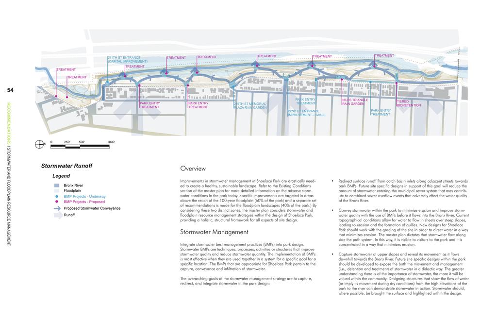
8 Many opportunities exist to enhance stormwater management in Shoelace Park including reducing un-wanted flooding or ponding, reducing erosion, increasing opportunities for infiltration, detaining water where it can better support plants, and diverting pollution from the Bronx River. 100 year fl oodplain 55 Bronx River Stormwater Management Strategies Wet Meadow An effective plan to manage stormwater includes source control strategies that are incorporated into stormwater BMPs. Source Control strategies recommended at Shoelace Park are: direct stormwater runoff from impervious to pervious surfaces when not in areas with steep slopes; utilize permeable pavements; increase the amount of non-turf areas of groundcover vegetation and trees; extend stormwater runoff travel path to slow Time of Concentration; and reduce the total area of impervious surfaces wherever possible (especially within the floodplain). Swale Riparian Upland Forest -Swales and/or -Rain Garden/Bioretention -Slope Reduction Bench Pastoral In conjunction with these source control strategies, the master plan also recommends that future site designs incorporate the concept of a runoff chain, a sequence of structures and methods (BMPs) designed to holistically convey, treat, and infiltrate stormwater. Stormwater managements BMPs are most effective when used together. The goal for Shoelace Park is to have all runoff that enters Shoelace Park be captured, conveyed, detained, filtered by plants, infiltrated, and managed. Future designs should look to the site to see which BMPs are possible and most effective given site specific conditions. Slotted/Flush Curb Trench Drain Energy Distribution Structure Swale -Slotted/Flush Curb -Swale -Permeable Pavement -Rain Garden/Bioretention Promenade RECOMMENDATIONS l STORMWATER AND FLOODPLAIN RESOURCE MANAGEMENT


9 Stormwater Best Management Practices (BMPs) The recommended stormwater BMPs can be broken down into two categories: Areas of Conveyance, linear techniques of moving runoff through the park and Areas of Treatment, techniques used in specific locations that allow runoff to be detained and/or infiltrated. Conveyance Best Management Practices Conveyance BMPs will guide stormwater to a catchment area or termination point and must be sensitive to the park s topography. Several BMPs will be used in a chain throughout the conveyance system. By coordinating the design of conveyance BMPs with proposed park improvements, the construction of a shared condition such as a new paved path will reduce operational expenses, including the increased longevity of pavements. 56 RECOMMENDATIONS l STORMWATER AND FLOODPLAIN RESOURCE MANAGEMENT Legend Direction of Runoff Runoff Chain Concept Diagram Bronx Boulevard The Promenade Park Walk 100-year Floodplain The design of conveyance BMPs must also consider the need to slow the velocity of runoff and control flow volumes entering treatment BMPs via inlet structures. Conveyance BMPs to be considered in Shoelace Park include: Custom check dams, weirs, and energy dissipation structures Open channel: vegetated and reinforced swale Infiltration trench (french drain) Trench drains (for use in areas where conveyance crosses areas of pavement) and pipes and drop structures that convey flow from catch basins to raingardens or other treatment BMPs in the park. Raised curbs and slotted curbs with flow spreaders (i.e. stone used for energy dissipation) Working together, these practices illustrate a runoff chain and form comprehensive systems that will covey water through the site while allowing for greater infiltration, and protection of non-paved surfaces from erosion. Additional information on existing site conditions is required to further develop site designs that support the recommended stormwater conveyance system. This information includes: Areas of contributing impervious catchments and periods of contribution (i.e. at all runoff events, or only when catch basins are filled or curbs overtopped) Spatial requirements necessary for volume of water to be treated Relationship to utility lines (where high flow management is required) Visual qualities Proximity to non-complementary programs Proximity to non-complementary vegetation (mature tree roots) General terrain and adjacent slope Proximity to treatment BMPs (for conveyance BMPs only) Relationship to floodplain delineation (limited BMP applications due to flooding) Much of the information above can be provided in an updated topographic, tree and utility survey of the park. An updated survey is a recommendation of this master plan, as is a coordinated approach to all future stormwater management activities. Slotted curb and flow spreader Armorized swale adjacent to pavement Trench drain Bioretention adjacent to paved area


10 Treatment Best Management Practices Monitoring and Maintenance of Best Management Practices The master plan analysis phase looked at park conditions and best available information on topography and circulation in order to make recommendations for stormwater catchment opportunity areas. Treatment BMPs typically require a greater amount of space than conventional stormwater conveyance techniques. The site analysis accounts for this greater need for space and stormwater goals are incorporated into the program development of the site. When the project moves past the Master Plan stage, calculations of the treatment-area-to-capture ratio will be necessary to quantify the amount of stormwater that the BMPs will be required to treat. BMP treatment opportunity areas have been identified on the master plan drawing at higher elevations along both Bronx Boulevard and Duncomb Avenue, where high velocity runoff coming from the ultra-urban sub-watersheds can be slowed and collected soon after entering the park. Slowing and collecting water near the park entrances protects steep slopes downhill and reduces the need for conveyance BMPs. Substantive areas of treatment will be located near park entrances and, pending the treatment-area-to-capture ratio, additional runoff will be conveyed to treatment BMPs in the Parkland Terrace where the sewer line is located. Stormwater management improvements in the Promenade Terrace will have the opportunity to incorporate overflow structures due to the elevational relationship to the main sewer line. BMPs located in Terrace areas below the sewer line elevation will require the design of inlet control devices to manage the treatment-area-to-capture ratio. Additionally, treatment at the park entrances makes stormwater management strategies visible to park visitors, reinforcing the connections between the recreational space and its ecological and hydrological functions as a place of habitat creation, stormwater filtration, conveyance and infiltration. Because of the additional benefits of habitat enhancement and creation, treatment BMPs can create significant outdoor education opportunities. Therefore, siting the treatment BMPs in the landscape should be coordinated with program opportunity areas in the park. Areas designated to receive stormwater management improvement BMPs seek to capitalize upon the synergy of compatible adjacent uses. One example of this is the proposed display rain garden at Niles Triangle, which further enhances the historic plaza and redefines its relationship to the Promenade. Treatment BMP strategies that can be implemented in the park include: Biofiltration (vegetated depressions varying from higher maintenance, showcase rain gardens to more utilitarian, lower maintenance bioretention basins) Wet meadow Slope reduction benches (i.e., terracing) Subsurface detention basin with passive reuse for rain gardens and active reuse for grey water systems (i.e., irrigation) The incorporation of means of monitoring will be essential in determining the effectiveness of treatment BMPs once they are implemented. Monitoring will allow for adjustments to be made to future designs, throughout the phased implementation of stormwater management improvements. Likewise, the effectiveness of built BMPs will, in part, be contingent upon the implementation of an ongoing maintenance protocol, to be established upon completion of construction. Floodplain Resource Management and Ecological Enhancements The master plan makes recommendations to improve the ecological functioning of floodplain resources, defined as the natural resources found in floodplains. Floodplains play an important role in interconnected ecosystems. In the case of Shoelace Park, this includes the Bronx River and the landscape eco-types that surround it: riparian and upland woodlands. Over the long term, all built structures should be removed from the Riverside Terrace zone (except existing basketball courts) and areas designated as within the 100-year floodplain. These measures would promote opportunities for storage and conveyance of floodwaters while protecting capital investments. Further recommendations include the reduction of impervious surfaces, achieved primarily through the removal of the existing asphalt park path along the river s edge. Instituting stormwater BMPs in the upper and middle terraces and enacting source control strategies will significantly reduce the amount of sediment carried by runoff before it flows into the lower terrace zone and floodplain and filter nutrients and impurities. While specific amounts are not easily quantified, instituting stormwater BMPs will also allow for the promotion of infiltration with the potential to contribute to groundwater recharge. Stormwater BMPs implemented in the upland areas of the park will also assist in the enhancement of water quality and the reduction of pollutants carried during low flow storm events. 57 RECOMMENDATIONS l STORMWATER AND FLOODPLAIN RESOURCE MANAGEMENT Custom check dams, weirs, energy dissipation structures Armorized swale adjacent to vegetated area Bioretention basin, rain garden
The open space system should provide connective elements, relate to natural resources, and enhance the suburban character of the landscape..
 The open space system should provide connective elements, relate to natural resources, and enhance the suburban character of the landscape.. Mixed-use and infill development should maintain or enhance
GUIDELINES FOR ECOLOGICAL PERFORMANCE
 3 Landscape........................................... 3.2 Stormwater Management................................... 3.3 Hardscape........................................... 3.4 Streetscape..........................................
VEHICULAR AND PEDESTRIAN CIRCULATION
 This perspective sketch communicates the intended character and quality of a proposed streetscape design. Locate benches near a major intersection where people tend to gather. Seating and lighting provide
LOUISIANA STATE UNIVERSITY COMPREHENSIVE & STRATEGIC CAMPUS MASTER PLAN. APPENDIX G - Stormwater Study Findings & Stormwater Solutions
 LOUISIANA STATE UNIVERSITY COMPREHENSIVE & STRATEGIC CAMPUS MASTER PLAN APPENDIX G - Stormwater Study Findings & Stormwater Solutions LSU: MP Narrative July 2017 3.5 Open Space Existing Conditions The
Green Infrastructure Recommendations For Parks and Public Spaces
 Green Infrastructure Recommendations For Parks and Public Spaces Issued by the Jersey Water Works Green Infrastructure Committee And Prepared by Meliora Design This document recommends ways to integrate
Design Specifications & Requirements Manual
 11 PARKS & OPEN SPACES 11.1 DEFINITIONS... 1 11.1.1 Neighbourhood Parks... 1 11.1.2 District Parks... 1 11.1.3. Sport Parks... 1 11.1.4 Urban Parks... 1 11.1.5 Civic Spaces... 1 11.1.6 Open Space System...
Design Specifications & Requirements Manual
 11 PARKS & OPEN SPACES 11.1 DEFINITIONS... 1 11.1.1 Neighbourhood Parks... 1 11.1.2 District Parks... 1 11.1.3. Sport Parks... 1 11.1.4 Urban Parks... 1 11.1.5 Civic Spaces... 1 11.1.6 Open Space System...
FACT SHEET: Pervious Pavement with Infiltration
 FACT SHEET: Pervious Pavement with Infiltration DESCRIPTION Pervious pavement is a Green Infrastructure (GI) technique that combines stormwater infiltration, storage, and structural pavement consisting
COMPLETE GREEN STREET CHECKLIST
 COMPLETE GREEN STREET CHECKLIST This document was developed to dissect the structure of an urban street and explore opportunities to make our streets more complete while also integrating green street strategies.
Urban Stormwater Retrofit Program Highlights
 Urban Stormwater Retrofit Program Highlights Delaware Estuary Environmental Summit 2007 Prepared and Presented by: Liz Feinberg Project Funding: William Penn Foundation PA Coastal Zone Management Program
Chapter 3 Site Planning and Low Impact Development
 CHAPTER 3 Site Planning and Low Impact Development Chapter 3 Site Planning and Low Impact Development 3.0 Introduction The City of Charleston requires that major residential, large commercial (>1 acre),
Appendices: Glossary. General Terms. Specific Terms. Low Impact Development Approaches Handbook
 67 67 General Terms Specific Terms 66 Low Impact Development Approaches Handbook The vocabulary of low impact development is evolving, and many terms are used interchangeably and to describe the same or
Tentatively Selected Plan within Harlem River, East River and Western Long Island Sound Planning Region. First Level Costs. Federal Non-Federal Total
 HARLEM RIVER, EAST RIVER AND WESTERN LONG ISLAND SOUND PLANNING REGION Flushing Bay and Creek Ecosystem Restoration Source Feasibility Study Background Study Resolution (1994), Reconnaissance Report (1996),
5. LOW IMPACT DEVELOPMENT DESIGN STANDARDS
 5. LOW IMPACT DEVELOPMENT DESIGN STANDARDS Low Impact Development (LID) requires a shift in stormwater management away from conveying runoff to a small number of downstream points through hydraulically
Appendix D - Technical Design Criteria for BMPs
 Appendix D - Technical Design Criteria for BMPs City of Wayzata Page 3 On-site infiltration features Definitions and Scope: Infiltration facilities are constructed basins or depressions located in permeable
River Corridor Overlay Zone (RCOZ) Article 5
 Article 5") River Corridor Overlay Zone (RCOZ) Article 5 The site is in one of two designated districts. The first is the CBD (central business district) River District, which recognizes the urban character and unique
River Corridor Overlay Zone (RCOZ) Article 5 The site is in one of two designated districts. The first is the CBD (central business district) River District, which recognizes the urban character and unique
Los Angeles River-Arroyo Seco Confluence Restoration Vision Plan. Professor Meredith McKenzie, JD Urban & Regional Planning Dept Cal Poly Pomona
 Los Angeles River-Arroyo Seco Confluence Restoration Vision Plan Professor Meredith McKenzie, JD Urban & Regional Planning Dept Cal Poly Pomona The Los Angeles River Watershed Arroyo Seco Watershed Map
DEALING WITH STORM WATER MANAGEMENT
 December 2012 DEALING WITH STORM WATER MANAGEMENT This fact sheet provides information on the guiding principles of storm water management practices, explains the difference between structural and non-structural
Toronto Complete Streets Guidelines
 Toronto Complete Streets Guidelines 108 110 7.1 Green Infrastructure Design Principles 112 7.2 Context-Sensitive Green Streets 114 7.3 Key Green Street Elements Green infrastructure refers to natural and
Introduction to Low Impact Development. Dr Kathy Chaston Coral & Coastal Management Specialist NOAA Office of Ocean & Coastal Resource Management
 Introduction to Low Impact Development Dr Kathy Chaston Coral & Coastal Management Specialist NOAA Office of Ocean & Coastal Resource Management http://hawaii.gov/dbedt/czm/resource/publication.php A Comprehensive
CHAPTER 8. Mrs. Zimman s Class - Central Elementary
 SUSTAINABILITY CHAPTER 8 Mrs. Zimman s Class - Central Elementary 8.1 OVERVIEW Green infrastructure also known as low impact development (LID) and environmental or sustainable site design is an environmentally
DRAFT DESIGN CRITERIA STORMWATER TREATMENT STANDARDS CITY OF OVERLAND PARK
 DRAFT DESIGN CRITERIA STORMWATER TREATMENT STANDARDS CITY OF OVERLAND PARK A. Authority As set forth in the Overland Park Municipal Code (OPMC), Chapter 16.210, the Director of Planning and Development
HEALTH SCIENCES BUILDING REDEVELOPMENT PROJECT
 INTRODUCTION In recent years, the University of Cincinnati (University) has demonstrated a commitment to identifying and implementing sustainable goals and objectives throughout University s Uptown Campuses.
Chapter 6. Green Streets
 Chapter 6. Green Streets Description Green streets are designed in a holistic manner that minimizes impervious surfaces, emphasizes landscaped elements, includes measures for enhancing water quality, while
MANUAL OF DESIGN, INSTALLATION, AND MAINTENANCE REQUIREMENTS FOR STORMWATER MANAGEMENT PLANS
 MANUAL OF DESIGN, INSTALLATION, AND MAINTENANCE REQUIREMENTS FOR STORMWATER MANAGEMENT PLANS May 2007 SECTION 1 Responsibility of Applicant TABLE OF CONTENTS A. Stormwater Management Plan Required Information
Green Infrastructure and Low-Impact Development Technologies
 Green Infrastructure and Low-Impact Development Technologies The guiding principles of these technologies is to manage stormwater at their sources using natural means, and establish conditions so that
Transportation. Strategies for Action
 Transportation A major priority for the Overlake Neighborhood is to develop a multimodal transportation system. To achieve this system, a balance has to be found among travel, circulation and access needs;
Stormwater Low Impact Development - A Natural Solution
 Stormwater Low Impact Development - A Natural Solution Sarah U Ren Program Director The Watershed Center of Grand Traverse Bay 231-935-1514, suren@gtbay.org Our Mission: The Watershed Center advocates
Mendota Heights 2040 Comprehensive Plan Draft Vers
 4 Parks and Trails The City of Mendota Heights boasts a variety of recreational and open space opportunities. Few cities can claim access to regional trails, riverside and lakeside parks, scenic bluffs
Throughout. square. (Crystal City Vision Plan 2050)
") 1: Terms related to the PSMP document 1 public space (see also public realm, civic space) An open space designated on the regulating plan, accessible to all, including Plazas, Mini Parks, and Neighborhoods
1: Terms related to the PSMP document 1 public space (see also public realm, civic space) An open space designated on the regulating plan, accessible to all, including Plazas, Mini Parks, and Neighborhoods
Preliminary Sketch Plan for Fort Hunter Park
 Preliminary Sketch Plan for Fort Hunter Park Public Presentation November 19, 2009 Dauphin County Parks and Recreation 100 Fort Hunter Road Harrisburg, PA 17110 (717) 599-5188 www.dauphinc.org THOMAS COMITTA
Dogpatch/22nd Street Greening
 TEAM MEMBERS Prepared for: GreenTrustSF Central Waterfront www.gtsfcw.org Prepared by: Fletcher Studio San Francisco, CA www.fletcherstudio.com Landscape Architecture Urban Design Environmental Planning
Grass Buffer T-1. Description. Site Selection. Designing for Maintenance
 Description Grass buffers are densely vegetated strips of grass designed to accept sheet flow from upgradient development. Properly designed grass buffers play a key role in LID, enabling infiltration
Key elements : Filter Strips must be designed within parameters required by the Fort Wayne s Development Standards/Criteria Manual.
 4.4. Filter Strips Filter Strips are densely vegetated lands that treat sheet flow storm water from adjacent pervious and impervious areas. They function by slowing runoff, trapping sediment and pollutants,
The Vision. Photo provided by The Minervini Group. 46 Vision, Objectives & Strategies
 Vision, Objectives & Strategies The is the public framework and guide for future development of the Grand Traverse Commons. The establishes public polices for infrastructure, the preservation of natural
Introduction to Low Impact Development. Fred Milch. East Central Florida Regional Planning Council
 Introduction to Low Impact Development Fred Milch East Central Florida Regional Planning Council Low Impact Development (LID) Low impact development (LID) is a term used to describe a land planning and
Low Impact Development Guidance Manual
 May 2009 TABLE OF CONTENTS Section 1 Introduction 1 Overview 2 Definitions 4 2 Conservation Design Practices 5 Cluster Development 6 Minimize Pavement Widths 8 Minimize Setbacks & Frontages 10 Open Space
Bioretention cell schematic key
 Bioretention Cells Bioretention cell schematic key 1 3 Hardwood mulch 2 Curb cut 3 18-30 Modified soil 4 Stone aggregate choker layer 5 Stone aggregate base layer 6 Subdrain 7 Undisturbed soil 8 Overflow/Cleanout
CHAPTER 11 SITE DESIGN AND LOW IMPACT DEVELOPMENT
 CHAPTER 11 SITE DESIGN AND LOW IMPACT DEVELOPMENT Source: City of Bend Chapter Organization 11.1 Purpose... 11-1 11.2 Applicability... 11-1 11.3 Low Impact Development Overview... 11-2 11.3.1 Key Strategies...
Potential Green Infrastructure Strategies May 6, 2015 Workshop
 Potential Green Infrastructure Strategies May 6, 2015 Workshop Background The City of Cortland is developing the Tioughnioga Urban Headwaters Green Infrastructure Action Plan with funding from the National
APPENDIX A. Proposed Guidance and LID checklists for UConn and Town of Mansfield
 APPENDIX A. Proposed Guidance and LID checklists for UConn and Town of Mansfield 22 Guidance Document for Low Impact Development Best Management Practices for UConn June, 2011 In 2007, the Connecticut
Kittson Parkway / Watershed Park Parking Lot
 Kittson Parkway / Watershed Park Parking Lot Date Constructed: Summer 2005 Site Location / Description: Kittson Parkway, North Delta, British Columbia. Permeable parking lot adjacent to Watershed Park;
Green Infrastructure Overview
 Green Infrastructure Overview Christopher C. Obropta, Ph.D., P.E. obropta@envsci.rutgers.edu Jeremiah Bergstrom, LLA, ASLA jbergstrom@envsci.rutgers.edu February 26, 2016 Water Resources Program NJDEP
understanding Green Infrastructure In Zoning
 understanding Green Infrastructure In Zoning Purpose Measurable standards can be adopted within municipal zoning codes, and subdivision and stormwater regulations, to promote a comprehensive approach to
Figure 3-1: Public Realm Plan
 3 Public Realm Figure 3-1: Public Realm Plan 3.1 Public Realm Concept The public realm concept for the Little Mountain site integrates a clear and accessible movement network with public spaces for social
LOW IMPACT DEVELOPMENT TOOLS FOR VERMONT TOWNS
 LOW IMPACT DEVELOPMENT TOOLS FOR VERMONT TOWNS Low Impact Development (LID) is an approach to managing stormwater runoff based on strategies that mimic natural hydrologic processes. LID provides an alternative
Section4 Design Vision & Implementation Plan
 Section4 Design Vision & Implementation Plan W Woodschurch Rd 4.1 Design Focus Areas The Framework Plan is simply the starting point for directing the design and implementation of a wide range of transportation
This appendix discusses some of the key
 Appendix C: The Nuts and Bolts of Stormwater Management Strategies for Streets and Parking Lots This appendix discusses some of the key design considerations to keep in mind when implementing green streets
Glenn Highway MP DSR. Landscape Narrative
 Glenn Highway MP 34-42 DSR Landscape Narrative Project Landscape Goals The Glenn Highway MP 34-42 Project extends through a variety of landscape types typical to the Matanuska-Susitna Valley. In general,
Stormwater Management Techniques WMPF LAND USE TRAINING INSTITUTE MARCH 14, 2018
 Stormwater Management Techniques WMPF LAND USE TRAINING INSTITUTE MARCH 14, 2018 Potential Impacts of New Development Urban development can significantly increase stormwater runoff Water quality considerations
Appendix E: Illustrative Green Infrastructure Examples
 Appendix E: Illustrative Green Infrastructure Examples Integrating LID into San Francisco s Urban Landscape Figure E. High-density Residential Figure E. Low-density Residential Figure E. Mixed Use 7 Figure
Old Mill Community Association Bioretention Facility
 Project Overview This project will install a bioretention facility in a community recreation area owned by the Old Mill Community Association, Inc. Drainage from the area is currently unmanaged and has
Urban Water Management and Soils (ESRM 311 & SEFS 507)
") Urban Water Management and Soils (ESRM 311 & SEFS 507) Cougar Mtn Regional Wildland Park & Lakemont Blvd, Bellevue WA Lecture Today Some Urban Water management terms Examples of water management in urban
Urban Water Management and Soils (ESRM 311 & SEFS 507) Cougar Mtn Regional Wildland Park & Lakemont Blvd, Bellevue WA Lecture Today Some Urban Water management terms Examples of water management in urban
Stormwater Basin Retrofit Project P-6 St. Peters, MO 30% Design Meeting Willott Square / Pegasus Farms
 Stormwater Basin Retrofit Project P-6 St. Peters, MO 30% Design Meeting Willott Square / Pegasus Farms Matt Bardol, P.E., CFM, CPESC, D.WRE Meeting Agenda Stormwater Management & Water Quality Overview
ATTACHMENT A STORMWATER MANAGEMENT TECHNIQUES Cahill Associates Environmental Consultants
 ATTACHMENT A STORMWATER MANAGEMENT TECHNIQUES New Development/Redevelopment Techniques Porous Bituminous Pavement Porous Bituminous Pavement is standard asphalt in which the fines have been held to a minimum,
Town Center. Block 5 Existing multifamily residential units are expected to remain.
 Area Guidelines Germantown s districts should be developed as distinct communities with unique features that are supported through the guidelines. The guidelines not only help distinguish these districts
Stormwater Prevention and Control
 Stormwater Prevention and Control Principles of Stormwater Management Stormwater Fact Sheet No. 4 This fact sheet is No. 4 of a eight-part series focused on stormwater runoff problems and control strategies.
Preci nct P l ans Figure 56 Campus Aerial Photo, 2008 CAL STATE EAST BAY, HAYWARD CAMPUS MASTER PLAN
 9 Precinct Plans This section contains a detailed discussion of the planning and design concepts for specific areas or precincts of the Cal State East Bay Hayward campus. The Precinct Plans pertain to
4.5 City of Indianapolis Stormwater Green Infrastructure Guidance: Bioretention (rain gardens) Bioretention Fact Sheet Bioretention Technical Design
 Bioretention Fact Sheet Bioretention Technical Design") 4.5 City of Indianapolis Stormwater Green Infrastructure Guidance: Bioretention (rain gardens) Bioretention Fact Sheet Bioretention Technical Design Specification Bioretention O & M Manual Draft Green
4.5 City of Indianapolis Stormwater Green Infrastructure Guidance: Bioretention (rain gardens) Bioretention Fact Sheet Bioretention Technical Design Specification Bioretention O & M Manual Draft Green
Post Construction BMPs
 Post Construction BMPs Why are Post Construction BMPs important? With increased development brings the increase of impervious cover Parking lots, rooftops, driveways Storm water runoff volume increases
ST. MARY S SOIL CONSERVATION DISTRICT (SMSCD) AND DPW&T CONCEPT EROSION AND SEDIMENT CONTROL AND STORMWATER MANAGEMENT GUIDELINES AND CHECKLIST
 AND DPW&T CONCEPT EROSION AND SEDIMENT CONTROL AND STORMWATER MANAGEMENT GUIDELINES AND CHECKLIST") St. Mary s Soil Conservation District 26737 Radio Station Way, Suite B Leonardtown, MD 20650 Phone: 301-475-8402 ext. 3 Fax: 301-475-8391 www.stmarysscd.com St. Mary s County Government Department of Public
St. Mary s Soil Conservation District 26737 Radio Station Way, Suite B Leonardtown, MD 20650 Phone: 301-475-8402 ext. 3 Fax: 301-475-8391 www.stmarysscd.com St. Mary s County Government Department of Public
n1. Design 5.4.6a Urban Bioretention 5.4.6a Urban Bioretention Variations: Planter box, Extended tree pits, Stormwater curb extensions.
 5.4.6a Urban Bioretention Variations: Planter box, Extended tree pits, Stormwater curb extensions. Description: Urban bioretention SCM are similar in function to regular bioretention practices except they
Low Impact Development Ideas and Effects in the Built Environment
 Low Impact Development Ideas and Effects in the Built Environment Joe Sewards UF/IFAS Extension, Volusia county Urban Horticulture agent and Master gardener coordinator Presentation Outline Predevelopment
4.6. Low Impact and Retentive Grading
 4.6. Low Impact and Retentive Grading Low Impact Grading techniques focus on utilizing existing topography during Site layout to minimize cost. Proposing structures, roads, and other impervious surfaces
Urban Watershed Mentors
 Urban Watershed Mentors Bureau of Environmental Services Josh Robben Urban Stormwater background Stormwater retrofits Site assessment Design considerations Maintenance considerations Resources/programs
Green Infrastructure and the Urban Forest: Thinking Outside the Planter Box
 Green Infrastructure and the Urban Forest: Thinking Outside the Planter Box James DeRoussel RLA P r o g r a m M a n a g e r W a t e r s h e d M a n a g e m e n t G r o u p Let s put a tree there! What
ADDENDUM TO BIOLOGICAL SCOPING SURVEY REPORT, BOTANICAL SURVEY AND WETLAND DELINEATION
 ADDENDUM TO BIOLOGICAL SCOPING SURVEY REPORT, BOTANICAL SURVEY AND WETLAND DELINEATION FOR AVALON INN (APN 069-241-27 & -04) 1201 & 1211 NORTH MAIN STREET FORT BRAGG, CA MENDOCINO COUNTY prepared for:
INTRODUCTION TO GREEN INFRASTRUCTURE HOW WE CAN PROTECT OUR COMMUNITIES AND OUR WATERS Maywood Public Library Bergen County, New Jersey
 INTRODUCTION TO GREEN INFRASTRUCTURE HOW WE CAN PROTECT OUR COMMUNITIES AND OUR WATERS Maywood Public Library Bergen County, New Jersey Jeremiah D. Bergstrom, LLA, ASLA Rutgers Cooperative Extension Water
Leduc Industrial Outline Plan SE W4
 Leduc Industrial Outline Plan SE 1-50-25-W4 Within the North Leduc Industrial ASP Prepared for: Leduc Energy Park Ltd. Prepared by: Stantec Consulting Ltd. File No. 1161 104655 V5 Table of Contents 1.0
SEATTLE PUBLIC UTILITIES Drainage Design Options for street right of ways.
 SEATTLE PUBLIC UTILITIES Drainage Design Options for street right of ways. Numerous ecosystem-based functional stormwater quantity and quality design alternatives are possible within the street ROW. Several
Low Impact Development for your homes, businesses & streets
 Low Impact Development for your homes, businesses & streets What s the problem anyways? - Development Impacts the Water Cycle In the past, our main pollution concern was Point Source Pollution Our current
North Oakville East Parks Facilities Distribution Plan. November, 2009
 North Oakville East November, 2009 POLICY CONTEXT 1) Purpose a) The purpose of this document is to be a guide for the location, configuration, design and development of the parks system for the North Oakville
Urban Stormwater: Best Practice Environmental Management Guidelines. CSIRO This electronic edition published by CSIRO PUBLISHING, 2006.
 Urban Stormwater: Best Practice Environmental Management Guidelines. Chapter 5 Water Sensitive Urban Design Key references Department of Planning, 1993, Better Drainage: Guidelines for the Multiple Use
MCCOYS CREEK RESTORATION 30% DESIGN
 MCCOYS CREEK RESTORATION 30% DESIGN THE MCCOYS CREEK RESTORATION PLAN The restoration plan aims to reduce flooding, restore ecosystem health, expand recreational opportunities along the creek, and connect
COMMUNITY DEVELOPMENT DEPARTMENT POLICY DRAINAGE FOR RESIDENTIAL PROJECTS WITH ONE OR TWO UNITS REVISED JANUARY 4, 2018
 COMMUNITY DEVELOPMENT DEPARTMENT POLICY DRAINAGE FOR RESIDENTIAL PROJECTS WITH ONE OR TWO UNITS REVISED JANUARY 4, 2018 A. California Residential Code Requirement - Construction plans shall indicate how
for Master Planned Development Framework Design Standards & Guidelines
 B L A C K D I A M O N D DE S I G N G U I D E L I N E S for Master Planned Development Framework Design Standards & Adopted June 18, 2009 Introduction and Purpose The Master Planned Development (MPD) Framework
FREEWAY/TOURIST DISTRICT
 FREEWAY/TOURIST DISTRICT DESIGN STANDARDS FOR THE CITY OF MOUNTLAKE TERRACE March, 2014 MOUNTLAKE TERRACE FREEWAY/TOURIST DESIGN STANDARDS March, 2014 1 TABLE OF CONTENTS Introduction...1 Design Site Design
ADOPTED CAPITAL IMPROVEMENT PROGRAM BUDGET ARROYO PROJECTS
 ADOPTED CAPITAL IMPROVEMENT PROGRAM BUDGET ARROYO PROJECTS HAHAMONGNA FY 212-216 Capital Improvement Program Priority Description Total Estimated Costs Appropriated Through FY 211 Adopted FY 212 FY 213
COLLIER BOULEVARD (CR 951) CORRIDOR
 CORRIDOR") Project(s) Goals Improve Traffic Circulation, Capacity & Safety Focus on Safety During Design & Construction Address Public Concerns Design an Aesthetically Pleasing Project Limit Environmental Impacts
Project(s) Goals Improve Traffic Circulation, Capacity & Safety Focus on Safety During Design & Construction Address Public Concerns Design an Aesthetically Pleasing Project Limit Environmental Impacts
Improving Communities Through the Arroyo Seco Sustainability Campaign and Watershed Assessment
 Improving Communities Through the Arroyo Seco Sustainability Campaign and Watershed Assessment Arroyo Seco Headwaters in the San Gabriel Mountains Major tributary to the Los Angeles River 44 square mile
Urban runoff in my neighborhood (Capitol Hill) is heavy with trash and other debris.
 is heavy with trash and other debris.") South Platte River Meeting Comments & s #1 I am a huge fan of river areas and would love the Platte and surrounding waterways to improve to allow habitat for wildlife and recreation opportunities for citizens.
South Platte River Meeting Comments & s #1 I am a huge fan of river areas and would love the Platte and surrounding waterways to improve to allow habitat for wildlife and recreation opportunities for citizens.
APPENDIX G: TOWN ORDINANCE REVIEW
 APPENDIX G: TOWN ORDINANCE REVIEW TYLin (225740) Woodard & Curran SWMP January 2013 Stormwater LID strategies, ranked for Zoning Bylaw and Site Plan Review Standards Dimensional Requirements Permit the
Ramsey Center area - potential BMP sites
 Ramsey Center area - potential BMP sites Lilly Branch Carlton St. 1 2 Joe Frank Harris Commons 3 4 8 5 East Campus Rd. 11 6 12 7 9 East Campus Deck 10 20 16 17 Ramsey Center 13 14 18 19 15 River Road Road
STREAM BUFFERS
 88-415 STREAM BUFFERS 88-415-01 PURPOSE In the Kansas City region and throughout the nation, vegetated stream buffers have been clearly shown to protect stream stability and related infrastructure, improve
Rainscaping. Rainscaping includes rain gardens, bioswales, combinations of. A guide to local projects in St. Louis
 Rainscaping A guide to local projects in St. Louis Rain garden on South Grand Boulevard in the city of St. Louis. Rainscaping includes rain gardens, bioswales, combinations of plantings, water features,
Pennsylvania Stormwater Best Management Practices Manual
 Pennsylvania Stormwater Best Management Practices Manual DRAFT - JANUARY 2005 Section 4 Comprehensive Stormwater Management: Integrating Site Design, Non-Structural, and Structural BMP's This page intentionally
Chapter 5: Natural Resources and Environment
 NATURAL RESOURCES AND ENVIRONMENT 5-1 5 Chapter 5: Natural Resources and Environment BACKGROUND AND INTENT Urban expansion represents the greatest risk for the future degradation of existing natural areas,
Green City, Clean Waters
 Green City, Clean Waters Green Infrastructure Maintenance Manual Consent Order & Agreement Deliverable VIII City of Philadelphia Combined Sewer Overflow Long Term Control Plan Update Submitted to The Commonwealth
COMMUNITY DESIGN. GOAL: Create livable and attractive communities. Intent
 COMMUNITY DESIGN Intent An attractive, well-designed County will attract quality development, instill civic pride, improve the visual character of the community, and create a strong, positive image for
County of Prince Edward. Stormwater Management Plan. Agreement in lieu of a Stormwater Management Plan
 County of Prince Edward Stormwater Management Program Date: E-Permitting Number: This stormwater management plan (Agreement) is hereby submitted by the Owner to specify the methods that will be implemented
Urban Water Management (ESRM 311 & SEFS 507) Cougar Mtn Regional Wildland Park & Lakemont Blvd, Bellevue WA
 Cougar Mtn Regional Wildland Park & Lakemont Blvd, Bellevue WA") Urban Water Management (ESRM 311 & SEFS 507) Cougar Mtn Regional Wildland Park & Lakemont Blvd, Bellevue WA Lecture Today Urban Water management terms Examples of water management in urban areas Field
Urban Water Management (ESRM 311 & SEFS 507) Cougar Mtn Regional Wildland Park & Lakemont Blvd, Bellevue WA Lecture Today Urban Water management terms Examples of water management in urban areas Field
The West Vaughan Employment Area Secondary Plan Policies
 Part 2: The West Vaughan Employment Area Secondary Plan Policies 2.1 General Policies It is the policy of Council: 2.1.1. That the West Vaughan Employment Area (the WVEA), identified on Schedule 1, will
IV. Development in the Rural Overlay District
 Intracoastal Waterway Route 17 Route 168 Great Dismal Swamp VIRGINIA NORTH CAROLINA IV. Development in the Rural Overlay District IV-1 Route 17 in Chesapeake s Rural Overlay District affords distant views
2. Analysis. DRAFT Gerald Richards & Pleasantview Park Master Plan
 DRAFT Gerald Richards & Pleasantview Park Master Plan 19 Historic Features According to the National Register of Historic Places and the National Historic Landmarks Program, there is nothing of national
Pennsylvania Stormwater Best Management Practices Manual. Chapter 4. Integrating Site Design and Stormwater Management
 Pennsylvania Stormwater Best Management Practices Manual Chapter 4 Integrating Site Design and Stormwater Management 363-0300-002 / December 30, 2006 Chapter 4 Integrating Site Design and Stormwater Management
Project Location. Jay and Patty Baker Park and Gordon River Greenway Connector Bridge. Naples Beach Golf Club. Gordon River. East. Naples.
 Gordon River Project Location Naples Beach Golf Club East Naples Naples Naples Bay Evergreen Golf and Country Club and Gordon River Greenway Connector Bridge Gordon River Greenway CONNECTOR BRIDGE AND
Low Impact Development (LID) Techniques. Associate BD Presentation, October 7, 2014
 Techniques. Associate BD Presentation, October 7, 2014") Low Impact Development (LID) Techniques Associate BD Presentation, October 7, 2014 Low Impact Development (LID) Techniques What are LIDs? Why are they used? Where are they used? How are they designed or
Low Impact Development (LID) Techniques Associate BD Presentation, October 7, 2014 Low Impact Development (LID) Techniques What are LIDs? Why are they used? Where are they used? How are they designed or
ROCHESTER INSTITUTE OF TECHNOLOGY Active Transportation Improvements 2010
 ROCHESTER INSTITUTE OF TECHNOLOGY Active Transportation Improvements 2010 In 2008, the Rochester Institute of Technology (RIT) completed a Comprehensive Parking and Transportation Study. Recommendations
City of Dallas Complete Streets Program. SAME Infrastructure Forum February 2, 2018
 City of Dallas Complete Streets Program SAME Infrastructure Forum February 2, 2018 Complete Streets Design Manual Adopted by City Council January 27, 2016 JANUARY 27, 2016 2 What are Complete Streets?
Appendix I. Checklists
 Appendix I Checklists Town of Greenwich Drainage Manual Department of Public Works - Engineering Division Town Hall - 101 Field Point Road, Greenwich, CT 06836-2540 Phone 203-622-7767 - Fax 203-622-7747