Report to/rapport au : Planning Committee Comité de l'urbanisme. and Council / et au Conseil. June 11, juin 2012
|
|
|
- Marilynn Charles
- 6 years ago
- Views:
Transcription
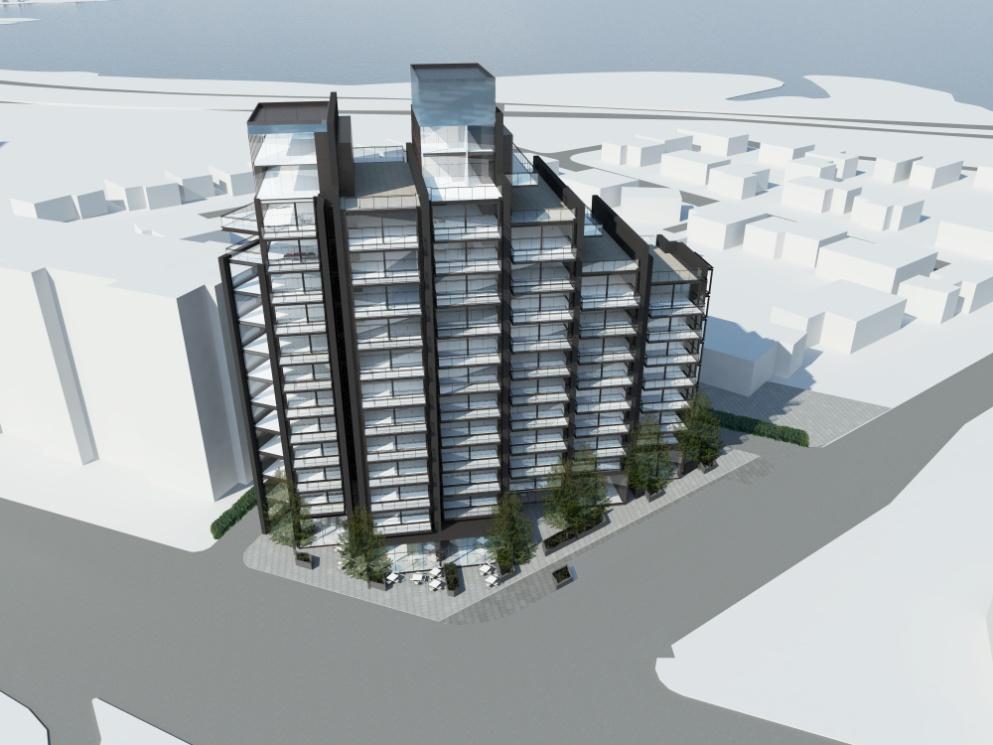
1 162 Report to/rapport au : Planning Committee Comité de l'urbanisme and Council / et au Conseil June 11, juin 2012 Submitted by/soumis par : Nancy Schepers, Deputy City Manager/Directrice municipale adjointe, Planning and Infrastructure/Urbanisme et Infrastructure Contact Person / Personne ressource: John Smit, Manager/Gestionnaire, Development Review-Urban Services / Examen des projets d'aménagement-services urbainsplanning and Growth Management/Urbanisme et Gestion de la croissance (613) , John.smit@ottawa.ca Bay/Baie (7) Ref N : ACS2012-PAI-PGM-0159 SUBJECT: OBJET : ZONING 927 RICHMOND ROAD AND 108 WOODROFFE AVENUE (FILE NO. D ) ZONAGE 927, CHEMIN RICHMOND ET 108, AVENUE WOODROFFE REPORT RECOMMENDATIONS That the Planning Committee recommend Council approve: 1. An amendment to the City of Ottawa Zoning By-law to change the zoning of 927 Richmond Road and 108 Woodroffe Avenue from a Traditional Mainstreet zone with a height limit of 25 metres(tm (H25)) to a new Traditional Mainstreet (TM [xxxx](h47)) exception zone with a height limit of 47 metres to permit a mixed-use development as detailed in Document 2 and as shown in Document 1; and 2. The implementing by-law go forward to City Council for approval after Site Plan Control Approval is obtained and the agreement registered on title. RECOMMANDATIONS DU RAPPORT Que le Comité de l urbanisme recommande au Conseil d approuver ce qui suit :
2 Une modification au Règlement de zonage de la Ville d Ottawa en vue de faire passer le zonage du 927, chemin Richmond et du 108, avenue Woodroffe de zone de rue principale traditionnelle limitant la hauteur à 25 mètres (TM (H25)) à une nouvelle zone de rue principale traditionnelle (TM [xxxx](h47)) assortie d une exception et limitant la hauteur à 47 mètres, afin de permettre un aménagement polyvalent, tel qu exposé en détail dans le document 2 et tel qu illustré dans le document 1; 2. Que le règlement d application ne soit pas soumis à l approbation du Conseil municipal avant qu une approbation de réglementation du plan d'implantation ne soit obtenue et que l entente ne soit enregistrée sur le titre. EXECUTIVE SUMMARY Assumptions and Analysis The subject property is located on the northwest corner of Richmond Road and Woodroffe Avenue. The applicant is proposing to demolish the existing single detached dwelling and mixed-use building on the property and construct a new 14-storey (47-metre) building with approximately 92 dwelling units and 277 square metres of commercial on the ground floor. The subject property is designated Traditional Mainstreet. The proposed rezoning will allow a compact development that creates an animated pedestrian focus at the corner of two arterial roadways. The subject property is served by two bus stops and the traffic anticipated to be generated from the proposed development will not have a significant impact on the surrounding streets. The setbacks proposed, building design and the transition to the lower density residential development to the north will help mitigate the impact of the proposed development on that community, including sun/shadow impact. The proposed development is in conformity with the Richmond Road/Westboro Secondary Plan which allows for taller buildings on Richmond Road, provided that any one of five specific policies are satisfied. It is the Department s opinion that three of the five are satisfied. Taller apartment buildings are a common characteristic of this section of Richmond Road, the subject property is located at two arterials roads and can create a community focus and the proposal conforms to the compatibility policies in the Official Plan. Financial Implications If the zoning amendment is carried and an appeal is brought before the Ontario Municipal Board, staff resources would be utilized to defend Council s position. In the event the zoning amendment is not carried, an external planning and traffic consultant would need to be retained at an estimated cost of $55,000 to $60,000. Funds are not
3 164 available from within existing resources and the expense would impact Planning and Growth Management s 2012 operating status. Public Consultation/Input Notification and public consultation was undertaken in accordance with the Public Notification and Public Consultation Policy approved by City Council for Zoning By-law amendments. Forty-one comments were received as a result of the public notification. Thirty-six respondents expressed concerns while three were in support and two wanted more information on the proposal. The Ward Councillor also held a public meeting in the community on April 4, 2012 and a further meeting on May 16, 2012 with Community Leaders. The comments received at the meeting were similar to those expressed as a result of public notification. RÉSUMÉ Hypothèses et analyse La propriété visée se trouve à l angle nord-ouest du croisement entre le chemin Richmond et l avenue Woodroffe. Le requérant propose de démolir la maison unifamiliale et le bâtiment polyvalent qui se trouvent sur la propriété, et de construire un nouvel édifice de 14 étages (47 mètres) abritant environ 92 unités d habitation et 277 m 2 d espace commercial au rez-de-chaussée. La propriété visée est située dans une voie désignée rue principale traditionnelle. La modification de zonage proposée permettra un aménagement regroupé qui créera un point de rencontre animé pour les piétons à l angle des deux artères. L endroit est desservi par deux arrêts d autobus et la circulation produite par l aménagement proposé ne devrait pas avoir un impact significatif sur les rues avoisinantes. Le retrait et la conception ds bâtiments ainsi que la transition vers le quartier résidentiel de plus faible densité au nord contribueront à limiter les répercussions de l aménagement proposé sur cette collectivité, y compris en matière de pénétration du soleil et d ombrage. L aménagement proposé est conforme au plan secondaire du chemin Richmond/Westboro, qui autorise la présence de bâtiments plus élevés sur le chemin Richmond, à la condition que les cinq politiques spécifiques soient respectées. Le Service estime que trois des cinq politiques le sont. Les tours d habitation sont fréquentes dans ce tronçon du chemin Richmond. La propriété visée se trouve à l angle de deux artères et pourrait offrir un centre de rassemblement communautaire, et la demande est conforme aux politiques de compatibilité du Plan officiel. Répercussions financières Si la modification de zonage est adoptée et qu un appel est interjeté auprès de la Commission des affaires municipales de l'ontario, des ressources en personnel seraient affectées pour défendre la position du Conseil. Dans le cas contraire, les services d un consultant externe en planification et en circulation devraient être retenus, pour un coût estimé entre $ et $. Ces fonds ne sont pas disponibles à
4 165 même les ressources existantes et cette dépense aurait des répercussions sur le fonctionnement d Urbanisme et Gestion de la croissance en Consultation publique/commentaires Des avis ont été lancés et une consultation publique a été menée, conformément à la politique sur les modifications au Règlement de zonage approuvée par le Conseil municipal. Quarante et un commentaires ont été reçus par suite de l avis public. Trentesix personnes ont exprimé des préoccupations, trois ont soutenu le projet et deux autres ont souhaité obtenir plus d information sur la demande. Le conseiller municipal du quartier a également organisé une réunion publique le 4 avril 2012 et une seconde le 16 mai 2012 avec les dirigeants communautaires. Les commentaires reçus lors de la réunion publique étaient de même nature que ceux exprimés par suite de l avis public. BACKGROUND The subject property is located on the northwest corner of Richmond Road and Woodroffe Avenue and consists of two lots which have been combined into one site. On the northern portion of the property is a two storey single detached dwelling while on the southern portion is a two and a half storey mixed use building which contained a convenience store at ground level and dwelling units on the upper floors. The subject property is approximately square metres in area with frontage on Woodroffe Avenue of approximately 56 metres and on Richmond Road of approximately 30 metres. To the north is a City owned public pathway and a low density residential neighbourhood. To the east is a restaurant and other commercial uses while to the south is the Byron Avenue linear Park, a school and a funeral parlour. To the immediate west is a nine storey mixed-use building with commercial uses on the ground floor and residential above. Further to the west are other commercial uses including an automobile dealership and a car wash and a high rise apartment building having a height of 29 storeys. The applicant is proposing to demolish the two existing buildings and construct a new 14 storey (47 metre) mixed-use building with approximately 277 square metres of commercial on the ground floor and approximately 92 dwelling units. The current zoning on the property is Traditional Mainstreet with a height limit of 25 metres. In addition to the increase in height, the applicant is also requesting modifications to performance standards relating to yards, landscaping, the location of ground floor residential and parking and loading. DISCUSSION Primary Official Plan The subject property is designated Traditional Mainstreet on Schedule B of the Primary Plan (Volume 1). Lands with this designation offer some of the most significant opportunities in the city for intensification through more compact forms of development,
5 166 a lively mix of uses and a pedestrian-friendly environment. The Official Plan encourages intensification along Mainstreets primarily through the redevelopment of sites and additions to buildings. The most common feature of all Mainstreets is their function as a mixed-use corridor with their ability to provide a wide range of goods and services for both the neighbouring communities and the region at large. Through compact mixed-use and pedestrian-oriented streets, development along Mainstreets is intended to increase support to the public transit system and alternative forms of transportation, to enhance a community focus, and to minimize travel and disruption to existing neighbourhoods. The applicant's proposed development satisfies the direction for lands Designated Traditional Mainstreet. It will bring a new building to the corner of Richmond Road and Woodroffe Avenue and create an animated pedestrian friendly environment along this street edge by having retail uses at grade. The design of the building will complement the character of Traditional Mainstreets found in Ottawa by using such methods as different building materials, varying setbacks, vegetation and transition in building heights. The following discussion highlights how the proposed development meets various policy directions in the Official Plan specific to Traditional Mainstreets. A key thrust of the policies of the Official Plan is that redevelopment and infill are encouraged on Traditional Mainstreets in order to optimize the use of land through intensification in a building format that encloses and defines the street edge and provides direct pedestrian access to the sidewalk. The proposed rezoning will allow for a development that, with the use of building design and vegetation, creates a strong urban edge on a predominant corner of two arterial roads. The policies for Traditional Mainstreets provide that buildings over six storeys in height may be considered under any one of five circumstances described in Policy The subject site and proposed development meets three of these. The proposed height building heights is consistent with the prevailing heights of other existing developments along this section of Richmond Road; The proposed development, with its unique architecture, at grade animation and location at an intersection can contribute to creating a focal point for the area; and The proposed development meets the considerations set out in Section and 4.11 related to design and compatibility. Key thrusts of the Official Plan for all intensification focus on urban design and compatibility considerations. With respect to compatibility, the Official Plan notes that in general terms, compatible development means development that, although is not necessarily the same as or even similar to existing buildings in the vicinity, nonetheless enhances an established community and coexists with development without causing any undue adverse impact on surrounding properties. It fits well within its physical context and works well among those functions that surround it.
6 Section 4.11 Compatibility Considerations 167 This section of the Official Plan recognizes that the integration of taller buildings into an area where a lower built form exists is an important urban design consideration, particularly in association with intensification. Section 4.11 provides for development proposals to address issues of compatibility and integration with surrounding land uses by ensuring that an effective transition in built form is provided between areas of different development profile and provides direction on how this may be achieved. Specifically, it notes that transition can be accommodated through a variety of means, including incremental changes in building height, massing, character, architectural design and building setbacks. With respect to the applicant s proposal, the building will step down in height towards the low density residential development to the north. The impact of the proposed building will also be offset by the rear yard setback proposed, which ranges from approximately 4.5 metres to 23 metres and the Woodroffe Walk pedestrian/cycling pathway, which is between eight and nine metres wide. This distance separation will also help minimize the impact of overlook into private amenity areas. The massing of the building will be addressed both through the use of different heights but also by using transparent materials, such as glass and sheer walls at varying angles, which help break the building into smaller components. These architectural characteristics also help create a sense of transition between buildings along the street and to the north. In addition to the foregoing, the Official Plan also recognizes that in comparison to lower profile buildings, high-rise buildings have a greater chance to impact the qualities that people may associate with a particular place. As such, new high-rise buildings must be sensitive to the existing neighbourhood context. While the above paragraph talks about scale, massing, setbacks and transition, there are other matters that need to be considered. Among these are matters of street character, potential to create unique places, proximity to transit and shadow impacts. With respect to character, the Official Plan indicates that taller buildings can be better accommodated along streets with a wider public right, which can help to mitigate impacts and also assist to provide appropriate enclosure for wider streets. The front of the proposed building will face the intersection of Richmond Road and Woodroffe Avenue. The public right of way at this location includes not only Richmond Road but also Byron Avenue and the linear park, which is approximately 50 m in width. The width of the subject property varies, but at its greatest depth is approximately 62 metres in depth. At other points, this varies from 30 metres to 60 metres. With the size of the subject property, there is opportunity to provide the setbacks and transition towards surrounding properties that help make a taller building compatible. With respect to place making, the subject property is located at the corner of two arterial roads providing for the proposed development to create new views, vistas and landmarks, with an architectural character that enhances the skyline of the city. In relation to this, the urban design considerations, such as the orientation of the building to take advantage of passive solar heating, along with the architectural style and quality, the proposed development is consistent with Council approved design guidelines. With
7 168 commercial uses at the ground level, the proposed patio along the street edge and the planting of vegetation, including trees, the public realm will be enhanced. With respect to transit, the subject property is well served by public transit with a stop located on both the Woodroffe and Richmond frontages of the property and while the surrounding streets are experiencing large volumes of traffic at the peak hours, the proposed development will have a minimal traffic impact on that existing situation. Finally, while no one has a right to light, a consideration of the proposed rezoning is the shadow impact it will create. As provided in the plan, through the use of design measures, a development should minimize shadowing on adjacent properties to the extent practicable and in particular for outdoor amenity areas. A sun/shadow study completed for this proposal indicates that during the summer months, the impact on the surrounding low density residential uses to the north will be minimal. This impact increases during the time of the equinoxes; however, the greatest impact is in the earlier morning hours, with the impacts declining as the morning progresses and with there being no shadow impact during the afternoon. The greatest impact is during the winter solstice, however, as with the equinoxes, this greatest impact is in the morning hours and lessens in the afternoon. Nevertheless, the shadowing impact from this proposed development allows for at least four consecutive hours of uninterrupted sunlight on any of the properties affected by this proposal. It is the Department s position that the use of varying heights and the setbacks provided help mitigate the impact of shadowing. Section Design Objectives and Principles In addition to the Compatibility policies contained in Section 4.11 of the Official Plan, development proposals on Mainstreets are also to be evaluated with respect to the Design Objectives and Principles in Section In this section, the Official Plan acknowledges that introducing new development in existing areas that have developed over a long period of time requires a sensitive approach to differences between the new development and the established area. The Official Plan provides guidance on measures that will mitigate these differences and help achieve compatibility of form and function. Allowing for flexibility and variation that complements the character of existing communities is noted in the Plan as being central to successful intensification. Section contains seven design objectives relating to how built environment should be addressed as the City matures and evolves. These Design Objectives are broadly stated, and are to be applied within all land use designations, either at the citywide level or on a site-specific basis. Each of the design objectives that the Department believes are relevant to the applicant s proposal are presented below, as well as how the Department believes they are being satisfied. The first design objective is to enhance the sense of community by creating and maintaining places with their own distinct identity. To fulfill this objective, design should:
8 169 Support the overall image of Ottawa as the Nation s capital. Recognize and reflect on the history of the city or community. Promote quality consistent with a major metropolis, and a prime business and tourist destination. Create distinctive places and appreciate local identity in patterns of development, landscape and culture. Reflect a thorough and sensitive understanding of place, context and setting. The proposed development will meet these design policies by incorporating a quality of architecture that will enhance and improve upon the image of City as well as promote Ottawa as a major metropolis. The placement of a high-rise apartment building on the property is reflective of an existing characteristic, whereby other mid to high rise apartments are located along this portion of Richmond Road. The proposed commercial uses at the ground level are characteristics of the Richmond Road Traditional Mainstreet Area and by having a commercial patio at the ground level, this will help create distinctive places that will increase animation and enhance community interaction. By having the building step down to the properties to the north and by having the rear yard extensively landscaped, the proposed development picks up on the vegetated character of the community and minimizes the impact on surrounding properties. The second design objective relates to defining quality public and private spaces through development. To fulfill this objective, design should: Clearly define and connect public and private spaces by: o Defining and enclosing spaces using buildings, structures and landscaping. o Recognizing every building as being part of a greater whole that contributes to the overall coherency of the urban fabric. Enhance and enliven the quality, character and spatial delineation of public spaces. Address the relationship between buildings and between buildings and the street. Meet the needs of pedestrians as a priority. Contribute to attractive public spaces and important vistas. Minimize the exposure of inhabitants to noise levels that could adversely impact their health and well-being. The proposed development will use landscaping, both hard and soft and structures, such as the buildings and planters, to help define the relationship between the publiclyassessable area on the subject property. By using various materials to provide texture, colour and relief and by providing amenities such as benches and vegetation, the quality and character of the public spaces provided will be enhanced and made more attractive and help meet the needs of pedestrians. Through the Site Plan Control Process, a noise study will be completed to evaluate the impact of the surrounding noise factors, such as vehicles on Richmond Road, on the proposed building, to see
9 170 what mitigation measures (e.g. window treatments and air-conditioning) need to be employed for the residents of the proposal. A third design objective to consider when evaluating a rezoning proposal is the ability of the proposal to create places that are safe, accessible, easy to get to and easy to move through. In this regard, design should: Connect buildings and spaces through a network of roads, sidewalks, and pathways in ways that are understandable. These connections should be accessible to all users and incorporate the principles of universal access and where connections lead into a building, the building and its facilities should be designed so that it can be approached, entered, and used by persons with physical or sensory disabilities. Integrate public transit with existing and new development, where feasible. Provide appropriate (i.e., size and placement) signage identifying pathways, intersections and landmarks. Create places and spaces that are visible and safe and can be confidently used at all hours of the day and at night where it is appropriate to do so. A new sidewalk will be constructed in the public realm providing easy and universal access to the commercial patio. The fourth design objective provides that development should: Be integrated to complement and enliven the surroundings. Allow the built form to evolve through architectural style and innovation. Complement the massing patterns, rhythm, character, and context. The landscaping, open patio space and changes in building height of the proposal will complement and enliven the surroundings. It will provide for an architectural and landscaped architectural style that shows innovation that will complement the rhythm, character and context of the surrounding area. Residential units with direct ground access maintain the character of lower density residential housing to the north and improve safety by having eyes on the street. The fifth consideration of design in allowing taller buildings is to provide for adaptability and diversity, by creating places that can adapt and evolve easily over time and that are characterized by variety and choice. In this regard, design should: Achieve a more compact urban form over time. Allow for varying stages of maturity in different areas of the city, and recognize that buildings and site development will exhibit different characteristics as they evolve over time. Accommodate the needs of a range of people of different incomes and lifestyles at various stages in the life cycle. The proposed development, which provides approximately 45 per cent open space, is an example of compact urban form for this site, given its shape. With the landscaping, open space, building setbacks and architectural characteristics provided, the proposed
10 171 development can be better integrated into the surrounding community. As well, the units provided will help fulfill the goal of providing accommodation to meet the needs of people of different incomes and lifestyles at various stages in life. The sixth design objective relates to understanding and respecting natural processes and features, and to promote environmental sustainability in development. To accomplish this, design should: Protect, integrate and enhance the urban forest, vegetative cover, green spaces and corridors, environmental features and landscapes, and existing topography, where possible and appropriate. The proposed development will provide substantial landscaping, particularly abutting the lower density residential development to the north. The final design objective relates to maximizing energy efficiency and promoting sustainable design to reduce the resource consumption and carbon footprint of the built environment. As such, design should: Orient development to maximize opportunities for passive solar gain, natural ventilation and use of energy efficient development forms and building measures. Maximize opportunities for sustainable transportation modes (walking, cycling, transit facilities and connections). Reduce hard surfaces and maximize landscaping and site permeability. The proposed development is oriented with one side to the south, to make use of passive solar gain, with units to be designed to have both north and south facing windows, which will help provide for natural ventilation. With the provision of two bus stops at the subject property (the No.2 and No.87), there is the increased possibility of transit use, as a sustainable transportation mode. As well, with the landscaping in the rear, hard surfaces are reduced and site permeability increased. Richmond Road/Westboro Secondary Plan In addition to the applicable polices in the Primary Official Plan, the proposed development is also subject to policies in the Richmond Road/Westboro Secondary Plan. The purpose of this plan is to translate the principles and policies of the Primary Plan to the community level. Some of the principles on which this secondary plan is developed are compact, well-designed, vibrant, safe and less auto-dependent communities, attractive streetscapes with trees, open spaces, pedestrian amenities and a choice of housing. The Secondary Plan divides the study area into different sectors, with the subject property being located in sector two. As with other sectors along the Richmond Road mainstreet, the plan generally calls for buildings in the range of four to six storeys. However, policies specific to the Richmond Road and Scott Street Traditional Mainstreets indicate that redevelopment and infill are encouraged on these streets in
11 172 order to optimize the use of land through increased building height and density. As such, greater building heights will be considered in any of the following circumstances: 1. Specific building heights are established in the Zoning by-law based on the Richmond Road/Westboro Community Design Plan or other Council-approved study. 2. The proposed heights conform to prevailing building heights or provide a transition between existing buildings. 3. The development fosters the creation of a community focus where the proposal is on a corner lot or a gateway location or at a location where there are opportunities to support transit at a transit stop or station. 4. The development incorporates facilities, services or matters set out in Section of the Official Plan with respect to the authorization of increases in height or density that, in the opinion of the City, advances the vision of Mainstreets. 5. Where the application of the provisions of Section and Sections 4.11 of the Official Plan determine that additional height is appropriate. In considering the applicant's request for an increase in height for this mixed-use building along Richmond Road, the Department notes that while only having to satisfy one of any five criteria to be considered appropriate for additional height and density, it is the Department's contention that the proposal satisfies three of the criteria. It is a common characteristic of development along this section of Richmond Road to have taller apartment buildings. There is a nine storey apartment building immediately to the west and approximately 250 metres further west, there is a 29-storey apartment building. Approximately 275 metres to the east there is an 11 storey apartment building while at 793 Richmond, approximately 550 metres away there is a 15-storey apartment building. The approval of this rezoning will allow a form of development that is common to the community s existing character. As well, the height of the proposed building at 14 storeys will offer an excellent transition in building height to the adjacent nine-storey building and as the height is different than other buildings along this portion of Richmond Road, the proposed change in building height helps prevent a canyon effect created by buildings of identical height. The subject property is located on the corner of two arterial roadways and as such, has the opportunity to create a community focus. With the proposed commercial uses on the ground floor and the patio area, the amount of animation at the street level will be increased. Being located at the intersection of two arterial roadways, the property benefits from being served by two bus stops; one on Richmond Road and the other on Woodroffe Avenue. The proposed development will provide the opportunity to support local transit objectives. As provided earlier in this submission, the proposed development satisfies the policies of sections and 4.11., which show through sensitive design and techniques such as different building materials, setbacks, and changes in building height and width, how the proposed development can be constructively integrated into the community.
12 173 Transportation Considerations The Richmond Road/Westboro Secondary Plan realized that widening Richmond Road to accommodate a greater amount of traffic was counterproductive to the purposes of a Traditional Mainstreet environment. As a result, to overcome the need to add additional road capacity, the Secondary Plan calls for an increase in modal split to as high as 40 per cent and as such, developments that would contribute to achieving that desired goal. It is the Department s opinion that the proposed higher density development, with direct access to two bus routes, as well as a pedestrian and cycling system in the Byron Linear Park just to the south is supportive of achieving this goal of the Secondary Plan. As part of the application submission, the applicant provided a traffic study and addendum. From the traffic study addendum, at the Secondary Plan desired rate of a 40 per cent modal split, during the AM peak, the proposed development would generate an anticipated extra 48 vehicles. During the PM peak, this would be 44 vehicles and during the Saturday peak, the volume would be 56 vehicles. At a more moderate rate, and closer to the city average, a 20 per cent modal split would result in an AM peak vehicle rate of 59 vehicles while the PM peak would be 53 vehicles and the Saturday peak would be 67 vehicles. With both the modal splits provided the impact on the surrounding traffic network would be minimal. Despite the minimal impact resulting from this development proposal, both the Department and the applicant realize that the surrounding community is experiencing traffic concerns along Woodroffe Avenue and along Richmond Road. For instance, during the weekday afternoon peak hour, the Richmond Road/Woodroffe Avenue intersection is operating above its theoretical capacity. Some improvements to the operating condition can be obtained by adjusting the signal timing of existing traffic lights but the intersection will continue to operate close to its theoretical capacity during the afternoon peak. To address the traffic volumes and concerns of the surrounding neighbourhood, what is needed is a more comprehensive traffic study. As part of the Site Plan Control process, the applicant will be contributing towards this. Zoning By-law Performance Standards In addition to an increase in height from 25 to 47 metres, the applicant is also requesting modifications to other performance standards. These relate to required setbacks, landscaping, allowing residential uses at ground level and parking and loading requirements. Setbacks and landscaping The requested rear and side yard setbacks and the reduced rear yard landscaping strip relate to a concrete portion of the parking garage that will protrude above ground level to virtually the property line and serve as a raised garden structure (approximately 1.5 metres high). Beyond this, the proposed building will be between approximately 4.5 metres and 23 metres from the rear yard and for the side yard, three metres at grade and 1.2 metres above the second storey, which as provided in this report, will help minimize the impact of the proposed height.
13 174 Above 15 metres the Zoning By-law requires a building to have an additional two metre setback. As well, above the fourth floor the Zoning By-law also requires that the building be constructed at a 45 degree angle. While the applicant has employed increased setbacks in the building and the building is expected to be successfully integrated with the surrounding uses, these do not conform to the provisions of the parent zoning. The two metre setback is not provided and the 45 degree angle occurs at the eighth floor and above. Ground Floor Residential While residential uses are allowed on the ground floor of property zoned Traditional Mainstreet, commercial uses must be located in the first six metres of the front wall abutting the street. There will be commercial uses on the ground floor along the Richmond frontage of the property, however, on the Woodroffe frontage of the building there are proposed to be residential uses. The Department can support this request as the commercial uses along Richmond Road will help achieve the Traditional Mainstreet goals of the Official Plan and the Secondary Plan. Parking and Loading While the applicant will be providing enough parking for each unit, he is requesting a change to the rate at which parking for visitors and commercial tenants are provided. The request is to provide visitor parking at a rate associated with the former City of Ottawa (0.083 spaces per dwelling unit after the first 12) and for a restaurant use, to provide two spaces, instead of the required three. The applicant is also intending to provide loading along the western side of the property. The Department can support the proposed parking reductions as the proposed development is located at the corner of two Arterial roadways that have bus service which directly services the subject property. With a proposed reduction, approximately seven visitor parking spaces will be provided on site, depending on the final unit count. With respect to the commercial parking, the smaller commercial unit will not require parking and should the larger unit be occupied by a restaurant use, such as is proposed, the reduction would only be for one space. It is expected that with the growth of this area as a traditional mainstreet, many of the patrons will come from the surrounding residential areas and make use of other forms of transportation. Finally, the Department can support the loading as proposed as this is where an entrance to the site currently exists and would have been used by vehicles making deliveries. Site Plan Control Approval In order to help ensure that the development is constructed as proposed, the Department is recommending that the implementing Zoning By-law Amendment not go forward to City Council until such time as the complementary Site Plan application is approved and the required agreement registered on title.
14 175 RURAL IMPLICATIONS There are no rural implications associated with this report. CONSULTATION Notification and public consultation was undertaken in accordance with the Public Notification and Public Consultation Policy approved by City Council for Zoning By-law amendments. Forty-one comments were received as a result of the public notification. Thirty-six respondents expressed concerns while three were in support and two wanted more information on the proposal. The Ward Councillor also held a public meeting in the community on April 4, 2012 and a further meeting on May 16, 2012 with Community Leaders. The comments received at the meeting were similar to those expressed as a result of public notification. COMMENTS BY THE WARD COUNCILLOR Councillor Taylor is aware of the proposal. LEGAL IMPLICATIONS If the amendment is carried, and the matter is appealed to the Ontario Municipal Board, the timeframe for a hearing is anticipated to take four days and can be conducted using internal staff resources. Should the amendment not be approved and the matter is appealed, the timeframe is expected to take the same amount of time, but an external planner and traffic consultant will need to be retained. The estimated costs will be in the $55,000-$60,000 range. If the amendment is not carried, written reasons will need to be provided. RISK MANAGEMENT IMPLICATIONS There are no risk management implications associated with this report. FINANCIAL IMPLICATIONS If the zoning amendment is carried and an appeal is brought before the Ontario Municipal Board, staff resources would be utilized to defend Council s position. In the event the zoning amendment is not carried, an external planning and traffic consultant would need to be retained at an estimated cost of $55,000 to $60,000. Funds are not available from within existing resources and the expense would impact Planning and Growth Management s 2012 operating status. ACCESSIBILITY IMPACTS The proposed building will provide barrier free access.
15 ENVIRONMENTAL IMPLICATIONS 176 There are no environmental implications associated with this report. TECHNOLOGY IMPLICATIONS There are no technology implications associated with this report. TERM OF COUNCIL PRIORITIES Healthy and Caring Communities APPLICATION PROCESS TIMELINE STATUS The application was not processed by the "On Time Decision Date" established for the processing of Zoning By-law amendments due to a need to address traffic concerns. SUPPORTING DOCUMENTATION Document 1 Location Map Document 2 Details of Recommended Zoning Document 3 Consultation Details Document 4 Proposed Development DISPOSITION City Clerk and Solicitor Department, Legislative Services to notify the owner, applicant, Ottawa Scene Canada Signs, 1565 Chatelain Avenue, Ottawa, ON K1Z 8B5, Ghislain Lamarche, Program Manager, Assessment, Financial Services Branch (Mail Code: 26-76) of City Council s decision. Planning and Growth Management to prepare the implementing by-law, forward to Legal Services and undertake the statutory notification. Legal Services to forward the implementing by-law to City Council.
16 177 LOCATION MAP DOCUMENT 1
17 178 DETAILS OF RECOMMENDED ZONING DOCUMENT 2 Proposed Changes to the Comprehensive Zoning By-law 1. Rezone the subject lands shown in Document 1 from TM H(25) to TM[XXXX] H(47). 2. Add a new exception to Section 239 Urban Exceptions with provisions similar in effect to the following: a) Relief from the restriction on residential uses on the ground floor of a mixed use building in the TM zone located within a depth of 6.0 metres of the front wall of a building abutting a street, such that it does not apply. b) Reduction in the minimum interior side yard setback requirement from 3.0 metres to 0.5 metres for that portion of a building 3.0 metres or less in height. c) Reduction in the minimum rear yard setback requirements from 7.5 metres to 0.5 metres for any portion of a building less than 3.0 metres or less in height. d) For that part of a building above 3.0metres high, the minimum rear yard setback is 4.5 metres. e) The minimum 2.0 metre front yard setback for that part of a building above 15.0 metres does not apply, nor does Table 197(g)(ii)(2). f) The additional 2.0 metre corner side yard setback for any part of a building above 15.0 metres does not apply. g) Notwithstanding Table 197(g)(ii)(3), the 45 degree angle plane is to be measured from a height of 29 metres instead of 15 metres. h) Where a landscaped area is required, the minimum required width may be reduced to 0.5 metres so long as a minimum 1.4 metre high opaque screen is also provided. i) Change in the rate to which visitor parking is provided to spaces per unit after the first 12 units. j) Change the rate at which parking is calculated for a restaurant use from three to two parking spaces for the first 50 square metres. K) A loading space may be located in a required interior side yard abutting a residential zone.
18 179 CONSULTATION DETAILS DOCUMENT 3 NOTIFICATION AND CONSULTATION PROCESS Notification and public consultation was undertaken in accordance with the Public Notification and Public Consultation Policy approved by City Council for Zoning By-law amendments. Forty-one comments were received as a result of the public notification. Thirty-six respondents expressed concerns while three were in support and two wanted more information on the proposal. The Ward Councillor also held a public meeting in the community on April 4, 2012 and a further meeting on May 16, 2012 with Community Leaders. The comments received at the meeting were similar to those expressed as a result of public notification. SUMMARY OF PUBLIC INPUT Concerns Relating to the Proposed Development 1. The proposed building is too high; it s not in keeping with the existing neighbourhood. It is a common characteristic to have higher profile apartment buildings along this section of Richmond Road. Currently there is a nine storey apartment building immediately to the west of the subject site and a 29 storey apartment building on the western edge of the car wash. To the east are a12 and a 15 storey apartment building. 2. The traffic on Woodroffe Avenue and Richmond Road is already very heavy and dangerous; this building will only make it worse. The proposed development will have a minimal impact at the peak times on the existing traffic in the surrounding area. 3. There will be inadequate parking provided for visitors and commercial uses on the property. Approximately seven visitor parking spaces will be provided on site. As the proposed development is directly serviced by two bus stops, the proposed visitor parking is expected to be sufficient for the proposed development. In relation to commercial parking, the proposed reduction is only for one space. 4. The proposed building will cause sun/shadow on homes to the north and decrease their privacy.
19 180 It is recognized that the proposed development will cast shadows on homes to the north but so does the nine storey building to the west and as would a building constructed under the current zoning. However, it is also recognized that the shadows move quickly and provide all residences with at least four hours of sunlight. 5. The vehicular exit onto Woodroffe Avenue will cause conflicts with pedestrians. The vehicular exit onto Woodroffe is typical of other apartment building vehicle exits in the City and is not expected to result in significant pedestrian conflicts. 6. It is unacceptable that the minimum interior side yard be reduced from 3.0 metres to 1.8 metres. The reduction in the interior side yard is adjacent to an existing nine storey apartment building and is not expected to create a conflict with that development. 7. The community should have a say on what commercial tenants go into the building. The Zoning By-law allows commercial uses but it is up to the owner to decide what uses will occupy the building. 8. The proposed development will result in a decreased quality of life. It is expected that the proposed development can be positively integrated into the existing community and will not result in a decrease in the quality of life. 9. The use of air-conditioning in the building will increase global warming and energy dependency. It is not expected that the air-conditioning in the building will have a significant effect on global warming or energy dependency.
20 This proposal is in contravention of the Richmond Road/Westboro Secondary Plan. As presented in this submission, the proposed development is in conformity with the Richmond Road/Westboro Secondary Plan. 11. The proposed development will result in increased noise. As a mixed-use residential/commercial building, the proposed development is not expected to become a noise annoyance to the surrounding community. 12. With the construction of this building the neighbourhood would no longer be family friendly. The commercial uses on the ground floor can help create a family focus in the immediate area and the units proposed are being constructed to meet the needs of a cross section of the population, including families. 13. I am worried about the loss of trees along Woodroffe Walk. The proposed development will not result in the loss of trees along Woodroffe Walk. In fact, through the site plan process, more vegetation will be planted in the rear yard, adjacent to Woodroffe Walk, improving the situation. 14. The 120 metres radius for notification is not sufficient. The 120 metre radius is in compliance with the requirements of the Planning Act. 15. A proposed right hand turn lane southbound from Woodroffe to Richmond Road is not a good idea. There is not proposed to be a right hand turn lane southbound from Woodroffe to Richmond Road.
21 We need a comprehensive traffic study for the area. The requirement for the property owner to conduct or contribute to a more comprehensive traffic study for the area will be addressed through the Site Plan Control process for this development. Reasons in Support of the Proposal 1. The proposed development will be beneficial to our community. 2. The proposed development is in conformity with the Richmond Road/Westboro Secondary Plan. 3. The extra density will be beneficial to the commercial uses in the area. 4. The proposed development will go a long way to implementing the Official Plan policies of making this area of Richmond Road a Traditional Mainstreet. April 4, PUBLIC MEETING COMMENTS The comments expressed at the public meeting were the same as those expressed during the public notification process. COMMUNITY ORGANIZATION COMMENTS The Woodroffe North Community Association and the Woodpark Community Association both provided the following comments. The Woodroffe North Community Association (WNCA) and the Woodpark Community Association Inc. (WCA) in response to the Zoning By-law Amendment proposal for the properties located at 929 Richmond Road and 108 Woodroffe Avenue send this letter. Our Associations represent in excess of 1000 distinct households located in our two communities. Our Boards have received feedback from community members with respect to the requested Zoning By-law Amendment proposal. We are not opposed to development at this location provided that: 1. It is compatible with the recently adopted Community Design Plan (CDP) secondary plan for this portion of the Richmond Road corridor;
22 Any proposed development /redevelopment does not lead to increased problems with traffic, spill over parking, excessive demands on the potable water, stormwater and sanitary systems and; 3. The proposed development does not interfere with the right of our residents to the enjoyment of their properties, in particular the use and enjoyment of their outside amenity space. The Boards of the Associations, after discussions with affected neighbours in the Woodroffe North and Woodpark communities, have reviewed the proposed rezoning for 929 Richmond Road and 108 Woodroffe Avenue. Our comments include but are not limited to the following points: I. Increase in height from 25 to metres We do not support a 14-storey residential/commercial development at this location. The Richmond road/westboro Community Design Plan (CDP) clearly indicates that this lot on this portion of Richmond Road is zoned for a maximum of 25 metres or approximately 8 storeys. II. Relief from the 45-degree plane above four storeys We do not support relief from the 45-degree plane above four storeys. Given the close proximity of this proposed building to immediately adjacent and abutting one and two storey family homes in the Woodroffe North Community, we expect that significant shadow-casting will occur if the angled plane requirement is waived. III. Relief from the 2 metre setback above the 15 metres of building height We do not support the relief from the 2 metre setback above the 15 metres of building height. Given the close proximity of this proposed building to the one and two storey family homes of the Woodroffe North Community, relief from the setback requirement will exacerbate the overlooking problem for immediate neighbours resulting in a further loss of their right to the enjoyment of their outdoor amenity areas. IV. Relief from the restriction on ground-floor residential uses A. Our Associations have significant concerns regarding the proposed commercial uses on the ground floor of the proposed mixed-use tower. These concerns involve offsite parking impacts and increased traffic circulation through the Woodroffe North and Woodpark neighbourhoods. B. Furthermore, the proposed commercial use only parking spaces on Woodroffe are not supported because their location is too close to an already congested intersection; the planned vehicular access to the building s parking garage and current OC Transpo bus stop on both sides of Woodroffe Avenue immediately north of Richmond Road. V. Reduction of the number of visitor parking spaces
23 184 A. We do not support the reduction in the number of visitor parking spaces from 15 to 8 parking stalls. Given that the proposed number of resident parking spaces (68) will be deficient to needs (there will be 85 condo units in this tower), a reduction in visitor spaces to only 8 stalls will mean that visitors will be forced to find alternative places to park off-site. B. Nearby narrow residential streets in Woodroffe North will be the favoured location for off-site visitor parking. Woodpark will likely also be impacted by increased parking (legal or otherwise) on Compton, Ancaster, Allison and Byron Avenues. VI. Reduction of the required number of commercial parking spaces We do not support the reduction of the number of commercial parking spaces from 6 to 2. Once again, patrons of the commercial businesses will choose our neighbourhoods streets to park their cars when they frequent these enterprises. VII. Further Comments A. The WNCA has received significant feedback from Woodroffe North residents regarding the perceived impact on traffic that this proposed development will have on their community. The traffic study associated with the rezoning proposal indicates that the intersection of Woodroffe Avenue and Richmond Road is failing, particularly during the weekday PM peak period. Yet, the traffic study indicates that that there will be no significant impact form this proposed development. Frankly, the traffic study does not fully examine the traffic situation at the Richmond Road/Woodroffe signalized intersection. B. Both of our Associations request that comprehensive intersection vehicle delay and queuing studies, as well as pedestrian/vehicle/bicyclist conflict studies be undertaken before any further consideration is given to this rezoning request. C. While the private approach to the suggested residential/commercial tower is being proposed for Woodroffe Avenue immediately north of Richmond Road, it will be problematic for vehicles executing left turns into and out of the access at Woodroffe Avenue. D. Furthermore, creating an access/egress point for vehicles associated with the 85 residential units proposed for 929 Richmond Road/108 Woodroffe Avenue at this location on Woodroffe Avenue is very likely to cause unacceptable delays for traffic (including OC Transpo buses) travelling either northbound or southbound on this section of Woodroffe Avenue. In fact, we argue the location of the proposed private approach could very well create a dangerous situation for both vehicular and pedestrian traffic at this location on Woodroffe Avenue. to Comments from Woodroffe North and Woodpark Community Associations As presented in this report, the proposed development is in keeping with the policies of both the Primary and Secondary Official Plans. The applicant uses design and transition to help ensure that the proposed development is positively integrated into the
24 185 surrounding community with minimal impact and it is the Department s position that the proposal will become an important component of the Richmond Road Traditional Mainstreet. As part of the Site Plan for the proposal, the Woodroffe Avenue on street parking will be eliminated and the property Owner will be assisting in the preparation of a comprehensive parking study to address the wider traffic concerns of the surrounding community. ADVISORY COMMITTEE COMMENTS N/A

25 186 PROPOSED DEVELOPMENT DOCUMENT 4
PLANNING COMMITTEE REPORT JULY COMITÉ DE L URBANISME RAPPORT 34 LE 11 JUILLET ZONING 968 ST.
 86 COMITÉ DE L URBANISME 6. ZONING 968 ST. LAURENT BOULEVARD ZONAGE 968, BOULEVARD ST-LAURENT COMMITTEE RECOMMENDATION That Council approve an amendment to the Zoning By-law 2008-250 to change the zoning
Report to Rapport au: Planning Committee / Comité de l'urbanisme November 10, 2015 / 10 novembre 2015
 1 Report to Rapport au: Planning Committee / Comité de l'urbanisme November 10, 2015 / 10 novembre 2015 and Council / et au Conseil November 25, 2015 / 25 novembre 2015 Submitted on October 22, 2015 Soumis
PLANNING COMMITTEE REPORT 33A 11 JULY COMITÉ DE L URBANISME RAPPORT 33A LE 11 JUILLET ZONING , 4479 AND 4487 INNES ROAD
 273 COMITÉ DE L URBANISME 12. ZONING - 4471, 4479 AND 4487 INNES ROAD ZONAGE - 4471, 4479 ET 4487 CHEMIN INNES COMMITTEE RECOMMENDATIONS That Council: 1. Approve an amendment to the Zoning By-law 2008-250
Report to/rapport au : Planning Committee Comité de l'urbanisme. and Council / et au Conseil. June 22, juin 2012
 104 Report to/rapport au : Planning Committee Comité de l'urbanisme and Council / et au Conseil June 22, 2012 22 juin 2012 Submitted by/soumis par : Nancy Schepers, Deputy City Manager/Directrice municipale
DRAFT Northeast Quadrant of Kipling Avenue and Highway 7 DRAFT AUGUST 29, Goals Land Use. The goals of this Plan are to:
 AUGUST 29, 2017 12.15 Northeast Quadrant of Kipling Avenue and Highway 7 12.15.1 Goals 12.15.2 Land Use The goals of this Plan are to: 12.15.2.1 General Provisions: a) Ensure the development of a compact
PLANNING COMMITTEE REPORT AUGUST COMITÉ DE L URBANISME RAPPORT 35 LE 29 AOÛT ZONING RICHMOND ROAD
 111 COMITÉ DE L URBANISME 7. ZONING - 175 RICHMOND ROAD ZONAGE 175, CHEMIN RICHMOND COMMITTEE RECOMMENDATION That Council approve an amendment to Zoning By-law 2008-250 to change the zoning of 175 Richmond
PLANNING COMMITTEE REPORT 32A 27 JUNE COMITÉ DE L URBANISME RAPPORT 32A LE 27 JUIN ZONING 99,101,105 AND 107 PARKDALE AVENUE
 1 COMITÉ DE L URBANISME 1. ZONING 99,101,105 AND 107 PARKDALE AVENUE ZONAGE 99,101,105 ET 107 AVENUE PARKDALE COMMITTEE RECOMMENDATION That Council approve an amendment to Zoning By-law 2008-250 to change
Report to/rapport au : Transportation Committee Comité des transports. November 26, novembre 2012
 1 Report to/rapport au : Transportation Committee Comité des transports November 26, 2012 26 novembre 2012 Submitted by/soumis par : Nancy Schepers, Deputy City Manager/Directrice municipale adjointe,
Bel-Air Lexus Automobile Service Station
 Bel-Air Lexus Automobile Service Station Design Brief 443-447 McArthur Avenue Ottawa April 30, 2015 14-1299-MCA Site Details Application: Site Plan Control Legal Description and Municipal Addresses: 443
December 16, Gary Sealey Kanata Beaverbrook Community Association Inc. 2 Beaverbrook Road Ottawa ON K2K 1L1. Dear Mr. Sealey
 December 16, 2013 Gary Sealey Kanata Beaverbrook Community Association Inc. 2 Beaverbrook Road Ottawa ON K2K 1L1 Dear Mr. Sealey Re: Letter of Opinion - Update 1131 Teron Road Application # D02-02-12-0041
ELMVALE ACRES SHOPPING CENTRE MASTER PLAN
 ELMVALE ACRES SHOPPING CENTRE MASTER PLAN Contents 1.0 INTRODUCTION... 2 2.0 LOCATION... 2 3.0 EXISTING CONTEXT... 2 4.0 VISION & GUIDING PRINCIPLES... 2 5.0 LAND USE AND BUILT FORM... 4 5.1 St. Laurent
Re: 1110 Fisher Avenue Proposed Residential Development Revised Proposal File D PLANNING RATIONALE ADDENDUM
 October 23, 2014 Prestige Design & Construction 50 Camelot Drive Ottawa, ON K2G 5X8 Attention: Mr. Enzo DiChiara Dear Mr. DiChiara Re: 1110 Fisher Avenue Proposed Residential Development Revised Proposal
Uptown Rideau Street Secondary Plan [Amendment #166, January 12, 2016]
![Uptown Rideau Street Secondary Plan [Amendment #166, January 12, 2016]](/thumbs/76/73760497.jpg "Uptown Rideau Street Secondary Plan [Amendment #166, January 12, 2016]") [Amendment #166, January 12, 2016] The policies of this Secondary Plan are in effect, save and except for the property at 560 Rideau Street, for which there remains a site specific appeal to this Secondary
[Amendment #166, January 12, 2016] The policies of this Secondary Plan are in effect, save and except for the property at 560 Rideau Street, for which there remains a site specific appeal to this Secondary
Report to Rapport au: Planning Committee / Comité de l'urbanisme February 23, 2016 / 23 février 2016
 1 Report to Rapport au: Planning Committee / Comité de l'urbanisme February 23, 2016 / 23 février 2016 and Council / et au Conseil February 24, 2016 / 24 février 2016 Submitted on February 11, 2016 Soumis
URBAN DESIGN BRIEF. 2136&2148 Trafalgar Road. Town of Oakville
 URBAN DESIGN BRIEF 2136&2148 Trafalgar Road Town of Oakville Prepared By: METROPOLITAN CONSULTING INC For 2500674 Ontario Inc November 2016 TABLE OF CONTENTS Page No. 1.0 Introduction/Description of Subject
Urban Design Manual PLANNING AROUND RAPID TRANSIT STATIONS (PARTS) Introduction. Station Study Areas
 Introduction. Station Study Areas") 111111 PLANNING AROUND RAPID TRANSIT STATIONS (PARTS) Introduction The ION rapid transit system will link Waterloo, Kitchener and Cambridge through a central transit corridor (CTC). There are a number
111111 PLANNING AROUND RAPID TRANSIT STATIONS (PARTS) Introduction The ION rapid transit system will link Waterloo, Kitchener and Cambridge through a central transit corridor (CTC). There are a number
URBAN DESIGN BRIEF URBAN DESIGN BRIEF 721 FRANKLIN BLVD, CAMBRIDGE August 2018
 URBAN DESIGN BRIEF URBAN DESIGN BRIEF 721 FRANKLIN BLVD, CAMBRIDGE August 2018 DESIGN BRIEF CONTENTS PART A 1.0 INTRODUCTION 2.0 DESCRIPTION & ANALYSIS OF SITE CONTEXT 3.0 DESIGN CONSTRAINTS AND OPPORTUNITIES
FORMER CANADIAN FORCES BASE (CFB) ROCKCLIFFE SECONDARY PLAN. Official Plan Amendment XX to the Official Plan for the City of Ottawa
 ROCKCLIFFE SECONDARY PLAN. Official Plan Amendment XX to the Official Plan for the City of Ottawa") FORMER CANADIAN FORCES BASE (CFB) ROCKCLIFFE SECONDARY PLAN Official Plan Amendment XX to the Official Plan for the City of Ottawa 1 INDEX THE STATEMENT OF COMPONENTS PART A THE PREAMBLE PAGE Purpose...
FORMER CANADIAN FORCES BASE (CFB) ROCKCLIFFE SECONDARY PLAN Official Plan Amendment XX to the Official Plan for the City of Ottawa 1 INDEX THE STATEMENT OF COMPONENTS PART A THE PREAMBLE PAGE Purpose...
Land Use Amendment in Southwood (Ward 11) at and Elbow Drive SW, LOC
 at and Elbow Drive SW, LOC") 2018 November 15 Page 1 of 10 EXECUTIVE SUMMARY This land use amendment application was submitted by Rick Balbi Architect on 2017 August 31 on behalf of Sable Developments Ltd, and with authorization from
2018 November 15 Page 1 of 10 EXECUTIVE SUMMARY This land use amendment application was submitted by Rick Balbi Architect on 2017 August 31 on behalf of Sable Developments Ltd, and with authorization from
Report to/rapport au : Planning Committee Comité de l'urbanisme. and Council / et au Conseil. May 22, mai 2012
 1 Report to/rapport au : Planning Committee Comité de l'urbanisme and Council / et au Conseil May 22, 2012 22 mai 2012 Submitted by/soumis par : Nancy Schepers, Deputy City Manager/Directrice municipale
13 THORNHILL YONGE STREET STUDY IMPLEMENTATION CITY OF VAUGHAN OPA 669 AND TOWN OF MARKHAM OPA 154
 13 THORNHILL YONGE STREET STUDY IMPLEMENTATION CITY OF VAUGHAN OPA 669 AND TOWN OF MARKHAM OPA 154 The Planning and Economic Development Committee recommends the adoption of the recommendations contained
[PLANNING RATIONALE] For Site Plan Control and Lifting of Holding Zone By-Law 101 Champagne Avenue. May 23, 2014
![[PLANNING RATIONALE] For Site Plan Control and Lifting of Holding Zone By-Law 101 Champagne Avenue. May 23, 2014](/thumbs/75/71599615.jpg "[PLANNING RATIONALE] For Site Plan Control and Lifting of Holding Zone By-Law 101 Champagne Avenue. May 23, 2014") [PLANNING RATIONALE] For Site Plan Control and Lifting of Holding Zone By-Law 101 Champagne Avenue May 23, 2014 Contents 1.0 Introduction... 2 2.0 Site Context... 2 2.1 Adjacent Uses... 2 Figure 1: Site
[PLANNING RATIONALE] For Site Plan Control and Lifting of Holding Zone By-Law 101 Champagne Avenue May 23, 2014 Contents 1.0 Introduction... 2 2.0 Site Context... 2 2.1 Adjacent Uses... 2 Figure 1: Site
Planning, Property and Development Department Report. To the Riel Community Committee
 Planning, Property and Development Department Report To the Riel Community Committee Date: October 30, 2006 File: SP 5/2006 Subject: Waverley West Northeast Neighbourhood Area Structure Plan Location:
Report to/rapport au : Planning Committee Comité de l'urbanisme. and Council / et au Conseil. June 12, juin 2012
 187 Report to/rapport au : Planning Committee Comité de l'urbanisme and Council / et au Conseil June 12, 2012 12 juin 2012 Submitted by/soumis par : Nancy Schepers, Deputy City Manager/Directrice municipale
114 Richmond Road Les Soeurs De La Visitation D'Ottawa. Community Discussion
 114 Richmond Road Les Soeurs De La Visitation D'Ottawa Community Discussion Overview of the Proposal Ashcroft s Vision The Development Proposal Ashcroft has released its proposal a for development (700+
Clairtrell Area Context Plan
 Clairtrell Area Context Plan March 2005 Urban Development Services City Planning Contents 1. Introduction... 4 2. Development Structure... 6 2.1 Streets... 7 2.1.1 Sheppard Avenue and Bayview Avenue...
1. APPLICATION FOR NEW CONSTRUCTION AT 506 KENT STREET, A PROPERTY LOCATED IN THE CENTRETOWN HERITAGE CONSERVATION DISTRICT
 1 1. APPLICATION FOR NEW CONSTRUCTION AT 506 KENT STREET, A PROPERTY LOCATED IN THE CENTRETOWN HERITAGE CONSERVATION DISTRICT DEMANDE DE NOUVELLE CONSTRUCTION AU 506, RUE KENT, PROPRIÉTÉ SITUÉE DANS LE
776 and 784 St. Laurent Boulevard City of Ottawa
 Engineering Land / Site Development Municipal Infrastructure Environmental / Water Resources Traffic / Transportation Structural Recreational 776 and 784 St. Laurent Boulevard City of Ottawa Planning Rationale
Welcome. Walk Around. Talk to Us. Write Down Your Comments
 Welcome This is an information meeting introducing the applications for proposed redevelopment of the Yorkdale Shopping Centre site at 3401 Dufferin Street and 1 Yorkdale Road over the next 20+ years,
Highland Village Green Design Guidelines
 Highland Village Green Design Guidelines Publishing Information Title Highland Village Green Design Guidelins Author The City of Calgary Status DRAFT - Proposed document subject to changes Additional Copies
Complete Neighbourhood Guidelines Review Tool
 Complete Neighbourhood Guidelines Review Tool Prepared By: City of Regina Planning Department October 2014 Page 1 of 14 Community Development Review Checklist for Secondary Plans and Concept Plans The
WELLINGTON STREET WEST COMMUNITY DESIGN PLAN
 36 3.CDP POLICIES 37 Wellington Street West CDP Vision Statement 38 3.1 Introduction 3.1.1 Purpose The development of buildings and public spaces is influenced by a variety of factors over time. City of
PLANNING COMMITTEE REPORT 33A 11 JULY COMITÉ DE L URBANISME RAPPORT 33A LE 11 JUILLET ZONING 96 NEPEAN STREET ZONAGE 96, RUE NEPEAN
 1 COMITÉ DE L URBANISME 1. ZONING 96 NEPEAN STREET ZONAGE 96, RUE NEPEAN COMMITTEE RECOMMENDATION That Council approve an amendment to Zoning By-law 2008-250 to change the zoning of 96 Nepean Street from
CONTENTS 8.0 LAND USE 8.1 GENERAL LAND USE 8.2 RESIDENTIAL 8.3 MIXED USE 8.4 COMMERCIAL 8.5 EMPLOYMENT LANDS
 8-2 Land Use 8.0 LAND USE CONTENTS 8.1 GENERAL LAND USE 8.1.1 Uses provided for in all Land Use Designations 8.1.2 Uses prohibited in Hazardous Lands, Hazardous Sites and Special Policy Areas 8.1.3 Uses
175 RICHMOND ROAD ZONING BY-LAW AMENDMENT PLANNING RATIONALE
 175 RICHMOND ROAD ZONING BY-LAW AMENDMENT PLANNING RATIONALE Prepared for: Prepared by: OCTOBER 2011 175 RICHMOND ROAD ZONING BY-LAW AMENDMENT PLANNING RATIONALE Prepared for: Claridge Homes 2001-210 Gladstone
Report to/rapport au : Ottawa Built Heritage Advisory Committee Comité consultatif sur le patrimoine bâti d Ottawa
 95 Report to/rapport au : Ottawa Built Heritage Advisory Committee Comité consultatif sur le patrimoine bâti d Ottawa and/et Planning Committee Comité de l'urbanisme and Council / et au Conseil May 18,
Official Plan Review: Draft Built Form Policies
 PG.30.1 REPORT FOR ACTION Official Plan Review: Draft Built Form Policies Date: May 15, 2018 To: Planning and Growth Management Committee From: Chief Planner and Executive Director, City Planning Division
10 COPE DRIVE. May 08, 2018 Planning Rationale and Design Brief. Site Plan Control
 10 COPE DRIVE May 08, 2018 Planning Rationale and Design Brief Site Plan Control Prepared for: Taggart Realty Management 225 Metcalfe Street, Suite 708 Ottawa, ON K2P 1P9 taggart.ca Prepared by: Fotenn
178 Carruthers Properties Inc.
 178 Carruthers Properties Inc. Planning Rationale for 178 Carruthers Avenue Site Plan Control Application June 2014 Table of Contents 1.0 Introduction 2.0 Overview of Subject Property 3.0 Current Zoning
Regency Developments. Urban Design Brief. Holyrood DC2 Rezoning
 Regency Developments Urban Design Brief Holyrood DC2 Rezoning Stantec Consulting Ltd. 7-31-2017 1. Overview Regency Developments intends to rezone the lands located at 8510 and 8511 93 Avenue, within the
Mark-up of the effect of the proposed Bronte Village Growth Area OPA No.18 on the text of section 24, Bronte Village, of the Livable Oakville Plan
 Mark-up of the effect of the proposed Bronte Village Growth Area OPA No.18 on the text of section 24, Bronte Village, of the Livable Oakville Plan Notes: This document is provided for information purposes
20 & 30 Frank Nighbor Place
 Engineering Land / Site Development Municipal Infrastructure Environmental / Water Resources Traffic / Transportation Structural Recreational Planning Land / Site Development Planning Application Management
ROAD CLOSURE AND LAND USE AMENDMENT SILVER SPRINGS (WARD 1) NORTHEAST OF NOSEHILL DRIVE NW AND SILVER SPRINGS ROAD NW BYLAWS 2C2018 AND 29D2018
 NORTHEAST OF NOSEHILL DRIVE NW AND SILVER SPRINGS ROAD NW BYLAWS 2C2018 AND 29D2018") Page 1 of 19 EXECUTIVE SUMMARY This application proposes redesignating two parcels in the community of Silver Springs from Special Purpose Future Urban Development (S-FUD) District and undesignated road
Page 1 of 19 EXECUTIVE SUMMARY This application proposes redesignating two parcels in the community of Silver Springs from Special Purpose Future Urban Development (S-FUD) District and undesignated road
1.0 Purpose of a Secondary Plan for the Masonville Transit Village
 Report to Planning and Environment Committee To: Chair and Members Planning & Environment Committee From: John M. Fleming Managing Director, Planning and City Planner Subject: Masonville Transit Village
Bloor St. W. Rezoning - Preliminary Report
 STAFF REPORT ACTION REQUIRED 1638-1644 Bloor St. W. Rezoning - Preliminary Report Date: April 1, 2008 To: From: Wards: Reference Number: Toronto and East York Community Council Acting Director, Community
Urban Design Guidelines Townhouse and Apartment Built Form
 Urban Design Guidelines Townhouse and Apartment Built Form Town of Wasaga Beach Table of Contents 1. Introduction 1.1. Purpose 1.2. Urban Design Principles 1.3. Application of Guidelines 2. Site Design,
5.1 Site Plan Guidelines
 5. Community Core Guidelines Development of the Community Core will take place by plan of subdivision and site plan approval. It will occur in a phased manner that will reflect the timing of residential
POLICY AMENDMENT AND LAND USE AMENDMENT TUXEDO PARK (WARD 9) CENTRE STREET N AND 26 AVENUE NE BYLAWS 36P2017 AND 234D2017
 CENTRE STREET N AND 26 AVENUE NE BYLAWS 36P2017 AND 234D2017") Page 1 of 11 EXECUTIVE SUMMARY This application proposes to redesignate a single parcel of land in the Community of Tuxedo Park from Commercial Corridor 2 (C-COR2 f1h10) District to Mixed Use Active Frontage
Page 1 of 11 EXECUTIVE SUMMARY This application proposes to redesignate a single parcel of land in the Community of Tuxedo Park from Commercial Corridor 2 (C-COR2 f1h10) District to Mixed Use Active Frontage
Commercial Development Proposal Tenth Line Road. Planning Rationale Report. Minto Developments Inc.
 Commercial Development Proposal 2168 Tenth Line Road Report September 2015 Prepared for Minto Developments Inc. Paquette Planning Associates Ltd. 56 Hutchison Avenue Ottawa, Ontario K1Y 4A3 PH: 613-722-7217
280 Manse Road - Official Plan Amendment, Zoning Amendment, Draft Plan of Subdivision Applications - Preliminary Report
 STAFF REPORT ACTION REQUIRED 280 Manse Road - Official Plan Amendment, Zoning Amendment, Draft Plan of Subdivision Applications - Preliminary Report Date: March 11, 2014 To: From: Wards: Reference Number:
New-Cast Mixed-use Development Proposal King Street West, Newcastle, Ontario
 URBAN DESIGN BRIEF New-Cast Mixed-use Development Proposal King Street West, Newcastle, Ontario TABLE OF CONTENTS: 1.0 Executive Summary 2.0 Creating Vibrant and Sustainable Urban Places: Excerpts from
2. Section 239 Urban Exceptions (f) Maximum building height 11.0 metres.
 Maximum building height 11.0 metres.") 67 COMITÉ DE L URBANISME 4. ZONING 50 AND 54 BELL STREET NORTH ZONAGE 50 ET 54, RUE BELL NORD COMMITTEE RECOMMENDATION AS AMENDED That Council approve an amendment to Zoning By-law 2008-250 to change the
67 COMITÉ DE L URBANISME 4. ZONING 50 AND 54 BELL STREET NORTH ZONAGE 50 ET 54, RUE BELL NORD COMMITTEE RECOMMENDATION AS AMENDED That Council approve an amendment to Zoning By-law 2008-250 to change the
Planning Rationale Fernbank Road, Ottawa. Major Zoning By-law Amendment and Site Plan Control Application Ontario Inc.
 Planning Rationale Major Zoning By-law Amendment and Site Plan Control Application 5264 Fernbank Road, Ottawa 1872089 Ontario Inc. March 2014 Planning Rationale Major Zoning By-law Amendment and Site Plan
TABLE OF CONTENTS 1.0 INTRODUCTION... 3
 TABLE OF CONTENTS 1.0 INTRODUCTION... 3 1.1. BACKGROUND... 3 1.2. THE PROPOSAL... 5 2.0 EXISTING POLICY FRAMEWORK... 5 2.1. PROVINCIAL POLICY STATEMENT (PPS)... 5 2.2. CITY OF LONDON OFFICIAL PLAN (OP)...
1296 Kennedy Road - Zoning Amendment Application - Preliminary Report
 STAFF REPORT ACTION REQUIRED 1296 Kennedy Road - Zoning Amendment Application - Preliminary Report Date: January 15, 2016 To: From: Wards: Reference Number: Scarborough Community Council Acting Director,
2900 Steeles Avenue East at Don Mills Road in the Town of Markham
 STAFF REPORT INFORMATION ONLY 2900 Steeles Avenue East at Don Mills Road in the Town of Markham Date: January 23, 2008 To: From: Wards: Reference Number: North York Community Council Director, Community
École Secondaire 2405 et 2419 chemin Mer Bleue Road. Planning Rationale Report. May 2018
 École Secondaire 2405 et 2419 chemin Mer Bleue Road Report Prepared for Conseil des écoles publiques de l'est de l'ontario Prepared by Paquette Planning Associates Ltd. 56 Hutchison Avenue Ottawa, Ontario
PLANNING RATIONALE FOR THE PROPOSED RIVERSIDE SOUTH ELEMENTARY SCHOOL 715 BRIAN GOOD AVENUE, OTTAWA, ON
 PLANNING RATIONALE FOR THE PROPOSED RIVERSIDE SOUTH ELEMENTARY SCHOOL 715 BRIAN GOOD AVENUE, OTTAWA, ON Conseil des écoles publiques de l'est de l'ontario (CEPEO) French Public School Board TABLE OF CONTENTS
and Richmond Street West - Official Plan Amendment Application - Preliminary Report
 STAFF REPORT ACTION REQUIRED 822-838 and 860-862 Richmond Street West - Official Plan Amendment Application - Preliminary Report Date: August 14, 2017 To: From: Wards: Reference Number: Toronto and East
URBAN DESIGN BRIEF 181 Burloak Drive, Oakville
 URBAN DESIGN BRIEF 181 Burloak Drive, Oakville February 2017 Our File: 1730B 230-7050 WESTON ROAD / WOODBRIDGE / ONTARIO / L4L 8G7 / T: 905 761 5588/ F: 905 761 5589/WWW.MHBCPLAN.COM TABLE OF CONTENTS
Bayview Avenue Official Plan Amendment, Zoning Amendment and Site Plan Control Applications Request for Direction Report
 STAFF REPORT ACTION REQUIRED 2425 2427 Bayview Avenue Official Plan Amendment, Zoning Amendment and Site Plan Control Applications Request for Direction Report Date: May 28, 2015 To: From: Wards: Reference
Bank Street Secondary Plan
 1.1 Introduction The is a guide to the long term design and development of the portion of Bank Street between Riverside Drive and Ledbury Park, and provides direction on land use, built form, design, parking,
MOMENTUM. Design Brief. Site Plan Control and Minor Variance Applications. 59 Russell Avenue
 MOMENTUM PLANNING AND COMMUNICATIONS Design Brief Site Plan Control and Minor Variance Applications 59 Russell Avenue December 2014 Revised February 2015 Prepared by: Dennis Jacobs MCIP, RPP Index 1. Introduction
Report to Rapport au: Built Heritage Sub-Committee / Sous-comité du patrimoine bâti April 9, 2015 / 9 avril and / et
 1 Report to Rapport au: Built Heritage Sub-Committee / Sous-comité du patrimoine bâti April 9, 2015 / 9 avril 2015 and / et Planning Committee / Comité de l'urbanisme April 28, 2015 / 28 avril 2015 and
POLICY AMENDMENT AND LAND USE AMENDMENT KILLARNEY/GLENGARRY (WARD 8) NW CORNER OF RICHMOND ROAD AND 33 STREET SW BYLAWS 1P2015 AND 7D2015
 NW CORNER OF RICHMOND ROAD AND 33 STREET SW BYLAWS 1P2015 AND 7D2015") Page 1 of 13 EXECUTIVE SUMMARY This application seeks to redesignate an RC-2 (Residential Contextual One/Two Dwelling) parcel to MC-Gd72 (Multi-Residential Contextual Grade-Oriented) to allow for multi-residential
Page 1 of 13 EXECUTIVE SUMMARY This application seeks to redesignate an RC-2 (Residential Contextual One/Two Dwelling) parcel to MC-Gd72 (Multi-Residential Contextual Grade-Oriented) to allow for multi-residential
PROPOSED MINOR ZONING BY-LAW AMENDMENT
 PLANNING RATIONALE 929 RICHMOND ROAD/108 WOODROFFE AVENUE OTTAWA, ONTARIO PROPOSED MINOR ZONING BY-LAW AMENDMENT WESTBORO POINT DEVELOPMENTS INC. JANUARY 2012 1. INTRODUCTION... 1 2. PROJECT BACKGROUND
Urban Design Brief 1576 Richmond Street City of London
 Urban Design Brief City of London Treadstone Developments October 31, 2014 Urban Design Brief October 31, 2014 TABLE OF CONTENTS Page No. INTRODUCTION... 1 SECTION 1 LAND USE PLANNING CONCEPT... 1 1.1
Urban Design Brief Fanshawe Park Road. Competition Toyota
 Urban Design Brief 1300 Fanshawe Park Road Competition Toyota May 2, 2014 TABLE OF CONTENTS Page No. INTRODUCTION... 1 SECTION 1 LAND USE PLANNING CONTEXT... 1 1.1 The Subject Lands... 1 1.2 The Proposal...
East Bayshore Road Neighbourhood
 East Bayshore Road Neighbourhood Northridge Property Management Urban Design Brief 3195 East Bayshore Road City of Owen Sound January 2016 East Bayshore Road Neighbourhood Northridge Property Management
TALL BUILDING GUIDELINES
 TALL BUILDING GUIDELINES Urban Design Guidance for the Site Planning and Design of Tall Buildings in Milton May, 2018 A Place of Possibility Contents 1.0 INTRODUCTION 1 1.1 What is a Tall Building? 2
Attachment 1 TOWN OF NEW TECUMSETH. Manual for the Preparation of an Urban Design Report
 Attachment 1 TOWN OF NEW TECUMSETH Manual for the Preparation of an Urban Design Report July 2010 TABLE OF CONTENTS Background, Policy Framework and the Preparation of Urban Design Reports 1. Introduction
5 TOWN OF MARKHAM OFFICIAL PLAN AMENDMENT NO. 144 MILLIKEN MAIN STREET SECONDARY PLAN
 5 TOWN OF MARKHAM OFFICIAL PLAN AMENDMENT NO. 144 MILLIKEN MAIN STREET SECONDARY PLAN The Planning and Economic Development Committee recommends the following: 1. The communication from Brendan O Callaghan,
Urban Design Guidelines for Large-Format Retail
 Urban Design Guidelines for Large-Format Retail May 2006 Compte tenu de la nature de ce document, il n'est disponible qu'en anglais. La Ville pourra, sur demande, traduire ce document au complet ou en
1960 SCOTT STREET PLANNING RATIONALE
 1960 SCOTT STREET PLANNING RATIONALE SITE PLAN CONTROL APPLICATION AUGUST 2017 IN ASSOCIATION WITH: 1960 SCOTT STREET PLANNING RATIONALE SITE PLAN CONTROL APPLICATION AUGUST 2017 PREPARED FOR: KELLY RHODENIZER,
PLANNING RATIONALE 3843 INNES ROAD, ORLEANS 78 UNITS CONDOMINIUM PROJECT MELKART DEVELOPMENTS Inc.
 78 UNITS CONDOMINIUM PROJECT MELKART DEVELOPMENTS Inc. 2 PLANNING RATIONALE 78 UNITS CONDOMINIUM PROJECT Proposed at 3843 Innes Road Orleans, Ontario Report Prepared for: Melkart Developments Inc. 3497
KANATA CENTRUM 255 KANATA AVENUE OFFICIAL PLAN AMENDMENT ZONING BY-LAW AMENDMENT
 KANATA CENTRUM 255 KANATA AVENUE OFFICIAL PLAN AMENDMENT ZONING BY-LAW AMENDMENT JUNE 2015 PREPARED BY: FOTENN Consultants Inc. 223 Mcleod Street Ottawa, ON K2P OZ8 (613) 730-5709 PREPARED FOR: Kanata
Urban Design Brief. 583, 585 and 589 OXFORD STREET EAST. Salt Clinic Canada Inc.
 Urban Design Brief 583, 585 and 589 OXFORD STREET EAST Salt Clinic Canada Inc. February 3, 2013 TABLE OF CONTENTS Page No. INTRODUCTION... 1 SECTION 1 LAND USE PLANNING CONCEPT... 1 1.1 The Subject Property...
141 GEORGE STREET PLANNING RATIONALE
 141 GEORGE STREET PLANNING RATIONALE MINOR ZONING BY-LAW AMENDMENT NOVEMBER 2, 2016 PLANNING RATIONALE 223 McLeod Street Ottawa, ON K2P 0Z8 613.730.5709 fotenn.com INTRODUCTION FOTENN Consultants is acting
PLANNING JUSTIFICATION REPORT
 PLANNING JUSTIFICATION REPORT 55 DELHI STREET CITY OF GUELPH PREPARED FOR: VESTERRA PROPERTY MANAGEMENT PREPARED BY: LABRECHE PATTERSON & ASSOCIATES INC. SCOTT PATTERSON, BA, CPT, MCIP, RPP PRINCIPAL,
646 Kingston Road - Official Plan Amendment and Zoning Amendment Applications - Preliminary Report
 STAFF REPORT ACTION REQUIRED 646 Kingston Road - Official Plan Amendment and Zoning Amendment Applications - Preliminary Report Date: December 8, 2014 To: From: Wards: Reference Number: Toronto and East
and services The protection and conservation of environmentally significant and sensitive natural heritage features and functions.
 6. Land Use 6.0 Preamble A healthy and livable city is one in which people can enjoy a vibrant economy and a sustainable healthy environment in safe, caring and diverse neighbourhoods. In order to ensure
599 Kennedy Road - Official Plan Amendment and Zoning Amendment Application - Preliminary Report
 STAFF REPORT ACTION REQUIRED 599 Kennedy Road - Official Plan Amendment and Zoning Amendment Application - Preliminary Report Date: March 7, 2017 To: From: Wards: Reference Number: Scarborough Community
Urban Design Brief to 1557 Gordon Street & 34 Lowes Road West
 Urban Design Brief 1533 to 1557 Gordon Street & 34 Lowes Road West Reid s Heritage Homes Ltd. & 883928 Ontario Ltd. and RHH Property Management Ltd. City of Guelph Zoning By-law Amendment November 2017
393, 395, 397, 399, 401 and 403 Spring Garden Avenue Official Plan and Zoning By-law Amendment Application Preliminary Report
 STAFF REPORT ACTION REQUIRED 393, 395, 397, 399, 401 and 403 Spring Garden Avenue Official Plan and Zoning By-law Amendment Application Preliminary Report Date: March 29, 2010 To: From: Wards: Reference
ADMINISTRATION RECOMMENDATION(S) 2018 January 25. That Calgary Planning Commission recommend APPROVAL of the proposed Land Use Amendment.
 2018 January 25. That Calgary Planning Commission recommend APPROVAL of the proposed Land Use Amendment.") Page 1 of 9 EXECUTIVE SUMMARY This land use amendment proposes to redesignate a parcel from DC Direct Control District to Multi-Residential Contextual Grade-Oriented (M-CG) District to allow for multi-residential
Page 1 of 9 EXECUTIVE SUMMARY This land use amendment proposes to redesignate a parcel from DC Direct Control District to Multi-Residential Contextual Grade-Oriented (M-CG) District to allow for multi-residential
240 and 242 Finch Avenue West Zoning By-law Amendment Application Preliminary Report
 REPORT FOR ACTION 240 and 242 Finch Avenue West Zoning By-law Amendment Application Preliminary Report Date: March 1, 2019 To: North York Community Council From: Director, Community Planning, North York
2. APPLICATION TO ALTER 192 STANLEY AVENUE, A PROPERTY LOCATED IN THE NEW EDINBURGH HERITAGE CONSERVATION DISTRICT
 27 COMITÉ DE L URBANISME 2. APPLICATION TO ALTER 192 STANLEY AVENUE, A PROPERTY LOCATED IN THE NEW EDINBURGH HERITAGE CONSERVATION DISTRICT DEMANDE EN VUE DE MODIFIER LE 192, AVENUE STANLEY, PROPRIÉTÉ
DAVENPORT VILLAGE SECONDARY PLAN
 27 DAVENPORT VILLAGE SECONDARY PLAN 27. DAVENPORT VILLAGE SECONDARY PLAN 1. VISION FOR THE DAVENPORT VILLAGE SECONDARY PLAN Davenport Village, municipally known as 830, 940, 980 and 1100 Lansdowne Avenue,
1071 King Street West Zoning Amendment Application - Preliminary Report
 STAFF REPORT ACTION REQUIRED 1071 King Street West Zoning Amendment Application - Preliminary Report Date: August 9, 2012 To: From: Wards: Reference Number: Toronto and East York Community Council Director,
BASIC SITE PLAN AND DESIGN PRINCIPLES FOR REDEVELOPMENT OF 114 RICHMOND ROAD
 BASIC SITE PLAN AND DESIGN PRINCIPLES FOR REDEVELOPMENT OF 114 RICHMOND ROAD Department of Planning and Growth Management City of Ottawa August 2009 1. Site Locations and Description The property is located
THE CITY OF VAUGHAN BY-LAW BY-LAW NUMBER A By-law to adopt Amendment Number 1 to the Official Plan of the Vaughan Planning Area.
 THE CITY OF VAUGHAN BY-LAW BY-LAW NUMBER 015-2014 A By-law to adopt Amendment Number 1 to the Official Plan of the Vaughan Planning Area. NOW THEREFORE the Council of the Corporation of the City of Vaughan
5959 Yonge Street Rezoning Application - Preliminary Report
 STAFF REPORT ACTION REQUIRED 5959 Yonge Street Rezoning Application - Preliminary Report Date: February 23, 2011 To: From: Wards: Reference Number: North York Community Council Director, Community Planning,
URBAN DESIGN BRIEF Gordon Street City of Guelph. Prepared on behalf of Ontario Inc. March 25, Project No. 1507
 URBAN DESIGN BRIEF 1131 Gordon Street City of Guelph Prepared on behalf of 1876698 Ontario Inc. March 25, 2016 Project No. 1507 423 Woolwich Street, Suite 201, Guelph, Ontario, N1H 3X3 Phone (519) 836-7526
The West Vaughan Employment Area Secondary Plan Policies
 Part 2: The West Vaughan Employment Area Secondary Plan Policies 2.1 General Policies It is the policy of Council: 2.1.1. That the West Vaughan Employment Area (the WVEA), identified on Schedule 1, will
QUEEN-RIVER SECONDARY PLAN
 34 QUEEN-RIVER SECONDARY PLAN 34. QUEEN RIVER SECONDARY PLAN 1. INTRODUCTION The Queen-River area is approximately 6.4 hectares and is located at the eastern edge of the Downtown as shown on Map 34-1.
Edward R. Sajecki Commissioner of Planning and Building. Land Use Review- Former Parkway Belt West Lands- Fieldgate Drive and Audubon Boulevard
 Corporate Report Clerk s Files Originator s Files CD.04.FOR DATE: November 15, 2011 TO: FROM: SUBJECT: Chair and Members of Planning and Development Committee Meeting Date: December 5, 2011 Edward R. Sajecki
Urban Design Brief December 23, 2015 Southside Construction Group Official Plan & Zoning By-Law Amendment
 Urban Design Brief Proposed Official Plan & Zoning By-Law Amendment 3244, 3263 and 3274 Wonderland Road South Southside Group December 23, 2015 TABLE OF CONTENTS Page No. INTRODUCTION... 1 SECTION 1 LAND
CONTENTS 6.1 URBAN DESIGN
 6-2 Urban Design and Sustainable Development 6.0 URBAN DESIGN AND SUSTAINABLE DEVELOPMENT CONTENTS 6.1 URBAN DESIGN 6.1.1 General Policies 6.1.2 The Public Realm 6.1.3 Streets and Blocks 6.1.4 Streetscapes
St. Lawrence Neighbourhood Focused Area - Official Plan Amendment Status Report
 STAFF REPORT ACTION REQUIRED St. Lawrence Neighbourhood Focused Area - Official Plan Amendment Status Report Date: May 21, 2015 To: From: Wards: Reference Number: Toronto and East York Community Council
Workshop 3. City of Burlington Waterfront Hotel Planning Study. September 14, The Planning Partnership
 Workshop 3 City of Burlington Waterfront Hotel Planning Study September 14, 2017 The Planning Partnership The Waterfront Hotel Planning Study 01 The Brant & Lakeshore Planning Study will establish a Strategic