Response by The Dartington Hall Trust
|
|
|
- Cathleen Matthews
- 5 years ago
- Views:
Transcription


1 Consultation Response by The Dartington Hall Trust Site Reference: SH_39_02_08/13
2 Contents Introduction 1 Site Description 2 Development Proposal and Context 3 Site Technical Assessment 4 Planning Policy Review 5 Summary 7
3 Introduction This document provides information related to the potential use of land at the rear of Garden Close, Rattery for development. It has been assembled by The Dartington Hall Trust (DHT) drawing on assessments prepared by a multi-disciplinary professional team in response to the consultation on the emerging Plymouth and South West Devon Joint Local Plan. It specifically addresses the question of suitability and deliverability of the sites in terms of their ability to meet needs, which may be identified through a Neighbourhood Planning process. It provides a systematic and thorough analysis to ensure that the Joint Local Plan is founded on a sound evidence base. The work undertaken and reflected in this document supports the Local Planning Authorities inclusion of the land at rear of Garden Close, Rattery. Its key findings are: The land to the rear of Garden Close comprises about 0.67 ha of land adjacent to the Rattery Village Settlement Boundary. The site is available for housing development for up to five homes to meet local needs and demand as identified by the council and local community. The site is not constrained by technical issues including access, landscape, ecology, or servicing and is considered viable. The site is compliant with National Planning Policy Guidance and will assist South Hams in supporting the needs of rural villages. The site is deliverable within a timescale which contributes to the requirement to demonstrate a five year land supply for housing. 1

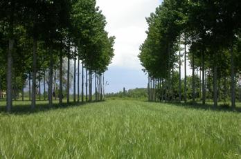
4 Site Description Figure 1: Site Photograph The land at the rear of Garden Close, Rattery is located immediately to the west of Garden Close near the heart of the village. The site comprises 0.67 ha of unserviced land comprising a single agricultural field. The site is bounded by residential gardens on the north and east. 2
5 Development Proposal and Context The Land to rear of Garden Close, Rattery has been identified by DHT as available for consideration by the council and the Rattery Parish and residents to help meet the future housing needs of the area. A sensitive development of up to five dwellings on this site is considered appropriate. The site was assessed in the 2009 SHLAA as site SH_39_02_08/13 which highlighted the potential to deliver fifteen dwellings in the period. There are no planning applications for the site identified on South Hams District Council s website. However, immediately to the north of the site, the application 39/0343/13/F (erection of twelve new dwellings) was approved in January 2014 and completed in April This exception site has delivered ten affordable and two open market dwellings under the planning authority s Village Housing Initiative and is an extension to the Garden Close cul-de-sac. The design of the Village Housing site has accommodated potential future access to the land to rear of Garden Close site and access rights have been maintained. 3
6 Site Technical Assessment Access The National Cycle Network Route 2 (NCN2) route can be accessed 120 m to the north of the proposal site and provides links to Dartington, Totnes and Plymouth. Access to the development can be achieved through Garden Close. The Access Appraisal concludes that there are no material highway or transportation matters that would preclude the Local Planning Authority (LPA) from approving any planning application in relation to highways concerns. Utilities Electricity, mains water and foul drainage are available for connection nearby. Further work is required to establish the potential for surface water attenuation. There is a three-phase overhead electricity supply which will need to be diverted. Flood Risk The site is outside Flood Zones 2 and 3. Ecology The site does not lie within any statutory or nonstatutory designated sites though it is within the potential foraging area for Greater Horseshoe Bats. The design of any development in the area should reinforce potential flyways through landscaping and will be subject to appropriate mitigation for example, conditions on external lighting. There is potential for a number of protected species to be present in the area and any development proposal will require survey and assessment. An overview ecology report has identified a number of assessments required to support any development design or proposal including: Extended Phase 1 Habitat Survey. Ecological Impact Assessment (EcIA). Bat Activity Survey (cf South Hams Special Areas of Conservation (SAC) Planning Guidelines). Possible other surveys if indicated (reptiles, amphibians, breeding birds, dormice, invertebrates). Based on the desk-based environmental assessment, no overriding ecological constraints to development are identified. Appropriate on-site mitigation and enhancement will be required for any notable species. Delivery There are no issues which would impede delivery and the site is sufficiently viable to contribute to the district s affordable housing need. 4
7 Planning Policy Review DHT shares with the council the overarching aim to produce a sound local plan in order to guide development in a sustainable way over the coming years. This assessment includes reference to both policy compliance for proposed development and plan-making compliance for the forthcoming presubmission Draft Local Plan. Under Section 38(6) of the Planning and Compulsory Purchase Act 2004 the Local Development Plan provides the primary guidance in consideration of planning proposals. However, this consultation is intended to inform the content of the new Joint Local Plan for the area so initial consideration of appropriateness of allocations and policies is based on the National Planning Policy Framework (NPPF) and National Planning Practice Guidance (NPPG). National Policy Planning Balance Development on this site presents an opportunity to satisfy the NPPF objective to significantly boost the supply of housing, and the requirement for Local Planning Authorities to make plans and to determine planning applications based on the presumption in favour of sustainable development. Specifically, development is supported by the following: NPPF 49 requires that housing applications should be considered in the context of the presumption in favour of sustainable development. NPPF 54 highlights the importance of responding to local needs for rural, affordable housing, including exception sites. NPPF 55 states the importance of housing in enhancing and maintaining the vitality of rural communities. This site is not isolated but is an extension to the existing community at Rattery. NPPF 14 (and 197) highlights the presumption in favour of sustainable development. For decisiontaking, this means: In the absence of a robust plan the council should grant permission unless any adverse impacts of doing so would significantly and demonstrably outweigh the benefits... or specific policies in this Framework indicate development should be restricted. Based on this appraisal, it is clear that this site accords with the requirements of the NPPF in respect of social, economic and environmental considerations and the principle of development on this site would be supported by national policy. NPPF 10 notes that Plans and decisions need to take local circumstances into account, so that they respond to the different opportunities for achieving sustainable development in different areas. This site is about small scale rural development to support local needs. 5
8 National Policy Plan Soundness The NPPF sets out a number of requirements for plan-making. NPPF 182 summarises the tests of soundness as being: positively prepared, justified, effective and consistent with national policy. The inclusion of the land at the rear of Garden Close, Rattery helps meet these tests with particular support for the following: NPPF 15 highlights that policies in Local Plans should also follow the approach of the presumption in favour of sustainable development. NPPF 28 requires planning policies to positively support rural economy and communities. NPPF 47 stresses the need to boost significantly the supply of housing to support a wide choice of quality homes. A community responsive scheme is an opportunity to contribute to the supply of deliverable and developable sites. Local Policy Analysis The Plymouth and South West Devon Joint Local Plan will replace the Local Development Framework (LDF) which provides guidance with respect to development proposals which may be permitted in the South Hams. The work undertaken for DHT confirms that this site will be compliant with expected local policies. Neighbourhood Planning Rattery Parish is not a designated Neighbourhood Plan area and we understand they wish to progress a Parish Plan rather than a statutory development plan. DHT will work with the Parish and community to consider options for bringing forward small scale development within this site. NPPF 55 requires that to promote sustainable development in rural areas, housing should be located where it will enhance or maintain the vitality of rural communities. The council recognises that the market towns provide the most sustainable approach to meeting housing needs in the district and recognises the importance of supporting smaller scale development in the villages. 6
9 Summary The information and analysis contained in this document demonstrates that: Allocation for development based on local needs is appropriate in this area. A review of technical and design issues makes it clear that a scheme is deliverable. On the basis of current policy, and in light of the lack of site constraints, this site could begin to deliver in the five year time frame. Potential Delivery Programme Years one to five up to five homes It will be for the council to determine the specific allocations and wording and it is not clear how nonstrategic allocations in rural communities will be codified. However, in light of the availability of this unconstrained site, which is well located for the neighbouring community, we would recommend that this allocation be made in the form of up to five dwellings to confirm to the community the appropriate scale of development. Consultants The appraisals have been prepared by the Dartington Hall Trust with support and advice from specialist consultants including: Planning advice Prof Chris Balch, Professor of Planning, Plymouth University Planning advice Mary Elkington, Figura Planning Masterplanning and Estate Framework Studio Partington Heritage Stephen Bond, Heritage Places Transport Assessment Hydrock Surface and foul drainage infrastructure Jubb Consulting Engineers Ecology EAD Ecology 7
10 Figure 2: Site Location Plan Scale A m Vines Orchard Barn 61 Furzefield 114.0m The Old Smithy Corbolt Cottage Corbett Cottage FB The Plains Brookside Cottage Issues Sinks Burnside Linstow 1 2 Ferndale Court Cottage Rock Park Hazelwood Playing Field GARDEN CLOSE Garden Park Play Area Belle Vue Montrose 119.2m Church House Inn Churchside Old Hall Cottage St Mary's Church Rattery Location plan 61 Wor The Grey House Rattery Sketch Scheme Churchills The Pound House 1:500 on A1 1:1000 on A3 Springfield The Dartington Ha The Firs Ash Cottage The Chantry Drawing BT 1605 Nimh House Indicative purposes onl Do not scale from this d M 8
11 Figure 3: Suggested Development Constraints Scale A3 Notes Court Cottage Burnside Linstow Sinks 1 Rock Park 2 Fernda Up to five houses would fit well within the topography of the site. Particularly if clustered in a similar way to the most attractive parts of the existing village. Hazelwood Playing Field Vehicle access Shared woodland GARDEN CLOSE Pedestrian access only Suggested development area in grey hatch Shared woodland Garden Park Play Area Belle Vue Montrose 119.2m Church House Inn Churchside Old Hall Cottage St Mary's Church Ra Shared amenity land Level access on contour The Grey House Suggested development area in grey hatch The Pound House Shared woodland Churchills Pedestrian access only Spri The Firs Ash Cottage The Chantry Nimh House M 9
Response by The Dartington Hall Trust
 Consultation Response by The Dartington Hall Trust Site Reference: (T6 in DPD) 14_56/2246/13/f Contents Introduction 1 Site Description 2 Development Proposal and Context 3 Site Technical Assessment 4
DHT 750_EDR_00 Ecological Deliverability Appraisal DHT Access Appraisal C DHT Heritage Overview
 Consultee ID:1020173 April 2017 Rep Summary TTV29 (7) Broom Park Field Legal, Compliant and Sound Hearing: DHT wish to participate in the examination hearings to further develop our comments, to enable
Rep Summary TTV28 (1) Dartington Lane. Introduction. Update
 Dartington Lane. Introduction. Update") Consultee ID:1020173 April 2017 Rep Summary TTV28 (1) Dartington Lane Legal, Compliant and Sound Hearing: DHT wish to participate in the examination hearings to further develop our comments, to enable
Consultee ID:1020173 April 2017 Rep Summary TTV28 (1) Dartington Lane Legal, Compliant and Sound Hearing: DHT wish to participate in the examination hearings to further develop our comments, to enable
Plumpton Neighbourhood Development Plan Revised Pre Submission Document - Regulation 14 Consultation
 REPRESENTATIONS... Plumpton Parish Council Plumpton Neighbourhood Development Plan Revised Pre Submission Document - Regulation 14 Consultation Representations submitted on behalf of: Cala Homes (South
Plymouth and South West Devon Joint Local Plan
 Plymouth and South West Devon Joint Local Plan Totnes and Area Briefing 19 th July The Totnes Area Introduction to the Joint Local Plan Potential Development Sites The Local Issues Discussion The Totnes
Copyright Nigel Deeley and licensed for reuse under this Creative Commons Licence
 1 Copyright Nigel Deeley and licensed for reuse under this Creative Commons Licence Prepared by the Neighbourhood Plan Steering Group on behalf of Garway Parish Council with assistance from 2 Table of
STATEMENT OF COMMON GROUND (CD/H01) LAND ADJ A385 TOTNES ROAD COLLATON ST MARY APPEAL REFERENCE: APP/X1165/A/14/
 LAND ADJ A385 TOTNES ROAD COLLATON ST MARY APPEAL REFERENCE: APP/X1165/A/14/") STATEMENT OF COMMON GROUND (CD/H01) LAND ADJ A385 TOTNES ROAD COLLATON ST MARY APPEAL REFERENCE: APP/X1165/A/14/2214154 APPEAL BY TAYLOR WIMPEY (EXETER) LIMITED LOCAL PLANNING AUTHORITY TORBAY COUNCIL
STATEMENT OF COMMON GROUND (CD/H01) LAND ADJ A385 TOTNES ROAD COLLATON ST MARY APPEAL REFERENCE: APP/X1165/A/14/2214154 APPEAL BY TAYLOR WIMPEY (EXETER) LIMITED LOCAL PLANNING AUTHORITY TORBAY COUNCIL
Parish of Repton NEIGHBOURHOOD DEVELOPMENT PLAN
 Parish of Repton NEIGHBOURHOOD DEVELOPMENT PLAN BASIC CONDITIONS STATEMENT December 2018 CEF 4 Legal Requirements This statement has been produced by the NDP Working Group on behalf of Repton Parish Council
Settlement Boundaries Methodology North Northumberland Coast Neighbourhood Plan (August 2016)
") Introduction This background paper sets out a methodology for the definition of settlement boundaries in the North Northumberland Coast Neighbourhood Plan. The neighbourhood plan is planning positively
Introduction This background paper sets out a methodology for the definition of settlement boundaries in the North Northumberland Coast Neighbourhood Plan. The neighbourhood plan is planning positively
Ward: Fishbourne. Bethwines Farm Blackboy Lane Fishbourne Chichester West Sussex PO18 8B
 Parish: Fishbourne Ward: Fishbourne FB/16/00961/FUL Proposal New pitched roof to the bunker building. Site Bethwines Farm Blackboy Lane Fishbourne Chichester West Sussex PO18 8B Map Ref (E) 483188 (N)
Neighbourhood Planning Local Green Spaces
 Neighbourhood Planning Local Green Spaces Introduction... 2 1. Why green space is important... 4 2. Neighbourhood plans and green space... 6 3. Evidence... 8 Statutory designations... 9 Green space audit...
WELCOME. Land North of STEVENAGE. We would like to thank you for attending our public exhibition today.
 WELCOME We would like to thank you for attending our public exhibition today. The purpose of this event is to share our proposals and hear your thoughts on our ideas. Members of the project team are on
Ward: West Wittering. Proposal Change of use from public highway pavement to residential garden use.
 Parish: West Wittering Ward: West Wittering WW/17/03295/FUL Proposal Change of use from public highway pavement to residential garden use. Site Izora 1 Watersedge Gardens West Wittering PO20 8RA Map Ref
SOUTH CAMBRIDGESHIRE DISTRICT COUNCIL. REPORT TO: Planning Committee 1 April 2015 Planning and New Communities Director
 SOUTH CAMBRIDGESHIRE DISTRICT COUNCIL REPORT TO: Planning Committee 1 April 2015 AUTHOR/S: Planning and New Communities Director Application Number: Parish(es): Proposal: Site address: Applicant(s): Recommendation:
SOUTH EAST LINCOLNSHIRE LOCAL PLAN: HOUSING PAPER DONINGTON (JUNE 2016)
") SOUTH EAST LINCOLNSHIRE LOCAL PLAN: HOUSING PAPER DONINGTON (JUNE 2016) 1 DONINGTON S PLACE IN THE SPATIAL STRATEGY 1.1 Policy 2 of the South East Lincolnshire Local Plan 2011-2036 Draft for Public Consultation
SOUTH EAST LINCOLNSHIRE LOCAL PLAN: HOUSING PAPER DONINGTON (JUNE 2016) 1 DONINGTON S PLACE IN THE SPATIAL STRATEGY 1.1 Policy 2 of the South East Lincolnshire Local Plan 2011-2036 Draft for Public Consultation
DUNSFOLD NEIGHBOURHOOD PLAN Site Selection Policies
 DUNSFOLD NEIGHBOURHOOD PLAN Site Selection Policies The criteria for assessing sites for future housing and business development in Dunsfold are set out below. (Development criteria, covering what it is
Statement of Community Involvement LAND OFF SOUTHDOWN ROAD HORNDEAN, HAMPSHIRE
 LAND OFF SOUTHDOWN ROAD HORNDEAN, HAMPSHIRE CONTENTS Page 1. Introduction 3 2. Pre-application Discussions 4 3. The Consultation Process 5 4. Consultation Feedback 7 5. Responses to Consultation Feedback
LAND EAST OF MILL LANE, SHERBURN VILLAGE PLANNING STATEMENT
 LAND EAST OF MILL LANE, SHERBURN VILLAGE PLANNING STATEMENT On behalf of The Church Commissioners for England Land East of Mill Lane, Sherburn Village Planning Statement On Behalf of The Church Commissioners
Replacement Golf Course Facilities and Residential Development, Churston. Environmental Statement Non-Technical Summary
 Replacement Golf Course Facilities and Residential Development, Churston Environmental Statement Non-Technical Summary July 2011 Reproduced from the Ordnance Survey s map with the permission of the Controller
DEVELOPMENT MANAGEMENT REPORT
 ITEM A07-1 DEVELOPMENT MANAGEMENT REPORT TO: BY: Development Management Committee (South) Development Manager DATE: 21 June 2016 DEVELOPMENT: SITE: WARD: APPLICATION: APPLICANT: Outline application for
Planning and Regulatory Committee 20 May Applicant Local Councillor Purpose of Report
 Planning and Regulatory Committee 20 May 2014 7. APPLICATION FOR PLANNING PERMISSION FOR THE CARRYING-OUT OF DEVELOPMENT PURSUANT TO PLANNING PERMISSION REFERENCE NUMBER 603451 DATED 28 FEBRUARY 2007 WITHOUT
Great Easton Neighbourhood Plan Statement of Basic Conditions
 Great Easton Neighbourhood Plan 2017-2031 Statement of Basic Conditions OCTOBER 2016 GREAT EASTON PARISH COUNCIL Contents 1.0 Introduction....Page 2 2.0 Summary of Submission Documents and Supporting Evidence..
Committee Report. Case Officer: Gemma Walker. Ward: Bacton & Old Newton. Ward Member/s: Cllr Jill Wilshaw.
 Committee Report Item No: 1 Ward: Bacton & Old Newton. Ward Member/s: Cllr Jill Wilshaw. Reference: DC/17/05423 Case Officer: Gemma Walker Description of Development Outline planning application (all matters
Effingham Neighbourhood Plan 1. Basic Conditions Statement
 Effingham Neighbourhood Plan 1 Basic Conditions Statement Effingham Neighbourhood Plan 2016: Basic Conditions Statement 2 Contents This statement has been prepared by Effingham Parish Council to accompany
Ward: Southbourne. Outline application with all matters reserved. Erection of 5 no. dwellings and associated works.
 Parish: Southbourne Ward: Southbourne SB/16/00205/OUT Proposal Site Outline application with all matters reserved. Erection of 5 no. dwellings and associated works. Dunkirk South Lane Southbourne Emsworth
Wildlife and Planning Guidance: Neighbourhood Plans
 Wildlife and Planning Guidance: Neighbourhood Plans This Leaflet is one of a series of 4 Wildlife and Planning Guidance Leaflets and is intended to provide useful information to assist you to campaign
DONCASTER METROPOLITAN BOROUGH COUNCIL. PLANNING COMMITTEE - 15th October Expiry Date:
 DONCASTER METROPOLITAN BOROUGH COUNCIL PLANNING COMMITTEE - 15th October 2013 Application 3 Application Number: 13/01158/FUL Application Expiry Date: 31st July 2013 Application Type: Full Application Proposal
Perth and Kinross Council Development Management Committee 8 June Pre-Application Report by Development Quality Manager
 Perth and Kinross Council Development Management Committee 8 June 2016 5(3)(i) 16/259 Pre-Application Report by Development Quality Manager Residential development at St Martins Road, Land 120 metres West
WELCOME GYPSY LANE. Wider Site Location plan. Proposals for the development of LAND OFF FOXLYDIATE LANE WEBHEATH. Proposals for the development of
 WELCOME The developers are preparing an outline planning application for a residential led development and need the community s views in order to develop the proposals further WHAT IS PROPOSED? A high
RYEDALE SITES LOCAL PLAN MATTER 3 HOUSING ALLOCATION SITE REF.SD5 LAND EAST OF WHITBY ROAD, PICKERING DAVID WILSON HOMES REPRESENTOR ID: 1073
 RYEDALE SITES LOCAL PLAN MATTER 3 HOUSING ALLOCATION SITE REF.SD5 LAND EAST OF WHITBY ROAD, PICKERING INTRODUCTION DAVID WILSON HOMES REPRESENTOR ID: 1073 1.1 We write on behalf of our client David Wilson
Development of land adjacent to Braggs Farm Lane and Rumbush Lane, Dickens Heath. Welcome. Today s exhibition. The proposal site
 Welcome Welcome to this event to discuss the development of land adjacent to Braggs Farm Lane. is currently in the preliminary stages of designing proposals to sensitively develop this site with high-quality
2015/1020 Mr Edward Cockburn Caravan storage on hardcore base (Retrospective) Ranah Stones, Whams Road, Hazlehead, Sheffield, S36 4HT
 Ranah Stones, Whams Road, Hazlehead, Sheffield, S36 4HT") 2015/1020 Mr Edward Cockburn Caravan storage on hardcore base (Retrospective) Ranah Stones, Whams Road, Hazlehead, Sheffield, S36 4HT Dunford Parish Council have not commented Councillor Andrew Millner
2015/1020 Mr Edward Cockburn Caravan storage on hardcore base (Retrospective) Ranah Stones, Whams Road, Hazlehead, Sheffield, S36 4HT Dunford Parish Council have not commented Councillor Andrew Millner
Agenda Update Sheet. Planning Committee A
 Agenda Update Sheet Planning Committee A Date: 22 nd June 2017 Agenda Section 5: Applications Part I Recommended for Approval ITEM: 1 DM/16/5502 Summary of Consultees Surrey County Council No objection
ROCHFORD LOCAL DEVELOPMENT FRAMEWORK: Sustainability Appraisal/ Strategic Environmental Assessment. Rochford Core Strategy Preferred Options Document
 ROCHFORD LOCAL DEVELOPMENT FRAMEWORK: Sustainability Appraisal/ Strategic Environmental Assessment Non Technical Summary Rochford Core Strategy Preferred Options Document October 2008 SUSTAINABILITY APPRAISAL
Cookham Parish Council s Response to The Draft Local Borough Plan
 Cookham Parish Council s Response to The Draft Local Borough Plan As Agreed at the Planning Committee Meeting on 10 th January 2017. Designation of Poundfield as a Local Green Space The Parish Council
Derry City and Strabane District Council Planning Committee Report. Amended layout from approval A/2004/0462/F with reduction from 166 units
 Derry City and Strabane District Council Planning Committee Report COMMITTEE DATE: 1 st February 2017 APPLICATION No: APPLICATION TYPE: PROPOSAL: LOCATION: APPLICANT: AGENT: Full Planning application Amended
Plumpton Neighbourhood Plan Site Assessment Report
 Plumpton Neighbourhood Plan Site Assessment Report May 2016 1 Contents 1. Introduction 3 2. Methodology 4 2.1 Identification of Potential Sites 4 2.2 Assessment Process 5 2.3 Assessment Criteria 6 2.4
Neighbourhood Plan Representation
 Date: 10 th November 2017 Neighbourhood Plan Representation Land to the east of Callow Hill Road, Alvechurch Introduction This representation has been prepared by RPS Planning and Development on behalf
DEVELOPMENT MANAGEMENT REPORT
 ITEM A08-1 DEVELOPMENT MANAGEMENT REPORT TO: BY: DATE: DEVELOPMENT: SITE: WARD: APPLICATION: APPLICANT: Development Management Committee Development Manager Proposed live/work unit in connection with existing
Land at Rampton Road. Cottenham
 Land at Rampton Road Cottenham Introduction TEP is preparing an outline planning application for 54 dwellings on 6.9 hectares of land adjacent to Rampton Road, Cottenham on behalf of the owners Cambridgeshire
Vigo Neighbourhood Plan Basic Conditions Statement
 Vigo Neighbourhood Plan Basic Conditions Statement Plan Period: 2016 to 2028 Status: Submission Version Qualifying Body: Vigo Parish Council Glossary of Some Terms & Abbreviations Used in this Document
an Inspector appointed by the Secretary of State for Communities and Local Government
 Appeal Decision Site visit made on 14 July 2015 by I Radcliffe BSc(Hons) MCIEH DMS an Inspector appointed by the Secretary of State for Communities and Local Government Decision date: 18 August 2015 Appeal
Copyright Nigel Deeley and licensed for reuse under this Creative Commons Licence
 1 Copyright Nigel Deeley and licensed for reuse under this Creative Commons Licence Prepared by the Neighbourhood Plan Steering Group on behalf of Garway Parish Council with assistance from 2 Table of
APPLICATION REFERENCE: PL/2016/02759/PPFL
 APPLICATION REFERENCE: PL/2016/02759/PPFL Site Address: Land Adjacent To Mount Farm Tanworth Lane, Chewisck Green. Proposal: Erection of 54 dwellings following the granting of outline permission 2014/1163/S
AT MOONS YARD, GROVE ROAD, SELLING, FAVERSHAM PLANNING STATEMENT DHA REF: JAC/MG/9967
 DEMOLITION OF EXISTING COMMERCIAL BUILDINGS, REMOVAL OF THE EXISTING HARD SURFACE AREAS AND THE ERECTION OF 5 No DWELLINGS WITH AMENITY SPACE, PADDOCKS, PARKING, ACCESS AND LANDSCAPING AT MOONS YARD, GROVE
Introduction. Grounds of Objection
 Planning application ref. number 18/04496/APP Planning application to Aylesbury Vale District Council for the erection of 17 dwellings and associated works to the South of Hogshaw Road Granborough. Granborough
Neighbourhood Planning Guidance Local Green Spaces
 Neighbourhood Planning Guidance Local Green Spaces Introduction This guidance note has been produced for communities preparing neighbourhood plans in North Dorset to help them to identify, assess and designate
Tandridge Local Plan Assessing the Ecological Suitability of 183 sites considered for development Tandridge District Council, Surrey
 Tandridge Local Plan Assessing the Ecological Suitability of 183 sites considered for development Tandridge District Council, Surrey PLANNING I DESIGN I ENVIRONMENT 1.0 INTRODUCTION TEP conducted Site
Site Assessment Technical Document Appendix A: Glossary
 Central Bedfordshire Council www.centralbedfordshire.gov.uk Site Assessment Technical Document Appendix A: Glossary July 2017 1.1.11-1 - ii Appendix A: Glossary Term Agricultural Land Classification AONB
National Planning Policy Framework
 National Planning Policy Framework February 2019 Ministry of Housing, Communities and Local Government ( ( (!"#$%&"'()'"&&$&*()%'$+,( -."/01%.2( ( ( @$"0"/1"9(12(@&$
BLEWBURY NEIGHBOURHOOD DEVELOPMENT PLAN STATEMENT OF BASIC CONDITIONS
 BLEWBURY NEIGHBOURHOOD DEVELOPMENT PLAN STATEMENT OF BASIC CONDITIONS Introduction 1.1 This statement has been prepared to accompany the submission of the Blewbury Neighbourhood Development Plan ( the
OKEFORD FITZPAINE NEIGHBOURHOOD PLAN
 OKEFORD FITZPAINE NEIGHBOURHOOD PLAN Dear Parishioner, The Neighbourhood Plan Project Team have prepared this leaflet to summarise the full Neighbourhood Plan document. It provides a summary of the Vision,
Welcome. Site/11/04. Site/11/03. Proposed Site. 11,400 new homes needed in east Cambs
 Welcome Welcome to our consultation on our proposals for new homes on land north east of Soham Road, Fordham. Members of the project team are available to answer any questions you have and listen to feedback.
Wyvern Park Skipton Environmental Statement. Non-technical Summary - April 2015
 Wyvern Park Skipton Environmental Statement Non-technical Summary - April 2015 BWB Consulting Ltd Whitehall Waterfront 2 Riverside Way Leeds LS1 4EH Telephone: +44(0)113 233 8000 Copyright This Report
APP/G1630/W/15/
 Appeal Decision Site visit made on 20 October 2015 by William Fieldhouse BA (Hons) MA MRTPI an Inspector appointed by the Secretary of State for Communities and Local Government Decision date: 20 November
Mid Suffolk District Council Planning Control Department 131 High Street Needham Market IP6 8DL
 Mid Suffolk District Council Planning Control Department 131 High Street Needham Market IP6 8DL OUTLINE PLANNING PERMISSION Town and Country Planning Act 1990 THE TOWN AND COUNTRY PLANNING (DEVELOPMENT
STATEMENT OF OBJECTION TO THE PROPOSED DEVELOPMENT OF LAND AT CHURCH CLIFF DRIVE FILEY
 STATEMENT OF OBJECTION TO THE PROPOSED DEVELOPMENT OF LAND AT CHURCH CLIFF DRIVE FILEY You will be aware that Scarborough borough council have adopted a new local plan that includes land at Church Cliff
UTT/17/2075/FUL - (BERDEN) (Referred to Committee by Councillor Janice Loughlin. Reason: In the Public Interest)
 (Referred to Committee by Councillor Janice Loughlin. Reason: In the Public Interest)") UTT/17/2075/FUL - (BERDEN) (Referred to Committee by Councillor Janice Loughlin. Reason: In the Public Interest) PROPOSAL: LOCATION: APPLICANT: Amendments to the design of a scheme for a 49.99MW battery
UTT/17/2075/FUL - (BERDEN) (Referred to Committee by Councillor Janice Loughlin. Reason: In the Public Interest) PROPOSAL: LOCATION: APPLICANT: Amendments to the design of a scheme for a 49.99MW battery
Derry City and Strabane District Council Planning Committee Report
 Derry City and Strabane District Council Planning Committee Report COMMITTEE DATE: 23 rd March 2016 APPLICATION No: APPLICATION TYPE: PROPOSAL: LOCATION: APPLICANT: LA11/2015/0395/F Residential Development
CA//16/00504/FUL. Canterbury City Council Military Road Canterbury Kent CT1 1YW. Crown copyright and database rights 2016 Ordnance Survey
 O Scale 1:1,250 Map Dated: 09/05/2016 CA//16/00504/FUL Crown copyright and database rights 2016 Ordnance Survey 100019614 Canterbury City Council Military Road Canterbury Kent CT1 1YW AGENDA ITEM NO 13
Wildlife and Planning Guidance: Local Plans
 Wildlife and Planning Guidance: Local Plans This Leaflet is one of a series of 4 Wildlife and Planning Guidance Leaflets and is intended to provide useful information to assist you to campaign effectively
Special Landscape Area (Great Orme and Creuddyn Peninsular). Agricultural land (grade 3a). TPO A14 (1982) - group of trees (G4) on east boundary.
. Agricultural land (grade 3a). TPO A14 (1982) - group of trees (G4) on east boundary.") TAN 24 and TAN 5: Technical Advice Note (TAN) 24: The Historic Environment (2017) Guidance on how the planning system considers the historic environment during development plan preparation and decision
TAN 24 and TAN 5: Technical Advice Note (TAN) 24: The Historic Environment (2017) Guidance on how the planning system considers the historic environment during development plan preparation and decision
Ashford Borough Council - Report of Head of Development, Strategic Sites and Design Planning Committee 20 September 2017
 Application Number Location 17/00950/AS Land to the rear of 96A, Kingsnorth Road, Ashford, Kent Grid Reference 00463/41043 Parish Council Ward Application Description Applicant Agent Site Area South Ashford
2015/0291 Reg Date 13/04/2015 Parkside
 2015/0291 Reg Date 13/04/2015 Parkside LOCATION: PROPOSAL: TYPE: APPLICANT: OFFICER: BROOK GREEN & TINYBROOK, WAVERLEY CLOSE, CAMBERLEY, GU15 1JH Outline application for the erection of two blocks of flats
1 The development hereby permitted shall be carried out in accordance with the following approved plans:
 Location The Avenue Tennis Club The Avenue London N3 2LE Reference: 16/6509/FUL Received: 10th October 2016 Accepted: 10th October 2016 Ward: Finchley Church End Expiry 5th December 2016 Applicant: Mrs
CENTRAL BEDFORDSHIRE COMMITTED TO WORKING TOGETHER WITH LOCAL COMMUNITIES
 WELCOME Thank you for coming to our consultation event to find out more about our emerging proposals for Hayfield Park, a residential development jointly promoted by the Hayfield Consortium: Martin Grant
3. Neighbourhood Plans and Strategic Environmental Assessment
 1. Introduction This report sets out a draft Screening Determination for the Preston Parish Council s Neighbourhood Plan and has been prepared by rth Hertfordshire District Council. The purpose of the
Babergh and Mid Suffolk Joint Draft Local Plan Consultation, August 2017, Public Consultation
 Babergh and Mid Suffolk Joint Draft Local Plan Consultation, August 2017, Public Consultation Having reviewed the documents, the Society has made the following response: Housing Delivery Q 7. Do you agree
Test Valley Borough Council. Strategic Housing Land Availability Assessment (SHLAA)
") Test Valley Borough Council Strategic Land Assessment (SHLAA) Appendix 2 Southern Test Valley Sites Where a Change in Policy is Required for Residential Development Final Version as at 1 st April 2014
Test Valley Borough Council Strategic Land Assessment (SHLAA) Appendix 2 Southern Test Valley Sites Where a Change in Policy is Required for Residential Development Final Version as at 1 st April 2014
VIEW PLANS AT: mmary&keyval=ny3yzlhy0b100
 HARROGATE BOROUGH COUNCIL 09/6.49.165.A.OUT /15/05195/OUT/0 09/6.49.165.A.OUT /15/05195/OUT/1 DATE: 12 May 2016 PLAN: 09 CASE NUMBER: 15/05195/OUT GRID REF: EAST 416110 NORTH 465707 APPLICATION NO. 6.49.165.A.OUT
Land at Fiddington Hill Nursery, Market Lavington
 Land at Fiddington Hill Nursery, Market Lavington Briefing Report for Market Lavington Parish Council Persimmon Homes (Wessex) April 2016 Background This brief report has been prepared following the Market
SUPPORTING PLANNING STATEMENT. Proposed Residential Development Land to the West of Cody Road, Waterbeach, Cambridgeshire. for.
 SUPPORTING PLANNING STATEMENT Proposed Residential Development Land to the West of Cody Road, Waterbeach, Cambridgeshire for Manor Oak Homes Prepared by: Peter McKeown MSc, BSc (Hons) York House, Dukes
Reporter: Section 3 Place, Drymen, pp reference: Body or person(s) submitting a representation raising the issue (including reference number):
 submitting a representation raising the issue (including reference number):") Issue 10 Drymen Development plan Reporter: Section 3 Place, Drymen, pp.66-69 reference: Body or person(s) submitting a representation raising the issue (including reference number): Nadja Ray (85) Stuart
Issue 10 Drymen Development plan Reporter: Section 3 Place, Drymen, pp.66-69 reference: Body or person(s) submitting a representation raising the issue (including reference number): Nadja Ray (85) Stuart
DEVELOPMENT MANAGEMENT REPORT
 ITEM A03-1 DEVELOPMENT MANAGEMENT REPORT TO: BY: Development Management Committee (North) Development Manager DATE: 6 December 2016 DEVELOPMENT: SITE: WARD: APPLICATION: APPLICANT: Erection of two bungalows
DRAFT STRATEGIC ENVIRONMENTAL ASSESSMENT REPORT
 DRAFT STRATEGIC ENVIRONMENTAL ASSESSMENT REPORT Published by Limpsfield Parish Council in accordance with EU Directive 2001/42 on Strategic Environmental Assessment and with the Environmental Assessment
SAHAM TONEY NEIGHBOURHOOD DEVELOPMENT PLAN : THE POLICIES
 SAHAM TONEY NEIGHBOURHOOD DEVELOPMENT PLAN 2018-2036: THE POLICIES This is a much-abridged version of the full neighbourhood Plan, and includes only the policy text, the main policy maps and some key charts.
Alder View. Introduction. Alder View. Harwell. The Vision. The Team. Taylor Wimpey
 Introduction Welcome to the public exhibition for, a development by Taylor Wimpey on the land south of Grove Road,. This exhibition will provide an overview of the development proposals for the site and
PLANNING STATEMENT. Market House Market Place Kingston upon Thames KT1 1JS
 PLANNING STATEMENT To support planning and listed building consent applications for change of use from Class A1 shop and Class A3 cafe to Class A3 restaurant at: Market House Market Place Kingston upon
Heritage in Neighbourhood Plans
 Heritage in Neighbourhood Plans Dave Chetwyn Managing Director, Urban Vision Enterprise CIC Chair, Historic Towns Forum Planning Adviser, Locality Vice Chair, National Planning Forum Associate of The Consultation
PLANNING COMMITTEE DATE: 07/09/2015 REPORT OF THE SENIOR MANAGER PLANNING AND ENVIRONMENT SERVICE CAERNARFON. Number: 4
 Number: 4 Application Number: C15/0034/37/LL Date Registered: 21/05/2015 Application Type: Full - Planning Community: Llanaelhaearn Ward: Llanaelhaearn Proposal: Location: Summary of the Recommendation:
Carterton Construction Ltd is bringing forward plans for up to 85 new family homes and extra care facilities on land east of Burford.
 Welcome Carterton Construction Ltd is bringing forward plans for up to 85 new family homes and extra care facilities on land east of. We are at the early stages of designing our proposals and have a number
LONGDEN VILLAGE DEVELOPMENT STATEMENT
 LONGDEN VILLAGE DEVELOPMENT STATEMENT 2017-2027 1 Longden Development Statement 2017-2027 15/01/18 1. Background 1.1 Longden Village Longden village is a very rural and traditional community first mentioned
INTRODUCTION NORTH HEYBRIDGE GARDEN SUBURB
 INTRODUCTION This event is being hosted by the promoters of the proposed North Heybridge Garden Suburb who are working with Maldon District Council and other key stakeholders on the preparation of a comprehensive
SITE ASSESSMENT CHECKLIST
 1. Site Details a. What is the site s name/reference? SITE ASSESSMENT CHECKLIST CR3NPWHY 3007 Gasometer Site Godstone Road CR3 0EG b. Where is the site located? Wyhteleafe; Godstone Road. Urban category1
ABOUT CALA HOMES CALA HOMES
 WELCOME Welcome to this public consultation event for our proposed development on land to the east of Salisbury Road, in Hungerford. Thank you for taking the time to come along today. Homes and Wates Developments
Tennis Court Rear Of 3-5 Corringway London NW11 7ED
 Location Tennis Court Rear Of 3-5 Corringway London NW11 7ED Reference: 18/4122/FUL Received: 3rd July 2018 Accepted: 3rd July 2018 Ward: Garden Suburb Expiry 28th August 2018 Applicant: Ms Sarah Robinson
Barvills Solar Farm Environmental Statement Non-Technical Summary
 Barvills Solar Farm Environmental Statement Non-Technical Summary 13 March 2015 Produced for Prepared by St John s House Queen Street, Manchester M2 5JB Contents Contents... 2 1 Introduction... 3 1.1 Development
WELCOME. Olney Road, Lavendon INTRODUCTION. The Site. The Application. The Need for Housing. A Sustainable Location LAVENDON TURVEY OLNEY ROAD
 0 WELCOME INTRODUCTION Gladman Developments Ltd have successfully invested in communities throughout the UK over the past 0 years, developing high quality and sustainable residential, commercial and industrial
National Planning Policy Framework
 National Planning Policy Framework Draft text for consultation March 2018 Ministry of Housing, Communities and Local Government Crown copyright, 2018 Copyright in the typographical arrangement rests with
A VISION FOR BLAIRGOWRIE
 Welcome to the Westpark Partnership and Lidl UK GmbH Community Presentation. The purpose of this presentation is for you to view and comment upon the revised and updated proposals for the allocated development
PLANNING APPLICATION FOR ERECTION OF 258 DWELLINGS AND ASSOCIATED WORKS LAND TO THE REAR OF MILTON CRESCENT, LUPSET
 SEPTEMBER 2017 EH YOR.2801 PLANNING APPLICATION FOR ERECTION OF 258 DWELLINGS AND ASSOCIATED WORKS PLANNING STATEMENT LAND TO THE REAR OF MILTON CRESCENT, LUPSET ON BEHALF OF KEEPMOAT HOMES TOWN & COUNTRY
A payment of 1080 is due in this instance, for a meeting and follow up written response, and will be made by card over the phone.
 JPPC ref: AG/6002 18 th September 2014 Planning Services Vale of White Horse District Council Benson Lane Crowmarsh Gifford Wallingford OX10 8ED Dear Sir/Madam REQUEST FOR PRE-APPLICATION ADVICE RE: RESIDENTIAL
Tisbury and West Tisbury Neighbourhood Plan. Site Assessment
 Tisbury and West Tisbury Neighbourhood Plan Site Assessment 16 th June 2017 This page is intentionally blank. Quality information Project Role Name Position Actions Summary Signature Date Researcher and
2014/0590 Reg Date 26/06/2014 Chobham
 2014/0590 Reg Date 26/06/2014 Chobham LOCATION: PROPOSAL: TYPE: APPLICANT: OFFICER: ASCOT PARK POLO CLUB, WESTCROFT PARK FARM, WINDLESHAM ROAD, CHOBHAM, WOKING, GU24 8SN Erection of a two storey detached
Planning Application 13/00952/FULLS at Ampfield Hill, Romsey, Test Valley: Great Crested Newt Survey Following on From Ecological Assessment
 10 June 2014 Mr Allan Clark esq Ampfield Parish Council Blue Haze Ampfield Hill Ampfield Romsey SO51 9BD By email only Our Ref: P13/46 Dear Mr Clark Planning Application 13/00952/FULLS at Ampfield Hill,
Tarrington Neighbourhood Development Plan Housing site assessment
 Tarrington Neighbourhood Development Plan Housing site assessment December 2015 Dr DJ Nicholson DJN Planning Ltd 1. Introduction 1.1 Tarrington Neighbourhood Development Plan (NDP) Steering Group have
South Worcestershire Development Plan. South Worcestershire Design Guide Supplementary Planning Document
 South Worcestershire Development Plan South Worcestershire Design Guide Supplementary Planning Document Statement of Consultation: Early Engagement Scoping Paper February 2017 1. Introduction 1.1 This
Everton s Neighbourhood Plan. Site Allocation - Assessment Criteria
 Everton s Neighbourhood Plan Site llocation - ssessment Criteria Introduction 1.1 This report assesses all the sites identified through the emerging Neighbourhood Plan for Everton and their potential for
46 Burley Street, Leeds, LS3 1LB Retail Statement
 , LS3 1LB Retail Statement , LS3 1LB Retail Statement October 2014 Indigo Planning Indigo Planning Limited Toronto Square Leeds LS1 2HJ Tel: 0113 380 0270 Fax: 0113 380 0271 info@indigoplanning.com indigoplanning.com
Parish: Westbourne. Ward: Westbourne WE/16/01078/COU
 Parish: Westbourne Ward: Westbourne WE/16/01078/COU Proposal Change of use of land to a private gypsy and traveller caravan site consisting of 1 no. mobile home, 1 no. utility building, 1 no. touring caravan