MOMENTUM. Planning Rationale and Design Brief for 235 King Edward Avenue. Minor Variance and Site Plan Applications
|
|
|
- Kathryn Ross
- 5 years ago
- Views:
Transcription

1 MOMENTUM PLANNING AND COMMUNICATIONS Planning Rationale and Design Brief for 235 King Edward Avenue June 30, 2015
2 Planning Rationale and Design Brief for 235 King Edward Avenue Prepared for: Anand Aggarwal in Partnership Manor Park Management 231 Brittany Drive, Suite D Ottawa, ON K1K 0R8 Prepared by: Dennis Jacobs MCIP, RPP Momentum Planning and Communications 1165 Greenlawn Crescent Ottawa, ON K2C 1Z4 With support from: MMM Group Ltd 1145 Hunt Club Road, Suite 300 Ottawa ON K1V 0Y3
3 Table of Contents Page 1. Introduction 1 2. Existing Conditions Site Overview Site Location Road Network and Transit 5 3. Development Proposal Overview 5 4. Policy and Regulatory Framework Provincial Policy Statement (2014) Official Plan 2003 (Consolidated May 2014) Urban Design Guidelines Comprehensive Zoning By-law ( ) Summary Opinion 31 List of Figures Figure 2.1: Aerial of the site at 235 King Edward 2 Figure 2.2: Aerial of the site and surrounding neighbourhood 3 Figure 2.3: View of site facing north-east from King Edward 4 Figure 2.4: View of the site facing south from St. Patrick 4 Figure 2.5: View of King Edward facing south 4 Figure 2.6: View of King Edward facing north 4 Figure 2.7: View of Murray Street 4 Figure 2.8: Existing Paramedic Facility 4 Figure 3.1: View of the proposed hotel facing northeast 6 Figure 3.2: View of the proposed hotel facing northwest 6 Figure 3.3: View of the proposed hotel facing south 7 Figure 3.4: View of the proposed hotel from intersection 8 Figure 3.5: View of proposed hotel facing north on King Edward 8 Figure 3.6: Proposed Site Plan 9 Figure 3.7: Preliminary Landscape Plan 10 Figure 4.1: Official Plan Schedule B: Urban Policy Plan 14 Figure 4.2: Official Plan Annex 9: Gateways 15 Figure 4.3: Official Plan Schedule C: Primary Cycling Network 16
4 Figure 4.4: Official Plan Schedule D: Rapid Transit Network 16 Figure 4.5: Official Plan Schedule F: Central Area Roads 17 Figure 4.6: Official Plan Schedule I: Multi-Use Pathways 17 Figure 4.7: Zoning for the site and surrounding area 24 Figure 4.8: By-law Schedule Appendix A Floor Plans
5 1. Introduction This Planning Rationale and Design Brief has been prepared by Momentum Planning and Communications ( Momentum ) in support of a minor variance and site plan applications for the subject property located at the intersection of King Edward Avenue and St. Patrick Street. The subject property consists of multiple municipal addresses: 235 and 237 King Edward Avenue, 364 and 380 St. Patrick Street, and 259 and 261 Murray Street (referred to herein as the site ). The intended address for the proposed development would be 235 King Edward Avenue. The site has split zoning. The parcel at 364 St. Patrick Street is currently zoned Traditional Mainstreet Zone Exception [2108] S317 and the balance of the site is zoned Traditional Mainstreet. A minor variance will be necessary to revise the current building specific height schedule (S317) to match the proposed design changes to the building envelope. There will be no increase in the existing maximum allowable height on the site which is controlled by the view plane from Beechwood Cemetery. The purpose of this Rationale and Design Brief is to assess the appropriateness of the proposed development in the context of the surrounding community and the policy and regulatory framework applicable to the site. This report is supported by the following additional studies carried out by others: 1. Architectural and Site Design and Sun Shadow Analysis by Woodman Architect and Associates Ltd. 2. Geotechnical Investigation dated June 23, 2015 by Paterson Group Inc. 3. Phase 1 Environmental Site Assessment dated June 9, 2015 by Paterson Group Inc. 4. Site Servicing and Storm Water Report dated June 16, 2015 by A. Dagenais & Associates Inc. 5. Topographical Plan dated May 15, 2015 by Annis, O Sullivan, Vollebekk Ltd. 6. Traffic Noise Impacts Assessment dated June 19, 2015 by Hugh Williamson Associates Inc. 7. Landscape Plan by Tracy Whalen Landscape Architect 8. Transportation Impact Assessment dated June 29, 2015 by D. J. Halpenny and Associates Ltd. 2. Existing Conditions 2.1 Site Overview The six parcels that make up the site are legally described as: Plan Pt Lots 1 and A; and RP 4R Parts 1 and 2 (municipally known as 235 King Edward Avenue); Plan Pt Lots 1 and A RP; 4R Parts 3 and 4 (municipally known as 235 King Edward Avenue); Plan Pt Lots A 1 and 2 (municipally known as 364 St. Patrick Street); Plan E33.5 N Pt Lot 2 (municipally known as 380 St. Patrick Street); 1

6 Plan Part of Lot 1A St. Patrick St N/S (municipally known as 259 Murray Street); and Plan Part of the S Part of Lot 2 St. Patrick St N/S (municipally known as 261 Murray Street). The site has approximately 51 metres of lot frontage along St. Patrick Street and 47 metres of lot frontage along King Edward Avenue. The total area of the site is approximately 0.25 hectares (0.62 acres). 2.2 Site Location Figure 2.1: Aerial of the site at 235 King Edward Avenue The site, shown in Figures 2.1, is located at the southeast corner of the intersection of King Edward Avenue and St. Patrick Street. It is part of a small block that is bound by St. Patrick Street to the north, Murray Street to the south, and King Edward Avenue to the west. The site currently includes a graveled, surface parking lot at the northwest corner (364 St. Patrick Street), and three buildings which are intended to be demolished in order to facilitate an assembly of the six existing lots into one and development of the proposed hotel. The existing buildings include the Shepherd s of Good Hope shelter and counseling office in the northeast corner of the site (380 St. Patrick Street), a wellness centre for holistic medicine abutting the parking lot to the south (235 King Edward Avenue), and a law office in the southwest corner of the site adjacent to the wellness centre 2
 commercial and institutional")
7 (237 King Edward Avenue). The remaining two parcels (259 and 261 Murray Street) are vacant land. Directly abutting the site to the east is an Ottawa Paramedic facility. Other surrounding land uses include low-rise residential, consisting primarily of semi-detached and townhouse dwellings, as well as various low profile (up to 4 storeys) commercial and institutional uses. The site is also within walking distance of the ByWard Market, the Rideau Centre, and the Rideau Street commercial area. Figures 2.2 to 2.8 show the site and surrounding area. Figure 2.2: The site and surrounding neighbourhood 3


8 Figure 2.3: View of the site facing northeast from King Edward Avenue Figure 2.4: View of the site facing south from St. Patrick Street Figure 2.5: View of King Edward Avenue facing south Figure 2.6: View of King Edward Avenue facing north Figure 2.7: View of Murray Street facing east, including existing access to the site Figure 2.8: Existing Paramedic Post adjacent to the site 4
9 2.3 Road Network and Transit Existing access to the site is provided from St. Patrick Street to the north, King Edward Avenue to the west, and Murray Street to the south. There are existing sidewalks on King Edward Avenue, St. Patrick Street, and Murray Street. OC Transpo Route 1 is the primary route on St. Patrick Street and Murray Street. It provides service to the ByWard market, Vanier and other destinations across the city. The site is located 850 metres from the approved LRT route along Rideau Street. 3. Development Proposal Overview A site plan (Application #D ) was submitted to the City in June 2013 for this site but has been placed on hold. During the process, the property owner acquired all of the adjacent parcels (except the EMS station). The original proposal was for a nine storey mixed-use building (with a maximum height up to 27 metres) with two floors of underground parking, 183m 2 of commercial space on the ground floor, and 98 furnished residential apartment units on floors 2 to 9. The building was intended to operate as an apartment hotel for short to medium term stays. The main site access was provided from St. Patrick Street. The current development proposal is for a nine (9) storey full service Holiday Inn Hotel containing 167 suites. The proposed development is intended to offer standard hotel accommodations. The ground floor will be approximately 1205 square metres and will accommodate the main lobby and reception, a media lounge, a family dining bar and buffet, a meeting room, kitchens, washrooms, service rooms, and storage rooms. Five visitor parking spaces will be provided outside of the main entrance along with a lay-by for two vehicles at the entrance and all other parking will be provided underground. A total of 79 underground spaces will be included. Ingress to the site will be provided from St. Patrick Street and egress will be provided on Murray Street. Figures 3.1 to 3.7 illustrate the proposed development. Additional floor plan drawings can be found in Appendix A. The proposed hotel is in a key location, given the proximity to the ByWard Market, Downtown Ottawa, and Gatineau. It is conveniently located within walking distance of a number of commercial, recreational, and institutional uses, as well as OC Transpo service. The site is in a highly visible location along a key entry route into Ottawa from the Province of Québec. As well, St. Patrick Street brings travellers from the eastern neighbourhoods of New Edinburgh, Rockcliffe Park, Vanier, Lindenlea and Manor Park through Lowertown and into the ByWard market area past this site. This project will be the first significant redevelopment and intensification of this small block which implements the policies of the Official Plan. Given the site s physical separation from the adjacent blocks by the surrounding streets, it presents an opportunity to use a transitional height as a landmark and entrance feature into the neighbourhood as well as the city as a whole. Given the small area of the block and the generally lower profile nature of the surrounding community, it is felt that a mid-rise building of 9 storeys will provide a focal point and set the stage for the eventual redevelopment of the remainder of the block in a similar manner. 5


10 The proposed development will complement the existing land uses and provide a destination to bring people into the area. The revitalized site will contribute to an enhanced pedestrian environment through wider sidewalks, shade trees, decorative lighting, enhanced pedestrian surfaces, a distinctive entry feature at the corner of Murray and King Edward and a wide expanse of windows allowing visibility into the building along the sidewalk. The first two floors have been designed in a distinctive manner to connect with other low profile buildings in the area. Figure 3.1: View of the proposed hotel facing northeast from King Edward Avenue Figure 3.2: View of the proposed hotel facing northwest from Murray Street 6


11 Figure 3.3: View of the proposed hotel facing south from St. Patrick Street Figure 3.4: View of the proposed hotel facing south from the intersection of St. Patrick Street and King Edward 7

12 Figure 3.5: View of the proposed hotel facing north from King Edward Avenue 8

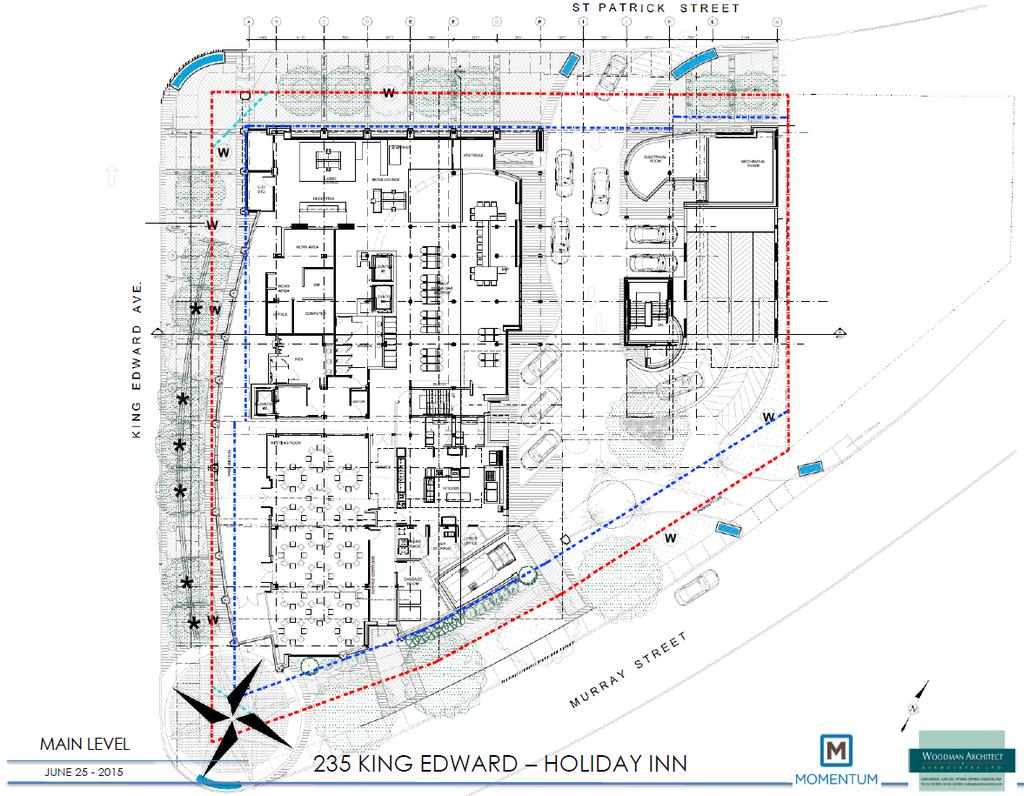
13 Figure 3.6: Proposed hotel site plan 9

14 Figure 3.7: Proposed hotel preliminary landscape plan 10
15 4. Policy and Regulatory Framework 4.1 Provincial Policy Statement (2014) The 2014 Provincial Policy Statement (PPS) came into effect on April 30, 2014 and provides policy direction on matters of provincial interest related to land use planning. The PPS is issued under the authority of Section 3 of the Planning Act, which requires that decisions affecting planning matters be consistent with the policy statements issued under the Act. A relevant fundamental principle of the PPS is the intensification of built-up areas to efficiently use land with existing infrastructure and public service facilities to avoid the need for unjustified and uneconomic expansion. As a result, planning authorities must identify and promote opportunities for intensification and redevelopment (Policy ). Intensification is defined in the PPS as: The development of a property, site or area at a higher density than current exists through: a) redevelopment; b) the development of vacant and/or underutilized lots within previously developed areas; and c) infill development. In addition to meeting the intensification principle in the PPS of concentrating growth within the urban area, the proposed development also addresses the following policies outlined in the Provincial Policy Statement: Promoting efficient development and land use patterns which sustain the financial well-being of the Province and municipalities over the long term (Policy 1.1.1(a)); Accommodating an appropriate range and mix of residential, employment (including industrial and commercial), institutional, recreation, park and open space, and other uses to meet longterm needs (Policy 1.1.1(b)); Promoting cost-effective development patterns and standards to minimize land consumption and servicing costs (Policy 1.1.1(e)); Efficiently using the infrastructure and public service facilities which are planned or available (Policy (a)); Promoting opportunities for intensification and redevelopment where this can be accommodated taking into account existing building stock or areas, including brownfield sites, and the availability of suitable existing or planned infrastructure and public service facilities required to accommodate project needs. (Policy ); and 11
16 Promoting a land use pattern, density and mix of uses that minimize the length and number of vehicle trips and support current and future use of transit and active transportation (Policy ); The PPS also discusses the importance of a coordinated, integrated and comprehensive approach to addressing planning matters within municipalities and between the various levels of government, particularly in relation to managing and promoting growth and development, and economic development strategies by: Providing for an appropriate mix and range of employment and institutional uses to meet longterm needs (Policy (a)); Promoting opportunities for economic development (Policy 1.7.1(a)); Promoting long-term economic prosperity by optimizing the long-term availability and use of land, resources, infrastructure and public services facilities (Policy 1.7.1(b)); Maintaining and, where possible, enhancing the vitality and viability of downtowns and mainstreets (Policy 1.7.1(c)); and Providing opportunities for sustainable tourism development (Policy 1.7.1(g)). It is our professional opinion that the proposed development is consistent with the 2014 PPS and supports provincial policy objectives. The site is located on a designated Mainstreet within the City of Ottawa and will contribute to the vitality of King Edward Avenue and pedestrian activity in the area. The proposed development would take advantage of existing infrastructure, provide employment opportunities, and contribute to the City s tourism potential. The proposed development will also add to the vitality of lands in close proximity to the ByWard Market, Downtown Ottawa, and Gatineau. 4.2 City of Ottawa Official Plan 2003 (Consolidated May 2014) The Official Plan (OP) provides the planning policy framework for evaluating the appropriateness of a proposed development at a City-wide level as well as in relation to the specific site. Strategic Directions Section 1.3 The Ottawa 20/20 Process and the Guiding Principles emphasizes the importance of bringing tourism and visitors to the City, and of achieving economic prosperity in order to support local people and businesses, as well as enhance the attractiveness and vitality of the city. Section 2.2 Managing Growth sets out strategic directions to meet the challenge of managing growth and directing it to the urban area where existing services are in place or where they can be provided efficiently, as well as to locations with significant development potential, such as Mainstreets. Concentrating growth within these areas also promotes a pattern and density of development that supports transit, cycling and walking. This section provides an overall strategy and context for the consideration of intensification and infill. The Plan is predicated on an approach best described as nodes and corridors which are areas targeted for more intensive growth. The site is located in one of 12
17 these targeted areas as it is designated Traditional Mainstreet on Schedule B Urban Policy Plan and therefore is an area with strong support for intensification and infill. Section Urban Design and Compatibility speaks to ensuring that the design of new development contributes to an area s sense of community and identity in order to promote the city as a tourist destination. The proposed development supports the strategic directions of the OP. It responds to the existing conditions while recognizing the planned function of the site and surrounding area. The site represents an infill opportunity. The majority of the site is currently vacant and located in an established urban area with full municipal services. It is strategically situated in close proximity to the ByWard Market, Downtown Ottawa, and Gatineau, and to take advantage of surrounding transit facilities and a variety of services and amenities. The proposed development will enhance the area s economic vitality and will contribute to the existing amenities and overall visitor experience in the area. Land Use Designations Traditional Mainstreet The site is designated as Traditional Mainstreet on Schedule B (Urban Policy Plan) of the OP, as shown in Figure 4.1. Section Mainstreets states that Mainstreets are intended for intensification and the Official Plan will focus development on these nodes and corridors in order to support public transit, create a community focus, minimize the length of trips taken, and minimize disruptions in existing, stable neighbourhoods. Traditional Mainstreets are planned as compact, mixed-use, pedestrian-oriented streets that provide for access by foot, cycle, transit and automobile. A wide range of uses are permitted within the Traditional Mainstreet designation including retail and service commercial uses, offices, residential and institutional uses. According to Section 3.6.3, the Traditional Mainstreet designation permits building heights up to six storeys. In the original development proposal a rezoning was approved to increase this height to 9 storeys or 27 metres. The current proposal implements that height limit and extends onto the adjacent parcels with a 6 storey profile in conformity with current policy and zoning. The proposed development maintains the intent of the Traditional Mainstreet designation by contributing to the range of uses and employment opportunities in the area. The proposed development represents an infill opportunity that will take advantage of proximity to a number of land uses and services, as well as to the ByWard Market, Downtown Ottawa, and Gatineau. The proposed development of a nine storey hotel on the subject property satisfies Policy 11 Subsection c) in Section 4.11 of the OP as the site is a prominent corner at a key entry point both into Ottawa from the Province of Québec but also into the community known as Lowertown. It is in keeping with the character of the area. 13
. It is also recognized on Annex 9 (Figure 4.2) as a gateway and node for entry into Ottawa.")
18 Figure 4.1: City of Ottawa Official Plan - Schedule B: Urban Policy Plan Design Priority Area As a Traditional Mainstreet, the site is designated as a Design Priority Area in Section of the OP, and is therefore subject to the City of Ottawa Urban Design Review Panel (UDRP). It is also recognized on Annex 9 (Figure 4.2) as a gateway and node for entry into Ottawa. Two submissions have been made to the UDRP during the pre-consultation phase of the application in 2012, and the proposed development will be presented again on July 9, 2015 for formal approval. 14
.")
19 Subject Site Transportation Network Figure 4.2: Annex 9 Central Area Gateways, Nodes and Distinctive Streets St. Patrick Street, Murray Street, and King Edward Avenue are classified as Arterial Roads by the City of Ottawa Official Plan Schedule F (Central Area/Inner City Road Network). Schedule D (Rapid Transit Network) indicates that King Edward Avenue is planned as a Transit Priority corridor. On-road cycling facilities are currently provided on King Edward Avenue and both St. Patrick Street and Murray Street will incorporate future on-road cycling facilities according to Schedule C (Primary Urban Cycling Network). St. Patrick Street, Murray Street, and King Edward Avenue will also feature scenic entry routes as indicated on Schedule I (Multi-Use Pathways and Scenic-Entry Routes (Urban)). The Official Plan schedules are shown below in Figures 4.3 to 4.6. The Official Plan Annex 1 Table 1 has a right-of-way protection for King Edward Avenue between Sussex Drive and Rideau Street for 40 metres and for St. Patrick Street between King Edward Avenue and Vanier Parkway for 37.5 metres; therefore this site is subject to this right-of-way protection. 15


20 Figure 4.3 City of Ottawa Official Plan - Schedule C: Primary Urban Cycling Network Figure 4.4: City of Ottawa Official Plan - Schedule D: Rapid Transit Network 16


21 Figure 4.5: City of Ottawa Official Plan - Schedule F: Central Area/Inner City Road Network Figure 4.6: City of Ottawa Official Plan - Schedule I: Multi-Use Pathways and Scenic-Entry Routes (Urban) 17
22 The proposed development is in an ideal location to take advantage of existing and planned transportation networks. The site is easily connected to the ByWard Market, Downtown Ottawa, Gatineau and several other key locations and services by transit, walking, cycling and by car. Urban Design and Compatible Development Section Urban Design and Compatibility provides direction on patterns, locations of land uses, and issues related to urban design. The intention is for development to be sensitive to and compatible with existing communities that have developed over long periods of time. In keeping with OP Section 2.5.1, the following table offers a response to how the proposed development addresses the City s design objectives. Design Objective 1. To enhance the sense of community by creating and maintaining places with their own distinct identity. 2. To define quality public and private spaces through development. How the Proposed Development Meets the Objective The proposed development responds to the existing conditions while recognizing the planned function of the site and surrounding area. The site is located at a key entrance to both the City and the community of Lowertown. It is adjacent to the ByWard Market area and Ottawa s central business district. Surrounded by multi-lane arterial roadways requires a significant form and height to create a gateway entrance to anchor the new development in the area. Currently, this segment of King Edward and St. Patrick lacks a cohesive building and lot fabric. Development over the last decade has been focused on highway commercial uses and the older buildings have not been well maintained. This proposal has been designed to re-invigorate the corner and this entrance to the City and will support the street by establishing a pattern of development and activity that will contribute to creating a vibrant street. The building design responds to the Traditional Mainstreet designation by using architectural detailing to differentiate the first two storeys from the balance of the building and focus this base on the adjacent sidewalk and pedestrian zone. Additional detailing and the use of colour and materials on the remaining floors along with a large open terrace at the second level on the Murray Street side. The form drops to 6 storeys on the east and south wings to break up the building mass and add visual interest to all sides of the building. As well, an entrance feature has been added to the south east corner to animate the intersection of King Edward and Murray. A curved façade has been incorporated into the King Edward frontage to create a unique look and pedestrian environment. The building is setback 3 metres from the corner side yard along St. Patrick, softening the interface between the building and the public realm by creating a usable attractive space for pedestrians. This area will be further enhanced through landscaping treatment that includes street trees. On the Murray Street side, the intent is to create an attractive pedestrian area connecting the building to the street and creating opportunities for street animation in an area with southern exposure and protected by 18
23 3. To create places that are safe, accessible and are easy to get to and move through. 4. To ensure that new development respects the character of existing areas. 5. To consider adaptability and diversity by creating places that can adapt and evolve easily over time and that are characterized by variety and choice. 6. To understand and respect natural processes and features in development design. 7. To maximize energy efficiency and promote sustainable design to reduce the resource consumption, energy use and carbon footprint of the built environment. the building. The site has been designed with only one entrance and separate exit to serve the underground parking garage limiting the potential conflict between pedestrians and vehicles. Wide, landscaped sidewalks will be provided along the King Edward, St. Patrick and Murray Street edges. This project will be the first significant redevelopment and intensification of this small block which implements the policies of the Official Plan. Given the site s physical separation from the adjacent blocks by the surrounding streets. It presents an opportunity to develop and design a building with transitional heights to create a landmark, entrance feature into the neighbourhood as well as the city as a whole. Given the small area of the block as a whole and the generally lower profile nature of the surrounding community, it is felt that a mid-rise building of 9 storeys will provide a focal point and set the stage for the eventual redevelopment of the remainder of the block in a similar manner. The first two floors of the building have been designed to carry the two storey character of the adjacent buildings along King Edward Avenue. This will support and enhance the relationship to the sidewalk and pedestrian activity on this block. This architectural treatment wraps around the building face on St. Patrick to maintain a consistent relationship to the street and adjacent building to the east. The proposed full service hotel will bring a new form of accommodation into this area. The addition of a publically accessible restaurant will improve opportunities for pedestrian street level activity. It is intended to manage storm water runoff from the site through on site holding tanks. This includes underground storage tanks and temporary surface storage on the open air terraces. It is proposed to add both street trees in addition to plantings on the open air terraces. The building has been oriented to maximize solar gain for the open air terraces. As well, the building mass will provide shelter from prevailing winds to these areas. The site is well served by local public transit as King Edward is a designated transit priority route. It is also within easy walking distance of both day to day services and extensive shopping and entertainment in the ByWard Market and Rideau Centre. Section 4.11 Urban Design and Compatibility relates to urban design and compatible development and provides direction on how to assess development applications as they relate to existing or planned community character and in the overall context of the OP. The following table identifies the criteria and how the proposed development addresses it: 19
24 Criteria Traffic: Roads should adequately serve the development, with sufficient capacity to accommodate the anticipated traffic generated. Generally development that has the potential to generate significant amounts of vehicular traffic should be located on arterial or major collector roadways so as to minimize the potential for traffic infiltration on minor collector roadways and local streets. Vehicular Access: The location and orientation of vehicle access and egress should address matters such as the impact of noise, headlight glare and loss of privacy on development adjacent or immediately opposite. Vehicular access and egress for development that has the potential to generate a significant amount of vehicular traffic should be oriented on streets other than local streets, wherever the opportunity exists, considering traffic safety and other transportation objectives of this Plan. Parking Requirements: The development should have adequate on-site parking to minimize the potential for spillover parking on adjacent areas. A range of parking forms, including surface, decked, and underground, should be considered taking in account the area context and character. Opportunities to reduce parking requirements and promote increased usage of walking, cycling and transit will be pursued, where appropriate, particularly in the vicinity of transit stations or major transit stops in accordance with the provisions of Section 4.3. Outdoor Amenity Areas: The development should respect the privacy of outdoor amenity areas of adjacent residential units and minimize any undesirable impacts through the siting and design of the buildings and the use of screening, lighting, landscaping or other mitigative design measures. Loading Areas, Service Areas, and Outdoor Storage: The operational characteristics and visual appearance of loading facilities, service areas (including garbage), parking and areas for the outdoor storage of goods or materials should be mitigated using a variety of methods. These uses and activities should be located away from residences where possible Response A Traffic Study has been prepared evaluating the impact of the proposed development on the surrounding area. The property is situated within the established arterial road network. The site is situated at the confluence of 3 major arterial roads St. Patrick, King Edward and Murray with vehicular access to St. Patrick. King Edward is a designated transit priority route. As well, the site is within 850 metres of the LRT route. Ingress to the site will be provided from St. Patrick Street and egress will be provided on Murray Street. The entrance to the underground parking structure will be at the eastern edge of the site away from the intersection. The entrance will be fully enclosed to reduce headlight glare. A total of 79 underground parking spaces will be provided. Bicycle parking requirements will be met on site. On the second floor there will be an outdoor private terrace on the Murray Street (south side). This will be landscaped. Accessed from the seventh floor, there will be two smaller roof top terraces on the east and southwest ends of building. All loading and service areas will be internal to the building. There will be no outdoor storage. 20
25 Lighting: The potential for light spill over or glare from any lighting source onto adjacent light sensitive areas should be avoided or mitigated. Noise and Air Quality: The development should be located and designed to minimize the potential for significant adverse effects on adjacent sensitive uses related to noise, odours, and other emissions. Sunlight: The development should minimize shadowing on adjacent properties, to the extent practicable, particularly on outdoor amenity areas, through the siting of buildings or other design measures. Microclimate: The development should be designed to minimize adverse effects related to wind, snow drifting, and temperature on adjacent properties. Supporting Neighbourhood Services: The development should contribute to or be adequately served by existing or proposed services and amenities such as health facilities, schools, parks and leisure areas. Where the proposed development itself is to contribute such services and amenities, they should be of a scale appropriate to the needs and character of the area. No additional street lighting is proposed by this project. Any lighting of proposed amenity areas will meet City standards. No significant noise or air quality impacts are anticipated from this project. A noise and vibration study has been undertaken to identify and recommend corrective measures for any impacts on the residential uses of the site from the adjacent arterials. A full sun shadow analysis has been undertaken as part of the urban design review with no significant impacts being identified on adjacent properties. No significant impacts are anticipated on the local microclimate. The site is well served by existing services in the immediate such as: o ByWard Market o Le Patro Community Centre o Macdonald Gardens Park o Rideau Centre and retail/commercial services along Rideau Street o National Art Gallery 4.3 City of Ottawa s Urban Design Guidelines Urban Design Guidelines for Development along Traditional Mainstreets The City of Ottawa s Urban Design Guidelines for Development along Traditional Mainstreets were approved by City Council on May 24, The Guidelines are intended to be used to assess, promote and achieve appropriate development along Traditional Mainstreets. They are general guidelines and therefore the proposed development should comply with the overall design direction of the guidelines, rather than with each specific policy. These guidelines apply for all streets throughout the City identified as Traditional Mainstreets by the Official Plan. The objective of these guidelines is to highlight ways to: To promote development that will enhance and reinforce the recognized or planned scale and character of the street; To promote development that is compatible with, and complements its surroundings; To achieve high-quality built form and strengthen building continuity along Traditional Mainstreets; 21
26 To foster compact, pedestrian-oriented development linked to street level amenities; and To accommodate a broad range of uses including retail, services, commercial uses, offices, residential and institutional uses where one can live, shop and access amenities. The Guidelines provide specific policies under seven general design categories: streetscape, built form, pedestrians and cyclists, vehicles and parking, landscape and environment, signs, and servicing and utilities. The table below outlines how the proposed development achieves these objectives. Design Objective Streetscape Align streetwall buildings with the existing built form or with the average setback of the adjacent buildings in order to create a visually continuous streetscape (Guideline 1) Provide or restore a minimum 2.0 metre wide concrete sidewalk and locate to match approved streetscape design plans for the area. Where there is no approved streetscape plan, match the existing context (Guideline 3) Locate streetscape elements in the boulevard clear of the unobstructed 2.0 metre sidewalk, including trees, paving, benches, newspaper boxes, bicycle parking, and parking meters (Guideline 5) Create attractive public and semi-public outdoor amenity spaces such as green spaces with trees, pocket parks, courtyards, outdoor cafés, seating and decorative pools or fountains (Guideline 6) Built Form Design quality buildings that are rich in architectural detail and respect the rhythm and pattern of the existing or planned, buildings on the street, through the alignment of elements such as windows, front doors, cornice lines, and fascias etc. (Guideline 8) Ensure sufficient light and privacy for residential and institutional properties to the rear by ensuring that new development is compatible and sensitive with adjacent uses with regard to maximizing light and minimizing overlook (Guideline 10) Use clear windows and doors, to make the pedestrian level façade of walls facing the street highly transparent, and locate active pedestrian-oriented uses at-grade (Guideline 11) Set back the upper floors of taller buildings to help achieve a human scale and more light on the sidewalks (Guideline 12) Highlight buildings on corner sites, where two public streets intersect, with special treatment such as a corner entrance. Continue the same level of architectural detailing around both sides of the building (Guideline 16) Pedestrian and Cyclists How the Proposed Development Meets the Objective The development reinforces the existing build to line to create a continuous frontage and provides a wide pedestrian area with a minimum width of 2.0 metre wide along Murray, St. Patrick and King Edward. The restaurant is located on the first floor and along with an internal glassed walkway further enhances pedestrian activity and street level animation. The building provides clear windows and doors to make the pedestrian level façade of walls facing the street highly transparent. Architectural treatments create a two storey podium to tie in with adjacent building forms and are complimented by variations in colour and texture on upper storeys to break down the building mass and scale. 22
27 Provide sheltered bicycle parking in visible locations near building entrances and pedestrian walkways. Ensure that these locations minimize conflict with pedestrians (Guideline 18) Locate front doors to face the mainstreet and be directly accessible from the public sidewalk. (Guideline 19) Vehicles and Parking Provide only the minimum number of required car parking spaces. (Guideline 27) Landscape and Environment Select trees, shrubs and other vegetation considering their tolerance to urban conditions such as road salt or heat. Give preference to native species of the region that are of equal suitability (Guideline 28) Plant street trees between 6.0 and 8.0 metres apart along public streets and internal pedestrian walkways (Guideline 30) Use green building technologies such as green roofs, drip irrigation, and other Leadership in Energy and Environmental Design (LEED) approaches (Guideline 32) Signs Design buildings to include defined spaces to accommodate signs that respect building scale, architectural features, signage uniformity and established streetscape design objectives (Guideline 33) Servicing and Utilities Enclose all utility equipment within buildings or screen them from both the traditional mainstreet and private properties to the rear (Guideline 38) Design lighting so that there is no glare or light spilling onto surrounding uses (Guideline 40) Bicycle parking will be provided at grade under the building. The front doors have been located to face the key corner intersections and are directly accessible from the public sidewalk. Onsite parking has been kept to minimum parking requirements. The site will incorporate a mix of trees, shrubs and seasonal planters. It is intended to use planters sized so they can be relocated during winter months to allow for snow clearing but their size will provide the optimal tree size given the constraints. Street trees are proposed in accordance with staff direction to minimize conflicts with underground infrastructure and the limitations of using planters. Landscaped terraces will be provided on the second and seventh floors of the hotel. No ground signage. The building has been designed to enhance the public realm and pedestrian activity on the street. All utility equipment is within the building No glare will be caused as a result of the proposed development. 4.4 Comprehensive Zoning By-law ( ) The site currently has split zoning. The 364 St. Patrick Street parcel is zoned Traditional Mainstreet with Exception [2108] and Schedule 317 (TM [2108] S317). The balance of the site is zoned Traditional 23

28 Mainstreet (TM). The site is located within the Mature Neighbourhood Overlay, but as the site is nonresidential, the provisions of the overlay do not apply. There is no heritage designation affecting the site. Figure 4.7 illustrates the site s zoning. Based on Section 197, the purpose of the TM zone is to: Accommodate a broad range of uses including retail, service commercial, office, residential and institutional uses, including mixed-use buildings but excluding auto-related uses, in areas designated Traditional Mainstreet in the Official Plan; Foster and promote compact, mixed-use, pedestrian-oriented development that provide for access by foot, cycle, transit and automobile; Recognize the function of Business Improvement Areas as primary business or shopping areas; and Impose development standards that will ensure that street continuity, scale and character is maintained, and that the uses are compatible and complement surrounding land uses. Figure 4.7: Zoning for the Site and Surrounding Area A hotel is a permitted use in the TM zone. It is subject to the following provisions: c) the wall at grade facing the main street having 50% of its facade comprised of windows and entrances and, in the case of a corner lot, the entrance may be in an angle at corner walls facing a street intersection; and 24
29 d) parking garage, provided that 100% of the ground floor fronting on the street excluding any related mechanical room or pedestrian or vehicular access, is occupied for a depth of three metres by other uses permitted to be located on the ground floor. Urban Exception 2108 addresses setbacks, encroachment of building elements into the setback, and maximum building heights. The provisions relevant to the proposed development are as follows: Despite Table 197(e) and subsection 197(4)(d), no additional setback of 2 metres is required from the front and corner side lot lines, for any part of the building at or above the fourth storey or 15 metres, whichever is less. Despite Section 65, canopies, awnings and balconies may project to within 0.4 metres of a lot line. Maximum building heights are as per Schedule 317 (Figure 4.8).. Figure 4.8: Comprehensive Zoning By-law Schedule
30 The provisions set out in the table below are from the TM zone unless otherwise noted. Zoning Mechanisms Existing Requirement Compliance (a) Minimum lot area No minimum yes (b) Minimum lot width No minimum yes (c) Maximum front yard setbacks King Edward 2 m* yes (d) Interior side yard setbacks (i) maximum (ii) minimum 3 m between a non-residential use building or a mixed-use building and another nonresidential use building or mixeduse building, except where a driveway is provided, in which case the setback must be a maximum of 6 m where the driveway leads to a parking area of 20 or more spaces The maximum setback provisions of row (d)(i) above do not apply to the following cases and the following minimum setbacks apply: N/A (1) 3 metres for a non-residential use building or a mixed-use building abutting a residential zone. N/A (e) Minimum corner side yard setback (f) Minimum rear yard setback (g) Maximum building height All other cases - no minimum (maximum setback provisions of row (d)(i) apply in these cases) 3 m, except for any part of a building above 15 metres for which an additional 2 metre setback must be provided (i) rear lot line abutting a 7.5 m N/A residential zone (ii) rear lot line abutting a public 4.5 m N/A laneway (iv) other cases No minimum yes Schedule 317 (Figure 4.8) Schedule 317 applies to 364 St. Patrick Street (i) minimum 6.7 metres for a distance of 20 metres from the front lot line* (ii) maximum (1) 20 metres but not more than 6 storeys, except where otherwise shown on the zoning maps Yes Yes Exception 2108 Variance required 26
31 (2) where the building height is greater than four storeys or 15 metres, at and above the fourth storey or 15 metres whichever is the lesser a building must be setback a minimum of 2 metres more than the provided setback from the front lot line as set out under subsection 197(5) below, and from the a corner side lot line (3) no part of a building on a lot with a rear lot line abutting an R1, R2, R3 or R4 Zone may project above a 45 degree angular plane measured at a height of 15 metres from a point 7.5 metres from the rear lot line, projecting upwards towards the front lot line (see illustration below). (By-law ) (h) Maximum floor space index No maximum yes (i) Minimum width of landscaped area (i) abutting a residential zone (ii) in all other cases 3 m, may be reduced to one metre where a minimum 1.4 metre high opaque fence is provided No minimum, except that where a yard is provided and not used for required driveways, aisles, parking or loading spaces, the whole yard must be landscaped *In accordance with subsection (c), for the purpose of determining the front yard setback, a lot that abuts any of the following streets designated Traditional Mainstreet in the Official Plan is to be treated as though it fronts that street: (r) King Edward Avenue from Rideau Street to Bruyère Street In addition, the Zoning By-law contains provisions for parking as set out in the table below: Parking Provision Existing Requirement Compliance (i) Minimum number of parking spaces (Sec. 101) Hotel - 1 per guest unit for up to 40 guest units, and 1 per 6 guest units over 40 guest units Total required 62 for 167 units Restaurant 3 for first 50 m 2 of gross floor area plus 10 per 100 m 2 of gross floor area over 50 m 2 of gross floor area Yes 79 underground with 5 short term spaces at grade. Total = 84 spaces N/A yes 27
32 (ii) Minimum and maximum dimension requirements for a motor vehicle parking space (Sec. 106) (v) Minimum required width of a landscaped buffer (Sec. 110) restaurant total = 15 spaces for 147 m 2 Overall Total = 77 (a) A minimum width of 2.6 metres and a maximum width of 2.75 metres* (b) A minimum length of 5.2 metres, except for parallel parking where a minimum length of 6.7 metres is required* yes yes (a) Abutting a street 3 m N/A (b) Not abutting a street none Yes (vi) Minimum number of bicycle parking spaces (Sec. 111) 1 per 1,000m 2 of gross floor area Yes - 15 spaces The proposed minor variance will be required to revise Schedule 317 to reflect the new building envelope. There is no overall increase in height from maximum set of 27 m or 9 storeys..the proposed design is in keeping with the height limitations of the two zones. The revisions to the site plan would implement the requested minor variances to the Zoning By-law. Urban Design Review Panel Response to Preconsultation The following commentary was based on the original application on the smaller site. The response provided applies the Panel recommendations to the new proposal. UDRP Comments December 6, 2012 General Comments The Panel thanks the applicant for coming in for a second pre-consultation. The proposal has made significant improvements since the last pre-consultation. The Panel appreciates that it is a challenging site and is in general support for the current direction of the proposal. The Panel encourages the applicant to continue to work on the design by clearly defining the base, middle, and top of the building, making the building more contextually sensitive and positively contributing to the public realm. Context Do not intrude upon the established view planes. Verify what is permitted and work within those constraints. Parapets and/or mechanical utilities are not permitted within the view plane either. Design Response General Comments The acquisition of the additional lots has enabled the project design to evolve significantly and build on the strengths of the original proposal. By incorporating all of the lots with the exception of the EMS Facility, the ability to provide a better 360 degree contextual response was greatly enhanced and contributions to the public realm at the southern entrance point have created a signature streetscape. Context The proposed design conforms in all respects with the regulated view plane from the Beechwood Cemetery. 28
33 Consider emphasizing or raising the corner (but not such that it interferes with the view plane) and provide a transitional step-down to neighbouring buildings. This would be a sympathetic gesture and will be more contextually appropriate. Consider how this development will be viewed from both downtown and Beechwood cemetery. Revisit the glass curtain wall. If not properly addressed, it could make the building look cold. Streetscape and Public Realm Clarify and define all design intentions as they relate to streetscape improvements. The perspective renderings show generous streetscape improvements which aren t shown on the Site Plan. Please provide more detail at the next meeting. Carefully use illumination at the base and top of the building to help make the building appealing in both day and night. The building could serve as a beacon to pedestrians and vehicles. Through adequate illumination that is both safe and uplifting, the building can make a positive contribution to the public realm. Further explore the blank side walls. Take into account the visibility of this site as the design progresses. This project has the potential to become a modest yet successful landmark building, given its prominent site characteristics. The building will be extremely visible for people driving from many different directions within the city. In some ways, this building may inevitably function as a gateway into Ottawa from Quebec. Architecture Create a more chiseled, nuanced built form by thinking about the building as having three parts: base, middle and top. Work toward creating a stronger podium base with a slight step back at the middle portion and another step back to the top. o Emphasize the public realm on King Edward Avenue and Murray Street by developing a strong building base. A strong corner element has been incorporated with a step down to 6 storeys as the building moves east. A 2 storey cornice line and a single storey decorative wall around the electrical/mechanical rooms provide a link to the single storey EMS Facility. The revised design has treated all sides of the building as fronts to ensure a 360 degree appreciation. Comment no longer applies. Streetscape and Public Realm The landscape plan has significantly advanced with the addition of full street trees along Murray and street scaled trees in movable planters along King Edward and St. Patrick. An entrance feature at Murray and King Edward animates the site at grade and then follows King Edward in a graceful windowed arc providing both an interior and exterior pedestrian experience. The comments on lighting have been considered and incorporated. The east facing wall has been broken into two panels with architectural treatments. Consideration is being given to creating living walls or the addition of public art. Every effort has been made to make this a landmark entry point given its prime location. Architecture Along St. Patrick there is a defined 2 storey podium with a 4 storey middle section and a 3 storey top. Along King Edward there is a strong 2 storey base dropping to a single storey element leading to the entrance feature at the SEW corner. The building steps back to the 4 storey middle section and only the corner portion raises another 3 storeys to the full 9 storey height. Continuing along King 29
34 Consider using a dark coloured brick at the bottom and lighter coloured brick at the top. o Offer a tree canopy around the site with visible, proper signage underneath the canopy. o Increase the podium to be 2 or 3 storeys, to align with approximate heights of neighbouring buildings. o Establish a datum line to mitigate the impact of its height and massing. As an alternative to the step backs, consider bringing the overall scale of the building down and working to sculpt the built form on the two main streets it fronts onto, while animating the blank side walls. Explore incorporating a southern patio into this development. Edward the building drops first to 6 storey and then again to a large terrace at the second storey. Landscaping and tree canopy provide an animated pedestrian experience along King Edward and St. Patrick, the primary pedestrian movement areas. As well decorative sidewalk treatments enliven the atmosphere. A strong 2 storey cornice provides a link around the building and to the adjacent buildings on King Edward. Given the varied heights allowed in the zoning, there are well defined steps in the building envelope to mitigate the massing of the building. A second storey terrace outside the indoor pool takes advantage of the southern exposure. 30
35 5. Summary Opinion It is the professional opinion of Momentum Planning and Communication that the requested minor variance and site plan application represent good land use planning and are appropriate for the site based on the following reasons: The proposed development is consistent with the 2014 Provincial Policy Statement policies with respect to promoting the efficient use of land, existing infrastructure and existing public facilities, as well as promoting cost-effective development patterns and standards to minimize land consumption and servicing costs. It will encourage the inclusion of an appropriate range and mix of land uses and employment opportunities to meet long-term needs. The proposed development will also help provide opportunities for economic development through diversifying the economic base and providing for sustainable tourism development. The proposed development will add to the vitality of lands in close proximity to Downtown Ottawa, the ByWard Market, and Gatineau. The proposed development conforms to the City s Official Plan goals, objectives and policies, particularly in promoting tourism and bringing visitors to the City in order to support economic development and the local community. The proposed development conforms to the goals, objectives and policies for Traditional Mainstreets. While the Traditional Mainstreet designation generally supports building heights in the four (4) to six (6) storey range, greater building heights can be considered in a number of circumstances including sites which are transit supportive, on corner lots, at a gateway into a community and where compatibility with the surrounding community can be demonstrated. This site is located on a transit priority corridor and is a designated gateway into both Lowertown and Ottawa as a whole. The massing and scale of the building have been designed with appropriate transition, setbacks and use of hard and soft landscaping that is in keeping with the surrounding development. The proposed development conforms to the City s compatibility criteria established in the Official Plan (Sections 2.5.1, 3.6.2, and 4.11). The proposed development will introduce a use that is in keeping with the Traditional Mainstreet. The proposed use meets the general purpose and intent of the Zoning By-law. All other zoning performance standards can be met with the exception of the variance to Height Schedule 317. Under Section 45(1) of the Planning Act there are four tests a minor variance must meet: o Is the application minor? The proposed variance to the height schedule relates to a re-design of the building due to the increased lot area and does not materially change the intent of the schedule which was to regulate the overall height maximum of 27 metres and the articulation of the building ro meet design guidelines. o Is the application desirable for the appropriate development of the lands in question? 31
36 o o o The orignal application to develop this site was constrained due the adjacent lands and buildings. The acquistion of these lots has allowed for an improved overall lot and building design that maximizes the gateway nature of the site. Does the application conform to the general intent of the Official Plan? As noted thorughout this Planning Rationale, the proposed development conforms to the intent of the Official Plan with respect to intensification and redevelopment along Traditional Mainstreets and implements the land use polisies of Section and the urban design and compatibility policies of Sections and Does the application conform to the general intent of the Zoning By-law? The intended use of hotel is permitted on the site and the need for the minor variance relates only to the building specific nature of Schedule 317 and conforms to the general intent of the By-law in all other ways. The proposed development meets the four tests for a minor variance under the Planning Act. In conclusion, the proposal to develop a nine (9) storey hotel on this site represents good planning and is in the public interest. Please feel free to contact me at (613) or djacobs@momentumplancom.ca if you have questions regarding the content of this Planning Rationale. Prepared by: Signed original on file Dennis Jacobs MCIP, RPP Principal Planner 32
37 Appendix A Floor Plan Drawings 33
38 34
178 Carruthers Properties Inc.
 178 Carruthers Properties Inc. Planning Rationale for 178 Carruthers Avenue Site Plan Control Application June 2014 Table of Contents 1.0 Introduction 2.0 Overview of Subject Property 3.0 Current Zoning
DRAFT Northeast Quadrant of Kipling Avenue and Highway 7 DRAFT AUGUST 29, Goals Land Use. The goals of this Plan are to:
 AUGUST 29, 2017 12.15 Northeast Quadrant of Kipling Avenue and Highway 7 12.15.1 Goals 12.15.2 Land Use The goals of this Plan are to: 12.15.2.1 General Provisions: a) Ensure the development of a compact
CONTENTS 8.0 LAND USE 8.1 GENERAL LAND USE 8.2 RESIDENTIAL 8.3 MIXED USE 8.4 COMMERCIAL 8.5 EMPLOYMENT LANDS
 8-2 Land Use 8.0 LAND USE CONTENTS 8.1 GENERAL LAND USE 8.1.1 Uses provided for in all Land Use Designations 8.1.2 Uses prohibited in Hazardous Lands, Hazardous Sites and Special Policy Areas 8.1.3 Uses
Clairtrell Area Context Plan
 Clairtrell Area Context Plan March 2005 Urban Development Services City Planning Contents 1. Introduction... 4 2. Development Structure... 6 2.1 Streets... 7 2.1.1 Sheppard Avenue and Bayview Avenue...
[PLANNING RATIONALE] For Site Plan Control and Lifting of Holding Zone By-Law 101 Champagne Avenue. May 23, 2014
![[PLANNING RATIONALE] For Site Plan Control and Lifting of Holding Zone By-Law 101 Champagne Avenue. May 23, 2014](/thumbs/75/71599615.jpg "[PLANNING RATIONALE] For Site Plan Control and Lifting of Holding Zone By-Law 101 Champagne Avenue. May 23, 2014") [PLANNING RATIONALE] For Site Plan Control and Lifting of Holding Zone By-Law 101 Champagne Avenue May 23, 2014 Contents 1.0 Introduction... 2 2.0 Site Context... 2 2.1 Adjacent Uses... 2 Figure 1: Site
[PLANNING RATIONALE] For Site Plan Control and Lifting of Holding Zone By-Law 101 Champagne Avenue May 23, 2014 Contents 1.0 Introduction... 2 2.0 Site Context... 2 2.1 Adjacent Uses... 2 Figure 1: Site
MOMENTUM. Design Brief for 1161 Heron Road. Site Plan Control
 MOMENTUM PLANNING AND COMMUNICATIONS Design Brief for 1161 Heron Road July 2016 Prepared for: 1649362 Ontario Inc. c/o Manor Park Management 231 Brittany Drive, Suite D Ottawa ON K1K 0R8 Prepared by: Dennis
Regency Developments. Urban Design Brief. Holyrood DC2 Rezoning
 Regency Developments Urban Design Brief Holyrood DC2 Rezoning Stantec Consulting Ltd. 7-31-2017 1. Overview Regency Developments intends to rezone the lands located at 8510 and 8511 93 Avenue, within the
10 COPE DRIVE. May 08, 2018 Planning Rationale and Design Brief. Site Plan Control
 10 COPE DRIVE May 08, 2018 Planning Rationale and Design Brief Site Plan Control Prepared for: Taggart Realty Management 225 Metcalfe Street, Suite 708 Ottawa, ON K2P 1P9 taggart.ca Prepared by: Fotenn
776 and 784 St. Laurent Boulevard City of Ottawa
 Engineering Land / Site Development Municipal Infrastructure Environmental / Water Resources Traffic / Transportation Structural Recreational 776 and 784 St. Laurent Boulevard City of Ottawa Planning Rationale
PLANNING RATIONALE 3843 INNES ROAD, ORLEANS 78 UNITS CONDOMINIUM PROJECT MELKART DEVELOPMENTS Inc.
 78 UNITS CONDOMINIUM PROJECT MELKART DEVELOPMENTS Inc. 2 PLANNING RATIONALE 78 UNITS CONDOMINIUM PROJECT Proposed at 3843 Innes Road Orleans, Ontario Report Prepared for: Melkart Developments Inc. 3497
TABLE OF CONTENTS 1.0 INTRODUCTION... 3
 TABLE OF CONTENTS 1.0 INTRODUCTION... 3 1.1. BACKGROUND... 3 1.2. THE PROPOSAL... 5 2.0 EXISTING POLICY FRAMEWORK... 5 2.1. PROVINCIAL POLICY STATEMENT (PPS)... 5 2.2. CITY OF LONDON OFFICIAL PLAN (OP)...
599 Kennedy Road - Official Plan Amendment and Zoning Amendment Application - Preliminary Report
 STAFF REPORT ACTION REQUIRED 599 Kennedy Road - Official Plan Amendment and Zoning Amendment Application - Preliminary Report Date: March 7, 2017 To: From: Wards: Reference Number: Scarborough Community
ELMVALE ACRES SHOPPING CENTRE MASTER PLAN
 ELMVALE ACRES SHOPPING CENTRE MASTER PLAN Contents 1.0 INTRODUCTION... 2 2.0 LOCATION... 2 3.0 EXISTING CONTEXT... 2 4.0 VISION & GUIDING PRINCIPLES... 2 5.0 LAND USE AND BUILT FORM... 4 5.1 St. Laurent
Urban Design Manual PLANNING AROUND RAPID TRANSIT STATIONS (PARTS) Introduction. Station Study Areas
 Introduction. Station Study Areas") 111111 PLANNING AROUND RAPID TRANSIT STATIONS (PARTS) Introduction The ION rapid transit system will link Waterloo, Kitchener and Cambridge through a central transit corridor (CTC). There are a number
111111 PLANNING AROUND RAPID TRANSIT STATIONS (PARTS) Introduction The ION rapid transit system will link Waterloo, Kitchener and Cambridge through a central transit corridor (CTC). There are a number
Urban Design Brief to 1557 Gordon Street & 34 Lowes Road West
 Urban Design Brief 1533 to 1557 Gordon Street & 34 Lowes Road West Reid s Heritage Homes Ltd. & 883928 Ontario Ltd. and RHH Property Management Ltd. City of Guelph Zoning By-law Amendment November 2017
Mark-up of the effect of the proposed Bronte Village Growth Area OPA No.18 on the text of section 24, Bronte Village, of the Livable Oakville Plan
 Mark-up of the effect of the proposed Bronte Village Growth Area OPA No.18 on the text of section 24, Bronte Village, of the Livable Oakville Plan Notes: This document is provided for information purposes
141 GEORGE STREET PLANNING RATIONALE
 141 GEORGE STREET PLANNING RATIONALE MINOR ZONING BY-LAW AMENDMENT NOVEMBER 2, 2016 PLANNING RATIONALE 223 McLeod Street Ottawa, ON K2P 0Z8 613.730.5709 fotenn.com INTRODUCTION FOTENN Consultants is acting
Uptown Rideau Street Secondary Plan [Amendment #166, January 12, 2016]
![Uptown Rideau Street Secondary Plan [Amendment #166, January 12, 2016]](/thumbs/76/73760497.jpg "Uptown Rideau Street Secondary Plan [Amendment #166, January 12, 2016]") [Amendment #166, January 12, 2016] The policies of this Secondary Plan are in effect, save and except for the property at 560 Rideau Street, for which there remains a site specific appeal to this Secondary
[Amendment #166, January 12, 2016] The policies of this Secondary Plan are in effect, save and except for the property at 560 Rideau Street, for which there remains a site specific appeal to this Secondary
December 16, Gary Sealey Kanata Beaverbrook Community Association Inc. 2 Beaverbrook Road Ottawa ON K2K 1L1. Dear Mr. Sealey
 December 16, 2013 Gary Sealey Kanata Beaverbrook Community Association Inc. 2 Beaverbrook Road Ottawa ON K2K 1L1 Dear Mr. Sealey Re: Letter of Opinion - Update 1131 Teron Road Application # D02-02-12-0041
Bel-Air Lexus Automobile Service Station
 Bel-Air Lexus Automobile Service Station Design Brief 443-447 McArthur Avenue Ottawa April 30, 2015 14-1299-MCA Site Details Application: Site Plan Control Legal Description and Municipal Addresses: 443
MOMENTUM. Design Brief. Site Plan Control and Minor Variance Applications. 59 Russell Avenue
 MOMENTUM PLANNING AND COMMUNICATIONS Design Brief Site Plan Control and Minor Variance Applications 59 Russell Avenue December 2014 Revised February 2015 Prepared by: Dennis Jacobs MCIP, RPP Index 1. Introduction
URBAN DESIGN BRIEF. 2136&2148 Trafalgar Road. Town of Oakville
 URBAN DESIGN BRIEF 2136&2148 Trafalgar Road Town of Oakville Prepared By: METROPOLITAN CONSULTING INC For 2500674 Ontario Inc November 2016 TABLE OF CONTENTS Page No. 1.0 Introduction/Description of Subject
Re: 1110 Fisher Avenue Proposed Residential Development Revised Proposal File D PLANNING RATIONALE ADDENDUM
 October 23, 2014 Prestige Design & Construction 50 Camelot Drive Ottawa, ON K2G 5X8 Attention: Mr. Enzo DiChiara Dear Mr. DiChiara Re: 1110 Fisher Avenue Proposed Residential Development Revised Proposal
Commercial Development Proposal Tenth Line Road. Planning Rationale Report. Minto Developments Inc.
 Commercial Development Proposal 2168 Tenth Line Road Report September 2015 Prepared for Minto Developments Inc. Paquette Planning Associates Ltd. 56 Hutchison Avenue Ottawa, Ontario K1Y 4A3 PH: 613-722-7217
Planning Rationale Fernbank Road, Ottawa. Major Zoning By-law Amendment and Site Plan Control Application Ontario Inc.
 Planning Rationale Major Zoning By-law Amendment and Site Plan Control Application 5264 Fernbank Road, Ottawa 1872089 Ontario Inc. March 2014 Planning Rationale Major Zoning By-law Amendment and Site Plan
(DC1) Direct Development Control Provision DC1 Area 4
 Direct Development Control Provision DC1 Area 4") . General Purpose (DC) Direct Development Control Provision DC Area 4 The purpose of this Provision is to provide for an area of commercial office employment and residential development in support of the
. General Purpose (DC) Direct Development Control Provision DC Area 4 The purpose of this Provision is to provide for an area of commercial office employment and residential development in support of the
5.1 Site Plan Guidelines
 5. Community Core Guidelines Development of the Community Core will take place by plan of subdivision and site plan approval. It will occur in a phased manner that will reflect the timing of residential
PLANNING JUSTIFICATION REPORT
 PLANNING JUSTIFICATION REPORT 55 DELHI STREET CITY OF GUELPH PREPARED FOR: VESTERRA PROPERTY MANAGEMENT PREPARED BY: LABRECHE PATTERSON & ASSOCIATES INC. SCOTT PATTERSON, BA, CPT, MCIP, RPP PRINCIPAL,
770 BRONSON AVENUE. Zoning By-law Amendment and Site Plan Control
 770 BRONSON AVENUE Zoning By-law Amendment and Site Plan Control Revised Planning Rationale + Design Brief August 2016 REVISED PLANNING RATIONALE 223 McLeod Street Ottawa, ON K2P 0Z8 613.730.5709 fotenn.com
East Bayshore Road Neighbourhood
 East Bayshore Road Neighbourhood Northridge Property Management Urban Design Brief 3195 East Bayshore Road City of Owen Sound January 2016 East Bayshore Road Neighbourhood Northridge Property Management
KANATA CENTRUM 255 KANATA AVENUE OFFICIAL PLAN AMENDMENT ZONING BY-LAW AMENDMENT
 KANATA CENTRUM 255 KANATA AVENUE OFFICIAL PLAN AMENDMENT ZONING BY-LAW AMENDMENT JUNE 2015 PREPARED BY: FOTENN Consultants Inc. 223 Mcleod Street Ottawa, ON K2P OZ8 (613) 730-5709 PREPARED FOR: Kanata
URBAN DESIGN BRIEF URBAN DESIGN BRIEF 721 FRANKLIN BLVD, CAMBRIDGE August 2018
 URBAN DESIGN BRIEF URBAN DESIGN BRIEF 721 FRANKLIN BLVD, CAMBRIDGE August 2018 DESIGN BRIEF CONTENTS PART A 1.0 INTRODUCTION 2.0 DESCRIPTION & ANALYSIS OF SITE CONTEXT 3.0 DESIGN CONSTRAINTS AND OPPORTUNITIES
PLANNING RATIONALE FOR THE PROPOSED RIVERSIDE SOUTH ELEMENTARY SCHOOL 715 BRIAN GOOD AVENUE, OTTAWA, ON
 PLANNING RATIONALE FOR THE PROPOSED RIVERSIDE SOUTH ELEMENTARY SCHOOL 715 BRIAN GOOD AVENUE, OTTAWA, ON Conseil des écoles publiques de l'est de l'ontario (CEPEO) French Public School Board TABLE OF CONTENTS
FORMER CANADIAN FORCES BASE (CFB) ROCKCLIFFE SECONDARY PLAN. Official Plan Amendment XX to the Official Plan for the City of Ottawa
 ROCKCLIFFE SECONDARY PLAN. Official Plan Amendment XX to the Official Plan for the City of Ottawa") FORMER CANADIAN FORCES BASE (CFB) ROCKCLIFFE SECONDARY PLAN Official Plan Amendment XX to the Official Plan for the City of Ottawa 1 INDEX THE STATEMENT OF COMPONENTS PART A THE PREAMBLE PAGE Purpose...
FORMER CANADIAN FORCES BASE (CFB) ROCKCLIFFE SECONDARY PLAN Official Plan Amendment XX to the Official Plan for the City of Ottawa 1 INDEX THE STATEMENT OF COMPONENTS PART A THE PREAMBLE PAGE Purpose...
Urban Design Manual 2.0 DRIVE-THROUGH FACILITIES. Background. Urban Design Challenges
 222221 2.0 DRIVE-THROUGH FACILITIES Background In recent years, drive-through facilities have grown significantly in popularity with drive-through restaurants, in particular, being established on numerous
ONTARIO MUNICIPAL BOARD
 PL 120483 ONTARIO MUNICIPAL BOARD Applicant/Appellant: 2124123 Ontario Limited Subject: OPA, Rezoning and Draft Plan of Subdivision Municipal Address: 3940 Highway 7 East Municipality: City of Markham
4780 Eglinton Avenue West - Zoning By-law Amendment and Draft Plan of Subdivision Applications - Preliminary Report
 STAFF REPORT ACTION REQUIRED 4780 Eglinton Avenue West - Zoning By-law Amendment and Draft Plan of Subdivision Applications - Preliminary Report Date: May 29, 2014 To: From: Wards: Reference Number: Etobicoke
FRUITVALE TRANSIT VILLAGE (Phase 2) Residential Project
 Residential Project") FRUITVALE TRANSIT VILLAGE (Phase 2) Residential Project DEVELOPER: SIGNATURE PROPERTIES ARCHITECT: HKIT ARCHITECTS April 23, 2010 TABLE OF CONTENTS 3 Vision 4 Description of Site 5 Guiding Concepts 6
FRUITVALE TRANSIT VILLAGE (Phase 2) Residential Project DEVELOPER: SIGNATURE PROPERTIES ARCHITECT: HKIT ARCHITECTS April 23, 2010 TABLE OF CONTENTS 3 Vision 4 Description of Site 5 Guiding Concepts 6
City of Vaughan Urban Design Guidelines for Infill Development in Established Low-Rise Residential Neighbourhoods
 City of Vaughan Urban Design Guidelines for Infill Development in Established Low-Rise Residential Neighbourhoods DRAFT - September 2016 Contents 1. Introduction 1 2. Policy Context 3 3. Characteristics
appendix and street interface guidelines
 appendix five: building and street interface guidelines appendix 5 building and street interface guidelines BOULEVARDS Boulevards are generally characterized by higher levels of traffic movement at higher
New-Cast Mixed-use Development Proposal King Street West, Newcastle, Ontario
 URBAN DESIGN BRIEF New-Cast Mixed-use Development Proposal King Street West, Newcastle, Ontario TABLE OF CONTENTS: 1.0 Executive Summary 2.0 Creating Vibrant and Sustainable Urban Places: Excerpts from
Urban Design Brief December 23, 2015 Southside Construction Group Official Plan & Zoning By-Law Amendment
 Urban Design Brief Proposed Official Plan & Zoning By-Law Amendment 3244, 3263 and 3274 Wonderland Road South Southside Group December 23, 2015 TABLE OF CONTENTS Page No. INTRODUCTION... 1 SECTION 1 LAND
URBAN DESIGN BRIEF 181 Burloak Drive, Oakville
 URBAN DESIGN BRIEF 181 Burloak Drive, Oakville February 2017 Our File: 1730B 230-7050 WESTON ROAD / WOODBRIDGE / ONTARIO / L4L 8G7 / T: 905 761 5588/ F: 905 761 5589/WWW.MHBCPLAN.COM TABLE OF CONTENTS
MOMENTUM. Planning Rationale for. Site Plan Control and Minor Variance Applications Canadian Shield Drive
 MOMENTUM PLANNING AND COMMUNICATIONS Planning Rationale for Site Plan Control and Minor Variance Applications 1100 Canadian Shield Drive April 2015 Prepared by: Dennis Jacobs MCIP, RPP Index 1. Introduction
and services The protection and conservation of environmentally significant and sensitive natural heritage features and functions.
 6. Land Use 6.0 Preamble A healthy and livable city is one in which people can enjoy a vibrant economy and a sustainable healthy environment in safe, caring and diverse neighbourhoods. In order to ensure
Wide asphalt driveway abutting school property. garage built with incompatible materials, too close to park. incompatible fencing materials
 Wide asphalt driveway abutting school property incompatible fencing materials garage built with incompatible materials, too close to park Lack of plantings as a buffer between private property and open
Arterial Mainstreets ottawa.ca
 Urban Design Guidelines for Development along Arterial Mainstreets ottawa.ca Ce document est disponible en français sur ottawa.ca. This document is available in French on ottawa.ca. Approved by City Council
Official Plan Review: Draft Built Form Policies
 PG.30.1 REPORT FOR ACTION Official Plan Review: Draft Built Form Policies Date: May 15, 2018 To: Planning and Growth Management Committee From: Chief Planner and Executive Director, City Planning Division
Urban Design Brief Fanshawe Park Road. Competition Toyota
 Urban Design Brief 1300 Fanshawe Park Road Competition Toyota May 2, 2014 TABLE OF CONTENTS Page No. INTRODUCTION... 1 SECTION 1 LAND USE PLANNING CONTEXT... 1 1.1 The Subject Lands... 1 1.2 The Proposal...
URBAN DESIGN BRIEF Gordon Street City of Guelph. Prepared on behalf of Ontario Inc. March 25, Project No. 1507
 URBAN DESIGN BRIEF 1131 Gordon Street City of Guelph Prepared on behalf of 1876698 Ontario Inc. March 25, 2016 Project No. 1507 423 Woolwich Street, Suite 201, Guelph, Ontario, N1H 3X3 Phone (519) 836-7526
PORT WHITBY COMMUNITY
 PORT WHITBY COMMUNITY SECONDARY PLAN UPDATE COMMUNITY IMPROVEMENT PLAN URBAN DESIGN GUIDELINES September 2015 DRAFT PROPOSED AMENDMENT NUMBER # to the Whitby Official Plan PURPOSE: The intent of this Amendment
Urban Design Guidelines for Large-Format Retail
 Urban Design Guidelines for Large-Format Retail May 2006 Compte tenu de la nature de ce document, il n'est disponible qu'en anglais. La Ville pourra, sur demande, traduire ce document au complet ou en
MOMENTUM PLANNING RATIONALE ZONING AND SITE PLAN APPLICATIONS MIXED USE REDEVELOPMENT 383 SLATER/400 ALBERT PLANNING AND COMMUNICATIONS.
 MOMENTUM PLANNING AND COMMUNICATIONS PLANNING RATIONALE ZONING AND SITE PLAN APPLICATIONS MIXED USE REDEVELOPMENT 383 SLATER/400 ALBERT May 2017 Prepared by: Dennis Jacobs MCIP, RPP Index 1. Introduction
Urban Design Guidelines Townhouse and Apartment Built Form
 Urban Design Guidelines Townhouse and Apartment Built Form Town of Wasaga Beach Table of Contents 1. Introduction 1.1. Purpose 1.2. Urban Design Principles 1.3. Application of Guidelines 2. Site Design,
Commercial Development Permit Area
 City of Kamloops KAMPLAN Commercial Development Permit Area PURPOSE The purpose of this Development Permit Area (DPA) is to establish objectives and provide guidelines for the form and character of commercial
Design Brief and Planning Rationale. for Site Plan Control Application. Harmony Subdivision, Stage 1, Block 104
 Design Brief and Planning Rationale for Site Plan Control Application Harmony Subdivision, Stage 1, Block 104 4025 Strandherd Drive, Minto Communities Inc. Prepared By: NOVATECH Suite 200, 240 Michael
RIVERSIDE DESIGN CD-1 GUIDELINES. Adopted by City Council August 9, 1983
 $1 City of Vancouver Land Use and Development Policies and Guidelines Community Services, 453 W. 12th Ave Vancouver, BC V5Y 1V4 F 604.873.7344 fax 873.7060 planning@city.vancouver.bc.ca RIVERSIDE DESIGN
1296 Kennedy Road - Zoning Amendment Application - Preliminary Report
 STAFF REPORT ACTION REQUIRED 1296 Kennedy Road - Zoning Amendment Application - Preliminary Report Date: January 15, 2016 To: From: Wards: Reference Number: Scarborough Community Council Acting Director,
QUEEN-RIVER SECONDARY PLAN
 34 QUEEN-RIVER SECONDARY PLAN 34. QUEEN RIVER SECONDARY PLAN 1. INTRODUCTION The Queen-River area is approximately 6.4 hectares and is located at the eastern edge of the Downtown as shown on Map 34-1.
Bank Street Secondary Plan
 1.1 Introduction The is a guide to the long term design and development of the portion of Bank Street between Riverside Drive and Ledbury Park, and provides direction on land use, built form, design, parking,
2136 & 2148 Trafalgar Road Town of Oakville Region of Halton
 PLANNING JUSTIFICATION REPORT 2136 & 2148 Trafalgar Road Town of Oakville Region of Halton Zoning By-Law Amendment Application 2500674 Ontario Inc. November 2016 Table of Contents Page 1.0 Location/Summary
The West Vaughan Employment Area Secondary Plan Policies
 Part 2: The West Vaughan Employment Area Secondary Plan Policies 2.1 General Policies It is the policy of Council: 2.1.1. That the West Vaughan Employment Area (the WVEA), identified on Schedule 1, will
YONGE STEELES CORRIDOR SECONDARY PLAN. Young + Wright / IBI Group Architects Dillon Consulting Ltd. GHK International (Canada) Ltd.
 Ltd.") PART A: PREAMBLE 1.0 PURPOSE The purpose of this Secondary Plan is to provide a development framework for intensification of the Yonge/ Steeles corridor including the north side of Steeles Avenue West
PART A: PREAMBLE 1.0 PURPOSE The purpose of this Secondary Plan is to provide a development framework for intensification of the Yonge/ Steeles corridor including the north side of Steeles Avenue West
Policies and Code Intent Sections Related to Town Center
 Policies and Code Intent Sections Related to Town Center The Town Center Vision is scattered throughout the Comprehensive Plan, development code and the 1994 Town Center Plan. What follows are sections
WELLINGTON STREET WEST COMMUNITY DESIGN PLAN
 36 3.CDP POLICIES 37 Wellington Street West CDP Vision Statement 38 3.1 Introduction 3.1.1 Purpose The development of buildings and public spaces is influenced by a variety of factors over time. City of
Highland Village Green Design Guidelines
 Highland Village Green Design Guidelines Publishing Information Title Highland Village Green Design Guidelins Author The City of Calgary Status DRAFT - Proposed document subject to changes Additional Copies
38 Queen s University Campus Master Plan Part 1
 38 Queen s University Campus Master Plan Part 1 46 The Campus at the City Scale Chapter 4 The Campus at the City Scale 39 Queen s is an urban University centrally located in Kingston. Decisions made by
WEST LOOP DESIGN GUIDELINES CHECKLIST
 WEST LOOP DESIGN GUIDELINES CHECKLIST Section 1.0 General Strategies 1.1 DESIGN EXCELLENCE: ENCOURAGE HIGH QUALITY AND INNOVATIVE DESIGN OF NEW BUILDINGS WITHIN THE WEST LOOP WITHOUT BEING PRESCRIPTIVE
1354 CARLING AVENUE FORMAL RESUBMISSION HOLLOWAY LODGING
 1354 CARLING AVENUE FORMAL RESUBMISSION HOLLOWAY LODGING DECEMBER, 2017 THE SITE 1354 CARLING AVENUE The subject property is at a key gateway to the Carlington Neighbourhood, and when combined with future
URBAN DESIGN BRIEF NORTHVIEW FUNERAL HOME HIGHBURY AVE N, LONDON, ON
 URBAN DESIGN BRIEF NORTHVIEW FUNERAL HOME - 1490 HIGHBURY AVE N, LONDON, ON 1.1Purpose The intent of the following report is to identify an opportunity for redevelopment of two residential properties within
PLANNING RATIONALE. Site Plan Control Application Somerset Street. Prepared for: Jamie & Shelley Helmer 123 Percy, Ottawa, ON K1R 6C6
 PLANNING RATIONALE Site Plan Control Application - 601 Somerset Street Prepared for: Jamie & Shelley Helmer 123 Percy, Ottawa, ON K1R 6C6 Prepared by: Lloyd Phillips & Associates Ltd. August 1, 2017 CONTENTS
Site Planning. 1.0 Site Context. 2.0 Pedestrian Circulation Systems. Pag e 2-23
 The following photographs from throughout the country illustrate key urban design principles. Photographs are provided to illustrate the overall urban design concepts described in Chapter 1 of the Downtown
Welcome. Walk Around. Talk to Us. Write Down Your Comments
 Welcome This is an information meeting introducing the applications for proposed redevelopment of the Yorkdale Shopping Centre site at 3401 Dufferin Street and 1 Yorkdale Road over the next 20+ years,
4.0 Design Guidelines For The Village Centre. South fields Community Architectural Design Guidelines Town of Caledon
 4.0 Design Guidelines For The Village Centre 4.0 Design Guidelines for the Village Centre The Village Centre is the focal point of the entire South Fields Community and is designed as a traditional commercial
Gas Stations ottawa.ca
 Urban Design Guidelines for Gas Stations ottawa.ca Ce document est disponible en français sur ottawa.ca. This document is available in French on ottawa.ca. Approved by City Council May 24, 2006 City of
PLANNING RATIONALE. for. Site Plan Application
 PLANNING RATIONALE for Site Plan Application 2781, 2791, and 2797 Baseline Road And 2704, 2706, and 2734 Draper Avenue Prepared by: Lloyd Phillips & Associates Ltd. File: 0811 Planning Rationale Page 1
Complete Neighbourhood Guidelines Review Tool
 Complete Neighbourhood Guidelines Review Tool Prepared By: City of Regina Planning Department October 2014 Page 1 of 14 Community Development Review Checklist for Secondary Plans and Concept Plans The
Planning Rationale in Support of an Application for Zoning By-Law Amendment. 4495, 4499, 4509 & 4515 Innes Road City of Ottawa
 Planning Rationale in Support of an Application for Zoning By-Law Amendment 4495, 4499, 4509 & 4515 Innes Road City of Ottawa Prepared by: Holzman Consultants Inc. Land Development Consultants March 26,
URBAN DESIGN BRIEF REPORT
 URBAN DESIGN BRIEF REPORT PREPARED FOR 2568401 ONTARIO INC NEW GASBAR, CONVENIENCE STORE & CARWASH DEVELOPMENT @ 1509 FANSHAWE PARK ROAD WEST LONDON, ONTARIO GAMA ENGINEERING INC. PROJECT NUMBER 1669 PREPARED
Bloor St. W. Rezoning - Preliminary Report
 STAFF REPORT ACTION REQUIRED 1638-1644 Bloor St. W. Rezoning - Preliminary Report Date: April 1, 2008 To: From: Wards: Reference Number: Toronto and East York Community Council Acting Director, Community
T O W N O F A J A X URBAN DESIGN GUIDELINES FOR MOTOR VEHICLE GAS BARS / SERVICE CENTRES
 T O W N O F A J A X URBAN DESIGN GUIDELINES FOR MOTOR VEHICLE GAS BARS / SERVICE CENTRES June 2006 Table of Contents TABLE OF CONTENTS... 1 1.0 INTRODUCTION... 2 1.1 Purpose... 2 1.2 Organization of the...
280 Manse Road - Official Plan Amendment, Zoning Amendment, Draft Plan of Subdivision Applications - Preliminary Report
 STAFF REPORT ACTION REQUIRED 280 Manse Road - Official Plan Amendment, Zoning Amendment, Draft Plan of Subdivision Applications - Preliminary Report Date: March 11, 2014 To: From: Wards: Reference Number:
B L A C K D I A M O N D D E S I G N G U I D E L I N E S for Multi-family Development
 B L A C K D I A M O N D D E S I G N G U I D E L I N E S for Multi-family Development Adopted June 18, 2009 This section of the Design and focuses on site planning and design guidance for new multi-family
Urban Design Brief. Watson Parkway North & Watson Road North Guelph, Ontario. Prepared by Coletara Development
 Urban Design Brief Watson Parkway North & Watson Road North Guelph, Ontario Prepared by Coletara Development December, 2013 Urban Design Brief, Coletara Development 1 Introduction This Urban Design Brief
Land Use Amendment in Southwood (Ward 11) at and Elbow Drive SW, LOC
 at and Elbow Drive SW, LOC") 2018 November 15 Page 1 of 10 EXECUTIVE SUMMARY This land use amendment application was submitted by Rick Balbi Architect on 2017 August 31 on behalf of Sable Developments Ltd, and with authorization from
2018 November 15 Page 1 of 10 EXECUTIVE SUMMARY This land use amendment application was submitted by Rick Balbi Architect on 2017 August 31 on behalf of Sable Developments Ltd, and with authorization from
240 and 242 Finch Avenue West Zoning By-law Amendment Application Preliminary Report
 REPORT FOR ACTION 240 and 242 Finch Avenue West Zoning By-law Amendment Application Preliminary Report Date: March 1, 2019 To: North York Community Council From: Director, Community Planning, North York
*** DRAFT 2 FOR PUBLIC REVIEW ***
 6.7 The area is generally bounded by the Red Hill Valley Parkway to the west, Lake Avenue to the east, the Queen Elizabeth Way (QEW) to the north, and by the properties just south of Queenston Road to
PLANNING RATIONALE: ZONING BY-LAW AMENDMENT
 PLANNING RATIONALE: ZONING BY-LAW AMENDMENT August 2013 PREPARED BY: PREPARED FOR: 2367352 Ontario Limited FOTENN Consultants Inc. 223 McLeod Street Ottawa, ON K2P 0Z8 613-730-5709 www.fotenn.com Grading
Tel: (705) Fax: (705)
 Fax: (705)") 521 and 525 Essa Road City of Barrie Tel: (705) 812-3281 Fax: (705) 812-3438 Email: INFO@IPSCONSULTINGINC.com 1 5 0 D U N L O P S T R E E T E A S T, S U I T E 2 0 1, B A R R I E O N T A R I O L 4 M 1 B
521 and 525 Essa Road City of Barrie Tel: (705) 812-3281 Fax: (705) 812-3438 Email: INFO@IPSCONSULTINGINC.com 1 5 0 D U N L O P S T R E E T E A S T, S U I T E 2 0 1, B A R R I E O N T A R I O L 4 M 1 B
FLORIN ROAD CORRIDOR Site Plan and Design Review Guidelines Checklist
 FLORIN ROAD CORRIDOR Site Plan and Design Review Guidelines Checklist Applicant s Name: Project Address: Phone: Email: Applicant shall fill out the design guidelines checklist for all guidelines applicable
and Richmond Street West - Official Plan Amendment Application - Preliminary Report
 STAFF REPORT ACTION REQUIRED 822-838 and 860-862 Richmond Street West - Official Plan Amendment Application - Preliminary Report Date: August 14, 2017 To: From: Wards: Reference Number: Toronto and East
350 SPARKS/137 BAY PLANNING RATIONALE
 350 SPARKS/137 BAY PLANNING RATIONALE MINOR ZONING BY-LAW AMENDMENT & SITE PLAN CONTROL APPLICATIONS JUNE 2015 PREPARED BY: FOTENN Consultants Inc. 223 Mcleod Street Ottawa, ON K2P OZ8 (613) 730-5709 PREPARED
667 BANK STREET Planning Rationale Rick Milito June 2017
 667 BANK STREET Prepared for: Mr. Rick Milito 765 Melfa Crescent Ottawa, ON K2C 0P4 Prepared by: Fotenn Planning + Design 223 McLeod Street Ottawa, ON K2P 0Z8 fotenn.com March 20, 2017 1.0 INTRODUCTION
Community Design Plan
 Gardena General Plan 2006 Authority While the is not a required element of a General Plan, it is included because improving the community appearance and image is paramount to the overall quality of life
175 RICHMOND ROAD ZONING BY-LAW AMENDMENT PLANNING RATIONALE
 175 RICHMOND ROAD ZONING BY-LAW AMENDMENT PLANNING RATIONALE Prepared for: Prepared by: OCTOBER 2011 175 RICHMOND ROAD ZONING BY-LAW AMENDMENT PLANNING RATIONALE Prepared for: Claridge Homes 2001-210 Gladstone
13. New Construction. Context & Character
 13. New Construction Context & Character While historic districts convey a sense of time and place which is retained through the preservation of historic buildings and relationships, these areas continue
MEADOWGLEN DR. ORLEANS. Zoning By-Law Amendment Application November 2012
 5911 MEADOWGLEN DR. ORLEANS Zoning By-Law Amendment Application November 2012 Prepared by: 223 McLeod Street Ottawa, ON K2P 0Z8 T: 613.730.5709 ext.238 F: 613.730.1136 Prepared for: 371A Richmond Road,
lot flankage Y street 16m 6m landscape strip for large site 3m landscape strip for small medium site
 Commercial General Commercial Objectives Create developments compatible with adjacent land uses in scale, function and character Define a consistent and attractive street edge with quality landscaping,
Urban Design Brief. 583, 585 and 589 OXFORD STREET EAST. Salt Clinic Canada Inc.
 Urban Design Brief 583, 585 and 589 OXFORD STREET EAST Salt Clinic Canada Inc. February 3, 2013 TABLE OF CONTENTS Page No. INTRODUCTION... 1 SECTION 1 LAND USE PLANNING CONCEPT... 1 1.1 The Subject Property...
20 & 30 Frank Nighbor Place
 Engineering Land / Site Development Municipal Infrastructure Environmental / Water Resources Traffic / Transportation Structural Recreational Planning Land / Site Development Planning Application Management