Blueprint Denver. An Integrated. Land Use and. Transportation Plan
|
|
|
- Maurice Miller
- 5 years ago
- Views:
Transcription
1 Blueprint Denver An Integrated Land Use and Transportation Plan
2
3 LAND USE AND TRANSPORTATION PLAN Table of Contents Acknowledgements Plan Guide Chapter 1 Introduction 1 Chapter 2 Denver Today and Tomorrow 7 Chapter 3 Blueprint Denver Concept 15 Chapter 4 The Plan Map 33 Chapter 5 The Land Use Component 71 Chapter 6 The Transportation Component 91 Chapter 7 Areas of Stability and Areas of Change 119 Chapter 8 Small Area Planning 143 Click on the page number to go to that chapter s page Click on the chapter title to go to a summary with links to that chapter Chapter 9 Blueprint Denver Implementation 161 Chapter 10 Public Participation Process 173 Glossary 185 Appendix Plan 2000 Annual Report and Blueprint Denver Indicators Denver Street Function/Classification Definition Criteria Maps Areas of Change and 129 Areas of Stability Blueprint Denver Scenario Enhanced Bus Corridors Existing TMAs Land Use Today Land Use and Zoning Discrepancies Missing Bike Links s and ways Population Growth in the 90s Potential Roadway Capacity Improvements Public Facilities Transportation Enhancements Zoning Scenario The Plan Map Web links to Blueprint Denver s website and other publications. Blueprint Denver blueprint-denver Metro Vision reg_growth/mv2020.htm Game Plan gameplan Plan CompPlan_2000 Master Bicycle Plan dephome.asp?depid=598
4 ^ Acknowledgements The Honorable Wellington E. Webb Mayor of the City and County of Denver Denver City Council Dennis Gallagher District 1 Ted Hackworth District 2 Ramona Martinez District 3 Joyce Foster District 4 Polly Flobeck District 5 Charlie Brown District 6 Kathleen MacKenzie District 7 Elbra Wedgeworth District 8 Deborah Ortega District 9 Ed Thomas District 10 Happy Haynes District 11 Susan Barnes-Gelt At-Large Cathy Reynolds At-Large Denver Planning Board William Hornby Chair Jan Belle Frederick Corn Pat Cortez Michael Dino Daniel Guimond Mark Johnson Herman Malone Joyce Oberfeld Bruce O Donnell Robert Wright PhD Land Use and Transportation Advisory Committee Bruce Alexander Co-Chair Willie Shepherd Co-Chair Ron Abo Lisa Bardwell Councilwoman Susan Barnes-Gelt Mike Billings Dick Bjurstrom Brian Brainerd Kathleen Brooker Brad Buchanan Bob Carnicello Theresa Donahue Carolyn Etter Melissa Feher-Peiker Stephanie Foote Councilwoman Joyce Foster Rick Garcia Lucia Guzman Michael Henry Bob Hickman Mark Johnson Charlie Jordan Mason Lewis Marcy Lister Chris Martinez Virginia Martinez Sarah McCarthy Claire Monash Jennifer Moulton Kelly Nordini Bruce O Donnell Chuck Perry Jackie Peterson-Hall Susan Powers Jeanne Robb Mateo Miguel Romero Kathy Sandoval Leroy Smith Bill Vidal Anne Warhover Darrell Watson Councilwoman Elbra Wedgeworth Jackson White Robert Wright PhD Jim Zavist City Staff Community Planning and Development Agency Jennifer Moulton Director Ellen Ittelson Co-Project Manager Steve Gordon Co-Project Manager Katherine Cornwell Catherine Cox Mark Williams Theresa Lucero Phil Plienis Jeff Gockley Julius Zsako Nora Kimball Dennis Swain Dave Becker Tom Best Devon Buckels Kiersten Faulkner Janell Flaig Matt Seubert Tyler Gibbs Ken Barkema Maps Julie Connor Graphic Design Daniel Michael Graphic Design Jim Ottenstein Graphic Design Public Works Janice Finch Tony Ogboli Terry Rosapep Bill Sirois Dave Willett Jason Longsdorf s and Recreation City Attorney s Office City staff Susan Baird David Broadwell from many other City agencies Consultants Fregonese Calthorpe Associates Calthorpe Associates Fehr & Peers Center for Regional and Neighborhood Action Project Partners City Council Aides Channel 8 Public Works s and Recreation The many citizens whose regular attendance and participation added immeasurably to the success of the process and the final outcome of Blueprint Denver
5 CHAPTER 1 Introduction

6 ^ Creating a vibrant, community-oriented city requires the collective vision of those who make the city work, the wisdom of those who want the best for future generations, and the lessons of the past. To create and preserve strong neighborhoods, safe streets and buildings that will be treasured for years, Denver s energy must be harnessed and directed appropriately. Blueprint Denver explores the relationship between land use and transportation, advocating land-use and transportation decisions be made in conjunction. Those of us who live in Denver appreciate the richness of all our city has to offer: the quiet neighborhoods threaded together by community spirit, combined with the bustle and economic stamina of a world-class city. And like any growing world-class city, Denver must remain true to its essence and character while being enriched by new thoughts, actions and energy. This vision and action to maintain and foster a high quality of life for Denver is known collectively as Blueprint Denver. Developed over 18 months, this plan presents a strategy to improve our city by shaping the places where we live, travel, work, shop and play. Blueprint Denver encourages and promotes more efficient use of transportation systems, expanded transportation choices, appropriate and mixed land uses, and the revitalization of declining neighborhoods all of which ultimately will improve our quality of life. The Blueprint Denver vision of our future was laid out in the Denver Comprehensive Plan 2000 (Plan 2000), and furthers the principles of Metro Vision 2020, the plan for the Denver region that the City has adopted. Blueprint Denver explores the important relationship between land use and transportation and advocates that land-use and transportation decisions be made in conjunction with each other. Understanding and strategically managing the relationship between land use and transportation is crucial to improving the quality of life in any major city. Transportation policy in part determines how to get from home to work, the amount of time spent commuting, and the types and degrees of choices available for getting from one place to another. The other part of this equation is determined by the choices we make about land use. When developing a new land use, community setting, building design and orientation all have an effect on transportation use. The Blueprint Denver vision of our future was laid out in the Denver Comprehensive Plan 2000 (Plan 2000), and furthers the principles of Metro Vision 2020, the plan for the Denver region that the City has adopted. Plan 2000 created its vision for the community through a series of general goals, visions of success and specific objectives and strategies. Blueprint Denver serves as the first step in implementing and making concrete the vision outlined in Plan As a result, the plan s vision will not be achieved without some significant changes to the way the community plans for the future. 2 WHAT IS A LAND USE AND

7 BLUEPRINT DENVER Shortly before World War II, Denver represented 72 percent of the region s population. Today, Denver represents 23 percent of the population and 34 percent of the jobs. Therefore, to maintain a high quality of life, Denver residents must be concerned about growth and its impacts on the city, the region, the Front Range and Colorado. When Denver adopted Plan 2000, it also adopted the regional plan, Metro Vision Metro Vision 2020 contains six major elements to promote a healthy region. Blueprint Denver promotes five of those six elements that apply to Denver. The elements that apply to Denver are: Extent of urban development Denver established an urban growth boundary for Denver and has adhered to it. Blueprint Denver identifies areas within its boundaries that are appropriate for new development. CHAPTER 1 INTRODUCTION Open space Denver has added substantial open space that helps shape the region s form, protects environmental resources, and provides recreational opportunities. Balanced, multi-modal transportation system This is a key tenet of Blueprint Denver that will be achieved in a variety of ways, including through an emphasis on creating and enhancing multi-modal streets and endorsing the completion of the rapid transit system. Urban centers Blueprint Denver calls for improving and adding new centers to create vibrant urban areas that serve not only Denver neighborhoods, but also the region. Downtown and Cherry Creek are Denver s centers with the greatest regional draw. Environmental quality Blueprint Denver also acknowledges that the location, type of growth and land development have significant effects on the region s air and water quality and strives to create transportation options and sustainable development. Why is Blueprint Denver Necessary? Like any good city, Denver has a vision for the future. It will examine its policies, keeping what works and discarding what doesn t work, to fulfill this vision. Blueprint Denver is the primary step to implement and achieve the vision outlined in Plan A comprehensive examination of Denver s landuse ordinances and procedures and its investment strategies will occur as a result of Blueprint Denver. The zoning ordinance is the city s most important tool for implementing landuse decisions. Denver s last major revision to the zoning code and comprehensive rezoning of the city was in However, it has been Shortly before World War II, Denver represented 72 percent of the region s population. Today, Denver represents 23 percent of the population and provides 34 percent of the jobs. Metro Vision 2020 Elements Promoted by Blueprint Denver Established urban growth boundary Added substantial open space Create multi-modal streets and support buildout of the rapid transit system Create new and enhance existing urban centers Support sustainable development to protect regional air and water quality TRANSPORTATION PLAN? 3


8 ^ amended many times and is no longer easy to understand or use. The regulations contained in the zoning ordinance may no longer reflect the community s values or wishes. Some of the ideas in the ordinance are dated and will not lead to a sustainable future for Denver. To better understand what needs to be done, it is important to review the area s history of land-use and transportation planning. 16th Street 1920s: Main street; trolley line; wide sidewalks for pedestrians, cars and parking on both sides of the street; and mixed-use buildings including housing. 16th Street 1950s: One-way street to increase capacity for cars; autos dominate; few pedestrians; and lacks people-friendly amenities such as awnings, trees or benches As planning evolved during the end of the 19th century, city plans addressed land-use and transportation as halves of the same whole. Cities evolved with business and industry located near the transportation hub of a city, with employee housing nearby. Eventually schools and parks emerged, followed by entertainment venues and more businesses. Over time, public transit systems developed in the larger cities. At the end of the 19th century and into the early 20th century, streetcars helped create close-in neighborhoods. Housing spread along these transit lines, followed by businesses that served everyday needs, such as markets, post offices and doctor s offices all within walking distance of one another. In the Denver of 1920, 16th Street was a classic main street and was the hub of the trolley system. Land-use planning began changing in the 1920s, with the widespread growth of zoning as the dominant form of regulation. Instead of the land s relation to the street and scale of its surroundings being the most important factor in making decisions, land began being regulated primarily by its use and by how that use related to adjacent uses. The separation of uses required more and longer trips, and increasingly these trips were made in cars. By the 1950s, more people owned cars, which led to unprecedented mobility, new freeway systems, and faster growth in outlying areas. Evolution of the bedroom suburb followed these trends with houses and businesses being separated and where driving was required for most activities. Another offshoot of suburbanization was that engineering concerns took precedence over integrated planning for land use and transportation. Thus, streets were engineered almost solely to accommodate more cars. The consequences of planning for land use and transportation separately can be seen in and around nearly every American city more time spent in cars, polluted air, limited mobility for those unable to drive and landscapes that detract rather than add to quality of life. This is not the vision Plan 2000 calls for, so the City is changing the way it plans. The legacy of land-use and transportation planning trends is visible in the evolution of Denver s 16th Street. Today the street contains many of the elements endorsed by Blueprint Denver. 4 WHAT IS A LAND USE AND

9 BLUEPRINT DENVER Land-use and Transportation Planning in Context the History of Denver s 16th Street In the 1920s many pedestrians and sometimes bicyclists used Denver s 16th Street; and automobiles shared the street with trolleys. In the 1950s, the street was modified for use primarily as a one-way route to maximize auto movement; transit use and foot-traffic decreased as the street became a hostile place to walk. Today, 16th Street actually moves more people than it did in the 1950s, but because of the people-friendly design, it is also one of the premier urban destinations in the region. Sixteenth Street illustrates many of the key concepts of Blueprint Denver that a right-of-way can move more people and become a more pleasant place when its design jointly considers land use and transportation. CHAPTER 1 INTRODUCTION What Are the Goals of Blueprint Denver? Blueprint Denver will outline the specific steps that must be taken to achieve the Plan 2000 vision. There are several key concepts that are central to Blueprint Denver s successful implementation. The plan will direct growth to Areas of Change and manage and limit change in Areas of Stability. Areas of Stability include the vast majority of Denver and are primarily the fairly stable residential neighborhoods where minimal change is expected during the next 20 years. The goal is to maintain the character of these areas yet accommodate some new development and redevelopment to prevent stagnation. Meanwhile, the vast majority of new development will be funneled to areas that will benefit from and thrive on an infusion of population, economic activity and investment. These places are Areas of Change. Improving the function of streets is the foundation of these goals. Blueprint Denver proposes that streets be viewed as a means to move people and not just cars. Multi-modal streets accommodate more trips by more people in the same amount of space by improving transit and providing better pedestrian and bicycle facilities. Multi-modal streets consider all types of transportation to be equally important, helping mixed-use development, another key concept, become successful. Mixed-use development is not a new idea and in fact is an old, highly successful idea that fell out of favor for many years and now is being reinvented. Mixed use refers to urban centers where residential, retail and commercial areas are intertwined. These urban centers were popular in most cities until the advent of suburban neighborhoods and the restrictive zoning that occurred in the last half of the 20th century. Returning to communities where people can walk or take transit for their daily errands, 16th Street today: Active pedestrian environment; major public investment in rapid transit and streetscape; increased capacity of the street to carry people, not just cars; mixed-use buildings including housing; transportation system connectivity; and transit oriented development. Cities are an invention to maximize exchange (goods, services, culture, friendship, ideas, and knowledge) and to minimize travel. David Engwicht author of Reclaiming our Towns and Villages TRANSPORTATION PLAN? 5
10 ^ The greatest current challenge to the environment is managing growth slowing the loss of land, the consumption of resources, the congestion and the human stress created by urban sprawl. The public-policy challenge to develop and implement balanced and sustainable growth strategies addressing equity, stewardship and cooperation will become ever more critical. Plan 2000 or drive with shorter and less frequent car trips, already has happened in some parts of Denver, such as Lower Downtown. While significant progress has been made on many fronts, much of the plan s vision will not be achieved without some significant changes. Denver has many good examples of planning, but they often are isolated victories within a particular neighborhood or district. This plan develops a comprehensive approach to address all the components needed to achieve a livable city. Blueprint Denver examines the links between land use and transportation from a city-wide perspective. This plan explores existing Denver ordinances and regulations, recommends steps to improve these regulatory tools and provides a framework for implementing these measures. In this way, Blueprint Denver bridges the gap between the general policies of Plan 2000 and the detailed implementation measures that follow. Plan Relationships Denver Plans Comprehensive Plan 2000 Regional Plans Developed by: Small Area Plans Neighborhood Plans Corridor Plans District Plans Citywide Plans Blueprint Denver DPR Game Plan Bike Master Plan Pedestrian Master Plan Stormwater Management Plan Housing Plan RTD CDOT DRCOG Metro Wastewater Urban Drainage and Flood Control 6
11 CHAPTER 2 Denver Today and Tomorrow
12 ^ Key concepts: Denver grew by 87,000 people from 1990 to 2000 By 2020 Denver's population is forecast to increase by 132,000 people or 60,700 households Employment is expected to increase by 109,200 jobs by 2020 Traffic congestion will increase, with 162 miles of roadway projected to operate near or over capacity The capacity and permitted locations for growth based on current zoning will not make it possible to maximize the benefits or avoid the negative impacts from growth A blueprint for how Denver should grow is vital to Denver s future Accommodating more growth in Denver will be challenging. The negative impacts of unregulated growth are well documented and are most often expressed in terms of too much traffic, loss of open space and new development out of character with existing development. Without the big picture that Blueprint Denver provides, the project by project and neighborhood by neighborhood struggle to maintain livability, as represented by fighting to maintain the status quo, will continue. This chapter explores the expected conditions of Denver in 2020 if the city does not pursue alternatives to our likely growth pattern given the existing zoning designations. Chapter 3 outlines the concepts of Blueprint Denver and describes the conditions of Denver in 2020 based on adoption of this plan. What is Denver like in 2000? Growth In terms of population, the City and County of Denver is growing at a rate unmatched since the 1940s. Between 1990 and 2000, the city s population increased by more than 87,000 residents, an increase of nearly 19 percent. 1 (The Population Growth; map shows how population growth occurred in Denver in the 1990s.) City and County of Denver population change during previous decades ,000 80,000 60,000 40,000 20, ,000-40, Growth and Land Use This growth manifests itself in burgeoning urban districts downtown and Cherry Creek and the blossoming of adjacent neighborhoods. Some of these neighborhoods were underused or blighted as recently as 10 years ago, including Lower Downtown (LoDo), Uptown and the Platte River Valley. These areas dramatically illustrate the benefits of shaping growth to achieve a community s desired change. Change also is occurring in 8 DENVER IN 2000
13 DENVER S LAND USE AND TRANSPORTATION PLAN How population growth occurred in Denver in the 90s DIA REGIS CHAFFEE PARK GATEWAY/GREEN VALLEY RANCH MONTBELLO GLOBEVILLE BERKELEY SUNNYSIDE ELYRIA/SWANSEA NORTHEAST PARK HILL STAPLETON WEST HIGHLAND SLOAN LAKE WEST COLFAX BARNUM BARNUM WEST HIGHLAND JEFFERSON PARK UNION STATION AURARIA CBD LINCOLN PARK FIVE POINTS CIVIC CENTER NORTH CAPITOL HILL CAPITOL HILL COLE WHITTIER CITY PARK WEST CLAYTON SKYLAND CITY PARK SUN VALLEY WESTWOOD MAR LEE VALVERDE BAKER ATHMAR PARK RUBY HILL SPEER WASH. PARK WEST PLATT PARK CHEESMAN PARK COUNTRY CLUB WASH. PARK UNIVERSITY UNIVERSITY PARK ROSEDALE OVERLAND BEAR VALLEY VILLA PARK HARVEY PARK HARVEY PARK SOUTH COLLEGE VIEW SOUTH PLATTE CONGRESS PARK NORTH PARK HILL SOUTH PARK HILL HALE MONTCLAIR CHERRY CREEK HILLTOP BELCARO WASHINGTON VIRGINIA VALE CORY- MERRILL VIRGINIA VILLAGE WELLSHIRE UNIVERSITY HILLS GOLDSMITH EAST COLFAX LOWRY FIELD WINDSOR INDIAN CREEK HAMPDEN POPULATION CHANGE (persons) 3,000 to 6,100 Extremely High Increase 1,000 to 3,000 High Increase 500 to 1,000 Moderate Increase 150 to 500 Slight Increase -150 to 150 Unchanged -1,150 to -150 Loss Neighborhood Boundary 2000 Census Tract Boundary Areas not within the City & County of Denver Statistical Neighborhood names, e.g. Goldsmith are in approximate locations 1990 Population = 467, Population = 554,636 FORT LOGAN SOUTHMOOR PARK HAMPDEN SOUTH KENNEDY MARSTON CHAPTER 2 DENVER TODAY AND TOMORROW AND IN

14 ^ Unprecedented growth means more traffic. Transportation use is largely a result of regional growth and driving habits. Much of Denver s congestion results from auto trips that originate or terminate outside city limits. In 2001, it is estimated that 62 percent of the trips in Denver either started or ended outside the city limits source: DRCOG, Fehr and Peers traditionally single-family neighborhoods such as Platt and West Highlands. In some of these areas, large new residential units are being built in the midst of older, more modestly-scaled houses because of an influx of more affluent residents. While private investment in neighborhoods is generally a positive trend, it can have negative consequences if private investment does not respect the high quality urban design elements of an area such as architectural character, garage location, alley access, private open space and tree preservation. Lacking attention to these characteristics, investment may result in neighborhod instability and reduced quality of life for exisiting residents. Whether positive or negative, Denver is changing because of growth. These additional residents and the concurrent economic prosperity enjoyed by many support a wider variety of shops, services and cultural opportunities. Areas such as 32nd and Lowell, Bear Valley Shopping Center, LoDo and South Federal s evolving Asian goods markets, have seen stagnant shopping districts return to busy marketplaces that attract consumers from many parts of the city and region. Despite this growth, a handful of neighborhoods in the city, including the northern neighborhoods of Globeville and Elyria-Swansea, remain without some services as basic as a grocery store. Growth and Transportation Growth also has become more apparent through increased traffic congestion and air pollution. Residents in the Denver region drove an average of 22 miles a day in 1999 up from 18 miles in That translates to a 20 percent increase in fewer than 10 years. During that same period, the increase in delayed hours due to congestion increased from 20 hours to 45 hours per person per year. That means 37 percent of daily travel time is spent in congestion up from 22 percent in This is due to the rapid growth in regional population coupled with residents increasing driving distances. In 2001, there were 158 miles of roadway in the City and County of Denver operating at or near capacity. Denver s congested roads equal about 45 percent of the region s 354 miles of congested roads in This translates into lost time and added fuel costs of $760 per person per year in 1999 for the Denver region up from $285 in Despite Denver s new light-rail line, as well as other improvements to the transit network, it is estimated that only 10 percent of the daily trips in the City and County of Denver will use public transit in Denver is a desirable place to live for many people; but congested roads and air pollution may threaten the area s future prosperity and livability. 10 DENVER IN 2000

15 BLUEPRINT DENVER What will Denver be like in 2020? Looking at trends in population growth, real-estate development and transportation use, how will Denver continue to change and how will the city function in the next 20 years? This vital question leads to answers about what may happen if the community takes no steps to plan wisely for future growth. To predict where growth will go, it is necessary to develop a model that can test alternatives for how growth can be distributed, look at forecasts for growth in 2020, understand how growth can be accommodated, and determine the capacity for growth based on Denver s current zoning. Based on these factors, a zoning scenario was created. It is possible to describe the impacts on Denver by studying the zoning scenario along with the corresponding transportation modeling. Modeling future growth Blueprint Denver tested a number of potential growth scenarios to determine the likely future settlement pattern of the city. The results were evaluated using a model for regional transportation demand developed by the Denver Regional Council of Governments (DRCOG) and also measured against Blueprint Denver s transportation benchmarks. The tested scenarios are plausible and are based on realistic assumptions about growth forecasts, economically viable development and transportation investments. The scenarios test ideas to see which strategies are the most effective in reaching the many goals of Blueprint Denver. How much growth is expected by 2020? In 2020, Denver County is forecast to have a population increase of 132,000, translating into 60,700 more households. Employment is expected to increase by 109,200 jobs. These figures are based on forecasts developed by the Denver Regional Council of Governments. DRCOG is a voluntary association of 49 county and municipal governments in the metro area working cooperatively to address regional issues. DRCOG has developed a regional plan called MetroVision 2020 that includes policies for the region. These policies, along with trends in population and employment growth, were used to develop the forecasts. How will Denver continue to change and how will the city function in the next 20 years? This vital question leads to answers about what may happen if the community takes no steps to plan wisely for future growth. CHAPTER 2 DENVER TODAY AND TOMORROW Increased air pollution comes with the increase in traffic. How will growth be accommodated? Much of Denver s growth will be accommodated by infill development on vacant land or through redevelopment of existing sites. Redevelopment replaces or expands existing development. For either type of development, the amount of growth that can be accommodated on any particular site is limited by the financial feasibility of the development and by zoning regulations. Zoning regulations determine where land uses can be located and what densities are allowed. AND IN

16 ^ How does zoning capacity affect where growth will occur? Under the assumption that existing zoning will remain basically the same, zoning capacity shows where future growth and change can occur and how many people can live and work in an area. Zoning determines the capacity for development on a piece of land by determining the amount of building square footage or the number of dwelling units that are allowed. To determine the capacity of land for future development, zoning and land-use planners considered all of the major regulations that would apply to new developments. The analysis included a thorough review of the regulations that affect density both directly building size requirements and indirectly landscaping and parking requirements. The zoning scenario also calculated likely development on vacant land and through the application of a real estate development model determined which properties have the potential to redevelop. How will growth be distributed under Denver s existing zoning? Today, existing zoning capacity can accommodate about 69,800 households, slightly more than the population increase of 60,700 households forecast by DRCOG, although there are individual neighborhoods where capacity is not sufficient to meet demand. However, current zoning has the capacity to accommodate about 246,900 additional employees more than enough to meet the projected increase of 109,200 jobs Forecast Zoning Capacity Jobs 109, ,000 Households 60,700 69,800 Growth and change are inevitable. The quality of change will determine whether new growth is compatible with Denver s urban design legacy. Currently, Denver provides more employment development opportunities than residential development opportunities compared to the rest of the region. Existing zoning capacity is far less restricted for commercial development than for residential development, providing limited opportunities for developers to change the balance between jobs and housing. As a result, there is a relative scarcity of housing, which may have an unintended negative consequence on housing affordability. Consumers and developers, simply through the laws of supply and demand, may raise the value of existing housing and subsequently the price of land available for future housing. 4 The zoning scenario The zoning scenario was created by taking DRCOG s forecast for employment and population growth (used to develop the Regional Transportation Plan), and distributing the projected growth across the city according to a realistic development pattern based on existing zoning capacity. 12 DENVER IN 2000
17 BLUEPRINT DENVER Redevelopment capacity was estimated for Denver by applying the calculations used by developers and builders. For each parcel, a hypothetical redevelopment project was considered within the parameters of existing zoning to determine if it would be profitable. If the hypothetical project was profitable after the expenses of acquisition, demolition and construction, the parcel was considered to have the long-term potential to redevelop. The zoning scenario distributes more than 36 percent of the forecasted new housing throughout the existing stable residential areas in the city. By comparison the most pedestrian- and transit-friendly areas of the city such as corridors, transit stations and neighborhoods near downtown receive only 13 percent of new housing in the zoning scenario. Downtown grows by 24 percent in both housing and employment. A 27 percent increase in housing occurs in the new neighborhoods of Lowry, Gateway and Stapleton. How will growth affect transportation? Regardless of whether Denver chooses to manage its growth, traffic congestion is on the rise and is likely to continue increasing. In the next 20 years, DRCOG projects that daily vehicle miles of travel in the region will increase by 28 million miles, with an increase of nearly 5 million daily vehicle miles in the City and County of Denver. This growth will result in more than 450 miles of congested roads in the region roads operating near or over capacity of which 162 miles will be in Denver. With 36 percent of all the congested roadways, Denver will bear the burden of regional congestion. The existing fiscally constrained Regional Transportation Plan for 2020 provides for only limited increases in the transit and traffic handling capacity for Denver. Much of the region s financial investment for transportation will serve the high growth areas in the suburbs. Light-rail construction and highway improvements for I-25 and I-225 will require a substantial portion of the available regional transportation funds during the next five years. Therefore, few other improvements to travel corridors can be expected. And even with expanded light rail, public transit use is expected to increase by just one percent for work-related trips. It is inevitable that congestion and growth in travel time and distance will continue to increase. Lessons Learned This scenario shows that the large amount of new housing scattered among existing neighborhoods results in higher traffic flows in the neighborhoods and a nominal increase in transit ridership. In addition, most of the areas where land use can be closely linked to transportation experience little development and remain largely as they are today during the next 20 years. Because new housing is built on scattered sites, most of the Often, cities and counties adopt regulations to accommodate much more growth than is projected. This strategy allows the private market great leeway in selecting the appropriate locations for development. On the other hand, cities and counties that closely match zoned supply with expected growth can shape and apply direction to the market forces that lead to the development of land in urban areas. CHAPTER 2 DENVER TODAY AND TOMORROW AND IN

18 ^ projects are small, and the high cost of construction on these small sites results in relatively expensive housing. Zoning is the current official policy regarding land use. Understanding the implications of development capacity based on zoning provides the city s residents and planners with important information about where potential development patterns may pose threats to the city s overall quality of life. The zoning scenario reveals: Growth that accommodates only the needs of the automobile creates poor pedestrian environments and discourages walking, biking and transit use. A haphazard and unfocused potential land-use pattern that does not correlate with major transportation corridors, transit station areas or the neighborhoods near downtown. A lack of support for the mixed-use, pedestrian-friendly environment that could develop along many of the transit corridors in Denver. Insufficient intensity to encourage investment, such as amenities and services that are essential to pedestrians and transit users. As a result, if land were developed according to the zoning scenario, Denver will likely see increased traffic in neighborhoods, low transit ridership, reduced air quality and scarce affordable housing. Is there an alternative that better manages growth? Growth and expansion are inevitable in the next 20 years. Without well thought-out guidance, including a comprehensive exploration of zoning policies, livability and prosperity in Denver and the region are in jeopardy. Little new development will occur in transit corridors under the zoning scenario. What follows in Chapter 3 is a description of the Blueprint Denver concept to mitigate the effects of negative growth patterns that likely will occur under existing zoning. Blueprint Denver builds from the Comprehensive Plan 2000 vision and develops a framework to integrate land-use and transportation planning to ensure a more sustainable future for Denver residents. Footnotes 1 United States Census 2 Texas Transportation Institute, Mobility Data for Denver Region, Colorado, Denver Regional Council of Governments, Fehr and Peers Scattered site housing is typically expensive. 4 See Appendix for a detailed description of the methodology used for the capacity analysis 14
19 CHAPTER 3 Blueprint Denver Concept
20 ^ Key concepts: Plan 2000 directed the City to undertake a land-use and transportation plan Blueprint Denver Reinvestment and character preservation will promote stable neighborhoods Growth will be directed to Areas of Change Mixed-use development will bring shops, services, employment and entertainment close to residential areas and encourage access by walking, biking and transit Multi-modal streets will increase the capacity of the transit system to move people and will result in more active corridors, attractive to a variety of land uses Interconnected and diverse transportation options will improve the convenience of rapid transit Mountain views, parks, parkways and other important legacies will be preserved Denver s Comprehensive Plan 2000 anticipates the consequences of unmanaged growth and prescribes a new vision for the future quality of life within Denver s human and physical environments. Specifically, Plan 2000 calls for a land-use and transportation plan to balance and coordinate Denver s mix of land uses to sustain a healthy economy, support the use of alternative transportation, and enhance the quality of life in the city. Blueprint Denver is a response to this direction from the comprehensive plan. The previous chapter examined the city s recent growth trends and presented a likely growth scenario during the next 20 years if Denver continues these current trends under existing zoning. This chapter describes the key elements of an alternative growth scenario for Denver that integrates planning for land use with transportation. The chapters that follow describe more explicitly the land-use and transportation components of the plan, and Chapter 7 presents more details about the Blueprint Denver core concept. Relationship of Blueprint Denver to Plan 2000 Several key elements of Plan 2000 provided the framework for Blueprint Denver. These elements are found in Plan 2000 s visions of success and in the plan objectives. Key elements of the Plan 2000 visions for success include: Congruency of land use and zoning: a built environment with greater overall urban design integrity, stronger connections among urban centers, and a richer and more diverse mix of uses within geographically proximate areas. Information and communication: greater clarity in land-use regulatory policies, easier access to information, and more opportunities to communicate with city agencies and other interests about land-use policies and issues. Compact development: improve[d] neighborhood cohesion, reduce[d] urban sprawl and residents more directly connect[ed] to services and amenities within their immediate living environment. Mobility: residents will enjoy a greater variety of convenient transportation options and alternative mobility choices. Preservation of urban legacies: ongoing development and maintenance of the parks and parkways system, preservation of historic resources, and quality urban design consistent with Denver s traditional character. Plan 2000 lists certain objectives that must be pursued to achieve the visions of success including: 16 BLUEPRINT DENVER

21 BLUEPRINT DENVER Creating a city-wide land-use and transportation plan Clarifing and updating Denver s zoning ordinance Preserving and enhancing the individuality, diversity and livability of Denver s neighborhoods Supporting the development of a clean, efficient and innovative transportation system Through the direction of Plan 2000, a vision for Denver s future land-use and transportation system emerged that embraces these visions of success and plan objectives. The city engaged in an intensive public process to generate ideas for a new concept to manage future growth. The concepts in this plan represent input from residents, business leaders, community activists and civic leaders. The ideas and strategies incorporated in Blueprint Denver have been adopted as a supplement to the Plan Evolution of the Blueprint Denver Concept Public Involvement Planning for Blueprint Denver involved an ongoing public process that included regular meetings of a 46-member advisory committee. This Land Use and Transportation Advisory Committee met over a 17-month period to develop and discuss the ideas presented in this plan. Early in the process, the Land Use and Transportation Advisory Committee participated in a planning workshop to design alternative future development scenarios for the city. During this workshop the committee was asked to identify areas where growth was occurring and areas where change would be beneficial. The committee prepared six maps at the workshop. The original scope of work for Blueprint Denver called for developing several alternative land-use scenarios from the maps prepared at the workshop. However, the maps generated in the planning workshop demonstrated remarkable consensus, and distinct alternatives were not distinguishable. Instead, what emerged was one clear alternative for how the city should develop in the future and where beneficial change should occur. In addition, there was equal interest in creating stability by preserving the character of, and reinvesting in, Denver s existing neighborhoods. The result was an innovative map that illustrated Areas of Change and Areas of Stability. The Areas of Change represent those parts of the city where change is either underway or desirable. Areas of Stability represent the majority of Denver s residential areas where there is a prevailing character that should be preserved or enhanced through reinvestment. The Areas of Change and Areas of Stability map then was introduced to the public through a series of open houses in each of the council districts plus one city-wide open house, as well as an open house for the Inter- Neighborhood Cooperation. A series of planning and design workshops CONCEPT Small Area Plans are the center of Denver planning and are influenced by subject plans, Plan 2000 and MetroVision CHAPTER 3 BLUEPRINT DENVER CONCEPT 17

22 ^ followed the introductory open houses. These workshops focused on sections within selected Areas of Change as a way of testing the proposed plan concepts in key areas of the city such as corridors, transit stations and neighborhoods. Areas of Stability workshops were held to test ways to manage development in several ways, including directing potential growth to areas where neighborhood reinvestment is needed, areas where growth is complementary to neighborhood character, or where infrastructure investment is needed. The open houses and workshops involved hundreds of citizens. Many changes were made to the initial plan map as a result of public input. Residents helped create the Blueprint Denver vision. The alternative to sprawl is simple and timely: neighborhoods of housing, parks, and schools placed within walking distance of shops, civic services, jobs, and transit a modern version of the traditional town. The convenience of the car and the opportunity to walk or use transit can be blended in an environment with local access for all the daily needs of a diverse community. Peter Calthorpe author of The Next American Metropolis A draft plan emerged from the 14 months of planning, based largely on the extensive input of Denver residents. A new round of public review and input, which included six city-wide forums, followed the draft plan. Additional changes (to make the plan more user-friendly and to refine key concepts and implementation strategies) resulted from this round of input. A Vision for Denver in 2020 The planning process for Blueprint Denver resulted in a new vision for Denver in 2020 organized around the plan s central premise that growth should be directed to Areas of Change, while the character of neighborhoods in Areas of Stability should be preserved and enhanced. With the goals of Plan 2000 and the succesful implementation of Blueprint Denver, the city in the year 2020 builds on the elements that define its character through a coordinated land-use and transportation system. Blueprint Dever anticipates several key outcomes of this integrated approach to planning for the future: Neighborhood reinvestment and character preservation creates stability in residential areas. Enhanced transportation system connectivity strong links between and among transit, bicycle and pedestrian routes promotes the use of multiple modes of transportation. Multi-modal streets increase the capacity of corridors to move people, not just cars. Appropriately located and attractive density stimulates postive change and development in areas with strong links to transit. Attractive streetscape, people-friendly amenities and mixed uses transform auto-dominated streets into lively, active corridors that support the needs of transit users and encourages people to walk. Traffic trouble spots within residential areas are reduced. A coordinated system of green corridors and trails creates a cohesive park system. 18 BLUEPRINT DENVER


23 BLUEPRINT DENVER A diversity of housing in terms of size, type and cost provides a range of housing options and prices throughout the community. Residential areas are located near employment centers, thus creating more job opportunities across the city. Denver s legacies, such as historic buildings and districts, parks and parkways, and urban design, have been preserved, maintained and enhanced. Revitalization and redevelopment in parts of the city respects people s diversity and cultural history. Historic preservation and urban design contribute to the development of a sense of place and community across Denver s neighborhoods. Economic generators continue to provide jobs to residents and promote Denver as a national business center. The Blueprint Denver Concept Plan Strategy: Direct Growth to Areas of Change There are 26 Areas of Change that serve as the basis of the Blueprint Denver concept. Certain features may characterize an Area of Change, such as: Underutilized land near downtown and along the South Platte River Areas undergoing positive change that is expected to continue Areas adjacent to and around transit stations (both existing and planned) Areas along corridors with frequent bus service that can accommodate development, especially where there is potential for a pedestrian-friendly shopping environment Areas with special opportunities such as where major public or private investments are planned Most of the Areas of Change already are developed to varying degrees. In most cases, there is enough capacity of public facilities such as streets, sewers and schools so that additional development will be able to take advantage of existing infrastructure in the area. However, these areas have not realized their full development potential. Some are zoned incorrectly for accommodating future development. In addition to regulatory barriers, many of these Areas of Change do not contain amenities such as plazas, street trees or high-frequency transit that would attract the type of development that meets the goals of Plan 2000 and Blueprint Denver. The 26 Areas of Change identified in the planning process also include three large, vacant redevelopment sites. These were created by the closure of the Air Force Base at Lowry and the former Stapleton Airport, and the annexation of land for the new Denver International Airport, creating the Gateway District. Typical Denver corridor in Model Denver corridor in Areas of Change are parts of the city where new growth or redevelopment can best be accommodated because of transportation choices and opportunities for mixed-use development. Channeling growth to older industrial areas, districts close to downtown, major arterial corridors, historical trolley routes or existing and planned light rail stops will benefit the City as a whole. CHAPTER 3 BLUEPRINT DENVER CONCEPT CONCEPT 19
24 ^ Future development will be directed to three areas: 1. Downtown 2. Lowry, Stapleton and Gateway 3. Areas where land use is closely linked to transportation A region with a high growth demand has several fundamental growth choices: try to limit overall growth; let the towns and suburbs surrounding the metropolitan center grow until they become a continuous mass; attempt to accommodate new growth in redevelopment and infill locations; or plan new towns and new growth areas within reasonable transit proximity of the city center. While each strategy has inherent advantages and problems, every region will have to find an appropriate mix of these very different forms of growth. Peter Calthorpe author of The Next American Metropolis Three Types of Areas of Change To achieve Blueprint Denver s growth management objective, new development will be directed to three general areas: Downtown Lowry, Stapleton and Gateway Areas where land use and transportation are closely linked The Blueprint Denver concept encourages development in and around downtown Denver; supports the development of Lowry, Stapleton and Gateway by fashioning these areas after Denver s urban design legacies; and promoting appropriate development in the remaining Areas of Change. These remaining Areas of Change link transit to a somewhat more intensive mixed-use development, while creating pedestrian-friendly places that help reduce the number and lengths of trips made by car. By directing growth to these areas that are appropriate for new development, Blueprint Denver strives to preserve the community s established neighborhoods. The result will be beneficial for all areas of Denver while also accommodating new residents and jobs. Downtown Blueprint Denver expects that 47,000 additional jobs and 21,000 new housing units will be developed in the city core by More so than anywhere else in the region, downtown development strongly links residents and employees to transportation. The downtown is the area best served by transit and is one of the most pedestrian-friendly areas in the region, with many downtown streets having a good human-scale environment. The 16th Street transit mall is Colorado s best example of how pedestrian and transit friendliness can occur when land use is closely coordinated with transportation. New patterns are emerging in and around downtown that complement the plan s objectives. The success of LoDo, for example, has spurred developer interest in the Central Platte Valley, as well as the Ballpark, Golden Triangle and Uptown neighborhoods. Chapter 7 contains a more detailed description of Areas of Change and Areas of Stability. Strategies Infill and redevelop vacant and underused properties Reuse of older buildings, including industrial buildings Historic preservation Compatibility between new and existing development Balanced mix of uses no one use has a dominating impact within the mix Transit service and access Multi-modal streets ing reduction strategies, such as shared parking and TMA Adequate parks and open space Economic activity business retention, expansion and creation Housing, including affordable housing 20 BLUEPRINT DENVER
25 48TH I-70 I-70 JEWELL EVANS 6TH ALAMEDA YALE MISSISSIPPI HAMPDEN DENVER S LAND USE AND TRANSPORTATION PLAN PENA TOWER CHAMBERS PEORIA HAVANA MONACO COLFAX LEETSDALE COLORADO YORK UNIVERSITY I-25 BROADWAY BRIGHTON BOULEVARD I-25 38TH STAPLETON GATEWAY COLFAX 6TH FEDERAL JEFFERSON PARK/ HIGHLANDS NORTHEAST DOWNTOWN WEST 38TH AVENUE DOWNTOWN SHERIDAN WEST COLFAX/ WEST TRANSIT ORIENTED DEVELOPMENT ALAMEDA TOWN CENTER MORRISON ROAD SOUTH FEDERAL BOULEVARD SOUTH BROADWAY NORTH INDUSTRIAL GATES TRANSIT ORIENTED DEVELOPMENT CHERRY CREEK EAST COLFAX (WEST OF COLORADO BLVD.) EAST COLFAX (EAST OF COLORADO BLVD.) LOWRY HAMPDEN Legend SOUTHEAST TRANSIT ORIENTED DEVELOPMENTS City/County Boundary Areas of Change Areas of Stability Arterials CHAPTER 3 BLUEPRINT DENVER CONCEPT Areas of Change CONCEPT 21


26 ^ High-density development downtown provides an intense mix of employment, housing, shopping, services and entertainment in close proximity to each other with convenient access to transit. Stapleton, Gateway, Lowry Blueprint Denver expects 17,000 additional jobs and 16,000 new housing units at Stapleton, Gateway and Lowry by One of Denver s unique characteristics is the presence of these large vacant development sites. These sites were created when the Air Force base at Lowry and the former Stapleton Airport closed and also when land was annexed for the new Denver International Airport, creating the Gateway District. These sites offer the potential to create new neighborhoods that embody the best characteristics of Denver s traditional residential areas. The Blueprint Denver scenario calls for a level of local retail, services and jobs to support the needs of residents who will occupy future housing on these sites. Such a development pattern ensures that residents can find goods, services and employment close to home and may help reduce the number and length of trips taken. In modeling various growth scenarios, those that contained a substantial jobs-housing balance within the districts decreased the amount of forecasted external traffic by as much as 15 percent. Designing multi-modal, interconnected street grid systems in these new neighborhoods is equally important to providing mixed land uses. Multi-modal streets ensure that residents have a range of transportation options at their disposal. Growth will be directed to the large new neighborhood development sites that include Lowry (pictured), Stapleton and Gateway. Strategies Coordinated master planning Urban character Pedestrian and transit supportive design and development standards Mixed land uses retail and employment near residential neighborhoods Diversity of housing type, size, and cost Multi-modal streets Street grid/connectivity Transit service and access Reduce land used for parking with shared parking and structured parking Extensions of Denver s urban legacies Adequate parks and open space Remaining Areas of Change Blueprint Denver expects an additional 30,000 jobs and 15,000 new housing units in the remaining Areas of Change by If growth is redirected from the Areas of Stability to the Areas of Change, the model results are positive less development intrusion and traffic in the neighborhoods and more redevelopment along corridors and near transit stations with little or no increase in traffic. Slight reductions in traffic may even result where land uses are mixed and highly coordinated with transit access. Public facility capacities generally are adequate to accommodate 22 BLUEPRINT DENVER


27 BLUEPRINT DENVER additional development without significant replacements, and a focused growth management strategy allows for good coordination between new infrastructure investment and private development. The transformation of auto-dominated corridors into vibrant, mixed-use, pedestrian-friendly places is a potential outcome of the Blueprint Denver strategy. There are reasons, however, that these areas have not developed already. Some are incorrectly zoned for future development. In addition to regulatory barriers, many do not contain the amenities that would attract development of mixed-income housing. Some are perceived as unsafe or undesirable. Most will require some combination of regulatory reform, public investment and public-private partnerships to create a positive change. Strategies Address edges between Areas of Stability and Areas of Change Compatibility between existing and new development Reuse of older buildings, including industrial buildings Historic preservation Pedestrian and transit supportive design and development standards Eliminate auto-oriented zoning standards Mixed land uses Infill and redevelop vacant and underused properties Reduce land used for parking with shared parking and structured parking Multi-modal streets Transit service and transit access Adequate parks and open space, especially where density is increased Diversity of housing type, size, and cost Retain low and moderate income residents Economic activity business retention, expansion and creation Growth scenarios that had a substantial jobshousing balance within the districts decreased the amount of forecasted external traffic by as much as 15 percent. CHAPTER 3 BLUEPRINT DENVER CONCEPT An ideal place to direct growth is vacant land near downtown and near existing or planned light rail stations. Plan Strategy: Preserve Stable Neighborhoods Areas of Stability These areas represent the bulk of the residential portions of the city and employment areas not designated as Areas of Change. Preserving and revitalizing neighborhood character has been a prevailing concern throughout the planning process. The need to direct and manage the location, type and intensity of future development is balanced by an equally strong desire to preserve those areas of the city with an established character. Within Areas of Stability there may be places such as stagnant commercial centers where reinvestment would be desirable to make the area an asset to and supportive of the surrounding neighborhood. Generally, Areas of Stability face two types of concerns: character preservation and reinvestment. Character preservation Denver has experienced a nationwide phenomenon in recent years referred to as pop-tops and scrape-offs. These CONCEPT 23

 and replacing a house with a larger house, sometimes out-of-scale or architecturally")
28 ^ What are Areas of Stability? Areas of Stability include most of Denver, primarily the stable residential neighborhoods and their commercial areas, where minimal change is expected during the next 20 years. The ideal for Areas of Stability is to identify and maintain the character of an area while accommodating some new development and redevelopment in appropriate locations. terms refer to the recent trend of significant second-story additions to modest single family houses (pop-tops) and replacing a house with a larger house, sometimes out-of-scale or architecturally incompatible (scrape-offs). A host of associated urban design and architectural character concerns result from these alterations to the existing structures and lots. There are several reasons for this phenomenon. First, demand is outpacing supply in the Denver housing market and is creating a highly competitive real estate environment, particularly in neighborhoods with convenient access to downtown and with a range of shops, services and other community amenities. Second, Denver s stable neighborhoods have a large supply of modest homes that are smaller than what many people today would like. These factors have made parcels more valuable for their development potential than for their existing residential structures. Reinvestment Other parts of the city have experienced a different set of circumstances. These areas demonstrate stability through a high homeoccupancy rate, yet are threatened by inadequate or deteriorating infrastructure (unpaved alleys and a lack of curbs or gutters), land-use conflicts such as those between industrial and residential uses, or a lack of basic services such as grocery stores. These areas need stabilization through reinvestment. New residential development should demonstrate compatible architectural features. Preserve Areas of Stability A central goal of the plan is to reduce development capacity in the Areas of Stability from 20,000 new housing units to 8,000, and to reduce employment from 37,000 new jobs to 15,000 with most of the new job growth located in the business districts and industrial areas. Modest, well-cared for houses are an asset in many neighborhoods. Areas of Stability represent the bulk of the city, and development in these areas is responsible for most development controversies. The Areas of Stability grew slowly in the 1990s, yet many neighborhoods experienced considerable redevelopment pressures that created controversies regarding architectural and urban design compaibility. These areas currently are zoned to accommodate 20,000 more housing units and 37,000 employees about one-third of the city s capacity. This means that without a strategy to address this potential for development, Denver s stable neighborhoods may face a threat that goes beyond issues of design compatibility and into issues related to the zoned capacity of a lot to accomodate more intense development types. In the land-use and transportation analysis, it became obvious that large amounts of development in the Areas of Stability would be harmful to achieving the vision of quiet neighborhoods, vibrant corridors and active districts. For much of the 1990s in Denver, as in other regions, alternatives to sprawl were discussed. One obvious approach to mitigate sprawl is to increase the 24 BLUEPRINT DENVER


29 BLUEPRINT DENVER density of development in built-up areas to reduce land consumption. Generally, the areas of the city that are the most dense, such as downtown, also have very different transportation characteristics and offer a mixture of uses near one another. Therefore, residents, employees and visitors in these places are much more inclined to walk, bike or take transit and are less auto dependent. The dynamics of this environment led to an assumption that higher density is a general benefit, especially for encouraging non-auto transportation use and should be pursued whenever possible. Blueprint Denver takes a different approach to density. Higher density always reduces land consumption, but it only has transportation benefits when paired with a land-use mix that provides destinations within a convenient walking distance, in areas that have access to transit and transportation corridors, and in areas that have street patterns that are interconnected and developed with sidewalks. Adding density to areas that are single use, far from transit and with a low-density street pattern simply adds an equal number of auto trips. In many parts of the Areas of Stability, there would be little benefit derived from additional growth. Limiting overall development in the Areas of Stability helps to achieve many growth management goals, while preserving the valued quality of life that is characteristic to Denver s neighborhoods. Residents of Tampa Bay in their cars then sitting where their cars had been. CHAPTER 3 BLUEPRINT DENVER CONCEPT Strategies Address incompatible zoning and land use issues Compatibility between existing and new development, design and development standards Address edges between Areas of Stability and Areas of Change Diversity of housing type, size, and cost Uphold the legacy of walkable neighborhoods Provide neighborhood traffic management programs Revitalize neighborhood centers and provide basic services (grocery) Reinvest in substandard and deteriorating infrastructure Now the same number of people are sitting in an invisible bus... Plan Strategy: Multi-modal Streets Denver s ability to continue to widen roads to accommodate increased demand from automobile traffic is limited. Additionally, road widening threatens the city s goals to create streets that are pedestrian friendly and safe. Therefore, the City must seek alternative ways to increase the capacity of streets to carry more people, not just more cars. In response to this need, Blueprint Denver proposes the concept of multi-modal streets. Multi-modal streets focus on accomodating all modes or types of travel including rapid transit (bus and rail options), bicycles and pedestrians, as well as cars. Single-occupant vehicles consume large amounts of space in the roadway and are the least efficient way to move large numbers of people through a corridor. Single occupant vehicles create congestion that leads to unsafe travel conditions for other types of travelers as well as other drivers.... and now they are walking or biking. CONCEPT 25

30 ^ Higher density always reduces land consumption, but it only has transportation benefits when paired with a land-use mix that provides destinations within a convenient walking distance, in areas that have access to transit and transportation corridors, and in areas that have street patterns that are interconnected and developed with sidewalks. Adding density to areas that are single use, far from transit and with a lowdensity street pattern simply adds an equal number of auto-trips. Blueprint Denver identifies street types with appropriate street design elements to create safe streets that effectively move people and accommodate multiple types of transportation. Land uses adjacent to a street determine the appropriate street types and associated design elements that should apply. More information on multi-modal streets, street function designation and street types can be found in Chapter 6. Plan Strategy: Innovative Transit Options Blueprint Denver relies on strategies that improve the rapid transit choices available to residents and commuters. Buildout of the proposed rapid transit system is a critical piece of the Blueprint Denver strategy. It will add capacity to the transportation system so that more trips can be accommodated. It also will provide opportunities for more intensive, mixed-use development surrounding stations and along transit corridors. Proposed innovative transit options supported by this plan include: Light rail Bus rapid transit Commuter rail Enhanced bus corridors Neighborhood circulator buses This system cannot be built in isolation without consideration for land use patterns and the means of access to these rapid transit options by bicycle and pedestrian routes. Links between transit routes and the provision of facilities and amenities that make transit use pleasant and convenient are important planning elements. Strategies to improve mass transit circulation options within the city as well as to outlying suburbs is a planning reality if the city intends to preserve quality of life and ensure a sustainable future for residents. Innovative transit options. Growth Implications of the Plan Strategy Modeling the Blueprint Denver Scenario A growth model was developed to understand the implications of Blueprint Denver s strategy to direct growth to Areas of Change while preserving the Areas of Stability. The Blueprint Denver scenario assumes the Denver Regional Council of Governments forecast of housing and employment growth but distributes it differently than the zoning scenario. It shifts anticipated development from Denver s lower density residential neighborhoods (Areas of Stability) to corridors, close-in neighborhoods, and land around existing and planned light-rail stations (Areas of Change). 26 BLUEPRINT DENVER
31 BLUEPRINT DENVER Lessons Learned In the Areas of Change, the Blueprint Denver scenario facilitates increased transit ridership, more pedestrian activity and shared parking in business districts along corridors and in employment center districts. Results of this scenario include decreased traffic in neighborhoods, while development along transit corridors increases. Many of the Areas of Change generate new businesses and more housing options that include mixed-use living with greater opportunity for mixed-income housing. With better design and development standards, these areas become active pedestrian places where walking to and from transit stops is a pleasant, convenient experience. The Blueprint Denver scenario provides the best combination of growth patterns to achieve the vision outlined in Plan Blueprint Denver Scenario vs. Zoning Scenario A comparison of the zoning and Blueprint Denver scenarios reveals differences in distribution of new households and employment. With Blueprint Denver, a substantial amount of new growth in both housing and employment is funneled away from stable neighborhoods to areas where development or redevelopment can best be accommodated because of transportation choices and opportunities for mixed-use development. Additionally, Blueprint Denver concentrates more employment downtown rather than spreading it across the city in areas that are difficult to access by transit. Remaining Areas of Change 13% Remaining Areas of Change 25% L,G,S 27% Zoning Capacity L,G,S 27% Downtown 24% Blueprint Denver Scenario Downtown 35% Stability 36% Stability 13% Comparing scenario analysis results for households CHAPTER 3 BLUEPRINT DENVER CONCEPT Growth in Households 2000 to 2020: Blueprint Denver Scenario versus Zoning Scenario Blueprint Denver Zoning Downtown 21,200 14,600 Lowry, Stapleton, Gateway 16,400 16,400 Remaining Areas of Change 15,200 7,900 Areas of Stability 7,900 21,800 Total Household Growth by ,700 60,700 Growth in Employment 2000 to 2020: Blueprint Denver Scenario versus Zoning Scenario Blueprint Denver Zoning Downtown 47,000 26,200 Lowry, Stapleton, Gateway 17,500 16,400 Remaining Areas of Change 29,500 26,200 Areas of Stability 15,200 40,400 Total Employment Growth , ,200 Comparisons between Blueprint Denver and Zoning scenarios are on the next two pages. Remaining Areas of Change 24% Remaining Areas of Change 27% Comparing scenario analysis results for employment. Downtown 24% Zoning Capacity L,G,S 15% Blueprint Denver Scenario L,G,S 16% Downtown 43% Stability 37% Stability 14% CONCEPT 27

32 ^ Zoning scenario Growth as illustrated by the additional housing units per acre from 2000 to 2020 less than to to 1 1 to 2 2 and over Interstate Areas of Change boundary Lightrail 28 BLUEPRINT DENVER

33 DENVER S LAND USE AND TRANSPORTATION PLAN CHAPTER 3 BLUEPRINT DENVER CONCEPT Blueprint Denver scenario Growth as illustrated by the additional housing units per acre from 2000 to 2020 less than to to 1 1 to 2 2 and over Interstate Areas of Change boundary Lightrail CONCEPT 29
34 ^ Shaping Growth: Realistic Challenges 1. Regional cooperation and planning 2. Balancing property owner expectations with appropriate zoning policies & designations 3. Funding for transportation infrastructure Shaping Growth Tools for Shaping Growth Blueprint Denver develops a comprehensive approach for addressing all the components needed to achieve a coordinated land-use and transportation system vision city-wide. The City can rely on three powerful tools available for shaping growth: Regulatory tools Public infrastructure investment Public-private partnerships Regulatory tools define the type and intensity of new development and prescribe design and development standards to achieve an area s overall urban design goals. Public infrastructure investments, such as a park or light-rail line, improve the development climate of an area and make it more attractive to private investment. Both public and private investment has a positive effect on property values and development patterns. By using public investments strategically, government can reinforce and guide the growth concept and stimulate interest and leverage investment from the private sector. A public-private partnership involves using public funds or activities to directly foster private investment and development activity that otherwise would not occur. This often can result in new types of housing (including affordable housing), buildings or development within areas that otherwise would remain stagnant. The most successful public-private partnerships are those in which risks are shared in developing new models; once the success is proven, others soon follow. Chapter 7 explores the variety of ways these tools may be used to address the strategies presented in the previous section. Realistic Challenges to Shaping Growth Denver is part of a growing region. The Denver metropolitan area is expected to grow by more than 890,000 people in the next 20 years. Choices related to managing growth in Denver should be made in a regional context. Denver is linked dynamically to the rest of the region through transportation, economics, social behavior, politics and geography. A scenario where Denver grows little or not at all, while the region surrounding it increases by a million people, likely would damage the quality of life for people who live in Denver and throughout the region. Since Denver functions as the center of the metropolitan area with its cross-roads of highways, railroads and transit as well as its entertainment venues and commerical ventures its choices in growth management affect the surrounding communities. Just as a strong 30 BLUEPRINT DENVER
35 BLUEPRINT DENVER downtown core is the heart of any successful city plan, so is a strong city such as Denver that functions as the core of a larger region. The existing zoning and development expectations of property owners are important considerations in developing a plan for Denver. Property owners understandably expect to maintain or increase their property s economic worth and must play an important role in any growth management plan. Conformance with the Plan 2000 vision for a sustainable future also affects the development potential of a property. As a supplement to Plan 2000, Blueprint Denver will be used in development review to determine whether new developments contribute to a coordinated and balanced land-use and transportation system. Therefore, it will be important during implementation to carefully determine the best balance of property owner expectations with appropriate zoning policies and designations. Private investment will be needed to make Blueprint Denver a reality. New development or redevelopment cannot be dependent solely on public subsidies. The regulatory framework must allow and facilitate the private sector s ability to meet community needs for housing choices, retail shopping and services, and economic activity. Entrepreneurial enterprises, especially small businesses, should find many locations to develop and thrive. Despite the inevitable growth in traffic, it is clear that Denver and the region cannot build enough miles of streets and highways to eliminate traffic congestion. Funding for transportation projects at the regional, state and federal levels already is severely constrained, and the many municipalities in the region compete with Denver for these scarce funds. It also is economically unrealistic to expand most streets and highways in urban areas, given the high cost of acquiring the land for road widening. Regardless of the availability of funds, expanding streets and highways would have to overcome immense environmental obstacles and neighborhood opposition. Given these constraints, it makes sense to look to alternative solutions to transportation problems solutions that focus on maximizing the investment in existing infrastructure, integrating land-use and transportation planning, and promoting other modes of transportation. Examples of benchmarks Percent of development accommodated through infill development a measure of the development located to take advantage of existing streets, parks and transit lines, and where relatively short trips are needed to get from place to place Vehicle Miles Traveled a measure of the distance cars are driven in Denver, a strong indication of air pollution and general congestion CHAPTER 3 BLUEPRINT DENVER CONCEPT Measuring the Effects of Change and Stability Benchmarks Benchmarks will be used as a way to quantify the success of Blueprint Denver as implementation occurs. Benchmarks rely on data gathered and compared over time to determine if the plan strategies are successful in achieving the desired objectives and outcomes. When data shows negative trends, it can act as an early warning system to uncover flaws or weaknesses in the plan and thereby direct future policy changes. CONCEPT 31
36 ^ Conversely, positive trends reveal successful policies and strategies that should be continued or expanded. Benchmarks provide accountability in the plan implementation process and serve as a guide for future adjustments to plan objectives and stategies. The benchmarking process will be incorporated in the Plan 2000 Annual Report. The annual report intends to tie the budget process with the success of city programs and processes in implementing Plan 2000 goals and objectives. Therefore, if the benchmarks indicate that certain programs are highly successful, then these programs would be called out by the Planning Board as projects that should receive priority funding in the next budget cycle. Conversely, where benchmarks indicate that certain goals and objectives are not being met, the Planning Board may recommend alterations in funding or suggest that the City make certain policy or program adjustments to reverse a negative trend. The plan Appendix outlines the process that will be used to evaluate the success of Blueprint Denver implementation. Next Steps In the succeeding chapters, this plan will discuss implementation strategies of the Blueprint Denver scenario. Chapter 4 describes the plan maps and describes the land-use and transportation building blocks vocabulary of the plan. Chapters 5 and 6 delineate the land-use and transportation components, while Chapter 7 elaborates on the details of the concept and the tools to direct growth to Areas of Change, while stimulating reinvestment and preserving character in Areas of Stability. 32
37 CHAPTER 4 The Plan Map
38 ^ Key Concepts The Blueprint Denver Plan Map sets the basic parameters for future land-use decisions Land use and transportation types are multi-dimensional and interconnected Descriptions of the building blocks, landuse and street types indicate the future composition and urban design of different areas in Denver Multi-modal streets are an effective strategy for moving more people, not just more cars, through a fixed corridor The design of multimodal streets helps balance auto needs with the needs of other forms of travel Design and development standards will assure that new development is compatible with its surroundings and enable the pleasant and safe integration of streets within a community setting Introduction This chapter presents the Plan Map and the vocabulary used to describe the map components. The vocabulary consists of building blocks that provide a framework for the land-use and transportation types. These building blocks and associated land-use and transportation types provide a frame of reference for historical and recent development patterns, as well as patterns that should be carried into the future as part of Blueprint Denver. The descriptions of the land-use and transportation types describe images and qualities of land-use and transportation patterns in a way that is accessible to the general public. The Denver Today map illustrates an image of Denver in 2001, categorized by these land-use and transportation types. These types also are used to define the Blueprint Plan Map that illustrates the city s desired vision. The Plan Map types do not simply describe the typical existing characteristics of each land use or street in the city today; instead, they define the ideal future land use, rapid transit corridors, and multi-modal street characteristics. Thus the description of types is intended as a guide for future development to demonstrate patterns that build upon the best existing characteristics of the neighborhoods and city. Each building block is associated with land-use and street types that characterize both their functional role within the city and the design standards to be applied to them. The land-use building blocks consist of a set of individual types. The building blocks include: Districts (types: downtown, employment, industrial, campus, entertainment/cultural/civic and parks and open space) Residential areas (types: mixed-use, urban residential, single-family/duplex residential, and single-family residential) Centers (types: regional center, town center, neighborhood center, and transit-oriented development) Corridors (types: pedestrian shopping and commercial) The transportation building blocks consist of a set of individual components of an interconnected transportation system. The transportation building blocks include: Regional rapid transit (types: rail light rail and commuter rail, HOV lanes and bus rapid transit, and stations and park-and-ride facilities) Multi-modal street system (types: residential street, main street, mixed-use street, commercial street, and industrial street; and functions: local, collector, arterial, downtown access). 34 THE PLAN


39 DENVER S LAND USE AND TRANSPORTATION PLAN Denver s Land Use Today Blueprint Denver Graphics Department, Community Planning & Development Agency 2002 CHAPTER 4 THE PLAN MAP MAP 35

40 ^ Other transportation infrastructure including alleys, curbs, gutters, BLUEPRINT DENVER TYPOLOGY street ramps, stormwater drainage and detention facilities, signalization LAND USE BUILDING BLOCKS TRANSPORTATION and signage, bridges, sidewalks, streetscaping, medians and pavement District Rapid Transit System The definitions remove confusion that might otherwise arise when terms are Neighborhood Corridor Center LAND USE TYPES TRANSPORTATION TYPES Multi-Modal Street System Street Types (Interface) Functional Classification (Function) used to describe the elements of Blueprint Denver. Without a common set of defined terms, a land-use type such as pedestrian shopping corridor can be ambiguous meaning different things to different people. Blueprint Denver typology. Downtown is a district comprised of a variety of land uses such as the retail at Larimer Square. Adding physical design elements further refines the land-use and transportation types. The plan recognizes that certain design elements play an important role in whether a land use or street contributes to the overall vision of Blueprint Denver. This plan identifies particular design characteristics that can mean the difference between whether a new structure or street design fails or succeeds as an addition to the community. For example, creating a pedestrian friendly city is a central premise of Blueprint Denver. In a pedestrian shopping corridor, which calls for strolling and window shopping, design standards include bringing buildings near the sidewalk and providing an adequate amount of display window area at street level. A main street, the street type often associated with pedestrian shopping corridors, includes design elements such as wide sidewalks and tree lawns. Blueprint Denver defines both the function an area serves and the design elements needed to make it function properly. Using land-use and transportation types focuses on the experience of place at ground level, where the qualities of a pedestrian-oriented city are most apparent. Density and traffic impacts of land-use development can be mitigated through appropriate urban design. People often find the same design traits appealing for small buildings as well as large buildings. Furthermore, certain design elements are appealing for both low- and high-volume streets. It is, therefore, a central premise of this plan that design, when applied correctly, alleviates some of the impacts created by density and traffic. 36 THE PLAN
41 BLUEPRINT DENVER The Plan Map Purpose and Use Purpose of the Plan Map The Blueprint Denver Map arranges the building blocks described later in this chapter to illustrate Denver s desired future (introduced in Chapter 3). The map is the component of Blueprint Denver that addresses the man-made geography of the city. The Plan Map identifies areas where the land uses or intensity of uses are envisioned to change (generally the Areas of Change), as well as areas where land uses should be maintained and improved in their existing state (generally the Areas of Stability). For instance, new neighborhood centers are identified in Stapleton and at the intersection of Umatilla and Alameda. The Map also indentifies existing neighborhood centers, such as at Downing at Evans and Hampden at Monaco, that should be maintained and improved. Regarding transportation, the map illustrates the regional rapid transit system, multi-modal street types (which relate to the interface between adjacent land uses and travel mode choices), and multi-modal street functions (which relate to the mobility and access functions of a street). Multi-modal street function designations were already in existence and were updated as a part of this planning effort. How to Read the Plan Map The Plan Map: Land Use and Transportation Positive aspects of how Denver could look in the future are identified using a series of symbols and colors. For instance, downtown Denver is red. The Cherry Creek Regional Shopping Center is deep purple and has a square box in it. The Gates Rubber Company site is identified as a transit-oriented development area by pink, and the transit stations have a red symbol. The area at I-25 and Colorado Boulevard is marked the same as Gates because it will also be a transit-oriented development area once T-REX is completed and light rail is operating. The map also identifies the planned rapid transit system, multi-modal street types, and multi-modal street function. The rapid transit system is based upon RTD s system buildout plan. A map legend is provided for the existing and planned transportation types that shows different colors, shading, or symbols for existing and planned rapid transit corridors and stations, multi-modal street type, and street function designations. For example, Broadway is a mixed-use arterial, except for a stretch between Speer Boulevard and Alameda, which is a main street; the commercial corridor portion is shown in orange and the main street portion is shown in pink. The Blueprint Denver Plan Map identifies areas where the land uses or intensity of uses are envisioned to change (generally the Areas of Change) as well as areas where land uses should be maintained and improved in their existing state (generally Areas of Stability). CHAPTER 4 THE PLAN MAP MAP 37

42 ^ Use of the Plan Map Land-use types indicated on the Plan Map suggest the zoning needed to support the characteristics of identified land use and transportation patterns. Street types indicated on the Plan Map define the street environment that should be created to support the land use. For example, industrial areas should have streets with wide lanes to accommodate trucks, and pedestrian shopping areas should have wide sidewalks to accommodate pedestrians. The Plan Map should be used to develop small area plans and to guide regulatory changes and public investment strategies for the area in question. Zoning changes, public infrastructure investments and partnership strategies should be based on the Plan Map. Use of the Plan Map in the development of small area plans is discussed in Chapter 8. After conducting a review of a proposed project or small area plan, the City may discover that Blueprint Denver did not predict the growth and evolution of a neighborhood or the city correctly. In this case, the Plan Map will be amended using the building blocks and land-use and transportation types identified in this Plan. Broadway south of Speer is both a commercial and main street arterial, as shown by the shading on the Plan Map. The Plan Map should be used in the development of small area plans and to guide regulatory changes and public investment strategies. Land Use Building Blocks Below are definitions for the land-use types. The land-use types are organized around four general building blocks: districts, residential areas, centers and corridors. The building blocks in these four categories must be applied to reflect the complex character of many areas. The boundaries of the building blocks are not fixed some areas are in a state of transition, as is the case with several older industrial areas around downtown that are emerging as mixed-use neighborhoods. The types distinguish functional land-use characteristics under the building block framework with regard to typical location, transportation characteristics, land-use mix, employment and housing characteristics. The types also address basic physical regulatory parameters including bulk and density. Minimum basic design standards are prescribed for each land-use type. These design standards describe the ideal characteristics with the understanding that many existing areas in Denver do not and in some cases may never meet this ideal. The last pages of this chapter are tables illustrating the relationship between land-use building blocks and a variety of land-use characteristics, design standards and development standards. Chapters 5 and 6 will describe the tools used to transform areas that do not meet ideal design standards. 38 THE PLAN

43 BLUEPRINT DENVER Districts Districts may cover a few blocks or hundreds of acres. The district boundaries contain an area with a generally consistent character in land-use mix, physical design and transportation characteristics. A district, however, may be large enough to incorporate both smaller centers and corridors. Downtown Downtown Denver is the centerpiece of the city and region with the highest intensity of uses in Colorado. Many uses are attracted to the centralized location government entities, employers, entertainment venues, educational facilities, restaurants, nightclubs, cultural facilities and hotels. Downtown is not only a significant source of employment, with more than 100,000 employees, but also a unique neighborhood offering a special variety of housing for people who prefer to live in the midst of its activity and amenities. In addition to the minimum development standards, downtown has special design standards that address architectural form and site design. The buildings in downtown create the skyline by which the world recognizes Denver. Complex skyscrapers, unique civic structures and the large concentration of historic buildings, justify current design review. Existing zone districts B-5, B-7, the Commons PUD, B-8G and R-4X and landmark district designations Lower Downtown, Downtown Denver District, Larimer Square and Civic Center make developments in these areas among the most highly regulated in the City. Employment Employment areas contain office, warehousing, light manufacturing and high tech uses such as clean manufacturing or information technology. Sometimes big-box retail is found in these areas. These areas are distinguished from mixed-use centers in that they have few residences and typically have more extensive commercial and some industrial activity. Employment areas require access to major arterials or interstates. Those areas with manufacturing and warehousing uses must be able to accommodate extensive truck traffic and rail in some instances. Due to these special transportation requirements, attention to design, screening and buffering is necessary when employment districts are near other districts that include residential use. Examples of employment districts include the Denver Tech Center and portions of Stapleton and Lowry. SOUTH PLATTE RIVER AURARIA UNION STATION CBD COLFAX GOLDEN TRIANGLE CHERRY CREEK BROADWAY PARK AVE. UPTOWN Greater Downtown Denver. Downtown buildings create Denver s recognizable skyline. CHAPTER 4 THE PLAN MAP MAP 39


44 ^ Industrial As manufacturing and shipment have become more sophisticated, the need for heavy industrial areas adjacent to rail has lessened. Some of these older areas have historic buildings that are suitable for conversion to office and residential, a notable trend in LoDo and the Ballpark District. Others have the potential to be more diverse employment areas. Warehousing remains a viable use with high demand for trucking. Active industrial areas require access to major arterials or interstates. Heavy rail facilities also are often adjacent to industrial districts. Streets in these districts must be able to accommodate heavy trucks. Special attention to design, screening and buffering is necessary where industrial districts abut districts that include residential use. Examples of this form of development include the I-70 and South Platte River corridors. Warehousing in some Industrial Districts remains a viable type of land use. Campus Districts are usually large areas with a variety of buildings for a primary user. Campus A campus is a special district that typically is dominated by a single, large institutional user. Universities, medical centers and large research facilities are examples. Campuses are usually large, contiguous areas that contain a variety of buildings and uses geared toward a primary purpose. In addition to institutional uses, some large companies organize their headquarters as a campus. Often specialized retail will locate near or in a campus district to meet the needs of those on campus. If present, residential tends to be limited to dormitory-type facilities. CU Health Sciences Center, University of Denver and the Auraria Higher Education Campus are all campuses. Entertainment/Cultural/Exhibition These specialized districts include regional event-oriented, civic or cultural attractions. Sometimes a few additional uses are included in each district. Such a district can blossom into a more vital and well rounded area, blending cultural or sporting events with entertainment, civic uses, restaurants and even office uses. Often a single large facility dominates, but sometimes (as in a theater district) a group of large and small facilities make up the district. Adequate parking is essential, but many districts thrive with substantial transit use, shared parking with an adjacent business district and pedestrian access. Examples include the Performing Arts Center and the National Western Stock Show. s and Open Space s and natural open space are public spaces, ranging from our historic, traditional parks to natural areas along the waterways. They provide a welcome respite from the intensity of urban living. s and open spaces range from active neighborhood and community parks with recreation fields and centers to larger preserves of natural open areas that provide 40 THE PLAN


45 BLUEPRINT DENVER space for wildlife habitat. A greenway is a linear park or open space developed along a stream, canal, or other natural or man-made feature. They enhance nearby neighborhoods by providing park space and frequently off-street bicycle paths. Some examples include the Platte River Greenway, City and Westwood. Residential Areas and Neighborhoods A neighborhood is an area that consists primarily of residential land uses. A city should contain neighborhoods that offer a variety of housing types, as well as complementary land-use types such as stores, parks and schools that provide the basic needs of nearby residents. Historical, cultural or ethnic amenities, such as a collection of historic homes, art galleries, or ethnic or specialty shops and restaurants, should be accentuated to help neighborhoods develop a niche within the city. Easily identifiable borders help distinguish each neighborhood. Neighborhoods are primarily residential but vary in density, size and adjacency of non-residential uses. Typical neighborhoods are 500 to 1,000 acres, but higher density neighborhoods may be much smaller. There are several different types of residential areas, and neighborhoods often have more than one type within them. The plan introduces a vocabularly to describe various residential land-use characteristics that might be found in a number of neighborhoods. There are four general types of residential areas: Mixed-use Urban residential Single-family/duplex residential Single-family residential s and open space provide a respite from the intensity of urban living. CHAPTER 4 THE PLAN MAP Mixed-Use These areas have a sizable employment base as well as housing. Intensity is higher in mixed-use areas than in other residential areas. Land uses are not necessarily mixed in each building or development or even within each block. But within the neighborhood, residential and non-residential uses are within walking distance of one another. The proportion of residential to commercial uses varies considerably from one mixed-use district to another. The Golden Triangle, Uptown and the Jefferson Highland Area of Change are examples of mixed-use districts. Depiction of a mixed-use building. Urban Residential Urban residential neighborhoods are higher density and primarily residential but may include a noteworthy number of complementary commercial uses. New housing tends to be in mid- to high-rise structures, and there is a greater MAP 41
46 ^ housing base than employment base. A mixture of housing types is present, including historic single-family houses, townhouses, small multi-family apartments and sometimes high-rise residential structures. Capitol Hill, Cheesman, Riverfront in the Central Platte Valley and Cherry Creek East are good examples of urban residential areas. Depiction of an urban residential building. Depiction of a duplex residential building. Depiction of single family houses. Single Family/Duplex Residential Single family duplex residential areas are moderately dense areas that are primarily residential but with some complementary, small-scale commercial uses. However, the employment-base is minor compared to the housing base. There is a mixture of housing types, including single-family houses, duplexes, townhouses and small apartment buildings. Typically densities are between 10 and 20 housing units per acre area-wide, and single family detached structures often predominate. Many historic neighborhoods contain this combination of housing types including City West, Alamo Placita and portions of West Washington. Newer neighborhoods such as Cherry Creek typically have townhouses and duplexes. Single Family Residential Neighborhoods of single family houses represent the majority of Denver s residential areas, particularly those developed after 1900 and especially those built after Densities are fewer than 10 units per acre, often less than six units per acre neighborhood-wide, and the employment base is significantly smaller than the housing base. Single-family homes are the predominant residential type. Some of the many areas in Denver with this attribute include Rosedale, University, Hill, Washington, Sloan Lake, Regis, Montbello, Green Valley Ranch, Hampden and Bear Valley. Centers A center is the focal point of one or more neighborhoods. Centers provide convenient access to shops, restaurants and community-oriented services, such as day care, libraries and meeting halls. There are shorter auto trips and more walking and bicycling in a center since residential and commercial areas are near one another. Attractive and safe pedestrian connections from the surrounding neighborhood to the center encourage people to walk or bike to destinations in the center such as transit stations, bus stops or businesses. The size of a center and its role in the city vary correspondingly with the scale and accessibility of the surrounding neighborhoods. Ideally, centers should support both daytime and evening activities to create an attractive and safe neighborhood destination. 42 THE PLAN

47 BLUEPRINT DENVER Neighborhood Centers This small center serves the many everyday shopping, service or entertainment needs of one or more neighborhoods. A mix of land uses includes those for convenience shopping, personal services and restaurants. A neighborhood center also may contain offices that serve nearby residents. Occasionally, neighborhood centers contain boutique shopping or popular restaurants that act as a regional draw. Examples include both supermarket-based shopping centers, such as 44th and Lowell or Monaco and Hampden, or historical streetcar districts, such as 9th and Corona, Old South Gaylord or 39th and Tennyson. Good pedestrian and bus transportation links should connect neighborhood centers. As a result, these neighborhood centers are natural locations for bus transit hubs. Town Centers Town centers are similar to neighborhood centers but meet a larger variety of shopping, entertainment, service and employment needs and are large enough to serve several neighborhoods. They usually contain shopping and commercial uses that total at least 150,000 square feet and often have specialty shops for ethnic products, baked goods, apparel, toys and the like. Entertainment and other types of unique services that attract people from across the city are also found in town centers. Unlike many shopping centers and malls, town centers should be pedestrian-friendly places that are focal points of nearby neighborhoods. Urban design features such as plazas, landscaping, small parks and civic features contribute to making these places focal points of community activity. Town centers in Denver include 14th and Krameria, University Hills, Bear Valley Shopping Center and Broadway Market Place. Blueprint Denver endorses the MetroVision 2020 concept of Urban Centers. These community focal points are high-density, transitsupportive, pedestrianoriented, mixed-use locations providing a range of retail, business, civic, cultural and residential opportunities for the surrounding area that help the average density of the region to increase by allowing higher density development in appropriate locations. CHAPTER 4 THE PLAN MAP Regional Centers Ideally, a regional center has a balance of retail, employment and residential uses; however, many began as one major use, such as a regional shopping center or a large office park. These centers cover a fairly large area and are dense enough to encompass both the dominant use and a wide variety of other uses. These centers have an atmosphere that is attractive to patrons from throughout the region. Cherry Creek is an example of a regional center where a major shopping center is at the core of many other uses concentrated in a small area. Depiction of a town center. MAP 43
48 ^ Transit-Oriented Development (TOD) There are many land-use types described in this chapter downtown, pedestrian-oriented shopping corridors and centers where creating links between land use and transportation are critical elements. One of the explicit purposes of each of these land-use concepts is to support transit and to create areas that are pleasant places to walk and bike. Transit-oriented developments are distinctly different because these land uses have a direct correlation to the function of a mass transit system. These development sites are located at stations or stops along bus or rail lines within a mass transit network. Transit-oriented developments offer an alternative to traditional development patterns by providing housing, services, and employment opportunities for a diverse population in a configuration that facilitates pedestrian and transit access. 1 Some key attributes of TOD commonly include: Depiction of development around a transit station. A balanced mix of uses (residential, retail, office, entertainment, public facilities and others) Compact, mid- to high-density development Close proximity to transit, emphasizing a pedestrian-friendly and attractive pedestrian environment Multi-modal transportation connections (rail, bus, bicycle, pedestrian and others) Reduced emphasis on auto parking including lowered parking requirements, shared parking, parking configurations that mitigate the visual impacts of automobiles, parking structures located near but not necessarily at stations and replacement of surface parking lots with structured parking Urban design guidelines to improve character and create a sense of place Attractive, multi-story buildings facing the station and adjacent streets A variety of housing types and prices, including affordable housing opportunities Access to open space and recreational amenities A high degree of connectivity between station area and surrounding neighborhoods The planned developments at Colorado Station (I-25 and Colorado), Stapleton and Denver Union Station Inter-modal Transportation Center are a few examples of future transit-oriented development areas. 44 THE PLAN


49 BLUEPRINT DENVER Corridors Corridors share some of the same attributes as centers, but these areas are more linear and oriented along one or more streets. As with streetcar commercial districts and streets with heavy auto traffic, corridors historically have formed in conjunction with the transportation infrastructure, as illustrated by historic streetcar commercial districts and high traffic commercial arterial streets. A corridor s commercial vitality relies on careful planning for automobiles. But because corridors are linear and meet the needs of the immediate surrounding districts as well as street traffic, the land-use and transportation system should be designed and improved to accommodate many types of travel including walking and buses. Denver Union Terminal will be the central transit oriented development hub in the regional rapid transit system. CHAPTER 4 THE PLAN MAP Pedestrian Shopping Corridor A pedestrian shopping corridor exhibits the same land uses as a town center or neighborhood center, but it orients those uses in a linear rather than circular pattern. Many of the existing pedestrian shopping corridors in Denver grew from streetcar business districts. These corridors are scaled to be compatible with surrounding residential neighborhoods. Pedestrian shopping corridors have a continuous street frontage of buildings, wide sidewalks, on-street parking, and shared parking among businesses. These corridors provide pedestrian amenities and good transit service. Examples of this development pattern include East Colfax between Grant and York, Broadway from Ellsworth to Third Avenue, and the Welton Street light-rail corridor through Five Points. Commercial Corridor Commercial corridors are linear business districts primarily oriented to heavily used arterial streets. They share similarities with pedestrian shopping corridors but are larger and accommodate more auto traffic. Because of the heavy traffic, special design features are necessary for buildings to be accessible and visible to someone driving by, while also practical for transit, bicycle and pedestrian use. Commercial corridors are favored locations for big-box retail, which can present special design challenges. Many corridors accommodate major bus transit routes and have significant numbers of transit users. Well-designed commercial corridors include street trees, wide sidewalks, on-street parking and attractive bus stops, and, as a result, exhibit a fair amount of pedestrian activity. Colorado Boulevard, Federal Boulevard and Hampden Avenue are commercial corridors. Pedestrian shopping corridors invite walking and window shopping. (Illustration courtesy of Urban Advantage) MAP 45

50 ^ Transportation Building Blocks A regional rapid transit system will provide a frequent, reliable and convenient alternative to the automobile. The two fundamental transportation building blocks are the regional rapid transit system and the multi-modal street system. The rapid transit system is important because it provides infrastructure that can help shape a more sustainable land-use pattern. Focusing development around rail stations reduces vehicle trips and creates less pollution than other types of development that strictly rely on the automobile. The multi-modal street system provides the transportation backbone for all of Denver. It has two different, but important, aspects that influence development. The first is street function, which defines the more traditional mobility and access role that a particular street plays (i.e., whether it is meant for longer or shorter distance trips). Secondly, street interface (i.e., street types) provides the connection with the surrounding land uses. This is essentially how the street design relates to the development adjacent to the street right-of-way. Each of the transportation building blocks is explained in more detail below. Regional Rapid Transit System The rapid transit system is the first component of the transportation building blocks. The elements of the rapid transit system include rail (both light rail and commuter rail), High Occupancy Vehicle (HOV) lanes, Bus Rapid Transit (BRT), and the stations and park-n-ride facilities that serve both the rail and bus network. The purpose of the rapid transit system is twofold. First, it provides a reliable and convenient alternative to the automobile. Rapid transit provides frequent, reliable service that gives it an advantage over traditional bus services and allows it to be competitive with the automobile. Secondly, rapid transit can play an important role in influencing sustainable land-use patterns. Concentrating development in and around rapid transit corridors promotes a more efficient land-use pattern. People living and working in and around rapid transit corridors rely less on the automobile due to enhanced pedestrian, transit, and bicycle access. In addition, development can be more concentrated with less impact and can consist of a more diverse mix of land uses. Each of the rapid transit system elements is described in more detail below. More specific information about the actual existing and proposed rapid transit system is provided in Chapter 6. The plan for the existing and proposed rapid transit system was developed by the Regional Transportation District (RTD) with input from local jurisdictions and is consistent with DRCOG s Metro Vision THE PLAN
.")

51 BLUEPRINT DENVER Rail Transit The rail transit element of the regional rapid transit system consists of both light rail and commuter rail service. Both types of rail typically operate in designated rights of way separate from other forms of transportation (i.e., cars, bikes, pedestrians, and freight rail). In addition, connections with other forms of transportation sometimes are grade separated (e.g., rail crossing of a major street) to reduce conflicts. Commuter rail differs from light rail in that it typically serves longer distance trips, has fewer stops within a corridor, and uses diesel-powered vehicles. The operational characteristics of light rail include smaller vehicles and better acceleration, allowing it to function more efficiently on a multi-modal street mixed with other forms of transportation (i.e., cars, bikes, buses, and pedestrians). Both commuter rail and light rail provide advantages over the automobile. As demand increases, light rail and commuter rail lines can easily be expanded by adding cars to the trains or by increasing the frequency of service. Thus, rail serves densely built areas such as downtown Denver more efficiently. Rail corridors also play a vital role in providing access to special events, sports and cultural facilities, and entertainment. Light Rail has been a success beyond expectations in Denver. CHAPTER 4 THE PLAN MAP High Occupancy Vehicle Lanes (HOV) and Bus Rapid Transit (BRT) HOV lanes and BRT use buses and automobiles rather than trains. HOV lanes are buffer or barrier-separated highway lanes that may be used by buses, motorcycles, and people who carpool. HOV lane restrictions typically are limited to the peak travel times in the morning and afternoon. BRT is a relatively new technology that combines some aspects of rail transit with the flexibility of buses. It can operate on exclusive transit ways, HOV lanes, expressways, or ordinary streets. As compared to typical diesel bus technology, a BRT system can potentially combine new technology (using propane or other alternative non-diesel fuel), priority for transit, cleaner and quieter operation, rapid and convenient fare collection, and integration with land-use policy. In Denver regional studies, BRT has been and will be considered as an alternative along with rail technologies, especially in corridors that may not currently have the land-use densities to support rail ridership. It also can serve as an interim transit solution and an effective tool to prepare HOV lanes are buffer or barrier-separated highway lanes that may be used by buses, motorcycles and carpools. development patterns to adequately support rail transit in the future. 2 Stations and park-n-ride Facilities Stations and park-n-ride facilities servicing rapid transit routes are important elements of the regional rapid transit system. These facilities provide the connection between the rapid transit system and multi-modal street system MAP 47

52 ^ and serve as the key link between transit and land use. They provide an opportunity for mixed-use development to increase ridership and offer accessible housing, offices, and other uses both as origins and destinations. These facilities must be well connected with local bus routes, neighborhood circulator buses, express bus routes with regional connections, and have good bike and pedestrian connections both internal and external to the site. Multi-Modal Street System A multi-modal street in 1920s Denver accommodated trolleys, cars, pedestrians and cyclists. A multi-modal street balances the needs of all modes of travel, giving people the option to walk, bike, take transit or drive. The concept of multi-modal streets diverges from conventional street designs that emphasize a high level of service for automobiles over other transportation modes. Blueprint Denver recognizes that all streets are or should be multi-modal streets, with each street providing the best balance of the various travel mode choices. However, the Plan also emphasizes that all multi-modal streets are not designed the same. Design of a multi-modal street is based on both the function of the street and the adjacent land use. The street function designation defines the broad purpose of the street such as the need to primarily move vehicles or primarily provide land access. A street s function defines its engineering design and travel speed, as well as its character and connectivity within the community and the entire Denver region. Traditional street function designations include the following: Arterials Collectors Local Streets Due to their uniqueness, Downtown Access Streets have been added as an additional street function designation. As described in more detail below, a street s interface is how it relates to its users and adjacent land use. Users include auto drivers, truck drivers, bicyclists, and transit riders within the travelway, people parking their cars on the street, and pedestrians within the pedestrian environment of the street. The interface of the street with adjacent land use is an important relationship that affects street design. Based on this interface concept, Blueprint Denver assigns special street type categories for each multi-modal street according to the adjacent land uses. As described below, the following five street types are used in this Plan: residential, main street, mixed-use, commercial, and industrial. Two other special street types are also described below: landmark streets and one-way couplets. The Plan Map in the first section of this chapter emphasizes the combination of street function and street type for Denver s arterial and collector streets. Most of Denver s local streets are a residential street type. 48 THE PLAN


53 BLUEPRINT DENVER In addition to regional rapid transit and the multi-modal street system (street function and types), other types of street related improvements play a significant role in the building blocks that promote livability in both Areas of Stability and Areas of Change. Planning, developing and maintaining this other public infrastructure requires substantial investment and must be considered along with the City s other capital investment priorities. These other types of public infrastructure are essential components of an integrated multi-modal street system, forming an additional layer, or subsystem. This subsystem regulates traffic movement, alleviates obstacles to mobility, protects roadways from flooding and manages access, among other functions. This subsystem includes: Alleys Curbs, curb ramps, gutters and instersection drainage Storm water drainage and detention facilities Signals and signage Bridges Sidewalks Streetscaping in public rights-of-way Medians Pavement Traffic management features (pedestrian crossings, narrower travel lanes, roundabouts, traffic circles, etc.) One of these elements alleys deserves special mention, because it illustrates the important role that a subsystem can play in creating desired development patterns. The multi-purpose function of alleys should not be underestimated. From a practical standpoint, alleys provide basic transportation and utility access. For vehicles, alleys are the primary access to rear-facing garages. Trash trucks and large delivery vehicles also use this public space, allowing these vehicles to perform necessary functions without hampering traffic on City streets. From a utility perspective, alleys provide adequate space to locate underground wet and dry utilities, pole mounted wires and surface storm water facilities. By providing space for utilities, storm water drainage, trash pickup and delivery trucks, alleys keep visually blighting elements off of the streets. The use of alleys for rear-facing garages reduces curb cuts along the block fronts in neighborhoods, thereby preserving sidewalk continuity and creating a more pedestrian-friendly environment. The use of alleys in Denver is prevalent throughout the historic neighborhoods. Alleys are a basic defining feature that helps differentiate traditional neighborhood development and suburban type development. New trends in land-use and transportation planning emphasize alley-accessed Residential alleys in Sunnyside. Streetscaping along Santa Fe. Traffic management features in Uptown. CHAPTER 4 THE PLAN MAP MAP 49
54 ^ The role of alleys in urban design The use of alleys for access to rear-facing garages reduces curb cuts along the block fronts in residential neighborhoods, thereby preserving sidewalk continuity and creating a more pedestrian-friendly environment. An important premise of the multi-modal street concept is the recognition that most streets exist within a constrained right-of-way and cannot fully accommodate the ideal needs of every mode of travel. This results in tradeoffs. Some multimodal streets attempt to balance traffic capacity with pedestrian and bicyclist needs, while other streets emphasize pedestrian and transit mobility at the cost of traffic capacity. garages and fewer curb cuts along the street frontage. Alley use enhances the street environment, thereby promoting livability in neighborhoods. Alleys are emphasized in the design and development standards discussed in both Chapters 4 and 5 of this plan. In both Areas of Change and Areas of Stability alleys contribute to desired development patterns. Connectivity and continuity within the land-use and transportation system is an important precept of Blueprint Denver that holds true for the sidewalk subsystem, the storm drainage subsytem or other similar public infrastructure subsystems as well. Therefore, Blueprint Denver s land-use and transportation strategies will guide future investment in public infrastructure. Multi-Modal Street Function Street function designations encompass both the design characteristics of streets and the character of service or travel trips that the streets are intended to provide. Traditionally, categorizing street function forms a hierarchy of streets ranging from those that are primarily for travel mobility (arterials) to those that are primarily for access to property (local streets). These two primary concepts, mobility and access, relate to the ability to get from one location to another (mobility) and the ability to get into and out of a particular piece of property (access). The street function system recognizes that individual streets do not act independently of one another but instead form a network that works together to serve travel needs on a local, city and regional level. Blueprint Denver recognizes and retains the City s existing street function designations of arterials, collectors and local streets but also presents criteria to better classify the function of the City s streets. The criteria, presented in the Appendix, are based on nationally accepted standards and practices recognized by the City and County of Denver and the Denver Regional Council of Governments (DRCOG), and by professional and regulatory organizations such as the Institute of Transportation Engineers and the American Association of State Highway and Transportation Officials (AASHTO). In general, the current street function designations remain the same under Blueprint Denver, with the exception of a new designation, downtown access, which is described in detail below. Blueprint Denver augments the traditional street function designations with recommended design elements and operational changes to provide a more balanced environment for pedestrians, bicyclists, transit users and motorists. Denver s street function system is illustrated on the Plan Map at the beginning of this chapter. The map designates arterials, collectors, controlled 50 THE PLAN
55 BLUEPRINT DENVER access highways, and downtown access streets. Detailed information on the street function designations is provided below. Arterial Streets Arterials are designed to provide a high degree of mobility and generally serve longer vehicle trips to, from, and within urban areas. Denver s arterial system interconnects major urban elements such as the central business district, employment centers, large urban and suburban commercial centers and residential neighborhoods. Movement of people and goods, also known as mobility, rather than access, is the primary function of an arterial street. Arterial streets serve a city-wide function and are, therefore, designated using a broader city-wide perspective. Posted speed limits on arterial facilities generally range from 30 to 45 miles per hour, depending on the type of area being served. Streets in higher density central business districts or residential neighborhoods usually accommodate the lower end of the speed range. Traffic volume and capacity of an arterial street depend, in part, on the number of through and turning lanes, signals, the number of driveways and access points, and the volume of bus and truck traffic. The volume and capacity of arterials can range from 10,000 vehicles a day on a two-lane arterial to 75,000 vehicles on a six-lane arterial. it is often extremely difficult to make adequate provisions for pedestrians. Yet this must be done because pedestrians are the lifeblood of our urban areas, especially in the downtown and other retail areas. In general, the most successful shopping sections are those that provide the most comfort and pleasure for pedestrians. AASHTO A Policy on Geometric Design of Streets and Highways CHAPTER 4 THE PLAN MAP Collector Streets Collectors are designed to provide a greater balance between mobility and land access within residential, commercial and industrial areas. The makeup of a collector street largely depends on the density, size and type of nearby buildings. Posted speed limits on collector streets generally range from 25 to 35 miles per hour. Traffic volume and capacity can range from 5,000 vehicles a day on a two-lane facility to 20,000 vehicles a day on larger multi-lane facilities. Local Streets The design features of local streets are influenced less by traffic volumes and are tailored more to providing local access. Mobility on local streets is typically incidental and involves relatively short trips at lower speeds to and from other streets. Because of their neighborhood nature, travel speeds are usually lower than collectors and arterials. Posted speed limits on local streets range from 25 to 30, depending on available right-of-way and the adjacent land uses. Traffic volumes on local streets should not exceed 2,000 vehicles a day. MAP 51

56 ^ Local streets are designed for short trips and low traffic volumes, such as this street in the Hilltop neighborhood. Downtown Access Streets Streets located in downtown areas are unique compared to the traditional street function designations of arterial, collector and local. These streets provide a high degree of access to the highly intense mixed land uses including office, retail, entertainment, residential, and public uses located within downtown. Travel by alternative modes is crucial to reducing congestion and minimizing land devoted to vehicular travel and parking. Consequently, Blueprint Denver has designated streets within certain boundaries as downtown access streets. This area is bounded by Colfax Avenue on the south, Wewatta Street on the north, Speer Boulevard on the west and Avenue and Broadway on the east. All of the streets within this area are designed as multi-modal streets to accommodate a complex transportation network with the following characteristics: Higher levels of mobility during peak hours Heavy pedestrian activity and bicycle travel Intensive bus and light-rail transit movements Frequent and disruptive loading and unloading activities A large reservoir of both on-street and off-street parking spaces Complex underground utility systems. Typically, streets designated as downtown access streets are one-way streets consisting of two or more travel lanes, with on-street parking on one or both sides, arranged in a closely spaced grid pattern. Speeds on downtown access streets generally range between 20 and 30 mph, with speeds during peak hours in the range of 15 to 25 mph. Traffic capacity and volumes on downtown access streets which depend on the number of travel lanes, signals, and other factors range from 5,000 to 25,000 vehicles per day. Street Interface Street interface focuses on the cross-section of a street and how the street relates to the adjacent land uses. It consists of three areas: the travelway area needed to move vehicles; the pedestrian area needed to move people and transition people between vehicles and land uses or from one land use to another; and the land use and urban design area, where land uses meet the street (e.g. building faces, front yards) and how the street looks and feels to its users. Urban design focuses on character and aesthetics and includes building orientation, streetscapes, lighting, landscaping themes and building architecture. The Travelway Area The travelway is the section of the street in which vehicles travel. It includes bicycle lanes, travel lanes, turning lanes and 52 THE PLAN

57 BLUEPRINT DENVER medians. While the travelway is primarily for the movement of vehicles, it also is where pedestrians cross streets to reach land uses and access transit. The design of the travelway affects how much traffic a street can carry and how fast vehicles will travel. Equally important, the design of the travelway affects how people perceive the street. Wide expanses of asphalt and concrete with barren landscaping are perceived as barriers to pedestrians who often choose not to cross such streets even when their destination is directly across the street. The travelway connects with the pedestrian area along its length and connects with adjacent land use via driveways and intersections. The Pedestrian Area The pedestrian area is the section of the street needed to move people and transition people between land uses and between vehicles and land use. This environment includes on-street parking, curbs and gutters, tree lawns, sidewalks and bus stops. It is the interface between land use and the travelway. Often, amenities such as on-street parking and tree lawns achieve a dual purpose they serve to slow down traffic in the travelway as well as provide a more attractive and safer pedestrian area. Pedestrian-friendly streets provide the foundation for safe, active and livable areas. Whether it is a quiet residential area, a busy shopping district or a major arterial, pedestrian amenities generate activity on the street, encourage walking, bicycling, and transit use, thereby contributing to quality of life. Attention to the pedestrian area and the design of connections to buildings and sites are critical to the transit viability. Every trip has a pedestrian component, but transit riders usually walk more than drivers do at both ends of each trip. If the connection from the transit stop to the destination is safe, comfortable, direct, and engaging, transit use becomes an attractive alternative to driving. If other needs can be met in the process, such as daily errands, the attraction becomes that much stronger. In addition, pedestrian amenities make a critical difference in the safety, comfort, and mobility of those without the option of driving: the elderly, the disabled, children, and lower-income people. In an environment designed for drivers, these segments of the population often are forgotten. The Land Use and Urban Design Area The land-use and urban design area is where land uses meet the street (e.g. building faces, front yards), and it is fundamental to how the street looks and feels to its users. Urban design focuses on character and aesthetics and includes building orientation and placement, streetscapes, lighting, landscaping themes and building architecture. The travelway area includes travel, turning and bike lanes, as well as medians and pedestrian crosswalks. CHAPTER 4 THE PLAN MAP MAP 53

58 ^ This area includes the land uses that are lined up along the street and how they relate to the street. It deals with the mix of uses as well as how they are accessed. It also deals with the appearance of the buildings, both from the standpoint of pedestrians in the pedestrian area and passengers in vehicles traveling through the travelway area. Finally, the location and design of alleys that allow garages to be in the rear, and coordinated access management (the limitation of driveways and other access points between the pedestrian area and the travelway area), are important considerations. Access management is discussed in more detail in Chapter 6: The Transportation Component. Multi-Modal Street Types As indicated earlier, the concept of street interface is embodied in the designation of street types on the Plan Map. Street types are categorized based on their adjacent land use. Five new street types have been designated for the Plan Map: Residential street Main street Mixed-use street Commercial street Industrial street Two other special street types also are relevant because of their unique and historical nature: Landmark streets One-way couplets Focusing on how land uses meet the street is the function of urban design. As described in the previous section, the traditional designation of a street s function broadly defines its design and operational characteristics related primarily to the movement of motor vehicles. The multi-modal street types define streets by relating them to the adjacent land use and their function for pedestrians, bicyclists and transit. Street design often ignores, or de-emphasizes, other modes of travel when it is based solely on the traditional emphasis of street function. The design of a street, its intersections, sidewalks, and transit stops should reflect the adjacent land uses since the type and intensity of the adjacent land use directly influences the level of use by other modes. The street types attempt to strike a balance between street function, adjacent land use, and the competing travel needs. Each street type prioritizes various design elements by looking at factors related to both the adjacent land use and the appropriate balance of transportation modes. Of course, the 54 THE PLAN

59 BLUEPRINT DENVER improvements to a particular street will depend upon the availability of public right-of-way and funding. Where sufficient public right-of-way exists, all initial priority design elements are recommended and may be accommodated. If sufficient land and funding are available, secondary priority design elements could then be added. Within constrained public right-of-way and with limited transportation funding, however, tradeoffs between design elements are required to balance the functions of the various travel modes and mobility and access needs. Table 1 provides the minimum dimension for the priority design elements associated with each street type. CHAPTER 4 THE PLAN MAP The general characteristics of the five main street types are described below. A more detailed description for landmark streets and one-way couplets is also provided. Residential Streets Residential streets serve two major purposes in Denver s neighborhoods. As arterials, residential streets balance transportation choices with land access, without sacrificing auto mobility. As collectors and local streets, residential streets are designed to emphasize walking, bicycling and land access over mobility. In both cases, residential streets tend to be more pedestrianoriented than commercial streets, giving a higher priority to landscaped medians, tree lawns, sidewalks, on-street parking and bicycle lanes. Logan Street in West Wash. Residential streets also serve an important role for Denver s local parks. Residential streets create connections that emphasize walking, bicycling, and vehicular connections to Denver s local parks. Creating a diverse array of mobility options to local parks is critical to enhancing the use and character of the park system, which is such a vital part of Denver s urban fabric. Residential streets consist of two to four travel lanes but place a higher priority on pedestrian and bicycle friendliness than on auto mobility. Initial priority design elements Sidewalks Tree lawns On-street parking Bike lanes on designated bicycle routes Alleys and rear-facing garages Residential street birds-eye view. Residential street cross section. Secondary priority design elements MEDIAN/TURN LANE Number and width of travel lanes (especially for collector and local streets) Landscaped medians SETBACK SETBACK SIDEWALK SIDEWALK TREE LAWN TREE LAWN PARKING/ BIKE LANE TRAVEL TRAVEL PARKING/ BIKE LANE MAP 55

60 ^ Examples of traffic management features Medians On-street parking Street trees Narrower travel lanes Traffic circles and roundabouts Reduced pedestrian crossing distances at intersections, using curb extensions, traffic islands, and other measures Diverters Main Streets Main streets serve the highest intensity retail and mixed land uses in areas such as downtown and in regional and neighborhood centers. Main streets are designed to promote walking, bicycling, and transit within an attractive landscaped corridor. Generally, main street commercial activities are concentrated along a two- to eight-block area but may extend farther depending on the type of adjacent land uses and the area served. Main Street in Highlands at 32nd and Lowell. Main Street birds-eye view. Main streets may have two to four travel lanes. On-street parking usually is provided to serve adjacent land uses. Tree lawns and detached walks are emphasized. In especially busy pedestrian districts, the landscaped tree lawn may be replaced with an amenity zone featuring street trees in grates. To further create a pedestrian-friendly atmosphere, main streets may have wide sidewalks, street furniture (benches, information kiosks, trash receptacles, etc.), outdoor cafés, plazas and other public spaces. Initial priority design elements Wide sidewalks with transit access and pedestrian plazas Well-marked pedestrian crosswalks and signals Bicycle facilities Curb extensions Tree lawns / amenity zones On-street parking Secondary priority design elements Medians Width and number of travel lanes Main Street cross section. SIDEWALK SIDEWALK TREELAWN TREELAWN PARKING TRAVEL TRAVEL PARKING 56 THE PLAN


61 BLUEPRINT DENVER Examples of traffic management features Narrower travel lanes Alternative paving material Tree planters in parking lane On-street parking Reduced pedestrian crossing distances at intersections, using curb extensions, traffic islands, and other measures Raised intersections High-visibility crosswalks Mixed-Use Street Mixed-use streets emphasize a variety of travel choices such as pedestrian, bicycle and transit use. Mixed-use streets are located in high-intensity mixeduse commercial, retail and residential areas with substantial pedestrian activity. These streets are attractive for pedestrians and bicyclists because of landscaped medians and tree lawns. Mixed-use streets can have on-street parking and wide sidewalks depending on the type and intensity of adjacent commercial land uses. On-street parking, bicycle lanes, landscaping and sidewalk width are higher priorities than the number of travel lanes on this type of street. Initial priority design elements Wide sidewalks with transit access Well-marked pedestrian crossings and signals Bicycle lanes on designated bike routes Bicycle facilities Tree lawns On-street parking Secondary priority design elements Width and number of travel lanes (on collector and local streets) Medians Examples of traffic management features Landscaped medians On-street parking Street trees Narrower travel lanes Traffic circles and roundabouts Reduced pedestrian crossing distances at intersections, using curb extensions, traffic islands, and other measures SETBACK SIDEWALK 3rd Avenue in Cherry Creek North, a mixed-use neighborhood A Mixed-Use Street Bannock near 10th. TREE LAWN PARKING LANE BIKE LANE TRAVEL 13th Avenue east of Broadway is a Mixed-Use Street. A Mixed-Use Street birds-eye view. MEDIAN/TURN LANE TRAVEL TRAVEL TREE LAWN PARKING LANE BIKE LANE SIDEWALK SETBACK A Mixed-Use Street cross section. TRAVEL CHAPTER 4 THE PLAN MAP MAP 57


62 ^ An ideal commercial corridor efficiently moves cars and transit, and contains safe, attractive pedestrian elements. Colorado and Federal Boulevards in Denver both need reinvestment to be ideal commercial corridors. Commercial Street The most widespread commercial street type is the strip commercial arterial. These arterials typically serve commercial areas that contain many small retail strip centers with buildings set back behind front parking lots. Because of this, strip commercial arterials have many intersections and driveways that provide access to adjacent businesses. Historically, this type of street often is highly auto-oriented and tends to discourage walking and bicycling. On-street parking is infrequent. Commercial streets are designed with multiple lanes divided by a landscaped median or a continuous two-way left turn lane in the center. Commercial streets are designed to balance traffic mobility with access to nearby businesses. However, because there are so many intersections and access points on commercial streets, they often become congested. Initial priority design elements Number and width of travel lanes Medians Pedestrian facilities Transit accommodations Limited driveways and other access points Colorado Boulevard. A Commercial Street birds-eye view. SETBACK SIDEWALK TREE LAWN BIKE LANE TRAVEL TRAVEL MEDIAN/TURN LANE TRAVEL TRAVEL A Commercial Street cross section. TRAVEL TRAVEL SETBACK SIDEWALK TREE LAWN BIKE LANE Secondary priority design elements Bicycle facilities Tree lawns Two-way center left-turn lanes On-street parking Examples of traffic management features Medians Consolidated driveways Synchronization of traffic signals On-street parking Narrower travel lanes Reduced pedestrian crossing distances at intersections, using curb extensions, traffic islands, and other measures Industrial Streets Industrial streets serve industrial areas. These streets are designed to accommodate a high volume of large vehicles such as trucks, trailers and other delivery vehicles. Bicycles and pedestrians are infrequent but still need to be accommodated. Industrial streets typically are two to four lanes, which in general are wider than usual to accommodate larger vehicles. On-street parking often is used to 58 THE PLAN

63 BLUEPRINT DENVER store trailers and other large vehicles. Sidewalks are provided but are not as wide as in other higher-density commercial and retail areas. This is the only street type in which attached sidewalks are allowed with tree lawns outside of sidewalks. Attached sidewalks allow larger vehicles and trailers to park on the street without damaging tree canopies in the tree lawn. Initial priority design elements Wider travel lanes Sidewalks Wider turning radius at intersections Secondary priority design elements Medians Bicycle lanes On-street parking Number of lanes Tree lawns CHAPTER 4 THE PLAN MAP Examples of traffic management features ing restrictions Wider turn radius at intersections and access points Acceleration and deceleration lanes Special Denver Street Categories While not fitting the definition of street types, two other categories of streets are noteworthy because of their unique character and evolution in the Denver street system landmark streets and one-way couplets. Both of these may function as arterials, collectors, or local streets. One-way couplets also may function as downtown access streets. Because of the land uses adjacent to the streets, one-way couplets can be designated any of the five street types: residential, main, mixed-use, commercial or industrial. Landmark streets also are characterized by several street types as well, including residential, main street, or mixed-use. Landmark Streets Originally, many of the landmark streets were developed as parkways and boulevards to connect Denver s major parks; to serve as components of a system for pleasure drives and as settings for fine homes, important public and private institutions; and recreational amenities. Because of their connection to the regional street system, landmark streets serve key functions of mobility and land access. They are important components of the city s street function system of arterial, collector, and local streets, as well as the city s bicycle and pedestrian systems. 6th Avenue way. MAP 59


64 ^ 17th Avenue way is a Denver landmark. Landmark streets are designated as Denver landmarks by City Council based on a recommendation from the Denver Landmark Preservation Commission, which considers the street s historical, architectural and geographical significance. Once designated, the Landmark Commission provides advice and guidance to the Public Works Department and s and Recreation Department on projects affecting landmark streets so that projects are implemented with sensitivity to the street s historic character. Particular features or elements of projects that are reviewed by the Landmark Commission include: landscaped medians and tree lawns, planting patterns along the street, and the relative balance and arrangement of planted area to paved surface area. Each landmark street has its own unique character and design. Right-of-way can vary significantly from street to street and from segment to segment. Generally, these streets consist of two to four lanes in each direction, with wide tree lawns along each side. Wide, attractively landscaped medians separate the travel lanes. Medians typically are continuous, with limited cross-street access. Finally, landmark streets have strict setback and sign regulations. Denver s existing parks and parkways are shown on the map at the end of this chapter; this map includes parkways and boulevards designated by City ordinance, as well as Denver landmark streets. One-Way Couplets One-way couplets are pairs of one-way streets that function as a single higher-capacity street. Couplets are usually separated by one city block, allowing travel in opposite directions. One-way couplets serve many different areas of Denver from higher-density commercial and mixed-use areas, such as downtown and regional centers, to lower-density residential areas and main streets. One-way couplets are designed to have a higher transportation capacity than an equivalent two-way street. They can be designated any of the five street types: residential, main, mixed-use, commercial or industrial..east 8th Avenue serves as a one-way couplet in conjunction with East 6th Avenue. One-way couplets generally consist of two to four lanes, and emphasize mobility over land access. Because all vehicular travel is flowing in the same direction on each street, couplets have fewer movements at intersections and better synchronization of traffic signals. In addition, because there usually are fewer lanes than an equivalent two-way street, pedestrian-crossing distances are shorter. This configuration of one-way streets potentially may be safer for pedestrians. Traffic management measures may be needed, however, to slow traffic and ensure pedestrian safety and comfort. 60 THE PLAN
65 BLUEPRINT DENVER Multi-Modal Street Design The design elements associated with each street type and street function serve as the foundation for developing the multi-modal street. Their presence in the street environment is essential to ensure the appropriate connection between land use, transportation, urban design, community, environment and social interaction. Their accepted dimensions are important to the designer who becomes responsible for turning the multi-modal street concept into reality. Table 1 presents the design element minimum dimensions associated with the primary physical elements of the street. Please note that the design element minimum dimensions are intended for use in locations with relatively minimal right-of-way constraints. In built-up areas where right-of-way constraints are significant these minimums are desirable but may not be achievable. However, the design element minimums should be a priority in built-up areas where there is an opportunity for uniformity in defined sub-areas, blocks and corridors. Automobile transport has dominated development patterns for most of the 20th century. Adapting multiple modes of transportation to existing corridors presents significant design challenges. New development must consider site access by pedestrians, cyclists and transit users in addition to automobiles. CHAPTER 4 THE PLAN MAP Table 1 Design Element Minimum Dimensions D e s i g n El e m e n t E l e m e n t Wi d t h S t a n d a r d R a n g e Bicycle Lanes 5'-0" 4'-0" to 6'-0" Adjacent to an unpaved shoulder 4'-0" Adjacent to on-street parking 5'-0" Adjacent to high speed traffic, or high use 6'-0" Travel Lanes 11'-0" 10'-0" to 16'-0" Travel lane, less than 40 mph 11'-0" Travel lane, greater than 40 mph 12'-0" Transit lane exclusive 12'-0" 11'-0" to 12"-0" Right-turn or left-turn lane 11'-0" 10'-0" to 14"-0" Two-way left-turn lane 14'-0" 12'-0" to 14"-0" Medians Variable 4'-0" and greater Median setback from travel lane 1'-0" 6" to 2'-0" Median for landscaping and pedestrian refuge 8'-0" 8'-0" to 12'-0" Raised median for single left-turn lanes (curb included) 18'-0" 18'-0" Raised median for double left-turn lanes (curb included) 28'-0" 28'-0" On-street parking and loading 8'-0" 8'-0" Shoulder 5'-0" 3'-0" to 10'-0" Emergency, unmarked, vehicles only 8'-0" 8'-0" Shoulder, mixed bicycles, emergency, slow vehicles 8'-0" 8'-0" to 10'-0" Tree Lawns 8'-0" 8'-0" and greater Sidewalks Variable 5'-0" and greater Attached to curb and gutter 8'-0" 8'-0" and greater Detached from curb and gutter 5'-0" 5'-0" and greater As a key implementation strategy of Blueprint Denver, a comprehensive multi-modal street design guidelines manual will be developed by Public Works Transportation Division, in cooperation with other City agencies. This manual will provide more detailed direction for balancing or prioritizing the infrastructure for each mode of travel in the context of the adjacent land MAP 61
66 ^ uses. The guidelines take an interdisciplinary approach to street design that will further encourage coordination among traffic engineers, planners, urban designers, architects, emergency response officials, and the community when designing new streets or reconstructing existing streets. This approach fosters communication with those designing other elements of the community and results in more context-sensitive and collaborative designs. The guidelines will refine the information presented in Table 1 and will provide the rationale for when and how the guidelines are to be applied. Linking Multi-Modal Street Types and Street Functions Table 2 below illustrates the general relationship between multi-modal street types and street functions: Table 2 Relationships between Denver Multi-Modal Street Types and Functional Class Categories F U N C T I O N A L C L A S S R e s i d e n t i a l S t r e e t M a i n S t r e e t S T R E E T TY P E M i x e d - U s e S t r e e t C o m m e r c i a l S t r e e t I n d u s t r i a l S t r e e t Arterial Collector Local Downtown Access Nearly all street types can be designated all four of the street functions, and vice versa. This relationship means that street design must consider the characteristics of both street function and street type when enhancements are made to the multi-modal street system. Each cell in the table above represents different characteristics that should be considered in design. For example, a street that can be designated with an arterial function and as a residential street type has different characteristics or design features than a residential street designated as a local or collector street. Residential arterial streets serve longer distance trips than residential local or collector streets. As such, maintaining the through capacity should be a higher priority on a residential arterial than on a residential local or collector street. As another example, a mixed-use collector street and an industrial collector street have different characteristics. A mixed-use collector emphasizes accommodating several transportation modes while an industrial collector emphasizes accommodating heavy trucks and automobiles over other forms of transportation. 62 THE PLAN
67 BLUEPRINT DENVER Conclusion The terms in this chapter are an important way to describe Denver s future as envisioned in the Plan Map. The terms also have been applied to the land and transportation system based on the existing conditions. These concepts are not simply vocabulary terms to describe elements of the plan they serve as building blocks to achieve the plan s vision. They are utilized to describe Denver s future, which is presented conceptually in the Plan Map. The Plan Map should be used to develop smaller scale plans and related implementation legislation or public investment strategies. Zoning changes, neighborhood plans, public investments and transportation improvements should be based on the Plan Map. These building blocks set guidelines for how individual land-use and transportation types should be designed to a high standard within their functional roles. The next two chapters will address how these building blocks can be implemented into city policies and regulations within the city-wide context. The following chapter, Chapter 5, addresses land-use tools and Chapter 6 addresses transportation tools. Footnotes 1 Lang, Alice H. and Diaz, Roderick B.; Bus Rapid Transit: An Integrated and Flexible Package of Service; APTA 2000 Rail Conference Proceedings Paper. 2 Calthorpe, Peter. The Next American Metropolis, Princeton Architectural Press, 1993 Sources of funding for transportation infrastructure Private sector developers and property owners pay for on-site improvements and adjacent roadways, as well as other infrastructure. The transportation improvement program (TIP) is the regional funding plan for the distribution of federal and state transportation funds. The Capital Improvement Program (CIP) allocates funding to city transportation and infrastructure projects, as well as other city capital improvements Improvement Districts provide different types of mechanisms, using special tax assessments and other funding sources, to construct, maintain, and/or operate public improvements. CHAPTER 4 THE PLAN MAP MAP 63
68 ^ Building Block Attributes Downtown Employment Industrial Location Intensity Residential Density There is only one New building FAR average Most new development between 75 downtown district in the above 3.0, with some above & 150 DUA (dwelling units per region 15 acre) Close access to major FAR averages of 2.0 to 4.0 N/A roads and transit Often along rail lines or close access to major roads or airport New buildings are typically 0.2 FAR, historic uses can approach 0.75 FAR Typically, residential uses are not located in industrial areas Campus/ Institutional According to needs of institution Usually less than 1.0 FAR, but individual buildings may be much higher Varies from 0 to 20 DUA on average where present; dorms may be much higher Mixed-use Proximate to downtown, regional centers or light rail stops FAR averages of 1 to 1.5, sometimes higher 20 to 50 DUA, sometimes much higher Urban Residential Single-family/ Duplex Residential Single Family Residential Neighborhood Centers Usually by Downtown, transit corridors or regional centers Usually 1/3 mile from transit corridors, centers, former streetcar lines Usually farther from Downtown than townhouse residential neighborhoods By intersections of arterials, collectors or 0.75 FAR for neighborhood average, some buildings 4 or more 0.5 on average, with FAR of over 1 in some buildings Low FAR, averaging from 0.2 to to 1.0 FAR, one to two story buildings Above 20 DUA, sometimes more than 100 DUA More than 10 DUA, usually less than 20 DUA neighborhood-wide. Fewer than 10 DUA neighborhoodwide Low overall, but may be 30 to 40 DUA in individual buildings former streetcar lines Town Centers Intersection of arterials FAR 0.5 to 1.25 Low overall, may be 20 to 40 DUA in individual buildings Regional Centers Including and surrounding regional-scale land use Commercial use greater than 500,000 square feet Moderate for district overall, but may be 20 to 150 DUA in individual buildings TOD Centered around permanent transit stations 0.5 FAR to 4.0 FAR Between 12 and 100 DUA Pedestrian Shopping Corridor Commercial Corridor Arterials that carry fewer than 25,000 trips per day, often along former streetcar routes. Can be along busier arterials if traffic speeds are lower than 30 MPH and sidewalks are wider, with more room for trees and street furniture Average FAR of 1.0 Higher densities are desirable near downtown Moderately low for the corridor overall, but may be 20 to 40 units per acre in individual buildings Along major arterials Average FAR from 0.2 to 0.6 From very low to 30 units per acre Detailed descriptions and examples of each type of land-use type are provided earlier in this chapter 64 THE PLAN
69 BLUEPRINT DENVER Mix of Uses Size Transportation Use Office, retail, hotel, residential, entertainment and civic About 1,400 acres or 2 square miles High level of pedestrian & bicycle activity & transit use plus auto use. More than half of travel is non-auto Office, some warehousing or light 10 to 300 acres Major transit destinations but auto uses manufacturing Light and heavy industrial and warehousing; some office Usually educational, medical or research oriented. Often residential, office & specialty retail in or next to campus Light industry, office, retail & entertainment uses mixed with residential horizontal & vertical mix Primarily residential with moderate levels of small-scale commercial use Primarily residential with periodic small-scale commercial uses Primarily single-family residential and some trucking accommodated 500 to 2,000 acres Auto-oriented, w/ transit for employees. Often dependent on truck & rail facilities, special requirements dominate street design Typically 50 to 500 acres Auto use accommodated but often campuses serve as major transit destinations, with pedestrian connections to adjacent neighborhoods 50 to 300 acres High pedestrian activity and significant transit use in addition to automobile uses 200 to 400 acres Good transit access and significant levels of pedestrian and bicycling along with automobile use 200 to 600 acres Good transit access and significant levels of pedestrian and bicycling activity along with automobile use 500 to 1,000 acres Predominantly auto, some transit, walking and biking CHAPTER 4 THE PLAN MAP Smaller scale retail and everyday services and some office and residential Retail, office, entertainment uses. Many w/ boutiques with regional pull, residential desirable Office, retail, hotel, residential and entertainment Residential and office uses with support retail and services Primarily small-scale, streetfronting commercial uses; residential uses also may be present 25,000 to 150,000 sq. ft. of retail At least 150,000 commercial. sq. ft. Varies but averages 300 acres About 50 acres At least 2 blocks long, but may extend for miles. With nodes of activity, every mile or so High level pedestrian and bicycle activity and transit; plus auto use Appropriate next to light-rail transit, regional bus stations, or arterials Excellent pedestrian zones that accommodate automobile and transit use equally well; appropriate for light rail and major bus corridors Most trips are made via transit, walking and bicycling. Automobile reliance is discouraged These are mixed transportation mode corridors, with heavily used transit routes and a high level of pedestrian and bike use, as well as autos Primarily commercial uses, with periodic residential nodes Generally at least 5 blocks long Primarily automobile use but frequently coincide with high frequency transit routes. Pedestrian safety is key to transit use MAP 65
70 ^ Design Standards Design Standards Downtown Employment Industrial Mixeduse Pedestrian scaled facades and contextual design X X X Prominent street facing entry X X X X X Architectural scaling elements X X X X X Big box development: continuous arcade along the façade of anchor store and in-line retail store frontage Awnings to protect pedestrians and mark entrances X X Ground floor windows on multi-family buildings stoops can be used to raise porches and entrances above street level to increase the privacy of occupants X X Urban Residential X X X Extensive ground floor windows and frequent access X X X Window transparency requirements to enable pedestrians to see into buildings X X X X Sidewalk uses, outdoor seating, street-carts and vendors, etc. allowed and encouraged X X X Retail or similar active uses on main floor X X Option Maximum percentage a garage can occupy of a public facing façade X X X X Garage entrances flush or recessed from façade X X Detached garage recessed from façade Tree canopy X X X Street trees X X X X X Preservation of mature trees in front setback X Landscaping between structures and primary street X X X X Landscaping in front setback/parkway setback X X X X X Landscaping standards and screening adjacent to residential and mixed-use areas X X X X 66 THE PLAN
71 BLUEPRINT DENVER Single Family/ Duplex Residential Single Family Residential Neighborhood Centers Pedestrian Shopping Corridor Town Centers Regional Centers TOD Commercial Corridor X X X X X X X X X X X X X X X X X X X X X X X X X X X Campus CHAPTER 4 THE PLAN MAP X X X X X X X X X X X X X X X X X X X X X X X X X X X X X X X X X X X X Option X X X X X X X X X X X X X X X X X X X X X X X X X X X X X X X X X X X X X X X X X X X X X X X X X X X X X X X X X X X X X X X X X X X MAP 67
72 ^ Development Standards Development Standards Downtown Employment Industrial Mixeduse Urban Residential Maximum FAR X X X X X Minimum FAR X Bulk plane limitations on corner lots Buildings scaled to allow sunlight on major open spaces X X Height limitations Option Option Side and rear setbacks Option Option Maximum building setback to bring buildings to the sidewalk X X X X Accessory units encouraged X Detached sidewalks w/ trees in grates X Option Option Option Option Attached sidewalks X Detached walks with tree lawn Option Option Option Option Direct pedestrian connections X X X X Full site coverage to ensure continuity of the streetscape underground or structured parking X X Garage uses facing public streets and plazas restricted X X X Structured parking X X X X No parking between structure and primary street X X X X Maximum parking ratio X Developed on a grid pattern X X X X Enclosure, buffering and screening of external effects X X X X X Drive-in facilities restricted X X Drive-in facilities prohibited X X Minimize curb cuts to restrict auto access across sidewalks X X X X Maximum driveway width X X When alleys are present, garage access from alley X X Option refers to the judgement of the regulator, not the developer 68 THE PLAN
73 BLUEPRINT DENVER Single- Family/ Duplex Residential Single Family Residential Neighborhood Centers Town Centers Regional Centers TOD Pedestrian Shopping Corridor Commercial Corridor Campus X X X X X X X X X X X X X X X X X X X X Option Option Option Option Option Option X X X Option X X X X X X X X X X X X X X X X X X X X X Option CHAPTER 4 THE PLAN MAP X X X X X X X X Option X X X X X X X X X X X X X X X X X X X X X X X X X X X X X X X X X X X X X X X X X X X X X X X X X X X X X X X X X X X X X X X X X X X X X X X X X X X X MAP 69
74 ^ Kennedy s and Golf Course Willis Case Golf Course Babi-Yar/ Grove of Rememberance Hentzell Hampden Heights North Future Stapleton s & ways Northside Broadway Future Stapleton s & ways Swansea Inspiration Point Elyria Argo Rocky Mountain Lake Berkely Lake Dunham Globeville Landing Atzlan Chaffee McDonough Ciancio Alcott Martin Luther King Jr. St. Charles Place Russell Square Downing Future Stapleton s & ways Skyland Schafer City of Nairobi City of Axum Martin Luther King Jr way Columbus Franco City of Cuernavaca Community Plaza Osage Highland Gateway Hirshorn Commons Highland Pferdesteller Morrison Mestizo-Curtis Williams Speer McClain Future Stapleton s & ways Northeast Denver Community Thunderbolt Community Douglas Viking Fuller Highland Senior Center Quick Fred Thomas City Stout St. Children s Lawson Broadway s Benedict Fishback Confluence Centennial Speer Blvd Viaduct West Gates Crescent Jefferson Sloan Lake Auraria Hallack McNichols Skyline Bell Creekfront City Esplanade Colfax way Civic Center Verben Montclair Denison Richthofen Lindsley Lincoln Sanchez Rude Mayfair Cheesman Quality Hill Weir Gulch Marina Congress Sunken Gardens s Martinez Kittredge Grant Humphrey s Governor s Frog Hollow Barnum North Future Lowry s & ways 6th Ave way Crestmoor s Manley Alamo Placita Milstein Flores Barnum East Barnum South Robinson Cranmer Crestmoor Hungarian Freedom Dailey Valverde Nursery Facility Bluff Lake Ferguson Bezoff Elmendorf Silverman Montbello Civic Center Village Place Falcon Montbello Central Ford field Green Valley West Ranch Green Valley East Ranch First Creek Clear Creek way Colorado Blvd way Monaco way Lakewood & Dry Gulch Weir Gulch Burns Pulaski West-Bar-Val-Wood City of Brest Habitat Aspgren Four Mile House Historic Belcaro Huston Lake Westwood Washington Vanderbilt Salsbury Ditch Jacobs Ford Garland City of Potenza Overland Pond Garfield Lake Place Middle School Godsman City of Madras Cook Veteran s Platte Ash Grove Overland Golf Course Ruby Hill Sanderson Gulch Sanderson Gulch Centennial Pasquinel s Landing Irving St Observatory Harvey Denver Christian Frontier Grant State Home Harvard Gulch Deboer Harvard Gulch Rosedale Riverfront City of Kunming West Harvard Gulch McWilliams Bible Golden Key Loretto Heights Dartmouth Gulch Hampden Heights West Eisenhower Bear Valley Hampden Heights Hutchinson East Hutchinson Goldsmith Gulch Hillcrest Magna Carta Goldsmith Gulch North Southmoor Jefferson Square Southmoor Pinecrest Rosamond Princeton way Eastmoor Pinehurst Lake of Lakes Goldsmith Gulch South Village West (Wagon Trail) 49th Ave way 47th Ave way 45th Ave way North Havana St. way51st Ave way North Peoria St. way Chambers Rd. way s and parkways W. 46th Ave way 26th Ave way Montview Blvd way 17th Ave way Forest way Avenue Colfax way Hale way Speer Blvd way Cl 7th Ave way Country Cl Will 3rd Ave way 1st Ave way City of Karmiel Feder Alameda way Steele St way City of Takayama Marion St way Downing St way Logan St way Alameda Ave way Bonnie Brae Bonnie Brae way Uni Bow-Mar Heights Stanford Union Ave Arizona Ave way Monaco way Village West (Wagon Trail) Dudley Buchtel Blvd way Syracuse & Yale Bikeway Quebec St & Tamarac St way Wellshire Golf Course Yosemite St way Bear Creek Sheridan Quincy Ave s Zenobia way 70
75 CHAPTER 5 The Land Use Component

76 ^ This chapter describes the land-use regulations and tools that will be used to reach Blueprint Denver s vision. Chapter 4, the Plan Map, characterizes the building blocks that describe the desired characteristics of areas within Denver. These residential areas, districts, corridors and centers must become more than simply a location for stores or housing. They must become lively, attractive and efficient places that can be accessed easily through a variety of ways, including walking from nearby neighborhoods. Land-use regulations ensure that buildings within residential areas, districts, corridors and centers work together with public infrastructure to create these desired places. 32nd and Lowell is an attractive and lively place, and easily accessible. Key concepts: Land-use regulations are the primary tool to designate areas for the appropriate type of development Appropriate land-use regulations ensure buildings work with public infrastructure to create desired development patterns Blueprint Denver s vision cannot be implemented with the City s current zoning New zoning should concentrate as much on building design as it does on activities that occur within buildings These places are created by establishing standards for development, allowing appropriate mixes of uses and densities, and prohibiting or limiting inappropriate uses. While these standards create the regulatory framework, the public sector must develop a climate that attracts private investment. One way to encourage private-sector redevelopment is to create opportunities for economically rewarding development. Although regulations cannot increase the market demand in an area for a specific type of building, they can encourage development by allowing sufficient development intensity and appropriate mixes of uses so that planned land uses are more likely to be economically feasible. After describing the land-use regulations and tools, this chapter examines the weaknesses in Denver s current zoning code that make it difficult to implement Blueprint Denver and depicts the attributes that need to be incorporated in a revised zoning code. Chapter 7 explains how the land-use tools described here and transportation tools in Chapter 6 can be applied in the Areas of Stability and Areas of Change. Types of Tools Three types of tools form the basis for creating an environment needed to support desirable development: regulatory policies, public infrastructure, and partnerships between the public and private sector. Regulation is a powerful, but not entirely sufficient tool, to bring about the vision of Blueprint Denver. Generally, land-use regulatory tools address the dimensions of a development with regard to size, density, setbacks and height, and allow or limit the land uses that can be included in buildings. Regulation also can guide the basic design of a structure. In addition to regulatory tools, public infrastructure improvements and public/private partnerships are essential to create the synergy needed to implement the plan. Key public infrastructure, such as adding or improving parks and building transit, can help citizens feel more amenable to living in a certain area. Partnerships can be created between public agencies and private 72 THE LAND USE

77 BLUEPRINT DENVER interests by lending money, using redevelopment agency powers and sharing responsibility for maintaining public amenities. The infrastructure and partnership tools are described in Chapter 7. Land-Use Regulations in General Zoning The zoning code affects the following four basic aspects of development: Uses Uses refer to the way in which land is being used. For instance, single-family dwelling is one type of residential use, whereas a grocery store is a type of commercial use. Each zone district allows a range of uses. Single-family homes are allowed in all residential zone districts, whereas factories are typically allowed only in industrial zone districts. The zoning code also includes limitations and conditions on uses. Development standards Development standards prescribe the allowable dimensions of a development in terms such as its bulk and height and its placement on the site. CHAPTER 5 THE LAND USE COMPONENT Regulation is a powerful tool to realize Blueprint Denver s vision. Design standards Design standards control the appearance of a structure such as its window and door placement and roof form. Zone map Denver s zoning map shows the zone district that applies to each property in the city. The designated uses, development standards, and design standards for each zone district apply to each property that falls into that zone district. Other land-use regulations Subdivision ordinance and regulations These regulations determine how private land is divided into streets and parcels of land. Site plan review Site plan review, set out in code and regulations, determines how buildings are arranged on a site and how development on the site relates to and affects its surroundings. There are three types of reviews: ministerial, which is done at the zoning desk; administrative, which is done for Planned Building Groups and Planned Developments; and, design review, which is done by urban design professionals. Landmark designation The Landmark Preservation Ordinance provides the authority to designate buildings and areas that have architectural, historical and geographical significance. Once a building or district is designated, the Landmark Commission must review and approve exterior changes or demolition. COMPONENT 73

78 ^ View Plane preservation The view plane ordinances preserve aesthetic views of the mountains and downtown by outlining a geographic area that cannot contain tall buildings. The Land-Use Tools Live-work lofts in a redeveloped building on Larimer Street. Mixed-use zoning provides for a mixture of uses enabling residents to live, shop and work in the same area. It encourages residential with commercial uses such as moderate-sized offices or retail. The uses can be in the same building or separate buildings within the same district. Live-work townhouses are examples of building types accommodated through mixed-use zoning. The City and County of Denver must have readily available tools for addressing common challenges if Blueprint Denver is to be effective. A toolbox of new and existing land-use tools will be used to reach city-wide objectives and to address many of the challenges found in areas around the city. Once the tools are adopted, their effectiveness will be evaluated and the tools will be modified. There are several regulatory tools that need to be applied because they affect different aspects of development. For example, changes to zoning can allow enough density and mix of uses so that a good development proposal will be economically feasible. Design standards can ensure that the quality of design is an asset to the surrounding neighborhood. Finally, for large, vacant Areas of Change, subdivision regulations can be used to establish connectivity in the street plan, designate adequate street rights-of-way, provide adequate public facilities, and plat lots. Regulatory Tools Zoning Changes Language amendments The zoning language can be amended for a zone district to change the allowed uses or the standards. This revised language then would apply to every property in that zone district. Other language amendments, such as a modified definition of a use, apply to every zone district in which that use is allowed. A change in the land-use standards of a zone is one tool to improve compatibility. For example, a zone that currently allows drive-through restaurants could be altered to make these businesses subject to additional conditions (known as a conditional use). Another strategy is to provide a set of standardized limitations on allowable uses (e.g. retail is permitted, but only up to a limited square footage per building). Creating new and more appropriate zone districts In some cases there are gaps in zone districts that make it difficult to find an appropriate fit between the land uses in an area and zoning. For instance, the current zone districts covering many traditional Denver neighborhoods leap in scale from R-2 at 14 units to the acre to R-3 which, at a 3:1 floor area ratio, allows approximately 120 units per acre, or to R-4 at a 4:1 FAR with a potential of building high rises at 150 units per acre or more. In other cases, a zoning district that allows the appropriate uses, densities, and design standards for 74 THE LAND USE

79 BLUEPRINT DENVER certain Areas of Change may not exist. In such instances a new zone district needs to be created or an existing zone district needs to be modified through a language amendment. Given the number of proposed transit-oriented development districts, a new zone district may need to be created, or the existing mixed-use zone districts may need to be modified. Map amendments In some instances it may be appropriate to change the zoning in Areas of Stability to create a better match between existing land uses and the zoning. In other instances it may be necessary to change the zoning in an area to establish the appropriate framework for achieving the vision for each Area of Change. For example, some areas near downtown are zoned for industrial use but are slated for mixed-use development. In this case, the underlying zoning would need to be changed to a mixed-use zone district. Density bonuses or premiums Density bonuses or premiums are sometimes awarded to promote development that provides a public purpose. Historic preservation, housing and affordable housing, and public plazas are among the public purposes for which the incentive of additional development is provided. One example in Denver is bonuses that are provided in downtown through a Transfer of Development Rights (TDR) program. The transfer of development rights to new development from historic buildings has helped these buildings be preserved and re-used. Development Standards FAR limits FAR limits are a regulatory tool that addresses the amount of square footage that can be built on a given parcel of land. FAR is the ratio of the total floor area of a building to the land area of the site. Height limits The height of a building can be limited to keep the buildings in scale. Setbacks This standard controls the distance a building is set back from the property line. In new single-family neighborhoods, a minimum front setback is established to assure consistency of building placement to sidewalks. In existing neighborhoods, new houses must comply with the average setback of existing homes. For commercial and mixed-use development, a maximum front setback or build-to line brings buildings next to or near the sidewalk and helps create the style of a main street. Side and rear yard setbacks are also established. ing location ing along main streets can be required to be placed to the side or behind commercial buildings and prohibited between the building and the sidewalk. This improves pedestrian access and contributes to the visual appeal of a main street environment. gross floor area of a building total area of the lot = FAR What is FAR? Floor-to-Area-Ratio is a standard measure of a building s intensity. FAR is the ratio of the gross floor area of a building divided by the square footage of the land it sits upon. Thus a 10,000 square foot building that sits on a 10,000 square foot parcel has a FAR of 1.0. Each of the development examples above has a FAR of 1.0. CHAPTER 5 THE LAND USE COMPONENT COMPONENT 75
80 ^ Existing zoning regulations in the B-4 zone allows for a maximum FAR of 2.0. However, the zone requires 5 parking spaces or roughly 2,000 square feet of parking lot area for every 1,000 square feet of retail space. This required parking occupies land that could otherwise be used for a building structure. Unless a developer wishes to build expensive structured parking, a FAR of 2.0 is impossible to achieve, even with a building over 20 stories tall! Instead of a 2.0 FAR, the actual FAR that can be achieved with this parking requirement and surface parking is less than 1.0. The diagram below represents a bulk plane that goes vertically upward 10' from the side property lines and then projects over the property at a 45-degree angle. Off-street parking requirements The number of parking spaces required for different land uses is prescribed in the zoning code. For example, several zone districts require 1.5 parking spaces for each dwelling unit. ing requirements can shape development. Surface parking takes up land, but land values must be high to cover the expense of structured parking. In some parts of Areas of Change, especially those with existing or planned high-quality transit access, minimum parking requirements also could be modified to encourage the creation of pedestrian- and transit-friendly centers and main streets. Signs In commercial areas, signs are essential for business identification, but can cause clutter. As with parking, the size, design, and location of signage should be carefully considered. Landscaping Landscaping is a prized amenity. In low-density residential areas, it is important to assure that sufficient landscaping is incorporated into a development by using maximum lot coverage standards, minimum landscaping percentages, and requirements that mature trees be preserved. However, in commercial or high-density residential areas, where buildings have little or no setback, landscaping will have an urban character. In redevelopment areas, landscaping regulations will group open-space into active places, such as plazas, or usable recreation areas, designed for public or semi-public use, and will maintain or re-establish street landscaping. Bulk limits Bulk regulations are designed to control the mass of structures, provide consistency among structures, and allow sunlight to reach adjacent property. This is done by establishing an imaginary plane beyond which a structure may not be built. Transitions between residential and non-residential areas One of the current challenges facing Areas of Stability is the presence of industrial or larger auto-oriented commercial buildings near residences. This close proximity detracts from the visual appeal and livability of a residential area while putting businesses in the awkward position of being in conflict with their neighbors. Transitions between conflicting uses can be eased by requiring: Vegetated screens or buffers Screening walls and fences Site arrangements to keep service or delivery areas screened and away from residential uses Design elements that tie businesses into residential neighborhoods such as gables and more modest signage Transitional height limits 76 THE LAND USE

81 BLUEPRINT DENVER Design Standards For certain Areas of Stability, the underlying zoning is generally appropriate, but specific design features of new development are not compatible with the community s values. Specific design standards generally fall into the following categories: Garage treatment Often, new housing is designed with a prominent garage door that dominates the view of the building from the street. In Denver s older neighborhoods, these garage-oriented structures may be conspicuously incompatible with older and historical houses. Design guidelines can address garage door treatment in a number of ways including: Have garage doors recessed or set back from the rest of the front façade Limit the size of garage doors facing the street to a fixed percentage of the front façade. Windows and doors When the street-facing façade is punctuated with windows and doors, it tends to appear friendlier than a blank or unbroken facade. Also, street-facing doors tend to give a human quality to a building. Design standards can specify a minimum percentage of windows and can require that front doors directly face the street. Porches and other neighborhood features When an existing residential area has a prominent architectural feature such as front porches or a certain roofline, new homes in those existing areas can be required to integrate these features into their designs. Compatible building designs New buildings should reinforce existing or desired character. The development and design standards described above do much to accomplish this. Further standards related to materials, roof shape, heights, rhythm, glazing patterns, or special site arrangements may be needed in special circumstances to assure greater compatibility. Additional Regulatory Tools Subdivision Subdivision is the fundamental process by which street rights-of-way and legal lots are established. Much of Denver has been subdivided with a street, lot and building pattern well established. Subdivision remains an essential part of the land-use regulatory system only where land has not been subdivided or where resubdivision is necessary. Stapleton and Gateway are examples of areas that have never been subdivided; the Central Platte Valley is an example of an area that needs to be resubdivided because of its dramatic change in use. Compatible building means designing similar roof lines and scale to neighboring homes, such as this example in Washington. The 1999 Housing Plan, a supplement to Plan 2000, calls for reducing the regulatory costs of housing. One of the actions is to review current land planning, design and infrastructure requirements to determine if they unnecessarily add to the cost of housing. Those that add unnecessarily to the cost should be changed. CHAPTER 5 THE LAND USE COMPONENT COMPONENT 77

82 ^ Denver s detached sidewalks and tree lawns with mature trees are among the city s legacies. Street creation The most permanent physical feature of a new subdivision is its streets. If history is any guide, long after the original houses and buildings have been replaced, the streets will still be there. Early subdivisions established the grid and set a standard for continuity that continues today. They also created the standard for alleys to be the primary auto (or formerly carriage) access. Denver s detached sidewalks and tree lawns with mature trees are among the city s trademark images. It is a system that was developed to make walking to streetcar stops more enjoyable. New subdivisions can recreate this fundamental framework of streets. The post-war era saw a change from a streetcar and pedestrian orientation to an auto orientation. Residential developments, such as those with an abundance of cul-de-sacs, lack street continuity, force longer car trips, and turn their backs on perimeter streets. Likewise, more recent arterial streets lack sidewalks, dedicating all of the right-of-way to traffic lanes. Today, communities recognize the importance of returning to some of the advantages of yesterday s commitment to walking and transit. Newer requirements try to balance the needs of cars with other transportation systems. As a result, these streets have more potential to accommodate mixed-use development, which, in turn, promotes more walking. In new subdivisions, a minimum connectivity interval is a regulatory tool to ensure that streets flow and provide good connections for everyone who uses them. For example, along the edges of the development, street connections or intersections may be required at about 600-foot intervals. Inside this defined area, street patterns can be grid-like, curvilinear, radial, irregular, or any other pattern that connects to the perimeter streets. In this manner, interior parts of a development retain their connectivity as well. An example of an interconnected street pattern that is an alternative to the street grid can be found in the Bear Valley neighborhood. Maximum block sizes Historically, Denver streets have created a pattern of blocks that tends to be fairly standard regardless of the use. Newer development that lacks connectivity requirements tends to have larger super blocks of residential or commercial activity that is oriented to the center of the block. An office park such as the Denver Tech Center is an example of this approach; the fence canyons that line arterial streets are another outcome. A street connectivity requirement could create a maximum block length of about 600 feet, which may need to be further refined with additional requirements for lot definition. Alternatively, block size can be tied to density such that, as densities increase, the maximum block size decreases and street access increases. 78 THE LAND USE

83 BLUEPRINT DENVER Lot creation Subdivision regulations also establish legal lots. Most of the older parts of Denver have a standard lot size of 50 by 125 feet with the narrow side tending to face the street. Newer areas tend to have more variety of lot size and orientation. The subdivision and base zone regulations should be revised to provide for varied lot sizes to promote a variety of housing types and prices. Street Design Standards Once a subdivision plat identifies the location and amount of street rightof-way, the design of the street components must be established. Again, many of Denver s streets are already in place and adequately serve many people. Where a street is non-existent or is inadequate, Denver s street design standards apply. The Streetscape Design Manual (City and County of Denver, 1993) provides additional direction for the sidewalk, tree lawn and other amenities. When development occurs, the City requires that the adjacent right-of-way be brought up to the applicable street design standard. Depending on the particular case, this may include some or all of the following: Additional traffic lane(s) Curb and gutter Detached sidewalk Tree lawn with ground cover or special paving Street trees Street lights Median design A Gateway subdivision and its street pattern. CHAPTER 5 THE LAND USE COMPONENT Ministerial Design Standards Ministerial design standards are those that require no discretionary decisionmaking by those who administer them. They are objective, based on clear measurements and unambiguous language. An example of a ministerial design standard is a requirement that the garage doors on a single-family house occupy no more than 35 percent of the front façade. The value of ministerial design standards is that they are effective in accomplishing basic design goals while being inexpensive to administer. Their low administrative cost enables them to be applied broadly, improving the basic level of design in many portions of the city. COMPONENT 79

84 14th Ave. 13th Ave. 12th Ave. 16th Ave. 14th Ave. 13th Ave. 12th Ave. ^ Protecting Denver s Legacies Several components of the land-use regulatory system protect Denver s legacies urban design, historic buildings and districts, and views of the mountains and downtown. These, along with parks and parkways, represent Denver s fundamental cultural values. Galapago St. 12th St. Speer Blvd. Fox St. Speer Blvd. Welton St. 13th St. Elati St. Glenarm Pl. 14th St. Colfax Ave. Delaware St. B D D F D B D The view from the State Capitol is protected. B D D B E E E E E E C C C C C A A C C A A A A Cherokee St. 15th St. F Tremont Pl. Bannock St. F 16th St. Mall Acoma St. Court Pl. F Cleveland Pl. F Broadway D F B Lincoln St. Lincoln St. B D F A C Sherman St. Colfax Ave. Sherman St. C E A Grant St. Grant St. A C E E Logan St. Logan St. C C C A A A A Pennsylvania St. Pennsylvania St. Urban Design Review A few zone districts require review of building design based on adopted design standards and guidelines. This staff intensive review is appropriate for a few high visibility areas such as downtown (B-5) and Cherry Creek North (CCN). Historic Buildings and Districts Landmark designation is the means by which historic buildings and districts are protected through design and demolition review. To qualify as a landmark, the Landmark Preservation Ordinance specifies that a building or district must have significance in two of three categories architecture, history and geography. Regardless of designation, reuse of buildings is an important concept for sustainability. View Plane Preservation There are many public places in Denver with spectacular views of the mountains or downtown Denver. Picking a point (e.g., the steps of the State Capitol) and establishing a plane that cannot be penetrated by new buildings can preserve these views. Land-Use Regulatory Priorities Once Blueprint Denver is adopted, one of the highest priorities will be to revise current Denver laws, procedures and practices to implement the vision represented by this document. This section outlines the rationale and the steps needed to meet this goal. This diagram shows the emphasis in Denver s current zoning code in favor of uses. Uses Standards Design The current Denver Zoning code and its limitations The current Denver code originated in 1956 and has been revised extensively since then. As the community s expectations for development changed, so did the code, and it has evolved to include many new districts that are highly specialized. While many new ideas have been added, little has been deleted or revised in 45 years. As a result, the code is a particularly unwieldy document, difficult to use and understand, and sometimes unpredictable in its effect. A few of its flaws are described below. Too many use types Because its basic design is from the 1950s, it tends to regulate uses by specifically defining each gradation of use, listing each with 80 THE LAND USE
85 BLUEPRINT DENVER great detail and with many nuances. The basic premise of this approach is that the appearance of the building, its compatibility with the surrounding uses, and its impacts on the community are closely related to and can therefore be defined by the use within the building. However, 45 years of experience with the effects of zoning demonstrates that it is much more effective to directly regulate impact or appearance than to expect it to happen indirectly through detailed regulation of uses. More than 379 different uses are currently listed in Denver s zoning districts. Among them are obsolete uses (apothecary, typewriter and adding machine store), incredibly specific uses ( a candy, nut and confectionery store in which potato chips are not manufactured ), and other curious uses ( bridge studio, including the teaching of the card game known as bridge and the playing of the card game known as bridge ). These evolved not through a comprehensive listing of uses, but rather by the accretion of 45 years of modification, one district or use at a time. Too many zones The code contains 67 distinct zoning districts. Some, such as R-1, R-3 and B-4, are the remnants of the original 1956 zoning legislation. Some are rarely used today (RS-4), some were enacted to implement special plans, and others evolved to solve a specific problem. The combination of uses and districts involves more than 24,000 possible combinations more than enough to cover any conceivable need. It takes a zoning specialist or planner more than two years of service in the zoning office to master the zoning code. CHAPTER 5 THE LAND USE COMPONENT Conflicting development standards The basic development standards often conflict. For example, the permitted FAR in the B-4 district is 2.0, but parking requirements typically limit the actual intensity to a FAR of less than a 1.0. Few design related standards in the basic zones Most zones do not contain basic design standards aimed at ensuring a minimum standard of appearance and compatibility in new buildings again the focus of the zone district is on land use. Design review has been instituted in a few high visibility areas. There is continued pressure to expand design review to many other areas, but current structure of the code makes design review an awkward and burdensome addition. Unenforceable standards Many standards were written without regard to the problems of enforcement. For example, some uses limit the number of employees that may work within a building or the number of customers per day. These standards, however, are almost impossible to enforce without the use of an undercover police detective, a very inefficient allocation of resources. A much more effective way to regulate impact and size is to limit the dimensions of some physical part of the building, which then can be enforced at the permit counter. A candy, nut and confectionary store in which potato chips are not manufactured is an example of an incredibly specific use in Denver s zoning code. COMPONENT 81

86 ^ Imposition of zoning conditions and waivers The unsatisfactory performance of the current regulations has led to the use of unique conditions and waivers applied to rezonings. These waivers and conditions, which are not organized in the zoning code, further complicate Denver s zoning situation. In addition, these conditions are written to address the construction of buildings and are not crafted broadly enough to address the ongoing regulation of the land after construction is completed. They remain enforceable for decades after, regardless of their effectiveness and applicability. With over 24,000 possible combinations of uses and zone districts, the zoning code is unwieldy. The result is that the regulatory system does not deliver effective land-use regulation, but its administration absorbs a large amount of resources. It is difficult to envision how Blueprint Denver will be implemented by simply adding another layer of regulation on top of the current code. In fact, if the reforms mentioned in this chapter are instituted, it may be appropriate to eliminate the practice of rezoning with conditions and waivers. Planned Unit Developments (PUD) A PUD involves a negotiated development plan between a developer and the City and County of Denver. Concerns with PUDs are that their widespread proliferation has increased the complexity of regulating land use, and the conditions they place on development sometimes perform poorly and inflexibly once the PUD has been adopted. This issue can be addressed if the city acts on the authority to repeal obsolete PUD zoning and change it to a more appropriate district. Lack of uniform processes for development review There is a lack of a single, unified site plan review process. Instead, innumerable formal, informal and ad hoc review processes have been created through the years. Lack of an intermediate public body for development plan review Denver relies very heavily on its zoning processes to regulate individual land development projects. Many cities have an intermediate public body, such as a fully-empowered planning commission, to engage in a public development review and approval process. Staff resources needed to administer the code Major changes in the staffing of the Community Planning and Development Agency are unlikely. This means that if more attention is to be given to issues raised in this plan such as developing an interesting, mixed-use environment in the Areas of Change, or ensuring compatibility of character for new buildings in Areas of Stability some current tasks will receive less staff time and attention. Revising and simplifying the code will allow more attention to issues such as implementing Blueprint Denver without any loss in the protections given by the current code. 82 THE LAND USE
87 BLUEPRINT DENVER Proposed revision of the Denver Zoning Code The following revisions will make the Denver code easier to use, more predictable and much more effective in creating the kind of environment envisioned by Blueprint Denver. The revised code will consist of standardized land uses, as well as development and design standards available for use in all zone districts. Each district will have a similar format, with each component of the zone district treated in a similar manner. As a result, a matrix may be developed to summarize the content of all zone districts. Currently, the zoning code pays particular attention to land-use issues, focusing on detailed distinctions, such as in the difference between a bank and a savings and loan. The intent of the revised zoning code is to give equal attention to the land-use, development and design aspects of the code. Supplemental tools, such as overlay districts, will be available to address special situations. Zone Districts The format of the 67 zoning districts can be improved. Some zone districts are rarely applied in the City but remain on the books. Some have distinctions between districts that are barely perceptible. Still others have distinctions that could be addressed better through overlay zones. The zoning districts would be refined into the following categories: Basic Zones There would be fewer basic zones categorized into residential, business, industrial and mixed-use zones. They all would contain the same set of uses, each being listed as permitted, not permitted, limited or conditional. Similarly, all the development standards and design standards would apply or not apply in each district. For simplicity, the current designations such as R-3 and B-3 would be retained and the fundamental rights within each of these basic zones would remain the same. Furthermore, to reduce the proliferation of zone districts, the city should reclassify obsolete, unbuilt PUDs into more appropriate general zoning categories. To limit the future excesses of PUDs, the city should reserve them for special situations and should provide tighter standards that define what type and scale of development will qualify for this zone designation. Overlay Zones Many detailed distinctions can be made by using overlay zones, applied as a supplement to a consistent set of basic zones. Overlay zones usually address specific issues dealing with a specific area or type of area. However, an overlay may geographically cover a variety of underlying basic zones. Because many of the issues that the different overlays address are similar, a small set of overlay zones that can be applied as needed throughout the city should be adopted as part of a basic zoning package. Uses Standards Design Equal attention must be given to the land use, development and design aspects of the code. CHAPTER 5 THE LAND USE COMPONENT COMPONENT 83
88 ^ Uses Zone Zone Zone Retail P P Hotel P C L3 Factory P L4 Representation of proposed new format. Each box will indicate if a use is permitted, permitted conditionally or permitted with limitations. Examples of general overlay zones might include a pedestrian overlay zone or a transit overlay zone (these are discussed in more detail in Chapter 9 Implementation). In these cases, additional development or design standards may be applied. Some use refinement is appropriate in overlay zones, such as further limitations on land uses permitted elsewhere. However, overlays primarily should address the impact, design and character. For administrative simplicity, overlay districts should be designed not to duplicate the breadth of content in the basic zones but to specify how the regulations of the basic zone should be modified. In addition, adopting standard overlay districts should reduce the need to establish unique overlay districts in many parts of the city. Land Uses One of the first and most straightforward revisions of the code should be to simplify the list of permitted uses. Uses listed in each district should be selected based on how their different activities affect neighboring uses, or based on their probable impact. For example, the Denver code lists separate uses for apparel, bank, bicycle shop, and beauty shop in some zones, while in others it distinguishes between retail-limited and retail-major and between retail small, retail medium, and retail large. It lists separately and regulates differently an artist gallery and an artist shop, based on whether the customer wants to purchase a finished painting or the oils and canvas to make a painting. Zoning codes are best when the land-use definitions address differences in uses that can be noticed by a reasonable neighbor. It seems as if only the most meddlesome of neighbors would care if a store sold paintings or if it sold artists supplies. When the definitions of uses change from one zone district to another, a standard matrix of uses and zone districts cannot be created. A standardized comprehensive matrix of uses by zone districts makes the code easier to use, understand and administer. To do this, use definitions must be standardized. Each cell of the matrix then shows if a use is permitted, permitted with limitations or conditions, or not permitted for each zone district. Many modern zoning codes following this approach use only land-use distinctions. The American Planning Association recently published the Land-Based Classification System, updating the 1965 system that was used to draft thousands of zoning codes in the United States. The basic set of uses defined by activity lists only 70 uses for all conceivable activities. Using the Land-Based Classification System or similar definitions means that the entire zoning code would have a consistent set of uses and a consistent format for all zoning districts. 84 THE LAND USE
89 BLUEPRINT DENVER Development Standards In addition to standardizing uses, the basic zoning districts should standardize the format of development standards that may be applied to each zone. Each zone then can take advantage of a standard set of controls that deal with bulk, height and other attributes. For example, the current controversy over scale for new homes in residential zones could be addressed by applying a FAR maximum, as is commonly used in commercial zones. The development standards would include minimum setbacks, maximum setbacks (also known as build-to lines), FAR, maximum lot coverage, minimum landscaping percentage, minimum tree canopy required, height (regular and bulk plane), lot size, density (units per acre), as well as others. Not every zone would use each standard, but each zone would have exactly the same format of development standards, and they all would be used the same way among the zone districts. Other standards would be included, such as off street parking requirements and signage. (See the matrix in chapter 4.) Design Standards The motivation behind having so many zones, uses and conditions is a desire to influence the design of buildings and areas. Impacts and basic physical characteristics can be controlled most effectively by using a straightforward set of design standards, in addition to the development standards described above. These are not guidelines but a set of specific solutions to common problems. The way a building addresses the sidewalk in pedestrian areas, landscaping, buffering and screening methods, roof shape, door and window arrangement, and materials for construction all can be developed into a set of simply administered standards. Once generally adopted in the regulatory framework, the design standards can be applied by reference in any of the basic or overlay zones. Thus, each common set of issues would have a common set of design solutions. This would allow for more consistent treatment of issues. Refinements made from the experience in one part of town can be applied to similar situations elsewhere. In addition, developers, planners and neighbors will become familiar with and skilled at consistently applying the same simple set of design principles. Procedures for Design Review One of the biggest concerns in developing more design regulation is that it will be more time consuming. Certainly, if each building were subject to a discretionary, subjective design review process, the amount of staffing required would be enormous. However, if the task of bringing design issues into the zoning code is set up correctly, and the code is made more efficient A typical list of development standards might include: Maximum height in feet Minimum open space as a percent of lot area Open space, minimum square feet per dwelling unit Maximum coverage of a lot by a building Maximum floor to area ratio Maximum dwelling units per acre Minimum lot area ing requirement, minimum or maximum Landscaping required Setbacks (minimum) Setbacks (maximum or build-to line) Bulk plane setbacks Fences or walls required Solar access bulk plane Minimum dwelling size in square feet Building separation required Garage/parking location CHAPTER 5 THE LAND USE COMPONENT COMPONENT 85
90 ^ # of Permits Issued The greater the discretion provided for in the review of buildings, the more staff review time needed and the less permit requests that can be reviewed necessitating longer turnaround times or hiring more staff. Time + Discretion at the same time, it could be done using about the same resources as now. The design issues would be dealt with in three stages described below. Ministerial Reviews Ministerial reviews are those that are administered by the zoning office using clear, objective standards. These need to be straightforward and unambiguous, usually by providing a standard based on a measurement that can be taken from a drawing of the proposed project. These standards may take into account the location relative to a street or other common element or a use that requires buffering. Examples include standards for entrance location and the amount of glass on a pedestrian-oriented street, or buffering required when adjacent to a residential zone. This kind of review would be the most common, accounting for as much as 85 percent of all permits requiring attention to design issues. Administrative Review Administrative review is most commonly handled through the Planned Building Group (PBG) or Planned Development (PD) procedures today. This is an administrative decision but involves more judgment (and therefore more discretion) on the part of the decision-maker. This system also requires standards, but these apply to larger projects, complex buildings and groups of buildings, and those that are context sensitive. While the percentage of permits that go through this process may be small, these developments often have a large impact because of their size or location. In some cases, certain high impact uses may be required to go through this review regardless of the zone or overlay zone. The same design standards would be applied in the same manner for all site plan review. Design Review Design review is a process that involves subjective and discretionary review, guided by site-specific design standards. Typically, professional planning staff or a special board either recommends or actually makes the decision. Design review is used today for designated landmarks and in prominent development areas, most notably downtown, Cherry Creek, and the new development areas of Lowry, Stapleton, and the Gateway. Due to the time and expense involved, additional areas selected for full design review should be limited. Because resources are scarce design review should be used only when the other two review methods are not adequate. Design review is an effective tool for reviewing only the most sensitive areas and important buildings and uses in the community. 86 THE LAND USE
91 BLUEPRINT DENVER The Zoning Map Adopting a new zoning code does not require adopting a new zoning map. However, Blueprint Denver raises issues that cannot be resolved by simply changing the form and structure of the current regulations. In some cases, the current zoning does not allow the envisioned mix of uses or intensity and arrangement of development. In other cases, the appropriate uses are permitted, but standards in the zoning district do not create the desired environment. In still other cases, especially in some of the Areas of Stability, too much development intensity is allowed. However, the wholesale adoption of a new zoning map for a community the size of Denver is simply too complex to undertake immediately. Many, much smaller communities have bogged down when the combination of a new code and new zoning map are presented for adoption hearings. Therefore, a strategic approach should be taken, making those changes that are possible city-wide, while relying on small area planning (see Chapter 8) for recommending many of the geographically specific changes that will implement this plan. CHAPTER 5 THE LAND USE COMPONENT In Areas of Change, sometimes zoning does not allow sufficient intensity to develop new uses. In some cases, the uses permitted are incompatible with the proposed new land-use type. In other cases the uses are sufficient, but the development and design standards are not sufficient for developing the envisioned environment. Some of these issues can be resolved by adopting a new zoning code with general, city-wide overlay zones (such as pedestrian or transit area overlays). Some will require a full-scale small area plan to resolve the issues. In the same vein, the Areas of Stability may have areas where existing zoning permits densities higher than the current use and higher than what is envisioned in Blueprint Denver. Addressing zone changes in these areas undoubtedly will be a difficult process to undertake, but it is the root of many of Denver citizens unease about growth. The concept of Areas of Stability will not be successful without addressing the areas where zoning is incompatible with the current neighborhood, the areas that should remain stable, and where growth is not needed or actually harmful to the fulfillment of Plan 2000 goals. Zoning should be adopted that makes relatively few current uses non-conforming but resolves the incompatibility of parts of the current zoning map with Plan 2000 s vision. COMPONENT 87

92 ^ Ongoing Compatibility with the Plan Map Proposed amendments to the Zone Map should be thoroughly evaluated for their compatibility with the Plan Map. Those that are compatible should be recommended for approval. Those that are found to be incompatible should be carefully evaluated to determine if the application should be modified to conform better to the Plan Map, or if the Plan Map should be modified to reflect the zoning map amendment. If neither can be accomplished, the application should be recommended for denial. If this refinement and rigor is practiced, over time the Plan Map and Zone Map will become more compatible and consistent. The Streetscape Design Manual shapes basic physical characteristics of the city scene by outlining a straightforward set of standards. Subdivision and Street Design Regulations Subdivision regulations have limited applicability in a mostly developed city such as Denver. However, where applicable, it is an important tool that should be used to its fullest extent. Subdivisions should establish the street pattern with right-of-way dedication; establish maximum block sizes; provide sites for essential public facilities such as parks and schools; protect waterway and floodplain areas; and set out an appropriate lot pattern. Subdivision should be viewed as a fundamental tool to assure that public infrastructure and private development will be well integrated. In new development areas that have not been subdivided, the subdivision ordinance and applicable rules and regulations should be revised to meet these expectations. Consideration should be given to making subdivision a required part of the development process in unsubdivided areas. Where an Area of Change is expected to undergo dramatic change of use, such as from industrial to mixed use, resubdivision may be a useful tool if the street pattern is inadequate. Otherwise, land-use regulatory tools such as the Streetscape Design Manual and site plan review should prove adequate. The Streetscape Design Manual remains one of the City s most important tools for creating attractive, functional streets. It is a challenge, however, to adapt the manual to suit a variety of land-use conditions. Additional tools should be added to provide standards for features such as sidewalk bulbouts and transit stations. 88 THE LAND USE
93 DENVER S LAND USE AND TRANSPORTATION PLAN LEGEND Small Medium Large CHAPTER 5 THE LAND USE COMPONENT Potential discrepancy between land-use characteristics and current regulations I-70 W 38th Martin Luther King I-25 Light Rail Colfax Speer Colorado Federal r S o u th Platte Rive Evans Hampden US 285 COMPONENT 89
94 ^ Priority Actions for Land Use Regulation 1 Reorganize the Zoning Code 2 Consolidate site plan review processes and revise site plan rules and regulations 3 Amend Subdivision ordinance and rules and regulations 4 Prepare overlay district language 5 Evaluate zone districts for consistency with Plan 6 Propose map amendments to deal with significant land use-zoning discrepancies Conclusion Land-use regulations and tools will be central in implementing Blueprint Denver. The Blueprint Plan Map outlines the city s future structure by using building blocks of districts, residential areas, centers, corridors and rapid transit and streets. Land-use regulations ensure the buildings within these districts, corridors and centers work together with public infrastructure to create vital and compatible places. Three types of tools form the basis for creating pedestrian- and transit-friendly environments: regulatory policies, public infrastructure and partnerships between the public and private sector. Regulations establish standards for development, allow appropriate mixes of uses and densities, and prohibit or limit inappropriate uses. Regulation also can guide the basic design of a structure. In addition to regulatory tools, public infrastructure improvements and public-private partnerships are essential to create the synergy needed to implement the plan. Unfortunately, current Denver regulations do not deliver effective land-use regulation, and their administration requires a significant allocation of resources. To implement Blueprint Denver, a comprehensive revision of the code is needed to allow more attention to developing a human scaled, pedestrian-friendly environment in the Areas of Change and to ensure that new buildings in the Areas of Stability are compatible with current conditions and character. 7 Use Blueprint Denver Plan Map to evaluate zoning map amendments 90
95 CHAPTER 6 The Transportation Component
96 ^ Key concepts: A street s entire right-of-way should be appropriate to and complement adjacent buildings Since every trip begins and ends with walking, the pedestrian environment is the primary transportation element that connects all travel modes The rapid transit system shapes land use patterns by promoting more sustainable development focused around transit stations Connectivity means a seamless connection for all modes of travel, as well as between modes of travel Many tools are needed to address Denver s transportation issues including better transit, better bike and pedestrian connections, and neighborhood traffic management measures Introduction The transportation building blocks described in Chapter 4, the regional rapid transit system and the multi-modal street system, must be enhanced to make Blueprint Denver a reality. This chapter describes how the transportation building blocks can be enhanced by establishing multimodal and inter-modal connections, by stressing the importance of street types and street functional classifications, and by presenting additional transportation tools critical to implementing Blueprint Denver. In accordance with the Plan 2000, implementing the tools presented in this chapter will enhance existing multi-modal and inter-modal transportation connections while also ensuring that future development will feature a range of diverse and well-integrated transportation choices. The result will be an improved environment for pedestrians, bicyclists and transit users and less reliance on single-occupant vehicles. Connecting Modes of Transportation In general, people claim to prefer their cars because of the convenience. A motorist can get in the car, choose the most direct route to a specified destination and usually park within a few yards of that destination. This level of control is what makes the automobile so popular. Controlling one s mobility can be dramatically reduced when using other forms of transportation, particularly when it seems less thought is given to connections for modes other than cars. For example, lack of shelter and amenities at transit stops, infrequent service, and inadequate, unattractive and discontinuous sidewalks make transit and walking difficult when compared to the car. It is important to remember that everyone at some point during a trip is a pedestrian. For walking, bicycling and transit to be competitive with the automobile, the existing transportation infrastructure must be enhanced so that there is a seamless connection for each mode of travel and also between modes. If the connection from the transit stop to the destination is safe, comfortable, direct and attractive, transit becomes an acceptable alternative to driving. Connecting modes of travel is more than simply ensuring there is a continuous sidewalk or bike lane; it requires forethought to integrate facilities in a cohesive and appealing manner. It also requires attention to the elements of connection that make walking, biking and waiting for transit on streets an attractive, convenient and comfortable experience. 92 THE TRANSPORTATION


97 BLUEPRINT DENVER Elements of Connection Street System Streets are the primary conduits for all modes of travel; their design and operation substantially influence the extent that people will walk, bike or use transit. Some of the critical elements of connection for streets include: Small block sizes to provide pedestrian scale to development. Narrower streets to reduce pedestrian crossing distance, pedestrian exposure to traffic and reduce vehicle speeds. Neighborhood traffic management to increase pedestrian safety and reduce the impacts from excessive speeds and intrusive cut-through traffic in neighborhoods. Access management to improve the flow of traffic, reduce accidents by eliminating conflicts between vehicles, improve pedestrian and bicycle safety, enhance the walking environment, and allow space for street amenities such as on-street parking and street trees. Bus Transit System Connecting the transit system to other modes occurs on the street at transit stops and at inter-modal centers. Close attention should be given to the details at these connections as well as to the buildings and developments that are essential to transit viability. Safe, comfortable, direct and inviting connections between transit and destinations are as important as frequent and reliable transit service. The following are important elements of connection for the transit system: Timed-transfer centers and stops to conveniently link connecting bus lines and minimize wait time between transfers. Inter-modal transfer centers that integrate appropriate facilities for all modes of travel. Pleasant, accessible and functional transit stops that provide a safe, secure, convenient and comfortable location to access transit with adequate sheltered space for the number of people waiting. Bicycle System Bicycles are a viable alternative to driving, accommodating longer trips than walking, particularly when combined with transit. Emphasis should be placed on ensuring that the facilities are adequate, well-maintained, continuous and secure. Connecting the bicycle system to other modes entails not only connections to the travel system itself, but attention to details at the end of the trip. The following are important elements of connection for the bicycle system: Continuous and interconnected systems of bicycle lanes, bicycle routes and off-street paths. Control over personal mobility is a factor in making the automobile so popular. Bike racks on buses connect separate modes of transportation. CHAPTER 6 THE TRANSPORTATION COMPONENT COMPONENT 93

98 ^ Intersection design that accommodates bicycles including continuation of lanes through intersections, bicycle detectors, and adequate clearance time at traffic signals. Secure bicycle parking that is highly visible, conveniently located near building entrances and transit stops, adequately lit, well-signed, and possibly sheltered. Bicycle stations (publicly- or privately-operated facilities that offer services such as covered, secure, valet bike parking; bike accessories and repair; bike and transit information; and, when possible, food service and locker rooms) at locations where there are high volumes of bicyclists. Appropriate locations may include office complexes and transit, entertainment and shopping centers. Bicycle accommodations provided on RTD s rail transit vehicles at all times, not just non-peak times. Pedestrian System Since every trip begins and ends with walking, the pedestrian environment becomes the primary transportation element that connects all travel modes. The pedestrian system is needed to move people and provide them access to adjacent land uses. The following elements of connectivity enhance the safety, comfort and attractiveness of the pedestrian system: Every trip begins and ends with walking. Interconnected pedestrian system with continuous sidewalks along streets; clear and direct connections from sidewalks into and between buildings and transit stations. Wider sidewalks at more congested locations such as bus stops, building entrances and resting areas. Curb extensions or building frontage setbacks may be used for widening. Crosswalks with highly visible markings and advanced signage, and increased travel information and education for pedestrians. Buffers between sidewalks and travel lanes created by street trees, tree lawns or on-street parking. Recognition of the green connections linking parks in Denver. Alternative paving surfaces, materials and unique surface designs to provide a visual warning to drivers entering pedestrian areas, and improve the visual appearance of streets and sidewalks for pedestrians. Provisions of curb ramps, removal of barriers and conflict points, and other improvements for elderly, disabled, and transit-dependent travelers. Public places designed into the pedestrian environment ranging from large plazas to small niches or pocket parks for gathering or resting. 94 THE TRANSPORTATION
99 BLUEPRINT DENVER How to Use Street Types and Functional Classifications as Tools As explained in detail in Chapter 4, the Plan Map, multi-modal street types and functional classifications deal with how a street interfaces with the adjacent land use and how the street is intended to function from a mobility standpoint. Both are important elements to consider when attempting to create seamless connections between several transportation modes. As tools to implement Blueprint Denver, each element gives direction to City staff, elected officials, neighborhoods and others who are undertaking more detailed planning efforts to develop project-level recommendations. The street types and functional classifications provide guidance on priority design elements to consider and relate specific characteristics of multi-modal streets to their function at a city-wide level. Without this guidance, each transportation improvement project could be developed independently without regard to its relation to land use and to other streets in the City. Transportation Tools Denver s transportation system consists of many components that must work together to make Blueprint Denver a reality. These components include: the transit system, pedestrian facilities, bicycle facilities, parking, the systemwide tools of travel demand management and transportation systems management, and roadway network and drainage infrastructure. This section provides a description of each component, identifies how the component currently is being used as a tool to accomplish Blueprint Denver, and lists priorities for how each component can be enhanced. CHAPTER 6 THE TRANSPORTATION COMPONENT Unlike land-use policies that guide the development of private property outside of the public right-of-way, transportation policies primarily address the public infrastructure of streets, alleys, bikeways, sidewalks, and transit services. However, the transportation policies recommend tools and strategies that also affect how private development contributes to the transportation system. Directly, that occurs via physical improvements (e.g., management of auto access across city rights-of-way, or the construction of streets as part of new development). Indirectly, City policies affect development through tools that reduce travel demand and encourage alternatives to the automobile. Most of the tools other than transit require implementation actions by the City since the design, operation, maintenance and approval of transportation facilities are public agency responsibilities. Transit As a tool, transit represents opportunities to provide regional rapid transit, including light-rail transit (LRT), high-occupancy vehicle lanes (HOV), bus rapid transit (BRT), and commuter rail. COMPONENT 95
100 ^ It also includes expanding the existing light rail and bus services. Such improvements may result in new bus routes including circulator routes, higher frequencies on existing routes, appropriately-sized buses for the type of service required, increasing transit access through park-n-rides, better pedestrian connections and amenities, and improved bike access and amenities. Transit may involve installation of Intelligent Transportation Systems (ITS) such as bus priority signalization, real-time bus route and transfer information at user-friendly kiosks, and information from variable message signs. Emphasis on transit-oriented developments (TOD) also should be considered a part of the transit tool. Current Use of Transit as a Tool Regional Rapid Transit System In addition to the successful completion and operation of the Central Corridor LRT line (30th and Downing to I-25 and Broadway) in 1995, and the Southwest LRT extension (I-25 and Broadway to Mineral Avenue) in 2000, several other major rapid transit corridors are in various stages of development. Two corridors the Central Platte Valley Corridor and the Southeast I-25/I-225 Corridor, also known as T-REX (Transportation Expansion Project) were funded and construction began in Opening in 2002, the Central Platte Valley line will connect the existing Central Corridor line to the 16th Street Mall Shuttle at Denver Union Terminal in Lower Downtown. Stations along the line will provide transit service to the west side of the Auraria Campus, Mile High and Pepsi Center. The T-REX project includes 19 miles of light rail transit along I-25 and I-225, including 13 new stations. A formal Major Investment Study (MIS) to determine a preferred alternative transportation investment has been completed in several other corridors. North Metro Corridor I-25 and US 85 north of Downtown Denver US 36 Corridor Between Boulder and Downtown Denver Gold Line Corridor Denver to Wheat Ridge I-225 Corridor er Road to I-70 East Corridor Downtown Denver to DIA West Corridor Downtown Denver to Lakewood In addition, an additional light-rail access into downtown between the Broadway / I-25 station and Civic Center Station at Colfax and Broadway is planned. Transit improvements in these corridors are not yet funded. RTD intends to seek funding from the voters in the next several years for all these corridors. 96 THE TRANSPORTATION
101 BLUEPRINT DENVER This funding program is designed as an accelerated 10-year regional transit expansion plan to construct the preferred transit in each of the corridors. The funding also would provide increased parking and pedestrian access at station areas in the southwest and southeast corridors. Union Station, jointly purchased by four public agencies in 2001 RTD, DRCOG, CDOT and the City and County of Denver would serve as the rapid transit system s hub. Expanded Bus Services Currently, RTD has a system of more than 1,100 buses to serve its local, limited, express and special service routes for the metro area. With expansion of the rapid transit system described above, RTD will reorient some of its existing routes to better serve rapid transit corridors and may add circulator type routes to serve rapid transit stations. RTD also has plans to expand its bus fleet to 1,400 vehicles by the year Transit Access The City has initiated a new bus shelter and bench program in partnership with the private sector with the purpose of: Encouraging the use of public transportation Enhancing the appearance and character of transit stops in neighborhoods and business areas Improving the level of maintenance at stops in response to complaints from the community Newly designed benches and shelters will replace more than 1,400 advertising benches at current locations during the next three years, many where benches did not exist previously. RTD has completed a bike rack and permit program to accommodate bikes on all buses and many light-rail transit vehicles. This allows bicyclists to connect to all bus and off-peak rail routes seamlessly with transit. Also, RTD has a system of more than 65 park-n-ride facilities throughout the metro area. Currently, there are plans to expand that number to 97 by the year 2020, and RTD is seeking funding for expanding existing facilities, especially at overcrowded light-rail station parking facilities. Operational Improvements/Enhancements Transit priority improvements are being completed in certain areas to improve the operation of transit travel in congested areas by using priority green phases, exclusive bus lanes and special bus stops that decrease passenger loading times and improve the ability of the bus to reenter the traffic stream. These measures are being implemented on key arterial streets and major bus transit corridors. The concept of timed-transfers is being tested and implemented by RTD. A timed-transfer station presently exists at the intersection of Ulster and Tufts in southeast Denver. The primary purpose of a timed-transfer system is to US 36 BRT Gold Line LRT West LRT US 285 US 36 Commuter Rail to Boulder SW LRT Sheridan US 36 6th Ave Speer Broadway N. Metro Bus/HOV I-25 Colfax Santa Fe C470 N. Metro LRT SE LRT I-70 I-25 I-225 LRT LRT-Future Phase II HOV/ BRT Commuter Rail to DIA East Commuter Rail I-225 LRT The City will pursue RTD s rapid transit buildout scenario, in addition to other opportunities for the advancement of rail transit. CHAPTER 6 THE TRANSPORTATION COMPONENT COMPONENT 97

102 ^ synchronize all or select transit routes so that they meet almost simultaneously at the same location during regular intervals. This will help minimize wait times between transfers. Bus shelters help to encourage the use of public transportation. TOD The City has established a Light Rail Station Development Program to encourage transit-oriented development at existing and proposed stations. The program focuses on proactive planning with property owners and communities adjacent to the stations and addresses how the station can be integrated effectively into the community. Some of the issues addressed in the process are: transportation access for pedestrians, bicycles, transit and automobiles; the type and density of land use; urban design; and parking. The program also works with private property owners and potential developers to help implement and develop incentives for TODs. Potential TOD incentives include reductions in parking requirements for mixed-use zone districts and tax increment financing for designated urban renewal areas. Plan Priorities for Transit as a Tool Support efforts to increase funding for the build-out of the regional rapid transit system, including RTD s FasTracks and the advancement of rail. Evaluate and implement options for enhanced bus transit services such as higher frequency bus service, BRT and priorities for intelligent transportation systems (ITS) investments (including bus priority signalization) on the following corridors: Federal Boulevard Colorado Boulevard East/West Colfax Avenue Broadway south of I-25 Brighton Boulevard north of Downtown Quebec/Monaco Streets Hampden Avenue Speer/Alameda Corridor from northwest Denver, through downtown and Cherry Creek, to Aurora West 38th Avenue East/West Evans Avenue East/West Alameda Avenue University Boulevard Leetsdale Drive Smith Road/East 40th Avenue Develop new bus circulator routes for the neighborhoods surrounding all proposed rail stations. These circulator routes should serve as 98 THE TRANSPORTATION
103 River DENVER S LAND USE AND TRANSPORTATION PLAN I-25 I-225 I-70 6th Ave Sheridan Pena Blvd. CHAPTER 6 THE TRANSPORTATION COMPONENT Cherry Creek I-270 Brighton Blvd. W. 38th Ave. York Colfax Speer Federal I-25 Broadway University Colorado Blvd. Monaco Pkwy. Quebec Leetsdale Enhanced bus transit corridors Alameda SouthPlatte Evans Santa Fe US 285 SMITH RD. 40TH AVENUE Hampden COMPONENT 99
104 ^ Regarding neighborhood transportation, Plan 2000 states: The City s process for addressing neighborhood transportation issues must consider trade-offs within and between neighborhoods as well as with economic interests. The following principles should apply: Avoid solving one neighborhood s problem at the expense of another neighborhood or at the expense of the City s economic interests. Distribute benefits and burdens; treat issues equally. Link land-use planning activities closely to transportation needs and actual transportation improvements. Increase enforcement of traffic laws to improve driver behavior. Provide a greater emphasis on transit and alternative modes. Increase awareness of the impacts of travel behavior on neighborhood quality of life. many of the neighborhoods surrounding the station as possible and provide high-frequency service to be competitive with driving to and parking at the station. Coordinate with RTD to link timed-transfer points to Areas of Change that serve as regional and neighborhood centers. As RTD further develops its timed-transfer concept, the City should work with RTD to identify locations within Areas of Change to enhance transit service. The Areas of Change that should be targeted include TODs, regional centers and town centers. Develop additional transit-oriented development incentives, including: promotion of shared parking; creation of new zone districts and/or overlays that allow for reduced parking requirements and support a mix of transit-supportive land uses; and development of dedicated funding to land bank key land parcels near stations to preserve future development opportunities. Neighborhood Traffic Management As traffic congestion increases on Denver s arterial street system, neighborhood collector and local streets increasingly are affected by speeding and non-local traffic. Neighborhood traffic management addresses these impacts and helps improve livability in neighborhoods. Traffic management is a city-wide issue. Treating every issue as if it were unique is ineffective and inefficient. In addition, many problems and solutions need to be examined from a broader perspective to ensure that one neighborhood s solution does not become another neighborhood s problem. A traffic management program is an effective, systematic and fair approach to addressing such problems. Any neighborhood traffic management program should provide a consistent, city-wide approach to addressing neighborhood traffic and transportation issues related to pedestrian safety, traffic speed and traffic volume on residential streets. Such a program recognizes that a street is a highly complex environment with multiple competing needs such as land access and livability versus mobility, vehicular accommodations versus multi-modal balance, and consistency of function versus flexibility of form. Potential traffic management strategies and techniques are directly linked to the city-wide street type designations and are intended to enhance both the form and function of city streets. Strategies and techniques for neighborhood traffic management may include a combination of the following: Support for additional transit service Public education and special programs 100 THE TRANSPORTATION

105 BLUEPRINT DENVER Increase in and consistent enforcement of speed limits and other traffic regulations, including signage and enforcement in school zones and other high pedestrian activity areas. Engineering, operations and design approaches changes in signing and striping of roadways and intersections additional or improved signalization at intersections traffic calming measures that have proven effective for comparable conditions in other similar cities and neighborhoods Through implementation of a neighborhood traffic management program, the City, in partnership with neighborhoods, can consistently study and implement methods designed to reduce traffic impacts. Individual neighborhood traffic plans must include extensive neighborhood and citizen involvement. Through a series of meetings and workshops, the City and participants can discuss the planning process, identify problems and issues, collect and review traffic data, define specific quantifiable goals, review potential solutions, and develop and refine the neighborhood traffic plan. Current Use of Neighborhood Traffic Management as a Tool Neighborhood traffic management currently is handled on a case-by-case basis. One example is the Central Denver Transportation Plan completed in The project was initiated based on complaints and requests by the Central Denver neighborhoods (an area bounded by Colfax on the north, Quebec Street on the east, I-25 on the south, and Broadway on the west) to address multiple transportation issues within the area. Some of these issues were speed, safety and motorist behavior. The preparation of neighborhood traffic plans includes extensive citizen involvement. CHAPTER 6 THE TRANSPORTATION COMPONENT An on-going challenge in this process was the need to balance access to downtown, Cherry Creek and other regional destinations with neighborhood interests. (This challenge is a critical issue and needs to be addressed in any neighborhood traffic management planning process that affects travel patterns to regional destinations such as downtown.) There was general concern about area-wide growth patterns, a perceived lack of adequate public transit, and noise. The study resulted in a list of solutions that identified near-term, mid-term and long-term objectives and ideas and solutions for more than 20 specific street segments within the study area. Implementation is ongoing as funding becomes available. Some of the Central Denver Transportation Plan projects that have been completed involved striping changes and reducing the number of travel lanes on several one-way couplets in the Capitol Hill, Speer, West Washington and Platt neighborhoods. COMPONENT 101

106 ^ Plan Priorities for Neighborhood Traffic Management as a Tool Implement a city-wide neighborhood traffic management program. A pedestrian-friendly environment provides an affordable transportation alternative. Integrate appropriate traffic management principles into new development and re-development occurring in Areas of Change and Areas of Stability through the development review process. Distribute information about potential neighborhood traffic management strategies during the small area planning process outlined in Chapter 8. One outcome of a neighborhood plan, for example, may be application for developing a formal neighborhood traffic plan to address traffic problems identified during the small area planning process. Pedestrian Enhancements As a tool, pedestrian enhancements become the primary transportation element that connects all travel modes. Increased pedestrian amenities and well-planned pedestrian connections enhance walking as a viable form of transportation, especially when integrated into transit-oriented developments. A pedestrian-friendly environment provides the most affordable and cost-effective transportation alternative that any community can plan, design, construct and maintain. Benefits of pedestrian enhancements and travel include: Reduced vehicle miles traveled and less environmental pollution. Increased community and social interaction and potentially less crime because of increased activity and observation by pedestrians. Improved health due to exercise and stress reduction. Additional open space, park trails, view corridors, visual relief and aesthetics in business areas and other neighborhood districts. Interconnections and access to parks, campus districts, entertainment and public facilities (including museums, zoos, sports stadiums, entertainment facilities and special events among others). Reduction of individual travel costs (auto maintenance, parking, fuel). Current Use of Pedestrian Enhancements as a Tool Pedestrian enhancements currently are addressed on an individual basis through Denver s development review process. Standards are applied to projects as related to issues such as building placement, building entryway location and pedestrian connections. In addition, Denver s Streetscape Design Manual currently is used to provide urban design guidelines for pedestrian amenities including sidewalks, street trees, lighting, signage, paving and furnishings. Also, Denver constructs new and improved pedestrian facilities through the use of a Capital Improvement Program (CIP). Special attention 102 THE TRANSPORTATION
107 BLUEPRINT DENVER has been paid to providing curb ramps and other facilities to accommodate disabled persons and the elderly. More than $500,000 a year is programmed to provide pedestrian ramps at intersections. Denver is actively pursuing pedestrian enhancements as a transportation tool. Public and private development projects are reviewed to ensure adequate pedestrian connections. Pedestrian connections between Lower Downtown and the Highlands neighborhood are being developed and involve non-auto, multi-use bridges over the consolidated mainline, I-25 and the South Platte River and paths through parks and plazas. Plan Priorities for Pedestrian Enhancements as a Tool Complete a comprehensive sidewalk inventory and revise the City s current sidewalk maintenance policy. Currently, adjacent property owners are responsible for sidewalk improvements. A new policy needs to be developed concerning the extent of the City s involvement in and funding for maintaining and enhancing sidewalks. This may include developing a dedicated funding source for sidewalk maintenance and enhancement. Develop a pedestrian master plan that will include: CHAPTER 6 THE TRANSPORTATION COMPONENT A workshop to elicit the public s pedestrian priorities and concerns An inventory of sidewalk and non-sidewalk pedestrian infrastructure including deficiencies (i.e. gaps in sidewalks and significant barriers to pedestrian connections) A review of pedestrian elements recommended in other city plans and a review of public feedback from the pedestrian workshops Creation of a tool to prioritize improvements by identifying important pedestrian corridors and destinations in the city (i.e. arterial and collector streets served by transit, neighborhood destinations, downtown, TODs, pedestrian shopping corridors, schools, parks and large entertainment facilities) Identification and prioritization of improvements Creation of pedestrian amenity guidelines for Areas of Change and Areas of Stability they should build upon policies identified in the City s Streetscape Design Manual and relate directly to Areas of Change and Areas of Stability Continue program for providing curb ramps and other facilities to accommodate disabled and transit-dependent persons, as well as the elderly Development of partnerships that are coordinated with Denver s s and Recreation Department to enhance pedestrian connections between parks and other recreational facilities COMPONENT 103

108 ^ Investigation of funding opportunities. Coordination with RTD, DRCOG, CDOT, and adjacent municipalities to invest in pedestrian infrastructure to support transit ridership in enhanced bus transit corridors. Ensure the continued development of sidewalk improvements with other improvements on major arterial corridors where opportunities to enhance the pedestrian environment exist. Signed bike routes create a bikeable environment. Bicycle Enhancements Bicycle enhancements help provide a viable alternative to driving for the commuter cyclist and facilitate bicycle travel for the recreational cyclist. Successful enhancements emphasize adequate, well-maintained, continuous and secure facilities. Connection of the bicycle system to other modes consists of connections to the travel system itself and to the end of the trip. Many bicycle facilities, especially trails, have multiple commuter and recreational users and should be designed for this multiple use. A bicycle-friendly environment consists of significant regional trails linked to a network of major streets with striped bicycle lanes and signed bicycle routes. The system maximizes connections to other modes such as pedestrian routes and transit, and minimizes unsafe interactions with auto traffic at intersections. Benefits of bicycling include: Fewer vehicle miles traveled and less environmental pollution. Reduced land and financial resources devoted to vehicle parking and travel lanes. Improved health through exercise and stress reduction. Reduced individual travel costs (auto maintenance, parking, fuel). The City is expanding and maintaining the bicycle system to ensure that missing links are being reduced and that the overall situation for high-traffic bike areas is improved. This includes providing for bike amenities such as lockers, parking, on-street signage and markings, lighting and security, and easier access to bicycle information. Current Use of Bicycle Enhancements as a Tool Current efforts to enhance the bicycle system and the use of bicycles as an alternative to private, single-occupancy vehicles include: Signing of the city-wide grid system of bike routes. Improved bicycle infrastructure, such as adding bicycle lanes, as part of other transportation projects. 104 THE TRANSPORTATION
109 River DENVER S LAND USE AND TRANSPORTATION PLAN Denver International Airport I-70 Brighton Blvd. York Colorado Blvd. Speer Alameda Hampden Cherry Creek Platte Broadway South I-70 Federal University Evans Yale 56th Ave. Quebec Havana Pena Blvd. 40th Ave. Smith Rd. 23rd Ave. Leetsdale US nd Ave. LOWRY I-270 I-25 Washington St. I Alameda 5 2 Colfax 4 6th Ave I Santa Fe Sheridan 15 LEGEND 43rd Ave. bridge over RR tracks: Fox to Inca 46th Ave.: Platte River Trail to National Western Complex Northeast Neighborhoods: Green Valley Ranch/Gateway/ Emerald Strands Trails Colorado Blvd. at 12th Ave. intersection Alameda Ave. at Santa Fe, Kalamath and I-25 off-ramps Underpass reconstruction: Cherokee-Santa Fe Bayaud Ave. bridge Cherry Creek Trail improvements: University to Downing Leetsdale at Bayaud/Cedar Leetsdale at Jersey Broadway Station (RTD Connection) east/west connections Iowa Ave. underpass reconstruction Santa Fe Drive trail Iowa to Florida Iliff Ave. bridge at Santa Fe Drive/Evans Ave. Station (RTD Connection) West Harvard Gulch Trail connection Bridge over I-25: Bellaire to Colorado Blvd. Station (RTD Connection) Bridge over I-25 at Iliff/Warren/Dahlia Quincy Ave. Bike Trail/Grant Ranch connections CHAPTER 6 THE TRANSPORTATION COMPONENT Missing Bicycle Links COMPONENT 105

110 ^ Bike stations in key locations such as transit centers can enhance bike access and usage. Support of bicycle advocacy organizations and coordination with other municipalities to improve regional connections, and expansion of bicycle education and enforcement for children and other bicyclists. Distribution of Denver bicycle route maps and sponsorship of programs such as Bike to Work Day, Cycle Safety Circus (children s bicycle education) and bicycle parking at numerous public events. Review of private and public development projects to ensure adequate bicycle parking and access. Denver s zoning ordinance has been amended to require bicycle parking in non-residential, office or retail areas. The number of bike parking spaces required by the ordinance is determined based on the total off-street parking spaces required. Specific rules and regulations governing the dimensions and design of bicycle parking have been adopted. The updated Denver Bicycle Master Plan has identified priorities including: Improved integration of on-street bicycle facilities with Denver parks. Some examples include expanding the system into Areas of Change such as Commons in the Central Platte Valley, Lowry, Stapleton and Gateway. Improved circulation into and around downtown. This includes additional on-street pavement markings and connections to existing on-street facilities and to Commons. Placement of microwave sensors at intersections for signal activation where signals are now triggered by the presence of motor vehicles only. This demonstration project is designed to test a new technology to provide safer crossing for bicyclists at signalized intersections. Expansion of RTD bicycle accommodations. This includes: provisions for bikes on RTD rail transit vehicles during peak travel times; bike storage at and connections to RTD park-n-rides and light-rail stations; and development of a bike station at the Denver Union Terminal. Continued efforts to expand bicycle advocacy, education and enforcement. Plan Priorities for Bicycle Enhancements as a Tool Implement the updated Bicycle Master Plan, including filling in the missing links in the bicycle grid network. Develop detailed inventory of bike facilities (routes, parking, amenities) and bicycle plans as part of the small area planning process. Establish dedicated funding for construction of bicycle facilities prioritized in the Bicycle Master Plan. Coordinate funding and simultaneous construction of bike facilities with street, drainage and other infrastructure improvements. 106 THE TRANSPORTATION

111 BLUEPRINT DENVER ing When looking at parking as a tool, Plan 2000 emphasizes developing a comprehensive city-wide approach that addresses parking needs within major urban centers, at transit stations, and in neighborhoods next to major facilities. This city-wide approach emphasizes building shared-use parking structures; developing reduced parking ratios for appropriate areas through the zoning process; and managing neighborhood parking, which includes establishing parking management districts, metered zones and neighborhood pass programs. Zoning code parking requirements significantly influence the design, character and development of buildings because of the quantity of land required for parking lots. Zoning typically requires a substantial amount of space for parked cars, with ratios sometimes based on excessive standards not supported by actual parking demand. ing requirements often are applied with a one size fits all perspective without regard for the density and transit orientation of an area. Ample free parking surrounding employment and shopping centers encourages driving even when high-quality transit is available. CHAPTER 6 THE TRANSPORTATION COMPONENT Neighborhood parking management can establish metered zones. Eliminating or reducing parking minimums and/or establishing parking maximums in districts around transit can reduce the amount of land required for parking, thereby allowing more intensive development. The relative scarcity of parking and resulting higher parking prices can discourage the use of single-occupant vehicles. Reduced parking minimums and parking maximums should be implemented only where there is frequent transit service, at employment centers with effective travel demand management programs, and at mixed-use development projects with complementary uses that can share parking. Any proposed parking requirement changes must be analyzed carefully to ensure that impacts to the surrounding neighborhoods are considered. Current Use of ing as a Tool ing ratios and parking management measures are currently being used by the city via: ing ratios Denver s mixed-use zone districts allow for reduced parking requirements near transit stations and allow for shared parking credits. The Commons neighborhood development in the Central Platte Valley has parking maximums instead of minimums. ing management Neighborhood parking permit programs are being used in several areas impacted by nearby facilities or businesses including the Colorado Health Center District and the Old South COMPONENT 107
112 ^ Gaylord area. A parking district has been established for the Commons neighborhood in the Platte Valley to promote shared parking and joint use structures. Plan Priorities for ing as a Tool Establish a dedicated funding source and public private partnerships for constructing shared-use, structured parking facilities in appropriate Areas of Change to spur higher density development. Evaluate parking ratios for areas around transit stations and in enhanced bus transit corridors to determine if reductions in requirements or parking maximums are appropriate. This should be done in the context of developing a TOD zone district or overlay. Evaluate the feasibility of comprehensive parking management in high density and TOD Areas of Change. ing districts should be encouraged to promote shared parking and neighborhood parking permit programs to minimize the impacts of parking and traffic on the surrounding neighborhoods. Access Management Coordinated access management is an important tool for achieving Blueprint Denver s vision in both Areas of Change and Areas of Stability. Access management means the planning, design and implementation of land-use and transportation strategies that control the location and flow of vehicular traffic into and out of businesses and residential developments across the pedestrian area and onto the travelway area. As traffic volumes increase, efforts to accommodate the access needs of individual property owners become more complex. Providing desired property access must be balanced with concerns about vehicular traffic on adjacent roadways and conflicts with pedestrian, bicycle and transit users. If access management strategies in Denver are not considered during development review and corridor planning, the following can occur: Increased intersection and mid-block conflicts that could result in accidents Travel routes for pedestrians and bicyclists that are discontinuous, indirect and unattractive Congested and difficult access to parking and adjacent businesses and residences Significant interruption and delays for traffic along key roadways Access management involves consolidating access points along high traffic corridors, particularly commercial streets, to reduce conflicts between vehicles 108 THE TRANSPORTATION

113 BLUEPRINT DENVER entering or leaving the corridor and vehicles already in the corridor. By reducing the number of conflict points, operations along the corridor can be improved. Pedestrian safety also is enhanced. Effective access management requires planning as well as regulatory solutions. City agencies need to consistently study and implement methods to reduce undesirable conflicts at property access points, including driveways, alleys and loading areas. Revisions to zoning code and site planning regulations should be coordinated with the development of transportation standards and guidelines. In order to improve access management, a coordinated and consistent access management policy is needed. Such a policy should address the different street types and functional designation of streets, including the nature and intensity of the adjacent land use. Traffic impact studies should be required during the development review process when the data provided by such studies is necessary to evaluate access point locations and operations. In specific problem areas on existing commercial roadways, corridor access management plans should be developed and implemented. CHAPTER 6 THE TRANSPORTATION COMPONENT Too many access points (driveways) along commercial corridors can cause vehicle conflicts, reduce traffic flow and create an unfriendly pedestrian environment. Denver should incorporate a range of strategies and techniques for access management in its zoning, subdivision, development review, and transportation design standards and guidelines. Current Use of Access Management as a Tool Access management currently is dealt with on a case-by-case basis through the development review process. Where it is feasible, commercial driveways are consolidated as redevelopment occurs in high traffic corridors. Access management for individual private property must recognize the legal requirements of individual property owners right of access to and from the public roadway. Plan Priorities for Access Management as a Tool Develop a coordinated and consistent access management policy and program for Denver. Integrate appropriate access management principles into new development and re-development occurring in Areas of Change and Areas of Stability through the development review process. Design access points based on thorough traffic impact studies, which take into account existing and anticipated access needs as well as the convenience and safety for all transportation modes. Reduce the number of existing driveways and curb cuts along commercial street corridors, especially as redevelopment occurs. COMPONENT 109
114 ^ Establish and enforce minimum distances between public street intersections and private property access points. Establish standards for the number and type of access points for land uses and parcels based on linear frontage, number of lots, or other measures. Include access management in developing transportation design standards that recognize both street type and function in determining access. Provide incentives to develop shared access locations and shared parking and to provide parking circulation across private property boundaries. Distribute information about potential access management strategies during the small area planning process outlined in Chapter 8. Travel Demand Management (TDM) Travel demand management (TDM) is designed to influence travel behavior and reduce single-occupant vehicle trips at peak times. TDM means demand-side strategies (as opposed to supply-side strategies, which might be new lane construction) that are intended to affect how, if and when the transportation system is used. TDM is a broad range of strategies that is intended to reduce peak period automobile trips by encouraging the use of high-occupancy modes. TDM strategies include: preferential parking for carpools and vanpools; free or reduced-cost transit passes; promotion of transit, carpooling, biking, walking, flex time, alternative work schedules and telecommuting; designation of transportation coordinators at employment sites; and shuttle service to and from park-n-ride lots. Transportation Management Associations (TMAs), are public-private partnerships that bring together government agencies, businesses and neighborhood residents to address traffic congestion, air quality, mobility options and other related problems in specific areas. TMAs typically advocate transportation issues at the local and state levels, develop and market alternative transportation programs and manage resources such as parking and paratransit. 110 THE TRANSPORTATION

115 River BLUEPRINT DENVER Existing TMAs Downtown Transportation Management Association US 285 Sheridan Federal South Platte Santa Fe I-25 Broadway Brighton Blvd. Speer Colfax 6th Ave Alameda I-25 York University Yale Colorado Blvd. Transportation Solutions Stapleton I-270 Hampden Cherry Creek Current Use of Travel Demand Management as a Tool TMAs currently are functioning in Denver. The City originally provided financial, technical and policy support for the formation of these associations. TMAs exist, or soon will exist, in the following areas: I-70 Lowry I-225 Existing TMA In Development Southeast Transportation Management Organization (SETMO) Note: SETMO boundary extends along I-25 to Lincoln Ave. Pena Blvd. The City s electric vehicles for work-related trips are an enviromentally-friendly option so employees leave their cars at home. CHAPTER 6 THE TRANSPORTATION COMPONENT Downtown (Downtown Transportation Management Association) Cherry Creek/Colorado Blvd/Glendale (Transportation Solutions) Lowry (in cooperation with Transportation Solutions) Stapleton Denver Technological Center (Southeast Transportation Management Organization) Services vary by TMA but include operation of transit circulator services, transportation project improvements (such as sidewalks), development and coordination of employer programs to encourage the use of alternative modes, and advocacy for transportation improvements and services from RTD, CDOT, Denver, DRCOG and others. Specific TDM requirements were established for the Commons neighborhood development in the Central Platte Valley and the Colorado Center Development near I-25 and Colorado. The development of a TDM program was a mandatory item identified in the PUD zoning for both areas to reduce traffic, promote transit and improve air quality. Most TDM programs are strictly voluntary. RideArrangers, the TDM division of DRCOG, has implemented several successful programs to reduce the dependence on single occupant vehicles. These include bike pool, carpool, school pool and vanpool programs. COMPONENT 111
116 ^ Plan Priorities for TDM as a Tool Expand existing TMAs in Areas of Change with a large employment base. Assist in establishing new TMAs in appropriate areas not covered by the expansion of existing TMAs. The DIA/Gateway area should consider establishing a TMA as employment levels increase in that area. Establish TDM measures to be used in the access management process. Neighborhoods should be encouraged to use TDM measures because they help reduce neighborhood generated traffic. Require that a TDM program be developed as part of the small area planning process for all TOD and higher-density Areas of Change with a significant employment base. Transportation System Management (TSM) While TDM programs address demands on the transportation system, TSM programs are intended to address the supply side of transportation facilities. TSM is a set of tools or methods for improving the existing transportation system to relieve congestion with minimal roadway widening. TSM includes traffic control through the use of: traffic signs and pavement marking systems; management of special events; planning and designing of operational improvements; investigation and improvement of safety needs as identified through engineering studies; collection and maintenance of transportation data and records; and, sign visibility review. TSM strategies also include intersection and signalization improvements, freeway bottleneck removal and application of ITS technology. Current Use of Transportation System Management as a Tool Denver currently operates a Traffic Management Center (TMC) that is involved in many of the program elements identified above, including signal systems, traveler information and special event management. The TMC oversees more than 1,200 signals in Denver and is in the process of developing fiber optic connections to the entire system to make it easier to adjust signal timing to changing traffic conditions. Signal timing improvements for highly congested corridors are completed regularly to improve traffic flow. The TMC also handles traffic control for special events at facilities such as Coors Field, the Pepsi Center and the Mile High sports complex. Key intersections near these facilities have closed-circuit cameras to identify locations for signal timing adjustments, provide information to traffic control personnel working special events, and monitor congested areas for modifications of the traffic control plan. Some system management elements, including access management, currently are being addressed through the development review process. Operational 112 THE TRANSPORTATION
117 BLUEPRINT DENVER improvements, such as intersection improvements and sign improvements, typically are identified as a result of citizen input or a City-initiated study. Improvements to high-accident intersections and other problem areas are completed on a priority basis. Plan Priorities for TSM as a Tool Continue to enhance development of Denver s TMC. The TMC will continue to play an important role in using technology to manage the existing roadway system as growth and traffic congestion increase. Prioritize operational and ITS improvements for enhanced bus transit corridors. Along with RTD, the City should invest resources to improve bus operations in designated high traffic corridors to improve transit operations and increase ridership. Coordinate with the development review staff in the Public Works Department and the Community Planning and Development Agency to promote access management as a means to achieve land-use goals as well as traffic operational goals. Current access management procedures should be reviewed to provide needed improvements that affect land-use access and pedestrian safety. Roadways and Other Infrastructure Plan 2000 emphasizes the need to manage the effectiveness of Denver s roadway network, including its street grid, first by investing in operational and reconstruction improvement, and then by increasing new roadway capacity at key locations that best serve the city as a whole. One of the strategies toward achieving this objective supports major improvements to the roadway system based on detailed sub-area or corridor studies, which investigate all access options and not just automobiles or transit. Detailed sub-area or corridor plans require input from the whole community, as well as a comprehensive assessment of transportation, land use and other factors. As such, the maintenance and reconstruction of existing infrastructure, targeted capacity improvements and the development of drainage facilities should be a priority. Investment in and management of roadway and drainage infrastructure is an important tool to manage growth and development within Denver. Targeted capacity improvements in both roadway and drainage infrastructure in Areas of Change serve to accommodate growth where it is desirable and address problems where they may exist in Areas of Stability. Public investment in both on-street and off-street facilities to accommodate alternative modes of travel will allow the City to provide a vital and efficient Intelligent Transportation Systems ITS is much more than just coordinating traffic signals; it involves real-time information processing to monitor changing conditions, disruptions and changing traffic patterns in response to actual conditions and incidents. Improves the reliability of transit and traffic systems. Improves safety for all modes of travel. Provides easy access to current and real-time information. Reduces the time required for transporting goods and emergency services. Reduces transportation costs, travel time, and improves employee productivity. Reduces environmental impacts of transportation projects and reduces fuel consumption. Encourages the use of public transportation. CHAPTER 6 THE TRANSPORTATION COMPONENT COMPONENT 113
118 ^ Special Districts On-going maintenance of streetscaping and other infrastructure developed to enhance multi-modal streets is extremely important. Without maintenance, streetscaping and other infrastructure will deteriorate and detract from lively, attractive business and activity areas. Special districts should be formed, in partnerships between the City and property owners, to provide tax funding not only for construction but for long-term maintenance as well. Multi-jurisdictional corridors Hampden, Wadsworth, Sheridan and Quebec are examples of arterial streets that traverse several jurisdictions and may also be state highways. Any studies or plans require participation from all government entities. multi-modal network of streets. These investments should be preceded by small area planning efforts that conduct a thorough analysis of alternatives and include extensive public involvement. Improvements in infrastructure capacity are often controversial, particularly roadways, because of potential impacts to the surrounding community. Maintenance and reconstruction of existing infrastructure also is important to preserving and enhancing the quality of life of neighborhoods. Maintaining and enhancing existing roadways and drainage infrastructure often is overlooked but is an extremely important tool to ensure the future livability of Denver s neighborhoods. Current Use of Roadway and Other Infrastructure as a Tool The City s CIP process currently addresses priorities related to funding for infrastructure investments. The process addresses both capacity improvements as well as maintenance and reconstruction activities. Roadway capacity improvements typically are developed through a corridor or district planning process (such as the Stapleton Development Plan, Lowry Reuse Plan and Federal Boulevard Plan), while drainage facility capacity improvements are developed based on identification of existing drainage problems. Maintenance and reconstruction activities require assessing the condition of different types of infrastructure. Various levels of data for assessing conditions are kept for bridges, alleys, storm sewers, sanitary sewers, street pavement, street curbs, street gutters, street ramps and sidewalks. This conditional assessment data is used to rate the condition of the City s inventory of infrastructure and determine where CIP maintenance and reconstruction funds should be spent. This inventory and assessment effort should be continued and expanded and should be used to develop priorities for operational and maintenance funding. In addition, the City obtained voter approval of special bond programs to increase or accelerate funding for construction of improvements. Other funding programs include investment in regional roadways and transit improvements that benefit Denver through DRCOG regional planning, the Transportation Improvement Program funding processes (which involves critical partnerships with other cities, counties, CDOT, RTD and federal agencies), and private investment in infrastructure related to development. Often private land owners and developers share in the cost of capacity and reconstruction improvements such as at Stapleton, Gateway, Lowry and the Commons neighborhood. Partnerships with local business groups and community organizations are required to ensure that special streetscaping and other infrastructure, once constructed in local business and activity areas, is properly maintained. The City has a variety of tools that allows business and 114 THE TRANSPORTATION
, Local Maintenance Districts, Business Improvement Districts (BIDs) and other special districts can be used to construct and maintain infrastructure such as")
119 BLUEPRINT DENVER residential property owners to assist in constructing and maintaining the infrastructure and amenities developed. Local Improvement Districts (LIDs), Local Maintenance Districts, Business Improvement Districts (BIDs) and other special districts can be used to construct and maintain infrastructure such as streets, adjacent streetscaping, curb and gutters, water and drainage utility systems, sidewalks, and alleys. Perhaps the biggest advantages to those desiring or needing improvements are that property owners are able to apportion the cost of improvements to more Infrastructure construction at the Stapleton site. than just one property owner and that the cost of improvements can be spread over time. In addition, these districts may be able to take advantage of the City s ability to borrow money at lower interest rates than individuals. A public vote may be required for the City to incur debt through bonds. The larger, more expansive LIDs and BIDs also allow property owners not familiar with construction, contracting, engineering, or financing to rely on the City to undertake the process for them. The City can act as an agent to manage the project s design and construction. Plan Priorities for Roadway and Other Infrastructure Eliminate gaps and mismatches of infrastructure with development and redevelopment in Areas of Change. Expand funding for maintaining and constructing existing infrastructure needed for both Areas of Change and Areas of Stability. Pursue targeted capacity improvements and multi-modal enhancements with an inclusive, comprehensive, and detailed planning process along the following corridors (as provided in previously adopted City and regional plans): Brighton Boulevard (Broadway to I-70) East 56th Avenue (Washington Street to Pena Boulevard) Construction of roadways for the Stapleton and Gateway Areas of Change East Evans Avenue (Colorado Boulevard to Quebec Street) Federal Boulevard (Colfax Avenue to Hampden) Leetsdale Drive (Alameda to Havana Street) Pena Boulevard (I-70 to DIA) Quebec Street (Leetsdale Drive to 23rd Avenue) Smith Road/40th Avenue (Blake/Walnut to Quebec Street) North Washington Street/38th Street (Brighton Boulevard and 38th Street to East 52nd Avenue) West Alameda Avenue (Knox Court to I-25) Hampden, Santa Fe to city limits Continue to pursue private investment in infrastructure related to development. CHAPTER 6 THE TRANSPORTATION COMPONENT COMPONENT 115
120 ^ Complete a comprehensive Downtown Transportation Study due to significant changes in the transportation system, such as light rail and land uses, including large numbers of additional housing units. Continue developing the inventory, assessment, and geographic information systems (GIS) mapping for various infrastructure systems including pavement, sidewalks, alleys, etc. Provide assistance to local community organizations and business groups to form local improvement districts and business improvement districts to ensure adequate funding for construction and maintenance of streetscaping and other infrastructure. Ensure annual funding through CIP and Transportation Improvement Program processes, coordinated with DRCOG, RTD and CDOT. Promote regional solutions to water detention and drainage issues in Areas of Change. Support efforts to do a city-wide watershed study that will highlight the overlap between Areas of Change and problem areas for water detention. Support city-wide water quality design guidelines. Conclusion/Summary The purpose of this chapter has been to describe the tools necessary to develop a transportation system that balances the needs of all modes of travel, providing the public with multiple transportation choices. The success of a multi-modal system hinges on the strength of the system s connections and the opportunity for diverse mobility options within the system. A summary of proposed transportation enhancements is shown in the map on the last page of this chapter. This map combines the individual improvements shown earlier in the chapter onto a single, comprehensive map. Chapter 7 applies the land-use and transportation tools presented in Chapters 5 and 6 to Areas of Change and Stability. 116 THE TRANSPORTATION
121 River DENVER S LAND USE AND TRANSPORTATION PLAN PENA BOULEVARD GATEWAY STAPLETON LEGEND Areas for Capacity Improvement Corridors for Capacity Improvement WASHINGTON BRIGHTON ALAMEDA 56TH AVENUE I-70 SMITH ROAD 40TH AVENUE South Platte Sheridan Knox Ct. FEDERAL QUEBEC York Colfax Speer Cherry Creek Alameda EVANS Yale LEETSDALE Broadway University Colorado Blvd. I-25 Havana I-225 CHAPTER 6 THE TRANSPORTATION COMPONENT Potential roadways capacity improvements I nd Ave. I-70 Blake/Walnut 23rd Ave. 6th Ave I-25 Santa Fe US 285 Hampden Quincy COMPONENT 117
122 River ^ Transportation enhancements Denver International Airport West Corridor to Lakewood U S 36 Corridor to Boulder & Gold line Corridor to Arvada U S 36/North Metro HOV & BRT STAPLETON GATEWAY LEGEND Areas for Capacity Improvement* Roadway Corridors for Capacity Improvement* Evans Evans Enhanced Transit Corridors Southwest Corridor to Littleton North Metro Corridor to Thornton I-225 Corridor through Aurora Southeast I-25 Corridor to Douglas County East Corridor to DIA I-225 I-25 I-70 6th Ave Sheridan Pena Blvd. I-270 Washington St. 52nd Ave. Alameda 40th Ave. Brighton Blvd. York Speer Cherry Creek I-25 Federal Broadway Knox Ct. University Colorado Blvd. Alameda South Platte Yale Smith Rd. Regional Rapid Transit (Light Rail, Commuter Rail, High- Occupancy Vehicle (HOV) Lanes, Bus Santa Fe Hampden 56th Ave. I-70 Blake/Walnut 23rd Ave. Quebec Leetsdale Havana US 285 W. 38th Ave. Colfax Quincy LOWRY Monaco Pkwy. I-225 Rapid Transit (BRT)) RTD Rail Route Under Study Bike Missing Link *Improvements shown are recommendations from previously adopted City plans 118
123 CHAPTER 7 Areas of Stability and Areas of Change
124 ^ Key concepts: All areas of Denver are either an Area of Stability or Change, or on a continuum from change to stability Direct growth to places that will benefit from an infusion of activity, population and investment Character preservation, reinvestment and limited growth are the primary concerns for stable residential neighborhoods Regulations should encourage development with standards for appropriately located density Public and private partnerships create innovative projects Public infrastructure investments stimulate private investment and improve the physical environment Smart growth connects residents to transit, jobs and centers of activity, and increases housing and employment opportunities This chapter describes the concepts of Areas of Stability and Areas of Change that were introduced in Chapter 3. Some of the land-use and transportation tools that are presented in Chapters 5 and 6 are also highlighted as the most useful way to achieve the objectives for the Areas of Stability and Areas of Change. Areas of Stability Shaping Denver s future involves more than deciding where and how new development will occur. It is equally important to enhance what has drawn people to live in and be loyal to Denver over the years. In recognition of how strongly Denver s citizens feel about their neighborhoods, Blueprint Denver includes tools that focus on keeping valued community characteristics in many of Denver s older and stable neighborhoods. These new measures provide tools that help shape where and how redevelopment occurs. Areas of Stability include the vast majority of Denver, primarily the stable residential neighborhoods and their associated commercial areas, where limited change is expected during the next 20 years. The goal for the Areas of Stability is to identify and maintain the character of an area while accommodating some new development and redevelopment. One of the most successful and common policy tools to preserve a neighborhood s special qualities is to designate the neighborhood as a historic district. Because this tool is known to work, many Denver neighborhoods have sought and continue to seek landmark status. However, most neighborhoods do not meet the stringent requirements necessary to qualify for historic designation nor do all neighborhoods want to live under the restrictions imposed by a historic district designation. Blueprint Denver includes measures specifically designed to enhance the unique qualities of older neighborhoods that are looking for new ways to preserve neighborhood character and quality of life. Relation to Areas of Change Blueprint Denver does not seek to change the growth forecast for Denver. The Plan distributes forecasted growth to Areas of Change, where it will be most beneficial, and away from Areas of Stability, where it may have some negative consequences. Thus Areas of Stability and Areas of Change have a symbiotic relationship. Despite this relationship, Areas of Change and Stability should not be considered as mutually exclusive. First, each area in the city can be thought of as located on a continuum from change to stability. Second, in stable residential neighborhoods there often are areas that would benefit 120 AREAS OF STABILITY
125 48TH I-70 I-70 JEWELL EVANS 6TH ALAMEDA YALE MISSISSIPPI HAMPDEN DENVER S LAND USE AND TRANSPORTATION PLAN PENA TOWER CHAMBERS PEORIA HAVANA MONACO COLFAX LEETSDALE COLORADO YORK UNIVERSITY I-25 BROADWAY I-25 FEDERAL 38TH Legend City/County Boundary Areas of Change Areas of Stability Arterials CHAPTER 7 AREAS OF STABILITY AND AREAS OF CHANGE COLFAX 6TH Areas of Stability SHERIDAN AND AREAS OF CHANGE 121


126 ^ from change, such as stagnant commercial development that would benefit from revitalization and possibly provide some neighborhood services. These areas, due to their lack of reinvestment, have a negative visual impact on the surrounding area. Similarly, Areas of Change may include viable residential and commercial pockets that should be treated as Areas of Stability. Types of Areas of Stability West Highlands is a neighborhood that illustrates the characteristics that draw people to Denver. While residents of many parts of Denver want to maintain the character of their neighborhoods, these predominantly residential areas do not all have similar characteristics. The Areas of Stability can be thought of as belonging predominantly to one of the following two categories: Committed Areas and Reinvestment Areas. Committed Areas Committed Areas are stable neighborhoods that may benefit from the stabilizing effects of minor infill development rather than large-scale, major redevelopment. For example, reinvestment in the Washington neighborhood is not necessary to improve its character. Tools appropriate for this neighborhood seek primarily to maintain present character and to motivate modest redevelopment of selected areas, such as commercial corridors or neighborhood centers. Infrastructure, which is generally adequate, needs to be maintained. Brick tudors are a characteristic housing type in many stable Denver neighborhoods like Greater Hill. Committed Areas of Stability face many different challenges. For example, some neighborhoods are primarily concerned about the transitions or lack of transitions between commercial areas and residential areas. Some neighborhoods are focused on traffic issues. Other neighborhoods are more concerned about replacement housing that has a design incompatible with the rest of the neighborhood. The challenge in these latter neighborhoods is to preserve character without preventing residents from upgrading their homes to meet contemporary standards. Reinvestment Areas Reinvestment areas are neighborhoods with a character that is desirable to maintain but that would benefit from reinvestment through modest infill and redevelopment or major projects in a small area. These areas would encourage investment but in a more limited and targeted way than in Areas of Change. Residents in these areas face a variety of challenges and opportunities. Examples of challenges include concern about deteriorated and poorly maintained housing stock, inappropriate land uses or inadequate buffering 122 AREAS OF STABILITY

.")
127 BLUEPRINT DENVER between uses, lack of services such as grocery stores, lack of curbs and gutters and other infrastructure, and maintaining affordable housing. Opportunities for improvement also can vary widely. Examples include redeeming vacant land for a neighborhood park or redeveloping underutilized land to provide needed neighborhood services. Blueprint Denver does not identify committed areas or reinvestment areas. Tools are provided in this plan for both approaches. The appropriate tools for each neighborhood can be selected to deal with a single issue or multiple issues through the small area planning process (See Chapter 8). In fact, many neighborhoods contain a mix of types and will not cleanly fit into the committed or reinvestment approaches. Thus a plan might specify tools to promote reinvestment in one portion of a neighborhood and tools to stabilize other parts of the neighborhood. Small Area Plans Small area plans are the primary vehicle for applying tools to promote stability and re-investment. Because Denver residents are actively involved and versed in addressing issues at a neighborhood level, it follows that a small area plan is the best means to address many of the issues that confront Areas of Stability. Standardized tools presented here can be applied to fit the specific circumstances in each neighborhood. Chapter 8, Small Area Planning, covers in detail the contents and processes for such plans. Potter Highlands is a neighborhood with historic district designation. CHAPTER 7 AREAS OF STABILITY AND AREAS OF CHANGE Toolbox for Areas of Stability Many tools are available to maintain valued community characteristics in Denver s many stable neighborhoods. Some of the key regulatory tools from Chapter 5 are listed here, followed by a more complete description of public infrastructure and partnership tools that could be applied to Areas of Stability. Tools from Chapter 6, The Transportation Component, also are described. Regulatory Tools The role of regulation in Areas of Stability is to ensure that land uses and densities are compatible with stable residential neighborhoods. Another role is to make sure that beneficial commercial development in reinvestment areas is not impeded and that any redevelopment that occurs is attractive and supportive of transit, walking and bicycling. Regulation also aims to prevent or mitigate negative impacts from non-residential development, especially where these uses are adjacent to residential development. Some Areas of Stability could benefit from modest reinvestment. Just as the degree of the mismatch between land use and zoning varies, so does the range of possible solutions. In some cases, the underlying zoning allows redevelopment projects that are grossly incompatible with buildings AND AREAS OF CHANGE 123

128 ^ valued by the community, and a change to a different zoning designation is warranted to prevent this. In other cases, the mismatches are minor, so amendments to the zone s regulatory language are sufficient to address the specific issues. Language amendments A change in the language of a zone district is one tool that can improve compatibility of buildings within an Area of Stability. A house substantially larger than the other homes in the neighborhood. Creating new and more appropriate zone districts In some cases there are gaps in zone districts that make it difficult to find an appropriate fit between the land uses in an area and zoning. A replacement or new zone district may be needed. Map amendments In some cases it may be appropriate to change the zoning in an area to create a better match between existing land uses and the zoning. Design standards For certain Areas of Stability the underlying zoning is generally appropriate, but specific design features of new development are not compatible with existing development that is valued by the community. Specific design standards include garage treatment, window and door placement, and the presence of front porches (See the matrix at the end of Chapter 4). Development standards Development standards regulate building dimensions and orientation to ensure that new development is compatible with its surroundings. Such standards include floor area ratio limits, bulk limits, parking and garage location, height limits, and setbacks (especially minimum and maximum front-yard setbacks). Landscaping is one of the most prized amenities in the Areas of Stability. When new investment provides a landscaped area substantially smaller than seen around nearby homes, it can be disconcerting to neighbors (See the matrix at the end of Chapter 4). The following is an example of how several development standards can be combined to address landscaping for new developments. Clarify maximum lot coverage standards to exclude hardscape or impermeable surfaces. Use alleys to access new garages and parking where alleys exist, leaving the entire front setback available for landscaping. Increase minimum landscaping percentages to better match historical patterns. Establish minimum side-yard landscaping requirements to ensure a landscaped buffer between adjacent houses. Require existing trees in the frontyard setback to be preserved. 124 AREAS OF STABILITY


129 BLUEPRINT DENVER Landmark designation If there is a large concentration of historically significant buildings in a neighborhood, Landmark designation may be appropriate. Overlay zones This type of zoning can apply to areas where there are similar objectives but where the base zoning varies or where additional standards are needed to reinforce a certain character. Two examples are overlay zones for transit and pedestrian districts. Public Infrastructure Tools In addition to regulation, infrastructure improvements can directly improve conditions in Areas of Stability. Minor investments such as curbs and gutters and sidewalks can have a significant impact. In revitalization areas, public infrastructure also can set the stage for private investment. Street improvements Right-of-way improvements can greatly change or restore the character to a street improving its pedestrian friendliness and providing a context for increased investment. Collectors and arterials can be improved by providing landscaped medians or more sidewalk space and room for street trees. Bulbouts can be built at intersections to minimize the distance pedestrians must cross while increasing their view of oncoming traffic. Increased on-street parking provides a greater buffer between pedestrians and traffic. Pedestrian amenities Street improvements such as street trees, lighting, and street furniture provide the context for increased investment in an area. This tool can help change market perceptions and increase local pride in an area. Such improvements also encourage walking. Traffic calming As traffic congestion increases on arterial street systems, neighborhood collector and local streets may be affected by non-local traffic spreading through them. This will be addressed through the implementation of a neighborhood traffic management program. Transit improvements High-frequency, high-quality transit service can help decrease auto use on certain streets and, in Reinvestment Areas, attract development. s and open space Certain Areas of Stability may have a lack of recreational opportunities such as a recreation center. These shortcomings can be identified during the small area planning process and addressed using methods detailed in the Denver s and Recreation Game Plan. City Council passed an ordinance to preserve established trees in the front setback of residential zone lots. Older, mature trees contribute to neighborhood character, provide shade and serve as a buffer. The attractiveness of the 6th Avenue and York intersection was greatly improved by landscaping and street furniture. CHAPTER 7 AREAS OF STABILITY AND AREAS OF CHANGE AND AREAS OF CHANGE 125

130 ^ Partnership Tools In general, partnerships between the private and public sector are a useful tool to address many community needs that are not being met solely through private market activity or public infrastructure. The public sector can partner with private interests to reduce the risk of development or to subsidize costs of otherwise unprofitable development. Examples of uses for partnerships include: Capitol Heights on Grant and 13th is a mixed income and mixed-use development that offers affordable housing in the Capitol Hill neighborhood, adjacent to downtown. One of Denver s strengths is its social diversity and openness. Diverse living and working arrangements, fair housing and sensitivity to needs enhance this strength. A balanced continuum of housing programs and services that address the needs of all levels of homeownership, rental and special needs housing must be provided in a variety of neighborhoods. The 1999 Housing Plan, a supplement to the Denver Comprehensive Plan Redevelopment of a brownfield site Affordable housing development Business recruitment and retention; attracting services to revitalize neighborhoods Job growth in revitalization areas Mixed-income Housing Mixed-income housing development in an Area of Stability can maintain moderate income housing opportunities in the face of increasing housing prices. This can occur by combining public and private financing. Home-ownership Loans To increase or maintain home-ownership levels in Areas of Stability, housing loans can be made to moderate income, first-time homebuyers. Many programs are already in place, but there may be some opportunity for the City to increase available funds or to expand the marketing of available programs. Economic Development Economic development tools range from providing low interest loans to writing down the interest rate on bank loans made to businesses. City agencies also can help recruit specific services, such as a grocery store, that are lacking in Areas of Stability or create businesses that provide jobs to local residents. Appearance Improvements A façade improvement loan is an example of a tool that can improve the appearance of commercial areas. These loans usually are provided at low or no interest to businesses willing to restore or improve street-facing facades. Similarly, low interest loans can be provided to homeowners to improve the appearance of their homes. These loans are a relatively inexpensive way for the City to improve the appearance of commercial streets, neighborhood centers and homes. In revitalization areas, a partnership that produces a successful result can lead the way for the private sector to follow. For example, a financially 126 AREAS OF STABILITY

131 BLUEPRINT DENVER successful mixed-use project of housing and retail will enable private interests to more easily obtain financing for similar projects and at lower interest rates. More importantly, private developers may begin to look at the area with a more favorable viewpoint. Areas of Change The purpose of Areas of Change is to channel growth where it will be beneficial and can best improve access to jobs, housing and services with fewer and shorter auto trips. Areas of Change are parts of the city where most people agree that development or redevelopment would be beneficial. As steps are taken to plan for, and, in some cases, develop or redevelop these areas, a high priority will be providing housing opportunities for existing residents. A major goal is to increase economic activity in the area to benefit existing residents and businesses, and where necessary, provide the stimulus to redevelop. Areas of Change are found throughout Denver. These areas have many different characteristics, but some of the most common traits are close proximity to a commercial arterial street, along a historical trolley route, adjacent to existing or planned light-rail stops, or locations in older industrial areas or in large vacant areas. Opportunities for pedestrian-oriented, mixed-use development can be found in most of these areas. Many of the Areas of Change are located near downtown. Some of them have relatively high concentrations of minority populations and lower-income groups. Successfully developing these Areas of Change should not come at the expense of displacing these residents. Instead, these redevelopments should become diverse neighborhoods, both in income and ethnic background; but this should be largely through the addition of new residents to the areas, rather than by displacement. The City must be careful to encourage the retention of low-income residents. Whenever possible, new investment should be encouraged in a way that benefits local residents and supports entrepreneurial activity. Therefore, regulatory reform, strategic investments and aggressive housing programs must accompany the development of most of the Areas of Change to ensure that these become wonderful neighborhoods for all, not just for the fortunate few. Areas of Change provide Denver with the opportunity to focus growth in a way that benefits the city as a whole. Future residents and workers in these areas will have excellent access to efficient forms of transportation that include walking, biking, buses and light rail. However, redevelopment in these areas does more than just reduce the potential traffic congestion in the city. New development can improve the economic base, provide jobs, and enhance the Growth can be channeled to areas near transit, providing transportation options as well as creating economic activity for residents. The 1999 Housing Plan states that diverse housing opportunities should be provided in the City. It is important to provide a full range of housing types and price ranges and to adopt policies that maintain diversity over time. Where necessary, the City should adopt regulations and/or incentives to facilitate the production of new affordable housing. CHAPTER 7 AREAS OF STABILITY AND AREAS OF CHANGE AND AREAS OF CHANGE 127
132 ^ The guiding principles to achieve the land use and transportation vision of Blueprint Denver for the Areas of Change are: Contribute to the urban design vision Preserve and enhance valued attributes of the area Contribute to the economic vision Expand transportation choices and pedestrian friendliness Protect and enhance environmental quality and Denver legacies visual quality of buildings, streets and neighborhoods, thereby positively affecting the quality of life in both the Areas of Change and in the surrounding neighborhoods. Criteria for Selecting Areas of Change and Adding New Areas of Change The following criteria were used to select the Areas of Change. After the plan is adopted, new or revised Areas of Change can be proposed based on these same criteria. The criteria may need to be augmented as conditions change. Underutilized land, especially industrial land, near downtown and along the Platte River Areas already undergoing positive change that is expected to continue Areas adjacent to transit and around transit stations, both existing and planned Areas along corridors with frequent bus service that can accommodate development, especially areas with potential as pedestrian shopping corridors Areas with special opportunities, such as where major public or private investments are planned. Toolbox for Areas of Change New development and revitalization can be encouraged through the appropriate use of tools, which have been categorized as follows: land-use regulations, public infrastructure including transportation improvements, and partnerships between the public and private sectors. Regulatory Tools One of the keys for the public sector to encourage the private sector to redevelop land is to create opportunities for economically rewarding development. Although regulations cannot increase the market demand for an area or a specific type of building, they can limit the size and type of development or otherwise impose conditions that make redevelopment infeasible without subsidy. Therefore, the base strategy for encouraging development is to allow sufficient development intensity and appropriate mixes of uses so that planned land uses will be economically feasible. Design standards can ensure that the quality of design is an asset to the surrounding neighborhood. Finally, for large, vacant Areas of Change, subdivision regulations can be used to ensure street connectivity for new development so that auto trips are not concentrated on a limited number of overburdened streets. 128 AREAS OF STABILITY
133 48TH I-70 I-70 JEWELL EVANS 6TH ALAMEDA YALE MISSISSIPPI HAMPDEN DENVER S LAND USE AND TRANSPORTATION PLAN PENA TOWER CHAMBERS PEORIA HAVANA MONACO COLFAX LEETSDALE COLORADO YORK UNIVERSITY I-25 BROADWAY BRIGHTON BOULEVARD I-25 38TH STAPLETON GATEWAY COLFAX 6TH FEDERAL SHERIDAN JEFFERSON PARK/ HIGHLANDS NORTHEAST DOWNTOWN WEST 38TH AVENUE DOWNTOWN WEST COLFAX/ WEST TRANSIT ORIENTED DEVELOPMENT ALAMEDA TOWN CENTER MORRISON ROAD SOUTH FEDERAL BOULEVARD SOUTH BROADWAY NORTH INDUSTRIAL GATES TRANSIT ORIENTED DEVELOPMENT CHERRY CREEK EAST COLFAX (WEST OF COLORADO BLVD.) EAST COLFAX (EAST OF COLORADO BLVD.) LOWRY Legend City/County Boundary Areas of Change Areas of Stability HAMPDEN Arterials SOUTHEAST TRANSIT ORIENTED DEVELOPMENTS CHAPTER 7 AREAS OF STABILITY AND AREAS OF CHANGE Areas of Change AND AREAS OF CHANGE 129


134 ^ Changes to Zoning Language Amendments In some cases, a zoning district that allows the appropriate uses, densities, and design standards for certain Areas of Change may not exist. In such instances a new zone district needs to be created or an existing zone district needs to be modified through a language amendment. Given the number of proposed transit oriented development districts, a new zone district may need to be created, or the existing mixed-use zone districts may need to be modified. Map Amendments In some cases it may be necessary to change the zoning to establish the appropriate framework for achieving the vision for Areas of Change. For instance, some areas near downtown are zoned for industrial use but are slated for mixed-use development. In this case, the underlying zoning would need to be changed to a mixed-use zone district. Mixed-Use Zoning Mixed-use zoning provides a mixture of uses to enable residents to shop and work in the same area. Mixed-use zoning allows or encourages residential use with commercial use, such as moderate sized offices or retail. The uses can be either mixed in the same building or in separate buildings near each other. It may be appropriate to include a requirement that no one major use type can exceed a certain percent of the total development. This would assure that uses are indeed mixed and that one particular use does not dominate, especially in new development areas. Overlay zones This type of zoning can apply to areas where there are similar objectives but where the base zoning may vary or development objectives are more specific. A pedestrian and a transit overlay district should be developed. These zones should be developed using a standardized format. Landmark designation If there is a large concentration of historically significant buildings in a neighborhood, Landmark designation may be appropriate. All areas in Denver are on a continuum of change to stability. Attention to urban design details such as building orientation, signage, wide sidewalks and pleasant streetscape can transform an area. Development Standards Lower parking requirements One of the best strategies for increasing the potential for redevelopment in an area is to lower artificially high parking requirements. High parking requirements often result in underutilized parking lots that create an unfriendly pedestrian environment and constitute an inefficient, unsightly land-use pattern. ing requirements can also be reduced for proximity to transit stops or pedestrian districts or for sharing of parking among a collection of businesses. In some areas, parking maximums may be applied. Reduced parking, how ever it is achieved, means more land for development, which supports more active use and pedestrian activity. The 130 AREAS OF STABILITY


135 BLUEPRINT DENVER location and design of parking lots and structures contributes to a safer and more attractive pedestrian environment. FAR and building envelope limits When used together, these tools limit the amount of floor area that can be developed and the shape that it can take. A building envelope establishes the structural form through bulk planes, height limits, and setbacks. A FAR approach used alone allows greater flexibility in design than establishing a building envelope while controlling for overall impacts on a community, since most impacts are associated with the use and its floor area. Design Standards Design standards are a valuable regulatory tool. By improving the relationship between buildings and the street, a place becomes more attractive and pedestrian friendly, encouraging walking and other modes of non-auto travel. Examples of design standards are street facing entries, awnings, and ground floor windows. Design standards that are appropriate for Areas of Change are detailed in Chapter 4, The Plan Map. Subdivision and Street Standards Finally, for large, vacant Areas of Change, subdivision regulations can be used to ensure new development provides street continuity and does not concentrate cars on a few overburdened streets. These regulations will assure street connectivity, set street rights-of-way, set maximum block sizes, and provide for variations in lot sizes to promote a variety of housing. Street design standards require streetscaping treatment that can be adjusted to complement the land use. Public Infrastructure Tools Although changes to regulations cannot improve market demand, there are other tools available that can help increase market share by changing the public s and development community s perceptions of an area. Basic Infrastructure Basic public infrastructure streets, stormwater, sewer, water, parks and trails is typically paid for by the developer or by the City. The developer is required to build the on-site or local improvements at the time of the development. The City is required to build the larger regional system into which local improvements connect. Assistance in paying for local improvements or building the regional system earlier can spur private development. In some cases, these improvements may solve long-standing problems, such as inadequate storm drainage. Right-of-way changes can improve the appearance and character of an area. A parking management district can be formed along a main street or in a center to address issues such as spillover parking and to work out issues such as lighting, maintenance and future parking needs comprehensively. A business association may manage a parking district. CHAPTER 7 AREAS OF STABILITY AND AREAS OF CHANGE AND AREAS OF CHANGE 131
 ing has regulatory, public infrastructure, and partnership aspects.")
136 ^ Street improvements Making sidewalks wider and separating them from traffic are helpful in making an area friendly for pedestrians. Such improvements also encourage walking. Public parking facilities (on-street and off-street) ing has regulatory, public infrastructure, and partnership aspects. The regulatory aspects of zoning requirements for parking are as described in the previous section. In Denver, publicly-owned parking is provided on street and to serve City-owned facilities. On-street parking is available for visitors, overflow or existing shortages. In areas of intense development such as downtown, privately-owned parking lots and structures are open to the public and serve multiple users. In many cases, public-private partnerships are necessary to fund, manage, and maintain parking in an area, especially if it is structured parking. Creating such mechanisms for businesses to share parking can benefit the area with more intensity of activity, more attractive design, and lower development costs. In some areas, providing common parking lots or structures can be an effective business development strategy. Where parking is paid rather than free, there are even more opportunities to provide parking for multiple users rather than exclusive parking for each use. Transit Improvements While public parking facilities improve the efficiency of supply, transit improvements decrease demand. The benefits of transit improvements to the region are obvious including less congestion and pollution. Transit improvements also tend to increase pedestrian activity in a neighborhood. This increased pedestrian activity also increases patronage of businesses within walking distance of the stations. A circulator bus can allow people access to several destinations from a transit station or a parking lot, thus reducing the number of auto trips. Commons attracted new development to the Central Platte Valley area. s and Open Space s and open space are among Denver s prized features. As the intensity of development increases in Areas of Change, so too should access to parks and recreation. In some cases, investment in new parks, such as at Commons in the Central Platte Valley, attract new development and establish an expectation of quality design and development. In other cases, better connections will be provided to existing parks. Partnership Tools Partnership tools involve private redevelopment supported by the public or public facilities supported with private funding. Urban renewal districts An urban renewal district allows local government to raise money for improvements through tax increment financing. The year the urban renewal district is created, the redevelopment 132 AREAS OF STABILITY


137 BLUEPRINT DENVER agency determines the tax revenue from properties within the district. For a limited number of years after the district is created, the increase in tax revenue, generated beyond the base year tax revenue level, is captured to pay for improvements within the district. Technical support Technical assistance can be a useful tool to get a mixed-use or non-traditional development off the ground. Assistance can come in the form of pro-forma calculations, construction and building code advice, or leasing and marketing advice. An example is sharing a solution with a potential developer about how to build residential over commercial while meeting building codes and keeping costs down. Mixed-income Housing Selectively subsidizing housing development costs in Areas of Change can help meet moderate income housing needs while also encouraging people to live in areas where they can use transit, or walk to shopping, employment and services. Once an Area of Change is established, mixed-income housing is important to ensure that housing opportunities remain for people of all incomes. Often a combination of public and private financing is needed to achieve mixed-income housing. It also can be achieved by requiring that a portion of new housing be affordable. Economic Development Economic development tools range from providing low interest loans to writing down interest. Tenant recruitment and marketing efforts can be effective actions. Also, an increase of housing in Areas of Change helps make pedestrian areas more vibrant and local businesses more profitable. The Grand Lowry Lofts is a mixed-income project that required a combination of public and private financing. CHAPTER 7 AREAS OF STABILITY AND AREAS OF CHANGE Travel Demand Management Reducing the number of people who drive alone within an Area of Change can keep congestion under control and make it possible to reduce parking requirements. Establishing Transportation Management Associations can help accomplish this. This could range from a single large development working with its tenants or an association of several property owners and businesses. These organizations might offer bus passes, supply vans for van pools, organize car pools, operate circulator buses, and generally encourage use of alternative transportation modes. Public and private participation by the City and the construction company generated financing for Acme Lofts. Demonstration Projects A successful public-private development partnership can ignite market demand in an area where reinvestment is desirable. Success demonstrates to lenders and other developers that there is market demand and relatively less risk for development. Developers benefit because a public agency helps shoulder much of the financial risk. For example, when private lenders were unwilling to make construction loans for residential lofts, the City and the construction company provided financing. Lenders stepped in once the market for lofts was proven. AND AREAS OF CHANGE 133

138 ^ Land Assemblage Where land is held in multiple ownerships, the City and other public agencies may assist with land assemblage to provide larger parcels for redevelopment. In some cases, land assemblage is needed in conjunction with developing transit station areas. Descriptions of Areas of Change Districts The Areas of Change are described below and are organized into districts, residential areas, centers and corridors, corresponding to the categories described in Chapter 4. In most cases, changes in these areas will occur through following adopted plans such as for downtown Denver, Stapleton, and Lowry, or through developing new small area plans. Furthermore, six of the Areas of Change were the subject of small area workshops designed to test the processes, concepts and tools and to provide a jumpstart in developing more detailed plans. This process is described in Chapter 10. Downtown Downtown is the center of the City itself and of the Denver metropolitan area. It has the most intense land-use development and transportation systems. It consists of a number of well-known districts within the central core: the Central Business District, Lower Downtown District, Central Platte Valley, Auraria Campus, Golden Triangle and part of Uptown. These subdistricts of the downtown area have distinct characteristics, land uses and functions. They are centered around the Central Business District and transition in both scale and intensity toward the surrounding residential neighborhoods. There are significant design and scale differences between the sub-districts, though all emphasize high-quality urban design, pedestrian-friendly design and multi-modal transportation. The vision for downtown is to continue more of the same types of high quality office, hotel, retail, residential and mixed-use development. Cherry Creek has a pedestrian-friendly environment with a mix of retail, commercial and residential uses. Cherry Creek mixed-use district Cherry Creek is a vibrant mixed-use neighborhood with a large, regional shopping district in its southwest quadrant and a smaller concentration of commercial uses extending east of the shopping district along the 1st Avenue corridor. An office/hotel district occupies the southeast sector of the neighborhood, and retail uses line the west side of Colorado Boulevard south of Alameda. To the north and east of the shopping district, what historically was essentially a single-family residential neighborhood, is being redeveloped with new single-family and multi-family residences, primarily townhomes. The neighborhood vision is to continue redeveloping the area in a manner that focuses on livability and produces a well-integrated blend of residential, 134 AREAS OF STABILITY


139 BLUEPRINT DENVER regional and neighborhood retail, office, hotel, open space, and public uses in a pedestrian-friendly environment. Lowry mixed-use district The Lowry neighborhood is on the site of the former Lowry Air Force Base in east Denver and west Aurora. The 1,866-acre Lowry neighborhood at buildout is projected to have about 4,000 homes, 10,000 students in a campus, 10,000 employees, and 800 acres of parks and open space. A town center will provide neighborhood-serving retail within a half-mile walk of nearly every residence in Lowry, as well as many residences in the neighborhoods to the west. Stapleton mixed-use district The former Stapleton International Airport, a 4,700-acre site, is being redeveloped into several neighborhoods. When complete, the Stapleton neighborhoods will consist of a network of urban villages with employment centers, parks and opens space. Stapleton, the largest urban infill project in the United States, will be capable of supporting more than 30,000 jobs and 25,000 residents. More than one-third of the property will be devoted to parks, recreation and open space. Integrating Stapleton into the fabric of the city will enhance surrounding neighborhoods and provide strong ties to the adjacent Rocky Mountain Arsenal National Wildlife Refuge, the Lowry neighborhood, and Fitzsimmons Medical Complex. Gateway mixed-use district The Gateway area extends from 40th and Chambers to DIA along Peña Boulevard. As one of the city s new development areas, the 4,500-acre Gateway has much potential; however, the fact that it is owned by multiple parties creates some unique obstacles for planning. Gateway is best considered as two areas. The area south of 56th Avenue has the potential to be a mixed-use community providing essential services for the residential development in Gateway and the adjoining Green Valley Ranch and Montbello neighborhoods. North of 56th, much of the land is restricted to commercial use because of proximity to the airport. While much planning has been done to locate and design a grid of streets and to accommodate commuter rail to the airport, more planning is needed to direct development in the Gateway to meet the goals of Plan The Gateway Concept Plan has been adopted, but many of its concepts are outdated. Lowry s redevelopment furnishes office space as well as residential for many income levels. Stapleton s redevelopment provides for large tracts of open space along with commerical, industrial and residential. CHAPTER 7 AREAS OF STABILITY AND AREAS OF CHANGE North Industrial Area employment district The North Industrial Area includes much of the industrial portion of the Elyria Swansea neighborhood and a portion of the Globeville neighborhood. These AND AREAS OF CHANGE 135


140 ^ The North Industrial Area needs buffering between its residential and industrial. industrial areas surround stable residential areas that need some reinvestment and are affected by some of the industrial uses. Buffering the residential areas from the industrial areas is needed. This area includes some large employers, as well as considerable land used for truck parking and junkyards. Much of the industrial area should be improved to serve industry better and attract new businesses that provide jobs for nearby residents. Other portions of the area should be converted to mixed use, especially near the proposed transit stations and to buffer the residential areas. Finally, some of the industrial area should be considered for commercial development that would provide needed shopping for residents. Descriptions of Areas of Change Neighborhoods The conceptual plans for these areas incorporate a broad mix of uses to revitalize an area. Where there is an existing population, emphasis is on retaining a diverse population and discouraging displacement. Brighton Boulevard mixed-use neighborhood Brighton sub-area has considerable potential for redevelopment. Northeast Downtown s diversity includes the residential reuse of many historic, industrial buildings. The Brighton sub-area incorporates one to two blocks on either side of Brighton Boulevard from downtown to Interstate 70. A mixture of housing, retail services and office development is ideally suited for redeveloping this sub-area. However, some warehousing and distribution uses may remain. This also will entail converting this industrial street to a mixed-use street. Brighton s role as an entry to downtown, as well as its proximity to neighborhoods and its interstate access, creates considerable potential for back office services, neighborhood serving retail and a variety of housing types. The proximity of the Platte River greenway to the Brighton sub-area will provide opportunities to enhance the greenway edges, locate development along it, and use it as a major bicycle and pedestrian connection to downtown. Northeast Downtown mixed-use neighborhood Bounded by downtown to the southwest, the Brighton sub-area to the north, and the Welton/Downing light-rail line to the south and east, the heart of this area is the Curtis Historic District and adjacent residential area that is an Area of Stability. In the Curtis Historic District, the vision focuses on retaining existing high-quality housing stock, while encouraging reinvestment through infill on vacant lots and reuse of unoccupied or dilapidated structures. Northeast downtown includes a broad diversity of neighborhoods and land dynamics within a relatively small area. Redevelopment potential includes a mixed-use district parallel to the Brighton sub-area, enhanced pedestrian shopping on Welton Street adjacent to light rail in Five Points and new development on vacant parcels. 136 AREAS OF STABILITY


141 BLUEPRINT DENVER Jefferson -Highland mixed-use neighborhood The Jefferson Highland area overlooks downtown from the west. This sub-area retains much of the mix of residential, commercial, industrial and institutional uses that characterize historically self-contained neighborhoods. The type of mixed-use development envisioned intends to revive the best of these characteristics and respect the scale of historic buildings. Urban apartments mixed with pockets of retail with housing above will be one type of redevelopment along collectors and arterials. Bordering these mixed-use streets will be townhouses and higher density residential buildings. In addition to these general redevelopment directions, this sub-area proposal identifies a location for a neighborhood center to serve residents needs. The portion of the Highland neighborhood included in this Area of Change is distinguished by its many historic buildings and districts, as well as its new residential development. Some of the major employment, sports facilities and nodes of historic buildings in Jefferson create different challenges. Descriptions of Areas of Change Transit-Oriented Development (TOD) The TOD Areas of Change have or will have a light-rail transit stop as a focal point surrounded by transit-oriented development. West Colfax Light Rail Station Area TOD with urban residential Jefferson Highland has a mix of uses that characterizes historically self-contained neighborhoods. CHAPTER 7 AREAS OF STABILITY AND AREAS OF CHANGE Colfax west of Federal and the proposed west corridor light-rail line comprise the West Colfax West TOD sub-area. The pedestrian-oriented shopping development pattern along West Colfax is similar to the proposed East Colfax (Lincoln Street to Colorado Boulevard) sub-area described below. However, unlike East Colfax, the closeness of this area to the light rail line calls for main street designs that may be integrated into the larger TOD district. Single family/duplex and urban residential land-use types surround two of the four TODs of the West Corridor. The TOD surrounding the Federal Station needs connections to destinations as well as new mixed uses. The Sheridan Station will provide parking, employment and residential uses. Because of its size and location, the Gates TOD is a singular opportunity. Gates Light Rail Station Area (I-25/Broadway) TOD The Gates TOD lies at the intersection of the Southeast, Southwest and Central Corridor light-rail lines. This largely out-moded industrial site holds the potential for high-density housing, employment, and publicly accessible open space. Proximity to major transportation facilities, the Platte River, adjacent residential, industrial and South Broadway commercial areas creates a perfect blend of uses and access to develop a model TOD. AND AREAS OF CHANGE 137

 and the Yale Station area offer smaller scale redevelopment opportunities for housing, office and retail.")
142 ^ Southeast Light Rail Corridor TOD Alameda Square is envisioned as the center of a revitalized commercial corridor. Along the I-25 Corridor south of Broadway, there are several TOD opportunities. The Colorado Station area and the Belleview Station area offer the greatest potential for larger-scale TOD development. Both areas have the potential to create a mixed-use urban village centered around the light-rail station. The Southmoor Station area (near Hampden) and the Yale Station area offer smaller scale redevelopment opportunities for housing, office and retail. Other spot opportunities for redevelopment exist near the Louisiana and University stations. West Evans Light Rail Station Area (Southwest Corridor) TOD This transit stop has the potential for redevelopment of the industrial land adjacent to the Platte River and the station. As with the Gates TOD, the Platte holds long-term potential as an amenity. Descriptions of Areas of Change Town Center Alameda Towncenter The focal point of the Alameda Towncenter sub-area is the Alameda Square shopping center at the intersection of Umatilla and Alameda. Redeveloping the shopping center will concentrate activity along the corridor and offer neighborhood-serving shops and services and perhaps housing. Alameda Avenue is envisioned as a revitalized commercial corridor attractive to transit riders. Descriptions of Areas of Change Corridors Land uses and street design elements should be enhanced on W. 38th Avenue corridor to create a pedestrian shopping environment. Linear Areas of Change are called corridors. They have different scales and intensities and generally fall into three categories: pedestrian shopping corridor, river corridor, and commercial corridor. The first is oriented to pedestrians and provides smaller shops serving a neighborhood market area. The last is more auto oriented with a much larger market area. West 38th pedestrian shopping corridor West 38th Avenue between Sheridan and Inca Street demonstrates redevelopment potential as a pedestrian shopping corridor interspersed with residential. Patches of main street style development define portions of the existing corridor. Redevelopment along West 38th Avenue would fortify this corridor as one of the primary urban residential and pedestrian shopping streets with a frequent-service bus transit route in northwest Denver. Market demand will drive the amount of commercial retail development, while West 38th Avenue s pedestrian and transit orientation will influence 138 AREAS OF STABILITY

143 BLUEPRINT DENVER the amount of urban residential development along the corridor. The Inca and West 38 th Avenue stop on the proposed Gold Line will provide significant TOD opportunity. Morrison Road pedestrian shopping corridor Three features define the Morrison Road sub-area: a town center to serve the residential area adjacent to Alameda; a neighborhood shopping area at Sheridan and Morrison Road; and a cultural center including arts, retail, and civic uses. In addition, pedestrian shopping is expected to fill in portions of Morrison Road in the future. Land along Morrison Road is underused, and the diagonal orientation of the roadway with its adjacent unusual lot configurations predispose the area to redevelopment that would take advantage of these unique features. The unusual lot configurations give rise to a host of redevelopment opportunities: unusual architectural designs, pocket parks, and unique living spaces. Creating a pedestrian shopping area will encourage the growth of neighborhod services, more transit service, and enhancements to transit. East Colfax (Lincoln to Colorado) pedestrian shopping corridor The focus of this sub-area centers on Colfax Avenue from Lincoln Street to Colorado Boulevard. The texture of this district as a historic streetcar line has faded over time. The redevelopment proposal for the East Colfax (Lincoln to Colorado) sub-area concentrates on recapturing that sense of history by bolstering the area s role as a pedestrian shopping corridor. It also focuses on redevelopment with high-density residential, an entertainment area with additional parking and restaurants in the vicinity of the Ogden and Fillmore theaters, and mixed-use development throughout. Redevelopment along East Colfax concentrates on filling in the holes to create a pedestrian corridor CHAPTER 7 AREAS OF STABILITY AND AREAS OF CHANGE The Central Industrial Area river corridor The Central Industrial area currently is the industrial spine adjacent to the Platte River and railroad tracks to the south of downtown. Proximity to the southern extension of the light-rail line creates opportunities for redevelopment, including dense housing and mixed-use development to the east of the light-rail line. The Platte River corridor and the ability to change land uses within the floodplain are subject to further study. Much of it will be maintained as an industrial area, but there are likely to be opportunities to provide more employment, housing and open space. A TOD is possible to redevelop out of the industrial land south of the Alameda Street transit station. AND AREAS OF CHANGE 139


144 ^ South Federal Boulevard commercial corrridor Access and parking along Hampden could be better organized to allow for a more pedestrian-friendly corridor. South Federal south of Colfax is an area of change because of its vibrancy as an ethnic corridor. It is a high-traffic corridor that serves as the primary non-freeway, north-south route on the west side of Denver. It is scheduled to be widened to six lanes. Because of the width of the travelway and the traffic volumes, the parcels fronting Federal are not appropriate for pedestrian shopping uses. The emphasis is to promote corridor redevelopment that supports transit so that pedestrians and consumers are protected from the negative impacts of a high traffic volume. Hampden commercial corrridor Hampden Avenue will remain a heavily traveled commercial corridor. The recent improvements in bus service and the coming light-rail station have made pedestrian safety and connections a higher priority. The small area workshop showed some modest potential to add urban residential and create a more mixed-use town center at Hampden and Tamarac. Most notable was a concept to better organize access and parking to serve each block of strip commercial, thereby making it possible to add sidewalks and landscaping. This also would create a more attractive business environment. East Colfax (East of Colorado Boulevard) commercial corrridor The focus of this sub-area centers on Colfax Avenue from Colorado Boulevard to Yosemite. Redevelopment possibilities for this East Colfax sub-area include introducing mixed-uses along this major bus corridor. South Broadway commercial corrridor Neighborhoods around Broadway help activate its businesses. South Broadway is envisioned as a revitalized commercial corridor where areas of pedestrian activity occur at key intersections. Adjacent urban residential and mixed-use development helps to activate Broadway businesses. A key node at Evans Avenue serves the additional purpose of putting residents and activity within walking distance of the Evans transit station. Antique Row is a unique destination. There is also the potential for creating some pedestrian shopping segments similar to First Avenue and Broadway. 140 AREAS OF STABILITY

145 BLUEPRINT DENVER Guiding Principles for Areas of Stability and Change Every project or plan needing City approval be it a small area plan, rezoning or site development plan is expected to contribute to achieving the Blueprint Denver vision for land use and transportation and the overall Plan 2000 vision of sustaining Denver s quality of life. These guiding principles summarize the fundamental concepts of Blueprint Denver. The overall concept of Blueprint Denver implementation is to create as many effective tools as possible at the city-wide level. Similar problems should have similar solutions regardless of the location. Small area plans will be the primary mechanism for compiling a set of implementation strategies tailored to the specific conditions and vision of an area. This will all take time. Many questions have arisen about the effectiveness of Blueprint Denver between the time of adoption and implementation. Projects will surface that need an immediate response from the City and citizens in the affected neighborhood. The concepts in Blueprint Denver provide considerable guidance for projects and situations that arise during this period between plan adoption and implementation. The following are guiding principles to achieve the land use and transportation vision of Blueprint Denver and Denver Comprehensive Plan Areas of Stability Respect valued development patterns Relationship of the building to the street Location of garage, driveway, and parking Front yard landscaping Building scale Roof shape Durability of materials Respect valued attributes of area Diversity of housing types and prices Neighborhood-serving retail and services Existing buildings, especially those adding distinctive character and identity Mature landscaping Existing circulation (streets, alleys, sidewalks) Significant views from public places s and parkways Expand transportation choice Pedestrian safety and comfort Access to transit Street system continuity Minimize traffic impacts on neighborhood streets Lower traffic speed Less cut-through traffic Not solving one problem only to create another Respect environmental quality Tree canopy Permeable open space s and parkways CHAPTER 7 AREAS OF STABILITY AND AREAS OF CHANGE Preservation of historic architecture is a fundamental part of Blueprint Denver s guiding principles. Respect adjoining property Light, air and privacy Fencing Orientation to the street Alignment of buildings along street Night lighting AND AREAS OF CHANGE 141

146 ^ The new urbanist development under construction at the former Elitch Gardens site respects many of the Blueprint Denver s guiding principles. Areas of Change Contribute to urban design vision Orientation to the street Alignment of buildings along street Location of garage, driveway, and parking Front yard landscaping Building scale Roof shape Durability of materials Transition to adjacent areas, especially Areas of Stability Respect valued attributes of area Existing buildings, especially those adding distinctive character and identity Economic generators Diversity of housing types and prices Mature landscaping Significant views from public places s and parkways Contribute to economic vision Balance of uses Transportation access Economic opportunity Expand transportation choice Pedestrian/bicyclist safety and comfort Links between modes (pedestrian, bicycle, transit) Access to transit Street system continuity (streets, alleys, sidewalks, bikeways) Transit ridership Shared parking solutions Improve environmental quality Tree canopy Permeable open space s and parkways Site lighting Noise, vibration, and odor mitigation Conclusion This chapter has shown that there are tools available to maintain the character of Areas of Stability and to promote development in the Areas of Change. Some of these tools will be applied on a city-wide basis. Others will be applied at a more detailed level through small area plans. Given that it will take time to implement these tools, the guiding principles described above and described throughout the plan in more detail will be used in the interim by decision makers during project planning and development review. The next chapter describes the content and process that should be used to establish a specific vision and set of standardized tools in a small area plan. 142
147 CHAPTER 8 Small Area Planning
148 ^ Key concepts: Small area plans for neighborhoods, corridors and districts should utilize a standardized process, format and planning tools Small area plans must ultimately agree with both Plan 2000 and Blueprint Denver Civic responsibilities that improve the overall quality of Denver will be addressed in small area plans Small Area Plans: Neighborhood District Corridor Subject Plans: Blueprint Denver MetroVision Bicycle Master Plan s Game Plan Pedestrian Plan Comprehensive Plan: Plan 2000 What is a Small Area Plan? A small area plan is any plan that addresses the issues of a portion of the city. Small area plans can cover as few as 10 acres or as many as 4,500 acres the size of Stapleton or Gateway. It is useful to identify three different geographic scales for plans neighborhood, corridor and district. Small area plans cover a specific geography that often has a cohesive set of characteristics. The advantage of a small area plan is its ability to engage issues and people on a close-up, personal scale. The result can be a richly detailed plan that addresses the area s unique issues with tailored solutions. However, one disadvantage with small area plans is if they are unrealistically narrow in scope, considering only local issues while ignoring the city-wide context. The result can fragment Denver into a parochial society of neighborhoods that could contradict broader goals. Similarly, there are disadvantages when each small area plan uses a different process or proposes unique solutions to similar problems. The result can be delayed implementation and difficult administration. If each neighborhood plan includes its own zoning designations, design standards, or street types, over time Denver s planning and zoning would become hopelessly complex and fragmented. This chapter recommends a standardized process for small area plans so they can be smoothly crafted, readily adopted, efficiently administered, and more readily implemented. The chapter outlines minimum necessary content for a small area plan to ensure that, while addressing the localized issues of the area, it also responds to the city-wide context and addresses city-wide goals and issues. Additionally, a set of standardized tools is included for use in small area plans again so those plans can be easily developed and efficiently administered. Small area plans also will be used to adjust, maintain and reinvigorate Blueprint Denver over time, thereby keeping it a vital and useful document. And finally, if solutions can be organized in a similar format, based on a standardized set of tools, the small area plans will more easily and therefore more likely be implemented. Also of note are subject plans that cover the entire city. These plans further direct City policy and budgeting, especially for capital improvements. Examples of subject plans include Blueprint Denver, the Bicyle Master Plan, and the proposed s Game Plan. MetroVision 2020 is an example of a plan for regional growth covering the entire metro area. Plan Context Now that it has been adopted by City Council, Blueprint Denver will become a significant part of the City s land-use and transportation policy. As such, it is 144 SMALL AREA
149 BLUEPRINT DENVER important to understand the context in which it will function. Denver s landuse policy is set by elected officials and implemented by boards, commissions, and City staff. Land-use policy is developed in public processes that rely on public, board and commission, and staff participation. City Council reviews land-use policy-related ordinances and considers adopting them after an extensive public review process. Plan 2000 is the guiding document for land-use policy. The policy is primarily implemented through plans adopted as supplements to the comprehensive plan, the zoning ordinance, and the zoning map. Transportation policy is more widely spread out because the City is only one of several entities that provide and direct transportation systems and fund capital improvements. Denver s citizens, the Mayor, City Council, boards and commissions, and City staff all have specific roles and responsibilities in the development, review, adoption, and implementation of land-use policy. Denver has a strong mayoral form of government, with the Mayor appointing agency directors and other key staff positions, appointing boards and commissions, and structuring and assigning responsibilities to City agencies. City Council as a legislative body approves plans, zoning language and map amendments, budgets, contracts and payments. Depending on their specific charge, boards and commissions may provide direction, recommendations, or decisions regarding the development, adoption, interpretation, or implementation of land-use or transportation policy. Different Types of Small Area Plans There are three kinds of small area plans: neighborhood, corridor and district. While most plans apply only to Denver, some include other jurisdictions. A corridor spanning several cities or a district straddling two communities are examples. Neighborhood Denver is organized into 77 statistical neighborhoods based on census tracts. Most neighborhood plans are for predominantly residential areas. Therefore, more than other types of small area plans, citizens or neighborhood organizations play a significant role. All plans, regardless of type, have a strong and significant component of citizen participation. Neighborhood plans often are initiated in response to changing conditions such as a large development proposal, transportation infrastructure construction, or expansion of a large institution. Because of the residential nature of many neighborhood planning areas, issues of city services, housing, education, and human services are high priorities. Some recently completed examples include the Hill, Whittier, and the Cherry Creek neighborhood plans. The Hampden South Neighborhood has three census tracts. I-25 Census tracts are small, relatively permanent statistical subdivisions of a county. Census tracts usually have between 2,500 and 8,000 persons and, when first delineated, are designed to be homogenous with respect to population characteristics, economic status and living conditions. HAMPDEN AVE TAMARAC HAMPDENDR. SOUTH BELLEVIEW AVE. YOSEMITE I-225 CHAPTER 8 SMALL AREA PLANNING Corridor A corridor plan focuses on a significant linear feature such as a street, waterway or highway and the adjacent area of influence. Many PLANNING 145

150 ^ corridor plans address streets that serve as the boundaries between neighborhoods. These streets tend to be long enough to encompass portions of several neighborhoods. The City or business associations typically initiate them in response to a proposed capital investment or a shared issue. Examples of capital investment projects include a major public beautification investment for the corridor; introduction of new transit technology such as bus rapid transit or light-rail; or open space and trails along a waterway. Corridor plans place emphasis on land-use, transportation, infrastructure, urban design, and economic development issues. Examples of completed corridor plans include The Boulevard Plan (for Colorado Boulevard), the Federal Boulevard Plan, and the Cherry Creek Greenway Plan. Small area plans can deal with neighborhoods, corridors or districts. Criteria for selecting areas for Small Area Plans: Disinvestment Significant change Public improvements needed Redevelopment opportunities Large new development Transit station development opportunities District District plans are for a cohesive area with common conditions and issues. The content and process varies according to the development and constituency. District plans often address the land-use, development, urban design and transportation characteristics of relatively small areas such as neighborhood, town or regional centers and campuses, as well as large additions to Denver such as Stapleton or Lowry. Planning for relatively large areas also may encompass new open space and parks, public investments, new streets and transportation service, as well as land-use and transportation issues. Recently, with the introduction of light rail to Denver, transit-oriented development plans have been in the spotlight as examples of district plans, such as the Colorado Station Area Framework Plan. Other examples include the Stapleton Development Plan, the Lower Downtown Plan and the Stadium Area Plan. Initiating a Small Area Planning Process Blueprint Denver sets a new framework for small area plans and provides new tools. Combined with the pressures of growth and public investment, this creates tremendous demand for undertaking small area plans. Again, small area planning is a partnership between the City and the area s stakeholders residents, businesses, institutions and other government entities. Neither can do an effective small area plan alone. As a result, there is and will be a need for more planning than there are resources. It is therefore essential to use criteria to evaluate and prioritize requests for small area plans. Plan 2000 outlines a number of criteria to establish priorities for small area planning: Evidence of disinvestment, deteriorating housing, and high vacancy, unemployment and poverty rates. Significant change is occurring or anticipated. 146 SMALL AREA
151 BLUEPRINT DENVER Public facilities and/or physical improvements need to be addressed. Opportunities for substantial infill or redevelopment are present. Opportunities arise to influence site selection, development or major expansion of a single, large activity generator. Opportunity for development in conjunction with a transit station exists. Also important are criteria that more specifically address the goals of Blueprint Denver: Creating opportunity for appropriate development in Areas of Change. Stabilizing conditions that threaten Areas of Stability. Promoting public investments that increase transportation choice. City staff from relevant agencies, with assistance from the Planning Board, will evaluate neighborhoods, corridors and districts using these criteria to establish priorities. Available resources will be allocated and timeframes established for starting specific plans. Organizations may be able to supplement City resources by helping with public involvement and participating in the planning process. A small area planning handbook will provide more detailed guidance on how to prepare a small area plan. More detail about the process, using the Plan Map and other resources, will be provided. The handbook also will set parameters for plan amendments should conditions change dramatically. Standardized Process: Better utilization of time Broader participation More timely completion Faster response to changing conditions Better analysis and content Plans undertaken and updated more frequently CHAPTER 8 SMALL AREA PLANNING Standardized Process Small area plans historically have been done in isolation from one another. Lessons learned about the best method for drafting one plan are not necessarily transferred to the next. Under the goals of Blueprint Denver, however, a standarized process will be provided for all small area plans. It will entail an inclusive public process, similar format, established level of analysis, standardized set of tools, and recognition of civic responsibilities and City-wide context. There are four positive consequences for having a standardized process to develop small area plans. First, citizen and staff time will be better utilized. Those who develop plans often learn some of the same lessons and come to the same conclusions as those who developed plans before, but only after spending valuable time reinventing the wheel. Second, a smooth process assures broader participation, more timely completion and faster response to changing conditions. Third, the content of each plan is improved because time saved can be spent on evaluating citizen input, thorough technical analysis and clearly articulated implementation strategies. Fourth, implementing a completed small area plan becomes easier because plans are PLANNING 147

152 ^ in a similar format and address similar issues with similar recommendations and tools. As a result, small area plans will be undertaken and updated more often, implemented more easily and include more effective recommendations to improve conditions in the subject area. Any small area plan is a joint undertaking of the City and the citizens of the affected area. Considerable teamwork and coordination is required, especially if another organization, such as a neighborhood association, is a co-sponsor of the planning effort. Participants during a Land Use and Transportation Plan charrette. Before beginning the plan, some basic research on the area, including a review of existing plans and studies should be completed so that a well-established set of steps can be outlined. Every plan must incorporate these steps, although the details may vary from plan to plan. The following sections describe the major steps, and the order in which they come, in the standardized planning process. The actual plan the written document may arrange its contents to best relay the information, so long as the plan document is well organized, clear, concise and tailored to the findings. Community Participation Key to every plan is a thoughtful public involvement strategy that is integrated into the planning process. A successful public involvement strategy includes a wide range of mechanisms for people to share their ideas, questions and concerns. The strategy should: inform a broad variety of citizens; provide ample opportunities for participants to provide feedback; and give more involved citizens an opportunity to interact directly in the process. Some methods for citizen participation are described here. Depending on the size and complexity of the plan or group, several of these methods may be used for one planning effort. No matter which methods are selected, the goal is to engage as many citizens as possible in an efficient, effective and timely manner. Charrette A charrette is a workshop where participants actively design a future for the planning area using maps or aerial photographs. For example, participants may identify specific land uses they want to change, specific landmarks to be preserved, locations for additional growth, changes to the street cross sections, or key public improvements. Citizen Advisory Committee A citizen advisory committee is a group of informed citizens representing a full range of interests that meets regularly to review information and products and make recommendations as the plan is being developed. They are useful as a sounding board for new ideas, to ensure that the plan s content reflects the values of citizens and stakeholders in the area, and to develop innovative ideas. 148 SMALL AREA
153 BLUEPRINT DENVER Newsletters and surveys Periodic newsletters can be delivered through a variety of means, such as the mail, as a newspaper insert, or through the Internet, to inform a broad constituency. An early newsletter may contain a response survey. The Internet also can provide an effective way to elicit response and comment from the public. Open Houses Open houses are a good way to keep citizens informed while giving them the opportunity to discuss issues with planners and stakeholders. Open houses not only allow citizens to get questions answered but also to provide feedback directly to staff. Open houses also help foster a sense of community in a neighborhood, district or corridor, helping to motivate support for the planning process. Strengths, Weaknesses, Opportunities and Threats (SWOT) SWOT is an effective participation method designed to engage many ideas from many people on an equal basis. Participants are asked to identify the strengths and weaknesses of, the opportunities present in, and the threats facing their area. The resulting list can be used throughout the process to develop a vision statement, check identified issues and verify that implementation covers those issues. It also can help focus planning efforts on issues that have the greatest impact on the area. CHAPTER 8 SMALL AREA PLANNING The planning process, once initiated, can best be described as a series of phases. The time and effort spent on each phase will vary depending on the characteristics of the area and experience of the participants. Phase 1 Background and Introduction This first phase sets the stage for the planning process to come. Typical components include: Defining the planning area and defining subareas, if applicable Defining the purpose of the small area plan for the City and for the other stakeholders Discussing the planning process Identifying stakeholders and partners and defining a public involvement strategy Phase 2 Planning Context Every area of the city has a planning context based on already adopted plans and previous studies. This phase defines the context, which may include some or all of the following: Comprehensive Plan (the current plan is Denver Comprehensive Plan 2000) Standard process 1. Background and introduction 2. Planning context 3. Vision statement 4. Assessment 5. Plan recommendations 6. Plan implementation program PLANNING 149

154 ^ Population Employment Neighborhood in 2000 in ,000 3,300 1,000 1,050 Population estimates and projections are an important planning tool. Blueprint Denver and other city-wide plans such as the Bicycle Master Plan or proposed s Game Plan Small area plans adopted as supplements to the comprehensive plan Transportation, urban design, drainage, or other studies of specific issues State or federal policy direction that may be applicable Phase 3 Vision statement The vision statement is a concise description of the area at some point 10 to 20 years in the future. There also may be guiding principles to further advise the planning process and recommendations. Phase 4 Assessment Assessment is the inventory and analysis phase of the process. It includes an inventory of existing conditions covering all of the chapter topics of the Comprehensive Plan 2000 and an analysis of the issues to be addressed by the plan. A list of the chapters and topics that might be included in the assessment follows. Neighborhood, district and corridor plans will place different emphases on the various components. As it becomes available, the City s Geographic Information System (GIS) will create a fast, accurate compilation of the multiple layers of data for the area. Demographic trends Analysis of demographic trends should include past trends for the area, available projections and comparison with the city for population and household characteristics, income and poverty rates, and education levels. Environmental sustainability Analysis of environmental sustainability should include topics such as physical setting and topography, tree canopy, street trees, flood plain, brownfields, and air and water quality. The focus and depth of the discussion will depend on the attributes of the planning area. Structures and areas can be designated as Landmarks. Land use and zoning A key component of the land-use and zoning study is to evaluate, refine and correct the Blueprint Denver Plan Map. Refinements may include regional and local destinations and additional Areas of Change and Areas of Stability. The existing land-use regulatory framework (zoning, view plane, historic structures and districts, design review districts) must be defined and mapped. The same must be done for the existing land uses and built form attributes. A comparison of these can identify needed buffers and transitions between different uses and densities and significant discrepancies between land use and zoning. Another component is to define the likely change agents such as significant land assembleges, opportunity sites, and major proposed projects. 150 SMALL AREA
155 BLUEPRINT DENVER Housing Analysis of housing should include housing characteristics and change over time, an inventory of housing by type, home ownership and tenancy trends, and housing cost compared to city and metro area. Opportunities to meet a broader range of housing types and prices also should be identified. Legacies Plan 2000 identifies legacies such as historic preservation, parks, and urban design. Mapping residential types and discussing types of architecture, building materials, site attributes, and other aspects of urban form is one component. The historic preservation element should discuss the history of development and resulting development pattern and identify landmark structures and districts, both designated and eligible. Similarly, the existing parks, parkways, and open space system needs to be evaluated and mapped. Some of the other urban design elements may include significant views, focal points, gateways, and area and sub-area edges. Mobility Major components of mobility may include the street system (overall street pattern, street classification, street type), traffic patterns and volumes, parking issues and inventory, transit routes and frequencies, bike routes, pedestrian connections (especially related to destinations), and pedestrian and bike safety issues. In some planning areas, attention may be given to identifying existing or potential pedestrian or transit priority areas and to neighborhood traffic management issues. Economic activity Economic activity will vary considerably from one area to another. Where considerable employment, retail and other activity is an important present or future attribute, information about existing businesses and employment, retail, and industrial areas and sub-areas is essential. Other information may include estimates of employment by category and inventory of other economic generators, significant retail shopping patterns in and out of the planning area, and development trends. In some cases, it may be appropriate to conduct a market study. Neighborhood The key attributes of neighborhood issues may include the social fabric of the area (community organizations and informal gathering places, for example), communication, and an inventory of community facilities (schools, recreation centers, religious institutions, senior centers, libraries, other public facilities, and major private facilities). In some areas, public safety and health issues (crime rates) will be significant. Arts and Culture Arts and culture is sometimes an important component for an area. An inventory of large and small arts and cultural facilities often is the best way to depict this characteristic. The Vision of Plan 2000: Denver Comprehensive Plan 2000 is the effort of hundreds of residents, looking through their differing lenses, to agree on the City s long-term purposes, to think through Denver s special inheritance and its effect on those purposes, and then to suggest strategies that will buy that inheritance as much long-term insurance as possible to sustain it for the future. The Guiding Principles of Plan 2000: The following guiding principles Economic Opportunity, Environmental Stewardship, Equity and Engagement are the core values of Plan CHAPTER 8 SMALL AREA PLANNING PLANNING 151

156 ^ Phase 5 Plan Recommendations The plan recommendations must incorporate three components: a concept plan for the planning area (based on the Blueprint Denver Plan Map); plan recommendations in the form of goals and objectives, issue identification and resolution; and civic responsibilities. Phase 6 Plan Implementation Program Small theaters can be a neighborhood attribute. Goal: Improve access for neighborhood residents Issue: Transit is inadequate Recommendation: Increase the frequency of bus service The final component of the plan is to create an implementation program by applying the tool kit to achieve the plan recommendations. As discussed earlier, the tool kit has three types of tools regulatory, public infrastructure, and public-private partnership that need to be considered and used to achieve the plan recommendations. Other components of the implementation program may include discussion of the capacity and resources for implementation (public, private, nonprofit, organizational) and assignment of priorities, responsibility and schedule. Follow up for evaluating progress and setting new priorities also should be discussed. Civic Responsibilities and Community Context A basic tenet of small area plans is that specific areas cannot solve problems at the expense of their neighbors or the city as a whole. Each small area should address a set of civic responsibilities that will improve the city s livability. As an example: it is a civic responsibility to provide many different housing types to accommodate people of different ages and income levels. By addressing this responsibility, Denver can be an accessible place for many different types of individuals and families. Another is accepting and reinforcing the Area of Change and Area of Stability designations that have been refined by the planning process. This assures a city-wide approach to channeling growth to increase benefits and minimize burdens. Blueprint Denver Plan Map As a key inventory step, an area s Blueprint Denver map gets reviewed, corrected and refined to balance neighborhood and city-wide interests. This includes the Areas of Change and Areas of Stability within the area, as well as the street types and transit lines. The plan recommendations must justify any significant deviation from the Blueprint Denver Plan Map. If the small area plan recommends land-use types, transportation, Areas of Change, and Areas of Stability consistent with Blueprint Denver, this portion of the plan would be considered acceptable without further study. If recommended changes represent an underlying change from Blueprint Denver, a technical study will be required to see if the change suggested has a significant impact to the city as a whole and if that impact is positive or negative. 152 SMALL AREA
157 BLUEPRINT DENVER Through the process of producing a small area plan, it might be determined that lower or higher levels of growth would be consistent with the plan s vision. Minor differences up to a 20 percent variation do not need to be specifically addressed. However, major differences should be addressed in the plan, and any impact on Denver as a whole should be examined. This includes not only the individual impact of the specific plan, but also the cumulative impact of similar decisions in other plans. Other Civic Responsibilities Affordable housing The need for a broad range of housing types and prices throughout the city is very important to the quality of life for Denver as well as the entire region. A diversity of housing is essential in every part of the city. Housing types that meet the needs of each particular stage in life enables a resident to age within the same neighborhood. This allows the young and old to live in the same neighborhood with their parents and children respectively, if they so choose. Affordable housing also can mean modest-wage workers living closer to their jobs, decreasing transportation expenses and increasing transportation efficiency. Transportation system integrity Having a connected regional system of roads and rapid transit is essential to continuing the metropolitan area s vitality. Improving streets so that they complement adjacent land uses, and vice versa, is encouraged. Roadways of city-wide importance and new transit lines are identified and discussed in Chapter 6. For example, there may be an opportunity to increase sidewalk width, provide on-street parking or add a transit stop along certain commercial streets. However, to decrease the traffic capacity of a street or reroute a transit line may have adverse impacts on other parts of the city. Transit Oriented Development (TOD) TOD is an example of another transportation element in Blueprint Denver that has broad importance for the city. TODs bring employees and residents within walking distance of highfrequency transit routes, and, as a result, improve the efficiency of the regional transportation system. Community facilities While most community facilities are viewed positively, those that are deemed less desirable nonetheless often are essential to serving the needs of the neighborhood and the City. Some of these facilities are best clustered, while others need to be dispersed throughout the city. Every plan needs to deal with existing facilities and potential expansions, as well as new facilities. Some major facilities will require special planning and site selection processes. Price Year Average home sales prices and rents have been increasing rapidly. CHAPTER 8 SMALL AREA PLANNING PLANNING 153
158 ^ Consistency with adopted plans A proposed plan must be consistent with already adopted plans including Plan 2000, Blueprint Denver and plans for adjacent small areas. Substantial differences between the proposed plan and adopted plans must be identified. In some cases, the difference may point out a new trend that should be reflected in other plans; if not, the proposed plan should be adjusted. The Planning Board s review and recommendations regarding proposed plans will take this into consideration. Regional coordination Regional coordination is increasingly important to Denver. In some cases, consistency with regional smart growth and transportation policies may take priority over local neighborhood recommendations. Required Content and Graphics Format For ease of administration, each small area plan should follow the same basic format that is outlined in the content above. Within this basic format, flexibility is allowed as long as the minimum content outlined in this chapter is addressed. In addition to the basic order and minimum content, each plan should: Use standardized tools Summarize recommendations Determine priorities among the recommendations Tools For Small Area Plans Land-use and transportation conclusions in the small area plans should use standard tools, available City-wide, that are contained in Blueprint Denver s toolbox. If a new tool is needed, it will be developed for use in other neighborhoods as well. The use of standardized tools keeps the administrative burden on the City within a reasonable level and enables recommendations to be drafted and implemented more quickly. Regulatory Tools Regulatory tools can be implemented to shape, encourage and discourage future land-use changes. Zoning Zoning tools include: Keep zoning as is Amend language in code Rezone selected parcels to a new district 154 SMALL AREA
159 BLUEPRINT DENVER Apply fundamental overlay zones e.g. transit or pedestrian overlay Utilize a specific overlay zone district Evaluate the need for additional development guidelines review Landmark district For those buildings or districts with architectural, historical or geographical significance, a landmark district may be recommended to provide protection from demolition or inappropriate remodeling. View protection A view of downtown or the mountains from a point in an important public place can be recommended for protection through a view preservation ordinance. Public Infrastructure Tools CHAPTER 8 SMALL AREA PLANNING Public investments in an area have an immediate impact and are not subject to market conditions and private decisions. However, they are subject to a competitive City budgetary process. Plans should prioritize desired investments to ensure that the most beneficial investments are addressed first. Recommendations from city-wide and small area plans will be included in the annual budget process. The cost of public infrastructure is such that small area plans must include an evaluation of existing infrastucture for condition and capacity to handle future growth or change in land use. The plan also should identify all the potential sources of revenue, be they public, private, or partnership. Transportation Transportation investments include: Neighborhood traffic management Street improvements, including storm drainage, alleys and targeted roadway capacity improvements Medians Transit improvements new bus route improved bus service fixed-guideway buses light-rail transit corridors local circulator buses additional transit stops improvements to transit stops, including pedestrian connections PLANNING 155
 s and parkways, like 17th Avenue way, are neighborhood assets. The following table gives a sample of some construction costs for transportation improvements.")
160 ^ Bike lane, route, path, and other amenities Sidewalk improvements Priority signals for pedestrians, bikes and transit Street trees/detached walks Street furniture ing structures and/or surface lots (shared-use) s and parkways, like 17th Avenue way, are neighborhood assets. The following table gives a sample of some construction costs for transportation improvements. Linear improvements are for a length of about one block or 600 linear feet (l.f.). Infrastructure Element Cost (2001 dollars) Bus bench (1) $1,000 Bus shelter (1) $7,500 Bike lane-on-street (600 l.f.) $1,000 Bike path-off-street (600 l.f.) $47,000 Sidewalk (600 l.f.) $34,000 Curb & gutter (600 l.f.) $36,000 Alley (600 l.f.) $105,000 Roadway paving-asphalt (600 l.f.) $110,000 Traffic signal (1) $150,000 s New parks and open spaces have obvious benefits to the community and surrounding property owners. facilities are popular and sought after but can be expensive to create, operate and maintain. Combining facilities such as parks and open space with storm water quality and detention facilities is imporant but requires additional operation and maintenance coordination. Green streets beautified pedestrian connections along streets between parks. ways streets with broad medians and treelawns s neighborhood, community or regional scale Open spaces natural areas Plazas public space within more dense urban districts Facilities Some neighborhoods are in need of key civic facilities such as: Recreation centers Libraries Ballfields 156 SMALL AREA


161 BLUEPRINT DENVER Partnerships Tools In the absence of a strong private development market that can produce positive change without public money, partnerships can be formed between public and private partners. In Areas of Change, a partnership can help stimulate additional private investment by changing market perceptions. In Areas of Stability, partnerships can be useful tools in developing affordable housing or in improving a business district. Partnerships are discussed more fully in Chapter 7. Examples of investments that can occur through partnerships include: Shared parking Brownfield mitigation Public plazas or parks Affordable housing Land assemblage Business recruitment Façade improvement loans Business incubator Pilot projects CHAPTER 8 SMALL AREA PLANNING Various revenue sources are available to the City including Community Development Block Grants, tax increment financing and special programs, such as funding for cleaning up brownfields. Implementation of Small Area Plans Into City-wide Policies and Priorities Plan Adoption This median addition on Logan is both a transportation and aesthetic improvement Because small area plans are so important in helping direct future resources, adoption involves a thorough evaluation, as well as formal action. The process, in order, is as follows: A completed plan draft is formally submitted to the Planning Director. The Planning Director directs a multi-agency, technical review committee to evaluate the plan s format, contents and process, especially related to the Comprehensive Plan, Blueprint Denver, and other adopted plans. The committee recommends changes as needed. The recommended changes, if any, are reviewed by the entity that drafted the plan, and then a response to the recommendations is submitted. The Planning Director transmits the revised plan to the Planning Board for a work session to review the contents, committee PLANNING 157
162 ^ Policies for Plans: Consistent with Plan 2000 Standardized content and format Standardized tools Address civic responsibilities City implementation recommendations and compatibility with Plan 2000, Blueprint Denver and other adopted plans. Planning Board conducts a public hearing and makes a recommendation to City Council based on the review committee s findings and public testimony. City Council acts on adopting the proposed plan as a supplement to Plan The adopted plan is put into digital format and published electronically. Limited numbers of printed copies will be available. City Commits To Implement Conforming Plans The premise of Blueprint Denver is that similar problems should have similar solutions. The toolkit presents a variety of mechanisms for developing implementation strategies for small area plans. If plans take advantage of the broader range of tools in the regulatory, public infrastructure, and partnership categories, City implementation should be readily available. Implementation takes place on many levels for the City and other partners. Regular recommendations and decisions such as review of proposed developments and recommendations on rezonings can benefit from a thoughtful, clear small area plan. Similarly, a neighborhood association s annual work program can be more targeted based on clear recommendations. Some of the more substantial recommendations, such as public infrastructure, are dependent on the highly competitive annual funding of capital improvements. Evaluation of the Plan One of the criteria the City will use to consider implementing a plan s programs is the effectiveness of proposed investments in improving conditions in the City, as measured by objective benchmarks. Therefore, the plan should attempt to forecast how it would improve those benchmarks that are applicable to the small area planning process. What About Existing Neighborhood Plans? Until they are updated using this process, existing neighborhood plans will continue to guide City decisions. For example, plans that call for implementation through zone changes or neighborhood improvements will continue to be considered for implementation. However, existing neighborhood plans vary greatly in their format and their implementation effects. Neighborhood plan updates should build on the foundation of prior plans. These plans represented the neighborhood and City consensus at the time 158 SMALL AREA
163 BLUEPRINT DENVER the plan was completed. In many cases, these plans have been the agents of change for the areas they serve. A comprehensive review of the successes, failures and the ideas not yet implemented should form the foundation of any renewed planning effort. Summary of Policies Small area plans must be in agreement with Plan 2000 and Blueprint Denver prior to adoption by City Council. If the small area plan complies with these two City-wide plans, it may be adopted without delay. If the small area plan conflicts with these two plans, it must be reviewed and reconciled, either through modifications to the small area plan or to Blueprint Denver. The City will establish a standardized content and format for small area plan documents. The City will establish a standardized set of tools to be used for implementing small area plans. Recommendations should be prioritized within the plan document. Small area plans must address applicable civic responsibilities. The City will commit to implement adopted small area plans that are in agreement with Plan 2000 and Blueprint Denver, subject to the City s competitive budget process. CHAPTER 8 SMALL AREA PLANNING This standardized approach to small area planning in Denver creates new opportunities. Plans can be developed more quickly, standardized tools can be applied, and subjects can be covered comprehensively. This process allows Small Area Plans to tackle required issues and to emphasize the qualities of place that make Denver unique, inviting and interesting. PLANNING 159
164 ^ Public facilities Bear Valley Marston Regis Berkeley West Highland Sloan Lake West Colfax Villa Barnum West Barnum Westwood Mar Lee Harvey Harvey South Fort Logan Chaffee Globeville Elyria/ Swansea Sunnyside Highland Jefferson Auraria Union Station CBD Five Points Cole Whittier City West Clayton City Skyland Sun Valley Lincoln Civic Center Capitol Hill Cheeseman Congress Valverde Baker Speer Country Club Cherry Creek Athmar Washington west Belcaro Ruby Hill Washington Cory- Merrill Overland South Platte Platte Rosedale University University College View Wellshire Northeast Hill Stapleton North Hill South Hill East Colfax Montclair Hale Hilltop Lowry Field Washington- Virginia Vale Windsor Virginia Village Indian Creek Goldsmith University Hills Hampden Southmoor Hampden South Kennedy Denver International Airport (see inset below) Montbello Gateway Green Valley Ranch Denver International Airport LEGEND Interstates Major Streets Community Centers Cultural Facilites Recreation Centers Hospitals DFD Stations DPD Stations Public Libraries DPS Schools County Boundary 160
165 CHAPTER 9 Blueprint Denver Implementation

166 ^ Key concepts: Inter-agency coordination will maximize resources available for planning and development Key regulatory implementation priorities include revising the zoning code and developing pedestrian and transit overlay zones Public infrastructure implementation priorities include rapid transit system buildout, neighborhood traffic management and enhanced bike and ped facilities Collaboration through public and private partnerships will bring together interests and resources to create innovative projects How we use our land today, defines what people will live with tomorrow. As the City prepares to implement Blueprint Denver, there are basic strategies applicable city-wide that are essential and may dramatically improve land-use and transportation qualities. This chapter summarizes the regulatory, infrastructure and partnership recommendations that affect the whole city and are a high priority for accomplishing Blueprint Denver. As described in the previous chapter, small area plans will be used to address smaller, more specific issues that require attention to the dynamics of an area. Land Use Regulation Strategy This section outlines basic regulatory strategies to implement Blueprint Denver that apply either city-wide or to multiple areas of the city. Priorities include revisions to the zoning code, changes to the site plan review process, modifications to the City s subdivision ordinance and regulations, and use of the Blueprint Plan map. Reorganizing the zoning code Fundamental to achieving the regulatory changes set out in the plan is to reorganize the zoning code. The result will be a code that is Web-friendly with a similar structure for all zone districts. The initial step, described in Chapter 5, is to reduce and standardize definitions of land uses and add some development and design standards. The fundamental use and development rights of all zone districts would remain intact. In addition, new zone districts will be added to meet identified needs; one example is a zone district for transit-oriented development. Action Reorganize the zoning code with a language amendment that reduces and standarizes use definitions and adds development and design standards. Add needed zone districts. Responsible Agencies Community Planning and Development Agency (CPDA), City Attorney s Office, Public Works, and other agencies as needed. Time Frame Submit to City Council for adoption in late Elimination of Obsolete Zone Districts Some zone districts may be used so little that it makes sense to eliminate them, while others no longer reinforce Denver s land-use vision. In these cases, the zoning language will be amended to eliminate the district from the code and the map will be amended to reassign the affected areas to more compatible zone districts. These actions will require considerable public involvement and close coordination with affected property owners. 162 IMPLEMENTING
167 BLUEPRINT DENVER Action Amend code to eliminate obsolete zone districts and amend map to apply new zone districts to affected areas. Responsible Agencies CPDA and City Attorney s Office Time Frame 2-5 years Revisions to the Zone Districts Once the code itself is reorganized, it will be necessary to reevaluate the content of various zone districts that may have land uses, development and design standards and signage and parking requirements that are no longer compatible with Denver s vision. More experience with the reorganized code will be necessary before recommendations can be given to the community and to City Council. Each district change will require an extensive public process to understand the consequences of proposed language changes and to garner support from stakeholder groups. Action Modify zone districts that do not reinforce the policies of Blueprint Denver. Protecting neighborhood character in the low-density residential zone districts, R-0, R-1, and R-2, will be examined first by addressing issues such as front, side, and back yard open space and the long house. Responsible Agencies CPDA and City Attorney s Office Time Frame less than 1 year for the R-0, R-1, R-2 zone districts; up to 3 years and beyond for other zone districts. Correct Significant Land Use-Zoning Discrepancies As illustrated on the Areas of Stability map, Chapter 7, a few areas within Areas of Stability have a significant discrepancy between land use and zoning. The most dramatic of these should be corrected. Some of the more minor discrepancies are best left until the code is reorganized to see if additional development and design standards solve the issues. Action Correct significant discrepencies between land use and zoning in Areas of Stability Responsible Agencies CPDA with stakeholder groups, City Attorney s Office Time Frame Revisions to the Zoning Map The Blueprint Plan Map (page 43, Chapter 4) is a conceptual depiction of Denver s land-use and transportation vision for the future. Because it is Priority Actions for Land Use Regulation 1 Reorganize the Zoning Code 2 Consolidate site plan review processes and revise site plan rules and regulations 3 Amend Subdivision ordinance and rules and regulations 4 Prepare overlay district language 5 Evaluate zone districts for consistency with Plan 6 Propose map amendments to deal with significant land use-zoning discrepancies 7 Use Blueprint Denver Plan Map to evaluate zoning map amendments CHAPTER 9 BLUEPRINT DENVER IMPLEMENTATION THE PLAN 163
168 ^ conceptual, the map s boundaries between land-use types are not always specific. Eventually, the zoning map and Blueprint Denver map should be in agreement. In the meantime, when zoning map amendments are proposed, the Plan Map (and any refinements generated through small area plans) will be used as a policy guide for staff recommendations and City Council action. Over time, the zoning map itself must be amended to make it more compatible with the Blueprint Denver Plan Map. This means that zoning in some Areas of Change will be modified to provide the range of uses, intensity of development, and development and design standards reflected in the land-use types. Likewise, zoning in some Areas of Stability will need to be modified to provide a range of uses and development intensity more reflective of the current land-use pattern. Action Modify the Zoning Map to be more compatible with the Blueprint Denver Land-use Map and to reinforce the Areas of Change and Stability Responsible Agencies CPDA and City Attorney s Office Time Frame 2-5 years and more Overlay zones Two overlay zones transit and pedestrian will be proposed as language amendments and then be available for use where appropriate city-wide. They are intended to provide a solution for particular situations that occur throughout the city and to modify the underlying zoning accordingly. In addition to creating the overlay zone, the City may adopt some standard rules and regulations for site plan review as well. The transit overlay zone will address the relationship of buildings to stations, parking requirements, enhanced pedestrian safety and convenience, and other factors that encourage the use of transit. The transit overlay zone will be used most appropriately adjacent to light-rail stations and other permanent transit facilities. The pedestrian overlay zone will be applied to support a high-quality pedestrian-friendly environment between destinations within a specific area. Building setback, entrance location, and storefront windows are examples of design features that promote an environment conducive to pedestrians. Other overlay districts may also be developed for application throughout the city as the zoning code is revised. Action Prepare language to create transit and pedestrian overlay districts in the zoning code. Recommendations to apply the city-wide overlays will come through small area plans or as the zoning code is revised. 164 IMPLEMENTING


169 BLUEPRINT DENVER Responsible agencies CPDA, Public Works, others as needed Site Plan Review Time Frame Language for pedestrian and transit overlays will be submitted to City Council in late Site plan review is a key step in land-use regulation. It assures that a proposed development, both for the development itself and for its various impacts on its surroundings, meets all of the City s regulatory requirements. Consolidating the review processes in the code and adopting associated rules and regulations are important in implementing Blueprint Denver. The land-use, urban design, and transportation components of the rules, regulations and review process are of particular note, as are storm drainage and water quality requirements. Transportation requirements are compiled into a Transportation Engineering Plan. Action Consolidate site plan review processes and procedures as the zoning code is reorganized and amend the site plan rules and regulations to reinforce the development and design standards. Responsible agencies CPDA, Public Works, and other agencies Time Frame Rules and regulations to be submitted to Planning Board for adoption in early 2003 The consistent house fronts in some neighborhoods are still apparent today CHAPTER 9 BLUEPRINT DENVER IMPLEMENTATION Subdivision The subdivision ordinance and regulations address dedication of land for streets and other public facilities and the way in which large parcels are subdivided into smaller ones. The subdivision ordinance should be amended to require a subdivision plat where none exists. The current subdivision regulations should be revised to ensure that new neighborhoods continue to exhibit some of the best characteristics seen in established neighborhoods. Because much of Denver already is subdivided, amending the ordinance and rules and regulations is a high priority only for Gateway and Stapleton; however, there are some pockets of unsubdivided land where making subdivision mandatory could solve some issues of infrastructure coordination. Site planning assures compliance with the zoning code. A subdivision plat must be required where none exists and should organize proposed streets in a master street plan that provides connectivity within and between neighborhoods. The subdivision plat should establish block and lot sizes that allow for a pedestrian scale to the street and building arrangement. THE PLAN 165
170 ^ Priority actions for public transportation Advance improvements that directly support Blueprint Denver s future land uses. Support development of transit services, including regional rapid transit, enhanced bus corridors, local circulators and transit-supportive land use. Provide urban design, street and other infrastructure improvements that match the desired street type. Prepare an assessment of pedestrian access throughout the City and build key connections. Fill gaps in the bicycle route system as recommended in the Bicycle Master Plan. Better manage traffic on neighborhood streets using a neighborhood traffic management program. Use existing streets better by applying parking strategies, travel demand management and transportation system management to full advantage. Continue to expand the capabilities of the Traffic Management Center. Action Amend the subdivision ordinance and associated rules and regulations. Responsible agencies CPDA, City Attorney s Office, and Public Works Time Frame Transportation Design Standards and Guidelines It is imperative that a strong multi-modal street system be developed if Blueprint Denver is to be implemented successfully. Transportation standards and guidelines will be developed to link street types to the design and construction of new or reconstructed streets associated with new development. The transportation standards and guidelines will address issues such as street function, access management, medians, sidewalks, lighting, site circulation and access. These issues and others need to be clearly defined so that Blueprint Denver can be directly linked to the City s development review and project design processes. Actions Develop transportation standards and guidelines manual Responsible Agencies Public Works Transportation Division and other divisions, CPDA, s and Recreation (DPR) Time Frame 2002 Public Infrastructure This section describes the basic public infrastructure strategies to implement Blueprint Denver. It focuses on transportation, related public infrastructure for storm water, and parks. While funding is not in place for most of the improvements recommended in Blueprint Denver, the strategies described here must be in place to take full advantage of public infrastructure investments. Just as important are the parks improvements to be proposed through the Game Plan. Overall priorities are to: Use public infrastructure as an investment coordinated with private land use projects, economic development, and partnership strategies through small area planning. Coordinate funding from multiple public sources such as regional, state and federal sources. Develop fiscally responsible and creative funding strategies to implement this Plan. The responsibility for public infrastructure improvements has two aspects: design and funding. Public improvements should be designed to promote investment in the city. Fiscal responsibility demands that the investments be 166 IMPLEMENTING

171 BLUEPRINT DENVER coordinated and multiple funding sources be used whenever possible. Local or on-site infrastructure is the responsibility of the property owner or developer. Partnerships such as special districts may enhance the quality and pace of construction of these improvements, as well as provide for on-going operation and maintenance. Regional infrastructure is the public sector s responsibility. The City uses its capital improvements budget, general obligation bonds, and grant funds to pay for these improvements. Other entities such as RTD, DRCOG, CDOT, Metro Wastewater, and Urban Drainage and Flood Control are significant funding partners with the City. Often a multidisciplinary planning effort, such as for a corridor, station area, or park is the catalyst for designing and funding these improvements. Transportation Improving transportation choice and balance throughout the city especially for non-auto travel is a key component of Blueprint Denver. The priorities to accomplish this include enhancements and management strategies for all transportation modes. Transit Improvements identified in City and regional transit plans should be funded to create a cohesive transit system. CHAPTER 9 BLUEPRINT DENVER IMPLEMENTATION Actions Establish a leadership role with RTD to define where, when and how the regional rapid transit system can be completed. Identify and develop enhanced bus corridors. Support infrastructure investments, zoning changes, development incentives, and other transit-supportive strategies to achieve a Transit-Oriented Development (TOD) in rail station areas and at other key transit locations. Develop small area bus circulators to provide non-auto access to transit stations. Responsible Agencies Mayor s Office, Public Works RTD, DRCOG, and CDOT Time Frame 2 to 10 years RTD provides public transit to the metro area. Roadways and Other Infrastructure Maintaining and enhancing the City s roadway and other infrastructure is important in implementing Blueprint Denver. Actions Continue to develop inventory and condition assessments for key City infrastructure including bridges, alleys, sidewalks, storm sewers, sanitary sewers, street pavement, street curbs, street gutters, THE PLAN 167
172 ^ Challenges for Implementation A major challenge to implementation of Blueprint Denver is the already limited funding for transportation projects. Denver funding is inadequate to meet even existing needs. Creative combination of funding sources will be critical in the future. Bond programs, grants, private developers, RTD partnership, and other funding sources should be actively pursued to supplement existing public funding sources. street ramps and sidewalks. Develop priorities for replacement and repair of inadequate infrastructure based on City policy and adopted plans. Promote multi-modal street reconstruction projects that either enhance Areas of Stability or facilitate desired development in Areas of Change. Provide targeted capacity improvements in Areas of Change and other significant travel corridors. Develop a storm water management plan to promote regional solutions to water detention and water quality issues. Responsible Agencies Public Works, CPDA Time Frame Ongoing Neighborhood Traffic Management A neighborhood traffic management program is a comprehensive approach to solving specific neighborhood traffic issues and meeting the principles set out in Plan Actions Implement a traffic management program by integrating the principles into the small area planning and development review processes. Disseminate information about the many available traffic management strategies to interested groups and individuals. Evaluate and refine the program periodically. Responsible Agencies Public Works, CPDA, City Council, neighborhood groups Time Frame On-going; evaluation every 1 to 3 years Bicycle Enhancements Actions Implement the updated Bicycle Master Plan to fill in the missing links in the bicycle network Responsible Agencies Public Works Time Frame On-going Coordinate bicycle improvements with construction of other infrastructure improvements 168 IMPLEMENTING
173 BLUEPRINT DENVER Pedestrian Enhancements Actions Develop a Pedestrian Master Plan that establishes a basic inventory of pedestrian infrastructure, identifies priority pedestrian areas, and establishes enhanced pedestrian access as a cornerstone of public policy. Prioritize investment in pedestrian infrastructure to support transit ridership for light rail and enhanced bus corridors and to improve safety. Develop a sidewalk maintenance and replacement policy, including recommendations for dedicated funding sources. Develop green streets to connect parks. Responsible Agencies Public Works, CPDA, DPR, RTD, City Council, neighborhood groups Time Frame 2 to 5 years ing and Transportation Management Strategies Transportation system management strategies reduce reliance on single occupant vehicles, improve the efficiency of the transportation system and allow parking reductions at destinations served by good transit access and shared parking. ing can often be shared with one set of cars in the day and another at night. CHAPTER 9 BLUEPRINT DENVER IMPLEMENTATION Actions Incorporate new parking requirements in revisions of the City s zoning code to facilitate reduced parking, shared parking, and parking structures where appropriate. Develop public policies and funding sources and public-private partnerships to construct shared-use parking structures in key transit-oriented centers, public entertainment locations, and high-intensity employment or activity areas. Develop regulations which require development of and participation in a Transportation Management Association for private developments, employment centers and activity centers above a certain size. Increase efficiency of the entire transportation system through better traffic management and operations. Responsible Agencies Public Works, CPDA, transportation management associations, private developers and property owners Time Frame 2 to 5 years THE PLAN 169

174 ^ s and Open Space s and open space have been a focus in planning throughout Denver s history. City Agency Partnerships A key step for strategic investments is to develop internal City partnerships to submit joint funding requests and develop joint work programs. Key City agency partnerships for Blueprint Denver implementation include: Community Planning and Development Agency Public Works s and Recreation Denver Urban Renewal Authority Environmental Health Mayor s Office of Economic Development and International Trade The Game Plan, a master plan for Denver s parks and open space system, will be released early in The plan includes a number of specific recommended improvements that will link Denver residents with the outdoors. In Areas of Change, new open space opportunities may emerge through public-private partnerships to design or construct a plaza or a special street. The green streets concept will be elaborated on through small area plans and should be coordinated with master planning for better pedestrian connections. Recommendations for investments in large parks should trigger appropriate small area planning to enhance public investment and coordinate with other public improvements. An example of one such major park investment is the South Platte River corridor from Colfax south to the city limits. The South Platte River has been the focal point of parks planning. Commons in the Central Platte Valley and Northside in Globeville illustrate this potential. The river corridor to the south of Colfax has yet to receive this same level of planning and investment. Currently, the area is part of the City s transitioning industrial base. While maintaining viable industrial and employment areas along the river, there are opportunities to improve certain segments as amenities for southwest Denver, improve flood control, connect parks and trails across the river, and build new neighborhoods. Partnerships There are several different types of partnership tools mentioned in Chapters 4, 5, 6,and 7. Blueprint Denver points to a number of priorities for partnership activities, including affordable housing, economic activity (especially in Areas of Change); transit-oriented development; regional cooperation; and shared parking. Use City resources (often federal) to lend funds to businesses for improving their facades or expanding their businesses to create new jobs; also lend money to developers to create mixed-income housing. Provide financing to fill the gap needed to make priority projects feasible. Assemble land in priority areas. Work with associations to promote transit use or to maintain public spaces. Assign staff resources to provide technical assistance. Work with local jurisdictions in the region to address transportation and growth issues. The following examples demonstrate how some key issues can be addressed through partnerships. Partnerships work only when each party has sufficient funding and has the capacity to carry out its responsibilities. 170 IMPLEMENTING

175 BLUEPRINT DENVER Affordable Housing To implement this plan, the City will consider making mixed-income housing developments along transit corridors a priority for housing resources. These projects typically involve a low interest loan from the City, developer s equity including equity from the sale of low-income housing tax credits, and financing from bonds issued by the City. The City receives grants from the U.S. Department of Housing and Urban Development that can be used to produce affordable housing. In 2002, the City will receive about $20 million in private activity bonds to lend to developers for mixed-income, rental housing. If needed and available, these resources also might include tax increment financing. Reducing parking requirements near transit stations also reduces development costs and enhances the feasibility of such apartment developments. In TODs, tenants could receive Eco-passes as part of their rent, thereby encouraging them to use transit to reach work and other destinations. Thus, several plan objectives can be met including: increasing transit ridership; providing affordable housing in locations served by transit and nearby employment and services; and increasing access to jobs. Regional growth and transportation Denver working alone cannot effectively manage growth. Many of the issues such as transportation can be addressed effectively only on a regional basis. The most important transportation measure is transit. For example, building out a regional rapid transit system will take a coordinated effort with the Regional Transportation District, the Colorado Department of Transportation, the Denver Regional Council of Governments, and the support of local governments including Denver individually as well as through the Metro Mayors Caucus. Another example is the purchase of Denver Union Terminal in downtown Denver as a regional intermodal transit center. Funding for purchase and master planning has been provided by RTD, DRCOG, CDOT, and the City and County of Denver. The four entities have entered into an intergovernmental agreement that addresses interim ownership, funding responsibility, and the master planning process and outcome. The master plan will address integrating all of the transportation modes and transit lines, maximizing development opportunities, and long-term management and operation of the station. Regional recognition of Urban Centers triggers eligibility for regional resources. Resource commitments can be made after recognition of center plans, enabling private investments to occur with lower risk. These public investments and partnerships among local CIPs, RTD, GOCO, DRCOG, and OEC and other public entities will encourage private investment. Colorado Station will become an intermodal transit center for the region. CHAPTER 9 BLUEPRINT DENVER IMPLEMENTATION Responsibilities Public-private partnership obviously involves two or more partners with both the capacity and willingness to achieve a shared outcome. The City must commit adequate funding and resources for these partnerships and should always view the partnership as one aspect of a coordinated implementation effort. THE PLAN 171


176 ^ Blueprint Denver An Integrated Land Use and Transportation Plan Putting It All Together There are two basic types of implementation recommendations. The first are those establishing tools and processes that can be used where needed. They must occur on a general basis to help implement the plan at a specific site or in a specific small area plan. Examples of these general implementation recommendations are described above. Second, once these city-wide recommendations are in place, much of the detailed application will occur through the small area planning described in Chapter 8. The demand for small area planning for specific Areas of Change and Areas of Stability will be substantial, and the City and community must prioritize these efforts using the criteria described in Chapter 8. Denver Comprehensive Plan 2000 A Vision for Denver and Its People These two plans provide the policy base for small area planning. The combination of Plan 2000 and Blueprint Denver provides a substantial policy base and set of tools to undertake the depth of planning necessary to accommodate the community s vision at the regional, city, neighborhood, corridor, and district levels. Small Area Planning Handbook To better facilitate effective small area planning, a handbook that expands on Chapter 8 will be prepared. The handbook will expand on the process for initiating and conducting a planning process and will include contents of the plan as described in Blueprint Denver. The handbook will be a resource to promote consistency and quality among planning efforts. It will provide greater direction on the three components of implementation: regulation, public infrastructure, and partnership. Action Prepare a small area planning handbook Responsibilible agency CPDA Time Frame 2002 Conclusion Implementation of Blueprint Denver will require a long-term, substantial commitment from the City and its many constituencies. This commitment must be earned through steady progress in accomplishing the recommendations and seeing measurable results. The land-use and transportation benchmarks will be incorporated into the Plan 2000 annual report. Concerted and coordinated support will be needed to adopt the regulatory recommendations. Annual budgets and work programs will need to be formulated to integrate land use and transportation. 172
177 CHAPTER 10 Public Participation Process

178 ^ Key concepts: The Blueprint Denver planning process engaged thousands of residents Because growth will affect residents in myriad ways, on-going public input and education is fundamental to Blueprint Denver implementation Blueprint Denver requires the action of citizens for successful implementation Land Use and Transportation Plan Public Process Approach Denver s Plan 2000 called for developing a land use and transportation plan recognizing that the city will be a better place in 20 years if a plan successfully considers the strong relationship between transportation and land-use decisions. These are decisions that will have a profound effect on Denver s quality of life. An extensive public participation process was key to generating new ideas, reinvigorate old ideas and refine both to address Denver s particular needs. This chapter outlines this public involvement process, highlights key ideas in Blueprint Denver that resulted from the public s participation and points to future actions. Blueprint Denver is built on a foundation of broad public input obtained at the neighborhood level 19 open houses and eight hands-on workshops held in various areas throughout the city. In addition, comments were obtained through newsletters and websites. An advisory committee of interested citizens and business leaders tested each idea and suggested new concepts to be incorporated into the plan. These mechanisms provided residents with the opportunity to identify issues, submit comments and critiques, and pose questions during Blueprint Denver s development. Advisory Committee Blueprint Denver is built on the foundation of a broad range of public input. Based on a list of nominations from City Council, Plan 2000 volunteers, City staff and consultants, Mayor Wellington Webb selected the Land Use and Transportation Advisory Committee (LUTAC). Ultimately 46 individuals accepted this invitation and donated countless hours volunteering to craft the Plan s concepts. The LUTAC provided guidance to City staff and the consultant team as Blueprint Denver was developed and also advised City Council and the Mayor on final plan elements and implementation. LUTAC members made themselves available to the public as an additional conduit for input into the Plan. LUTAC meetings were held about once a month and the public was welcome to attend. In fact, many citizens regularly attended the LUTAC meetings. The Land Use and Transportation Advisory Committee: Served as a focus group to generate and test ideas Became advocates for the ideas generated during the planning process Made recommendations on plan content Represented a variety of perspectives within the context of city-wide planning 174 PUBLIC
179 BLUEPRINT DENVER Public Input and the Plan Development Process The LUTAC played a significant role in creating a plan vocabulary of terms, developing the broad plan concepts of Areas of Change and Areas of Stability, and conducting a number of public involvement workshops. The LUTAC assisted in creating a plan vocabulary to define certain city-wide land-use and transportation development patterns. The terms identified particular land-use types such as neighborhood center and typical street patterns such as main street that are associated with those land-use classifications. The land-use types were defined by characteristic elements such as density, floor area ratio, mixture of uses and average land area. The street types included characteristic elements such as lane width, sidewalk width, tree lawns and bike lanes. In December 2000, the Advisory Committee participated in a planning workshop to design alternative scenarios for land-use changes during the next 20 years. After much study, there was remarkable consensus regarding future land-use scenarios. The consensus was so prevalent among the multiple plans created at the workshop that alternative scenarios for change were unnecessary. A great deal of discussion from the advisory committee revealed that equally important to change in some areas was stability in others. Taking this into consideration, the original vision of Blueprint Denver was shifted from identifying alternative land-use change scenarios to designating Areas of Change and Areas of Stability. Open Houses Open houses were held at key points during the Blueprint Denver process. The first round of 13 open houses was hosted in spring of 2001 by the LUTAC, the Community Planning and Development Agency (CPDA) and the Public Works Department to introduce the initial Blueprint Denver concepts for Areas of Change and Areas of Stability. To reach the broadest crosssection of the community, an open house was held in each of the 11 City Council districts. A presentation to the Inter-Neighborhood Cooperation (INC) a group representing neighborhood associations from around the city served as a prelude to the open houses. The INC presentation was recorded and re-broadcast on Channel 8. The final City-wide open house was held at the Denver Public Library and concluded the initial public outreach campaign. CPDA and Public Works created a series of presentation boards describing: The Land Use and Transportation Plan offered a variety of ways for the public to stay informed and to participate directly during the development of the plan. Among these were: Advisory Committee Areas of Change Workshops Areas of Stability Workshops Open Houses Newsletters Interactive Web Site Telephone Hotline Presentations CHAPTER 10 PUBLIC PARTICIPATION PROCESS The motive for a land-use and transportation plan. Forecasts for growth during the next 20 years. PARTICIPATION 175

180 ^ Initial land-use and transportation concepts developed in conjunction with LUTAC, including descriptions and maps of the Areas of Change and Areas of Stability. The open houses created a forum to introduce the initial Plan concepts and to receive feedback from the community. The open houses and information about the Plan s concepts were announced in the following ways: The LUTAC along with CPDA and the Public Works hosted a series of open houses. Stakeholders: Residents, property owners, business leaders or community activists with an interest in the future status of an area. Newspaper advertisements were placed in the Denver Post, Rocky Mountain News and the Denver Business Journal, which provided an overview of the planning process and listed all of the open house meetings. (circulation in excess of 1,000,000) Postcards listing all the open house meetings were mailed out to more than 20,000 households and registered neighborhood organizations. Nearly 20,000 Blueprint Denver newsletters were sent by direct mail and were circulated at public meetings. (The newsletter included a survey more than 400 responses were received and results presented to the LUTAC.) Repeated broadcasts were presented on Channel 8 of the Blueprint Denver Plan presentation to the INC. An interactive website detailed the planning activities and provided users with the opportunity to give feedback through a survey and comment section. Attendance at the open houses averaged 50 to 60 people, with more than 150 people attending the City Council District 11 open house. Participants at the open houses provided feedback through a survey, general comment cards and map notations. All comments received were recorded and forwarded to LUTAC and most were posted on the website. The open houses generated a great deal of feedback that, in some instances, led to significant changes in the Plan s concepts. For example, an overwhelming number of residents expressed concern over the boundaries of the East Colfax (East of Colorado) Area of Change. The comments led to a significant adjustment to the change area boundary along this portion of East Colfax. The second round of open houses and meetings were held in October 2001 following the release of the draft Blueprint Denver Plan. These six open houses one in each quadrant of the city, plus the far Northeast and Central Denver provided an opportunity for the public to learn more about the draft plan, ask questions and offer comments. In addition to the six open houses, more than 25 smaller group meetings and presentations were made to special interest groups. The several hundred people that attended generated thousands of comments. Several means were used to solicit input on the draft plan and to advertise the open houses. A brochure was published that provided a summary of the plan 176 PUBLIC
181 BLUEPRINT DENVER and the dates, times and locations for the six open houses. These were mailed to those registered on the Blueprint Denver mailing list, the registered neighborhood assocations, distributed through the City Council offices, other city agencies and other interested parties. Also, a poster-sized brochure was produced that provided more information on the draft plan and summarized the main components. The draft plan itself was posted on the City s website. A questionnaire was distributed at the public meetings and also posted on the City s website. The questionnaire asked questions on the following subjects: Multi-modal streets verses street widening Reorganizing the City zoning code Managing growth in Denver The Areas of Change and Areas of Stability concepts Build out of the rapid transit system All comments on the draft plan were distributed to staff and the consultant and were considered as the final draft was prepared for LUTAC to release to the Planning Board. The Planning Board in turn recommended revisions based on public comment and forwarded the final plan to City Council for adoption. CHAPTER 10 PUBLIC PARTICIPATION PROCESS Small Area Workshops After presenting the initial plan concepts for Areas of Change and Areas of Stability at the open houses, a series of small area workshops was conducted to test the suitability of the land-use and street classifications at a neighborhood level. Six Areas of Change and two Areas of Stability were selected for study. CPDA mailed invitations to more than 5,000 stakeholders from all of the study area neighborhoods to participate in the design workshops. The purpose of change area exercises was to test the Blueprint Denver concepts and tools in specific areas. Participants were asked to identify positive and negative attributes of the study area and envision new possibilities for the future of the area. In the case of the stability area workshops, participants identified tools that should be used to protect positive neighborhood attributes. For each Area of Change workshop, small groups of participants came up with a number of potential redevelopment scenarios. The consultants created synthesis plans that combined the common themes from the variety of scenarios envisioned. Blueprint Denver incorporates the results of the workshops as test models for other Areas of Change that exhibit similar characteristics. Many of the recommendations proposed in Blueprint Denver are a result of issues identified in the small area workshops. Synthesis Plans: The amalgamation of all the maps prepared by workshop participants. PARTICIPATION 177
182 ^ For each of the six Areas of Change workshops, a regulatory map was developed to recommend possible land uses and basic zoning modifications to achieve those proposed land uses. The plans, maps and street cross-sections developed through the small area workshops should be the starting point for developing small area plans that also will address land use, transportation, open space, urban design and affordable housing. In addition to the six Areas of Change workshops, two Areas of Stability workshops tested tools for addressing issues that are typical of those facing Areas of Stability. Participants investigated the spectrum of issues facing the workshop s subject neighborhood and developed tools to protect desired character and facilitate desired change. The stability area workshops tested new methods for the small area planning process in Denver. As with the Areas of Change workshops, the Areas of Stability workshops generated synthesis plans that were a consolidation of the participants ideas. The workshops success in using a similar standardized method for small area planning will make it possible to accomplish many tasks and obtain organized feedback. This new approach will make it possible to work in several areas simultaneously, in addition to creating small area plans more quickly and productively. The East Colfax Small Area Workshop produced these two illustrations: East Colfax today, and East Colfax as a pedestrian shopping corridor. Small area workshops were conducted in 6 areas of the city: the vicinity of 40th Avenue and 40th Street TOD, West Colfax/West TOD, Hampden, Jefferson, Morrison Road, and East Colfax. The purpose of the workshops was to test the processes, concepts and tools and to provide a jump-start in developing more detailed plans. Small area workshops are a mechanism to obtain major citizen participation and support while producing plans expeditiously. The synthesis and illustrative plans generated through the workshops should be viewed as conceptual, potential scenarios for redevelopment over a 20-year period. The small area workshop process demonstrates how consensus can be quickly formed which can be a point of departure for completing a full plan. To illustrate the nature of the small area workshops held in Areas of Change, a synopsis of the East Colfax workshop is presented here. The East Colfax workshop produced illustrations that show a potential development scenario for the corridor which focused on the area from Grant Street to Gilpin Street, between 14th and 16th Avenues. The approximately 150 attendees were seated at 14 tables and asked to discuss positive attributes as well as problems in this stretch of East Colfax. They then were asked to use icons showing different land uses to describe what they would like East Colfax to be in the future, including which buildings should be preserved. 178 PUBLIC


183 BLUEPRINT DENVER All 14 maps were traced onto a single map to develop a synthesis plan. It calls for an urban residential district on the west and at other places in the corridor, an entertainment district in the middle where theatres already exist, and pedestrian shopping corridors on either side of the entertainment district. The participants recommended a combination of retail, office and restaurant uses at ground floor with residential and/or office above. The illustrative plan proposes one of many scenarios that could be developed to transform East Colfax into a corridor that promotes walking, transit, housing and shopping. It shows buildings oriented to the street, potential new land uses, streetscape improvements, public plazas and parking lots masked from view. Interactive Website The city created an interactive website where anyone with access to the Internet could view maps and illustrations, find answers to frequently asked questions, and post comments about Blueprint Denver. As Blueprint The East Colfax Small Area Workshop Denver was developed, the website allowed interested citizens to both read produced these two illustrations: The Synthesis Plan [top], and the Illustrative Plan. and respond to information. The site included the same survey as was posted in the newsletter. CHAPTER 10 PUBLIC PARTICIPATION PROCESS Throughout the project, products created by the consultant team were placed on the web for public review. The draft of Blueprint Denver and supporting maps were posted to the City website once it was available for public review. Newsletter The newsletters contained much of the same information as the website, including a description of the basic concepts of the plan, a survey to gather input, and contact information for those who wished to get more involved. It was broadly distributed by mail, through City Council offices and through LUTAC members. There is an interactive website regarding all aspects of Blueprint Denver. Hotline Denver staff established a telephone hotline where members of the public could call to pose questions or record comments. Questions from the hotline were answered with a return call from the appropriate staff member. Staff also posted some questions received from the hotline on the website under Frequently Asked Questions. Comments received through the hotline were also compiled and submitted to City staff and the consultant team. PARTICIPATION 179
184 ^ General Public Input Generally, the public input during the drafting stages of Blueprint Denver presented strong support for linking transportation with land-use decisions. There also was strong support for the Blueprint Denver concept of Areas of Stability and Areas of Change. The majority of the criticisms addressed specific boundaries around Areas of Change. Some of the Plan s boundaries were adjusted, or the land-use designations were changed to reflect many of these comments. The West Colfax, East Colfax (east of Colorado), and Jefferson Highlands are some of the Areas of Change that were modified in response to comments. Some citizens rejected the idea that Denver should accommodate any new growth. They expressed the idea that Denver should begin discouraging growth. It is plausible that less growth would decrease some localized traffic problems and would prevent unwanted change. However, Blueprint Denver shows that people living outside of the City generate much of the traffic and air pollution that negatively affects Denver s quality of life. By encouraging growth in key areas within Denver, traffic in residential neighborhoods decreases, transit use increases and suburban sprawl is moderated. In addition, growth can bring about revitalization or wanted change in many areas of the city. Effects of Growth on Residents Ever since the Areas of Change concept was introduced, people have expressed concern about what effect it will have on existing residents. How will their lives, property and livelihood be affected by focusing growth into a certain area? Will encouraging revitalization raise property values, lead to higher taxes and higher rents and thereby, displace less affluent residents? Will affordable housing units be redeveloped into more expensive mixed-use developments? Where will additional community facilities be located? These are valid concerns that must be addressed in the planning process. Community facilities Community facilities are remarkably diverse. Therefore, defining the institutions that are considered community facilities and identifying the myriad ways they may impact our neighborhoods and our city pose a significant challenge. The purpose of community facilities is to provide community service: education, health and human services; criminal justice; or cultural and entertainment attractions. Community facilities include schools, hospitals, jails, museums, parks and libraries, among others. They are operated by private non-profit organizations, governmental agencies, or corporate entities. The largest and most widely known of the community 180 PUBLIC
185 BLUEPRINT DENVER facilities have significant budgets which provide jobs and have positive impacts on the economic health of our community and, in some cases, our region. In many cases, they have the potential to foster greater community involvement and volunteerism, while at the same time addressing the needs and interests of diverse individuals. Thus they can enhance the quality of life within our City by promoting the education, health, safety and welfare of its residents and visitors. Despite the community benefits that come from facilities, they can have harmful effects on immediate neighbors. The reality or anticipation of negative consequences from new or expanding institutions sometimes leads to public controversy about their siting, design and operation. Though individual organizations may have standard siting procedures, the City and County of Denver as a whole lacks a universal approach to siting most controversial facilities. Existing ordinances do govern the location of residential care facilities, such as group homes. Given the individual issues and differing nature of facilities, a standardized siting procedure could lack the flexibility and responsiveness to nuance that is needed. CHAPTER 10 PUBLIC PARTICIPATION PROCESS However, Denver does have standard expectations for all siting decisions. 1. Valuing and preserving community facilities; 2. Increasing awareness of the location and distribution of existing facilities; 3. Meeting user needs while achieving more equitable distribution of facilities within the city; 4. Developing a fair and equitable process prior to making controversial decisions by providing access to all relevant information and the opportunity for interested individuals and organizations to be heard and heeded, in so far as possible, without sacrificing the greater good of the community; 5. Fostering collaboration among facility developers (including the City) and neighborhood residents and other stakeholders to reduce disputes and improve the quality of siting decisions; 6. Considering transportation access needs for users during siting decisions; 7. Maintaining the physical and operational integrity of community facilities; and, 8. Enhancing the positive and reducing the negative impacts of community facilities. The City expects to use a broad-based participatory process for siting community facilities. Such a process shall be designed to incorporate elements such as early notification of affected parties, creation of a document that sets forth the need for and impact of the facility, facilitated PARTICIPATION 181
186 ^ Key Citizen Actions Support funding for rapid transit and transportation infrastructure Vote for neighborhood bond issues Take advantage of mixed-use areas Whenever possible choose to walk, bike, carpool or take transit Support the revision of the zoning code Participate in neighborhood events and organizations public meetings, and additional community outreach efforts as necessary to achieve fuller public participation. Support for the Blueprint Denver Concept Through the feedback obtained from the advisory committee, the public outreach process and the eight workshops, participants expressed very strong support for the concept of directing growth to revitalize Areas of Change while simultaneously controlling growth in Areas of Stability. The citizens of Denver see that growth can have either positive or negative impacts depending on where and how it is accommodated. The public also has shown significant support for the location of the Areas of Change. (Although some people have taken exception to the inclusion of some areas; modifications have been made in an effort to address many of these concerns.) Participants in the process largely supported the idea of encouraging growth next to many of the City s arterials and corridors, in and around downtown, near existing and future light-rail stops, in centrally-located, outdated industrial areas, and in the large master-planned redevelopment sites of Lowry and the former Stapleton Airport. Citizen Action Blueprint Denver is intended to be a living document that is updated to respond to changing conditions and to the more detailed recommendations that are found in a small area plan. As a city-wide plan, Blueprint Denver addresses the big picture issues that affect the city as a whole; whereas, small area plans are an avenue for issues specific to a particular district, neighborhood or corridor. In short, Blueprint Denver is a concept that relies upon detailed implementation plans to bring it to fruition. There is a civic responsibility that accompanies this plan. It requires citizen action over the next 20 years to ensure that development fosters good design, affordable housing, economic development, rapid transit access, pedestrian friendliness, efficient/attractive transportation systems and neighborhood stability. Ongoing Public Education To stimulate citizen action Blueprint Denver staff will continue to engage residents in the planning process. The broad public participation leading up to the adoption of Blueprint Denver is the start of an on-going educational program. Efforts will be made to reach out to and inform the public. The City, especially the Community Planning and Development Agency, will maintain a dialogue with neighborhood interests, the business community, foundations, special interest groups, and others about Blueprint Denver and solicit their support and active participation in its implementation. 182 PUBLIC
187 BLUEPRINT DENVER Public Process Summary Overall, the public participation process has been extensive, well received and inclusive. It s important to realize the value of this participation and the commitment of Denverites in shaping their community s future growth. When people take time out of their busy schedules to take part in these important decisions, it s an indication of how much the people of Denver care for both their neighborhoods and their City. There will be continued opportunities for residents, business owners, civic leaders and interest groups to participate as the strategies in Blueprint Denver move toward implementation. Denver will be a better place because of civic involvement and commitment. In Blueprint Denver, as in Plan 2000, Denver citizens have been very generous with their time. The result is strong, inclusive, and visionary planning. CHAPTER 10 PUBLIC PARTICIPATION PROCESS PARTICIPATION 183
188 ^ 184
189 Glossary
190 ^ Access The ability to reach desired goods, services and activities. Access also refers to the ability to get into and out of a particular piece of property. See Mobility. Access Management Control of the number of access points (driveways), and the location and flow of vehicular traffic into and out of businesses and residential development across the Pedestrian Area and onto the Travelway Area. See Pedestrian Area and Travelway Area. Affordable Housing Affordable housing has many meanings. Within the context of this plan, affordable housing generally refers to households of modest means which often struggle to find housing that does not consume an inordinate amount of their income and that meets their needs. Air Quality Air that meets federal standards for pollution and allows clear views of distant objects such as the mountains or downtown skyline. Alley Narrow access ways mid-block, at the rear of residential and business properties. Alternative Transportation Travel by means other than a car. Light rail, commuter rail, bus, bicycling and walking are often grouped together under this heading. Arterial Major roadway designed to provide a high degree of mobility and serve longer vehicle trips to, from, and within major activity centers in Denver and the region. Bicycle Facilities and Amenities Includes bike routes, lanes and paths which are interconnected, safe and attractive; bike parking and storage (racks & lockers). Bicycle Lane A separate lane on a roadway that is reserved for bicyclists and demarcated by lane striping. Bicycle Route A signed bicycle route is typically designated along more lightly traveled residential or secondary roads. Bike Station Attended bike-transit centers that offer secure, covered, valet bicycle parking and other amenities. Brownfield According to the Environmental Protection Agency, a brownfield is an abandoned, idled, or under-used industrial or commercial facility where expansion or redevelopment is complicated by real or perceived environmental contamination. Bulbout See curb extension. Bulk Plane An imaginary plane beyond which a structure may not be built; controls the mass of structures, provides consistency among structures, and provides for sunlight to reach structures. Bus Circulator or Shuttle Bus A bus providing more localized bus service for a specific area such as a transit station, shopping area, employment center, the Downtown area, or other activity center. Bus Rapid Transit Buses using and occupying a separate right-of-way for the exclusive use of public transportation service. Capital Improvement Program Scheduled infrastructure improvements as part of a city budget. Collector A roadway that collects and distributes local traffic to and from arterial streets, and provides access to adjacent properties. Commuter Rail Local passenger rail, either locomotive-hauled (typically dieselpowered) or self-propelled (typically hybrid propulsion technology). 186 BLUEPRINT DENVER
191 BLUEPRINT DENVER Curb Extension An area where the sidewalk and curb are extended into the parking lane, resulting in a narrower roadway, usually to shorten pedestrian crossing distance. (Often referred to as a bulbout or neckdown ) Daily Vehicle Miles A measure of the total miles traveled by all vehicles over 24 hrs. This is a good measure to show the growth in the number of cars and the increase in the length of car trips. Downtown Access Streets Streets designated by Blueprint Denver in Denver s broader downtown area. This designation recognizes that streets located in downtown areas are unique compared to the traditional street function designations of arterial, collector and local. DRCOG Denver Regional Council of Governments. The planning agency for the Denver region. FAR The ratio of the gross floor area of a building to the area of the land on which it rests. Frontage The part of a lot that touches a street. Functional Classification See Street Function. Geographic Information System (GIS) Computer generated maps based on data such as land use or population. Green Streets Streets with additional landscaping, often linking parks. Defined in the s Game Plan. High-Occupancy Vehicle Lanes (HOV) Buffer or barrier-separated highway lanes that may be used by buses, motorcycles, and carpools. Infill Development Development on vacant lots in developed areas. Impervious Surface Surface through which water cannot easily penetrate, such as roof, road, sidewalk, and paved parking lot. Infrastructure Public improvements such as roads and traffic signals, sidewalks and bicycle paths, water and sewer lines, power and telecommunication lines. Intelligent System Technology Real-time information about local travel conditions. Land Bank Acquisition of land by a local government or other nonprofit entity for eventual resale or improvement later. Landmark Designation The Landmark Preservation Ordinance provides the authority to designate buildings and areas that have architectural, historical and geographical significance. Chapter 30, Revised Municipal Code. Landmark Streets Streets designated as landmarks under Chapter 30, RMC. Light Rail A rail system with vehicles operating on a fixed track and powered by an overhead electric power source. Local street A neighborhood or minor street that provides access to adjacent properties only. Mobility on local streets is typically incidental and involves relatively short trips at lower speeds to and from collector streets. Medians A linear strip of island in the center of a street often planted with trees, bushes and other landscaping. Metro Vision 2020 Metro Vision is DRCOG s long-range growth strategy for the Denver region. Mixed-Use Development Mixes of residential, commercial and office space within the same buildings and districts. GLOSSARY GLOSSARY 187
192 ^ Mobility The ability to move from one place to another, or movement of people and goods from one place to another. See access. Multi-Modal Streets Streets that accommodate multiple modes of travel including rapid transit (bus and rail options), bicycles and pedestrians, as well as cars. Neighborhood Traffic Management Includes various traffic calming strategies to address pedestrian safety, traffic speed and cut-through traffic in neighborhoods. Off-Street ing ing that is provided outside of the right-of-way of a public street, typically in a surface parking lot or parking structure. One-way Couplets Pairs of one-way streets that function as a single highercapacity street. Couplets are usually separated by one city block, allowing travel in opposite directions. On-Street ing ing that is provided within the right-of-way of a public street, typically in designated parallel or diagonally striped spaces adjacent to moving traffic lanes. Overlay Zone Zoning that is superimposed over the existing zoning of an area and establishes additional regulations. Paratransit Transit service required by the Americans with Disabilities Act (ADA) of 1990 for individuals with disabilities who are unable to use fixed-route transportation systems. Also, any more informal van or shuttle service. -and-ride Lot ing lots where motorists park their cars and transfer to public transportation. RTD s version is called park-n-rides (PnRs). ing Management A tool to address localized parking issues, e.g. Colorado Health Center District, Old South Gaylord area, Commons Neighborhood in the Platte Valley. ing Ratio A ratio expressing the number of parking spaces per dwelling unit, or per certain amounts of square footage of commercial space (office or retail space). Pedestrian Area Sidewalks and other sections of the street needed to move people and transition people between land uses and between vehicles and land use. Pedestrian Facilities Sidewalks, pedestrian signals, crosswalks. Pedestrian-Friendly Street design that facilitates safe, comfortable and attractive pedestrian travel. Plan 2000 The Denver Comprehensive Plan Planned Unit Development (PUD) Specific zoning for a specific parcel of land. Regional Transportation District (RTD) The regional public transportation agency for the six County Denver metro areas. Roundabout A traffic circle or rotary. Scale The relative proportion of the size of different elements of the built environment to one another; the measurement of the relationship of one object to another. Setback The distance a building is set back from the property line. Shared ing Combining parking spaces for different uses that require peak parking at different times of the day. 188 BLUEPRINT DENVER
193 BLUEPRINT DENVER Site Plan Review Site plan review, set out in code and regulations, determines how buildings are arranged on a site and how the development on the site relates to and impacts its surroundings. Special District Organizational and financing mechanisms involving special tax assessments and fees to build, operate, and/or maintain public infrastructure. Street Function A traditional classification for streets which defines engineering design and travel speed, as well as its character and connectivity within the community; also known as functional classification. Streetscaping Physical amenities added to the roadway and intersections, including lighting, trees, landscaping, art, surface textures and colors and street furniture. Stormwater Drainage System Facilities to control surface runoff from precipitation, including alleys, curbs and gutters, and intersection drainage ( cross-pans ), in addition to underground pipes. Structured ing ing that is provided in a structure as opposed to surface parking. Subdivision The fundamental process by which street rights-of-way and legal lots are established. Telecommuting Using computers, telephones, modems, fax machines, and other telecommunications devices to connect to a workplace from a remote location (such as home). Traffic Calming Methods used to reduce vehicular speed and volume, and increase the sharing of streets by pedestrians and other users. Traffic Circles Raised circular islands located in the middle of an intersection so that drivers must maneuver around them at a slow speed. Traffic Island Raised areas in the roadway. Transfer of Development Rights A process that allows an owner of one parcel of land to trade the zoned development potential of the land to land somewhere else in exchange for a public purpose such as historic preservation. Transit Public transportation by bus, rail, or other conveyance. Transit-Oriented Development (TOD) Form of development that maximizes the benefits from the investment in transit infrastructure by concentrating the most intense types of development around transit stations to promote increase transit use. Travel Demand Management (TDM) A broad range of strategies intended to reduce peak period automobile trips. Transportation Management Association (TMA) Public-private partnership that develops and markets alternative transportation programs and manages resources such as parking and paratransit. Also called Transportation Management Organization (TMO). Transportation Systems Management (TSM) A set of tools or methods for improving the existing transportation system to relieve congestion with minimal roadway widening. Tree Lawn The strip of land, usually vegetated, between the sidewalk and street. Vanpool Employer provided vehicle to use for vanpooling employees to and from the work site. GLOSSARY GLOSSARY 189
194 ^ Vehicle Miles Traveled (VMT) A measure of the total miles traveled by all vehicles over a certain time period. View Plane The view plane ordinances preserve views by establishing, from a given location, an area that cannot be penetrated by a building s height. Urban Design Involves the social, economic, functional, environmental, and aesthetic objectives that result in the plan or structure of a city, in whole or in part. Zoning Basic means of land use control used by local governments. It divides the community into districts (zones) and imposes different land use controls on each district, specifying the allowed uses of land and buildings, the intensity or density of such uses, and the bulk of buildings on the land. Zoning Code The compilation of land use regulations for the City. It includes general definitions and land use, and building size and location requirements by zone district. Zoning Map Map that depicts the location of zone districts in the city. 190

195 Appendix
196 ^ Plan 2000 Annual Report and Blueprint Denver Indicators Introduction Plan 2000 outlines the community s vision, goals, objectives and strategies for maintaining and improving the health of our City s physical and human environments. Plan 2000 calls for the development of an annual report, one component of which examines community indicators to monitor the progress of the comprehensive plan s implementation. Since Blueprint Denver is a supplement to Plan 2000, the land use and transportation indicators will be incorporated in the Plan 2000 Annual Report and Performance Indicators Supplement. This appendix outlines how the Blueprint Denver indicators will be utilized in the Plan 2000 Annual Report. The Annual Report and Performance Indicator Supplement are constructed so that the benchmark is the year 2000, the indicators are the data measured annually and the targets for certain indicators represent a goal to be achieved by Benchmarks Indicators are a means of measuring changes in our physical and human environments over time. However, in order to measure changes, it is first necessary to establish benchmarks for The benchmarks are a starting point that allow us to view at one time a broad range of community issues and focus our attention on those issues that appear to be most pressing. Tracking changes in indicators against the benchmarks is not intended to give definitive answers regarding issues facing the community. Rather, they serve as an early warning system a set of gauges to alert us to possible problems; or, conversely, the indicators may reveal positive trends in the data collected and potential success in achieving the goals, objectives and strategies of Plan If the indicators reveal notable trends, they should be explored in greater detail. The first Plan 2000 Annual Report and accompanying Performance Indicators Supplement compiled a preliminary data set to be used to gauge improvement or decline in a variety of indicators of community well being. As annual reports are released in the following years, the data will be compared to the 2000 benchmark year to determine the progress toward the achievement of the goals and objectives outlined in the comprehensive plan. While most of the indicators measure improvement or decline generally, some will measure improvement or decline against established targets. Where supplemental plans have been prepared to guide progress toward certain Plan 2000 objectives, targeted benchmarks will be used to measure success toward implementation of these more specific objectives. Establishing Targets Blueprint Denver establishes certain objectives that should be achieved to ensure a balanced and coordinated land use and transportation system. Because Blueprint Denver adds another level of specificity to Plan 2000, it is desirable to establish reasonable targets, which should be achieved to ensure that implementation is on course, for some indicators. By establishing targets, it becomes possible to determine whether the City is on track toward achieving the goals of Blueprint Denver. 192 BLUEPRINT DENVER
197 BLUEPRINT DENVER Are Targets Being Reached? Annual report indicator measurements should demonstrate movement toward projected Blueprint Denver targets. If an examination of the trend in an indicator shows that the 2020 targets are unlikely to be met (or more rarely, too easily met), the first step should be to verify the accuracy of the indicator. If the data appears to be an accurate measurement, a change may be needed. Changes can come in two forms; changes to the implementation of Blueprint Denver, or changes to the content of the plan. Changes to implementation would involve a review of the strategies and the specific actions. For instance, if transit ridership on the new Southeast Light Rail Line falls below the projections for 2006 and 2007, new strategies would be formulated and some additional actions might be called for. On the other hand, it may be that the policies in Blueprint Denver need to be modified because of changing circumstances. A change in circumstances may well necessitate a revision to a policy in Blueprint Denver and the development of new strategies and actions. For instance, if RTD fails to get approval for an expansion of the rapid transit system, some Blueprint Denver policies may need to be revised and a new approach developed. APPENDIX Blueprint Denver Indicators A complete list of land use and transportation indicators will be included in the Plan 2000 Performance Indicator Report. Where a specific amount of change needs to occur by 2020, then established targets would be included to measure progress toward this objective. Since Plan 2000 implementation is reviewed annually, the performance indicators will be subject to review and modification to track the data that reflects most accurately the condition of the city s human and physical environments and provides the city with the best information to guide policy decisions. APPENDIX 193
198 ^ Denver Street Function/Classification Definition Criteria Overview Blueprint Denver recognizes and retains the City s existing classification system of arterials, collectors and local streets, but also presents criteria to better classify the function of the City s streets. The criteria are based on nationally accepted standards and practices recognized locally by the City and County of Denver, the Denver Regional Council of Governments (DRCOG), as well as by professional and regulatory organizations such as the Institute of Transportation Engineers (ITE) and the American Association of State Highway and Transportation Officials (AASHTO). Historically, Denver designated streets as arterials, collectors, and locals based on certain criteria. Blueprint Denver further refines the criteria used to designate the class of a street and, in some cases, changes the designation/classification of particular streets to better reflect their actual function. New Transportation Standards and Multi-Modal Street Design Guidelines are being developed. The criteria for arterial, collector, and local street designation/classification are a combination of quantitative and subjective measures that are applied to both existing and future characteristics of arterial, collector, and local streets. Not all of the criteria need to be met in designating an arterial, collector, or local street, and some criteria carry more weight than others. The criteria and street designations are reviewed on an on-going basis to accommodate changing conditions. The following criteria are listed in order of relative importance or weight for arterial, collector and local streets: Arterial Streets Consist of a grid of streets generally spaced at 1 to 1.5 mile intervals; Serve as significant streets citywide, accommodating trips of miles between Denver neighborhoods, employementemployment and retail centers, including downtown; Provide connectivity between other arterials (e.g. connects parallel north-south or east-west arterials); Provide connectivity between or to freeway interchanges; Accommodate existing or future average daily traffic volumes of 20,000 or greater (individual segments may accommodate lower volumes); Provide significant restrictions on driveways and other access points to adjacent land uses; Accommodate the regional transit system usually providing bus service at frequencies of 30 minutes or less during peak hours; Operate and are designated as arterial streets in adjacent jurisdictions; Generally accommodate speeds of 30 mph or greater; Provide traffic signals at major intersections and driveways, generally spaced at 1/3- to 1/2- mile intervals; Function as significant snow, truck, or emergency routes; Provide 4 or more travel lanes; and Serve higher-density and higher-intensity land uses adjacent to the streets. 194 BLUEPRINT DENVER
199 BLUEPRINT DENVER Special Criteria for Arterials within Travel Corridors For the purposes of functional classification, a travel corridor is defined as a street, or series of closely spaced parallel streets, that operate as a system. In general, the streets in a travel corridor provide the same function or provide complementary functions. One example is a pair of one-way streets that operate as a couplet. In addition to the criteria listed above, the following criteria are used to identify arterial streets within travel corridors: APPENDIX Streets that are parallel to major, or regionally significant transit corridors, with parallel streets providing additional vehicular capacity; Streets that are part of a one-way couplet system; and/or Streets in corridors where the traffic count of the cordon (line drawn across several streets at a given point) exceeds the vehicular capacity of one of the streets Collector Streets Consist of a grid of streets generally spaced at? -mile intervals; Serve as locally significant streets (accommodates trips of less than 5 miles distance between Denver neighborhoods, or between downtown and central neighborhoods); Provide connectivity between arterials (e.g. connects parallel north-south or eastwest arterials) or between other collectors; Provide connectivity between important neighborhood activity centers such as commercial areas, town centers, schools, parks and residential neighborhoods; Accommodate existing or future average daily traffic volumes of 20,000 or less (individual segments may accommodate slightly higher volumes); Accommodate the local transit system or provide bus service at frequencies of 60 minutes or less during peak hours; Operate as and are designated as collector streets in adjacent jurisdictions; Accommodate speeds of 25 mph or greater; Provide limited restrictions on driveways and other access points to adjacent land uses; Provide traffic signals at major intersections and driveways, generally spaced at?- to 1/3-mile intervals; Function as local or regional snow, truck, or emergency routes; Provide no more than 4 travel lanes; and Serve all levels of land use density and intensity adjacent to the streets. Local Streets Serve primarily to provide access to housing in residential neighborhoods; Provide connectivity to and from collector streets for shorter trips at lower speeds; Accommodate existing or future average daily traffic volumes of 2,000 vehicles per day or less; Post speed limits generally ranging between 25 and 30 mph; APPENDIX 195
200 ^ Provide few if any restrictions on driveways and other access points to adjacent land uses; Have traffic controls at intersections with major streets which may include stop signs or traffic signals with no rule of thumb for traffic control spacing. Downtown Access Streets In refining Denver s existing street classification system, Blueprint Denver designates a new classification of street called Downtown Access Streets. These streets are unique to the downtown or central business district area. These streets provide a high degree of access to the highly intense mixed land uses including office, retail, residential, and public uses located within downtown. Travel by alternative modes is extremely important to reduce congestion, and minimize land devoted to vehicular travel and parking. Consequently, Downtown Access Streets are designed as multimodal facilities to accommodate a complex transportation network with the following characteristics: Higher levels of mobility during peak hours, Heavy pedestrian activity and bicycle travel, Intensive bus and light rail transit movements, Frequent and disruptive loading and unloading activities, A large reservoir of both on-street and off-street parking spaces, and Complex underground utility systems Downtown Access Streets primarily provide local land use access, and are, therefore, designated using a more local perspective. Arterial streets adjacent to or perpendicular to Downtown Access Streets for example, Speer Boulevard and Colfax Avenue serve citywide and regional travel to and from downtown. Definition Criteria The following criteria are used in designating Downtown Access Streets as part of Blueprint Denver. The criteria are a combination of quantitative and subjective measures that are applied to both existing and future characteristics of streets located in downtown Denver. Not all of the criteria need to be met in designating Downtown Access Streets, but some criteria carry more weight than others. The following criteria are listed in order of relative importance or weight: Includes streets located entirely or partially in the downtown area; Consists primarily of a grid of closely spaced one-way streets; Serves high-density and high-intensity mixed land uses located adjacent to the street in a downtown environment; Provides primary access to downtown businesses and activity, while emphasizing safety and efficiency for all modes of travel using access and traffic management techniques; Provides relatively wide sidewalks, with enhanced pedestrian amenities such as street trees and other landscaping, public art and street furniture, and public plazas; 196 BLUEPRINT DENVER
201 BLUEPRINT DENVER Uses synchronized traffic signals, with pedestrian crossing phases, at major intersections, generally at closely spaced intervals; Provides connectivity to the surrounding arterial and collector roadway network; Accommodates existing or future average daily traffic volumes of 5,000 or greater; Accommodates an extensive local and regional transit system including bus and light rail transit; Provides specified loading zones and large amounts of parking both public on-street (usually metered or restricted) parking and private off-street parking structures or surface lots; Includes specialized signage, priority signalization, and priority lanes to accommodate peak traffic flows, on-street parking, or transit vehicles; Includes bicycle lanes and other bicycle amenities on certain streets, to provide bicycle access and connectivity with major Denver and regional bike routes; Accommodates vehicular speeds of 30 mph or less; and Provides two or more travel lanes. APPENDIX Applying these criteria, the streets located within the following boundaries in downtown Denver have been designated as Downtown Access Streets: Colfax Avenue on the south, Speer Boulevard on the west, Wewatta Street and Avenue West on the north, and Broadway Street on the east. APPENDIX 197
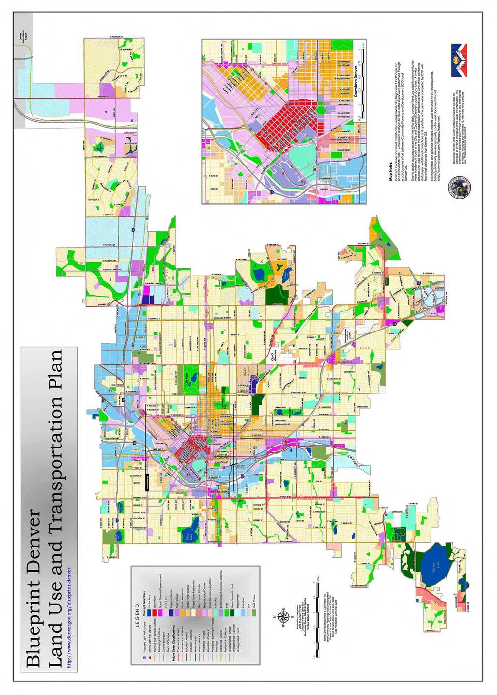
202
NEIGHBORHOOD PLANNING INITIATIVE
 NEIGHBORHOOD PLANNING INITIATIVE INC-ZAP October 22, 2016 TODAY 1. What is NPI? 2. Overview of Proposed NPI Approach 3. Next Steps REFRESHER 10-14 Bear Valley Fort Logan Regis Berkeley Highland Barnum
CHAPTER 7: Transportation, Mobility and Circulation
 AGLE AREA COMMUNITY Plan CHAPTER 7 CHAPTER 7: Transportation, Mobility and Circulation Transportation, Mobility and Circulation The purpose of the Transportation, Mobility and Circulation Chapter is to
Chapter 4. Linking Land Use with Transportation. Chapter 4
 Chapter 4 Linking Land Use with Transportation Chapter 4 59 Chapter 4 Linking Land Use with Transportation Community Design and Transportation Program Introduction Since the 1950s, the predominant development
Living in Albemarle County s Urban Places
 Living in Albemarle County s Urban Places ALBEMARLE COUNTY, VIRGINIA A Closer Look at Albemarle s Approach to Managing Growth and Creating Quality Urban Environments www.albemarle.org Page 2 Living in
Creating a vibrant, beautiful,
 PLAN GUIDE Chapter 1: An Integrated Land Use and Transportation Plan Creating a vibrant, beautiful, community-oriented city where people feel comfortable walking to neighborhood shops, new buildings
TO: Denver Planning Board FROM: Analiese Hock, Senior City Planner DATE: March 13, 2018 RE:
 Community Planning and Development Planning Services 201 W. Colfax Ave., Dept. 205 Denver, CO 80202 p: 720.865.2915 f: 720.865.3052 www.denvergov.org/cpd TO: Denver Planning Board FROM: Analiese Hock,
Wasatch CHOICE for 2040
 Wasatch CHOICE for 2040 Economic Opportunities We Can Choose a Better Future We enjoy an unparalleled quality of life along the Wasatch Front. People from all over the world are drawn to our stunning scenery,
Corridor Vision. 1Pursue Minnehaha-Hiawatha Community Works Project. Mission of Hennepin County Community Works Program
 1Pursue Minnehaha-Hiawatha Community Works Project Minnehaha-Hiawatha Community Works is a project within the Hennepin Community Works (HCW) program. The mission of the HCW program is to enhance how the
CHAPTER 3 VISION, GOALS, & PLANNING PRINCIPLES. City of Greensburg Comprehensive Plan. Introduction. Vision Statement. Growth Management Goals.
 CHAPTER 3 VISION, GOALS, & PLANNING PRINCIPLES Introduction The Greensburg Comprehensive Plan is intended as a working community document. A combination of long and short-term goals, this document is intended
Transit-Oriented Development
 Transit-Oriented Development Path to Sustainability West Windsor February 22, 2007 George S. Hawkins Context for Presentation NJ Future is a non-partisan, 501(c)3 non-profit organization. Offer perspective,
Staff Report and Recommendation
 Community Planning and Development Planning Services 201 W. Colfax Ave., Dept. 205 Denver, CO 80202 p: 720.865.2915 f: 720.865.3052 www.denvergov.org/cpd TO: City Council Neighborhoods and Planning Committee
Plano Tomorrow Vision and Policies
 Plano Tomorrow Vision and Policies PLANO TOMORROW PILLARS The Built Environment The Social Environment The Natural Environment The Economic Environment Land Use and Urban Design Transportation Housing
North Salt Lake General Plan Update 2013
 North Salt Lake General Plan Update 2013 Acknowledgements Updating the North Salt Lake General Plan was a process that would not have been possible without the support of elected officials and the general
1.0 Introduction. Purpose and Basis for Updating the TMP. Introduction 1
 1.0 Introduction The Town of Castle Rock is situated between the metropolitan areas of Denver and Colorado Springs, amidst a unique terrain of rolling hills, mesas, ravines, and waterways. Like many Front
A BLUEPRINT FOR BROCKTON A CITY-WIDE COMPREHENSIVE PLAN
 A BLUEPRINT FOR BROCKTON A CITY-WIDE COMPREHENSIVE PLAN Public Meeting October 2016 1 Plan Summary and Discussion Public Meeting May 4 2017 City of Brockton Bill Carpenter, Mayor Department of Planning
Chapter 1.0 Introduction
 Chapter 1.0 Introduction 1.1 Background The North Metro commuter rail line is part of the RTD FasTracks regional transit system expansion program to build more than 100 miles of rail transit throughout
North Fair Oaks Community Plan Summary and Information
 North Fair Oaks Community Plan Summary and Information WHAT IS THE NORTH FAIR OAKS COMMUNITY PLAN? The North Fair Oaks Community Plan is part of the San Mateo County General Plan, and establishes policies
C. Westerly Creek Village & The Montview Corridor
 C. Westerly Creek Village & The VISION Community Vision When the goals of the city are achieved Westerly Creek Village, a distinctive community defined by Montview Boulevard and Westerly Creek, is a strong
The Five Components of the McLoughlin Area Plan
 The Five Components of the McLoughlin Area Plan This documents contains the complete language of the five components of the McLoughlin Area Plan: The Vision Statement The Values The Guiding Principles
2040 LUP is a part of the Comprehensive Plan and carries the same legal authority. Economic Challenges
 1.1. Guiding Anchorage s Growth Where will new residents settle over the next two decades? Where will people work, shop, and play? Will there be enough room to grow? How will Anchorage look? Will growth
1.0 PROJECT PURPOSE AND NEED
 1.0 PROJECT PURPOSE AND NEED The FasTracks Plan includes the extension of the Central Corridor from its current terminus at 30th/Downing to a connection to the East Corridor commuter rail service planned
ARLINGTON COUNTY, VIRGINIA
 ARLINGTON COUNTY, VIRGINIA County Board Agenda Item Meeting October 15, 2005 DATE: September 28, 2005 SUBJECT: Request to Advertise the adoption of the 2005 Clarendon Sector Plan C. M. RECOMMENDATION:
V. Vision and Guiding Principles
 V. Vision and Guiding Principles The Master Plan for the Powers Ferry Corridor seeks a foundation in the desires of the community. At times, various elements of the community offered opposing viewpoints,
Concord Community Reuse Project Goals and Guiding Principles. Overarching Goals (OG)
") Concord Community Reuse Project Goals and Guiding Principles Overarching Goals (OG) No priority is implied by the order of presentation of the goals and guiding principles. Overarching goals for the Concord
Concord Community Reuse Project Goals and Guiding Principles Overarching Goals (OG) No priority is implied by the order of presentation of the goals and guiding principles. Overarching goals for the Concord
Issues Requiring Future Study
 Issues Requiring Future Study Transportation planning is an ongoing process that tends to identify new issues as it finds solutions for others. Some issues are so complex that a solution to one problem
3. ELEMENTS OF THE METRO VISION 2035 PLAN
 3. ELEMENTS OF THE METRO VISION 2035 PLAN What is Metro Vision and why does it matter? For more than 50 years, DRCOG has championed a regional perspective on key issues facing the metropolitan area and
CHAPTER 1. Ms. Guajardo s Class - Central Elementary CH 1 1
 INTRODUCTION CHAPTER 1 Ms. Guajardo s Class - Central Elementary CH 1 1 1.1 SETTING South Centre City is a linear corridor south of Downtown Escondido paralleling Centre City Parkway and South Escondido
Blueprint Denver Task Force Meeting #16 February 22, 2018
 Blueprint Denver Task Force Meeting #16 February 22, 2018 Agenda Welcome, Meeting Overview and Process Update Change Categories Small Group Recommendations Discussions: Land Use and Built Form General
Blueprint Denver A BLUEPRINT FOR AN INCLUSIVE CITY. Executive Summary
 Blueprint Denver A BLUEPRINT FOR AN INCLUSIVE CITY Executive Summary PUBLIC REVIEW DRAFT 2 1/7/2019 DENVERIGHT BLUEPRINTDENVER Blueprint Denver: A Blueprint for an Inclusive City An Equitable City Planning
Chapter 2: Vision, Goals and Strategies
 Chapter 2: Vision, Goals and Lake Elmo Today & Tomorrow Comprehensive Plan 2040 2 VISION, GOALS & STRATEGIES - DRAFT 4-6-2018 INTRODUCTION Comprehensive Plan Purpose Perhapse the most important objective
4.1.3 LAND USE CATEGORIES
 4.1.3 LAND USE CATEGORIES a. City Center District The City Center District incorporates the existing character and mix of uses in downtown Belmont to encourage redevelopment and new development in keeping
Sheridan Boulevard S TAT I O N A R E A P L A N S H E R I D A N B O U L E VA R D S TAT I O N A R E A P L A N
 Sheridan Boulevard S TAT I O N A R E A P L A N 1 City of Lakewood Adopted November, 2006 S H E R I D A N B O U L E VA R D S TAT I O N A R E A P L A N The Vision The City of Lakewood s overall vision is
Silverdale Regional Center
 Silverdale Regional Center Vision for Silverdale Regional Center The Silverdale Regional Center Plan (Plan) will guide the evolution of the Silverdale Regional Center from a collection of strip malls and
East Central Area Plan
 East Central Area Plan Steering Committee Meeting March 8 th, 2018 CHUN Tears McFarlane House Vision Statement Development Opportunities Analysis Vision Elements 1. Equitable, Affordable and Inclusive
CHAPTER 8 ISSUES, CONCERNS, CONSTRAINTS AND OPPORTUNITIES
 CHAPTER 8 ISSUES, CONCERNS, CONSTRAINTS AND OPPORTUNITIES Introduction This River Conservation Plan was developed during a time of tremendous activity and effort in planning the transformation of the Delaware
Implementation Guide Comprehensive Plan City of Allen
 Implementation Guide 2030 Comprehensive Plan City of Allen DRAFT 2015 Implementation Guide Allen 2030 Comprehensive Plan INTRODUCTION The Comprehensive Plan serves as a guide for the growth and development
LAND USE OVERVIEW WHAT YOU WILL FIND IN THIS CHAPTER
 LAND USE WHAT YOU WILL FIND IN THIS CHAPTER Information about the City s expected population and employment growth. Description and capacity of existing and future land use designations. Policies that
Status Update (2006 vs. Now) Citizen s Advisory Committee February Plan for Prosperity
 Citizen s Advisory Committee February Plan for Prosperity") Status Update (2006 vs. Now) Citizen s Advisory Committee February 2018 Plan for Prosperity 2000 2017 2000 2017 Gardnerville Population 6,000 5,760 5746 5,500 5,000 5,067 5,550 5,165 5,394 5,412 5,250
Status Update (2006 vs. Now) Citizen s Advisory Committee February 2018 Plan for Prosperity 2000 2017 2000 2017 Gardnerville Population 6,000 5,760 5746 5,500 5,000 5,067 5,550 5,165 5,394 5,412 5,250
Draft for Public Review. The Market and Octavia Neighborhood Plan
 Draft for Public Review The Market and Octavia Neighborhood Plan San Francisco Planning Department As Part of the Better Neighborhoods Program December 2002 IOverview Why Plan a Better Neighborhood Here
CHAPTER 12 IMPLEMENTATION
 CHAPTER 12 IMPLEMENTATION The 2010 Town of Denton Comprehensive Plan is intended to capture a vision of the future of Denton. As such, it provides a basis for a wide variety of public and private actions
A. WHAT IS A GENERAL PLAN?
 I. Introduction A. WHAT IS A GENERAL PLAN? A general plan is the planning guideline for the future of a city. It contains goals and policies which regulate urban development, the protection of the natural
3. Endorse the LRT vision in transforming Surrey into Connected-Complete-Livable communities, and more specifically, the official vision statement:
 CORPORATE REPORT NO: R038 COUNCIL DATE: February 20, 2017 REGULAR COUNCIL TO: Mayor & Council DATE: February 16, 2017 FROM: General Manager, Engineering FILE: 8740-01 SUBJECT: Surrey Light Rail Transit
Joint Meeting City Council and the Plan Commission. September 1st, 2015
 Joint Meeting City Council and the Plan Commission September 1st, 2015 1 The City Plan Commission shall recommend a City Plan for the physical development of the City Article IX Section 2 of the City of
WATERFORD Plan of Preservation, Conservation and Development Supplement Part 1 - Policy Element
 WATERFORD 2012 Plan of Preservation, Conservation and Development 2015 Supplement Part 1 - Policy Element Effective June 11, 2015 2015 Plan Update GOAL To respond to the evolving land use needs and continually
S A C R A M E N T O C O U N T Y JACKSON HIGHWAY & GRANT LINE EAST VISIONING STUDY
 JACKSON HIGHWAY & GRANT LINE EAST S A C R A M E N T O C O U N T Y P L A N N I N G D E P A R T M E N T SUMMARY AND WORKBOOK November 19, 2008 History of the Visioning Study Sacramento County has two growth
Making TOD Work in the Heart of Suburban Sprawl
 Making TOD Work in the Heart of Suburban Sprawl Rocky Mountain Land Use Institute March 6, 2009 Speakers Ben Herman, FAICP, Principal Clarion Associates Darcie White, AICP, Principal Clarion Associates
1 Introduction. Chapter. In this chapter:
 Chapter 1 Introduction In this chapter: 1.1 A Snapshot of the Region 1.2 Towards a Sustainable Region 1.3 The Provincial Context 1.4 Purpose and Organization The Regional Municipality of York Official
TOD 101 CREATING LIVABLE COMMUNITIES WITH TRANSIT
 1 CREATING LIVABLE COMMUNITIES WITH TRANSIT What are transit Centered Communities? Benefits of Partnerships to Support and Implement What You Will Learn Portland s Pearl District Your Trainers Today Catherine
3. VISION AND GOALS. Vision Statement. Goals, Objectives and Policies
 Vision Statement Queen Creek s interconnected network of parks, trails, open spaces and recreation opportunities provide safe and diverse activities and programs that sustain its unique, small town, equestrian
Visioning Statement and Guiding Principles
 Visioning Statement and Guiding Principles Planning for the Future The General Plan The General Plan represents Woodland's shared vision of the future and defines a path to lead the community toward its
SECTION ONE: INTRODUCTION. introduction
 introduction 1 INTRODUCTION Since it was first established in 1843 as a trading post for the Hudson s Bay Company, Victoria has evolved into a Provincial capital city that is recognized across Canada and
Blueprint Denver Task Force Meeting #
 Blueprint Denver Task Force Meeting #1 6.23.16 1. Welcome and Introductions Your name and affiliation Name 1 thing you love about Denver Name 1 thing you d change about Denver All in 30 seconds! Ready,
CITY OF COLWICH COMPREHENSIVE PLAN LAND USE LAND USE 1
 LAND USE LAND USE 1 WHAT YOU WILL FIND IN THIS CHAPTER: Discussion of today s conditions and tomorrow s projections Discussion of challenges and opportunities Discussion of the environmental quality goals,
Corridors. Re-vitalize our Corridors and Gateways
 Corridors Re-vitalize our Corridors and Gateways Artist s rendering from the 287 Strategic Plan, 2015 Corridors are the major throughways of Loveland but they also provide important commercial, community
1 October Dear Citizens of Charlotte and Mecklenburg County,
 1 October 2011 Dear Citizens of Charlotte and Mecklenburg County, As co-chairs of the Center City 2020 Vision Plan Steering Committee, we are proud to present the Center City 2020 Vision Plan, which sets
BROOKLYN PARK / 85TH AVE LRT STATION CDI DEVELOPMENT GUIDELINES DRAFT
 August 2018 Page intentionally left blank The Brooklyn Park Library adjacent to the 85th Ave LRT Station Area. OVERVIEW The Blue Line LRT Extension / Bottineau corridor offers a unique opportunity to leverage
12/9/2013. HOLLYWOOD/PINES CORRIDOR PROJECT AMPO 2013 Annual Conference October 24, Our Perspective. Broward.
 HOLLYWOOD/PINES CORRIDOR PROJECT AMPO 2013 Annual Conference October 24, 2013 Our Perspective Broward Fort Lauderdale 1 Broward Metropolitan Planning Organization Fort Lauderdale Fort Lauderdale Skyline
CHAPTER 7: VISION AND ACTION STATEMENTS. Noble 2025 Vision Statement
 CHAPTER 7: VISION AND ACTION STATEMENTS This chapter presents the vision, policy and action statements that transform the comprehensive planning study, an analysis of Noble s past, future trends and community
Wadsworth Boulevard S TAT I O N A R E A P L A N
 Wadsworth Boulevard S TAT I O N A R E A P L A N City of Lakewood Adopted November, 2006 The Vision The City of Lakewood s overall vision is to transform the area around the light rail station into a mixed-use
WELCOME and introduction
 1 WELCOME and introduction Mobility Hub Locations within Burlington STUDY OVERVIEW STUDY OBJECTIVES The City of Burlington is developing four Area Specific Plans, one for each of Burlington s Mobility
4 Sustainability and Growth Management
 4 Sustainability and Growth Management Introduction Traditionally, has assumed growth and development with limited consideration for the long-term negative social, environmental or economic impacts on
EXHIBIT A. Tax Increment Reinvestment Zone No. 1 (Town Center) First Amended Project Plan 1
 First Amended Project Plan 1") EXHIBIT A Tax Increment Reinvestment Zone No. 1 (Town Center) First Amended Project Plan 1 1 As amended by Resolution No. 2008-02-001(TR1R) of the Tax Increment Reinvestment Zone No.1, and approved to
EXHIBIT A Tax Increment Reinvestment Zone No. 1 (Town Center) First Amended Project Plan 1 1 As amended by Resolution No. 2008-02-001(TR1R) of the Tax Increment Reinvestment Zone No.1, and approved to
Plan Overview. Manhattan Area 2035 Reflections and Progress. Chapter 1: Introduction. Background
 Plan Overview The Manhattan Urban Area Comprehensive Plan (the Comprehensive Plan) is a joint planning initiative of the City of Manhattan, Pottawatomie County, and Riley County. The 2014 Comprehensive
THE 355/270 CORRIDOR:
 THE 355/270 CORRIDOR: Strategic Ideas for Sustaining a Livable Work Place Project Summary ACCESS LIFE DESIGN HEALTH WORK Montgomery County Planning Department The Maryland-National Capital Park and Planning
Port Credit Local Advisory Panel October 20 th Meeting
 Port Credit Local Advisory Panel October 20 th Meeting Focus Of This Evening s Meeting: 1. Hurontario Main Street Higher Order Transit Study 2. Port Credit Mobility Hub & GO Station Parking Structure Study
Preliminary Plan Framework: Vision and Goals
 Preliminary Plan Framework: Vision and Goals Draft: May 2015 Introduction Since the Town of Milliken s comprehensive plan was last updated in 2010, the community was heavily impacted by the 2013 flood,
Midtown Greenway Land Use and Development Plan Executive Summary
 Midtown Greenway Land Use and Development Plan Executive Summary Introduction The Midtown Greenway Land Use and Development Plan sets policy direction for land use and development in the Midtown Greenway
Executive Summary. NY 7 / NY 2 Corridor
 Executive Summary NY 7 / NY 2 Corridor Transportation and Land Use Study December 2005 Prepared for: Town of Colonie Capital District Transportation Committee Prepared by: Introduction: Land use decisions
Welcome to the Oakridge Centre Open House
 Welcome to the Oakridge Centre Open House Why is the City hosting this event? This open house is to inform you of a rezoning application submitted to the City of Vancouver to amend the existing CD-1 (Comprehensive
The transportation system in a community is an
 7 TRANSPORTATION The transportation system in a community is an important factor contributing to the quality of life of the residents. Without a sound transportation system to bring both goods and patrons
The University District envisions, in its neighborhood
 Envisioning the University District Link Light Rail in Seattle s neighborhoods CIY OF SEALE CONCEP-LEVEL SAION AREA PLANNING RECOMMENDAION RESOLUION # 30165 EXHIBI L Vision 08.2000 he University District
Official Plan Review
 Official Plan Review Summary Report - The Built Environment August 2014 Part 1: Introduction Planning for a healthy, prosperous and sustainable community is an important goal for our municipality. From
Urban Planning and Land Use
 Urban Planning and Land Use 701 North 7 th Street, Room 423 Phone: (913) 573-5750 Kansas City, Kansas 66101 Fax: (913) 573-5796 Email: planninginfo@wycokck.org www.wycokck.org/planning To: From: City Planning
MALL REVITALIZATION CASE STUDIES
 MALL REVITALIZATION CASE STUDIES DECEMBER 9, 2012 MALL REVITALIZATION OVERVIEW Introduction Sample Case Studies prepared for Lacey Woodland District Steering Committee as it considers strategies to revitalize
South Davis County COMMUNITY SPOTLIGHT
 South Davis County COMMUNITY SPOTLIGHT Davis/SLC Community Connector Bus Rapid Transit line connecting SLC & Davis County RTP Phase 1 Project Generate 3,100 average weekday riders Relieve congestion on
Town Center (part of the Comprehensive Plan)
") Town Center (part of the Comprehensive Plan) Mercer Island Town Center Looking North (2014) In 1994, a year-long process culminated in a set of design guidelines and code requirements for the Town Center
Town Center (part of the Comprehensive Plan) Mercer Island Town Center Looking North (2014) In 1994, a year-long process culminated in a set of design guidelines and code requirements for the Town Center
K. SMART ASSOCIATES LIMITED
 Planning Justification Report Zoning By-Law Amendment 185 King Street North Waterloo, Ontario April 7th, 2017 Project Reference Number 16-245 K. SMART ASSOCIATES LIMITED CONSULTING ENGINEERS AND PLANNERS
Purpose of the Master Plan
 Purpose of the Master Plan 4 Master Plan Purpose The Master Plan is a policy framework for decisions that affect the physical, social and economic environment of the Town. The Parker 2035: Master Plan
3 Vision and Goals. Vision and Goals. Blueprint for Bloomsburg. Vision. Town of Bloomsburg Comprehensive Plan,
 Vision and Goals 3 Vision and Goals Citizens of the Town of Bloomsburg clearly value their natural and cultural heritage, the walkable, mixed use pattern of downtown, the access to education, and the community
Chapter 1: Introduction
 Chapter 1: Introduction The Penn Avenue Community Works Corridor Vision and Implementation Framework presents an integrated communitybased vision and a coordinated, long-term implementation framework for
III. Design Principles
 III. Design Principles The design of Bay Meadows Phase II has been guided by a series of Urban Design Principles. These principles, informed by consultant site analysis, City staff recommendations, and
Chapter 3: Land Use and Local Planning
 3.1 Chapter 3: Land Use and Local Planning 2040 3.2 Chapter 3: Land Use and Local Planning CONTENTS Introduction 3.3 Coordinating Thrive MSP 2040 and Transportation Policy Plan 3.6 Coordination of Regional
Introduction. Chapter 1. Purpose of the Comprehensive Plan Plan Organization Planning Process & Community Input 1-1
 Chapter 1 Introduction Lakewood 2025: Moving Forward Together Purpose of the Comprehensive Plan Plan Organization Planning Process & Community Input 1-1 Purpose of the Comprehensive Plan The Comprehensive
CITY CLERK. Parkland Acquisition Strategic Directions Report (All Wards)
") CITY CLERK Clause embodied in Report No. 10 of the, as adopted by the Council of the City of Toronto at its meeting held on November 6, 7 and 8, 2001. 10 Parkland Acquisition Strategic Directions Report
CITY CLERK Clause embodied in Report No. 10 of the, as adopted by the Council of the City of Toronto at its meeting held on November 6, 7 and 8, 2001. 10 Parkland Acquisition Strategic Directions Report
Purpose of the Master Plan
 Purpose of the Master Plan 4 Master Plan Purpose The Master Plan is a policy framework for decisions that affect the physical, social and economic environment of the Town. The Parker 2035: Master Plan
Preparing to Review City-owned Property
 Preparing to Review City-owned Property June 28, 2017 WORKING DRAFT Prepared for: Mayor DeBoer and the Holland City Council Prepared by: Denny Ellens William J. Johnson Soren Wolff Phil Meyer REPORT CONTENTS
City of Royalton Comprehensive Land Use Plan 2005 to Revision February 8, 2011
 City of Royalton Comprehensive Land Use Plan 2005 to 2015 2011 Revision February 8, 2011 PART ONE: INTRODUCTION TO THE COMPREHENSIVE PLAN 1.0 Purpose and Introduction The Comprehensive Land Use Plan provides
Chapter #3 LAND USE AND SCENARIO PLANNING
 Chapter #3 LAND USE AND TABLE OF CONTENTS 3.0 Land Use and Scenario Planning...3-1 3.1 Introduction IMAGINE 2040...3-1 3.2 Background...3-3 3.2.1 4D Analysis...3-3 3.3 Imagine 2040 Scenario Planning...3-7
2 nd & St Paul, LLC and BAH-PLA, LLC
 Community Planning and Development Planning Services 201 W. Colfax Ave., Dept. 205 Denver, CO 80202 p: 720.865.2915 f: 720.865.3052 www.denvergov.org/cpd TO: Denver City Council FROM: Theresa Lucero, Senior
Cumberland Region Tomorrow is a private, non-profit, citizen based regional organization working with Greater Nashville Regional Council
 Cumberland Region Tomorrow is a private, non-profit, citizen based regional organization working with Greater Nashville Regional Council and others in the public and private sectors, dedicated to planning
Sacramento Area Council of Governments (SACOG)
") Sacramento Area Council of Governments (SACOG) The Blueprint Vision The SACOG Board of Directors adopted the Preferred Blueprint Scenario in December 2004, a bold vision for growth that promotes compact,
Sacramento Area Council of Governments (SACOG) The Blueprint Vision The SACOG Board of Directors adopted the Preferred Blueprint Scenario in December 2004, a bold vision for growth that promotes compact,
ELK GROVE GENERAL PLAN VISION
 2-1 CHAPTER 2: 2-2 CREATING OUR The Community Vision for Elk Grove, expressed through a Vision Statement and a series of Supporting Principles, is a declaration of the kind of community that Elk Grove
In the heart of the Southern Sector is a diamond in the rough
 WESTMORELAND DART STATION AREA PLAN Map III-2.24 The Westmoreland DART Station Area In the heart of the Southern Sector is a diamond in the rough the Westmoreland Transit Station. This DART station, near
MOUNT BAKER TOWN CENTER: THE 2014 REZONE AND TRANSIT ORIENTED DEVELOPMENT. By Talis Abolins
 MOUNT BAKER TOWN CENTER: THE 2014 REZONE AND TRANSIT ORIENTED DEVELOPMENT By Talis Abolins In 2014, the City of Seattle adopted Ordinance 124513, and created a transit oriented rezone over the area known
DRAFT FOR PUBLIC REVIEW. Game Plan for a Healthy City
 DRAFT FOR PUBLIC REVIEW 2018 Game Plan for a Healthy City 2 Denveright. Parks & Recreation Game Plan Draft for Public Review Draft for Public Review Executive Summary Game Plan Overview Executive Summary
SAN RAFAEL GENERAL PLAN 2040 INTRODUCTION AND OVERVIEW
 SAN RAFAEL GENERAL PLAN 2040 INTRODUCTION AND OVERVIEW Steering Committee Presentation February 14, 2018 Purpose of General Plan Guide land use and development decisions Coordinate transportation, infrastructure,
Gold Line Bus Rapid Transit Transit Oriented Development (BRTOD) Helmo Station Area Plan
 Helmo Station Area Plan") Appendix F Gold Line Bus Rapid Transit Transit Oriented Development (BRTOD) Helmo Station Area Plan Introduction and Purpose of the Plan The Gold Line Bus Rapid Transit facility is an eleven-mile dedicated
Appendix F Gold Line Bus Rapid Transit Transit Oriented Development (BRTOD) Helmo Station Area Plan Introduction and Purpose of the Plan The Gold Line Bus Rapid Transit facility is an eleven-mile dedicated
CITY OF PUYALLUP. Background. Development Services
 CITY OF PUYALLUP Development Services 333 South Meridian Puyallup WA 98371 To: City Council From: Katie Baker, AICP, Planning Division Re: South Hill Neighborhood Plan Adoption Date: (Meeting date: February
P LAN PURPOSE AND PROCESS
 RIVER NORTH PLAN P LAN PURPOSE AND PROCESS BRIGHTON BOULEVARD/40 TH AND 40 TH TOD 7 PLAN PURPOSE AND PROCESS L OCATION The River North Plan study area is in North Denver just northeast of downtown. Project
Urban Design Manual PLANNING AROUND RAPID TRANSIT STATIONS (PARTS) Introduction. Station Study Areas
 Introduction. Station Study Areas") 111111 PLANNING AROUND RAPID TRANSIT STATIONS (PARTS) Introduction The ION rapid transit system will link Waterloo, Kitchener and Cambridge through a central transit corridor (CTC). There are a number
111111 PLANNING AROUND RAPID TRANSIT STATIONS (PARTS) Introduction The ION rapid transit system will link Waterloo, Kitchener and Cambridge through a central transit corridor (CTC). There are a number