Cahersiveen, Waterville & Sneem Functional Areas Local Area Plan
|
|
|
- Brook Brooks
- 5 years ago
- Views:
Transcription


1 KERRY COUNTY COUNCIL - COMHAIRLE CONTAE CHIARRAI Cahersiveen, Waterville & Sneem Functional Areas Local Area Plan Kerry County Council Planning Policy Unit Adopted 21st January 2013-Effective from 18th February VOLUME 1 Written Statement and Maps
2 Table of Contents Section 1 Introduction 1-42 Section 2 CAHERSIVEEN Functional Area Section 2a Settlement Plans Cahersiveen Town & Associated Maps Appendix 1 Architectural Conservation Area Appendix 2 Existing Protected Structures Appendix 3 Opportunity Sites Portmagee & Land Zoning Map An Gleann & Land Zoning Map Baile an Sceilig & Land Zoning Map Dún Géagáin & Land Zoning Map Kells Renard Section 2b Valentia Island & Associated Maps Appendix 1 Proposed Protected Structures Knightstown & Land Zoning Map Appendix 1 Opportunity Sites Appendix 2 Architectural Conservation Area Chapeltown & Land Zoning Map Section 2c Rural Area & Associated Maps Appendix 1 Proposed Protected Structures Appendix 2 Existing Protected Structures 176 Section 3 WATERVILLE Functional Area Section 3a Settlement Plans Waterville Town & Associated Maps Appendix 1 Architectural Conservation Area Appendix 2 Existing Protected Structures Caherdaniel & Land Zoning Map Máistir Gaoithe & An Chíllín Líath & Land Zoning Map Draft Cahersiveen Waterville Sneem FALAP
3 Table of Contents Section 3b Rural Area & Associated Maps Appendix 1 Proposed Protected Structures 237 Section 4 SNEEM Functional Area Section 4a Settlement Plans Sneem Town & Associated Maps Appendix 1 Architectural Conservation Area Appendix 2 Existing Protected Structures Castlecove & Land Zoning Map Tahilla Section 4b Rural Area & Associated Maps Section 5 Section 6 SEA Statement HDA-Finding of No Significant Effects Report Draft Cahersiveen Waterville Sneem FALAP
4 SECTION 1 CAHERSIVEEN, WATERVILLE & SNEEM FUNCTIONAL AREAS INTRODUCTION 1.0. INTRODUCTION The Local Area Plan for the Functional Areas of Cahersiveen, Sneem and Waterville has been prepared in accordance with the provisions of the Planning and Development Act 2000 and the Planning and Development (Amendment) Act A Local Area Plan shall be consistent with the objectives of the County Development Plan and shall consist of a written statement and plan or plans which may include: Objectives for the zoning of land for the use solely or primarily of particular areas for particular purposes, Such other objectives in such detail as may be determined by the Planning Authority for the proper planning and sustainable development of the area to which it applies including details on community facilities and amenities and on standards for the design of developments and structures. This plan shall remain in force for a period of up to 6 years from its date of adoption, unless a review of the plan the plan is deferred by the Local Authority in accordance with Section 12 Planning & Development (Amendment) Act The Plan comprises of six sections, firstly an introduction followed by a section on each of the functional areas of Cahersiveen, Sneem and Waterville. Section 1 of this Plan comprises of the introduction to the three Functional Areas and contains the overall strategy which provides a coherent, integrated statement of the policies and objectives that need to be implemented in order to provide for sustainable development. Section 2a comprises policies and zoning maps for the Cahersiveen Functional Areas and for the larger settlements of Cahersiveen, Knightstown and Portmagee with defined boundaries for each settlement. It contains policies for the sustainable development of the smaller dispersed rural settlements of An Gleann, Baile an Sceilig, Chapeltown, Dún Géagáin, Kells and Renard. In accordance with Objective SS3-10(b) of the County Development Plan , Section 2b contains policies for the sustainable development of Valentia Island and the settlements of Knightstown and Chapeltown. The policies and zoning for lands outside the settlement boundaries, as defined on the maps in Section 2c, are contained in the County Development Plan with a number of additional specific objectives for rural areas contained in Section 2c of this plan. Section 3a comprises policies and zoning maps for the Waterville Functional Areas and for the settlement of Waterville. Draft Cahersiveen/Waterville/Sneem Functional Areas Local Area Plan Introduction 1
5 It contains policies for the sustainable development of the smaller dispersed rural settlements of Caherdaniel, Máistir Gaoithe and An Chíllin Líath. The policies and zoning for lands outside the settlement boundaries are contained in Section 3b of this plan. Section 4a comprises policies and zoning maps for the Sneem Functional Areas and for the settlement of Sneem. It contains policies for the sustainable development of the smaller dispersed rural settlements of Castlecove and Tahilla. The policies and zoning for lands outside the settlement boundaries are contained in Section 4b of this plan. Section 5 and 6 contains the SEA statement and HDA Finding of no significant effects report. Development within the boundaries of the settlements shall be carried out and in compliance with the Objectives of the Kerry County Development Plan as well as any specific objectives contained within the individual settlement plans. Any objectives or policies contained in the individual settlement plans relate to the individual settlements and are not intended to be interpreted or construed as relating to any lands outside the development boundaries as defined. The policies and zoning for lands outside the settlement boundaries are contained in the County Development Plan with a number of additional specific objectives for rural areas contained in each section of this plan. While the objectives of the Local Area Plan must be consistent with the objectives of the County Development Plan, in any instance where ambiguity may arise, the provisions, policies and objectives of the County Development Plan shall have precedence. The overall aim for this plan is to provide a comprehensive local planning framework for the three functional areas of Cahersiveen, Sneem and Waterville which clearly sets out the policies and objectives for its development in a sustainable manner. Taken in conjunction with the Regional Planning Guidelines and the County Development Plan it will complete the planning framework for the area. The plan will clearly set out the policies and objectives for the sustainable development of each settlement and make clear to landowners, developers and the general public what the vision of the Planning Authority for the area is. In the formulation of policies and objectives in this plan the planning authority have had regard to the following documents: - National Development Plan ( ) - National Spatial Strategy ( ) - Sustainable Development A Strategy for Ireland Departmental Planning Guidelines - Meitheal Chiarrai - The Barcelona Declaration Implementation Plan - South West Regional Planning Guidelines Kerry County Development Plan Draft Cahersiveen/Waterville/Sneem Functional Areas Local Area Plan Introduction 2
6 - The Provision of Schools and the Planning System; A Code of Practice for Planning Authorities. The Dept. of Education and Science and DoEHLG. (2008) - Údaras na Gaeltachta Beartas Forbatha Staidéar Teangeolaíochta na Gaeltachta - DoEHLG Circular PSSP6/ The Planning System and Flood Risk Management The EU Water Framework Directive - The South West River Basin Management Plan, - The Transitional and Coastal Water Action Program, - The National Cycle Policy Framework - Spatial Planning and National Roads Guidelines, DoECLG Retail Planning, Guidelines for Planning Authorities, DoECLG Our Sustainable Future-Framework for the Sustainable Development of Ireland, DoECLG Provision of Tourist & Leisure Signage on National Roads (March 2011) - Our Sustainable Future-Framework for the Sustainable Development of Ireland, DoECLG EU s Common Implementation Strategy for Water framework Directive Guidance Doc No.20 (2000/60/EC) - Draft freshwater pearl muscle sub basin management plans - Draft County Kerry Renewable Energy Strategy - Focus on Urban Water discharge in Ireland Report (EPA 2012) The Council is obliged, in the performance of its functions, to have regard to government policies and guidelines, and it is within the context of these documents that local policies are developed. In accordance with legislation, local area plans must be consistent with the provisions and policies of the County Development Plan. Similarly County Development Plans must be consistent with the provisions of the Regional Planning Guidelines. This provides for the consistent, coherent transfer of higher order planning strategies from regional level to the local level and ensures that policy at all levels works to achieve the broader strategic goals for the region. The planning hierarchy in Ireland is guided and regulated by national, regional and local planning policy. The Development Plan is an important tier in the planning hierarchy and ensures that national and regional spatial planning policy trickles down into local planning policies and objectives as part of the Functional Local Area plans. One of the most important spatial planning frameworks is the National Spatial Strategy which guides national planning policy. The Kerry County Development Plan contains the strategy for the preparation of local area plans which divides the County into functional areas based on their strategic role and service provision for their hinterlands. The Tralee Killarney Hub, designated under the National Spatial Strategy, is the focal point for the County s development in a Draft Cahersiveen/Waterville/Sneem Functional Areas Local Area Plan Introduction 3
7 National context, being one of a number of Gateways and Hubs throughout the Country identified to promote balanced regional development. In the National Spatial Strategy (NSS), the Functional Areas are located within a Diversifying Area, which is defined in the NSS as follows:- There are areas, along the west coast particularly, that have been successfully diversifying in recent years. The restructuring of their economies has been based on growing a variety of economic activities. These economies had traditionally been largely dependent on the agricultural sector... However, local authorities should now carefully manage and sustain this diversification process in the future by focusing on conserving the attractiveness of both the landscape and townscape of the areas that supported the diversification process in the first place. Local authorities can perform this role through the planning system through a focus on ensuring that new development is of the highest quality in terms of design and location. In the Regional Planning Guidelines (RPGs) the three Functional Areas are located within the Western Strategic Planning Area, fig 1. Section of the RPGs states that: A more balanced approach to development in order to maintain vibrant rural communities, with an equal level of urban and rural growth. In other towns of the region outside of the Gateway and hubs, there will be moderate population growth in line with local employment opportunities. In the Regional Settlement Strategy (see table 4.7 of the RPG) the main aim for Cahersiveen, Sneem and Waterville and their functional areas is to strengthen them and stimulate sustainable growth in indigenous economic development, while appropriate levels of sustainable growth is permissible in the key villages and smaller settlements. Core Strategy Section 7 the Planning and Development (Amendment) Act 2010 stipulates that development plans must contain an evidence-based core strategy, the purpose of which is to articulate a medium to longer term quantitatively based Spatial Strategy. A central tenet of a core strategy is adherence to National and Regional population targets, urban settlement hierarchies and sustainable rural development. The Core Strategy as set out in the County Development Plan provides a policy framework for land use zoning at local level as well as other policy matters. The strategy is specific in setting population targets and housing requirements. This allows an accurate assessment of the amount of land required to facilitate population targets. The Functional Area Plans are in accordance with the Core Strategy of the Kerry County Development Plan which in turn is consistent with the National Spatial Strategy and the South West Regional Planning Guidelines in supporting balanced development throughout the County.The implementation of the Core Strategy is made possible by: Draft Cahersiveen/Waterville/Sneem Functional Areas Local Area Plan Introduction 4

8 The Settlement Structure which defines the settlement hierarchy and indicates how future population growth should be distributed throughout the County and the functional area. The Development Land Requirements which outlines the guiding principles and sets out strategic policies regarding the zoning of land for residential and other uses during the life time of the Plan. The Spatial Development Framework (as set out in the CDP) which sets out strategic policies on the location of residential and employment-related development, transport framework and environmental quality. Figure 1.1: Strategic Planning Areas and the main settlements in the South West Region These Functional Area Plans are supported by strategic economic development policies, rural housing policies and the strategic policies relating to transport and infrastructure as detailed in the County Development Plan. The distribution of targeted population growth throughout the functional areas have been determined in accordance with the Core strategy and settlement hierarchy into Cahersiveen, Sneem and Waterville towns and the smaller settlements and rural areas. The preliminary Census 2011 returns are used to inform population and growth predictions for these Functional Area Plans. Using the same growth rate as in the Draft Cahersiveen/Waterville/Sneem Functional Areas Local Area Plan Introduction 5
9 RPGs, the projected 2018 figures have been extrapolated. The population and growth target figures are shown in Tables 1.1 & 1.2. Details of the growth strategy for each of the Functional Areas and individual settlements are provided in Section Growth Strategy of this plan. Draft Cahersiveen/Waterville/Sneem Functional Areas Local Area Plan Introduction 6


10 FIG.1.2 HIERARCHY OF PLANS National Spatial Strategy Regional Planning guidelines Regional Planning Guidelines County Development Plan Map of County Showing Local area Plan Location County Development Plan Local Area Plan Draft Cahersiveen/Waterville/Sneem Functional Areas Local Area Plan Introduction 7
11 TABLE 1.1 POPULATION AND GROWTH TARGETS SOUTH WEST REGION POPULATION ,176 SOUTH WEST REGION POPULATION target ,849 COUNTY KERRY POPULATION ,048 COUNTY KERRY POPULATION target ,239 TRALEE KILLARNEY HUB POPULATION ,307 TRALEE KILLARNEY HUB POPULATION target ,076 BALANCE OF COUNTY POPULATION ,741 BALANCE OF COUNTY POPULATION target ,163 Draft Cahersiveen/Waterville/Sneem Functional Areas Local Area Plan Introduction 8
12 Table 1.2 FUNCTIONAL AREA POPULATION TARGETS 2011 census 2018 target WIDER HUB AREA WIDER HUB AREA AN DINGLE DAINGEAN 7, DINGLE 7850 CAHERCIVEEN 5, CAHERCIVEEN 5653 CASTLEISLAND 10, CASTLEISLAND KENMARE 6325 KENMARE 7210 KILLORGLIN 10, KILLORGLIN 8690 LISTOWEL LISTOWEL BALLYBUNION 2687 CASTLEGREGORY 2069 RATHMORE 4407 SNEEM 1, WATERVILLE 2, BALLYBUNION 3059 CASTLEGREGORY 2256 RATHMORE 4828 SNEEM 1357 WATERVILLE 2238 Cahersiveen, Waterville, Sneem Functional Areas Local Area Plan 8 Introduction
13 1.1 Functional Areas and Complimentary Roles In the preparation of the County Development Plan, an analysis of the functionality of the County was carried out and areas identified on the basis of service provision of the principle towns, their sphere of influence and their strategic role in the development of the county. Cahersiveen was identified as one of the six primary functional areas while Sneem and Waterville are both local functional areas. Fig1.3: Local Area Plan Functional Areas as per the Kerry County Development Plan Primary Functional Areas These areas are provided with their higher order services from a large principal settlement /district town (Cahersiveen) whose sphere of influence extends over a wide geographic area. Cahersiveen plays a strategic role in servicing the rural catchments as well as supporting and driving the rural economy of the County. It is envisaged that the town will act as the focal point for future job creation within sustainable commuting distance for their populations. The strategy for the principal settlement of Cahersiveen in this Primary Functional Areas is:- To maintain and expand its current level of service provision in order to underpin the viability of the rural hinterlands. To act as the main employment centre for its area. To act as focal point for the investment necessary to strengthen the area. Cahersiveen is supported by the smaller settlements of Knightstown and Portmagee. These villages provide for the daily needs of their hinterlands. It is important that these settlements continue to maintain their existing population and services and to function as intermediate settlements between the rural dwellers and the larger towns. Cahersiveen, Waterville, Sneem Functional Areas Local Area Plan 9 Introduction
14 In the primary functional area the strategy for the smaller settlements of An Gleann,Baile an Sceilig, Chapeltown, Dún Géagáin, Kells and Renard is:- To ensure that they retain their current level of service provision and develop in a sustainable manner as attractive settlements while maintaining their existing character. To ensure infrastructural provision in order to consolidate their roles in a sustainable manner. The primary functional area is supported by the adjoining local functional areas. 1.3 Local Functional Areas These functional areas (Sneem & Waterville) have smaller geographic catchments, smaller populations and, while their main settlement function as service centres for a small number of other settlements they are smaller and have a lesser service provision than the principle towns. These towns play a very important role as service providers for smaller villages and rural dwellers in more remote rural areas and are critical for viability of these rural communities. In many of these settlements, unlike the larger principle towns, the ongoing provision of services is marginal. The emphasis for these settlements will be to promote measures which will remove barriers to development and ensure population growth and ongoing demand for services. The primary objective for these settlements is to retain and where possible increase their current level of population. Similar to the smaller settlements in the primary functional areas the smaller settlements in these areas will continue to function as daily service providers and act an intermediate level between the rural areas and the larger towns. The strategy for the smaller settlements is:- To ensure that they retain their current role as daily service providers for their rural areas. To retain their rural character. Provide an alternative location for rural style dwelling to one-off rural housing Cahersiveen, Waterville, Sneem Functional Areas Local Area Plan 10 Introduction
15 Fig1.4 The Functional Areas showing settlements and extent of rural area 1.4 Strategic Issues The concepts of linkages, critical mass and potential have been defined in the County Development Plan. Identifying the Potential of an area, the barriers to development and the needs of the area in order to reach its potential, is a difficult task involving a wide spectrum of economic and cultural groups. The coordination of these different sectors is necessary in order to develop an integrated, coordinated approach to achieving the potential of the functional area. One of the major difficulties that the county experience is its peripherality. Furthermore, many of the villages of the functional areas are also peripheral within the County. It is considered that the level of service provision within the south west Kerry Settlements will be commensurate with the size of the settlements and the population serviced. In effect, the demand for higher order services will be provided in the first instance within Cahersiveen and then for increasing service provision within the Regional centres of Tralee and Killarney. The Sneem functional area is linked to Kenmare due to its closer proximity. The critical mass of population within the area will sustain an increased range of services and facilities which will in turn make further inward investment more likely. It is important, therefore, that linkages between the south west Kerry Settlements and the Hub are sustainably provided in order to facilitate access to these services. Cahersiveen, Waterville, Sneem Functional Areas Local Area Plan 11 Introduction
16 Linkage is one of the key concepts outlined in the National Spatial Strategy. In effect the relevant linkages are to the Tralee Killarney Hub in a transportation context, good broadband connection in a telecommunications context and the national grid in an energy context. With journey times of approx 60 minutes respectively the main roadways linking Cahersiveen and the Functional Area to the Tralee - Killarney Hub are the N70 (Tralee to Cahersiveen) and the N70 & N72 (Killarney to Cahersiveen). This route continues onto Waterville. The route to Sneem is usually via Kenmare on the N71 or the R568/569 with a journey time of 90 minutes.these roadways have been identified as strategic / intraregional corridors in the current Regional Planning Guidelines for the South West Region ( ). In order for the functional area to provide the range of facilities and services desired by the population, it needs to achieve and maintain a certain level of population. What is considered to be a critical mass of population will vary on the level of service required, so the critical mass necessary to maintain the traditional services of a small village is different to that of a larger town. In the period , the district centre, village and small villages/development nodes of the Cahersiveen and Waterville Functional Areas experienced a slight population decline while Sneem had a slight increase. Bahaghs Baile an Sceilig Caher Canuig Castle quin Killinane Port magee St Finans Teer anearagh Valentia Total Table 1.3a Electoral District Populations for the Cahersiveen Functional Area Castlecove Loughbrin Sneem Tahilla Total Table 1.3b Electoral District Populations for the Sneem Functional Area An Baile Breac Cathair Dónall Doire Fhíonain Doire Ianna An timleach Loch Luioch Maistir Gaoithe Table 1.3c Electoral District Populations for the Waterville Functional Area total Cahersiveen, Waterville, Sneem Functional Areas Local Area Plan 12 Introduction
17 Due to the current economic situation, many areas of the County have been affected by rural depopulation. Policies need to be developed to promote the strengthening of settlements in these areas to act as a catalyst for reinvigorating them and creating the conditions and environment for population growth. These policies should concentrate on providing the ingredients for sustainable growth in the larger settlements initially. These larger settlements should act as the focal point for infrastructural development, population and service provision growth. Pending completion of this infrastructural provision, the smaller settlements should aim to consolidate their existing settlement pattern and maintain their intrinsic qualities and character. Fig 1.5 Percentage population change (CSO) The success of the measures outlined in this local area plan, are to a large extent dependent on population growth which is in turn largely reliant on employment creation. In recent years the three functional areas have successfully developed a number of sustainable cottage / micro type industries based on food and crafts. These areas are ideal locations for the establishment and growth of such industries. The Planning Authority will actively facilitate the sustainable development of these industries at appropriate locations within the plan area. The publication of the Sustainable Rural Housing Guidelines 2005 has required Planning Authorities to identify areas under urban pressure and develop policies to regulate development in these areas by reserving their development potential for persons from the area or having traditional links with the area. Cahersiveen, Waterville, Sneem Functional Areas Local Area Plan 13 Introduction
18 The Core Strategy identifies these areas and outlines growth strategies for the settlements and remaining rural areas. The policies are intended to limit ribbon development and urban sprawl as well as to provide a more integrated, serviceable town structure. Much of the growth expected for the plan area is dependant on inward migration. The settlements of each functional area, therefore, needs to identify the reasons why it is better to locate there than in other competing areas. The main factor which is readily identifiable is Quality of Life. A clean environment, good educational facilities, good health services, high quality social and cultural facilities and amenities are readily available. These assets, including landscapes, seascapes and freshwater systems, however, cannot be taken for granted and ongoing efforts to maintain and improve the quality of these and to facilitate only sustainable type developments must be continued. Kerry County Council acknowledges the tireless efforts undertaken by the Tidy Town Committees throughout the functional areas and will continue to support those involved in enhancing their local environment. Within the County, Tralee and Killarney are recognised as the main retail locations within the retail hierarchy. This will continue to be so. The location of retail development within settlements shall be determined having regard to the vitality, vibrancy and viability of the town centre as well as any infrastructural and floorspace availability restrictions which may arise. Settlements generally develop in response to their natural attributes, constraints and environment. The towns and villages throughout the County have evolved on this basis. One restriction which is of particular importance is the ability to dispose of treated effluent. Many of the smaller settlements throughout the functional area have no defined village core and as such have little or no capacity to dispose of treated effluent. It is considered that such settlements should maintain their existing character and settlement pattern. On a more macro level financial, technological, agri-food and manufacturing jobs are considered necessary in order to offset recent employment losses in the construction sector, and to provide more stable employment opportunities than perhaps tourism, which is seasonal, competitive and highly sensitive to international events. Attracting industry to Gaeltacht areas can prove challenging, largely due to their perceived peripherality and infrastructural deficits. A wide range of industries, companies and employment opportunities have however been established throughout the Kerry Gaeltacht areas. Údarás Na Gaeltachta has assisted many of these enterprises. For long-term growth of the settlements, high quality attractive environments need to be combined with employment opportunities if the quality of life potential is to be capitalized upon. Competitive pressures from world markets are increasing, particularly with regard to labour factors. The provision of high added-value knowledge based industry/ Creative Industry is seen as forming a significant part in the provision of sustainable employment in the region. Cahersiveen, Waterville, Sneem Functional Areas Local Area Plan 14 Introduction
19 This concept needs to be combined with nurturing existing indigenous talent to provide products which are unique to the area and capitalise on creative local talents. The Gaeltacht Uíbh Rátháigh covers an extensive area within the southern part of the Cahersiveen Functional Area and most of the Waterville Functional Area. This constitutes an important part of the linguistic, social, and cultural tradition of the county. This area is also rich in traditional ways, folklore, writing, music, and historic and archaeological sites. Every effort must be made to preserve and maintain Gaeltacht traditions. Fig 1.6 An Gaeltacht Uíbh Ráthaigh The cultural heritage of the Iveragh peninsula area is very strong. Its landscape, folklore, historic, archaeological, musical, linguistic and literary diversity gives the area a unique character and sense of identity.in every sense the area is a cultural gem and every effort must be made to maintain and preserve the Gaeltacht tradition. In particular the area is identified with its linguistic heritage, being one of the remaining areas throughout the Country where the Irish language is spoken. The preservation of the Irish language is of paramount importance to the area and the Country as a whole. The importance of tourism cannot be overstated. The Iveragh Peninsula and the Ring of Kerry are world renowned tourist destinations with magnificent scenery, distinctive villages and heritage (natural, built and cultural) of international significance. Skellig Michael (Sceilig Mhichil) is an UNESCO World Heritage Site famed for its exceptionally well preserved early Christian monastic site. Cahersiveen, Waterville, Sneem Functional Areas Local Area Plan 15 Introduction
20 Skellig Michael attracts tourists not only for its monastic history but also for its internationally important nature reserve. The three functional areas are rich in archaeological heritage, there is potential in utilizing them on a discovery trail/green route as places of interest. Tourism growth needs to be encouraged and facilitated in a sustainable manner so as to ensure that the quality of the overall product is not eroded and that its long term success is not compromised. The development of walking, hill and mountain climbing, birdwatching, maritime leisure and cycling as leisure pastimes is continually increasing and the diversity of the rural countryside within the plan area makes it ideal to capitalise on this growth area in a sustainable manner. Cycling in particular is a huge potential growth market which needs significant investment if it is to fulfill its potential in the area. Events like the Ras Na Mumhan, Charlie Chaplin Festival and many more festivals, races, regattas etc will continue to play a major role in the development of the area. Adaptability and quality are two factors facing this industry as competing markets become more accessible. Despite the many factors which have presented numerous challenges for Irish tourism in recent years, the industry has nonetheless shown itself to be very resilient in maintaining its share of the international travel and tourism market. Due to the world economic downturn there are likely to be some fundamental changes in the tourism industry in the coming years. One option the region has is to brand itself as an ecotourism destination. Eco/geotourism in particular is a huge potential growth market which needs significant investment if it is to fulfill its potential in the area. The larger piers and harbours at Cahersiveen, Knightstown and Portmagee have many functions including fishing, marine leisure and tourism. There are numerous other smaller piers and slipways that cater for local fishing and other marine activities. The beaches at Kells Bay, Derrynane, White Strand (Cahersiveen) and Ballinskelligs have blue flag status. Provision and security of energy supplies for the future is becoming increasingly important. In addition the cost of fossil fuels is set to become less affordable in the coming years with a consequent impact on production costs and competitiveness. Reliance on renewable energy will increase and it is important, for the reasons mentioned as well as the employment opportunities in this sector, that residential and commercial developers are encouraged to incorporate sustainable energy saving designs / mechanisms. Kerry County Council is currently preparing a Renewable Energy Strategy. The adopted strategy will be incorporated into the County Development Plan The strategy will strike a balance between the provision of renewable energy developments and the preservation and conservation of the rich natural environment of the area. The magnificent scenery, cultural heritage and unique identity of the area have also led to a high level of demand for holiday homes. The County Development Plan does not permit holiday homes in rural areas. This policy has proved very successful in protecting the landscape of the area, retaining the remaining capacity for local people as well as making sites for locals more affordable. Cahersiveen, Waterville, Sneem Functional Areas Local Area Plan 16 Introduction
21 There are an estimated 1250 holiday and second homes within the combined functional areas. This figure represents circa 40% of the housing stock. The percentage in Waterville town is even greater. The issue of holiday homes in the settlements must be considered from a number of perspectives. The provision of holiday home developments which are unoccupied for most of the year does not contribute to the development of active, vibrant local communities and acts as a deterrent to local people wishing to live in the smaller settlements. Until recently the demand for holiday homes far outstripped the indigenous demand and, in the long term, the consequence is that the proportion of holiday homes to permanent residential dwellings is likely to remain high. This is evident in Cahersiveen, Sneem and Waterville where there are a number of holiday home schemes. Some settlements, such as Cahersiveen are large enough to accommodate a certain level of holiday home development without a significant adverse impact. In Waterville and the smaller settlements such as Baile an Sceilg, Castlecove and Caherdaniel the impact is far greater. The scale of many of these schemes totally dominates the settlement. Such a situation is undesirable from a social and cultural perspective. In addition, as mentioned previously, the character of the settlements which gives them their unique identity needs to be maintained. While there may be perceived implications for tourism on any restrictions on holiday homes, the Cahersiveen, Sneem and Waterville Functional Area Local Area Plan has made no specific provision for holiday home development. Within many of these settlements a large number of housing estates have been developed in recent years. However, due to the current economic climate a substantial number of dwellings in these estates remain unfinished and unoccupied. The disposal of effluent from some smaller settlements is dependent on local receiving waters. In many instances these receiving waters are at, or close to, capacity in terms of accepting treated effluent. Where there is little capacity remaining, the long-term future expansion of such a village must be examined in terms of the impact of the expansion on the character and nature of the village. The provision of adequate water and wastewater treatment facilities is a priority for the sustainable development of the settlements throughout the area. The magnificent scenery and unique identity of the Iveragh Peninsula and especially along the Ring of Kerry route is being spoiled by the erection of road side signage. The proliferation of signage seriously affects the visual amenities of the landscape and adds to the visual clutter. These signs are generally associated with commercial business and tourist accommodation. The majority of signage along public roads and erected on private land are unauthorised. Kerry County Council will seek to remove all unauthorized signage. Kerry County Council controls the erection of finger post signs. It is the policy to restrict the number of finger post signs permitted to an individual/single business to two signs. A licence is required for the erection of a sign, these shall be renewed annually. Cahersiveen, Waterville, Sneem Functional Areas Local Area Plan 17 Introduction
22 1.5 Overall Development Strategy The strategy for the three Functional Areas is dependent on the consolidation and sustainable economic growth of the settlements. This can only be achieved through creating employment and attracting people to live in the settlements, thereby strengthening their urban structure and creating a demand to support local services. The RPG for the area promotes a more balanced approach to development in order to maintain vibrant rural communities, with an equal level of urban and rural growth Future population growth must be balanced between the towns and rural area with a focus on strengthening the established functions of the towns while exploring ways of diversifying the local economies. In other towns of the region outside of the Gateway and hubs, there will be moderate population growth in line with local employment opportunities. The proximity of the settlements in the functional area to the major hub towns of Tralee and Killarney makes them a viable alternative for persons seeking a more rural lifestyle. The importance of developing attractive settlements is therefore critical to attracting inward migration to the area. Regional Settlement Strategy Development Objective RSS-07 of RPGRSS-07 Settlements in the Western Area It is an objective to strengthen the economic and tourism roles of the towns and villages and forge greater links to their surrounding hinterlands and to peripheral areas and improve accessibility to peripheral areas in a sustainable manner. In rural areas which are suffering from population decline, specific strategies need to be developed to facilitate sustainable diversification of the rural economy. Such rural diversification should be located in areas which will avoid significant environmental effects. Any population growth will be distributed in a manner so that there is a balance between the town and villages/rural areas. Controls should be introduced for rural areas under pressure from urban generated housing. The Cahersiveen, Sneem and Waterville Functional Areas will be places where: Their intrinsic qualities will provide a unique location and quality of life for residents and visitors. The Irish language will be preserved and promoted as a living daily-use language and Gaeltacht communities will be supported in order to strengthen and expand the social networks that nourish Irish as the community language. The negative effects of peripherality will be minimised through the sustainable provision of adequate infrastructure and communications. Facilities will be put in place to promote continued sustainable diversification of the rural economy. The character of the built environment will be maintained through high quality design in the settlements throughout the area. The settlements of the area will act as the focal point for services serving their surrounding rural hinterland. The level of service provision will be commensurate with the size of settlement and demand from the rural hinterland served. Cahersiveen, Waterville, Sneem Functional Areas Local Area Plan 18 Introduction
23 The settlements of the area will be vibrant and distinctive communities that have individual roles and provide for the social, economic and employment needs of their residents and rural catchment in a sustainable manner. They will develop as attractive locations in which to live and work and will provide a broad range of residential options. The provision of adequate water and wastewater infrastructure will facilitate the sustainable development of the villages without adverse impact on the environment. People enjoy living, working and visiting. In order to facilitate this, a broad range of sustainable residential / accommodation types will be available so as to support sustainable growth. Provision shall not be made for holiday home developments in order to allow for the development of settlements which have a permanent year round population. This in turn will require year round services and facilities which will result in an attractive place for locals and visitors alike, while protecting the Irish language. Objective No OO-1 OO-2 OO-3 OO-4 OO-5 OO-6 OO-7 Overall Objectives It is an objective of the Council to: Development and Economic Strategy Provide an improved quality of life for all the citizens of the area by promoting the area s economic potential, protecting its natural and built environment and safeguarding its cultural heritage. Provide for the development of the area in a manner which is sustainable and protects its social, cultural, environmental and economic assets for future generations. Provide for balanced growth throughout the area by promoting the strengthening of rural communities and providing the infrastructure to facilitate job creation and diversification in these areas in a sustainable manner. Promote and foster local entrepreneurial activity and encouraging innovative and sustainable economic activity. Strengthen the town and villages throughout the area, improve the infrastructure provided, sustainably develop the critical mass necessary to maintain and expand the service provision within them, and make them more attractive places in which to live. Promote the sustainable development of indigenous knowledge based, cultural and creative industries as a means of strengthening the economic base of the area and acting as a focus for inward investment.. Facilitate farmers markets and similar initiatives at appropriate locations and encourage local food production and promote a local food culture within the functional area. Promote renewable energy generation in accordance with the County Kerry Renewable Energy Strategy, at appropriate locations and energy conservation measures as well as sustainable settlement patterns in order to promote local energy generation / energy conservation and sustainable communities and travel patterns. Cahersiveen, Waterville, Sneem Functional Areas Local Area Plan 19 Introduction
24 OO-8 Ensure compliance with The Planning System and Flood Risk Management Guidelines for Planning Authorities (DEHLG 2009). Residential Development OO-9 OO-10 Ensure that the zoning of residential land shall comply with the provisions of the Zoning Criteria contained in Section of the Kerry County Development Plan Ensure that 20% of the land zoned in the plan for residential, or for a mix of residential and other uses, shall be made available for the provision of social and affordable housing. Infrastructure OO-11 OO-12 OO-13 OO-14 OO-15 OO-16 OO-17 Ensure that development of zoned land within these settlements is dependent on the provision of adequate water and wastewater infrastructure as set out in S1.3 the Strategic Issues section of this plan and on the provision of other critical infrastructure. Improve water supplies in the plan area, paying particular regard to the EPA s Remedial Action List. Protect drinking water quality and public water supply sources, having particular regard to their zones of influences. Ensure that new developments shall incorporate on site measures in accordance with Sustainable Urban Drainage Systems where appropriate so as to minimise culverting, encourage native waterside vegetation and promote the use of reed beds and permeable paving to absorb pollutants and regularise storm water run-off. Ensure that new storm and foul drainage proposals are drained by gravity, except where otherwise deemed necessary by the Council. Comply with The Urban Waste Water Treatment Regulations 2001 and Address the recommendations of the Urban Waste Water Discharges in Ireland for Population Equivalents Greater than 500 Persons A Report for the Years 2006 and 2007 (Office of Environment Enforcement- EPA, 2009). Urban Waste Water Discharges in Ireland Report (EPA, 2012). Facilitate the licensing of wastewater discharges, including storm water discharges which come within the scope of The Waste Water Discharge (Authorisation) Regulations Ensure that all infrastructure and amenity projects identified undertake a Habitats Directive Assessment in accordance with best practice and guidance of their impact on Natura 2000 sites as part of the planning and decision making process and in considering the most suitable locations or scale for Cahersiveen, Waterville, Sneem Functional Areas Local Area Plan 20 Introduction
25 OO-18 OO-19 OO-20 OO-21 OO-22 OO-23 OO-24 provision of the project ensure avoidance of negative impact. Ensure compliance with the Spatial Planning and National Roads Guidelines, DoECLG Archaeology & Heritage Protect and enhance structures included in the Record of Protected Structures or proposed for inclusion by requiring that: No such building is demolished. The maintenance, alteration, extension, replacement or insertion of any significant feature(s) or part(s) to a protected structure shall not be detrimental to the character of the structure. Development shall be carried out and designed sympathetically having regard to the architectural character of the structure and the setting. The erection of any structure within the curtilage, adjacent to, or within the vicinity of the structure shall not be detrimental to the character of the structure and the setting, and shall be sited and designed sympathetically with the character of the structure and the setting. Any works that will materially affect the character of a protected structure or proposed protected structure shall require planning permission. Ensure that road project proposals take cognisance of the NRA s guidelines on archaeological assessments. Ensure that any proposed development within the lands highlighted as representing the zone of archaeological potential around a monument listed in the Record of Monuments and Places (RMP) is referred to the National Monuments Section of the Department of Environment, Heritage and Local Government. Such developments will be the subject of archaeological impact assessment and may require further subsequent archaeological mitigation buffer zones/exclusion zones, monitoring, pre-development archaeological testing, and archaeological excavation prior to a decision being made. Ensure the preservation of all archaeological monuments included in the Record of Monuments and Places (RMP) as established under section 12 of the National Monuments (Amendments) Act In ensuring such preservation, the Council will have regard to the advice and recommendations of The National Monuments. Service, The National Museum of Ireland and other statutory agencies. For sites which have been identified, but not yet added to the RMP the planning department will have regard to the advice and recommendations of the National Monuments Service and the County Archaeologist. Have regard to the advice and recommendations of The National Monuments Service, The National Museum of Ireland and other statutory agencies in the identification and protection of all previously unknown archaeological sites. Ensure that erection of any structure adjacent to, or within the vicinity of an Cahersiveen, Waterville, Sneem Functional Areas Local Area Plan 21 Introduction
26 OO-25 OO-26 OO-27 OO-28 OO-29 OO-30 OO-31 OO-32 OO-33 archaeological monument or feature shall not be detrimental to character of the monument/feature or its landscape setting, and shall be sited and designed sympathetically with the character of the monument/feature or the setting. Archaeology & Heritage Promote public awareness and facilitate appropriate advisory guidance in relation to the protection of the archaeological heritage of the county. Built Environment Encourage the development of a compact and sustainable settlement structure by ensuring that new development is contiguous with existing development and makes effective use of backland and infill sites. Provide a high quality of design in private and public development, increasing the quality of the public domain while maintaining the character, form and settlement pattern of the settlements. Promote the preparation and implementation of An Energy Conservation Strategy and associated awareness campaign within the Plan area. Promote the development of energy efficient (passive / low energy) buildings and encourage developers to design and build houses/buildings towards an A rating standard as set out by the National Building Energy Rating (BER) methodology. Natural Environment Support the implementation of the Kerry Heritage and Biodiversity Plan and the NRA (2008) document Management of Noxious Weeds and Non-Native Invasive Plant Species on National Roads and any subsequent updates, including measures outlined to control / manage alien species, in consultation with the National Parks and Wildlife Service. Ensure full compliance with the requirements of Directives 79/409EEC (Birds Directive) and 92/43/EEC (Habitats Directive) with respect to Appropriate Assessment / Habitats Directive Assessment of any relevant plans or development proposals. As part of this any proposed amendments / variations to the plan or development proposals should be screened with respect to the potential impact on Natura 2000 sites and the requirement for appropriate assessment / Habitats Directive Assessment in accordance with Article 6 of the Habitats Directive. Promote the protection and enhancement of surface water, groundwater water resources and their associated habitats and species, including fisheries. Ensure that any development that would have an unacceptable impact on the water resource of the area, including surface water and groundwater quality and quantity, any fish bearing watercourse, riparian zone, river corridors and associated wetlands of significance will not be permitted. Provide where appropriate for the protection, management, and as appropriate, enhancement of existing wetland habitats where flood protection/management measures are considered to be necessary. Cahersiveen, Waterville, Sneem Functional Areas Local Area Plan 22 Introduction
27 OO-34 Prohibit illegal burning, deposit and disposal of waste materials by the use of the statutory and non statutory powers of the local authority. OO-35 OO-36 OO-37 OO-38 OO-39 OO-40 OO-41 OO-42 OO-43 OO-44 OO-45 OO-46 Natural Environment Ensure that no projects which will be reasonably likely to give rise to significant adverse direct, indirect or secondary impacts on the integrity of any Natura 2000 sites having regard to their conservation objectives, shall be permitted on the basis of this Plan (either individually or in combination with other plans or projects) unless imperative reasons of over riding public interest can be established and there are no feasible alternative solutions. Where invasive introduced species, including Japanese Knotweed are identified on a site or in the vicinity of a site (underground parts of the plants may extend laterally up to 7 meters), the planning Authority may request a suitable scheme for their eradication and/or control as part of the planning application process. Gaeltacht Uíbh Ráthaigh Promote and develop the Gaeltacht as a centre of linguistic and cultural heritage in tandem with policies which will encourage sustainable economic development in order to ensure vibrant communities. Seek to enhance the unique cultural identity and secure the sustainability of the Gaeltacht communities into the future. Ensure that all signage erected in the Gaeltacht is in Irish only or complies with Objective SG 9-44 of the County Development Plan and Section 3.10 Scéim Gaeilge Ensure that all new Council Tenants of Social Housing supports in Category A Gaeltacht areas in Kerry show a fluency in spoken Irish and a positive impact on the use of Irish in the area. Encourage the provision of facilities for the teaching / learning of the Irish language and for the production of traditional entertainment and the presentation of culture through the medium of Irish. Ensure that as many Council services are provided as far as possible through Irish. Tourism Facilitate the provision of an Integrated Tourism Management Strategy. Facilitate the development of ecotourism and other niche markets. Facilitate the sustainable extension and diversification of tourist facilities. Ensure that proposed Tourism and Recreation Strategies, Projects and Activities, take account of the need to incorporate biodiversity considerations, particularly in the case of internationally designated sites of nature conservation importance and in non designated sites that contain important habitats and species. Coastal Zone Management Support the development of an integrated approach to coastal zone Cahersiveen, Waterville, Sneem Functional Areas Local Area Plan 23 Introduction
28 OO-47 OO-48 OO-49 OO-50 OO-51 OO-52 OO-53 OO-54 OO-55 OO-56 OO-57 OO-58 OO-59 OO-60 management and in particular to foster the application of this concept in appropriate coastal zones throughout the Plan Area. Facilitate the preparation of an integrated coastal zone management plan for the plan area. Flood Risk Management Ensure that any development proposals on lands at risk of flooding shall be subject to a flood impact assessment in accordance with the Flood Risk Management Guidelines (2009). Rural Housing Development Ensure that all residential units are permanent places of residency Ensure that the Rural housing policies as set out in the County Development Plan shall apply to all residential development. The Planning Authority will look favourably on applications from family members on family landholdings, in accordance with the proper planning and sustainable development of the area. Ensure that all dwellings in the rural area are served by individual septic tanks/treatment units based on an assessment of soil characteristics in accordance with the EPA s Code of practice-wastewater Treatment and Disposal Systems serving Single House (p.e. 10) or any subsequent amendment or revision documents. Piers and Harbours Support the sustainable development of the piers and harbours as potential economic generators for the area and support the maintenance of other facilities such as slipways and to protect them from inappropriate uses. Facilitate improved access to, improved launch facilities and marine leisure activities at piers in a sustainable manner. Rural Settlements & Villages Ensure that all new development takes place within the development boundary of the settlements/villages. Encourage the development of a compact and sustainable village structure by ensuring that new development is contiguous with existing development and makes effective use of backland and infill sites. Promote attractive streetscape and approaches into the village and preserve and enhance the elements of the built and natural environment which define the unique character of the village. Unfinished Estates Encourage the completion and occupation of unfinished estates. Transportation Encourage sustainable commuting practices in the Functional Areas Ensure compliance with the Spatial Planning and National Roads Guidelines, DoECLG Roadside Signage Seek to remove all unauthorized signage and advertisements erected on Cahersiveen, Waterville, Sneem Functional Areas Local Area Plan 24 Introduction
29 OO-61 roadside verges and on private lands. Restrict the number of finger post signs permitted to an individual/single business to two. Ensure the annual payment for each finger post licence. 1.6 Settlement Strategy Settlement Hierarchy The settlements within each of the Functional Areas are designated on the basis of the following classification; District Centres constitute the principal settlements within the Primary functional areas. They are large settlements that provide a range of services to the towns, villages and rural areas in their catchments. They have populations in excess of 1,000. Their functions are complementary to the regional centres and each other. They also have an important regional employment function within their surrounding catchment. Cahersiveen town is defined in this plan as a district centre. Towns constitute the principal settlements within the Local functional areas. They are large settlements that provide a range of services to the, villages and rural areas in their catchments. They also provide local level community services, sporting facilities and medical centres that meet the needs of the surrounding catchments. Sneem and Waterville are defined in this plan as towns. Villages provide for convenience and daily needs and small scale employment opportunities for their residents and surrounding rural population. They also provide local level community services, such as primary schools, churches, local sporting facilities and a community hall. Knightstown, Portmagee and Caherdaniel are designated as villages in this plan Small Villages/Development Nodes are localities with a scattered development pattern providing a range of local community facilities, such as a primary school, sporting club or a general shop or post office. The settlement pattern is not cohesive, but they are often characterised by strong geographic communities. An Gleann, Baile an Sceilig, Chapeltown, Dún Géagáin, Kells and Renard are small villages/development nodes in the Cahersiveen functional area. Castlecove and Tahilla are in the Sneem Functional Area. Caherdaniel, Maistir Gaoithe and An Chillin Líath are in the Waterville Functional Area. For ease of reference these settlements are indicated on Figure 1.7. Cahersiveen, Waterville, Sneem Functional Areas Local Area Plan 25 Introduction
30 Figure 1.7 Settlement Hierarchy in the Functional Areas Development Strategy It is an objective of the South West RPGs that targeted population growth in the plan area will be distributed in a manner so that there is a balance between the town and villages/rural areas. The development strategy of this plan follows and is consistent with that approach. The development strategy promotes the District town of Cahersiveen as the main focus for development within the plan area offering the greatest potential for economic, social and cultural development. Sneem and Waterville will continue to provide a range of services to the villages and rural areas in their catchments. Caherdaniel, Knightstown and Portmagee are considered important local service centres (villages) and act as stabilizing service centres for their rural hinterland. All the small villages and development nodes will remain as dispersed rural settlements retaining their existing rural character and serving local population needs. In the villages and settlements, the approach in this Local Area Plan is to define a development boundary on the zoning map for the particular village/settlement. It is not intended to specifically designate land for proposed residential use as the small amount of zoned land would be meaningless. The development boundary contains suitable land for the development of residential units. The development management and control system will safeguard land from inappropriate development which would limit the planned and sustainable growth of the village into the future. Cahersiveen, Waterville, Sneem Functional Areas Local Area Plan 26 Introduction
31 All proposed development and changes of uses will be assessed with regard to residential amenity and all planning and sustainable development considerations relevant to the proposal and/or its surroundings. This plan will encourage the development of compact and sustainable village structures. New houses will be located where they are contiguous to existing development and make effective use of infrastructure and of backland and infill sites. Other objectives may also be relevant to particular villages addressing issues such as flood risk or the provision of critical infrastructure or community facilities. In this plan, therefore, the development boundary represents the focus for new development in each particular village. It is the preferred area where new development should be located, subject to the other objectives of the plan Growth Strategy Population projections are necessary in order to accurately assess the future demand for housing, amenity, infrastructure and employment. The period of this plan is until 2018 and population projections for the period of the plans have been prepared on that basis. The distribution of targeted population growth throughout the County and each functional area has been determined in accordance with the Core Strategy and settlement hierarchy to the functional areas and the settlements and rural areas. In accordance with the South West RPGs and the Core Strategy it is intended to have balanced growth between the main urban settlements (Cahersiveen, Sneem and Waterville) and the rural area/ the remaining settlements. The targeted housing figures for the three larger towns of Cahersiveen, Sneem and Waterville include 50% headroom. Only the District centre and main town in each of the Functional areas contain land specifically zoned for residential development. Growth prediction for smaller towns, villages and development nodes is difficult due to their lower population base. Prescriptive growth figures and specific land use zonings can act as a barrier to development. It is considered therefore, rather than allocating prescriptive areas of zoned lands for the villages and smaller settlements, that managing the growth in a manner which will retain their character and create functional, attractive and well designed communities is a preferable approach. Generally, the established zoning categories used in previous plans to define the uses appropriate in existing areas of development are not to be found in the new plans. The plans are now vision statement rather than a land use survey approach. Cahersiveen, Waterville, Sneem Functional Areas Local Area Plan 27 Introduction
32 All proposed development and changes of use within established and developed areas will be assessed in relation to, the objectives of the County Development Plan , any general objectives in the local area plan that apply to the particular location, the character of the surrounding area, residential amenity, availability of infrastructure and any other planning and sustainable development considerations considered relevant to the proposal or its surroundings. Only the proposed lands use zonings, designations, objectives are indicated on the Land Zoning Map for each village and settlement node Cahersiveen Functional Area The population of the entire Functional Area as contained in the 2006 Census was 5,211 persons and in 2011 it was 5,074. The population growth target indicates that the population of the entire plan area will grow by 497 persons between the years 2012 and 2018 to a total of 5, census 2006 census 2011 census 2012 estimate 2018 target Cahersiveen Functional 5,051 5,212 5,074 5,156 5,653 Area Cahersiveen Town 1,272 1,294 1,454 1,499 1,772 Table 1.4a Population change and population target in the Cahersiveen Functional Area In accordance with the RPG and the Core Strategy it is intended to have balanced growth between the main urban settlement (Cahersiveen) and the rural area and the remaining settlements. The Core Strategy has allocated a growth figure of 273 persons for Cahersiveen town. A population figure of 1,772 is therefore targeted for Cahersiveen town by The remaining population growth of 224 will be distributed between the rural area and throughout the villages of Knightstown and Portmagee to the smaller villages/development nodes of An Gleann, Baile an Sceilig, Chapeltown, Dún Géagáin, Kells and Renard. The breakdown of the population allocation between Valentia Island and the rural area/ villages is based on a ratio of the individual DED census to the overall functional area population. The population projections and allocations for the settlements/nodes of Portmagee An Gleann, Baile an Sceilig, Dún Géagáin, Kells and Renard cannot be ascertained due to their size and lack of census data. These figures will be included within the overall rural population allocations. Cahersiveen, Waterville, Sneem Functional Areas Local Area Plan 28 Introduction
33 Settlement Projected Housing Requirement Targeted Population Increase (no.) Cahersiveen Knightstown Chapeltown (Valentia ED) Portmagee Rural areas & small villages / nodes An Gleann Baile an Sceilig Dún Géagáin Kells Renard Table 1.4b Projected housing & population targets in the Cahersiveen Functional Area Sneem Functional Area The population of the entire Functional Area as contained in the 2006 Census was 1,233 persons and in 2011 it was 1,244. The population growth target indicates that the population of the entire plan area will grow by 113 persons between the years 2012 and 2018 to a total of 1, census census census estimate target Sneem Functional Area 1,377 1,233 1,244 1,260 1,357 Table 1.5a Population change and population target in the Sneem Functional Area In accordance with the RPG and the Core Strategy it is intended to have balanced growth between the main urban settlement (Sneem) and the rural area and the remaining villages and nodes. It is intended to allocate 50 % of the growth to Sneem. The remaining 50% will be divided between the rural areas and to the smaller villages/development nodes. A population growth figure of 57 persons is allocated to Sneem. The remaining population growth of 56 will be distributed between the rural area and to the smaller villages/development nodes of Castlecove and Tahilla. The population projections and allocations for the settlements/nodes cannot be ascertained due to their size and lack of census data. These figures will be included within the overall rural population allocations. Settlement Projected Housing Requirement Targeted Population Increase (no.) Sneem Rural areas & small villages / nodes Castlecove Tahilla Table 1.5b Projected housing & population targets in the Sneem Functional Area Cahersiveen, Waterville, Sneem Functional Areas Local Area Plan 29 Introduction
34 Waterville Functional Area The population of the entire Functional Area as contained in the 2006 Census was 2,173 persons and in 2011 it was 2,052. The population growth target indicates that the population of the entire plan area will grow by 160 persons between the years 2012 and 2018 to a total of 2, census 2006 census 2011 census 2012 estimate 2018 target Waterville Functional 2, ,052 2,078 2,238 Area Table 1.6a Population change and population target in the Waterville Functional Area In accordance with the RPG and the Core Strategy it is intended to have balanced growth between the main urban settlement (Waterville) and the rural area and the remaining settlements. It is intended to allocate 50 % of the growth to Waterville. The remaining 50% will be divided between the rural areas and to the smaller villages/development nodes. A population growth figure of 80 persons is allocated to Waterville. The remaining population growth of 80 will be distributed between the rural area and to the smaller villages/development nodes of Caherdaniel, Máistir Gaoithe and An Chíllin Líath. The population projections and allocations for the settlements/nodes cannot be ascertained due to their size and lack of census data. These figures will be included within the overall rural population allocations. The breakdown of the population allocation between the rural and the villages is based on a ratio of the individual DED census to the overall functional area population. Settlement Waterville (An Timleach & Loch Luíoch ED) Rural areas & small villages / nodes Caherdaniel Máistir Gaoithe An Chíllin Líath Projected Housing Requirement Targeted Population Increase (no.) Table 1.6b Projected housing & population targets in Waterville Functional Area Zoning Criteria It is important that zoning within the settlements is carried out in a logical and informed manner which will provide for the long-term sustainable development of the settlements. The criteria used in deciding the extent and location of proposed residential zoning are set out in the Core Strategy and section of the County Development Plan. Cahersiveen, Waterville, Sneem Functional Areas Local Area Plan 30 Introduction
35 1.6.5 Development Management It is intended that development in each Functional Area will comply with the development management standards set out in Chapter 13 of the Kerry County Development Plan Flood Management It is the policy of the Council, that development should not be subject to an inappropriate risk of flooding nor should it cause or exacerbate such a risk at other locations. In this regard, applicants for development should have particular regard to the Guidelines issued by the DoEHLG The Planning System and Flood Risk Management 2009.It is an objective of the Regional Planning Guidelines for the South West, to ensure that significant developments in upland areas, such as wind farm developments, roadway construction, peatland drainage and forestry proposals, provide sufficient storm water attenuation so as to avoid the occurrence of river erosion or flooding downstream. This plan supports that objective. The OPW have published draft preliminary flood Zone Maps for the County, these are noted by Kerry County Council. Any proposed development on those lands shall be subject to a flood impact assessment. 1.7 An Cultúr agus An Gaeilge Section 10(2)(m) of the Planning and Development Act 2000 requires the council to include objectives for the protection of the linguistic and cultural heritage of the Gaeltacht including the promotion of Irish as the community language. The absolute number of people speaking the Irish language on a daily basis has risen slightly between 2002 and As a percentage of the population in the Gaeltacht area the figure for each of the functional areas has risen to 15.6%, 10% and 16 %( see Tables 1.7a, b, & c. (Gaeltacht EDs in italics)). This figure includes the use of Irish within the education system. Only 247 people or 2.8% speak Irish daily outside the education system. 141 (2.7%) persons in the Cahersiveen Functional Area speak Irish daily.14 (1%) persons in the Sneem Functional Area speak Irish daily, 92 (4.2%) persons in the Waterville Functional Area speak Irish daily. These figures indicate that Waterville has the highest percentage of daily Irish speakers outside the educational system. As an indicator of the future strength of the language, the % of population is a more relevant indicator than absolute numbers. As the percentage decreases, the external pressures on the language increase. This trend is an obvious cause for major concern and indicates a massive decline in the use of the language in everyday life. Cahersiveen, Waterville, Sneem Functional Areas Local Area Plan 31 Introduction
36 Bahaghs Baile an Sceilig Caher Canuig Castle quin Killinane Port Magee Togh roinn Fhíonáin Teer anearagh Valencia Total % % Table 1.7a % of population speaking Irish daily in the Cahersiveen Functional Area Castlecove Loughbrin Sneem Tahilla Total % 6% 5% 5% 6% % 11% 11% 10% 10% Table 1.7b % of population speaking Irish daily in the Sneem Functional Area An Baile Breac Cathair Dónall Doire Fhíonain Doire Ianna An timleach Loch Luioch Maistir Gaoithe Total % 11% 11% 21% 12% 7% 20% 13% % 13% 14% 18% 16% 13% 38% 16% Table 1.7c % of population speaking Irish daily in the Waterville Functional Area The extent of the Gaeltacht area is shown on fig 1.6 but the daily use of the language is declining. The protection of the Irish language is of National importance and crucial to our national identity. The issue of preserving the Irish language is difficult and complex and needs a much broader range of measures than can be included in a land use plan such as this. It is important, however, that the policies contained within the plan are broad and wideranging enough to facilitate any future strategies and initiatives that might emerge. The main factors that need to be considered in the preservation of the Irish language are; Demographics, Economic Factors, Facilities and Infrastructure. In recent years the Council has been particularly proactive in the promotion of the Gaeltacht areas in Kerry. The Kerry County Council Scéim Gaeilge aims to promote the provision of services through the Irish language for the people of the Gaeltacht. Such proactive measures are important in ensuring the survival of the Irish language and its associated Gaeltacht culture. Cahersiveen, Waterville, Sneem Functional Areas Local Area Plan 32 Introduction
37 There are significant development pressures, both in relation to holiday homes and permanent homes in the functional areas due to its high visual and amenity quality. Given the pressures of such development it is inevitable that the in-migration of non-irish speakers will affect the viability of the Irish language. It is important that facilities be provided which facilitate the teaching of the Irish language to those who desire it. 1.8 Coastal Zone Management Kerry County Council recognises that areas of the Coastline are a valuable amenity resource with significant recreation potential. The natural assets of the coastline including Kells, Ballinskelligs Bay, piers/ harbours and numerous beaches enable the areas to offer sustainable tourism as an important economic activity. Some of the key issues facing the coastal zone of the functional areas are: Lack of integration between regulatory bodies that control activities in the Coastal Zone. Promote greater public awareness of and involvement in environmental issues. Decline in traditional industries such as fishing due to impact of EU quota restrictions. Expansion of newer industries such as aquaculture which require an integrated response between land and sea Ensure development and activities are compatible with environmental legislation, particularly with regard to Nature Conservation Protection against risks including flooding and erosion. Development of sustainable marine tourism opportunities. Kerry County Council with other agencies shall seek: The regeneration of coastal towns and communities, reinforcing their local economic and social roles and importance to the wider region; The conservation of the coastal environment and coastal waters, including the natural character, historic environment and tranquility of undeveloped areas, particularly in the areas of coastline and estuary designated as sites of European or international importance for nature conservation. The overall maritime area provides new opportunities for economic development, which includes the potential for the sustainable development of new off-shore resources in terms of renewable energies and other seabed based opportunities. Kerry County Council is part of a collaborative project led by the Heritage Council in partnership with neighboring counties. The project has developed a GIS-based approach to enable the comprehensive audit and subsequent assessment of heritage in the coastal areas of these counties. The Coastal Heritage Project, has been renamed the Heritage Map Viewer. Phase III of the project is underway (2012) with 24 Local Authorities now involved. It is intended to develop the project at a national level with the heritage map viewer ultimately becoming a key source for national heritage datasets. Cahersiveen, Waterville, Sneem Functional Areas Local Area Plan 33 Introduction
38 1.8.1 Flood Risk Management It is the policy of the Council, that development should not be subject to an inappropriate risk of flooding nor should it cause or exacerbate such a risk at other locations. In this regard, applicants for development should have particular regard to the Guidelines issued by the DoEHLG The Planning System and Flood Risk Management The OPW have published draft preliminary flood Zone Maps for the County, these are noted by Kerry County Council. Any proposed development on those lands shall be subject to a flood impact assessment. 1.9 Biodiversity in the Plan Area The plan area contains habitats and species of local, national and international nature conservation importance. The plan area s rich biodiversity helps to underpin its credentials as an environmentally friendly, sustainable and healthy place to live, work and visit. It also helps to underpin the quality image of food produced in the area. It is important that these elements of biodiversity are conserved for current and future generations to enjoy as well as for their own intrinsic value. In order to achieve this, it is important that efforts are made to maintain / improve good water quality and habitat condition. It is also important that nature based tourism and recreational projects / activities are carried out in a manner which does not unduly harm sensitive species or habitats. In certain areas extra care will need to be taken to ensure that developments are compatible with nature conservation objectives for designated sites. In order to achieve this, it is important that efforts are made to retain natural features such as field boundaries, tree lines and water features and to improve water quality across the plan area. Some aspects of the Plan Areas rich biodiversity are outlined below. More information is available in the County Heritage and Biodiversity Plan as well as from the National Parks and Wildlife Service - who are the lead agency for nature conservation in Ireland ( Field Boundaries Various types of field boundaries can be found within the plan area, including stonewalls, hedgerows and treelines. These support biodiversity by providing food and shelter for plants and animals. They also act as pathways along which species travel and disperse though the wider countryside. Development proposals which provide for the retention or provision of such habitats are less likely to be harmful to biodiversity interests. In particular interference with hedgerows should be avoided during the bird nesting season between the 1 st of March and the 31 st of August. The Derrynane area supports a population of Nattarjack Toads which are known to use dry stone walls / rocky areas for hibernation purposes. Cahersiveen, Waterville, Sneem Functional Areas Local Area Plan 34 Introduction
39 1.9.2 Wetlands Wetlands were in the past often disregarded as wastelands. Nowadays their role in flood regulation, water purification, wildlife habitat, flood regulation and recreation as well as many other benefits, is being increasingly recognised and valued. Peatlands are also important carbon stores. Wetlands are defined in the Planning and Development Regulations 2001, as amended. These generally involve saturated soils and include a wide range of habitats such as; peatlands (bog, wet heath and fens), marshes, inter-tidal areas, wet woodlands and floodplains that are periodically flooded. Drainage, infilling, reclamation and afforestation are activities / works which can harm wetlands. Planning Permission is required for the drainage or reclamation of wetlands in excess of 0.1 hectares or below that if likely to have a significant effect on the environment (for more detail see Freshwater Systems The rivers and lakes within the plan area contain internationally important populations of Salmon, Freshwater Pearl-mussels (FWPM) and Otters. Maintenance of good water quality and flows, fish passage, spawning grounds and riparian vegetation are therefore of importance in the plan area. Smaller watercourses, including streams can support are also of importance for biodiversity as these in themselves support a wide range of plants and animals and also provide pathways along which species travel and disperse though the wider countryside. FWPM Sub-Basin Management Plans have been produced to act alongside the wider River Basin Management Plans (RBMPs) for the Currane and Blackwater Catchments and provide a programme of measures required to improve the habitat of the freshwater pearl mussel so that it can attain favourable conservation status. Any proposed development to infill or significantly alter riverbanks where there is a risk of interference with the aquatic habitat, wetland areas and lands likely to contribute to increased flood discharge will generally not be permitted. Drainage of these areas may also be prohibited Coastal Habitats The plan area contains a wealth of coastal habitats, including estuarine salt marshes and mudflats, dune systems, lagoons and rocky shores. Some of these are susceptible to damage from development and recreational pressure. For instance, caravan parks on soft coast, particularly dunes, concentrate human activities in a small area which if not properly managed, can lead to wind and marine erosion. Furthermore, the provision of physical barriers / developments at coastal locations (e.g marinas) can interfere with the ability of mobile ecosystems to modify in response to dynamic coastal processes. Dune and intertidal ecosystems associated with mobile substrates are particularly susceptible in this regard. Coastal squeeze is the term used where the intertidal habitats are trapped between rising sea levels (and extent of tidal ranges) and coastal flood defences. It is important to recognise that sea levels are Cahersiveen, Waterville, Sneem Functional Areas Local Area Plan 35 Introduction
40 predicted to rise over the coming years and that where there are fixed landward boundaries (e.g. flood defence walls) intertidal habitats such as saltmarsh and mudflat may reduce in extent if they are unable to migrate landwards Birds While the entire plan area is rich in birdlife, the offshore islands, cliffs, coastal zones and estuaries are of particular importance. The puffins of Skellig Michael are synonymous with the area. Another readily identifiable species is the Chough. Rough pasture lands, located within approx 300m of the coast and which are grazed by cattle are particularly beneficial to Chough, as are the high sea cliffs found in abundance in the plan area. Birds are susceptible to habitat loss and disturbance (some species more so than others) and these should be minimised, where possible. Sea Eagles have in recent times being reintroduced to the area and are frequently seen in the plan area, notably in the vicinity of Lough Currane Bats A number of bat species are known to be resident in the plan area, including the lesser horseshoe bat, which is a bat species of international importance. Loss of or disturbance to roosting sites and foraging areas (hedgerows, tree lines, woodlands, species-rich grasslands) can reduce population numbers below critical thresholds. For the lesser horseshoe bat the retention of woodlands and scrub in the vicinity of roosting sites is of importance as this bat species does not fly in or across open areas. Works interfering with bats and especially their roosts, including for instance the installation of lighting in the vicinity may only be carried out under license from the National Parks and Wildlife Service (NPWS) obtained prior to the commencement of works Invasive Species Infestations by introduced and invasive species have been recorded in the plan area. Some of these including Japanese knotweed and the Giant Rhubarb could be described as locally abundant and appear to be particularly suited to the mild climate experienced in the South West. The creeping water primrose (Ludwigia grandiflora), which is considered to be one of the most aggressive of the non native plants categorised Europe wide as invasive species has recently been identified near Sneem. Invasive introduced species tend to reproduce rapidly and are difficult to kill once established. These plants not native to the area and as well as being harmful to biodiversity can look out of place as they form dense thickets along roadsides, waste ground and waterways. Roadsides and brownfield / derelict lands are of particular risk due to their accessibility and to the high concentrations of disturbed soil generally found at these locations. It is therefore very important to prevent the movement of earth contaminated with rhizomes, cuttings from hedge trimming or other fragments from one area to another. Naturalised mink are also known to be present in the plan area. This Cahersiveen, Waterville, Sneem Functional Areas Local Area Plan 36 Introduction
41 species is native to North America but is now well established in Ireland as a result of escapes from fur farms, some of which still operate. Mink are predators of globally threatened seabirds and waders and as such constitute a threat to biodiversity in the plan area. Further information on Mink Predation and Control in Ireland is available from the NPWS. 2.0 ZONING DEFINITIONS & ZONING MATRIX Residential The purpose of this zoning is to provide for new residential areas, to protect and improve existing residential areas and to provide facilities and amenities incidental to those residential areas. The residential zonings are intended to provide for the full range of housing types required to meet demand and changing demographics. It is intended that higher densities, subject to good design, will be accommodated closer to the town centre. The range of additional uses open to consideration within the residential zoning include community, social and medical facilities as well as small local shops, restaurants and public houses where it can be demonstrated that there is a need for such facilities and that it will not affect the predominantly residential nature of the area or the vitality and viability of the centre of the settlement. Residential development shall only take place in conjunction with the provision of the necessary physical, social, community, educational and recreational services/facilities being provided. Lands used as green / amenity areas within residential developments have not been specifically identified as part of this plan but there is a presumption against the development of such land. Applications for significant residential developments shall include an assessment of existing educational facilities serving the area Town Centre To primarily provide for mixed uses including retailing, residential, commercial, office, civic buildings, financial institutions, professional services and any other uses appropriate to the town centre. Proposed developments should improve the vitality and viability of the town centre and shall meet the needs of the town and the hinterland. Individual applications will be assessed on the basis of the proposed development as well as existing uses, and other proposals in the vicinity. Developments which the Planning Authority considers would unduly affect the character, quality and amenity of the town will not be permitted. A diversity of uses for both day and evening will be encouraged and the degree of accessibility for all users shall be high. In order to protect the amenities of the town and in the interests of the proper planning and sustainable development of the town, opening hours of proposed take-away and fast food outlets will be restricted as deemed appropriate by the Planning Authority. Cahersiveen, Waterville, Sneem Functional Areas Local Area Plan 37 Introduction
42 In order to protect the retail function and amenity and vibrancy of the town centre, betting offices and take away/fast food outlets will be assessed in the context of the existing level of provision Mixed Use Mixed use zoning is intended to cater for a mix of uses outside of the town centre including local shops, petrol stations, offices, visitor accommodation and other commercial uses that are acceptable outside the town centre. These sites shall be developed with a complementary mix of uses where possible. Development on such sites shall not detract from the vitality and viability of the town centre. Small scale retail uses are acceptable on these sites in the form of local neighbourhood shops with a gross floor area of not more than 500sqm. Any residential development on these sites shall be secondary to the primary commercial/retail use. The site and any residential development shall be compatible with the primary use Retail Warehouse Retail warehouses are generally large scale, single retail stores catering for the car borne customer and specialising in bulk goods products such as furniture, carpets, tiles, DIY and electrical goods etc. Retail warehouses require extensive areas of showroom space, where storage occurs on the shop floor. Minimal additional storage would normally be required. In general, retail warehouses are not easily accommodated in town centre locations given their size and extensive car parking requirements. Other retail developments will not be permitted on such sites Public/Community/Institutional/Educational Public/Community/Institutional and educational facilities including schools, churches, day-care centres, childcare facilities, community buildings and health facilities will normally be permitted. Limited residential or business uses will only be permitted where they are functionally related and ancillary to community facilities at the site Industry Land zoned for industry is to facilitate industry/manufacturing Light Industry In order to preserve this land for light industrial use, uses that do not directly relate to industrial activities, such as housing, retail or community uses will not be permitted. Uses shall not be injurious to the residential amenity of the area. Ancillary showrooms associated with the main use on site will be permitted up to a floor area of 100sqm but retail units will not be permitted Passive Open Space/Amenity Passive open space generally relates to use as town parks and children s playground areas and areas intended as natural amenity areas adjacent to natural features such as rivers. Unrelated uses, such as shops and houses, will not be permitted. The development of ancillary car parks and ancillary related facilities will be open to consideration. These Cahersiveen, Waterville, Sneem Functional Areas Local Area Plan 38 Introduction
43 uses, however, shall not detract from the primary use as passive open space. Adjacent developments should be designed to overlook and provide passive surveillance of these spaces. Where this zoning is located within or in the vicinity of Natura 2000 sites, which are nature conservation sites of international importance, development proposals will be required to demonstrate compatibility with the conservation objectives of such sites. As part of this, the potential for wildlife disturbance, the trampling of sensitive vegetation and the potential spread of invasive introduced species should be assessed Active Open Space/Amenity This zoning is intended solely for the provision of recreational uses. Active uses include the provision of playing pitches, tennis courts etc. Unrelated uses, such as shops and houses, will not be permitted. The development of recreational buildings and car parks necessary for the use of the amenity will be considered. These uses, however, shall not detract from the primary use as active open space Retail Sites zoned for retail use are earmarked solely for retail development. Supermarkets and/or shopping centres will be permitted on these sites. Retail warehousing developments will not be permitted on such sites Business / Science / Technology Business uses comprise of a range of activities from telesales and computer programming companies to company headquarters etc. They are characterized by clean non-polluting activities, which produce a product but do not serve the public directly. Business / Science / Technology zoning are often used for such uses as offices, research and development or communication companies. Developments not directly related to business / science/ technology uses, such as heavy industry, retail or residential will generally not be permitted Commercial Development of land zoned commercial in the rural area of each Functional Area shall be regulated in accordance with the provisions of the Zoning Matrix and the County Development Plan (see section ) Tourism/Leisure Lands zoned specifically for tourist and leisure related uses, such as hotels, indoor sports and recreation facilities, activity centres. Uses may also include eco tourism and other specific niche markets Harbour/Marine related activities Lands zoned specifically for harbour /marine related activities. Boat maintenance, storage and fishing equipment will generally be permitted. Marinas, sailing and other maritime, tourist and leisure related uses will also normally be accommodated. Fish processing, and associated services will be encouraged to locate at a sustainable location(s) outside of the Cahersiveen, Waterville, Sneem Functional Areas Local Area Plan 39 Introduction
44 town (centre) boundary in order to protect the physical and visual amenity of the waterfront area. Development of land zoned for these activities shall be regulated in accordance with the provision of the Zoning Matrix Car Park Land zoned for the provision of a public car park which may include provision for coach parking. 2.2 LAND USE & IMPROVEMENTS, DEFINITIONS Mixed Use Streetscape Where land is indicated as Mixed Use Urban Streetscape a range of mixed uses will be considered. New development must incorporate the traditional architectural values of the existing streetscapes in the town in terms of massing, scale, form, and street frontage. Local architectural elements shall be incorporated in the design of structures where appropriate Residential Streetscape Same as mixed use streetscape except use is solely residential Village Improvements Village improvement is a zoning objective for smaller settlements that is intended to generally improve the appearance and built environment of the village. It includes the improvement of streetscape and the improvement/provision of footpaths and the requirement for lighting and hard and soft landscaping where deemed appropriate Opportunity Sites Opportunity Sites are sites of prime importance in the development of the town. Please refer to development briefs contained in the local area plan for further information Caravan Park Mobile homes, caravans and camping facilities for similar static type units will be permitted within this zoning. These units will be for temporary residential use only Village Core To primarily provide for mixed uses and any other uses appropriate to the village centre. Proposed developments should improve the vitality and viability of the village centre and shall meet the needs of the village and the hinterland. Individual applications will be assessed on the basis of the proposed development as well as existing uses, and other proposals in the vicinity. Developments which the Planning Authority considers would unduly affect the character, quality and amenity of the village will not normally be permitted Non Conforming Uses Many uses exist in locations where they do not conform to designated use zoning objectives set out for that area and are normally long term established uses that have developed over time. When there is an extension to, or improvements of premises accommodating these uses proposed, each shall be considered on its merits and permission may be granted where it Cahersiveen, Waterville, Sneem Functional Areas Local Area Plan 40 Introduction
45 can be shown that the proposal does not adversely affect amenities in the vicinity and is compatible with the proper planning and sustainable development of the area. Cahersiveen, Waterville, Sneem Functional Areas Local Area Plan 41 Introduction
46 Res TC MU RW PCIE I LI POS AOS Ret BST COM HM TL Advertisement Boards N O O O N O O N N P O O N O Amusement Arcade N O¹ O N N N N N N O N N N O Bank/Credit Union/Building Society N P O N O N N N N N N N N N Bed and Breakfast/Guesthouse O O O N O N N N N N N N N N Betting office N O² O N N N N N N N N N N N Café/restaurant O P O O O O O O³ O³ P O O O O Call centre/telesales N O O N N N N N N N P O N N Car park/multi-storey (commercial)4 N P P P N O O N N P P N O N Casual trading N O O N N N N O O O N N O N Cash and Carry N N O P N N O N N N N O N N Cemetery N N N N P N N N N N N N N N Childcare facility O O O O P N O N N O O O N N Cinema/Theatre N P O O O N N N N O N N O P Civic-amenity site N N N N N O O N N O N O O N Community Hall/Facility O P P O P N N N N N N N O O Conference centre N P P N O N N N N N P N N O Cultural/heritage building O P P O P N N O O O N N O O Data-centre/Web-hosting centres N P P O O N O N N N P O N N Drive-through restaurant N N O O N N N N N P N N N N Dry cleaners N P O N N N N N N P N N N N Education (day and/or night) O P P N P N N N N O O N N N Fast food/take-away N O² O O N N O N N O O N N N Funeral home N O O N O N N N N N N O N N Garden centre N N N O N N N N N O N O N N Healthcare Professionals O P O O P N N N N O N N N N Hair dressing salon/beauty salon O P O O O N N N N O N N N N Heavy commercial vehicle park N N N N N P P N N N N O N N Hospital O O O N P N N N N N N N N N Hostel O O O N O N N N N N N N N N Hotel O P P N O N N N N O 5 N N O Draft Cahersiveen, Waterville Sneem Functional Area Local Area Plan INTRODUCTION 41
47 Res TC MU RW PCEI I LI POS AOS Ret BST COM HM TL House hold fuel depot N N N N N O O N N N N O N N Industry/Light industry with showroom 6 N N N O N O O N N N N O N N Media recording and media associated uses N O O O O N N N N O P O N N Motor sales showroom N N O O N N O N N O N O N N Night-club/Dancehall N O O N N N O N N O N N N O Office O P P O O N N N N N P O N N Off-licence N P O N N N N N N P N N N N Place of public worship O P P N P N N N N N N N N N Petrol filling station N N O O N N N N N O N N N N Public house O P O N O N N N N O N N N O 7 Repairs garage N N O N N N P N N N N O N N Residential institution O O O N O N N N N N N N N N Sports club/recreational building O O O O O N N N O O O O N P Supermarket (>500sqm) N P O N N N N N N P N N N N Warehouse/storage depots/distribution centres N N N N N O N N N N N O N N Playing Pitches P N O N O N N N P N N N N P General Retail Shopping N 9 P P N N N N N N P N N N N KEY Res- residential TC Town Centre MU- Mixed Use RW- Retail Warehouse TL tourism and Leisure HM-Harbour/ Marine PCIE- Public/community/institutional/educational I- Industry LI Light Industry POS Passive Open Space AOS Active Open Space Ret- Retail BST Business/Science/Technology COM - Commercial N = Not normally permitted O 8 = Open to consideration P = Permitted in principle NOTES 1 There are locations in the town centre where amusement arcades are inappropriate and applicants are advised to liaise with the Planning Authority. 2 In general, these developments will not be permitted on the main street of town centres in order to protect the retail function and amenities of the town centre. 3 Small kiosk-type buildings will be considered 4 All applications will have to comply with the car parking standards contained in the County Development Plan 5 Hotel to be ancillary to the main retail use at the site 6 Net retail space to be a maximum of 100sqm and shall be solely related to the associated industrial/light industrial use at the site 7 As an integral part of overall complex. 8 Land uses in the open to consideration category may or may not be acceptable and proposals in this category will be considered by the Planning Authority on their individual merits and within the context of the proper planning and sustainable development of the area. 9 Local convenience shopping may be permitted. Draft Cahersiveen, Waterville Sneem Functional Area Local Area Plan INTRODUCTION 42
48 SECTION 2 CAHERSIVEEN FUNCTIONAL AREA LOCAL AREA PLAN Cahersiveen Functional Area Local Area Plan 43 Cahersiveen Town
 south west of Killorglin and approx. 67 Kilometers (42 miles) from Tralee. (See Map 1) 1.")
49 SECTION 2a CAHERSIVEEN TOWN LOCAL AREA PLAN 1.0. Town Profile 1.1 Location Cahersiveen is located on the northern coast of the Iveragh Peninsula (Uíbh Ráthach) on the N70 along the Ring of Kerry. It is positioned approx. 42 Kilometers (26 miles) south west of Killorglin and approx. 67 Kilometers (42 miles) from Tralee. (See Map 1) 1.2 Brief History Cahersiveen or Cathair Saidhbhín, means "Little Sadhbh s ringfort. The name originated from a caher or stone ringfort near the old hospital, but the source of the name Saidhbhin (or Sive) is unknown except that she was the daughter of a chieftain named Airt. The town was aptly described by the local poet Sigerson Clifford as The town that climbs the mountain and looks upon the sea. The town is steeped in history. In the 17 th and 18 th centuries, population in the south West Kerry was very sparse and low. By 1815 there were only five houses with a small population. However this changed significantly due to the influence of a Scotsman, Alexander Nimmo. He was appointed by the House of Commons in 1809 to examine the bog lands of the South West for economic potential. He soon realised that the main road to Cahersiveen needed improving and quickly set about constructing the present day route to Cahersiveen from Mountain stage. The road was completed by 1824 and it led to the rapid improvement and population increase in the town. As a result of the road the population increased from 201 persons in 1821 to 1,862 in The quay and harbour were constructed in 1825 and development was rapid mainly through its fishing and farming community. Thirteen years later the population was over a thousand people. Cahersiveen Functional Area Local Area Plan 44 Cahersiveen Town
50 Warburton's History of Dublin of 1818 stated: 'the town of Cahersiveen in the County Kerry, one hundred and sixty miles from Dublin, was thirty miles from the nearest post town, and so completely cut off from all communications with the metropolis, that, having some intercourse with America, the Dublin newspapers and letters used sometimes to arrive there via New York having twice crossed the Atlantic. The old Royal Irish Constabulary barracks beside the River Fertha is of a distinctive style of architecture. Apparently the plans for the barracks and another set for a fortress in India got mixed in transit and the incorrect buildings were constructed in each location. The IRB had considerable support in the area and in February 1867 there was an attempt at revolution. It was the only Fenian rising in Kerry in They planned to take the barracks but the police were alerted and the plan was aborted. The English planned to capture O'Connor, leader of the Fenians and Colonel Curzon reported: 'Cahersiveen I have seen and I have no hesitation in saying that I never saw so vile a spot... the appearance and the manner of the people of that place stamp it as a den of mischief The principle family in the import business in the 18 th centaury was the O Connell s. Daniel O'Connell, known as the Liberator, was born on 6th August 1775 and spent his childhood in Carhen House. The O'Connell Memorial Church is one of the only Catholic churches in the world dedicated to a layman. The church was built on the Main Street in 1888 in memory of O'Connell and was designed by George Ashlin. During the Civil War there was a good deal of activity in the area. The town was held throughout the summer of 1922 by Republicans but on 23 rd August 1922 Free State troops under Brigadier Tom O'Connor took control of Cahersiveen and destroyed the barracks. Numerous historical structures from the 17 th and 18 th century are still visible in Cahersiveen town today. The O Connell Memorial Church was completed towards the end of the 19 th century and the Great Southern and Western Railway line between Killorglin and Valentia Harbour, which was opened in December 1893 and closed on January 30 th The Valentia Meteorological Station is Ireland s oldest synoptic weather station and was originally built on Valentia Island (1868). It moved to its current location in 1892 and is today one of the most important weather stations on the western seaboard of Europe. 1.3 Function & Facilities Cahersiveen is defined as a District Centre in the county settlement hierarchy as set out in the Kerry County Development Plan Such centres have important service and employment functions within their catchment areas. It is situated on the Ring of Kerry tourist drive along the N70 and is an important centre for trade and commerce with tourism, and service industries providing local employment. It therefore serves an important dual role in the South Kerry area The development of the marina within the town is a major amenity and tourism initiative, which it is hoped will act as a catalyst for further development. It is in the area of tourism where the town displays its greatest potential for employment growth. Cahersiveen Functional Area Local Area Plan 45 Cahersiveen Town
51 While located on the Ring of Kerry, the town has not experienced the tourism growth or income of similar sized towns throughout the county. Cahersiveen at present does not have the range, quality or size of accommodation or high quality hotel facilities which are present in other towns attracting greater tourist numbers such as Killarney or Daingean Uí Chúis. Such facilities would make the town a more attractive place to visit and act as a base for visiting Kerry. Cahersiveen has developed as a successful centre for civic institutions. These include branches of the Department of Social Protection, the Department of Communications, Energy and Natural Resources and the Legal Aid Board. The Meteorological Service and Valentia Observatory are also located within the town. There are sufficient education facilities in the town, including primary schools and one post primary schools. There are adequate community facilities serving the existing population such as the family resource centre/primary care centre, care centre, public library and childcare facilities. 1.4 Population Growth & Targets There are currently no available 2011 population figures for Cahersiveen town. It falls within the Caher DED and the 2011 census figures indicate that Caher DED has a population of 2,008 compared to the 2006 figure of 2,127. This represents a 5.6% decrease over the five year period and compares badly with the county as a whole which shows an 3.7% increase over the same period census Cahersiveen* 1,272 1,294 1,454 (estimate) Caher DED 2,043 2,127 2,008 *Cahersiveen Town only Table 2.1. Population Change In terms of age profile there are significant variations between the figures for Cahersiveen and the county and national figures as can be seen from the table below. The population cohort years of age is significantly less than the county and national average, while the 65+ age group is much higher. Population Cahersiveen 2, % 12.1% 26.6% 25.3% 16% Kerry 139, % 13.1% 28.6% 25% 13.8% National 4,239, % 14.9% 31.7% 21.9% 11% Table 2.2; Age profile in Cahersiveen (2006) Population targets for the town of Cahersiveen until the end of the local area plan period in 2018 are contained in table 2.3. A population figure of 1,772 is targeted for the town by This represents an increase of 273 persons in the period census 2006census 2012 estimate 2018 target 1,272 1,294 1,499 1,772 Table 2.3 Population and population targets for Cahersiveen town Cahersiveen Functional Area Local Area Plan 46 Cahersiveen Town
52 1.5 Growth and Residential Development The development boundary for Cahersiveen defines the existing extent of the area where new development may be considered, whilst also allowing for some expansion and some re-development in the town core. The development boundary for Cahersiveen is largely determined by topography and infrastructural considerations. Cahersiveen has a targeted population increase of 273 people over the plan period. At an occupancy rate of 2.6 persons this equates to 105 dwellings at an average density of 5 dwellings /acre (12/ha), indicating a demand for 21.5 acres (8.7 Ha) of zoned land. This figure in conjunction with an allowance of headroom to ensure choice in the market for development land equating to a 50% increase on actual housing land requirement, in line with the Development Plans Guidelines for Planning Authorities (DoEHLG, 2007) results in a overall figure of 32.2 acres( 13.1 ha). The additional headroom is included to allow for the provision of competition, the avoidance of market monopoly and the non availability of zoned lands.therefore 32.2 acres (13.1 ha) are required to be zoned to fulfil the urban residential housing demand over the period of the plan. Settlement Area of Land Zoned Projected Housing Projected Population Residential (acres)* Provision Increase (no.) Cahersiveen 32.2acres (13.1ha) * includes 50% headroom Table 2.4 Land Requirement and Population projection The National survey of ongoing housing developments conducted by the DoECLG concluded that there are two unfinished/derelict estates in the town. These estates contain 35 no dwellings that are complete/vacant, or at various levels of completion. It is the policy of Kerry County Council to seek the completion of these estates. Considering the existing availability of 35 units, an additional 70 units are therefore required to meet the housing demand. This equates to 21acres (8.75ha). 2.0 FUTURE VISION AND DEVELOPMENT STRATEGY 2.1 SWOT Analysis To help formulate objectives for the future development of Cahersiveen, it is useful to try and determine the strengths and weaknesses and identify opportunities and threats to the future development of the town. To ensure the sustainable development of Cahersiveen, the strengths and opportunities identified below need to be encouraged, protected and developed, while the weaknesses and threats must be addressed as an integral part of the objectives of this Local Area Plan. Cahersiveen Functional Area Local Area Plan 47 Cahersiveen Town
53 SWOT Analysis Strengths Tourist destination on the N70 Ring of Kerry Natural environment Strong musical & cultural heritage(annual music festival) Adequate potable water and wastewater treatment capacity available Area of high architectural and archaeological heritage Attractive harbour area & marina Pride of place Good permeability throughout the town Weaknesses Peripheral location Limited year round employment opportunities Reliance on tourism with seasonal nature Lack of tourist growth or income compared to similar size towns Lack of a designated bus car park/ stop in the town centre Tired looking urban form Proliferation of signage throughout the town has given rise to visual clutter Lack of tourist infiltration between the town centre and the marina / water front Lack of facilities along the marina e.g. Café, restaurants, toilets, etc Limited hotel type accommodation in the town itself Underutilized harbour/waterfront area Opportunities Development and enhancement of local production and craft industry Develop indigenous employment opportunities Encourage developments in the Information Technology sector within the town Provide more pedestrian routes through built-up areas Promote the area as an active outdoor active / water sports holiday destination Establish a new streetscape along the new ring road Protect the built heritage of the town for future generations. Promote the green energy sector Enhancement of cultural heritage potential will improve tourist attraction. Enhance harbour frontage development and usage Expand harbourside walkway over the old / disused railway line bridge Encourage ecotourism and other niche tourism markets Provide a dedicated location for a farmers market within the town Threats Unemployment Emigration and out-migration Lack of patronage / footfall stopping in the town off the Ring of Kerry tours Inappropriate new development that is not contiguous to the town centre detracting from the compact urban form and unsympathetically new development to the existing built heritage Competition from foreign holiday destinations Number of holiday homes compared to permanent residence Fuel and transport affordability Cahersiveen Functional Area Local Area Plan 48 Cahersiveen Town
54 Future Vision and Development Strategy; The future vision for Cahersiveen is for the continued growth and development of the town as the primary urban centre for a large rural hinterland with key employment, educational, service and tourist functions. For centuries Cahersiveens fishing, agriculture and tourism potential mitigated the effects of its peripherality and remoteness from the county s major economic centres. In recent years the slump in the construction industry, the closure and demolition of the power station, textile and manufacturing industries as well as the downsizing of companies in the area has had a huge impact on the economic viability of the town. Nevertheless, Cahersiveen has innate strengths including its harbour, scenery, leisure activities and culture/history; all of which can be capitalised on to develop local markets and opportunities in a sustainable manner. Local residences are at the heart of the development strategy of the town. Community identity and pride will be advanced through the recognition and enhancement of the local distinctiveness in culture, heritage and its environment and a high well maintained public realm. The vibrancy of the town and the future growth of population and services are largely dependent on the provision of secure year round employment opportunities. The Council recognises the need to conserve and enhance the environmental qualities of Cahersiveen while accommodating and integrating development. The Council is also mindful of the need for a balanced economic base for the town and region. In particular it wishes to upgrade land uses to realise the potential of the waterfront to contribute to the amenity and economy of the town. The development of this area in an ordered and attractive way is necessary to provide a new precinct and focus which will enhance the town as a whole. In addition to its traditional role as a service centre, Cahersiveen has developed as a national and international tourist destination. This is due largely to its location on the famous Ring of Kerry Route which brings hundreds of touring buses through the town every year. However the area is not benefiting to its full potential as a large number of tourist buses stop outside Cahersiveen town rather than in the town itself. It is an objective of this plan to encourage additional tourist to stop in the town and promote the area as an attractive recreation / leisure activities / walking holiday destination in a sustainable manner which will complement the existing settlement characteristic. The future vision of the town will be achieved through a series of ambitious but achievable development strategies (figure 2.1). Cahersiveen Functional Area Local Area Plan 49 Cahersiveen Town
55 Figure 2.1 Development Strategy for Cahersiveen town Economic Environmental Social Maximise growth in population and services to a level which will create a vibrant town, while maintaining and enhancing its physical assets, unique character and natural attributes. Develop Cahersiveen as an integrated employment center for South West Kerry, building on the existing facilities and its strategic location on the Iveragh Peninsula. Provide an improved quality of life for the residence of Cahersiveen town by creating attractive public realms, squares and amenities. Increase the attractiveness of the town as a place to live, stabilise population and thus counteract the current trend of people moving to the countryside and outskirts. Improve the experience for visitors/tourist and locals without loosing the essential character of the town. Focus public expenditure on increasing capacity of infrastructure. Promote the development of a high quality marina and waterfront area in a sustainable manner. Zone land in a manner which maintains the town s compact form and conserving its character and natural setting, while ensuring that future growth adheres to the principles of sustainability. Promote and encourage the musical heritage of the town. Conserve and enhance the distinctive local architectural heritage and the unique surrounding natural landscape and to ensure that future developments are sympathetic to both the existing built heritage and to the local terrain. Create greater permeability, connectivity and access between the town centre and amenities in a sustainable manner, thus enhancing the overall image of Cahersiveen. Ensure a high quality of design in all developments 2.2 SECTORAL STRATEGIES AND OBJECTIVES Town Centre & Urban form Cahersiveen town is essentially one long, slightly curved street, which developed in an East to West direction from the central market cross. The historical centre extends approximately 1.5miles from end to end. The existing settlement pattern of the town exhibits extensive ribbon development on the approach roads. Cahersiveen Functional Area Local Area Plan 50 Cahersiveen Town
56 This ribbon development, with the gradual transition from urban to rural development, leads to a lack of urban definition and a reduced sense of having arrived at an urban settlement. It is an aim of this plan to; Improve the urban definition of the boundaries of the settlement and to promote the development of attractive approach routes into the town, and Retain and improve, as necessary, the distinctive historical, architectural and physical character of the town, The location of the town between the Valentia River to the North and the Beentee mountains to the South has been a factor in determining the settlement pattern of the town. These physical barriers have prevented the town from developing an in-depth settlement pattern around a core area and have contributed to its linear form. This form is less efficient in terms of servicing, access to facilities and community development. A less linear urban form will promote accessibility to employment and to commercial, educational, social and other services, and will improve traffic safety and flow will reduce servicing costs and provide a more pedestrian friendly environment. At the centre of the town is the commercial heart. There are a number of 3 and 4 storey buildings with fine plaster work and well articulated corners. Traditionally the upper floors would have been residences, although today many are left vacant and underused. At either end of Main Street the scale of the buildings reduces to 2 storey structures and their physical condition varies considerable. Running parallel to Main Street and elevated on the higher slopes of the Beentee Mountains is Top Street, a historical street with traditional vernacular houses, built in terraces and small clusters of cottages and outbuildings. While many of these buildings have been lost or insensitively re-modernised, several remain unaltered, though in poor condition. High Street and Bridge Street links Main Street and Top Street. These former terraced streets, curve slightly and step down towards the waterfront. A dense network of lanes exists in the backlands between Main Street and the waterfront/river. Traditionally these would have served terraces of small cottages but they have been removed to provide much needed parking and commercial buildings. The main civic space within the town is the long Main Street. At its centre the building line steps back on one side to form a gently curved square. The quality of this square is undermined by the dominance of on street car parking and some poorly presented shop fronts. Introducing a public square into this area with tourist bus stops, with a high quality hard landscaping and lighting design would enhance this space immensely. This would encourage tourists to stop in the town centre, thus ensuing café and businesses would benefit from its location on the busy Ring of Kerry tourist route. The second important public space is the Fair Green, somewhat hidden behind the old market house. This space is underutilized with the exception of a children s playground and is visually weakened by the presence off street parking. Cahersiveen Functional Area Local Area Plan 51 Cahersiveen Town
57 This square has the potential to develop as an attractive residential/mixed use square adjacent and within walking distance of the commercial centre of the town. A formalised Farmers market would greatly increase the commercial activity in the area. Objective No. TC-1 TC-2 TC-3 TC-4 TC-5 TC-6 Town Centre It is an objective of the Council to: Promote the sustainable development of the town centre as an attractive location for shopping, business, tourism, residential and community life. Maintain the vitality and viability of the town centre as an important shopping location for its functional area Promote the re-use and regeneration of key town centre sites and facilitate a range of appropriate uses as outlined in the Zoning Matrix table. Improve public spaces within the historical centre, including footpaths, streetscape, lighting, in particular The Square on Main Street and the Fair Green. Encourage the creation of a new public space, e.g. in front of the Bank and the resource centre Facilitate the alleviation of traffic congestion and the restructuring of parking spaces in the town centre. Provide for easy and safe pedestrian movement throughout the town centre. Encourage the use of upper floors in the town centre buildings for commercial or residential use Employment and Economic Activity Cahersiveen plays a key role within the economy of the wider area and functions as the main employment centre for those areas separated by distance from the development corridor of Tralee and Killarney. It is designated as one of six District Centres in County Kerry in the Retail Development Strategy in the Co. Kerry Development Plan Each district centre serves its own catchment area and is self-sufficient in terms of food and convenience shopping, but provides only a limited range of comparison goods. Demand for comparison shopping is met largely in the regional towns of Tralee and Killarney. The overall aims of this plan is to facilitate the ongoing sustainable development of the existing employment sector and services in Cahersiveen town and secure the development of further diverse employment in order to create a self sustaining attractive town The population of the catchment area is insufficient to support the development of the town as high order retail and service centre. There is however, the potential to consolidate and further develop its district functions to allow for a much greater degree of self-sufficiency in goods and services. Cahersiveen Functional Area Local Area Plan 52 Cahersiveen Town
58 This will require the development of a more attractive town centre environment, centrally located parking, measures to reduce traffic congestion, and the provision of suitable land for the expansion of retail and service activities. Cahersiveen supports diverse sectors such as tourism, retail, services, financial services and agriculture. The town also supports the Iveragh Co-op Farmers mart, located outside the town boundary at Carhan Lower Employment The town itself developed traditionally as a market town serving the needs of a historically successful farming and fishing hinterland. The vitality of many of the town s small businesses is still dependant on the spending power of customers from the rural areas. However, the decline in agricultural employment numbers is reducing the contribution that the farming community makes to the towns economy. While its contribution is still significant, in itself it is insufficient to support economic activity at traditional levels. While the population of the town has increased significantly over the 5 year period up to 2010 with a slight decline in 2011 (Table 2.3), the local economy of Cahersiveen has come under significant pressure with the decline in traditional industries and the closure of significant employers in the town. The latest census figures issued by the Central Statistics Office (CSO) indicate a dramatic increase in the number of people on the live register. The number of people on the live register in the Cahersiveen local office in January 2012 was % increase County 7,212 7,930 13,303 16,918 17,145 17,258 Cahersiveen Table 2.5 Persons on the Live Register for Cahersiveen (CSO, fig January of each year) Small-to-medium-scale local businesses have developed from cottage industries with some success. District towns such as Cahersiveen can also be attractive locations for small-scale technology enterprises. Such uses do not need to locate in traditional employment centres and often choose instead to locate in areas that offer an attractive environment and quality of life. The industrial park has not been successful in attracting purely manufacturing /industrial enterprises. It is consequently proposed that measures be introduced to attract new manufacturing industries, IT and Interactive /media entertainment industries and companies into the town. Cahersiveen has developed as a successful centre for civic institutions. This suggests that firms who do not need to locate close to markets and transport infrastructure such as telesales, IT and interactive entertainment (including video games industries), financial services, company and public sector headquarters, etc., could locate successfully in Cahersiveen. The range of uses in this category are characterised by being clean nonpolluting activities, which produce a product but do not serve the public directly. Cahersiveen Functional Area Local Area Plan 53 Cahersiveen Town
59 As was the case all over the country, the construction industry was a major employer in recent years, employing 25 % (95 persons) of the total male work force in the town in Due to the downturn in the economy this is no longer the case. The numbers employed in manufacturing had declined from 80(14%) in 2002 to 45(7%) in 2006 which reflected the closure of many factories throughout the town. A steady percentage (23%, 143 persons in 2006) of the work force are employed in administrative, managerial and professional jobs due in part to the decentralisation of the Legal Aid board headquarters, which established itself in the town. In order to provide for future employment and economic growth it is imperative that this plan supports and endorses facilities to retain the diverse range of employment sources within the town. Employment opportunities range from retail, services, industrial / manufacturing, local food production and business enterprise. The Council will promote and tap into the tourism potential the town and surrounding area offers as well as the alternative manufacturing and interactive entertainment industry. This will guard against an over reliance on any particular sector and sustain the long term viability of the town Industry District towns can be attractive locations for small-scale technology enterprises. Such uses do not need to locate in traditional employment centres and often choose instead to locate in areas that offer an attractive environment and quality of life. Sufficient un-used warehouses are provided to the south west of the town at Garranearagh. Any new industries of a similar type will be encouraged through the planning process, to establish and develop within this existing industrial park where possible, and create a clustering of similar type businesses Business/ Enterprise Use It is proposed through the promotion of a high quality environment and the provision of suitable land with broadband access, to provide for the development of the office, information and technology sectors. A good broadband network, good office facilities and an accessible transport network serve to attract these industries to the town. The high standard of environment in the town has and will continue to support the establishment of such enterprises. The interactive entertainment/media industry is the economic sector involved with the development, marketing and sales of video games. It encompasses dozens of high skilled job disciplines and employs thousands of people worldwide. Such industries could locate successfully in Cahersiveen due to the type of produce being created and a good broadband network. The range of uses are characterised by being IT, internet based and clean nonpolluting activities, which produce a product but do not serve the public directly and do not need to be situated close to large economic markets. Cahersiveen Functional Area Local Area Plan 54 Cahersiveen Town
60 Home Working The Council considers it vital to maximise the opportunities afforded for home-based working by developing technology. Broadband internet access can contribute significantly to the local economy, by allowing access to new markets that provide new economic opportunities and encourage the spread of entrepreneurial activity and ideas. Of particular relevance to south Kerry, it offers opportunities for maintaining population in the area by availing of employment opportunities through home-working. Small scale local food production and other niche market activities could revive the town and ensure the economic survival of this area. Home working can also be beneficial in reducing the need to travel. However, in certain urban areas some types of businesses operating from a residential property can impact negatively on residential amenity. Operation should be confined to accepted business hours. The scale should not be of a size / intensity sufficient to alter the character of the site from a primarily residential use to a commercial use. Objective No. EEA-1 EEA-2 EEA-3 Employment and Economic Activity It is an objective of the Council to : Ensure the town maximises its potential to develop as the principal employment centre for the area providing a fully functional service centre for its residents and those in the rural catchment area. Strengthen Cahersiveens role as a local market town, tourist and employment centre functioning in the Ring of Kerry sub region. Protect lands zoned for employment/industrial uses in the town from inappropriate development that would prejudice the long-term development of such uses EEA- 4 Actively promote Cahersiveen as an area for the location of Business / enterprise uses and sustainable small and medium scale industries. EEA-5 EEA-6 Facilitate the sustainable diversification of the economy. Support home working where proposals comply with the objectives and standards of this Local Area Plan and of the County Development Plan. Encourage the appropriate redevelopment of the Waterfront/ Marina area as an potential economic generator Waterfront & Marine Activity The waterfront area of the town has two distinct areas. The eastern section between the junction of Bridge Street and Quay Street is a focal point on the rivers edge, adjacent to the bridge and the impressive former RIC barracks building recently restored as the local heritage centre. This aspect of the waterfront area is currently occupied by a funeral home, abandoned industrial structures and the Legal Aid building. The area contributes little to the public realm and is underutilised by the local people for its amenity value. Cahersiveen Functional Area Local Area Plan 55 Cahersiveen Town
61 There is an opportunity to redevelop the area as a new leisure / amenity district with café, restaurants and toilet facilities fronting onto the Valentia River, giving access to the waterfront. These measures would create a high quality civic amenity to match any foreign holiday destination. A special urban design initiative through improved surfacing, lighting and the inclusion of an art stage or similar type venture would further inject much needed life into the area and visually improve the waterfront. The western section of the water front consists of a leisure marina with 93 fully serviced berths, and the working quay/harbour. The marine activity centre is located on the waterfront and acts as a base for sailing, rowing, angling and diving. There is an opportunity to upgrade the aesthetics and visual amenity of this area and to promote it as one of the best outdoor activity / water based, adventure pursuit centres in the south west region. Fishing is a source of income and direct employment for the area and also contributes indirectly, through fish exports/sales and promoting the town as a destination for fresh and quality food. In recent years the fishing industry has deteriorated significantly and its use is limited to a small number of fishing vessels. While support for the fishing industry will still remain a focus of the harbour, its use will be on a limited scale Tourism Despite its location in the heart of one of the country s major tourist destinations on the ring of Kerry, Cahersiveen has failed to develop its tourist potential to the full. It is an objective of the Council to address this and to incorporate measures to ensure the town reaps the benefit from its prominent location on the renowned Ring of Kerry. At the outset the majority of tourists visiting the County are exploring the world renowned Ring of Kerry and travel to the town via tour buses. The lack of designated tourist bus stops in the centre of the town discourages tours from stopping here, preferring to disembark in small café / restaurant / toilet stops outside the town. If the tourists from these tours were encouraged to stop and walk through the side streets, explore the waterfront, they may be encouraged to spend additional time and money in the town. Instead they are treated to a whistle stop commentary and view the town through a bus window. It is important that Cahersiveen is not just viewed as a point along the Ring of Kerry route, this is not to diminish the importance of this to the town, but it is important to highlight other aspects such as the wonderful fishing, the marine life, and the spectacular coastal and mountain scenery on its doorstep and its proximity to Sceilig Michael and Valentia Island, etc. The marina is a major amenity and tourism asset and capitalises on maritime tourism, which it is hoped will act as a catalyst for further development. Fishing trips, boat tours, sailing, rowing, angling and diving provide further recreational activities. There is also an opportunity to further promote Cahersiveen as a base for water activity / outdoor adventure centre of the South-West region and develop its own ecotourism brand in a sustainable manner. With the co-operation and joined up thinking the public / locals within the town could capitalise on the up-surge of outdoor activities and adventure breaks in recent years. Cahersiveen Functional Area Local Area Plan 56 Cahersiveen Town
62 Additionally, the town centre has a number of vacant buildings and derelict sites, which detract from the appearance of the town. The council will use its legislative powers under the Derelict Sites Act 1990 to ensure that the problem of dereliction is addressed. It is proposed that all new amenity developments shall reinforce the existing character with special emphasis being placed on developing new urban amenity spaces particularly capitalising on the waterfront. Cahersiveen has a limited range of accommodation and high quality hotel and restaurant facilities which attract many tourists. A greater variety of these facilities would make the town an attractive place to visit and act as a base for visiting the Iveragh peninsula. The town centre is visually attractive and has a number of outstanding buildings. In this regard it is important to ensure that new development enhances the existing streetscapes and that existing landmark buildings are maintained to the highest standards. The town is very reliant on tourism for its economic development and viability. Nonetheless, it is important that the town and the surrounding area should further develop and enhance its tourist potential and promote itself as a year round tourist destination. The town should consider organising festivals/events around its cultural and historical past. Daniel O Connell and playwright/poet Sigerson Clifford were two natives of the town. The success of the Charlie Chaplin film festival in Waterville and Writers Week in Listowel should be used as an example of how these events enhance tourist potential. While there is clearly a need for making available information on the tourism attractions of Cahersiveen, there is also a need for the marketing of Cahersiveen as a tourism destination, both in terms of the facilities available in the town and as a base from which to access the surrounding area. This involves sensitively improving signage into and around the town, developing a tourism strategy for the town and promoting Cahersiveen as a tourism destination nationally and internationally Objective Tourism No. It is an objective of the Council to: T-1 Promote Cahersiveen as an all year round tourist destination. T-2 Promote Cahersiveen as a service centre for visitors and tourists to the Iveragh peninsula/ring of Kerry. T-3 Facilitate the sustainable extension and diversification of tourist facilities throughout the town including improved signage where appropriate. T-4 Encourage the sustainable improvement of existing and new recreational facilities at appropriate locations which would focus on particular strengths of Cahersiveen, e.g. water activity, sailing, canoeing, sea angling / fishing etc, and as a base for walking /cycling and other similar activities. T-5 Facilitate the development of high quality accommodation and hotel developments within the town at an appropriate location. T-6 Promote the development potential of the harbour / Marina area in a sustainable manner. Cahersiveen Functional Area Local Area Plan 57 Cahersiveen Town
63 2.2.5 Natural Environment European and National legislation now protect the most valuable of our remaining natural environment, through designation of sites as proposed Natural Heritage Areas, candidate Special Areas of Conservation and Special Protection Areas. The designation of these sites at a national level is the responsibility of the Department of Arts, Heritage and the Gaeltacht, but it is the responsibility of all of us to protect these sites. The process of designation of such sites is ongoing, with new sites being added and boundaries of existing sites being adjusted, as better information becomes available. In addition, there is a range of plants and animals that are protected under national legislation. The Valentia Harbour/Portmagee channel is currently designated as a Special Area of conservation (SAC) under the EU Natural Habitats Directive (SI 94 of 1997) for its excellent example of reefs, large shallow inlets, bays, sandflat and tidal mudflats. The Iveragh Peninsula is also desginated as a Special Protected Area (SPA) under the EU Bird Directive (74/409/EEC) for its support of important bird species such as Chough Fulmar, Kittiwakes, Guillemot and Peregrine. It also supports a range of other breeding seabirds. Numerous scenic routes are identified on the approach into the town along the N70 North East of the town. While no designated views and prospect are identified within the town boundary of Cahersiveen, the town does contain valuable vistas within the urban form that are unique to this part of the County. These vistas should be retained where possible to enhance the Natural environment of the area. Objective No. NE-1 NE-2 NE-3 NE-4 NE-5 NE-6 NE-7 Natural Environment It is an objective of the Council to: Ensure that any new development in the town shall not have a significant adverse impact on the natural environment. Ensure that the water quality of the Valentia River and its tributaries is maintained and protected from pollution arising from development and is enhanced where possible. Ensure that development in the town does not lead to the deterioration in the quality of surface or groundwater. Protect environmentally sensitive areas including scenic areas and promote the knowledge and appreciation of the natural amenities of the town. Ensure that any flood plain infill and riverbank alteration will be prohibited where there is a significant risk of interference with the aquatic habitat and flood discharge. Any such development will be subject to the approval of Inland Fisheries Ireland and the Office of Public Works (OPW). Ensure any proposed development on lands subject to a flood risk comply with the provisions of Section 11-4 of the County Development Plan in relation to Flood Risk Management. Ensure that any planning applications for developments / flood sensitive developments within the flood plain or any area previously prone to flooding in proximity to the river or areas previously prone to flooding. Cahersiveen Functional Area Local Area Plan 58 Cahersiveen Town
64 2.2.6 Transport and Movement Roads Transport and infrastructure are important quality of life factors. Good transport links, free flowing traffic and adequate parking are an important determinant in achieving growth in population, employment and tourism as well as developing an attractive town. Cahersiveen is located on the National Secondary route N70, the renowned Ring of Kerry tourist route, which experiences considerable through traffic and congestion during peak times in the tourist season. Its physical configuration as a single long street aggravates the problem. As a busy market town the pressure of servicing and shopping traffic combined with through traffic volume leaves a marked effect on the towns environmental qualities. Inadequate bus parking in the town centre as well as poorly accessible off street parking is seen as a further detraction to tourists visiting Cahersiveen. The provision of a relief road, to be developed as an urban street, would alleviate traffic off the Main Street, and additionally calm the centre of the civic and commercial heart of the town, thus improving its attractiveness as a place to shop and visit. A number of streets within the town are narrow and unable to deal with the additional capacity of traffic generated in recent years and during the summer months, for example Gurrainebane and High Street Public Transport Cahersiveen is connected by public transport with Tralee, Killorglin, Killarney, and the remainder of the Ring of Kerry route by bus (route 279 & 280). There is a reliance on private transport to access the area. Many visitors prefer to use private vehicles to tour the extensive countryside and local amenities, such as Valentia Island. There will, therefore, always be a demand for parking in the towns, subject to a vast improvement in the public transport service Parking Existing and proposed car parks are shown on the zoning map. There are a number of parking areas situated around the town, in particular to the rear of the Main Street. Apart from on street parking, the main surface carpark is located off O Connell Street while there is a smaller one around the Fair Green to the rear of the petrol station and supermarket. This carpark serves the shops and the adjacent park, library and playground. There are also a number of private car parks attached to various businesses. There are sufficient parking spaces provided in the car parks. The public should be encouraged to use existing car parks rather than on street parking. The development of replacement off street parking would create an opportunity for streetscape improvement Pedestrian and Cyclist Movement The urban structure of the town core area provides a permeable network of streets and lanes. However, parts of the urban fabric footpaths are in need of repair or replacement, for example, High Street (Barr na Straide) and the Old Road. At present the town does not provide cycle lanes. Footpaths, cycle lanes and parking facilities should be built into the planning and design of new or upgraded road infrastructure proposals and public realm/environmental projects. Cahersiveen Functional Area Local Area Plan 59 Cahersiveen Town
65 Relief /Waterfront Access Road The N70 National Secondary Road runs through Cahersiveen serving as the town s main street. The town is therefore subject to a significant volume of through-traffic including commercial vehicles and tour buses on what is a relatively narrow road. In addition this route provides poor access to the waterfront area making it difficult to capitalise on one of the towns most significant physical assets. It is proposed to reduce congestion on Main Street and provide access to the waterfront by the development of a new link road. The route will start at the western side of the town where two alternative route options are indicated and will join Quay Street at the entrance to the wastewater treatment plant. At the eastern end of town, two alternative routes to return to the N70 are indicated. An additional north-south road (making partial use of The Avenue) is proposed to provide a link between the new waterfront route and Main Street at a more central location (See Map 4). The proposed route is indicative only Universal Access The Barcelona Declaration Plan provided a strategic framework to make all services accessible to everyone. Following on from this the National Disabilities Act 2005 came into force after which the Access for All Implementation Plan was adopted by the Kerry Local Authorities. This outlines the proposed work of Kerry Local Authorities in implementing an access for all policy. Priority is given in the Implementation Plan to Local Authority buildings and other facilities to which access is most frequently required, including accessibility throughout the external environment of public footpaths, streets and crossings and the physical interface with public transport facilities. The Council will also ensure that, as far as practicable, new services or built facilities are accessible to persons with disabilities. The Implementation Plan details remedial actions needed to make identified areas and buildings accessible for all its customers. Objective No. TM-1 Objective No. TM-2 TM-3 Transport and Movement It is an objective of the Council to: Facilitate the sustainable development of new relief road to relieve traffic on Main Street and to open up opportunity sites along the Marina/ waterfront area. Transport and Movement It is an objective of the Council to: Provide a north-south link between the N70 and the new relief road if Alternative A becomes the preferred option. Ensure access to the proposed residential lands South of Main Street are accessed only via Main Street or High Street (pending road widening works). Cahersiveen Functional Area Local Area Plan 60 Cahersiveen Town
66 Objective No. Transport and Movement It is an objective of the Council to: TM-4 Provide a North South link between the new waterfront route and Main Street at a central location. TM-5 Provide a number of dedicated bus stops along Main Street / Church Street (outside O Connell church, Library area) to encourage additional tourist footfall in the town centre. TM-6 Encourage the sustainable provision of safe cycle ways and parking facilities for bicycles at appropriate locations. TM-7 Facilitate the upgrading of the Valentia River railway viaduct in a sustainable manner for amenity and pedestrian use. TM-8 Facilitate improvement works on Old Road, High Street and Barr na Sráide, where possible. TM-9 Implement the provisions of the Access for All Implementation Plan (Kerry County Council) TM-10 Reserve new access points to facilitate orderly in-depth development Water Wastewater Infrastructure and Waste Management Public water and wastewater and surface water drainage infrastructure in Cahersiveen is the responsibility of Kerry County Council. It is the aim of the Council to continue its programme for the replacement of defective water distribution network and, where necessary, to refurbish sections of the water supply infrastructure that are considered insufficient to enable sustainable future growth in the town Public Water Supply Cahersiveen town is served by the Cahersiveen Water Supply Scheme. This Scheme has adequate capacity to cater for the targeted growth of the town in the plan period Wastewater Cahersiveen town has a public wastewater scheme. The existing treatment consists of a Secondary Waste Water Treatment Plant which discharges to the Valentia River. The existing plant has a design capacity to treat a loading of 5200PE which is well in excess of peak loading experienced during the summer months. The effluent discharges from the treatment plant are well within the regulatory requirements Surface Water The town has a separate stormwater network. No surface water runoff is permitted to discharge into the foul sewers. Surface water discharge from new developments will be required to be designed in accordance with the principles of attenuation and controlled discharge, Sustainable Urban Drainage Systems (SUDS), any storm water policy document that may be produced by the Council and in accordance with the County Development Plan Interceptors shall be situated in locations where surface run-off can be contaminated by pollutants. Cahersiveen Functional Area Local Area Plan 61 Cahersiveen Town
67 Waste Management As the earth s resources are finite it is important that energy is used wisely and that waste is reduced in order to ensure that undue burdens are not placed on future generations. Limerick City Council, Limerick County Council, Clare County Council and Kerry County Council have adopted a Waste Management Plan for Limerick/Clare/Kerry Region in accordance with the Waste Management Act, 1996 and Waste Management (Planning) Regulations, The Waste Management Plan for Limerick/Clare/Kerry Region covers all non-hazardous wastes generated within the region. The Waste Management Plan sets out the proposed policy for integrated waste management including the planning, regulation, collection, recycling, recovery, and disposal of such wastes in accordance with current national and EU waste legislation and policy. This plan encourages an approach to waste management based on the core principles of prevention, minimisation, reuse and recycling of waste, and the application of the polluter pays principle. It is acknowledged that an increase in the town s population will increase the pressures on waste recycling facilities in the town. Objective Water, Waste infrastructure and Waste Management No. It is an objective of the Council to : W-1 Facilitate the provision of the necessary water and waste water infrastructure required to ensure the sustainable development and future growth of the town. W-2 Ensure that the development of zoned lands is contingent on adequate water and waste water infrastructure being available. W-3 Ensure that all new developments be provided with water display meters to inform people of their public water usage and to promote public awareness. W-4 Ensure that all new developments incorporate best practice water conservation measures, such as the provision of dual-flush toilets, rain water collector and harvesting systems, as deemed appropriate by the council so as to conserve treated water. W- 5 Encourage the recycling of materials from all waste sources and promote the principles of waste prevention and minimisation with local business, schools and communities. Objective Water, Waste infrastructure and Waste Management No. It is an objective of the Council to : W-6 Ensure that all new residential and large scale commercial development permitted provide /designate an area to accommodate waste management facilities. Cahersiveen Functional Area Local Area Plan 62 Cahersiveen Town
68 2.2.8 Residential Development Existing Residential Development Cahersiveen, like all other towns in the county has undergone a building boom over the last decade. CSO 2006 figures show that over 12% of all private housing units in Cahersiveen were built post The figure for Kerry as a whole is 15.3% and the national figure is 17%, which indicates that Cahersiveen did not have the same significant boom as other towns in the county. Only 23% of private houses were built post 1991 compared to 32.4% for the county as a whole which indicates a slower rate of development over a period of time. Residential development has occurred in an uncoordinated manner with a number of estates and clusters of houses along approach roads into the town over a kilometre from the town centre. On both sides of the town considerable development (Cois Uisce & Lighthouse View) has taken place, while there are large tracts of undeveloped land between these new developments and the town centre. Large uncoordinated development has also taken place on the northern side on the Valentia River in Castlequin. This has resulted in the creation of a scattered disjointed development pattern and has created a car dependant population. Studies show that depending on the topography of the area, people will walk up to 500 metres to avail of shopping and other facilities but that beyond that distance people are more likely to avail of motorised transport. The layout and the monotonous design of many of these developments are also at variance with the variety of design and architectural motifs found in the older buildings of the town centre. Rather than forming an extension to the town core most of the new residential developments are not only physically removed from the town centre but are also divorced from the centre in terms of overall design and layout Future Residential Developments It is considered appropriate in the interest of sustainable development and in accordance with the Core Strategy of the County Development Plan , that future zoning of residential development will only be considered on infill/brownfield sites or on lands contiguous with existing residential areas in order to avoid further leapfrogging of development and to ensure the development of a compact urban form which will allow for the minimisation of car use and ensure that most facilities are within walking distance of every home. It is envisaged that Cahersiveen town will have a projected population increase of 273 people over the lifetime of the plan. At an occupancy rate of 2.6 persons this equates to 105 dwellings at an average density of 5 dwellings /acre (12/ha), indicating a demand for 21 acres (8.7Ha) of zoned land. This figure in conjunction with an allowance of headroom to ensure choice in the market for development land equates to 31.5acres (13.1h) of housing land requirement, in line with the Development Plans Guidelines for Planning Authorities (DoEHLG, 2007). The additional headroom is included to allow for the provision of competition, the avoidance of market monopoly and the non availability of zoned lands. Cahersiveen Functional Area Local Area Plan 63 Cahersiveen Town
69 A mix of housing types should be provided in any new development to allow for varied housing needs and in recognition of the fact that household composition has altered considerably in recent years and there is no longer an average household type. Housing design and layout needs to reflect this change and should result in a more varied style of development. It is not intended to prescribe density standards for lands zoned for residential purposes in this plan. Rather the appropriate densities for any future housing developments will be considered by the Planning Authority on a case by case basis and will be based on high quality design integrating with the overall image of the town and surrounding developments. In general, housing densities will be higher closer to the town centre and lower towards out of centre locations. Applicants are requested to refer to the Guidelines for Planning Authorities on Sustainable Residential Development in Urban Areas issued by the DoEHLG in May 2009 for further guidance in relation to housing densities and design.developers intending to apply for housing developments in the town are advised to hold pre-planning meetings with the Planning Authority and liaise with other relevant sections of Kerry County Council Non Permanent Residential Developments Cahersiveen, unlike other tourist towns in the County has not experience a large scale number of non permanent / holiday home residential developments within the town itself. It is estimated that 15% (75) of all dwelling units in Cahersiveen are either holiday homes or second homes. Some entire estates are holiday homes which are idle for a large proportion of the year. This leads to a lack of community, with vacant dwellings in a development during winter months and short stay residents during summer months. For these reasons it is an objective of the Planning Authority to zone lands for permanent residential purposes only Unfinished Residential Developments Cahersiveen had developed a tourism base and this is reflected in the high proportion of new residential units in the town both holiday use and rental. There is planning permission for an additional estimated 150 dwelling units on which work has either not commenced or completed. This massive surplus of housing, combined with the present economic climate has resulted in a number of estates being abandoned, unoccupied or uncompleted. The Planning Authority will encourage the completion of unfinished estates and individual dwelling units. Objective No. H-1 H-2 Residential Development It is an objective of the Council to: Promote the development of high quality, attractive residential developments in the town. All developments shall comply with Sustainable Residential Development in Urban Areas issued by the DoEHLG 2009 Ensure that the provision of recreational, social and cultural facilities keep pace with the development of housing to support a growing population and create a viable community. H-3 Promote the development of suitable derelict and backland sites for infill housing schemes and other sustainable development proposals. Cahersiveen Functional Area Local Area Plan 64 Cahersiveen Town
70 Objective Residential Development No. It is an objective of the Council to: H-4 Require that planning applications for housing developments shall comply with the development management standards and urban design guidance as contained in Chapter 13 of the Kerry County Development Plan and shall also comply with all relevant guidelines issued by the Department of the Environment, Heritage and Local Government Retail Development Retail Strategy Cahersiveen is a fourth tier retail centre as defined by the Retail Planning Guidelines Fourth tier towns comprise of towns with a population of between 1,500 and 5,000. Cahersiveen s population is just outside that threshold but is in this tier due to its dominance in the overall functional area. These retail centres provide basic convenience shopping, either in small supermarkets or convenience shops and in some cases, lower order comparison shopping such as hardware and some clothes. Demand for comparison (clothes, electrical equipment, house furniture, carpets and DIY equipment) shopping is met largely in the regional towns of Tralee and Killarney. Cahersiveen has a good variety of small shops mainly catering for the local market and a few catering specifically for the tourist market. The main shopping area is concentrated on New Market Street, Main Street and Church Street with a limited amount of shopping on other side roads such as O Connell Street The extent and population of the catchment area is insufficient to support the development of the town as a higher order retail and service centre. There is however, the potential to consolidate and further develop its district functions to allow for a much greater degree of self-sufficiency in goods and services. This will require the development of a more attractive town centre environment, centrally located parking, measures to reduce traffic congestion, and the zoning of suitable land for the provision of a broader retail function. Cahersiveen s proximity to Killorglin and Kenmare and the hub towns of Killarney and Tralee, which have a wider range of retail outlets results in a certain amount of revenue leakage to these larger urban centres New Retail Development The challenge for the town in terms of retail development is to re-introduce and maintain the vitality and viability of the retail core area in the town centre and ensure it is not undermined by out of town centre developments or by substantial retail leakage to Tralee and Killarney. The creation of an attractive shopping environment with a wide variety of shops to cater not only for the needs of local shoppers but also for the tourist market is important for the future viability of the town centre. The location of new retail developments in the town centre of high architectural design and layout which integrates fully with the existing built environment will be encouraged. Cahersiveen Functional Area Local Area Plan 65 Cahersiveen Town
71 The Planning Authority will apply a sequential approach to the location of new retail developments in the town. This approach is designed to ensure the vitality and viability of the town centre. Future retail developments should therefore be located in the town centre on land zoned town centre/mixed use or the town centre opportunity sites. In the event that town centre sites are proven by the developer to be unavailable for larger retail developments, consideration will be given to sites on the edge of the town centre. The edge of town centre is generally defined in the Retail Planning Guidelines as; A location within easy walking distance (usually not more than 300 to 400 metres) of the primary retail area of a town centre, and providing parking facilities that serve the centre as well as the new development thus enabling one trip to serve several purposes. Potential retail development sites within the town are provided for in the mixed use, and retail sites. It is envisioned that these lands will cater for small indigenous retailing which will incorporate a streetscape linking Main Street to the Marina area. Pedestrian access will be the key element to the development of these lands. Small shops units catering for native businesses should also be provided here. These could include local food producers, crafts businesses, etc. This area must provide for its own individual niche rather than detracting from the existing town center Retail Warehouse Developments Retail Warehousing is an increasingly important sector of the retail industry, and as such, necessary to the development of Cahersiveen as a higher order district retail centre. Retail warehouse developments should be located on land zoned specifically for such developments on the outskirts of the town. Retail warehouse developments differ from retail developments as they consist of retail units for bulky goods which cater for mainly car-borne customers. In general retail warehousing for a town should be concentrated in one location in order to minimise the impact on the surrounding rural hinterland, to provide a more cohesive urban form, to minimise car movements and for ease of access. Land is provided for the development of a retail warehousing park at Garranebane, as shown on Map 2 and there is the existing Industrial estate along the Valentia Road. Objective No. RD-1 RD-2 RD-3 RD-4 Retail Development It is an objective of the Council to: Ensure that the town centre is the focal point and core retail area of the town. Encourage the improvement in the range, scale and accessibility of retail outlets within the town. Apply the sequential approach when assessing planning applications for new retail developments within the town. All major applications shall be accompanied by a retail impact assessment. Ensure that new retail developments other than small scale convenience shopping and retail warehousing are located in the town centre, and where this is not viable on edge of centre sites. Ensure that new retail developments in the town centre shall be of high architectural design and layout and integrate easily with the existing built heritage. Cahersiveen Functional Area Local Area Plan 66 Cahersiveen Town
72 Community facilities/social Infrastructure/amenity The quantity and quality of community, cultural, educational and recreational facilities in the town is of huge importance not only for the local residents but also to prospective citizens and employers/employees considering relocating to the town. Social infrastructure and recreational facilities are important components in achieving a strong local community. This spans a wide range of uses from educational, recreational facilities and health services. Cahersiveen has a wide range of social infrastructure and amenities. The community centre is centrally located on Main Street along with the Library, tourist information centre and public toilets. The Legal Aid Board has its headquarters in an impressively designed building along Quay Street. The town has many facilities including the Garda station positioned at the Fair Green, the heritage centre public library, tourist information centre on Main Street and St Anne s Community Hospital, Post office, HSE office, public toilets and many other diverse community services. Met Eireann have a large meteorological observatory at Garranebane, however the observatory continues to be known as the Valentia Observatory Recreation and Amenity Cahersiveen has a good range of recreation amenities. This includes a large sports facility at Castlequin and St Marys GAA Club. The marina is used for sailing and other maritime, tourist and leisure related activities, co-ordinated from the Marina Office along the waterfront. However the Marinas full potential has yet to be achieved in terms of footfall and visitors using the facility Town Park The town park is located along the southern bank of the Valentia River and north of the former RIC barrack/current heritage centre. The park is a linear, open space with wonderful views of Valenia River, Valentia Island and Over The Water. While the park contributes hugely to the overall amenity of the waterfront area, it has failed to reach its full potential in terms of users. Lands adjacent/east to the existing park are ideal for the expansion of this amenity. A central town park (Fair Green) is located to the rear of New Market Street and contains the children s playground Walkways / Cycle Routes It is envisaged that additional walkways will join up via a number of existing and new (and natural) walkways along the marina/ waterfront and town park. It is foreseen that these walkways would connect with the town centre and environs, thus creating greater permeability between the urban and natural environment. The disused railway line crossing the Valentia River is presently closed off to users. This structure has the potential to create a huge amenity for the town by expanding the marina walkway for locals and tourist alike to use. It is also envisaged that over the lifetime of this plan the potential exists to re-open the railway bridge so as to provide an attractive amenity and to improve connectivity between Cahersiveen town and the proposed railway recreational green route in the rural area and environs of the town (see Rural chapter 4). Cahersiveen Functional Area Local Area Plan 67 Cahersiveen Town
73 Educational and Childcare Facilities Education is a key component in the ongoing growth of Cahersiveen town and is regarded as the engine in the attainment of social and economic changes. For this reason the Council will aim to provide the highest possible quality of education, childcare and community facilities to meet the needs of all groups of society. It is vital that the future expansion in education facilities corresponds with both existing and predicted population and economic growth rates during the lifetime of the new plan. Education is at the heart of Cahersiveen town. The town accommodates 2 primary school; Cahersiveen Convent and SC Mhuire na mbraithre. School Cahersiveen Convent SC Mhuire na mbraithre Figure 2.6 Primary School enrolment figures in Cahersiveen. Interestingly the number of pupils enrolling in the two primary schools differs slightly from 2007 to The number of students in Cahersiveen convent decreased by 16 % over the four year period between However SC Mhuire na mbraithre National School experienced a slight increase, approx. 9.4%, during the same period. As both are single sex schools it would appear that the population of females of primary school age in the town is decreasing while the population of males of post primary age is increasing. School 2009/ / / /2007 Coláiste na Sceilige Figure 2.7 Post Primary School enrolment figures within the vicinity of Cahersiveen town. Colaiste na Sceilge which is a modern and state of the art post primary school is situated at Garranabane. Enrolment figures here follow similar trends to those of the Cahersiveen convent school. The number of pupils attending has generally decreased since 2006/2007 with an enrolment number at 487persons, a 6.3% decline over the last four years. Childcare facilities include full day-care and sessional facilities and services for pre-school children and school-going children (outside of school hours). A number of small scale childcare facilities are currently operating in the town. Objective Social Infrastructure and Amenity No. It is an objective of the Council to : SIA-1 Safeguard existing social infrastructure and amenities and make provisions for new social, cultural and recreational facilities to meet the needs of the town in a proper and sustainable manner. Facilitate the development of educational facilities in accordance with SIA-2 the proper and sustainable development of the town by making provision for new educational facilities, or extensions to existing facilities, sufficient in their overall extent, quality and distribution to meet educational needs. SIA-3 Promote the provisions of childcare facilities, including crèches and play schools sufficient in their extent, quality and distribution to meet the childcare needs of the town, having regard to the Childcare Facilities: guidelines for Planning Authorities (DoEHLG, June 2001) Cahersiveen Functional Area Local Area Plan 68 Cahersiveen Town
74 Built Environment Urban Form Analysis The basic linear form of the town has remained essentially unaltered since the original OS map of The location of the principal streets and roads remains the same. What has altered is the extent of the built up area. Main Street and Church Street are considered the central focus of the town. Main Street has a good mix of uses including a bank, pubs, and offices etc. The building line of a section of Main Street is set back creating a larger square. This area is used for on street carparking but could be better utilised as a hard landscaped area containing street furniture similar in style to Killorglin. The main focal point on Church Street is the imposing Daniel O Connell memorial Church. The vista down Bridge Street towards the Barracks and the bridge is one of the most interesting and attractive views in the town. The Old Road runs east west and parallel with the main street in the town. This street is underutilised and often ignored by tourist. The Old Road is comprised mainly of two storey buildings residential properties. The incline up the road allied with a succession of stepped buildings and the gentle curve in the street all give the sense that the visitor is entering a relatively dense urban area and creates a sense of expectation. The area surrounding the Fair Green has little to offer in architectural terms, and although close to the town centre has not developed commercially. Much of the area is used as surface carparking. The rear of the buildings along New Market Street has potential to develop a streetscape facing onto the park. The marina area has an eclectic mix of architectural structures and uses especially on the northern side of the street overlooking the harbour. The southern side of the road is essentially residential. The development of the Legal Aid Board along Quay Street has fundamentally changed this part of town and introduced a very attractive view overlooking the river. O Connell Street has a commercial component at its southern end although this has been reduced in recent years. The street has a large residential component but a number of other uses including the BunScoil are also found along this road. Because of its length and the diversity of uses the street lacks any architectural coherence. Objective No UF-1 UF-2 UF-3 Urban Form It is an objective of the Council to: Ensure that future development in the town takes place on infill, brownfield and appropriately zoned greenfield sites and consolidates the compact urban form of the town making it an attractive and sustainable settlement. Promote new streetscape development at appropriate locations in the town as indicated on the Zoning Map. Ensure that a high quality urban environment is provided throughout Cahersiveen. Applications for new development should be accompanied by a design statement Cahersiveen Functional Area Local Area Plan 69 Cahersiveen Town
75 Derelict Sites The Derelict Sites Act 1990 requires that owners or occupiers of any land to take all reasonable steps to ensure that the land and any structure within, does not become, or continue to be, a derelict site. A derelict site is any land, which detracts, or is likely to detract, to a material degree, from the amenity, character or appearance of land in the neighbourhood of the land. To avoid dereliction and maximise use of resources the Planning Authority is committed to the development of historic buildings and streetscapes which allows them to be adapted to meet modern requirements. The Planning Authority will facilitate the development of protected structures and streetscapes in ways that optimise their use while conserving their innate architectural and historic value. Objective No. DS-1 DS-2 Derelict Sites It is an objective of the Council to: Ensure that all derelict sites within the town are identified and are dealt with in accordance with the Derelict Sites Act Encourage the appropriate reuse and sensitive restoration of unused/derelict properties in the town Opportunity Sites There are a number of areas in the town centre that are in need of physical and environmental improvement works and offer the potential to greatly improve the appearance of the town. Opportunity Sites are defined here as sites which are visually or functionally important, and where the application of good urban design would have the maximum impact on the social and sustainable economic growth of the town. Site 1 Fair Green Area Site 2 Marina/Waterfront Site 3- Bridge St/Quay St Junction A detailed appraisal for each site is outlined in Appendix Shop Fronts & Signage A number of traditional shop fronts have been retained in Cahersiveen. Many of the signs are hand painted. While many of the original shop-fronts have either been removed in their entirety or substantially altered what remains is still of significant architectural value. The preservation of the remaining examples is vital for the retention of the identity and character of the town. Original shop-fronts that display good design features and add to the streetscape should be retained and renovated. The Council will encourage the preservation and refurbishment of existing traditional shop-fronts and name plates, and the development of new shop-fronts in traditional design. Modern shop-fronts must be designed to the highest standards and can interpret traditional design principles in innovative ways so as not to detract from the character of the area. While some retailers may wish to use a retailer s corporate identity, this should be balanced against the need to enhance the quality of an individual property or streetscape. The key to a successful shop-front is clarity and simplicity. The design of a new shop-front should relate to the architectural characteristics of the building of which it forms a part. Cahersiveen Functional Area Local Area Plan 70 Cahersiveen Town
76 It should relate sympathetically to the upper floors in proportion, scale and vertical alignment. Traditional shop-front frameworks should be vertical in emphasis and generate a balanced composition of elements. The materials used should complement the architectural character of the street and should integrate with the overall visual unity of the street. Timber is the most appropriate material for a traditional building. The design and location of advertisements and signs deserve careful consideration, to ensure the quality of buildings and shop-fronts is not obscured by a plethora of unnecessary, inappropriate and unsympathetic advertising. Objective No SS-1 SS-2 SS-3 Shopfronts and signage It is an objective of the Council to: Ensure that all shopfronts are of traditional design and materials. Ensure that high quality shopfronts and signage are provided throughout the town. Ensure that internally illuminated signs are not utilised. Encourage the preservation and refurbishment of existing traditional shop-fronts and nameplates in appropriate materials Urban Design and Development Standards Good urban design contributes to an improvement in factors affecting quality of life, and can create the physical conditions for economic regeneration. The streets provide Cahersiveen with its particular character. All new development should contribute to the visual, social, functional and environmental context of the site and the overall town. Design should reinforce the characteristics that give an area its local identity. In areas of poor architectural quality, proposals should contribute to the upgrading of the character of the streetscape. Urban design is the process of shaping the physical environment for life in cities, towns and villages. It is the art of making places. It involves the design of buildings, groups of buildings, spaces and landscapes, and establishing the processes that make successful development possible. The challenge is to create a place that will be used and enjoyed by a wide range of different people for different purposes, not only now but in years to come. The key to good urban design is the adoption of a multi-disciplinary approach from the initial stage of a project. It is the policy of the planning authority to promote good design, to rely less on prescriptive standards and to assess development proposals on their individual design merits. Objective No. UD-1 UD-2 Urban Design It is an objective of the Council to: Require that all applications for new development in the town centre shall be accompanied by an Architectural Design & Impact Statement. Ensure the design of premises or the refurbishment of existing premises in the town is sympathetic to existing development in the vicinity, complies with the objectives of the Architectural Conservation Area, and is of a design composition that enhances the streetscape. Cahersiveen Functional Area Local Area Plan 71 Cahersiveen Town
77 Objective No. UD-3 UD-4 UD-5 Urban Design It is an objective of the Council to: Ensure that developments comply with the Sustainable Residential Development in Urban Area and the Urban Design Manual- A Best Practice Guide as issued by the DoEHLG in 2008, where appropriate. Ensure that new roadways, new road widening schemes, vehicle parking areas and junction improvements works are carried out in a visually sensitive manner, where possible. Ensure that new developments front onto public spaces or walkways and that they provide an active frontage of attractive design and scale BUILT HERITAGE Protected Structures The town centre contains a number of buildings of historical and architectural interest which make a positive contribution to the streetscape and constitute an important element of the areas built heritage. A number of these buildings are included in the Record of Protected Structures in the Kerry County Development Plan Within the Cahersiveen town boundary there are 26 structures included in the Record of Protected Structures. These structures are listed in Appendix 2 and are indicated on Map Architectural Conservation Areas Parts of the town have been designated an Architectural Conservation Area (ACA) as indicated on Map 3(b) and Appendix 1. This area has been revised since the previous Local Area Plan. An ACA is defined as a place, area, group of structures or townscape taking account of building lines and heights that is of special architectural, historical, archaeological, artistic, cultural, scientific, social or technical interest or that contributes to the appreciation of a protected structure. Objective Built Heritage No. It is an objective of the Council to: BH-1 Designate and preserve those areas indicated on the Map 3b as an Architectural Conservation Area (ACA) in accordance with the provisions of the Planning and Development Acts 2000 as amended and outlined in Appendix 1. BH-2 Preserve the town s architectural heritage and encourage development that is designed in a manner that is in keeping with the scale, character and pattern of the existing built fabric and urban form. New developments must be designed to a high architectural standard and must take cognisance of local design features and materials Archaeological Heritage There are numerous recorded monuments within the proposed town boundary and a number of monuments contiguous to or in the vicinity of the proposed boundary, which will be protected from inappropriate development. These are indicated on Map 3(a). Cahersiveen Functional Area Local Area Plan 72 Cahersiveen Town
78 Objective No. Archaeological Heritage It is an objective of the Council to: AH-1 AH-2 AH-3 AH-4 Ensure the preservation of all archaeological monuments in the plan area as included in the Record of Monuments and Places. Have regard to the recommendations of The Heritage Service, the National Museum of Ireland and other statutory agencies in the carrying out of local authority development control functions. Have regard to the advice and recommendations of the County Archaeologist in respect of monuments and features not currently listed in the Record of Monuments and Places. Ensure that any proposed development within the lands highlighted as representing the zone of archaeological potential around a monument listed in the Record of Monuments and Places (RMP) is referred to the National Monuments Section of the Department of Artds, Heritage and the Gaeltacht. Such developments will be the subject of archaeological impact assessment and may require further subsequent archaeological mitigation buffer zones/exclusion zones, monitoring, predevelopment archaeological testing, and archaeological excavation prior to a decision being made Flood Management It is the policy of the Council, that development should not be subject to an inappropriate risk of flooding nor should it cause or exacerbate such a risk at other locations. In this regard, applicants for development shall ensure that the development fully integrates the requirements of the Flood Risk Management Guidelines where relevant and appropriate. The OPW have published draft preliminary flood Zone Maps for the County, these are noted by Kerry County Council. Any proposed development on those lands shall be subject to a flood impact assessment. Objective No. FM-1 Flood Risk Management It is an objective of the Council to: Ensure that any planning applications for developments / flood sensitive developments within the flood plain or any area previously prone to flooding in proximity to the river or areas previously prone to flooding shall be accompanied by a flood impact assessment. Cahersiveen Functional Area Local Area Plan 73 Cahersiveen Town
79 Appendix 1 Architectural Conservation Area Introduction Many of the towns and villages of County Kerry contain areas which exhibit a distinct character and intrinsic qualities, based on their historic built form and layout. Conservation areas are usually located in the older parts of our towns and villages. They are places whose surviving historic, architectural and locally distinctive features make them special. This character is often derived from the cumulative impact of the area's buildings, their setting, landscape and other locally important features. The materials used and the manner in which they are used in the buildings all posses historical significance and render a sense of place and identity. These areas are an expression of our culture and our identity and constitute an important part of our heritage. ACA designation highlights the need to preserve and enhance these qualities. The Planning and Development Act, 2000 (as amended) provides the legislative basis for the protection of such areas, known as Architectural Conservation Areas, or ACAs. An ACA is a place, area, group of structures or townscape, taking account of building lines and heights, that is of special; architectural, historical, archaeological, artistic, cultural, scientific, social or technical interest or value or that contributes to the appreciation of protected structures (1) and whose character it is an objective of the Development Plan to preserve. ACA designation may be used to protect the following a) groups of structures of distinctiveness or visual richness or historical importance b) the setting and exterior appearance of structures that are of special interest, but the interiors of which do not merit protection; c) the setting of a protected structure when this is more extensive than its curtilage d) designed landscapes where these contain groups of structures as in, for example, urban parks, the fromer demesnes of country houses and groupings of archaeological or industrial remains e) groups of structures which form dispersed but unified entities but which are not within the attendant grounds of a single dominant protected structure. Planning controls are more extensive with exempted development limited. Any works that would have a material effect on the character of an ACA requires planning permission. Kerry County Council recognises that by making provision for the protection of these areas, in order to retain the special character of an area, in many cases, this protection is best achieved by controlling and guiding change on a wider scale than the individual structure. The objective of the designation is to guide the processes of change within an area and ensure that all future developments are carried out in a manner sympathetic to the special character of the area. The increased scale of development over the last decade has led to the loss of a number of more modest historic buildings and this has served to increase the value of what remains. Cahersiveen Functional Area Local Area Plan 74 Cahersiveen Town
80 This document is one of a series of appraisals aimed at identifying the special character of each ACA throughout the county, with specific conservation objectives and policies formulated to protect their character. The aim is to give guidance to owners/occupiers and developers as to the type of work that would require planning permission. The objective of an Architectural Conservation Area is to prevent the erosion of our built heritage and to protect against demolition or inappropriate alterations through the careful control and management of change. Owners, occupiers or developers proposing to carry out works within the ACA should be aware that the normal exemption development regulations, will no longer apply. Therefore, in its assessment of whether or not works constitute exempted development, the Planning Authority must have regard to not only the impact on the character of the structure itself and adjacent structures, as required under Section 4(1) (h), but must now also have regard to the impact on the overall character of the area, as required under Section 82(1) of the Planning & Development Act 2000(as amended). The designation of ACA status therefore results in restrictions on certain works to the exteriors of structures, their settings and plot boundaries. For example, the construction of a small house extension or a boundary wall within an ACA may require planning permission, although such works may be exempted development elsewhere. Owners, occupiers or developers proposing to carry out works within the ACA should be aware that in general, planning permission will be required for any new build to the front of structures and changes of original materials, such as windows, doors, wall finishes, boundary walls, roof materials, rainwater goods etc. While new development and alterations to existing structures can still occur subject to planning, proposals should respect or enhance the area's special character. The key consideration for the Planning Authority will be to ensure that development proposals respect the special character and appearance of the area and contribute to its preservation and enhancement. Location and boundary of the Conservation Area The proposed ACA is centred on Main Street, extending eastwards from the junction with High Street on the south side as far as The Round Tower, Church Street, and from the vicinity of the junction with Old Market Street on the north side as far as the vicinity of the junction with O Connell Street. The ACA also includes a block of about twelve properties on the west side of Old Market Street, and a group of buildings on the east side of O Connell Street extending north from the junction with Main Street as far as the O Connell Hotel. Finally the ACA includes a block of property extending east along New Market Street, from the junction with Bridge Street and north along Bridge Street from the junction with New Market Street. Cahersiveen Functional Area Local Area Plan 75 Cahersiveen Town
81 Map 1: ACA Boundary Historical development of the area The completion of the first carriage road along the north coast of the Iveragh peninsula in 1821 provided the impetus that allowed for the expansion of Cahersiveen from a small village to town status. A description of Cahersiveen by Alexander Nimmo prior to the completion of the road reads as follows There was not a decent public house, and I think only one house was slated and plastered in the village of Caherseveen, the rest, a few thatched scattered cabins, the nearest post office thirty miles distant 1. The following description of Cahersiveen in 1824 attests to the impact of the new road, there are, in 2 three years, built upwards of twenty respectable two-storey houses, slated and plastered with good sash windows A respectable shop, with cloth, hardware, and groceries; a comfortable inn, with six bedrooms and six horse stable: a post office, bridewell, new chapel; a quay which is covered with limestone, brought as a return freight for slates.a salt works; two stores preparing for the purchase of oats, and a considerable traffic in linen and yarn. (3) The population of Cahirsiveen; increased from a mere 205 in 1821 to 1,192 in 1831 and to 1,862 by There is also no doubt, that the development of the slate quarry on Valentia, which was opened by the Knight of Kerry in 1816, also contributed to the expansion of Cahersiveen. 1 Alexander Nimmo s Map for the Bogs commissioners. Glen Maps 2 Old World Colony: Cork and South Munster David Dickson CUP Cahersiveen Functional Area Local Area Plan 76 Cahersiveen Town


82 In the first edition of the OS map (1841/42) the west end of Main Street essentially terminates at the junction with High Street, and the east end terminates at Courcey s Cross. There was little urban development beyond those points, the urban structure was far less elongated than it is now. O Connell Street was referred to as Battle Street in the first edition of the OS map and as Bank Street in the second edition of The layout of the north side of Main Street from the junction with O Connell Street to the junction with Bridge Street has been altered significantly in the intervening years. In the first edition of the OS map the Courthouse and the Bridewell were located along this stretch of Main Street. The opening of the Farranfore to Valentia Harbour railway line in 1893 provided a further boost to the growth of Cahersiveen. Photo. 1 New Market St., Photo. 2 New Market St., Present day Photo. 3 O Connell St., Photo. 4 O Connell St., Present day. Cahersiveen Functional Area Local Area Plan 77 Cahersiveen Town
83 Map 2: 1 st Edition OS Map 1842 Schedule of Protected Structures and Recorded Monuments There are eight structures included in the Record of Protected Structures within the ACA. - RPS Ref. No An Tig Gaelach, Main Street. -RPS Ref. No McCrohan, Main Street. - RPS Ref. No. KY Church Street. - RPS Ref. No. KY Townhouse, Old Market St., - RPS Ref. No. KY Townhouse, Old Market St., - RPS Ref. No. KY The Provincial Stores, Main Street, - RPS Ref. No. KY Credit Union, Main St., / O Connell St. - RPS Ref. No. KY Court House, Market Street. There is no Recorded Monument within the proposed ACA, but there are a number to the north west of the ACA in the vicinity of the Abbey of the Holy Cross in Old Market Street. Description of Existing Built Environment a) Street Pattern The street pattern is dominated by Main Street, which runs in a northeast/southwest direction almost parallel to the Valencia River and 300 metres approximately from the shoreline. The other prominent streets including High Street, Market Street, Bridge Street and O Connell Street meet Main Street at right angled intersections. New Market Street and West Main Street are extensions of Main Street. Cahersiveen Functional Area Local Area Plan 78 Cahersiveen Town
84 b) Form and arrangement of Public and Private Open Space There is no designated public open space within the boundaries of the ACA. All the buildings within the ACA apart from one building on Bridge Street access directly onto the public footpath and any private open space is to the rear of these properties. Private open spaces within the proposed ACA are almost exclusively located to the rear of properties. c) Socio Economic Functions The majority of the structures on Main Street, included within the proposed ACA are commercial premises. Those on O Connell Street, Market Street and Bridge Street are mainly residential. There are a number of buildings which were formerly commercial but have now reverted to residential use, fortunately a number of these buildings have retained the nameplates and fenestration of former years. A number of traditional shopfronts have been retained and add to the character of the ACA (Photo. 5) Photo. 5 Photo. 6 Nth. side of Main Street Photo. 7 Sth. side of Main Street Street Cahersiveen Functional Area Local Area Plan 79 Cahersiveen Town
85 d) Built Fabric-General Description The detailing along Main Street shows the character and variety of buildings commonly found in many Irish towns. Cahersiveen has a interesting mix of house styles that enliven the streetscape. On the south side of Main Street a terrace of three storey largely uniform buildings with rendered ruled and lined walls with decorative arched mouldings over the first floor window openings and flat mouldings over the second floor openings. In contrast the buildings opposite on the south side are non uniform in design but still provide architectural interest. Traditional style shopfronts contrast with more formal classical style facades. (Photo.7 & 8) Photo. 7 Main Street Photo. 8 Main Street The asymmetrical design of some buildings within the ACA attracts the eye and serves to enliven the streetscape, as can be seen in the examples below. (Photo. 9 & 10) Photo. 9 O Connell Street Photo. 10 West Main Street There are a few curved corner buildings within the ACA which add hugely to the character of the streetscape, the relatively new Credit Union building also adopts this theme. (Photo.11-13) Cahersiveen Functional Area Local Area Plan 80 Cahersiveen Town
86 Photo. 11 Church Street Photo. 12 Main Street Photo. 13 Old Market Street Photo. 14 New Market Street. Photo. 15 New Market Street Cahersiveen Functional Area Local Area Plan 81 Cahersiveen Town
87 e) Roofs, Ridges and Chimneys Ridge heights vary considerably throughout the ACA. The vast majority of roofs are pitched slated roofs but there are exceptions (Photo.14) which add interest to the streetscape. Changes in ridge also serve to enhance the streetscape. (Photo.15) Photo. 16: Old Market Street Photo. 17 Old Market Street f) Walls The majority of the buildings within the ACA have a smooth plaster or lined render finish although pebbledash is used with good decorative effect in a few instances. Red brick is also used effectively on a façade in Main Street. An alternative finish can be seen on two structures in Old Market Street where window quoins and string courses are emphasized in plaster and the background is finished in pebbledash. The use of colour to emphasize architectural features is effectively demonstrated in a number of instances (Photo. 18 & 19) Fig 18 Bridge Street Photo.19 Courthouse Cahersiveen Functional Area Local Area Plan 82 Cahersiveen Town
88 g) Openings Some entrances and openings have been altered over the years to suit particular commercial or domestic circumstances, but overall, window openings, doorways and archways have remained relatively intact. Cahersiveen has a number of double height oriel windows, which especially in a narrow street add huge interest to the streetscape. (Photo.21& 22) A three storey single bay structure with wyatt style windows on Old Market Street adds drama to the streetscape. (Photo.20) Photo. 20 Old Market Street Photo. 21 MainStreet Photo. 22 Main Street Photo. 23 Main Street Cahersiveen Functional Area Local Area Plan 83 Cahersiveen Town
89 h) Boundaries Most structures within the ACA front directly onto the pavement apart from a few buildings on Bridge Street and the Courthouse on New Market Street. Photo. 24 Stonewall boundary i) Rainwater Goods Some original cast-iron rainwater pipes and gutters remain but there has been replacement in a piecemeal manner. Cast iron is a resilient material and the retention of cast iron rainwater goods not only makes sense from an economic viewpoint but also enhances the heritage value of buildings. j) Views There are a number of vistas within the ACA, in particular looking south along O Connell Street towards Main Street with An Tig Gaedealac as the focalpoint. (Photo 25) Similarly, looking west along Main Street with the spire of the former Church of Ireland in the background. This vista is enhanced by the narrowness of the street. (Photo. 26) Photo. 25: View south along O Connell St. Photo. 26: View west along Main St. Cahersiveen Functional Area Local Area Plan 84 Cahersiveen Town

90 Summary of Special Character The principle features of the built form are - variety of building form and architectural styles dating mainly from the late 19 th to the early 20 th century. - pitched roofs covered in slate or artificial slate - roofs have variable ridge and eaves heights and mainly A type roofs with a few notable exceptions. - simple rectangular shapes with a mixture of traditional and modern shopfronts - quite a number of timber sash windows, with a selection of upvc top opening or casement windows. - some modern infill of a non traditional style - traditional decorative plasterwork (Photo.27) Negative features - some unsympathetic alterations to historic features such as windows, the cumulative effect of which is damaging to its status as a conservation area, the removal of traditional wooden sash windows and their replacement with upvc can detract hugely from the character of a building. - some poorly maintained buildings - some unsympathetic modern development Photo. 27 Guidelines for development within the Conservation area. 1. New Buildings Any new buildings in the Conservation Area should be designed with reference to their surroundings and their impact on the character and appearance of the area. Special attention should be paid to form, height, bulk, materials (style and colour), proportion of openings and detailing of roofs, windows and doors. 2. Alterations and Extensions These should not dominate an existing building s scale or alter the composition of its main elevation. Any alterations including partial demolition should respect an existing building and its materials. All new work should complement the old in quality, texture and colour as well as method of construction. Artificial wall cladding and coatings or artificial roof slates will not generally be allowed on any elevation. Cahersiveen Functional Area Local Area Plan 85 Cahersiveen Town
91 3. Materials. In certain circumstances planning permission will include conditions to ensure that traditional materials, appropriate to a particular building or site, are used. 4. Colour and Painting. The architectural unity of a Conservation Area, in whole or part, may depend on the use of specific colours for the decoration of external rendered walls, joinery or railings. Therefore original colour schemes should be retained. Walls and stone detailing which have traditionally not been painted should generally remain undecorated. 5. Advertisements. All advertisements within a Conservation Area should be sympathetic to its historic character. New advertisement displays will be strictly controlled and the removal of inappropriate signs pursued. There will be a presumption against internally illuminated projecting fascia signs and advertising above ground floor level. Advertisement hoardings of any description will not be appropriate. 6. Undoing Damage. The Council will use opportunities created through planning applications or other proposals to negotiate improvements which remove unsympathetic alterations or additions from existing buildings and which secure the proper repair or restoration of buildings. 7. Protected Structures. Some buildings in the Conservation area may be included in the RPS. Any internal or external alterations to a Protected Structure may require planning permission. Elements such as doors, windows, cornices, consoles, cast iron gutters, decorative plaster hood mouldings are critical elements in determining the heritage character of the ACA. The fabric of the ACA therefore, is made up of elements which themselves may be quite small, but when taken together are important in determining the character of the town. The cumulative effect of small changes to these elements whether by removal, crude repair or tactless additions can have a long-term detrimental effect on the character and visual amenity of the town. Whilst the fabric of the town is simple in detail, it reflects almost 200 years of local craftsmanship and is an important expression of the town s vernacular architecture. 8 Views. Existing views need to be maintained. 9 Landscaping. The original pattern of gardens and grounds and the presence of trees can contribute greatly to the character of a conservation area and should be retained. Planning Implications Works not affecting the character of the ACA (do not require planning permission) a) Maintenance and Repairs. Planning permission is not required for regular maintenance works and genuine repairs within the ACA (such as roof, window repairs or rainwater goods) as long as original materials are retained where they exist or where replacement is necessary that it is on a like-for-like basis. When repairing a building in a conservation area the original character of masonry and /or brickwork walls should be maintained. Roof- chimneys, dormer windows, satellite dishes. The roof is one of the most important parts of a property as it makes the building wind and watertight and can bring harmony to a streetscape. Where possible the original roof material (such as natural slate) ridge tiles and hip tiles should be retained and repaired, or replaced on a like-for-like basis. Cahersiveen Functional Area Local Area Plan 86 Cahersiveen Town
92 Imitation slates are a poor substitute in quality and appearance for natural slate and detract from the character of a building. The conversion of loft space and the installation of inappropriate dormer windows and/ or rooflights to the front pitch can have a negative impact on the appearance of a building and detract from the character of a roofscape. In some areas dormer windows may be acceptable but they must be of a modest size, have pitched roofs and be built in traditional materials and designs. The shape, height and variety of chimney stacks and other architectural details on buildings in a conservation area contribute greatly to the local character and should be retained and repaired. Aerials, satellite dishes and alarm boxes can have a detrimental impact on the appearance of a building. Where possible they should be situated inside or to the rear of a building or carefully located to minimise the impact on the character of the building. Window and Door openings. Windows and doors are an important component of a building and any alteration or replacement can significantly alter the character and appearance of a house. Whenever possible the original windows and doors should be retained and repaired in order to keep the integrity of the original design, so preserving the character and proportions of the building. The efficiency (thermal capacity and soundproofing) of the windows can be increased through the use of appropriate secondary glazing. Imitation replacement window styles and inappropriate replacement window materials (such as upvc) are poor alternatives for traditional timber vertical sliding sash windows. upvc windows have thicker cruder frames than timber windows. These unsuitable styles and materials impact on the proportions and overall appearance of a window and a building. The character of a house is then changed and this can have a detrimental impact on the overall appearance of a townscape and a conservation area. Rainwater Goods. Original cast iron rainwater goods such as gutters on brackets, downpipes and hoppers contribute to the character and appearance of buildings in a conservation area. UPVC rainwater goods attached to fascia boards have a negative impact on the appearance of a traditional house. Where possible original rainwater goods should be retained and repaired or replaced on a like-for-like basis. b) Internal Alterations. ACA designation does not prevent internal changes or rearrangements (save in the case of Protected Structures) as long as these changes do not impact on the exterior of the structure. c) Restoration of character. Where original materials have been removed and replaced with inappropriate alternatives, the restoration or reinstatement of such features will not require planning permission where the method, materials and details for the works have been agreed with Kerry County Council d) Works to the public realm. It is the aim of the Council to improve the pedestrian environment in Cahersiveen. To this end the Council will encourage the removal of incongruous items of street furniture, including poles, public signage, or other items which add to the visual clutter and detract from the streetscape and pedestrian safety. Cahersiveen Functional Area Local Area Plan 87 Cahersiveen Town
93 Works impacting on the character of the area (works requiring planning permission) 1. External walls. * Removal of render. * Changes to the original finish, or the addition of an applied layer of masonry, brick, wood or plaster. 2. Roof- chimneys, dormer windows, satellite dishes. * The removal of the original roofing materials such as natural slate and its replacement with modern materials such as fibre cement tiles. * The removal of existing chimney stacks and early terracotta, or clay pots or other features of the roofscape. * The installation of rooflights solar panels or dormer windows on front elevations, or on slopes visible from the public realm. * The removal of timber bargeboards and/or their replacement in a material other than the existing 3. Window and Door openings. * Alterations to structural openings and creation of additional openings. * The installation of rooflights or dormer windows on front elevations or on slopes visible from the street. Where dormers are deemed to be permissible, these should fit in with the character of the structure, be of a modest size and should be constructed of natural materials. * Replacement of doors or windows in a style, material, or method of opening other than the existing. * The replacement of single glass panes with double glazed units reinforced glass or textured glass. * Removal of features such as fanlights, overlights, sidelights and door ironmongery 4. Rainwater goods. * Removal of original cast iron hoppers, gutters and downpipes. 5. Extensions. * Extensions and all new build that impacts on the street facing elevations of buildings within the ACA will require planning permission. * Proposals for the alteration or extension of properties within the ACA will normally be acceptable where they are sensitive to the existing building, in keeping with the character and appearance of the area and will not compromise the amenities of adjacent properties. * Any proposals for extensions should be subsidiary in size and design to the main building and of appropriate scale, should normally be located on the rear elevations of a property and appropriate materials should be used. * Very careful consideration will be required for alterations and extensions affecting the roof of a property as these have the potential to significantly impact on the character and appearance of the ACA. 6. Commercial frontages. * The alteration of frontages of shops or other commercial premises within the ACA, the installation of new signage and the installation of additional external elements such as security shutters or grilles to the facades of commercial premises. Cahersiveen Functional Area Local Area Plan 88 Cahersiveen Town
94 7. Plot widths/ Building lines. * Any such alterations could impact negatively on the character of the area. 8. Amalgamation of sites /properties. * Any such alterations could impact negatively on the character of the area. 9. New build / Replacement * Developers will be required to demonstrate that any new build reflects the established character of the buildings in the ACA, developers need to take account of such aspects as roof line, overall proportions and external finish. 10. Backland Development. * The height of any backland development should not exceed that of the existing building stock. 11. Demolition. * The demolition of any building in the ACA would have to be justified on the grounds of structural defects or failure. As part of the justification for demolition, details will be required of repairs/or remedial works normally used in such circumstances and an explanation as to why they are not suitable in this case. * The developer will also be required to submit a comprehensive photographic survey of the structure to be demolished. Cahersiveen Functional Area Local Area Plan 89 Cahersiveen Town
95 APPENDIX 2 Existing Protected Structures 1.Name & Address Former RIC Barracks, Bridge St. RPS Ref. No Name & Address Former Library, Main St. RPS Ref. No Name & Address O Connell Memorial Church, Church St. RPS Ref. No Name & Address Art Gallery, Old Oratory, West Main St. RPS Ref. No Cahersiveen Functional Area Local Area Plan 90 Cahersiveen Town

96 5 Name & Address C.J. Sheehan, Main St. RPS Ref. No Name & Address Keatings Bar, Main St. RPS Ref. No Name & Address Terraced House, McCrohan, Main St., RPS Ref. No Cahersiveen Functional Area Local Area Plan 91 Cahersiveen Town
97 8. Name & Address Terraced building, An Tig Gaedalach, Main St. RPS Ref. No Name & Address Terraced building (Murphy), 15 Main St. RPS Ref. No Name & Address Town house, Bridge St. RPS Ref. No. KY Name & Address Town house, New Market St. RPS Ref. No. KY Cahersiveen Functional Area Local Area Plan 92 Cahersiveen Town


98 12. Name & Address Kellys Bar, Church St. RPS Ref. No. KY Name & Address The Round Tower, Church St. RPS Ref No. KY Name & Address C. O Neill, West Main St. RPS Ref. No. KY Name & Address Town house, Old Market St. RPS Ref. No. KY Cahersiveen Functional Area Local Area Plan 93 Cahersiveen Town


99 16. Name & Address Town house, Old Market St. RPS Ref. No. KY Name & Address The Provincial Stores, Main St. RPS Ref. No. KY Name & Address Cahersiveen Credit Union, Main St. RPS Ref. No. KY Name & Address O Connors Pharmacy, Church St. RPS Ref. No. KY Cahersiveen Functional Area Local Area Plan 94 Cahersiveen Town


100 20. Name & Address Town house, O Connell St. RPS Ref. No. KY Name & Address Stone Structure, off Old Market St. RPS Ref. No. KY Name & Address Former Convent, O Connell St. RPS Ref. No. KY Name & Address Bank of Ireland, Main St. RPS Ref. No. KY Cahersiveen Functional Area Local Area Plan 95 Cahersiveen Town


101 24. Name & Address Court House, New Market St. RPS Ref. No. KY Name & Address Bridge, Cloghanelinehan RPS Ref. No Name & Address Detached house, Valentia Road RPS Ref. No. KY Cahersiveen Functional Area Local Area Plan 96 Cahersiveen Town
102 APPENDIX 3 Opportunity Sites Site 1 Fair Green Area Aim: To sustainably develop this large site as a new mixed use urban streetscape providing new residential, commercial outlets and office use in close proximity to the town centre and providing direct access onto Main Street. Site Location and Description This area comprises the site of the town library, the council works yard, the car park to rear of the supermarket, and the Fair Green (a large landscaped park, part of which is as a children s playground). Development Potential At presents it is rather poorly presented, particularly on the north side, existing of by lowgrade commercial buildings, a funeral parlour, houses (including rear gardens and storage areas for properties fronting onto the main street), and the Garda station. The north and the east side must be improved and consolidated with new terrace housing overlooking the historically important public green space. The western edge comprises of stepped terrace structures, some of which are derelict or unoccupied. Any redevelopment of this area should encourage the refurbishment and re-occupancy of these structures. The development of this site presents an opportunity to regenerate a large site close to the heart of the town. The development should be mixed use including a mixture of residential type, small scale commercial and office units typical of any town centre site. The new Civic Offices/Library in Killorglin demonstrates how a contemporary development can add new life to a small country town. It is of significant importance that the relevant landowners work together to ensure the entire land is developed in a uniformed and coherent approach. Piecemeal development of these lands will not be favorably considered. General Requirements To ensure that the proposed development is a success and will integrate easily into the surrounding townscape, the design and layout of the development will be required to be of a high design standard and must contribute to a visual identity that can be marketed outside the area. Permeability for both pedestrians and car users is of utmost importance throughout the development. Given the size of the site an urban design statement must be prepared and submitted to the council with any planning application for the lands. The urban design statement must comply with the requirements of section 13.3 of the County Development Plan A high standard of finished materials, landscaping (both hard and soft) and street furniture including lighting, will be expected. The use of landscaping and public art which has been such a huge success in the Civic Office/Library complex in Killorglin, will also be encouraged as will the creation of a public art space. Cahersiveen Functional Area Local Area Plan 97 Cahersiveen Town
103 Site 2 - Marina/Waterfront Aim: To sustainably develop this large landmark waterfront brownfield site as a new mixed use urban streetscape providing new tourist facilities in close proximity to the waterfront and town centre Site Location and Description This area lies between the Marina and the Legal Aid Board site and comprises land that is partly vacant land, and partly hard-surfaced quay-side. Part of the site is known formerly as the Rod & Reel Site. Development Potential To fully realise the untapped potential for Cahersiveen of this uniquely located water-side asset, this site should be utilised for not only residential uses, but also commercial, retail and tourist-related activities. The redevelopment of this site presents an opportunity to regenerate a large waterfront site close to the heart of the town. The size, location and configuration of the site will allow for the development of a new streetscape along Quay St. The proposed streetscape would be contemporary in design but would reflect a traditional Irish streetscape in scale and massing. It is intended that the development at this landmark site should be for uses benefiting the whole community. Any proposal shall be of high quality design integrating with the waterfront location and contributing to the public domain. The harbour front side would facilitate tourist/commercial uses such as café/restaurants and yet recognizing that the area is still a working/fishing harbour. The use of contemporary architecture along the southern facades overlooking the harbour will address the character and strategic location of this site, its sensitive location, the need to maintain public access as well as visual and pedestrian permeability. It is of significant importance that the relevant landowners work together to ensure the entire land is developed in a uniformed and coherent approach. Piecemeal development of these lands will not be favourably considered. General Requirements To ensure that the proposed development is a success and will integrate easily into the surrounding townscape, the design and layout of the development will be required to be of a high design standard and must contribute to a visual identity that can be marketed outside the area. Permeability for both pedestrians and vehicle users is of utmost importance throughout the development as this site is adjacent to a working harbour. Given the size of the site an urban design statement must be prepared and submitted to the council with any planning application for the lands. The urban design statement must comply with the requirements of section 13.3 of the County Development Plan A high standard of finished materials, landscaping (both hard and soft) and street furniture including lighting, will be expected. The use of public art which has been such a huge success in the Civic Office/Library complex in Killorglin will also be encouraged as will the creation of a public art space. Cahersiveen Functional Area Local Area Plan 98 Cahersiveen Town
104 Site 3 Site at Quay Street/Bridge Street junction Aim: To sustainably develop this brownfield site as a mixed use tourist site. Site Location and Description This area lies at the corner of Bridge Street and Quay Street. The site is adjacent to the Bridge and the impressive former RIC barracks building. The extent of the opportunity site currently includes the derelict industrial unit, once used as storage area for Sive Mineral Company, another derelict industrial unit directly south of this and the old oil depot yard east of the Legal Aid Board Building and the Sewerage Treatment Plant.. A number of car parking spaces are also present on this site. Development Potential This site has the potential to be a focal point of the town. There is an opportunity to redevelop this site with new structures incorporating café and restaurants and other tourism related uses centred on squares / civic spaces. The new development should contribute to the creation of a new public space addressing both the waterfront and Quay Street. The redevelopment of this site presents an opportunity to regenerate a large site close to the heart of the town while overlooking the bridge and waterfront. The development would be mixed use including a mixture of residential types and small scale commercial units typical of any town centre site. The proposed streetscape could be contemporary in design but would reflect a traditional streetscape in scale and massing. General Requirements To ensure that the proposed development is a success and will integrate easily into the surrounding townscape, the design and layout of the development will be required to be of a high design standard and must contribute to a visual identity that can be marketed outside the area. Permeability for pedestrians is of utmost importance throughout the development. Cahersiveen Functional Area Local Area Plan 99 Cahersiveen Town

105

106

107
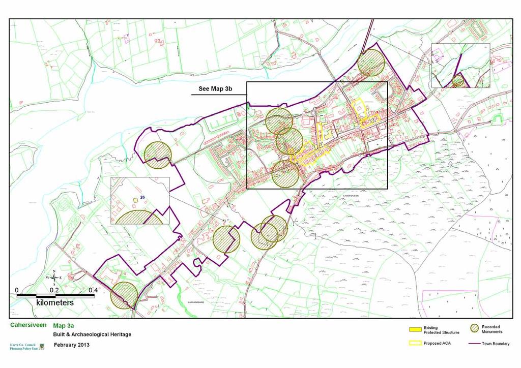
108

109

110
111 PORTMAGEE LOCAL AREA PLAN 1.0 CONTEXT 1.1 Location Portmagee (Port Mhig Aoidh; Magee s Harbour or An Caladh; The Ferry) is a coastal village located on the R565 at the western end of the Iveragh Peninsula. It is located 16 km southwest of Cahersiveen. The town is nested between St Finans Bay and Valentia Island and is on the Skellig Ring Tourist drive. 1.2 Population There is no specific census returns for Portmagee village. The village is located in the DED of Portmagee. The 2006 census showed 376 persons in the entire DED. This figure increased from 363 in This represented a 3% increase in population. The population in 2011 was Functions & Facilities Portmagee is mainly a residential settlement which provides service and community facilities to the local community. Social services include a Church, a health centre, a national school, a Garda station, and a community centre. Retail uses comprises shops, a post office, public houses, a hostel. It also functions as a base for the local fishing fleet and has a modest tourism function. The village is set in a scenic landscape situated on a tourist route on the R565 main road between Valentia Island and the main land. The village therefore benefits from passing trade. In addition, Portmagee also functions as a tourist destination. Portmagee s Annual Set Dancing and Ceili Weekend occur every May. For its size Portmagee village has a broad range of services and facilities both for locals and tourists, however many of these facilities/services are only open during the tourist season. There are also a number of bed and breakfasts and holiday homes developments in the village and surrounding area. The village also serves as a departure point for tourists travelling to visit Skellig Michael. 1.4 Infrastructure There is public water supply available in the village. Water quality is an ongoing issue during summer months. There has been some recorded capacity issues. However it is anticipated that water savings associated with ongoing leak detection are likely to ensure that sufficient capacity will be available to cater for the targeted growth. There is a primary settlement tank in the village. The treatment is by means of a septic tank and outlet into the bay. The system is currently inadequate but there are no plans to upgrade at this time. Cahersiveen Functional Area Local Area Plan 100 Portmagee
112 1.5 Urban Form The development of Portmagee has centred on the waterfront. The main street is linear and is open to the sea on the north side apart from a group of buildings at the eastern end. The western extremity of the street ends in a cul de sac. Up to recently the village had a compact urban core but recent developments including ribbon development along the approach roads has served to dilute the compact nature of the original settlement. More recent developments especially holiday home developments to the south west of the village, because of their uniformity and estate style layout sit uncomfortably next to the old waterfront area where a mixture of house sizes and colour add variety to the overall look of the area. The existing Main Street with its simple forms and broad palette of colours is undoubtedly the most attractive element of Portmagee. The village lacks a public open space while there is some space along the seafront a more sheltered location is also required. Small-scale residential development is occurring to the rear of some properties along the main street. A new housing development has been constructed to the west of the village. This development takes the form of modern suburban type housing estate. Access off Main Street to substantial backland sites is therefore limited and this must be addressed if a compact and permeable urban structure is to be achieved. While the village is largely linear in nature there is also extensive areas of both developed and undeveloped land to the rear of roadside development. The creation of in-depth development would provide for a more compact and sustainable urban form. The village has a small but strongly defined urban core centred along the waterfront. The village architecture is largely comprised of traditional 19 th century two storey structures. The number of vacant/ derelict sites within the village is small, but new development which will break the building line at these locations would undermine the village s potential to develop a stronger village form and should not be considered. Extending the streetscape to include vacant sites on the perimeter of the existing street would serve to reinforce the character of the village centre while allowing for the expansion of its retail and service core. Tourism is a significant part of the local economy and the traditional character and vernacular architecture of the village is an important part of the villages tourist appeal. New development will need to reflect the traditional character of the existing built form in order to maintain and enhance this tourist asset. 1.6 Built Heritage There are no protected structures in the plan area. It is not proposed to include any additional structures on the Record of Protected Structures. It is considered however, that those elements of the built environment which define the character of the village need to be enhanced and preserved. It is an objective of this plan to designate an ACA along a section of the Main Street along the waterfront so that its attractive form and character can be retained in any future development. Cahersiveen Functional Area Local Area Plan 101 Portmagee
113 It is necessary to ensure that the local character and sense of place are enhanced and a coherent urban structure is created. It is important therefore that new development reflects the traditional elements of the existing streetscape. 1.7 Archaeology There are no archaeological monuments in or in close proximity to the plan area. 1.8 Natural environment and Amenity Valentia Harbour/Portmagee Channel is designated as a SAC. The village is located in an area rich in natural beauty and amenities. The mountains to the south provide attractive views from the village and form scenic backdrops against which the village is set. There are several walking routes identified in the vicinity of the village and hill walking/mountaineering attracts many visitors to the area. 1.9 Vehicular and Pedestrian Traffic The village is located on a busy regional route and is the main vehicular entrance to Valentia Island via the bridge. The set back along the waterfront provides sufficient parking to meet current demand. There is one small car park adjacent to the Church grounds. The proposed amenity area adjacent to the Church will increase parking requirements in this vicinity. Footpaths are required at a number of locations throughout the village to provide for connectivity between residential areas to the west and the east Employment The 2006 Small Area Population Statistics for the DED in which Portmagee is located indicate that the main source of employment for males in the area is the construction industry (20%) followed by agriculture & fishing (17%) and manufacturing (14%). Due to the downturn in the economy this probably is no longer the case. The majority of employed females are employed in the service sector. It is likely that a number of residents commute to Cahersiveen for employment. In order to encourage indigenous businesses and more employment in the village, lands designated for tourism and small scale industrial use is zoned within the settlement boundary. The village itself developed traditionally as a port and fishing (market) village serving the needs of a historically successful farming hinterland. The vitality of many of the town s small businesses is dependant on the spending power of customers from the rural areas and the construction of harbour related activities Harbour & Marine Activity Portmagee has a pier that has an important role in the continuing success of the marine leisure, recreation and tourism sectors in the area. Support for the fishing industry remains the central focus of the pier. Fishing is a major source of income and direct employment for the area and also contributes indirectly, through fish exports and processing. Boat trips for Skellig Michael are on offer from the pier and powerboat trips operate also. Cahersiveen Functional Area Local Area Plan 102 Portmagee
114 The area is renowned for the some of the best Salmon & Sea Trout Angling in Europe. Whale, dolphin and shark spotting are becoming increasingly popular along the coast of the Iveragh Peninsula Growth and Residential Development The level of planning permissions demonstrates growth in the plan area and its immediate surrounds. Growth may be sustained if Portmagee develops the capacity to attract services and facilities. The future demand for detached dwellings would otherwise be met through rural development. Like other towns and villages in the county, Portmagee experienced a period of growth as evidenced by the 2011 census which saw a 3.7% increase from the 2006 census. However the level of residential planning permissions granted in the period has indicated a limited growth potential over the next number of years. 2.0 DEVELOPMENT STRATEGY The overall vision for Portmagee is to ensure that it develops as an attractive location for residents and tourists alike and that future development preserves the village s character as a small fishing village and reinforces it where necessary. The development boundary for Portmagee defines the existing extent of the area where new development may be considered, whilst also allowing for some expansion for residential development to the east of the village core. During the lifetime of this Plan, development will focus mainly on these lands, located close to the village core. It is important that while many new residents will commute to other centres for employment, that Portmagee develops the social and economic infrastructure to function as a sustainable community in its own right. Increased local retail and commercial uses within the village core adjacent to existing uses would serve to achieve this. The development strategy for the village is to: Maximise growth in population and services to a level which will create a vibrant village, while maintaining and enhancing its physical assets, unique character and natural attributes. Ensure that future development supports the existing role and function of the village as a rural service centre, fishing port and small tourist village having regard to the scale of the existing settlement and the setting of the village in an attractive rural landscape. Ensure that all new development is of traditional design and layout and does not detract from the character of the settlement. Cahersiveen Functional Area Local Area Plan 103 Portmagee
115 Ensure that all new development is located within the settlements development boundary. A sequential approach shall be taken to all new development. Ensure that any future tourism developments are sensitive to the existing character of the village and should be appropriate in scale. Developments which are open on a year round basis should be encouraged. Provide for adequate sporting and playground facilities to cater for the recreational needs of locals and tourists in a sustainable manner. Promote the fishing and angling potential for the town in a sustainable manner. Promote the sustainable development of a high quality marina and waterfront area. Ensure that future residential development within the village caters for the needs of the local population who wish to live in the area on a permanent basis. Encourage the sustainable expansion in the range and number of commercial services within the village which in turn will provide local employment and improve the quality of life of the local community. Encourage the development of niche tourism market, based on marine activity, sustainable marine and adventure holidays and develop its own ecotourism brand in a sustainable manner 3.0 OVERALL OBJECTIVES Objective No. OO-1 OO-2 Overall Objectives It is an objective of the Council to: Ensure that the development will be carried out in a sustainable coherent and strategic manner and will be contingent on adequate infrastructure being provided. The piecemeal and uncoordinated development of such sites will not be permitted. Ensure that the high quality natural setting of the village is maintained and protected from inappropriate development. 4.0 SPECIFIC OBJECTIVES Architectural & Built Heritage Objective No. It is an objective of the Council to: AH-1 Preserve the village s architectural heritage and encourage development to be designed in a manner that is in keeping with the scale and character of the existing village. New developments should respect local design features. Cahersiveen Functional Area Local Area Plan 104 Portmagee
116 Objective No. MU-1 Mixed Use Zoning It is an objective of the Council to: Zone lands for the development of mixed uses at appropriate locations to provide for the expansion of local employment, retail and service uses. Objective No. Vehicular and Pedestrian Traffic It is an objective of the Council to: T-1 Seek the provision/improvement of continuous footpaths / walkways as indicated on the Land Zoning Map. Objective No. Amenity It is an objective of the Council to: A-1 Facilitate the development of a village park at the location indicated on the Land Zoning Map. Objective No. TL-1 Tourism and leisure It is an objective of the Council to: Promote the appropriate development of a niche tourism market, based on sustainable marine activity, sustainable marine and adventure holidays. Cahersiveen Functional Area Local Area Plan 105 Portmagee

117


118 AN GLEANN LOCAL AREA PLAN 1.0 CONTEXT 1.1 Location An Gleann is a small rural development node and is located approximately half-way between Baile na Sceilg and Portmagee at the head of St Finans Bay on the Iveragh Peninsula. Fig 1; Location of An Gleann settlement 1.2 Population There are no population figures for the village of An Gleann itself. It is located within the ED of St Finians (Toghroinn Fhíonáin). The population in this ED increased between 2002 and 2006 from 137 to 154 people. It increased marginally in the 2011 census to 161 people. 1.3 Functions & Facilities An Gleann is a small coastal residential village with limited facilities, which include a Roman Catholic Church, a primary school, a children s playground and community centre. The beach area attracts a number of holidaymakers during the summer months, but the village lacks any tourist facilities. The main employer in the area is Skelligs Chocolate located less than a kilometre from the village centre. An Gleann is essentially a rural area with a high density of dispersed rural housing. It is a dispersed settlement rather than a village in the traditional sense. An Gleann Ionad lae offers a preschool service, day care centre and community centre. Cahersiveen Functional Area Local Area Plan 106 An Gleann
119 1.4 Infrastructure While there is a public water supply available in the village, water quality is an ongoing issue during the summer months. If required can be connected with and utiliise surplus capacity from the Waterville Scheme There is no public sewage treatment unit in the village at present. A preliminary report is in place for the provision of a new treatment plant. This is unlikely to occur within the life of the plan. 1.5 Urban Form An Gleann is a dispersed rural settlement located at the intersection of two local roads with the church, the village shop(closed) and community services centre, located at the core. There is no developed streetscape; rather, the village is comprised of detached dwellings with varied setbacks. House types are varied. There is no distinct divide as such, between the village and the surrounding countryside. The beach area is 350 metres to the south of the village core area and there is only a limited amount of development at this location 1.6 Built Heritage & Archaeology There are two Protected Structures located just outside the development boundary. A Celtic cross style memorial is located on the eastern boundary of the village. The old Catholic church now in ruins, is also a Recorded Monument, is located to the south of the village. There are no archaeological monuments within the proposed boundary although there are a large number in the vicinity of the village 1.7 Natural environment and Amenity An Gleann is located in a low lying pocket of land at the head of St. Finans Bay, surrounded by a ring of hills some rising to almost 400 metres. Its physical isolation and dramatic seascapes and views of the Skelligs, give the area a unique character. The north-western half of the village is zoned Secondary Special Amenity in the Kerry County Development Plan The Iveragh Peninsula SPA is in close proximity to An Gleann. The beach is located a short distance from the settlement node. Due to strong currents the beach is unsuitable for swimming and other water based activities. 1.8 Vehicular and Pedestrian Traffic Tourist traffic during the summer months creates a busy atmosphere but during the winter months, because of its relatively isolated location traffic is mainly local. There is no footpath network in the village. 1.9 Employment Skellig Chocolates is located at An Gleann and is the main source of employment in the area. The business is currently been renovated due to fire damage. The vitality of the area and its small businesses are dependant on the spending power of customers from the rural areas and the passing tourists. Cahersiveen Functional Area Local Area Plan 107 An Gleann
120 1.10 An Gaeltacht An Gleann is located within a Gaeltacht area and the preservation and promotion of the Irish language is critical in its future development 1.11 Growth and Residential Development This area is comprised of scattered one off housing. There has been a considerable level of ribbon development on the approach roads over the years and this has largely been confined to the northern or landward side of the road. All new residential dwellings will have to comply with the rural settlement policies as contained in the County Development Plan. The development boundary for An Gleann defines the existing extent of the area where new development may be considered, whilst also allowing for some expansion for development adjacent to the settlement core. 2.0 DEVELOPMENT STRATEGY The overall vision for An Gleann is to maintain the character of this distinctive dispersed settlement pattern, to promote the area as an attractive place to live in and to visit, while preserving and enhancing the use of Irish as the daily communal language. An Gleann is a dispersed rural settlement area. Given the lack of any facilities in the area and the absence of an existing village/settlement structure, the need to prioritise investment into existing settlements, it is not intended to develop a new village settlement in An Gleann. The development strategy for An Gleann therefore is to: Ensure that any future developments should be sensitive to the existing character of the area and should be appropriate in scale. Developments which are open on a year round basis should be encouraged. Promote the redevelopment of commercial/retail outlet serving the local community Preserve and promote the Irish language Ensure that all residential development shall cater for the needs of the local population who wish to live in the area on a permanent basis. Encourage the sustainable development of ecotourism and other niche markets along with the sustainable extension and diversification of tourist facilities as a possible source of employment Cahersiveen Functional Area Local Area Plan 108 An Gleann
121 3.0 OVERALL OBJECTIVES Objective No. OO-1 It is an objective of the Council to: Promote the development of ecotourism and other niche markets in a sustainable manner. Cahersiveen Functional Area Local Area Plan 109 An Gleann
122
123 BAILE AN SCEILG LOCAL AREA PLAN 1.0 CONTEXT 1.1 Location Baile an Sceilg is a coastal village located off the R566 on the Iveragh Peninsula. Dún Géagáin with which it shares many services is located 1.5 km to the north. Although a certain level of development has taken place between the two settlements in recent years they can still be viewed as two distinct settlements. Baile an Sceilg is located within An Gaeltacht Uíbh Ráthaigh. 1.2 Population There are no population figures for the village of Baile an Sceilg itself. It is located within the ED of Ballinskelligs. The population in this ED decreased slightly between 2002 and 2006 from 358 to 355 people. It increased marginally in the 2011 census to 372 people. 1.3 Functions & Facilities Baile an Sceilg is an important tourist settlement on the Skellig Ring. It shares many services and functions with Dún Géagáin. It is the more dispersed of the two villages with fewer services. The settlement has a few social facilities including a public house, shop and an industrial unit producing bags and packaging. The local GAA (St Michaels) pitch is located between Baile an Sceilg and Dún Géagáin. 1.4 Infrastructure There is a public water supply available in the village. Water quality is an ongoing issue during the summer months. If required can be connected with and utilise surplus capacity from the Waterville Scheme There is a primary treatment unit serving the area. The unit is inadequate and there are no plans to upgrade. 1.5 Urban Form The village is comprised of a scattered collection of houses, linear in form comprised of mainly detached structures without a set building line. In recent years the development of a number of holiday developments has altered the character of the settlement and has led to a significant increase in the built-up area. The new developments are comprised of relatively uniform house types in a cluster formation. Some recent developments have added to the streetscape element of the village, if this streetscape was further developed it would give the village a more defined core area and urban structure. The complex of buildings attached to the cable station was a significant landmark in the area, but over the years most of these buildings have been demolished. A terrace of four two storey houses remains from the original Cable Station complex. Cahersiveen Functional Area Local Area Plan 110 Baile an Sceilg
124 1.6 Built Heritage & Archaeology There are no recorded monuments within the proposed plan area. Kinard House is a protected structure (ref KY ). A terrace of dwellings forms a prominent part of the streetscape. These four terraced dwellings (Cable Station) are attractive vernacular style two storey buildings. 1.8 Natural Environment and Amenity Baile an Sceilg is located in a low lying pocket of land about 500 metres from the shoreline of Ballinskelligs Bay. The beach area has an EU Blue Flag designation The seaward and southern side of the village is zoned Secondary Special Amenity in the Kerry County Development Plan. The bay area is part of the Baile an Sceilg Bay and Inny Estuary candidate SAC which is of considerable conservation significance because of the presence of two types of salt marsh, which are listed in Annex 1 of the EU habitats Directive. The area also has a significant population of Ringed Plover and Common Scoter and the sand dunes in the area support a population of rare liverwort species called the Petalwort (Petalophylum ralfsii). 1.9 Vehicular and Pedestrian Traffic The beach area generates a lot of vehicular traffic during the summer months and the car park area can get very congested at times. Tourist traffic during the summer months creates a busy atmosphere but during the winter months, because of its relatively isolated location traffic is mainly local Employment The largest employer in the village is Delpac, which manufactures bags and other forms of packaging for the Irish and British markets An Gaeltacht Baile an Sceilg is located within a Gaeltacht area and the preservation and promotion of the Irish language is critical in its future development. It is considered that the revival of the Irish language college would add a further attraction to an area in need of employment and income Growth and Residential Development A number of housing developments on both sides of the main street have been completed in recent years. These dwellings are primarily used as holiday homes. A few single houses for permanent residents have been completed over the same period. The number of holiday homes constructed in recent years far outweighs the number of permanent residential completions. There has been a considerable level of ribbon development on the approach roads over the years. All new residential dwellings will have to comply with the rural settlement policies as contained in the County Development Plan. Cahersiveen Functional Area Local Area Plan 111 Baile an Sceilg
125 The development boundary for Baile an Sceilig defines the existing extent of the area where new development may be considered, whilst also allowing for some expansion for development adjacent to the village core. During the lifetime of this Plan, development will focus mainly on these lands, located close to the village core. It is the an objective of the plan to encourage the development of a compact and sustainable village structure by ensuring that new development is contiguous with existing development and makes effective use of backland and infill sites. All new development shall occur within the development boundary and shall reflect the existing vernacular design. 2.0 DEVELOPMENT STRATEGY The overall vision for Baile an Sceilg is to ensure that it develops as an attractive location for residents and tourists alike and that future development preserves the village s character and reinforces it where necessary It is important to maintain the open countryside between Baile an Sceilg and Dún Géagáin. The development strategy for Baile an Sceilg is to promote a more gradual organic development of Baile an Sceilg as a rural village and tourist centre commensurate with the level of infrastructure provision. Growth in recent years has been largely confined to the holiday home sector. The village is located within a Gaeltacht area and it is important that no development takes place which will be detrimental to the promotion of the Irish language. It is considered that the revival of the Irish language college would add a further attraction to an area in need of employment and income. The development strategy for the village is to: Ensure that future development should support the existing role and function of the village as a small local focal point for it s surrounding rural community Enhance the visual amenities of the village. The village is on an important tourist route, the Skellig Ring, and development should not detract from the amenities that make this drive a popular tourist attraction. Promote the use of the Irish language and revival of the Irish language college. Ensure that future residential development within the village should cater for the needs of the local population who wish to live in the area on a permanent basis. Promote the development of commercial/retail outlet serving the local community at an appropriate location. Cahersiveen Functional Area Local Area Plan 112 Baile an Sceilg
126 3.0 OVERALL OBJECTIVES Objective No. OO-1 It is an objective of the Council to: Promote the sustainable development of year round facilities providing increased services to the local area and increasing added value of the tourism product. 4.0 SPECIFIC OBJECTIVES Objective No. Open Space, Recreation and Amenity It is an objective of the Council to: A-1 Reserve lands for the development of a village green as indicated on the zoning map. Objective No. CR-1 Commercial/retail Facilities It is an objective of the Council to: Promote the sustainable development of commercial/retail outlet serving the local community at an appropriate location. Objective No. Vehicular and Pedestrian Traffic It is an objective of the Council to: T-1 Improve pedestrian connectivity within the settlement by the provision of pedestrian routes at appropriate locations. Objective No. Gaeltacht Uíbh Rathaigh It is an objective of the Council to: G-1 Preserve and promote the use of Irish as the community language. Facilitate the revival of the Irish college. Cahersiveen Functional Area Local Area Plan 113 Baile an Sceilg
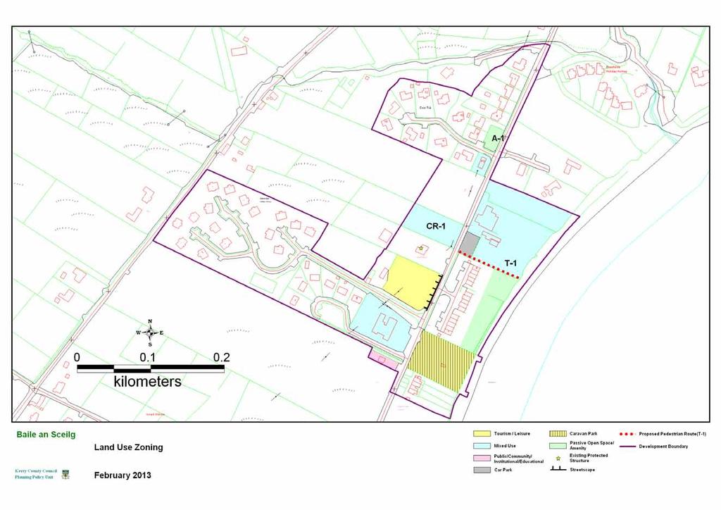
127
128 DÚN GÉAGÁIN LOCAL AREA PLAN 1.0 CONTEXT 1.1 Location Dún Géagáin is a coastal village located off the R566 on the Iveragh Peninsula. Baile an Sceilg with which it shares many services is located 1.5 km to the south. Although a certain level of development has taken place between the two settlements in recent years they can still be viewed as two distinct settlements. Dún Géagáin is located within An Gaeltacht Uíbh Ráthaigh. 1.2 Population There are no population figures for the village of Dún Géagáin itself. It is located within the ED of Ballinskelligs (Baile an Sceilg). The population in this ED decreased slightly between 2002 and 2006 from 358 to 355 people. It increased marginally in the 2011 census to 372 people. 1.3 Functions & Facilities Dún Géagáin is an important tourist village on the Skellig Ring. Compared to Baile an Sceilg,Dún Géagáin is the most concentrated of the two villages with the wider range of services. Dún Géagáin has a range of social facilities including a Roman Catholic Church, day care centre, community centre, hard surface playing area, a public house, shop and an industrial unit producing veterinary products. There is no grocery shop within the village but there is one located approximately 500 metres to the north of the village on the R566. The local GAA (St Michaels) pitch is located between Dún Géagáin and Baile an Sceilg. 1.4 Infrastructure There is a public water supply available in the village. If required can be connected with and utilise surplus capacity from the Waterville Scheme There is a primary treatment unit serving the area. The system is currently at capacity but there are no current plans to upgrade. 1.5 Urban Form Dún Géagáin is a traditional rural village, linear in form comprised of mainly detached structures without a set building line apart from an attractive stretch of village streetscape to the north of the church. If this streetscape was further developed it would give the village a more defined core area and urban structure. There are a variety of building types within the village from the traditional single storey cottage to the more modern form of the Cill Rialaig shop. Building heights vary throughout the village. Some new cluster type developments in the village are of a uniform design which is untypical of the older built forms. Cahersiveen Functional Area Local Area Plan 114 Dún Géagáin
129 1.6 Built Heritage & Archaeology There are no Protected Structures or recorded monuments within the proposed plan area. 1.7 Natural environment and Amenity Dún Géagáin is located in a low lying pocket of land about 500 metres from the shoreline of Ballinskelligs Bay. The beach is located a short distance from the settlement node. The eastern side of the village is zoned Secondary Special Amenity in the Kerry County Development Plan. The Ballinskelligs Bay and Inny Estuary SAC is in close proximity to Dún Géagáin. 1.8 Vehicular and Pedestrian Traffic Tourist traffic during the summer months creates a busy atmosphere but during the winter months, because of its relatively isolated location traffic is mainly local. 1.9 Employment The largest employer in the village is Ballinskelligs Veterinary Products, which contains a state of the art laboratory and manufacture products for the Irish and British markets. Other employment is provided at the primary school and at the community centre. The Udaras Na Gaeltachta premises are located slightly to the north on the R An Gaeltacht Dún Géagáin is located within the Gaeltacht Uíbh Ráthaigh and the preservation and promotion of the Irish language is critical in its future development. It is considered that the revival of the Irish language college would add a further attraction to an area in need of employment and income Growth and Residential Development Two housing developments on the seaward side of the main street have been completed in recent years. It is likely that these dwellings will be bought as holiday homes. A few single houses for permanent residents have been completed over the same period. The number of holiday homes constructed in recent years far outweighs the number of permanent residential completions. The new housing developments that have taken place have been close to the urban core and have succeeded in maintaining a compact urban form The development boundary for Dún Géagáin defines the existing extent of the area where new development may be considered, whilst also allowing for expansion re-development in the village core. The development boundary is largely determined by topography and infrastructural considerations. It is the an objective of the plan to encourage the development of a compact and sustainable village structure by ensuring that new development is contiguous with existing development and makes effective use of backland and infill sites. All new residential dwellings will have to comply with the rural settlement policies as contained in the County Development Plan. Cahersiveen Functional Area Local Area Plan 115 Dún Géagáin
130 2.0 DEVELOPMENT STRATEGY The overall vision for Dún Géagáin is to maintain its compact urban form and develop a vibrant sustainable village which is an attractive place to live in and to visit. Future development should be in-depth in order to create a strong and identifiable village core It is important to maintain the open countryside between Dún Géagáin and Baile an Sceilg. The development strategy for Dún Géagáin is to promote a more gradual organic development as a rural village and tourist centre commensurate with the level of infrastructure provision. Growth in recent years has been largely confined to the holiday home sector. The village is located within a Gaeltacht area and it is important that no development takes place which will be detrimental to the promotion of the Irish language. It is considered that the revival of the Irish language college would add a further attraction to an area in need of employment and income. A limited number of one off dwellings may be permitted to connect to the existing treatment system, otherwise all development shall comply with the EPA standards regarding waste water treatment. The development strategy for the village is to: Ensure that future development should support the existing role and function of the village as a small local focal point for its surrounding rural community and should have regard to the scale of the existing settlement and the setting of the village in an attractive rural landscape. Ensure that development does not detract from the amenities that make the Skellig Ring drive a popular tourist attraction. Promote the use of the Irish language and revival of the Irish language college. Ensure that future residential development within the village caters for the needs of the local population who wish to live in the area on a permanent basis. Promote the development of commercial/retail outlet serving the local community at an appropriate location. Facilitate the sustainable development of ecotourism and other niche markets along with the sustainable extension and diversification of tourist facilities as a possible source of employment Cahersiveen Functional Area Local Area Plan 116 Dún Géagáin
131 3.0 SPECIFIC OBJECTIVES Open Space, Recreation and Amenity Objective No. It is an objective of the Council to: A-1 Reserve lands for the development of a village green as indicated on the zoning map Objective No. CR-1 Commercial/retail Facilities It is an objective of the Council to: Promote the development of commercial/retail outlet serving the local community at an appropriate location Objective No. An Gaeltacht Uíbh Rathaigh It is an objective of the Council to: G-1 Promote the Irish language and revival of the Irish language college. Cahersiveen Functional Area Local Area Plan 117 Dún Géagáin

132

133 KELLS LOCAL AREA PLAN 1.0 CONTEXT 1.1 Location Kells (Na Cealla) is a small rural coastal development node and is located approximately half-way between Glenbeigh and Cahersiveen. The settlement is situated 2.5km west of the N70, approximately 15 km south west of Glenbeigh and approximately 13 km north east of Cahersiveen. The settlement is centred on Kells Bay and the beach area. N70 N70 N70 N70 N70 Fig 1: Location map for Kells 1.2 Population There are no population figures for the settlement of Kells itself. It is located within the ED of Killnane. The population in this ED increased between 2002 and 2006 from 271 to 273 people. It decreased in the 2011 census to 249 people. 1.3 Functions & Facilities Kells is essentially a small coastal residential settlement with limited facilities. The beach area attracts a number of holidaymakers during the summer months, but the village lacks any tourist facilities. Many of the residences are occupied on a seasonal basis. Kells is essentially a rural area with a high density of dispersed rural housing. There is no village as such. The nearest shop is located on the N70 2km to the south. There is also a Community Resource Centre located at the old railway complex known as Kells Junction. This facility serves the community in the surrounding hinterland. Cahersiveen Functional Area Local Area Plan 118 Kells
134 The bay area provides a safe haven for a large number of pleasure craft. Kells Bay is a popular fishing/angling destination. 1.4 Infrastructure Kells is supplied with water from a group water scheme. There is no existing wastewater treatment plant in the village and there are no plans to install one. 1.5 Built Form The settlement developed originally around the coastguard complex and is comprised of a loose grouping of dwellings without a clearly defined core or streetscape. In essence the topography of the area has determined the form of the settlement. Fig 2: Built form 1.6 Built Heritage & Archaeology There are no Recorded Protected Structures within the proposed plan area. There is however one structure which because of its architectural and historical significance should be included in the Record of Protected Structures. There is one Recorded Monument within the proposed plan area. This is a cillin or children s burial ground (Ref. KE ) located between the old coastguard building and the seafront. 1.7 Natural environment and Amenity Kells Bay has an EU designated Blue Flag beach. The area surrounding the settlement is lush and trees are a dominant part of the landscape as one approaches the village from the N70. Kells is located in a low lying pocket of land at the head of Kells Bay, surrounded by a ring of hills. Its physical isolation and dramatic seascapes and views of the Dingle Bay and the Dingle Peninsula, give the area a unique character. The area to the south of the node is designated Secondary Special Amenity, and the area to the east and west of the Bay is zoned Prime Special Amenity in the Kerry County Development Plan The Iveragh Peninsula SPA is in close proximity to Kells and runs along the coastline. Cahersiveen Functional Area Local Area Plan 119 Kells
135 1.8 Vehicular and Pedestrian Traffic Tourist traffic during the summer months creates a busy atmosphere but during the winter months, because of its relatively isolated location traffic is mainly local. Traffic congestion is sometimes an issue on the approach road to the beach during the summer months. 1.9 Growth and Residential Development This area is comprised of scattered one off housing. There has been a considerable level of ribbon development on the approach roads over the years and this has largely been confined to the southern or landward side of the road. The development boundary for Kells defines the existing extent of the area where new development may be considered, whilst also allowing for some expansion for development adjacent to the settlement core which is adjacent to the caravan park. 2.0 DEVELOPMENT STRATEGY The overall vision for Kells is to maintain the character of this distinctive dispersed settlement pattern, to promote the area as an attractive place to live in and to visit, while preserving and enhancing the tourism potential. Kells is a dispersed coastal settlement node. There is no wastewater treatment facility in the area and there are no proposals to construct one. Given the lack of any facilities in the area and the absence of an existing village/settlement structure, the need to prioritise investment into existing settlements, it is not intended to develop a new village settlement in Kells. The development strategy for the settlement node is to; Ensure that future development supports the existing role and function of the settlement node as small tourist node and should have regard to the scale of the existing settlement and the setting of the settlement node in an attractive rural landscape. Ensure that all future developments are sensitive to the existing character of the area and are appropriate in scale. Commercial developments which are open on a year round basis should be encouraged. Promote the fishing and angling potential for the area Maintain the Kells Bay Blue Flag beach designation Cahersiveen Functional Area Local Area Plan 120 Kells
136 Encourage the sustainable development of ecotourism and other niche markets along with the sustainable extension and diversification of tourist facilities as a possible source of employment 3.0 SPECIFIC OBJECTIVES Objective No. NE-1 NE-2 Natural Environment It is an objective of the Council to: Maintain the Kells Bay Blue Flag beach designation Prepare a tree preservation order for appropriate trees throughout the settlement node and promote additional planting Objective No. ICF-1 Infrastructure and Community Facilities It is an objective of the Council to: Facilitate the sustainable provision of a public toilet in Kells in close proximity to the public carpark and beach at an appropriate location. Cahersiveen Functional Area Local Area Plan 121 Kells

137 RENARD LOCAL AREA PLAN 1.0 CONTEXT 1.1 Location Renard is a rural area situated on the Iveragh Peninsula c. 5km to the southwest of Cahersiveen. It is located on a headland less than 1km to the east of Knightstown, Valentia from which it is separated by sea. Fig 1: Location map for Renard 1.2 Population There is no specific census returns for Renard itself. Renard is located in the DED of Caher. 1.3 Functions & Facilities Renard is essentially a rural area with a high density of dispersed rural housing. There is no village as such and the residents of the area use Cahersiveen for their everyday needs. The seasonal car ferry to Knightstown operates from Renard pier. There is a public house/restaurant and a fish processing facility located at the pier. The pier is used by local fishing boats, leisure craft and other tourist related boats. 1.4 Infrastructure There is public water supply available in the area. There is no existing wastewater treatment unit in Renard and there are no proposals to construct one. Cahersiveen Functional Area Local Area Plan 122 Renard
138 1.5 Urban Form The development node of Renard is centred on the waterfront. This area contains the bar/restaurant and the fish processing plant. The area does not have any semblance of an urban settlement as such, but is simply a loose collection of mainly one- off dwellings in a rural location. 1.6 Built Heritage & Archaeology There are no protected structures or archaeological monuments in or in close proximity to the plan area 1.7 Natural environment and Amenity Renard is adjacent to Valentia Harbour/Renard Channel which is designated as a SAC, which contains important examples of reefs, shallow inlets and tidal mudflats. The area is rich in natural beauty and amenities. Renard is comprised of a relatively flat open landscape almost devoid or trees. There are a number of vantage points in Renard where panoramic views of Valentia Harbour and neighbouring headlands are available. 1.8 Vehicular and Pedestrian Traffic Renard is located on a busy route and is the main entrance to Valentia Island via the ferry. When the Valentia Island ferry is in operation from March October there is a constant flow of traffic through Renard. During the winter months traffic is local. 1.9 Employment Renard developed traditionally as a ferry port and fishing village. Kerry Fish Ltd is located at Renard Point and is the main source of employment in the area. The vitality of the area and it small businesses are dependant on the spending power of customers from the rural areas and the passing ferry bound tourists Harbour & Marine Activity Renard has a pier & ferry that has an important role in the continuing success of the marine leisure, recreation and tourism sectors in the area. Support for the fishing industry remains the central focus of the pier. Fishing is a major source of income and direct employment for the area and also contributes indirectly, through fish exports and processing. Boat trips for Skellig Michael are on offer from the pier, and powerboat trips operate also Growth and Residential Development This area is comprised of scattered one off housing developments. There has been a considerable level of ribbon development westward from Renard Cross over the years and this has largely been confined to the southern or landward side of the road. The level of planning permissions demonstrates growth in the plan area and its immediate surrounds. Growth may be sustained if Renard develops the capacity to attract services and facilities. The future demand for detached dwellings would otherwise be met through rural development in accordance with the policies of the County Development Plan. Cahersiveen Functional Area Local Area Plan 123 Renard
139 2.0 DEVELOPMENT STRATEGY The overall vision for Renard is to maintain the character of this distinctive dispersed settlement pattern, to promote and enhance the tourism potential. Given the lack of any facilities in the area and the absence of an existing village/settlement structure, the need to prioritise investment into existing settlements and the proximity of Cahersiveen which is a district centre 5km away, it is not intended to develop a new village settlement in Renard. The development strategy for Renard therefore is to: Ensure that future development should support the existing role and function of the settlement node as a small fishing and tourist node. Development should have regard to the scale and setting of the existing settlement in an attractive rural landscape. Commercial developments which are open on a year round basis shall be encouraged. Promote the fishing and angling potential for the area in a sustainable manner. Promote the development of the waterfront/pier area in a sustainable manner. 3.0 SPECIFIC OBJECTIVES Objective No. ICF-1 Infrastructure and Community Facilities It is an objective of the Council to: Facilitate the provision of a public toilet in Renard adjacent to the carpark Objective No Tourism It is an objective of the Council to: T-1 Promote the sailing and fishing/angling potential for the area. Cahersiveen Functional Area Local Area Plan 124 Renard
140 Section 2b VALENTIA ISLAND LOCAL AREA PLAN 1.0 CONTEXT 1.1 Location Valentia Island (Dairhbre; the island of the oak forest) is located off the western coast of the Iveragh peninsula. It is the largest island off the County Kerry coast and is directly connected to the mainland by a bridge to Portmagee and by ferry to Renard during the summer months. The island is approximately 11 kilometres (6.8 mls) long by almost 3 kilometres (1.9 mls) wide. 1.2 Population The DED of Valentia covers the towns of Knightstown and Chapeltown and the reminder of the island. The 2006 census showed 713 persons. This figure increased from 690 in This represented a 3% increase in population. The figure in 2011 was 664, this represented a 6% decrease in population. 1.3 Functions & Facilities The island contains two main settlements at Knightstown and Chapeltown. These are designated as village/small village settlement nodes in the Kerry County Development Plan The settlements provide a range of services to their rural catchment area. Many of the residential units on the island are holiday homes. The island has a broad range of facilities most are contained within the boundaries of the two settlements. Due to the seasonal nature of demand for services in the area a number of businesses on the island are closed throughout the winter period. The Valentia Hospital is a 16 bed hospital which provides long stay and day care. The Valentia Heritage Centre is located on the island. It tells the story of the geology, human, natural and industrial history of the island, with exhibits on the Cable Station, the Marine (Coastguard) Radio Station and the RNLI lifeboat. The Skellig Experience tells the story of the Sceilig Mhichil the works and lives of the Skellig monks of the early Christian period, their activities, their endurance and their dedication in gaining a foothold on a tiny, inhospitable, offshore island and creating a community there that survived for some 600 years The Valentia Observatory is part of Met Éireann service. The observatory was set up in August Valentia island is, on average, the wettest weather station in Ireland. Planning permission has been obtained for a new air monitoring facility on the island. The Valentia Coast Radio station (Marine Rescue sub centre) is located in Dohila in the north of the island. An important quarry on the northern part of the island which opened in 1816 still operates today. The famous Valentia Slate has been used in many prominent buildings including the British House of Commons. Adjacent to the slate quarry is the grotto. Glanleam Gardens is a 40 acre site on an east facing bay on Valentia Island. Cahersiveen Functional Area Local Area Plan 125 Valentia Island
141 It was created in the 19th century by the 19th Knight of Kerry, with plants sent back by plant collectors from all over the world, particularly Australasia. Much of the collection and its descendants survive, spreading and growing to enormous proportions due to the warming influence of the Gulf Stream. Valentia lighthouse was once a Cromwellian fort, guarding the harbour with a similar fort across the mouth of the harbour on Beginnis Island. 1.4 Infrastructure There is a waste water treatment plant in Knightstown only. The island is served by public water. While there is ample water for the duration of this Plan, some water management measures may be necessary at times of seasonally peak demand, because of limitations in the sizes of some of the pipes. 1.5 Built Form The two villages on the island are connected by the R565 which continues onto the Maurice O'Neill Memorial Bridge which links the island to the mainland. The R565 forms the spine of development on the island with the majority of development in close proximity to it. The island consists of dispersed rural dwellings mostly located along the road network. 1.6 Built Heritage The island has a rich architectural and built heritage. There are a large number of protected structures within the Knightstown boundary. The Cable Station building which is one of over fifty Protected Structures in Knightown was designed by the renowned 19 th century Cork architect Thomas Deane in Valentia Island was the eastern terminus of the first commercially viable transatlantic telegraph cable. The first attempt in 1857 to land a cable from Ballycarbery Strand on the mainland just east of Valentia Island ended in disappointment. After subsequent failures of cables landed at Valentia in 1858 and Foilhommerum Bay in 1865, the vast endeavor finally resulted in commercially viable transatlantic telegraph communications from Foilhommerum Bay to Heart's Content, Newfoundland in Transatlantic telegraph cables operated from Valentia Island for one hundred years, ending with Western Union International terminating its cable operations in There are a number of protected structures outside Knightstown boundary Ref KY dwelling house, Knightstown Ref KY Coombe House, Knightstown Ref KY Cromwell Lighthouse Ref KY former staff cottages (near Grotto) Ref Glanleam House It is not proposed to include any additional structures on the Record of Protected Structures. Cahersiveen Functional Area Local Area Plan 126 Valentia Island

142 1.7 Archaeology The general archaeology of the Island is dominated by prehistoric sites, early ecclesiastical sites and secular sites of the Early Medieval Period. Frank Mitchell s study of Valentia Island illustrated the wealth of archaeological evidence buried under and within the peat, while subsequent excavation in the Bray area at the south-western end of the island has shown added many new features to this extensive medieval landscape An extensive medieval landscape with earlier prehistoric features houses, enclosures, field walls, pathways, corn drying kilns etc is found in the townland of Bray. These features would be particularly sensitive and provision is made to ensure that these areas are protected in as much as possible, given that they represent two outstanding examples of relict prehistoric and early medieval landscapes. The townland of Bray is the location of an extensive Early Medieval landscape that owes its outstanding preservation to its location in an upland area of marginal lands. Medieval houses with associated outbuildings, enclosures, corn drying kilns, paths and tracks attest to the lifestyle of people on Valentia during the Early Medieval period, while the finding of earlier prehistoric features within and under the peat illustrate the importance of this area from the earliest settlement of the region. Cahersiveen Functional Area Local Area Plan 127 Valentia Island

143 Figure 1; Bray, Valentia Island 1.8 Natural environment and Amenity Knightstown is located on a flat coastal plain at the north eastern tip of Valentia Island. The village s sheltered harbour area makes it a popular location for water based activities. It is part of the Valentia Harbour/Portmagee Channel candidate Special Area of Conservation. The site contains important examples of reefs, shallow inlets and tidal mudflats. Part of the island is also designated as the Iveragh Peninsula SPA. Fossilised tetrapod trackways and footprints have been preserved in Devonian rocks on the north coast of the island. These prints date to about 385 million years ago. The Valentia Island trackways are among the oldest signs of vertebrate life on land. The Island predominantly consists of extensive agriculture/ natural vegetation, moors/heathland, pasture, broad leaf forest, transitional woodland/shrub, natural grasslands and complex cultivation patterns, (Source; Corine 2006 Landuse Database). Part of the island is also designated as a Special Protected area (the Iveragh Peninsula SPA). This SPA is of special conservation interest for the following species; Chough, Peregrine, Kittiwake, Guillemot and Fulmur. Vegetatative cliffs are the predominant habitat in the site and support a good variety of plant species such as Thrift (Armeria maritime), Sea Campion (Silene vulgaris subsp. Maritina), Sea Spleenwort (Asplenium marinum) and Rock Sea-spurry (Spergularia rupicola).the land adjacent to the cliff edges, areas of sand dunes and some uplands are also included within the SPA. The chough is a medium sized, red legged member of the crow family. It is a specialised feeder on soil invertebrates, although it also takes split grain. Coastal areas of the island are a stronghold for the Chough with feeding and nesting sites available. Particularly high densities of Chough occur at Valencia Island where livestock grazing presents the species with widespread feeding opportunities. The high cliffs of this Natura 2000 site are steeply sloping rather than sheer and are likely to be suitable for breeding Fulmar. Cahersiveen Functional Area Local Area Plan 128 Valentia Island
144 The frequent rock outcrops in the site provide excellent nesting ledges for peregrines, which utilise the coastal fringe, bog and heath habitat in the area for foraging. 1.9 Vehicular and Pedestrian Traffic The Valentia island ferry operates from March to October. The ferry generates quite an amount of traffic especially during the months of July and August. During the winter season access to the island from the mainland is via the bridge at Portmagee Employment The 2006 Small Area Population Statistics for the ED in which Valentia is located (Valencia) indicate that the main source of employment for males in the area is the construction industry (20%) followed by manufacturing (10%).These figure are likely to have reduced due to the current economic situation. The majority of employed females are professionals, followed by those working in the service sector (28%). There is no major employment on the island other than Valentia Hospital and the Coast guard radio station. Small and medium sized businesses predominate. Employment opportunities on the island and within the villages are limited and many islanders travel to work on the mainland. In order to encourage indigenous businesses and more employment on the island and in the villages, lands are designated for tourism and small scale commercial/industrial use within the settlement boundaries. It is the policy of the council to promote the sustainable development of specialised niche markets and businesses such as the production and sale of local food, boat building/repairs and appropriate tourism related activities Growth and Residential Development There has been a considerable amount of development on the island in recent years mainly in the two settlements and one off single dwellings type development. These developments cater predominantly for the holiday home market Amenity It is proposed to develop green route (s) in a sustainable manner at appropriate locations on the island. Subject Environmental Assessments at project level, such routes could facilitate recreational activities such as walking, cliff/rock climbing, cycling and nature observation. These would provide a valuable amenity resource for the area with some spectacular sea and mountain views and would constitute an additional tourist attraction on the island and in the Cahersiveen area. In deciding on exact routes Article 6, Habitats Directive Assessments will be required and alternative routes / solutions may need to be considered in order to avoid significant effects on biodiversity. Issues to be considered include the potential for wildlife disturbance (light, noise etc), trampling and erosion of sensitive vegetation / soils and the potential for the introduction / spread of invasive species Tourism Tourism is an important element of the economy of Valentia Island. The existing tourism product needs to be protected, with greater value being derived from it. In addition, efforts need to be made to lengthen the tourism season. Cahersiveen Functional Area Local Area Plan 129 Valentia Island
145 Tourism needs to focus on the strengths of the area, namely the untouched rural landscape, birdlife, the marine environment, the built heritage and the areas interesting history which includes the Trans Atlantic Cable, the Skellig Experience, the Observatory, and the Slate Quarry etc. The area offers scope for outdoor pursuits such as birdwatching, walking, hill and mountain/rock climbing, astrotourism and marine leisure where compatible with nature conservation designations. The island also has the unique opportunity for astronomic activities due to its dark and unpolluted skies. The potential for eco-tourism in the area is immense, but is not fully developed. Geo/Ecotourism is a form of tourism which appeals to the ecologically and socially conscious. It focuses on the local environment and culture, typically involving travel to destinations where flora, fauna, geology, high quality environment and cultural heritage are the primary attractions. Responsible geo/ecotourism includes programmes that minimize the negative aspects of conventional tourism on the environment, and enhance the local community. An integral part of geo/ecotourism is the promotion and creation of economic opportunities for the local communities. The development of a small geopark at an appropriate location focussing on the tetrapod prints would greatly promote the sustainable development of geotourism on the island. The landscape, cultural and linguistic heritage and amenities of the area constitute a prime asset on which the tourism industry is based. The size of the settlements and their unique character make them particularly sensitive to development. It is accepted however that expansion of the tourism industry is based on appropriate development. This plan, in accordance with the principles of sustainable tourism development outlined by Fáilte Ireland promotes suitable sustainable tourism development. When considering proposals for new tourism development, priority will be given to those that are encouraging longer visitor stays and add to the range of facilities available to people who live in the area all year round. Recreation and tourism activities can cause increased disturbance to habitats and species that are important for biodiversity. Accordingly, tourism and recreation projects, strategies and activities should ensure that the ecological integrity of the region s natural environment is maintained, particularly with regard to Natura 2000 sites. In order to boost tourism, the profile of the Island needs to be highlighted with increased and updated tourist signage at strategic points in the functional area and throughout the island. Tourist signage needs to be improved. The Altazamuth Walk is a walk created by the Tidy Towns Committee. It begins at the Altazamuth Stone on Peter Street, Knightstown and is edged by wildlife habitats and gardens, ending on the seafront adjacent the Catholic Church. It is an objective to promote and facilitate the development of green routes, in a throughout the island in sustainable manner. These walkways will promote sustainable ecotourism, geotourism and other niche markets. Cahersiveen Functional Area Local Area Plan 130 Valentia Island
146 The Telegraph field at Foilhommerum Bay is located along one of the green routes. The redevelopment of the original cable station would be an attractive addition to the island and boost tourism. 2.0 DEVELOPMENT STRATEGY Valentia Island is probably one of the most attractive rural seaside areas in County Kerry with very few if any locations matching its mix of architectural, historical, natural and cultural heritage. The island still retains its innate character and it is essential, that this is retained. The retention of this heritage is critical to its future development as a tourist destination. The Island has a number of innate strengths including an attractive landscape, spectacular sea views, character and charm. It is important that the Island capitalises on its location and its heritage in a sustainable manner. It is considered, that the Island can enhance its development potential as a tourist destination with sustainable heritage and marine/water based activities as its main attractions. It is important that the features which attract tourists to the area are protected, while appropriate opportunities for employment generating tourist development are encouraged. The development strategy for the Island is: That future development should support the existing roles and functions of Knightstown and Chapeltown as rural service centres and small tourist villages and should have regard to the local rural community living in an attractive landscape. That all future tourism developments shall be sensitive to the existing character of the island. Facilities and developments which are open on a year round basis should be encouraged in order to counteract peripherality and seasonality. To ensure that future residential development on the island should cater for the needs of the local population who wish to live on the Island on a permanent basis. Protect the natural environment and the architectural and archaeological heritage of the Island. To provide for greater commercial opportunities in a sustainable manner to meet the needs of the local island community and to provide for an expansion in the range and number of commercial services on the island. This in turn will provide local employment and improve the quality of life of the local community. To promote the development of sustainable ecotourism, geotourism and other niche markets along with the sustainable extension and diversification of tourist facilities as a possible source of employment. Encourage the development of a boat building, storage and repair facility at an appropriate location and in a sustainable manner. Promote and facilitate the development of green routes, in a sustainable manner. Cahersiveen Functional Area Local Area Plan 131 Valentia Island
147 3.0 OVERALL OBJECTIVES Objective No. OO-1 OO-2 It is an objective of the Council to: Encourage the sustainable development, extension and renewal of all aspects of tourism related activities. Ensure that the high quality natural setting of the island is maintained and protected from inappropriate development. 4.0 SPECIFIC OBJECTIVES Objective No. AH-1 AH-2 Architectural & Built Heritage It is an objective of the Council to: Preserve the architectural heritage and encourage development to be designed in a manner that is in keeping with the scale and character of the island. New developments should respect local design features. Encourage the appropriate reuse and sensitive restoration of unused/derelict properties on the Island. Archaeology Objectives It is an objective of the Council to: A-1 Secure the inclusion of the structures included the archaeological special protection area into the Record of Protected Structures A-2 Protect the views and vistas around the monuments, the inter-visibility of the monuments and the integrity of the existing archaeological landscape setting in the prehistoric landscape identified (see Fig 1). Applicants are advised to liaise with the County Archaeologist in advance of any application for development within these sites. AT-1 AT-2 AT-3 AT-4 Amenity & Tourism It is an objective of the Council to Encourage the improvement of sensitively designed tourist information boards and signage at appropriate locations. Protect and encourage the sustainable development of literary, musical, artistic, sporting and other cultural heritage initiatives. Facilitate the development of green routes, in a sustainable manner, throughout the island at appropriate locations and subject to Article 6 Appropriate Assessment Screening. These green routes could be used, where appropriate, for recreational activities such as walking, cycling and nature/historical observation. Promote Geo tourism at appropriate locations and other scientific disciplines as form of sustainable development. Cahersiveen Functional Area Local Area Plan 132 Valentia Island
148 Objective No NE-1 PH-1 Natural Environment It is an objective of the Council to: Preserve any existing mature trees where possible and promote additional planting of native trees and shrubs in new developments. Piers And Harbours It is an objective of the Council to; Support the sustainable development of the harbour as a potential economic generator for the island Cahersiveen Functional Area Local Area Plan 133 Valentia Island
149 APPENDIX 1 Proposed Protected Buildings Unique identity number: RPS KY Address: Reenglass House, Kilinane, Cahersiveen Farranreagh, Valencia Description: Two storey over basement structure, Ordnance Survey Map: 6259D National Grid co-ordinates: 42,511m, 76,348m Site features: Remains of a number of other structures and farm buildings to rear Special interest; Architectural, historical, social Location Map (not to scale) Appraisal: Associated with the Fitzgerald family (Knight of Kerry) Part of the house once housed a thriving knitting industry Cahersiveen Functional Area Local Area Plan 134 Valentia Island
150 Unique identity number: RPS KY Address: Ballyhearney House, Ballyhearney, Valentia Description: Detached Two storey three bay structure, Gabled single storey porch to front, with two storey gabled projection to rear. Ordnance Survey Map: 6306 National Grid co-ordinates: RPS ,355m, 75,549m Site features: Outhouses to the north of the building. Special interest; Architectural, historical, social Location Map (not to scale) Appraisal: Built in the last decade or the eighteenth century, the large solid wall to window ratio is an indicator of its age. In terms of design this is a unique building. Used as a hospital during the Famine. The building was abandoned for a time and was reroofed by the Knight of Kerry in A modest scale house of informal design it nonetheless represents an important element of the architectural history of Valentia. This building has architectural historical and social significance and should be included in the RPS. Cahersiveen Functional Area Local Area Plan 135 Valentia Island
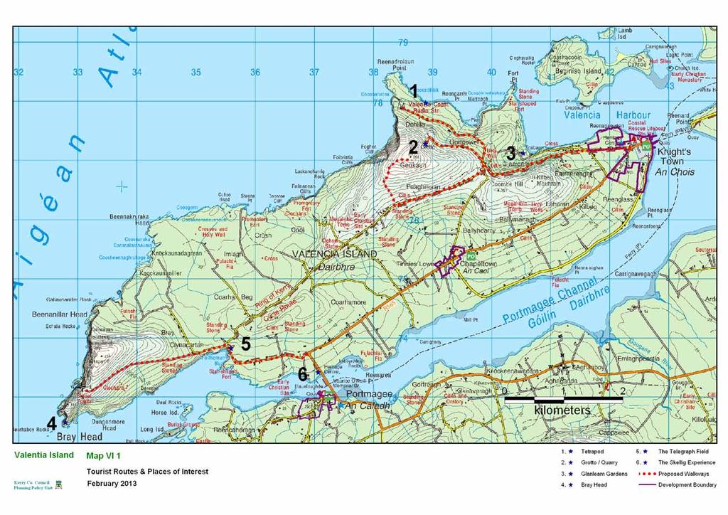
151
152 KNIGHTSTOWN LOCAL AREA PLAN 1.0 CONTEXT 1.1 Location Knightstown (An Chois - the pirate) is named after the former local landlord The Knight of Kerry. Knightstown is located on the eastern side of Valentia Island, which is off the western coast of the Iveragh peninsula. It is the largest village on the island and is directly connected to the mainland by ferry during the summer months. Knightstown is approximately 3km to the north east of Chapeltown and approximately 5.5km to the south west of Cahersiveen (via ferry). 1.2 Population There is no specific census returns for Knightstown. The DED of Valencia covers the town and the entire island. The 2006 census showed 713 persons. This figure increased from 690 in This represented a 3% increase in population. The figure decrease in 2011 to 664, this represented a 6% decrease in population 1.3 Functions & Facilities The settlement of Knightstown is designated as a village in the Kerry County Development Plan It provides a range of services to its rural hinterland and also acts as the main settlement on an island that benefits substantially from tourism. Many of the residential units in the village are holiday homes. The village has a broad range of facilities including a Roman Catholic Church, a Church of Ireland church with a sensory garden, A Garda station, a residential/training centre for the mentally handicapped, an RNLI lifeboat station, a heritage centre, hostels, restaurant, shops, a grocery shop, and a scuba diving centre. Due to the seasonal nature of demand for services in the area a number of businesses in the village are closed during the winter period. The newly built breakwater and marina in the harbour offers a broad range of marine based activities. The marina will have 220 berths when fully completed. For its size Knightstown village has a broad range of services and facilities both for locals and tourists, however many of these facilities/services are only open during the tourist season. There are also a number of bed and breakfasts and holiday homes developments in the village and surrounding area. 1.4 Infrastructure Wastewaters in Knightstown receive primary treatment, before discharge to Valentia Harbour. The design capacity of the treatment facility is 800pe and is considered to be approaching capacity. The system acts as a combined system with no separate provision for storm water runoff. The town is served by public water. Cahersiveen Functional Area Local Area Plan 136 Knightstown
153 1.5 Urban Form Unlike some other villages in south Kerry, Knightstown has a highly developed and attractive street system. The prolific Scottish engineer, Alexander Nimmo was commissioned by the Knight of Kerry in 1830 to prepare a layout plan for what was then referred to as the New Town of Valentia. The village was developed in the 1840s and has managed to retain its distinctive character. The attractive streets and impressive terraces give Knightstown an architectural character unsurpassed in any other village in Kerry. Market Street which forms the core of the village runs west to east from the Church of Ireland and terminates in the beautifully restored clock tower on the pier. The varied assortments of buildings along the Promenade are a further addition to the rich architectural mix found in Knightstown. The village has an attractive promenade extending along the seafront which forms the eastern boundary of the village and includes the pier area. There are opportunities to extend this walkway amenity throughout the town. The village is rich in architectural heritage, archaeological heritage and local history. An item of particular interest is the Altazmuth Project which has been promoted by the local community in recent years 1.6 Built Heritage The village has a rich architectural heritage. The Cable Station building which is one of over fifty Protected Structures in the village was designed by the renowned 19 th century Cork architect Thomas Deane in Many of the officer s houses, which form the terraces along the Promenade and are on the RPS, have been bought as holiday homes and are well maintained by their new owners. It is considered that future development should preserve and enhance the elements of the built environment which define the character of the village. Two sections of streetscape have been identified which present a particularly coherent and attractive traditional frontage and should be retained. It is not proposed to include any additional structures on the Record of Protected Structures. It is considered however, that those elements of the built environment which define the character of the village need to be enhanced and preserved. It is an objective of this plan to designate an ACA along a section of the Main Street so that its attractive form and character can be retained in any future development. It is necessary to ensure that the local character and sense of place are enhanced. It is important therefore that new development reflects the traditional elements of the existing streetscape. Cahersiveen Functional Area Local Area Plan 137 Knightstown
154 1.7 Archaeology There are no archaeological monuments in proximity to the plan area or within it. 1.8 Natural environment and Amenity Knightstown is located on a flat coastal plain at the north eastern tip of Valentia Island. The village s sheltered harbour area makes it a popular location for water based activities. It is part of the Valentia Harbour/Portmagee Channel candidate Special Area of Conservation. The site contains important examples of reefs, shallow inlets and tidal mudflats 1.9 Vehicular and Pedestrian Traffic Knightstown is the terminus for the Valentia island ferry which operates from March October. The ferry generates quite an amount of traffic especially during the months of July and August. During the winter season access to Knightstown from the mainland is via the bridge at Portmagee Employment The 2006 Small Area Population Statistics for the ED in which Knightstown are located (Valentia) indicate that the main source of employment for males in the area is the construction industry (20%) followed by manufacturing (10%).These figure are likely to have reduced due to the current economic situation. The majority of employed females are professionals, followed by those working in the service sector (28%). There is no major employment in the village other than Valentia Hospital. Employment opportunities within the village are limited and many islanders travel to work on the mainland. In order to encourage indigenous businesses and more employment in the village, lands designated for tourism and small scale mixed use is zoned within the settlement boundary. Two opportunity sites have also been identified Growth and Residential Development There has been a considerable amount of development in the village in recent years mainly to the south and west of the village core, off the R565. These developments are estate type developments and have not contributed to or extended the existing streetscape. A development of houses and apartments fronting Market Street and in the grounds of Reenellen House and a smaller development at the eastern end of Market Street fronting the Promenade have regenerated the village centre. All these developments cater predominantly for the holiday home market. There has also been a demand for one off houses mainly to the west of the village. The level of planning permissions demonstrates growth potential in the plan area and its immediate surrounds. Future growth may be sustained if Knightstown develops the capacity to attract services and facilities including upgraded waste water treatment facilities. The future demand for detached dwellings would otherwise be met through rural development. Cahersiveen Functional Area Local Area Plan 138 Knightstown
155 The development boundary for Knighstown defines the existing extent of the area where new development may be considered, whilst also allowing for expansion /re-development in the village core. It is an objective of the plan to encourage the development of a compact and sustainable village structure by ensuring that new development is contiguous with existing development and makes effective use of backland and infill sites Opportunity sites Opportunity sites are defined here as sites which are visually or functionally important and where the application of good urban design would have the maximum impact on the social and economic growth of the village. This plan has identified two sites; Market Street and the former Slate Yard. Further appraisal of these sites is contained in Appendix DEVELOPMENT STRATEGY The overall vision for Knightstown is to ensure that it develops as an attractive location for residents and tourists alike and that future development preserves the village s character and reinforces it where necessary Knightstown is probably one of the most attractive settlements in County Kerry with very few if any settlements matching its mix of architectural, historical and cultural heritage. The village still retains its innate character and it is essential, that this is retained. The retention of the architectural heritage of the village is critical to its future development as a tourist destination. Knightstown has a number of innate strengths including an attractive seafront, spectacular sea views and a defined urban form with character and charm. It is important that the village capitalises on its location and its heritage. It is considered, that, through the implementation of high quality urban design, architecture and public facilities that Knightstown can enhance its development potential as a tourist destination with sustainable heritage and water based activities as its main attractions. It is important that the features which attract tourists to the area are protected, while appropriate opportunities for employment generating tourist development are encouraged. As mentioned previously, the village is serviced by a primary wastewater treatment plant. This plant is nearing capacity and there are no immediate plans to upgrade. Discharge is into the Valentia Harbour which has sensitive receiving water with Natura 2000, bathing water and shellfish water designation. In the short term therefore, and pending the upgrading of the treatment plant, the development potential of the village is seriously curtailed. Notwithstanding these restrictions, this plan sets out a development vision for future uses throughout the settlement in order to avoid inappropriate development compromising proper planning principles in the interim. Cahersiveen Functional Area Local Area Plan 139 Knightstown
156 The development strategy for the village is to: Ensure that future development should support the existing role and function of the village as a rural service centre and small tourist village Ensure that all development shall have regard to the scale and setting of the existing village in an attractive rural landscape. Encourage the sustainable development of adequate sporting and playground facilities. These should be provided for within the village to cater for the recreational needs of locals and tourists. Promote the enhancement of the promenade/waterfront area in a sustainable manner. Ensure that future residential development within the village caters for the needs of the local population who wish to live in the area on a permanent basis. Protect the natural environment, architectural and archaeological heritage of the village from developments of an inappropriate nature and scale given that these attributes contribute greatly to the distinctive character of the village. Encourage the sustainable expansion in the range and number of commercial services within the village which in turn will provide local employment and improve the quality of life of the local community. Develop ecotourism and other niche markets along with the sustainable extension and diversification of tourist facilities as a possible source of employment 3.0 OVERALL OBJECTIVES Objective No. OO-1 OO-2 It is an objective of the Council to: Ensure that new residential development shall be small-scale and low density served by individual treatment units/septic tanks that comply fully with the EPA Code of Practice on waste water treatment and disposal systems serving houses/small communities, until such time as the waste water treatment system for the village is upgraded.. Ensure that the high quality natural setting of the village is maintained and protected from inappropriate development. Cahersiveen Functional Area Local Area Plan 140 Knightstown
157 4.0 SPECIFIC OBJECTIVES Architectural & Built Heritage Objective No. It is an objective of the Council to: AH-1 Preserve the village s architectural heritage and encourage development to be designed in a manner that is in keeping with the scale and character of the existing village. New developments should respect local design features. AH-2 Encourage the appropriate reuse and sensitive restoration of unused/derelict properties along the Main Street. AH-3 Designate the area indicated on the map as an Architectural Conservation Area (ACA) Objective No. Vehicular and Pedestrian Traffic It is an objective of the Council to: T-1 Provide for continuous walkway footpath within the village. T-2 Seek the provision of continuous walkway from Jane Street to the Promenade. Objective No NE-1 Natural Environment It is an objective of the Council to: Preserve any existing mature trees where possible and promote additional planting of native trees and shrubs in new developments. Objective No. Amenity It is an objective of the Council to: A-1 Facilitate the development of a town park at the location indicated on the Land Zoning Map. Cahersiveen Functional Area Local Area Plan 141 Knightstown
158 APPENDIX 1 Opportunity Sites Site 1 Market Street Aim: To sustainably redevelop and improve this village centre site in order to provide a strong urban streetscape and a significant area of public space Site Location and Description The site is located on the southern side of Market Street. The buildings along the northern streetscape are set back. The area is currently used as private residential open space. The site is on either side of the junction on Jane Street. Development Potential The redevelopment of this site presents an opportunity to create a strong urban streetscape which would regenerate the heart of the town, which would benefit the community. This site should make provision for a two storey traditional streetscape on the south side of Market Street, and shall allow for retail and residential use. In relation to the mixed use streetscape the emphasis will be on residential development with the potential for future conversion to retail and commercial use. Planning applications are to be accompanied by comprehensive urban design statements A small plaza or other central public space would give expression to a town s history and character, provide a visual and social focal point, and contribute to a sense of identity and place. Site 2 The Slate Yard Aim: To sustainably develop this brownfield site as a tourist/leisure site Site Location and Description This area comprises the site of the former slate yard. Currently it is rather poorly presented, particularly on the eastern side, by low-grade commercial buildings and houses (including rear gardens and storage areas for properties fronting onto Market Street and the Promenade). The north and the east side must be improved and consolidated with new tourist facility overlooking the historically important Altazamuth Trigonometric point. The site comprises of structures, some of which are derelict or unoccupied. Cahersiveen Functional Area Local Area Plan 142 Knightstown
159 Development Potential The development of this site presents an opportunity to regenerate a large site in the heart of the village. This site has the potential to be a focal point of the village. The development would be mixed use including a mixture of tourist, recreational and leisure use typical of any small town centre site. Any redevelopment of this area should encourage the refurbishment and re-occupancy of the existing structures. The large stone building is a protected structure which should be sensitively restored and utilized. It is of significant importance that the relevant landowners work together to ensure the entire land is developed in a uniformed and coherent approach. Piecemeal development of these lands will not be favourably considered. General Requirements To ensure that the proposed development is a success and will integrate easily into the surrounding townscape, the design and layout of the development will be required to be of a high design standard and must contribute its visual identity. Permeability for both pedestrians and car users is of utmost importance throughout the development. A walkway from Jane Street through the Slate yard and onto the Promenade would give added vibrancy to the area. Given the size of the site an urban design statement must be prepared and submitted to the council with any planning application for the lands. The urban design statement must comply with the requirements of section 13.3 of the County Development Plan Cahersiveen Functional Area Local Area Plan 143 Knightstown

 and the 2 nd edition (1897) of the OS maps, Peter Street is referred to as Coastguard Street and the terrace of six buildings on the west side of the street is referred to")
160 Appendix 2 Knightstown Architectural Conservation Area Introduction See the introduction to the Cahersiveen ACA. Location and boundary of the Conservation Area The proposed ACA is comprised of four blocks centred on Market Street and Peter Street. Historical development of the area Map. 1: ACA Boundary The Scottish engineer, Alexander Nimmo was responsible for the layout of Knightstown, having been commissioned to carry out the task by the Knight of Kerry in the early 1830s. In the 1 st edition (1842) and the 2 nd edition (1897) of the OS maps, Peter Street is referred to as Coastguard Street and the terrace of six buildings on the west side of the street is referred to as Coast Guard Station. In the first edition the only buildings shown on the north side of Market Street are the Post Office and adjoining building and the nearby terrace of four buildings referred to on the map as Police Barracks. Cahersiveen Functional Area Local Area Plan 144 Knightstown
161 In the second edition five additional structures are shown on the north side of Market Street including what is now the Knightstown Coffee House and adjoining building. st Map 2 1 Edition OS Map (1842) FARRANREAGH Map 3: 2 nd Edition OS Map (1897) Cahersiveen Functional Area Local Area Plan 145 Knightstown
162 Schedule of Protected Structures and Recorded Monuments Knightstown has a rich architectural heritage and has a higher concentration of Protected Structures than any other settlement in the county. There are five structures included in the Record of Protected Structures within the ACA. - RPS Ref. No Knightstown Coffee Shop, Market St. - RPS Ref. No. KY Former Post Office, Market St. - RPS Ref. No. KY Town House, Market St. - RPS Ref. No. KY Radio Tce., Market St. - RPS Ref. No. KY Radio Tce., Market St. There is no Recorded Monument within the proposed ACA. Description of Existing Built Environment a) Street pattern: Market Street is now the main thoroughfare in Knightstown, although mainly residential in character there are a small number of commercial premises also located on the street. Market Street runs east west from the junction opposite St. John the Baptist Church to the waterfront. Peter Street and Jane Street intersect with Market Street at right angles, Peter Street to the north and Jane Street to the south Photo. 1 Terrace Market Street b) Form and arrangement of public and private open space. All of the buildings, apart from the old Post Office and adjoining structure have an area of private open space to the rear of the buildings. There is no public open space within the confines of the ACA. The two uniform terraces within the ACA have private open space to the front bounded by stone walls. c) Socio economic functions. The buildings within the ACA are mainly private, with a small number of commercial premises. Cahersiveen Functional Area Local Area Plan 146 Knightstown
163 d) Built fabric-general description. The buildings within the proposed ACA are either two storey or one and a half storey, with the exception of St Derercas Hall which is single storey. A number of the buildings have simple traditional style open porches. One of the buildings within the ACA, Knightstown Coffee House has one of the finest examples of shopfront craftsmanship in the county. The two terraces within the ACA are comprised of attractive vernacular style buildings simpler and less elaborate than some of the other terraces in Knightstown. Photo. 2 Original roof covering Photo. 3 Shop front detailing e) Roofs, ridges, chimneys. Some of the buildings have retained the original slating material which has a lot more character and texture than the newer variety of roofing material. (Photo. ) f) Walls. The majority of the buildings within render finish. the ACA have a smooth plaster or lined Photo. 4 & 5 Peter Street Cahersiveen Functional Area Local Area Plan Knightstown 147
164 Photo. 6 Photo. 7 g) Openings. Some entrances and openings have been altered over the years to suit particular commercial or domestic circumstances, but overall, window openings and doorways have remained relatively intact. Two contrasting styles of window opening are evident on Peter Street in one instance the first floor window opes are much smaller that the ground floor a feature often found, whereas on the other side of the street the first floor windows are larger. (Photo 4 & 5) Photo. 8 Photo. 9 Cahersiveen Functional Area Local Area Plan 148 Knightstown
165 h) Boundaries. Most structures within the ACA do not front directly onto the pavement but have an area of private open space. An interesting feature connecting the properties forming the four unit terrace on Market Street is the use of a slate slab over the water channel (Photo i) Rainwater Goods. Some original cast-iron rainwater pipes and gutters remain but there has been replacement in a piecemeal manner. Cast iron is a resilient material and the retention of cast iron rainwater goods not only makes sense from an economic viewpoint but also enhances the heritage value of buildings. Photo. 10 Photo 11 j) Views. The vista looking east along Market Street towards the waterfront, with the clock tower in the forefront and the harbour and Reenard in the background is one of the iconic views associated with this part of south Kerry. Summary of Special Character The principle features of the built form are - traditional urban style buildings dating mainly from the late 19 th to the early 20 th century. - pitched roofs covered in slate or artificial slate - roofs have variable ridge and eaves heights - the use of traditional unobtrusive signage - the retention of a high proportion of timber sash windows Negative features - some unsympathetic alterations to historic features such as windows, the cumulative effect of which is damaging to its status as a conservation area. Guidelines for development within the Conservation area. For the Guidelines for development within the Conservation area., works not affecting the character of the ACA (do not require planning permission) and works impacting on the character of the area (works requiring planning permission) see Cahersiveen ACA Cahersiveen Functional Area Local Area Plan 149 Knightstown

166
167 CHAPELTOWN LOCAL AREA PLAN 1.0 CONTEXT 1.1 Location Chapeltown (An Caol) is located on the southern side of Valentia Island. It is a small village on the island and connected to Knightstown by the R565.It is halfway between Knighstown and Portmagee. Although a certain level of development has taken place between the two settlements in recent years they can still be viewed as two distinct settlements. 1.2 Population There are no population figures for the village of Chapeltown itself. The DED of Valencia covers the village and the entire island. The 2006 census showed 713 persons. This figure increased from 690 in This represented a 3% increase in population. The population decreased in the 2011 census to 664 people. 1.3 Functions & Facilities Chapeltown has a range of social facilities including a Roman Catholic Church, community centre, a public house, shop. There is no grocery shop within the settlement. The local GAA ground & pitch is located here. Scoil Naisiúnta Dar Earca and the community centre serve the entire island. In this sense Chapeltown acts as the social centre for the island. 1.4 Infrastructure There is a public water supply available in the village.there is no wastewater treatment unit in the village. There is a preliminary report for the provision of a new system but it is unlikely to be provided within the life of this plan. 1.5 Urban Form Chapeltown was one of many villages developed around newly constructed churches following Catholic Emancipation in the 1830s. Chapeltown is a traditional rural village, linear in form comprised of mainly detached structures without a set building line. The village has developed in a linear fashion along the R565 with limited development along the local roads, which intersect with the R565 at the village centre. A recently constructed terrace type development along the R565 serves to enhance the village streetscape. If this streetscape was further developed it would give the village a more defined core area and urban structure. There are a variety of building types within the village. Building heights vary throughout the village. Some new cluster type developments in the village are of a uniform design which is untypical of the older built forms. Cahersiveen Functional Area Local Area Plan 150 Chapeltown
168 1.6 Built Heritage & Archaeology There are no Protected Structures or recorded monuments within the proposed plan area. 1.7 Natural environment and Amenity Chapeltown is located in a low lying pocket of land about 1km from the shoreline of Valentia Island which forms part of the Valentia Harbour/Portmagee Channel SAC. A number of invasive introduced species, including Japanese knotweed and Giant Rhubarb are found within the village. These plants are not native to the area and as well as being harmful to biodiversity can look out of place as they form dense thickets along roadsides, waste ground and waterways. They reproduce rapidly and are difficult to kill once established. It is therefore very important to prevent the movement of earth contaminated with rhizomes, cuttings from hedge trimming or other fragments from one area to another. Given the prevalence of these plants in the settlement, development proposals, where appropriate, will be required to submit a suitable scheme for their eradication and/or control, prior approved by the Planning Authority. 1.8 Vehicular and Pedestrian Traffic Due to its location on the R565 roughly midway between Portmagee and Knightstown there is a considerable amount of through traffic especially during the summer months. Insufficient car parking space is a problem. There is no car park attached to the church and the community centre has minimal parking available. Parking along the R565 is problematic and providing additional parking space within the village centre is a priority. Sightlines at the junction of the R565 and the Coast road in the village centre are inadequate and need to be improved Tourist traffic during the summer months creates a busy atmosphere but during the winter months, because of its relatively isolated location traffic is mainly local. 1.9 Growth and Residential Development Unlike Knightstown, the recent level of development in Chapeltown has been limited. However there has been a considerable demand for development along the R565 both to the east towards Knightstown and to the west towards Portmagee. This reduction in the level of open countryside between the settlements is considered undesirable and in the long term would lead to a lack of definition for the settlement. Chapeltown has the capacity to attract and absorb future demand for detached dwelling houses that would otherwise be met through linear roadside development in rural areas. This will contribute to a reduction in unsustainable ribbon development, while ensuring the demand for larger detached dwellings is catered for in a sustainable pattern and in close proximity to the school and other services. Cahersiveen Functional Area Local Area Plan 151 Chapeltown
169 The development boundary for Chapeltown defines the existing extent of the area where new development may be considered, whilst also allowing for some expansion for some re-development in the village core. It is the an objective of the plan to encourage the development of a compact and sustainable village structure by ensuring that new development is contiguous with existing development and makes effective use of backland and infill sites. 2.0 DEVELOPMENT STRATEGY The overall vision for Chapeltown is to ensure that it develops as an attractive location for residents and tourists alike and that future development preserves the village s character and reinforces it where necessary. The development strategy for the village is to: Maintain the open countryside between Chapeltown and Knightstown. Ensure that future development supports the existing role and function of the village as a small local focal point for it s surrounding rural community Ensure that future residential development within the village caters for the needs of the local population who wish to live in the area on a permanent basis. Promote the development of commercial/retail outlet serving the local community. Development proposals should not facilitate the introduction or spread of invasive introduced species, such as Japanese Knotweed or Giant Rhubarb. 3.0 SPECIFIC OBJECTIVES Objective No. Open Space, Recreation and Amenity It is an objective of the Council to: A-1 Reserve lands for the development of a village green as indicated on the zoning map & develop a riverside park. Objective No. CR-1 Commercial/retail Facilities It is an objective of the Council to: Promote the development of commercial/retail outlet serving the local community Cahersiveen Functional Area Local Area Plan 152 Chapeltown
170 Objective No. AH-1 Architectural & Built Heritage It is an objective of the Council to: Encourage the appropriate reuse and sensitive restoration of unused/derelict properties. Objective No. Vehicular and Pedestrian Traffic It is an objective of the Council to: T-1 Provide for an additional car parking area within the village. Objective No. NE-1 NE-2 Natural Environment It is an objective of the Council to: Where invasive introduced species, including Japanese Knotweed are identified on a site or in the vicinity of a site (underground parts of the plants may extend laterally up to 7 meters), the planning Authority may request a suitable scheme for their eradication and/or control as part of the planning application process. Ensure that any significant future developments on these lands are subject to a flood impact assessment Cahersiveen Functional Area Local Area Plan 153 Chapeltown

171
172 SECTION 2C RURAL AREA 1.0 OVERVIEW 1.1 Introduction The purpose of this section of the plan is to make provision for planning policies in rural areas that are below the strategic level of the County Development Plan and are more local in nature. The rural area of the Cahersiveen Functional Area Local Area Plan, shown in Figure 4.1, is defined as all the rural area within the functional area boundary and outside the boundaries of the town, villages and the small villages/development nodes. The rural area, as defined in this plan, is functionally linked to the settlements. Valentia Island is not part of the rural area, see section 2b. Figure 1: Cahersiveen Functional Area Those living in the rural area are largely dependant on the town and villages for services such as schools, services and employment. It is likely that a substantial proportion of people travel to larger towns such as Killarney and Killorglin for employment. Tourism and agriculture are strong in this area. 1.2 Purpose of Rural Area Plan The functional area local area plan will; Look at rural area at a local level as opposed to the more strategic level of the County Development Plan. Identify strengths, weaknesses, opportunities, threats in the rural area. Gather information on the rural area. Identify protected structures in the rural areas. Identify objectives for the rural area that are not at the strategic County Development Plan level. Cahersiveen Functional Area Local Area Plan 154 Rural Area
173 1.3 SWOT ANALYSIS FOR RURAL AREA Strengths A strong urban centre (Cahersiveen Town) as a focal point Major tourist destination Strong cultural & linguistic heritage Attractive and varied landscape/seascape with coastline, inlets, rivers, pastures and mountains Strong economic and social linkages between the rural area and urban settlements Villages have in the most part retained their character Area with some of the best scenery in the country The Ring of Kerry & The Skellig Ring are important tourist routes Existing piers and Outdoor pursuits e.g. bird watching, fishing, walking, hill and mountain climbing, marine leisure etc Close to the 18 hole golf courses at Waterville Blue Flag Beaches at Kells, White Strand and Ballinskelligs Weaknesses Peripheral location Difficulty in competing with the range of services and attractions on offer in Killorglin and Killarney Reliance on tourism with seasonal nature Limited employment opportunities Opportunities Conserve built heritage Protect the natural environment and biodiversity Increase level of marine leisure activities, ecotourism and other niche markets in a sustainable manner Promote the development of cycle routes and other outdoor activities promote walking tours, hill and mountain climbing at sustainable levels Promote sustainable mari-culture Greater use of the marine environment for sustainable leisure activities Threats Over-development of rural area. Decrease in population numbers speaking Irish Pollution of surface and groundwater Loss in quality of landscape. Emigration and loss of population and consequent reduced demand for services Affordability of transport fuel Competition from cheaper locations Loss of biodiversity External economic factors Cahersiveen Functional Area Local Area Plan 155 Rural Area
174 1.4 Population The population of the entire Functional Area as contained in the 2006 Census was 5,212 persons and in 2011 it was 5,074. The population growth target indicates that the population of the entire plan area will grow by 497 persons between the years 2012 and 2018 to a total of 5, census census census estimate target Cahersiveen Functional Area* 5,051 5,212 5,074 5,156 5,653 Cahersiveen Town 1,272 1,294 1,454 1,499 1,772 *Includes Cahersiveen town Table 1: Population change and population target in the Cahersiveen Functional Area Figure 2: Population Change Transport The area is served by the N70, national secondary routes, the R565, R566 & R567 regional roads and a network of local roads. It is important that any development in the rural area is acceptable in terms of traffic safety and does not impact negatively on the carrying capacity and general safety of public roads in accordance with Chapter 8 and section 13.9 of Chapter 13 in the Kerry County Development Plan Cahersiveen Functional Area Local Area Plan 156 Rural Area
175 Figure 3: Road Network in the Cahersiveen Functional Area 1.6 Cycle paths / Walkways Marked paths and cycle routes are an important resource for attracting tourists and providing recreation for local residents. They can also open up potential for farm diversification into small-scale tourist services. Numerous spectacular walking routes exist in the functional area around Bolus and Ducalla head, Coonanaspig, and Valentia Island. The Kerry Way walking trails also intersect the plan area, Mountainstage to Cahernaman, Cahernaman to Coars and a spur to Cahersiveen. These established walkways provide some of the most scenic views as well as isolated and dramatic countryside in the county. The Beentee Loop is a 9km walkway located to the south of Cahersiveen. It is proposed that a green route be developed along the old railway line between Killorglin and Cahersiveen in accordance with development objective INF8-38 of the Kerry County Development Plan Kerry County Council and South Kerry Partnership are seeking to promote the utilisation of the old railway line as a Greenway /route. Subject to strategic environmental assessment, at project level, this green route could facilitate recreational activities such as walking, cycling and nature observation. This would provide a valuable amenity resource for the area with some spectacular sea and mountain views and would constitute an additional tourist attraction in the Cahersiveen area. Cahersiveen Functional Area Local Area Plan 157 Rural Area
176 Figure 3: Potential recreational green route along the disused railway route 1.7 Water Supply The area is served by public water mains, group water mains and private water supplies. It is imperative that groundwater is protected from polluting development. All development must have regard to the zones of influence for groundwater public water supplies and catchments for surface water public supplies. Cahersiveen Functional Area Local Area Plan 158 Rural Area


177 Figure 4: Water supply and source in the Cahersiveen Functional Area 1.8 Wastewater Treatment Developments in the rural area are served by individual septic tanks/treatment units based on an assessment of soil characteristics in accordance with the EPA s Code of practice- Wastewater Treatment and Disposal Systems serving Single House (p.e. 10) or any subsequent amendment or revision documents 1.9 Landscape The study area located on the north west corner of the Iveragh Peninsula is centered on the town of Cahersiveen and delineated by the sea to the north and the west and by a line of Mountain ranges to the south and east. Several different sub landscapes are notable here with the summits and upper slopes of the mountains and hills covered with bog/heath/moor while coniferous plantation occurs on the western slope of the Feta river valley. Large areas of peat land are located on the valley floors, while dry stone walls occur on the middle slopes around Ballinskelligs. St Finans Bay comprises of a slightly varied topography and landscape than that of the northern part of the functional area. Rock outcrop are adjacent to the coastline, revealing some of the most spectacular examples of cliff within the County at Bolus Head and Ducalla head (The Kerry Cliffs). The settlement patter in this function area is scattered on the lower topography around the main roads, services and smaller settlements. Having regard to the spectacular landscape present there a number of views and prospects are designated in this functional area. These are illustrated in Figure 5 below. Cahersiveen Functional Area Local Area Plan 159 Rural Area
178 Figure 5: Views and Prospects and Special Amenity areas in the Rural area 1.10 Natural Environment The Cahersiveen functional area has a variety of spectacular physical features and biodiversity which combined produce some of the most intriguing natural environment in Ireland. The extent of SPA (Special Protection Areas), and SAC (Special Areas of Conservation) areas are the most plentiful in the county and are shown in Figures 6 &7 and Map Ru-3 and are listed in Table 2. Natura 2000 site boundaries are subject to change refer to for current boundaries. Designation Type Site Code Site Name SPA Iveragh Peninsula SPA SPA Puffin Island SPA SPA Skelligs SPA csac Ballinskelligs Bay & Inny Estuary csac Valentia Harbour/Portmagee Harbour csac Killarney National Park, Macgillycuddy s Reeks and Carragh lake catchment Table 2: SPA and SAC in the Rural Area Cahersiveen Functional Area Local Area Plan 160 Rural Area
179 Figure 6: SPAs in the Rural Area The Iveragh Peninsula SPA The Iveragh Peninsula SPA is a large site situated on the western coast of the plan area. The designation encompasses the high coast and sea cliffs around the Northern Coastline of the Iveragh Peninsula, around the northern verge of Valentia Island and Bolus Head as far as Lambs head in the south. The site is a SPA under the EU. Birds Directive of special conservation interest for the following species: Peregrines, Guillemot, Fulmar and Kittiwake and is the second most important site in the country for Chough. Puffin Island SPA Puffin Island lies approximately 0.5 km off the northern side of St Finan s bay. It is a long, narrow island of Old Red Sandstone. The island is almost divided into two halves the southern half is a long narrow, rocky ridge, rising to 130 m, while the northern half broadens into a grassy plateau though has a high point of 159 m. The island is surrounded by mostly steep cliffs and slopes. In the past Puffin Island was grazed quite heavily by sheep and today rabbits are commonly found.. The site is a Special Protection Area (SPA) under the E.U. Birds Directive, of special conservation interest for the following species: Fulmar, Manx Shearwater, Storm Petrel, Lesser Black-backed Gull, Razorbill and Puffin. The site is also of special conservation interest for holding an assemblage of over 20,000 breeding seabirds. Cahersiveen Functional Area Local Area Plan 161 Rural Area
180 Puffin Island is owned by Birdwatch Ireland and is managed for conservation purposes. The island is also a statutory nature reserve. Skelligs SPA The Skellig SPA comprises of the Great Skellig Island (218m high) and the Little Skellig Island (134m high). Both highly exposed and rugged island are 3km apart and approx. 14km and 11 km respectively from the mainland of south west Kerry. The geology of the islands is made from old sandstone with a little slate and veins of white quartzite. The Great Skellig supports a diverse range of flora, such as Thrift, sea Campion, Rock Sea spurrey and Sea mayweed. The Great Skellig has an international important population of Storm Petrel ( in 2002) and one of the largest colonies of Puffins in the country. Little Skellig is not as vegetated due to the effect of nesting birds on the vegetation and is better known for its colony of Gannets, approximately 26,436 pairs identified in This is not only the largest in Ireland but in the World. Other important species of birds found on the Skellig Island include; Chough, Fulmars, Manx Kittiwake, Guillemot and Razorbill. Both Islands are designated as a Statutory Nature Reserve. BirdWatch Ireland holds a long term lease on Little Skellig. It is believed that the high numbers of day trippers to the Great Skellig could impact negatively on the fragile soil cover on the island. Therefore a balance must be created between promoting tourism and maintaining the ecological integrity of the island. The Valentia Harbour/Portmagee Harbour SAC The Valentia Harbour/Portmagee Harbour SAC is situated to the north of the functional area and separates Valentia Island from the mainland. The Channel is approximately 1km wide and contains a number of examples of Habitats listed on Annex 1 of the EU habitats directive, For example; Reefs, Shallow inlets and tidal mudflats. The area is also commonly known for its excellent example of sediment communities including calcareous algae also know as Coral. The reefs of Valentia Island are composed of areas that are very exposed to, or very sheltered from wave action. This results in the numerous covering of Barnacles, limpets, mussels and Kelp. The Ballinskelligs Bay & Inny Estuary SAC This SPA is situated on the western end of the Iveragh Peninsula, west of Ballinskellig settlement. The site extends from Horse Island (Inside study area) around the bay to Rineen Point (outside this study area). The region is designated as part of the SAC due to its wide natural environment and biodiversity, such as the Atlantic sea meadow and the Mediterranean salt meadows (both Annex 1 of the E.U Habitats Directive).It also contains low sand hills which support a population of rare liverwort species called the petalwort (petalophylum ralfsii). Cahersiveen Functional Area Local Area Plan 162 Rural Area
181 Killarney National Park, MacGillycuddy s Reeks and the Caragh River Catchments Part of the Killarney National Park, MacGillycuddy Reeks and the Caragh River Catchment SAC site intersects the plan area. This SAC site includes the mountains, rivers and lakes of the Iveragh peninsula, and the Paps Mountains which stretch westward from Killarney to Kells region. It is the most mountainous region in Ireland and includes the highest peak in the country; Carrauntoohil which reaches 1039m above sea level. The site contains at least ten habitats which are listed on Annex I of the EU Habitats Directive. The site obtained its status as a candidate SAC due to the presence of blanket bog, Yew wood and alluvial woodlands, priority habitats on Annex I of the E.U. Habitats Directive. The site is also selected as a candidate SAC for lowland oligotrophic lakes, upland oligotrophic lakes, floating river vegetation, alpine heath, dry heath, wet heath, Molinia meadows, old Oak woodlands, Rhynchosporion, Calaminarian grassland and Juniper scrub, all habitats listed on Annex I of the E.U. Habitats Directive. The site is also selected for the following species listed on Annex II of the same directive Killarney Fern, Slender Naiad, Freshwater Pearl Mussel, Kerry Slug, Marsh Fritillary, Killarney Shad, Atlantic Salmon, Brook Lamprey, River Lamprey, Sea Lamprey, Lesser Horseshoe Bat and Otter 1. Figure 7: csacs in the Rural Area 1 National Parks and Wildlife Service Cahersiveen Functional Area Local Area Plan 163 Rural Area
182 Designation Type Site Code Site Name NHA Knockroe bog NHA Table 3: NHA in the Rural Area Knockroe bog NHA Knockroe Bog NHA contains a fairly extensive area of deep, lowland blanket bog and is located 13 km east of the town of Cahersiveen, 4 km north of Deriana Lough and 19 km south-west of the MacGillycuddy Reeks in the townland of Knockroe, Co. Kerry. It is situated on a valley-side of the Owroe River, below Coomacarrea Mountain, at between 60 m and 120 m altitude. It adjoins upland to the north and South-West, where its boundaries are defined by rivers, streams and drainage ditches. Land to the north and south-east is predominantly low-lying agricultural land. The underlying bedrock is Old Red Sandstone. Several types of blanket bog vegetation occur within the site. Of particular interest are the systems of interconnecting pools, known as tension or tear pools, which are aligned perpendicular to the direction of slope. These areas are wet and quaking and support a good cover of bog mosses. Figure 8: NHA in the Rural Area There are a number of mature trees and woodlands on Valentia Island and in the area around Kells Bay which are important in terms of biodiversity and providing amenity areas to the public. Cahersiveen Functional Area Local Area Plan 164 Rural Area
183 1.11 Amenity There are three blue flag beach designations in the plan area; Kells in the north, White strand at Ballycarbary and Ballinskelligs beach in the southern region of the plan area. The whole area is linked by the The Valentia/ Portmagee Harbour and the Ballinskelligs Bay with one of the most attractive scenery and landscape on the South West coast of Ireland. Numerous coastal and mountain walks are dotted throughout the local landscape Tourism Tourism is a significant industry in the Cahersiveen Functional Area as it includes a large amount of attractive coastline and estuary, which contain features of historical, cultural and natural significance popular with visitors. This area attracts significant visitor numbers each year. Similarly, the Ring of Kerry and the Skellig Ring provide internationally renowned attractions for day trippers, long stay tourists, water-based activities and leisure breaks. The attractive coastline and beaches in the area which have features of historical, cultural and natural significance also provide opportunities for sustainable shore angling, deepsea fishing and walks. The Skellig Islands and Valencia Island off the shores of South-West Kerry are also an important attraction for tourist and leisure breaks. The National Spatial Strategy advises that second-home and holiday home development can act as a revitalising force in economic terms, particularly in areas that are structurally weak, but an emphasis is needed on clustering such tourism driven development in small towns or villages. Where possible, holiday accommodation should be within the settlements of the area, where visitors can enjoy access to shops, services and public transport. The tourism industry relies on the quality and attractiveness of the built and natural heritage and the objectives in the Kerry County Development Plan , that are directed towards the conservation of the built and natural environments must be respected not only for their own sake but because of their importance of these underlying resources to the local economy. The area is also located in the Gaeltacht which is rich in traditional ways, folklore, writing, music, and historic and archaeological sites.the potential for a niche ecotourism in the area is immense, but is not fully developed. Efforts need to be made to lengthen the tourism season in this area and this could be achieved by further promoting ecotourism in the area. This is a form of tourism which appeals to the ecologically and socially conscious. Large numbers of waterbirds and waders overwinter within the plan area which could be used to attract tourists to the area in the off season. Similarly whale and sea eagle tours are possible during the winter months. Ecotourism focuses on the local environment and culture, typically involving travel to destinations where flora, fauna, high quality environment and cultural heritage are the primary attractions. Cahersiveen Functional Area Local Area Plan 165 Rural Area
184 Responsible ecotourism includes programmes that minimize the negative aspects of conventional tourism on the environment, and enhance the local community. Therefore, an integral part of ecotourism is the promotion of recycling, energy efficiency, water conservation, and the creation of economic opportunities for the local communities. The landscape, cultural and linguistic heritage and amenities of the area constitute a prime asset on which the tourism industry is based. The size of the settlements and their unique character make them particularly sensitive to development. It is accepted however that expansion of the tourism industry is based on appropriate development. This plan, in accordance with the principles of sustainable tourism development outlined by Fáilte Ireland promotes suitable sustainable tourism development. When considering proposals for new tourism development, priority will be given to those that are encouraging longer visitor stays and add to the range of facilities available to people who live in the area all year round Built Heritage There are a number of existing protected structures within the rural area Ref KY Coastguard Station, Kells Ref KY Valentia View Cahersiveen Ref KY Meteorological Observatory, Valentia Road Ref Gleensk Viaduct Ref Foilmore National School Ref Dwelling House Carhon House, Cahersiveen Ref Dwelling House Castlequin Ref O Connell monument, Cahersiveen Ref Belleville, Portmagee Ref Killemlagh Church, Rathkieran, Emlagh Ref Celtic Memorial Cross, Keel It is proposed to have two additional protected structures Ref KY Detached Dwelling, Cloghanelinaghan, Cahersiveen Ref KY Bahoss House, Bahaghs, Cahersiveen 1.14 Rural Areas with Clustered Distinctive settlement patterns The Core Strategy of the Kerry County Development Plan identified 4 different rural area types. One of these areas, Rural areas characterized by distinctive settlement patterns and highly dispersed rural settlement is predominately found in isolated Gaeltacht areas. These areas are characterized by a tradition of clustered development in the traditional clochan/cluster form. Cill Rialaig is a fine example of this traditional clochan type layout. Cill Rialaig Artists Project was set up by Kilreelig Projects Ltd, as an artist s retreat on the remote Bolus Head. It is an old settlement that suffered large population loss during the famine and gradually became completely abandoned during the mid to late part 20 th century. The majority of Cahersiveen Functional Area Local Area Plan 166 Rural Area
185 the village has now been beautifully brought back to life as some of the dwellings are built in a similar style to the originals but are sensitive reconstructions rather than renovations and gives the impression of what a traditional clochan type development would resemble. Unlike so many others, this is the kind of development that enhances the very reason people visit the landscape. Now all kinds of artists, poets, writers and craftspeople come from all over the world to gain inspiration from the surroundings and solitude. Artists are encouraged to donate artwork to the Project to help with the upkeep Archaeology The general archaeology of the Cahersiveen area is dominated by early ecclesiastical sites and secular sites of the Early Medieval Period, such as hut sites, and enclosures. Prehistory is represented by fulachta fiadh, standing stones, stone pairs, wedge tombs, rock art, promontory forts and pre-bog field systems, track-ways and platforms. The finest examples of these prehistoric monuments in the area are located in the townlands of Teeromoyle/Gortnagulla/Caherlehillian/Coulagh at the head of the Ferta River valley. Thus extensive upland landscape adjoins the rock art landscape at Kealduff/Letter/Coomsaharn already protected in the Killorglin FALAP and must be seen as part of the same continuum, representing the earliest settlement of the peninsula in the Late Neoloithic/Early Bronze Age when the copper resources of the area became so important. Indeed, one of the largest hoards of bronze axes in the country is from within the area at Carhan Lower. Ecclesiastical sites such as Church Island and Illaunloughan are of international importance while the presence of the recently excavated early ecclesiastical site at Caherlehillian, within a broader prehistoric landscape, only adds to the importance of the area. The World Heritage site at Skellig Michael is the finest example of an early ecclesiastical hermitage in Europe and is one of its most important and iconic archaeological monuments. The Cahersiveen Functional Area Plan contains an archaeologically rich and diverse area of the county. There are approximately 520 monuments listed in the Record of Monuments & Places within the Functional area, many of which are archaeological complexes comprising numerous individual monuments and features. The majority of the monuments date to the Early Medieval period though prehistoric remains are well represented. There are 8 National Monuments located here of which 5 are in state ownership, 2 are in state guardianship and 1 is subject to a preservation order. A further 7 monuments have been entered in the Register of Historic Monuments (Registration). The National Monuments and Registered Monuments within the functional area are listed below in Tables 4.4 and 4.5, while particularly important landscapes with high densities of recorded monuments in two particular areas are outlined in the following pages. Finally general and specific archaeological objectives for the plan are suggested. Townland Description Status RMP NM No TOWNLAND DESCRIPTION STATUS Cahersiveen Functional Area Local Area Plan 167 Rural Area
186 Ballinskelligs Abbey Ballinskelligs Ownership KE Kimego West Cahergall Cashel Ownership KE Kimego West Leacanabuaile Cashel Guardianship KE Portmagee Illaunloughan Ownership KE Beginish Stone house Guardianship KE Church Island Church Island Ownership KE Tinnies Upper Complex Preservation Ke078 Kerry 010,023 & 011 Table 4: National Monuments within Cahersiveen Functional Area Townland Description RMP NM No Cahersiveen Church Ke Coarha Mor & Beg Complex Ke etc 1123 etc Cool East Monastic Enclosure Ke Kildreelig Monastic Enclosure Ke Kildreelig Deserted Village Ke Killogrone Watermill/Ogham Stone Ke Letter Oratory Ke Table 5: Registered Monuments within the Cahersiveen Functional Area The greatest concentration of rock art in the country is located in the townlands of Kealduff Upper, and Coomasaharn. This extensive Late Neolithic /Early Bronze Age landscape is worthy of special protection given its national and international importance and the strong possibility that further features remain to be recorded. The townlands of Teeromoyle, Gortnagulla, Caherlehillian & Coulage at the head of the Terta River valley are the location of an extensive prehistoric landscape with some later monuments most notably the important early ecclesiastical site at Caherlehillian. Wedge tombs, rock art, megalithic structures, enclosures, standing stones and field systems occur in the area which is part of the wider rock art landscape at Kealduff/Coomasaharn are already protected in the Killorglin FALAP. The quality of the remains and the upland nature of much of the area have helped to preserve this landscape and the important physical relationships between the various monument types and the landscape itself. The archaeological remains are crucial to our understanding of the Late Neolithic and Bronze Age periods, locally and regionally. Cahersiveen Functional Area Local Area Plan 168 Rural Area


187 Figure 9: Teeromoyle/Gortnagulla/Caherlehillian/Coulagh This prehistoric landscape need to be treated with special sensitivity and afforded special archaeological protection. Cahersiveen Functional Area Local Area Plan 169 Rural Area
188 Figure 10: Archaeological Monuments and proposed protected structures 1.16 Flood Risk Management Flood Risk Data for the functional area has been mapped on figure 11, using soil maps, recorded flood event locations and lands benefitting from OPW drainage schemes (available on ). The OPW have published draft preliminary flood Zone Maps for the County. Flood Risk Management in the area will be in accordance with the 2009 Government Guidelines on The Planning System and Flood Risk Management, the relevant development objectives of this plan and with Section 11.4 of the Kerry County Development Plan Figure 11 shows recorded flood locations and other identified potentially vulnerable areas. Cahersiveen Functional Area Local Area Plan 170 Rural Area
189 Figure 11: Flood Data in the Rural Area Kerry County Council has a policy to limit and manage the permitted runoff from all new developments, in order to protect river water quality and to avoid downstream flooding of the sewer network or river. Any large scale developments must incorporate Sustainable Urban Drainage Systems (SUDS) to restrict the discharge of stormwater from developments. Kerry County Council has a number of interim standards covering river quality protection, river regime protection and river and coastal flooding protection Piers / Harbours There are a number of small piers and harbours located around the coast of the functional area. These piers are used for various purposes including fishing, tourism and leisure. These piers are maintained by Kerry County Council. It is the policy of Kerry County Council to maintain and repair theses piers for public use and to support the sustainable development of the piers as potential economic generators for the area and support the maintenance of other facilities such as slipways and to protect them from inappropriate uses Windfarms Kerry County Council is preparing a Renewable Energy Strategy. The draft strategy is currently on public display. The adopted strategy will be incorporated into the County Development Plan Cahersiveen Functional Area Local Area Plan 171 Rural Area
190 OVERALL OBJECTIVES Ru-1 Ru-2 Ru-3 Ru-4 It is an objective of the Council to: Provide for balanced growth throughout the area by promoting the strengthening of rural communities and provide the infrastructure to facilitate job creation and diversification in these areas in a sustainable manner Ensure that development on un-serviced lands comply fully with the Code of Practice; Waste water treatment and disposal systems serving single houses and where necessary Wastewater Treatment Manuals - Treatment Systems for Small Communities, Business, Leisure Centres and Hotels Ensure that all fish bearing watercourses within the plan area and their riparian zones including the flood plain are protected from significantly harmful development and from the effects of wastewater discharges. Have regard to CFRAM Flood Maps for areas prone to flooding, when assessing planning proposals. 4.3 SPECIFIC OBJECTIVES Ru-AT-1 Ru-AT-2 Ru-AT-3 Ru-AT-4 Ru-AT-5 Ru-AT-6 Ru-AT-7 Amenity & Tourism It is an objective of the Council to Encourage the development of walking routes within the plan area and associated car parking facilities at appropriate locations so as to facilitate sustainable outdoor recreational activities in the plan area. Encourage the improvement of sensitively designed tourist information boards and signage at appropriate locations. Protect and encourage the development of literary, musical, artistic, sporting and other cultural heritage initiatives. Facilitate the development of a green route in a sustainable manner along the route of the dismantled railway line.this green route could be used, where appropriate, for recreational activities such as walking, cycling and nature observation. Facilitate the sustainable extension and diversification of tourist facilities Protect the sand dunes / dune system in the plan area in particular Ballinskelligs and prohibit any development that would damage or lead to erosion of any dune system. Protect from inappropriate development the protected views and prospects in the plan area as identified in figure 5. Cahersiveen Functional Area Local Area Plan 172 Rural Area
191 Built Environment It is an objective of the Council to: Ru B-1 Encourage the appropriate reuse and sensitive restoration of unused/derelict properties. Ru-EE-1 Ru-EE-2 Employment and Economic Activity It is an objective of the Council to : Facilitate sustainable diversification of the rural economy Provide the infrastructure and support for the sustainable development and expansion of employment opportunities, including indigenous knowledge based industries. Archaeology Objectives It is an objective of the Council to: A-1 Secure the inclusion of the structures included the archaeological special protection area into the Record of Protected Structures. A-2 Protect the views and vistas around the monuments, the inter-visibility of the monuments and the integrity of the existing archaeological landscape setting in the prehistoric landscape identified (see Fig 9). Applicants are advised to liaise with the County Archaeologist in advance of any application for development within these sites. Cahersiveen Functional Area Local Area Plan 173 Rural Area
192 USHEET 1 APPENDIX 1 Proposed Protected Buildings Unique identity number: RPS KY Address: Villa Nuova, Cloghanelinaghan, Cahersiveen Description: Detached three bay, two storey over basement house, with single storey balustraded bow to front.. Ordnance Survey Map: 6212 National Grid co-ordinates: 46,994m, 80,518m Site features: Outbuildings to the rear Special interest; Architectural Location Map (not to scale) Appraisal: Believed to have been built in the 1820s by a Dr. James Barry. The building has been unoccupied in recent years. In the 1 st. edition of the OS map (1842) all that is depicted at this location is a rectangular structure which does not correspond with the footprint of the present Villa Nuova. This building has many attractive features and is forms an important part of the architectural history of the Cahersiveen area. This building is of special architectural significance and should be included in the RPS. Cahersiveen Functional Area Local Area Plan 174 Rural Area
193 USHEET 2 Unique identity number: RPS KY Address: Bahoss House, Bahaghs, Cahersiveen Description: Two storey over basement structure, with three bay east facing front façade with single bay pedimented breakfront. Window and door surrounds are finished in brick. Ordnance Survey Map: 6213 National Grid co-ordinates: 51,359m, 80,112m Site features: Remains of a number of other structures and farm buildings to rear Special interest; Architectural, historical, social Location Map (not to scale) Appraisal: Although in a ruinous state for many decades, this building is one of the most impressive former dwellings in South Kerry with its classically inspired front façade. The building served as the Cahersiveen Union Work House during the Famine, having lain empty for a few years previously. It is depicted as Cahersiveen Union Work House in the first edition 1841/42 OS map and in the second edition 1897, a number of additional buildings are shown within the complex, including a fever hospital, mortuary, chapel and school. Only the main original building now remains, this is an important element of the architectural history of South Kerry. This building is of architectural, historical and social significance and should be included in the RPS. Cahersiveen Functional Area Local Area Plan 175 Rural Area
194 APPENDIX 2 Existing Protected Structures DOEHLG REF: TOWNLAND: GLEENSK DOEHLG REF: TOWNLAND: FOILMORE DOEHLG REF: TOWNLAND: CARHAN LOWER DOEHLG REF: TOWNLAND: CASTLEQUIN DOEHLG REF: DOEHLG REF: TOWNLAND: LATEEVE TOWNLAND: CARHAN LOWER DOEHLG REF: DOEHLG REF: TOWNLAND: KEEL TOWNLAND: RATHKIERAN RPS REF: KY TOWNLAND: KELLS RPS Ref: KY TOWNLAND: GARRANEBANE RPS REF: TOWNLAND: CAHERCIVEEN Cahersiveen Functional Area Local Area Plan 176 Rural Area

195

196

197
198 SECTION 3 WATERVILLE FUNCTIONAL AREA LOCAL AREA PLAN Draft Waterville Functional Area Local Area Plan 177 Waterville Town
199 1.0. TOWN PROFILE SECTION 3a WATERVILLE TOWN LOCAL AREA PLAN 1.1 Location Waterville (An Coireán; The Whirlpool) is located on the south western coast of the Iveragh Peninsula (Uíbh Ráthach) on the N70 along the Ring of Kerry. It is on the eastern side of Ballinskelligs Bay, and is approximately 17 km south of Cahersiveen Brief History The town gets its Irish name from the whirlpool which is created when the Finglas River joins Lough Currane. The area is rich in archaeological and mythological history. The Milesians landed here and led an invasion force to defeat the Tuatha Dé Dannan and conquer Ireland. There are numerous tombs, stone circles and gallauns in the vicinity. On Lough Currane is Church Island which holds St Fionáns chapel. The McCarthy family controlled the area and had a stronghold in the area where they fought the Anglo Normans. The Butlers were given shooting and fishing rights to Lough Currane. Waterville House became the residence of the Butler family. The Butler Dynasty is still associated with the town. 1.2 Function & Facilities Waterville is the main settlement in the Waterville Local Functional Area. It is defined as a town in the county settlement hierarchy as set out in the Kerry County Development Plan The town plays a very important role as service providers for smaller villages and rural dwellers in more remote rural areas and is critical to the viability of these rural communities. In many of these settlements, unlike the larger principle towns, the ongoing provision of services is marginal. The emphasis for these settlements will be to promote measures which will remove barriers to sustainable development and ensure population growth and ongoing demand for services. Waterville has an important service and employment function within its catchment areas. It is situated on the Ring of Kerry tourist drive along the N70 and is an important centre for trade and commerce with tourism, and service industries providing local employment. It therefore serves an important dual role in the South Kerry area The town is primarily a tourist resort but also functions as a local service centre for the resident population and surrounding rural hinterland. The town is a popular stopover on the Ring of Kerry route and its famous golf links also attracts a large number of visitors all year round. Lough Currane is a world renowned fishing lake. There are two hotels (Bayview & Butler Arms) operating full time in the town with the Waterville Lake Hotel just outside. The Butler Arms was the destination of Charlie Chaplin on his numerous holiday trips. There are a number of B&Bs and other forms of tourist accommodation within the town. Draft Waterville Functional Area Local Area Plan 178 Waterville Town
200 The town has a relatively good range of social facilities including a community school, a primary school, a community centre, health centre, Waterville G.A.A pitch with associated facilities, churches, and a Garda Station. There are a range of shops and services reflecting its role as a local service centre. 1.3 Population Growth & Targets There are currently no available 2011 population figures for Waterville town. Waterville town falls within two EDs of An tímleach(emlagh) and Loch Luíoch (Loughcurrane). The 2011 census figures indicate that An tímleach DED has a population of 920 compared to the 2006 figure of 924, while Loch Luíoch ED has a population of 265 compared to the 2006 figure of 324.This represents a 8% decrease over the five year period and compares badly with the county as a whole which shows a 3.7% increase over the same period An Tímleach Loch Luíoch Total Table 1: Population Census In accordance with the RPG and the Core Strategy of the Kerry County Development Plan , it is intended to allocate 50% of the Waterville Functional Area Plan growth to Waterville town.population targets for the town of Waterville until the end of the plan period in 2018 are contained in table 2.3. A population figure of 598 is targeted for the town by This represents an increase of 80 persons in the period Growth and Residential Development The development boundary for Waterville defines the existing extent of the area where new development may be considered, while also allowing for some expansion and redevelopment in the town core. The development boundary for the town is largely determined by topography (the Bay & Lough) and infrastructural considerations such as the waste water catchment area. The town has developed north of Waterville Bridge and it is not proposed to extend the boundary south of this. It is targeted that Waterville will have a projected population increase of 80 people during the plan period. At an occupancy rate of 2.6 persons this equates to 31 dwellings at an average density of 5 dwellings /acre (12/ha), indicating a demand for 6 acres (2.5 Ha) of zoned land. This figure in conjunction with an allowance of headroom to ensure choice in the market for development land equating to a 50% increase on actual housing land requirement, results in a overall figure of 9 acres( 3.6 ha). The additional headroom is included to allow for the provision of competition, the avoidance of market monopoly and the non availability of zoned lands.therefore 9 acres (3.6 ha) are required to be zoned to fulfil the urban residential housing demand over the period of the plan. Draft Waterville Functional Area Local Area Plan 179 Waterville Town
201 Settlement Area of Land Zoned Targeted Housing Targeted Population Residential (acres)* Provision* Increase (no.) Waterville 9 (3.6 ha) * includes 50% headroom Table 3: Land Requirement and Population projection The survey of ongoing housing developments conducted by the DoECLG and Kerry County Council concluded that there are a number of unfinished/vacant estates in the town. These estates contain dwelling units at various levels of completion. These estates amount to 30 units. One development (Dunboy Homes) is completely developed and is awaiting connection to the upgraded public waste treatment unit. It is the policy of Kerry County Council to seek the completion of these estates. Considering the existing availability of 30 units, an additional 16 units are therefore required to meet the housing demand. This equates to 4.8acres (2ha). 2.0 FUTURE VISION AND DEVELOPMENT STRATEGY 2.1 SWOT Analysis To help formulate objectives for the future development of Waterville, it is useful to try and determine the strengths and weaknesses and identify opportunities and threats to the future sustainable development of the town. To ensure the sustainable development of Waterville, the strengths and opportunities identified below need to be encouraged, protected and developed, while the weaknesses and threats must be addressed as an integral part of the objectives of this Local Area Plan. SWOT Analysis Strengths Tourist destination on the N70 Ring of Kerry Natural environment including Ballinskelligs Bay and Lough Currane Strong musical & cultural heritage Area of high archaeological and architectural heritage Attractive Bay & waterfront area Pride of place Located in the Gaeltacht Uíbh Ráthaigh Waterville's renowned golfing infrastructure Modern waste water treatment plant(under construction) Draft Waterville Functional Area Local Area Plan 180 Waterville Town
202 Weaknesses Peripheral location Limited year round employment opportunities Reliance on tourism with seasonal nature Lack of tourist growth or income compared to similar size towns Lack of a designated bus car park/ stop in the town centre Tired looking urban form Proliferation of signage throughout the town has given rise to visual clutter Lack of tourist infiltration between the town centre and the water front Lack of facilities along the waterfront e.g. Café, restaurants, toilets, etc Limited hotel type accommodation in the town itself Underutilized seafront and bay area Number of holiday homes and second home Non blue flag beach Slow Broadband speeds. Lack of short loop walks Opportunities Promote green energy sector Development and enhancement of local production and craft industry Develop indigenous employment opportunities Provide more pedestrian routes through built-up areas Promote the area as an active outdoor active / water sports holiday destination Protect the built heritage of the town for future generations. Enhancement of heritage potential will improve tourist attraction. Enhance waterfront development and usage Expand waterside walkway Ecotourism and other niche tourist markets Provide a dedicated location for a farmers market within the town Development of sustainable marine based activities Professional Remote/home working online Develop new walking routes/heritage trails in and around the village. Threats Further decline in the numbers speaking Irish Unemployment Emigration and out-migration Lack of patronage / footfall stopping in the town off the Ring of Kerry tours Excessive number of holiday homes compared to permanent residence Further emigration of families, youth and potential talent. Draft Waterville Functional Area Local Area Plan 181 Waterville Town
203 2.2 Vision and Development Strategy The vision for Waterville is for the sustainable growth and development of the town as the primary settlement for a large rural hinterland with key employment, educational, service and tourist functions. In the past Waterville s agriculture and tourism potential mitigated the effects of it s peripherally and remoteness from the county s major economic centres. Waterville has innate strengths including the Ballinskelligs Bay/Lough Currane, scenery, leisure activities and culture/history; all of which can be capitalised on in a sustainable manner to develop local markets and opportunities. Local residences are at the heart of the development strategy of the town. Community identity and pride will be created through the recognition and enhancement of the local distinctiveness in culture, heritage and its environment and a high well maintained public realm. The vibrancy of the town and the future growth of population and services are largely dependent on the provision of secure year round employment opportunities. In addition to its traditional role as a service centre, Waterville has developed as a national and international tourist destination. This is due largely to its location on the famous Ring of Kerry Route which brings hundreds of touring buses through the town every year. However the area is not benefiting to its full potential as a large number of tourist buses stop outside Waterville town rather than in the town itself. It is an objective of this plan to encourage additional tourist to stop in the town and promote the area as an attractive recreation / leisure activities / walking holiday destination in a manner which will complement the existing settlement characteristic. There are an excessive number of holiday homes compared to permanent residence; priority must be given to permanent residency and the occupation of vacant dwellings. Figure 2.1 Development Strategies for Waterville Economic Environmental Social Draft Waterville Functional Area Local Area Plan 182 Waterville Town
204 Maximise growth in population and services to a level which will create a vibrant town, while maintaining and enhancing its physical assets, unique character and natural attributes Develop Waterville as an integrated employment centre for the area, building on the existing light industrial and commercial facilities and its strategic location Provide an improved quality of life for the residents of Waterville Increase the attractiveness of the town as a place to live, stabilise population numbers and thus counteract the current trend of people moving to the countryside and outskirts Improve the experience for visitors/tourists and locals without loosing the essential character of the town. Promote the sustainable development of a high quality waterfront area Encourage the sustainable growth of the town by ensuring that all development connects to the public treatment system. Develop a high visual and architectural standard of development so as to enhance the attractiveness of the town to both residents and visitors alike. Present zoning provisions for a framework to maintaining the town s compact form and conserving its character and natural setting, while ensuring that future growth adheres to the principles of sustainability. Promote and encourage the linguistic and musical heritage of the town Conserve and enhance the distinctive local architectural heritage and the unique surrounding natural landscape and to ensure that future developments are sympathetic to both the existing built heritage and to the local terrain 2.3 Sectoral strategies and objectives Town Centre & Urban form The centre of Waterville has a one-sided linear settlement pattern which has been determined by the sea to the west which has resulted in settlement being concentrated on the eastern /landward side of the N70. The absence of significant development on the seaward side of the street affords panoramic views of Ballinskelligs Bay and is probably one of the town s most valuable attributes. A significant amount of residential development has occurred on the northern approach roads to the town, not only on the N70 but also on the Spunkane road and the Tarmons road. Draft Waterville Functional Area Local Area Plan 183 Waterville Town
205 A certain amount of development has also taken place to the south of the town along the N70 and to the east of the town centre although landforms and the proximity of Lough Currane restrict development in this direction. The streetscape along the main street is mainly comprised of two-storey terraced structures. Roof profiles are fairly regular throughout the town. Due to the physical constraints development on approach roads particularly those from the north but also the N70 to the south and the road south of Lough Currane has resulted in the creation of a dispersed settlement pattern. While the earlier terraces associated with the Cable Company allowed for a more compact urban settlement pattern subsequent development has served to dilute this. New residential developments frequently take the form of housing estates. While these can include attractive estate developments, they do not contribute to the development of a permeable streetscape necessary to extend the village form. It is an aim of this plan to; Improve the urban definition of the boundaries of the settlement and to promote the development of attractive approach routes into the town, and Retain and improve, as necessary, the distinctive historical, architectural and physical character of the town, Objective No. TC-1 TC-2 TC-5 TC-6 TC-7 TC-8 TC-9 Town Centre It is an objective of the Council to: Promote the sustainable development of the town centre as an attractive location for shopping, business, tourism, residential and community life. Promote the re-use and regeneration of key town centre sites and facilitate a range of appropriate uses as outlined in the Zoning Matrix table. Retain, improve and encourage new appropriate uses in existing buildings (in accordance with the development management guidelines of this plan), which may, at present be empty and or underutilized Encourage the refurbishment of derelict buildings throughout the town centre for uses appropriate to the town centre (see zoning matrix) Facilitate the alleviation of traffic congestion and the restructuring of parking spaces in the town centre. Provide for easy and safe pedestrian movement throughout the town centre. Encourage the use of upper floors in the town centre buildings for commercial or residential use. Maintain the vitality and viability of the town centre as an important shopping location for its catchment/functional area. Draft Waterville Functional Area Local Area Plan 184 Waterville Town
206 Seafront and Promenade Waterville is characterised by a long seafront and promenade which attracts locals and visitors alike. It is considered that this area is underutilised. Many coach tours stop to have their pictures taken with the statue of Charlie Chaplin and local hero Mick O Dwyer. The Council will promote the design of an attractive, high quality open space along the waterfront area. The proposal should provide a defined purpose, and designed to support the people and activities around it. Introducing a public square into the area would provide an area for residents and visitors to meet and use both during the day and at night, using a high quality lighting design and a combination of hard and soft landscaping. A central feature, such as a contemporary fountain or clock, would provide a central focal. Seating should be provided. A crucial aspect of the design should be making the whole area pedestrian friendly; achieved by prioritising pedestrian access across the busy main road and incorporating traffic calming measures. Unobtrusive business such as cycle hire companies may be facilitated along this public space. A Polish the Prom initiative would enhance the promenade, through improving seating and introducing railings. The provision of additional seating along the stretch would encourage elderly people. This proposal will improve the tired, cracked surfacing along the promenade Distinctive paving (such as granite with poems, riddles or appropriate images engraved) would improve the image of the promenade without creating a feeling of overdevelopment. Incorporate public art (Charlie Chaplin) and tree/flowerbed planting. It should encourage people to walk along the sea front. The council will work with local groups to achieve the above works. Objective No SP-1 Seafront and Promenade It is an objective of the Council to: Promote a distinctive, high quality public realm along the waterfront area by creating a pleasant, usable space for local residents and visits alike Employment The town itself developed traditionally as a market town serving the needs of a historically successful farming and fishing hinterland. The vitality of many of the town s small businesses is still dependant on the spending power of customers from the rural areas. However, the long term decline in agricultural activities is reducing the contribution that the farming community makes to the towns economy. While its contribution is still significant, in itself it is insufficient to support economic activity at traditional levels. In recent decades the economy of Waterville has been heavily reliant on tourism. There are two hotels (Bayview & Butler Arms) operating full time in the town with the Waterville Lake Hotel just outside. These hotels employ a number of people in the service/tourist industry. Draft Waterville Functional Area Local Area Plan 185 Waterville Town
207 In order for the town to provide for future employment and economic growth it is imperative that this plan supports and endorses facilities to retain the diverse range of employment sources within the town ranging from retail, services, industrial / manufacturing and business enterprise as well as promote and tap into the tourism potential the town and surrounding area offers as well as the alternative manufacturing and interactive entertainment industry. This will ensure against an over reliance on any particular sector and sustain the long term viability of the town Home Working The Council considers it vital to maximise the opportunities afforded for home-based working by developing technology. Broadband internet access can contribute significantly to the local economy, by allowing access to new markets that provide new economic opportunities and encourage the spread of entrepreneurial activity and ideas. Of particular relevance to south Kerry, it offers opportunities for maintaining population in the area by availing of employment opportunities through home-working. Home working can also be beneficial in reducing the need to travel. However, in certain areas some types of businesses operating from a residential property can impact negatively on residential amenity. Operation should be confined to accepted business hours. The scale should not be of a size / intensity sufficient to alter the character of the site from a primarily residential use to a commercial use. Objective No. EEA-1 EEA-2 Employment and Economic Activity It is an objective of the Council to : Ensure the town maximises its potential to sustainably develop as the principal employment centre for the area providing a fully functional service centre for its residents and those in the rural catchment area. Strengthen Watervilles role as a local market town, tourist and employment centre functioning in the Ring of Kerry sub region. EEA- 3 Actively promote Waterville as an area for the location of Business / enterprise uses and sustainable small and medium scale industries EEA-4 EEA-5 Facilitate the sustainable diversification of the economy. Support home working where proposals comply with the objectives and standards of this Local Area Plan and of the County Development Plan. Encourage and support the sustainable development of the waterfront area as a potential economic generator. Draft Waterville Functional Area Local Area Plan 186 Waterville Town
208 2.3.3 Tourism Despite its location in the heart of one of the country s major tourist destinations on the Ring of Kerry, and its architectural character and dramatic natural setting, Waterville has failed to maximise its tourist potential. A number of factors combined are attributed to this. It is an objective of the Council to address these issues and incorporate measures to ensure the town reaps the benefit from its prominent location on the famous Ring of Kerry. At the outset the majority of tourist visiting the County are exploring the world renowned Ring of Kerry and travel to the town via tour buses. The lack of designated tourist bus stops in the centre of the town discourages tours from stopping here, preferring to disembark in small café / restaurant / toilet stops outside the town. If the footfall from these tours were encouraged to stop and walk through the streets, explore the waterfront, they may be encouraged to spend additional time and funds in the historical town. Instead they are often only treated to a whistle stop commentary and view the town through a bus window. It is important that Waterville is not just viewed as a point along the Ring of Kerry route, this is not to diminish the importance of this to the town, but it is important to highlight other aspects such as the wonderful fishing, the marine life, and the spectacular coastal and mountain scenery on its doorstep and its proximity to Sceilig Michael etc. Lake Currane is renowned for some of the best salmon and sea trout angling in Europe. The town is also a renowned golf destination with two golf courses, Waterville Links being a Championship Course and the more recently built Skellig Bay Golf Course. Waterville Golf Links is rated in the top 5 in Ireland and in the top 20 links courses in the world. The Council recognises that the area around the seafront has a central part to play in the development of tourism in Waterville. The Council will encourage investment in this area to enhance its tourism potential through the provision and promotion of tourism and leisure sustainable facilities and the environmental upgrading of the area. In this regard, the amenity value of the waterfront will be promoted and sustainably enhanced. There is also an opportunity to promote Waterville as a base for water activity / outdoor adventure centre of the South-West region and develop its own ecotourism brand in a sustainable manner such as birdwatching (the sea eagle). With the co-operation and joined up thinking the public / locals within the town the area could capitalise on the up-surge of outdoor activities and adventure breaks in recent years. Additionally, the town centre has a number of vacant buildings and derelict sites, which detract from the appearance of the town. The council will use its legislative powers under the Derelict Sites Act 1990 to ensure that the problem of dereliction is addressed. It is proposed that all new amenity developments shall reinforce the existing character with special emphasis being placed on developing new urban amenity spaces particularly capitalising on the waterfront. Waterville has a limited range of accommodation and high quality hotel and restaurant facilities which attract many tourists. A greater variety of these facilities would make the town an attractive place to visit and act as a base for visiting the Iveragh peninsula. Draft Waterville Functional Area Local Area Plan 187 Waterville Town
209 The town is very reliant on tourism for its economic development and viability. Nonetheless, it is important that the town and the surrounding area should further develop in a sustainable manner and enhance its tourist potential and explore the option of promoting itself as a year round tourist destination. While there is a clearly a need for making available information on the tourism attractions of Waterville, there is also a need for the marketing of Waterville as a tourism destination, both in terms of the facilities available in the town and as a base from which to access the surrounding area. This involves improving signage into and around the town, developing a tourism strategy for the town and promoting Waterville as a tourism destination nationally and internationally. Efforts need to be made to lengthen the tourism season in this area and this could be achieved by further promoting ecotourism in the area and the development of other niche markets. When considering proposals for new tourism development, priority will be given to those that are encouraging longer visitor stays and add to the range of facilities available to people who live in the area all year round. The Charlie Chaplin Comedy Film Festival, triathlon and the Norish Fest represent something innovative that attracts people and business to the town. Other aspects of the towns history should be used to promote festivals such as the Cable Company etc. Waterville is located within a Gaeltacht area. The promotion of the language and the creation of a Gaelscoil would attract students into the vicinity. The provision of many holiday homes and rental accommodation in the locality makes Waterville an ideal location for such an initiative. Objective No. TL-1 TL-2 TL-3 TL-4 TL-5 Tourism & Leisure It is an objective of the Council to: Promote Waterville as a year round tourist destination with the promotion of festivals and other activities. Promote Waterville as a service centre and destination for visitors and tourists to the Iveragh peninsula/ring of Kerry. Facilitate the sustainable extension and diversification of tourist facilities throughout the town including improved signage where appropriate. Encourage the improvement of existing and new recreational facilities in a sustainable manner which focus on particular strengths of Waterville, e.g. water activities, sea eagle tours, sea angling / fishing etc, and as a base for walking /cycling and other similar activities. Promote the development of Waterville as a golfing destination. Draft Waterville Functional Area Local Area Plan 188 Waterville Town
210 2.3.4 Natural Environment European and National legislation now protect the most valuable of our remaining natural environment, through designation of sites as proposed Natural Heritage Areas, candidate Special Areas of Conservation and Special Protection Areas. The designation of these sites at a national level is the responsibility of the Department of the Arts, Heritage and the Gaeltacht, but it is the responsibility of all of us to protect these sites. The process of designation of such sites is ongoing, with new sites being added and boundaries of existing sites being adjusted, as better information becomes available. In addition, there is a range of plants and animals that are protected under national legislation. The town is located on a narrow neck of land between Ballinskelligs Bay and Lough Currane. A coastal fringe to the north and south of the development boundary is zoned Prime Special Amenity in the current County Development Plan in recognition of the fact that this landscape is visually very sensitive and has little or no capacity to accommodate development. Objective No. NE-1 NE-2 Natural Environment It is an objective of the Council to: Ensure that any new development in the town shall not have a significant adverse impact on the natural environment. Ensure any proposed development on these lands complies with the provisions of Section 11-4 of the County Development Plan in relation to Flood Risk Management Heritage and Archaeology There are twelve structures included in the Record of Protected Structures within the proposed development boundary, which are as follows: Reg. No Coastguard Station. Reg. No St. Michael and All Angels Church. Reg. No Butler Memorial Fountain. Reg. No Cable Station. Reg. No Two semi-detached houses. RPS The old cable house RPS A to RPS F Dwelling Houses In addition to the architectural and social value found in individual buildings certain streetscapes present an attractive traditional aspect which should be preserved. It is considered that future development should preserve and enhance elements of the built environment which define the character of the town. A number of streetscapes have been identified which present particularly coherent and attractive traditional frontage which should be retained. These are contained within the ACA (see appendix 1). There is one recorded monument within the settlement area (KE ). Draft Waterville Functional Area Local Area Plan 189 Waterville Town
211 Architectural & Built Heritage Objective No. It is an objective of the Council to: AH-1 Preserve the village s architectural heritage and encourage development to be designed in a manner that is in keeping with the scale and character of the existing village. New developments should respect local design features. AH-2 Encourage the appropriate reuse and sensitive restoration of unused/derelict properties along the Main Street. AH-3 Designate the area indicated on the map as an Architectural Conservation Area (ACA) Transport and Movement Roads Transport and infrastructure are important quality of life factors. Good transport links, free flowing traffic and adequate parking are an important determinant in achieving sustainable growth in population, employment and tourism as well as developing an attractive town. Waterville is located on the National Secondary route N70, the renowned Ring of Kerry tourist route, which experiences considerable through traffic and congestion during peak times in the tourist season. Its physical configuration and junction layout aggravates the problem. As a busy market town the pressure of servicing and shopping traffic combined with through traffic volume leaves a marked effect on the towns environmental qualities. Inadequate bus parking in the town centre as well as poorly accessible off street parking is seen as a detraction to tourists visiting Waterville Public Transport Waterville is connected by public transport with Cahersiveen, Kenmare and the reminder of the Ring of Kerry route by bus (route 279 & 280) and to Tralee and Killarney. Any other vehicular mode of transport requires the passenger to hire a car or alternatively, for large groups, hire a coach. There is a reliance on private transport to access the area. Many visitors prefer to use private vehicles to tour the extensive countryside and local amenities; therefore there will always be a demand for parking in the town Parking There are a number of parking areas situated around the town, in particular to the rear of the Main Street, in an attempt to prevent excessive on street parking in the town centre. It is considered that there is a sufficient amount of spaces available Pedestrian and Cyclist Movement The urban structure of the town core area provides a permeable network of streets and lanes. However, some footpaths are in need of repair or replacement. At present the town does not provide cycle lane. Footpath provision is inadequate especially along the N70 to the north and south of the town. The provision of footpaths, in an environmentally sensitive manner, along this busy route in a built up area should be a priority. Draft Waterville Functional Area Local Area Plan 190 Waterville Town
212 Universal Access The Barcelona Declaration Plan provided a strategic framework to make all services accessible to everyone. Following on from this the National Disabilities Act 2005 came into force after which the Access for All Implementation Plan was adopted by the Kerry Local Authorities. This outlines the proposed work of Kerry Local Authorities in implementing an access for all policy. Priority is given in the Implementation Plan to Local Authority buildings and other facilities to which access is most frequently required, including accessibility throughout the external environment of public footpaths, streets and crossings and the physical interface with public transport facilities. The Council will also ensure that, as far as practicable, new services or built facilities are accessible to persons with disabilities. The Implementation Plan details remedial actions needed to make identified areas and buildings accessible for all its customers. Objective No. TM-1 TM-2 TM-3 TM-4 Transport and Movement It is an objective of the Council to: Encourage the sustainable provision of safe cycle ways and parking facilities for bicycles at appropriate locations Implement the provisions of the Access for All Implementation Plan (Kerry County Council) Reserve new access points to facilitate orderly in-depth development Reserve land as indicated on the Zoning Map as a promenade and pedestrian coastal walkway Water Wastewater Infrastructure and Waste Management Public water and wastewater and surface water drainage infrastructure in Waterville is the responsibility of Kerry County Council. It is the aim of the Council to continue their programme for the replacement of defective water distribution network and, where necessary, to refurbish sections of the water supply infrastructure that are considered insufficient to enable sustainable future growth in the town Public Water Supply Waterville town is served by the Waterville Water Supply Scheme which is been upgraded. This Scheme has adequate capacity to cater for the targeted growth of the town in the plan period. Significant amount of over capacity will be available once complete Wastewater Waterville town has a public wastewater scheme. The existing treatment is currently inadequate. A new wastewater treatment plant is under construction. It is envisaged that it will be completed and operational by late Upon completion of the treatment plant, it will be the policy of Kerry County Council to ensure that all new residential dwellings located within the settlement boundary and within the sewer catchment shall be connected to the public sewer. Draft Waterville Functional Area Local Area Plan 191 Waterville Town
213 Surface Water The town has a separate stormwater network. No surface water runoff is permitted to discharge into the foul sewers. Surface water discharge from new developments will be designed in accordance with the principles of attenuation and controlled discharge, Sustainable Urban Drainage Systems (SUDS), any storm water policy document that may be produced by the Council and in accordance with the County Development Plan Interceptors shall be situated in locations where surface run-off may be contaminated by pollutants. Objective No. Water, Waste infrastructure and Waste Management It is an objective of the Council to : W-1 Facilitate the provision of the necessary water and waste water infrastructure required to ensure the sustainable development and future growth of the town. W-2 Ensure that the development of zoned lands is contingent on adequate water and waste water infrastructure being available. W-3 Ensure that all new developments be provided with water display meters to inform people of their public water usage and to promote public awareness. W-4 Ensure that all new developments incorporate best practice water conservation measures, such as the provision of dual-flush toilets, rain water collector and harvesting systems, as deemed appropriate by the council so as to conserve treated water. W- 5 Encourage the recycling of materials from all waste sources and promote the principles of waste prevention and minimisation with local business, schools and communities. W-6 Ensure that all new residential development permitted provide /designate an area to accommodate waste management facilities Flood Management It is the policy of the Council, that development should not be subject to an inappropriate risk of flooding nor should it cause or exacerbate such a risk at other locations. In this regard, applicants for development shall ensure that the Plan fully integrates the requirements of the Flood Risk Management Guidelines where relevant and appropriate. The OPW have published draft preliminary flood Zone Maps for the County, these are noted by Kerry County Council. Any proposed development on those lands shall be subject to a flood impact assessment. Draft Waterville Functional Area Local Area Plan 192 Waterville Town
214 2.3.8 Growth and Residential Development Residential Development Waterville, like all other towns in the county has undergone a building boom over the last decade. On both sides of the town considerable development has taken place, while there are large tracts of undeveloped land between these new developments and the town centre. The layout and the monotonous design of many of these developments are also at variance with the variety of design and architectural motifs found in the older buildings of the town centre. Rather than forming an extension to the town core most of the new residential developments are not only physically removed from the town centre but are also divorced from the centre in terms of overall design and layout Future Residential Developments It is considered appropriate in the interest of sustainable development, that future zoning of residential development will only be considered on infill/brownfield sites or on lands contiguous with existing residential areas in order to avoid further leapfrogging of development and to ensure the development of a compact urban form which will allow for the minimisation of car use and ensure that most facilities are within walking distance of every home. Upon completion of the new treatment plant, it will be the policy of Kerry County Council to ensure that all new residential dwellings located within the settlement boundary and within the sewer catchment shall be connected to the public sewer Non Permanent Residential Developments Waterville, like other tourist towns in the County has seen the development of a number of non permanent / holiday home residential developments. It is estimated that 50% of all dwelling units in Waterville are either holiday homes or second homes. Some entire estates are holiday homes which are idle for a large proportion of the year. This leads to a lack of community, with vacant dwellings in a development during winter months and short stay residents during summer months. For these reasons it is an objective of the Planning Authority to zone lands for permanent residential purposes only Unfinished Residential Developments Waterville had developed a tourism base and this is reflected in the high proportion of new residential units in the town for both holiday and rental use. There is planning permission for an additional estimated 40 dwelling units on which work has either not commenced or not completed. This massive surplus of housing, combined with the present economic climate has resulted in a number of estates being abandoned, unoccupied or imcomplete. The Planning Authority will encourage the completion of unfinished estates and individual dwelling units. Draft Waterville Functional Area Local Area Plan 193 Waterville Town
215 Objective No. H-1 H-2 Residential Development It is an objective of the Council to: Promote the development of high quality, attractive residential developments in the town. All developments shall comply with Sustainable Residential Development in Urban Areas guidelines issued by the DoEHLG 2009 Ensure that all new residential units are located within the development boundary on residential zoned land and are for permanent occupancy use only. Ensure that the provision of recreational, social and cultural facilities H-3 keep pace with the development of housing to support a growing population and create a viable community. H-4 Promote the development of suitable derelict and backland sites for infill housing schemes and other sustainable development proposals. H-5 Encourage the completion and occupation of unfinished estates H-6 Ensure that all new developments are connected to the upgraded waste water treatment plant. H-7 To ensure that 75% of all lands within Zone 2 shall be developed prior to any development occurring within Zone Built Environment Derelict Sites The Derelict Sites Act 1990 requires that owners or occupiers of any land to take all reasonable steps to ensure that the land and any structure within, does not become, or continue to be, a derelict site. A derelict site is any land, which detracts, or is likely to detract, to a material degree, from the amenity, character or appearance of land in the neighbourhood of the land. To avoid dereliction and maximise use of resources the Planning Authority is committed to the development of historic buildings and streetscapes which allows them to be adapted to meet modern requirements. The Planning Authority will facilitate the development of protected structures and streetscapes in ways that optimise their use while conserving their innate architectural and historic value. Objective No. DS-1 DS-2 Derelict Sites It is an objective of the Council to: Ensure that all derelict sites within the town are identified and are dealt with in accordance with the Derelict Sites Act Encourage the appropriate reuse and sensitive restoration of unused/derelict properties in the town. Draft Waterville Functional Area Local Area Plan 194 Waterville Town
216 Shop Fronts & Signage A number of traditional shop fronts have been retained in Waterville. The preservation of the remaining examples is vital for the retention of the identity and character of the town. Original shop-fronts that display good design features and add to the streetscape should be retained and renovated. The Council will encourage the preservation and refurbishment of existing traditional shop-fronts and name plates, and the development of new shop-fronts in traditional. Modern shop-fronts must be designed to the highest standards and can interpret traditional design principles in innovative ways so as not to detract from the character of the area. While some retailers may wish to use a retailer s corporate identity, this should be balanced against the need to enhance the quality of an individual property or streetscape. Objective No SS-1 SS-2 SS-3 Shopfronts and signage It is an objective of the Council to: Ensure that all shopfronts are of traditional design and materials. Ensure that high quality shopfronts and signage are provided throughout Waterville. Ensure that internally illuminated signs are not utilised. Encourage the improvement of the image of the primary retail areas along the main street and the waterfront area. Draft Waterville Functional Area Local Area Plan 195 Waterville Town


217 Introduction See the introduction to the Cahersiveen ACA Appendix 1 Architectural Conservation Area Location and boundary of the Conservation Area The proposed ACA is centred on West View Terrace and South View Terrace. West View Terrace is comprised of two terraces with a total of seventeen dwellings, located on the landward side of the N70 on the northern approach to Waterville. It is situated at a prominent location at the entrance to Waterville and forms an important element of the architectural heritage of the village. South View Terrace is located 100 metres approx to the west of the main street. The boundary of the ACA encompasses the entire footprint of the terraces including the front and rear garden spaces. w Westview W Map; 1 ACA Boundary Map 1: ACA Boundary Draft Waterville Functional Area Local Area Plan 196 Waterville Town
218 Historical development of the area Similar to other settlements in South Kerry, Waterville is of relatively recent origin. The nucleus of the village would have developed during the first half of the nineteenth century and the development of the cable station in the latter half of the 1800s would have promoted the expansion of the village, with the construction of a number of new buildings associated with the cable station. Map 2: 1 st Edition OS Map (1842) An examination of the 1 st and 2 nd Editions of the OS map shows that in the early 1840s Waterville was comprised of a group of scattered houses including a hotel and a police barracks. By the late 1890s it had adopted the layout we see today, including the development of terraced housing associated with the Commercial Cable Company, who laid the cable to Waterville in South View Terrace is shown on the 2 nd Edition of the OS map, West View Terrace was completed in 1900 (Map 3) as staff housing for the Commercial Cable company. Photo. 1. South View Terrace Draft Waterville Functional Area Local Area Plan 197 Waterville Town

")


219 Map 2(above): 2 nd Edition OS Map (1897). Map 3 (below) Draft Waterville Functional Area Local Area Plan 198 Waterville Town
220 Waterville cable station was established by the Commercial Cable Company in 1880, and at its height around the turn of the century it employed up to 300 male telegraphists. The company ceased operations in Waterville in A tender was issued in 1899 for the construction of a new cable station, offices and dwellings. The buildings were designed by James Franklin Fuller ( ) a prolific Kerry born architect, who was a well known ecclesiastical architect, but who, by this time had a diverse portfolio. Schedule of Protected Structures and Recorded Monuments There are no structures included in the Record of Protected Structures within the ACA. There is no Recorded Monument within the proposed ACA. Description of Existing Built Environment a)street Pattern West View Terrace runs almost parallel to the N70 and the buildings are between 70 and 120 metres distant from the N70. The terrace has a north/south orientation with the front facing west towards the sea. South View terrace has an east/west orientation with the front facing south as the name suggests. b) Form and arrangement of public and private open space. All the properties comprising West View Terrace have rear open space and ample front open space. The immediate front garden area varies between metres in length, the access road separates this space from a much longer front garden space which extends to the N70. South View Terrace has much more limited front and rear open space. There is no public open space attached to the terraces. c) Socio economic functions. All the properties within the ACA are residential. Photo 2: West View Tce. No Photo 3: West View Tce., No 1-7 (2012) d) Built fabric-general description. West View Terrace is comprised of two terraces, the terrace comprising No. 1-7 is uniform in character but the individual units are not uniform. The central unit is a flat fronted three bay structure. The two end units are two bay with hipped ends. Draft Waterville Functional Area Local Area Plan 199 Waterville Town
221 The other four units are two bay with single bay gabled breakfronts. The second terrace (No 8-17) is comprised of five paired three bay units each with a single bay gabled breakfront. South View Terrace is comprised of five units and is quite similar in overall design to No. 1-7 West View Terrace but without the two end units. e) Roofs, ridges, chimneys. Some of the redbrick chimney stacks retain the original terracotta chimneypots and the decorative redbrick detailing on the chimney cap, (Photo 4) others have been rendered, Ridge heights are uniform throughout the terraces. Photo 4; West View Tce. Photo 5; South View Tce. Photo 6: Existing gable end chimney stack. f) Walls. All walls have a smooth plaster finish. A string course forms a unifying feature along the front and side walls of South View Terrace (Photo 6), although it has been removed in one instance. The removal of one of two matching gable end chimney stacks and the insertion of a dormer roof light also detracts from the uniformity of the overall terrace. The use of relatively muted colours helps to maintain the unity of the terraces. The use of colour to emphasize architectural features such as window and door surrounds and window sills is quite effective. (Photo 8) Draft Waterville Functional Area Local Area Plan 200 Waterville Town
222 Photo 8; West View Tce. Photo 7; Entrance, South View Tce. Photo 9; West View Tce. g) Openings. Paired and triple window openings are a feature of the three groups of terraces. Each of the breakfronts is comprised of paired window openings on the ground floor and triple window openings on the first floor. (Photo 9) Semi-circular arched openings providing access to a recessed porch are a feature of West View; those at South View have a segmental arch. (Photo. 7) A number of front doors are now flush with the front wall. (Photo. 9) Many of the houses have replaced the original one over one wooden sash windows with upvc top opening windows. h) Boundaries. At West View Terrace, the front garden areas are separated by hedging, wrought iron gates and railings which are of relatively uniform design, separate the front garden areas from the access road, (Photo 10 & 11) the lower garden areas have a stone wall boundary. South View Terrace has a capped stone front boundary wall with robust piers. (Photo 12) Draft Waterville Functional Area Local Area Plan 201 Waterville Town
223 Photo 10; West View Tce. Photo 11; West View Tce. Photo 12; South View Tce. boundary wall. i) Rainwater Goods. Some original cast-iron rainwater pipes and gutters remain but there has been replacement in a piecemeal manner. Cast iron is a resilient material and the retention of cast iron rainwater goods not only m akes sense from an economic viewpoint but also enhances the heritage value of buildings. j) Views. The uninterrupted view of West View Terrace from the N70. (Photo 13) Photo 13: View from N70 Draft Waterville Functional Area Local Area Plan 202 Waterville Town
224 Summary of Special Character The principle features of the built form are - intact uniform terraces - The terraces are relatively unspoilt and have retained a high proportion of original features. Negative features - Some unsympathetic alterations to historic features such as windows and rainwater goods, the cumulative effect of which is damaging to its status as a conservation area. - The dilapidated state of the original lamp standards and boundary wall at West View Tce. (Photo 15-16) Photo 14: Lamp standard Photo 15: Lamp standard Photo 16: Boundary wall West View Terrace For the Guidelines for development within the Conservation area., Works not affecting the character of the ACA (do not require planning permission) and works impacting on the character of the area (works requiring planning permission) see the Cahersiveen ACA. Draft Waterville Functional Area Local Area Plan 203 Waterville Town


225 Appendix 2 Existing Protected Structures 1.Name & Address Cable Stn., Spunkane. RPS Ref. No Name & Address St. Michael & All Angels Church, Waterville. RPS Ref. No Name & Address Butler Memorial Fountain RPS Ref. No Name & Address Cable House, Waterville RPS Ref. No Draft Waterville Functional Area Local Area Plan 204 Waterville Town


226 5. Name & Address Semi Detached Cottages, Waterville RPS Ref. No Name & Address The Old Cable Houses, 7,8,9 Iveragh Tce., Waterville RPS Ref KY Name & Address Two storey six unit terrace, Main St., Watervile. RPS KY (A-F) Draft Waterville Functional Area Local Area Plan 205 Waterville Town
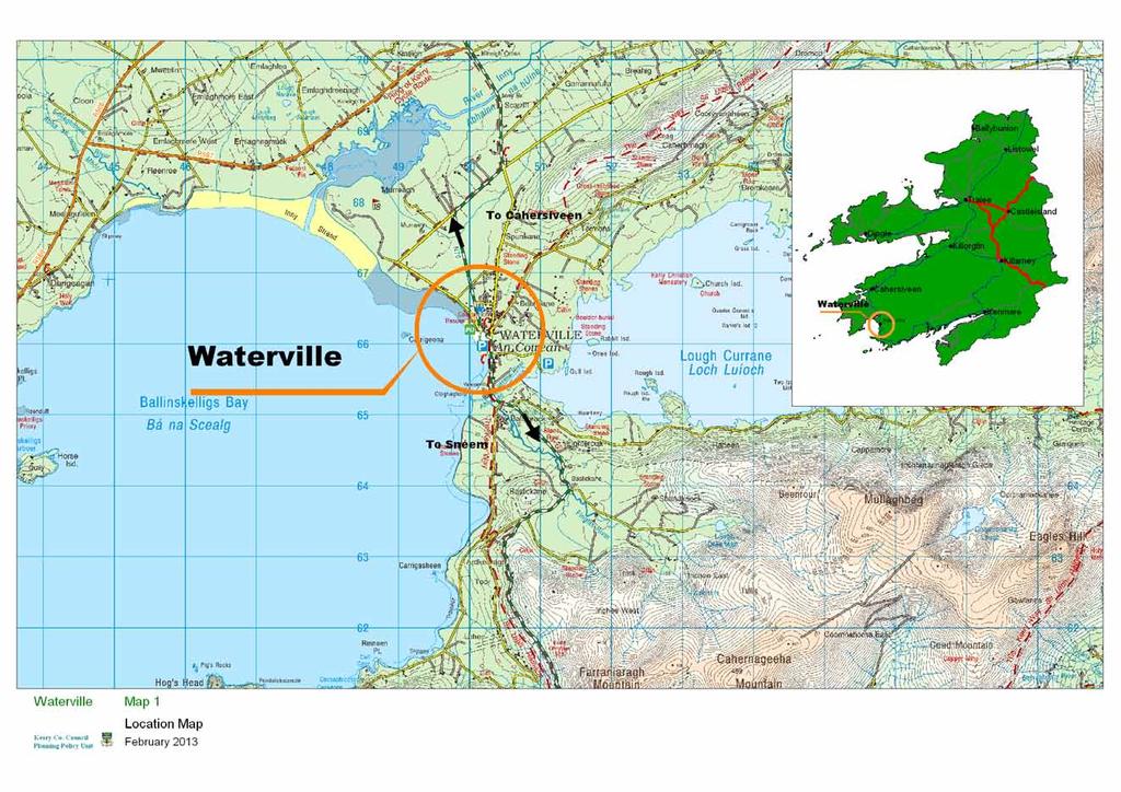
227
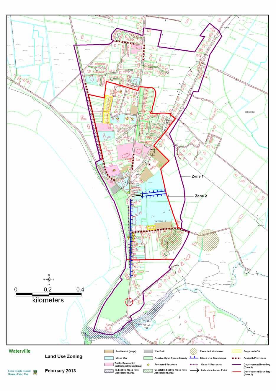
228

229 CAHERDANIEL LOCAL AREA PLAN 1.0 CONTEXT 1.1 Location Caherdaniel (Cathair Dónaill - Donal s Fort) is a small scenic coastal village located on the N70 on the Iveragh Peninsula. It is located approx 13km southeast of Waterville and approx. 20km west of Sneem. The village is just under a kilometre from Derrynane Bay. Derrynane House the home of Daniel O Connell is less than 3 km to the west of the village. Cathair Dónall is located within An Gaeltacht Uíbh Ráthaigh. N70 Fig 1.1 Location of Caherdaniel Settlement 1.2 Population There are no population figures for the village of Caherdaniel itself. It is located within the ED of Cathair Dónaill. The population in this ED decreased between 2006 and 2011 from 348 to 312 people. This is a 10% decline. The population in adjacent ED of Doire Fhíonáin (Derrynane) increased over the same period from 170 to 189. This is a 10% increase. 1.3 Functions & Facilities Caherdaniel is primarily a tourist village availing of its proximity to Derrynane and its location on the Ring of Kerry route. The village also provides a basic range of services to the surrounding hinterland. Waterville Functional Area Local Area Plan 206 Caherdaniel
230 The village has a community centre, primary school, Catholic Church, two public houses (one with restaurant facilities) and a restaurant. Derrynane GAA clubhouse and playing pitches are located to the south of the village outside the development boundary 1.4 Infrastructure There is a public water supply available in the village. Current wastewater infrastructure is inadequate. There are however proposals for a new wastewater treatment plant and a preliminary report for the provision of a new system is in place. It is unlikely that it will be built within the life of this plan. 1.5 Built Urban Form Caherdaniel has developed around the crossroads at the centre of the village. The original village was concentrated on the Derrynane road west of the N70. The main streetscape element is located on the Derrynane road. In the remainder of the village there is no developed streetscape, but rather a series of detached dwellings some with front gardens, and no set building line. Large groups of trees throughout the village add to the character of the settlement. If this streetscape was further developed it would give the village a more defined core area and urban structure. There are a variety of building types within the village. Building heights vary throughout the village. A large cluster type housing development to the north of the village is of a uniform design which is untypical of the older built forms. 1.6 Built Heritage & Archaeology The village takes its name from the nearby caher (fort), Cathair Donaill. There is one Recorded Protected Structures within the development boundary: St Crohan s Catholic Church. (ref; ) The streetscape on the southern side of the Derrynane Road from the junction with the N70 as far as the entrance to St. Crohan s is considered to be of significant architectural and heritage value and as such should be included as a proposed Architectural Conservation Area (ACA). There are no Recorded Monuments within the proposed development boundary 1.7 Natural environment and Amenity The village is located in a very scenic coastal location with panoramic views of mountain terrain and seascape. The Coomnahorna River flows through the village. An extensive area to the south and east of the village and a small area within the proposed development boundary is zoned Secondary Special Amenity in the Kerry County Development Plan The Kenmare River SAC and Iveragh Peninsula SPA are just over a kilometre to the southwest of the village. The nearby Derrynane beach has blue flag status and is a popular tourist destination particularly during the summer month. Waterville Functional Area Local Area Plan 207 Caherdaniel
231 Otters are listed for protection in this Natura 2000 site and are likely to travel from the SAC through the village via the river Coomnahorna. Development proposals, including any bridges, amenity areas and walkways will be required to be designed and operated in a manner which would not adversely impact on Otter populations in the area. A number of invasive introduced species, including Japanese knotweed, Giant Rhubarb, Buddleja (Butterfly tree) and Rhododendron are prevalent in the village. These plants not native to the area and as well as being harmful to biodiversity can look out of place as the form dense thickets along roadsides, waste ground and waterways. They reproduce rapidly and are difficult to kill once established. It is therefore very important to prevent the movement of earth contaminated with rhizomes, cuttings from hedge trimming or other fragments from one area to another. Given the prevalence of these plants in the settlement, development proposals, where appropriate, will be required to submit a suitable scheme for their eradication and/or control, prior approved by the Planning Authority 1.8 Vehicular and Pedestrian Traffic The N70 National Secondary Route which is part of the Ring of Kerry route and one of the busiest routes in the County passes through Caherdaniel here. There are a number of bends on the approach roads and within the village which has a calming affect on traffic Tourist traffic during the summer months creates a busy atmosphere but during the winter months, because of its relatively isolated location traffic is mainly local. 1.9 An Gaeltacht Uíbh Ráthaigh Cathair Dónall is located within a Gaeltacht area and the preservation and promotion of the Irish language is critical in its future development. It is considered that the revival of the Irish language college would add a further attraction to an area in need of employment and income Growth and Residential Development There has been a significant amount of residential development in the vicinity of the village over the last decade especially to the west of the village along the N70 and between the N70 and Derrynane Bay. Development has also taken place along the N70 to the north and southeast of the village and also in parts of the Lamb s Head Peninsula to the south of the village. A number of houses have been built on the seaward side of the N70 and along the road to Derrynane. It is likely that these dwellings are used as holiday homes. A few single houses for permanent residents have been completed over the same period. The number of holiday homes constructed in recent years far outweighs the number of permanent residential completions. There has been a considerable level of ribbon development on the approach roads over the years and this has largely been confined to the northern or landward side of the road. All new residential dwellings will have to comply with the rural settlement policies as contained in the County Development Plan. Waterville Functional Area Local Area Plan 208 Caherdaniel
232 There are a number of holiday homes in the village and surrounding area. It is proposed to designate land adjacent to the school for tourism and Leisure. It is considered that a sports and leisure facility with some outdoor activities would be appropriate at this location. These facilities would cater for the tourist and adjacent school. This site would also be suitable for the development of a hostel. 2.0 DEVELOPMENT STRATEGY The village of Caherdaniel has developed essentially around St. Crohans Catholic Church and the central core of the village is still concentrated on this area. Additional development outside this central core area is comprised of one-off houses. Due to its scenic location and the physical constraints such as rock outcrops and steep gradients, scope for additional development is limited. The triangular space formed by the junction of the N70 and the Coomnahorna road and an area fronting the Coomnahorna road to the southeast are viewed as key locations for the future expansion of the village core. An area fronting the N70 and an infill site also offer potential sites for additional streetscape development. The development strategy for Caherdaniel is to promote a more gradual organic development of Caherdaniel as a rural village and tourist centre commensurate with the level of infrastructure provision. Growth in recent years has been largely confined to the holiday home sector. The village is located within a Gaeltacht area and it is important that no development takes place which will be detrimental to the promotion of the Irish language. The development strategy for the village is: To ensure that future development should support the existing role and function of the village as a small local focal point for it s surrounding rural community and should have regard to the scale of the existing settlement and the setting of the village in an attractive rural landscape. That future residential development within the village should cater for the needs of the local population who wish to live in the area on a permanent basis. Promote the development of commercial/retail outlet serving the local community. Development proposals should not facilitate the introduction or spread of invasive introduced species, such as Japanese Knotweed. Waterville Functional Area Local Area Plan 209 Caherdaniel
233 3.0 SPECIFIC OBJECTIVES Objective No. OO-1 Objective No. AM-1 Objective No. CR-1 Objective No. NE-1 NE-2 Objective No. TL-1 Gaeltacht Uíbh Ráthaigh It is an objective of the Council to: Preserve and promote the Irish language. Open Space, Recreation and Amenity It is an objective of the Council to: Reserve lands for the development of an amenity area and walkway as indicated on the zoning map Commercial/retail Facilities It is an objective of the Council to: Promote the development of commercial/retail outlet serving the local community Natural Environment It is an objective of the Council to: Where invasive introduced species, including Japanese Knotweed are identified on a site or in the vicinity of a site (underground parts of the plants may extend laterally up to 7 meters), the planning Authority may request a suitable scheme for their eradication and/or control as part of the planning application process. Ensure that any significant proposed development on these lands that the council consider is at risk of flooding shall be subjected to a flood impact assessment Tourism & Leisure Facilities It is an objective of the Council to: Promote the development of tourism and leisure facilities serving the local community and tourist Waterville Functional Area Local Area Plan 210 Caherdaniel
, the other on the north side to")
234 Appendix 1 Caherdaniel Architectural Conservation Area Introduction See introduction to Cahersiveen ACA p.xxx. Location and boundary of the Conservation Area The ACA is comprised of two blocks on the Derrynane road, one on the south side with some frontage on the N70 (Block 1), the other on the north side to the west of the Coomnahorna River (Block 2). Block 2 Block 1 Map 1; ACA Boundary Historical development of the area The name of the village is derived from the name of a pre-christian cashel (Caher Donal KE ) 750 metres approx. to the west of the village. Caherdaniel developed around the crossroads formed by the intersection of the Derrynane /old Coad road and the main road around the Iveragh Peninsula now known as the N70. Waterville Functional Area Local Area Plan 211 Caherdaniel
235 Map 2; 1 st Edition OS Map (1842) 2 nd Edition OS map (1896) Map 3; 2 nd Edition OS Map (1897) In the 1 st edition of the OS map (Map. No. 2) the layout of the village centre is similar to today with St. Crohans church (built c 1825), another building to the east of the church located on what is now the N70, designated as a school house, two buildings on the south side of the Derrynane road and a group of four buildings further west on the north side of the road. Waterville Functional Area Local Area Plan 212 Caherdaniel
 shows the layout of the village centre and the footprint of the buildings as it remains today; the School house was now located to the north east of the village centre and the building previously")
236 The 2 nd edition of the OS map (Map. No. 3) shows the layout of the village centre and the footprint of the buildings as it remains today; the School house was now located to the north east of the village centre and the building previously designated as School House is now shown as Dispensary and one of the buildings on the north side of the Derrynane Road is designated as Constabulary Barracks. Some of the earliest available photographic images of Caherdaniel (Photo. No. 3 & 4), show the group of buildings on the south side of the Derrynane road much as they are today Schedule of Protected Structures and Recorded Monuments There are no structures included in the Record of Protected Structures within the ACA, although St Crohans Church just to the south of the ACA is a Protected Structure (RPS No ) There is no Recorded Monument within the proposed ACA. Photo. 1 Block 1 Photo. 2 Block 2 Photo. 3 View from north east Photo. 4 View from north west Waterville Functional Area Local Area Plan 213 Caherdaniel
237 Description of Existing Built Environment a) Street Pattern Simple street pattern, the old village developed in a linear fashion along the Derrynane road, the proximity of the Coomnahorna River, possibly prevented the development of land on the north side of the Derrynane road nearest the N70. b) Form and arrangement of public and private open space. Attractive public green space with seating on the north side of the Derrynane road. Private open space to the rear of premises. c) Socio economic functions. The properties within the ACA are a mix of residential and commercial. d) Built fabric-general description. The buildings within the ACA are relatively uniform two storey three bay, pitched roof structures with a few exceptions. (Photo 6) Photo. 5 Original slates Photo. 6 Fronting N70 e) Roofs, ridges, chimneys. There is little variation in ridge heights, simple robust centrally located chimneys, some of the buildings retain original slating material which are full of texture and tonal variations which adds to the overall character of the ACA (Photo. 5) f) Walls. The four buildings in Block 1 all have a different finish, all four originally appear to have had a plaster finish as is evident from the early Lawrence images (Photo. 4 &5). The corner building nearest the N70 with gable facing the N70 has a smooth lined plaster finish with rusticated plinth and quoin stones, next door has a pebbledash finish with smooth render plat band and eaves course (Photo No. 8 ) similar to another building in Block 2 (Photo. 7) The third building has vertical hanging slates, ( Photo. 9) not very common nowadays in this part of Kerry, Derrynane House nearby, being one of the few remaining examples. The end building has a stone finish. (Photo. 10) Waterville Functional Area Local Area Plan 214 Caherdaniel

238 Photo. 7 Platband decoration Photo. 9 Vertical hanging slate Photo. 8 Platband decoration Photo. 10 Stone facing g) Openings. The position and dimensions of openings has remained relatively unaltered over the years. Unlike many other locations there is a high retention level of wooden sliding sash windows, which makes a huge contribution to the overall character of the ACA. The four six over six sliding sash windows are an intrinsic part of the fabric of the first building Freddies and are an important element of the character of the overall ACA Waterville Functional Area Local Area Plan 215 Caherdaniel
239 Photo. 11 Photo. 11 Photo. 12 h) Boundaries. All the structures within the ACA front directly onto the narrow pavement. (Photo.13) Photo.13 i) Rainwater Goods. Some original cast-iron rainwater pipes and gutters remain but there has been replacement in a piecemeal manner. Cast iron is a resilient material and the retention of cast iron rainwater goods not only makes sense from an economic viewpoint but also enhances the heritage value of buildings. j) Views. View west from the N70 (Photo.14) Waterville Functional Area Local Area Plan 216 Caherdaniel
240 Photo. 14 View from N70 Summary of Special Character The principle features of the built form are - The retention of traditional architectural features. - Unobtrusive traditional style name plates and advertising which helps maintain the character of the ACA Negative features - some unsympathetic alterations to historic features such as windows, the cumulative effect of which is damaging to its status as a conservation area. - Guidelines for development within the Conservation area. For the Guidelines for development within the Conservation area., works not affecting the character of the ACA (do not require planning permission) and works impacting on the character of the area (works requiring planning permission) see Cahersiveen ACA Waterville Functional Area Local Area Plan 217 Caherdaniel

241
 and An Chillín Liath (Kileenleagh) are two small settlement nodes located inland on local roads off the N70 on the Iveragh Peninsula approximately 9km to the")

242 MÁISTIR GAOITHE & AN CHILLÍN LIATH LOCAL AREA PLAN 1.0 CONTEXT 1.1 Location Máistir Gaoithe (Mastergeehy) and An Chillín Liath (Kileenleagh) are two small settlement nodes located inland on local roads off the N70 on the Iveragh Peninsula approximately 9km to the northeast of the town of Waterville and approximately 13 km south of Cahersiveen. There is an approximate distance of 4km between the two settlements. For the purposes of the local area plan, the two settlements will be treated together as they are in effect ancillary to each other and are closely linked in terms of function, services and community. Both settlements are located within the Gaeltacht Uíbh Ráthaigh Fig 1.1 Location of settlements 1.2 Population There are no population figures for the village of Máistir Gaoithe/An Chillín Liath itself. It is located within the EDs of Doire Ianna and Máistir Gaoithe. Between 2002 and 2006 the population fell from 292 to 285. It decreased marginally in the 2011 census to 271 people. Waterville Functional Area Local Area Plan 218 Máistir Gaoithe & An Chillín Liath
243 1.3 Functions & Facilities Máistir Gaoithe/An Chillín Liath provide essential rural services to a dispersed rural catchment area, which primarily relies on agriculture and forestry for employment. The settlement in Máistir Gaoithe has declined over the years with the closure of the school in the early 1970s and the church in the early 1990s. These facilities are now located in An Chillín Liath. Forbairt na Dromoda is based in An Chillín Liath. This has a public house (Inny Tavern), shop, the Dromid hostel, a community hall/day care centre and industrial/commercial units all in one complex. All that remains in Máistir Gaoithe is the Post Office and a small number of dwelling houses. Máistir Gaoithe is now essentially a rural area with a high density of dispersed rural housing. It is a dispersed settlement rather than a village in the traditional sense. The Kerry Way walking route passes through the area. This route provides further opportunities for developing this niche tourist market. 1.4 Infrastructure An Chillín Liath is supplied with water from a group water scheme. There is no existing wastewater treatment plant in the village and there are no plans to install one. 1.5 Built Form An Chillín Liath is a dispersed rural settlement located between the road and the River Inny. It comprises of the church, school, the community services centre, located at the core. There is no developed streetscape; rather, the village is comprised of detached dwellings with varied setbacks. The Ionad an Dromada development consists of a number of well designed buildings (see below). Waterville Functional Area Local Area Plan 219 Máistir Gaoithe & An Chillín Liath
244 1.6 Built Heritage & Archaeology There is one Recorded Protected Structures; the old National School in Máistir Gaoithe (Duchas Ref. No ). There are a number of recorded monuments in the area but only one within the existing settlement of Máistir Gaoithe; a standing stone located approximately 60metres to the north of the old school. (Ref No. KE ) 1.8 Natural environment and Amenity An Chillín Liath is located on flat low lying ground on the south bank of the Inny river. Much of the surrounding countryside is covered with coniferous plantations. Just over 4 km to the south the land rises significantly to peaks of over 650 metres and there are a number of lakes including Lough Derriana. All this area is part of the Killarney National Park candidate Special Area of Conservation. 1.9 Vehicular and Pedestrian Traffic Tourist traffic during the summer months creates a busy atmosphere but during the winter months, because of its relatively isolated location traffic is mainly local. There is no footpath network in the village Employment There is a commercial unit in Ionad an Dromada occupied by Ivertec Ltd. Ivertec Ltd is a developer of information management software and services to all levels of the education sector. Sceilg Ola which is a fuel company operates from the area An Gaeltacht Máistir Gaoithe and An Chillín Liath are located within the Gaeltacht Uíbh Ráthaigh and the preservation and promotion of the Irish language is critical in its future development 1.12 Growth and Residential Development This area is comprised of scattered one off housing. There has been a considerable level of ribbon development on the approach roads over the years and this has largely been confined to the northern or landward side of the road. All new residential dwellings will have to comply with the rural settlement policies as contained in the County Development Plan. The development boundary for Máistir Gaoithe & An Chillín Liath defines the existing extent of the area where new development may be considered, whilst also allowing for some expansion for development adjacent to the settlement core. Waterville Functional Area Local Area Plan 220 Máistir Gaoithe & An Chillín Liath
245 2.0 DEVELOPMENT STRATEGY The overall vision for Máistir Gaoithe and An Chillín Liath is to maintain the character of this distinctive dispersed settlement pattern, to promote the area as an attractive place to live in and to visit, while preserving and enhancing the use of Irish as the daily communal language. The development strategy therefore is to: Ensure that any future developments should be sensitive to the existing character of the area and should be appropriate in scale. Developments which are open on a year round basis should be encouraged. Promote the redevelopment of commercial/retail outlet serving the local community at an appropriate location Preserve and promote the use of Irish language Ensure that all residential development shall cater for the needs of the local population who wish to live in the area on a permanent basis. Encourage the sustainable development of ecotourism and other niche markets along with the sustainable extension and diversification of tourist facilities as a possible source of employment Ensure that all proposed developments are compatible with the conservation objectives of the Natura 2000 sites in the area. 3.0 SPECIFIC OBJECTIVES Objective No. ICF-1 Infrastructure and Community Facilities It is an objective of the Council to: Encourage the provision of facilities along the Kerry Way Walking Route at appropriate locations in a sustainable manner Waterville Functional Area Local Area Plan 221 Máistir Gaoithe & An Chillín Liath

246


247 Section 3b RURAL AREA 1.0 OVERVIEW 1.1 Introduction The rural area of the Waterville Functional Area Local Area Plan, shown in Figure 1, is defined as all the rural area within the functional area boundary and outside the boundaries of the town, villages and the small villages/development nodes. The rural area, as defined in this plan, is functionally linked to the settlements. Figure 1: Waterville Functional Area Those living in the rural area are largely dependant on the town and villages for services such as schools, services and employment. It is likely that a substantial proportion of people travel to larger towns such as Cahersiveen, Kenmare, Killarney and Killorglin for employment. Tourism and agriculture are strong in this area. Waterville Functional Area Local Area Plan 222 Rural Area
248 1.2 Purpose of Rural Area Plan The functional area local area plan will; Look at rural area at a local level as opposed to the more strategic level of the County Development Plan. Identify strengths, weaknesses, opportunities, threats in the rural area. Gather information on the rural area. Identify protected structures in the rural areas. Identify objectives for the rural area that are not at the strategic County Development Plan level. 1.3 SWOT ANALYSIS FOR RURAL AREA Strengths A strong urban centre (Waterville Town) as a focal point Major tourist destination Strong cultural & linguistic heritage, Gaeltacht Uíbh Ráthaigh Attractive and varied landscape/seascape with coastline, inlets, rivers, lakes, pastures and mountains Strong economic and social linkages between the rural area and urban settlements Villages have in the most part retained their character Area with some of the best scenery in the country On the Ring of Kerry tourist route Existing piers and outdoor pursuits e.g. bird watching, fishing, walking, hill and mountain climbing, marine leisure etc Renowned golf courses at Waterville Blue Flag Beach at Derrynane Weaknesses Peripheral location Difficulty in competing with the range of services and attractions on offer in Killorglin, Cahersiveen, Kenmare and Killarney Reliance on tourism with seasonal nature Limited employment opportunities Opportunities Conserve built heritage Protect the natural environment and biodiversity Increase level of marine leisure activities, ecotourism and other niche markets in a sustainable manner. Promote walking tours, hill and mountain climbing at a sustainable level. Promote sustainable mari-culture Greater use of the marine environment for sustainable leisure activities Waterville Functional Area Local Area Plan 223 Rural Area


249 Threats Over-development of rural area. Decrease in numbers speaking Irish Pollution of surface and groundwaters Loss in quality of landscape. Unemployment/emigration Loss of biodiversity External economic factors and competition from cheaper locations Affordability of transport fuel 1.4 Population The population of the entire Functional Area in the 2006 Census was 2,173 persons and in 2011 it was 2,052. The population growth target indicates that the population of the entire plan area will grow by 160 persons between the years 2012 and 2018 to a total of 2, census 2006 census 2011 census 2012 estimate 2018 target Waterville Functional Area 2, ,052 2,078 2,238 Table 1; Population change and population target in the Waterville Functional Area Figure 2: Population Change Waterville Functional Area Local Area Plan 224 Rural Area
250 1.5 Transport The area is served by the N70, national secondary route (Ring of Kerry), the R567 regional road and a network of local roads. It is important that any development in the rural areas is acceptable in terms of traffic safety and does not impact negatively on the carrying capacity and general safety of public roads in accordance with Chapter 8 and section 13.9 of Chapter 13 in the Kerry County Development Plan Figure 3; Road Network in the Waterville Functional Area 1.6 Cyclepaths / Walkways Marked paths and cycle routes are an important resource for attracting tourists and providing recreation for local residents. They can also open up potential for farm diversification into small-scale tourist services. Numerous spectacular walking routes exist in the functional area. The Kerry Way (Slí Uíbh Rathach) walking trails also intersect through the plan area. The route splits in two just south of Maistir Gaoithe and encircles Lough Currane and rejoins at Waterville. These established walkways provide some of the most scenic views as well as isolated and dramatic countryside in the County. The Derrynane Mass Path is a 6km loop walk through the grounds and vicinity of Derrynane House. Marked paths and cycle routes are an important resource for attracting tourists and providing recreation for local residents. They can also open up potential for farm diversification into small-scale tourist services. Waterville Functional Area Local Area Plan 225 Rural Area


251 However, in order to protect the underlying environmental attributes and resources in the area, upon which much of the tourist industry is based, it is important that due consideration is given to these when providing for new routes or intensifying use of less established routes 1.7 Water Supply The area is served by public water mains, group water mains and private water supplies. It is imperative that groundwater is protected from polluting development. All development must have regard to the zones of influence for groundwater public water supplies and catchments for surface water public supplies. Figure 4: Water supply and source in the Waterville Functional Area 1.8 Wastewater Treatment Developments in the rural area are served by individual septic tanks/treatment units based on an assessment of soil characteristics in accordance with the EPA s Code of practice- Wastewater Treatment and Disposal Systems serving Single House (p.e. 10) or any subsequent amendment or revision documents Waterville Functional Area Local Area Plan 226 Rural Area


252 1.9 Landscape The study area located on the south western part of the Iveragh Peninsula is centered on the town of Waterville and delineated by the sea to the west and by a line of Mountain ranges to the south and east. Several different sub landscapes (Corine Data 2006) are notable here with the summits and upper slopes of the mountains and hills covered with peat bog/moorland There are large areas of natural grassland/pastures and natural vegetation area in the lower areas and mountain foothills. Ballinskelligs and Derrynane Bay comprises of a slightly varied topography and landscape than that of the remainder of the functional area. This area consists of sand dunes and marshes/lagoons. The settlement patter in this function area is scattered on the lower topography around the main roads, services and smaller settlements. Having regard to the spectacular landscape present here a number of views and prospects are designated in this functional area. These are illustrated in Figure 5 below. Figure 5: Views and Prospects and Special Amenity areas in the Rural area 1.10 Natural Environment The Waterville functional area has a variety of spectacular physical features and biodiversity which combined produce some of the most intriguing natural environment in Ireland. Waterville Functional Area Local Area Plan 227 Rural Area


253 The extent of SPA (Special Protection Areas) and SAC (Special Areas of Conservation) areas are shown in Figures 6 & 7 and Map Ru-3 and are listed in Table 2 Natura 2000 site boundaries are subject to change refer to for current boundaries. Designation Type Site Code Site Name SPA Iveragh Peninsula SPA SPA Deenish Island & Scarriff Island csac Ballinskelligs Bay & Inny Estuary csac Killarney National Park, MacGillycuddy Reeks and Caragh River Catchment csac Kenmare River Table 2; SPA and SAC in the Rural Area Figure 6: SPAs in the Rural Area Waterville Functional Area Local Area Plan 228 Rural Area


254 Figure 7: csacs in the Rural Area Designation Type Site Code Site Name NHA Knockroe bog NHA Table 3: NHA in the Rural Area Waterville Functional Area Local Area Plan 229 Rural Area

255 Figure 8: NHA in the Rural Area There are a number of mature trees and woodlands in the area around Derrynane National Park which are important in terms of biodiversity and providing amenity areas to the public Amenity The plan area has many fine beaches including Derrynane beach in the southern region of the plan area. This beach has a Blue Flag designation. The area contains Ballinskelligs Bay, Lough Currane and Derrynane Historic National Park and beach with one of the most attractive scenery and landscape on the south west coast of Ireland. Numerous coastal and mountain walks are dotted throughout the local landscape Tourism Tourism is a significant industry in the Waterville Functional Area as it includes a large amount of attractive coastline and estuary, which contain features of historical, cultural and natural significance popular with visitors. This area attracts significant visitor numbers each year. Similarly, the Ring of Kerry provide internationally renowned attractions for day-trippers, long stay tourists, water-based activities and leisure breaks. Derrynane House and its associated National Park and adjacent beaches attract tourists to the area. Waterville Functional Area Local Area Plan 230 Rural Area
256 The attractive coastline and beaches in the area which have features of historical, cultural and natural significance also provide opportunities for shore angling, deep-sea fishing and walks.lake Currane is renowned for the some of the best salmon and sea trout angling in Europe. Bird watching, whale, dolphin and shark spotting are becoming increasingly popular along the coast of the Iveragh Peninsula. Horse riding and other equestrian sports are popular in Caherdaniel and along the beaches. There are a number of caravan/camping sites located in the Derrynane and Glanbegs area which are occupied on a seasonal basis. The Planning Authority will encourage the sustainable upgrading and the improvement of facilities in existing caravan parks in order to attract more tourists to the area and provide local employment. The tourism industry relies on the quality and attractiveness of the built and natural heritage and the objectives in the Kerry County Development Plan , that are directed towards the conservation of the built and natural environments must be respected not only for their own sake but because of their importance of these underlying resources to the local economy. Efforts need to be made to lengthen the tourism season in this area and this could be achieved by further promoting ecotourism in the area. This is a form of tourism which appeals to the ecologically and socially conscious. Large numbers of waterbirds and waders overwinter within the plan area which could be used to attract tourists to the area in the off season. Similarly whale and sea eagle tours are possible during the winter months. When considering proposals for new tourism development, priority will be given to those that are encouraging longer visitor stays and add to the range of facilities available to people who live in the area all year round. The area is also located in the Gaeltacht Uíbh Ráthaigh which is rich in traditional ways, folklore, writing, music, and historic and archaeological sites.the potential for a niche eco-tourism in the area is immense, but is not fully developed. Efforts need to be made to promote the use of the language as figures indicate that the overall numbers speaking Irish daily is at a critically low level Built Heritage There are a number of existing protected structures in the rural area; Reg no Mastergeehy School Reg no Derrynane Abbey Reg no Derrynane Abbey Lodge Reg no Derrynane Abbey Summer House Reg no Dwelling house,west Cove Reg no Former Coastguard Complex, Castlecove It is proposed to add an additional structure to the list. RPS KY Ballybrack Cottage, Waterville Waterville Functional Area Local Area Plan 231 Rural Area


257 1.14 Archaeology The archaeology of the Waterville area is representative of all periods from the Late Neolithic/Early Bronze Age transition to the medieval period. Wedge tombs are scattered throughout the area with a notable concentration at Coomatloukane while there is evidence for Early Bronze Age copper mining at Coad and Behaghane. The Inny valley has substantial numbers of Bronze Age ritual monuments such as standing stones, pairs and stone alignments, while the enigmatic alignment and enclosure at Eightercua is a National Monument. Early monastic enclosures such as Dromkeare and Kilpeacon attest to the ecclesiastical importance of the area while the island monastery on Church Island in Lough Currane, with its fine collection of cross slabs, is a National Monument. Figure 9: Archaeological monuments & protected structures The Early Medieval secular settlement of the area is evidenced in the numbers of cashels (stone forts), particularly around Caherdaniel and Lough Currane, while the settlement complex at Beenbane and the fine fort at Loher are both National Monuments. In general terms the Waterville Functional Area contains an archaeologically rich and diverse area of the county. There are approximately 410 monuments listed in the Record of Monuments & Places within the FAP area, including archaeological complexes comprising numerous individual monuments and features. The monuments range in date from the Late Neolithic to the Early Medieval period. There are 6 National Monuments located here of which 4 are in state ownership, 1 is in state guardianship and 1 is subject to a preservation order. A further 3 monuments have been entered in the Register of Historic Monuments (Registration). Waterville Functional Area Local Area Plan 232 Rural Area
258 The National Monuments and Registered Monuments within the functional area are listed below in Tables 4 and 5, while particularly important landscapes with high densities of recorded monuments in two particular areas are outlined in the following pages. Finally general and specific archaeological objectives for the plan are suggested. TOWNLAND DESCRIPTION STATUS RMP NM_No Loher Cashel Ownership KE Darrynane Beg Ogham Stone Guardianship KE Cloghanecarhan Ringfort & Ogham Stone Ownership KE Beenbane Complex Ownership KE , 30, 34, /492 Church Island Ecclesiastical Site Ownership KE Eightercua Alignment & Enclosure Preservation KE PO152 Table 4: National Monuments within Waterville Functional Area Townland Description RMP No Reg No Caherdaniel Cashel Ke Dromkeare Monastic Enclosure Ke Eightercua Stone Alignment Ke Table 5: Registered Monuments within the Waterville Functional Area 1.15 Flood Risk Management Flood Risk Data for the functional area has been mapped on figure 10, using soil maps, recorded flood event locations and lands benefitting from OPW drainage schemes (available on ). In addition the OPW have published draft preliminary flood Zone Maps for the County. Flood Risk Management in the area will be in accordance with the 2009 Government Guidelines on The Planning System and Flood Risk Management, the relevant development objectives of this plan and with Section 11.4 of the Kerry County Development Plan Figure 10 shows recorded flood locations and other potentially vulnerable areas. Kerry County Council has a policy to limit and manage the permitted runoff from all new developments, in order to protect river water quality and to avoid downstream flooding of the sewer network or river. Any large scale developments must incorporate Sustainable Urban Drainage Systems (SUDS) to restrict the discharge of stormwater from developments. Kerry County Council has a number of interim standards covering river quality protection, river regime protection and river and coastal flooding protection. Waterville Functional Area Local Area Plan 233 Rural Area


259 Figure 10: Flood Data in the Rural Area 1.16 Windfarms Kerry County Council is preparing a Renewable Energy Strategy. The draft strategy is currently on public display. The adopted strategy will be incorporated into the County Development Plan 1.17 Piers / Harbours There are a number of small piers and harbours located around the coast of the functional area. These piers are used for various purposes including fishing, tourism and leisure. These piers are maintained by Kerry County Council. It is the policy of Kerry County Council to maintain and repair these piers for public use and to support the sustainable development of the piers as potential economic generators for the area and support the maintenance of other facilities such as slipways and to protect them from inappropriate uses. Waterville Functional Area Local Area Plan 234 Rural Area
260 2.0 OVERALL OBJECTIVES Ru-1 Ru-2 Ru-3 It is an objective of the Council to: Provide for balanced growth throughout the area by promoting the strengthening of rural communities and provide the infrastructure to facilitate job creation and diversification in these areas in a sustainable manner. Ensure that development on un-serviced lands comply fully with the Code of Practice; Waste water treatment and disposal systems serving single houses and where necessary Wastewater Treatment Manuals - Treatment Systems for Small Communities, Business, Leisure Centres and Hotels. Ensure that all fish bearing watercourses within the plan area and their riparian zones including flood plains are protected from significant harmful development and from the effects of wastewater discharges. 3.0 SPECIFIC OBJECTIVES Ru-A-1 Ru-A-2 Ru-AT-1 Ru-AT-2 Ru-AT-3 Ru-AT-4 Ru- AT-5 Ru-AT-6 Ru-AT-7 Archaeology Objectives It is an objective of the Council to: Ensure the preservation of all archaeological monuments and features in the plan area as included or scheduled for inclusion in the Record of Monuments & Places. Any proposed development within the lands highlighted as representing the zone of archaeological potential around a monument listed in the Record of Monuments & Places (RMP) will be referred to the National Monuments Section, DoAH&G. Such developments will be the subject of archaeological impact assessment and may require further subsequent archaeological mitigation buffer zones/exclusion zones, monitoring, pre-development archaeological testing, archaeological excavation and/or refusal of planning. Amenity & Tourism It is an objective of the Council to Encourage the development of walking routes within the plan area and associated car parking facilities at appropriate locations so as to facilitate sustainable outdoor recreational activities in the plan area. Encourage the improvement of sensitively designed tourist information boards and signage at appropriate locations. Protect and encourage the development of literary, musical, artistic, sporting and other cultural heritage initiatives. Facilitate the sustainable extension and diversification of tourist facilities Encourage the upgrading and the improvement of facilities in existing caravan parks in a sustainable manner. Protect the sand dunes / dune system in the plan area,in particular Waterville and Caherdaniel area, and prohibit any development that would damage or lead to erosion of any dune system. Protect from inappropriate development the protected views and prospects in the plan area as identified in figure 5. Waterville Functional Area Local Area Plan 235 Rural Area
261 Built Environment It is an objective of the Council to: Ru B-1 Encourage the appropriate reuse and sensitive restoration of unused/derelict properties. Ru-EE-1 Ru-EE-2 Employment and Economic Activity It is an objective of the Council to : Facilitate sustainable diversification of the rural economy. Provide the infrastructure and support for the sustainable development and expansion of employment opportunities, including indigenous knowledge based industries. Waterville Functional Area Local Area Plan 236 Rural Area
262 APPENDIX 1 Proposed Protected Buildings SHEET 1 Unique identity number: RPS KY Address: Ballybrack Cottage, Waterville Description: T shaped detached one and a half storey, three bay dwelling house, with four equidistant prominent chimney stacks. Modern porch Ordnance Survey Map: 6440D National Grid co-ordinates: 50,623m, 65,179m Site features: Garden area to front, outhouses to the rear of the building. Special interest; Architectural Location Map (not to scale) Appraisal: Depicted in the 1 st. edition OS map (1842) as a Post Office. A member of Daniel O Connell s extended family resided here for many decades. The symmetrical form and the proportions of the house add to its attractions. This building is an important element of the architectural history of the Waterville area. Waterville Functional Area Local Area Plan 237 Rural Area

263

264
265 SECTION 4 SNEEM FUNCTIONAL AREA LOCAL AREA PLAN Sneem Functional Area Local Area Plan 238 Sneem
266 Section 4a SNEEM LOCAL AREA PLAN 1.0 CONTEXT 1.1 Location The picturesque town of Sneem (An tsnaidhm The Knot), is located on the N70 on the Iveragh Peninsula and Ring of Kerry tourist route and is located approximately 25km to the west of Kenmare and 30km to the east of Waterville. The R568 to the northeast connects the town with Molls Gap and the N71 to Killarney which is 45km away. The town is attractively located on the River Sneem with dramatic mountains as a backdrop. 1.2 Population There are no population figures for the village of Sneem in the 2011 census. The village is located within the electoral DED of Sneem. The census recorded a decrease in the population between 2006 and 2011 from 577 to 555 persons. This equates to a percentage loss of 3.8%. While the population of the town is relatively small, the extent of the built up area and the bustling nature of the town give the impression of a larger town. In accordance with the RPG and the Core Strategy it is intended to allocate 50% of the Sneem Functional Area Plan growth to the town. This represents an increase of 57 persons in the period Growth and Residential Development The development boundary for Sneem defines the existing extent of the area where new development may be considered, whilst also allowing for some expansion for some redevelopment in the town core. The development boundary is largely determined by topography and infrastructural considerations. It is envisaged that Sneem will have a projected population increase of 57 people during the plan period. At an occupancy rate of 2.6 persons this equates to 22 dwellings at an average density of 5 dwellings /acre (12/ha), indicating a demand for 4.4 acres (1.8 Ha) of zoned land. This figure in conjunction with an allowance of headroom to ensure choice in the market for development land equating to a 50% increase on actual housing land requirement, in line with the Development Plans Guidelines for Planning Authorities (DoEHLG, 2007) results in a overall figure of 6.6 acres( 2.7 ha). The additional headroom is included to allow for the provision of competition, the avoidance of market monopoly and the non availability of zoned lands.therefore 6.6 acres (2.7ha) are required to be zoned to fulfil the urban residential housing demand over the period of the plan. Settlement Area of Land Zoned Residential (acres)* Projected Housing Provision (no.) Sneem 6.6a (2.7 ha) * includes 50% headroom Table 1.1 Land Requirement and Population projection Projected Population Increase Sneem Functional Area Local Area Plan 239 Sneem
267 The survey of ongoing housing developments conducted by the DoECLG and Kerry County Council concluded that there are a number of the unfinished/derelict/vacant estates in the town. These estates contain dwelling units at various levels of completion. It is the policy of Kerry County Council to seek the completion of these estates. Considering the existing availability of 26 vacant completed units, an additional 36 units commenced, 31 not commenced it is considered that there is a sufficient amount of existing housing available to meet the housing demand. It is therefore proposed not to zone any additional land for residential purposes. 1.4 Functions & Facilities Sneem is an important service town for its rural catchment area, especially as it is located a significant distance from other major service towns such as Kenmare and Killarney. It is also a busy tourist stopping point on the Ring of Kerry tourist route. It therefore serves an important dual role in the South Kerry area The town has a wide range of services and facilities. There are several small shops in the town and several pubs, cafés and restaurants. The town also has a primary school, a Garda station, a fire station and both Catholic and Church of Ireland churches. The Sneem Hotel is located on the Kenmare Road and adds to the range of tourist accommodation available in the town. Sneem boasts large amenity areas which are mainly focused on the River Sneem and Quay Road. There is a tennis court at the western side of the river and a playground at Sea View. On Quay Road there is a Garden of the Senses, a public barbeque area, Bird Village and a sculpture park (The Way the Fairies Went). The Geopark building is located on South Square on the Killarney Road. Kerry Geopark comprises an area c.500sq.km comprising of a number of communities including the Blackwater, Sneem, Caherdaniel, Derrynane and Tahilla (not all included in the functional area of this plan) and is an area rich in geology, man-made features, flora and fauna. 1.5 Infrastructure Sneem is located on the National Secondary route N70 and experiences considerable through traffic and congestion during peak times in the tourist season. Its physical configuration as a single long street with a narrow single lane bridge aggravates the problem. As a busy tourist town the pressure of through traffic volume and a busy stop on the ring of Kerry, leaves a marked effect on the towns environmental qualities. Sneem has a new modern treatment plant with a 2,500 population equivalent. The treatment plant was funded by public private partnership which was the first that was funded in this way in the county. It is the policy of Kerry County Council to ensure that all new residential dwellings located within the settlement and within the sewer catchment shall be connected to the public sewer. Sneem Functional Area Local Area Plan 240 Sneem
268 1.6 Urban Form Sneem has retained a compact and attractive urban form which has developed around the Squares and the natural features of the area. The town is focused on two squares, North Square and South Square, which are noted on the 1841 survey of the town. The squares are separated by the River Sneem and a narrow stone bridge from which there are attractive views of the River. Both Squares are in fact triangular in form and are based around two fair greens which are very well maintained and contain a number of public art pieces and statues to local characters. The streetscapes which form both squares are attractive and highly coloured giving the town a distinct character The North Square is the largest and the quieter of the two squares and contains many residential properties while South Square contains more of the tourist orientated shops. 1.7 Built Heritage & Archaeology There are eight structures included in the Record of Protected Structures, which are as follows: Ref. no Ref. no Ref. no Ref. no Ref. no Ref. no RPS KY RPS KY Sneem Garda Station Sneem Bridge Church of the Transfiguration The Blue Bull, South Square Quill s Woollen Market, South Square St. Michael s Catholic Church The Way the Fairies Went (Stone Sculptures) Sneem House, formerly Sheehan s Hotel, South Square The town has several important buildings and streetscapes. ACAs are proposed in order to maintain the architectural integrity and form of both Squares. There are no recorded archeological monuments within the plan area. 1.8 Natural environment and Amenity The town is set in a high quality natural environment which is reflected in the amount of public parks that have been developed in the town. The town s people recognise the importance of their environment which is evident from the high standard to which the town centres and amenity areas are maintained. As the town is on an important tourist route, it is vital that attractive views of the river from the bridge be maintained and that areas adjacent to the river are kept free from inappropriate development. Sneem Functional Area Local Area Plan 241 Sneem
269 The River Sneem running through the town is a candidate Special Area of Conservation ( Kenmare River). There is a history of flooding at certain locations along the river and any proposed development or works in proximity to the river will have to be carefully assessed by means of a flood impact assessment. A major development constraint in the town will be the preclusion of development on the flood plains of the River. As part of any project to provide a pedestrian bridge to the south of the river linking the amenity areas, the development is required to demonstrate compatibility with the Nature Conservation Objectives of Natura 2000 sites in the vicinity by way of an Article 6, Habitats Directive Assessment. Views of the river from Sneem Bridge and the Special Interest of Sneem Bridge which is a protected structure should also be protected 1.9 Vehicular and Pedestrian Traffic The town suffers from traffic congestion in particular during the tourist high season. This is due to the single lane bridge at the centre of the town and the volume of tourist traffic that passes through. Parking is a problem in the town during the summer when many cars and coaches park haphazardly on the North and South Squares. Not only does this cause congestion, it also takes away from the visual enjoyment of the Fair Greens and the surrounding streetscapes. Parking for coaches and cars is therefore an urgent requirement in the town. It is recognised that any new car/coach parks need to be centrally located so that they will be used by visitors and locals as an alternative to parking on both Squares. Junction improvements at the junctions of North Square and Seaview and South Square and Quay Road are also required. The latter especially is hazardous as it is a busy and restricted junction and visibility is often obstructed by parked vehicles. New footpaths and footpath improvements are needed in certain areas of the town to improve pedestrian connectivity and pedestrian safety. The movement of pedestrians between the town and amenity areas would be improved by the provision of a new pedestrian footbridge on the south side of Sneem Bridge. This will allow for better pedestrian connectivity between amenity areas on both sides of the river. A favoured design or location for this proposed crossing has not been identified at this stage. Support for this proposal is conditional on its compatibility with Nature Conservation Designations, Flood Risk Management, Water Quality and Landscape protection objectives. As part of this any such project will be required to demonstrate compatibility with the Nature Conservation Objectives of Natura 2000 sites in the vicinity by way of an Article 6, Habitats Directive Assessment Employment The main source of employment in the area is the service industry and tourism related employment. The town is over reliant on tourism of a seasonal nature and measures to encourage year round employment must be encouraged. Sneem Functional Area Local Area Plan 242 Sneem
270 1.11 Residential Development There are many residential properties on the two squares in the town and in the approach roads into the town. Three housing developments have been constructed in the town over the last few years. One on the Kenmare road to the east of the town, the second is located off North Square and the third is a mixture of contemporary holiday homes and permanent homes on the western edge of the town on the Waterville Road. There are a number of unfinished dwelling units within these estates. Ribbon development has occurred on the approach roads into the town from Molls Gap and Kenmare Flood Management It is the policy of the Council, that development should not be subject to an inappropriate risk of flooding nor should it cause or exacerbate such a risk at other locations. In this regard, applicants for development shall ensure that the Plan fully integrates the requirements of the Flood Risk Management Guidelines where relevant and appropriate. The OPW have published draft preliminary flood Zone Maps for the County, these are noted by Kerry County Council. Any proposed development on those lands shall be subject to a flood impact assessment. 2.0 DEVELOPMENT STRATEGY The overall strategy aims, through its land-use planning function, to improve the quality of life of the residents of the town and through its zoning provisions to promote economic development in a sustainable manner capitalising on the towns indigenous strengths and qualities. The strategy is to provide for the development of the town as an important tourist town and a local service centre on a scale commensurate with its infrastructural capacity and ensure that the unique character of the town is retained in its high quality environmental setting so that the town continues to be an attractive place to live and visit. At present, there is a good balance between tourist development and development for locals in the town. Future development needs to maintain the fragile attractive character of the settlement. The architecture form and layout of the North and South Squares form an intrinsic element of the character of the town, which must be maintained. It is an objective to designate and preserve the areas fronting onto the squares as architectural conservation areas. In order to reduce congestion and improve the appearance of the town during the summer months the strategy is to provide for a designated coach park incorporating toilet facilities. The operation of this car park may require additional traffic management measures. Sneem Functional Area Local Area Plan 243 Sneem
271 While Sneem contains some of the most attractive amenity provision of any town within the County, knowledge of and access to these amenities is not readily apparent to visitors. The strategy aims to create greater permeability, connectivity and access between these amenities, thereby integrating them with the town. This will enhance the overall image of Sneem and complement it s urban form with a definite environmental image. In order to counter ongoing population loss, Sneem needs to attract permanent residents. The provision of holiday homes, while creating a demand during summer months and thereby sustaining employment in the services sector, has its drawbacks in attracting permanent residents. People wishing to reside permanently in Sneem do not wish to live in development where many of the dwellings will be empty for a large part of the year, where they will not know their neighbours and where there will be no sense of place, identity on community spirit. This strategy considers that, in view of the level of residential development permitted within the town that residential development for the period of the plan should be for permanent residential development. It is considered that further holiday home development will militate against the creation of an attractive town for permanent residents. It is considered that the Sneem area needs to capitalise on its local strengths and the strategy aims to promote Sneem as a centre for craftwork and arts. An area of land has, therefore, been zoned for a craft village, which it is hoped can be developed for small craftwork units. In addition, it is proposed to zone an area within the town to expand the retail facility and provide an opportunity for the sale of local produce both local crafts and horticultural products from the local hinterland. 3.0 OVERALL OBJECTIVES Objective No. OO-1 OO-2 OO-3 OO-4 It is an objective of the Council to: Encourage the development of a compact and sustainable town structure by ensuring that new development is contiguous with existing development and makes effective use of backland and infill sites Ensure that the high quality and unique natural setting of the town and the amenity areas in the town are protected from inappropriate development Promote attractive streetscapes and approaches into the town by using appropriate urban design techniques to preserve and enhance the elements of the built environment which define the unique character of the town Ensure that the scale and balance of tourist facilities in the town is designed so that excessive or inappropriate tourist developments do not detract from the unique character of the town. Sneem Functional Area Local Area Plan 244 Sneem
272 4.0 SPECIFIC OBJECTIVES Objective No. OS-1 OS-2 OS-3 OS-4 OS-5 OS-6 OS-7 OS-8 Open Space, Recreation and Amenity It is an objective of the Council to: Ensure that development shall not have a significant detrimental impact on the natural environment Facilitate the development of new amenity areas in the town where appropriate Facilitate the provision of a river walkway along the Sneem River, in particular to the North of the Bridge. Ensure that the water quality of the Sneem River which is part of the Kenmare River csac (002158) is maintained and protected from polluting development Ensure that developments within the flood plain of the river will not be permitted. Any applications for developments in proximity of the river shall be accompanied by a flood impact assessment indicating any flood mitigation measures proposed Ensure that infill and riverbank alteration will be prohibited where there is a risk of interference with the aquatic habitat and flood discharge. Any such development will be subject to the approval of the Inland fisheries Ireland and the OPW Ensure that when development may have a significant environmental impact on the natural environment of the Sneem River that an environmental report is prepared. Prepare a tree preservation order for appropriate trees throughout the settlement and promote additional planting Objective No. COM-1 COM-2 COM-3 Commercial/Retail Facilities It is an objective of the Council to: Zone land for retail use in the town to provide for the future retail needs of the town and outlying areas. Zone lands for the development of commercial/mixed uses at appropriate locations to provide local employment and the retail and service needs of the locals and tourists Promote the development of a Craft Village at this location. Sneem Functional Area Local Area Plan 245 Sneem
273 Objective No. Transport and Movement It is an objective of the Council to: T-1 Reserve new access points to facilitate orderly in-depth development as indicated on the Zoning Map T-2 Facilitate improvements at the junction of North Square with Seaview and the junction of South Square with Quay Road T-3 Provide a new car and coach parking area adjacent to the Catholic Church with entrances off Quay Road and the road leading to the Church. Existing stone wall boundaries shall be retained where possible. This car and coach park shall be designed to a high architectural standard. T-4 Facilitate parallel parking along the southern street frontage of South Square from the junction with Quay Road to the Bridge. Footpaths along this area will also be widened within the life time of this plan. T-5 Seek the provision of additional footbridges across the river to the south and north of Sneem Bridge at appropriate locations and in a sustainable manner so as to provide safe pedestrian connection between amenity areas. Support for these proposals is conditional on demonstrated compatibility with Nature Conservation Designations, Flood Risk Management, Water Quality and Landscape and Built Heritage protection objectives. T-6 Seek the provision/improvement of walkways as indicated on the Zoning Map. Objective No. CI-1 CI-2 Community/Institutional Facilities It is an objective of the Council to: Reserve land for the future expansion of the primary school to the south as indicated on the zoning map. Promote the development of a public boat house at an appropriate location. Objective No. AH-1 Architectural Heritage It is an objective of the Council to: Preserve the Architectural Conservation Area Sneem Functional Area Local Area Plan 246 Sneem


274 Appendix 1 Sneem Architectural Conservation Area Introduction See the introduction to the Cahersiveen ACA. Location and boundary of the Conservation Area The proposed ACA is centred on the two squares, and essentially includes all the village centre area with the exclusion of the north western side of the North Square and the northern side of the South Square. Map 1: ACA Boundary Historical development of the area The footprint of the village as shown in the 1841/42 OS map is very similar to today. The northeast side of the North Square remains undeveloped, the South Square is depicted as a Fair. Sneem Functional Area Local Area Plan 247 Sneem
275 Map 2; 1841 OS map Description of Existing Built Environment a) Street pattern: Map 2: 1 st Edition OS map 1842 Photo.3 Main Street in early 1900s Photo. 4 Main St 2011 Map 3: 2 nd Edition OS Map 1897 Green, the North Square has no designation. Development along the south east and south west sides of the South Square is incomplete. nd In the 2 edition of the OS map (1897) the built up area has been extended but the north east side of the North Square remains undeveloped. Sneem Functional Area Local Area Plan 248 Sneem


276 The south side of the South Square is fully developed and the North and South Squares are designated as Fair Green, no mention of North Square or South Square. The south east side of the southern Fair Green is referred to as Bridgeview Terrace Photo 1; Photo 2; Present Day Photo 3; Photo 4; Present Day Photo 5; Photo 6; Present Day Sneem Functional Area Local Area Plan 249 Sneem


277 Photo 7; Photo 8; Present Day Photo 9; Photo 10; Present Day A comparison of some early photographic images of the South Square with current images demonstrate that the overall appearance of the built fabric has remained relatively unaltered for well over a century. Schedule of Protected Structures and Recorded Monuments There are four structures included in the Record of Protected Structures within the ACA. - RPS Ref. No Sneem Bridge - RPS Ref. No The Blue Bull - RPS Ref. No Quills - RPS Ref. No. KY Sneem House There is no Recorded Monument within the proposed ACA. a) Street Pattern The street layout resembles an elongated figure of 8, dissected by the Sneem River, which forms a focal point in the centre of the village. This street pattern has allowed for the formation of a more compact urban core, compared to many other villages in the county which are comprised of one long street. Sneem Functional Area Local Area Plan 250 Sneem
278 Photo. 11 Photo. 12 b) Form and arrangement of public and private open space. The layout of the village is unique, with not just one, but two large triangular public open spaces within the ACA. Although referred to as squares, these spaces are triangular in form. These well maintained public open spaces set off the streetscape and provide an added dimension to the overall living area (Photo 11, 12). Private open space is confined to the rear of premises. c) Socio economic functions. The buildings within the ACA are a mix of private and commercial premises. d) Built fabric-general description. The vast majority of the buildings are two storey with a few exceptions including a small number of two and a half storey structures and a few single storey buildings. Overall the built fabric is in good condition with little if any evidence of dereliction. Photo. 13 Sneem Functional Area Local Area Plan 251 Sneem
279 e) Roofs, ridges, chimneys. Ridge heights are fairly standard throughout the ACA, particularly along the southern end of the South Square (Photo. 11) There are instances where the ridge heights vary, this serves to enliven the overall streetscape (Photo 12, 13). The vast majority of the roofs are pitched slated roofs. Photo. 12 Photo. 13 f) Walls. The majority of the buildings within the ACA have a smooth plaster or lined render finish although a pebble-dash finish is also used in a few instances. (Photo.15) g) Openings. Some entrances and openings have been altered over the years to suit particular commercial or domestic circumstances, but overall, window openings, doorways and archways have remained relatively intact. The use of colour to emphasize architectural elements such as windowsills is effective and highlights the window openings. (Photo.14 ). A number of former commercial premises have retained their window openings which serves to maintain the character of the streetscape. Photo. 14 Photo. 15 h) Boundaries. Most structures within the ACA front directly onto the pavement. A low stonewall boundary delineates the two main public spaces. Sneem Functional Area Local Area Plan 252 Sneem
280 i) Rainwater Goods. Some original cast-iron rainwater pipes and gutters remain, however many metal elements have been replaced by upvc in the recent past. Cast iron is a resilient material and the retention of cast iron rainwater goods not only makes sense from an economic viewpoint but also enhances the heritage value of buildings. j) Views. There are a number of vistas within the ACA, in particular Summary of Special Character The principle features of the built form are; - traditional urban style buildings dating mainly from the late 19 th to the early 20 th century. - pitched roofs covered in slate or artificial slate - roofs have variable ridge and eaves heights and mainly A type roofs with a few exceptions. - simple rectangular shapes with a mixture of traditional and modern shopfronts - the use of traditional unobtrusive signage ( Photo. 16) - the retention of old style shopwindow openings in domestic buildings - quite a number of timber sash windows, with a selection of upvc top opening or casement windows. - some modern infill of a non traditional style - the arrangement of buildings around the two greens; relatively unaltered for over 150 years. Negative features - some unsympathetic alterations to historic features such as windows, the cumulative effect of which is damaging to its status as a conservation area. - some unsympathetic modern development Photo. 16 For the Guidelines for development within the Conservation area., Works not affecting the character of the ACA (do not require planning permission) and works impacting on the character of the area (works requiring planning permission) see the Cahersiveen ACA Sneem Functional Area Local Area Plan 253 Sneem

281 Appendix 2 Existing Protected Structures 1. Name & Address Garda Stn., Inchinaleega East. RPS Ref. No Name & Address St. Michaels R.C. Church. RPS Ref. No Name & Address The Way the Fairies Went. RPS Ref. No Sneem Functional Area Local Area Plan 254 Sneem


282 4. Name & Address Sneem Bridge. RPS Ref. No Name & Address Church of the Transfiguration. RPS Ref. No Name & Address The Blue Bull. RPS Ref. No Name & Address Quills Woollen Market, Sneem RPS Ref. No Sneem Functional Area Local Area Plan Sneem 255

283 8. Name & Address Sneem House RPS Ref. No. KY Sneem Functional Area Local Area Plan 256 Sneem
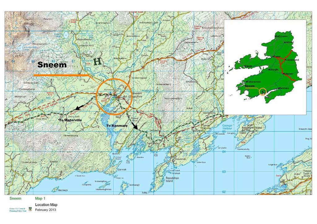
284

285
286 CASTLE COVE LOCAL AREA PLAN 1.0 CONTEXT 1.1 Location Castlecove (Cuan A Chaisleáin/An Siopa Dubh) is a small coastal village, east of Caherdaniel and south west of Sneem. The village is situated on the N70 Ring of Kerry tourist route. N70 Figure 1: The location of the Castlecove settlement 1.2 Population There are no population figures for the village of Castlecove in the census. It is located within the Electoral District of Castlecove. Population figures for this ED displayed an increase from 293 persons to 319 persons (8.9% increase) between 2006 and Functions & Facilities The village has a post office, a public house, a shop/petrol pumps, a Church and a café/surf shop. Lúb ná hábhann residential development is part constructed at the eastern end of the village. Staigue Fort exhibition centre is located to the west of the Sneem Functional Area Local Area Plan 257 Castlecove
287 settlement on the road leading to Staigue Fort. The exhibition centre also has a pub and café. There is a camping site to the west of the village. There is a small amenity area in the village between the bridge and the N70, adjacent to the River Staigue. This river provides an opportunity to provide amenity areas adjacent to it and along its banks. A pedestrian bridge would also be beneficial to connect amenity areas on opposite sides of the river as well as providing safe access for pedestrians through the village. These bridges and walkways should be designed and constructed in a manner which does not facilitate the spread or introduction of introduced/invasive species or which would increase flood risk in the area. Figure 2: The view along the N70 in Castlecove when viewed from the west 1.4 Infrastructure There is no wastewater treatment plant in the village and there are no plans to introduce one during the period of this local area plan. Dwellings in the area are served by individual septic tanks and waste water treatment systems. This is therefore a constraint on the future development of the village. The village is served by public mains 1.5 Urban Form The village is an attractive dispersed rural settlement in close proximity to the coast characterised by a small number of detached one-off houses and a limited number of commercial properties. New streetscape was formed at the eastern end of the village with the development of Lún na hábhann residential development. This development remains unfinished. The village centre is poorly defined and the addition of mixed use streetscapes in the village will improve the definition between the rural area and the Sneem Functional Area Local Area Plan 258 Castlecove
288 village. There is a large car park adjacent to the Church which is underutilised except during Church services. 1.6 Built Heritage & Archaeology There are no protected structures or recorded monuments within the settlement boundary. 1.7 Natural Environment and Amenity The village is located in a high quality natural environment with a number of natural amenities and has been relatively untouched by large-scale development to date. The quality and sensitivity of the environment and landscape will pose a challenge to the appropriate development of the settlement. There is a candidate Special Area of Conservation to the south of the plan area ( Kenmare River csac). Otters are listed for protection in this Natura 2000 site and are likely to travel from the SAC through the village via the river Staigue. Development proposals, including bridges, amenity areas and walkways will be required to be designed and operated in a manner which would not adversely impact on Otter populations in the area. The village is located on the estuary of the River Staigue which runs through the village from the mountains to the north. The River presents an opportunity to develop amenity areas and walkways along its banks. There are a number of beaches in the vicinity, the closest being Cove Strand (see Fig 3). There are also large wooded areas within the village giving it a rural character. A number of invasive introduced species, including Japanese knotweed are found in the village. These plants form dense thickets along roadsides, waste ground and waterways. It reproduces rapidly by vegetative means and is difficult to kill once established. It is therefore very important to prevent the movement of earth contaminated with Japanese Knotweed rhizomes, cuttings from hedge trimming or other fragments from one area to another. Given the presence of these plants in the settlement, development proposals will be required, where appropriate, to submit a suitable scheme for their eradication and/or control prior approved by the Planning Authority. Developers shall have regard to the NPWS guidance documents relating to this. Sneem Functional Area Local Area Plan 259 Castlecove

289 Fig 3: Cove Strand 1.8 Vehicular and Pedestrian Traffic The village experiences a certain amount of through traffic during the summer months due to its location on the Ring of Kerry. There are no footpaths serving the village and these are required to improve pedestrian connectivity in particular in the vicinity of the bridge. There is adequate parking in the village as there are two centrally located car parks, one adjacent to the Church and the second across from the Black Shop bar. 1.9 Employment There is limited employment in the settlement. The main source of employment in the area is the service industry and tourism related employment Residential Development The village is characterised by dispersed dwellings and most of the housing needs of the local population have been provided for in the surrounding rural countryside. A large development of 43 houses was previously granted permission on a site at Scart, across from the petrol station in the village. To date development has commenced on 10 units with 4 dwellings completed and occupied. Having regard to the limited predicted growth of the settlement no lands for proposed residential use will be allocated in Castlecove during the lifetime of this plan. 2.0 DEVELOPMENT STRATEGY Castlecove is an attractive coastal village on the Ring of Kerry Route which is rich in natural amenities. Future development should be sympathetic to the natural environment and should be in keeping with the scale of the existing settlement. Sneem Functional Area Local Area Plan 260 Castlecove
290 The extent of development proposed for the village is limited mainly due to the richness and sensitivity of the natural environment and the lack of short-term proposals for the provision of a treatment plant in the village. The extent of recently permitted residential development in the village has also been considered. New residential and mixed use development should be in the form of attractive streetscapes where indicated. These will add definition and help create attractive entrances into the village. There is potential to develop mixed use and residential streetscapes at four different locations in the plan area. At present there is a scattering of one-off dwellings and a basic range of services in the settlement and it has not experienced suburban-type development to date. Any future development should further enhance the character of the village. The river and wooded areas of the village should be protected from inappropriate development. Those areas of land that are adjacent to the river and are zoned for development are zoned for amenity use only. Large wooded areas have been omitted from the development boundary. Development proposals should not facilitate the introduction or spread of invasive introduced species, such as Japanese Knotweed. 3.0 OVERALL OBJECTIVES Objective No. OO-1 OO-2 Overall Objectives It is an objective of the Council to: Ensure that the high quality natural setting of the village is maintained and protected from inappropriate development by ensuring that new development is in keeping with the scale, bulk and design features of the existing urban fabric and integrates with the landscape. Promote attractive approaches into the village and ensure that any new developments are of a high architectural standard and contribute to the public realm. 4.0 SPECIFIC OBJECTIVES Objective No. Vehicular and Pedestrian Traffic It is an objective of the Council to: T-1 Reserve new access points to facilitate orderly in-depth development as indicated on the Zoning Map. T-2 Seek the provision/improvement of footpaths throughout the village as Sneem Functional Area Local Area Plan 261 Castlecove
291 indicated on the Zoning Map. T-3 Facilitate/improve pedestrian access at both sides of the Bridge over the River Staigue. T-4 Seek the provision of a pedestrian bridge as indicated in order to allow pedestrian access to amenity areas on both sides of the river subject to the outcome of a flood impact assessment. Objective No. OS-1 Opportunity Site It is an objective of the Council to: Redevelop the centrally located site within the village as a mixed use development subject to the outcome of a Flood Impact Assessment. Opportunity Site Village Centre Aim: To sustainably redevelop and improve this site as a new mixed use urban streetscape providing new residential, commercial outlet Site Location and Description This site comprises of a number of derelict commercial structures adjacent to the bridge and river. The site is adjacent to An Siopa Dubh. Currently it is rather poorly presented, particularly when viewed from the road with a number of low-grade commercial buildings Development Potential The development of this site presents an opportunity to regenerate a site which is a focal point in the settlement. The development would be mixed use including a mixture of residential, small scale commercial and tourist related units typical of any settlement node. General Requirements To ensure that the proposed development is a success and will integrate easily into the surrounding townscape, the design and layout of the development will be required to be of a high design standard and must contribute to a visual identity that can be marketed outside the area. Permeability for pedestrians is of utmost importance through the development and into the adjacent riverside amenity areas. Sneem Functional Area Local Area Plan 262 Castlecove

292
293 TAHILLA LOCAL AREA PLAN 1.0 CONTEXT 1.1 Location Tahilla (Tathuile) is a small village located at a crossroads on the N70 on the Iveragh Peninsula and on the Ring of Kerry tourist route. Tahilla is approximately 6km to the east of Sneem. N70 Figure 1.1 Location of the settlement of Tahilla 1.2 Population There are no population figures for the settlement of Tahilla in the most recent census figures. It is located within the Electoral District of Tahilla. The population of this ED increased substantially in the census period between 2006 and 2011 from 193 to 209 persons or by 8.3%. 1.3 Functions & Facilities There are very limited facilities in Tahilla which comprise of a church at the crossroads and a primary school to the north of the crossroads. While the village is located on the Ring of Kerry tourist route, it is not a stop-off point for tourist buses. There are no shops or retail facilities currently at this location. 1.4 Infrastructure There is no waste water treatment plant in the village and there is no plan to construct one over the period of the plan. Dwellings in the area are served by individual septic tanks and waste water treatment systems. Sneem Functional Area Local Area Plan 263 Tahilla
294 1.5 Urban Form The settlement of Tahilla is centred on a cross roads. The Catholic Church is located to the south of the crossroads. There is a large parking area on the northern side of the crossroads. 1.6 Built Heritage & Archaeology Tahilla Catholic Church (Ref ) is the only protected structure in the village. The Church dates from 1775 and is now in ruins. 1.7 Natural environment and Amenity The settlement is located in close proximity to the coast and there are large wooded areas giving it a high quality natural setting. The Tahilla River also runs through the settlement in a North to South direction. There are areas of both prime and secondary amenity in the surrounding rural area. There are also views and prospects along the N70 to the east of the crossroads. The coastline to the south of Tahilla is also designated as a Special Area of Conservation (SAC). N70 Figure 1.2 Amenity areas, views and prospects and SAC as designated in the Kerry County Development Plan Sneem Functional Area Local Area Plan 264 Tahilla
295 1.10 Residential Development There are no residential developments in the settlement of Tahillia. A number of single one off dwellings are noted dispersed in wider Tahilla area. It is imperative that the housing needs of locals are assessed in accordance with the appropriate policies and objectives as set out in the Kerry County Development Plan DEVELOPMENT STRATEGY Tahilla is a small development node in a rural area centred on a crossroads. It is located on the N70 where the maximum speed limit applies. There are very limited facilities/services available and there has been no demand for development in the area with the exception of rural dwellings. There is no wastewater treatment facility in the area and there are no plans to construct one in the period of the plan. The development strategy for the area is therefore to promote permanent residential development in keeping with the exiting settlement pattern. The development of a village core with higher density development is not envisaged. 3.0 OVERALL OBJECTIVES Objective No. OO-1 OO-2 OO-3 OO-4 Overall Objectives It is an objective of the Council to/that: Future Development in the area will be small in scale and should take the form of single one off developments or low density cluster type developments located on the minor cross roads served by individual treatment units/septic tanks, Encourage the development of a limited amount of ancillary facilities such as retail on the Minor crossroads. Any new development shall be designated to a high quality and standards to ensure integration with the landscape. Ensure that any development on lands to the south of the N70 road which is designated as a Special Area of Conservation (SAC) shall be subject to an Appropriate Assessment. 4.0 SPECIFIC OBJECTIVES Objective No. NE-1 NE-2 Natural Environment It is an objective of the Council to/that: Physical alteration to the bed or banks of the river Tahilla will be subject to the approval of Inland Fisheries Ireland and the OPW Retain the protected views and prospects, the amenity areas and protected structures in the area as designated in the Kerry County Development Plan Sneem Functional Area Local Area Plan 265 Tahilla
296 SECTION 4B RURAL AREA 1.0 OVERVIEW 1.1 Introduction The rural area of the Sneem Functional Area Local Area Plan, shown in Figure 1, is defined as all the rural area within the functional area boundary and outside the boundaries of the town, villages and the small villages/development nodes. The rural area, as defined in this plan, is functionally linked to the urban settlements. Figure 1: Sneem Functional Area Those living in the rural area are largely dependant on the town and villages for services such as schools, services and employment. It is likely that a substantial proportion of people travel to larger towns such as Killarney and Kenmare for employment. Tourism and agriculture are strong in this area. 1.2 Purpose of Rural Area Plan The functional area local area plan will; Look at rural area at a local level as opposed to the more strategic level of the County Development Plan. Identify strengths, weaknesses, opportunities, threats in the rural area. Gather information on the rural area. Identify protected structures in the rural areas. Identify objectives for the rural area that are not at the strategic County Development Plan level. Sneem Functional Area Local Area Plan 266 Rural Area
297 1.3 SWOT ANALYSIS FOR RURAL AREA Strengths A strong urban centre (Sneem Village) as a focal point Major tourist destination Strong architectural & cultural heritage Attractive and varied landscape/seascape with coastline, inlets, rivers, pastures and mountains Strong economic and social linkages between the rural area and urban settlements Villages have in the most part retained their character Area with some of the best scenery in the country The Ring of Kerry is an important tourist routes Existing piers and Outdoor pursuits e.g. bird watching, fishing, walking, hill and mountain climbing, marine leisure etc 12 hole golf course at Parknasilla and close to numerous 18 hole golf courses Close to the blue Flag Beach at Derrynane Situated within the Kerry Geopark Weaknesses Peripheral location Difficulty in competing with the range of services and attractions on offer in Kenmare and Killarney Reliance on tourism with seasonal nature Limited employment opportunities Opportunities Conserve built heritage Protect the natural environment and biodiversity Increase level of marine leisure activities, ecotourism and other niche markets in a sustainable manner Promote walking tours, hill and mountain climbing at sustainable levels Promote sustainable mari-culture Greater use of the marine environment for sustainable leisure activities Promotion of the Geo Park. Threats Emigration and loss of population and consequent reduced demand for services Unemployment External economic factors Over-development of rural area. Pollution of surface and groundwater Loss in quality of landscape. Loss of biodiversity Competition from cheaper locations Affordability of transport fuel Sneem Functional Area Local Area Plan 267 Rural Area


298 1.4 Population The population of the entire Functional Area as contained in the 2006 Census was 1,233 persons and in 2011 it was 1,244. The population growth target indicates that the population of the entire plan area will grow by 113 persons between the years 2012 and 2018 to a total of 1, census census census estimate target Sneem Functional Area 1,377 1,233 1,244 1,260 1,357 Table 1; Existing and projected population in rural Sneem Functional Area Figure 2: Population change Transport The area is served by the N70, national secondary routes, the R568 regional road and a network of local roads. It is important that any development in the rural area is acceptable in terms of traffic safety and does not impact negatively on the carrying capacity and general safety of public roads in accordance with Chapter 8 and section 13.9 of Chapter 13 in the Kerry County Development Plan Sneem Functional Area Local Area Plan 268 Rural Area
299 Figure 3: Road Network in the Sneem Functional Area 1.6 Cycle paths / Walkways Marked paths and cycle routes are an important resource for attracting tourists and providing recreation for local residents. They can also open up potential for farm diversification into small-scale tourist services. The Kerry way intersects the plan area and never strays too far from the N70. The Sneem-Fermoyle Loop walk meanders for 9 miles to the north of Sneem passing many geological and historical features. However, in order to protect the underlying environmental attributes and resources in the area, upon which much of the tourist industry is based, it is important that due consideration is given to these when providing for new routes or intensifying use of less established routes. Sneem Functional Area Local Area Plan 269 Rural Area


300 Figure 4: The Kerry Way (outlined with a red dashed line) intersecting the Sneem functional area 1.7 Water Supply The area is served by public water mains, group water mains and private water supplies. It is imperative that groundwater is protected from polluting development. All development must have regard to the zones of influence for groundwater public water supplies and catchments for surface water public supplies within the functional area. Figure 5: Water supply and source in the Sneem Functional Rural Area Sneem Functional Area Local Area Plan 270 Rural Area
301 1.8 Wastewater Treatment Developments in the rural area are served by individual septic tanks/treatment units based on an assessment of soil characteristics in accordance with the EPA s Code of practice- Wastewater Treatment and Disposal Systems serving Single House (p.e. 10) or any subsequent amendment or revision documents. 1.9 Landscape The study area located on the Southern aspect of the Iveragh Peninsula is centered on the village of Sneem and delineated by the sea to the south and by a line of Mountain ranges to the North and east. Several different sub landscapes are notable here with peat bogs, natural vegetation, coniferous/mixed forest and pasture (Corine Data 2006). Having regard to the spectacular landscape present here a number of views and prospects are designated in this functional area. These are illustrated in Figure 6 below. Figure 6: Views and Prospects and Secondary Special Amenity areas in the Rural area 1.10 Natural Environment The Sneem functional area has a variety of spectacular physical features and biodiversity which combined produce some of the most intriguing natural environment in Ireland. The extent of the SAC (Special Areas of Conservation) areas are shown in Figure 7 and Map Ru-3 and are listed in Table 2. Natura 2000 site boundaries are subject to change refer to for current boundaries. Sneem Functional Area Local Area Plan 271 Rural Area
302 Designation Type Site Code Site Name SAC Old Domestic Building, Askive Wood SAC Kenmare River SAC Killarney National Park, MacGillycuddy s Reeks and Caragh River Catchment SAC Blackwater River (Kerry) SAC Drongawn Lough Table 2: Natura 2000 sites in the Rural Area Figure 7: csacs in the Rural Area There are no Special Protected Areas, National Heritage Areas or Natural Reserve designations in the plan area. There are a number of mature trees and woodlands which are important in terms of biodiversity and providing amenity areas to the public Amenity While there are numerous blue flag beached within easy access to the Plan area there are none within this study area. The whole area is linked by the Kenmare River with one of the most attractive scenery and landscape on the South West coast of Ireland. Numerous established coastal and mountain walks are dotted throughout the local landscape. Sneem Functional Area Local Area Plan 272 Rural Area
303 1.12 Tourism South Kerry is well known as a tourist destination, and tourism contributes significantly to the economic activities in the area. The Sneem Functional Area is well endowed with a number of tourist attractions that have been developed and promoted, including Parknasilla Resort. The attractive coastline attracts a large number of tourists in the summer months. The coast is more rugged than that in Cahersiveen and Waterville FALAP areas.a number of accessible South Kerry islands provide the visitor with a contrasting schedule of views and experiences along with an attractive countryside of hills, wild mountains, rugged cliffs, rocky shores and sandy beaches. The area has a beautiful and challenging environment with a range of facilities and services, for marine leisure activities. Sailing, kayaking and other water based sports occur in the area. There are a number of archaeological, architectural and historical attractions throughout the functional area, including Staigue Fort which is one of the finest and largest stone ringforts in Ireland. The development of an archaeological trail through the area should be promoted. The availability of a range of holiday accommodation is an important factor in developing the area s tourism potential. Large-scale tourism developments should normally be located in the larger settlements. New development for the tourist industry should respect the existing settlement pattern of the area. Integrated tourism development facilities (i.e. those serving both tourists and local residents) such as sports and recreation activities will contribute to a more diverse range of visitor attractions, encourage longer visitor stays, help extend the visitor season and add to the quality of life for people who live in the area. Facilities like the Eclipse Activity & Adventure Centre offer a large range of outdoor activities. The region has a number of valuable natural and cultural assets that support the tourism industry. It also benefits from its reputation for quality food, with local and global brand names and a range of high quality hotels and restaurants. The potential for sustainable niche eco-tourism in the area is immense, and is currently being promoted through the development of a Geopark. Since 2003, the local community have been establishing and developing the area as a Geopark in the bid to encourage more sustainable development throughout the region by promoting Geotourism. Sneem Functional Area Local Area Plan 273 Rural Area
304 A Geopark can be defined as an area an area that exhibits a particular geological heritage which has a related sustainable development strategy such as the promotion and development of Geotourism. More simply put a geopark is an effective tool that allows communities to take greater control over their tourism product by adopting a grass root approach to the promotion of geological, ecological, cultural and historical resource which exists throughout the region. Responsible ecotourism includes programmes that minimize the negative aspects of conventional tourism on the environment, and enhance the local community. Therefore, an integral part of ecotourism is the promotion of recycling, energy efficiency, water conservation, and the creation of economic opportunities for the local communities. The area is also rich in traditional ways, folklore, writing, music, and historic and archaeological sites.the landscape, cultural and linguistic heritage and amenities of the area constitute a prime asset on which the tourism industry is based. The size of the settlements and their unique character make them particularly sensitive to development. It is accepted however that expansion of the tourism industry is based on appropriate development. This plan, in accordance with the principles of sustainable tourism development outlined by Fáilte Ireland promotes suitable sustainable tourism development. When considering proposals for new tourism development, priority will be given to those that are encouraging longer visitor stays and add to the range of facilities available to people who live in the area all year round Built Heritage There are seven protected structures in the area; Reg Ref Blackwater Bridge post Office Reg Ref dwelling house, Glashnacree Reg Ref Parknasilla. Reg Ref Derryquin Castle Reg Ref Derryquin Castle Gatelodge Reg Ref Detached dwelling Scart RPS Former Bishops House, Parknasilla There is no proposal for additional protected structures Archaeology The archaeology of the Sneem area is representative of all periods from the Early Bronze Age to the medieval period. Bronze Age ritual monuments such as standing stones, pairs, alignments and rock art are scattered throughout the area. There is extensive evidence of Early Medieval settlement around the coastal margin though the lack of early monastic or ecclesiastical monuments, with the notable exception of the monastic enclosure at Cloon West (National Monument) with its two outstanding cross slabs, is in contrast to other areas of the Iveragh peninsula. The functional area includes extensive upland and there are a number of important pre-bog field systems with associated enclosures, hutsites and cairns. The northern extent of the plan area does include the extensive rock art landscape Sneem Functional Area Local Area Plan 274 Rural Area

305 at Derrynablaha/Derreeny, near Ballaghbeama Gap, while the iconic Staigue Fort (National Monument) is also located in the area, both monuments/areas would be regarded as being of national and in the case of the rock art at Derrynablaha, international, importance. Photo 1: Staigue Fort In general terms the Sneem Functional Area Plan contains an archaeologically diverse area of the county. There are approximately 320 monuments listed in the Record of Monuments & Places within the functional area, a number of which are archaeological complexes comprising numerous individual monuments and features. The monuments range in date from the Early Bronze Age to the Early Medieval period. There are 3 National Monuments located here of which one is in state ownership the other two being subject to a preservation order. The National Monuments within the functional area are listed below in Table 3, while particularly important landscapes in two particular areas are outlined in the following pages. Finally general and specific archaeological objectives for the plan are set out. TOWNLAND DESCRIPTION STATUS RMP NM/PO Staigue Cashel Guardianship KE Behagane Castlecove Castle Preservation KE PO154 Cloon West Monastic Enclosure Preservation KE PO145 Table 3: National Monuments within Sneem Functional Area Derrynablaha/Derreeny This extensive rock art landscape contains the second highest concentration of rock art scribings in the country and is of national and international importance. The decorated stones are scattered over the east facing slopes of Mullaghanattin Mountain overlooking Ballaghbeama Gap to the north-north-west and Lough Brin to the East. The only larger Sneem Functional Area Local Area Plan 275 Rural Area

306 though more widespread concentration of rock art in Ireland, is in the already protected Kealduff/Coomsaharn area. The exact function of rock art is unknown though it is generally dated to the Late Neolithic/Early Bronze Age and is though to have some ritual significance possibly relating to water, as it is most often found near the heads of river valleys. Figure 8a: Derrynablaha/Derreeny This landscape is worthy of special protection given its national and international importance and the significance of the broad landscape setting to any understanding of the function of rock art. Sneem Functional Area Local Area Plan 276 Rural Area


307 Figure 8b; Derrynablaha Area OS 6 inch map Staigue The stone fort/cashel at Staigue is a National Monument in state guardianship and is one of the monuments in the Western Stone Forts proposed World Heritage Site. The stone fort is located at the head of a broad valley that runs south towards the sea, with extensive views. The fort probably dates to the Late Bronze Age/Iron Age. Figure 9a: Staigue Area OS Map Sneem Functional Area Local Area Plan 277 Rural Area

308 Figure 9b: Staigue Area OS 6 inch map These two areas, Derrynablaha/Derreeny and Staigue, located in upland regions, would be particularly sensitive and provision should be made to ensure that these areas are protected in as much as possible, given that they represent two outstanding examples of relict prehistoric and early medieval landscapes. Figure 10: Archaeological Monuments and proposed protected structures Sneem Functional Area Local Area Plan 278 Rural Area
. The OPW have published draft preliminary flood Zone Maps for the County.")

309 1.15 Flood Risk Management Flood Risk Data for the functional area has been mapped on figure 11, using soil maps, recorded flood event locations and lands benefitting from OPW drainage schemes (available on ). The OPW have published draft preliminary flood Zone Maps for the County. Flood Risk Management in the area will be in accordance with the 2009 Government Guidelines on The Planning System and Flood Risk Management, the relevant development objectives of this plan and with Section 11.4 of the Kerry County Development Plan Figure 11 shows recorded flood locations and other identified potentially vulnerable areas. Figure 11: Flood Data in the Rural Area Kerry County Council has a policy to limit and manage the permitted runoff from all new developments, in order to protect river water quality and to avoid downstream flooding of the sewer network or river. Any large scale developments must incorporate Sustainable Urban Drainage Systems (SUDS) to restrict the discharge of stormwater from developments. Kerry County Council has a number of interim standards covering river quality protection, river regime protection and river and coastal flooding protection Windfarms There are no areas designated for Wind farm development in this functional area. Kerry County Council is currently preparing a Renewable Energy Strategy. The adopted strategy will be incorporated into the County Development Plan Sneem Functional Area Local Area Plan 279 Rural Area
310 1.17 Piers / Harbours There are a number of small piers and harbours located around the coast of the functional area. These piers are used for various purposes including fishing, tourism and leisure. These piers are maintained by Kerry County Council. It is the policy of Kerry County Council to maintain and repair theses piers for public use and to support the sustainable development of the piers as potential economic generators for the area and support the maintenance of other facilities such as slipways and to protect them from inappropriate uses. 2.0 OVERALL OBJECTIVES Ru-1 Ru-2 Ru-3 It is an objective of the Council to: Provide for balanced growth throughout the area by promoting the strengthening of rural communities and provide the infrastructure to facilitate job creation and diversification in these areas in a sustainable manner Ensure that development on un-serviced lands comply fully with the Code of Practice; Waste water treatment and disposal systems serving single houses and where necessary Wastewater Treatment Manuals - Treatment Systems for Small Communities, Business, Leisure Centres and Hotels. Ensure that all fish bearing watercourses within the plan area and their riparian zones including flood plains are protected from significant harmful development and from the effects of wastewater discharges. 3.0 SPECIFIC OBJECTIVES Ru-AT-1 Ru-AT-2 Ru-AT-3 Ru-AT-4 Ru-AT-5 Ru-AT-6 Ru-AT-7 Amenity & Tourism It is an objective of the Council to Encourage the development of geo trails & walking routes within the plan area and associated car parking facilities at appropriate locations so as to facilitate sustainable outdoor recreational activities in the plan area. Encourage the improvement of sensitively designed tourist information boards and signage at appropriate locations. Protect and encourage the development of literary, musical, linguistic, artistic, sporting and other cultural heritage initiatives. Facilitate the sustainable extension and diversification of tourist facilities. Promote the sustainable development of a Geo Park Protect the sand dunes / dune system in the plan area in particular Castlecove area, and prohibit any development that would damage or lead to erosion of any dune system Protect from inappropriate development the protected views and prospects in the plan area as identified in figure 6. Sneem Functional Area Local Area Plan 280 Rural Area
311 Built Environment It is an objective of the Council to: Ru- B-1 Encourage the appropriate reuse and sensitive restoration of unused/derelict properties. Ru-EE-1 Ru-EE-2 Employment and Economic Activity It is an objective of the Council to : Facilitate sustainable diversification of the rural economy Provide the infrastructure and support for the sustainable development and expansion of employment opportunities, including indigenous knowledge based industries. Archaeology Objectives It is an objective of the Council to: A-1 Secure the inclusion of the structures included the archaeological special protection area into the Record of Protected Structures A-2 Protect the views and vistas around the monuments, the inter-visibility of the monuments and the integrity of the existing archaeological landscape setting in the prehistoric landscape identified (see Figs 8 & 9). Applicants are advised to liaise with the County Archaeologist in advance of any application for development within these sites. Sneem Functional Area Local Area Plan 281 Rural Area

312
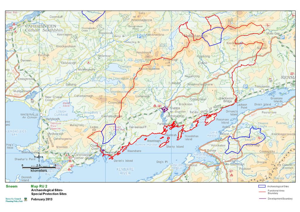
313

314
315 SECTION 5 SEA Statement INTRODUCTION 1.1 Terms of Reference Kerry County Council undertook the process of a Strategic Environmental Assessment (SEA) in parallel with the preparation of the Cahersiveen, Sneem and Waterville Functional Area Local Area Plan (FALAP) and the related variation to the Kerry County Development Plan A SEA is a systematic evaluation of the likely significant effects of implementing a Plan or Programme before it is adopted. Directive 2001/42/EC on the assessment of the effects of certain plans and programmes on the environment was transposed into Irish law under: The European Communities (Environmental Assessment of Certain Plans and Programmes) Regulations 2004 (S.I. No. 435 of 2004), amended in Regulations 2011 (SI. No 200 of 2011), and The Planning and Development (Strategic Environmental Assessment) Regulations 2004 (S.I. No. 436 of 2004) amended in regulation 2011 (SI No. 201 of 2011). This document (the SEA Statement) of the Cahersiveen, Sneem and Waterville FALAP document forms the final stage of the requirements for the Strategic Environmental Assessment (SEA) of the Plan and is prepared in conjunction with the final adopted plan. The aforementioned regulations set out the information to be included in a SEA Statement. These requirements are discussed in the following section. The SEA process consists of a series of steps or stages that need to be undertaken. There are; Screening of the P/P to establish whether it must undergo an SEA, Scoping of the details to be provided in the Environment Report, in consultation with the environmental authorities, An Environmental Report containing findings of the assessment on the likely significant effects on the environment of the P/P, Consultation on the draft plan and associated ER, An SEA statement identifying how environmental consideration and consultations have been integrated into the final plan and Monitoring Programme of the significant environmental effects of P/P. This report is step five of the above process, the SEA Statement of the Cahersiveen, Sneem and Waterville Plan and the related Variation to the Kerry County Development Plan Cahersiveen, Sneem and Waterville Functional Area Local Area Plan SEA Statement
316 1.2 Content of the SEA Statement The SEA Statement is required to include information summarising: - 1. How environmental considerations have been integrated into the plan 2. How the environmental report, any submission or observation to the planning authority in response to a notice under section 12(1) or (7) of the Act, and any consultations under article 13 F have been taken into account during the preparation of the plan 3. The reasons for choosing the plan, as adopted, in light of the other reasonable alternatives dealt with, and 4. The measures decided upon to monitor, in accordance with Article 13J, the significant environmental effects of implementation of the plan Each of these individual criteria will be addressed in separate sections of this SEA Statement. The interaction between the SEA Team and the Planning Policy Unit in Kerry County Council in preparing the Cahersiveen, Sneem and Waterville Functional Area Local Area Plan is shown in Figure 1.1.


317 Figure 1.1 SEA and Plan Interaction
318 2 INCORPORATION OF ENVIRONMENTAL ISSUES INTO THE PLAN 2.1 Introduction The SEA process can be broken down into a number of steps. At each stage of the process the impacts of the Plan on the environment and the public is assessed. Where it was assessed that the Plan may conflict with the environmental objectives then mitigation measures were proposed. The mitigation measures were predominately in the form of an amendment to or the addition of an objective in the draft Plan. The draft Plan was assessed during the following phases: - Scoping consultation with the statutory consultees and non statutory consultees Evaluation of draft Plan objectives and policies (included in environmental report) Evaluation of submissions and observations to draft Plan Evaluation of proposed amendments / material alterations to draft Plan Evaluation of amendments / material alterations to draft Plan Scoping The scoping report for the Strategic Environmental Assessment of the Functional area Local area plan outlines the procedures undertaken in the preparation of the Scoping Report and was prepared in parallel with the Draft Cahersiveen, Sneem and Waterville Functional Area Local Area Plan, which was carried out during May The integration of the SEA and the plan was achieved through close liaison between personnel delivering the SEA and the Function Area Local Area Plan itself. This included the key stages of scoping, the review of the existing situation in the area and the assessment of the Local Area Plan objectives. The scoping process also considered the Plan alternatives, environmental objectives, targets, indicators and monitoring arrangements. The overall outcome of the scoping process was to focus attention and resources on the most important environmental issues as a result of implementing the Plan. The internal procedures for integrating the plan process with the SEA process are outlined in fig Evaluation of draft Plan Objectives and policies Section 2 of the Environmental Report outlines the methodology of preparing the draft Plan and the Environmental Report. The Environmental Report evaluated the likely significant impacts of implementing the draft Plan on the environment using the baseline environmental data collected during the scoping process. As stated above the purpose of the Environmental Report was used to assess the likely significant effects of the Plan on the environment and to ensure that these significant impacts are considered during the preparation of the draft Plan.
319 The Environmental Report also considered a number of alternatives to the Plan. These alternatives were assessed and a preferred strategy chosen. This is further discussed in Section 4 of this SEA Statement The Environmental Report also outlined mitigation measures to remedy/reduce any potential significant impacts and a monitoring programme was developed to assess the impacts of the Plan on the environment. The monitoring programme is shown in Section 5 of the SEA Statement. Section (f) of the Schedule 2B of the SEA Regulations requires an assessment of the likely significant effects of the Plan on the environment. The Plan objectives were assessed against the Environmental Protection objectives in the Environmental Report prior to the release of the draft Functional Area Local Area Plan. The Environmental Objectives set out in Section 4 of the Environmental Report and further in the associated SEA addendum document, are described under a range of topics and are used as the standards against which the future development objectives of the Plan can be evaluated, to help to identify areas in which significant adverse impacts are likely to occur Evaluation of proposed amendments / material alterations to draft Plan The assessment of the proposed amendments / material alterations to the Draft FALAP after public consultation and receipt of submissions was carried out by assessing each of the proposed amendments against environmental protection objectives created as part of the SEA process. An initial screening process was conducted to determine the level or degree of impact that the proposed amendments to the Plan may or may not have on the SEA environmental objectives. A further assessment phase considered the proposed amendments to the Plan that may significantly conflict with the environmental protection objectives. Mitigation measures were recommended where significant conflict may arise. The mitigation measures proposed in the report mainly required the rewording, amending or additional text to a Plan objective. The Elected Members adopted a total of 26 proposed material alterations following this meeting. Adverts appeared in The Kerryman newspaper on 22nd November 2012 advising that these proposed material alterations were on public display from 22nd November to 20 th December An additional 7 no. submission were made on the proposed material alterations and associated SEA addendum document that went on public display on the 22 nd November The Elected members adopted the amendments to the material alterations following this meeting. The Cahersiveen, Sneem and Waterville Plan and the related Variation to the Kerry County Development Plan was subsequently adopted at that meeting held on the 20 th January 2013.
320 Table 2.1; The integration of environmental considerations into the final plan Section of the Functional Area Local Area Plan Mitigation measures outlined in the plan Introduction Additional paragraph 2-20 section 1.8 introduction. Cahersiveen Amended Objectives; T-4, FM-1 Knightstown Amended Objective; OO-1 Chapeltown Additional 3 no. paragraph in section 1.7, Additional bullet point in section 2.0 development strategy. Additional objectives; NE-1, NE-2 Valentia island 2 no. additional paragraphs in Section AT-3 objective modified, Additional paragraph in Section 1.8, Sneem Amended objective; T-5. Additional paragraph included in section 1.8. Additional paragraph in section 1.9. Objective deleted in overall objective. Castlecove Additional paragraph included in section 1.3. Additional paragraph included after the 1 st sentence in 2nd paragraph of section 1.7. Additional paragraph included after the 2nd paragraph of section 1.8. Additional objective OO-1, T-4 Caherdaniel Additional 4 paragraphs in section 1.8, additional bullet point in section 2.0, Additional objective NE-2 Cahersiveen rural Additional objective; Ru-At-6, Ru-At-7 Sneem rural Additional objective; Ru-At-6, Ru-At-7 Waterville Rural Additional objective; Ru-At-6, Ru-At-7, additional paragraph in section 4.6
321 3 INCORPORATION OF SUBMISSIONS AND CONSULTATIONS 3.1 Introduction This section of the SEA statement details how submissions received during the SEA process and draft Plan process were considered during preparation of the Plan. Under Article 13D of the SEA Regulations 2004 there is a requirement on the Local Authority to give notice to the Environment Authorities the scope of the Environmental Report. 13D(2)(c) of this Article: Indicates that a submission or observation in relation to the scope and level of detail of the information to be included in the Environmental Report may be made to the Planning authority within a specified period which shall be not less than 4 weeks from the date of the notice. Under Article 13A(4)(a) of the SEA Regulations 2004 the prescribed Environment Authorities are: the Environmental Protection Agency (EPA) the Minister for the Environment, Heritage and Local Government (DoEHLG), and Where it appears to the planning authority that the pan or programme, might have significant effect on fisheries or marine environment, the Minister for Agriculture, Marine and Food and the Minister for Communications, Marine and Natural Resources. Where it appears to the planning authority that the pan or programme, might have significant effect on the architectural or archaeological heritage or to nature conservation, the Minister for Arts, Heritage and Gaeltacht Affairs, and Any adjoining planning authority which prepared a draft plan, proposed variation or LAP SEA Scoping Consultation Kerry County Council consulted prescribed bodies and other potentially interested bodies during the scoping process of the SEA. Kerry County Council complied with the statutory requirements of the Planning and Development Act 2000(as amended) and the planning and development regulations 2001 (as amended) in relation to informing the prescribed bodies for the purpose of making an LAP and associated SEA. Initially a letter dated 31 st January 2012 and a copy of the SEA Scoping Report in relation to the pre-draft Cahervieen, Sneem and Waterville Functional Area Local Area Plan was sent to the appropriate bodies. Submissions and comments were invited on the same up to and including 1 st March Three submissions were received by Kerry County Council on the SEA scoping document. Table 3.1 summaries and addressed the issues raise.
322 Table 3.1 SEA Scoping Consultation Details SUBMISSION COMMENTS MADE ADDRESSED Department of Archaeology, Heritage & the Gaeltacht South Western Regional Authority Inland Fisheries Additional general policies relating to archaeological heritage, recorded monuments and any other archaeological features are recommended. A number of additional objectives regarding proposed development that includes a monument or site including a record of monument and places are recommended. Welcomes and acknowledges the work of KCC in preparing the SEA scoping report. Growth must be balanced between urban and rural areas Requests that LA must prepare a policy document for the Gaeltacht and Islands and their jurisdiction to enhance their unique cultural identity and secure sustainable communities. RES-03 of the RPG regarding Tourism is applicable to the Cahersiveen, Sneem and Waterville areas. Strategies for the promotion of walking and cycling are encouraged. Where intra urban bus services are not available the promotion of cycling and walking between towns centres, residential areas and employment zones is essential Monitoring indicators must be explored further by KCC in compliance with RIM -01 of the RPG A list of fish bearing watercourses in the plan area were identified Sufficient objectives included throughout the draft functional area local area plan. Sufficient objectives included throughout the draft functional area local area plan. Point noted Point noted and additional objective included in the Chapter 14 of the SEA ER. Point noted and additional objective included in the Chapter 14 of the SEA ER Additional information regarding the promotion of walking and cycling routes throughout the plan are set out in Chapter 8 and Chapter 14 of the SEA Point noted Amendments were introduced in the draft plan via chapter 6 and 14 of the SEA ER
323 3.1.2 First Public Consultation The draft Cahersiveen, Sneem and Waterville Plan and the related variation to the Kerry CDP , associated SEA Environmental Report and Habitats Directive Assessment (HDA) was put on public display on the 12 th September 2012 for a period of 6 weeks. A total of 34 no. submissions were received by the Planning Authority on the draft Plan. 26 no. amendments / modifications were made to the draft Plan following the initial consultation period. Several of these submissions related to the SEA process. A large number of the amendments / modifications to existing Plan objectives arose from submissions made by the Statutory Consultees (The Environmental Protection Agency, and The Department of the Environment, Heritage and Local Government) and members of the public. This constituted a first public display period. Submissions regarding the SEA process were received from the Environmental Protection Agency and the Department of Environment, Heritage, and Local Government, the Inland Fisheries and the South West Regional Authority during this period. These submissions were assessed by Kerry County Council for inclusion in the draft Plan. The County Managers Report and Recommendations on Submissions was considered at a Special Meeting of Kerry County Council held on the 12th November The Elected Members adopted a total of 26 proposed material alterations following this meeting. Following the meeting held on the 12 th November the County Manager determined that in accordance with section 13(6)(a) of the P&D Act, that a strategic environmental assessment was required to be carried out on the proposed material alterations to the variation and specified the period of 2 weeks to facilitate these assessment Second Public Consultation Following the completion the amendments / material alterations to the draft Cahersiveen, Sneem and Waterville Functional Area Local Area Plan, related variation to the CDP , the associated SEA addendum document went on public display during on the 21 st November 2012 until the 20 th December 2012 inclusive for 4 weeks period. In total 7 no. submissions were received during this period. Four of these submissions referred to the SEA process. These submissions were considered by Kerry County Council for consideration in the plan.
324 4 THE REASONS FOR CHOOSING THE PLAN AS ADOPTED, HAVING CONSIDERED ALTERNATIVES 4.1 Introduction The development and assessment of alternatives (or options) is a legal requirement under the SEA Directive. Under Article 5 (O.J. 2001) plans and programme proponents should ensure that: Reasonable alternatives taking into account the objectives and the geographical scope of the plan or programme, are identified, described and evaluated (Article 5.1) The Environmental Report includes an outline of the reasons for selecting the alternatives dealt with (Annex 1(h)) A statement is prepared summarising the reasons for choosing the plan or programme as adopted, in the light of the reasonable alternatives dealt with (Article 9.1(b)). Chapter 4 of the SEA Environmental Report identifies and describes the different development scenarios that were assessed by Kerry County Council and the SEA team. The alternatives were evaluated taking into account the vision of the draft Functional Local Area Plan and the geographical scope of the Plan. 4.2 Description of Alternatives As part of this plan making process a range of alternatives were considered as follows:- Alternative strategies are considered within Chapter 4 of the Strategic Environmental Assessment Environmental Report document prepared for the draft plan document. At the outset the do nothing or non intervention development strategy and the intervention development strategy were considered. It was decided that the intervention scenario was appropriate as on the basis that it would promote the proper planning and sustainable development of the settlements. Alternative zoning strategies were also considered. The main potentially viable options available were: (i) (ii) (iii) (iv) To expand the current zonings to provide for the future development of the town. Consolidate the existing zoning within the existing urban fabric. Reduce the level of zoning in line with the regional and county population protections and zone sufficient land to meet these requirements Do- nothing Scenario or the non intervention scenario
325 4.3 Assessment of Alternatives against Environmental Objectives Kerry County Council has made provision in the plan for sustainable levels of growth within of the Functional Area. These growth figures are in accordance with the population targets for the South West Regional Authority as issued by the DoECLG. These targets have been incorporated into the Plan and the variation. Kerry County Council is aware of the potential impact of development on the environment and of the need to ensure that development is planned to ensure the proper planning and sustainable development of the area. The following sections outline the alternative development options considered by the planning authority in the formulation of the plan with an explanation of why particular options were chosen Do-nothing Scenario or Non-Intervention Scenario The do-nothing scenario means that the current plan would be readopted with no material amendments. This in effect would mean ignoring development that had occurred during the period of the last plan and monitoring its implications for the future planning of the settlements. It is necessary to monitor the development of a plan area and react to development in planning for the future. This option would not achieve this. In addition such a scenario would not take into account advances in planning guidance, best practice in planning policy or experience gained through the implementation of the previous plan. This option was ruled out on the basis that it would not promote the proper planning and sustainable development of the settlements Intervention Scenario In this scenario intervention would mean reassessing the plan from first principles and looking at the options available in light of the developments during the period of the last plan, the advances in planning guidance and the overall strategy for the settlements Zoning Zoning within the settlements presented a number of choices. The main options available were: A) To expand the current zonings to provide for the future development of the settlements Having regard to the extent and location of the zoned land in the existing plan together with this option which would provide for the expansion of such zonings, it is considered that this option would result in ad-hoc and developer led planning for future development and would not provide an overall strategic framework for the guiding of
326 sustainable development. This is not in line with existing planning guidance and most likely would facilitate hab-hazard urban sprawl and unsustainable travel patterns. B) Consolidate the existing zoning within the existing urban fabric This option seeks to facilitate future development within the existing urban fabric on brownfield and infill type sites. Such an approach, in itself, would facilitate the sustainable use / reuse of brownfield lands and would reducing reliance on private cars within the settlement. However it would also reduce the level of choice available to developers / future home owners etc, who in turn may seek to build outside of the settlement boundaries on lands zoned for rural general purposes in the current County Development Plan. Accordingly such an approach may indirectly have harmful effects on the environment by way of impacting on such aspects as water quality, air quality and landscape and may result in more unsustainable commuting / travel patterns. C) Reduce the level of zoning in line with the regional and county population projections and zone sufficient land to meet these requirements This approach provides for the consolidation of the existing settlement pattern, giving preference to town centre and infill type sites while also providing for a sustainable level of growth within the settlement. The level of growth provided for in this option is based on Regional and County targets and accordingly has been strategically evaluated. This approach also allows for the coordination of planned infrastructure and development and facilitates the sustainable use of existing infrastructure. 4.4 Preferred Strategy Based on the environmental assessment of the alternative policy scenarios, it was found that Scenario 2c, intervention scenario - Reduce the level of zoning in line with the regional and county population projections and zone sufficient land to meet these requirements, was the preferred strategy for the County. This scenario recognises the balance that must be struck between the environment, quality of life and development (See appendix 2). Considering the objective to provide for a compact settlement and the need to make best use of available infrastructure it was considered that it would be appropriate to reduce the level of zoning in line with the regional and county population protections and zone sufficient land to meet these requirements the zoning of the undeveloped land within the existing urban fabric. The preferred strategy was identified as having potentially conflicting interactions with a number of environmental strategic objectives. Accordingly mitigation measures were recommended so as to reduce / eliminate potentially negative impacts and so as to incorporate additional environmental objectives. The recommended mitigation measures were also assessed and it is hereby concluded that the Plan makes sufficient provision for the protection of the environment through a range of objectives. It is imperative that
327 when implementing the Plan objectives equal weight is given to development and environmental objectives in order to achieve a balance. If this strategy is adopted mitigation will occur naturally as a result. In general the Functional Local Area Plan (FALAP) strategies will facilitate the concentration of development and infrastructure in a compact and sustainable manner and will reduce the need to provide for such facilities in an ad hoc manner in the open countryside. Table 4.1 Evaluation of Alternative against EPOs Likely to improve EPOs Probable conflict with EPOs unlikely to be mitigated Probable conflict with the EPOs likely to be mitigated Uncertain interaction with EPOs No likely interaction with EPOS Alternative Alternative 2a Alternative 2b (shortterm) (long term) Alternative 2c (long term) - - Following on from the proposed material alterations to the Draft Cahersiveen, Sneem and Waterville FALAP, the SEA Addendum document analysed the proposed amendments / material alterations against the Environment Protection Objectives (EPOs). Following an assessment it was considered that no further mitigation measure was required.
328 5 MONITORING PROGRAMME 5.1 Introduction Under Article 10 and Section (i) of Schedule 2B of the SEA Regulations, monitoring is required in order to identify at an early stage any unforeseen adverse effects caused by the Plan. This allows remedial action to be taken. Monitoring prevents the actual impacts of the Plan to be measured against those that were predicted. It allows major problems to be identified and dealt with in a timely fashion, and environmental baseline information to be gathered for future Plan reviews. It also ensures that proposed mitigation measures are carried out and that no unforeseen impacts occur. The methodology used in the development of the monitoring programme for the Functional Area Local Area Plan is based on the use of indicators and targets, the assignment of responsibilities and the setting of appropriate time lines. It also includes intervention in the event of an unforeseen occurrence. Monitoring is carried out by reporting on the set of indicators and targets drawn up for the various environmental aspects and used to describe future trends in the baseline, which enable positive and negative impacts on the environment to be measured. The indicators that are used show changes that would be attributable to implementation of the Plan. In particular, the indicators can also in certain circumstances act as an early warning system should unforeseen impacts occur or conditions deteriorate further or faster than anticipated. For example, water quality indicators describe trends in both improvements and deterioration in water quality. If quality targets are not being reached and water is seen to be unexpectedly deteriorating immediate intervention will be required. Monitoring will focus on aspects of the environment that are likely to be significantly impacted by the Plan. Indicators and targets have been identified for the main environmental issues in the study area, namely water, biodiversity, cultural heritage and landscape. The indicators chosen are at a level, which is relevant to the Plan, and are collated and reported on by a variety of Government Agencies, such as EPA, OPW, National Parks and Wildlife Services and different sections within Kerry County Council. Much of the indicator information required is already being actively collected and reported at a level sufficient to meet the needs of this Plan. The frequency of monitoring is set by relevant legislation. The monitoring programme for the SEA is given in Table 5.1.
329 Table 5.1: Monitoring Programme for SEA Environmental Objectives Indicator Responsible Authority Frequency Target Type Intervention required of WO1.1 WATER Maintain / improve the quality of surface water Changes in receiving water quality as identified during water quality monitoring for the SWRBMP conducted by KCC and the EPA Biotic quality rating of river waters at EPA monitoring locations KCC EPA As per monitoring cycle in accordance with the WFD Monitoring Programme As per monitoring cycle in accordance with EPA monitoring programme Achieve good status of surface waters in accordance with WFD by 2015 Improvement or at least no deterioration in surface water quality by 2015 Investigate source of problem and remedy accordingly Investigate source of problem and remedy accordingly WO1.2 Promote the use of Sustainable Urban Drainage Systems (SUDS) Provision of SUDS compliant drainage plans for proposed developments in study area Quantified surface water flows from proposed developments as part of planning process Measured river levels KCC KCC EPA SUDS compliant drainage plans to be provided with all proposed developments Hydrological assessments including quantified surface water contribution to be supplied with planning applications River levels logged as per EPA s logging cycle 100% compliance with SUDS drainage plans supplied with planning requests 100% compliance with hydrological assessments supplied with planning requests River levels to remain at current percentiles as per OPW hydrological data Planning application not to be considered for planning assessment unless necessary drainage plans are also submitted where necessary Planning application not to be considered for planning assessment unless necessary hydrological assessments are also submitted where necessary
330 Environmental Objectives WO1.3 WO1.4 Maintain / Improve the quality of groundwaters Maintain and improve the quality of drinking water supplies Indicator Changes in groundwater quality as identified in monitoring programmes conducted by KCC and the EPA under the RBMPs Drinking water quality and bacterial counts and frequency of boil water notices and RAL s notices from the EPA Frequency of water shortage notices Responsible Authority CCC WFD KCC Frequency As per monitoring cycle in accordance with the WFD Monitoring Programme As required by the population served in the study area and by the requirements of the Drinking Water Regulations Target Achieve good status of groundwaters in accordance with WFD by 2015 No water boil notices issued. No RALS from the EPA Decrease in the number of water shortage notices issued Type Intervention required of Investigate source of problem and remedy accordingly Investigate source of problem and remedy accordingly WO1.5 Maintain and improve the quality of waste water Number of new developments permitted which cannot be adequate served by wastewater treatment systems to current EPA specifications KCC EPA - No new developments granted permission which cannot be adequately served by wastewater treatment systems to current EPA specifications Investigate source of problem and remedy accordingly BO 1.1 BIODIVERSITY Conserve and protect designated habitats and species, including Natura 2000 sites Designation of additional areas due to biodiversity or geological value. Percentage of unique habitats and species lost in designated sites through trending of annual/ bi-annual habitat surveys. KCC DoECLG - No loss of protected habitats and species -
331 Environmental Objectives BO1.2 Conserve and enhance the diversity of habitats and species in non-designated sites Indicator Number of Article 6 assessments supplied with planning applications for developments proposed for sites overlying or potentially impacting Natura 2000 sites in study area. Percentage of unique habitats and species lost in nondesignated sites through trending of annual/ bi-annual habitat surveys. Percentage of native tree and broadleaf planted Percentage of proposals close to water incorporating riparian zones. Responsible Authority KCC DoECLG KCC SWRFB Frequency - - Target Article 6 assessments to be supplied with each planning application for sites overlying or having a potential to impact a Natura 2000 site. No loss of hedgerows such as Townland Boundary Hedges or roadside hedgerows.. Operators who conduct mechanical hedge cutting should have achieved the Teagasc proficiency standard MT 1302 Mechanical Hedge Trimming. 30% broadleaf afforestation Development of identified non-designated habitats as green belt. Type of Intervention required Planning application not to be considered for planning assessment unless necessary Article 6 assessments are also submitted where necessary Investigate source of problem and remedy accordingly Requirement planning permissions. in Requirement for provision of biodiversity plans with planning application where decided by KCC. Incorporation of riparian zones within proposals close to water systems.
332 Environmental Objectives LO1.1 LO1.2 PO1.1 LANDSCAPE Protect scenic landscapes, views, routes and landscape features of value. Protect streetscapes in towns and villages POPULATION HUMAN HEALTH AND Promote the creation of safe high quality environments / urban designs Indicator Number and type of developments in designated views and prospects Number of unauthorised developments in the settlements that will impact significantly on their existing character. Number of residential units granted planning permission Number of planning applications accompanied with Urban Design Statements Responsible Authority KCC KCC KCC Frequency Review each planning application as submitted. Annually Review during the lifetime of the Plan. Target No significant disruption of views or prospects No unauthorised developments in the settlements of the Plan area that will impact significantly on their existing character. Provision of suitable accommodation for the increased population under the lifetime of this Plan Increase in the number of planning applications accompanied with Urban Design Statements Type of Intervention required Planning application not to be considered for planning assessment where there is a potential conflict with designated views and prospects or areas of special amenity. Planning application not to be considered for planning assessment unless Architectural Impact Assessments are carried out where necessary. Investigate the source of the problem
333 Environmental Objectives Indicator Responsible Authority Frequency Target Type Intervention required of PO1.2 Protect and enhance green spaces and amenities available to the public Number of green spaces and amenities available to the public. KCC Review during the lifetime of the Plan. Increase in the number of green spaces and amenities available to the public. Investigate the source of the problem PO1.3 Protect and enhance medical educational and community facilities Occurrence of any decline in human health Number of educational facilities granted planning permission. Number of planning applications for community facilities granted planning permission HSE DoE&S KCC Review during the lifetime of the Plan. No significant deterioration in human health as a result of environmental factors. Increase in the number of educational facilities. Increase in the number of community facilities. Investigate source of problem and remedy accordingly PO1.4 Protect and enhance employment opportunities and economic development Employment rates over the lifetime of the Plan. DoET&E KCC Review during the lifetime of the Plan. Increase employment rates Investigate source of problem and remedy accordingly
334 MATERIAL ASSETS Environmental Objective Indicator Responsible Authority Frequency Target Type Intervention required of MAI1.1a Number of link roads / bypasses provided Increase in the number of link roads / bypasses MAO1.1 MATERIAL ASSET Promote sustainable transport infrastructure and practices MAI1.1b Number of private cars on road as a percentage of AADT. MAI1.1c Length of cycle lane provided KCC Review during the lifetime of the plan. Reduction in the number of private vehicles on the road. Increase in the use of public transport. Increase in the number of cycle lanes and parking shelters - MAI1.1d Number of cycle shelters provided
335 MATERIAL ASSETS Environmental Objective Indicator Responsible Authority Frequency Target Type Intervention required of MAI1.2a Quantity of household waste sent to landfill Reduction in the quantities of waste sent to landfill. MAO1.2 Promote sustainable waste management infrastructure and practices MAI1.2b Quantity of household waste sent for recycling MAI1.2c The number of bring banks and civic amenity facilities provided KCC Review during the lifetime of the plan. Increase in the quantities of waste sent for recycling. Increase in the number of bring banks provided for the population to 1 bank per 1,000 population - MAO1.3 Promote sustainable telecommunications infrastructure and practices MAI1.3a Number of houses / premises connected to broadband KCC Review during the lifetime of the plan. Increase in the number of houses / premises connected to broadband - MAO1.4 Promote sustainable energy infrastructure and practices (excluding transport) MAI1.4a Number of energy network upgrades KCC Review during the lifetime of the plan. Upgrading of energy networks (Electricity and Gas) within the plan area -
336 MATERIAL ASSETS Environmental Objective Promote the provision of MAO1.5 sustainable drainage infrastructure and practices Indicator MAI1.5a Completion of WWTP upgrades MAI1.5b percentage of applications granted planning permission which require the pumping of wastewaters Responsible Authority KCC Frequency Review during the lifetime of the plan. Target Provision and upgrade to provide adequate wastewater infrastructure based on existing and forecasted population demands Reduction in percentage of developments which require the pumping of wastewaters Type Intervention required - of
337 CULTURAL HERITAGE Environmental Objective Indicator Responsible Authority Frequency Target Type Intervention required of CHO1.1 CULTURAL HERITAGE Protect Archaeological features Number of unauthorised developments over the lifetime of the Plan which result in the loss or partial loss of sites of important archaeological status KCC DoEHLG Review the County Heritage Plan mid term. No unauthorised developments permitted over the lifetime of the Plan which will result in the loss or partial loss of sites of important archaeological status. Investigate source problem remedy accordingly of and CHO1.2 Protect Heritage Built Number of unauthorised developments in protected sites and complexes KCC - No unauthorised developments permitted over the lifetime of the Plan which will result in the loss or partial loss of protected structures or buildings of historic importance. Ensure all planning applications that might have an impact on built heritage are referred to the DoEHLG for comment and that their recommendations are adhered to. - CH01.3 Protect and encourage the development of literary, musical, artistic, sporting and other cultural heritage initiatives Provide funding as per Kerry Arts Plan KCC - Increase in literary and artistic events during the lifetime of the Plan -
338 AIR AND CLIMATE Environmental Objective Indicator Responsible Authority Frequency Target Type Intervention required of ACI1.1a Number of private cars on road as a percentage of AADT. Reduction in the number of private vehicles on the road. ACO1.1 Greenhouse emissions Gas ACI1.1b Use of public transport ACI1.1c Provision of cycle lanes and walking routes KCC Review during the lifetime of the plan. Increased use of public transport Increase numbers of cycle lanes and pedestrian routes in the study area -
339 ACO1.2 Air Quality ACI1.2a Air indicators quality KCC EPA Review during the lifetime of the plan. Maintain or improve ambient air quality through reduction of private vehicle usage - ACO1.4 Energy Efficient Buildings ACI1.4a Number of energy audits conducted Number of Passive / low energy designed buildings permitted / constructed KCC SEI Review during the lifetime of the plan. Increase the number of passive / low energy design buildings permitted / constructed and the making of existing buildings more energy efficient Increase in number of energy audits conducted on existing facilities and new homes - ACO1.5 Promote integrated coastal zone management practices ACI1.5 Number of applications granted on lands identified on OPW maps as been at risk from coastal flooding KCC OPW Review during the lifetime of the plan. Promote greater consideration of climate change impacts in coastal zone management -
340 SOILS AND GEOLOGY Environmental Objective Indicator Responsible Authority Frequency Target Type Intervention required of SGO1.1 SOILS GEOLOGY AND Maximise the sustainable re-use of brownfield sites. SGI1.1 Percentage of new developments on brownfield sites KCC Review during the lifetime of the plan. Percentage of new applications granted to be on brownfield sites. - SGO1.2 Maximise the sustainable re-use of soil within Greenfield sites. SGI2.1 Percentage of dwelling house planning permissions granted where a depth of 50cm of topsoil is required to be provided within the backgardens. KCC Review during the lifetime of the plan. Percentage of dwelling house planning permissions granted where a depth of 50cm of topsoil is required to be provided within backgardens. - SGO1.3 Maximise the sustainable use of soil and geological resources SGI3.1 Number of geological NHAs and CGS designated in lifetime of the plan KCC Review during the lifetime of the plan. Sites to be selected for NHA and CGS designations and designation process to have been undertaken during lifetime of the plan. -
341 FLOOD RISK Environmental Objectives Indicator Responsible Authority Frequency Target Decrease in the number of properties flooded. Type of Intervention required FRO1.1 Promote sustainable flood risk management practices Number and type of developments in the recognised flooding area Provision of flood risk evaluations with proposed developments/ changes to land zoning with emphasis on flood risk management No. of proposed surface water diversions supplied with hydrological assessments KCC - KCC - KCC - Adherence to the guidelines given in the DOEHLG s Guidelines on Flood Risk Management Mitigation of flood risk and damage to properties caused by flooding Mitigate against changes to surface water morphology and risk of new flooding areas Investigate source of problem and remedy accordingly Planning application not to be considered for planning assessment unless necessary assessments are also submitted in areas of known flooding or drainage district benefiting areas with planning applications Planning application not to be considered for planning assessment unless necessary hydrological assessments are also submitted
342 Habitats Directive Assessment Finding of No Significant Effects Report 1. Introduction A HDA is an evaluation of the potential impacts of a plan or program on the conservation status of Natura 2000 sites, and the development, where necessary, of mitigation or avoidance measures to preclude negative effects. A finding of no significant effects report is the output document where the project / plan is not considered to be likely to have significant adverse effects on Natura 2000 sites. A Draft Local Area Plan and accompanying Environmental and Habitats Directive Assessment Reports were prepared for the Cahersiveen, Waterville and Sneem Functional Areas in September Following receipt of submissions and observations and consideration of these and the Managers Report by the members, it is now proposed to make material alterations to the Draft Local Area Plan as outlined in the Proposed Material Alterations to the Draft Cahersiveen, Waterville and Sneem Functional Areas document. Those proposed amendments were accompanied by Strategic Environmental Assessment and Habitats Directive Assessment Reports. Following a further public consultation exercise and consideration of the subsequent Managers Report, by the members, the final Cahersiveen, Waterville and Sneem Functional Areas Local Area Plan was adopted on January 21 st 2013 and effective from the 18 th February It is also agreed by the members to adopt Variation no.9 to the Kerry County Development Plan to incorporate the provisions of the Cahersiveen, Waterville and Sneem Functional Areas Local Area Plan (FALAP) and to amend the zoning of lands, at and adjacent to the plan areas settlements to reflect the provisions of the Local Area Plan. This variation will amend the existing zoning within these settlements and the contiguous rural areas. In addition the proposed variation would give effect to Objective SS 3-10(a) & (b) of the County Development Plan which states. It is an objective of the Council to (a) Prepare local area plans for each of the functional areas of the County during the lifetime of the plan in accordance with relevant legislation including the Planning and Development (Strategic Environmental Assessment) Regulations (b)include as part of the Cahersiveen Functional Area Local Area Plan, a plan for Valentia Island as well as for the individual settlements. This Habitats Directive Screening report assesses the potential impact of the proposed material alterations and of the proposed variation on Natura 2000 sites and recommends, where necessary, mitigation or avoidance measures so as to preclude negative effects on Natura 2000 sites. *NB: This report should be read in conjunction with the following documents:- Draft Cahersiveen, Waterville and Sneem Functional Areas Local Area Plan (Kerry County Council, September 2012). Draft Cahersiveen, Waterville and Sneem Functional Areas Functional Area Local Area Plan Volume 3 Habitats Directive Assessment (Kerry County Council, September 2012). Proposed Material Alterations to the Draft Cahersiveen, Waterville and Sneem Functional Areas Local Area Plan (Kerry County Council, November 2012). Proposed Variation to the Kerry County Development Plan Variation No. 9 (November 2012). Kerry County Development Plan Cahersiveen Waterville Sneem Functional Areas Local Area Plan Finding of No Significant Effects Report
343 Appropriate Assessment Screening Report for the Kerry County Development Plan Plans or programs can only be permitted after having ascertained that there will be no significant adverse effect on the integrity of Natura 2000 sites. In a situation where it is not possible to fully demonstrate that adverse effects on the site integrity would occur, options must be explored so that any risk of damaging designated sites is avoided. Components within a plan or program, such as objectives or proposals, can be adjusted or removed to avoid significant adverse impacts prior to implementation. The plan or program may also proceed if sufficient mitigation or compensation measures are in place to ensure the overall integrity of the site. 2. Name of project or plan For the purposes of this report the plan should be taken to include the Cahersiveen, Waterville and Sneem Functional Areas Area Local Area Plan (FALAP) document in addition to Variation Number 9 to the Kerry County Development Plan document. 3. Name and Location of Natura 2000 sites in the vicinity SAC Killarney National Park, Macgillycuddy's Reeks & Caragh River Catchment SAC Ballinskelligs Bay And Inny Estuary, SAC Kenmare River, SAC Blackwater River SAC Valentia Harbour/Portmagee Channel, SAC Drongawn Lough SAC Old Domestic Building Askive Wood SAC Old Domestic Building Dromore Wood (ex situ) SAC Kilgarvan Ice House SAC Castlemaine Harbour (ex situ) SAC Lough Yganavan and Lough Nambrackdarrig (ex situ) SAC Mucksna Wood (ex situ) SAC Glanmore Bog (ex situ) SAC Maulagowna Bog (ex situ) SAC Caha Mountain (ex situ) SAC Clonnee and Inchiquin Loughs, Uragh Wood (ex situ) SAC Cleanderry Wood (County Cork) (ex situ) SAC Glengariff Harbour and Woodland (County Cork) (ex situ) SAC Slieve Mish (ex situ) SAC Mount Brandon (ex situ) SAC Blasket Islands (ex situ) SPA Iveragh Peninsula, SPA Puffin Island, SPA Deenish Island and Scarif Island SPA Skelligs SPA Castlemaine Harbour (ex-situ) SPA Killarney National Park (ex-situ) SPA Erik Bog (ex-situ) SPA Dingle Peninsula (ex-situ) SPA The Bull and Cow Rocks (Cork County) (ex-situ) SPA Beara Peninsula (Cork County) (ex-situ) CahersiveenWaterville Sneem Functional Areas Local Area Plan Finding of No Significant Effects Report 1
344 Figure 3.1 shows the csacs in the vicinity of the plan area while Figure 3.2 shows the SPAs in the vicinity of the plan area of the plan area. Figure 3.3 shows the location of the main surface water features in relation to the main settlements in the plan area. Natura 2000 site boundaries are subject to change. Information, data and the most up date maps of Natura 2000 sites, including those identified above are available from the Maps and Data Section on the NPWS website at CahersiveenWaterville Sneem Functional Areas Local Area Plan Finding of No Significant Effects Report 2


345 Above: Special Areas of Conservation, including candidate Special Areas of Conservation Cahersiveen Waterville Sneem Functional Areas Local Area Plan Finding of No Significant Effects Report 3


346 Above: Special Protected Areas including proposed Special Protected Areas Cahersiveen Waterville Sneem Functional Areas Local Area Plan Finding of No Significant Effects Report 4

347 Above: Main Surface Water Features and Settlements located within the Plan Area Cahersiveen Waterville Sneem Functional Areas Local Area Plan Finding of No Significant Effects Report 5
Settlements Strategy and Rural Development Policies
 CHAPTER 3 Settlements Strategy and Rural Development Policies 3.0 Introduction 3.0.1 This Chapter is presented in two parts. Part 1 deals with the settlements strategy for the County and incorporates sections
Chapter 2 Core Strategy
 Chapter 2 Core Strategy 11-24 2.1 Introduction 2.2 Strategic Planning Approach 2.3 Growth Consistency with the National Spatial Strategy & Regional Planning Guidelines 2.1 Introduction The overall strategy
FINDINGS OF NO SIGNIFICANT EFFECTS REPORT. of the
 FINDINGS OF NO SIGNIFICANT EFFECTS REPORT of the Listowel/Ballybunion Functional Area Local Area Plan (FALAP) (2013-2019) and related 10 th Variation of the Kerry County Development Plan (2009-2015) IN
SECTION 6. Habitats Directive Assessment. Finding of No Significant Effects Report
 SECTION 6 Habitats Directive Assessment Finding of No Significant Effects Report 1. Introduction A Habitats Directive Assessment (HDA) is an evaluation of the potential impacts of a plan or program on
Great Easton Neighbourhood Plan Statement of Basic Conditions
 Great Easton Neighbourhood Plan 2017-2031 Statement of Basic Conditions OCTOBER 2016 GREAT EASTON PARISH COUNCIL Contents 1.0 Introduction....Page 2 2.0 Summary of Submission Documents and Supporting Evidence..
Table of Contents. 3. Name and Location of Natura 2000 sites Description of the Project or Plan 5
 Table of Contents PAGE NUMBER 1. Introduction 1 2. Name of Project or Plan 1 3. Name and Location of Natura 2000 sites 1 4. Description of the Project or Plan 5 5. Is this Project or Plan directly connected
Strategic Environmental Assessment Screening Report. Dublin Port Masterplan Review 2017
 Strategic Environmental Assessment Screening Report Dublin Port Masterplan Review 2017 Table of Contents 1 Introduction... 1 2 Purpose of the Masterplan... 2 3 Task 1.1 Pre-Screening Check... 5 4 Task
Tāhuhu whakaruruhau ā-taone The sheltering ridge pole
 B2. Tāhuhu whakaruruhau ā-taone - Urban growth and form B2.1. Issues Tāhuhu whakaruruhau ā-taone The sheltering ridge pole Auckland s growing population increases demand for housing, employment, business,
elbridge Core Strategy
 C elbridge Core Strategy Celbridge is designated as a Moderate Growth Town in the RPGs. The County Development Plan reinforces this designation in its settlement strategy. Moderate Growth Towns within
Ipswich Issues and Options for the Ipswich Local Plan Review, August 2017, Public Consultation
 Ipswich Issues and Options for the Ipswich Local Plan Review, August 2017, Public Consultation Having reviewed the issues and options documents, the Society has made the following response: Part 1 Strategic
Guidelines for Planning Authorities and Part V of the Planning and Development Act 2000: December 2000
 Slide 1 Slide 2 Slide 3 Slide 4 As a planner in practice, whether within the Local Authority, private practice or An Bord Pleanala, due regard must be given to the guidance provided by the Department in
Our City Centre is a vibrant, creative and welcoming destination, with a modern business, cultural, shopping, leisure and residential offer
 3. Sheffield in 2034 Our City sits at the heart of a strong, distinctive and internationally successful City Region economy which supports innovation and enterprise Our City Centre is a vibrant, creative
Chapter 6 Retail Strategy
 Chapter 6 Retail Strategy 89-100 6.1 Introduction 6.2 Policy Context 6.3 Retail Strategy 6.4 Hub Towns 6.5 Regional Towns 6.6 District Towns 6.7 Villages and Small Villages 6.8 Retail Warehousing and Retail
Chapter 3 Core Strategy
 Chapter 3 Core Strategy 3.0 Introduction The core strategy sets out how the development objectives in the Development Plan are consistent with the National Spatial Strategy and the Regional Planning Guidelines.
Plan Modification to Chapter B2 of the Auckland Unitary Plan(AUP) Operative in part (15 November 2016)
 Operative in part (15 November 2016)") UNITARY PLAN UPDATE REQUEST MEMORANDUM TO FROM Phill Reid Linley Wilkinson DATE 25 September 2018 SUBJECT Plan Modification to Chapter B2 of the Auckland Unitary Plan(AUP) Operative in part (15 November
UNITARY PLAN UPDATE REQUEST MEMORANDUM TO FROM Phill Reid Linley Wilkinson DATE 25 September 2018 SUBJECT Plan Modification to Chapter B2 of the Auckland Unitary Plan(AUP) Operative in part (15 November
SHORELINE, FLOOD AND COASTAL DEFENCE MANAGEMENT PLANS
 These plans may provide opportunities as well as concern for recreational boating. They are currently being revised and consulted on. This document explains how we can engage in the process. Shoreline,
Schedule of Planning Applications Committee Date: 23 May Reference: 06/17/0726/F Parish: Hemsby Officer: Mr J Beck Expiry Date:
 Schedule of Planning Applications Committee Date: 23 May 2018 Reference: 06/17/0726/F Parish: Hemsby Officer: Mr J Beck Expiry Date: 22-05-2018 Applicant: Proposal: Site: Mr Gillett Change of use to the
Circular L8/08 2 September Water Services Investment and Rural Water Programmes Protection of Natural Heritage and National Monuments
 Circular L8/08 2 September 2008 Water Services Investment and Rural Water Programmes Protection of Natural Heritage and National Monuments 1. The purpose of this Circular is to provide local authorities
WINCHESTER TOWN 3.1 LOCATION, CHARACTERISTICS & SETTING
 WINCHESTER TOWN 3.1 LOCATION, CHARACTERISTICS & SETTING 3.1.1 The area referred to by the City Council, as Winchester Town, consists of the Winchester Wards plus the adjoining built up areas of Badger
STRATEGIC DIRECTION. QLDC PROPOSED DISTRICT PLAN [PART TWO] DECISIONS VERSION 3 strategic direction
![STRATEGIC DIRECTION. QLDC PROPOSED DISTRICT PLAN [PART TWO] DECISIONS VERSION 3 strategic direction](/thumbs/79/79711764.jpg "STRATEGIC DIRECTION. QLDC PROPOSED DISTRICT PLAN [PART TWO] DECISIONS VERSION 3 strategic direction") 3 STRATEGIC DIRECTION QLDC PROPOSED DISTRICT PLAN [PART TWO] DECISIONS VERSION 3 strategic direction QLDC DISTRICT PLAN [PART TWO] AUGUST 2015 3 strategic direction 3.1 Purpose This chapter sets out the
3 STRATEGIC DIRECTION QLDC PROPOSED DISTRICT PLAN [PART TWO] DECISIONS VERSION 3 strategic direction QLDC DISTRICT PLAN [PART TWO] AUGUST 2015 3 strategic direction 3.1 Purpose This chapter sets out the
DUBLIN DOCKLANDS MASTER PLAN AND RELATIONSHIP WITH OTHER PLANS
 .1 National Policy and Programmes.1.1 Sustainable Development A Strategy for Ireland, 1997.1.2 National Climate Change Strategy, 2007-2012.1. National Development Plan 2007-201.1.4 National Spatial Strategy,
STATEMENT OF OBJECTION TO THE PROPOSED DEVELOPMENT OF LAND AT CHURCH CLIFF DRIVE FILEY
 STATEMENT OF OBJECTION TO THE PROPOSED DEVELOPMENT OF LAND AT CHURCH CLIFF DRIVE FILEY You will be aware that Scarborough borough council have adopted a new local plan that includes land at Church Cliff
Sustainability Statement. Whitby Business Park Area Action Plan
 Sustainability Statement Whitby Business Park Area Action Plan November 2014 Contents Page 1. Introduction 1 2. Scoping 3 3. Sustainability Appraisal of Options 6 4. Assessment of Draft Area Action Plan
Appendix A. Planning Processes. Introduction
 1 Planning Processes Introduction This appendix outlines a number of planning processes which are used in the Auckland Region to support the effective management of development in the region s rural and
The Proposed Auckland Unitary Plan (notified 30 September 2013)
") 3 Business zones Introduction There are 10 business zones in the Unitary Plan: City Centre Metropolitan Centre Town Centre Local Centre Neighbourhood Centre Mixed Use General Business Business Park Light
3 Business zones Introduction There are 10 business zones in the Unitary Plan: City Centre Metropolitan Centre Town Centre Local Centre Neighbourhood Centre Mixed Use General Business Business Park Light
Draft Eastern District Plan
 Draft Eastern District Plan Submission_id: 31238 Date of Lodgment: 13 Dec 2017 Origin of Submission: Online Organisation name: Turrulla Gardens Pty Ltd C/- Mecone Organisation type: Industry First name:
A Growing Community Rural Settlement Areas
 Town of Huntsville Official Plan Review - POLICY BACKGROUND PAPER A Growing Community Rural Settlement Areas BACKGROUND: In addition to the fully municipally-serviced Urban Settlement Area and the Hidden
Appendix 1 Structure plan guidelines
 Appendix 1 Structure plan guidelines This appendix forms part of the regional policy statement [rps]. 1.1. Introduction Structure plans are an important method for establishing the pattern of land use
Submission to the Kildare County Council Development Plan North Kildare Chamber. Executive Summary
 ` 28 th May 2015 Submission to the Kildare County Council Development Plan 2017-2023 North Kildare Chamber Executive Summary North Kildare Chamber s mission is to work with businesses, community groups,
Appendix A: Retail Planning Assessment
 Rotherham Town Centre Masterplan Appendix A: Retail Planning Assessment 139 Appendix A Rotherham Town Centre Masterplan Retail Planning Background and Policy Context 1. Introduction 1.1 The Masterplan
SUSTAINABLE MANAGEMENT
 . Sustainable Management.1 The Concept of Sustainable Management The concept of sustainable management recognises there are limits to the use of natural and physical resources and there is a need to balance
2A District-wide Policies
 2A Introduction This Chapter contains policies which are relevant to subdivision, use and development activities occurring across all zones and areas of the District. The policies in this Chapter implement
EVALUATION OF MASTER PLAN ALTERNATIVES
 7 The Environmental Report is required to identify, describe and evaluate reasonable alternatives, taking into account the objectives and geographical scope of the Master Plan 2008. Three plan alternatives
Cotswolds AONB Landscape Strategy and Guidelines. June 2016
 Cotswolds AONB Landscape Strategy and Guidelines June 2016 Cotswolds AONB Landscape Strategy and Guidelines Introduction The evolution of the landscape of the Cotswolds AONB is a result of the interaction
Western Sydney Parklands Australia s Largest Urban Park
 Western Sydney Parklands Australia s Largest Urban Park 37 WLA 1 MAGAZINE 21 38 WESTERN SYDNEY PARKLANDS AUSTRALIA S LARGEST URBAN PARK Large urban parks have dual roles to play in meeting the demands
2040 LUP is a part of the Comprehensive Plan and carries the same legal authority. Economic Challenges
 1.1. Guiding Anchorage s Growth Where will new residents settle over the next two decades? Where will people work, shop, and play? Will there be enough room to grow? How will Anchorage look? Will growth
Killarney Town Development Plan ISSUES PAPER
 Killarney Town Development Plan 2015-2021 ISSUES PAPER 1 Introduction The Killarney Town Development Plan sets out the overall strategy for the proper planning and development of the town. The existing
DRAFT GREATER SYDNEY REGION PLAN OBJECTIVES, STRATEGIES AND ACTIONS
 Greater Sydney Commission DRAFT GREATER SYDNEY REGION PLAN OBJECTIVES, STRATEGIES AND ACTIONS Issued: 26 OCTOBER 2017 Version: 1 Subject: Greater Sydney Region and District Plans This information note
Neighbourhood Planning Local Green Spaces
 Neighbourhood Planning Local Green Spaces Introduction... 2 1. Why green space is important... 4 2. Neighbourhood plans and green space... 6 3. Evidence... 8 Statutory designations... 9 Green space audit...
ROCHFORD LOCAL DEVELOPMENT FRAMEWORK: Sustainability Appraisal/ Strategic Environmental Assessment. Rochford Core Strategy Preferred Options Document
 ROCHFORD LOCAL DEVELOPMENT FRAMEWORK: Sustainability Appraisal/ Strategic Environmental Assessment Non Technical Summary Rochford Core Strategy Preferred Options Document October 2008 SUSTAINABILITY APPRAISAL
Hobart A Strategic Framework
 Hobart 2025 A Strategic Framework Adopted by the Hobart City Council 15 October 2007 Table of Contents Introduction...2 Vision and Future Directions...3 FD1 Offers opportunities for all ages and a city
Rathmolyon Written Statement
 Settlement Rathmolyon Position in Settlement Hierarchy Village - Local centre for services and local enterprise development Position in Retail Strategy Fourth tier retail centre Population (2011) Census
Preliminary Plan Framework: Vision and Goals
 Preliminary Plan Framework: Vision and Goals Draft: May 2015 Introduction Since the Town of Milliken s comprehensive plan was last updated in 2010, the community was heavily impacted by the 2013 flood,
Ratthcaiirrn Wrriitttten Sttattementt
 Ratthcaiirrn Wrriitttten Sttattementt Settlement Rathcairn Position in Settlement Hierarchy Village Serve a smaller rural catchment; provide local services with some smaller scale rural enterprises in
Valuing Historic Places
 Valuing Historic Places Introduction Historic buildings and places have played an increasingly central role in the delivery of a range of public benefits, including education, economic development, sustainable
Suffolk Coastal Local Plan Review Issues and Options, August 2017, Public Consultation
 Suffolk Coastal Local Plan Review Issues and Options, August 2017, Public Consultation Having reviewed the issues and options documents, the Society has made the following response: Part 1 - Strategic
Core Strategy LONGFORD COUNTY DEVELOPMENT PLAN VARIATION NO. 1. Prepared by the Planning Section Longford Local Authorities
 Core Strategy LONGFORD COUNTY DEVELOPMENT PLAN 2009-2015 VARIATION NO. 1 Prepared by the Planning Section Longford Local Authorities Adopted on 19 September 2012 Introduction and Explanatory Note V ariation
Response to the London Bridge Area Vision and Site Allocations within the New Southwark Plan
 1 Melior Place London SE1 3SZ 020 7407 4701 teamlondonbridge.co.uk info@teamlondonbridge.co.uk 28 April 2017 Response to the London Bridge Area Vision and Site Allocations within the New Southwark Plan
Newcourt Masterplan. November Exeter Local Development Framework
 Newcourt Masterplan November 2010 Exeter Local Development Framework Background The Exeter Core Strategy Proposed Submission sets out the vision, objectives and strategy for the development of Exeter up
Meath County Development Plan. Variation No. 1 to Volume 1 Written Statement
 Meath County Development Plan 2013 2019 Variation No. 1 to Volume 1 Written Statement 2 Core Strategy Adopted Variation No. 1-04/11/2013 2.3.3 Residential Zoned Land Provision Table 2.4 details the requirement
Variation No. 2 Introduction & Explanatory Document Variation made on 19th May 2014
 Meath County Development Plan 2013 2019 Variation No. 2 Introduction & Explanatory Document Variation made on 19th May 2014 1.0 INTRODUCTION The Meath County Development was adopted on 17 th December
Town of Cobourg Heritage Master Plan. Statutory Public Meeting
 Town of Cobourg Heritage Master Plan Statutory Public Meeting April 25 th 2016 Presentation Overview 1. Introduction 2. Project background and schedule overview 3. Review of strategic direction content
This page has been intentionally left blank.
 This page has been intentionally left blank. Chapter 3 3-2 3. Employment 3.A Niagara Economic Gateway 3.A.1 General The Niagara Economic Gateway comprises: a) The Gateway Economic Zone which includes all
City Regions Ireland
 City Regions Ireland 01 CITY REGIONS IRELAND COMPRISES OF CORK CHAMBER, DUBLIN CHAMBER, LIMERICK CHAMBER, WATERFORD CHAMBER AND GALWAY CHAMBER, ALL MEMBERS OF CHAMBERS IRELAND. 5 CITIES 8 PRINCIPLES A
DUNSFOLD NEIGHBOURHOOD PLAN Site Selection Policies
 DUNSFOLD NEIGHBOURHOOD PLAN Site Selection Policies The criteria for assessing sites for future housing and business development in Dunsfold are set out below. (Development criteria, covering what it is
Western City District What we heard
 What we heard Vision to 2056 and Priorities Governance and implementation Infrastructure and funding The protection of the natural landscape including biodiversity and the Metropolitan Rural Area for food
3. Neighbourhood Plans and Strategic Environmental Assessment
 1. Introduction This report sets out a draft Screening Determination for the Preston Parish Council s Neighbourhood Plan and has been prepared by rth Hertfordshire District Council. The purpose of the
Ireland 2040 Our Plan Press Release
 Ireland 2040 Our Plan Press Release Today the Government published Ireland 2040 Our Plan for its final round of public consultations. Over the next number of weeks, until 3 November, the public will have
NEW REGIONAL OFFICIAL PLAN HIGH LEVEL PROCESS & FRAMEWORK
 NEW REGIONAL OFFICIAL PLAN HIGH LEVEL PROCESS & FRAMEWORK Why A New Official Plan Originally the role of Regionally Planning and content of Regional Official Plan (1970s) primarily focused on protecting
Stantonbury Neighbourhood Plan
 Stantonbury Neighbourhood Plan 2018-2031 Basic Conditions Statement October 2018 Intentionally blank 1.0 Basic Conditions Statement Introduction 1.1 This statement has been prepared by Stantonbury Parish
2.0 Strategic Context 4
 2.0 Strategic Context 4 2.1 The Area Action Plan is a non-statutory plan, which forms a corporate policy document, expressing particular issues and areas of concern while also providing a vision for the
Draft National Planning Framework: Ireland 2040.
 Draft National Planning Framework: Ireland 2040. Submission of Waterford City & County Council 1.0 Introduction: Waterford City & County Council welcome the document and the new approach to ensuring effective
Appendix. Statement Outlining Compliance with Ministerial Guidelines
 18 Appendix Statement Outlining Compliance with Ministerial Guidelines A18 Statement Outlining Compliance with Ministerial Guidelines Under section 28 of the Planning and Development Act 2010, Meath County
WATERFORD Plan of Preservation, Conservation and Development Supplement Part 1 - Policy Element
 WATERFORD 2012 Plan of Preservation, Conservation and Development 2015 Supplement Part 1 - Policy Element Effective June 11, 2015 2015 Plan Update GOAL To respond to the evolving land use needs and continually
Consultation Response to Lisburn and Castlereagh City Council LDP Preferred Options Paper (POP)
") Consultation Response to Lisburn and Castlereagh City Council LDP Preferred Options Paper (POP) Retail NI welcomes the opportunity to respond to the Council s Preferred Options Paper (POP) consultation
Consultation Response to Lisburn and Castlereagh City Council LDP Preferred Options Paper (POP) Retail NI welcomes the opportunity to respond to the Council s Preferred Options Paper (POP) consultation
10.0 Open Space and Public Realm
 10.0 Open Space and Public Realm 10.0 Open Space and Public Realm The Public Open Space System is comprised of: outdoor spaces available for public use that are either publicly owned (e.g., parks and
CITY VIEW OBJECTIVES
 SECTION 2: CITY VIEW OBJECTIVES CONTENTS 2.1 Introduction 1 2.2 Strategic Direction 1 2.3 The City View Resource Management Issues for the City 1 2.4 The Goal 3 2.5 The City View Objectives 3 Palmerston
The Gwennap Parish Vision Statement
 QUICK GUIDE What is a Neighbourhood Development Plan? Ultimately it is a document used by developers or anyone wishing to submit a planning application that describes the vision, strategy, plans, regeneration,
Official Plan Review
 Official Plan Review Summary Report - The Built Environment August 2014 Part 1: Introduction Planning for a healthy, prosperous and sustainable community is an important goal for our municipality. From
Table of Contents. Page. Chapter 1 Introduction. Chapter 2 Spatial Strategy, Core & Settlement Strategy
 Table of Contents Table of Contents Page Chapter 1 Introduction 1.1 Background 01 1.2 Legislative Context 02 1.3 Plan Informants 05 1.4 Profile of County Galway 08 1.5 Planning Issues in County Galway
Appropriate Assessment in relation to County Donegal Draft Heritage Plan
 Appendix 12 - Consultation Response a) Sinead Harkin Central Planning Unit Donegal County Council County House Lifford County Donegal Dear Ms Harkin, Appropriate Assessment in relation to County Donegal
3.0 Policy Context. 3.1 Introduction. 3.2 National Spatial Strategy, The Role of East Meath under the NSS
 3.0 Policy Context 52 Policy Context 3.0 Policy Context 3.1 Introduction There is an extensive range of strategic guidance and policy for land use planning in Ireland. This has been fully examined in the
MEATH WIND INFORMATION GROUP - A COMMUNITY CONCERN.
 MEATH WIND INFORMATION GROUP - A COMMUNITY CONCERN. Submission On Draft National Planning Framework 2040 To Department of Housing, Planning and Local Government P a g e 1 comprises of concerned residents
CASE STUDY 3 : ROSCOMMON BALANCING URBAN AND RURAL ISSUES
 CASE STUDY 3 : ROSCOMMON BALANCING URBAN AND RURAL ISSUES MARY GRIER SENIOR PLANNER ROSCOMMON COUNTY COUNCIL SETTING THE SCENE County Roscommon key facts County Roscommon urban v rural development in recent
Page 1 of 19 URBAN DESIGN FRAMEWORK FOR BOLTON STREET WATERFORD
 Page 1 of 19 URBAN DESIGN FRAMEWORK FOR BOLTON STREET WATERFORD 1.0 Introduction: The relocation of the City Council stores and depot from Bolton Street creates an exciting opportunity for development
North District What we heard
 What we heard Vision to 2056 and Priorities Governance and implementation Infrastructure and funding The vision for a metropolis of three cities, and the 30 minute city. Feedback emphasised: That for the
6 Growth Management Challenges and Opportunities
 6 Growth Management Challenges and Opportunities The Town has established a goal of attaining a 50% participation rate with respect to employment opportunities versus residential population. The Town s
building with nature - a new benchmark for green infrastructure
 building with nature - a new benchmark for green infrastructure Danielle Sinnett, Gemma Jerome, Sarah Burgess, Nick Smith and Roger Mortlock outline the aims, development and proposed operation of Building
Variation No 1: Dundalk & Environs Development Plan Core Strategy
 Variation No 1: Dundalk & Environs Development Plan 2009-2015 Core Strategy Adopted on 29 th August 2011 CONTENTS Page Section 1 1.0 Synopsis 1 1.1 Background Document 1 1.2 Variation of Dundalk and Environs
NOVEMBER 2013 CARRICK ON SUIR TOWN DEVELOPMENT PLAN Carrick on Suir Town Council
 NOVEMBER 2013 CARRICK ON SUIR TOWN DEVELOPMENT PLAN 2013 Carrick on Suir Town Council Effective from the 26 th November 2013 TABLE OF CONTENTS Table of Figures... 6 List of Tables... 7 Schedule of Policies...
Site Assessment Technical Document Appendix A: Glossary
 Central Bedfordshire Council www.centralbedfordshire.gov.uk Site Assessment Technical Document Appendix A: Glossary July 2017 1.1.11-1 - ii Appendix A: Glossary Term Agricultural Land Classification AONB
Proposed Southland District Plan 2012 Appeal Version October 2016
 S e c t i o n 3. 5 - F i o r d l a n d / R a k i u r a Z o n e The Fiordland/Rakiura Zone encompasses the Fiordland and Rakiura National Parks and part of Mt Aspiring National Park. It also includes areas
ROSCREA LOCAL AREA PLAN
 ROSCREA LOCAL AREA PLAN 2012-2018 June 2012 Table of Contents Chapter 1:Introduction 1.1 How to use this plan 3 1.2 Purpose of the plan 3 1.3 What is a Local Area Plan 3 1.4 Composition of the Plan 4 1.5
Parish of Repton NEIGHBOURHOOD DEVELOPMENT PLAN
 Parish of Repton NEIGHBOURHOOD DEVELOPMENT PLAN BASIC CONDITIONS STATEMENT December 2018 CEF 4 Legal Requirements This statement has been produced by the NDP Working Group on behalf of Repton Parish Council
2. Spatial Portrait, Vision and Objectives
 VISION & OBJECTIVES 2. Spatial Portrait, Vision and Objectives Introduction 2.1 This section sets out the spatial portrait of Uttlesford, the vision we have for the future of the area and the objectives
Northern Territory Compact Urban Growth Policy
 Northern Territory Compact Urban Growth Policy A Reference Policy Document to clause 2.7 (Reference to Policy) of the NT Planning Scheme May 2015 Table of Contents 1 Policy Setting... 3 1.1 Context for
The Meath County Development Plan will provide the main public statement of planning policies and objectives at county level.
 Meath County Council are delighted to engage in this public consultation process in relation to the review of the Meath County Development Plan 2007-2013 and the preparation of the next County Development
Boyne Valley to Lakelands County Greenway. Feasibility Report. Navan Kingscourt Railway Committee
 Boyne Valley to Lakelands County Greenway Feasibility Report Navan Kingscourt Railway Committee June 2013 Quality Control Issue/revision Issue 1 Revision 1 Remarks DRAFT FINAL Date April 2013 June 19 th
KELLS DEVELOPMENT PLAN
 KELLS DEVELOPMENT PLAN 2013-2019 J Statement Outlining Compliance with Ministerial Guidelines Adopted 7th October 2013 APPENDIX J STATEMENT OUTLINING COMPLIANCE WITH MINISTERIAL GUIDELINES Under section
Central City District What we heard
 What we heard Vision to 2056 and Priorities Governance and implementation Infrastructure and funding The vision for a metropolis of three cities, and the 30 minute city. Feedback requested: Clearer communication
OKEFORD FITZPAINE NEIGHBOURHOOD PLAN
 OKEFORD FITZPAINE NEIGHBOURHOOD PLAN Dear Parishioner, The Neighbourhood Plan Project Team have prepared this leaflet to summarise the full Neighbourhood Plan document. It provides a summary of the Vision,
Draft Island Development Plan
 Draft Island Development Plan February 2015 Written Statement Contents Part One 1 About the Island Development Plan What is the Island Development Plan? What is the Island Development Plan used for? Structure
Planning Policy Statement 7: Sustainable Development in Rural Areas
 December 2003 Consultation Response Planning Policy Statement 7: Sustainable Development in Rural Areas A response by Friends of the Earth Introduction Friends of the Earth has a strong interest in the
APPROPRIATE ASSESSMENT SCREENING IN ACCORDANCE WITH THE REQUIREMENTS OF ARTICLE 6(3) OF THE EU HABITATS DIRECTIVE FOR THE PROPOSED VARIATION OF THE
 OF THE EU HABITATS DIRECTIVE FOR THE PROPOSED VARIATION OF THE") APPROPRIATE ASSESSMENT SCREENING IN ACCORDANCE WITH THE REQUIREMENTS OF ARTICLE 6(3) OF THE EU HABITATS DIRECTIVE FOR THE PROPOSED VARIATION OF THE DUBLIN CITY DEVELOPMENT PLAN 2011-2017 RANELAGH AVENUE,
APPROPRIATE ASSESSMENT SCREENING IN ACCORDANCE WITH THE REQUIREMENTS OF ARTICLE 6(3) OF THE EU HABITATS DIRECTIVE FOR THE PROPOSED VARIATION OF THE DUBLIN CITY DEVELOPMENT PLAN 2011-2017 RANELAGH AVENUE,
14.5 HOPEFIELD: (REFER PLAN 39 AND PLAN 40)
") URBAN DYNAMICS WESTERN CAPE INC. 248 14.5 HOPEFIELD: (REFER PLAN 39 AND PLAN 40) FIGURE 83: LOCALITY - HOPEFIELD Within the context of the Saldanha Bay Municipal area, Hopefield, an historical agricultural
URBAN DYNAMICS WESTERN CAPE INC. 248 14.5 HOPEFIELD: (REFER PLAN 39 AND PLAN 40) FIGURE 83: LOCALITY - HOPEFIELD Within the context of the Saldanha Bay Municipal area, Hopefield, an historical agricultural
Welcome to the Oakridge Centre Open House
 Welcome to the Oakridge Centre Open House Why is the City hosting this event? This open house is to inform you of a rezoning application submitted to the City of Vancouver to amend the existing CD-1 (Comprehensive
Draft Portumna Local Area Plan
 Draft Portumna Local Area Plan 2016-2022 Forward Planning Galway County Council Áras an Chontae Prospect Hill Galway Period of public display: Friday the 31 st of July 2015 until Friday the 11 th of September
Section 1 Introduction
 Section 1 Section 1,, describes the role of the Official Plan. The Official Plan is one of five growth management plans that was completed under the umbrella of Ottawa 20/20. 1.1 The Role of the Official
Variation No.1 Galway County Development Plan Adopted: 24th April 2017
 Variation No.1 Galway County Development Plan 215-221 Adopted: 24th April 217 Chapter 2 - Spatial Strategy, Core & Settlement Strategy 2.1 Background In its simplest terms the County Development Plan s
PSRC REVIEW REPORT & CERTIFICATION RECOMMENDATION
 PSRC REVIEW REPORT & CERTIFICATION RECOMMENDATION KITSAP COUNTY COUNTYWIDE PLANNING POLICIES July 2, 2012 BACKGROUND A major emphasis of the Washington State Growth Management Act (GMA) is the need to