Draft Portumna Local Area Plan
|
|
|
- Blake Shepherd
- 5 years ago
- Views:
Transcription


1 Draft Portumna Local Area Plan Forward Planning Galway County Council Áras an Chontae Prospect Hill Galway
2 Period of public display: Friday the 31 st of July 2015 until Friday the 11 th of September 2015
3 Table of Contents Page 1. Introduction Preamble Profile of Portumna Local Area Plan Plan Informants and Key Considerations Strategic Vision and Development Strategy Strategic Vision Development Strategy Development Policies, Objectives and Guidelines Land Use Management Residential Development Social and Community Development Economic Development Tourism Transportation Infrastructure Utilities Infrastructure, Climate Change and Environmental Management Urban Design and Landscape Built Heritage and Cultural Heritage Natural Heritage and Biodiversity Local Area Plan Maps... 62

4 1. Introduction 1.1 Preamble This Local Area Plan is a land use plan and overall strategy for the development of Portumna covering the period This plan shall have effect from the date of adoption by the elected members of Galway County Council and shall cease to have effect at the expiration of 6 years from that date, unless the plan period is extended by resolution in accordance with Section 12 (d) to (f) of the Planning and Development (Amendment) Act The successful implementation of the plan should have a positive impact on Portumna, ensuring it develops in a sustainable manner and complements the implementation of the current Galway County Development Plan Profile of Portumna Portumna is located in south-east County Galway, approximately 68 kilometres south east of Galway City, 31 kilometres south of Ballinasloe and 24 kilometres west of Birr. The town straddles the county boundary with County Tipperary and it is recognised as the principle urban setting in south-east County Galway serving an extensive rural hinterland on either side of the county divide. Portumna is served by the National Secondary Road, the N65 and same acts as the main vehicular gateway to the town. Ordnance Survey Ireland. All rights reserved. Licence number 2010/15CCMA/Galway County Council. Figure 1: Contextual Map of Portumna Portumna derives its name from the Gaelic Port Omna meaning the landing place of the oak tree and it developed as a monastic settlement in the thirteenth century. The topography and natural features of the area have also influenced the pattern and form of development in the town over the years. Portumna is bounded by the River Shannon to the east, Lough Derg to the south and Portumna Forest Park to the south-west. The Shannon forms a natural boundary between County Galway and County Tipperary and it is prone to occasional flooding which is a constraint to development in some parts of the town. Lough Derg is the largest lake on the river covering 32,000 acres, stretching approximately 32 miles in length and 3 miles in width. Portumna Forest Park encompasses an area of approximately 600 hectares. The Galway County Development Plan identifies Portumna as a Key Town in the settlement hierarchy for the county. This entails it functioning as a self sufficient service hub, offering a Page 1
5 range services including health, community, finance, employment, educational and retail provision to a broad catchment population. A significant industry and large employer, Green Isle Foods, has recently announced an expansion plan for its existing operation in the town that will result in additional employment at the facility. Tourism represents a major asset to the town which can be enhanced upon further in the future. Portumna is strategically positioned to benefit from boating and angling activity associated with the Shannon waterway. Furthermore, there is scope to augment the heritage tourism product emanating from Lough Derg, the Dominican Friary, Portumna Castle, Portumna Forest Park and Portumna Union Workhouse for the betterment of the locality. The population of Portumna has risen modestly in recent times. The town had 1,530 inhabitants in the 2011 Census, which was an 11% (153 persons) increase on the 2006 Census figure of 1,377 inhabitants. It is envisaged that the town will experience similar growth in the forthcoming plan period. Therefore it is important to anticipate for same, by way of formulating a structured and proactive plan that will enable the town to prosper in a sustainable manner. 1.3 Local Area Plan Background to the Local Area Plan This Local Area Plan has been prepared by Galway County Council to provide a statutory framework for the future growth and development of Portumna. It is consistent with the policies and objectives contained in the Galway County Development Plan, including the Core Strategy, and seeks to address the needs and requirements of the local community, service providers and other stakeholders. The purpose of the Local Area Plan is to guide future development within the town in a sustainable and equitable manner and to inform members of the public, the local community, stakeholders and developers, of the policies and objectives that will shape the development of the town over the next six years. The policies and objectives for the development of the town include provisions in relation to land use management, community facilities, amenities, transport, infrastructure, urban design, cultural/built heritage, natural heritage and the environment. The plan period is for 6 years, from the date of adoption by Galway County Council, unless the timeframe is extended by resolution in accordance with Section 12(d) to (f) of the Planning and Development (Amendment) Act The plan area is comprised of the town and its immediate environs and is considered to provide an appropriate development envelope for the anticipated growth of the town for the plan period Statutory Process A Local Area Plan is prepared under the provisions of Sections 18, 19 & 20 of the Planning & Development Act 2000 as amended. A Local Area Plan is statutorily required to be consistent with the objectives of the current Galway County Development Plan and consists of a written statement and plans which may include objectives for the zoning of land in accordance with the proper planning and sustainable development of the area. The legislation also requires the provision of detail on community facilities, amenities and detail on standards for the design of developments and structures. Environmental assessments have also been undertaken to assess the potential impacts of the Local Area Plan on the environment, including an Environmental Report (SEA/ER) and a Stage 2 Appropriate Assessment (AA/NIR). The Environmental Report (ER) has been prepared in accordance with the EU Directive on SEA (2001/42/EC), the national Strategic Environmental Assessment Regulations (SI No. 436 of 2004), (SI No. 200 of 2011), the 2004 Strategic Environmental Assessment Guidelines Implementation of the SEA Directive (2001/42/EC): Assessment of the Effects of Certain Plans and Programmes on the Environment issued by the Department of Environment, Heritage and Local Government (DoEHLG) and regard has also being given to Circular PSSP 6/2011 Further Transposition of the EU Directive 2001/42/EC on Strategic Environmental Assessment (SEA). An Environmental Report (ER) is required as part of the plan making process to assess the likely significant adverse effects on the environment of implementing the Local Area Plan, before a decision is made to adopt it. A Habitats Directive Assessment (also referred to as an Appropriate Assessment or AA ) has been prepared in accordance with Article 6(3) of the EU Habitats Directive (92/43/EEC), European Page 2
6 Communities (Birds and Natural Habitats) Regulations 2011, the Appropriate Assessment of Plans and Projects in Ireland-Guidance for Planning Authorities 2010 issued by the Department of Environment, Heritage and Local Government and the Planning and Development Act 2000, (as amended). An Appropriate Assessment is an assessment of the implications of the plan or project, alone and/or in combination with other plans and projects, on the integrity of a Natura 2000 Site, in view of its conservation objectives. A Strategic Flood Risk Assessment has been prepared for County Galway, which broadly considers the flood risk issues relevant to the plan area. The Strategic Flood Risk Assessment has been prepared in accordance with the EU Floods Directive (2007/60/EC), the national European Communities (Assessment and Management of Flood Risks) Regulations 2010 (SI No. 122 of 2010), the Planning System and Flood Risk Management Guidelines for Planning Authorities 2009 issued by the DoEHLG as updated by the Departmental Circular PL 2/2014 and identifies broad flood risk areas within Portumna LAP area. A Stage 2 Strategic Flood Risk Assessment has also been undertaken for the plan area which has identified flood zones and areas deemed to be at risk of flooding. The relevant flood risk data, recommendations and mitigation measures from the Stage 2 Strategic Flood Risk Assessment (SFRA) have been incorporated into the Local Area Plan, as appropriate Plan Structure The Local Area Plan has been structured into 4 main sections as outlined below: Section 1 Section 2 Section 3 Section 4 Introduction Preamble Profile of Portumna Local Area Plan Plan Informants and Key Considerations. Strategic Vision and Development Strategy Strategic Vision Development Strategy Development Policies, Objectives and Guidelines Land Use Management Residential Development Social and Community Development Economic Development Tourism Transportation Infrastructure Utilities, Climate Change and Environmental Management Urban Design and Landscape Built Heritage and Cultural Heritage Natural Heritage and Biodiversity Local Area Plan Maps Map 1A and 1B Land Use Zoning Map 2A and 2B Specific Objectives Map 3A and 3B Flood Risk Management Supporting documents include a Stage 2 Appropriate Assessment (AA/NIR), an Environmental Report (SEA/ER) and a Stage 2 Strategic Flood Risk Assessment (SFRA) for the LAP area, which are available as separate documents to the Portumna Local Area Plan. Page 3
7 1.4 Plan Informants and Key Considerations Plan Informants The preparation of the Local Area Plan has been informed by a wide range of inputs, including the following: Public Consultation Legislative Context Strategic Planning Context Statutory Planning Context Local Planning Context Issues raised by the local community and other stakeholders through the publication of the Background Issues Paper, draft public consultation and written submissions. All relevant Irish and European planning and environmental legislation, in particular the Planning and Development Act , the Planning and Development Regulations ; EU Directives, including the Birds Directive (2009/147/EEC), Habitats Directive (92/43/EEC), Water Framework Directive (2000/60/EC), SEA Directive (2001/42/EC), the Floods Directive (2007/60/EC) and the EU Directive 2014/52/EU which amends Directive 2011/92/EU on the Assessment of the Effects of Certain Public and Private Projects on the Environment (EIA) and relevant associated regulations. National and regional policy documents and guidelines, in particular: Our Sustainable Future-A Framework for Sustainable Development for Ireland 2012, the National Development Plan as superseded by the Department of Public Expenditure and Reform document entitled Infrastructure and Capital Investment ; the National Spatial Strategy , the Regional Planning Guidelines for the West Region , the National Climate Change Strategy and follow on document National Climate Change Adaptation Framework, Buidling Resilience to Climate Change 2012, Smarter Travel - A Sustainable Transport Future , and a range of guidelines including the Local Area Plan Guidelines (2013), SEA Guidelines 2004, Sustainable Residential Development in Urban Areas Guidelines 2009, Spatial Planning and National Roads Guidelines for Planning Authorities (2012), The Planning System and Flood Risk Management Guidelines for Planning Authorities 2009 and Departmental Circular PL2/2014, Implementation of SEA Directive: Assessment of the Effects of Certain Plans and Programmes on the Environment Guidelines 2004, Appropriate Assessment of Plans and Projects in Ireland - Guidance for Planning Authorities 2010 and the Retail Planning-Guidelines for Planning Authorities Statutory plans, in particular the previous Local Area Plan for the town and the need for compliance and consistency with the current Galway County Development Plan and the Regional Planning Guidelines for the West Region Local plans, strategies and studies, including: the Biodiversity Action Plan for County Galway ; the Galway County Heritage Plan ; Galway Transportation and Planning Study 2002; Developing Sustainable Tourism in Galway: A Framework for Action ; Water-Based Tourism A Strategic Vision for Galway 2002; and Working Together: Shaping Our Future: Galway County Strategy for Economic, Social and Cultural Development the Local Economic and Community Plan (LECP) for County Galway Page 4
8 2014. Environmental Assessment Assessment of potential environmental impacts of the Local Area Plan, including a Strategic Environmental Assessment, Appropriate Assessment and Strategic Flood Risk Assessment Plan Issues, Considerations and Challenges The proper planning and sustainable development of Portumna encompasses a wide range of issues, considerations and challenges, many of which have been highlighted through the consultation process. The plan seeks to balance the wide ranging, and sometimes competing needs of the local community, landowners and the environment, along with promoting the important role of Portumna within County Galway. Some of the plans key issues, considerations and challenges are set out hereunder: Common Vision: A common strategic vision needs to be developed that provides a positive framework for future growth, consolidation and enhancement of the town in accordance with the principles of proper planning and sustainable development. Core Strategy: The Core Strategy in the Galway County Development Plan has identified a target population growth of up to 230 persons for Portumna through to 2021, which results in a requirement for 9.72ha of zoned land for residential purposes (based on 50% over-zoning). A key factor in the preparation of the Plan has been the determination of the best locations for residential land uses within the town to accommodate this future growth and to ensure residential development takes place in an orderly and sequential manner. Population Growth: Portumna has experienced a continued increase in population over recent Census periods. Ensuring sustainable settlement patterns, including the provision of the necessary planning framework, to accommodate educational, community, leisure and recreational facilities to satisfactorily match the level of population growth, is a key issue in planning for the future. Strategic Location: Portumna is located along the N65 National Secondary route in close proximity to the county boundary and interface with County Tipperary. The bridge is a strategic vehicular crossing point over the River Shannon and a gateway to the south east of County Galway. Furthermore, the town is recognised as a popular docking point for short stays by navigators awaiting a bridge swivel, prior to proceeding onwards with their boat journeys along the River Shannon. Infrastructure and Sustainable Transportation: Working towards ensuring that infrastructure is developed on an ongoing basis to service future developments in order to accommodate planned population growth, whilst ensuring compliance with the statutory obligations to achieve good water quality status under the EU Water Framework Directive and associated national legislation. Whilst the opportunities for public transport are limited in Portumna, there is scope to focus on promoting and facilitating the use of sustainable modes of transport, such as walking and cycling, in and around the town areas including in or near Portumna Castle and Demense and Portumna Forest Park. Facilitating bus service provision and associated facilities and reducing car dependency through integrated land use and transportation and wider Smarter Travel initiatives are also key considerations in the Local Area Plan process. Economic Activity and Tourism: Ensuring the enhancement of Portumna s role as a centre for employment for residents of both the town and wider hinterland, through maximising the opportunity presented by its synonymous association with the River Shannon and its recognition as a gateway to south east County Galway. It is important to foster and maintain local and small scale businesses through protecting the vitality and vibrancy of the town Page 5
9 centre, promoting and facilitating appropriate tourism ventures, while ensuring that Portumna remains an attractive place to work, live, visit and do business. Heritage and Environment: Promoting and facilitating appropriate growth of the town, while protecting the built, cultural and natural heritage of Portumna in accordance with applicable legislation and policy. This also includes consideration of the environmental designations adjacent to and within the plan boundary. Flooding: Flood risk issues are an important consideration in the preparation of the Local Area Plan, particularly in zoning lands for appropriate uses in flood risk areas, and the Local Area Plan is guided by the Stage 2 Strategic Flood Risk Assessment for the Portumna LAP area which was carried out as part of the plan making process and aligns with the guidance contained within the document The Planning System and Flood Risk Management Guidelines for Planning Authorities Guidelines for Planning Authorities (2009), as updated and the DECLG Circular PL 2/2014. Page 6
10 2. Strategic Vision and Development Strategy 2.1 Strategic Vision The plan is underpinned by a strategic vision. This is intended to guide the future growth and development of Portumna in a sustainable manner, achieving the overall objectives set out for the town in the Galway County Development Plan, in a way that reflects the existing character and amenity of the area, the surrounding landscape, heritage, environment and improves the quality of life of residents and the local community. The strategic vision is informed by guiding principles that will enable the overall vision to be achieved, these include: Realising the town s potential as one of the Key Towns as set out in the Galway County Development Plan and attracting the population target established in the Core Strategy up to 2021 and beyond. Acknowledging that the medium term growth of Portumna should focus on new sustainable communities and adopt a sequential approach to the zoning of residential lands extending outwards from the centre of the town in line with the Guidelines for Planning Authorities Sustainable Residential Development in Urban Areas (Cities, Towns and Villages) (2009). Reflecting the needs and aspirations of local communities, business and other interested and affected groups, as expressed through the public consultation process. Promoting sustainable land use and transport by capitalising on the opportunity presented by the potential to develop walking and cycling opportunities within the town focused around the forest and the river, so that sustainable travel such as walking, cycling and other smarter travel initiatives, along with integrated land use and transportation become central to the development of new neighbourhoods and the future development of Portumna. Maintaining and promoting a strong and vibrant town centre which sustains the ability to attract new businesses and meets the retailing and service needs of the town and its surrounding hinterland, in addition to offering a pleasant and attractive environment for shopping, business, tourism, recreation and living. Ensuring that there are a range of facilities, amenities and supporting services including educational, recreational, religious, social, community and civic requirements for children, youths, adults and the elderly, to serve a growing community. Optimising the potential of the town s strategic location, in close proximity to the River Shannon and as a service hub to an extensive rural hinterland, through facilitating and fostering appropriate tourism and economic development, through setting a positive and flexible framework, which enhances Portumna as a place for tourism and employment opportunities. Supporting the delivery of the necessary infrastructure to facilitate the future growth and sustainable development of the town. Protecting the natural assets, environment, built heritage and public realm of the town, including its local character for the benefit of future generations to come. Promoting a strong sense of community spirit, civic pride, local identity and social inclusiveness in the locality and establishing a strong local identity that is distinguishable from other areas. Page 7
11 Vision Statement To promote Portumna as a sustainable, self-sufficient and vibrant town, which maintains its unique character, capitalises on its existing cultural and tourism assets, while offering a pleasant environment for a growing community, for living, shopping, for education, business and recreation. This requires there to be a degree of balance whereby the environmental sensitivities of the area and Portumna Castle and Demense, Portumna Forest Park and Lough Derg in particular are safeguarded, for present and future generations to come. 2.2 Development Strategy Core Strategy Context A Core Strategy is required under the Planning and Development Act 2000 (as amended) to ensure that the development objectives of Development Plans/Local Area Plans are consistent, as far as practicable, with national and regional development objectives set out in the National Spatial Strategy and with the West Regional Planning Guidelines Based on the population targets outlined in the Regional Planning Guidelines, the Galway County Development Plan identifies a population target of 13,160 for the County (not including Galway City) by The Core Strategy details the allocation of this county population target within County Galway, the Tuam hub, the County town of Ballinasloe, Key Towns/Other Towns, Other Villages and Other Settlements including Rural Areas up to Portumna as one of the Key Towns/Other Towns within the Core Strategy/Settlement Strategy, seeks to augment its important position as key service centre and driver of growth for the town and its surrounding environs. A key component of the Portumna Local Area Plan is to ensure that it aligns with the Core Strategy/Settlement Strategy as set out in the Galway County Development Plan. The Core Strategy indicates that Portumna has been assigned a population growth target of 230 persons by 2021 with a housing land requirement of 9.72ha (which includes a permitted 50% over provision) in order to accommodate residential development over the plan period. The plan must therefore consider the most appropriate residential options such as phasing, rezoning and de-zoning in order not to exceed the maximum requirements of the 9.72ha from the Core Strategy and to ensure that suitable lands are brought forward for development during the plan period Development Options In order to achieve the strategic vision for Portumna, it is important to examine a number of Development Strategy Options to ascertain which option can deliver most effectively on the vision for the town. Continuing on with the previous plan is not considered an appropriate approach as it would not take account of advances in planning guidance, best practice or recent changes to legislation or E.U. Directives. Such an approach would also conflict with the Regional Planning Guidelines and the Core Strategy of the Galway County Development Plan and therefore would not be in accordance with the proper planning and sustainable development of the town. A number of potential development options have been considered hereunder. These options have been conceptualised having regard to a number of considerations including the Core Strategy, the settlement hierarchy, the role of the town as envisaged in the Galway County Development Plan, population and growth trends, the potential of the town, the existing development pattern and character of the town, the existing amenities and environmental sensitivities and the lands and services available for future development. These strategic options and maps as described and illustrated overleaf are indicative and for presentation purposes only. Page 8


12 Development Strategy Options Development Option 1 Concentrated Development to the North-West of the Plan Area. Option 1 provides for a scenario whereby all future development will refrain from interfering directly or occurring immediately adjacent to environmental designations and sensitivities that traverse the existing town plan boundary to the south and south east. Furthermore, the pursuance of this development approach would entail the removal of certain segments of the affected lands from the confines of the town boundary and the replacement of same with segments of land to the north and west. This option would limit the expansion of the town considerably, and would not take cognisance of the existing established development that has taken place to the south east of the town. Development Option 2 Urban Sprawl on the Arterial Routes of the Plan Area Option 2 provides for a scenario whereby all new development has the potential to materialise on spacious sites with an abundance of amenity space outwards along the arterial routes serving the town. This would likely constitute urban sprawl and displace development growth outwards and further away from the existing town centre to locations removed from the employment bases, school sites and general services within the town core, making it more difficult to encourage balanced and integrated development within the town. Development Option 3 Consolidate Town Expansion & Promote Sequential Development with a Refined Plan Boundary Option 3 seeks to consolidate the existing town centre, promote sequential development around the town core and avoid disorderly development on the periphery. In this scenario, future residential growth would be encouraged in a sequential manner from the town centre outwards, in order to maximise a return on investment in services and to ensure the availability of optimal, serviced lands to accommodate anticipated growth. Reducing the area of the plan provides an opportunity to focus development on integrating into and establishing connectivity to the town core. This would be a sustainable approach and assist in minimising the impact of climate change, while taking account of environmental considerations. Page 9
13 2.2.3 Preferred Development Option After an assessment of the development options presented, Option 3 is considered the preferred Development Option. This option includes a refined plan boundary, providing a more appropriate development envelope and greater certainty to the future growth of the town, including rationalised land use zonings to align with the Core Strategy. It also takes account of the infrastructural capacity within the town, with particular regard to water and wastewater availability and takes cognisance of flood risk areas. This approach supports the consolidation of development within the plan area, supports sequential development of the remainder of the urban core from the centre outwards and ensures that serviced, residential lands close to the town centre are the primary focus for development in the short to medium term. This in turn will encourage reduced travel demands, more sustainable transport options and ease of access to community facilities, employment resources and retail and service provision within the town. Retail in the town is one of the main sources of employment for the area and it is imperative that this employment base is maintained and strengthened. Appropriately scaled retail in the right location, including the development of brownfield and under-utilised sites in the town centre will ensure buoyancy, aid town centre vitality and viability and assist in reducing retail vacancy levels. The recent opening of a large scale retail complex westwards of the centre has the potential to significantly alter the retail dynamic of the settlement. Therefore going forward it is important to ensure balanced retail provision within the town centre so as to avoid there being displacement in this regard. Portumna has a limited industrial and enterprise base and this development option seeks to provide the planning framework to strengthen employment prospects through the land use zoning provisions and the policies and objectives set out within the plan. In addition, the tourism aspects of the town remains largely undeveloped, which also presents a significant opportunity to expand and promote the tourism base of the area, particularly given Portumna s close proximity to the River Shannon and heritage sites such as nearby Lough Derg. Portumna has an adequate provision of community facilities including schools, a library and a number of sport pitches, which are dispersed around the town, allowing the opportunity for shared use of such facilities. In planning for the requirements of a growing town, it is important to ensure that there are adequate lands available in these areas to allow for the expansion of these facilities to meet the future demands as the town develops. This development option also takes account of the necessary environmental considerations for Portumna. A Stage 2 Strategic Flood Risk Assessment was carried out in tandem with the preparation of the Local Area Plan which informs future land uses including the avoidance of flood risk areas and the inappropriate development of same. Green infrastructure and climate change were also keys elements for consideration in the preparation of this Local Area Plan. The built heritage, including recorded monuments, National Monuments, structures on the Record of Protected Structures, the designated Architectural Heritage Area and buildings of vernacular interest within Portumna are important attributes of the town and the preferred development option will ensure these elements are afforded the necessary protection. Similarly, the natural heritage and biodiversity of Portumna are important features which contribute to the character of the area and also need to be safeguarded under the preferred development option. Finally, this preferred Development Strategy Option is informed by the statutorily required environmental assessment and seeks to enhance sustainability, promote economic and social development and ensure quality of life and the protection of the environment. It also aligns with and aims to deliver on the Core Strategy requirements set out for Portumna in the Galway County Development Plan and supports the objectives of the Regional Planning Guidelines to provide for the sustainable, dynamic development of towns to a level that can deliver the conditions for balanced regional development. Page 10
14 2.2.4 Land Use Management and Zoning In order to deliver on this preferred Development Strategy, a number of scenarios have been considered in relation to land use management and zoning: 1. Re-zoning of lands. 2. Phasing of development on lands zoned for residential uses. 3. De-zoning of lands. The rationalising of the plan boundary, the phasing of residential development and the rezoning of certain lands for environmental reasons is considered the most appropriate approach at this time. Residential lands have generally been phased in a sequential manner, with Phase 1 residential lands identified for short to medium term growth in suitable locations that are serviceable and accessible. These lands include infill sites, sequential extensions to the existing residential fabric and growth areas predominantly to the north of the Plan Area. The phasing as applied allows for some flexibility, as detailed by the policies and objectives in the plan, while adhering to the Core Strategy. In general, green field/undeveloped lands located within identified flood risk areas (in particular Indicative Flood Zone A and B) have been rezoned as Open Space/Recreation and Amenity in accordance with the Flood Risk Management Guidelines 2009, in order to avoid inappropriate development in high to moderate flood risk areas and to address the potential impacts of climate change. Lands at the fringes of the Plan Area that are located within the European designated environmental sites i.e. the Special Areas of Conservation and Special Protections Area have all been zoned for Environmental Management, while lands that are located within the proposed Natural Heritage Areas, Portumna Forest Park and the grounds of Portumna Castle have been zoned Open Space/Recreation and Amenity. Large scale employment uses are focussed in the west and north area of the plan on Industrial, and Enterprise zonings. The town centre area remains the primary target for the location of new retail development, with opportunities to develop this sector in a consolidated and sequential manner. In addition, the land use zoning matrix provides further guidance on appropriate uses in the various zones. Overall this is considered to be the most appropriate option at this time for securing the orderly and sequential development of Portumna Compliance with the Galway County Development Plan The Portumna Local Area Plan sets out the overall development strategy, planning policies and objectives for the plan for the period from , which seeks to provide for the medium term planning and development benefit for Portumna as one of the Key Towns identified in the Settlement Strategy and Core Strategy of the Galway County Development Plan. The Plan continues to support the important economic, education, service and community role and function in line with the broad planning principles outlined in the National Spatial Strategy, the Regional Planning Guidelines for the West Region and the Galway County Development Plan. Population targets and the Core Strategy residential land area allocations for Portumna have been aligned in accordance with these overarching plans. The plan s policies, objectives, and development management guidelines and standards have also been informed by best practices, national planning guidance and the Galway County Development Plan, where appropriate. The SEA and AA and the SFRA have also informed the preparation of the Local Area Plan. Page 11
15 National Spatial Strategy & National Policy Regional Planning Guidelines Galway County Development Plan Portumna Local Area Plan Policy and Objectives Development Strategy Policy Policy DS 1 Development Strategy It is the overarching policy of Galway County Council to support and facilitate the sustainable development of the plan area in line with the preferred development strategy option, Option 3 - Consolidate Town Expansion & Promote Sequential Development with a Refined Plan Boundary which allows Portumna to develop in a manner, that maintains and enhances the quality of life of local communities, promotes opportunities for economic development, sustainable transport options and social integration, connectivity and social integration, protects the cultural, built, natural heritage and environment and complies with relevant statutory requirements. Development Strategy Objectives Objective DS 1 Orderly and Sequential Development Support the orderly and sequential development of the plan area, focussing on the consolidation and continued vitality and viability of the town centre and the protection and enhancement of the existing landscape setting, character and unique identity of the town. Objective DS 2 Consistency with Core Strategy (Refer to the Galway County Development Plan) Galway County Council will ensure that developments permitted within the plan area are consistent with the zoned land allocations in the Core Strategy and associated provisions in the Galway County Development Plan. Objective DS 3 European Sites Protect European sites that form part of the Natura 2000 network (including Special Protection Areas and Special Areas of Conservation) in accordance with the requirements in the EU Habitats Directive (92/43/EEC), EU Birds Directive (2009/147/EC), the Planning and Development (Amendment) Act 2010, the European Communities (Birds and Natural Habitats) Regulations 2011 (SI No. 477 of 2011) (and any subsequent amendments or updated legislation) and having due regard to the guidance in the Appropriate Assessment Guidelines 2010 (and any updated/superseding guidance). A plan or project (e.g. proposed development) within the plan area will only be authorised after the competent authority (Galway County Council) has ascertained, based on scientific evidence, screening for Appropriate Assessment, and a full Appropriate Assessment where necessary, that: 1. The plan or project will not give rise to significant adverse direct, indirect or secondary effects on the integrity of any European site (either individually or in combination with other plans or projects); or where 2. The plan or project will adversely affect the integrity of any European site (that does not host a priority natural habitat type and/or a priority species) but there are no alternative solutions and the plan or project must nevertheless be carried out for imperative reasons of overriding public interest, including those of a social or economic nature. In this case, it will be a requirement to follow procedures set out in legislation and agree and undertake all compensatory measures Page 12
16 necessary to ensure the protection of the overall coherence of Natura 2000; or where 3. The plan or project will adversely affect the integrity of any European site (that hosts a priority natural habitat type and/or a priority species) but there are no alternative solutions and the plan or project must nevertheless be carried out for imperative reasons of overriding public interest, restricted to reasons of human health or public safety, to beneficial consequences of primary importance for the environment or, further to an opinion from the Commission, to other imperative reasons of overriding public interest. In this case, it will be a requirement to follow procedures set out in legislation and agree and undertake all compensatory measures necessary to ensure the protection of the overall coherence of Natura Objective DS 4 Development Management Standards and Guidelines The general development management standards and guidelines set out under the current Galway County Development Plan, or any subsequent variation/review, shall apply as appropriate in the plan area. In addition, any specific development management guidelines set out in Section 3 of this plan shall also be applied, as appropriate, to development proposals in the plan area. Objective DS 5 Service Led Development Development under the plan shall be preceded by sufficient capacity in the public waste water infrastructure and potable water infrastructure. Objective DS 6 Residential Development Phasing Direct residential development into appropriately zoned and serviced areas in accordance with the phased development framework set out in Sections 3.1 and 3.2 and on Maps 1A/1B - Land Use Zoning. Objective DS 7 Flood Risk Management and Assessment (Refer to Maps 3A and 3B) Ensure that proposals for new developments located within identified or potential flood risk areas, or which may exacerbate the risk of flooding elsewhere, are assessed in accordance with the provisions of The Planning System and Flood Risk Management Guidelines for Planning Authorities 2009 (or as updated) and Departmental Circular PL2/2014 and the relevant policies and objectives of this plan. Objective DS 8 Climate Change and Adaptation Galway County Council shall support the National Climate Change Strategy and follow on document the National Climate Change Adaptation Framework Building Resilience to Climate Change 2012 (or any updated/superceding document) including the transition to a low carbon future, taking account of flood risk, soil erosion, the promotion of sustainable transport, improved air quality, the importance of biodiversity and green infrastructure, the use of renewable resources and the reuse of existing resources. Objective DS 9 Screening for Appropriate Assessment It is an objective of Galway County Council to ensure that Appropriate Assessment Screening and Appropriate Assessment, if required, is undertaken in view of the Conservation Objectives of the European sites that may be affected by the policies and objectives of the plan and that: a) The AA process will be a scientific assessment that will present relevant evidence where required, including data and analysis as available from the most up to date Article 17 reports on the conservation status of the natural habitats and species in the Habitat Directive Annexes and the most up to date Article 12 reports on status and trends of bird species, in addition to, data on ecological features in or near the Plan area available from other sources e.g. National Biodiversity Data Centre, BirdWatch Ireland, Bat Conservation Ireland and other sources as appropriate. b) Similarly that all habitats and species protected by Article 10 of the Habitats Directive and any other sites that may be considered as stepping stones in support of the European sites will be addressed as part of the AA process. Objective DS 10 Future Developments and EU Directives Ensure that all future developments within the plan area fully take into account the requirements of the Environmental Impact Assessment, Habitats, Birds, Water Framework and Floods Directives respectively, as relevant and appropriate. Page 13
17 3. Development Policies, Objectives and Guidelines 3.1 Land Use Management Context The Core Strategy of the current Galway County Development Plan sets the context and parameters for the development of Portumna as one of the Key Towns identified in the county. Based on population projections derived from the population targets set out in the Regional Planning Guidelines for the West Region , the amount of zoned residential land required to facilitate this target is set at 9.72ha for the time period up to Lands have also been zoned for other land uses in the plan, including town centre/commercial, business/enterprise, industry, tourism, community facilities and open space/recreation uses. These are based on Portumna s role in the Core Strategy/Settlement Strategy, existing land use patterns, and projected needs derived from medium and long term population targets. The optimum utilisation of existing and planned infrastructure is also a key consideration in the development of this land use framework Policies and Objectives Land Use Management Policy Policy LU 1 Land Use Management It is the policy of Galway County Council to provide a land use zoning framework for the plan area, to direct the type, density and location of development in a manner that contributes to the consolidation of the town centre and that complies with the statutory requirements of the Planning and Development Acts 2000 (as amended). The land use zoning framework is supported by a residential phasing scheme to ensure compliance with the Core Strategy and to promote the orderly and sequential development of the town. Land Use Zoning Objectives Objective LU 1 Town Centre/Commercial (C1) (Refer to Maps 1A/1B) Promote the sustainable development of the Town Centre as an intensive, well connected, high quality, well-landscaped, human-scaled and accessible environment, with an appropriate mix of uses, including residential, commercial, service, tourism, enterprise, public and community uses as appropriate, that provides a range of retail services, facilities and amenities to the local community and visitors to the town. The town centre and associated main streets shall remain the primary focus for retail and service activity within Portumna. Objective LU 2 Commercial/Mixed Use (C2) (Refer to Maps 1A/1B) Promote the sustainable development of commercial and complementary mixed uses, on suitable lands that can provide focal points for the provision of services to surrounding neighbourhoods/areas and opportunities for commercial enterprises, retail developments and employment creation and which do not undermine the vitality and viability of the town centre. Objective LU 3 Residential (R) (Refer to Maps 1A/1B and Objective RD1) Promote a phased, sequential approach on Residential zoned lands, with a strong emphasis on consolidating existing patterns of development, encouraging infill opportunities and promoting sustainable transport options. It is an objective to: (a) Promote the development of appropriate and serviced lands to provide for high quality, well connected and well laid out and landscaped sustainable residential communities with an appropriate mix of housing types and densities, together with complementary land uses such as community facilities, and sustainable transport options to serve the residential population of the area and the surrounding environment. (b) Protect existing residential amenities and facilitate compatible and appropriately designed new infill development, in accordance with the proper planning and sustainable development of the area. Page 14
18 A Phasing Scheme shall apply to residential uses on Residential (R) zoned lands, as set out under Objective RD1 in Section Objective LU 4 Industrial (I) (Refer to Maps 1A/1B) Promote the sustainable development of industrial and industrial related uses, including manufacturing, processing of materials, warehousing and distribution on suitable lands, with adequate services and facilities and a high level of access to the major road networks and public transport facilities. Adequate perimeter treatment and/or screening will be required to ensure high quality interfaces with public spaces and any adjoining residential areas or other sensitive land uses, as appropriate. Objective LU 5 Business and Enterprise (BE) (Refer to Maps 1A/1B) Promote the sustainable development of business and enterprise uses, light industry/warehousing and the facilitation of enterprise park/office park type uses, incubation/start-up units and Small Medium Enterprises, on suitable lands with adequate services and facilities and with a high level of access to the major road networks and to public transport facilities. Objective LU 6 Community Facilities (CF) (Refer to Maps 1A/1B) Promote the sustainable development of community facilities on suitable lands, with a high level of access to the local community, including educational, community, civic, public, institutional, recreational, cultural and other complementary uses, as appropriate. Objective LU 7 Tourism (T) (Refer to Maps 1A/1B) Promote Portumna as a premier tourist destination in its own right and as a tourism hub for the south east of the county, offering a high quality, rich and diverse experience to all visitors. Objective LU 8 Open Spaces/Recreation and Amenity (OS) (Refer to Objective DS 9 and Maps 1A/1B) Promote the sustainable management, use and/or development, as appropriate, of the OS lands. This will include the: a) Development of open spaces and recreational activities, in accordance with best practice and on suitable lands with adequate access to the local community and retain existing open space and recreational facilities, unless it can be clearly demonstrated to the satisfaction of Galway County Council that these uses are no longer required by the community. b) Appropriate management and use of any flood risk areas within the OS Zone to avoid, reduce and/or mitigate, as appropriate, the risk and potential impact of flooding. Objective LU 9 Constrained Land Use Zone (CL) (Refer to Objective DS 9 also) To facilitate the appropriate management and sustainable use of flood risk areas. This zoning limits new development, while recognising that existing development uses within these zones may require small scale development, as outlined below, over the life of the Local Area Plan, which would contribute towards the compact and sustainable urban development of the town. The underlying zoning or the existing permitted uses are deemed to be acceptable in principle for minor developments to existing buildings (such as small extensions to houses, most changes of use of existing buildings), which are unlikely to raise significant flooding issues, provided they do not obstruct important flow paths, introduce a significant additional number of people into flood risk areas or entail the storage of hazardous substances. Development proposals within this zone shall be accompanied by a detailed Flood Risk Assessment, carried out in accordance with The Planning System and Flood Risk Assessment Guidelines and Circular PL 2/2014 (or as updated), which shall assess the risks of flooding associated with the proposed development. Proposals shall only be considered where it is demonstrated to the satisfaction of the Planning Authority that they would not have adverse impacts or impede access to a watercourse, floodplain or Page 15
19 flood protection and management facilities, or increase the risk of flooding to other locations. The nature and design of structural and non-structural flood risk management measures required for development in such areas will also be required to be demonstrated, so as to ensure that flood hazard and risk will not be increased. Measures proposed shall follow best practice in the management of health and safety for users and residents of the development. Specifications for developments in flood vulnerable areas set out in this plan shall be complied with as appropriate. (Please also refer to Objective FL3 and DM Guideline FL 2) Objective LU 10 Environmental Management (EM) (Refer to Maps 1A/1B) Protect lands and sites with high biodiversity value and/or environmental sensitivity and promote their sustainable management and use. This will include the protection of the integrity of European sites that form part of the Natura 2000 network, in particular Special Areas of Conservation, in accordance with the conservation management objectives of these sites and the requirements of the EU Habitats Directive (92/43/EEC). Objective LU 11 Public Utilities (PU) (Refer to Maps 1A/1B) Facilitate the provision and maintenance of essential public utility infrastructure, together with necessary ancillary facilities and uses, as appropriate. Objective LU 12 Transport Infrastructure (TI) (Refer to Maps 1A/1B) Facilitate the provision and maintenance of essential transportation infrastructure. This shall include the reservation of lands to facilitate public roads, footpaths, harbours, canals, cycle ways, bus stops and landscaping, together with any necessary associated works, as appropriate. Objective LU 13 Flood Risk Areas and Land Use Zones (Refer to Maps 1A/1B and 3A/3B) Ensure that any proposed development that may be compatible with the land use zoning objectives/matrix but which includes a use that is not appropriate to the Flood Zone (as indicated on Map 3A/3B Flood Risk Management) and/or that may be vulnerable to flooding is subject to flood risk assessment, in accordance with The Planning System and Flood Risk Management Guidelines for Planning Authorities 2009 and the Departmental Circular PL 2/2014 (or as updated within the lifetime of this plan) and the policies and objectives of this plan. Objective LU 14 Land Use Zoning Matrix (Refer to DM Guideline LU 2) Direct different land uses into the appropriate land use zone(s) in accordance with the land use zoning objectives and the land use zoning matrix set out under DM Guideline LU2. Ensure that proposed land uses are compatible with existing land uses and in keeping with the character of the area. Land Use Density Objectives Objective LU15 Development Densities Ensure that the density of new development is appropriate to the land use zone and site context, is in keeping with the development pattern of the area, does not unduly impact on the amenities of the area and that it results in a positive relationship between existing developments and any adjoining public spaces. The development of higher density development shall be promoted in appropriate locations, such as suitable sites within the town centre and adjacent to public transport facilities, where such development is compatible with the built and natural heritage, urban design objectives, infrastructure capacity and environmental considerations. The density of developments will generally be in accordance with the guidance set out under DM Guideline LU1, although the Planning Authority may consider higher density developments where this is considered appropriate to secure the urban design or other objectives of the plan. Objective LU 16 Residential Densities Promote a range of residential densities within the plan area appropriate to the prevailing development pattern, supporting infrastructure, urban character and heritage resources in accordance with the guidance in Sustainable Residential Development in Urban Areas Guidelines 2009 (or as updated within the lifetime of this plan). Higher residential densities should be Page 16
20 encouraged at locations where it is appropriate to the existing context and density of the plan area, for example around the town centre and within convenient walking distance of public transport facilities, and where it will not unduly impact on built or natural heritage or impact adversely on the integrity of European sites. The density of residential developments will generally be in accordance with the guidance set out under DM Guideline LU1, although the Planning Authority may consider higher residential densities where this is considered appropriate to the context and necessary to secure the urban design or other objectives of the plan. Development will only be permitted where there is capacity and/or adequate services can be made available Development Management Guidelines Development Densities DM Guideline LU 1 Development Densities The development of higher densities will need to be appropriate to the context and will be assessed based on the merits of the proposal and subject to good quality design, compliance with both qualitative and quantitative standards, location, capacity of the site and infrastructure to absorb development, existing character of the area, established densities on adjoining sites, protection of residential amenities, proximity to public transport, etc. The Planning Authority may use its discretion in varying these density standards. The development density guidance in the tables below indicate the range of densities generally considered appropriate in the various land use zones and in different residential locations within the plan area. Land Use Zone Plot Area Ratio Maximum Site Coverage Minimum Public Open Space Zone C to 1.25 PAR 80% Site Specific Zone C to 1.00 PAR 70% Site Specific Zone R 0.10 to 0.50 PAR 50% 15% Zone I 0.40 to 1.00 PAR 60% 15% Zone BE 0.40 to 1.00 PAR 60% 15% Zone CF Site Specific Site Specific 15% Zone T Site Specific Site Specific Site Specific Zone OS Site Specific Site Specific Site Specific Zone CL Site specific Site specific Site specific Zone EM N/A N/A N/A Zone PU Site Specific Site Specific Site Specific Zone TI N/A N/A N/A Notes: 1. Plot Area Ratio Plot area ratio refers to the gross floor area of buildings on a site divided by the gross site area, where the gross floor area is expressed as a fraction of the gross site area. 2. Site Coverage Site coverage refers to the percentage of gross floor area of the building(s) footprint on the site. Increased site coverage may be considered on sites where underground or part-basement parking is provided, subject to high standards of design, adequate natural lighting and the protection of the amenity of adjacent developments. 3. Public Open Space Public open space generally refers to usable, well-located green areas but in certain cases may also include paved areas that can be used for recreation, that are well-landscaped and that form an integral part of the development. Public open space would generally only be required in non-residential and multiple unit residential developments. Page 17
21 Residential Density Medium to High Low to Medium Dwelling Units/Ha Dwelling Units/Acre Possible Appropriate Locations Town centre or immediately adjacent to public transport hubs Low Neighbourhood centres (typically within 400m walking distance of centre point), inner urban suburbs. Urban periphery, outlying lands, areas with capacity/environmental constraints. Land Use Zoning Matrix DM Guideline LU 2 Land Use Zoning Matrix The land use zoning matrix indicates the types of land uses that are Permitted in Principle (P), Open for Consideration (O) and Not Normally Permitted (N), for the land use zones designated in Section above. Whilst the matrix does not provide an exhaustive list of potential uses, the uses listed in the matrix should be considered by applicants to provide a clear indication of the overall acceptability of a particular land use within a specific zoning category. Where a use is proposed that is not listed in the matrix, development proposals will be assessed on their individual merits in accordance with the general guidance provided by the matrix and having regard to the nature of existing and proposed uses, to the general policies and zoning objective(s) for the area in the Local Area Plan and to the principles of proper planning and sustainable development. Where there is no perceived conflict between existing and proposed uses, favourable consideration will be given to the proposed development, subject to all other normal requirements and to the principles of the proper planning and sustainable development of the area. Land Uses Commercial and Industrial Uses C1 C2 R I BE T CF OS* EM PU TI Amusement O N N N N O N N N N N ATM P O O O O O O N N N N Bank/Building Society P N N N N N N N N N N Bar/Restaurant P O N N N O N N N N N B&B (Bed & Breakfast) 1 O O O 1 N N P N N N N N Betting Office O N N N N N N N N N N Boarding Kennel N N N O N N N N N N N Café 2 P P O O 2 O 2 P O 2 N N N N Caravan park - Holiday N N N N N O N N N N N Cash & Carry O O N O O N N N N N N Casual Trading O O N N N O O N N N N Cinema P O N N N O N N N N N Conference Centre P P N N P O N N N N N Data-Centres/Web-Hosting Centres P P N O P N N N N N N Drive-through Restaurant O O N N N N N N N N N Enterprise Centre O O N O P N N N N N N Extractive Industry N N N N N N N N N N N Garden Centre O P N N O N N O* N N N GP & Medical Related Services P P O N N N O N N N N Guesthouse 1 P O O 1 N N P N N N N N Hair Dressing Salon/Personal/Grooming P O O N N N N N N N N Home-based Economic Activity 1 O O O 1 N N N N N N N N Hostel P O O N N P N N N N N Hotel P O O N N P N N N N N Household Fuel Depot N O N O O N N N N N N Industrial N N N P O N N N N N N Logistic, Storage & Distribution Units N O N P O N N N N N N Media Recording & General Media Assoc. Uses O O O O P N N N N N N Motor Sales Showroom O O N O O N N N N N N Night-club O N N N N O N N N N N Office (<100m 2 ) P O O N N N O N N N N Office (100m 2 to 1000m 2 ) O P N O O N N N N N N Page 18
22 C1 C2 R I BE T CF OS* EM PU TI Office Park (>1000m 2 ) N O N O O N N N N N N Petrol Station O O N O O N N N N N N Professional /Other Services P P O N N N N N N N N Restaurant P O N N N P N N N N N Science & Technology Based Business O O N P P N N N N N N Scrap Yard N N N O N N N N N N N Service Garage N O N O O N N N N N N Shop Comparison P O N N N N N N N N N Shop Convenience P P O N N O N N N N N Shops Large Scale Convenience/ Comparison Centre P N N N N N N N N N N Small Scale Manufacturing N N N P O N N N N N N Storage Depot N N N P O N N N N N N Take-Away O O N N N O N N N N N Transport Depot N N N O O N N N N O N Veterinary Surgery O O O O O N N N N N N Warehousing (Incl. Wholesale) N N N P O N N N N N N Warehousing (Retail/Non-Food <700m 2 ) 3 O O N N N N N N N N N Warehousing (Retail/Non-Food/Bulky Household Goods 700m 2 5,000m 2 ) 3 N N N N O N N N N N N Residential Uses C1 C2 R I BE T CF OS* EM PU TI Apartments 1 P O O 1 N N N N N N N N Halting Site N N O N N N O N N N N Residential (Excluding Apartments) 1 O O P 1 N N N N N N N N Short term holiday accommodation O O N N N P N N N N N Retirement Home O O P N N N O N N N N Public, Community and Institutional Uses C1 C2 R I BE T CF OS* EM PU TI Buildings for the Health, Safety & Welfare of the Public P P O N O O P O* N O N Cemetery N N O N N N P O* N N N Childcare Facilities (Crèche/Nursery) P P O O O N P N N N N Club House & Associated Facilities O N O N N O P O* N N N Community Facility P O O N O O P O* N N N Crematorium N N O O O N O N N N N Cultural/Recreational Building P O O N O P P O* N N N Education Primary/Secondary O O O O N N P O* N N N Education Other Education/Training P O O O O N P N N N N Funeral Home P P O O O N O N N N N Leisure P O O N O O P O* N N N Library P P O N N O P N N N N Place of Public Worship O O O N O N O N N N N Open Space, Recreation and Amenity Uses C1 C2 R I BE T CF OS* EM PU TI Golf Course N N N N N P N O* N N N Recreational/Cultural Activities O O O O O P P O* N N N Agricultural Uses C1 C2 R I BE T CF OS* EM PU TI Abattoir N N N O N N N N N N N Agricultural Building O N O O O N O O* N N N Mart/Co-op O N N P N N N N N N N General/Services and Infrastructure Uses C1 C2 R I BE T CF OS* EM PU TI Advertisements Freestanding O O N O O N O N N O O Car Park P N O P O O O N N N O Recycling/Bring Bank Facilities N O N O O N O N N O N Refuse Landfill N N N N N N N N N N N Utilities Infrastructure & Public Service Installations O O O O O O O O* O P O Small scale, domestic Wind/Renewable Energy O O O O O O O O* N O N General Notes on Land Use Zoning Matrix: 1. Compatibility ( 1 ) These uses will be considered subject to Policy RD1 and Objective RD1 or RD9, as appropriate. 2. Cafe ( 2 ) This use will be considered where it is ancillary to an overall compatible development and serves the needs of the local area. Page 19
23 3. Warehousing ( 3 ) The development or subdivision of stores into less then 700m 2 shall not normally be permitted in edge-of centre and out-of-centre locations, in accordance with the Retail Planning Guidelines 2012 (or any updated/superseding document). 4. Data Centre May be defined as a facility, which has information technology equipment installed and operated, as well as storing and distributing electronic data. 5. Zone R: Residential Phase 1 is phased for residential development within the lifetime of this Plan (total undeveloped area: 9.72ha); -Phase 2 is generally not developable during the lifetime of this Plan, subject to the provisions and exceptions set out under Section Areas All areas noted in the above matrix are gross floor areas. 7. OS* - See also Map 3 Flood Risk Management, Objective LU 9 and Objective FL 2. Notwithstanding the Open Space/Recreation and Amenity zoning, proposed uses in this zone must demonstrate compliance with The Planning System & Flood Risk Guidelines (2009) (or as updated) in particular Chapter 3. A Justification Test may be required as set out in the said guidelines. 8. No specific land uses are attributed to the constrained land use zone as this zone reflects existing development located within flood zone A/B. For guidance on uses/development appropriate in this zone, please refer to Objective LU 9, Objective FL 3, DM Guidance FL 2, Sections 3.7.8, & and Map 1A/1B & Map 3 & The Planning System & Flood Risk Guidelines including Departmental Circular PL2/2014. (SRFA process) Notes on Land Use Classes in Land Use Zoning Matrix: The land use classes referred to in the land use zoning matrix have been defined as follows: 1. Permitted in Principle (P) A use that is classified as Permitted in Principle is one that the Local Authority accepts in theory in the relevant zone, subject to compliance with the relevant policies, objectives, standards and requirements set out in the Local Area Plan and the principles of proper planning and sustainable development. 2. Open for Consideration (O) A use that is classified as Open for Consideration is one that the Local Authority may permit where it is satisfied that the suggested form of development will be compatible with the policies and objectives for the zone, will not conflict with permitted uses and conforms to the proper planning and sustainable development of the area, including the policies and objectives set out in the Local Area Plan. 3. Not Normally Permitted (N) A use that is classified as Not Normally Permitted is one that, except in exceptional circumstances, will not be permitted by the Local Authority. This may be due to its perceived effect on existing and permitted uses, its incompatibility with the policies, objectives, standards and requirements contained in this Local Area Plan or the fact that it may be inconsistent with the proper planning and sustainable development of the area. The land use zones referred to in the land use zoning matrix are comprised of the following: 1. Zone C1 Town Centre/Commercial 2. Zone C2 Commercial/Mixed use 3. Zone R Residential 4. Zone I Industrial 5. Zone BE Business and Enterprise 6. Zone T Tourism 7. Zone CF Community Facilities 8. Zone OS Open Space/Recreation and Amenity 9. Zone EM Environmental Management 10. Zone PU Public Utilities 11. Zone TI Transport Infrastructure Table LU1: Areas of Land Use Zones within the Portumna Local Area Plan Land Use Zone Developed Land Undeveloped Area (ha) Land Area (ha) Total Area (ha) Zone C1 Town Centre/Commercial Zone C2 Commercial/Mixed Use Zone R Residential (Existing) Zone R Residential (Phase 1) Zone R Residential (Phase 2) Page 20
24 Zone I Industrial Zone BE Business and Enterprise Zone T Tourism Zone CF Community Facilities ZoneOS Open Space/Recreation and Amenities Zone EM Environmental Management Zone PU Public Utilities Zone TI Transportation Infrastructure Approximate Total Area Zone CL Constrained Land use (18.9) Note: Above areas derived from Map 1A/1B Land Use Zoning in GIS and are approximate. 3.2 Residential Development Context Galway County Council s primary aim in relation to residential development is to ensure the delivery of high quality, sustainable living environments which are attractive, safe, vibrant and meet the needs of the residents of the community. The principles of quality, sustainability and inclusivity must be foremost in future residential development in the plan area by way of including for private and specialised housing requirements. The Local Area Plan provides details in relation to the location, types and design of new residential development, together with a phasing framework for residential zoned land, which ensures compliance with the Core Strategy in the Galway County Development Plan and has had overall regard to the guidance contained within the document Sustainable Residential Development in Urban Areas (2009) and the principles of proper planning and sustainable development. Residential lands have been included in a phasing scheme. Phase 2 lands are not generally developable within the lifetime of the plan and Phase 1 lands are promoted for immediate development. The Phase 1 lands have been identified having regard to good planning principles such as the sequential approach (the identification of undeveloped lands closest to the town centre), potential pedestrian/cycle connectivity to the town centre and the avoidance of flood risk. Planning histories, unfinished estates and extant permissions were also considered but were not the sole factor in identifying the Phase 1 lands in this plan as there are a number of uncertainties with such permissions and also because many were granted planning permission in a different economic climate and are not necessarily the optimum lands to develop at this point in time, taking account of the Core Strategy and flood risk considerations Policies and Objectives Residential Development Policies Policy RD 1 Residential Development It is the policy of Galway County Council to support the creation of sustainable communities and high quality, well connected and accessible residential areas at appropriate locations, with a range of housing options and adequate support services, facilities and amenities, having regard to the guidance contained in the following policy/guidance documents or any updated/amended versions: Galway County Council s Housing Strategy. Sustainable Residential Developments in Urban Areas: Guidelines for Planning Authorities,2009. Urban Design Manual: A Best Practice Guide A Companion Document to the Guidelines for Planning Authorities on Sustainable Residential Development in Urban Areas, Architectural Heritage Guidelines for Planning Authorities Page 21
25 Design Manual for Urban Roads and Streets (DMURS), Galway Clustered Housing Guidelines, where appropriate, in the assessment of any proposals of new multiple unit housing developments within the Portumna Local Area Plan area. Galway County Council Traveller Accommodation Programme. Smarter Travel - A Sustainable Transport Future - A New Transport Policy for Ireland including the National Cycle Policy Framework and any other related national documents. EU Water Framework Directive and The Planning System and Flood Risk Management, Guidelines for Planning Authorities 2009 and Circular Pl2/2014. Sustainable Urban Housing: Design Standards for New Apartments, Guidelines for Planning Authorities, Policy RD 2 Phased Development on Residential Zoned Lands It is the policy of Galway County Council to encourage orderly, sequential and phased residential development in accordance with the Preferred Development Strategy and the land use management and zoning provisions set out in this Local Area Plan. This shall include a positive presumption in favour of the sequential development of suitably serviced Residential (Phase 1) lands in order to align the Local Area Plan with the Core Strategy/Settlement Strategy in the current Galway County Development Plan, subject to compliance with the policies and objectives in this Local Area Plan and the principles of proper planning and sustainable development. There will be a general presumption against residential development on lands zoned Residential (Phase 2) within the lifetime of the Local Area Plan, subject to the exceptions provided for under the Residential Development Objective RD1. Residential Development Objectives Objective RD 1 Phased Residential Development (Refer to Maps 1A/1B Land Use Zoning) Support the development of lands designated as Residential (Phase 1) within the lifetime of the Local Area Plan, subject to normal planning, environmental, access and servicing requirements and reserve the lands designated as Residential (Phase 2) for the longer term growth needs of the town. Residential (Phase 2) lands are generally not developable within the lifetime of this plan, with the exception of the following developments, which may be considered by the Planning Authority within the lifetime of this Local Area Plan subject to a suitable case being made for the proposal: 1. Single house developments for family members on family owned lands. 2. Non-residential developments that are appropriate to the site context, any existing residential amenity and the existing pattern of development in the area. 3. Where it is apparent that Residential (Phase 1) lands cannot or will not be developed within the plan period, residential development may be considered in a phased manner on some Residential (Phase 2) lands. 4. Development on Residential Phase 2 lands will normally only be considered where 50% of the lands in Residential Phase 1 are committed to development. The above exceptions will be subject to compliance with the Core Strategy in the Galway County Development Plan, the policies and objectives in this Local Area Plan, the principles of proper planning and sustainable development and to meeting normal planning, environmental, access and servicing requirements. Developments will only be permitted where a substantiated case has been made to the satisfaction of the Planning Authority and the development will not prejudice the future use of the lands for the longer term growth needs of the town. Page 22
26 Objective RD 2 Sequential Development Endeavour to promote the orderly and phased development of residential development in accordance with the principles of the sequential approach as set out in the Sustainable Residential Development in Urban Areas (Cities, Towns and Villages) Guidelines 2009 (or as updated). This shall include a positive presumption in favour of the sequential development of suitably serviced R- Residential (Phase 1) lands emanating outwards from the town core and/or sequential extensions to the existing residential fabric of suitably serviced R- Residential (Phase 1) lands within the LAP boundary, subject to the principles of proper planning and sustainable development and the current County Development Plan. This objective shall not refer to single house build. Objective RD 3 Quality Housing Environments Encourage the development of sustainable residential communities through the promotion of innovative, high quality building design and appropriate layouts, that prioritise walking, cycling and public transport options and provide for a high level of permeability, accessibility and connectivity to the existing built environment, services and facilities. In this regard, future residential development proposals will be in accordance with the principles set out in the DoEHLG document Sustainable Residential Development in Urban Areas 2009 and its companion document Urban Design Manual: A Best Practice Guide for Planning Authorities 2009, or any updated version of these documents published during the lifetime of this plan and shall also have regard to the design principles as set out in the Design Manual for Urban Roads and Streets (2013) (or as updated). Objective RD 4 Housing Options Require that a suitable variety and mix of dwelling types and sizes are provided in developments to meet different needs, having regard to demographics and social changes, social inclusion, life time changes, smaller household sizes, lower formation age, immigration, etc including the provision for older persons, for people with disabilities and other special needs households. Objective RD 5 Apartment Development Facilitate the development of apartments at appropriate locations, such as in the town centre, and have regard to the Sustainable Urban Housing: Design Standards for New Apartments Guidelines for Planning Authorities (or as updated), the Sustainable Residential Developments in Urban Areas: Guidelines for Planning Authorities (2009) and Urban Design Manual: A Best Practice Guide A Companion Document to the Guidelines for Planning Authorities on Sustainable Residential Development in Urban Areas (2009) in the assessment of this type of development. Objective RD 6 Open Space in Residential Areas Ensure the provision of adequate areas of high quality, safe and overlooked open space within residential developments and support the provision of play and recreational areas in all new large residential developments. Objective RD 7 Social and Specialist Housing Require that a minimum of 12% of all new eligible residential sites are set aside for the development of new social and specialist units, unless addressed through suitable alternative arrangements by agreement with the Planning Authority, in accordance with the Galway County Housing Strategy and Part V provision of the Planning and Development Act 2000 (as amended) and any subsequent amendments to Part V provision to reflect Government policy. Objective RD 8 Traveller Accommodation Support the provision of adequate accommodation facilities for the Traveller community in accordance with the Galway County Council Traveller Accommodation Programme , or any updated version of this document. Objective RD 9 Compatible Development Facilitate the development of appropriate, compatible uses within residential areas, subject to ensuring that an adequate amount of residential zoned lands are retained and can be developed for residential uses to meet the growth needs of the town within the plan period. Non-compatible uses include those uses that may generate large amounts of traffic, emissions, pollution, noise, odour, etc., or uses that can impact negatively on residential amenity. Objective RD 10 Other Residential Development There shall be a general presumption in favour of the development of nursing homes and retirement facilities and community/day care centres on residential zoned lands, community facilities zoned Page 23
27 lands or adjacent to the established town centre or as suitable re-use for protected structures or other buildings (e.g. institutional or educational buildings) that would have limited re-development potential given their size and architectural character, subject to normal planning, environmental, access and servicing requirements. Objective RD 11 Connectivity Between Phased Residential Lands Ensure that any development proposals for the R- Residential (Phase 1) lands consider and provide for both vehicular, pedestrian and cycle access, as appropriate to any adjoining R-Residential (Phase 2) lands. Provision should also be made in development proposals for green space linkages between both the R-Residential (Phase 1) lands and the R-Residential (Phase 2) lands in these areas, as appropriate. (Refer to Maps 2A/2B) Objective RD 12 Reservation of Access Points to Residential and Other Lands Reserve the access points as indicated on the Specific Objectives Map, and any other access points that may be identified for reservation by the Planning Authority during the Plan period, to ensure adequate vehicular, pedestrian and cycle access to back lands and to ensure connectivity and accessibility to lands with limited road frontage. (See Objective TI 10 and Refer to Maps 2A/2B ) Development Management Guidelines Residential Development Management Guidelines DM Guideline RD 1 Open Access Fibre Ducting Request that all new build residential developments have open access fibre connections installed for high speed technologies, where practicable, in accordance with the Department of Communications, Energy and Natural Resources document Recommendations for Open Access Fibre Ducting and Interior Cabling for New Residential Buildings Making Homes Fibre Ready, Social and Community Development Context Social Inclusion Social inclusion refers to a series of positive actions to achieve equality of access to services and goods, to assist all individuals to participate in their community and society, to encourage the contribution of all persons to social and cultural life and to be aware of and to challenge all forms of discrimination. Social inclusion seeks the creation of an inclusive and fair society, combating inequality, social exclusion and poverty. The quality of life in a community depends not only on the provision of housing, employment and infrastructure support but also on access to social, community and cultural facilities which are fundamental to social cohesion and personal enhancement. The social infrastructure of Portumna consists of a diverse range of social clubs/groups, sports clubs and community facilities that cater for both young and older persons. Social groups include the 79 bridge club, Portumna Players Drama Group, Na Calai Community Development Project, An Gairdin Environmental Group, Portumna Town FC, Portumna GAA, Portumna Rugby Football Club and Portumna Golf Club, to list but a few. Community Facilities Portumna has number of community facilities which are important amenities to the area such as the children s playground, library, schools, church and graveyard, medical facilities, Garda station, bank, post office and a number of sporting facilities. A growing population, such as that in Portumna, generates increased demand for the provision of services and it is desirable that these essential facilities are provided in tandem with new development and as new communities emerge. In this regard, Galway County Council s role is to ensure the adequate provision of appropriately zoned areas, to meet future demands for community facilities within the plan area, while providing a framework for the development of such uses through the policies and objectives contained within the Local Area Plan. Page 24
28 3.3.2 Policies and Objectives Social Inclusion and Universal Access Policy Policy SI 1 Social Inclusion and Universal Access It is the policy of Galway County Council to support the principles of social inclusion and universal access, to ensure that all individuals have access to goods, services and buildings, in order to assist them to participate in and contribute to social and cultural life within Portumna. Social Inclusion and Universal Access Objectives Objective SI 1 Social Inclusion Support, as appropriate, the implementation of the provisions of the Galway County Council Social Inclusion Action Plan 2010 and Social Inclusion Work Programme 2011, the County Galway Local Authorities Disability Action Plan , the Galway Age Friendly Strategy , Galway County Integration and Diversity Strategy , Galway Traveller Interagency Strategy, Celebrating Diversity Plan for the Development of LGBT Services and Supports in Galway City and County , the National Positive Ageing Strategy and any subsequent updates to these documents. Objective SI 2 Universal Access Ensure that housing developments, community facilities, public spaces, public roads, public footpaths and transport services give due consideration to the needs of disabled or mobility impaired people and the requirements of the Disability Act 2005, the Council s Disability Action Plan , and Traffic Management Guidelines 2003 (and any subsequent reviews/updates to these documents). Community Facilities and Amenities Policy Policy CF 1 Community Facilities and Amenities It is the policy of the Council to support the provision of an adequate level and equitable distribution of community facilities and amenities in the plan area that: Meets the needs of the local community as they arise and as resources permit. Are located in appropriate, accessible locations to serve the residential population in the plan area. Are clustered or linked together wherever facilities and amenities are complementary and it is practicable to do so, to allow for shared and multi-purpose use of facilities. Community Facilities and Amenities Objectives Objective CF 1 Lands for Community, Recreation and Amenity Facilities Ensure that there are adequate lands zoned and services to cater for the establishment, improvement or expansion of educational, community, recreation and amenity facilities within the plan area, and allow for existing community facilities to expand on adjacent lands used for such uses. Objective CF 2 Educational Facilities Support the provision of adequate educational facilities for the local community including primary, post-primary and other training facilities, in order to meet the needs of the widest range of residents within Portumna and its environs. Objective CF 3 Childcare Facilities Facilitate and promote the development of childcare facilities in suitable locations and in accordance with national policy and the Department of the Environment, Heritage and Local Government s document Childcare Facilities-Guidelines for Planning Authorities 2001, (or any updated/amended version of this document). Page 25
29 Objective CF 4 Health Services Seek to facilitate the continued improvement and expansion of health and medical care facilities within Portumna in a planned and co-ordinated way by seeking to accommodate projects that assist in providing health and medical facilities, together with their necessary support services and developments, as well as their infrastructural requirements. Objective CF 5 Recreation and Amenity Open Spaces Protect existing recreation and amenity open spaces from inappropriate development, so as to maintain their attractiveness and role in enhancing the amenity and overall character of Portumna and facilitate the development of open spaces and civic spaces at suitable locations within the plan area. Objective CF 6 Sports, Play and Exercise Facilities Support the provision of new sports, play and exercise facilities to service the needs of the local community, require the provision of play/exercise facilities in new large residential developments, and facilitate the development of same in other appropriate locations in the town, including supporting public/community initiatives to provide same. Objective CF 7 Community, Recreation and Amenity Facilities Retain existing facilities and lands zoned for such uses, and prevent their change of use or redevelopment, unless it can be clearly demonstrated that the facility/lands are no longer required and that the new use or development contributes to the overall community needs and recreation and amenity needs of Portumna. Objective CF 8 Amenity Network Support the establishment of an accessible and sustainable network of greenway linkages and amenities that provide safe and attractive circulation routes for pedestrians and cyclists for the enjoyment and recreational use of the entire community. This network should link together community facilities, amenities and built heritage features in the plan area and surrounding areas. Galway County Council will subject to compliance with the Habitats Directive seek to promote the functioning of greenway networks as wildlife corridors and habitats to enhance the biodiversity and the natural environment. Objective CF 9 Riverside Networks Encourage and support the sustainable development of riverside walkways and cycleways throughout the plan area where feasible and incorporate same into the development of adjoining lands of the marina, streams, woods and the demesne of Portumna Castle, as appropriate. Any potential impacts on natural heritage and designated conservation areas arising from such networks will be duly considered in accordance with the Habitats Directive as part of any proposal. 3.4 Economic Development Context In the current Galway County Development Plan, Portumna is identified as one of the Key Towns/Other Towns in the settlement hierarchy. Furthermore, due to its distance from Galway City there is a requirement for it to be self sufficient to an extent whereby a large proportion of the population, living in the town and surrounding area, are able to live, work, shop, go to school and enjoy recreation without the need for constant travel. The Local Area Plan recognises and supports this role and the potential of Portumna. The plan provides a land use framework along with policies and objectives to promote the development of a range of retail, commercial, industrial, enterprise and tourism activities, so as to encourage and sustain a diversity of employment opportunities within the confines of the town. Industrial, Business/ Enterprise and Retail/Commercial Services The Plan identifies undeveloped industrial zoned lands (I) to cater for industrial development along with the availability of Business/Enterprise (BE) lands which can facilitate a variety of enterprise and business type uses. In addition, the Town Centre/Commercial (C1) zone and new Commercial/Mixed Use (C2) zoned lands to east, west and north of town centre provide scope for a range of suitable Page 26
30 retail and service facilities within the town, while protecting the vitality and viability of the town centre and providing a strong base for employment opportunities. The development of any future retail and non-retail services in the town needs to be carefully planned, designed and managed in order to protect and enhance the town s unique character while promoting the economic vitality of the town centre and providing a strong base for employment opportunities. Portumna Retail Survey A recent retail vacancy and diversity of use survey was undertaken of the ground floor/street level of buildings in an area considered to be the retail core of Portumna town (this identified retail core does not fully reflect the town centre (mixed dev) zoning attributed to the Portumna Local Area Plan ). In relation to vacancy, the number of vacant units in the identified retail core were totalled and measured against the total number of uses/units in order to obtain the overall vacancy figure of 27%. The results furnished suggest there is a significant surplus of vacant retail space within the identified retail core. The overall retail floor space for convenience, comparison and vacant units within the identified retail core of Portumna was also surveyed and the estimates are highlighted below in table format. Retail Type Floorspace Convenience 1,264m2 Comparison 2,957m2 Vacant 2,343m2 Figure 2:Table of retail floor space estimates for identified retail core of Portumna In relation to diversity of use in Portumna, the survey detailed there to be an abundance of restaurants and ample provision of medical services, bars and business services dispersed throughout the identified retail core. Conversely, the data indicates there to be a lack of variety across a range of uses including mixed/children s clothing, toys/games, dry cleaning and floral services. The report also took account of derelict/obsolete sites/structures and there were four identified in total within the study area, with three in particular deemed to detract materially from the streetscape aesthetic owing to their highly prominent locations within the identified retail core. Finally, the survey identified possible opportunity sites within or adjoining the retail core and other development zones that are competing with the town centre. In relation to the former, one of the opportunity sites identified happens to be one of the aforementioned derelict sites on St. Brendan s street opposite the Catholic Church and it is desirable (subject to adherence with all aspects of planning legislation) that same be therefore consumed by retail/commercial development in the future. The report also identified a zone to the west of the identified retail core that has the potential to compete with the town centre and compromise its vitality. It is imperative therefore that this plan refrains from undermining the viability of the town core and hence there is a constant need to uphold the principles as set out in the Retail Planning Guidelines 2012 in this regard. The Hub Portumna The recently opened Hub Portumna, an information space that directs visitors to the various places of tourist interest in Portumna such as The Workhouse, local eateries and businesses. It also provides people with vital information on upcoming education courses and job opportunities. Advertisement space is also available for events, festivals and local community groups. The Hub relies on the cooperation and communication between businesses and communities to assist in its growth and success. The office also serves the wider towns and villages surrounding Portumna. There are presently two office spaces in the Hub with opportunities for business and start up entrepreneurs to avail of desk space within the Hub and presents an opportunity for businesses to showcase their products and services Economic Development Policies and Objectives Economic Development Policy Policy ED 1 Economic Development It is the policy of Galway County Council to support economic development and employment creation Page 27
31 in Portumna through the identification of appropriately located and adequately serviced lands for business and enterprise, retail, industrial, commercial and tourism developments, the promotion of investment in transportation and other support infrastructure and the creation of a high quality environment to encourage economic investment. The promotion of economic development and employment creation will be appropriately guided to ensure the protection of residential amenities, built and natural heritage, landscape/townscape/streetscape character and the vitality and viability of the town centre. Support the aims, objectives and recommendations, where appropriate in the context of Portumna, of the following: Local Economic and Community Plan (LECP) for County Galway Galway County Council Economic Development Strategy (when prepared). Regional Planning Guidelines for the West Region Economic Development Objectives Objective ED 1 Employment and Economic Development Support the implementation of the Economic Development Strategy in the Regional Planning Guidelines for the West Region (or as updated) and the economic development and tourism policies and objectives as set out in the Galway County Development Plan and any Economic Strategy prepared by Galway County Council. Objective ED 2 Business/Enterprise and Industrial Development Facilitate and encourage the establishment of business/enterprise, technology and industry uses that are considered compatible with surrounding uses, on suitably zoned and serviced sites. Where such uses are developed adjacent to residential areas or community facilities, suitable buffer zones shall be provided as well as adequate screening in the form of planting and landscaping, as appropriate. The Business and Enterprise (BE) and Industrial (I) zonings will be the primary focus for such uses, subject to the guidance provided in DM Guideline LU 2 Land Use Zoning Matrix. Objective ED 3 Retail Development Support the development of appropriate types, scales and patterns of retail development in suitable locations within the town and with high quality designs that: Comply with the Guidelines for Planning Authorities-Retail Planning 2012 (and any updated/superseding document) including the need for a sequential approach to retail development, the policies and objectives of any future Retail Strategy for Galway that may be adopted in the lifetime of this Local Area Plan and the guidance set out in the Retail Design Manual A Good Practice Guide Companion Document to the Guidelines for Planning Authorities Retail Planning Support the vitality and viability of the existing town centre and associated main streets and/or do not undermine their vitality and viability. Protect investment in strategic roads and infrastructure and that are easily accessible, particularly in terms of public transport. Contribute to the creation of a high quality retail environment. The Town Centre (C1) zoning will remain the primary focus for the location of new retail development. The Planning Authority will ensure that the location of future retail development is consistent with the key policy principles and order of priority as set out in the Guidelines for Planning Authorities-Retail Planning 2012 (and any updated/superseding document) and will require Retail Impact Assessments, including details of the sequential approach, Design Statements and Transport Impact Assessments, where appropriate, for retail developments in accordance with the Retail Planning Guidelines, the Retail Design Manual and DM Guideline ED1 and ED2. Objective ED 4 Visual Quality Working Environments Encourage the provision of high quality designs (including variations in design and scale), layout, boundary treatment and arrival views of development within Industrial (I), Business and Enterprise (BE), Town Centre/Commercial (C1) and Mixed Use/Commercial (C2) zones in order to positively contribute to the character and visual amenity of the area. Objective ED 5 Town Centre Viability, Vitality and Vacancy Page 28
32 Ensure a balance of development in the retail core of Portumna town so as to ensure that the main streets, St. Brendan s Street, Clonfert Avenue and St. Patrick s Street are revitalised, retail/commercial vacancies rates are reduced and that an unbalanced retail pull away from this area is avoided. Objective ED 6 Brownfield Development and Vacancy Encourage the redevelopment of existing brownfield sites within the plan area in order to maximise the sustainable regeneration of underutilised/vacant lands and/or buildings for potential commercial, retail and residential developments. Objective ED 7 New Industrial and Business and Enterprise Development Ensure that any new industrial or Business and Enterprise development shall demonstrate the following: A co-ordinated shared access arrangement where applicable Provision of footpath and cycling links to the town centre Buildings shall be of a high quality design and materials, particularly along the road edge providing enclosure and strong frontage Provide appropriate landscaping and usable public spaces Screened car parking (See Specific Objectives Map 2A/2B) Objective ED 8 Non Conforming Uses Where existing uses do not conform with the land use zoning objectives or matrix of the plan, the Planning Authority shall facilitate/support their relocation, as appropriate, to more sustainable and appropriately zoned lands. Objective ED 9 Proliferation of Any Individual Uses Protect and enhance the vitality and viability of the town centre by ensuring that it remains the primary retail, commercial and mixed use centre in the town and prohibiting a proliferation of any individual use which, in the opinion of the Planning Authority, does not contribute to the vitality and viability of the town centre Development Management Guidelines Economic Development Management Guidelines DM Guideline ED 1 Retail Impact Assessments Retail Impact Assessments will be required with planning applications for large retail developments (such as shopping centres or large food/grocery chain stores), mixed use developments with a large retail component, developments that may have a significant effect on the vitality and viability of the town centre or as otherwise considered appropriate by the Planning Authority. Retail Impact Assessments will be in accordance with the Retail Planning Guidelines for Planning Authorities (2012), including details of the sequential test. DM Guideline ED 2 Design Statements Design Statements may be required with planning applications for major retail proposals, retail proposals that are located within a sensitive area such as the ACA, and/or for developments within the curtilage/demense of Portumna Castle or as otherwise considered appropriate by the Planning Authority. Design Statements should address the issues raised in Section 5.3 of the Retail Planning Guidelines for Planning Authorities 2012 (and any updated/superseding document), including an appraisal of the character of the area adjoining the site and proposals for high quality design that integrates successfully with the context. Design Statements should also take account of the design and layout guidance set out in the Retail Design Manual A Good Practice Guide Companion Document to the Retail Planning Guidelines for Planning Authorities Tourism Context Tourism is an important industry in the local economy and it is acknowledged as a catalyst for a considerable amount of commercial activity in the town. Portumna has a significant number of tourist attractions focused around its picturesque location beside the River Shannon and adjacent to Page 29
33 Portumna Forest Park. The town subsequently has a rich natural and built heritage by virtue of its advantageous geographical setting. These characteristics and amenities simultaneously act as valuable recreational assets for the town and greatly enhance its overall appeal. Lough Derg and the River Shannon The Lough Derg Marketing Strategy Group (LDMSG) in conjunction with Failte Ireland and other key stakeholders recently launched a four year plan entitled A Roadmap for Experience Development and destination marketing This comprehensive strategy will develop Lough Derg as a key destination for superb water based activities combined with a range of very high quality walking, cycling, heritage, culture and food experiences that will entice domestic and international visitors to the area. This will be achieved through the joint co-operation of all tourism stakeholders in the development and marketing of the area under the Lakelands Lough Derg identity. Portumna Quay which is accessed by Church Road is a popular bathing and picnic area especially during the summer months. Furthermore, Waterways Ireland in their Mid Shannon and Lough Ree Project Study 2010 identified tourism opportunities in respect to harbour developments in the town. Portumna Forest Park Portumna Forest Park contains four looped trails which are dual use for both cycling and walking. The Forest Friendly Trail is a 1.4km multi-access trail suitable for wheelchairs, buggies or prams, children s bicycles and walkers of all abilities. It has sealed surfaces and wide timber boardwalk sections. It forms the core of the trail in the park. The Woodland Trail (2km) has wide and reasonably smooth surfaces, along with one section of narrow trail. It is suitable for walkers and cyclists out for a short gentle stroll or cycle. The Rinnmaher and Bonaveen trails are longer loops (10 km each approximately), extending to the outer areas of the Park. They have narrow sections of trail, with variable surfaces and some narrow boardwalks. Although not suitable for young children, these two trails offer an enjoyable, safe, off-road cycling experience for visitors. Bike rental is also available in the town. Hymany Way Hymany way, a charming trail for walking enthusiasts, commences from Portumna and arches onwards to Ballinasloe before terminating at Ballygar in north east County Galway. The trail traverses beautiful terrain and watercourses, including the biodiversity of the Shannon River and the species rich mosaic of habitats along its banks, cutover, drained and raised bog, forest paths and quite country roads. The Shannon Callows are famous for their birdlife with internationally important numbers of Skylark, Meadow Pipit, Reed Buntings, and Sedge Warblers. The Callows continue to hold over 40% of the Irish population of the globally endangered Corncrake. Portumna Golf Course/Club Portumna Golf Club is idyllically situated within the tranquil environs of Portumna Forest Park. This 18- hole course, par 72 parkland course is recognised as the best of its type in Connacht and it is rated 53 rd in Ireland s top 100 courses and 24 th in the top parkland courses in Ireland by Golf Digest. Architectural, Archaeological and Cultural Heritage Portumna Castle, the Friary and the Workhouse are elaborated on below under the sub heading of cultural heritage in section 3.9. Furthermore, there are an array of protected structures/recorded monuments within the town that supplement the status of the setting as settlement steeped in heritage. Sporting organisations and outdoor pursuits Team sports including GAA, soccer and rugby are integral aspects of community life in the town. Playing facilities in this regard are dotted at various locations throughout the town with many of the different organisations fielding a multiple of teams at juvenile and adult grades. The River Shannon and Lough Derg are the basis for a plethora of leisure activities and as alluded to above the woodlands associated with Portumna Forest Park are utilised for a variety of outdoor pursuits. Page 30
34 3.5.2 Tourism Policies and Objectives Tourism Policy Policy T 1 - Tourism Promotion and Recreational Amenity Provision Seek to maintain the status of Portumna as a popular place to live and visit, by striving to preserve the attributes and assets of the town that make it unique and by endeavouring to enrich the inhabitant/visitor experience by contributing positively towards enhancing the overall amenity, ambience and aesthetic of the town. Tourism Objectives Objective T 1 - Tourism Infrastructure and Services (Refer to Objective DS 9 also) Provide where feasible, and support the provision of tourism infrastructure and services including, walking, cycling and water based infrastructure and short-term guest accommodation facilities throughout the settlement in appropriate locations. Objective T 2 Sustainable Tourism Development Encourage and assist the sustainable development of the tourism potential of Portumna, Lough Derg and the River Shannon in a manner that respects, builds on, protects and enhances the cultural, built and natural heritage of the town and the local amenities within the plan area. Key projects/initiatives that will be supported will include: a) The EU Territories of Rivers Action Planning (TRAP) in the semblance of the Lough Derg Marketing Strategy Group, Life At The Lake A Roadmap for Experience Development and Destination Marketing b) Waterways Ireland Mid Shannon and Lough Ree Project Development Study Objective T 3 - Outdoor Pursuits (Refer to Objective DS 9 also) Support the provision and augmentation, of sporting, sailing, boating, kayaking and angling facilities, pier and marina development, pony trekking routes, golf courses, adventure centres and associated ancillary uses throughout the settlement in appropriate locations. Objective T 4 Enhancement of Swimming Facilities at Portumna Quay Facilitate the enhancement of bathing/swimming facilities and improvement works to the swimming area at Portumna Quay, as appropriate. (Refer to Maps 2A/2B Specific Objectives) Objective T 5 - Holiday Home Developments (Refer to Objective DS 9 also) Encourage the proportionate development of individual and multiple holiday home development schemes within existing adequately serviced sites/lands in the town. 3.6 Transportation Infrastructure Context Smarter Travel The Portumna Local Area Plan recognises and supports the importance of sustainable transport, including the effective integration of land use and transport and encouraging a modal shift from private transport to public transport, walking and cycling. The plan has had due regard to applicable national legislation and policy, including Smarter Travel: A New Transport Policy for Ireland , Spatial Planning and National Roads Guidelines for Planning Authorities (2012), the Traffic Management Guidelines (2003) and the Design Manual for Urban Roads and Streets (2013). The new manual aims to end the practice of designing streets as traffic corridors, and instead focuses on the needs of pedestrians, cyclists and public transport users. Public Transport Public transport in Portumna is limited to bus services, consisting predominantly of local and private services which play a vital role in connecting Portumna and its environs to Galway City, Loughrea and Birr. Page 31
35 Walking and Cycling The walking network in Portumna is comprised of existing footpaths adjoining public roads and there are a number of amenity pedestrian and cycling loops within the nearby forest. Galway County Council is currently in the process of preparing a walking and cycling strategy for the town and will thereafter endeavour to obtain funding for it through the Lough Derg tourism initiative. The concept comprises of a network of interconnected walking and cycling trails of varying distances that are envisaged to emanate from the marina, meander through the woodland, the fabric of the town and caress the river bank. This strategy will augment the pre existing four woodland trails referred to above under the tourism sub heading in section 3.5. Given the relatively compact urban form of Portumna, there is significant potential for a modal shift from the private car to walking and cycling as a mode of transport, particularly if improved linkages between the town centre and residential areas are realised and new developments focus on connectivity, legibility and permeability. Furthermore, the Galway County Walking and Cycling Strategy seeks to encourage and promote the importance of walking and cycling as sustainable modes of transportation, including the promotion of a network of integrated routes. The Local Area Plan will continue to support measures to improve the walking and cycling network in Portumna and to encourage a modal shift from private/motorised transport to walking and cycling. Roads, Traffic Management and Parking The aim of Galway County Council is to support the enhancement of the urban street network, to promote the efficiency of traffic circulation and management around Portumna and to facilitate the appropriate provision of parking convenient to the town centre. A number of public roads converge at Portumna including the N65 national secondary road, the R352 Scarriff road, the R355 Ballinasloe road and the heavily trafficked local road the L These important vehicular conduits can generate traffic congestion at key junctions in the town during peak periods Sustainable Transportation Policies and Objectives Sustainable Transportation Policy Policy ST 1 Sustainable Transport, Walking and Cycling It is the policy of Galway County Council to promote the use of public transport, walking and cycling as safe, convenient and environmentally sustainable alternatives to private transport and to implement the key goals, policy guidance and relevant actions set out in the Department of Transport s policy document Smarter Travel: A Sustainable Transport Future A New Transport Policy for Ireland and the National Cycle Policy Framework (and any subsequent amendments or updates to these documents), any forthcoming guidance in relation to street design and cycling facilities and any Smarter Travel Plan(s) that may be adopted by Galway County Council. Sustainable Transportation Objectives Objective ST 1 Integrated Land Use and Transport Ensure that land use planning is integrated with transportation planning and reduce the need to travel, particularly by private transport, through: Promoting the consolidation of development; Encouraging intensification and mixed use development along public transport corridors and at public transport hubs and nodes; Prioritising walking, cycling and public transport within new development proposals, as appropriate; Ensuring that land use and zoning are fully integrated with the provision and development of a comprehensive, sustainable, efficient, high quality transportation network that accommodates the movement needs of residents, businesses and visitors. Page 32
36 Objective ST 2 Sustainable Transportation Facilitate any Smarter Travel initiatives that will improve sustainable transportation within the plan area and facilitate sustainable transportation options including public transport, electric vehicles, car clubs, public bike schemes, improved pedestrian and cycling facilities, as appropriate. Objective ST 3 Public Transport Support the provision of improved and enhanced public transport facilities and services, including bus services, stops and shelters and any Rural Transport Initiative services, and all associated ancillary requirements, in consultation with the relevant public transport providers. Objective ST 4 Walking Facilitate the improvement of the pedestrian environment and network so that it is safe and accessible to all, through the provision of the necessary infrastructure such as footpaths, lighting, pedestrian crossings etc. New development shall promote and prioritise walking, shall be permeable, adequately linked and connected to neighbouring areas, the town centre, recreational, educational, residential and employment destinations and shall adhere to the principles contained within the national policy document Smarter Travel: A Sustainable Transport Future A New Transport Policy for Ireland and the Design Manual for Urban Roads and Streets (2013) (and any updated/superseding version of these documents). Galway County Council will ensure that new lighting in sensitive areas, such as close to water-bodies or stands of broadleaved trees, will be sensitively designed so as to avoid impacts on foraging bats and other nocturnal wildlife. Objective ST 5 Cycling Facilitate the improvement of the cycling environment/network so that it is safe and accessible, through adequate traffic management and the provision of the necessary infrastructure, such as surface treatment, junction treatment, cycle track(s), cycle lane(s), lighting, road crossings etc. New development shall promote and prioritise cycling, shall be permeable, adequately linked and connected to neighbouring areas, the town centre, recreational, educational, residential and employment destinations and shall adhere to the principles contained within the national policy documents Smarter Travel A Sustainable Transport Future , and the National Cycle Policy Framework and the Design Manual for Urban Roads and Streets (2013) (and any updated/superseding version of these documents). Objective ST 6 Bicycle Parking Seek to provide adequate levels of bicycle parking throughout the plan area, in accordance with the standards as set out in the current Galway County Development Plan, or as varied/updated and ensure that new private developments provide safe, secure and sheltered bicycle parking facilities. Objective ST 7 Walking and Cycling Strategy Support the implementation of the Portumna to Ballinasloe/Galway city route of the Galway County Council County Walking and Cycling Strategy (2013), as resources permit. Objective ST 8 Pedestrian Crossings Facilitate the provision of pedestrian crossings adjacent to schools, residential areas and at other appropriate locations within the plan area, as required. Objective ST 9 Mobility Management Plans Require Mobility Management Plans for all medium to large scale residential, commercial, mixed use or business/enterprise, industrial and technology developments, as appropriate. Objective ST 10 Charging Points for Electric Vehicles Facilitate the provision and delivery of recharging points for electric powered vehicles within public car parks and at other appropriate locations in Portumna for domestic, transition and end of journey type travel. Objective ST 11 Amenity Walking/Cycling Network Support the progressive improvement of the amenity walking/cycling network within Portumna. This shall include existing and enhanced public footpaths along the main streets and the provision of linkages to existing and future schools, cycling routes where possible and amenity corridors linking the town centre, residential areas, community facilities, public amenity areas and public transport areas. Page 33
37 Objective ST 12 Bus Facilities and Services Support the improvement of bus facilities and services in Portumna, including the following: a) Facilitate the upgrading of bus stops and the provision of bus shelters in the town centre and at any other bus stops that may be provided in the future. b) Consult with bus operators regarding the provision of (additional) bus services for Portumna Roads, Streets and Parking Policies and Objectives Roads, Streets and Parking Policies Policy TI 1 Roads, Streets and Parking It is the policy of Galway County Council to ensure that the road and street network is safe and convenient, that it has adequate capacity to accommodate motorised traffic and non-motorised movements, that it has a high environmental quality with appropriate adjacent development and built form, particularly in the case of urban streets and streetscapes, and that adequate parking facilities are provided to serve the needs of the town. In this regard, the principles, approaches and standards as set out in relevant national policy, including the Spatial Planning and National Roads Guidelines 2012, the Sustainable Residential Development in Urban Areas Guidelines for Planning Authorities 2009 and accompanying Urban Design Manual 2009, the Traffic Management Guidelines 2003, the Traffic and Transport Assessment Guidelines 2007, the Design Manual for Urban Roads and Streets (2013), the NRA Design Manual for Roads and Bridges as appropriate to the national road network outside areas subject to a reduced urban speed limit (and any updated/superseding version of these documents) and any forthcoming guidelines in relation to street design and cycling facilities shall be applied to new developments, as appropriate. Policy TI 2 County Development Plan Policies, Objectives and Development Management Standards including access onto National and Class II Controlled Roads (Refer to Objective DS 9 also) New developments including developments proposed onto and in proximity to National and Class II Controlled roads shall be assessed, as appropriate, in relation to details including the provision of a safe means of access/egress, provision of sightlines, car and bicycle parking, loading bay provision, building setbacks from routes/roads etc., and in accordance with the policies, objectives and Development Management Standards set out in the current Galway County Development Plan (or any varied or updated version). Roads, Streets and Parking Objectives Objective TI 1 National Road Network (a) Protect the national road network and safeguard the efficiency, safety, capacity and strategic investment in the N65 national secondary route, having regard to the Spatial Planning and National Roads Guidelines for Planning Authorities (b) Galway County Council will not normally permit the creation of any additional access points from new development or the generation of increased traffic/intensification from existing accesses onto the N65 where speed limits greater than 60kph apply. (c) Transitional zones (where national roads on the approaches to or exiting urban areas are subject to a speed limit of 60kph before a lower 50kph is encountered) a limited level of direct access to facilitate orderly urban development may be provided. Any such proposal must be subject to a road safety audit carried out in accordance with the NRA s requirement and a proliferation of such entrances, which would lead to a diminution in the role of such zones, shall be avoided. (d) There shall be a general presumption against large scale retail proposals located adjacent or close to existing, new or planned national roads and interchanges. Proposals for large scale developments will be required, where appropriate, to submit Traffic and Transport Assessments to assess the impact of the proposed development and associated traffic movements on the efficiency, Page 34
38 safety and capacity of the national road network. Objective TI 2 Urban Street Network Support the treatment of the route network within the built areas of the town as urban streets that prioritise the needs of pedestrians, that facilitate cyclists wherever possible and that support public and private transport movements, stopping and parking, as appropriate. In this regard, the principles, approaches and standards set out within the Design Manual for Urban Roads and Streets (2013) (or as updated) shall be applied to new developments, as appropriate. New developments will be required to facilitate the extension of the urban street network, to provide improved connectivity and permeability, particularly for pedestrians and cyclists, in order to achieve connectivity with the town centre and to promote sustainable transport options. Objective TI 3 Road Schemes/Road Improvements (Refer to Objective DS 9 also) Support the development of appropriately approved schemes/road improvements in and around the plan area. Objective TI 4 Preservation of Routes, Road Upgrades and Infrastructure Provision Prohibit development on lands which are reserved for proposed route corridors and associated buffers and where development would affect a route, line, level or layout of any proposed new roadway. Objective TI 5 Road Safety Audits and Traffic Impact Assessment Require all significant development proposals to be accompanied by a Road Safety Audit and Traffic and Transport Assessment carried out by suitably competent consultants, which are assessed in association with the cumulative impact with neighbouring developments on the road network, in accordance with the requirements contained within the NRA s Traffic and Transport Assessment Guidelines, having regard to Road Safety Audits in the NRA document DMRB HD19/12 Road Safety (including any updated/superseding versions of these documents). Objective TI 6 Noise Require all new proposed development, which is considered noise sensitive within 300m of existing, new or planned national roads or roadways with traffic volumes greater than 8220AADT, to include a noise assessment and mitigation measures if necessary with their planning application documentation. The cost of mitigation shall be borne by the developer. Mitigation measures in order to protect the noise environment of existing residential development will be facilitated or enforced as necessary. Objective TI 7 Signage on or Visible from National Roads Avoid the proliferation of non-road traffic signage on and adjacent to national roads outside of the 50-60kph speed limit area, in the interest of traffic safety and visual amenity, in accordance with the Spatial Planning and National Roads Guidelines for Planning Authorities (2012). The NRA document Policy and Provision of Tourist and Leisure Signage on National Roads March (2011) (including any updated/superseding versions of these documents) shall also be considered in the assessment of relevant developments. Objective TI 8 Schools Promote and facilitate greater ease of traffic movement and safe routes to schools in partnership with local schools and ensure that schools have a safe drop off/collection facilities for pedestrians, cyclists and vehicles and adequate and appropriately located staff parking. Objective TI 9 Parking Facilities (Refer to the Galway County Development Plan) a) Ensure that existing parking facilities in the town centre are managed appropriately and additional parking facilities are provided in suitable locations within the plan area to serve the needs of the town in accordance with applicable standards and guidelines. Provide disabled car parking facilities at appropriate locations throughout the town and ensure that all new developments have adequate car parking, disabled parking and cycling facilities. Requirements for car parking are contained in the Galway County Development Plan. b) Reserve lands at Clonfert Avenue and Church road for the development of car parking facilities. (Refer to Maps 2A/2B Specific Objectives) Page 35
39 Objective TI 10 Reservation of Access Point for Future Residential Development/Backlands Reserve the access points for future development and for the development and access to backlands including those identified on Maps 2A/2B Specific Objectives and any other access points that may be identified for reservation by the Planning Authority during the plan period, so as to ensure that adequate vehicular, pedestrian and cycle access to backlands, in order to facilitate efficient development of these lands and to ensure connectivity and accessibility to lands with limited road frontage. (Refer to Maps 2A/2B and Objective RD11) Objective TI 11 Access Provision to Industrial Park (See Objective ED7 also) Ensure that vehicular access to the land designated for industrial provision to the north of the town is obtained via a solitary communal/shared entrance off the R355 roadway and that adequate landscaping screening is afforded along the site perimeters (perimeter of these lands). (Refer to Maps 2A/2B Specific Objectives) Objective TI 12 Transport Infrastructure Reservations Protect lands from development that would compromise the future development of any transport infrastructure and associated buffers. (Refer to Specific Objectives Maps 2A/2B) Development Management Guidelines Development Management Guidelines Please Refer to the Development Management Standards and Guidelines in the Galway County Development Plan. 3.7 Utilities Infrastructure, Climate Change and Environmental Management Context The sustainable growth of Portumna is dependent on the satisfactory provision of service infrastructure, including utilities, energy and communication networks. This infrastructure requires the need to plan for all these elements so as to ensure that there is adequate availability to support future development, in an efficient manner that is environmentally appropriate, cost effective and protective of public health Water Framework Directive In accordance with the requirement of the Water Framework Directive, there is a Water Framework Directive Register of Protected Areas which consists of an inventory of protected area sites representing area categories to include waters used for the abstraction of drinking water, areas designated to protect economically significant aquatic species, recreational waters, nutrient sensitive areas, and areas designated for the protection of habitat and species. The European Communities (Drinking Water) (No.2) Regulations 2007 (S.I. No.278 of 2007) transpose outstanding aspects of the EU Drinking Water Directive into Irish law by underpinning comprehensive supervision and maintenance regimes for both sanitary authority and group water scheme supplies and by providing for increased penalties for non-compliance. Achieving and improving appropriate water quality standards for the town are of significant importance to Galway County Council. Irish Water is now responsible for the operation of public water and wastewater services and provision of these services across Ireland. For decades, Local Authorities have provided water and wastewater services within the resources available to them. In order to maintain continuity of service, Irish Water has entered into Service Level Agreements (SLA) with Galway County Council for the operation of Irish Water s assets for the next twelve years. Irish Water s Capital Investment Plan outlines the indicative investment priorities in water services infrastructure over the coming years. The Capital Investment Plan consists of a targeted programme consisting of individual projects and a range of sub-programmes, which will deliver improvements in drinking water quality, leakage, wastewater compliance, business efficiencies and customer service. Irish Water has also commenced work on a 25 Year Water Services Strategic Plan which will set out its long term strategy and Page 36
40 objectives. The Capital Investment Plan will be adjusted as required to meet the objectives and priorities of the Water Service Strategic Plan as adopted following assessment. Water Supply Portumna town and surrounding rural area receives its water supply from Lough Derg. The abstracted water is treated prior to consumption at the local treatment plant through processes of coagulation, filtration, chlorination and fluoridation. The existing water treatment plant has limited capacity and requires upgrading to meet demand levels into the future. These works will necessitate the upgrading of the inlet pipe and additional final water storage provision at the plant. Wastewater Disposal Portumna Wastewater Treatment Plant receives foul and combined flows from an extensive sewer network which collects discharges from the urban town area. There are a number of pumping stations located throughout the town of Portumna which assist in delivering these flows to the Wastewater Plant for treatment. It is envisaged that some upgrading works to the treatment process and the network will be required to meet future demands of the area. Surface Water Drainage In the period 1999 to 2001, as part of wider works associated with the Portumna Sewerage Scheme, sections of the storm water system were upgraded by way of separating surface waters from the foul sewerage system. An excessive quantity of storm water continues to be received at the treatment plant and therefore additional augmentation works are necessary in this regard. The provision of a storm water sewer outwards along the R352 and the Bridge Road will ameliorate the situation. The Local Area Plan will facilitate the upgrading of surface water infrastructure where necessary and promote the use of Sustainable Urban Drainage Systems (SuDS) in developments, such as permeable surfaces, retention ponds and rainwater harvesting, so as to restrict surface water runoff in new developments to green field levels and to minimise flood risks and potential impacts. Proposals for SuDs shall be in accordance with the recommendations as contained within the EPA document entitled Guidance on Authorisation of Discharges to Groundwater 2011 (or any updated version of this document) Water Supply, Wastewater and Surface Water Policies and Objectives Water Supply, Wastewater, Surface Water Policies Policy UI 1 Water Supply, Wastewater And Surface Water Infrastructure Support Irish Water in the provision and maintenance of adequate wastewater disposal and water supply and the maintenance of the existing surface water drainage infrastructure, in accordance with EU Directives, to service Portumna. This will include satisfactory capacity for public wastewater and a satisfactory quantity and quality of water supply. Sustainable Drainage System approaches and techniques within the plan area shall also be supported. Policy UI 2 Irish Water s Capital Investment Plan and Water Services Strategic Plan Support Irish Water in the implementation of their Capital Investment Plan (and as updated/superseded) and their Water Services Strategic Plan, once in place. Water Supply, Wastewater, Surface Water Objectives Objective UI 1 Irish Water and Water and Wastewater Projects Support Irish Water in identifying, prioritising and progressing the implementation of water and wastewater projects in the Portumna plan area, as appropriate. Objective UI 2 Water Supply and Water Conservation Ensure that new developments are adequately serviced with a suitable quantity and quality of drinking water supply, promote water conservation to reduce the overall level of water loss in the public supply and require that new domestic developments provide for water supply metering. Objective UI 3 Wastewater Disposal New developments shall only be permitted where it can be clearly demonstrated that they can be Page 37
41 serviced and that there is adequate capacity in the wastewater disposal infrastructure in accordance with applicable requirements and standards, including urban wastewater treatment disposal standards, in order to protect the River Shannon Callows SAC, Lough Derg, North-East Shore SAC and the Middle Shannon Callows SPA and Lough Derg (Shannon) SPA and their respective qualifying interests and special conservation interests. Objective UI 4 Connections to the Public Sewer and Public Water Mains Development shall connect to the public sewer and public water mains, subject to a connection agreement with Irish Water, in order to protect all waters in the plan area, and also to consolidate the urban structure and to control ribbon development along approach roads into Portumna. Objective UI 5 Surface Water Drainage and Sustainable Drainage Systems Maintain and enhance, as appropriate, the existing surface water drainage system throughout the plan area and ensure that new developments are adequately serviced with surface water drainage infrastructure and promote the use of Sustainable Drainage Systems in new developments. Surface water runoff from development sites will be limited to pre-development levels and planning applications for new developments will be required to provide details of surface water drainage and Sustainable Drainage Systems proposals, with the developer responsible for the satisfactory disposal of surface water. Objective UI 6 Wastewater Treatment Plant Buffer Provide and protect a 100 metre buffer around the wastewater treatment plant site. (Refer to Maps 2A/2B Specific Objectives) Water Quality The E.U. Water Framework Directive 2000/60/EC requires member states to ensure that all their waters (including surface and groundwater) achieve at least good status by 2015 and to ensure that the current status does not deteriorate in any waters. Portumna is located in the Lough Derg Water Management Unit in the Shannon International River Basin District and the Shannon International River Basin Management Plan recognises the need to integrate water protection measures with land use planning at regional and local level, as responsibility for taking measures within the plan lies with all public bodies whose activities impact on water quality or who regulate such activities. The Lough Derg Water Management Unit Action Plan states that 42% of the rivers have good status with the remainder being a mixture of high, moderate or poor status. Furthermore, 83% of the lakes within this Water Management Unit are of moderate status, with the remainder being of good status. The Plan Area is predominantly underlain with dark limestone and shale. The aquifer in the area is locally important which is moderately productive in local zones. The GSI Groundwater Protection Scheme identifies the majority of the plan area as having a groundwater vulnerability rating of high and medium with pockets of extreme and bedrock at surface. It is essential that groundwater is sufficiently protected in line with the Groundwater Directive and the Water Framework Directive Water Quality Policy and Objectives Water Quality Policy Policy WQ 1 Water Quality It is the policy of Galway County Council to seek the protection and improvement in water quality in all waters, in conjunction with other agencies and stakeholders in accordance with the EU Water Framework Directive (2006/60/EC), EU Groundwater Directive (2006/118/EC) and other relevant EU Directives, including associated national legislation and policy guidance, (including any superseding versions of same), and to support the implementation of the Shannon International River Basin District Management Plan (as updated), including its Programme of Measures and the actions and measures that form part of the Lough Derg Water Management Unit Action Plan and consider the above when assessing new development proposals. Page 38
42 Water Quality Objectives Objective WQ 1 Shannon International River Basin District Management Plan and Protection of Waters Support the implementation of the relevant recommendations and measures as outlined in the Shannon International River Basin Management Plan (or any other such plan that may supersede same during the lifetime of this Local Area Plan). Development shall only be permitted where it can be clearly demonstrated that the proposal would not have an unacceptable impact on the water environment, including surface water, groundwater quality and quantity, river corridors and associated wetlands. Objective WQ 2 Groundwater and Aquifers Support the protection of groundwater resources and dependent wildlife/habitats in accordance with the Groundwater Directive 2006/118/EC and the European Communities Environmental Objectives (Groundwater) Regulations, 2010 (S.I. No. 9 of 2010) as amended by the European Communities Environmental Objectives (Groundwater) (Amendment) Regulations 2012 or any other updates. In addition, protect the aquifer(s) that underlay the plan area from risk of environmental pollution and have regard to any groundwater protection schemes and groundwater source protection zones where data has been made available by the Geological Survey of Ireland Climate Change Climate change refers to changes in climatic conditions whether through natural variations or as a result of anthropogenic influences. The impacts of climate change present very serious global risks and threaten the basic components of life, including health, access to water, food production and the use of land. Climate change also poses threats in terms of likelihood and severity of flooding and impacts on water resources, biodiversity, natural habitats and species distribution. The Climate Action and Low Carbon Development Bill 2015 puts a framework in place to enable Ireland to make the transition to a low carbon economy by This will be achieved through a National Mitigation Plan to lower the level of greenhouse emissions and a National Adaptation Framework to provide for responses to changes caused by climate change. Furthermore the aforementioned Bill, targets a reduction in greenhouse gas emissions of 20 per cent over 1995 levels by At a local level, Galway County Council must contribute to the stabilisation and reduction of national greenhouse gas emissions, including climate change adaptation through the promotion of renewable energy sources and energy conservation in policies and objectives regarding the environment, housing and infrastructure. The policies and objectives within the Local Area Plan will contribute to the national commitment to limit the impact of climate change and reduce energy consumption and greenhouse gas emissions. This includes support for measures aimed at reducing travel demand by integrating land use and transportation, facilitating an increased modal share of sustainable travel modes, encouraging passive solar design and energy efficient buildings, promoting greater use of renewable energy and energy conservation, re-use of existing building stock, promoting waste reduction and addressing increased flooding risks due to climate change. Air Quality, Radon Gas The EU CAFE Directive was transposed into Irish legislation by the Air Quality Standards Regulations 2011 (SI No. 180 of 2011). The air quality within the Portumna area is generally good according to the EPA Air Quality Index. The Plan contains a number of policies and objectives that focus on air quality, including ensuring adherence to relevant air quality standards and promoting planting and landscaping, enhanced public transport and energy efficiency buildings. Radon is a naturally occurring radioactive and carcinogenic gas that originates from the decay of uranium in rocks and soils. Radon has no smell, colour or taste and can only be detected using special detectors. The Radiological Protection Institute of Ireland has identified Portumna as a low radon area, estimating that less than 1 % of homes are above the Reference Level. The Radiological Protection Institute of Ireland highlights the dangers of exposure to radon, including increased risk of lung cancer. Their website provides details with regard to assessing homes for the risk of radon ( Page 39
43 3.7.7 Climate Change, Air Quality, Radon Policies and Objectives Climate Change, Air Quality, Radon Policy Policy CC 1 Climate Change and Air Quality Policy It is the policy of Galway County Council to support EU and national legislation and strategies on climate change in its decision making, in order to contribute to a reduction and avoidance of human induced climate change and to assist in achieving the national targets set out under the Kyoto Protocol (as updated). Climate Change, Air Quality and Radon Objectives Objective CC 1 Climate Change and The National Climate Change Adaptation Framework Galway County Council shall support the National Climate Change Adaptation Framework 2012 (including any superseding document), the actions contained therein and any future local adaptation plan that relates to the plan area. Objective CC 2 Climate Change and Green Infrastructure Galway County Council shall promote the integration of green infrastructure/networks (e.g. interconnected networks of green spaces including aquatic ecosystems) and other physical features on land into new development proposals in order to mitigate and adapt to climate change. Objective CC 3 Air Quality Promote the preservation of best ambient air quality compatible with sustainable development throughout the plan area by seeking to protect and maintain the regulatory standards contained with the EPA s Air Quality in Ireland 2012 Key Indicators of Ambient Air Quality (or any superseding document) and ensure that all air emissions associated with new developments are within Environmental Quality Standards as set out in statutory regulations, namely SI 180/2011 Air Quality Standards Regulations Objective CC 4 Air Purification Encourage landscaping and deciduous tree planting in an environmentally sensitive manner within the plan area as a means of air purification, the filtering of suspended particles and the improvement of Portumna s micro- climate. Objective CC 5 Radon Galway County Council shall have regard to and implement as appropriate the specific guidance on radon prevention measures for new homes as contained within the Building Regulations Flood Risk Management and Assessment The Department of the Environment Heritage and Local Government and the Office of Public Works (OPW) published national flood risk management guidelines in 2009 entitled The Planning System and Flood Risk Management: Guidelines for Planning Authorities These Guidelines require Planning Authorities to ensure that, where relevant, flood risk is a key consideration in preparing development plans, local area plans and the assessment of planning applications. The aim of the Guidelines is to avoid flood risk where possible, substitute less vulnerable uses when avoidance is not possible and mitigate and manage the risk where avoidance and substitution are not possible. The Guidelines provide guidance on identifying areas where the probability of flood risk is high (Flood Zone A), moderate (Flood Zone B) and low (Flood Zone C) and identifies the types of land use that are appropriate within each Flood Zone. The Guidelines also highlight the need to assess the potential impacts of climate change as part of a Strategic Flood Risk Assessment for a plan. The Guidelines suggest that where mathematical models are not available, climate change flood extents can be assessed by using the Flood Zone B outline as a surrogate for Flood Zone A with allowance for the possible impacts of climate change. The OPW has produced flood maps as part of the Preliminary Flood Risk Assessment (PFRA) that identify areas at risk of flooding, including fluvial, coastal, pluvial and groundwater flooding, for the entire country. The OPW are also currently carrying out a catchment-based flood risk assessment and management study (CFRAMS) for the Shannon catchment, including Portumna. The Shannon CFRAMS will identify areas at risk of fluvial and tidal flooding to a greater level of detail than the Page 40
44 PFRA. Draft CFRAMS predictive fluvial flood extent maps are currently available for Portumna. Galway County Council has also carried out a Stage 1 Strategic Flood Risk Assessment (SFRA) for County Galway, and a Stage 2 SFRA for the Portumna Area. As part of the Stage 2 SFRA, the extent of Indicative Flood Zones A and B, have been identified. The Indicative Flood Zones were informed by the available flood risk indicator mapping, publically available information on past flood events and walkovers. The Stage 2 SFRA also identifies areas which are not in Indicative Flood Zones A and B, but which may be at risk of flooding from other sources such as pluvial flooding or groundwater flooding. The Portumna Local Area Plan takes due consideration of the national Flood Risk Management Guidelines 2009 and associated Circular PL2/2014 and the recommendations emanating from the Strategic Flood Risk Assessment for County Galway and to the Stage 2 SFRA for the Plan area. The Local Area Plan identifies Indicative flood zones in accordance with the Guidelines (shown on Map 3A/3B Flood Risk Management), designated land use zones (See Map 1A/1B Land Use Zoning) considered appropriate to each flood zone and includes policies and objectives dealing with flood risk assessment and management (See also Map 2 Specific Objectives). The Flood Zones identified are: Flood Zone Probability of Flooding Flood Risk Areas Included Flood Zone A High > 1:100 for river flooding (Includes SFRA flood risk areas) Flood Zone B Moderate 1:100 to 1:1000 for river flooding Flood Zone C Low < 1:1000 for river flooding The Local Area Plan also promotes the use of Sustainable Drainage Systems (SuDS) in developments, which can contribute to surface water retention and help reduce and prevent flooding Zoning and Flood Risk The Strategic Flood Risk Assessment that has been undertaken on the plan, informed by inter alia site walkovers, local knowledge and flood risk indicator mapping, indicates flood risk in parts of the town - please refer to the associated Stage 2 Strategic Flood Risk Assessment for the Portumna Local Area Plan which accompanies this Plan as a support document. Undeveloped lands are zoned Open Space, Recreation and Amenity, notwithstanding this, any proposed development on this zoning must also comply with The Planning System and Flood Risk Management Guidelines 2009 in terms of the uses being appropriate to the flood zone. Existing developed areas located within Flood Zone A/B have been attributed a Constrained Land Use zoning which seeks to facilitate the appropriate development of existing buildings while ensuring protection against flood risk Flood Risk Management and Assessment Policy and Objectives Flood Risk Management and Assessment Policies Policy FL 1 Flood Risk Management It is the policy of Galway County Council to support, in co-operation with the OPW, the implementation of the EU Flood Risk Directive (2007/60/EC), the Flood Risk Regulations (SI No. 122 of 2010) and the DoEHLG/OPW publication The Planning System and Flood Risk Management Guidelines for Planning Authorities 2009 and Departmental Circular PL2/2014 (or any updated/superseding legislation or policy guidance). Galway County Council will also take account of the OPW Catchment Flood Risk Management Plans (CFRAMS) as appropriate, the Preliminary Flood Risk Assessment (PFRA), the Strategic Flood Risk Assessment for County Galway , the Strategic Flood Risk Assessment carried out for Portumna and any recommendations and outputs arising from same that relate to or impact on the plan area. Policy FL 2 Principles of the Flood Risk Management Guidelines The Council shall implement the key principles of flood risk management set out in the Flood Risk Page 41
45 Management Guidelines as follows: 1) Avoid development that will be at risk of flooding or that will increase the flooding risk elsewhere, where possible; 2) Substitute less vulnerable uses, where avoidance is not possible; and 3) Justify, mitigate and manage the risk, where avoidance and substitution are not possible. Development should only be permitted in areas at risk of flooding when there are no alternative, reasonable sites available in areas at lower risk that also meet the objectives of proper planning and sustainable development. Flood Risk Management and Assessment and Flood Related Objectives Objective FL 1 Flood Risk Management and Assessment Ensure the implementation of the DoEHLG/OPW publication The Planning System and Flood Risk Management Guidelines for Planning Authorities 2009 (including its accompanying Technical Appendices) and including the Department of the Environment, Community and Local Government s Circular PL 2/2014 (or any updated/superseding document) in relation to flood risk management within the plan area. This will include the following: 1. Avoid, reduce and/or mitigate, as appropriate in accordance with The Planning System and Flood Risk Management Guidelines for Planning Authorities 2009 (and as updated), the risk of flooding within the flood risk areas indicated on Maps 3A/3B Flood Risk Management, including fluvial, pluvial and groundwater flooding, and any other flood risk areas that may be identified during the period of the plan or in relation to a planning application. 2. Development proposals in areas where there is an identified or potential risk of flooding or that could give rise to a risk of flooding elsewhere will be required to carry out a Site-Specific Flood Risk Assessment, and Justification Test where appropriate, in accordance with the provisions of The Planning System and Flood Risk Management Guidelines for Planning Authorities 2009, (or any superseding document) and Circular PL2/2014 (as updated/superseded). Any flood risk assessment should include an assessment of the potential impacts of climate change, such as an increase in the extent or probability of flooding, and any associated measures necessary to address these impacts. 3. Development that would be subject to an inappropriate risk of flooding or that would cause or exacerbate such a risk at other locations shall not normally be permitted. 4. Where certain measures proposed to mitigate or manage the risk of flooding associated with new developments are likely to result in significant effects to the environment or European sites downstream, such measures will undergo environmental assessment and Appropriate Assessment, as appropriate. 5. Galway County Council shall work with other bodies and organisations, as appropriate, to help protect critical infrastructure, including water and wastewater, within the County, from risk of flooding. Objective FL 2 Flood Zones and Appropriate Land Uses (Refer to Maps 3A/3B) 1. Protect Flood Zone A and Flood Zone B from inappropriate development and direct developments/land uses into the appropriate Flood Zone in accordance with The Planning System and Flood Risk Management Guidelines for Planning Authorities 2009 (or any superseding document) and the guidance contained in DM Guidance FL 1- Flood Zones and Appropriate Land Uses. Where a development/land use is proposed that is inappropriate within the Flood Zone, then the development proposal will need to be accompanied by a Development Management Justification Test and Site-Specific Flood Risk Assessment in accordance with the criteria set out under with The Planning System and Flood Risk Management Guidelines for Planning Authorities 2009 and Circular PL2/2014 (as updated/superseded). 2. Ensure that development proposals in areas identified in the plan within Flood Zone C that may be subject to potential flood risk from other sources (e.g. areas of indicative pluvial/groundwater flooding Page 42
46 and identified alluvium soil areas) are required to be accompanied by a Site Specific Risk Assessment in accordance with the criteria set out under The Planning System and Flood Risk Management Guidelines for Planning Authorities (2009) and Circular PL02/2014 (as updated/superseded). For development proposals in all other areas of Flood Zone C, the developer should satisfy him or herself that the level of flood risk is appropriate to the development being proposed. Where, in the opinion of the Planning Authority, the development proposal is of such a scale that flood risk must be considered (e.g. creation of significant areas of new hard standing which could significantly increase run-off), the Planning Authority may request that a site-specific flood risk assessment be carried out in accordance with the criteria set out under The Planning System and Flood Risk Management Guidelines for Planning Authorities (2009) and Circular PL 2/2014 (as updated/superseded). Objective FL 3 Structural and Non-Structural Risk Management Measures in Flood Vulnerable Zones Ensure that applications to existing developments in flood vulnerable zones shall provide details of structural and non-structural flood risk management measures to include, but not be limited to specifications of the following - floor levels, internal layout, flood resilient construction, flood resistant construction, emergency response planning, access and egress during flood events. (Please Refer to Objective LU 9 and DM Guideline FL 2) Objective FL 4 Flood Risk Assessment for Planning Applications and CFRAMS Ensure that site specific Flood Risk Assessments (FRA) accompany all planning applications in Flood Zones A and B, including those areas indicated on Maps 3A/3B even for developments appropriate to the particular Flood Zone. The detail of the site specific FRAs will depend on the level of risk and scale of development. A detailed site specific FRA should quantify the risks and effects of selected mitigation and the management of residual risks. Galway County Council shall have regard to the findings of the CFRAMS in the assessment of planning applications. Objective FL 5 Strategic Flood Risk Assessment, Flood Risk Assessments and Climate Change Ensure that Strategic Flood Risk Assessments and site specific Flood Risk Assessments consider and provide information on the implications of climate change with regard to flood risk in relevant locations. The 2009 OPW Draft Guidance on Assessment of Potential Future Scenarios for Flood Risk Management (or any superseding document) shall be consulted with to this effect. Objective FL 6 Environmental Impact Assessment/Statement (EIA/EIS) and Flood Risk Assessment Flood risk may constitute a significant environmental effect of a development proposal that in certain circumstances may trigger a sub-threshold EIS, therefore Galway County Council shall ensure that Flood Risk Assessment would form an integral part of any EIA undertaken for projects within the plan area. Objective FL 7 Pluvial, Groundwater Flood Risk and Historic Flood Risk Areas Planning applications on lands identified within pluvial and/or groundwater flood risk and/or areas which have flooded in the past shall be accompanied by a Site Specific Flood Risk Assessment that corresponds with that outlined under Chapter 5 Flooding and Development Management of The Planning System and the Flood Risk Management Guidelines for Planning Authorities (2009) (or any updates to same). Such assessments shall be prepared by suitably qualified experts with hydrological experience and shall quantify the risks and the effects of any necessary mitigation, together with the measures needed or proposed to manage residual risks. Objective FL 8 New and Emerging Data Future amendments to the plan shall consider, as appropriate any new and/or emerging data, including, when available, any relevant information contained in the Flood Risk Management Plans and as recommended in the Strategic Flood Risk Assessment for the plan area. Page 43
47 Objective FL 9 Protection of Water Bodies and Watercourses Protect water bodies and watercourses within the plan area from inappropriate development, including lakes, rivers, canals, streams, associated undeveloped riparian strips, wetlands and natural floodplains. This will include a 10 metre protection buffer from rivers/canal within the plan area, as measured from the near river/canal bank (this distance may be increased and decreased on a site by site basis, as appropriate). In addition, promote the sustainable management and uses of water bodies and avoid culverting or realignment of these features. Objective FL 10 Improvement and/or Restoration of Natural Flood Risk Management Functions Prevent the alteration to natural drainage systems and subject to compliance with the Habitats and Birds Directives, Galway County Council will contribute towards the improvement and/or restoration of the natural flood risk management functions of flood plains Waste Management The Connaught Waste Management Plan provides policy guidance on waste management in County Galway. Best practice in terms of waste management recommends that as much waste as possible is dealt with through reduction, reuse and recycling, with as little as possible remaining to be disposed of and this approach will be supported through the Local Area Plan. Galway County Council promotes environmental awareness measures, initiatives and campaigns in the local community through involvement with various groups and organisations and through the implementation of the Green Schools programme - an international programme designed to encourage and acknowledge whole school action for the environment Waste Management Policies and Objectives Waste Management Policies Policy WM 1 Waste Management It is the policy of the Council to support waste reduction and sustainable waste management through prevention, reduction and recycling and by facilitating the provision of adequate waste infrastructure, such as bring banks, at locations that will not adversely affect residential amenity or environmental quality. Policy WM 2 Waste Management Plan Support the implementation of the Replacement Connacht Waste Management Plan , Galway County Council s Litter Management Plan , the National Waste Prevention Programme, the EPA s National Hazardous Waste Management Plan and any superseding versions of these plans over the lifetime of this Local Area Plan. Waste Management Objectives Objective WM 1 Waste Prevention, Reduction and Recycling Promote the prevention, reduction and recycling of waste in new developments, new development proposals shall be required to submit proposals demonstrating how this is to be achieved and shall seek to ensure on-site provision for waste storage and segregation (bio-waste/dry recyclables/residual waste) pending collection at all new domestic and non-domestic premises. Objective WM 2 Bring Bank Facility Facilitate the installation of bring bank(s) at suitable locations within the plan area, which do not adversely affect residential amenity or environmental quality Telecommunications, Energy Infrastructure and Renewable Energy Telecommunications and Energy Infrastructure Developments require adequate power, energy and telecommunications services, including electricity, gas supply, telephone services and broadband, which are provided in Portumna by a number of different service providers. The plan aims to seek a balance between the need to maintain and develop energy and telecommunications infrastructure while having regard to amenities, protected areas and sensitive landscapes. Galway County Council will continue to implement the Council s Page 44
48 Energy Action Plan regarding energy efficiency and conservation in existing and future residential, commercial and industrial buildings within Portumna. Renewable Energy Resources Renewable energy is increasingly seen as a means to address climate change challenges, reduce carbon dioxide emissions and increase national energy security. Ireland s need to support renewable energy stems from its EU commitments, namely the EU Directive 2009/29/EC on the Promotion of Renewable Energy Sources, which establishes a binding target of 20% of overall EU energy consumption coming from renewable resources by 2020, as well as a binding 10% minimum target for energy from renewable resources to account for 16% of total energy consumption by In line with these commitments, Ireland s target for electricity from renewable energy sources is 40% by Galway County Council recognises the importance of developing renewable energy resources in the interest of delivering on the National Climate Change Adaptation Framework. The Planning and Development Regulations 2007 and 2008 provide some exemptions from planning permission for solar panel, heat pumps, wind turbines and wood pellet burners subject to certain conditions and limitations. However, the restrictions on exempted development as set out in Article 9 of the Planning and Development Regulations 2001 (as amended) also still apply. Where an individual wishes to install any class of micro-renewable technology that does not fall within the exemptions, they are required to apply for planning permission Telecommunications, Energy Infrastructure & Renewable Energy Policy & Objectives Energy and Communications Policy Policy EC 1 Energy and Communications It is the policy of Galway County Council to support the provision of adequate energy and communications infrastructure to service developments including gas, electricity, broadband, and telephone services. In particular, Galway County Council supports the increased use of renewable energy and the aims of sustainable energy use and conservation in building design and construction. Energy, Communications and Renewable Energy Objectives Objective EC 1 Broadband and Telecommunications Facilitate the provision of an adequate telecommunications infrastructure within the plan area, including telephone and broadband services, to the requirements of the relevant service providers and in accordance with the principles of proper planning and sustainable development. Objective EC 2 Electricity and Gas Supply Facilitate the provision of an adequate supply of electricity and gas to developments in the plan area, to the requirements of the relevant service provider, and in accordance with the principles of proper planning and sustainable development. Objective EC 3 Energy Conservation and Efficiency New buildings shall be sustainable in their siting, orientation, design and construction. Passive solar design techniques, high energy efficiency, low impact construction methods and the use of local building materials shall be encouraged to ensure that new developments minimise the environmental impacts and long term costs. Objective EC 4 Renewable Energy Promote and facilitate the development of renewable sources of energy within the plan area and encourage the integration of micro-renewable energy sources into the design and construction of new developments, as appropriate Development Management Guidelines Surface Water Network Development Management Guideline DM Guideline UI 1 Surface Water Network Require all relevant applications to provide for separate surface and foul water sewers to assist and optimise the use of the existing collection system and the wastewater sewage system. It shall be the responsibility of the developer to satisfactorily dispose of all surface water arising from their Page 45
49 development. Water Quality Development Management Guideline DM Guideline WQ 1 Water Bodies and Watercourses Require all relevant applications, which are located in close proximity to water bodies or watercourses to submit measures to reduce and prevent pollution to the water body/watercourse, both during construction and after completion of the scheme. Energy Statement Guidelines DM Guideline EC 1 Energy Statements All proposals for new non-residential developments with a floor area of 1,000m 2 or more and residential developments comprised of 10 or more units may be required to submit an Energy Statement outlining the methods proposed to minimise energy use in the development, such as building orientation and passive solar design, materials and insulation, renewable/alternative energy sources, etc. DM Guideline EC 2 Energy Efficient Street Lighting Galway County Council shall require the provision of energy efficient street lighting in all private developments. Flood Risk Management Guidelines DM Guideline FL 1 Flood Zones and Appropriate Land Uses The table below indicates the types of land uses that are appropriate in each of the Flood Zones identified within the plan area, in accordance with The Planning System and Flood Risk Management Guidelines for Planning Authorities (2009). Where developments/land uses are proposed that are considered inappropriate to the Flood Zone, then a Development Management Justification Test and Site-Specific Flood Risk Assessment will be required in accordance with The Planning System and Flood Risk Management Guidelines for Planning Authorities 2009 (and as updated). Land Uses Flood Zone A Flood Zone B Flood Zone C Inappropriate HVD Highly Inappropriate Appropriate (if proposed then Justification Vulnerable (if proposed then Justification Test (screen for flood Test and detailed FRA Development and detailed FRA required) risk) required) LVD Less Vulnerable Development WCD Water- Compatible Development Inappropriate (if proposed then Justification Test and detailed FRA required) Appropriate (detailed FRA may be required) Inappropriate due to climate change (if proposed then Justification Test and detailed FRA required) Appropriate (detailed FRA may be required) Appropriate (screen for flood risk) Appropriate (screen for flood risk) Notes (Refer to Flood Risk Management Guidelines (2009) for additional detail): 1. HVD Houses, schools, hospitals, residential institutions, emergency services, essential infrastructure, etc. 2. LVD Economic uses (retail, leisure, warehousing, commercial, industrial, non-residential institutions, etc.), land and buildings used for agriculture or forestry, local transport infrastructure, etc. 3. WCD Docks, marinas, wharves, water-based recreation and tourism (excluding sleeping accommodation), amenity open space, sports and recreation, flood control infrastructure, etc. Please refer to separate supporting document Portumna Local Area Plan Draft Strategic Flood Risk Assessment (2015). Page 46
50 DM Guideline FL 2 Structural and Non-Structural Risk Management Measures in Flood Vulnerable Zones Applications for development in flood vulnerable zones shall provide details of structural and nonstructural risk management measures to include, but not be limited to specifications of the following: Floor Levels In areas of limited flood depth, the specification of the threshold and floor levels of new structures shall be raised above expected flood levels to reduce the risk of flood losses to a building, by raising floor heights within the building structure using a suspended floor arrangement or raised internal concrete platforms. When designing an extension or modification to an existing building, an appropriate flood risk reduction measure shall be specified to ensure the threshold levels into the building are above the design flood level. However, care must also be taken to ensure access for all is provided in compliance with Part M of the Building Regulations. Where threshold levels cannot be raised to the street for streetscape, conservation or other reasons, the design shall specify a mixing of uses vertically in buildings - with less vulnerable uses located at ground floor level, along with other measures for dealing with residual flood risk. Internal Layout Internal layout of internal space shall be designed and specified to reduce the impact of flooding [for example, living accommodation, essential services, storage space for provisions and equipment shall be designed to be located above the predicted flood level]. In addition, designs and specifications shall ensure that, wherever reasonably practicable, the siting of living accommodation (particularly sleeping areas) shall be above flood level. With the exception of single storey extensions to existing properties, new single storey accommodation shall not be deemed appropriate where predicted flood levels are above design floor levels. In all cases, specifications for safe access, refuge and evacuation shall be incorporated into the design of the development. Flood-Resistant Construction Developments in flood vulnerable zones shall specify the use of flood-resistant construction aimed at preventing water from entering buildings - to mitigate the damage floodwater caused to buildings. Developments shall specify the use of flood resistant construction prepared using specialist technical input to the design and specification of the external building envelope with measures to resist hydrostatic pressure (commonly referred to as tanking ) specified for the outside of the building fabric. The design of the flood resistant construction shall specify the need to protect the main entry points for floodwater into buildings - including doors and windows (including gaps in sealant around frames), vents, air-bricks and gaps around conduits or pipes passing through external building fabric. The design of the flood resistant construction shall also specify the need to protect against flood water entry through sanitary appliances as a result of backflow through the drainage system. Flood-Resilient Construction Developments in flood vulnerable zones that are at risk of occasional inundation shall incorporate design and specification for flood resilient construction which accepts that floodwater will enter buildings and provides for this in the design and specification of internal building services and finishes. These measures limit damage caused by floodwater and allow relatively quick recovery. This can be achieved by specifying wall and floor materials such as ceramic tiling that can be cleaned and dried relatively easily, provided that the substrate materials (e.g. blockwork) are also resilient. Electrics, appliances and kitchen fittings shall also be specified to be raised above floor level, and one-way valves shall be incorporated into drainage pipes. Emergency Response Planning In addition to considering physical design issues for developments in flood vulnerable zones, the developer shall specify that the planning of new development also takes account of the need for effective emergency response planning for flood events in areas of new development. Applications for developments in flood vulnerable zones shall provide details that the following measures will be put in place and maintained: Page 47
51 Provision of flood warnings, evacuation plans and ensuring public awareness of flood risks to people where they live and work; Coordination of responses and discussion with relevant emergency services i.e. Local Authorities, Fire and Rescue, Civil Defence and An Garda Siochána through the SFRA; and Awareness of risks and evacuation procedures and the need for family flood plans. Access and Egress During Flood Events Applications for developments in flood vulnerable zones shall include details of arrangements for access and egress during flood events. Such details shall specify that: flood escape routes have been kept to publicly accessible land. such routes will have signage and other flood awareness measures in place, to inform local communities what to do in case of flooding. this information will be provided in a welcome pack to new occupants. Further Information Further and more detailed guidance and advice can be found at and in the Building Regulations. DM Guideline FL 3 Minimum Finished Floor Levels (FFL s) The Planning Authority shall: a) Require that site specific flood risk assessments be carried out to establish minimum ground floor levelss(s) for new developments in areas of potential flood risk in accordance with The Planning System and Flood Risk Guidelines for Planning Authorities (2009) and Circular PL2/2014 (as updated/superseded). The appropriate level to meet this standard should be determined using the best available information at the time. b) All details to be agreed in writing with the Area Engineer and submitted as part of a planning application. 3.8 Urban Design and Landscape Context Urban Design and Place-making Urban design refers to the theory and practice of creating urban places and involves buildings but focuses particularly on the spaces between buildings, including the streets, frontages, civic spaces and overall place-making, such as building types and arrangements, urban block types and patterns, mix of uses and activities, etc. Successful urban design is essential in the creation of attractive and sustainable living and working environments and the establishment of a unique identity and sense of place for the town. It is important to protect the distinctive character of the town and to enhance the quality of the built environment so as to enable people to continue living in attractive and safe surroundings, and to ensure a similar standard for future generations. This can be achieved through promoting new development, places and spaces that are of high quality, which promote sustainable lifestyles, are appropriately scaled, are responsive to their contextual surroundings, amenity, heritage, environment and landscape of the town and contribute to the future potential of the area. Landscape, Townscape and Visual Amenity The European Landscape Convention that was signed and ratified by Ireland came into force in March The Convention introduced a European wide concept centring on the quality of landscape protection, management and planning and extends to natural, urban, peri-urban and rural areas encompassing land, inland water, coastal and marine areas. The Convention defines landscape as...area, as perceived by people, whose character is the result of the action and interaction of natural and/or human factors, which is also the definition included in the Planning and Development Act, 2000 (as amended). Page 48
52 Galway County Council prepared a Landscape Character Assessment in 2002 which forms part of the current Galway County Development Plan and indicates the landscape character rating, value rating and sensitivity rating. Landscape sensitivity in County Galway ranges from Class 1 to Class 5, with Class 1 being low sensitivity, Class 2 moderate sensitivity, Class 3 high sensitivity, Class 4 - special sensitivity and Class 5 unique sensitivity. The landscape within the settlement boundary of Portumna town and immediately surrounding it ranges from Class 1 through to Class 4. The established built fabric of the town core and peripheral areas north of same constitute the Low (Class 1) and Moderately Sensitive (Class 2) Landscapes. Conversely, the High Sensitivity (Class 3) and Special (Class 4) Landscapes are concentrated southwards of the established built fabric of the town core towards the River Shannon. In addition, the views to and from Portumna Castle are of national importance and are required to be protected. Furthermore, there is a protected Focal Point within the plan area which protects views from two church towers. The townscape of Portumna is also an important part of the areas visual amenity and the protection and enhancement of the townscape, streetscapes and historic street patterns need to be considered with respect to the future conservation and development of the town Urban Design and Landscape Policy and Objectives Urban Design and Landscape Policy Policy UD 1 Urban Design and Landscape It is the policy of Galway County Council to promote the use of sustainable urban design principles and approaches that will help to create high quality built and natural environments appropriate to the context and landscape setting of the town, having regard to the guidance contained in the Sustainable Residential Development in Urban Areas Guidelines 2009 and the accompanying Urban Design Manual 2009 and the Design Manual for Urban Roads and Streets 2013 (including any superseding guidance documents). This will focus on the development of a high quality, well landscaped and appropriately scaled built environment with a strong civic and commercial core, responsive building frontages, appropriate building forms, heights, designs and materials and high quality civic, community, recreational and amenity facilities. The creation of a high quality natural environment will also be supported through the protection of the landscape sensitivities, views and prospects in the town and the promotion of the development of a green network and high quality landscaping. Urban Design and Place-Making Objectives Objective UD 1 High Quality, Context Sensitive Design Ensure that new developments are responsive to their site context and in keeping with the character, amenity, heritage, environment and landscape of the area. New development proposals will be required to complement the existing character of the town centre/area in terms of scale, height, massing, building line, urban grain and definition and through high quality design proposals for buildings/structures/shop fronts, the use of high quality, appropriate materials and the provision of appropriate signage, lighting, landscaping proposals and other such details. Objective UD 2 Public Spaces and Streets Promote the development of high quality public spaces consisting of streets, squares, parks and amenities connected by a network of pedestrian and cycling routes. Public spaces should have a high standard of design and street furniture that will create a coherent character for the area. This would include appropriately designed and located park benches, bus shelters, cycle storage facilities, refuse bins, signage, street sculpture, etc. but should avoid the over-proliferation of different elements and/or cluttering of public spaces. Objective UD 3 Spatial Definition and Animation Ensure that new developments are designed to provide spatial definition and animation to public spaces and streets through the use of appropriate building lines and built forms, responsive building frontages and passive surveillance and high quality streetscapes and/or landscaping edges to enclose and address public spaces. Perimeter block typologies provide a useful approach in Page 49
53 generating good spatial definition, adequate enclosure and a high quality public realm and the creation of focal points, such as landmark buildings and gateways, help to improve spatial definition and legibility and will be encouraged in appropriate locations. Objective UD 4 Green Network and Landscaping (Refer to Objective DS 3 also) Support the development of a network of amenities, open spaces and natural areas that support biodiversity, that incorporate existing landscape features such as local rivers, streams, trees, stone walls and hedgerows, that provide pedestrian and cycling linkages and active and passive recreation opportunities, that help to structure and provide relief from the built environment and that can provide areas for surface water attenuation and flood risk management. Objective UD 5 Street-Oriented Development and Responsive Frontages Promote street-oriented development along the urban street network within the built areas of the town and along the approach routes to the town. This will include improved facilities for pedestrians, cyclists and public transport as appropriate and the promotion of high quality building or landscaping edges to these routes. Buildings and spaces should be designed to provide a human scale along street frontages with the use of appropriate building heights and responsive ground floor treatments. Intensive, fine-grained developments will generally be encouraged to provide a diversity of building forms and public spaces. Objective UD 6 Design Statements Require design statements with all large scale or sensitively located development proposals, such as those in close proximity to the Architectural Conservation Area, protected structures, Portumna Castle Demesne, significant public amenity, elevated positions or visually vulnerable area, and in the case of any other development proposals where this is considered necessary by the planning authority. Design statements should include a site appraisal examining the location, context, landscape/townscape setting, accessibility, features and characteristics of the development site, which should be used to inform the selection of appropriate development forms and design responses and the incorporation and provision of any important landscape features in the layout and design of the development. Design statements should be succinct documents that include both text and supporting graphics demonstrating how the site context and characteristics and design principles, policies and objectives have been addressed in the design and layout of the development proposal. Objective UD 7 Landscape Character, Values, Sensitivity and Views/Prospects Protect the landscape character, values, sensitivities, focal points and views in the plan area, including those identified in the Galway County Development Plan, included in the Landscape and Landscape Character Assessment for County Galway (2 church towers in Portumna) as shown on Maps 2A/2B Specific Objectives. a) Ensure that new developments are responsive to the high and special sensitivity landscapes within the plan area, visually vulnerable areas, elevated areas or locally important townscape contexts. b) Require Visual Impact Assessment for developments with potential to impact on areas of significant landscape character, value or sensitivity, including both urban and natural features, such as historic buildings/structures, as appropriate. c) Prohibit development that will block or interfere with a significant view or prospect. Where it is considered that a development may impact on views or prospects, have regard to the significance of any such impact and any appropriate mitigation measures that should be incorporated. (Refer to Maps 2A/2B Specific Objectives and Galway County Development Plan) Objective UD 8 Pedestrian Connectivity and Permeability Preserve the existing pedestrian linkage/footpath network connecting St. Brendan s Street to St. Bridget s Road and the associated educational institutes. (Refer to Maps 2A/2B-Specific Objectives) Objective UD 9 Conservation of stone wall boundary feature along St. Joseph s road Preserve the roadside stone boundary wall feature afforded to a segment of lands along St. Joseph s Road and incorporate same into any proposal for development of these lands. (Refer to Maps 2A/2B-Specific Objectives and Objective NH10) Page 50
54 3.8.3 Development Management Guidelines Development Management Guidelines Please Refer to the Development Management Standards and Guidelines in the Galway County Development Plan. 3.9 Built Heritage and Cultural Heritage Context The built and cultural heritage within Portumna contributes to the character and local distinctiveness of the area. The built heritage includes both architectural and archaeological heritage and Portumna has a number of significant elements of both, that form part of the history and character of the town. Architectural Heritage Portumna s old town is delineated by two parallel, intersecting roads; St. Brendan s Street/ Clonfert Avenue and Abbey Street intersected by St. Brigid s Avenue/ St. Patrick s Street. These streets are wide in proportion to the building elevation heights giving the town a spacious feel. The domestic and commercial buildings themselves are, in most part, of a simple vernacular style, counter pointed by the neoclassical architecture of the public buildings. Galway County Council recognises the value that the built heritage contributes to the character and vitality of Portumna. The Council is committed to the protection and enhancement of this heritage through the measures contained in planning legislation, through the implementation of appropriate conservation led policies, as well as sensitive land use objectives, urban design principles and development standards, that will significantly enhance the architectural setting within Portumna. The Record of Protected Structures The current Galway County Development Plan incorporates the Record of Protected Structures, which protects structures which are considered to be of special architectural, historical, archaeological, artistic, cultural, scientific, social, technical interest or value. A statutory framework for protecting, managing and enhancing historic towns is set out in the Planning and Development Act 2000 (as amended). The inclusion of a structure on the RPS does not preclude appropriate use or development. There are a number of protected structures located within Portumna plan area, examples include Williams Foodstore and Bakery on Abbey Street and the former Courthouse building on Clonfert Avenue. Planning permission must be obtained before significant works which would materially alter the character of a protected structure can be carried out. Refer to the Record of Protected Structures which form part of the current Galway County Development Plan. Structures of local interest in Portumna are buildings of significance that retain traditional features and that contribute to local distinctiveness while sharing forms and styles that are unique to Ireland. Galway County Council recognises the importance of structures of local interest and the heritage. Architectural Conservation Area An Architectural Conservation Area is a place, area, group of structures or townscape, which is of special architectural, historical, archaeological, artistic, cultural, scientific, social, or technical interest. The Architectural Conservation Area can also include areas which contribute to the appreciation of a protected structure and may or may not include protected structures. Planning permission must be obtained before significant works, which might alter the character of a structure or/ the Architectural Conservation Area, can be carried out to the exterior. The designation of the historic town centre as an Architectural Conservation Area and the associated management of both individual buildings and the public realm in that area will significantly enhance the quality of the local environment within Portumna. Statement of Significance for the Architectural Conservation Area Portumna s principal significance lies in the combination of its street pattern, plot sizes and architectural coherence. The vast majority of buildings span the late 18 th to late 19 th centuries and share many characteristics. Surviving traditional shopfronts are important features. Having regard to its size Portumna contains a generous number of buildings of national or regional significance. The Page 51
55 town as a whole is attractive and inviting as a place to live, for visitors to the Lough Derg area, Portumna Castle and other attractions, and exhibits delightful inventiveness and variety. Archaeological Heritage Portumna also has a rich archaeological heritage, with a number of recorded monuments, providing evidence of early settlement in the area. The National Monuments Acts provide for the protection of archaeological heritage, including the establishment of a Record of Monuments and Places, which is a national inventory of archaeological sites and monuments, under Section 12 of the National Monuments (Amendment) Act Some archaeological sites and monuments may also be of significant architectural heritage value and may be afforded dual protection as a Recorded/National Monument under the National Monuments Acts and as Protected Structure under the Planning and Development Acts. The Archaeological Constraint Maps prepared for County Galway as part of the Record of Monuments and Places identify the approximate locations of archaeological sites and monuments and give an indication of the extent of the site or monument, although the area around the site or monument may also have archaeological potential and significance. Accordingly, the Local Area Plan refers to Zones of Archaeological Potential around Recorded Monuments and Places is typically 30m from the outline indicated on the Archaeological Constraint Maps. In advance of any new development on a site of archaeological significance or within a Zone of Archaeological Potential, there is a requirement for consultation with the Monument Service of the Department of Arts, Heritage and the Gaeltacht. The Galway County Development Plan also provides that, where developments are located within areas of archaeological potential or within close proximity to a Recorded Monument, then further archaeological assessment and/or mitigation may be necessary. The Minister for Arts, Heritage and Gaeltacht is responsible for the protection of our archaeological heritage, including the licensing of archaeological excavations under the National Monuments Acts When the owner or occupier of a property, or any other person proposes to carry out, or to cause, or to permit the carrying out of any work at or in relation to a Recorded Monument or Place they are required to give notice in writing to the Minister two months before commencing that work. Refer to the Archaeological Constraints Map for County Galway and the website of the National Monuments Service ( in relation to Recorded Monuments and Places on the RMP. Cultural Heritage The cultural heritage of an area is a general term that includes cultural services, such as public buildings (e.g. libraries and museums) and also encompasses a range of characteristics that help to define an area and its population, including local customs and traditions, language and literature. It is important to acknowledge the unique cultural identity that a town like Portumna displays and ensure that new development supports and complements same. The Irish Workhouse Centre in Portumna affords the public a real insight into life in Ireland in the latter part of the 19 th Century and early stages of the 20 th Century when institutions such as this were fully operational. All seven workhouse buildings are intact and provide patrons with a visual insight into the actual rooms people came through when seeking admission to and while occupying the workhouse. These rooms include the girls classroom, the girls yard, the women s dormitory block including the matron s quarters, the nursery, the women s workroom and the laundry. Portumna Castle was built between 1610 and 1618 by Richard Burke or de Burgo and was the main seat of the de Burgo family for over 200 years, until it was gutted by fire in The ground floor of the house is now open to the public. There are formal, geometrically laid out gardens to the north which include the wonderfully restored 17th century walled kitchen garden that has been organically planted with fruit trees, flowers, herbs and vegetables following its original plan. Portumna Castle is now a heritage museum of the Wild Geese and is also surrounded by Lough Derg, the River Shannon and Portumna Forest Park. The priory was built around 1254 by the Cistercians and was taken over by the Dominicans around The Priory was supressed during the Reformation but was revived again in It came into the ownership of the Earl of Clanicarde in It was abandoned by the Friars in the early 1700 s. Page 52
56 Patrick Sarsfield and Honora de Burgo were married at the Priory in January The Priory was used as a Protestant church around The Priory contains the tomb of the Earl of Clanicarde and his wife. The remains consist of a church with nave, chancel and transepts, a cloister and domestic buildings Policies and Objectives Built Heritage and Cultural Heritage Policies Policy HC 1 Built Heritage It is the policy of Galway County Council to support the conservation of architectural and archaeological heritage in the plan area, including Protected Structures, the Architectural Conservation Area, Recorded Monuments and Places and other important features of architectural or archaeological heritage in the plan area. Galway County Council will ensure the implementation of the legislative, statutory and policy provisions relevant to the conservation of the built heritage including the following (and any updated/superseding documents): Legislative provisions in the Planning and Development Act 2000 (as amended) and the National Monuments Act 1930 (as amended). Statutory provisions in the Galway County Development Plan, including the Record of Protected Structures. Policy guidance in Government Policy on Architecture , the Architectural Heritage Protection Guidelines 2004/2011, the Archaeology and Development: Guidelines for Good Practice for Developers. Policy HC 2 Cultural Heritage It is the policy of Galway County Council to acknowledge and promote awareness of the origins, historical development and cultural heritage of the town and to generally support high quality developments that relate to local heritage and to ensure that new development respects and is responsive to same. Built Heritage and Cultural Heritage Objectives Objective HC 1 Architectural Heritage Ensure the protection and conservation of architectural heritage in the plan area, in particular by implementing the relevant legislative provisions of the Planning and Development Act 2000 (as amended) in relation to architectural heritage and policy guidance contained within the Architectural Heritage Protection Guidelines 2004/2011, and the published DAHG & NDA advice series titled Access: Improving the Accessibility of Historic Buildings and Places 2011 (or any superseding document). Objective HC 2 Protected Structures Ensure the protection and sympathetic enhancement of structures included and proposed for inclusion in the Record of Protected Structures (RPS) that are of special architectural, historical, archaeological, artistic, cultural, scientific, social or technical interest, together with the integrity of their character and setting. Objective HC 3 Architectural Conservation Areas Protect, conserve and enhance the essential character of the Portumna Architectural Conservation Area, through respecting the surviving historic plots and street patterns and through the appropriate management and control of the design, location and layout of new development, alterations or extensions to existing structures, and/or modifications to the setting of the structure and the character of the Architectural Conservation Area (ACA). Objective HC 4 Development Relating to Protected Structures and ACA Ensure that any development, modifications, alterations, or extensions materially affecting the character of a protected structure, or structure adjoining a protected structure, or structure within or adjacent to the Architectural Conservation Area, is sited and designed appropriately and is not detrimental to the character or setting of the protected structure, or the Architectural Conservation Page 53
57 Area. This will include the following: Works materially affecting the character of a protected structure or the exterior of a building/structure within an Architectural Conservation Area will require planning permission. Any works/development carried out to a protected structure or the exterior of a building/structure within an Architectural Conservation Area shall be in accordance with best conservation practice and use sustainable and appropriate materials. Works/development within the Architectural Conservation Area shall ensure the conservation of traditional features and building elements which contribute to the character of the area. New proposals shall have appropriate regard to scale, plot, form, mass, design, materials, colours and function. Objective HC 5 Energy Efficiency and Traditional Buildings Ensure that measures to upgrade the energy efficiency of protected structures and traditionally built structures/buildings are sensitive to traditional construction methods and use appropriate materials and do not have detrimental impact on the material, aesthetic, visual character or function of the building. Objective HC 6 Demolition Prohibit development proposals, either in whole or in part, for the demolition of protected structures or structures within the Architectural Conservation Area, save in exceptional circumstances. Objective HC 7 Architectural Conservation Area Appraisal and Management Plan Prepare and publish an Architectural Conservation Area Appraisal and Management Plan for Portumna over the lifetime of the plan, to preserve, protect and enhance the character of this area, including the public realm and implement any recommendations arising from same. Objective HC 8 Vernacular Architecture and Structures of Local Interest Recognise the importance of the contribution of vernacular architecture to the character of Portumna and ensure the protection, retention, and appropriate revitalisation and use of vernacular heritage, including structures of local interest that contribute to the local distinctiveness, built heritage and/or streetscape character and resist the demolition of same. Objective HC 9 Portumna Castle and Demesne a) Protect, conserve and enhance the character of the historic demesne of Portumna Castle (outlined on Map 2A/2B), through the appropriate management and control of the design, layout and location of new development within or in proximity to same. b) Development proposals shall only be considered where they demonstrate high quality and sympathetic design, where they propose the use of high quality materials and do not negatively impact on the established character and features of the precious landscape. Development proposals within Portumna Castle Demesne shall also provide an impact assessment carried out by appropriately qualified personnel on the historic structures and features within the demesne, their setting and character and shall demonstrate that any development proposals have been appropriately considered and do not negatively impact on the precious landscape. (Refer to Maps 2A/2B Specific Objectives) Objective HC 10 Archaeological Heritage a) Ensure the protection and sympathetic enhancement of archaeological heritage in the plan area, in particular by implementing the relevant provisions of the Planning and Development Act 2000 (as amended), the National Monuments Act 1930 (as amended), and the Archaeology and Development: Guidelines for Good Practice for Developers. b) Ensure that any new development in the immediate vicinity of a National Monument and a Recorded Monument is sensitively designed and sited and does not detract from the Recorded Monument or its visual amenity. Objective HC 11 Archaeological Landscapes Seek to facilitate the identification of important archaeological landscapes in the plan area. Objective HC 12 Protection of Monuments and Places Ensure the protection and sympathetic enhancement of the monuments and places included and Page 54
58 proposed for inclusion in the Record of Monuments and Places, as well as any monument that may be designated as a National Monument, together with the integrity of their character and setting, by implementing the relevant provisions of the Planning and Development Act 2000 (as amended) and the National Monuments Act 1930 (as amended) and the Archaeology and Development: Guidelines for Good Practice for Developers. This will include the protection of Monuments on the list provided by the National Monument Service, Department of Arts, Heritage and the Gaeltacht, which has statutory responsibility in this area. Objective HC 13 Archaeological Assessment and Zones of Archaeological Potential (ZAPs) a) Ensure that all planning applications for development within close proximity of Recorded Monuments and Places and any monuments that may be designated as National Monuments, and within Zones of Archaeological Potential are referred to the Department of Arts, Heritage and the Gaeltacht (DAHG) and take account of the archaeological heritage of the area, any advice received from the DAHG and the need for archaeological assessments and, where appropriate, mitigation measures. b) An Archaeological Assessment for such developments within the plan area that include or are proposed to be located at or close to a Recorded Monument, those that are extensive in terms of area (0.5 hectares or more) or length (1 kilometre or more), those that may impact on the underwater environment (riverine) and developments that require an Environmental Impact Statement. National monuments include: National Monuments in the ownership of the state or Local Authority; Archaeological and architectural monuments/sites in the Record of Monuments and Places; Monuments in the Register of Historic Monuments; Underwater archaeological heritage; Previously unknown and unrecorded archaeological sites (including subsurface elements with no visible surface remains and potential sites under water in rivers, and can include fish traps, anchorages, bridges, fording points; Potential sites located in the vicinity of large complexes of sites and monuments; Present or former wetlands, unenclosed land, and rivers. c) Flood relief works and other development in or adjacent to the rivers and streams in Portumna have the potential to negatively impact on known, potential submerged or buried archaeology and therefore there will be a need for an appropriate level of archaeological assessment of any proposed works in these areas. Objective HC 14 Underwater Archaeological Sites Protect and preserve the underwater archaeological sites in rivers, lakes, intertidal and sub-tidal locations within the plan area, including forms of underwater archaeology that may await discovery in the waterbodies of Portumna. Objective HC 15 Cultural Heritage: Local Place Names Protect local place names as an important part of the cultural heritage and unique character of the plan area, and support the use of appropriate names for new developments that reflect the character/heritage of the area and that contribute to the local distinctiveness of the town. Naming of developments will be required to consult with Coiste Logainmneacha Chontae na Gaillimhe, Galway County Council Placename Committee to identify an appropriate name for new developments that reflect the local character and heritage of the area. Objective HC 16 Irish Workhouse Centre Promote and support the functioning of Portumna Workhouse as the Irish Workhouse Centre and for other tourism enterprise related activities in a sustainable manner that is respectful of the protected status of the site, in co-operation with other agencies and organisations in order to assist its heritage development, local tourism and the local economy. (Refer to Maps 2A/2B - Specific Objectives) Page 55
59 3.9.3 Development Management Guidelines Development Management Guidelines Please Refer to the Development Management Standards and Guidelines in the Galway County Development Plan Natural Heritage and Biodiversity Context Natural heritage includes the variety of life we see around us every day and also includes the landscape and its geological foundation. The variety of life is often referred to as biological diversity or biodiversity. Biodiversity is a word used to describe the natural world that includes people, animals, plants, microbes as well as the places they live which are called habitats. Natural heritage includes a wide range of natural features and processes that make an essential contribution to the environmental quality, ecological biodiversity, landscape character, visual amenity, recreational activities, public health and investment potential of the town. European Directives, Natura 2000 Network and Environmental Assessments At European level, the Habitats Directive (92/43/EEC) and the Birds Directive (2009/147/EC) mandate the identification and protection of Special Areas of Conservation (SACs) and Special Protection Areas (SPAs), which together create a network of protected wildlife areas, known as the Natura 2000 network, across the European Union. The designation of these sites forms part of a range of measures aimed at conserving important or threatened habitats and species. The Water framework Directive Register of Protected Areas as required under the Directive also contains an inventory of protected area sites representing area categories to include areas designated for the protection of habitat and species. There is a legal requirement that all land use plans comply with the Birds and Habitats Directives, in particular through the preparation of a Habitats Directive Assessment. The Strategic Environmental Assessment Directive (2001/42/EC) also requires that all land-use plans legally comply with the Strategic Environmental Assessment Directive, including the preparation of a Strategic Environmental Assessment, where necessary. Further details regarding the Habitats Directive Assessment and the Strategic Environmental Assessment are available separately as supporting documents to this Plan. Portumna has a considerable amount of designated sites that traverse the Plan area. These include two Special Areas of Conservation, namely the River Shannon Callows SAC and Lough Derg, North East Shore SAC. Furthermore, there are also two Special Protection Areas that traverse the plan area, namely the Middle Shannon Callows SPA and Lough Derg (Shannon) SPA. Natural Heritage Areas and Associated Legislation The national designation for wildlife is the Natural Heritage Area (NHA), and designated Natural Heritage Areas are protected under the Wildlife Acts The Natural Heritage Areas cover nationally important semi-natural and natural habitats, landforms or geo-morpholological features, wild plant and animal species or a diversity of these natural attributes. These areas are considered important for the habitats present or hold species of plants and animals whose habitat needs protection under national legislation. The proposed Shannon Callows Natural Heritage Area and the proposed Lough Derg Natural Heritage Area both traverse the plan area to the south. Ecological Networks Ecological networks are supported at EU level through the European Spatial Development Perspective and Natura 2000 and underpin the Pan-European Biological and Landscape Diversity Strategy, which has been ratified by Ireland. Inland and coastal waterways, which include lakes, rivers, and streams, are living systems of high local biodiversity value due to the habitats associated with them, and function as ecological corridors that connect related habitats/designated sites, enabling species to move between them. The canal and streams/rivers in the plan area perform an important ecological network function before draining into the aforementioned designated sites. Trees and hedgerows are also of high local biodiversity value and contribute to ecological connectivity. Features that contribute to the creation of an ecological network should be retained and included in the design plans for development proposals. Page 56
60 Green Infrastructure Green infrastructure can be defined as networks of green areas that provide multiple environmental, social, educational and economic benefits to society and can include open spaces, woodlands, parks, farmland and private gardens. The environmental benefits of identifying a green infrastructure network cannot be underestimated as the protection of natural features like flood plains, wetlands, woodlands and hedgerows provide far reaching benefits, e.g. in climate change adaptation. Developing a green infrastructure approach can assist with the loss of biodiversity while enhancing an environment in which we live and thereby creating a high quality environment. Comhar Sustainable Development Council publication (2010) Creating Green Infrastructure for Ireland: Enhancing Natural Capital for Human Wellbeing sets out how a network of green spaces can be developed to benefit natural heritage and biodiversity as well as the greater economy and society. Invasive Alien Species Non-native species both animal and plants can represent a major threat to local, regional and global biodiversity. Terrestrial and aquatic habitats can be negatively affected, resulting in significant damage to conservation and economic interests such as agriculture, forestry and civil infrastructure. The Third Schedule of the European Communities (Birds and Natural Habitats) Regulations 2011 list restricted non native species and Regulation No.49 and No.50 specifically relate to non-native species. The National Biodiversity Data Centre compiled a dirty dozen non-native invasive species report for County Galway in This publication recorded Bloody-red shrimp (Hemimysis anomala), Zebra mussel (Dreissena polymorpha) and Nuttall s Waterweed (Elodea nutallii) to be present in Lough Derg and/or the general vicinity of Portumna town. Development proposals must ensure that the presence or absence of invasive alien species has been addressed in accordance with the new European Regulations for the prevention and management of the introduction and spread of Invasive Alien Species (1 st Jan 2015) and the EC (Birds and Habitats) Regulations Where invasive alien species are present on a development site an Invasive Alien Species Management Plan will be required Policies and Objectives Natural Heritage and Biodiversity Policies Policy NH 1 Natural Heritage, Landscape and Environment It is the policy of Galway County Council, to support the conservation and enhancement of natural heritage and biodiversity, including the protection of the integrity of Natura 2000 sites, the protection of Natural Heritage Areas and proposed Natural Heritage Areas and the promotion of the development of a green/ecological network within the plan area, in order to support ecological functioning and connectivity, create opportunities in suitable locations for active and passive recreation and to structure and provide visual relief from the built environment. The protection of natural heritage and biodiversity, including European sites that form part of the Natura 2000 network, will be implemented in accordance with relevant EU environmental directives and applicable national legislation, policies, plans and guidelines, including the following (and any updated/superseding documents): EU Directives, including the Habitats Directive (92/43/EEC), the Birds Directive (2009/147/EC codified version of Directive), the Environmental Impact Assessment Directive (85/337/EEC) and EIA Directive (2014/52/EU), the Water Framework Directive (2000/60/EC), the Strategic Environmental Assessment Directive (2001/42/EC) and the Environmental Liability Directive (2004/35/EC). National legislation, including the Wildlife Acts ( ), the European Communities (Environmental Impact Assessment) Regulations 1989 (SI No. 349 of 1989) (as amended), the European Union (Water Policy) Regulations 2003 (as amended), the Planning and Development (Amendment) Act 2010, the European Communities (Birds and Natural Habitats) Regulations 2011 (S.I. No. 477 of 2011) and the Regulation of the European Parliament and of the Council on the Prevention and management of the Introduction and Spread of Invasive Non-Native Species [2013/0307 (COD)] (adopted by European Council and effective January 2015). National policy guidelines, including the Landscape and Landscape Assessment Draft Guidelines 2000, the Environmental Impact Assessment Sub-Threshold Development Guidelines 2003, Page 57
61 Strategic Environmental Assessment Guidelines 2004 and the Appropriate Assessment Guidelines Catchment and water resource management plans, including the Shannon International River Basin Management Plan (and as updated). Biodiversity plans and guidelines, including Actions for Biodiversity : Ireland s National Biodiversity Plan, the Biodiversity Action Plan for County Galway and the Biodiversity Guidelines produced by Galway County Council. Natural Heritage & Biodiversity Objectives Objective NH 1 European Sites Protect European sites that form part of the Natura 2000 network (including Special Protection Areas and Special Areas of Conservation) in accordance with the requirements in the EU Habitats Directive (92/43/EEC), EU Birds Directive (2009/147/EC), the Planning and Development (Amendment) Act 2010, the European Communities (Birds and Natural Habitats) Regulations 2011 (SI No. 477 of 2011) (and any subsequent amendments or updated legislation) and having due regard to the guidance in the Appropriate Assessment Guidelines 2010 (and any updated/superseding guidance). A plan or project (e.g. proposed development) within the plan area will only be authorised after the competent authority (Galway County Council) has ascertained, based on scientific evidence and Appropriate Assessment where necessary, that: 1. The plan or project will not give rise to significant adverse direct, indirect or secondary effects on the integrity of any Natura 2000 site (either individually or in combination with other plans or projects); or 2. The plan or project will adversely affect the integrity of any Natura 2000 site (that does not host a priority natural habitat type and/or a priority species) but there are no alternative solutions and the plan or project must nevertheless be carried out for imperative reasons of overriding public interest, including those of a social or economic nature. In this case, it will be a requirement to follow procedures set out in legislation and agree and undertake all compensatory measures necessary to ensure the protection of the overall coherence of Natura 2000; or 3. The plan or project will adversely affect the integrity of any Natura 2000 site (that hosts a priority natural habitat type and/or a priority species) but there are no alternative solutions and the plan or project must nevertheless be carried out for imperative reasons of overriding public interest, restricted to reasons of human health or public safety, to beneficial consequences of primary importance for the environment or, further to an opinion from the Commission, to other imperative reasons of overriding public interest. In this case, it will be a requirement to follow procedures set out in legislation and agree and undertake all compensatory measures necessary to ensure the protection of the overall coherence of Natura Objective NH 2 Protected Habitats and Species Support the protection of protected habitats and species listed in the annexes to the EU Habitats Directive 1992 (92/43/EEC), the Birds Directive (2009/147/EC) and regularly occurring-migratory birds and their habitats, species protected under the Wildlife Acts and the Flora Protection Order. This includes the protection of species such as the barn owl, otter, salmon, brook lamprey and bats and their roosts amongst others, and the maintenance of woodland, hedgerows, tree lines, waterways, ecological networks and corridors that serve as feeding areas, flight paths and commuting routes for bats. Objective NH 3 Natural Heritage Areas and Proposed Natural Heritage Areas Protect Natural Heritage Areas and proposed Natural Heritage Areas in accordance with the requirements of the Wildlife Act 1976, the Wildlife (Amendment) Act 2000 and the Planning and Development Act 2000 (as amended). Where a proposed development within the plan area may give rise to likely significant effects on any Natural Heritage Area or proposed Natural Heritage Area Page 58
62 an Ecological Impact Assessment or an Environmental Impact Assessment, as appropriate, may be required. (Refer to Maps 2A/2B Specific Objectives) Objective NH 4 Impact Assessments Ensure full compliance with the requirements of the EU Habitats Directive (92/43/EEC), SEA Directive (2001/42/EC) and EIA Directives including 2011/92/EU and 2014/52/EU and associated legislation/regulations, including the associated European Communities (Birds and Natural Habitats) Regulations 2011 (SI No. 477 of 2011), European Communities (Environmental Assessment of Certain Plans and Programmes) Regulations , Planning and Development (Strategic Environmental Assessment) Regulations and the European Communities (Environmental Impact Assessment) Regulations and European Union (ENVIRONMENTAL Impact Assessment) Planning and Regulations 2014 (or any updated/superseding legislation). Planning applications for proposed developments within the plan area that may give rise to likely significant effects on the environment and/or any designated site may be need to be accompanied by one or more of the following: an Environmental Impact Statement, an Ecological Impact Assessment Report, an Appropriate Assessment Screening Report or a Natura Impact Statement (NIS), as appropriate. Ensure that Natura Impact Statements and any other environmental or ecological impact assessments submitted in support of proposals for development are carried out in accordance with best practice methodologies and contain all necessary baseline assessments. Objective NH 5 Biodiversity and Ecological Networks Support the protection of biodiversity and ecological connectivity within the plan area including woodlands, trees, hedgerows, roadside verge vegetation, rivers, streams, canals, natural springs, wetlands, stonewalls, fens, blanket bog, heath, rock outcrops, geological and geo-morphological systems, other landscape features and associated wildlife, where these form part of the ecological network. a) Seek to retain and/or incorporate these natural features into developments, in order to avoid ecological fragmentation and maintain ecological corridors and stepping stones in the context of Article 10 of the Habitats Directive. b) Protect and enhance water quality and ecology of all waters including East Claggernagh Stream, Fairyhill Stream, the River Shannon and the area of Lough Derg in the plan area and their function as ecological corridors, by maintaining the existing banks and channels and ensuring that new developments in the plan area are set back at least 10 metres as measured from the near river bank (this distance may be increased and decreased on a site by site basis, as appropriate). c) Maintain and enhance biodiversity through the appropriate planting of native trees, shrubs and hedgerows indigenous to the area and of Irish provenance in public and private areas and in new developments. d) Seek to prevent the introduction of imported ash trees/plants or other such species into the plan area in line with the Plant Health Directive and any updated legislation. e) Ensure that any new development proposals within or near the 10m buffer are adequately assessed, undergo Appropriate Assessment and the preparation of an NIS, should screening show that this is necessary and where the Planning Authority consider that such screening/assessments are required. Objective NH 6 Water Resources Protect the water resources in the plan area, including rivers, streams, springs, wetlands, surface waters and groundwater quality, in accordance with the requirements and guidance in the EU Water Framework Directive 2000 (2000/60/EC), the European Union (Water Policy) Regulations 2003 (as amended), the Shannon International River Basin Management Plan (including any superseding document) and other relevant EU Directives, including associated national legislation and policy guidance (including any superseding versions of same). Support the application and implementation of a catchment planning and management approach to development and conservation, including the implementation of Sustainable Drainage System techniques for new development in the plan area. Objective NH 7 Wetlands, Springs, Rivers and Streams Seek to preserve the wetlands of Portumna, identify and protect natural springs, streams/rivers, where possible and ensure that any plans/projects with potential to adversely affect groundwater, Page 59
63 springs, streams or rivers, identify the presence of these features and adequately assess the impacts to them. Protect springs identified on Ordnance Survey mapping or any springs newly identified during project assessment, so that they are not impeded. Objective NH 8 Environmental Management Area Ensure that new development proposals on or near the Environmental Management Area that may impact on the Natura 2000 network are adequately assessed, undergo environmental and/or Appropriate Assessment, including the evaluation of cumulative/in combination effects, and any impacts identified can be avoided, reduced and/or mitigated, as appropriate, in accordance with applicable environmental legislation and policy prior to any consent being given. Objective NH 9 Riparian Zones Protect the riparian zones of watercourse systems throughout the plan area, recognising the benefits they provide in relation to flood risk management and in relation to the ecological integrity of the watercourse systems. This will include a general 10 metre protection buffer from rivers within the plan area as measured from the river bank, (this distance may be increased and decreased on a site by site basis, as appropriate). Objective NH 10 Trees, Parkland/Woodland, Stonewalls and Hedgerows a) Seek to protect important tree clusters and hedgerow in the plan area, including those identified on the Specific Objectives Map 2A/2B, and ensure that development proposals take cognisance of significant trees/tree stands and seek to retain natural boundaries including stonewall, hedgerow and tree boundaries, where possible. (See Objectives NH14, UD 9 and also Refer to Maps 2A/2B) b) Seek to carry out a tree survey on important tree strands within the plan area by suitably qualified personnel, as resources permit. Objective NH 11 Geological and Geomorphological Systems Protect and conserve geological and geomorphological systems, sites and features from inappropriate development that would detract from their heritage value and interpretation and ensure that any plan or project affecting karst formations are adequately assessed with regard to their potential geophysical, hydrological, hydro-geological or ecological impacts on the environment. Objective NH 12 Control of Invasive and Invasive Alien Species Seek to prevent the spread of invasive, invasive alien species and noxious weeds and require a landscaping plan to be produced for developments near water bodies and ensure that such plans do not include invasive species. Objective NH 13 Screening for Appropriate Assessment Ensure that all development proposals are screened to determine whether they on their own or in combination with other plans and projects are likely to have a significant effect on a European site in view of its conservation objectives. Where significant effects are likely or uncertain, an NIS will be required in accordance with the Habitats Directive. Objective NH 14 Protection of Bats and Bat Habitats Ensure that development proposals in areas recognised as potentially important for bats, including areas of woodland and hedgerows, including those areas identified on Maps 2A/2B Specific Objectives, shall be subject to suitable assessment for potential impacts on bats. This will include an assessment of the cumulative loss of habitat or the impact on bat populations and activity in the area and may include a specific bat survey. Any assessment shall be carried out by a suitably qualified professional and where development is likely to result in significant adverse effects on bat populations or activity in the area, development will be prohibited or require mitigation and/or compensatory measures, as appropriate. (See Objective NH 10 and also Refer to Maps 2A/2B) Objective NH 15 NPWS and Integrated Management Plans Galway County Council shall seek to engage with and support the National Parks and Wildlife Services (NPWS) at their request to ensure integrated Management Plans are prepared for all European Sites within the sphere of influence of the Portumna LAP area and ensure that such plans prioritise achieving the conservation objectives of the European sites, that they are practical, achievable and sustainable and have regard to all relevant ecological, cultural, social and economic Page 60
64 considerations and with special regard to the local community Development Management Guidelines Control of Invasive Alien Species Development Management Guideline DM Guideline NH 1 Control of Invasive Alien Species and Bio-Security Measures Ensure larger developments include the relevant documentation with their planning application to demonstrate the bio-security measures proposed to ensure that invasive alien species will not be introduced and/or spread within the development site. DM Guideline NH 2 Conservation Management Plan/Environmental Operating Plan and Project Specific Mitigation Measures Project specific mitigation measures may be included in a Construction Management Plan (CMP) or an Environmental Operating Plan (EOP) and will be commensurate to the level of impact predicted and determined to be successfully employable with regard to the Conservation Objectives of the European sites in question. The CMP or EOP may be required to present information on mitigation in terms of : 1) Evidence of how these will be secured and implemented and by whom; 2) Evidence of the degree of confidence of their likely success; 3) Timescale, relative to the plan or project, for their implementation or completion; 4) Evidence as to how the measures will be monitored and, should mitigation failure identified, how that failure will be rectified. Page 61
65 4. Local Area Plan Maps The following maps form part of the Local Area Plan: Map 1A Land Use Zoning Map 1B Land Use Zoning (Town Centre) Map 2A Specific Objectives Map 2B Specific Objectives (Town Centre) Map 3A Flood Risk Assessment Map 3B Flood Risk Assessment (Town Centre) Page 62
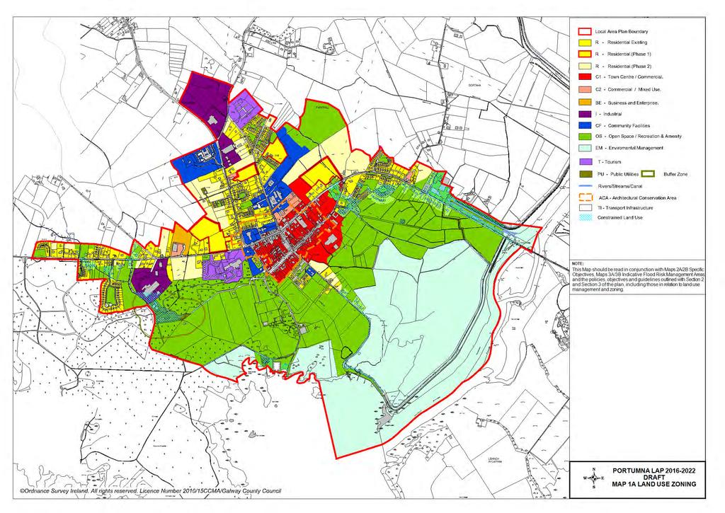
66

67
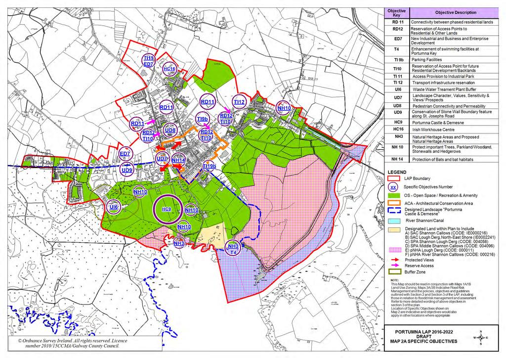
68

69

70

71
DRAFT Tuam Local Area Plan
 DRAFT Tuam Local Area Plan 2018-2024 January 2018 Table of Contents PAGE 1.0 Introduction.. 3 1.1 Preamble... 3 1.2 Profile of Tuam... 3 1.3 Local Area Plan... 4 1.4 Plan Informants & Key Considerations...
Draft Clifden Local Area Plan July 2018
 Draft Clifden Local Area Plan 2018-2024 July 2018 2 Table of Contents 1.0 Introduction.. 3 1.1 Preamble... 3 1.2 Profile of Clifden... 3 1.3 Local Area Plan... 4 1.4 Plan Informants & Key Considerations...
Oranmore Local Area Plan * Forward Planning Galway County Council Áras an Chontae Prospect Hill Galway
 Oranmore Local Area Plan 2012-2022* Forward Planning Galway County Council Áras an Chontae Prospect Hill Galway Adopted 24 th September 2012. *Deferral of Notice under 19(1)(d) for a period of 5 years
Gort Local Area Plan 2013
 Gort Local Area Plan 2013 Adopted 22 nd July 2013 Forward Planning Galway County Council Áras an Chontae Prospect Hill Galway Table of Contents Page 1. Introduction... 1 1.1 Preamble... 1 1.2 Profile of
elbridge Core Strategy
 C elbridge Core Strategy Celbridge is designated as a Moderate Growth Town in the RPGs. The County Development Plan reinforces this designation in its settlement strategy. Moderate Growth Towns within
Athenry Local Area Plan *
 Athenry Local Area Plan 2012-2022* Plan Adopted 25 th June 2012 Forward Planning Galway County Council Áras an Chontae Prospect Hill Galway Adopted 25 th June. *Deferral of Notice under 19(1)(d) for a
Variation No.1 Galway County Development Plan Adopted: 24th April 2017
 Variation No.1 Galway County Development Plan 215-221 Adopted: 24th April 217 Chapter 2 - Spatial Strategy, Core & Settlement Strategy 2.1 Background In its simplest terms the County Development Plan s
Variation No. 2 Introduction & Explanatory Document Variation made on 19th May 2014
 Meath County Development Plan 2013 2019 Variation No. 2 Introduction & Explanatory Document Variation made on 19th May 2014 1.0 INTRODUCTION The Meath County Development was adopted on 17 th December
Great Easton Neighbourhood Plan Statement of Basic Conditions
 Great Easton Neighbourhood Plan 2017-2031 Statement of Basic Conditions OCTOBER 2016 GREAT EASTON PARISH COUNCIL Contents 1.0 Introduction....Page 2 2.0 Summary of Submission Documents and Supporting Evidence..
Chapter 3 Core Strategy
 Chapter 3 Core Strategy 3.0 Introduction The core strategy sets out how the development objectives in the Development Plan are consistent with the National Spatial Strategy and the Regional Planning Guidelines.
Ipswich Issues and Options for the Ipswich Local Plan Review, August 2017, Public Consultation
 Ipswich Issues and Options for the Ipswich Local Plan Review, August 2017, Public Consultation Having reviewed the issues and options documents, the Society has made the following response: Part 1 Strategic
Variation No 1: Dundalk & Environs Development Plan Core Strategy
 Variation No 1: Dundalk & Environs Development Plan 2009-2015 Core Strategy Adopted on 29 th August 2011 CONTENTS Page Section 1 1.0 Synopsis 1 1.1 Background Document 1 1.2 Variation of Dundalk and Environs
Edenderry Local Area Plan
 Edenderry Local Area Plan 2017-2023 MATERIAL ALTERATIONS TO DRAFT EDENDERRY LOCAL AREA PLAN Public Display Document Section 1: Introduction 1.1 Introduction This report focuses on the proposed material
Official Plan Review
 Official Plan Review Summary Report - The Built Environment August 2014 Part 1: Introduction Planning for a healthy, prosperous and sustainable community is an important goal for our municipality. From
Site Assessment Technical Document Appendix A: Glossary
 Central Bedfordshire Council www.centralbedfordshire.gov.uk Site Assessment Technical Document Appendix A: Glossary July 2017 1.1.11-1 - ii Appendix A: Glossary Term Agricultural Land Classification AONB
Aebhin Cawley (Scott Cawley Ltd.) Appropriate Assessment in Practice A Consultant s Perspective
 Appropriate Assessment in Practice A Consultant s Perspective") Aebhin Cawley (Scott Cawley Ltd.) Appropriate Assessment in Practice A Consultant s Perspective Natura 2000 sites in Ireland 423 SACs (including 4 Marine) 153 SPAs Habitats Directive Article 6 (3) Any
Aebhin Cawley (Scott Cawley Ltd.) Appropriate Assessment in Practice A Consultant s Perspective Natura 2000 sites in Ireland 423 SACs (including 4 Marine) 153 SPAs Habitats Directive Article 6 (3) Any
DUBLIN DOCKLANDS MASTER PLAN AND RELATIONSHIP WITH OTHER PLANS
 .1 National Policy and Programmes.1.1 Sustainable Development A Strategy for Ireland, 1997.1.2 National Climate Change Strategy, 2007-2012.1. National Development Plan 2007-201.1.4 National Spatial Strategy,
Neighbourhood Planning Local Green Spaces
 Neighbourhood Planning Local Green Spaces Introduction... 2 1. Why green space is important... 4 2. Neighbourhood plans and green space... 6 3. Evidence... 8 Statutory designations... 9 Green space audit...
Tāhuhu whakaruruhau ā-taone The sheltering ridge pole
 B2. Tāhuhu whakaruruhau ā-taone - Urban growth and form B2.1. Issues Tāhuhu whakaruruhau ā-taone The sheltering ridge pole Auckland s growing population increases demand for housing, employment, business,
Strategic Environmental Assessment Screening Report. Dublin Port Masterplan Review 2017
 Strategic Environmental Assessment Screening Report Dublin Port Masterplan Review 2017 Table of Contents 1 Introduction... 1 2 Purpose of the Masterplan... 2 3 Task 1.1 Pre-Screening Check... 5 4 Task
DUNSFOLD NEIGHBOURHOOD PLAN Site Selection Policies
 DUNSFOLD NEIGHBOURHOOD PLAN Site Selection Policies The criteria for assessing sites for future housing and business development in Dunsfold are set out below. (Development criteria, covering what it is
A Growing Community Rural Settlement Areas
 Town of Huntsville Official Plan Review - POLICY BACKGROUND PAPER A Growing Community Rural Settlement Areas BACKGROUND: In addition to the fully municipally-serviced Urban Settlement Area and the Hidden
The Proposed Auckland Unitary Plan (notified 30 September 2013)
") 3 Business zones Introduction There are 10 business zones in the Unitary Plan: City Centre Metropolitan Centre Town Centre Local Centre Neighbourhood Centre Mixed Use General Business Business Park Light
3 Business zones Introduction There are 10 business zones in the Unitary Plan: City Centre Metropolitan Centre Town Centre Local Centre Neighbourhood Centre Mixed Use General Business Business Park Light
Droitwich Spa 6. Reasoned Justification
 87 Droitwich Spa 6 Reasoned Justification 6.1 Droitwich Spa is identified in the settlement hierarchy (Policy SWDP1) as a main town being the largest settlement in Wychavon District with an estimated population
Rochford District Council Allocations Development Plan Document: Discussion and Consultation Document Sustainability Appraisal
 Option SWH1 Balanced Communities Option SWH1 1 To ensure the delivery of high quality sustainable communities where people want to live and work Will it ensure the phasing of infrastructure, including
Suffolk Coastal Local Plan Review Issues and Options, August 2017, Public Consultation
 Suffolk Coastal Local Plan Review Issues and Options, August 2017, Public Consultation Having reviewed the issues and options documents, the Society has made the following response: Part 1 - Strategic
ROCHFORD LOCAL DEVELOPMENT FRAMEWORK: Sustainability Appraisal/ Strategic Environmental Assessment. Rochford Core Strategy Preferred Options Document
 ROCHFORD LOCAL DEVELOPMENT FRAMEWORK: Sustainability Appraisal/ Strategic Environmental Assessment Non Technical Summary Rochford Core Strategy Preferred Options Document October 2008 SUSTAINABILITY APPRAISAL
Appendix 1 Structure plan guidelines
 Appendix 1 Structure plan guidelines This appendix forms part of the regional policy statement [rps]. 1.1. Introduction Structure plans are an important method for establishing the pattern of land use
Circular L8/08 2 September Water Services Investment and Rural Water Programmes Protection of Natural Heritage and National Monuments
 Circular L8/08 2 September 2008 Water Services Investment and Rural Water Programmes Protection of Natural Heritage and National Monuments 1. The purpose of this Circular is to provide local authorities
Submission to the Kildare County Council Development Plan North Kildare Chamber. Executive Summary
 ` 28 th May 2015 Submission to the Kildare County Council Development Plan 2017-2023 North Kildare Chamber Executive Summary North Kildare Chamber s mission is to work with businesses, community groups,
Rathmolyon Written Statement
 Settlement Rathmolyon Position in Settlement Hierarchy Village - Local centre for services and local enterprise development Position in Retail Strategy Fourth tier retail centre Population (2011) Census
Appendix A. Planning Processes. Introduction
 1 Planning Processes Introduction This appendix outlines a number of planning processes which are used in the Auckland Region to support the effective management of development in the region s rural and
Plan Modification to Chapter B2 of the Auckland Unitary Plan(AUP) Operative in part (15 November 2016)
 Operative in part (15 November 2016)") UNITARY PLAN UPDATE REQUEST MEMORANDUM TO FROM Phill Reid Linley Wilkinson DATE 25 September 2018 SUBJECT Plan Modification to Chapter B2 of the Auckland Unitary Plan(AUP) Operative in part (15 November
UNITARY PLAN UPDATE REQUEST MEMORANDUM TO FROM Phill Reid Linley Wilkinson DATE 25 September 2018 SUBJECT Plan Modification to Chapter B2 of the Auckland Unitary Plan(AUP) Operative in part (15 November
DRAFT GREATER SYDNEY REGION PLAN OBJECTIVES, STRATEGIES AND ACTIONS
 Greater Sydney Commission DRAFT GREATER SYDNEY REGION PLAN OBJECTIVES, STRATEGIES AND ACTIONS Issued: 26 OCTOBER 2017 Version: 1 Subject: Greater Sydney Region and District Plans This information note
ROSCREA LOCAL AREA PLAN
 ROSCREA LOCAL AREA PLAN 2012-2018 June 2012 Table of Contents Chapter 1:Introduction 1.1 How to use this plan 3 1.2 Purpose of the plan 3 1.3 What is a Local Area Plan 3 1.4 Composition of the Plan 4 1.5
INCREMENTAL CHANGE AREA REVIEW March 2015 Page 1
 INCREMENTAL CHANGE AREA REVIEW March 2015 Page 1 Table of Contents Introduction... 3 Background to Review... 3 Comparison of the Schedules to the General Residential Zone... 7 Methodology... 7 Policy Context...
DRAFT WESTERN CITY DISTRICT PLAN PLANNING PRIORITIES AND ACTIONS
 Greater Sydney Commission DRAFT WESTERN CITY DISTRICT PLAN PLANNING PRIORITIES AND ACTIONS Issued: 26 OCTOBER 2017 Version: 1 Subject: Greater Sydney Region and District Plans This information note is
Our City Centre is a vibrant, creative and welcoming destination, with a modern business, cultural, shopping, leisure and residential offer
 3. Sheffield in 2034 Our City sits at the heart of a strong, distinctive and internationally successful City Region economy which supports innovation and enterprise Our City Centre is a vibrant, creative
Newcourt Masterplan. November Exeter Local Development Framework
 Newcourt Masterplan November 2010 Exeter Local Development Framework Background The Exeter Core Strategy Proposed Submission sets out the vision, objectives and strategy for the development of Exeter up
Ireland 2040 Our Plan Press Release
 Ireland 2040 Our Plan Press Release Today the Government published Ireland 2040 Our Plan for its final round of public consultations. Over the next number of weeks, until 3 November, the public will have
Chapter 2 Core Strategy
 Chapter 2 Core Strategy 11-24 2.1 Introduction 2.2 Strategic Planning Approach 2.3 Growth Consistency with the National Spatial Strategy & Regional Planning Guidelines 2.1 Introduction The overall strategy
Stantonbury Neighbourhood Plan
 Stantonbury Neighbourhood Plan 2018-2031 Basic Conditions Statement October 2018 Intentionally blank 1.0 Basic Conditions Statement Introduction 1.1 This statement has been prepared by Stantonbury Parish
Sustainability Statement. Whitby Business Park Area Action Plan
 Sustainability Statement Whitby Business Park Area Action Plan November 2014 Contents Page 1. Introduction 1 2. Scoping 3 3. Sustainability Appraisal of Options 6 4. Assessment of Draft Area Action Plan
Appendix A: Retail Planning Assessment
 Rotherham Town Centre Masterplan Appendix A: Retail Planning Assessment 139 Appendix A Rotherham Town Centre Masterplan Retail Planning Background and Policy Context 1. Introduction 1.1 The Masterplan
Vigo Neighbourhood Plan Basic Conditions Statement
 Vigo Neighbourhood Plan Basic Conditions Statement Plan Period: 2016 to 2028 Status: Submission Version Qualifying Body: Vigo Parish Council Glossary of Some Terms & Abbreviations Used in this Document
EVALUATION OF MASTER PLAN ALTERNATIVES
 7 The Environmental Report is required to identify, describe and evaluate reasonable alternatives, taking into account the objectives and geographical scope of the Master Plan 2008. Three plan alternatives
Core Strategy LONGFORD COUNTY DEVELOPMENT PLAN VARIATION NO. 1. Prepared by the Planning Section Longford Local Authorities
 Core Strategy LONGFORD COUNTY DEVELOPMENT PLAN 2009-2015 VARIATION NO. 1 Prepared by the Planning Section Longford Local Authorities Adopted on 19 September 2012 Introduction and Explanatory Note V ariation
City Regions Ireland
 City Regions Ireland 01 CITY REGIONS IRELAND COMPRISES OF CORK CHAMBER, DUBLIN CHAMBER, LIMERICK CHAMBER, WATERFORD CHAMBER AND GALWAY CHAMBER, ALL MEMBERS OF CHAMBERS IRELAND. 5 CITIES 8 PRINCIPLES A
PART 02 HASTINGS POINT IN CONTEXT
 PART 02 HASTINGS POINT IN CONTEXT 2.1 Background 2.1.1 Demographic Information 2.1.2 Existing Locality Characteristics 2.2 The Planning Framework 2.2.1 The Far North Coast Regional Strategy 2006 2.2.2
STRATEGIC DIRECTION. QLDC PROPOSED DISTRICT PLAN [PART TWO] DECISIONS VERSION 3 strategic direction
![STRATEGIC DIRECTION. QLDC PROPOSED DISTRICT PLAN [PART TWO] DECISIONS VERSION 3 strategic direction](/thumbs/79/79711764.jpg "STRATEGIC DIRECTION. QLDC PROPOSED DISTRICT PLAN [PART TWO] DECISIONS VERSION 3 strategic direction") 3 STRATEGIC DIRECTION QLDC PROPOSED DISTRICT PLAN [PART TWO] DECISIONS VERSION 3 strategic direction QLDC DISTRICT PLAN [PART TWO] AUGUST 2015 3 strategic direction 3.1 Purpose This chapter sets out the
3 STRATEGIC DIRECTION QLDC PROPOSED DISTRICT PLAN [PART TWO] DECISIONS VERSION 3 strategic direction QLDC DISTRICT PLAN [PART TWO] AUGUST 2015 3 strategic direction 3.1 Purpose This chapter sets out the
DAREBIN PLANNING SCHEME AMENDMENT C137
 Who is the planning authority? Planning and Environment Act 1987 DAREBIN PLANNING SCHEME AMENDMENT C137 EXPLANATORY REPORT This amendment has been prepared by the Darebin City Council, who is the planning
Table of Contents. Page. Chapter 1 Introduction. Chapter 2 Spatial Strategy, Core & Settlement Strategy
 Table of Contents Table of Contents Page Chapter 1 Introduction 1.1 Background 01 1.2 Legislative Context 02 1.3 Plan Informants 05 1.4 Profile of County Galway 08 1.5 Planning Issues in County Galway
Welford-on-Avon Neighbourhood Plan Consultation Event Sunday, 6 April Your name Your address
 Welford-on-Avon Neighbourhood Plan Consultation Event Sunday, 6 April 2014 Your name Your email address Please either: - complete this feedback form and put it in the box before leaving the Memorial Hall
Overview Report. Proposed Development
 Overview Report Proposed Development the construction of a 1km cycle/pedestrian trail including a new footbridge, new car park and entrance road at Drumshanbo Lock and a new pedestrian/cycle road crossing,
Meath County Development Plan. Variation No. 1 to Volume 1 Written Statement
 Meath County Development Plan 2013 2019 Variation No. 1 to Volume 1 Written Statement 2 Core Strategy Adopted Variation No. 1-04/11/2013 2.3.3 Residential Zoned Land Provision Table 2.4 details the requirement
STATEMENT OF OBJECTION TO THE PROPOSED DEVELOPMENT OF LAND AT CHURCH CLIFF DRIVE FILEY
 STATEMENT OF OBJECTION TO THE PROPOSED DEVELOPMENT OF LAND AT CHURCH CLIFF DRIVE FILEY You will be aware that Scarborough borough council have adopted a new local plan that includes land at Church Cliff
SUSTAINABLE MANAGEMENT
 . Sustainable Management.1 The Concept of Sustainable Management The concept of sustainable management recognises there are limits to the use of natural and physical resources and there is a need to balance
Plumpton Neighbourhood Development Plan Revised Pre Submission Document - Regulation 14 Consultation
 REPRESENTATIONS... Plumpton Parish Council Plumpton Neighbourhood Development Plan Revised Pre Submission Document - Regulation 14 Consultation Representations submitted on behalf of: Cala Homes (South
Parish of Repton NEIGHBOURHOOD DEVELOPMENT PLAN
 Parish of Repton NEIGHBOURHOOD DEVELOPMENT PLAN BASIC CONDITIONS STATEMENT December 2018 CEF 4 Legal Requirements This statement has been produced by the NDP Working Group on behalf of Repton Parish Council
Cotswolds AONB Landscape Strategy and Guidelines. June 2016
 Cotswolds AONB Landscape Strategy and Guidelines June 2016 Cotswolds AONB Landscape Strategy and Guidelines Introduction The evolution of the landscape of the Cotswolds AONB is a result of the interaction
Schedule of Planning Applications Committee Date: 23 May Reference: 06/17/0726/F Parish: Hemsby Officer: Mr J Beck Expiry Date:
 Schedule of Planning Applications Committee Date: 23 May 2018 Reference: 06/17/0726/F Parish: Hemsby Officer: Mr J Beck Expiry Date: 22-05-2018 Applicant: Proposal: Site: Mr Gillett Change of use to the
Welcome to our exhibition
 Welcome to our exhibition The Homes & Communities Agency (HCA) welcomes you to this public exhibition explaining our proposals for the redevelopment of the former Lea Castle Hospital site. About the Homes
WINCHESTER TOWN 3.1 LOCATION, CHARACTERISTICS & SETTING
 WINCHESTER TOWN 3.1 LOCATION, CHARACTERISTICS & SETTING 3.1.1 The area referred to by the City Council, as Winchester Town, consists of the Winchester Wards plus the adjoining built up areas of Badger
Draft Eastern District Plan
 Draft Eastern District Plan Submission_id: 31238 Date of Lodgment: 13 Dec 2017 Origin of Submission: Online Organisation name: Turrulla Gardens Pty Ltd C/- Mecone Organisation type: Industry First name:
Draft Island Development Plan
 Draft Island Development Plan February 2015 Written Statement Contents Part One 1 About the Island Development Plan What is the Island Development Plan? What is the Island Development Plan used for? Structure
Settlement Boundaries Methodology North Northumberland Coast Neighbourhood Plan (August 2016)
") Introduction This background paper sets out a methodology for the definition of settlement boundaries in the North Northumberland Coast Neighbourhood Plan. The neighbourhood plan is planning positively
Introduction This background paper sets out a methodology for the definition of settlement boundaries in the North Northumberland Coast Neighbourhood Plan. The neighbourhood plan is planning positively
3. Neighbourhood Plans and Strategic Environmental Assessment
 1. Introduction This report sets out a draft Screening Determination for the Preston Parish Council s Neighbourhood Plan and has been prepared by rth Hertfordshire District Council. The purpose of the
Maynooth. Local Area Plan Plean Cheantar Aitiuil Mháigh Nuad. 26th August 2013
 Maynooth Local Area Plan 2013 2019 Plean Cheantar Aitiuil Mháigh Nuad 26th August 2013 Table of Contents PART A Introduction and Context 1.0 Introduction 5 1.1 Local Area Plans Status and Process 6 1.2
1.0 PLANNING MARKHAM S FUTURE CONTENTS
 1-1 Planning Markham s Future 1.0 PLANNING MARKHAM S FUTURE CONTENTS 1.1 THE PURPOSE OF THE OFFICIAL PLAN 1.2 THE MARKHAM CONTEXT 1.3 THE REGULATORY CONTEXT 1.3.1 Province of Ontario 1.3.2 York Region
Enclosures Appendix 1: Draft Golders Green Station Planning Brief. Summary
 Policy and Resources Committee 23 February 2017 Title Report of Wards Status Urgent Key Golders Green Station Draft Planning Brief Cath Shaw Commissioning Director - Growth & Development Interim Deputy
Consultation Response to Lisburn and Castlereagh City Council LDP Preferred Options Paper (POP)
") Consultation Response to Lisburn and Castlereagh City Council LDP Preferred Options Paper (POP) Retail NI welcomes the opportunity to respond to the Council s Preferred Options Paper (POP) consultation
Consultation Response to Lisburn and Castlereagh City Council LDP Preferred Options Paper (POP) Retail NI welcomes the opportunity to respond to the Council s Preferred Options Paper (POP) consultation
CITY VIEW OBJECTIVES
 SECTION 2: CITY VIEW OBJECTIVES CONTENTS 2.1 Introduction 1 2.2 Strategic Direction 1 2.3 The City View Resource Management Issues for the City 1 2.4 The Goal 3 2.5 The City View Objectives 3 Palmerston
Appendix. Statement Outlining Compliance with Ministerial Guidelines
 18 Appendix Statement Outlining Compliance with Ministerial Guidelines A18 Statement Outlining Compliance with Ministerial Guidelines Under section 28 of the Planning and Development Act 2010, Meath County
Western City District What we heard
 What we heard Vision to 2056 and Priorities Governance and implementation Infrastructure and funding The protection of the natural landscape including biodiversity and the Metropolitan Rural Area for food
2.0 Strategic Context 4
 2.0 Strategic Context 4 2.1 The Area Action Plan is a non-statutory plan, which forms a corporate policy document, expressing particular issues and areas of concern while also providing a vision for the
Tiane Ltd Submission on Draft National Planning Framework Ireland 2040
 Tiane Ltd Submission on Draft National Planning Framework Ireland 2040 Date: 31 st March 2017 Authors: Ken Swaby / Ben Waite Approved By: Christy O'Sullivan ILTP Project Code & Reference: GOLDENATH Distribution:
KELLS DEVELOPMENT PLAN
 KELLS DEVELOPMENT PLAN 2013-2019 J Statement Outlining Compliance with Ministerial Guidelines Adopted 7th October 2013 APPENDIX J STATEMENT OUTLINING COMPLIANCE WITH MINISTERIAL GUIDELINES Under section
Neighbourhood Planning Guidance Local Green Spaces
 Neighbourhood Planning Guidance Local Green Spaces Introduction This guidance note has been produced for communities preparing neighbourhood plans in North Dorset to help them to identify, assess and designate
MAYFIELD WEST SECONDARY PLAN PHASE 2
 MAYFIELD WEST SECONDARY PLAN PHASE 2 Public Open House #3 February 25, 2010 Draft Preferred Land Use Scenario TOWN OF CALEDON PLANNING & DEVELOPMENT DEPARTMENT Open House Agenda TOWN OF CALEDON 1. Welcome
Chapter 2: OUTLINE PLANNING APPLICATION PROPOSALS. A New Garden Neighbourhood Matford Barton 17
 Chapter 2: OUTLINE PLANNING APPLICATION PROPOSALS A New Garden Neighbourhood Matford Barton 17 2.1. SUMMARY AND STATUS OF THE PROPOSALS 2.1.1. The parameter plans and associated wording in this chapter
APPENDIX K WINDSOR OFFICIAL PLAN
 CEAA ENVIRONMENTAL ENVIRONMENTAL IMPACT ASSESSMENT AMBASSADOR BRIDGE ENHANCEMENT PROJECT Replacement Span and Plaza Expansion APPENDIX K WINDSOR OFFICIAL PLAN Avalon Consulting Professionals of Ontario,
APPENDIX I STATEMENT OF COMPLIANCE. Plean Forbartha Chontae na Gaillimhe // Galway County Development Plan
 APPENDIX I STATEMENT OF COMPLIANCE Plean Forbartha Chontae na Gaillimhe // Galway County Development Plan Statement of Compliance Pursuant to Section 28 of the Planning and Development Act 2000 (as amended),
Town of Cobourg Heritage Master Plan. Statutory Public Meeting
 Town of Cobourg Heritage Master Plan Statutory Public Meeting April 25 th 2016 Presentation Overview 1. Introduction 2. Project background and schedule overview 3. Review of strategic direction content
Perth and Kinross Council Development Management Committee 8 June Pre-Application Report by Development Quality Manager
 Perth and Kinross Council Development Management Committee 8 June 2016 5(3)(i) 16/259 Pre-Application Report by Development Quality Manager Residential development at St Martins Road, Land 120 metres West
4 RESIDENTIAL ZONE. 4.1 Background
 4 RESIDENTIAL ZONE 4.1 Background The residential areas within the City are characterised by mainly lowrise dwellings sited on individual allotments. Past architectural styles, settlement patterns and
The Charter of European Planning BARCELONA 2013
 The Charter of European Planning BARCELONA 2013 The Vision for Cities and Regions Territoires of Europe in the 21st Century ECTP-CEU (The European Council of Spatial Planners Le Conseil Européen des Urbanistes)
Urban Design Guidelines
 Urban Design Guidelines These Urban Design Guidelines comprise the Key Design Objectives below, the Roads Design Guidelines overleaf and Neighbourhood Framework Plans. Together with Section 3: Urban Design
BRE Strategic Ecological Framework LI Technical Information Note 03/2016
 BRE Strategic Ecological Framework Technical Information Note 03/2016 September 2016 Contents 1. Introduction 2. Aims of BRE s Strategic Ecological Framework 3. How SEF is different from previous approaches
A VISION FOR SOUTH DUBLIN S FUTURE. Proposed Variation No. 2. Vacant Site Levy. Planning Report
 A VISION FOR SOUTH DUBLIN S FUTURE Proposed Variation No. 2 Vacant Site Levy Planning Report February 2018 Proposed Variation No. 2 South Dublin County Council County Development Plan 2016-2022 This is
WHITELEY TOWN COUNCIL NORTH WHITELEY DEVELOPMENT SEPTEMBER 2014
 WHITELEY TOWN COUNCIL NORTH WHITELEY DEVELOPMENT SEPTEMBER 2014 Dear Resident This Special Edition of the Whiteley Voice which has been prepared in conjunction with the North Whiteley Consortium is to
Dunboyne/Dunboyne North/ Clonee/ Local Area Plan
 Dunboyne/Dunboyne North/ Clonee/ Local Area Plan Strategic Policy SP 1 To operate an Order of Priority for the release of residential lands in compliance with the requirements of CS OBJ 6 of the County
14.5 HOPEFIELD: (REFER PLAN 39 AND PLAN 40)
") URBAN DYNAMICS WESTERN CAPE INC. 248 14.5 HOPEFIELD: (REFER PLAN 39 AND PLAN 40) FIGURE 83: LOCALITY - HOPEFIELD Within the context of the Saldanha Bay Municipal area, Hopefield, an historical agricultural
URBAN DYNAMICS WESTERN CAPE INC. 248 14.5 HOPEFIELD: (REFER PLAN 39 AND PLAN 40) FIGURE 83: LOCALITY - HOPEFIELD Within the context of the Saldanha Bay Municipal area, Hopefield, an historical agricultural
1 Introduction. Chapter. In this chapter:
 Chapter 1 Introduction In this chapter: 1.1 A Snapshot of the Region 1.2 Towards a Sustainable Region 1.3 The Provincial Context 1.4 Purpose and Organization The Regional Municipality of York Official
8.0 Design and Form of Development 43/
 42/ 8.0 Design and Form of Development 43/ Rothwells Farm, Golborne/ Development Statement Figure 7. Site Constraints Key 44/ Site Boundary 360 Bus Route/Stops Existing Trees Underground Water Pipe Sensitive
Meath County Development Plan. Proposed Draft Variation No. 1 to Volume 1 Written Statement
 Meath County Development Plan 2013 2019 Proposed Draft Variation No. 1 to Volume 1 Written Statement 2 Core Strategy Proposed Draft Variation No. 1!" #$ % & ' % $ ($ &' ) $) * (' &+( &' % $ * $ $ * %
2040 LUP is a part of the Comprehensive Plan and carries the same legal authority. Economic Challenges
 1.1. Guiding Anchorage s Growth Where will new residents settle over the next two decades? Where will people work, shop, and play? Will there be enough room to grow? How will Anchorage look? Will growth
Elderberry Walk. Developer HAB Housing
 Case studies Elderberry Walk Developer HAB Housing Development of 161 new homes on the former Dunmail Primary School site, focused around a central green street, with retained trees, new multifunctional
SECTION E. Realizing the Plan
 SECTION E Realizing the Plan 60 DESIGN REGINA - OFFICIAL COMMUNITY PLAN SECTION E Realizing the Plan Design Regina has been an ambitious plan-making exercise, with a high level of community, stakeholder,
Ratthcaiirrn Wrriitttten Sttattementt
 Ratthcaiirrn Wrriitttten Sttattementt Settlement Rathcairn Position in Settlement Hierarchy Village Serve a smaller rural catchment; provide local services with some smaller scale rural enterprises in
Clonard Written Statement
 Settlement Clonard Position in Settlement Hierarchy Village - Local centre for services and local enterprise development Position in Retail Strategy Fourth tier retail centre Population (2011) Census 339