Variation No.1 Galway County Development Plan Adopted: 24th April 2017
|
|
|
- Felicia Ferguson
- 6 years ago
- Views:
Transcription


1 Variation No.1 Galway County Development Plan Adopted: 24th April 217
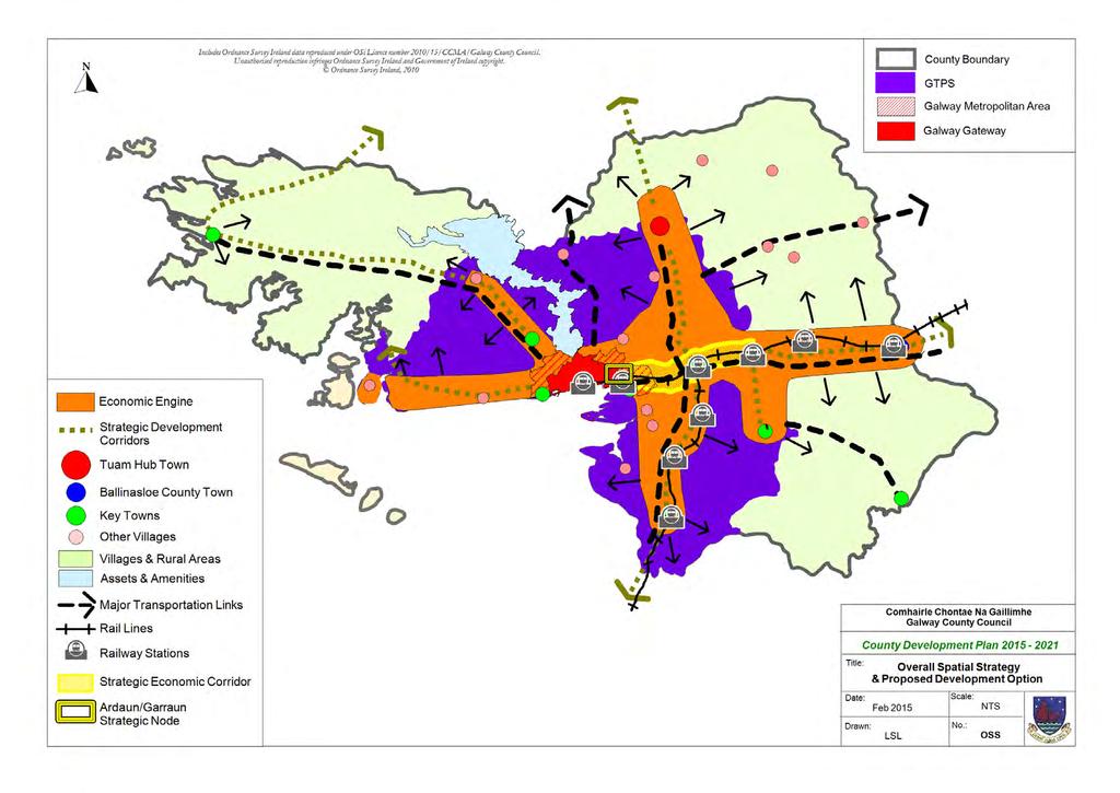
2 Chapter 2 - Spatial Strategy, Core & Settlement Strategy 2.1 Background In its simplest terms the County Development Plan s Spatial Strategy is the broad spatial distribution of people and activities, which sets the framework for the sustainable development of Galway into the future. The Spatial Strategy is determined by examining a range of potential development options for the County, arriving at the most appropriate outcome which will assist in delivering the Strategic Aims, as outlined in Chapter Spatial Strategy In setting the framework for the sustainable development of the County into the future, the Spatial Strategy must take account of the regional population targets set out in the Regional Planning Guidelines and determine how best to allocate this population throughout the County, over the lifetime of the plan. In this regard, a number of development options were examined so as to ascertain which option would deliver most effectively on the vision for County Galway and the Strategic Aims of the Plan Development Options A number of potential development options are listed hereunder, which were framed having regard to a range of considerations including the size of the settlements within the County, population and growth trends, regional population allocations, environmental sensitivities and the availability of services. The options are elaborated on and appropriately assessed as part of the Environmental Report of the SEA of the Plan. They include a) concentrating growth in urban areas and settlements, b) focussing growth predominantly into the Hub town of Tuam, c) promoting dispersed development throughout the County and finally d) developing the Hub town of Tuam, supporting the Gateway and key towns while encouraging the development of other settlement centres and appropriate development in the rural areas Preferred Development Options The County s Spatial Strategy builds on the principles established in the previous Galway County Development Plan , and the frameworks provided by the National Spatial Strategy and the Regional Planning Guidelines for the West Region The preferred option is primarily a structured approach to the future development of the County, building strong urban centres, facilitating job creation and regeneration, supporting the rural economy and carefully managing the County s environmental, heritage and natural assets, while avoiding exacerbation of flood risk. The preferred development option supports the nearby Gateway of Galway City and recognises the associated Galway Metropolitan Area, as referenced in the Regional Planning Guidelines, which includes the City area and a number of adjoining Electoral Divisions in the County which are inextricably linked to and function as part of the Gateway. This option focuses on fostering critical mass in the Hub town of Tuam to complement the Gateway and promote the development of the key towns and smaller villages along strategic development corridors, which it is anticipated will energise the surrounding rural areas within the County. While the strategic development corridors focus on the main established, and planned, transportation routes within the County including road and rail, simultaneously a greater emphasis shall be placed on the integration of land use and transportation generally, reducing travel distance and realising modal shift to more sustainable transportation options. This approach continues with the concept of a Strategic Economic Corridor to the east of Galway City, between Oranmore and Attymon, an area which has easy access and a high concentration of established and valuable infrastructure. This area has the potential to attract significant levels of investment and stimulate economic development and employment creation, performing a number of economic functions to support both the City, County and broader region. However, in addition to progressing the concept of the economic corridor, sustaining the buoyancy of the existing economic centres throughout the County, while 1
3 augmenting the tourism base and supporting sustainable rural-resourced enterprise, is critical to ensuring a balanced approach to the further development of the County. The preferred development option also proposes to pursue the main elements of the Galway Transportation and Planning Study (GTPS), as adopted by both Galway City and County in 23. The GTPS study area included Galway City and its hinterland, which is an area within an approximate 3km radius of the City. The recommendations of the study included both settlement and transportation options. It proposed consolidating development within Galway City and County within a planned corridor for expansion to the east, generally known as the Ardaun and Garraun area. It also focussed on developing the main county towns within Galway s catchment, linking to Galway City via a county-based, fixed route, radial network. It also proposed to continue with the careful management of the Galway Transportation and Planning Study (GTPS) area. This is the area of the County which experienced a rapid pace of growth during the prosperous years of the Celtic Tiger, resulting in high levels of single house development and increasing trends of dependency on the private car. The Galway Transportation Strategy (GTS), which was prepared by Galway City Council and Galway County Council in partnership with the National Transport Authority (NTA) in 216 supports the preferred development option. The study area for the Galway Transport Strategy comprises Galway County Council administrative area incorporating the settlements of Bearna, Maigh Cuillin, Baile Chlair, Oranmore and the Galway City administrative area. The overall objective of this strategy is to address and alleviate the transportation issues within the study area. The measures that are identified within the GTS include public transport initiatives, bus network provision, rail, park and ride facilities, cycle networks and the provision of the N6 Galway City Ring Road (GCRR) which is included as a Priority Transport Infrastructure Objectives listed in Table 5.1, Chapter 5 of this plan. Finally, in broader terms, the preferred development option seeks to provide for an enhanced quality of life for all citizens in County Galway, based on high quality sustainable residential communities, developed in tandem with social infrastructure and the provision of a pleasant working and recreational environment for all. 2
4
5 2.3 Development Strategy Objectives Development Strategy Objectives Objective DS 1 Development Strategy It is the overarching objective of Galway County Council to support and facilitate the sustainable development of County Galway in line with the preferred development strategy option: Option 4 To Develop the Hub Town of Tuam, supporting the Gateway and Key Towns while Encouraging the Development of Other Settlement Centres and Appropriate Development in Rural Areas, which will allow County Galway to develop in a manner that maintains and enhances the quality of life of local communities, promotes opportunities for economic development, sustainable transport options, social integration, and protects the cultural, built, natural heritage and environment while also complying with relevant statutory requirements. Objective DS 2 Galway Transportation and Planning Study Area (GTPS) a) Continue to recognise the defined Galway Transport and Planning Study Area, the commuter zone of Galway City, which requires careful management of growth and strong policies to shape and influence this growth in a sustainable manner. b) Support a review of the Galway Transportation and Planning Study during the lifetime of the Plan, in co-operation with Galway City Council. Consideration of the inclusion of a Strategic Transport Assessment shall form part of this review. Objective DS 3 Integrated Land Use and Sustainable Transportation Integrate land use planning and sustainable transportation planning, promote the consolidation of development, encourage sustainable travel patterns by reducing the need to travel particularly by private transport, while prioritising walking, cycling and public transport. Objective DS 4 Supporting and Securing Investment Galway County Council shall seek to secure investment or support investment, as appropriate, in the necessary infrastructure to pursue the Spatial, Core and Settlement Strategies as set out in this Plan. Objective DS 5 Protection and Management of the Assets of the County Protect and manage the assets that contribute to the unique visual and environmental character and sense of identity of County Galway, and which underpin tourism, heritage, biodiversity and quality of life. 4
6 Objective DS 6 Natura 2 Network and Habitats Directive Assessment Protect European sites that form part of the Natura 2 network (Including Special Protection Areas and Special Areas of Conservation) in accordance with the requirements in the EU Habitats Directive (92/43/EEC), EU Birds Directive (29/147/EC), the Planning and Development (Amendment) Act 21, the European Communities (Birds and Natural Habitats) Regulations 211(SI No.477 of 211) (and any subsequent amendments or updated legislation) and having due regard to the guidance in the Appropriate Assessment Guidelines 21 (and any updated or subsequent guidance). A plan or project (e.g. proposed development) within the plan area will only be authorised after the competent authority (Galway County Council) has ascertained, based on scientific evidence, Screening for Appropriate Assessment, and/or a Habitats Directive Assessment where necessary, that: a) The plan or project will not give rise to significant adverse direct, indirect or secondary effects on the integrity of any European site (either individually or in combination with other plans or projects); or b) The plan or project will have significant adverse effects on the integrity of any European site (that does not host a priority natural habitat type/and or a priority species) but there are no alternative solutions and the plan or project must nevertheless be carried out for imperative reasons of overriding public interest, including those of a social or economic nature. In this case, it will be a requirement to follow procedures set out in legislation and agree and undertake all compensatory measures necessary to ensure the protection of the overall coherence of Natura 2; or c) The plan or project will have a significant adverse effect on the integrity of any European site (that hosts a natural habitat type and/or a priority species) but there are no alternative solutions and the plan or project must nevertheless be carried out for imperative reasons for overriding public interest, restricted to reasons of human health or public safety, to beneficial consequences of primary importance for the environment or, further to an opinion from the Commission, to other imperative reasons of overriding public interest. In this case, it will be a requirement to follow procedures set out in legislation and agree and undertake all compensatory measures necessary to ensure the protection of the overall coherence of Natura 2. Objective DS 7 - Flood Risk Management and Assessment Ensure that proposals for developments located within identified or potential flood risk areas, or which may exacerbate the risk of flooding elsewhere, are assessed in accordance with the provisions of the Flood Risk Management Guidelines 29 (or any updated/superseding document) the relevant policies, objectives and guidelines within this plan and shall also take account of the National CFRAM Programme Flood Hazard Mapping and Flood Risk Management Plans when they become available. Objective DS 8 Climate Change Galway County Council shall support the National Climate Change Strategy and follow on document National Climate Change Adaptation Framework Building Resilience to Climate Change 212, on an ongoing basis through implementation of supporting objectives in this plan, particularly those supporting the use of alternative and renewable energy sources, sustainable transport, air quality, biodiversity, green infrastructure, coastal zone management, flooding and soil erosion. Objective DS 9 Projects/Associated Improvement Works/Infrastructure and Appropriate Assessment Ensure that proposed projects and any associated improvement works or associated infrastructure relating to renewable energy projects; water supply and abstraction; wastewater and discharges; flood alleviation and prevention; roads, power lines and telecommunications; and amenity and recreation provision are subject to Appropriate Assessment where relevant. Objective DS 1 Impacts of Developments on Protected Sites Have regard to any impacts of development on or near existing and proposed Natural Heritage Areas, Special Protection Areas and Special Areas of Conservation, Nature Reserves, Ramsar Sites, Wildfowl Sanctuaries, Salmonoid Waters, Refuges for Flora and Fauna, Conamara National Park, 5
7 shellfish waters, freshwater pearl mussel catchments and any other designated sites including future designations. Objective DS 11 - Strategic Development Corridors Co-ordinate new growth within the key towns, villages and settlements along the strategic development corridors throughout the County in order to create more sustainable development patterns and to optimise public and private investment made within the County and support the appropriate development of the Strategic Economic Corridor. Objective DS 12 Service Led Development Development shall only be permitted where there is satisfactory water and wastewater provision to service same, either existing or to be provided by the applicant in tandem with the development. Objective DS 13 - SEA Monitoring of the Plan Carry out SEA monitoring of the plan to ensure that any potential significant environmental effects of implementing the plan are identified and can be addressed accordingly. 2.4 Core Strategy The Core Strategy is an integral component of the Spatial Strategy. It transposes the population targets for Galway set out in the Regional Planning Guidelines and allocates them throughout the County, which in turn determines the Settlement Hierarchy and provides a rationale for the amount and location of land proposed to be zoned. The preparation of a Core Strategy as part of the County Development Plan process is a statutory requirement under the Planning and Development Act, 2 (as amended), establishing a transparent evidence-based strategy for the sustainable spatial development of the County. It is also a mechanism to demonstrate that the objectives of the Development Plan are consistent with national and regional development objectives as set out in the National Spatial Strategy and the Regional Planning Guidelines. STATUTORY REQUIREMENTS FOR THE CORE STRATEGY The Planning and Development Act requires the Core Strategy to: Provide relevant information to demonstrate that the Development Plan and the Housing Strategy are consistent with the National Spatial Strategy and Regional Planning Guidelines. Take account of any policies of the Minister in relation to population targets. Quantify the requirements for zoning of lands for residential and or a mix of residential and other uses and quantify the housing units to be included in the area. Demonstrate how the zoning proposals accord with national policy and that development will take place on a phased basis. Demonstrate that in setting out objectives regarding retail development in the plan, the Planning Authority has had regard to any Ministerial guidelines that relate to retail. Set out a settlement hierarchy. Include a diagrammatic type Core Strategy Map/visual representation, depicting the above information. Include a Core Strategy Table, summarising the key statistics in the Core Strategy regarding the distribution of future population and housing and its alignment with the Regional Planning Guidelines. 6
8 Core Aims of the Core Strategy Build on the regional level linkages between County Galway, the Gateway and other parts of the West Region by supporting the implementation of the regional spatial strategy, as set out in the West Regional Planning Guidelines. The regional spatial strategy aims to develop the Galway Gateway, the Tuam Hub and Castlebar-Ballina Linked Hub, supported by the development of the Athlone Gateway and key towns, encouraging the development of other settlement centres and appropriate development in the rural areas of the region. Provide for the growth of the County towards a target population of up to 198,5 persons by 222, as set out in the Regional Planning Guidelines for the West Region and to distribute that part of the population growth anticipated up to 221, in line with the Settlement Strategy and Hierarchy set out in this plan. Focus a greater growth in the Hub town of Tuam, the key towns, lower tier other towns and villages in a sequential manner, recognising the role that new infrastructure and public transport links will play in their future, while maintaining the viability of rural communities in the hinterlands of these towns and villages. Ensure a high level of environmental protection in the implementation of the Core Strategy and strategic aims and objectives of the plan Consistency with National Spatial Strategy and Regional Planning Guidelines In broad terms, the key objectives of the National Spatial Strategy and the Regional Planning Guidelines for the West Region with which the County Development Plan should align are as follows: STRATEGIC OBJECTIVES OF THE NSS & RPG s Providing for population growth in compliance with regional population targets. Promoting the development of the western region and notably for Galway the Galway City Gateway and Hub town of Tuam, linking the capabilities of the Gateway to other areas. Supporting the complementary roles for medium sized towns, smaller towns and villages as a focus for economic and social activity and residential development. Sustaining vibrant and diversified rural areas and identifying different types of rural areas with the need for differing responses to appropriate circumstances. Revitalising the West based on diversification of an economy previously centred on agriculture, and recognising the economic potential based in tourism, marine and natural resources and certain types of enterprise development. Meeting the infrastructural requirements of the region for now and into the future. Recognising that a high quality environment is a prerequisite for economic success, social cohesion and sustainable development. Enhancing the quality of life for all citizens and strengthening and protecting the cultural heritage of An Ghaeltacht. Strengthening linkages in terms of good transport, communications and energy networks to enable areas to play to their strengths. 7
9 Facilitating and providing integrated access infrastructure and sustainable transport, promoting public transport, minimising travel demand, maximising safety and enabling the efficient movement of goods and people. Promoting co-operation with other regions to develop economic corridors that accelerate overall regional growth Compliance with National and Regional Population Targets The Regional Planning Guidelines for the West Region have given effect to national population targets assigned by the Department of the Environment, Community and Local Government, by designating predefined population targets, with a maximum target at County level and a minimum target at Hub level. The County Development Plan must be consistent with the population targets set out in the RPGs, which is the starting point of the Core Strategy population allocation among the various settlements within the County. Population Targets West Region Galway County Tuam Hub ,2 17,1 7, ,7 185,86 8, , 4 198, 5 9,5 Target Increase : 79,2 28,4 1,9 Table 2.1: West Region Population Targets (Source: Regional Planning Guidelines ) Area Population Census 211 West Region 445,356 Galway County 175,124 Tuam 8,242 (Includes Tuam & Environs) Table 2.2: Census Population Figures (Source: Census 211) Analysis of Regional Population Figures According to Census data analysis, the population of the West Region grew by 65,59 during the nine year period between 22 and 211, which equates to an average population increase of 7,229 per annum. The Regional Planning Guidelines regional population growth target of 79,2 over the period 21 to 222 would deliver an average population increase of 6,6 each year, however, the RPGs annual growth rate target from is 7,83 and from is 6,117. The overall trend to date has been a positively increasing population; with the actual increase from the 21 target to the 211 Census figure being 3,156 or 45% of the annual targeted growth for the period
10 The RPG population target for the West Region in 21 was 442,2. When the average annual growth from of 7,229 is added to this figure of 442,2, a figure of 449,429 emerges for 211, which is slightly higher than the actual 211 Census population figure for the West Region, which was 445,356. County Galway is progressing well towards the RPG 216 target, as the average annual growth rate anticipated for County Galway is 2,627 while the actual growth rate from County Galway for 21 to 211, being almost double this figure at 5,24. The Central Statistics Office (CSO) is preparing national population forecasts based on the Census 211 results. Once these are prepared, it is anticipated that the Department of the Environment, Community and Local Government will prepare revised population targets for the Regional Authority Areas, Gateways and Hubs which will feed into the next review of the Regional Planning Guidelines. It is expected however, that significant changes to population targets will not result as the population targets in the West Region continue to provide a realistic basis for the development of the region and for the Core Strategy for County Galway, for the period 215 to Analysis of County Population Figures The population of the administrative area of County Galway increased from 143,245 in 22 to 175,124 persons in 211. The most comparable figures between actual population and targets are the 211 Census Figures of 175,124 and the stated 21 RPG estimates of 17,1, a difference of 5,24. At County level the population increased by 31,879 from 22 to 211, which is an average annual increase of 3,542 persons per annum. The RPG population target for the period 21 to 216 is 15,76, equating to an average annual growth of 2,627 persons per annum. Therefore the 211 population figures could have reached 173,642 or 172,727 if these trends were followed, both of which were below the actual 211 Census figure of 175,124, a difference of 1,482 or 2,397 persons respectively. As previously referred to, the 211 Annual Report of the West Regional Authority indicated that County Galway is in line to achieve its 216 RPG targets. Population Figures Galway County Tuam (&Environs) 22 Census 143, 245 5, Census 159,256 6, RPG Estimates 17,1 7,6 211 Census 175,124 8, RPG Target 185, 86 8,6 222 RPG Target 198, 5 9,5 Table 2.3: Census Population Figures & RPG Population Targets (Source: Census 22, 26, 211 & Regional Planning Guidelines for the West Region ) Analysis of Tuam Hub Figures The only other specific population target in the RPGs that relates to the administrative area of County Galway is that for the Hub Town of Tuam. When an analysis of these figures is undertaken, similar to that applied to the County figures above, it highlights actual population figures compared to target population figures are increasing at a higher than anticipated rate. The population of Tuam increased from 5,947 in 22 to 8,242 persons in 211, an increase of 2,295 persons which is an average annual increase of 255 persons, per annum. The RPG population target for Tuam for the period 21 to 216 is 1, persons, equating to an estimated average annual growth of 167 persons per annum. Therefore the 211 population figures could have reached 7,855 or 7,767 if these 9
11 trends continued, both of which were less than the actual 211 Census figure of 8,242, a difference of 387 or 475 respectively. The Census 211 population figures for Tuam were 8,242 as compared to the RPG 21 estimates of 7,6. Notwithstanding the higher than anticipated population of Tuam, of note is that the regional allocation figures for Tuam are based on minimum population targets, given its status as a Hub Town, and therefore the additional population can be accommodated once the overall population growth for the County remains within the maximum County targets set by the RPGs Population Allocation The County Development Plan provided for a maximum population target of 15,76 to the period 216, through its Core Strategy. This target was to be achieved by accommodating housing for 1,227 persons on zoned land within the urban areas of the County and by accommodating 5,533 persons in other settlements and the rural countryside. The Regional Planning Guidelines provide a maximum county target population up to the period 222, which is 198,5 persons, however as this County Development Plan timeframe runs from , adjustments need to be made to allow for the extra year. This methodology has been devised in consultation with the West Regional Authority, who are satisfied with the approach taken. The following table demonstrates how the Planning Authority arrived at the population allocations that will be included in the current Core Strategy Table. Population Figures Population Adjustment Calculations RPG Population Allocation (6 years) Estimates for 21 = 17,1 Estimates for 216 = 185,86 (185,86 17,1) = 15,76 15,76 / 6 = 2,626.6 Persons Average annual increase per annum RPG Population Allocation Estimates for 216 = 185,86 Estimates for 222 = 198,5 (198,5 185,86) = 12,64 12,64 / 6 = 2,16.6 Persons Average annual increase per annum County Development Plan = 6 Years Years =2,626.6 persons = 2,16.6 persons = 2, = 2, = 2, = 2, = 2, (2,16.6) =13,159.6 Core Strategy 13,16 persons Population Allocation for Table 2.4: Core Strategy Population Allocation Calculations Application of the Core Strategy Population Allocations The Core Strategy sets out the relevant figures for the population targets and the associated housing land requirement for the various urban areas listed in the Core Strategy Table at the end of this chapter. The housing land requirement is reflected through the quantum of zoned lands which facilitate residential 1
12 development. The Galway County Development Plan does not contain detailed zoning for the settlements, as zoning for the various towns and villages is specifically addressed in the relevant Local Area Plans, as appropriate, which are generally in place for all towns with a population over 15 persons. The Core Strategy must also set out how it is proposed to address the issue of any over-zoning in the Local Area Plans in place. In this regard, the approach assumed is that of phased sequential development and the re-zoning of lands as appropriate, in order to address any over-zoning and environmental constraints identified. This will ensure that the quantum of zoned lands that is available for development remains within the allocation outlined under the Core Strategy and that the Local Area Plans are consistent with the County Development Plan. This approach will also ensure that the urban settlements are consolidated by keeping them as physically compact as possible, which in turn reduces travel demand, better integrates land use and transportation options, allowing the promotion of more sustainable transportation modes The Core Strategy and Settlement Hierarchy The Core Strategy is statutorily required to provide for a Settlement Hierarchy which forms the basis of the Spatial Strategy for the County. The settlement hierarchy means a rank assigned to a town based on an assessment by the Planning Authority of the proposed function, role and the potential for economic and social development of the town. The Settlement Strategy and Settlement Hierarchy are dealt with in detail in Section 2.6 below, which also provides details on the rural areas of the County in respect of which the ministerial planning guidelines Sustainable Rural Housing-Guidelines for Planning Authorities (25) apply Extant Permissions and Unfinished Housing Estates In preparing the Core Strategy, an analysis of extant permissions on residential lands within Tiers 1, 2, 3 and 4 occurred. This analysis showed that the majority of units of extant permissions relate to R1 (Phase 1) zonings within the settlements that have live Local Area Plans. Notwithstanding the foregoing, there is a degree of uncertainty associated with extant permissions along with a number of wide-ranging variables to consider. A number of these permissions may expire prior to the adoption of this plan, some may receive an extension of duration pursuant to 42 of the Planning and Development Act, 2 (as amended), some may not be constructed owing to issues of viability and non-compliance with newly introduced building regulations, while on the other hand some may well be developed. It is not anticipated that most extant permissions will be developed and or will be subject to revised planning applications. The position with regard to all such developments will be known with more certainty at the next review of the Local Area Plans and will be fully addressed at such a review. The figures relating to extant permissions are outlined below in Table 2.5. Unfinished estates within the County are currently being addressed through the implementation of the national guidelines Managing and Resolving Unfinished Housing Developments Guidance (DoECLG, 211) and through the allocation of monies from the National Site Resolution Fund. Similar to the extant permissions, the final outcome of unfinished units is uncertain given the various stages of construction of the units, the various stakeholders involved and whether the units will be completed, sold, occupied or demolished. It is considered that only units complete and vacant will be of supply benefit over the plan period and according to the most recent figures available, this extends to a total of 295 units within the County. It is also difficult to appropriately gauge current demand for such units in the market, where location is a key desirability factor. This issue will be addressed progressively as information becomes available and the next review of the Local Area Plans will provide an opportunity to incorporate all available information at that time. It should be noted that Unfinished Estates come under the heading of extant permissions and as noted above the majority of these are in the Phase 1 zoned lands for residential purposes. Table 2.5 details unfinished estates data. Town Extant Units on R1 (Or Equivalent) Extant Units on R2 (Or Equivalent) Tuam Ballinasloe 39 (Phase1) & (Phase2) 271 (Phase 1) & 26 (Phase2) Loughrea Oranmore/Garraun Athenry
13 Gort Clifden 1 Bearna (R2+OV+IV Zonings) Portumna 178 (42 Units on Mixed Use Zone) Maigh Cuilinn Baile Chláir 6 Ardaun - - Oughterard 5 Headford An Cheathrú Rua 1 Craughwell 59 An Spidéal 2 TOTAL: 1, Table 2.5: Number of Units Relating to Extant Permissions in Local Area Plan Settlements Vacancy Rates and Residential Yield on Mixed Use Zonings Vacancy Rates The most recent Census indicates that the average residential vacancy rate for County Galway is 19.4%, equating to a figure of 15,66 units of which 3,274 are classified as vacant holiday homes. Having regard to this high level of vacant units, the Core Strategy Table has factored vacancy into the calculations, in so far as it can. It applies and includes the 19.4% vacancy rate in the figures presented therein to arrive at the figures in Column 7 in the Table entitled Housing Units on Residential Zoned Lands 1% Zoning, and has therefore influenced the remainder of figures within the table. It is acknowledged that vacant units contribute to supply and for this reason it has been considered alongside future demand requirements. This vacancy rate has also informed the Housing Strategy and figures contained therein. The approach taken reflects access to best available datasets from the CSO, which presently inhibits more detailed analysis of holiday/second homes. It should be noted that the vacancy rate applied does not take account of the usual frictional vacancy rate which would result in a lesser rate than that applied in the calculations in the Core Strategy Table. Residential Yield on Mixed Use Zonings An analysis of planning histories in mixed use zones and/or town centre zones was carried out for the larger Settlements. The pattern of development experienced in Galway towns over an extended period does not suggest that the mixed use town centre zone provides residential developments of any significance. During the period of economic growth a number of town centre developments comprising commercial and residential uses were permitted and while some of the smaller proposals have been developed, the majority of the larger developments have not commenced. Given the current economic climate and the type of developments in question, it is not anticipated that these will progress Household Size and Density Specifications The household sizes used in the calculations of the Core Strategy are 2.4 for Tuam and 2.6 for the remainder of the County. These are the same household sizes used in the Core Strategy of the Galway County Development Plan and were originally provided by the Regional Planning Guidelines for the West Region. Density specifications are typically used to manage development intensity and also to ensure that insufficient densities are not permitted which can compromise existing services, minimise the choice of housing options and undermine the viability of sustainable transportation options. Encouraging higher densities in appropriate locations capitalises on investment in existing infrastructure, supports employment, helps create sustainable and inclusive communities and encourages the preservation of the surrounding rural character and agricultural land uses. In relation to density and the Core Strategy, the Core Strategy Table provides for indicative density assumptions for the purposes of calculating the development land requirements for the various settlements listed within the table. In addition, Local Area Plans prepared for a number of the settlements in the County and Chapter 3 and DM Standard 2 of this plan, details more 12
14 specifically the densities considered appropriate in the different settlements within the settlement hierarchy tiers The Core Strategy and Transportation Strategy Chapter 5 of the County Development Plan sets out the Transportation Strategy which supports the Spatial Strategy, Core Strategy and Settlement Hierarchy for the County. It provides a strategic transportation framework promoting inter-connections between the Hub, the key towns and other settlements. The Settlement Strategy focuses on developing population centres along the County s existing transportation network, so as to provide the critical mass to support the maintenance and development of the network, and in the case of the Western Rail Corridor railway line, provide the critical mass and demand for its full re-opening in the future, benefiting the County and the Region as a whole. Galway County Council continues to support the extension of and improvements to existing transport infrastructure within the County, such as road, cycle, port and harbour networks and in conjunction with other agencies supports the improvements to rail, air and bus services, including the Rural Transport Programme. Details of the national and regional network and the inter-urban and commuter rail routes in the County are provided in Chapter 5, on Map TI 1-Strategic Transport Network Water and Wastewater Capacity In preparation of the Core Strategy cognisance has been taken of the provision of water and wastewater infrastructure and the availability of capacity within the public supply networks. The responsibility for the provision of these services now lies with Irish Water, supported by Galway County Council, as appropriate. While the overarching aim is to protect and enhance the water quality of the County and to ensure the implementation of the Water Framework Directive and Western River Basin Management Plan, it is acknowledged that infrastructure availability may be limited in some of the key towns and settlements identified in the Core Strategy Table. Notwithstanding this, in allocating population to the various towns and villages within the County, strategic decisions were taken based on the proposed role and function of the particular settlement and in the knowledge that infrastructural investment is required. It is considered that inclusion in the Core Strategy would assist in providing a plan led approach to securing the investment necessary in the future. The objectives set out in this section of the plan clearly assert that development may not proceed unless the necessary water and wastewater infrastructure is in place to service same The Core Strategy and Retail Development The Core Strategy is also statutorily required to contain information to show that in setting out objectives for retail development, the Planning Authority has had regard to the Retail Planning Guidelines and that the estimates of required future retail development are based on and take account of the specific population targets. In addressing this requirement, Galway County Council intends to prepare a Retail Strategy in conjunction/consultation with Galway City Council as set out in Chapter 4, Objective R3 of this plan. This Retail Strategy shall take account of the above requirements. Chapter 4 of the plan sets out the retail hierarchy for the County and provides a number of other objectives regarding retail management, set within the framework of the Retail Planning Guidelines for Planning Authorities 212. The retail hierarchy aligns with the designation of settlements in the Core Strategy table and associated Settlement Hierarchy, with the Hub town, County town and the key towns as the main focus for new retail developments. However, appropriately scaled new retail development in centrally located sites within Other Villages and Other Settlements shall also be encouraged Economic Development and Other Land Uses Land uses such as employment/industry uses and transport options have also informed the Core Strategy and Settlement Strategy in terms of assisting in identifying the role and capacity that individual settlements have for development and also in determining where the population allocations under the Core Strategy should go. The Spatial and Core Strategy, in line with the Regional Planning Guidelines for the West Region, recognises priority areas in relation to economic development for the County, such as the provisions for a Strategic Economic Corridor to the eastern area of the County, the role of urban areas in sustaining economic buoyancy, the importance of attracting foreign direct investment, promoting 13
15 indigenous industry, the food and craft sector, tourism, renewable energy and the smart economy, which are all detailed in Chapter 4 of the Plan and Map ED 1. In addition, Chapter 6 details policies and objectives in relation to services and infrastructure which are vital to the support of industrial and commercial development to both zoned lands in key towns and non-zoned lands in smaller settlements. National guidance on transport and residential development, such as policy on Smarter Travel-A Sustainable Transport Future (29-22), the Spatial Planning and National Roads Guidelines for Planning Authorities (212) and the Guidelines for Sustainable Residential Development in Urban Areas (29) have also informed the Core Strategy, advocating the need to promote compact urban development, reduce car dependency and promote sustainable mobility. This is achieved through closely integrating housing with other significant land uses such as employment and commercial zones, amenity and community facilities and ensuring the provision of sufficient amounts of lands identified for employment purposes at suitable locations, taking account of national planning policies such as those above and the availability of the required physical infrastructure, particularly access and water services. 14
16
17 2.5 The Core Strategy Objectives Core Strategy Objectives Objective CS 1 Provision of a Settlement Hierarchy Galway County Council shall provide a strong and clearly defined hierarchical network of settlements that allow for the sustainable and balanced growth of the County s economy. Objective CS 2 Development Consistent with the Core Strategy Galway County Council shall ensure that developments permitted within the County are consistent with the County population allocations set out in the Regional Planning Guidelines. Objective CS 3 Economic and Employment Development Galway County Council shall encourage the development of mixed-use settlement forms, supporting economic and employment development at appropriate locations, ensuring the provision of a satisfactory quantum of zoned land for employment and industry purposes, and ensuring housing, employment uses and community facilities are located in close proximity to each other and to public transport corridors, where possible. Objective CS 4 Development of Serviced Lands Galway County Council shall ensure that the zoning of lands for residential use is in accordance with the Core Strategy and Settlement Strategy in order to meet the development needs of the County, and ensure that the development of zoned lands is subject to adequate capacity being available in the relevant water and wastewater treatment facilities, prior to or in tandem with the development, in the interest of protecting water resources in the area. Objective CS 5 Phasing of Development of Lands The zoning of residential zoned lands within the urban areas shall be based on a phased, sequential approach as set out within the Local Area Plans, with a strong emphasis placed on consolidating existing patterns of development, encouraging infill opportunities and promoting sustainable transport options. Objective CS 6 Local Area Plans Galway County Council shall seek to prepare Local Area Plans for all settlements which have a population in excess of 1,5 persons either on an individual basis or in an electoral area Local Area Plan, having regard to the Local Area Plans Guidelines for Planning Authorities (213) and the associated Local Area Plans Manual (213). Objective CS 7 Core Strategy and the Countryside/Rural Areas Galway County Council shall recognise the important role of the rural areas within the County and shall protect and support these areas through the careful management of its key assets, including its physical and environmental resources, while supporting appropriate development in a balanced and sustainable manner and in accordance with the relevant policies and objectives set out throughout the Plan. Objective CS 8 Core Strategy and Demand for Development Galway County Council is committed to ensuring that the overall population growth of the County complies with the level of growth set by the Regional Planning Guidelines and settlement hierarchy as outlined within the Core Strategy. 2.6 Settlement Strategy Strong settlements are imperative to a buoyant and vibrant County as they support a range of jobs, services and sustainable transport options, while providing a range of housing choices and a focus for community 16
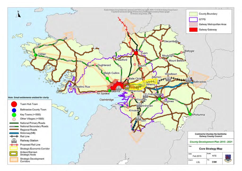
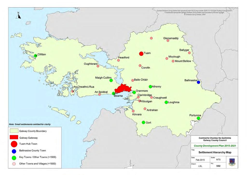
18 networks within the settlement area and beyond. In this regard, a Settlement Strategy is a spatial expression of population distribution, settlement size, and settlement role and hierarchy. The County Spatial Strategy together with the Core Strategy informs the Settlement Strategy, providing a planning framework for the location of population and development over the six year life span of this County Development Plan. The Settlement Strategy is very closely aligned with the Core Strategy and identifies potential development patterns for different areas of the County and informs the basis of policies and objectives necessary to create conditions that will influence the location of development into the future. The Settlement Strategy also gives effect to the broader objectives outlined in the National Spatial Strategy and the Regional Planning Guidelines for the West Region Settlement Hierarchy The Settlement Strategy builds on the Spatial Strategy taking account of the maximum Core Strategy population provision of 13,16 persons. The Settlement Hierarchy has been developed to allocate future population growth between the various towns, villages and the rural area of the County. It has taken account of the analysis of a range of criteria including the capacity of the settlement to contribute towards achieving the objectives of the Spatial Strategy and Core Strategy, the existing settlement size in terms of trends in population and household growth over previous census periods, the presence and capacity of water and wastewater services including planned investments in water and wastewater infrastructure, service functions (such as the number of services and retail units), accessibility, zoned land, landscape and heritage considerations. This Settlement Hierarchy recognises that there are different categories of settlements throughout Galway, all with a complementary role to play in the future prosperity of the County. In this regard it has identified over 1 settlements in the County ranging from small crossroad settlements, to larger villages and main towns such as Ballinasloe and Tuam. It also recognises that the rural area must be catered for within the Settlement Hierarchy as it plays an essential role in the overall settlement structure by developing sustainable rural communities. 17
19 The County Development Plan has adopted a six tiered system which is set out below. Tier Description 1. Galway Metropolitan Area Galway City is the identified Gateway and vital economic driver for the entire West Region. The types of services provided by the city reach beyond the city/county boundary. Significant employers include large public service and industrial organisations that draw employees from the network of satellite towns surrounding the City. The Galway Metropolitan Area includes the Gateway and a number of electoral divisions adjacent to the City which are inextricably linked to and function as part of a greater Galway City and includes the thriving satellite settlements of Oranmore and Bearna. The longer term plans to develop the Ardaun and Garraun areas will also contribute to strengthening the Galway Metropolitan Area. 2. Hub Town Tuam is the only major hub town identified in the National Spatial Strategy for County Galway and has witnessed a steady growth in population over the last number of Census periods. It is envisaged that Tuam will develop as a strong Hub Town complementing the Gateway and catering for a large catchment within the County and Region. 3. County Town Ballinasloe as a County town is one of the largest towns in Galway and performs an important role, in particular as a commercial/industrial centre for the eastern area of the County. The town has important transport connections and provides ease of access to other major regional centres including Dublin, Galway and Athlone. 4. Key Towns (Other Towns) (>15 Pop.) These towns provide an extensive range of services including health, community, financial, employment and retail. Many have a strong historical identity as market towns and in most cases have a relatively well-developed infrastructure. Sustained growth in these settlements is required to achieve their potential as self-sustaining towns in their own right. 5. Other Villages (<15 Pop.) These settlements have a population of less than 15 persons and provide a more limited range of services to smaller hinterlands than the key towns. Service provision often includes a range of retail and educational services but limited financial, health and community services. 18
20 6. Other Settlements & the Countryside These smaller settlements provide basic services to their community, such as convenience goods and primary education and religious services. They are distinguished from rural housing by the presence of these services which provide an important community purpose and the basis for further future development. The countryside refers to those parts of County Galway that are outside of recognised settlements. The tiers set out in the hierarchy allow the relationships between different types of towns, villages and settlements within the County to be visualised. The position of a settlement within the hierarchy sets out an indication of the potential scale of population growth permissible within the lifetime of the plan and therefore aligns closely with the Core Strategy population allocations. The underlying aims of the Settlement Strategy are linked with and supported by the relevant policies and objectives elsewhere in the plan, to ensure that settlements deliver on their roles as service and employment centres for the existing and targeted population. The Galway County Development Plan does not have any land use zonings other than those set out for the purpose of the County Galway Wind Energy Strategy, therefore, the settlements with a population of over 1,5 persons shall have a Local Area Plan in place, as statutorily required. The zoning provisions in the various Local Area Plans will give effect to development and future growth of the towns and villages. Local Area Plan Timeframe Status Tuam Live Ballinasloe A new LAP under preparation (Development Plan) Loughrea Live Oranmore Live Athenry Live Clifden Extended to 22 Bearna Extended to 217 Portumna Under Preparation Maigh Cuilinn Live Baile Chláir To Be Commenced Ardaun Under Consideration Oughterard To Be Commenced Headford Under Preparation An Ghaeltacht Extended to 218 Craughwell Live Table 2.6: Schedule of Status of Local Area Plans for County Galway 19
21 *Galway Metropolitan Area (Bearna/Oranmore Garraun/Ardaun) Hub Town TUAM County Town BALLINASLOE **Key Towns /Other Towns Loughrea, **Oranmore, Athenry, Gort, Clifden, Portumna, Maigh Cuilinn ***Other Villages Baile Chláir, Oughterard, Headford, Mountbellew, Ballygar, An Cheathrú Rua, Dunmore, Glenamaddy, Craughwell, Kinvara, Corofin, Moylough, Clarinbridge, An Spidéal, Ardrahan, Kilcolgan,An Tulaigh/Baile na habhann, Cor an Dola, Woodlawn, Kilconnell,New Inn,Ballymacward. Other Settlements & Rural Area Briarhill, An Carn Mór, Lackagh, Turloughmore, Abbeyknockmoy, Cluain Bú, Eanach Dhúin, Ahascragh, Attymon, Monivea, Eyrecourt, Banagher, Aughrim, Caltra, Clonfert, Kiltormer, Menlough, Lawrencetown, Fohenagh, Killoran, Castleblakeney, Ballinamore Bridge, Gorteen, Cappataggle, Willimastown, Kilkerrin, Barnaderg, Belclare, Kilbennan, Briarfield, Newbridge, Ballymoe, Milltown, Kilconly, Caherlistrane, Brownsgrove, Sylane, Lavally, Foxhall, Newbridge, Cashla, Kiltevna, Glinsk, Ballyglunin, Laragh More, Woodford, Killimor, Ballymana, Esker, Carrabane, Kiltullagh, Derrydonnell Beg, Ballinderreen, Kilchreest, Ballinakill, Moyglass, Peterswell, Killeenadeema, Drim, Kilconieran, Labane, Tynagh, Kilreekil, Abbey, Bullaun, Castledaly, Coose, Newcastle, Cooloo, Shanaglish, Na Forbacha, An Cnoc, Na Minna, Ros an Mhíl, Rosscahill, Tulaigh Mhic Aodháin, Leitir Móir, Cill Chiaráin, Cill Rónáin, Roundstone, Carna, Tully/Renvyle, Glinsk, Leitir Mealláin, Béal an Daingin, Tullycross, Rosmuc, An Fhairche, Leenane, Cleggan, Letterfrack, Casla, Corr na Móna, Ballyconneely, Sraith Salach, Claddaghduff, An Mám, Maam Cross, An Aird Mhóir, Maree, Kilbeacanty, Cloghanover, Camas. *Galway Metropolitan Area includes Galway City and the DEDs of Galway Rural, Ballintemple, Oranmore and Bearna (also the Bearna LAP Area) and includes the areas of Ardaun and Garraun. **Oranmore is listed here again, as the GMA only encompasses part of the LAP area of Oranmore. ***Note: Not all of the towns listed in this tier have or previously had Local Area Plans prepared for them, therefore only the towns with LAPs or previously prepared LAPs are listed in the corresponding tier of the Core Strategy Table. 2
22 2.6.2 Galway Metropolitan Area (GMA) The Galway Metropolitan Area is located at the top of the settlement hierarchy and this includes the Gateway of Galway City. It is recognised that the Galway Gateway is located outside the jurisdiction of Galway County Council; however given the County DED areas within the GMA are so inextricably linked to same, it is considered an appropriate location within the Settlement Hierarchy. The envisaged role in the NSS of Galway City and the role of the GMA as set out in the RPGs including the plan led growth of the Ardaun and Garraun area, are crucial to the future of the County and the wider region. The future prosperity of towns and villages near the City and the quality of life of people living within the commuter band around Galway City depend on the Gateway and GMA retaining its dynamic growth character. In addition, the Galway Transport Strategy (GTS) has identified a series of measures that are required to improve the transport infrastructure within Galway City and environs, leading to improvements in the general accessibility of the area to enable the GMA to fulfil its full potential as an economic driver of the region. Given it attracts significant inward investment and is a provider of regional services and facilities it is essential that the regional settlement strategy provides for the sustainable, dynamic development of the Galway Gateway and Galway Metropolitan Area to support the economic growth of the region The Tuam Hub The National Spatial Strategy designated Tuam as a Hub in Ireland s future spatial structure. Its role as a Hub is to interact with and complement the Gateway of Galway City and drive development in rural northeast Galway. The Regional Planning Guidelines for the West Region underpin this role and describe the town as an important industrial and agricultural centre for mid-connacht. The Tuam Local Area Plan makes provision for the development needs of Tuam to reach its minimum residential targets as set by the Regional Planning Guidelines 21 and to cater for the commercial, industrial, social and leisure requirements of this growing population. There is adequate capacity in the town s water supply and effluent treatment systems, and its location on the Western Rail Corridor will, when this facility is restored, provide a sustainable transport link between the western gateways and hubs. There are opportunities to expand and consolidate the town centre and business/enterprise districts of Tuam to capture and encourage sustainable economic growth and accommodate new residents. It is a key element of the Spatial and Settlement Strategy of the County Development Plan to promote and facilitate the development of Tuam as a town in which people can live and work in a quality and distinctive environment, and which will serve as a dynamic town for the social and economic progress of north and east Galway and the wider region Ballinasloe - The County Town Ballinasloe is the County town, playing an important role in particular for east Galway and in the delivery of Local Government services. This Development Plan commits to continue and enhance the delivery of Local Government services in the County town, Béal Átha na Sluaighe. It is a key commercial centre and a large employer for the residents of the town and surrounding hinterland. It provides higher order important services such as Portiuncula Hospital and St. Brigid s Hospital which serve a regional population. Ballinasloe is easily accessible by road and rail with direct links to Galway and Dublin. It is an important town with great potential that can facilitate growth and should be targeted in this regard The Key Towns/Other Towns (Population >1,5) For the purpose of this Development Plan, the towns in this tier refer to key towns with a population greater than 1,5 persons and they include Loughrea, Oranmore, Athenry, Gort, Clifden, Portumna and Maigh Cuilinn which hold important positions within the County as key service centres and drivers of growth for their immediate and surrounding areas. The key towns have a high degree of self-sufficiency, reduce the demand for travel and provide a good quality of life for residents. Self-sufficiency refers to where a large proportion of the population, living in the town or surrounding area, are able to live, work, shop, go to school and enjoy recreation without the need for constant travel Other Villages (Population <1,5) The villages in this tier of the hierarchy include Headford, Mountbellew, Baile Chláir, Ballygar, An Cheathrú Rua, Dunmore, Glenamaddy, Craughwell, Corofin, Moylough, Kinvara, Clarinbridge, An Spidéal, Ardrahan and Kilcolgan. They have strong settlement structures and have the potential to support additional growth, 21
23 offering an alternative living option for those people who do not wish to reside in the larger key towns and do not meet the housing need requirements for the rural area. The wastewater treatment facilities in some of these towns/villages require investment and therefore it is considered that their inclusion at this level in the hierarchy will provide a plan-led approach to securing this investment in the future Small Settlements and the Countryside/Rural Areas The remainder of the population targets are directed towards the small settlements and the rural areas. There are numerous small settlements in the County, which are considered predominantly rural in nature. They provide an important, albeit limited service to the local community through their existing facilities such as national schools or a post office and it is important to support the growth and development of these small centres to facilitate the needs of local communities. In addition to the small settlements, it is important to support viable rural communities in order to seek balanced growth in the different areas of the County and in this regard, the settlement hierarchy takes account of housing in the countryside or the rural area. However, development in the un-serviced countryside requires careful management, in order to balance the need to revitalise and support communities, while ensuring the overall sustainable development of these areas. In this regard, and in accordance with the national guidance document Sustainable Rural Housing- Guidelines for Planning Authorities (25) development of single rural housing, for rural generated housing needs for people who have intrinsic links to the rural area in which they seek to reside, shall be considered positively, however planning applications for such developments shall also be assessed in accordance with the relevant policies and objective set out within the Plan. The rural area of the County has been divided into two different categories, which fit very broadly in to the categories of rural areas as set out in the National Spatial Strategy and the Sustainable Rural Housing Guidelines. These rural area categories are: 1. Rural Areas Under Strong Urban Influence These areas exhibit characteristics such as proximity to the immediate environs or close commuting catchment of Galway City, rising population, evidence of considerable planning pressure for development of housing due to proximity to such urban areas or to major transport corridors with ready access to the urban area, and pressures on infrastructure such as the local road network. 2. Structurally Weaker Rural Areas These areas exhibit characteristics such as persistent and significant population decline as well as a weaker economic structure based on indices of income, employment and economic growth. In addition to the two broad rural areas listed above, there are a number of additional specific planning considerations that need to be taken into account when assessing rural housing in the countryside. These include rural housing within: Landscape Sensitivity Areas 3, 4 and 5 Areas where access is required on to restricted regional routes and national routes Gaeltacht areas. The above distinctions between the rural area is necessary in order to be able to facilitate the housing requirements of persons with roots or links in rural areas as appropriate, and also to be able to respond to local circumstances whether these relate to areas experiencing economic and population decline or to areas under substantial pressure for development. 22
24
25 2.7 Settlement Strategy Objectives Settlement Strategy Objectives Objective SS 1 Galway Metropolitan Area Galway County Council shall support the important role of Galway City and the Galway Metropolitan Area (which includes the City area and the Electoral Divisions of Oranmore, Bearna, Galway Rural and Ballintemple which are inextricably linked to and function as part of a greater Galway City), as key drivers of social and economic growth in the County and in the wider Western Region and will support the sustainable growth of the strategic settlements, including the future development of Ardaun and Garraun, within the Galway Metropolitan Area. Objective SS 2 Ardaun Facilitate and support the development of Ardaun in conjunction with Galway City Council. Objective SS 3 Hub Town : Tuam Galway County Council shall promote and secure the development of Tuam, to enable it to fulfil its potential as a hub town, so that it obtains the critical mass necessary to sustain strong levels of economic growth and prosperity, while supporting improvements in connectivity between the Gateway and the Hub, enhancing their complementary status. Objective SS 4 County Town : Ballinasloe Recognise the County town of Ballinasloe as an important driver of growth in the County and support its sustainable development in line with the Core Strategy, in order to sustain its commercial core, retain its population and accommodate additional population and commercial growth. Objective SS 5 Development of Key Towns Support the development of the key towns of the County as outlined in the Core Strategy and Settlement Strategy in order to sustain strong, vibrant urban centres which act as important drivers for the local economies, reduces travel demand and supports a large rural hinterland, while providing a complementary role to the hub town of Tuam and the smaller towns and villages in the County. Objective SS 6 Development of Other Villages Protect and strengthen the economic diversity of the smaller towns, villages and small settlements throughout the County, enabling them to perform important retail, service, amenity, residential and community functions for the local population and rural hinterlands Objective SS 7 Development of Small Settlements In the case of smaller settlements for which no specific plans are available, development shall be considered on the basis of its connectivity, capacity (including social, cultural, and economic, infrastructural and environmental capacity) and compliance with the Core Strategy and Settlement Strategy, good design, community gain and proper planning and sustainable development. Objective SS 8 Development of Rural Communities Galway County Council shall recognise the important role of rural communities to the sustainable development of County Galway and shall ensure the careful management of development in these areas, having due regard to the relevant policies and objectives set out elsewhere in the plan. 24
26 Core Strategy Table: February Core Strategy Population Allocation Housing Land Requirement (Ha) 4.Housing Land Requirement (Ha) (Includes Over Zoning) 5.Existing Undeveloped Residential Zoned Land 6. Proposed Zoning 7.Housing Units Yield on Residential Land 1% Zoning & Indicative Density Specifications 8.****Housing Units Yield on Other Lands 9.Shortfall/ Excess Using 5% Overzoning (Zoned Land Excluding Other County (Zoned Land Excluding Settlements & Countryside) Other Settlements & (Including Countryside) Tuam) 3,189 13, Gateway N/A N/A N/A N/A N/A N/A N/A N/A N/A Hub Town Tuam 2, County Town Ballinasloe 1, Other Towns (>15) Loughrea *Oranmore/Garraun Athenry Gort Clifden *Bearna Portumna Maigh Cuilinn 1,133 1,17 1, ***Other Villages (<15) Baile Chláir *Ardaun Oughterard Headford An Cheathrú Rua Craughwell An Spidéal **Subtotal: 1, , Other Settlements & Countryside 3, Total 13, (Excl. Other Settlements & Countryside) (Excl. Other Settlements & Countryside) (Excl. Other Settlements & Countryside) *These settlements form part of the Galway Metropolitan Area. **Individual figures within each tier may not calculate exactly to the subtotal figures due to rounding of numbers. ***The Settlement Hierarchy includes additional villages in this tier-only villages with LAPs prepared or proposed to be prepared are included in the Core Strategy Table. ****See new paragraph in Chapter 2. LAPs for Portumna, Headford, Baile Chláir and Oughterard will be progressed as a priority. See proposed Table 2.6 with list of LAPs and their status in Chapter 2. (Excl. Other Settlements & Countryside) 3,
27 Chapter 5 Roads & Transportation 5.1 Land Use Integration and Sustainable Transport Strategy The integration of transport planning, access and land-use considerations strives to provide for sustainable forms of transport, helps create more sustainable communities and promotes balanced regional development. The timely provision of a high quality transportation infrastructure within County Galway is critical to the County s socio-economic development and in the promotion of social and economic wellbeing. One of the strategic aims of the County Development Plan was to move towards a more sustainable and integrated concept of development with regard to land use, transportation, water services and energy supply. The Spatial/Settlement Strategy focused development in Tuam Hub Town and key towns and villages along strategic development corridors, emerging along the new transportation infrastructure (road and rail) as recommended in the Galway Transportation and Planning Study 1999, 23 (GTPS). Many of the GTPS s initiatives are still relevant and have informed subsequent policy documents and national guidelines such as the National Development Plan, the National Spatial Strategy, the Regional Planning Guidelines (RPG) for the West Region and have also informed the spatial/settlement strategies and the transportation strategy of previous Galway County Development Plans. The integration of land use and transportation shall continue to be the overarching strategic aim of the Galway County Development Plan The Transportation Strategy for County Galway as set out within this Chapter will build on the priority access infrastructure noted within the Regional Planning Guidelines for the West Region such as completion of the Atlantic Corridor M18/M17 and N17, the critical bypasses on National Secondary Routes such as the N59 Maigh Cuilinn and N17 Baile An Chláir By-Pass, the improvement /upgrade of the R336 between Galway and Scríb via Ros an Mhíl and the reclassification and upgrade of the N6/61 as a National Primary route as well as the provision of the N6 Galway City Ring Road. The RPG s also support a review of the Galway Transportation and Planning Study, the opening of the entire Western Rail Corridor, improvement to bus services and accessibility including the rural transport services, upgrading of air transportation infrastructure including services, promotion of a sustainable and usable cycling network within the region and the sustainable development of listed ports and harbours. Galway County Council will continue to support extensions and improvements to existing transport infrastructure within County Galway such as road, cycle, port and harbour networks and shall support in conjunction with other agencies improvements to rail, air and bus services including the Rural Transport Programme. It is acknowledged that the Council is a facilitator in the delivery of the public transport services and infrastructure as they are outside the jurisdiction of the Council. Galway County Council will collaborate with other agencies/service providers, and will also work with the National Transport Authority (NTA) and Transport Infrastructure Ireland (TII) who are the statutory authorities appointed with responsibility for delivering transport infrastructure in Ireland, and with Galway City Council in order to deliver an overall integrated transport solution for Galway. Transportation Solutions It is national policy since 29 that Ireland moves towards sustainable transport to reduce congestion and transport emissions, to support economic competitiveness and improve the quality of life for all. Smarter Travel A Sustainable Transport Future, a policy framework approved by the Government, sets out measures so that by 22 there will be thousands more people walking, cycling and using public transport. This policy emphasises the need to align land use and transportation which encourages sustainable patterns of travel and this is reflected at national and regional level through spatial planning and transport policies. Despite the economic difficulties of recent years, Galway City and environs has continued to grow in population and employment; and as the economy grows, the opportunities afforded by the city and environs will continue to attract more people to live and work in the area. In excess of 6, vehicles enter and exit the city on an average weekday i. There is significant pressure on the existing transport network 1
28 with the greatest volumes of traffic experienced during the morning and evening peak periods and in particularly along the main routes into the city from the surrounding areas of the county. The target is to ensure that all types of transportation are seamlessly integrated and are supported by sustainable land use to achieve national targets for transport emissions reductions by 22. The Galway Transport Strategy (216) GTS is a strategy prepared by Galway City Council and Galway County Council in partnership with the National Transport Authority (NTA). The aims of the GTS are to address the current and future transport requirements of the city and the settlements within the city environs and to identify the requirements for each mode of transport including walking, cycling, public transport and the private vehicle. The study area for the Galway Transport Strategy (GTS) comprises the Galway County Council administrative area incorporating the settlements of Bearna, Maigh Cuilinn, Baile Chlἁir, Oranmore and the Galway City Council administrative area. The objective of the strategy is to address and alleviate the transportation issues experienced in the study area. It recognises the need to do so in an integrated, sustainable manner aligning transport investment with settlement patterns and travel movements. It also supports a sustainable use of land-use to help achieve 22 national targets in relation to transportation and emissions. Opportunities to reduce congestion and car dependency will be supported through increased capacity of reliable public transport and the promotion and facilitation of cycling and walking, which in turn promotes the reduction of greenhouse gas emissions. The Strategy also recognises that Galway needs to fulfil the role of the Gateway as a driver of regional growth where accessibility is critical for the functioning of the city and environs and the overall development of the county and region. The following tables 5.1 and 5.2 set out the priority transport infrastructure objectives for the county. Future options will be explored to improve priority transport infrastructure, subject to the requirements of the Habitats Directive. Table 5.1 Priority Transportation Infrastructure Objectives : lists priority transport infrastructure to be provided and or for improvement that has been identified within the Development Plan period; Table 5.2 Regional/Local Transportation Infrastructure Objectives : lists regional/local transport infrastructure to be provided and or for improvement within the Development Plan period; National Roads N6 Galway City Ring Road Project (GCRR); N17 Tuam to Claremorris Scheme, including Tuam Town By Pass; M18/M17 Gort-Tuam Scheme, including the N17 Tuam By Pass; N18 Gleannascaul Scheme; **N59 Oughterard-Maam Cross Scheme; **N59 Maam Cross-Clifden Scheme; N84 Luimnagh Scheme; N63 Leacht Seoirse-Ballygar Scheme; N67 Kilcolgan-County Boundary Scheme (ongoing); N83 Tuam-Dunmore; N66 Kilchreest; N65 Kilmeen-Portumna; N84 Galway to County Boundary Scheme; N18 at Carrowmoneash northwards towards the interchange with the M6; Pavement Overlays N17 N18 N59 N63 N65 2
29 N66 N67 N83 N84 Critical Town By Passes N59 Maigh Cuilinn By-pass N17 Baile Chláir By-pass N59 Oughterard By-pass Other Roads R336 Bearna-Scríb via Ros an Mhíl; Athenry Relief Road & including M6 Link Road to the Cashla road (partially completed and ongoing); Link Road from R348 IDA estate and LP313; R34 R332 Public Car Parks Loughrea Car Park Portumna Car Park Gort Car Park Oughterard Car Park Cleggan Car Park Headford Car Park National and Local Cycle Networks The development of a national and local cycle network is a project which is essential as part of the development of a sustainable tourism industry and also at the local level for the development of an alternative transport mode. The GTS has identified such routes (Bearna, Maigh Cuillin and Oranmore) in the promotion of these alternative transport modes: Cycleways/Greenways Galway Clifden Greenway- Cycle Routes Support and develop the National Cycle Route between Dublin, Ballinasloe, Galway City and Clifden along a mostly off line route; Support and develop the National Cycle Route from Clifden to Leenane; Support and develop the National Cycle Route from Oranmore to Clarinbridge, Kilcolgan, Ballindereen, Kinvara and on to the County boundary; Support and develop walking and cycling routes in accordance with the Galway County Walking and Cycling Strategy 213; Support and develop walking and cycling routes in accordance with the Active Travel Town Strategies for Tuam, Ballinasloe, Clifden, Oranmore, Athenry and Gort; Support and develop the Walking and Cycling Routes in Bearna,Maigh Cuillin and Oranmore as contained in the GTS in close co-operation with Galway City Council; Support, promote and implement walking and cycling strategies for other towns in County Galway such as: Oughterard, Maigh Cuilinn, Clarinbridge, Kinvara, Portumna, Headford, Leenane, Cleggan, An Cheathrú Rua, Ballyconneely, An Spidéal, Bearna, Mountbellew, Moylough, Aughrim, Glenamaddy, Ballymoe, Ballygar, Dunmore, Craughwell, Ardrahan, Williamstown and Cill Chiaráin and Carna which will link in with the National Cycle Network 3
30 Rail Scoping Study (21) and the Galway County Walking and Cycling Strategy and the Galway Transport Strategy(GTS); Examine the possibility of identifying a route linking Ballindine (in Co. Mayo) with Milltown and Tuam and its environs to the National Cycling Network and/or the Tuam/Athenry cycle route; Design and develop the provision of a coastal walkway/cycleway from Bearna to Oranmore in conjunction with Galway City Council. Dualing of rail line from Galway-Athenry-Ballinalsoe; Western Rail Corridor; Other Transportation Implementation of Smarter Travel infrastructure projects; Harbour, Piers & Slipways Inis Oírr, Inis Meáin, Clifden, Kinvara & Sruthán; Table 5.1: Priority Transportation Infrastructure Objectives ** N59 National Secondary Route Clifden to Oughterard: The N59 National Secondary Route in County Galway is the primary transportation link to North Conamara. The route is substandard from an alignment, pavement, capacity and safety viewpoint and requires substantial investment. All options will be explored in accordance with the requirements of the Habitats Directive. Routes Works to be Undertaken R336, R446 Network improvement works, strengthening overlay and improvements. N59 from Galway City to the Mayo Network improvements. boundary via Leenane. Oranhill Link Roads. To complete link roads. N6 at Carrowmoneash to link to Oranmore Investigate and provide for a pedestrian Industrial Area on N18. crossing. Tuam Road Quality Bus Corridor In conjunction with Galway City complete the design of the Tuam Road quality bus corridor and reserve lands accordingly as outlined in the GTS. Consider creation of additional lanes or alteration of existing lanes for Quality Bus Corridors on the R446, N17, N59, N84 and linkage to the Western Rail Corridor. Consider creation of additional lanes or alteration of existing lanes for Quality Bus Corridors on the R446, N17, N59, N84 and linkage to the Western Rail Corridor. N65 Kilmeen to Portumna. Local and regional road networks within the County. Complete the design of Quality Bus Corridors and reserve lands accordingly. Complete the design of Quality Bus Corridors and reserve lands accordingly. Continue strengthening and improvement works to these networks. Table 5.2: Regional/Local Transportation Infrastructure Objectives Note: These lists are not exclusive. Improvements to the general road network shall continue to be undertaken as required and as resources permit. 4
31 5.1.1 Transportation Strategic Aims Galway County Council shall work with other agencies in the provision and maintenance of a road, rail, aviation and marine based transport infrastructure that promotes a choice of transport modes, which contributes to a sustainable and integrated transport strategy, promotes economic investment and provides a high quality of life for the existing and future population of County Galway. Galway County Council together with Galway City Council, the National Transport Authority (NTA) and Transport Infrastructure Ireland (TII) are committed to delivering a sustainable transport vision for Galway where all elements of transport are working together to achieve an integrated transport solution. This will be progressed in the city and environs area by the delivery of the GTS, which includes measures such as public transport, bus networks; rail, park and ride, cycle networks and the provision of the N6 GCRR as set out in Table 5.1 Priority Transport Infrastructure Objectives In accordance with the overall vision of this County Development Plan, EU environmental and national legislation and regulations, the Development Plan transportation objectives are based on the following strategic aims; To provide a safe and efficient network of transport to serve the needs of the people and the movement of goods and services to, from and within County Galway; Provide access for all in an integrated manner with an enhanced choice of transport options including the Rural Transport Programme; To promote and encourage the use of alternative sustainable modes of transport and to promote the use of transport energy from renewable resources; Promote development on serviced lands in towns and villages, particularly those located along public transport corridors in accordance with the Sustainable Residential Development in Urban Areas Guidelines (29), having regard to existing settlement patterns; To safeguard the strategic transport function and carrying capacity of the motorway and national road network including and associated junctions in order to provide for the safe and efficient movement of inter-urban and inter-regional traffic; To support the opening of the Western Rail Corridor route form Athenry, Tuam Hub Town, Claremorris to Collooney (4 Sections) as an option for passenger and cargo transportation; To support the upgrade of air transportation infrastructure within the County including improved access and air services in order to enhance air connectivity to domestic and foreign markets; Promote and enhance access (including ferry/cargo services) in a sustainable manner to and between the existing network of ports, harbours, piers, quays and slipways within the County and offshore islands in support of tourism and the local economy. 5.2 Land Use Integration and Sustainable Transportation Policies and Objectives Land Use Integration and Sustainable Transportation Strategy Policies Policy TI 1 Transportation Strategy and Compliance with Legislation It is the overarching policy of Galway County Council to comply with all relevant Irish and European planning and environmental legislation in implementing its Transportation Strategy. Policy TI 2 Development of an Integrated and Sustainable Transport System It is the policy of the Council to promote the development of an integrated and sustainable high quality transport system for the county, which includes the specific areas identified in the Galway Transport Strategy(GTS), which shall: a) Promote closer co-ordination between land use and sustainable transportation; b) Continue the provision of a range of transport options within Galway and in collaboration with Galway City Council, the National Transport Authority(NTA), Transport Infrastructure Ireland(TII), other statutory agencies and transport providers, including safe road network, a 5
32 range of bus and rail services, adequate facilities for walking and cycling and opportunities of air and water-based travel. Policy TI 3 Sustainable Travel Measure Support the Government s commitment under the EU Renewable Energy Directive (29/28/EC) to achieve agreed national targets in relation to sustainable transport to include those for electric vehicles to constitute 1% of the Irish transport fleet by 22 and a bio-fuel obligation, which will incrementally increase on a sustainable basis to 22, to meet the renewable energy target of 1% in 22. Policy TI 4 Land Use Integration and Transportation Ensure that land use planning is integrated with transportation planning and reduces the need to travel, particularly by private transport, by; a) Promoting the consolidation of development through the implementation of the Core Strategy/Settlement Strategy as outlined within this plan; b) Encouraging intensification and mixed use development at public transport hubs and nodes identified within the County; c) Prioritise walking, cycling and public transport alternatives within, and providing access to, new development proposals, as appropriate. Land Use Integration and Sustainable Transportation Strategy Objectives Objective TI 1 Sustainable Transportation Support and facilitate Smarter Travel initiatives contained in the Galway Transport Strategy (GTS) and other initiatives together with the plan level environmental protection policies and mitigation measures set out in the GTS, which will improve sustainable transportation within the County including public transport, electric and hybrid vehicles, car clubs, public bike schemes, park and ride/park and stride facilities, improved pedestrian and cycling facilities, as appropriate. Objective TI 2 Sustainable Travel Measures In order to help meet the agreed national targets set for the Transport sector under the EU Renewable Energy Directive (29/28/EC), Galway County Council shall: a) Facilitate improvements to existing public transport infrastructure and services through commuter rail and park and ride facilities; b) Collaborate with service providers in the improvement of fuel efficiency of motorised transport; c) Encourage the use of electric vehicles and bicycles, in line with Council and national policy; d) The Council shall continue to promote/implement the Cycle to Work Scheme for all employees; e) Support the provision of suitable infrastructure to encourage an increase in the use of electric vehicles including the piloting of charging points on-street at key areas subject to the availability of resources and the provision of charging points in non-residential developments. Objective TI 3 Mobility Management Plans Require Mobility Management Plans for all large scale residential, commercial, mixed use, business/enterprise or industrial developments, as appropriate. Objective TI 4 Transportation Hub Development Investigate the potential for the development of integrated transportation hubs at Tuam, Ballinasloe, Athenry, Gort, Clifden, Loughrea and at Garraun within the lifetime of this plan and as resources permit. 6
33 Seek to maximise the strategic integration of transport and rational land uses within the emerging transportation and economic corridors. Over the lifetime of this plan, emphasis will be placed on the provision of bus facilities adjacent to rail stations, where appropriate. 5.3 Transport Infrastructure Road and Transportation Networks The National Road Network can be classified into: a) Strategic routes which include National Primary and National Secondary routes; b) Non-National roads including regional roads and local roads Strategic Routes: Motorway, National Primary and National Secondary Roads Ireland s inter-urban motorway and dual carriageway networks provide vital, strategic transport links between our major cities, markets, ports and airports. Transport Infrastructure Ireland s (TII) primary concern, in considering consent applications relating to these sections of the network, is to ensure that the roads concerned continue to fulfil their strategic objective and to protect the major investment that has been made by Government in the development of these roads. Galway, due to its peripheral location relies heavily on its public road network for transportation. The NSS identifies the M6 national primary route as a strategic linking corridor and the N17/N18 as a strategic radial corridor. The Regional Planning Guidelines for the West Region designates the N/M6 and N17/18 as the main access routes in the region and the N59, N63, N83 and N84 as important inter-regional routes as well as the important inter-regional role of the N6, N65, N66 and N67 national secondary roads within County Galway Non-National Routes There are approximately 771kms of regional roads and 5,331kms of local roads in the County. Regional and local roads support the economy by providing links between national roads. Regional roads link towns and villages within the County and region and connect them to the national routes. They are intended to provide for traffic movement without the introduction of unnecessary traffic into residential or amenity areas. Development along these roads should not diminish their capacity to fulfil this role or prejudice their future development. Local roads are primarily service roads of greatest benefit to the immediate community served. They serve as part of the distribution network but their primary purpose is as service roads Galway Gateway Traffic and Transportation issues In light of Government policy and EU legislative developments, Galway County Council and Galway City Council have examined the transportation issues in Galway City and environs. An examination of these issues have shown a number of obstacles that transport users experience on a daily basis in and around Galway: Congestion on major routes around the city; Unreliable journey time due to uncertain quantum of delay; Journey time variability throughout the day; Peak hour traffic delays; Through traffic in conflict with internal traffic; Inadequate transport links to access markets within the city and transport outwards; Inadequate transport connections to the rest of the County, particularly westwards; Lack of accessibility to the Western Region as a whole; It is anticipated that the GTS, will have the following positive aspects in relation to solving the traffic problems in and around Galway: Reduce reliance on travel by the private car; 7
34 Provide a public transport network that can offer journey time reliability and frequencies sufficient to maximize the attractiveness of the service to meet the demand; Supplement the public transport network with complementary facilities such as Park and Ride for the benefit of people accessing the city from the surrounding rural areas; Facilitate city-bound, cross-city, cross-county and strategic east-west travel on the National and Regional road network without impacting on the functions of the city; Improve accessibility to and through residential areas for sustainable travel modes in order to improve the appeal of alternatives to the private car; Maximize connectivity by walking, cycling and public transport to major employment centres and educational facilities; and Achieve efficiency, reliability and resilience on Galway s transport network across all modes The Galway Transport Strategy (GTS) Galway County Council and Galway City Council in partnership with the National Transport Authority (NTA), have prepared the Galway Transport Strategy (GTS). The GTS includes a series of measures which will address the transport problems across the city and environs, especially during peak hours which extend to the wider county region due to the large volume of daily commuter traffic for work / education entering the city from the surrounding towns, villages and rural areas. These transport problems are having a significant effect on quality of life, the urban environment, safety and the economic performance of the city and environs as a driver of the economy in the West Region. The transport problems of the city and environs are also affecting the population in the wider county and region. The GTS builds on previous transport studies carried out for the Galway Region, and sets out an overview of the proposed actions and measures designed to address the current significant problems and inefficiencies in the movement of people and goods within and around the study area. The implementation of the GTS and the measures identified within the strategy are consistent with the Core Strategy as identified in the Galway County and City Development Plans. The measures identified in the GTS were developed using transport modelling technology. It defined the existing transport problems, predicting future travel demands, accessibility and modal share and assessed their mutual impacts and interdependencies. The strategy includes traffic management, which gives priority to walking, cycling and bus movements, modifications to the traffic network, management of parking activities and heavy goods vehicles, improvements to the public realm and use of smarter mobility. Notwithstanding the extent of the traffic management measures, the GTS has established that the reduction in traffic congestion requires both improvements to public transport, cycling and walking networks and the provision of a new ring road. The GTS builds on previous work by both Galway County Council and Galway City Council and supports the vision of both development plans and taking account of National and Regional policies and guidelines. The following sections set out the key elements of the Galway Transport Strategy: Public Transport The development of an integrated transport solution for the study area is a key component of the GTS. The GTS has identified that a high quality, high frequency bus service is a key component of the public transport provision for the city and environs area. This would include for a cross-city network of bus services which can serve major routes/destinations. This service will provide direct services for passengers wishing to travel to work on either side of the city, and improve east-west connectivity to include Bearna to Oranmore. Sections of the network would be of primary focus for the implementation of priority measures such as bus lanes and the removal of pinch points and delays which will improve the attractiveness of the bus as an alternative mode of transport, especially for commuters into the city from the wider county area. Bus Network-Regional For Regional and long distance bus and coach services journey speed and reliability are crucial issues. A bus based public transport network can cater for high volumes of demand along combined corridor sections 8
35 whilst providing greater direct access to the catchment within the environs of the county. It is anticipated that regional services travelling to and from Galway City will, for the most part avail of the city bus network, as outlined in the GTS, which includes new infrastructure proposals within the city and also a number of other proposals outside the city, such as the Tuam Road bus corridor scheme, which is currently under development Rail Galway City is seen as a major rail hub as recognised in the GTS. In recent years the daily commuters from the county area using the rail network have increased. The long term redevelopment of Ceannt Station as a new major multi-modal transport interchange will involve rail services expanding in frequency where there is sufficient passenger demand and usage. The opening of the Oranmore rail terminus at Garraun has witnessed an increase in rail usage by daily commuters to the city. Athenry is also a popular station for residents in the east/south of the county travelling by train to Ceannt Station. The planned upgrades at Ceannt Station will improve the passenger experience greatly and increase the numbers of daily commuters from Gort, Ardrahan, Craughwell, Athenry, Oranmore and Ballinasloe Park and Ride The GTS has considered options for developing park and ride facilities within the study area. Such facilities will reduce the amount of commuter traffic entering the city area and thus reduce the traffic congestion from commuters from the regional hinterland. Scheduled bus services will be linked with these facilities to maximise their financial viability and to offer a wide range of destinations. Suitable sites will be identified to facilitate this transport mode and the development of the bus network will be designed to accommodate the expected growth over time as demand increases Cycling Routes A critical element of the GTS is to develop a high quality, dedicated cycling network within the Galway City and environs, which will include measures which give priority to cyclists. The objective is to encourage the uptake in cycling both for commuting and as a leisure activity. This accords with national policy which gives guidance on measures to create a strong culture of walking and cycling. The primary network of cycle routes will comprise of three greenways connecting the Galway City into the county settlements. This includes Oranmore to the city centre and onwards to the Bearna Greenway; and the city centre to Oughterard Greenway The N6 Galway City Ring Road (GCRR) The road network caters for a range of users and a variety of journeys within and around the GTS study area. The city and environs will continue to grow and without intervention the current congestion on the approach into the city from the county area will worsen and inevitably impact on the overall function and success of the Galway Gateway. The GTS outlines the measures needed to address this problem. These include traffic management, new improved roads and links and the management of parking. The challenge that presents itself in the study area is very acute and characterised by heavy congestion and significant traffic volumes and while this is not the only transport problem, these conditions impact on the experiences of the urban environment and the attraction of walking and cycling. The GTS notes that the journeys entering and exiting the city from the county area, in particular on national and regional roads are not always capable of being accommodated by non-car modes. The transport surveys and modelling carried out indicate that strong demands for such car journeys remain and will increase in the future. There is a shift towards sustainable modes of transport as outlined in the GTS, however the efficiencies of these modes are jeopardised by the significant level of congestion which remains on the road network. The strategy indicates that the reduction in traffic congestion requires improvements to public transport, walking and cycling networks and the provision of a new orbital route. The provision of a new orbital route is considered necessary for an enhanced sustainable transport network as it will focus on supporting trips that cannot be facilitated by sustainable travel measures including city bound, cross-city and cross-county movements. This additional capacity provided by an orbital route will increase the opportunities for re-allocation of existing road space for use by pedestrians, buses and cyclists. In this regard the orbital route identified as the N6 GCRR project (being undertaken by Galway County Council on its own behalf and on behalf of the City Council and TII), is considered to be a critical part of the Transport Strategy for the county to deliver the necessary capacity and support the delivery of sustainable transport measures. 9
36 The N6 GCRR is supported by the following: The proposed N6 GCRR road development will function as part of the TEN-T network that includes the core transport routes in all EU Member States for all transport modes. The N6 around Galway forms part of the TEN-T comprehensive network in Ireland and is governed by EU regulations associated with such designation. This means that the proposed N6 GCRR will be a high quality road with limited access. This is to ensure that the road functions as intended in improving the transport infrastructure of Galway with proper control of access via junctions thus ensuring unhindered flow along the proposed route. The N6 GCRR is consistent with the priorities as set out in a number of the government s national policy documents including the National Development Plan , the Regional Planning Guidelines for the West Region and the National Spatial Strategy which include goals to tackle transportation infrastructure deficits. The NSS for the West Region Map 1 shows the national transport corridor extending from the N6 on the east of Galway City across the River Corrib to the west of Galway in order to serve Conamara and County Galway. The Infrastructure and Capital Investment Medium Term Exchequer Framework presents a Government- wide review of infrastructure, assess the existing capacity and identifies remaining gaps in Ireland s infrastructure that must be addressed to aid economic recovery, social cohesion and environmental sustainability. The N6 GCRR is consistent with the priorities of this review document in so far as it seeks to connect the west of County Galway to the remaining national road network and the ability to improve mobility of people and goods into and out of Galway. The Building on Recovery:Infrastructure and Capital Investment presents the Government s new framework for infrastructure investment in Ireland which prioritises spending on the areas of greatest need as the economy continues to grow. The N6 GCRR is consistent with the Roads Programme and schemes listed within this document which aims to remove traffic bottlenecks from a number of identified areas in the country including Galway Road Safety Galway County Council will work with relevant bodies and authorities to encourage, develop and improve existing entrances and junctions to restricted routes. 5.4 Roads and Transportation Policies and Objectives Roads and Transportation Policies Policy TI 5 Roads, Streets and Parking It is the policy of Galway County Council in conjunction with all relevant statutory agencies and infrastructure providers to provide road and street networks that are safe and convenient, that have adequate capacity to accommodate motorised traffic and non-motorised movements, that have a high environmental quality with appropriate adjacent development and built form, particularly in the case of urban streets and streetscapes, and that adequate parking facilities are provided to serve the needs of towns and villages within the County. In this regard, the principles, approaches, and standards set out in the Design Manual for Urban Roads & Streets (213) (including any superseding document) shall be applied to new development as appropriate. Policy TI 6 Protection of Strategic Transportation Infrastructure Seek to protect and safeguard the significant investment made in strategic transportation infrastructure, in particular the network of national roads, the existing rail lines and the Western Rail Corridor. Policy TI 7 Protection of National Road Network Protect the motorway and national road network and national road junctions in line with Government policies. Safeguard the carrying capacity, operational efficiency, safety and significant investment made in the development of the motorway and national road network within the County including the M6 Dublin to Galway Motorway, the M18 Gort to Crusheen Motorway and the M17/M18 Galway to Tuam, when completed,and the N6 Galway City Ring Road(GCRR) if approved and completed 1
37 Policy TI 8 Transportation Infrastructure Requirements for the Gateway and West of the County It is the policy of Galway County Council to work with Galway City Council and all relevant statutory bodies including the National Transport Authority (NTA) and Transport Infrastructure Ireland (TII) to deliver an appropriate infrastructural response to the transportation needs of the Galway Gateway, its environs and the west of the County as part of the proposed measures of the Galway Transport Strategy (GTS) including the plan level environmental protection policies and mitigation measures set out in the GTS. This shall include the provision of new infrastructure such as potential park and ride facilities, bus corridors, greenways, cycling and walking routes and the N6 Galway City Ring Road (GCRR), which are all integral in the delivery of the GTS with a view to relieving congestion, improving travel times, increased safety of all road users and enhancing connectivity and access within the region and enhanced accessibility of the western region in a national and international context. Any such solution shall have due regard to the necessity to protect the environment and will comply fully with the requirements of the Habitats Directive. Policy TI 9 Road Network Improvements and Western Rail Corridor/Greenway It shall be the policy of Galway County Council to ensure that any works to be carried out by Galway County Council or other statutory authority to any part of the road network which may affect the delivery of either the Western Rail corridor or any Greenway proposal shall be carried out in such a way so as not to compromise the longer term delivery of such alternative transportation proposals or any interim objectives to use the railway as a greenway. Policy TI 1 - Reclassification of Restricted Routes It is a policy of Galway County Council to liaise with Transport Infrastructure Ireland (TII) on the reclassification of Restricted Routes as a result of the construction of motorways. Policy TI 11 - Signage It is a policy of Galway County Council to liaise with Transport Infrastructure Ireland (TII) in relation to increased signage for rural towns adjacent to motorways in order to promote service availability. Road and Transportation Objectives Objective TI 5 Roads and Transportation Network Improvements Galway County Council will facilitate the progression of the necessary infrastructure improvements including new roads/projects listed in Table 5.1: Priority Transportation Infrastructure Objectives and those listed within Table 5.2: Regional/Local Transportation Infrastructure Objectives subject to relevant Irish planning and European environmental legislation including Article 6 of the Habitats Directive and/or other environmental assessment, where appropriate. Objective TI 6 Protection of National Routes and Strategically Important Regional Road Networks It is an objective of the Council to protect the capacity and safety of the National Road Network and Strategically Important Regional Road network (listed in DM Standard 19) in the County and ensure compliance with the Spatial Planning and National Roads Planning Guidelines (212). Galway County Council will not normally permit development proposals for future development that include direct access or intensification of traffic from existing accesses onto any national primary or secondary road outside of the 5-6 kph speed limit zone of towns and villages. Objective TI 7 Service/Rest Areas and Scenic Viewpoints a) Support Transport Infrastructure Ireland (TII) in the provision of service and rest area facilities that may be proposed by TII and have regard to the provisions of Section 2.8 of the DoECLG Spatial Planning and National Roads Guidelines and the NRA Service Policy (August 214) 11
38 with regard to any other proposals for roadside service facilities or off-line service facilities along National Roads and junctions that may be promoted by private developers. b) Support the development of scenic viewpoints on existing road infrastructure where appropriate, minimising environmental impact and having full regard to the DoECLG guidance documents on development along national roads. Objective TI 8 Traffic Management Plans Consider the review of Traffic Management Plans in Ballinasloe, Portumna, Gort, Athenry, Oranmore, Loughrea, Cill Rónain, Oughterard, Tuam and Cleggan. Carry out Traffic Management Plans for Craughwell, Headford, Kinvara, Bearna, Baile Chláir, Maigh Cuilinn, Leenane and Dunmore. Objective TI 9 Car Parking Provide/improve parking facilities in towns and villages as development and traffic demand. The requirements for car parking shall be in accordance with the standards and guidelines as set out within Section 13: Development Management Standards and Guidelines of this plan under Guidelines for Transportation, Roads, Parking, Loading and Storage. Objective TI 1 Traffic and Transport Assessment (TTA) and Road Safety Audits (RSA) Require all proposed new significant development proposals to be accompanied by a TTA and RSA, carried out by suitably competent consultants, which are assessed in association with their cumulative impact with neighbouring developments on the road network, in accordance with the requirements contained within TII s Traffic and Transport Assessment Guidelines, having regard and with respect to RSA GE-STY-124 (HD19/15) Road Safety Audit (including any updated superseding document). Objective TI 11 Urban Street Network and the Design Manual for Urban Roads and Streets Support the treatment of the route network within the built areas of towns as urban streets that prioritise the needs of pedestrians, that facilitate cyclists wherever possible and that support public and private transport movements, stopping and parking, as appropriate. In this regard, the principles approaches, and standards set out in the Design Manual for Urban Roads and Streets 213 (including any updated/superseding document) shall be applied to new development as appropriate. Objective TI 12 Noise Require all new proposed development, which is considered to be noise sensitive within 3m of existing, new or planned national roads, or roadways with traffic volumes greater than 8,2AADT, to include a noise assessment and mitigation measures if necessary with their planning application documentation. The cost of mitigation measures shall be borne by the developer. Mitigation measures in order to protect the noise environment of existing residential development will be facilitated or enforced as necessary. Objective TI 13 Signage On or Visible from all Roads Avoid the proliferation of non-road traffic signage on and adjacent to all roads in the interest of traffic safety and visual amenity, in accordance with the Spatial Planning and National Roads Guidelines for Planning Authorities (212). The TII document Policy and Provision of Tourist and Leisure Signage on National Roads March 211 (including any updated/superseding document) shall also be considered in the assessment of relevant developments. Objective TI 14 Road Safety Schemes Provide a safe road system throughout the County through Road Safety Schemes, which will include the continuation of the low cost safety measure programme, signage and delineation, traffic calming, and liaison with the school authorities to ensure that the schools provide safety features as required. Objective TI 15 - Transportation Infrastructure Requirements for the Gateway and West of the County It is an objective of Galway County Council to work with all other relevant bodies including the National Transport Authority (NTA), Transport Infrastructure Ireland (TII) and Galway City Council to deliver the necessary improvements to transportation infrastructure, including new infrastructure if necessary and the plan level environmental protection policies and mitigation measures set out in the GTS. This shall 12
39 include the provision of new infrastructure such as potential park and ride facilities, bus corridors, greenways, cycling and walking routes and the N6 Galway City Ring Road (GCRR) as set out in the Priority Transportation Infrastructure Objectives in Table 5.1 which are all integral in the delivery of the GTS with a view to secure the medium and long term economic and social development of Galway Gateway and the west of the County. Any such investment or project shall be carried out with due regard to the necessity to protect the environment and in full compliance with the provision of relevant legislation, including the Habitats Directive. Public Transport Objectives Objective TI 16 The Sustainable Development of the Western Rail Corridor Maintain the Western Rail Corridor as an option for passenger train and cargo transportation and support the opening of the remainder of the Western Rail Corridor route from Athenry to Collooney. Objective TI 17 Bus Services and the Rural Transport Programme (RTP) a) Support the provision of public and private bus services and ancillary infrastructure including bus shelters, park and ride facilities at appropriate locations; b) Support and help implement the Rural Transport Initiative including any revisions to same. Work with the HSE/local communities including the Galway Transport Co-ordination Unit (TCU) in order to encourage and promote a sustainable community-based public transport scheme; c) Ensure that all bus services and ancillary infrastructure including bus shelters, park and ride facilities at appropriate locations have appropriate regard to the needs of the disabled in line with regulatory requirements. Galway County Council supports shall be subject to there being prior compliance before being provided. Objective TI 18 Public Transport Plan The Council shall prepare a Public Transport Plan in consultation and co-operation with the National Transport Authority, the Galway Transportation Co-Ordination Unit (TCU) and other relevant agencies. Objective TI 19 Galway County Walking and Cycling Strategy Implement the recommendations and proposals within The National Cycle Network Scoping Study (21) and the Galway County Walking and Cycling Strategy 213 as outlined within Table 5.1: Priority Transportation Infrastructure Objectives for Co. Galway. Objective TI 2 - Dualing of Rail Tracks Support the proposal for the dualing of the rail line from Galway-Athenry-Ballinasloe, subject to relevant Irish planning and European environmental legislation including Article 6 of the Habitats Directive and/or other environmental assessment. Objective TI 21- Galway Transportation Strategy It is an objective of Galway County Council to support and facilitate the implementation of the public transport element of the Galway Transport Strategy across all modes of transport. Air Transport Objectives The following objectives are written with the provision of airstrips for the proper planning and sustainable development of the area in mind. Objective TI 22 Local Airstrips The Council shall safeguard the current and future operational, safety, technical and development requirements of local airstrips within its functional area by having regard to the advice of the Irish Aviation Authority with regard to the effects of any development proposals in the vicinity of local air strips. 13
40 Objective TI 23 Helipad Facilities The Council shall facilitate the provision of helipad facilities in industrial/commercial areas, strategic development sites or in areas in close proximity to hospitals, medical services facilities or emergency facilities where feasible and appropriate. Ports, Harbours, Piers and Slipways Objectives Objective TI 24 Sustainable Development of Ros an Mhíl Sea Port and Galway Harbour Galway County Council shall continue to recognise the strategic importance of Ros an Mhíl and Galway Harbour and shall promote and facilitate their continued sustainable development including the following: a) The Council shall undertake the improvement works to the existing road infrastructure servicing Ros an Mhíl as resources permit; b) Collaborate with Galway City Council and with the Galway Harbour Company in the promotion of interconnectivity between Galway Harbour and Ros an Mhíl. Objective TI 25 Sustainable Development of Ports, Harbours, Piers and Slipways a) Support the development of Ros an Mhíl Harbour as a deep water port and support and facilitate improvements and maintenance to other harbours including Inis Oirr and Inis Meáin, piers and slipways and consider any new marine infrastructure where appropriate; b) Facilitate the safe and convenient access to the water for the purpose of public transport, industry, commerce, sea rescue, tourism, aquaculture and recreation where appropriate and as resources allow. Objective TI 26 Harbour Bye-Laws Facilitate the implementation of harbour bye-laws for the regulation and control of harbour activities. Objective TI 27 Water Bourne Transport Support and facilitate the operation of ferry/cargo services between the mainland and the offshore islands within County Galway and those serving Galway Gateway and County Clare. Facilitate the sustainable expansion of such services/facilities over the lifetime of the plan in collaboration with service providers and other Local Authorities as appropriate, minimising environmental impact. Land use proposals that would prejudice the sustainable operation of these services will not normally be permitted. See TI 1 Strategic Transport Network Map (as amended) at the end of the Chapter. i Galway City Council Traffic Counts, November
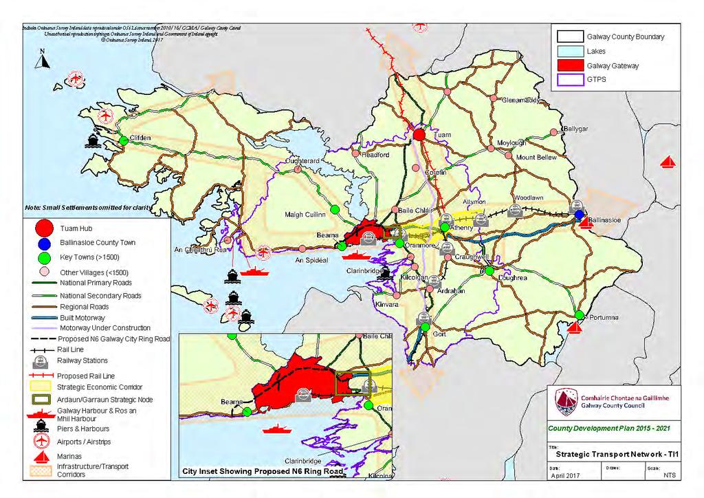
41
Chapter 3 Core Strategy
 Chapter 3 Core Strategy 3.0 Introduction The core strategy sets out how the development objectives in the Development Plan are consistent with the National Spatial Strategy and the Regional Planning Guidelines.
Oranmore Local Area Plan * Forward Planning Galway County Council Áras an Chontae Prospect Hill Galway
 Oranmore Local Area Plan 2012-2022* Forward Planning Galway County Council Áras an Chontae Prospect Hill Galway Adopted 24 th September 2012. *Deferral of Notice under 19(1)(d) for a period of 5 years
Variation No 1: Dundalk & Environs Development Plan Core Strategy
 Variation No 1: Dundalk & Environs Development Plan 2009-2015 Core Strategy Adopted on 29 th August 2011 CONTENTS Page Section 1 1.0 Synopsis 1 1.1 Background Document 1 1.2 Variation of Dundalk and Environs
Draft Portumna Local Area Plan
 Draft Portumna Local Area Plan 2016-2022 Forward Planning Galway County Council Áras an Chontae Prospect Hill Galway Period of public display: Friday the 31 st of July 2015 until Friday the 11 th of September
DRAFT Tuam Local Area Plan
 DRAFT Tuam Local Area Plan 2018-2024 January 2018 Table of Contents PAGE 1.0 Introduction.. 3 1.1 Preamble... 3 1.2 Profile of Tuam... 3 1.3 Local Area Plan... 4 1.4 Plan Informants & Key Considerations...
elbridge Core Strategy
 C elbridge Core Strategy Celbridge is designated as a Moderate Growth Town in the RPGs. The County Development Plan reinforces this designation in its settlement strategy. Moderate Growth Towns within
Chapter 2 Core Strategy
 Chapter 2 Core Strategy 11-24 2.1 Introduction 2.2 Strategic Planning Approach 2.3 Growth Consistency with the National Spatial Strategy & Regional Planning Guidelines 2.1 Introduction The overall strategy
Draft Clifden Local Area Plan July 2018
 Draft Clifden Local Area Plan 2018-2024 July 2018 2 Table of Contents 1.0 Introduction.. 3 1.1 Preamble... 3 1.2 Profile of Clifden... 3 1.3 Local Area Plan... 4 1.4 Plan Informants & Key Considerations...
Variation No. 2 Introduction & Explanatory Document Variation made on 19th May 2014
 Meath County Development Plan 2013 2019 Variation No. 2 Introduction & Explanatory Document Variation made on 19th May 2014 1.0 INTRODUCTION The Meath County Development was adopted on 17 th December
DUBLIN DOCKLANDS MASTER PLAN AND RELATIONSHIP WITH OTHER PLANS
 .1 National Policy and Programmes.1.1 Sustainable Development A Strategy for Ireland, 1997.1.2 National Climate Change Strategy, 2007-2012.1. National Development Plan 2007-201.1.4 National Spatial Strategy,
WINCHESTER TOWN 3.1 LOCATION, CHARACTERISTICS & SETTING
 WINCHESTER TOWN 3.1 LOCATION, CHARACTERISTICS & SETTING 3.1.1 The area referred to by the City Council, as Winchester Town, consists of the Winchester Wards plus the adjoining built up areas of Badger
ROCHFORD LOCAL DEVELOPMENT FRAMEWORK: Sustainability Appraisal/ Strategic Environmental Assessment. Rochford Core Strategy Preferred Options Document
 ROCHFORD LOCAL DEVELOPMENT FRAMEWORK: Sustainability Appraisal/ Strategic Environmental Assessment Non Technical Summary Rochford Core Strategy Preferred Options Document October 2008 SUSTAINABILITY APPRAISAL
Core Strategy LONGFORD COUNTY DEVELOPMENT PLAN VARIATION NO. 1. Prepared by the Planning Section Longford Local Authorities
 Core Strategy LONGFORD COUNTY DEVELOPMENT PLAN 2009-2015 VARIATION NO. 1 Prepared by the Planning Section Longford Local Authorities Adopted on 19 September 2012 Introduction and Explanatory Note V ariation
Meath County Development Plan. Variation No. 1 to Volume 1 Written Statement
 Meath County Development Plan 2013 2019 Variation No. 1 to Volume 1 Written Statement 2 Core Strategy Adopted Variation No. 1-04/11/2013 2.3.3 Residential Zoned Land Provision Table 2.4 details the requirement
Pre Draft Manager s Report Meath County Development Plan TABLE OF CONTENTS
 Pre Draft Manager s Report Meath County Development Plan 2013-2019 TABLE OF CONTENTS Section 1 Introduction and Overview of Pre Draft Consultation Report 1.1 Introduction... 1 1.2 Pre Draft Public Consultation...
Strategic Environmental Assessment Screening Report. Dublin Port Masterplan Review 2017
 Strategic Environmental Assessment Screening Report Dublin Port Masterplan Review 2017 Table of Contents 1 Introduction... 1 2 Purpose of the Masterplan... 2 3 Task 1.1 Pre-Screening Check... 5 4 Task
Dunboyne/Dunboyne North/ Clonee/ Local Area Plan
 Dunboyne/Dunboyne North/ Clonee/ Local Area Plan Strategic Policy SP 1 To operate an Order of Priority for the release of residential lands in compliance with the requirements of CS OBJ 6 of the County
Table of Contents. Page. Chapter 1 Introduction. Chapter 2 Spatial Strategy, Core & Settlement Strategy
 Table of Contents Table of Contents Page Chapter 1 Introduction 1.1 Background 01 1.2 Legislative Context 02 1.3 Plan Informants 05 1.4 Profile of County Galway 08 1.5 Planning Issues in County Galway
Chomhairle Cathrach na Gaillimhe Plean Forbartha. Galway City Council Development Plan
 Chomhairle Cathrach na Gaillimhe Plean Forbartha Galway City Council Development Plan Galway City Development Plan 2011-2017 Contents Foreword...v Introduction...vii 1 Overall Strategy Including Core Strategy...1
Ipswich Issues and Options for the Ipswich Local Plan Review, August 2017, Public Consultation
 Ipswich Issues and Options for the Ipswich Local Plan Review, August 2017, Public Consultation Having reviewed the issues and options documents, the Society has made the following response: Part 1 Strategic
Great Easton Neighbourhood Plan Statement of Basic Conditions
 Great Easton Neighbourhood Plan 2017-2031 Statement of Basic Conditions OCTOBER 2016 GREAT EASTON PARISH COUNCIL Contents 1.0 Introduction....Page 2 2.0 Summary of Submission Documents and Supporting Evidence..
Guidelines for Planning Authorities and Part V of the Planning and Development Act 2000: December 2000
 Slide 1 Slide 2 Slide 3 Slide 4 As a planner in practice, whether within the Local Authority, private practice or An Bord Pleanala, due regard must be given to the guidance provided by the Department in
Meath County Development Plan. Proposed Draft Variation No. 1 to Volume 1 Written Statement
 Meath County Development Plan 2013 2019 Proposed Draft Variation No. 1 to Volume 1 Written Statement 2 Core Strategy Proposed Draft Variation No. 1!" #$ % & ' % $ ($ &' ) $) * (' &+( &' % $ * $ $ * %
EVALUATION OF MASTER PLAN ALTERNATIVES
 7 The Environmental Report is required to identify, describe and evaluate reasonable alternatives, taking into account the objectives and geographical scope of the Master Plan 2008. Three plan alternatives
Gort Local Area Plan 2013
 Gort Local Area Plan 2013 Adopted 22 nd July 2013 Forward Planning Galway County Council Áras an Chontae Prospect Hill Galway Table of Contents Page 1. Introduction... 1 1.1 Preamble... 1 1.2 Profile of
City Regions Ireland
 City Regions Ireland 01 CITY REGIONS IRELAND COMPRISES OF CORK CHAMBER, DUBLIN CHAMBER, LIMERICK CHAMBER, WATERFORD CHAMBER AND GALWAY CHAMBER, ALL MEMBERS OF CHAMBERS IRELAND. 5 CITIES 8 PRINCIPLES A
A Growing Community Rural Settlement Areas
 Town of Huntsville Official Plan Review - POLICY BACKGROUND PAPER A Growing Community Rural Settlement Areas BACKGROUND: In addition to the fully municipally-serviced Urban Settlement Area and the Hidden
Schedule of Planning Applications Committee Date: 23 May Reference: 06/17/0726/F Parish: Hemsby Officer: Mr J Beck Expiry Date:
 Schedule of Planning Applications Committee Date: 23 May 2018 Reference: 06/17/0726/F Parish: Hemsby Officer: Mr J Beck Expiry Date: 22-05-2018 Applicant: Proposal: Site: Mr Gillett Change of use to the
Appendix 1 Structure plan guidelines
 Appendix 1 Structure plan guidelines This appendix forms part of the regional policy statement [rps]. 1.1. Introduction Structure plans are an important method for establishing the pattern of land use
ROSCREA LOCAL AREA PLAN
 ROSCREA LOCAL AREA PLAN 2012-2018 June 2012 Table of Contents Chapter 1:Introduction 1.1 How to use this plan 3 1.2 Purpose of the plan 3 1.3 What is a Local Area Plan 3 1.4 Composition of the Plan 4 1.5
1 Introduction. Chapter. In this chapter:
 Chapter 1 Introduction In this chapter: 1.1 A Snapshot of the Region 1.2 Towards a Sustainable Region 1.3 The Provincial Context 1.4 Purpose and Organization The Regional Municipality of York Official
Submission to the Kildare County Council Development Plan North Kildare Chamber. Executive Summary
 ` 28 th May 2015 Submission to the Kildare County Council Development Plan 2017-2023 North Kildare Chamber Executive Summary North Kildare Chamber s mission is to work with businesses, community groups,
Athenry Local Area Plan *
 Athenry Local Area Plan 2012-2022* Plan Adopted 25 th June 2012 Forward Planning Galway County Council Áras an Chontae Prospect Hill Galway Adopted 25 th June. *Deferral of Notice under 19(1)(d) for a
Tāhuhu whakaruruhau ā-taone The sheltering ridge pole
 B2. Tāhuhu whakaruruhau ā-taone - Urban growth and form B2.1. Issues Tāhuhu whakaruruhau ā-taone The sheltering ridge pole Auckland s growing population increases demand for housing, employment, business,
17. Coolaney-Rockfield Mini-Plan
 County Development Plan 2017-2023 Consolidated Draft + Adopted Amendments - August 2017 17. Coolaney-Rockfield Mini-Plan Village profile Coolaney is located approximately 23 km to the south-west of Sligo
Incorporating Draft Amendment Number 1 Made on 2 nd of March 2015
 Incorporating Draft Amendment Number 1 Made on 2 nd of March 2015 Ratoath Local Area Plan CONTENTS CHAPTER 1 BACKGROUND INFORMATION 1.1 Introduction... 1 1.2 Scope of the Local Area Plan... 2 1.3 Ratoath
Western City District What we heard
 What we heard Vision to 2056 and Priorities Governance and implementation Infrastructure and funding The protection of the natural landscape including biodiversity and the Metropolitan Rural Area for food
Appendix A. Planning Processes. Introduction
 1 Planning Processes Introduction This appendix outlines a number of planning processes which are used in the Auckland Region to support the effective management of development in the region s rural and
3.0 Policy Context. 3.1 Introduction. 3.2 National Spatial Strategy, The Role of East Meath under the NSS
 3.0 Policy Context 52 Policy Context 3.0 Policy Context 3.1 Introduction There is an extensive range of strategic guidance and policy for land use planning in Ireland. This has been fully examined in the
FOREWORD. Cllr Seamus O'Domhnaill
 FOREWORD On behalf of the Elected Members of Donegal County Council, I am delighted to introduce the Seven Strategic Towns Local Area Plan, 2018-2024. The Plan has been prepared in the context of the recently
Killarney Town Development Plan ISSUES PAPER
 Killarney Town Development Plan 2015-2021 ISSUES PAPER 1 Introduction The Killarney Town Development Plan sets out the overall strategy for the proper planning and development of the town. The existing
STRATEGIC DIRECTION. QLDC PROPOSED DISTRICT PLAN [PART TWO] DECISIONS VERSION 3 strategic direction
![STRATEGIC DIRECTION. QLDC PROPOSED DISTRICT PLAN [PART TWO] DECISIONS VERSION 3 strategic direction](/thumbs/79/79711764.jpg "STRATEGIC DIRECTION. QLDC PROPOSED DISTRICT PLAN [PART TWO] DECISIONS VERSION 3 strategic direction") 3 STRATEGIC DIRECTION QLDC PROPOSED DISTRICT PLAN [PART TWO] DECISIONS VERSION 3 strategic direction QLDC DISTRICT PLAN [PART TWO] AUGUST 2015 3 strategic direction 3.1 Purpose This chapter sets out the
3 STRATEGIC DIRECTION QLDC PROPOSED DISTRICT PLAN [PART TWO] DECISIONS VERSION 3 strategic direction QLDC DISTRICT PLAN [PART TWO] AUGUST 2015 3 strategic direction 3.1 Purpose This chapter sets out the
2040 LUP is a part of the Comprehensive Plan and carries the same legal authority. Economic Challenges
 1.1. Guiding Anchorage s Growth Where will new residents settle over the next two decades? Where will people work, shop, and play? Will there be enough room to grow? How will Anchorage look? Will growth
Ballivor Written Statement
 Settlement Ballivor Position in Settlement Hierarchy Village - Local centre for services and local enterprise development Position in Retail Strategy Fourth tier retail centre Population (2011) Census
Official Plan Review
 Official Plan Review Summary Report - The Built Environment August 2014 Part 1: Introduction Planning for a healthy, prosperous and sustainable community is an important goal for our municipality. From
Ireland 2040 Our Plan Press Release
 Ireland 2040 Our Plan Press Release Today the Government published Ireland 2040 Our Plan for its final round of public consultations. Over the next number of weeks, until 3 November, the public will have
Draft National Planning Framework: Ireland 2040.
 Draft National Planning Framework: Ireland 2040. Submission of Waterford City & County Council 1.0 Introduction: Waterford City & County Council welcome the document and the new approach to ensuring effective
Suffolk Coastal Local Plan Review Issues and Options, August 2017, Public Consultation
 Suffolk Coastal Local Plan Review Issues and Options, August 2017, Public Consultation Having reviewed the issues and options documents, the Society has made the following response: Part 1 - Strategic
Plan Modification to Chapter B2 of the Auckland Unitary Plan(AUP) Operative in part (15 November 2016)
 Operative in part (15 November 2016)") UNITARY PLAN UPDATE REQUEST MEMORANDUM TO FROM Phill Reid Linley Wilkinson DATE 25 September 2018 SUBJECT Plan Modification to Chapter B2 of the Auckland Unitary Plan(AUP) Operative in part (15 November
UNITARY PLAN UPDATE REQUEST MEMORANDUM TO FROM Phill Reid Linley Wilkinson DATE 25 September 2018 SUBJECT Plan Modification to Chapter B2 of the Auckland Unitary Plan(AUP) Operative in part (15 November
Rathmolyon Written Statement
 Settlement Rathmolyon Position in Settlement Hierarchy Village - Local centre for services and local enterprise development Position in Retail Strategy Fourth tier retail centre Population (2011) Census
CASE STUDY 3 : ROSCOMMON BALANCING URBAN AND RURAL ISSUES
 CASE STUDY 3 : ROSCOMMON BALANCING URBAN AND RURAL ISSUES MARY GRIER SENIOR PLANNER ROSCOMMON COUNTY COUNCIL SETTING THE SCENE County Roscommon key facts County Roscommon urban v rural development in recent
28. Coolaney-Rockfield Mini-Plan
 28. Coolaney-Rockfield Mini-Plan 28. Coolaney-Rockfield Mini-Plan Community facilities Community facilities in Coolaney-Rockfield consist of a primary school, crèche, community centre, sports field and
INTRODUCTION BACKGROUND
 INTRODUCTION 1 1 INTRODUCTION 18 INTRODUCTION 1 1.1 BACKGROUND The Dublin Docklands Development Authority (DDDA) is required to conduct a Strategic Environmental Assessment (SEA) of the review of the Draft
1.0 PLANNING MARKHAM S FUTURE CONTENTS
 1-1 Planning Markham s Future 1.0 PLANNING MARKHAM S FUTURE CONTENTS 1.1 THE PURPOSE OF THE OFFICIAL PLAN 1.2 THE MARKHAM CONTEXT 1.3 THE REGULATORY CONTEXT 1.3.1 Province of Ontario 1.3.2 York Region
Sustainability Statement. Whitby Business Park Area Action Plan
 Sustainability Statement Whitby Business Park Area Action Plan November 2014 Contents Page 1. Introduction 1 2. Scoping 3 3. Sustainability Appraisal of Options 6 4. Assessment of Draft Area Action Plan
INCREMENTAL CHANGE AREA REVIEW March 2015 Page 1
 INCREMENTAL CHANGE AREA REVIEW March 2015 Page 1 Table of Contents Introduction... 3 Background to Review... 3 Comparison of the Schedules to the General Residential Zone... 7 Methodology... 7 Policy Context...
CITY OF COLWICH COMPREHENSIVE PLAN LAND USE LAND USE 1
 LAND USE LAND USE 1 WHAT YOU WILL FIND IN THIS CHAPTER: Discussion of today s conditions and tomorrow s projections Discussion of challenges and opportunities Discussion of the environmental quality goals,
Appendix. Statement Outlining Compliance with Ministerial Guidelines
 18 Appendix Statement Outlining Compliance with Ministerial Guidelines A18 Statement Outlining Compliance with Ministerial Guidelines Under section 28 of the Planning and Development Act 2010, Meath County
Consultation Response to Lisburn and Castlereagh City Council LDP Preferred Options Paper (POP)
") Consultation Response to Lisburn and Castlereagh City Council LDP Preferred Options Paper (POP) Retail NI welcomes the opportunity to respond to the Council s Preferred Options Paper (POP) consultation
Consultation Response to Lisburn and Castlereagh City Council LDP Preferred Options Paper (POP) Retail NI welcomes the opportunity to respond to the Council s Preferred Options Paper (POP) consultation
SHORELINE, FLOOD AND COASTAL DEFENCE MANAGEMENT PLANS
 These plans may provide opportunities as well as concern for recreational boating. They are currently being revised and consulted on. This document explains how we can engage in the process. Shoreline,
Settlements Strategy and Rural Development Policies
 CHAPTER 3 Settlements Strategy and Rural Development Policies 3.0 Introduction 3.0.1 This Chapter is presented in two parts. Part 1 deals with the settlements strategy for the County and incorporates sections
TRIM DEVELOPMENT PLAN Volume 1 Written Statement
 TRIM DEVELOPMENT PLAN 2014 2020 Volume 1 Written Statement Table of Contents Trim Development Plan 2014-2020 Volume 1 Written Statement 1 Introduction to the Trim Development Plan 2014-2020. 1 1.1 Introduction...
Maynooth. Local Area Plan Plean Cheantar Aitiuil Mháigh Nuad. 26th August 2013
 Maynooth Local Area Plan 2013 2019 Plean Cheantar Aitiuil Mháigh Nuad 26th August 2013 Table of Contents PART A Introduction and Context 1.0 Introduction 5 1.1 Local Area Plans Status and Process 6 1.2
6 Growth Management Challenges and Opportunities
 6 Growth Management Challenges and Opportunities The Town has established a goal of attaining a 50% participation rate with respect to employment opportunities versus residential population. The Town s
DRAFT GREATER SYDNEY REGION PLAN OBJECTIVES, STRATEGIES AND ACTIONS
 Greater Sydney Commission DRAFT GREATER SYDNEY REGION PLAN OBJECTIVES, STRATEGIES AND ACTIONS Issued: 26 OCTOBER 2017 Version: 1 Subject: Greater Sydney Region and District Plans This information note
DAREBIN PLANNING SCHEME AMENDMENT C137
 Who is the planning authority? Planning and Environment Act 1987 DAREBIN PLANNING SCHEME AMENDMENT C137 EXPLANATORY REPORT This amendment has been prepared by the Darebin City Council, who is the planning
Newcourt Masterplan. November Exeter Local Development Framework
 Newcourt Masterplan November 2010 Exeter Local Development Framework Background The Exeter Core Strategy Proposed Submission sets out the vision, objectives and strategy for the development of Exeter up
Site Assessment Technical Document Appendix A: Glossary
 Central Bedfordshire Council www.centralbedfordshire.gov.uk Site Assessment Technical Document Appendix A: Glossary July 2017 1.1.11-1 - ii Appendix A: Glossary Term Agricultural Land Classification AONB
MEATH COUNTY COUNCIL Dunboyne, Clonee & Pace Local Area Plan
 MEATH COUNTY COUNCIL Dunboyne, Clonee & Pace Local Area Plan 2009-2015 Adopted 22 September 2009 Planning Department Dunboyne/Clonee/Pace Local Area Plan 2009-2015 Adopted 22 nd September 2009 Prepared
Town of Cobourg Heritage Master Plan. Statutory Public Meeting
 Town of Cobourg Heritage Master Plan Statutory Public Meeting April 25 th 2016 Presentation Overview 1. Introduction 2. Project background and schedule overview 3. Review of strategic direction content
County Donegal Development Plan Part A: The Strategic Plan Part B: Objectives and Policies of the Plan
 County Donegal Development Plan 2018-2024 Part A: The Strategic Plan Part B: Objectives and Policies of the Plan June 2018 County Donegal Development Plan 2018-2024 FOREWORD On behalf of the Elected Members
2A District-wide Policies
 2A Introduction This Chapter contains policies which are relevant to subdivision, use and development activities occurring across all zones and areas of the District. The policies in this Chapter implement
KELLS DEVELOPMENT PLAN
 KELLS DEVELOPMENT PLAN 2013-2019 J Statement Outlining Compliance with Ministerial Guidelines Adopted 7th October 2013 APPENDIX J STATEMENT OUTLINING COMPLIANCE WITH MINISTERIAL GUIDELINES Under section
20. Ballysadare Mini-Plan
 20. Ballysadare Mini-Plan 20. Ballysadare Mini-Plan Community facilities Ballysadare has a wide range of community facilities: a primary school, St Mary s College (secondary school), a health centre, playing
The Charter of European Planning BARCELONA 2013
 The Charter of European Planning BARCELONA 2013 The Vision for Cities and Regions Territoires of Europe in the 21st Century ECTP-CEU (The European Council of Spatial Planners Le Conseil Européen des Urbanistes)
Tiane Ltd Submission on Draft National Planning Framework Ireland 2040
 Tiane Ltd Submission on Draft National Planning Framework Ireland 2040 Date: 31 st March 2017 Authors: Ken Swaby / Ben Waite Approved By: Christy O'Sullivan ILTP Project Code & Reference: GOLDENATH Distribution:
Settlement Boundaries Methodology North Northumberland Coast Neighbourhood Plan (August 2016)
") Introduction This background paper sets out a methodology for the definition of settlement boundaries in the North Northumberland Coast Neighbourhood Plan. The neighbourhood plan is planning positively
Introduction This background paper sets out a methodology for the definition of settlement boundaries in the North Northumberland Coast Neighbourhood Plan. The neighbourhood plan is planning positively
Rochford District Council Allocations Development Plan Document: Discussion and Consultation Document Sustainability Appraisal
 Option SWH1 Balanced Communities Option SWH1 1 To ensure the delivery of high quality sustainable communities where people want to live and work Will it ensure the phasing of infrastructure, including
Draft Eastern District Plan
 Draft Eastern District Plan Submission_id: 31238 Date of Lodgment: 13 Dec 2017 Origin of Submission: Online Organisation name: Turrulla Gardens Pty Ltd C/- Mecone Organisation type: Industry First name:
NEW REGIONAL OFFICIAL PLAN HIGH LEVEL PROCESS & FRAMEWORK
 NEW REGIONAL OFFICIAL PLAN HIGH LEVEL PROCESS & FRAMEWORK Why A New Official Plan Originally the role of Regionally Planning and content of Regional Official Plan (1970s) primarily focused on protecting
Dréacht Phlean Ceantair Áitiúil na hardáin Draft Ardaun Local Area Plan
 Galway City Council Comhairle Cathrach na Gaillimhe Dréacht Phlean Ceantair Áitiúil na hardáin Draft Ardaun Local Area Plan 2018-2024 September 2017 Development Plan and Policy Section Contents 1. Context...
Our City Centre is a vibrant, creative and welcoming destination, with a modern business, cultural, shopping, leisure and residential offer
 3. Sheffield in 2034 Our City sits at the heart of a strong, distinctive and internationally successful City Region economy which supports innovation and enterprise Our City Centre is a vibrant, creative
A VISION FOR SOUTH DUBLIN S FUTURE. Proposed Variation No. 2. Vacant Site Levy. Planning Report
 A VISION FOR SOUTH DUBLIN S FUTURE Proposed Variation No. 2 Vacant Site Levy Planning Report February 2018 Proposed Variation No. 2 South Dublin County Council County Development Plan 2016-2022 This is
CITY VIEW OBJECTIVES
 SECTION 2: CITY VIEW OBJECTIVES CONTENTS 2.1 Introduction 1 2.2 Strategic Direction 1 2.3 The City View Resource Management Issues for the City 1 2.4 The Goal 3 2.5 The City View Objectives 3 Palmerston
SECTION ONE: INTRODUCTION. introduction
 introduction 1 INTRODUCTION Since it was first established in 1843 as a trading post for the Hudson s Bay Company, Victoria has evolved into a Provincial capital city that is recognized across Canada and
Appendix A: Retail Planning Assessment
 Rotherham Town Centre Masterplan Appendix A: Retail Planning Assessment 139 Appendix A Rotherham Town Centre Masterplan Retail Planning Background and Policy Context 1. Introduction 1.1 The Masterplan
Edenderry Local Area Plan
 Edenderry Local Area Plan 2017-2023 MATERIAL ALTERATIONS TO DRAFT EDENDERRY LOCAL AREA PLAN Public Display Document Section 1: Introduction 1.1 Introduction This report focuses on the proposed material
Vigo Neighbourhood Plan Basic Conditions Statement
 Vigo Neighbourhood Plan Basic Conditions Statement Plan Period: 2016 to 2028 Status: Submission Version Qualifying Body: Vigo Parish Council Glossary of Some Terms & Abbreviations Used in this Document
Policy DM19: Development and Nature Conservation
 Avonmouth Wetland Habitat Project October 2010 and December 2011 (the Cresswell study). Policy Links Bristol Local Plan Core Strategy Lead Policy BCS4: Avonmouth and Bristol Port BCS9: Green Infrastructure
Celbridge. Local Area Plan Statement. Planning Department Kildare County Council September 2017
 Celbridge Local Area Plan 2017-2023 Dréachtphlean Ceantair Áitiúil Cill Droichid Planning Department Kildare County Council September 2017 SEA Statement Kildare County Council Celbridge Local Area Plan
Welford-on-Avon Neighbourhood Plan Consultation Event Sunday, 6 April Your name Your address
 Welford-on-Avon Neighbourhood Plan Consultation Event Sunday, 6 April 2014 Your name Your email address Please either: - complete this feedback form and put it in the box before leaving the Memorial Hall
BRE Strategic Ecological Framework LI Technical Information Note 03/2016
 BRE Strategic Ecological Framework Technical Information Note 03/2016 September 2016 Contents 1. Introduction 2. Aims of BRE s Strategic Ecological Framework 3. How SEF is different from previous approaches
PSRC REVIEW REPORT & CERTIFICATION RECOMMENDATION
 PSRC REVIEW REPORT & CERTIFICATION RECOMMENDATION KITSAP COUNTY COUNTYWIDE PLANNING POLICIES July 2, 2012 BACKGROUND A major emphasis of the Washington State Growth Management Act (GMA) is the need to
Design Guidance. Introduction, Approach and Design Principles. Mauritius. November Ministry of Housing and Lands. .. a
 sig evelo r D Mauritius s. Utilities.. Individu a s. er itects.to ls chpers.po e Public. T. h rban D Sc U e me Promot e h ners. A Design Guidance o.h Planne rs n w iticians r l useholde National Development
Sustainable Growth. Sustainable Growth
 2 Sustainable Growth Sustainable Growth SUSTAINABLE GROWTH 2.1 COMMUNITY VISION... 2-5 2.2 THE CITY SYSTEM... 2-7 2.2.1 AREAS... 2-7 2.2.2 CITY-WIDE SYSTEMS... 2-8 2.2.3 PROVINCIAL PLAN BOUNDARIES AND
This page has been intentionally left blank.
 This page has been intentionally left blank. Chapter 3 3-2 3. Employment 3.A Niagara Economic Gateway 3.A.1 General The Niagara Economic Gateway comprises: a) The Gateway Economic Zone which includes all
GREATER CARLOW GRAIGUECULLEN URBAN AREA RETAIL STRATEGY 2012 TO Carlow County Council Laois County Council & Carlow Town Council
 GREATER CARLOW GRAIGUECULLEN URBAN AREA RETAIL STRATEGY 2012 TO 2018 Carlow County Council Laois County Council & Carlow Town Council 2012 Contents: Page 1. Introduction 3 2. Policy Review 5 3. Population
Ballinasloe Town Development Plan as Varied on
 Ballinasloe Town Development Plan 2009-2015 as Varied on 12-07-2011 SECTION 1. INTRODUCTION AND CONTEXT... 5 1.1 INTRODUCTION... 5 1.2 LEGISLATIVE CONTEXT... 5 1.3 POLICY CONTEXT... 7 1.4 THE PLAN AS A
9 Pershore. Introduction. Pershore Abbey
 118 Introduction 9.1 The historic town of Pershore lies on the River Avon and has a population of 7,000 (2009 Mid-Term Population Estimates). The main areas of the town are centred on the Abbey, the bustling
Central City District What we heard
 What we heard Vision to 2056 and Priorities Governance and implementation Infrastructure and funding The vision for a metropolis of three cities, and the 30 minute city. Feedback requested: Clearer communication