Core Strategy LONGFORD COUNTY DEVELOPMENT PLAN VARIATION NO. 1. Prepared by the Planning Section Longford Local Authorities
|
|
|
- Caitlin Greer
- 5 years ago
- Views:
Transcription

1 Core Strategy LONGFORD COUNTY DEVELOPMENT PLAN VARIATION NO. 1 Prepared by the Planning Section Longford Local Authorities Adopted on 19 September 2012
2
3 Introduction and Explanatory Note V ariation number 1 to the Longford County Development Plan has been made under Section 13 of the Planning and Development Act for the purpose of incorporating a Core Strategy into the Development Plan. Accordingly, the variation should be read in conjunction with the existing County Development Plan. The Variation has been prepared in accordance with the provisions of the Planning and Development Act , the Planning and Development (Strategic Environmental Assessment) Regulations, 2004 and Article 6 of the Habitats Directive 92/43/EEC. The Variation was adopted by the members of Longford County Council on the 19th September This document is divided into three parts; Part 1- provides an explanation regarding the requirement for the variation, what the variation consists of, what it is required to contain and outlines how the variation impacts on other planning policy documents. Part One does not form part of the variation and is for explanatory purposes only. Part 2- of Variation No. 1 outlines the actual Core Strategy, inserted into the County Development Plan It replaces key elements contained in Section 2.3 of the County Development Plan Part 3- of Variation No.1 outlines the changes to the County Development Plan, in addition to changes made to Section 2.3, in order to facilitate the incorporation of the Core Strategy into the remainder of the County Development Plan document. Longford County Council - Longford County Development Plan , Core Strategy 1
4 CONTENTS PART What is the Core Strategy... 3 PART CORE STRATEGY Introduction Requirement for Core Strategy and Variation of Development Plan Core Strategy Strategic Aims: Core Strategy Policy Context and Rationale Core Strategy Relationship with other Development Strategies Core Strategy Rationale Settlement Strategy Introduction and Background Key Aims of the Settlement Strategy Settlement Hierarchy Hierarchy Tiers Rural Areas/Open Countryside Longford Core Strategy Map Regional Planning Guidelines Population Targets Core Strategy Table Core Strategy Table Explained Implementation and Monitoring Future and Longevity of the current Core Strategy (Changes to the MRPGs and full publication of Census 2011) PART Changes to the Longford County Development Plan APPENDICES Appendix 1: Lands Bounding Longford Environs Appendix 5: Aquifer Buffer Zones Appendix 16: Key Service Town- Granard Appendix 17: Service Town- Edgeworthstown.. 94 Appendix 18: Local Service Towns- Ballymahon & Lanesborough Appendix 19: Serviced Settlements Longford County Council - Longford County Development Plan , Core Strategy 2
5 PART 1 What is the Core Strategy and what does it include? T his Core Strategy articulates a medium to longer term evidence and quantitatively based strategy for the spatial development of County Longford, whilst demonstrating consistency with national and regional development objectives outlined in the National Spatial Strategy and the Midlands Regional Planning Guidelines. In summary, this Core Strategy identifies the quantum, location and phasing of development for the plan period that is consistent with the regionally defined population targets and settlement hierarchy, and, which reflects the availability of existing services, planned investment, sequential development and environmental requirements (i.e. an evidence based approach in determining the suitability of lands for zoning purposes). In accordance with the requirements of the Planning and Development Act and the Guidance Note on Core Strategies issued in November , this core strategy includes; - Population targets; - Quantification of the requirements for zoning of lands for residential purposes; - Existing and future distribution of population within a defined settlement hierarchy; 1 Guidance Note on Core Strategies, Department of Environment, Heritage and Local Government, November 2010, Circular PSSP6/2010 (Core Strategy Guidance). 3
6 Furthermore, this core strategy also contains; a) A written statement which outlines the origins and broad aims of the strategy including population targets; b) A diagrammatic core strategy map which shows how it is envisioned the County will develop in line with the availability of infrastructure, services and amenities; and, c) Having regard to the emphasis being placed on the quantum and distribution of future population and housing development lands, the document also includes a Core Strategy Table which outlines same. What are the main aims of the Core strategy and what changes does it introduce? The Core Strategy demonstrates that the Longford County Development Plan is consistent as far as practicable with the policies of the Minister for Environment, Community and Local Government in relation to national and regional population targets, thus strengthening further the role of the Longford County Development Plan as the fundamental implementation mechanism between national, regional, and local policy. The main policy provisions of the Plan to which the Core Strategy relates are contained at Sections 2 and 3 of the Plan. In this regard the population projections and Settlement Strategy contained at section 2.3 of the Development Plan, in particular, are replaced by the Core Strategy Table and revised Settlement Strategy which identify population projections, distributions and zoned land availability for the County over the CDP period. The purpose of the Settlement Strategy is to identify and define all settlements in terms of a hierarchy for development for the duration of the Development Plan period. In this context, the Settlement Strategy forms the basis for guiding the quantum, scale and location of new developments within County Longford, up to
7 This Core Strategy demonstrates that the Longford County Development Plan is consistent with national and regional frameworks which have informed the policies and objectives of the Plan, which in turn provides a basis for day-to-day planning decisions. In light of the population targets and housing land requirement identified for the County of Longford within the MRPGs, this variation includes a significant level of modification to residential zonings in particular, in addition to the amendment and addition of objectives and policies within the Development Plan. The main changes to the Development Plan as a result of this variation include the modification of Chapter 2.3 of the Plan to introduce a revised Settlement Strategy and Hierarchy which is aligned with upper tier plans, the introduction of revised population targets and demonstration of how the population targets in the plan relate to the quantum of land zoned. 5
8 Changes to Local Area Plans- In addition to the changes made to the Development Plan and to facilitate the revised zoning objectives, contained as part of the Core Strategy, zonings and policies contained within existing Local Area Plans in the County will need to be addressed as a result of this Core Strategy. In instances where existing Local Area Plan zoning objectives are modified under this Core Strategy variation, the County Development Plan zonings shall take precedent over any Local Area Plan until such time as appropriate action is taken to either modify or revoke the relevant Local Area Plans (modification/revocation of Local Area Plans are a separate process). Ultimately, it is therefore proposed that the zoning maps and objectives contained as part of this document will replace any revoked local area plans. A separate core strategy applies in respect of Longford Town Development Plan, resulting in a set of actions to be implemented in relation to Longford Town Northern and Southern Environs Local Area Plans (lands of which are substantially contained within the Longford Town administrative area). Any lands that are located within the environs of Longford Town, outside of the Town Development boundary and that are not located within the Northern and Southern Environs Local Area Plan areas are addressed as part of this variation. It should be noted that while a separate Core Strategy variation applies to Longford Town, this variation will also deal with Longford Town when determining population targets, as Longford Town is also the principal town in the County Settlement Hierarchy. For the purposes of clarity, a schedule of works proposed as part of this variation is set out in Table 1 overleaf; 6
9 Table 1. Local Area Plans (LAP) LAP Date Adopted Expiry Date Action Process Required Following Variation Ballymahon As per CDP As per CDP Addressed as part of Variation. Carriglass July 2004 July 2010 Core strategy Map and Objectives incorporated into County Development Plan (CDP) under Core Strategy. Lanesboro Sept 2004 Sept 2010 Core strategy Map and Objectives incorporated into CDP under Core Strategy. Newtownforbes May 2006 May 2012 Core strategy Map and Objectives incorporated into CDP under Core Strategy. Drumlish June 2006 June 2012 Core strategy Map and Objectives incorporated into CDP under Core Strategy. Kenagh Sept 2006 Sept 2012 Core strategy Map and Objectives incorporated into CDP under Core Strategy. Ardagh Sept 2006 Sept 2012 Core strategy Map and Objectives incorporated into CDP under Core Strategy. Granard Oct 2006 Oct 2012 Incorporate Core strategy Map and Objectives into CDP under Core Strategy. Ballinalee Oct 2006 Oct 2012 Core strategy Map and Objectives incorporated into CDP under Core Strategy. Edgeworthstown Jan 2008 Jan 2014 Core strategy Map and Objectives incorporated into CDP under Core Strategy. No action required Core Strategy to Replace LAP Core Strategy to Replace LAP Core Strategy to Replace LAP Core Strategy to Replace LAP Core Strategy to Replace LAP Core Strategy to Replace LAP Core Strategy to Replace LAP Core Strategy to Replace LAP Core Strategy to Replace LAP Longford Northern Environs Longford Southern Environs Aug 2008 Aug 2014 To be addressed following the Longford County Development Plan Core Strategy and the Longford Town Development Plan Core Strategy To be addressed following the Longford County Development Plan Core Strategy and the Longford Town Development Plan Core Strategy 7
10 Strategic Environmental Assessment An SEA has been undertaken as part of the Variation. SEA is a systematic process of predicting and evaluating the likely environmental effects of implementing a plan, or other strategic action, in order to ensure that these effects are appropriately addressed at the earliest appropriate stage of decision-making on a par with economic and social considerations. Variation No.1 to the Longford CDP was required to undergo SEA. The findings of the SEA were expressed in an Environmental Report which accompanied the Proposed Variation on public display. The Environmental Report was updated by way of an Addendum which detailed changes arising from submissions and observations. The Environmental Report was also updated to take account of changes which were made to the Variation on foot of submissions (these changes were minor and would not be likely to result in environmental effects). On the making of the Variation, the Addendum was used to update the original Environmental Report into a final Environmental Report which is available alongside the Plan as varied. At each stage of the process the Elected Members took into account the findings of the Environmental Report and/or the Addendum as appropriate. Appropriate Assessment An Appropriate Assessment (AA) has been undertaken alongside this variation which assesses the implications of the variation alone and in combination with other strategic actions and projects, on the integrity of Natura 2000 sites in view of its conservation objectives. The AA process that was undertaken alongside the preparation of the Variation concluded that no Natura 2000 Sites are deemed to be at risk of likely significant effects of implementing the variation. 8
11 Strategic Flood Risk Assessment A strategic flood risk assessment (SFRA) of the Variation was also undertaken which integrated flood considerations into the Variation ensuring that it is consistent with the Flood Guidelines. The preparation of the Variation, SEA, AA and SFRA has taken place concurrently and the findings of the AA and SFRA have informed both the Variation and the SEA. These processes were undertaken in tandem with the preparation of the variation and have ensured full integration and consideration of environmental issues throughout each stage of the variation process. 9
12 PART 2 The following section replaces Section 2.3, Settlement Strategy, of the County Development Plan, unless as otherwise indicated. 2.3 CORE STRATEGY Introduction T his Core Strategy articulates a medium to longer term evidence and quantitatively based strategy for the spatial development of County Longford, whilst demonstrating consistency with national and regional development objectives outlined in the National Spatial Strategy (NSS) and the Midlands Regional Planning Guidelines (MRPG s). In summary, this Core Strategy identifies the quantum, location and phasing of development for the plan period that is consistent with the regionally defined population targets and settlement hierarchy, and, which reflects the availability of existing services, planned investment, sequential development and environmental requirements (i.e. an evidence based approach in determining the suitability of lands for zoning purposes). 10
13 2.3.2 Requirement for Core Strategy and Variation of Development Plan S ection 10 (1A) 1 of the Planning and Development Act , requires that a development plan shall include a core strategy which shows that development objectives in the development plan are consistent, as far as practicable, with national and regional development objectives set out in the National Spatial Strategy and regional planning guidelines. Section 10 (1B) of the Planning and Development Act , further requires that a planning authority shall prepare a core strategy within a prescribed timeframe after the making of regional planning guidelines and shall accordingly vary the Development Plan under Section 13 of the Planning and Development Act to include the core strategy. The Midland Regional Planning Guidelines were adopted in July 2010 and accordingly, in order to comply with the aforementioned statutory requirements of the Planning and Development Act , this variation provides for the inclusion of a core strategy in the Development Plan. 1 Inserted by Section 7 of the Planning and Development (Amendment) Act
14 2.3.3 Core Strategy Strategic Aims: The strategic aims of the Core Strategy are set out as follows: Aim 1 To demonstrate that the Longford County Development Plan is consistent, as far as practicable, with national and regional development objectives set out in the National Spatial Strategy and Regional Planning Guidelines for the Midland Region and other national guidelines and policies. Aim 2 To facilitate the closer alliance of County and sub-county level plans with regional policy. Aim 3 To identify the appropriate quantum, location and phasing of development considered necessary to provide for future population growth over the plan period in accordance with the National Spatial Strategy and Midland Regional Planning Guidelines. Aim 4 To develop this quantum of land in a manner that supports public transport and existing services. Aim 5 To provide a framework supported by an evidence based settlement strategy, for deciding on the scale, phasing and location of new development, having regard to existing services and planned investment over the coming years. Aim 6 To provide a framework within which the provision of sustainable infrastructure, amenities, economic investment and development can take place to maximize the use of resources in the plan area. 12
15 2.3.4 Core Strategy Policy Context and Rationale National and Regional Policy Context: - The National Spatial Strategy and The Midland Regional Planning Guidelines T he Midland Regional Planning Guidelines (MRPGs), made in accordance with the National Spatial Strategy (NSS), define a regional development model that is based on a spatial hierarchy centred on the linked gateway of Athlone, Tullamore, and Mullingar as identified in the NSS and supported by the principal towns of Longford and Portlaoise. National Policy contained in the NSS, is translated to a regional level in the Midland Regional Planning Guidelines , which subsequently guide policy making decisions at a local level through the County Development Plan. The Midland Regional Planning Guidelines were adopted in July For the first time the MRPGs introduce population targets for Longford which are also indicated in terms of future housing land requirements for the County. This coupled with the requirements of the Planning and Development (amendment) Act 2010, ensures that County Development Plan policies are now consistent with the RPGs, whereas County Development Plans were previously only required to have regard to the RPGs. The Core Strategy contained as part of this plan is therefore central to ensuring such compliance with the RPGs. In addition to the above, the Settlement Strategy contained in the MRPGs identifies Granard as a Key Service Town, Edgeworthstown as a Service Town and Ballymahon and Lanesboro as Local Service Towns. Supporting this, the next tier of the settlement strategy as defined by the MRPGs is the Rural Hinterland which includes the other towns, villages and open countryside. Accordingly, population allocation within the region is reflective of this model. The settlement hierarchy and policy outlined as part of the Core Strategy aligns itself with the terminology and goals set out in the MRPGs and are also informed by guidelines set out at a national level in relation to rural and urban residential development. 13

16 Figure 2.3.1: Midland Region-Spatial Settlement Strategy. 14
17 In light of the Midland Region Spatial Settlement Strategy, the MRPGs define population targets for County Longford, as follows; Table 2.3.1: Population Targets as defined by the MRPG s County Longford 34,391 39,392 41,392 Longford (Principal Town) ,747 12,622 County Balance 26,769 28,645 28,770 The MRPGs also indicate how the above population target for 2016 equates to a total housing land requirement of 163 hectares up until 2016, with 65 hectares and 98 hectares allocated to Longford Town and the remainder of the County respectively. Accordingly, the population and housing land requirement figures defined by the MRPGs are the starting point for the Core Strategy. Longford is also located within the Northern Development Area as set out under the MRPG s with the sequential development of Longford Town the principal town driving this area a key priority. Expansion of linkages to the Border and West, promotion of enterprise and the economy, consolidation of transport and infrastructure and the promotion of social, community and tourism development are all key policy objectives for the Northern Development Area and as such are promoted throughout this Core Strategy. Furthermore, the identified importance of consolidating smaller towns and villages with the provision of physical, social and community infrastructure is also reflected in the Settlement Hierarchy for the County and its associated policy objectives. 15
18 2.3.5 Core Strategy Relationship with other Development Strategies Housing Strategy- U nder Part V of the Planning and Development Act , each planning authority is required to review and include a Housing Strategy within the Development Plan to cover the plan period. The Housing Strategy for County Longford is contained at Annex 1 of the current County Development Plan In determining the housing demand methodology, the current Housing Strategy at the outset based the projection of the Longford County population on the detailed application of the Demographic Component Method. However, this was ultimately revised and policy in line with the Midland Regional Planning Guidelines (2004), concerning the population target, took precedence over the demographic component method and was used as the basis in formulating the County s population targets. In this regard, the population targets defined as part of the Housing Strategy support the settlement hierarchy outlined within the current MRPGs by reinforcing the roles of Longford (Principal Town), Granard (Key Service Town), Edgeworthstown (Service Town), Lanesboro and Ballymahon (Local Service Towns). In addition to the above, the Housing Strategy for Longford will be reviewed in accordance with the review of the Development Plan and the requirements of Part V of the Planning and Development Act, It should further be noted that whilst the Housing Strategy will remain the main document that addresses the provision of housing in the County, including social and affordable housing, demand for different housing types, meeting the needs of varying households and incomes, the population projections and settlement hierarchy defined as part of this core strategy take precedence over and replace the population projections and settlement hierarchy contained as part of the Housing Strategy. 16
19 Retail Strategy- The Longford County Retail Strategy , the relevant policy of which is contained at Section 4.3 of the Longford County Development Plan, identifies a retail hierarchy for County Longford. It is considered that the hierarchy is generally in line with the Midland Regional Planning Guidelines whilst recognising the existing retail functions of the settlements defined. The retail hierarchy reinforces the role of the settlements within the settlement hierarchy and, most importantly, the hierarchy recognises the importance and reinforces the role of Longford Town, as a Principal Town, and places it at the top of the retail hierarchy. It is considered most appropriate that a revised retail strategy is prepared as part of the review of the County Development Plan (due to commence in early 2013) having regard to the recently published Retail Planning Guidelines. 17
20 2.3.6 Core Strategy Rationale T his section sets out the methodology used for the core strategy to ensure that the Longford County Development Plan is consistent with the National Spatial Strategy, the Midland Regional Planning Guidelines and Government guidelines. The Core Strategy assigns regionally prescribed population targets as set out under the Regional Planning Guidelines, building upon the existing objectives of the Longford County Development Plan. A target population for the year 2022 has been allocated to County Longford by the Midlands Regional Authority through the Midlands Regional Planning Guidelines Longford Town is addressed under this Core Strategy as it is the Principal Town in the County Settlement Hierarchy. The Core Strategy identifies a population target of 39,392 by the year 2016 with a target population of 10,747 identified for the principal town of Longford Town. The target population of County Longford is accommodated under the Core Strategy The Core Strategy provides target populations for the Key Service Town of Granard, Service Town of Edgeworthstown and Support Service Towns of Ballymahon and Lanesborough as well as aggregate population targets for each of the remaining settlements throughout the County in addition to open countryside. The Longford County Development Plan was, overall, broadly in line with the Regional Planning Guidelines both in terms of population projections and the settlement hierarchy prescribed, however there were a number of issues which have been addressed to ensure that the development objectives in the Plan are consistent as 18
21 far as practicable with the current MRPGs, specifically in terms of quantum of lands zoned, densities applied and the roles of existing settlements within the County. The amount of undeveloped residentially zoned lands previously available (prior to this variation) under the CDP up to 2016 was 926ha. This compares to a figure of 163ha identified for County Longford in the Regional Planning Guidelines up to Furthermore, Longford Town s population allocation has been redefined to reflect its Principal Town status as prescribed in the Midland Regional Planning Guidelines. In this context this Core Strategy introduces greater consistency with national and regional population targets and policies by means of the introduction of a revised Settlement Hierarchy for the County having regard to the MRPG s and section 7 of the Planning and Development Act 2010, together with a Core Strategy Table. The existing zoning maps in the County have also been revised to reflect this new Settlement Hierarchy and Core Strategy Table. Settlement Hierarchy The Settlement Hierarchy has been revised to reflect the provisions of the core strategy, which outlines the anticipated location, extent and scale of development over the lifetime of the Plan. The Hierarchy prioritises areas for development within the County over the lifetime of the plan, on a tiered basis, having regard to the regional Settlement Hierarchy as set out under the Regional Planning Guidelines for the Midlands Region including the designation of Longford Town as a Principal Town, the complementary role of other towns and villages, the availability of services, infrastructure and transport linkages and a recognition of the rural nature, community needs, settlement structure and rural economy of the County. Core Strategy Table The Core Strategy Table indicates the distribution of future population and housing across the County s settlements. The position of each town in the Settlement 19
22 Hierarchy has been clearly linked to the quantitative population allocations as set out under the Core Strategy Table. The Core Strategy Table illustrates clearly how the population targets as set out for County Longford at table 4.3 of the Regional Planning Guidelines for the Midland Region are to be distributed across the County proportionate to a settlements positioning in the Settlement Hierarchy. Zoning Maps Following the population allocations set out in the Core Strategy Table, this variation also includes revised zoning maps to reflect these figures and to indicate the quantum and locations of future development for the plan period. It is considered that the lands identified for residential development are sufficient to meet the population targets set out in the Core Strategy Table and reflect each settlements role in the Settlement Hierarchy. The amount and location of zoned lands required within each settlement was determined using an evidence based approach which consisted of the following considerations; Position of the Settlement in the Regional Settlement Hierarchy and the population allocations set out under the Regional Planning Guidelines; Availability of services and infrastructure- planned and existing e.g. Smarter Travel and Water Services Investment Programme (WSIP); Potential for economic and social development of the settlement; Sequential Test; The need to consolidate settlements, keeping them physically compact; Flood risk assessment; Ground and surface water vulnerability; Environmental impact, including S.E.A and H.D.A. requirements; Planning history; Market availability/choice; 20
23 Residential Strategic Land Reserve- Zoning Objective A Residential Strategic Land Reserve has been introduced as part of the zoning strategy for the County. In order to comply with the housing land requirement and population allocations identified by the MRPGs, some lands previously identified for residential development have been reclassified under this new zoning which prevents the release of these lands over the current County Development Plan period. These lands while not considered for development purposes under the current Plan will be reconsidered in the context of the subsequent County Development Plan review. Site Resolution Objective It is important to acknowledge that there are a number of unfinished housing developments that exist within the County and in recognising this, the Core Strategy has identified a number of areas for the purpose of site resolution under the zoning Site Resolution Objective in order to provide opportunity to complete these areas to an appropriate and acceptable standard of development. This zoning identifies the challenges that these areas bring and aims to facilitate their development to provide improved residential amenity and enhance their cultural, heritage, social and economic sustainability. The zoning is flexible in nature and allows for the provision of community needs including education, childcare, healthcare, specialised housing such as OPDs, opportunities for local business and enterprise, active/ passive recreation and amenity, community facilities and local shop facilities where such facilities would be commercially viable. Proposals for residential development in these areas will be assessed in accordance with the settlement s position within the Settlement Hierarchy and monitored in line with the population targets as set out under the Core Strategy Table and in accordance with Policy IMP CS 3. The zoning also encourages potential applicants to actively engage with the Planning Authority in an effort to produce agreed development schemes for the identified sites 21
24 which will improve the existing amenities of the areas and ensure a level of protection to the character of the areas within which they are located. Industrial Strategic Lands Reserve In order to better reflect the economic and commercial needs of settlements based on the amended population and revised residential zoning targets a number of settlement zonings have also been reclassified, including the introduction of an Industrial Strategic Lands Reserve which, similar to the Residential Strategic Land Reserve, is intended to cater for the long term release of lands on a phased basis for industrial development. This was considered appropriate in order to reinforce the defined Settlement Hierarchy introduced by the Midland Regional Planning Guidelines. Rural Service Settlement and Hinterlands The remaining zoned lands designated as Rural Service Settlement and Hinterlands, will now cater for local housing need and demand while providing associated local level services appropriate to the area. 22
25 2.3.7 Settlement Strategy Introduction and Background T his Settlement Strategy has been aligned with the Settlement Strategy of the Regional Planning Guidelines for the Midland Region and provides a framework to guide the location and scale of new development for the Plan period. Local, Regional and National Policy encourages new developments to locate in existing towns and villages where the basic social and infrastructural services are available and where such services may be provided or expanded on an economic basis. This policy direction has the primary aim of facilitating sustainable live-work patterns to strengthen the existing urban centres in order to encourage enhanced commercial and employment opportunities, to provide an increased range of social and recreational facilities and to protect the agricultural industry and rural areas. Accordingly, the settlement strategy aims to provide for vibrant and viable settlements in urban and rural areas that provide a range of jobs, services and housing choice commensurate with their position on the hierarchy, with the capacity to facilitate the long-term sustainability of rural communities. The strategy was developed within the spatial development framework of national and regional policy, to ensure that the specific needs of communities are provided for, and to facilitate future development in a plan-led manner. 23
26 Key Aims of the Settlement Strategy T his section (formerly of the County Development Plan) is not amended as part of the variation, save for the re-numbering of the section. This section has been included as part of this document for contextual purposes only. The following policies have been established as key aims of the Settlement Strategy to facilitate its delivery on a strategic level. SET 1: The Council shall continue to support the strengthening of the urban and village network throughout the County in accordance with the hierarchy outlined in the following sections and supported by the Regional Planning Guidelines, Sustainable Rural Housing Guidelines and Sustainable Residential Development in Urban Areas, issued by the DoEHLG. SET 2: Functional roles of the larger towns shall be maintained and supported by the promotion of appropriate development in these areas and through the Development Management process. SET 3: The Settlement Strategy aims to create vibrant and thriving urban and rural communities, firmly rooted in the concepts of sustainability and maintaining a high quality of life. The extensive village network shall be used to support rural communities through the provision of neighbourhood level facilities, community services and social functions. Development shall be commensurate with the level of infrastructural provision anticipated over the lifetime of the plan (see infrastructural section programme of works). SET 4: The physical and social environment of the urban and village network is an important element in the promotion and strengthening of the settlement hierarchy. The Council aims, through the development management process and periodic initiatives at national and regional level, to create attractive urban and village environments with unique identities and an appropriate mix of uses to attract and retain population within the County. 24
27 Settlement Hierarchy T he settlement Hierarchy for the County has been assigned in line with the spatial structure as set out in the Regional Settlement Hierarchy defined in the MRPGs and categorises areas for development within the County on a priority basis across six tiers. The settlement hierarchy outlined in the MRPG s for County Longford is as follows: LONGORD PRINCIPAL TOWN GRANARD KEY SERVICE TOWN EDGEWORTHSTOWN SERVICE TOWN BALLYMAHON & LANESBORO LOCAL SERVICE TOWNS VILLAGE NETWORK (Serviced Settlements & Rural Service Settlements) Longford Town is described as a Principal Town in the MRPGs with the function of driving the northern part of the Midland Region. Granard is described as a Key Service Town. The purpose of key service towns is to drive their own local economies within their area. Edgeworthstown is described as a Service Town and the function of these towns is to perform important retail, residential, service and amenity functions for essentially local hinterlands and support nearby gateway and principle towns. Ballymahon and Lanesboro are described as Local Service Towns and the regional guidelines envisage these towns performing important local level, residential, retailing, social and leisure functions and providing appropriate local services to a wider rural hinterland. Further to the adherence of this settlement strategy to the Regional Hierarchy outlined above, the strategy builds on this structure by subdividing the village network tier into two levels, resulting in a settlement structure which is based on the prioritisation of key urban settlements in terms of population and investment growth, supported by a strong road network while sustaining and revitalising rural areas. A number of other factors have influenced the position of settlements within the hierarchy, including:- 25
28 the existing size of the settlements; the availability of infrastructure and services such as education facilities; public transport and the ability of the settlement to absorb such growth; The position of a settlement within the Hierarchy provides an indication of the potential scale of population growth permissible over the lifetime of the Plan and therefore plays a key role in the appropriate delivery of the population targets in order to achieve balanced development at local level, through the strengthening of urban settlement structures, while ensuring that the resources of rural areas are developed in a sustainable manner in meeting the needs of its people. The policy of the Council is to promote the development of Longford Town as the primary County/Regional centre for the area. The Town Council area is covered by the Longford Town Development Plan Lands immediately outside the town boundary within the County area are addressed in Appendix 1 as Longford Environs. 26
29 Hierarchy Tiers T he following paragraphs outline the Settlement Hierarchy for the County based on the Midlands Regional Planning Guidelines, refined to reflect the functional roles of these settlements at a County Level. Tier 1. Longford Town County Town of Regional Importance Longford Town is identified in the MRPGs as the main driver of development in the north of the region, with substantial retail and administrative functions and considerable social infrastructure serving a broad, cross-regional hinterland and hence has been identified as the main focus for population growth during the current Development Plan period. The majority of industrial, commercial, business and retail development will also be channeled to Longford Town. The urban area is covered by a separate Town Development Plan. Local Area Plans for the Southern and Northern Environs cover the environs areas of Longford Town that straddle both the town and county administrative areas. In addition to both Local Area Plans, there are existing zoned lands to the south west, east and north of the town, contained within the County Council administrative area, which allow for the natural growth of Longford Town and relate to existing zonings within the town boundary. It is policy of the Council that lands adjoining Longford Town in the County Administrative area including those lands unzoned outside the bypass may be considered for development other than residential development where appropriate, to be assessed on a site by site basis, subject to the availability of services and compliance with the development management standards and other policies and objectives contained within this plan. The Longford Northern and Southern Environs Local Area Plans are available as separate documents however, zonings to the southwest, east and north of the town and objectives for these areas are outlined in Appendix 1. 27
30 These zonings, contained as part of Appendix 1, are intended to be flexible, provided that the basic concepts of proper planning, residential amenity and good design practice are adhered to. Any proposed development should be compatible with the primary zoning use and should not detract from the amenity of the area. These zonings should be read in conjunction with the Development Plan Standards, particularly in relation to design, materials, public open space and parking requirements. The Longford Town Development Plan should also be referred to in relation to adjacent zonings/compatibility etc and cognisance should be taken of the Longford Northern Environs Local Area Plan and the Southern Environs Local Area Plan. LUTS- Land Use and Transportation Study of Longford Town and Environs A Land Use and Transportation Study was previously prepared in order to enhance the attractiveness of the town as a commercial destination and as a prime location to live, work and visit, and in order to address potential pressures on existing infrastructure that may threaten the continued prosperity, quality of life and overall vitality and viability of Longford Town and its environs, through increasing traffic congestion and resultant deterioration of the pedestrian environment. It is considered that this study will be updated in order to appropriately inform the review of the County and Town Development Plans. Tier 2. Granard Key Service Town Granard is a county growth centre with a regional element. Granard acts as an important driver for local economies in the area (remote from the main population centers of the region) with well established economic, administrative and social functions. The town performs important retail, residential, service and amenity functions for local rural hinterlands and supports the principal town of Longford. 28
31 Strong emphasis will be placed on the growth of the local economy in Granard and the development of its vital administrative and social functions to support and complement growth in the region, developing and enhancing synergistic links with the adjacent Border Region and building on its artistic and archaeological assets and tourism potential. Tier 3. Edgeworthstown Service Town Edgeworthstown serves a wide hinterland and provides important local level residential, retailing, social and leisure functions to its rural hinterland as well as facilitating service provision and accommodation. The town is located along a number of national and regional arterial routes and has good levels of public transport relative to the remainder of the County. Emphasis will be placed on maintaining Edgeworthstown s role as a County service centre, by way of orderly consolidation and expansion of services to meet the needs of the locality, commensurate with its position in the Settlement Hierarchy in a manner that supports the upper tiers of the urban hierarchy including the linked gateway and principal towns. Tier 4. Ballymahon and Lanesborough Local Service Towns Ballymahon and Lanesborough are established towns within the County which have an important role in the provision of local level retailing, social and leisure functions and local services to wider rural hinterland. Emphasis will be placed on the maintenance and consolidation of growth in these towns in line with their position in the Settlement Hierarchy in a manner that enhances their strong visual character and built fabric, natural heritage assets and amenities including the development of Lough Ree, with its diverse habitats and early Christian archaeological heritage in terms of tourism development. 29
32 Having regard to the above mentioned Settlement Hierarchy tiers, the following policy shall be applied; CS 1: Key Service Town, Service Town, Local Service Towns Proposals for residential development in the settlements defined above and as shown on the maps contained at Appendix 16, 17 & 18 will be determined in accordance with the requirements of the settlement hierarchy defined, the Core Strategy Table with regard to population return, the ability of the proposal to enhance the character of the settlement, the demand/need for the proposed level and type of residential development in the settlement and compliance with technical, legislative, environmental, design policy and/or criteria contained within the Development Plan or any other relevant plan, the functional area of which the settlement forms part. Tier 5. Serviced Settlements Abbeyshrule, Ardagh, Aughnacliffe, Ballinamuck, Ballinalee, Clondra, Carriglass, Drumlish, Keenagh, Legan, Newtownforbes The important complementary role of the existing network of towns and villages of the County is recognized in the Settlement Hierarchy. These established settlements have unique attributes in terms of natural and/or built heritage and specific cultural and historic associations that require specific designation to protect and enhance their character. Each town also has the necessary infrastructure capacity available to act as local growth settlements and serve the needs of their hinterlands while playing an important role in servicing and driving the rural economy of the county. The towns provide services to rural communities, including housing, neighbourhood level retail and social facilities and are of particular importance in the delivery of these services and as such, are critical for the on-going viability of these rural communities. A number of these settlements have been consolidated and in certain instances there are a number of existing developments which have commenced but have not been completed, therefore requiring site resolution. 30
33 CS 2: Serviced Settlements Serviced Settlements have been defined in accordance with the fact that infrastructure provision exists within these settlements and represents a tier of the settlement hierarchy that has most diversity amongst the settlements contained within it. Having regard to the above, proposals for residential development in service settlements, as shown on maps contained at Appendix 19, will be determined in accordance with the population allocations of the Core Strategy, the character and nature of the existing settlement and the ability of the proposal to enhance this, the ability of the settlement to absorb further development, the demand/need for the proposed level and type of residential development in the settlement and compliance with technical, legislative, environmental, design policy and/or criteria contained within the Development Plan or any other relevant plan, the functional area of which the settlement forms part. Residential development will also be considered on lands identified as Site Resolution Objective in accordance with the relevant zoning provision standards. Any residential development in these settlements will also be determined in accordance with the population allocations of the Core Strategy, the character and nature of the existing settlement and compliance with technical, legislative, environmental, design policy and/or criteria contained within the Development Plan or any other relevant plan, the functional area of which the settlement forms part. Tier 6. Rural Service Settlements & Hinterland Abbeylara, Ballycloughan, Ballywillan, Barry, Bunlahy, Carrickboy, Colehill, Coolarty, Cullyfad, Derraghan, Dring, Enybegs, Forgney, Kilahee, Kilnatraun, Legga, Lisryan, Melview, Moydow, Moyne, Mullinalaghta, Newtowncashel, Ratharney, Stonepark, Taghshinny The Settlement Hierarchy acknowledges the importance of Rural Areas in Longford for sustaining the vitality of rural communities. The emphasis in terms of the development of these areas will therefore be on a stabilisation of the population and the retention and enhancement of existing services and facilities and also the retention and creation of local level employment opportunities. These locations (see Appendix 2) have existing congregation areas and services such as schools, shops, post offices, public houses and residential houses available. Residential development in these areas will be only permitted at a small scale, reflective of the character of the existing settlements. Small scale residential 31
34 development which will alleviate the pressures for one off housing in the open countryside will be permitted in these areas. These areas will cater for local need, in a similar manner to current one-off housing policy (and in accordance with the provisions of the Sustainable Rural Housing Guidelines). Given the existing distinct character of these settlements which have experienced a certain level of recent development, it is envisaged that these areas will also provide limited local level services such as post offices, neighbourhood shops, national schools etc. There shall be a strong emphasis on the creation and maintenance of a sense of identity and local character in the proposed development of these areas. In total 40% of the County population allocation as prescribed under the MRPG s (excluding Longford Town) shall be accommodated in the Rural Service Settlements and the Open Countryside. It is not envisaged that these lands will be developed in their entirety over the duration of the current Development Plan period and it is intended that the quantum of lands designated will cater for the short, medium and long term population targets. In this regard and as part of this Core Strategy, the development potential of these areas will be commensurate with their position in the Settlement Hierarchy, whilst still providing for a level of development which is supportive to the role of the settlement and wider rural hinterland. Accordingly policy is inserted as part of this Core Strategy to monitor development in these areas to ensure compliance. Village Policy Statements may be prepared to address development issues in these Rural Service Settlements. In the interim the area contained within each identified village envelope shall be zoned for small scale residential reflective of the existing character of the settlement and limited local level services such as post offices, neighbourhood shops, schools etc, except where specifically stated otherwise. CS 3: Rural Service Settlements Proposals for residential development in settlements defined as Rural Service Settlements and as shown on the maps contained in Appendix 2 will be determined in accordance with the requirements of the Core Strategy Table with regard to population return, the sequential test, the 32
35 creation and maintenance of a sense of identity, recognition of the local character, the availability of appropriate infrastructure and sustainable community services and compliance with technical, legislative, environmental, design policy and/or criteria contained within the Development Plan or any other relevant plan, the functional area of which the settlement forms part. Proposals for one-off dwellings may also be considered on these lands and proposals in this regard will be determined in accordance with rural policy contained at The following objectives shall also be considered in terms of development of Rural Service Settlements. SET 6: (Forms part of current CDP, amended only to reflect terminology change) It is an objective of the Development Plan that Village Policy Statements may be prepared and may contain zonings and will also contain policy statements which will provide a basic framework for the development of each settlement. SET 7: (Forms part of current CDP, italics used to indicate amendment in order to comply with requirements of Core Strategy) Applications for development in Rural Service Settlements will be subject to assessment in terms of the size of development considered appropriate to the location, their visual impact and other normal planning criteria, including their ability to consolidate and enhance existing village character, and create or strengthen a sense of identity and distinctiveness for the settlement. Small scale residential clusters and limited local level services such as post offices, neighbourhood shops, schools etc. only will be considered in these settlements. SET 8: (Forms part of current CDP, not included as part of the amendment and included here in order to provide context) All developments are to provide normal facilities appropriate to the location such as roads, footpaths, street lights, services and any other such requirements considered appropriate. It is an objective that the towns designated in tiers 1 4 above will account for the majority of the population growth of the County over the duration of the Development Plan, in line with figure 2.3.3, resulting in a strong urban structure within the County in order to support its hinterland areas. 33
36 Rural Areas/Open Countryside T his section (formerly of the County Development Plan ) is not amended as part of the variation and has been listed as part of this document for contextual purposes only and to indicate the revised numbering of the section. The text and maps contained as part of Section of the current County Development Plan make up this section. 34
37 Figure 2.3.3: Settlement Hierarchy Tier Settlement Role Summary Description Tier 1 Longford Town Principal Town The main driver of development in the north of the region, with substantial retail and administrative functions and considerable social infrastructure serving a broad, cross-regional hinterland. Tier 2 Granard Key Service Town Important driver for local economies in the area (remote from the main population centers of the region), with established administrative, economic and social functions. Tier 3 Edgeworthstown Service Town Important retail, residential, service and amenity functions for local rural hinterlands and support the upper tiers of the urban hierarchy including the linked gateway and principal towns. Tier 4 Ballymahon Lanesborough Local Service Towns Important local level residential, retailing, social and leisure functions and providing appropriate local services to a wider rural hinterland (more remote from the linked gateway and principal towns). Tier 5 Abbeyshrule, Ardagh, Aughnacliffe,Ballinamuck, Ballinalee, Clondra, Carriglass,Drumlish, Keenagh, Legan, Newtownforbes Serviced Settlements Local growth settlements with infrastructural capabilities to accommodate residential development at appropriate scales and provide important local services to rural communities. Tier 6 Abbeylara, Ballycloughan, Ballywillan, Barry, Bunlahy, Carrickboy, Colehill, Coolarty, Cullyfad, Derraghan, Dring, Enybegs, Forgney, Kilahee, Kilnatraun, Leggah, Lisryan, Melview, Moydow, Moyne, Mullinalaghta, Newtowncashel, Ratharney, Stonepark, Taghshinny Rural Service Settlements & Hinterland Important historic settlements with distinct rural character which (in conjunction with one off housing in the open countryside in accordance with Rural Housing Policy) primarily fulfill local housing needs alongside limited local level services appropriate to their status. Open Countryside 35
38 Longford Core Strategy Map The Core Strategy Map (Figure 2.3.2) overleaf provides a visual representation of the settlement distribution throughout the County and identifies the settlement hierarchy in the context of transport and infrastructure available, including the county s national primary and secondary routes along with regional and local roads and the county s railway line. The Map provides a geographical illustration of how Longford is envisaged to develop over its Plan period in line with the availability and integration of services, transport, infrastructure and economic activity whilst also preserving its natural environment and amenities. In respect of core strategy requirements as set out under section 7 of the Planning and Development (Amendment) Act 2010, rural areas in respect of which planning guidelines relating to sustainable rural housing issued by the Minister under section 28, are identified by way of diagrammatic map at section (formerly of the County Development Plan ) Rural Areas/Open Countryside. 36


39 Figure 2.3.2: Core Strategy Map. 37
40 2.3.8 Regional Planning Guidelines Population Targets T he Midland Regional Planning Guidelines set out population projections for the region with specific targets for each County, the linked Gateway and Principal Towns. The population targets prescribed for County Longford are set out under table below. The guidelines indicate population targets of 39, 392 for County Longford to the period 2016 and 41, 392 to the period Of these targets 10, 747 and 12, 622 is indicated for Longford Town to the periods 2016 and 2022 respectively. The remaining balances of population are to be located across the remainder of the County in line with the Settlement Hierarchy. Table 2.3.2: Midland Regional Planning Guidelines Population Allocation Target 2016 Target 2022 County Longford 39, , 392 Longford Town (Principal Town) 10, , 622 County Balance 28, , 770 The population targets set out for County Longford provide for a population growth of 5,001 during the ten year period from 2006 to Longford Town, which is a principal town as designated under the RPG s and which accordingly sits at the top tier in the County Settlement Hierarchy, is allocated a population growth of 3,125 1 persons, resulting in the provision of targeted growth of 1,876 persons outside of Longford Town. In order to meet these targets an appropriate level of housing land must be made available for development over the lifetime of the Plan. Table which follows, sets out the amount of lands required in hectares (as prescribed by the 1 The allocated figure refers to the period up to The Longford County Development Plan is due for review in 2013 and covers the period from , hence the figures used cover up to the end of the 2015 period where a revised Development Plan will prescribe revised figures for the relevant period. 38
41 MRPGs) and the number of units required over the duration of the Development Plan in order to accommodate these population targets. The Midland Regional Planning Guidelines identify that 65 hectares of land is required for Longford Town, to be developed at an average of 30units/ha in order to cater for the needs of Longford Town. An average household size of 2.4 persons has been applied in line with national trends and to ensure consistency with the forecast calculations employed under the Regional Planning Guidelines in setting target population figures. The allocation of 65 hectares of residentially zoned lands will provide for 1, 950 residential units over the lifetime of the Plan catering for the target population allocation of 3, 125 (These figures as prescribed by the MRPGs allow for 50% headroom to facilitate market choice and meet the population target). For the remainder of the County, 98 hectares of land is required to be developed at an average density of 12 units / ha in order to meet the target population growth of 1, 876 persons up to Again an average household size of 2.4 applies allowing for 1, 176 residential units over the lifetime of the Plan thus catering for the target population of 1, 876 (incorporating c. 50% headroom). Table 2.3.3: Midland Regional Planning Guidelines Housing Land Requirements 2016 Target Population Growth as per RPG s Hectares of housing land required (+50%) Density Number of Units Required Longford Town (Principal Town) 3, units / ha. 1, 950 County Balance 1, units / ha. 1, 176 Total County Longford 5, ,
42 2.3.9 Core Strategy Table Introduction In compliance with the Midlands Regional Planning Guidelines , and the requirements for a Core Strategy under the Planning and Development Act 2000 (as amended), Table illustrates the distribution of target population throughout each of the settlements in County Longford. Building on the Settlement Strategy, the Core Strategy Table provides a quantitative expression for the spatial development of the County over the Development Plan period. The Core Strategy Table replaces Table and Table of the Plan and the population and household projections as set out under the Longford County Housing Strategy The table also gives a summary of the amount of land that was previously zoned for housing purposes under the Plan compared to that now zoned under the Core Strategy, in order to meet the population targets and future housing land requirement as set out under the Midland Regional Planning Guidelines. The table also identifies the quantum of lands addressed under the Core Strategy taking account of zoning objectives. 40
43 Table 2.3.4: Core Strategy Table (up to 2016) Settlement Designation Core Strategy Population Allocation Housing Requirement Hectares 1 in Previous Zoning in Zoning in Hectares 3 Housing Yield 4 Previous Excess Hectares 2 Zoning in Hectares County County Town 6 Longford Town Principal Town County Balance Other Towns 8 Granard 9 Edgeworthstown 10 Ballymahon 11 Lanesborough 12 Longford Environs n/a n/a n/a n/a n/a Serviced Settlements n/a Rural Service Settlements & Hinterland * Expressed in hectares and taken from Table 4.3 of the Regional Planning Guidelines for the Midland Region Amount of land zoned in Longford Development Plans and associated Local Area Plans prior to the Core Strategy, primarily for housing and expressed in hectares 3 Amount of land zoned as a result of Core Strategy, primarily for housing units, expressed in hectares Additional lands have been provided as per explanation at Columns 5,6 & 7 of , Core Strategy Table Explained, overleaf. 4 Housing yield is expressed in hectares. As defined by Guidance Note on Core Strategies, Housing Yield should be equal to column 3 Housing Requirement in Hectares. A density assumption of 30 units per hectare applies to Longford Town and an average density of 12 units per hectare applies to the remaining County Balance. 5 Population allocation has been taken from Table 4.3 of the Regional Planning Guidelines for the Midland Region Population allocation has been taken from Table 4.3 of the Regional Planning Guidelines for the Midland Region Population allocation has been taken from Table 4.3 of the Regional Planning Guidelines for the Midland Region The Planning & Development Act 2000 (as amended) and the guidelines on Core Strategies define town as settlements over 1,500 persons in the last census. Longford Town is the only one example of such town in the County. In order to address this situation, towns designated as Key Service Towns, Service Towns and Local Service Towns under the Regional Settlement Strategy in the Regional Planning Guidelines for the Midland Region in addition to the environs of Longford Town are aggregated for the purposes of the table 9 Granard is defined as a Key Service Town as set out under the Regional Settlement Strategy in the current Regional Planning Guidelines for the Midland Region 10 Edgeworthstown is defined as a Service Town as set out under the Regional Settlement Strategy in the current Regional Planning Guidelines for the Midland Region 11 Ballymahon is defined as a Local Service Town as set out under the Regional Settlement Strategy in the current Regional Planning Guidelines for the Midland Region 12 Lanesborough is defined as a Local Service Town as set out under the Regional Settlement Strategy in the current Regional Planning Guidelines for the Midland Region 13 Figure calculated at 40% of the County Balance as per Table 4.3 of the Regional Planning Guidelines for the Midland Region * The figure of 39.5 ha. is reflective of the population yield that this quantum of zoned land would generate. It should be noted however that given the nature of these areas contained within this tier of the Hierarchy i.e. open countryside, location specific parcels of residentially zoned land have not been defined. 41
44 Core Strategy Table Explained The following summary sets out an explanation of the headings contained in the Core Strategy Table. Column 1 Settlement Designation The first column sets out each of the settlements within County Longford, defined in line with the Settlement Hierarchy. Column 2 Core Strategy Population Allocation The second column Core Strategy Population Allocation sets out the population allocations for Longford as expressed at Table 4.3 of the Regional Planning Guidelines for the Midland Region A target population growth of 5,001 persons has been allocated to County Longford with 3, 125 persons to be located in Longford Town and the remaining balance to be distributed across the remainder of the County in line with the Settlement Hierarchy. 40% of the County balance of 3, 125 persons is to be to be located in the Open Countryside in line with the assumptions of the Midland Regional Planning Guidelines, Future Housing Land Requirements 2016 calculations. Column 3 Housing Requirement in Hectares Column three Housing Requirement in Hectares sets out the amount of land required for each settlement in order to accommodate the population targets in column number two Core Strategy Population Allocation. The figures provided for each settlement have incorporated 50% headroom in accordance with the document, Development Plans, Guidelines for Planning Authorities, DoEHLG June An average household size of 2.4 is used for the purpose of calculating the zoned land requirements. A density of 30 units per hectare has been applied for Longford and an average of 12 units per hectare has been applied for the County balance. The densities applied are considered averages as some settlements will have the ability to accommodate higher densities depending on the availability of services, infrastructure and proximity to public transport, whilst some settlements may be more suitable to lower densities. Column 4 Previous Zoning in Hectares Column four, Previous Zoning in Hectares, identifies the amount of zoned land previously available for development for each settlement prior to the Core Strategy. Originally there was 948 hectares of zoned lands available for development in County Longford including Longford Town. Column 5 Zoning in Hectares, Column 6 Housing Yield Column 7, Excess Zoning in Hectares Column five Zoning in Hectares and column six, Housing Yield, relates to the amount of lands now zoned solely for residential development under the Core Strategy in order to meet the population allocations as set out under the current Regional Planning Guidelines. The difference between the 42
45 previous zonings and that zoned under the Core Strategy is expressed in column seven Previous Excess Zoning in Hectares. A limited level of additional lands, over and above the Housing Requirement has been identified for the higher tier settlements of Longford Town, Granard, Edgeworthstown, Ballymahon and Lanesborough as indicated under Column 5 Zoning in Hectares. This additional provision of lands has been designated taking account of the factor of land availability which refers to the likelihood of the land actually being developed in the short-term. Longford has a larger percentage of the labour force employed in the agricultural sector than the state average. This has a direct impact on residentially zoned landholdings within settlement boundaries, which are still used for agriculture and therefore the likelihood of the land being developed is reduced which must be considered in determining residential zoning provision. The zonings also take account of the nature of residential zonings which also cater for the provision of local service facilities in some instances whilst also recognising that in some settlements lands are required for residential development for the purposes of consolidating the settlement. 43
46 Implementation and Monitoring The purpose of this section is to show clear mechanisms for the implementation of the Core Strategy in order to demonstrate how it s provisions will be achieved. This in turn should be monitored to assess whether the policies and objectives are delivering the Core Strategy. In order to ensure the effective implementation and monitoring of the Core Strategy in accordance with the requirements of the Planning and Development Act and the Midland Regional Planning Guidelines, it is considered that in addition to the policy and objectives already indicated as part of this Core Strategy, there is need for additional policy and objectives to ensure the successful realisation of the Core Strategy and provide a more robust implementation framework. In this regard, the following policy shall apply; IMP-CS 1: The Planning Authority shall promote and facilitate the development of the County in accordance with the provisions of the Core Strategy, including directing development in line with the settlement hierarchy and promoting development at an appropriate scale that is reflective of the terms of the Core Strategy Table and zoning maps. Central to the above, is the fact that a proportion of lands zoned throughout the County are currently zoned as part of other statutory land use plans, including the Town Development Plan and a number of Local Area Plans. The Core Strategy complies with the national and regional population targets and emphasises that the Development Plan is the fundamental link with national, regional and local policies. In meeting the requirements of the future population target, the Longford County Development Plan must ensure that the availability and orderly development of suitably zoned lands, housing in the countryside and infrastructure provision are sufficient to accommodate the population targets within the lifetime of the Plan. In this regard, the Core Strategy incorporates the zoning provisions of the previous Local Areas Plans throughout the County which have been revised to meet the relevant population targets by setting out the location and quantum of zoning. Furthermore, it should also be noted that whilst the quantum of development has been 44
47 defined for tier 6 of the Settlement Hierarchy (Rural Service Settlements and Hinterland), the location has not. In this regard policy is required to give priority to the Core Strategy variation and to ensure compliance with the Core Strategy and the zoning maps and policies contained as part of the Appendices to this Plan. Having regard to the above, the following policy and objectives shall be considered; IMP-CS 2: a) It is an objective of the Council to review the following Local Area Plans, in order to ensure that the population targets, future housing land requirement, zoning maps and policies contained as part of this Core Strategy can effectively be realised; Ballymahon Carriglass Lanesboro Newtownforbes Drumlish Kenagh Ardagh Granard Ballinalee Edgeworthstown b) The Northern and Southern Environs LAPs shall be reviewed to ensure consistency with the provisions of the Core Strategies. c) Having regard to points a) and b) and where any ambiguity arises between the content of any existing Land Use Plan and this variation, the Core Strategy will take precedence during any transitional period. IMP-CS 3: The Planning Authority shall monitor and maintain a record of residential development permitted in settlements designated under the Settlement Hierarchy in order to ensure compliance with the population allocations defined by the Core Strategy Table. IMP-CS 4: The Planning Authority shall apply the Settlement Hierarchy to determine the scale, rate and location of proposed developments and apply appropriate development management measures to ensure compliance with the Settlement Hierarchy and Strategy, including the population targets for the County as prescribed in the Core Strategy Table. 45
48 In addition to the above, there are other factors that will markedly contribute to the ability of the Core Strategy to be delivered. Central to this is an acknowledgement of the current situation within the County with regard to unfinished housing estates and live planning permissions located on lands now identified as Strategic Residential Reserve. It is considered important that the Council ensure an appropriate standard of housing development by facilitating the completion of estates. In addition, there is need to recognise where previous market choice has led developers with regard to the availability of lands for development. This is of particular importance when considering the level of development and land transfers that took place over the previous ten years compared with the slow-moving nature of the market at present. In this regard the following policy shall apply; IMP-CS 5: It is policy of the council that all activated and committed planning permissions, including those located on lands identified as Strategic Land Reserve, will be prioritised where it is determined that they support the completion of an unfinished housing estate. IMP-CS 6: It is policy of the council that all activated and committed planning permissions, including those located on lands identified as Strategic Land Reserve shall be assessed in accordance with the requirements of Section 42 of the Planning and Development Act In assessing applications for the extension of duration of planning permissions, in Strategic Land Reserve areas the Planning Authority shall consider the compatibility of the proposal in accordance with the Settlement Hierarchy and the role and function of the settlement within same. IMP-CS 7: The Planning Authority shall monitor and maintain a record of the quantum of residential development permitted by way of extension of duration on lands zoned Strategic Land Reserve in order to ensure general compliance with the terms of the Core Strategy. The development of a robust implementation framework allows the Core Strategy to be self monitoring through the incorporation of policy to ensure this. Table
49 below indicates this through demonstrating how the goals of the Core Strategy are achieved through policy that has been incorporated. Table 2.3.5: Monitoring Framework Strategic Aims Policy/Objective To demonstrate that the Longford County Development Plan is consistent, as far as practicable, with national and regional development objectives set out in the National Spatial Strategy and Regional Planning Guidelines for the Midland Region and other national guidelines and policies. SET 1, SET 2, SET 3, SET 4, IMP-CS1, IMP-CS4 To facilitate the closer alliance of County and subcounty level plans with regional policy. SET 1, CS1, CS2, CS3, IMP-CS 1, IMP- CS 2, IMP-CS3 Also see Appendices 16, 17, 18 and 19. To identify the appropriate quantum, location and phasing of development considered necessary to provide for future population growth over the plan period in accordance with the National Spatial Strategy and Midland Regional Planning Guidelines. CS 1, CS 2, CS3, SET 7, IMP-CS 1, IMP-CS3, IMP-CS 4, IMP-CS 7 Also see Table Core Strategy Table and Appendices 16, 17, 18 and 19. Develop this quantum of land in a manner that supports public transport and existing services. SET 1, SET 3, SET 4, CS 1, CS 2 Also see Core Strategy Map Provide a framework supported by evidence based settlement strategy, for deciding on the scale, phasing and location of new development, having regard to existing services and planned investment over the coming years. SET 3, SET 4, SET 7, CS 1, CS 2 Core Strategy Map & Section 5 Infrastructure Also see Table Core Strategy Table and Appendices 16, 17, 18 and 19. To provide a framework within which the provision of sustainable infrastructure, amenities, economic investment and development can take place to maximize the use of resources in the plan area. SET 3, SET 4, SET 7, CS 1, CS 2 Section 5 Infrastructure Also see Table Core Strategy Table and Appendices 16, 17, 18 and 19. With regard to the future and longevity of the Core Strategy, any future changes to the MRPGs and the recent publication of the completed Census in 2012 may have an impact in this regard. The Census provides an important indication as to the 47
50 suitability of the Core Strategy, including the policies and objectives contained as part of it, and points towards areas where strengthening of policy is required Future and Longevity of the current Core Strategy (Changes to the MRPGs and full publication of Census 2011) Given the requirement of the Core Strategy to comply with the Midland Regional Planning Guidelines, it is apparent that as the MRPGs are reviewed or updated, the Core Strategy may change as a result. In this regard the full publication of Census 2011 is extremely relevant with particular regard to the actual population figures for County Longford. The following table indicates the Target population, as outlined in the MRPGs, until 2016 and also shows the actual population as recorded in the 2011 Census. Table 2.3.6: Target Population as per MRPGs and Actual Population as per Census 2011 Settlement Target Population 2016 Actual Population 2011 County Longford 39, ,000 Longford Town (Principal Town) 10, (stated aggregate Town Pop., 12,908) County Balance 28, ,998 (stated aggregate rural Pop. 26,092) The 2011 Census indicates that the population of County Longford has grown strongly in recent times and is at a level higher than that envisaged at the time the MRPGs were finalised. As indicated by the above table, the target population for County Longford until 2016, as defined by the MRPGs is likely to be exceeded and in this regard the population is actually approaching the 2022 population target as defined by the MRPGs, which in opinion of the Planning Authority, would remain consistent with the relevant policies and objectives set out in the NSS and MRPGs. 48
51 However, until such time that the MRPGs are revised, the Core Strategy must proceed in accordance with the requirements of current planning legislation, using the population targets and future housing land requirement figures as contained within the current MRPGs. There is subjective opinion that suggests that current mitigating factors such as the economic downturn and emigration may well lead to a slower growth rate in the County over the short term and it is important to recognise this. Equally, it is important to acknowledge that the Census figures provide an important indication as to the suitability of the figures contained within the current Regional Settlement Strategy and the Core Strategy, whilst also providing an indication of where strengthening of policy and change is required. In this regard, it should be noted that the Department will be engaging with the CSO in developing updated National and Regional Population Forecasts, which will be adopted as an update of the current RPG's, probably by late a mid term point in the RPG's, and the situation will be reconciled. Following this, the population targets and future housing land requirement figures for the County will be revised and these figures will be incorporated into the updated Core Strategy contained as part of the County Development Plan review which is due to commence in
52 PART 3 Changes to the Longford County Development Plan This part of Variation No. 1 outlines the changes to the County Development Plan as a result of incorporating the Core Strategy and its associated Manager s Report. In this regard changes to policy/objectives for purposes other than incorporating the Core Strategy are not considered as part of this variation and are outside of its scope. The changes are documented and displayed in accordance with the order of the County Development Plan and generally provide for changes in terminology. It should be noted that in the event that not every change resulting from the introduction of the Core Strategy is listed below, or where any ambiguity arises between the content of the County Development Plan and this variation, the requirements of this variation will take precedence. Deletions from the County Development Plan are either marked using a strikethrough i.e. strikethrough, or where an entire section is to be deleted this is stated. Additions to the County Development Plan are indicated using italics, or where an entire section is added this is stated. Additions to policy arising from the SEA and AA process are indicated using blue italics. Reference to the following departments in the Plan should be read as follows; Department of Environment Heritage and Local Government replaced with Department of the Environment, Community and Local Government; Department of Agriculture and Food replaced with Department of Agriculture, Food and the Marine; Regional Fisheries Board replaced with Inland Fisheries Ireland. Please note that these changes are in addition to the introduction of the Core Strategy which is contained at Part 2 of this document. 50
53 Changes to Section 1; Introduction and Strategic Context Section of CDP Change Paragraph titled Midland Regional Planning Guidelines is deleted and the following text inserted; Midland Regional Planning Guidelines (MRPGs); The Midland Regional Planning Guidelines were adopted in July 2010 and document the regional spatial planning context for the region, which includes the Counties of Longford, Laois, Westmeath and Offaly. National policy contained in the NSS, is translated to a regional level in the Midland Regional Planning Guidelines, which will guide policy making decisions at a local level through the County Development Plan. For the first time the MRPGs introduce population targets for Longford which are also indicated in terms of future housing land requirements for the County. This coupled with the requirements of the Planning and Development (amendment) Act 2010, ensures that County Development Plans are now consistent with the RPGs, whereas County Development Plans were previously only required to have regard to the RPGs. The Core Strategy contained as part of this plan is therefore central to ensuring such compliance with the RPGs. Relevant to County Longford, Longford Town is described as a Principal Town in the MRPGs with the function of driving the northern part of the Midland Region. Granard is described as a Key Service Town. The purpose of key service towns is to drive their own local economies within their area. Edgeworthstown is described as a Service Town and the function of these towns is to perform important retail, residential, service and amenity functions for essentially local hinterlands and 51
54 support nearby gateway and principle towns. Ballymahon and Lanesboro are described as Local Service Towns and the regional guidelines envisage these towns performing important local level, residential, retailing, social and leisure functions and providing appropriate local services to a wider rural hinterland The list of Planning Guidelines are updated as follows; National Planning Guidelines Planning Authorities are required to have regard to any guidelines issued by the Minister. Accordingly, this plan has considered the following guidelines; Appropriate Assessment of Plans and Projects in Ireland - Guidance for Planning Authorities(2009) Architectural Heritage Protection Guidelines for Planning Authorities (2004) Architectural Heritage Protection for Places of Worship - Guidelines for Planning Authorities(2003) Architecture Policy Guidelines Best Practice Urban Design Manual (May 09) - Part 1 Best Practice Urban Design Manual (May 09) - Part 2 Childcare Facilities Guidelines for Planning Authorities (2001) Development Contribution Scheme for Planning Authorities (Circular PD 5/2007) Development Contribution Scheme for Planning Authorities - Circular PD4/2003 Development Management Guidelines- Guidelines for Planning Authorities (June 2007) Development Plans Guidelines - Guidelines for Planning Authorities (June 2007) Spatial Planning and National Roads Guidelines (January 2012) 52
55 Funfair Guidance Implementation of new EPA Code of Practice on WasteWater Treatment and Disposal Systems Serving Single Houses - Circular PSSP1/10 Implementing Regional Planning Guidelines- Best Practice Guidance (December 2010) Landscape and Landscape Assessment Provision of Schools and the Planning System Code of Practice for Planning Authorities, The Department of Education and Science and the Department of the Environment, Heritage and Local Government (2008) Quarries and Ancillary Activities- Guidelines for Planning Authorities (2004) Retail Planning Guidelines Section 261A of the Planning and Development Act, 2000 and related provisions, Guidelines for Planning Authorities(January 2012) Smarter Travel, A Sustainable transport Future, A New Transport Policy for Ireland Strategic Environmental Assessment (SEA) Sustainable Rural Housing Development Guidelines (2005) Sustainable Rural Housing Development Guidelines - Map Sustainable Residential Development in Urban Areas (May 09) Sustainable Urban Housing: Design Standards for New Apartment - Guidelines for Planning Authorities (2007) Taking in Charge of Housing Estates / Management Companies Taking in Charge of Residential Developments Circular Letter PD 1/08 Telecommunications Antennae and Support Structures-Guidelines for Planning Authorities (1996) The Planning System and Flood Risk Management - Guidelines for Local Authorities (Nov 09) The Planning System and Flood Risk Management - Technical Appendices (Nov 09) Tree Preservation Guidelines 53
56 Waste Water Discharge (Authorisation) Regulations - Circular PD 7/09 Wind Energy Development Guidelines (2006) Paragraph titled Population Forecasts is deleted and the following text inserted; Population Targets The Midland Regional Planning Guidelines have set a target population of 39, 392 for County Longford up to Details of population growth over the plan period and the physical implications of this growth are addressed in the Core Strategy and Housing Strategy sections of this plan. 54
57 Changes to Section 2; Development Plan Strategy Section of CDP Change 2.2 The following paragraph is amended as follows; Central to the achievement of the Development Plan Strategy is the core aim which is to provide a framework for the proper planning and sustainable development of the county. Accordingly ensuring that principles of sustainable development practices are promoted within the county is essential. These principles of sustainable development also feed into the County s Settlement Strategy which is outlined in the following section (consult Section 2.3). Core Strategy which is outlined in the following Section Paragraph titled Settlement Strategy is deleted and the following text inserted; Core Strategy The Core Strategy defined in this plan is in accordance with the national planning hierarchy outlined in the National Spatial Strategy and Regional Planning Guidelines. The Core Strategy ensures that future settlement patterns are defined in a sustainable manner, with the selection of future development locations based on evidence and the promotion of the development of critical mass in key settlements to facilitate the provision of a superior level of infrastructure and services in a manner that maximises the use of available resources. 55
58 2.2.1 Paragraph titled Infrastructural Provision is amended as follows; The settlement policy framework Core Strategy policy framework outlined above will in turn prioritise prioritises the provision of supporting infrastructure throughout the County. The availability of adequate water and wastewater services and safe and efficient movement patterns, in tandem with an adequate level of social infrastructure and community services, in accordance with the Core Strategy policy framework, will be is therefore a pre-requisite for future multi-unit development. 2.3 This section of the existing plan is replaced as documented in Part 2 of this variation. 56
59 Changes to Section 3; Housing Section of CDP Change 3.1 The first paragraph is amended as follows; The dynamics of the housing market in the County have changed significantly over the period of the current plan. This is substantially due to the Rural Renewal Tax Incentive Scheme which spurred on demand for housing units within the County, and is represented in the increased population growth that has occurred (see Section of this plan). A review of the housing strategy was commissioned by Longford Local Authorities in June 2007 and carried out by Keith Simpson and Associates. Adjustments were made to the strategy to take into account the Regional Population targets and allocations formulated in 2008, which are also reflected in the settlement strategy at Section 2.3 (tables and 2.3.2). The Housing Strategy was adjusted to take into account regional population targets and allocations in 2008 that were prescribed for the County. These figures, however, were subsequently changed following the adoption of the MRPGs in July In this regard many of the figures quoted as part of the housing strategy with regard to population targets, quantum of zoned lands and future residential land requirement are not equivalent to those documented as part of the Core Strategy. Therefore, it should be noted that while the Housing Strategy remains the main document that addresses the distributions of housing in the County, including social and affordable housing, demand for different housing types, meeting the needs of varying households and incomes, the population projections, zoned land requirement and the settlement hierarchy defined as part of the Core Strategy take precedence over and replace the population projections, zoned land requirement and settlement hierarchy contained as part of the Housing Strategy document and as indicated in this section (section 3.1). The Housing Strategy will subsequently be updated in accordance with the Development Plan Review which has a 57
60 statutory commencement date early in The results of this the Housing Strategy are summarised below and form the basis of Social and Affordable Housing policy. The full Housing Strategy document is available at Annex 1 of this plan. 3.2 The first paragraph is amended as follows; The following policies and objectives are included to address the issues outlined in the settlement strategy Core Strategy The first paragraph is amended as follows; The Settlement Strategy contained at Section 2.3 Core Strategy contained at Section 2.3 of this document identifies a hierarchy of settlements within the County. As illustrated above, these areas and other zoned lands are defined as Designated Settlements Policy HOU DS 3 is amended as follows; f) Individual sites will be required to provide minimum back garden lengths of 11 metres. These standards will apply unless otherwise specified in individual Local Area Plans/Village Policy Statements, in policy contained as part of this Development Plan with regard to the settlement, or where residential density guidelines are applied with alternative requirements particularly in relation to the quality of the completed development and/or specific use criteria (e.g sheltered housing provision). 58
61 Policy HOU DS 6 is amended as follows; b) Generally density should reflect the existing and traditional character of the settlement and be in keeping with the requirements of policy contained in the Core Strategy section of this plan. In line with the Sustainable Residential Development in Urban Areas: Guidelines for Planning Authorities (DoEHLG, 2008) or any subsequent update, higher densities shall be permitted in urban and town centres, particularly in areas with close proximity to rail lines and other modes of public transport. In all other cases, the density of developments will be assessed on a site by site basis. In this regard pre-planning discussions are actively encouraged. 59
62 Changes to Section 4; Economic Development Section of CDP Change ECON 1 is amended as follows; The Planning Authority will encourage the development of industrial, commercial and business development at appropriate scales having regard to the settlement strategy of the County. Generally where the proposed development is considered to be a large scale employer or considered intensive in nature, such developments shall preferably locate within Longford Town or Local Area Plan, settlements as defined in the settlement strategy hierarchy or on lands identified and zoned for these purposes, as part of this plan. (NB; Footnote no. 20 as per the current CDP still applies.) ECON 5 is amended as follows; Where an area of land is outside a settlement (i.e. an area not covered or proposed to be covered by a Local Area Plan or Village Policy Statement, as listed in this document), and is not otherwise zoned as part of this Development Plan, Local Area Plan or other statutory document, the use of such land shall be deemed to be primarily agricultural. This provides for agricultural and ancillary uses including associated residential. Other uses may be permitted subject to assessment on a siteby-site basis against relevant development management standards and technical criteria, including the other policies and objectives contained within this plan. 60
63 4.3 The following paragraph is inserted after the text at Section 4.3; With regard to the provisions of the Core Strategy, it is considered that the retail strategy is supportive of this. The retail hierarchy is generally in line with the Midland Regional Planning Guidelines whilst recognising the existing retail functions of the settlements defined. The retail hierarchy reinforces the role of the settlements within the settlement hierarchy and, most importantly, the hierarchy recognises the importance and supports the role of Longford Town, as a Principal Town, as it is placed at the top of the retail hierarchy. The Strategic Guidance contained at Section 4.3.2, reinforces the importance of the Midland Regional Planning Guidelines through acknowledging and promoting Longford Town s position in the national retail hierarchy whilst Section indicates that the strategic priority in the County must be to focus on enhancing the retail environment of Longford Town The second paragraph is amend as follows; One of the functions of the strategy update is to review advice on the broad quantum of additional retail floorspace that is required for the county over the period so as to maintain and enhance the positive economic performance of Longford Town and County. This role also entails the provisions of broad updated recommendations on where this new floorspace should be located. In this context the location and extent of new retail development must have regard to the planning framework for the County, particularly the Retail Planning Guidelines, the County Development Plan, the Longford Town Development Plan, and the various Local Area Plans prepared for and any other policy relevant to the settlements within Longford. Central to the provision of additional retail floorspace is the need to reinforce the retail hierarchy of the County, in existing town and village centres. Therefore, it is vital that Longford Town, as the county s principal urban centre continues to develop its retail function to meet expanding shopping needs and to 61
64 ensure a healthy and competitive retail environment AGR 1 is amended as follows; Where an area of land is outside a settlement (i.e. an area not covered or proposed to be covered by a Local Area Plan or Village Policy Statement, as listed in this document), and is not otherwise zoned as part of this Development Plan or, Longford Town Development Plan or other statutory document, the use of such land shall be deemed to be primarily agricultural. Primarily agricultural zoning provides for agricultural use of the land and any ancillary uses, including associated residential. Other uses may be permitted, subject to assessment on a siteby-site basis and compliance with the development control standards and other policies and objectives contained within this plan. The Establishment of suitably small-scale industrial/commercial developments in rural areas on family owned land and developments which would promote rural diversification, subject to relevant planning criteria, will also be encouraged. 4.5 The final paragraph of policy TOU 9 is amended to remove the reference to Section and replace this with Section
65 Changes to Section 5; Infrastructure Section of CDP Change 5.1 The first paragraph is amended as follows; Central to the achievement of the Development Plan Strategy is the Development Plan Goal which aims to Facilitate the provision of the county s infrastructure in a sustainable and efficient manner that promotes the social, economic and physical development of the County and the people that live within it. Key to this is the objective to integrate transport and land use in promoting sustainable development within the County. Accordingly this section of the plan is complemented by zoning objectives and policy contained in Section 2.3 Settlement Strategy Core Strategy of this plan. Addition of Bullet Point after paragraph 3 as follows; Engage with the Midland Regional Authority in the creation of a Co-ordinated Sustainable Transport Plan for the Midland Region to guide and inform local policy in the progression of sustainable transport This section, including the map is deleted and the following text is inserted; Sewerage Schemes There are a number of existing sewerage schemes in the County and a number of on-coming schemes for which funding has been secured. These are located at the following locations; Longford 63
66 Granard Edgeworthstown Ballymahon Lanesboro Abbeyshrule Ardagh Aughnacliffe Ballinalee Ballinamuck Clondra Drumlish Keenagh Legan Newtownforbes New Policy WS is inserted as follows; Where required, public wastewater collection and treatment infrastructure - which fully complies with requirements of the Urban Waste Water Treatment Directive (Council Directive 91/271/EEC of 21 May 1991 concerning urban waste-water treatment) (amended by Directive 98/15/EEC) including the need to provide secondary treatment and other treatment as required - shall be operational and with adequate capacity to accommodate waste water arising from development, prior to developments being occupied. Discharges arising from this collection and treatment shall also comply with the requirements of the Directive. WS(a) It is the policy of Longford County Council to investigate the preparation a Water Services Strategic Plan - in compliance with the Water Services Act - for the functional area of the Council. Such a Plan may be prepared jointly with other Water Services Authorities. 64
67 5.2.3 WS2 is amended as follows; It is the policy of Longford County Council to investigate the feasibility of establishing additional projects in terms of improving existing water supply, establishing new supplies, sewerage mains provision (including the connection of unsewered, areas including individual properties/ premises, serviced by septic tanks to the existing and planned sewer network) and improvement of existing treatment plants in the medium and long-term and for their extension to include adjoining residential dwellings WS15 is amended as follows; The Council shall consult implement the relevant recommendations set out in the EPA publication Urban Wastewater Discharges in Ireland for Population Equivalents Greater than 500 persons a Report for the Years (and any subsequent update) Focus on Urban Waste Water Discharges in Ireland (EPA Office of Environment Enforcement, 2012) in the provision, maintenance and expansion of water treatment systems in the County Policy FLO 3 is amended as follows; The Council shall have regard to the provisions of the guidelines issued by the DoEHLG regarding flooding implement the recommendations and provisions of the DEHLG s 2009 Guidelines for Planning Authorities entitled The Planning System and Flood Risk Management (and any subsequent update) in the operation of its duties New Policy FLO 4 is inserted as follows; 65
68 Where the probability of flooding from rivers is low (less than 0.1%, flood zone C) the developer should satisfy him or herself that the probability of flooding is appropriate to the development being proposed. Among other things, mapping including the OPW s Pluvial and Groundwater Preliminary Flood Risk Assessment mapping should be considered for this purpose. 66
69 Changes to Section 6; Environment, Heritage and Amenities Section of CDP Change ENV 7 is amended as follows; It is the policy of Longford County Council to encourage and promote compliance with the recommendations contained in the Shannon International and North South Share Western International River Basin Management Plans ENV 9 is amended as follows; The Council shall incorporate implement the relevant recommendations contained within any future the River Basin District/River Basin Management Plans for the Shannon International River Basin District and the North Western International River Basin District, in order to facilitate the implementation of the Water Framework Directive NHB 6 is amended as follows; It is the policy of the Council to protect sites designated in National and European legislation, and in other relevant International Conventions, Agreements and Processes. This includes sites proposed to be designated or designated as: Special Areas of Conservation under the Habitats Directive1 (Council Directive 92/43/EEC on the conservation of natural habitats and of wild fauna and flora). Special Protection Areas under the Birds Directive (Council Directive 67
70 79/409/EEC on the conservation of wild birds). Both the Birds and Habitats Directives have been transposed in Irish law by Ministerial Regulation. The European Communities (Natural Habitats) Regulations, 1997 are the most important of these because they provide for the protection measures and management regime that apply to SPAs and SACs. No projects giving rise to significant cumulative, direct, indirect or secondary impacts on Natura 2000 sites arising from their size or scale, land take, proximity, resource requirements, emissions (disposal to land, water or air), transportation requirements, duration of construction, operation, decommissioning or from any other effects shall be permitted on the basis of this Plan (either individually or in combination with other plans or projects (Except as provided for in Section 6(4) of the Habitats Directive, viz.there must be: (a) no alternative solution available, (b) imperative reasons of overriding public interest for the plan to proceed; and (c) adequate compensatory measures in place.)) Natural Heritage Areas (NHAs), Nature Reserves, and Refuges for Flora or Fauna under the Wildlife (Amendment) Act, NHB 20 is amended as follows; Proposed large-scale developments, particularly on greenfield sites and in environmentally sensitive areas, shall be assessed in terms of their impact on the biodiversity of the area. All projects and plans arising from this plan will be and, where appropriate, screened for the need to undertake appropriate assessment under Article 6 of the Habitats Directive in consultation with the National Parks and Wildlife Service. 68
71 New Policy NHB 22 is inserted as follows; The National Parks and Wildlife Service will be invited to prioritise the preparation of Management Plans for Natura 2000 Sites which are located in the vicinity of the County. This is in order to examine how the Conservation Objectives of the sites can be achieved in the context of the proper planning and sustainable development of the Plan area ILW 3 is amended as follows; Longford County Council shall, within its powers, protect Lough Ree from unsustainable, large-scale and high volume abstraction of water resources for use in areas external to Longford County.All abstractions of water from Lough Ree will be subject to assessment for compliance with the requirements of Article 6 of the Habitats Directive, in accordance with Policy NHB 6 and Policy NHB CHAR 3 is amended as follows; The Council shall aim to identify and protect the character and quality of urban areas through the establishment and implementation of its Local Area Plan and Village Policy Statement schedule as outlined in Section 2.3 policy contained as part of this plan with regard to the settlements defined at section 2.3 and through the establishment and implementation of relevant Local Area Plans and village policy statements AM 5 is amended as follows; It is the policy of the Council, through its schedule of Local Area Plans and Village 69
72 Policy Statements, to assess the existing public open spaces in the settlements in the County. Any deficiencies in public open space and areas where this deficiency may be addressed, will be identified at the plan stage and provision facilitated through the zoning and development management process The text is amended as follows; Social and Community services are provided by the Local Authority and other organisations in order to facilitate the educational, health, social, cultural and religious needs of the population within the County. It is essential that through the planning process adequate measures are taken to secure such development, in order to improve the quality of life experienced by people within Longford. The provision of social and community facilities will be further developed in line with the Local Area Plan and Village Policy statement schedule as identified in Section 2.3 of this plan. Core Strategy as defined in Section 2.3 of this plan SC 4 is amended as follows; To identify appropriate locations within settlements for childcare facilities. Areas zoned Residential, Educational, Institutional and/or Commercial under the Local Area Plans as part of this plan or other relevant statutory document will generally be considered suitable for the establishment of childcare facilities, subject to usual planning considerations (as outlined below) The second paragraph is amended as follows; Through the zoning programme indicated as part of this document or as identified in any under the relevant Local Area Plans or other statutory document, it is policy of the Council to ensure that adequate lands are available in appropriate and 70
73 accessible areas in the major settlements of the County for the provision, expansion or improvement of Health Care facilities. 71
74 Changes to Appendix 1; Lands Bounding Longford Environs Zoning Definitions and Mapping Change The second paragraph is amended as follows; The zonings are intended to be flexible, provided that the basic concepts of proper planning, residential amenity and good design practice are adhered to. Any proposed development should be compatible with the primary zoning use and not detract from the amenity of the area. These zonings should be read in conjunction with the Development Plan Standards, particularly in relation to design, materials, public open space and parking requirements. The Longford Town Development Plan and zonings with regard to the adjoining areas Northern and Southern Environs Local Area Plans should also be referred to in relation to adjacent zonings/compatibility. The Residential zoning definition has been removed and replaced as follows; Strategic Residential Land Reserve To provide for the longer term housing requirements of the town Residential development, other than that set out below, will not be permitted on these lands during the lifetime of the Plan (It should be noted that lands zoned for the purposes of strategic residential reserve may be released for development over future plan periods). The following residential type development may be considered acceptable; 1) Where there is a live permission for residential development that has not been activated. The life of these permissions may be extended in accordance with the provisions of Section 42A of the Planning & Development Act 2010, as amended. Proposals for new 72
75 developments will not be considered over the lifetime of the current plan period. 2) A proposal for a single dwelling house may be considered under this zoning where: a) the unit to be provided will serve as the permanent place of residence of the landowner or a member of his/her immediate family b) and where it can be clearly demonstrated that the provision of such a unit would not compromise the ability of the wider area of zoned land to be developed in the future, c) and the dwelling would easily integrate with the existing and future development of the lands and those in the vicinity. 3) In exceptional circumstances where it can be clearly demonstrated by the developer that there is a significant difficulty in the release or identification of lands for a specific residential type development, consideration will be given to the release of lands zoned Strategic Residential Reserve, subject to established planning criteria and including in particular; a) The requirement to remain within the overall residential land use targets as set out in the Core Strategy; b) The lands are being developed in a sequential manner; c) It has been clearly justified and demonstrated, to the satisfaction of the Planning Authority, that there is a clear discrepancy between the supply and release of residentially zoned lands and the demand for residential units. Certain developments that can demonstrate a strategic element, (e.g. a significant commercial or social element), may be deemed acceptable. 73
76 The following zoning objective is now inserted. Site Resolution Objective To provide a mix of uses for the sustainable regeneration of the area. This zoning allows for a redevelopment of the site to better to provide for the community and residents needs including the provision of housing which is more in line with the traditional character and scale of development in the area, having regard for market demand, family accommodation requirements or the needs of older people or those with disabilities. Any development proposal for the land will only be permitted where the development proposed is compatible with the existing development on the site and should aim to incorporate any of the following elements, that are appropriate to the site, in addition to the provision of residential accommodation; Community or resident needs (including education, childcare, healthcare, special needs housing etc); Opportunities for local business and enterprise; Active and passive recreation and amenity; Community facilities (properties could be rented for community development, crèches, childcare, drop-in centres, education, after-school care, training); Local shop facilities where such facilities would be commercially viable. Any development proposal for the site must be accompanied by a phasing scheme for the works including proposals for the protection of the residential amenities of existing residents in the area. Potential developers are advised to consult with the Planning Authority regarding any proposed site resolution developments at the preplanning stage. 74
77 * Note: Map1 and Map 2 as outlined in the plan document are removed and replaced with the revised zoning maps- Map 1 and Map 2, contained as part of this document. The following zoning objective has been amended as follows; Social/Community/Recreational To primarily provide for social and community facilities in addition to sporting and recreational facilities.. This zoning provides for facilities that serve the community as a whole such as schools, community centres, creches, nursing homes etc. and also allows for the extension of existing sporting, recreational and cultural facilities. Hi-Tech/Light Industrial/Employment Generating To primarily provide for Hi-Tech/Light Industrial and employment generating uses. Zonings of this nature are indicative and are adaptable to the nature, size and requirements of future employment/hi-tech industrial development. The creation of local employment and generation of economic development is the primary aim of this zoning. Hi-tech business/office will be considered within this zoning. The provision of developments within this zoning shall be designed to the highest architectural standards and will be flagship in terms of quality, employment and status. Preliminary Flood Risk Assessment mapping from the Office of Public Works is available indicating flood risk associated with parts of this zoning. Landowners should satisfy themselves prior to the making of any planning application of the potential of flooding on such lands and where appropriate any planning application on lands indicated by OPW mapping as prone to flooding shall be accompanied by a project level Flood Risk Assessment that incorporates a justification test and demonstrates that the development would not increase flood risk within or outside of the site or shall demonstrate that any 75
78 proposed development is water compatible. 76
79 Changes to Appendix 2; Development Envelopes Change Appendix 2 Development Envelopes Rural Service Settlements The following maps, relating to the settlements as identified below, shall be removed from this section; Abbeyshrule Aughnacliffe Ballinamuck Clondra Legan Changes to Appendix 5; Aquifer Buffer Zones Change Aquifer Buffer Zones 1 & 2 Moneylagan and Cloonanny Aquifer Buffer Zone 4 Lisrevagh Changes to Appendix 15; Specialist LAPS Change This appendix is removed in its entirety. 77
80 Changes to Annex 1; Housing Strategy Change The Housing Strategy has not been specifically changed however, it should be noted that while the Housing Strategy remains the main document that addresses the provision of housing in the County, including social and affordable housing, demand for different housing types, meeting the needs of varying households and incomes, the population projections, zoned land requirement and the settlement hierarchy defined as part of the Core Strategy take precedence over and replace the population projections, zoned land requirement and settlement hierarchy contained as part of the Housing Strategy document. The Housing Strategy will subsequently be updated in accordance with the Development Plan Review which has a statutory commencement date early in Changes to Annex 3; Ballymahon Local Area Plan Change This annex is removed in its entirety. INSERTIONS AND AMENDMENTS Appendix 1- Lands Bounding Longford Environs Appendix 5- Aquifer Buffer Zones Map Amendments Appendix 16- Key Service Town, Granard, Zonings and Policy Appendix 17- Service Town, Edgeworthstown, Zonings and Policy Appendix 18- Local Service Towns, Ballymahon and Lanesboro, Zonings and Policy Appendix 19- Serviced Settlements, Zonings and Policy 78
81 APPENDICES 79
82 Appendix 1 Lands Bounding Longford Environs See also: Changes to Appendix 1; Lands Bounding Longford Environs Zoning Definitions and Mapping, p
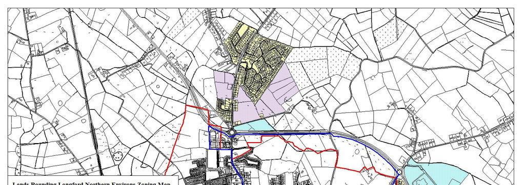
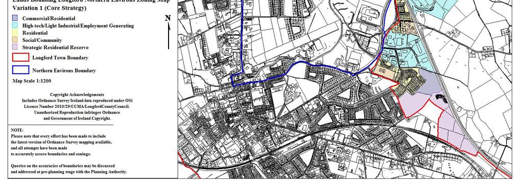
83 81
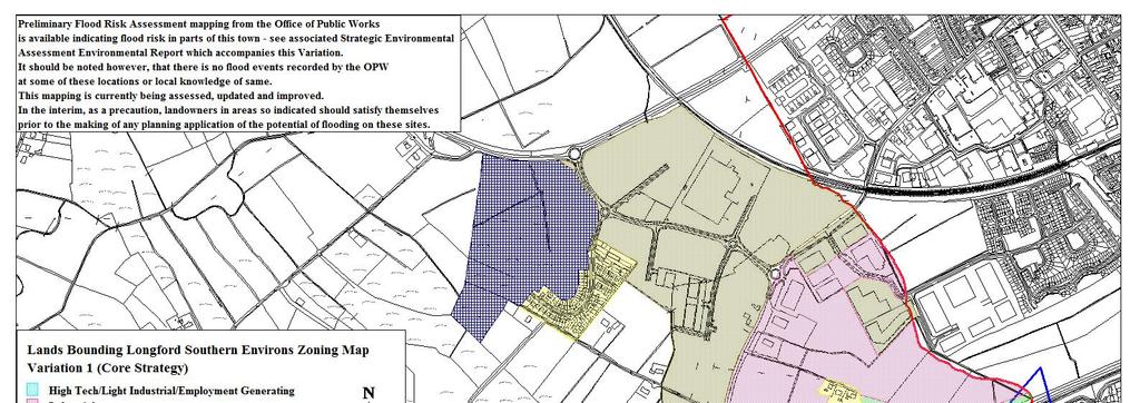
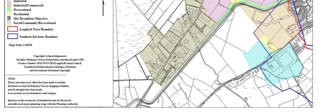
84 82
85 Appendix 5 Aquifer Buffer Zones Map Amendments 83
86 84
87 85
88 Appendix 16 Key Service Town- Granard Zoning Policy 86
89 Key Service Town Granard Granard is a County growth centre with a regional element acting as an important driver for local economies in the area, with well established economic, administrative and social functions. The town performs an important retail, residential, service and amenity functions for local rural hinterlands and supports the principal town of Longford. Strong emphasis will be placed on the growth of the local economy in Granard and the development of its vital administrative and social functions to support and complement growth in the region, developing and enhancing synergistic links with the adjacent Border Region. Zoning The zonings contained within this document and illustrated on the accompanying map are indicative of the level and nature of development which is deemed by the Planning Authority to be appropriate to the area. The development envelope shown is indicative of areas within and on the outskirts of the town that the planning authority consider appropriate for development, while satisfying the objectives of local, regional and national policy as contained in the relevant development plans and guidelines. The zonings are intended to be flexible and provided that the basic concepts of proper planning, residential amenity and good design practice are adhered to. Any proposed development should be compatible with the primary zoning use and should not detract from the amenity of the area. Zonings should be read in conjunction with the Development Plan Design Standards, particularly in relation to design, materials, public open space and parking requirements. The following zoning provisions should be read in consultation with the attached Zoning Map. 87
90 Residential To primarily provide for residential development; to preserve and improve residential amenity, dwellings and compatible uses including social and community facilities, open spaces and local shopping facilities The principles of sustainable development shall be taken into account when considering applications for residential development in the area, including the use of appropriate housing densities, natural, locally sourced materials, energy efficiency and transport implications, the impact on the existing ecology and compatibility with local environmental conditions. It is considered appropriate that existing residential areas are augmented and areas where gaps or leapfrogging of development have occurred are infilled, and the town be consolidated for the purposes of an appropriate and sustainable town structure, creating a clear urban/rural divide. Where appropriate, development design proposals shall provide for further access to adjacent zones of residential lands in order to facilitate their future access and development. Strategic Residential Reserve To provide for the longer term housing requirements of the town Residential development, other than that set out below, will not be permitted on these lands during the lifetime of the Plan (It should be noted that lands zoned for the purposes of strategic residential reserve may be released for development over future plan periods). The following residential type development may be considered acceptable; 1) Where there is a live permission for residential development that has not been activated. 88
91 The life of these permissions may be extended in accordance with the provisions of Section 42A of the Planning & Development Act 2010, as amended. Proposals for new developments will not be considered over the lifetime of the current plan period. 2) A proposal for a single dwelling house may be considered under this zoning where: a) the unit to be provided will serve as the permanent place of residence of the landowner or a member of his/her immediate family b) and where it can be clearly demonstrated that the provision of such a unit would not compromise the ability of the wider area of zoned land to be developed in the future, c) and the dwelling would easily integrate with the existing and future development of the lands and those in the vicinity. 3) In exceptional circumstances where it can be clearly demonstrated by the developer that there is a significant difficulty in the release or identification of lands for a specific residential type development, consideration will be given to the release of lands zoned Strategic Residential Reserve, subject to established planning criteria and including in particular; a) The requirement to remain within the overall residential land use targets as set out in the Core Strategy; b) The lands are being developed in a sequential manner; c) It has been clearly justified and demonstrated, to the satisfaction of the Planning Authority, that there is a clear discrepancy between the supply and release of residentially zoned lands and the demand for residential units. Certain developments that can demonstrate a strategic element, (e.g. a significant commercial or social element), may be deemed acceptable. 89
92 Commercial/Residential To primarily provide for commercial/retail development with a possible element of residential development Development carried out under this zoning should have regard to the dual use of the zoning, and, in particular, shall have regard to the retail policy for the County. Developers should be cognisant of the high profile locations of this zoning and design, siting and materials should be chosen accordingly. It is the policy of council to ensure maximum pedestrian permeability between the Main Street, Barrack Street and ancillary areas throughout the town centre. In this regard the pedestrian use of existing archways, lanes and passages, and the development of new non-vehicular linkages between Main/Barrack Street and backland and/or infill development and parking areas will be promoted, particularly where passive overlooking, active frontages, adequate lighting and security can be reasonably achieved. Developers will be required to facilitate such access where possible as part of any development proposal. Where appropriate, development design proposals shall provide for further access to adjacent zones of commercial/residential lands in order to facilitate their future access and development. Industrial / Commercial / Warehousing To primarily provide for industrial/workshop, warehouse and commercial or business development including compatible uses such as offices and distribution Zonings of industrial nature are indicative and are adaptable to the nature, size and requirements of future employment/industrial development. The creation of local employment opportunities is the primary aim of this zoning. Hi-tech business/office, and light industrial developments will be considered within this zoning. In certain instances 90
93 brownfield sites of a strategic nature may be considered for business use subject to compliance with all relevant development control standards. The term Commercial does not include traditional commercial functions that should locate within the town core. Where appropriate, development design proposals shall provide for further access to adjacent zones of industrial lands in order to facilitate their future access and development. Strategic Industrial Reserve To provide for the longer term industrial/workshop, warehouse and commercial or business development including compatible uses such as offices and distribution Lands zoned for the purposes of Strategic Industrial Reserve may be considered to meet longer term industrial needs of the area outside of the current Plan period. New industrial development of a substantial nature is not considered appropriate on these lands however in limited circumstances where live permissions for industrial development exists under this zoning, the life of said permission may be extended having regard to the provisions of the Planning and Development Acts Proposals for single small scale industrial units <500m 2 are considered appropriate on these lands where it can be demonstrated that such provision would not compromise the future ability of the adjoining lands to be developed as part of an overall scheme and that the development would integrate successfully with any future development. In addition where it has been clearly justified and demonstrated, to the satisfaction of the Planning Authority, that there is a clear discrepancy between the supply and release of industrial zoned lands and the demand for specific industrial development, consideration will be given to the release of lands zoned Strategic Industrial Reserve for these purposes. Certain developments that can demonstrate a strategic element, (e.g. a significant commercial or social element), may be deemed acceptable. 91
94 Social/Community/Education To primarily provide for educational, health, social, cultural, religious and community facilities This zoning provides for facilities that serve the community as a whole such as schools, community centres, crèches, nursing homes, etc. Recreational/Amenity To primarily provide for recreational open space and ancillary structures The proposed utilisation of the Motte as a public park would provide a strong recreational element required for the town, with the potential to establish a wildlife corridor and a potential link to other walking routes, facilitating the establishment of a pedestrian network of pathways.the zoning also provides for the protection of existing green areas and public open spaces which provide for the passive and active recreational needs. Road Objective To facilitate the provision of necessary road infrastructure A strategic road corridor will be reserved to facilitate the provision of a relief road to bypass the town along the N55. 92
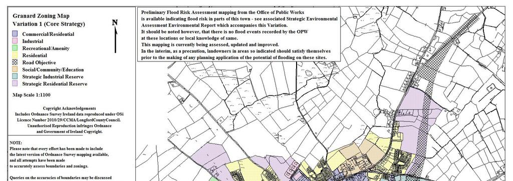
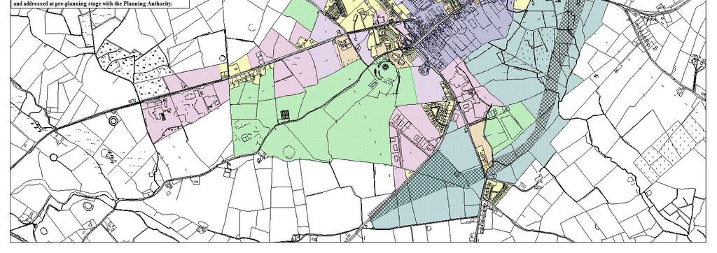
95 93
96 Appendix 17 Service Town- Edgeworthstown Zonings and Policy 94
97 Service Town Edgeworthstown Edgeworthstown serves a wide hinterland providing important local level residential, retailing, social and leisure functions to its rural hinterland as well as facilitating service provision and accommodation where major transport nodes are present. Emphasis will be placed on maintaining and enhancing Edgeworthstown s role as a service town, by way of orderly sustainable expansion commensurate with its position in the urban hierarchy. The zonings contained within this section and illustrated on the accompanying map are indicative of the level and nature of development which is deemed by the Planning Authority to be appropriate to the area. The development envelope shown is indicative of areas that the planning authority consider appropriate for development, while satisfying the objectives of local, regional and national policy as contained in the relevant development plans and guidelines. The zonings are intended to be flexible provided that the basic concepts of proper planning, residential amenity and good design practice are adhered to. Any proposed development should be compatible with the primary zoning use and should not detract from the amenity of the area. Zonings should be read in conjunction with the Development Plan Design Standards, particularly in relation to design, materials, public open space and parking requirements. The zoning provisions for each settlement should be read in consultation with the attached Zoning Maps. 95
98 Zoning Residential To primarily provide for residential development; to preserve and improve residential amenity, dwellings and compatible uses including social and community facilities, open spaces and local shopping facilities The principles of sustainable development shall be taken into account when considering applications for residential development in the area, including the use of appropriate housing densities, natural, locally sourced materials, energy efficiency and transport implications, the impact on the existing ecology and compatibility with local environmental conditions. The spatial structure of the development shall also consider characteristics of the existing built fabric. Accordingly, consideration shall be given to principle features such as Edgeworthstown House and its setting, Mostrim Rectory and the existing buildings located along the towns main street, ensuring the creation of a unique and appropriate environment that does not undermine the local sense of place. It is considered appropriate that existing residential areas are augmented and areas where gaps or leapfrogging of development have occurred are infilled (most noticeable on the western approaches into the settlement), and the town be consolidated for the purposes of an appropriate and sustainable town structure, creating a clear urban/rural divide. Where appropriate, development design proposals shall provide for further access to adjacent zones of residential lands in order to facilitate their future access and development. 96
99 Strategic Residential Reserve To provide for the longer term housing requirements of the town Residential development, other than that set out below, will not be permitted on these lands during the lifetime of the Plan (It should be noted that lands zoned for the purposes of strategic residential reserve may be released for development over future plan periods). The following residential type development may be considered acceptable; 1) Where there is a live permission for residential development that has not been activated. The life of these permissions may be extended in accordance with the provisions of Section 42A of the Planning & Development Act 2010, as amended. Proposals for new developments will not be considered over the lifetime of the current plan period. 2) A proposal for a single dwelling house may be considered under this zoning where: a) the unit to be provided will serve as the permanent place of residence of the landowner or a member of his/her immediate family b) and where it can be clearly demonstrated that the provision of such a unit would not compromise the ability of the wider area of zoned land to be developed in the future, c) and the dwelling would easily integrate with the existing and future development of the lands and those in the vicinity. 3) In exceptional circumstances where it can be clearly demonstrated by the developer that there is a significant difficulty in the release or identification of lands for a specific residential type development, consideration will be given to the release of lands zoned Strategic Residential Reserve, subject to established planning criteria and including in particular; 97
100 a) The requirement to remain within the overall residential land use targets as set out in the Core Strategy; b) The lands are being developed in a sequential manner; c) It has been clearly justified and demonstrated, to the satisfaction of the Planning Authority, that there is a clear discrepancy between the supply and release of residentially zoned lands and the demand for residential units. Certain developments that can demonstrate a strategic element, (e.g. a significant commercial or social element), may be deemed acceptable. Commercial / Residential To primarily provide for commercial/retail development with a possible element of residential development Development carried out under this zoning should have regard to the dual use of the zoning, and, in particular, shall have regard to the retail policy for the County. Developers should be cognisant of the high profile locations of this zoning and design, siting and materials should be chosen accordingly. All development in this regard will be subject to sequential test. Industrial / Commercial / Warehousing To primarily provide for industrial/workshop, warehouse and commercial or business development including compatible uses such as offices and distribution Zonings of industrial nature are indicative and are adaptable to the nature, size and requirements of future employment/industrial development. The creation of local employment opportunities is the primary aim of this zoning. Hi-tech business/office, and light industrial developments will be considered within this zoning. In certain instances 98
101 brownfield sites of a strategic nature may be considered for business use subject to compliance with all relevant development control standards. The term Commercial does not include traditional commercial functions that should locate within the town core. Where appropriate, development design proposals shall provide for further access to adjacent zones of industrial lands in order to facilitate their future access and development. Strategic Industrial Reserve To provide for the longer term industrial/workshop, warehouse and commercial or business development including compatible uses such as offices and distribution Lands zoned for the purposes of Strategic Industrial Reserve may be considered to meet longer term industrial needs of the area outside of the current Plan period. New industrial development of a substantial nature is not considered appropriate on these lands however in limited circumstances where live permissions for industrial development exists under this zoning, the life of said permission may be extended having regard to the provisions of the Planning and Development Acts Proposals for single small scale industrial units <500m 2 are considered appropriate on these lands where it can be demonstrated that such provision would not compromise the future ability of the adjoining lands to be developed as part of an overall scheme and that the development would integrate successfully with any future development. In addition where it has been clearly justified and demonstrated, to the satisfaction of the Planning Authority, that there is a clear discrepancy between the supply and release of industrial zoned lands and the demand for specific industrial development, consideration will be given to the release of lands zoned Strategic Industrial Reserve for these purposes. 99
102 Social/Community/Education To primarily provide for educational, health, social, cultural, religious and community facilities This zoning provides for facilities that serve the community as a whole such as schools, community centres, crèches, nursing homes, etc. Recreational / Amenity To primarily provide for recreational open space, environmental buffers and ancillary structures This zoning provides for sport and leisure facilities such as a clubhouse, changing rooms, meeting rooms, a gym, sports training halls, catering facilities, caretaker accommodation. The zoning also provides for the reservation of environmental buffers at strategic corridors throughout the town in order to provide a visual barrier between different landuses and ensure the protection of the town s watercourse. The protection of the Black River through the inclusion of a Buffer Zone will slow and filter any run-off into the watercourse, maintain an important wildlife corridor and enhance aesthetics of the area. The zoning further facilitates the protection of existing green areas and public open spaces which provide for the passive and active recreational needs. Road Objective To facilitate the provision of necessary road infrastructure A road reserve has been provided to facilitate the provision of an additional arm to the existing roundabout on the N4 to allow for the future connection to the proposed N4 Mullingar Rooskey National Route.. 100

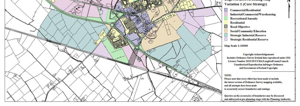
103 101
104 Appendix 18 Local Service Towns- Ballymahon & Lanesborough Zonings and Policy 102
105 Local Service Towns These towns have attractive streetscapes, physical settings and heritage buildings that present a strong visual character. They have an important role in the provision of local level retailing, social and leisure functions and local services to wider rural hinterland. Emphasis shall be placed on the maintenance and enhancement of strong visual character and built fabric in theses towns. The zonings contained within this section and illustrated on the accompanying map are indicative of the level and nature of development which is deemed by the Planning Authority to be appropriate to the area. The development envelopes shown are indicative of areas that the planning authority consider appropriate for development, while satisfying the objectives of local, regional and national policy as contained in the relevant development plans and guidelines. The zonings are intended to be flexible provided that the basic concepts of proper planning, residential amenity and good design practice are adhered to. Any proposed development should be compatible with the primary zoning use and should not detract from the amenity of the area. Zonings should be read in conjunction with the Development Plan Design Standards, particularly in relation to design, materials, public open space and parking requirements. The zoning provisions for each settlement should be read in consultation with the attached Zoning Maps. 103
106 Ballymahon Ballymahon is located on the River Inny to the east of Lough Ree, and is situated almost centrally between the large settlements of Athlone to the south-west, Mullingar to the east and Longford to the north. The town is served by an adequate road network- the national secondary route (N55) from Athlone to Cavan passes through the town as well as the regional route (R392) from Lanesboro to Mullingar, which generates steady levels of traffic through the settlement. Ballymahon exhibits a typical market town structure, based around a strong linear north-west/south-east axis. The main commercial activity is contained within a central core. Zoning Residential To primarily provide for residential development; to preserve and improve residential amenity, dwellings and compatible uses including social and community facilities, open spaces and local shopping facilities The principles of sustainable development shall be taken into account when considering applications for residential development in the area, including the use of appropriate housing densities, natural, locally sourced materials, energy efficiency and transport implications, the impact on the existing ecology and compatibility with local environmental conditions. It is considered appropriate that existing residential areas are augmented and areas where gaps or leapfrogging of development have occurred are infilled (most noticeable on the north western and south western approaches into the settlement), and the town be consolidated for the purposes of an appropriate and sustainable town structure, creating a clear urban/rural divide. 104
107 Requirements will be imposed in relation to the provision of interconnecting public open spaces in connection with larger residential developments, with particular emphasis on riverside access and walking routes, as outlined under the Recreational designation. Open space shall be designed with the following concepts in mind: safety, security, usability, access to the river, wildlife and habitat protection, character creation/preservation. Where appropriate, development design proposals shall provide for further access to adjacent zones of residential lands in order to facilitate their future access and development. Strategic Residential Reserve To provide for the longer term housing requirements of the town Residential development, other than that set out below, will not be permitted on these lands during the lifetime of the Plan (It should be noted that lands zoned for the purposes of strategic residential reserve may be released for development over future plan periods). The following residential type development may be considered acceptable; 1) Where there is a live permission for residential development that has not been activated. The life of these permissions may be extended in accordance with the provisions of Section 42A of the Planning & Development Act 2010, as amended. Proposals for new developments will not be considered over the lifetime of the current plan period. 2) A proposal for a single dwelling house may be considered under this zoning where: a) the unit to be provided will serve as the permanent place of residence of the landowner or a member of his/her immediate family 105
108 b) and where it can be clearly demonstrated that the provision of such a unit would not compromise the ability of the wider area of zoned land to be developed in the future, c) and the dwelling would easily integrate with the existing and future development of the lands and those in the vicinity. 3) In exceptional circumstances where it can be clearly demonstrated by the developer that there is a significant difficulty in the release or identification of lands for a specific residential type development, consideration will be given to the release of lands zoned Strategic Residential Reserve, subject to established planning criteria and including in particular; a) The requirement to remain within the overall residential land use targets as set out in the Core Strategy; b) The lands are being developed in a sequential manner; c) It has been clearly justified and demonstrated, to the satisfaction of the Planning Authority, that there is a clear discrepancy between the supply and release of residentially zoned lands and the demand for residential units. Certain developments that can demonstrate a strategic element, (e.g. a significant commercial or social element), may be deemed acceptable. Where Preliminary Flood Risk Assessment mapping from the Office of Public Works is available indicating flood risk on lands identified as Strategic Residential Reserve, development will not be considered pending a clear demonstration that the development would not increase flood risk within or outside of the site and/or the release of updated mapping from the OPW or any future Flood Risk Assessment prepared by the Planning Authority. 106
109 Site Resolution Objective To provide a mix of uses for the sustainable regeneration of the area. This zoning allows for a redevelopment of the site to better provide for the community and residents needs including the provision of housing which is more in line with the traditional character and scale of development in the area, having regard for market demand, family accommodation requirements or the needs of older people or those with disabilities. Any development proposal for the land will only be permitted where the development proposed is compatible with the existing development on the site and should aim to incorporate any of the following elements, that are appropriate to the site, in addition to the provision of residential accommodation; Community or resident needs (including education, childcare, healthcare, special needs housing etc); Opportunities for local business and enterprise; Active and passive recreation and amenity; Community facilities (properties could be rented for community development, crèches, childcare, drop-in centres, education, after-school care, training); Local shop facilities where such facilities would be commercially viable. Any development proposal for the site must be accompanied by a phasing scheme for the works including proposals for the protection of the residential amenities of existing residents in the area. Potential developers are advised to consult with the Planning Authority regarding any proposed site resolution developments at preplanning stage. 107
110 Commercial/Residential To primarily provide for commercial/retail development with a possible element of residential development Development carried out under this zoning should have regard to the dual use of the zoning, and, in particular, shall have regard to the retail policy for the County. Developers should be cognisant of the high profile locations of this zoning and design, siting and materials should be chosen accordingly. All development in this regard will be subject to sequential test. It is envisioned that much of the proposed retail/commercial development in the town would take place in the existing commercial core, revitalising the centre of Ballymahon and include provision for car-parking. Industrial / Commercial / Warehousing To primarily provide for industrial/workshop, warehouse and commercial or business development including compatible uses such as offices and distribution Zonings of industrial nature are indicative and are adaptable to the nature, size and requirements of future employment/industrial development. The creation of local employment opportunities is the primary aim of this zoning. Hi-tech business/office, and light industrial developments will be considered within this zoning. In certain instances brownfield sites of a strategic nature may be considered for business use subject to compliance with all relevant development control standards. The term Commercial does not include traditional commercial functions that should locate within the town core. Where appropriate, development design proposals shall provide for further access to adjacent zones of industrial lands in order to facilitate their future access and development. 108
111 Preliminary Flood Risk Assessment mapping from the Office of Public Works is available indicating flood risk at the edges of the industrial lands to the south west of the town. Landowners should satisfy themselves prior to the making of any planning application of the potential of flooding on these sites and any planning application on these sites shall be accompanied by a project level Flood Risk Assessment that incorporates a justification test and demonstrates that the development would not increase flood risk within or outside of the site. Strategic Industrial Reserve To provide for the longer term industrial/workshop, warehouse and commercial or business development including compatible uses such as offices and distribution Lands zoned for the purposes of Strategic Industrial Reserve may be considered to meet longer term industrial needs of the area outside of the current Plan period. New industrial development of a substantial nature is not considered appropriate on these lands however in limited circumstances where live permissions for industrial development exists under this zoning, the life of said permission may be extended having regard to the provisions of the Planning and Development Acts Proposals for single small scale industrial units <500m 2 are considered appropriate on these lands where it can be demonstrated that such provision would not compromise the future ability of the adjoining lands to be developed as part of an overall scheme and that the development would integrate successfully with any future development. In addition where it has been clearly justified and demonstrated, to the satisfaction of the Planning Authority, that there is a clear discrepancy between the supply and release of industrial zoned lands and the demand for specific industrial development, consideration will be given to the release of lands zoned Strategic Industrial Reserve for these purposes. 109
112 Social/Community/Public Utility To primarily provide for educational, health, social, cultural, religious and community facilities This zoning encompasses community uses (such as schools, churches, OPD s etc.), public utility and social/administrative designations such as the Fire and Garda Stations. Expansion of these services will be facilitated where needed and compatible with adjoining land uses. Residential/Community Services/Medicentre This zoning relates to the area of the former workhouse site to the south of the town on the western bank of the River Inny. The zoning accommodates the existing residential and medicentre/community services and healthcare facility which have already been established on the site and allows for the consolidation and expansion of these services. Any development at this location shall be designed to the highest standard and shall take cognisance of the riverside location and the preservation of recreational and visual amenity in this context. Preliminary Flood Risk Assessment mapping from the Office of Public Works is available indicating flood risk at the edges of this site. Landowners should satisfy themselves prior to the making of any planning application of the potential of flooding on this site and any planning application on this site shall be accompanied by a project level Flood Risk Assessment that incorporates a justification test and demonstrates that the development would not increase flood risk within or outside of the site. Recreational / Amenity To primarily provide for recreational open space, environmental buffers and ancillary structures 110
113 The proposed utilisation of the River Inny as a riverside walk and park would provide a recreational backbone to the town which would provide a wildlife corridor through the town and a potential link to other outlying recreational areas such as Newcastle woods, providing a community base for walking, watersports and other outdoor pursuits. This zoning also provides for sport and leisure facilities such as a clubhouse, changing rooms, meeting rooms, a gym, sports training halls, catering facilities, caretaker accommodation. 111
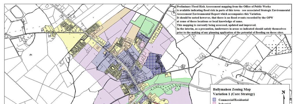
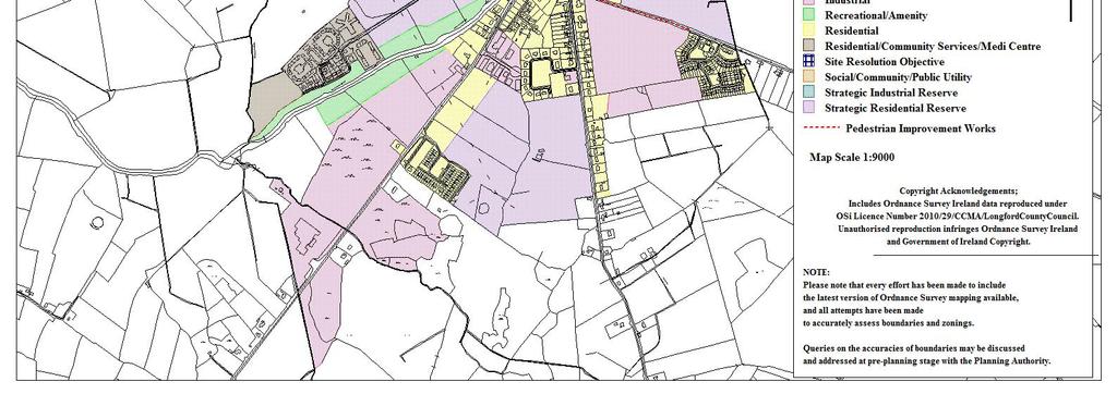
114 112
115 Lanesborough The main street of Lanesborough is located along the N63 (National Secondary Route) from Longford to Roscommon with the regional route from Lanesboro to Mullingar (R392) passing through in an east-west direction. The core area of the town, an important bridging point on the Shannon, is laid out in a linear pattern, running in an east-west direction across the River Shannon. Zoning Residential To primarily provide for residential development; to preserve and improve residential amenity, dwellings and compatible uses including social and community facilities, open spaces and local shopping facilities The principles of sustainable development shall be taken into account when considering applications for residential development in the area, including the use of appropriate housing densities, natural, locally sourced materials, energy efficiency and transport implications, the impact on the existing ecology and compatibility with local environmental conditions. It is considered appropriate that existing residential areas are augmented and areas where gaps or leapfrogging of development have occurred are infilled, and the town be consolidated for the purposes of an appropriate and sustainable town structure, creating a clear urban/rural divide. Requirements will be imposed in relation to the provision of interconnecting public open spaces in connection with larger residential developments, with particular emphasis on riverside access and walking routes, as outlined under the Recreational designation. 113
116 Open space shall be designed with the following concepts in mind: safety, security, usability, access to the river, wildlife and habitat protection, character creation/preservation. Where appropriate, development design proposals shall provide for further access to adjacent zones of residential lands in order to facilitate their future access and development. Strategic Residential Reserve To provide for the longer term housing requirements of the town Residential development, other than that set out below, will not be permitted on these lands during the lifetime of the Plan (It should be noted that lands zoned for the purposes of strategic residential reserve may be released for development over future plan periods). The following residential type development may be considered acceptable; 1) Where there is a live permission for residential development that has not been activated. The life of these permissions may be extended in accordance with the provisions of Section 42A of the Planning & Development Act 2010, as amended. Proposals for new developments will not be considered over the lifetime of the current plan period. 2) A proposal for a single dwelling house may be considered under this zoning where: a) the unit to be provided will serve as the permanent place of residence of the landowner or a member of his/her immediate family b) and where it can be clearly demonstrated that the provision of such a unit would not compromise the ability of the wider area of zoned land to be developed in the future, 114
117 c) and the dwelling would easily integrate with the existing and future development of the lands and those in the vicinity. 3) In exceptional circumstances where it can be clearly demonstrated by the developer that there is a significant difficulty in the release or identification of lands for a specific residential type development, consideration will be given to the release of lands zoned Strategic Residential Reserve, subject to established planning criteria and including in particular; a) The requirement to remain within the overall residential land use targets as set out in the Core Strategy; b) The lands are being developed in a sequential manner; c) It has been clearly justified and demonstrated, to the satisfaction of the Planning Authority, that there is a clear discrepancy between the supply and release of residentially zoned lands and the demand for residential units. Certain developments that can demonstrate a strategic element, (e.g. a significant commercial or social element), may be deemed acceptable. Where Preliminary Flood Risk Assessment mapping from the Office of Public Works is available indicating flood risk on lands identified as Strategic Residential Reserve, development will not be considered pending a clear demonstration that the development would not increase flood risk within or outside of the site and/or the release of updated mapping from the OPW or any future Flood Risk Assessment prepared by the Planning Authority. Commercial/Residential To primarily provide for commercial/retail development with a possible element of residential development 115
118 Development carried out under this zoning should have regard to the dual use of the zoning, and, in particular, shall have regard to the retail strategy for the County. Developers should be cognisant of the high profile locations of this zoning and design, siting and materials should be chosen accordingly. All development in this regard will be subject to sequential test. It is envisioned that much of the retail/commercial development in the town would take place in the existing commercial core, revitalising the centre of Lanesborough and include provision for car-parking. Industrial / Alternative Energy To primarily provide for industrial/workshop, warehouse and commercial or business development including compatible uses such as offices and distribution and to allow for the expansion of existing energy infrastructure. Zonings of industrial nature are indicative and are adaptable to the nature, size and requirements of future employment/industrial development. The creation of local employment opportunities is the primary aim of this zoning. Hi-tech business/office, and light industrial developments will be considered within this zoning. In certain instances brownfield sites of a strategic nature may be considered for business use subject to compliance with all relevant development control standards. To facilitate the transition from peat burning to renewable energy sources, the zoning also provides for the expansion of energy production facilities including biomass / biofuels, solar, wind and geothermal sourced energies. Manufacturing, servicing and research and development linked activities will also be considered. Where appropriate, development design proposals shall provide for further access to adjacent zones of industrial/alternative energy lands in order to facilitate their future access and development. 116
119 Preliminary Flood Risk Assessment mapping from the Office of Public Works is available indicating flood risk associated with parts of this zoning. Landowners should satisfy themselves prior to the making of any planning application of the potential of flooding on such lands and any planning application on these lands shall be accompanied by a project level Flood Risk Assessment that incorporates a justification test and demonstrates that the development would not increase flood risk within or outside of the site or alternatively shall demonstrate that any proposed development is water compatible. Social/Community/Education/Public Utility To primarily provide for educational, health, social, cultural, religious and community facilities This zoning encompasses community uses (such as schools, churches etc.), public utility and social/administrative designations such as the Fire and Garda Stations. Expansion of these services will be facilitated where needed and compatible with adjoining land uses. Recreational / Amenity To primarily provide for recreational open space, environmental buffers and ancillary structures This zoning also provides for sport and leisure facilities such as a clubhouse, changing rooms, meeting rooms, a gym, sports training halls, catering facilities, caretaker accommodation. The Green housing area is an integral part of the identity of Lanesboro, having been built by Bord na Mona in the 1950 s. The Church opposite, which is a listed building, and the elevated nature of the site add to the prominence of the grassed area, making it a natural congregation and gathering area. The addition of identifying features in this area, such as bog oak sculptures and seating, would provide the basis for development of a functional 117
120 congregation area in the town. The existing mature trees and planting would mean that the works required to improve this area would be minimal. The Riverside area along the banks of the Shannon is extensively used at present by locals and non-locals alike for passive and active recreational purposes. The connections from the riverside with the Commons North area adjacent make it a popular walking route, while the presence of the internationally renowned hot-water stretch make a highly regarded angling location. Local organisations have recently succeeded in installing fishing stands for disabled anglers, a well needed addition to the amenity potential of the banks. Development to the rear of the Main Street will be encouraged in a manner that enhances the riverside location, including the installation of native riverside planting to replace existing non-native hedging in particular. Protected Area/Passive Amenity This area forms part of the NHA/SAC/SPA of the Lough Ree area, which is also protected under the County Development Plan, The aim of this zoning will be to protect this area from unsuitable development, while enhancing its potential to continue as a valuable recreational and educational resource for Lanesboro. This may involve the repair and maintenance of signage and footpaths throughout the area, management and enhancement of the ecological attributes of the area and maintenance of these activities in a way that does not compromise environmental or ecological integrity. Signage is an important element that will help to raise awareness of the importance of the area over a wide range of disciplines from geology to ecology and ornithology. This should be designed in keeping with its surroundings. Similarly, footways should be simple and cause minimal intrusion into the landscape. 118
121 Tourism To support the provision of a heritage and amenity centre. This objective facilitates the provision of a heritage and amenity visitor centre / national park in combination with a potential monastic trail. The Car park and Lancashire Field are prominently located adjacent to the river with strong potential for the development of high profile leisure and amenity facilities with a possible element of interpretation and environmental education. Development of this area could include the provision of a hotel/leisure centre with conference facilities with potential for an integrated interpretative centre. In any case, development in this area must be of the highest quality with due regard given to the sensitivity of the location. This will include a high quality finish with carefully designed form, scale, design and materials to blend in with the surrounding landscape. Layout and location of parking and ancillary facilities will be an important element in the design of any proposed development in this location. Location of water sports and other active recreational facilities will be considered in this area, subject to stringent design criteria due to the sensitivity of the location. High design standards will be required for the proposed leisure and amenity development, respecting the high profile and scenic location. This will include siting criteria that will minimise the intrusion of the new structure into the existing lakeshore setting and the sensitive use of design and materials to successfully incorporate the structure and its ancillary facilities into the surrounding landscape. 119

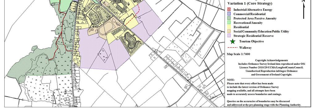
122 120

123 Appendix 19 Serviced Settlements- Zonings and Policy 121
124 Serviced Settlements These settlements have unique attributes in terms of natural and/or built heritage and specific cultural and historic associations that require specific designation to protect and enhance their character. Each town has the infrastructural capabilities available to act as local growth settlements. The towns also provide services to rural communities, including housing, neighbourhood level retail and social facilities and are of particular importance in the delivery of services such as social, community and neighbourhood services at a local level, to the highly dispersed rural population of Longford. The zonings contained within this section and illustrated on the accompanying maps are indicative of the level and nature of development which is deemed by the Planning Authority to be appropriate to the area. The development envelopes shown are indicative of areas within the towns that the planning authority consider appropriate for development, while satisfying the objectives of local, regional and national policy as contained in the relevant development plans and guidelines. The zonings are intended to be flexible and provided that the basic concepts of proper planning, residential amenity and good design practice are adhered to. Any proposed development should be compatible with the primary zoning use and should not detract from the amenity of the area. Zonings should be read in conjunction with the Development Plan Design Standards, particularly in relation to design, materials, public open space and parking requirements. The zoning provisions for each settlement should be read in consultation with the attached Zoning Maps. 122
125 Abbeyshrule Abbeyshrule, located in the south east of the County is situated on the River Inny, which flows through the town on the eastern boundary, and the Royal Canal which forms the western perimeter of the town. Abbeyshrule takes its name from the Gaelic word for stream or a river. Zoning Residential To primarily provide for residential development; to preserve and improve residential amenity, dwellings and compatible uses including social and community facilities, open spaces and local shopping facilities The principles of sustainable development shall be taken into account when considering applications for residential development in the area, including the use of appropriate housing densities, natural, locally sourced materials, energy efficiency and transport implications, the impact on the existing ecology and compatibility with local environmental conditions. Strategic Residential Reserve To provide for the longer term housing requirements of the town Residential development, other than that set out below, will not be permitted on these lands during the lifetime of the Plan (It should be noted that lands zoned for the purposes of strategic residential reserve may be released for development over future plan periods). The following residential type development may be considered acceptable; 1) Where there is a live permission for residential development that has not been activated. 123
126 The life of these permissions may be extended in accordance with the provisions of Section 42A of the Planning & Development Act 2010, as amended. Proposals for new developments will not be considered over the lifetime of the current plan period. 2) A proposal for a single dwelling house where: a) the unit to be provided will serve as the permanent place of residence of the landowner or a member of his/her immediate family b) and where it can be clearly demonstrated that the provision of such a unit would not compromise the ability of the wider area of zoned land to be developed in the future, c) and the dwelling would easily integrate with the existing and future development of the lands and those in the vicinity. 3) In exceptional circumstances where it can be clearly demonstrated by the developer that there is a significant difficulty in the release or identification of lands for a specific residential type development, consideration will be given to the release of lands zoned Strategic Residential Reserve, subject to established planning criteria and including in particular; a) The requirement to remain within the overall residential land use targets as set out in the Core Strategy; b) The lands are being developed in a sequential manner; c) It has been clearly justified and demonstrated, to the satisfaction of the Planning Authority, that there is a clear discrepancy between the supply and release of residentially zoned lands and the demand for residential units. Certain developments that can demonstrate a strategic element, (e.g. a significant commercial or social element), may be deemed acceptable. 124
127 Social/Community/Education To primarily provide for educational, health, social, cultural, religious and community facilities This zoning provides for facilities that serve the community as a whole such as schools, community centres, crèches, nursing homes, churches etc. Commercial/Residential To primarily provide for commercial/retail development with a possible element of residential development Development carried out under this zoning should have regard to the dual use of the zoning, and, in particular, shall have regard to the retail policy for the County. Developers should be cognisant of the high profile locations of this zoning and design, whereas siting and materials should be chosen accordingly to ensure the any additional developments enhance the existing attractive streetscape. Recreational / Amenity To primarily provide for recreational open space, environmental buffers and ancillary structures This zoning provides for the reservation of environmental buffers at strategic corridors throughout the town in order to provide a visual barrier between different land uses and ensure the protection of the town s watercourses, maintaining an important wildlife corridor and enhancing the aesthetics of the area. 125
128 Airport Development Objective To provide for Airport related activities and the expansion of existing Air Facilities. This zoning provides for the consolidation and expansion of existing airport services at Abbeyshrule including passenger buildings and services, airport infrastructure, hangerage, storage, maintenance and ancillary facilities, transport depot, training facilities, storage depot, warehouse, offices and light industrial/enterprise units. All developments in this zone will be required to comply with all Irish Aviation Authority standards. 126
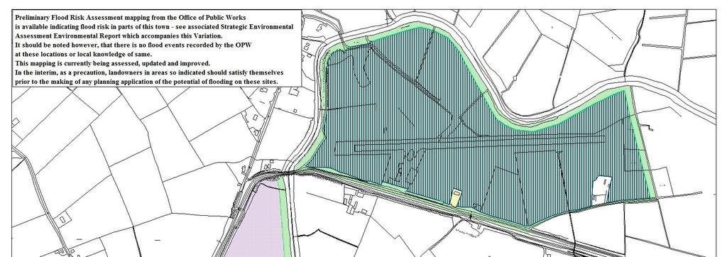
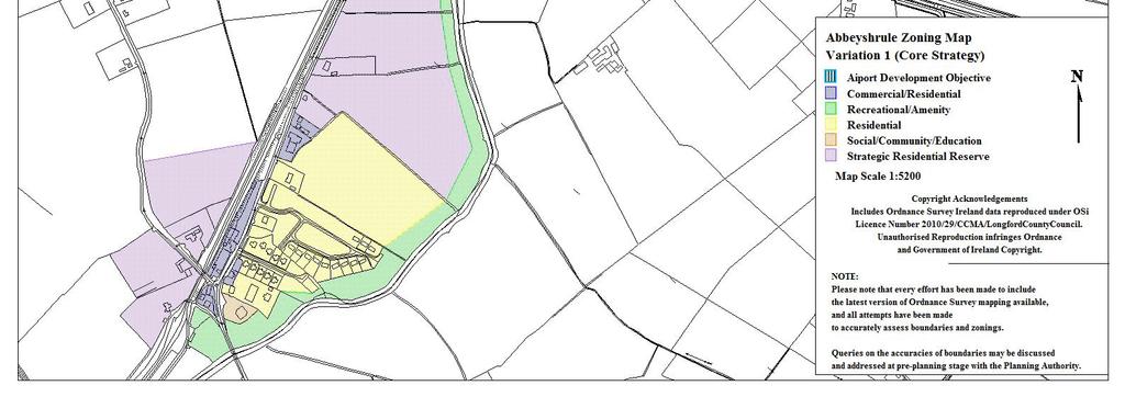
129 127
130 Ardagh Ardagh or Árd Achadh, meaning high field, situated beside the ancient Ardagh Mountain, is a picturesque village, located in the southern part of County Longford to the south east of Longford town and south west of Edgeworthstown. It is a traditional rural Irish village with a combination of rustic houses and fine churches. Zoning Residential To primarily provide for residential development; to preserve and improve residential amenity, dwellings and compatible uses including social and community facilities, open spaces and local shopping facilities The principles of sustainable development shall be taken into account when considering applications for residential development in the area, including the use of appropriate housing densities, natural, locally sourced materials, energy efficiency and transport implications, the impact on the existing ecology and compatibility with local environmental conditions. Strategic Residential Reserve To provide for the longer term housing requirements of the town Residential development, other than that set out below, will not be permitted on these lands during the lifetime of the Plan (It should be noted that lands zoned for the purposes of strategic residential reserve may be released for development over future plan periods). The following residential type development may be considered acceptable; 1) Where there is a live permission for residential development that has not been activated. 128
131 The life of these permissions may be extended in accordance with the provisions of Section 42A of the Planning & Development Act 2010, as amended. Proposals for new developments will not be considered over the lifetime of the current plan period. 2) A proposal for a single dwelling house may be considered under this zoning where: a) the unit to be provided will serve as the permanent place of residence of the landowner or a member of his/her immediate family b) and where it can be clearly demonstrated that the provision of such a unit would not compromise the ability of the wider area of zoned land to be developed in the future, c) and the dwelling would easily integrate with the existing and future development of the lands and those in the vicinity. 3) In exceptional circumstances where it can be clearly demonstrated by the developer that there is a significant difficulty in the release or identification of lands for a specific residential type development, consideration will be given to the release of lands zoned Strategic Residential Reserve, subject to established planning criteria and including in particular; a) The requirement to remain within the overall residential land use targets as set out in the Core Strategy; b) The lands are being developed in a sequential manner; c) It has been clearly justified and demonstrated, to the satisfaction of the Planning Authority, that there is a clear discrepancy between the supply and release of residentially zoned lands and the demand for residential units. Certain developments that can demonstrate a strategic element, (e.g. a significant commercial or social element), may be deemed acceptable. 129
132 Social/Community/Education To primarily provide for educational, health, social, cultural, religious and community facilities This zoning provides for facilities that serve the community as a whole such as schools, community centres, crèches, nursing homes, churches etc. Commercial/Residential To primarily provide for commercial/retail development with a possible element of residential development Development carried out under this zoning should have regard to the dual use of the zoning, and, in particular, shall have regard to the retail policy for the County. Developers should be cognisant of the high profile locations of this zoning and design, whereas siting and materials should be chosen accordingly to ensure any additional developments enhance the existing attractive streetscape. Recreational / Amenity To primarily provide for recreational open space, environmental buffers and ancillary structures This zoning provides for the reservation of environmental buffers at strategic corridors throughout the town in order to provide a visual barrier between different land uses and ensure the protection of the town s natural assets, maintaining an important wildlife corridor, enhancing the aesthetics of the area and providing important amenity areas. Tourism / Culture and Events To realise the tourism potential of the area 130
133 This objective provides for the development of the Arts, Culture and Entertainment facilities including activities that are accessible to all in both physical and economic terms. The zoning also provides for the facilitation of festivals and related events. 131

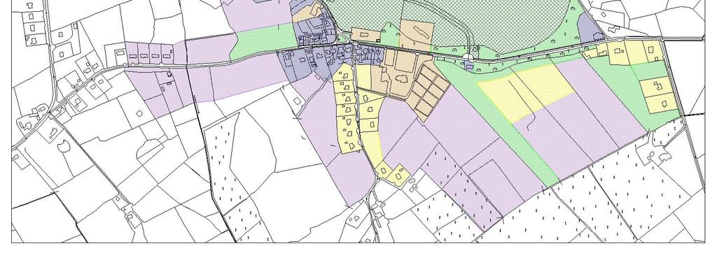
134 132
135 Aughnacliffe Aughnacliffe is a settlement in North County Longford, midway between Cavan Town and Longford Town in proximity to the lakes of the Upper Erne system and Gowna. Zoning Residential To primarily provide for residential development; to preserve and improve residential amenity, dwellings and compatible uses including social and community facilities, open spaces and local shopping facilities The principles of sustainable development shall be taken into account when considering applications for residential development in the area, natural, locally sourced materials, energy efficiency and transport implications, the impact on the existing ecology and compatibility with local environmental conditions. Strategic Residential Reserve To provide for the longer term housing requirements of the town Residential development, other than that set out below, will not be permitted on these lands during the lifetime of the Plan (It should be noted that lands zoned for the purposes of strategic residential reserve may be released for development over future plan periods). The following residential type development may be considered acceptable; 1) Where there is a live permission for residential development that has not been activated. 133
136 The life of these permissions may be extended in accordance with the provisions of Section 42A of the Planning & Development Act 2010, as amended. Proposals for new developments will not be considered over the lifetime of the current plan period. 2) A proposal for a single dwelling house may be considered under this zoning where: a) the unit to be provided will serve as the permanent place of residence of the landowner or a member of his/her immediate family b) and where it can be clearly demonstrated that the provision of such a unit would not compromise the ability of the wider area of zoned land to be developed in the future, c) and the dwelling would easily integrate with the existing and future development of the lands and those in the vicinity. 3) In exceptional circumstances where it can be clearly demonstrated by the developer that there is a significant difficulty in the release or identification of lands for a specific residential type development, consideration will be given to the release of lands zoned Strategic Residential Reserve, subject to established planning criteria and including in particular; a) The requirement to remain within the overall residential land use targets as set out in the Core Strategy; b) The lands are being developed in a sequential manner; c) It has been clearly justified and demonstrated, to the satisfaction of the Planning Authority, that there is a clear discrepancy between the supply and release of residentially zoned lands and the demand for residential units. Certain developments that can demonstrate a strategic element, (e.g. a significant commercial or social element), may be deemed acceptable. 134
137 Site Resolution Objective To provide a mix of uses for the sustainable regeneration of the area. This zoning allows for a redevelopment of the site to better provide for the community and residents needs including the provision of housing which is more in line with the traditional character and scale of development in the area, having regard for market demand, family accommodation requirements or the needs of older people or those with disabilities. Any development proposal for the land will only be permitted where the development proposed is compatible with the existing development on the site and should aim to incorporate any of the following elements, that are appropriate to the site, in addition to the provision of residential accommodation; Community or resident needs (including education, childcare, healthcare, special needs housing etc); Opportunities for local business and enterprise; Active and passive recreation and amenity; Community facilities (properties could be rented for community development, crèches, childcare, drop-in centres, education, after-school care, training); Local shop facilities where such facilities would be commercially viable. Any development proposal for the site must be accompanied by a phasing scheme for the works including proposals for the protection of the residential amenities of existing residents in the area. Potential developers are advised to consult with the Planning Authority regarding any proposed site resolution developments at preplanning stage. 135
138 Social/Community/Education To primarily provide for educational, health, social, cultural, religious and community facilities This zoning provides for facilities that serve the community as a whole such as schools, community centres, crèches, nursing homes, churches, burial grounds etc. Commercial/Residential To primarily provide for commercial/retail development with a possible element of residential development Development carried out under this zoning should have regard to the dual use of the zoning, and, in particular, shall have regard to the retail policy for the County. Developers should be cognisant of the high profile locations of this zoning and design, whereas siting and materials should be chosen accordingly to ensure that any additional developments enhance the existing attractive streetscape. Recreational / Amenity To primarily provide for recreational open space, environmental buffers and ancillary structures This zoning provides for the reservation of an environmental buffer in order to provide a visual barrier between different land uses and ensure the protection of the town s natural assets, maintaining an important wildlife corridor and enhancing the aesthetics of the area. 136

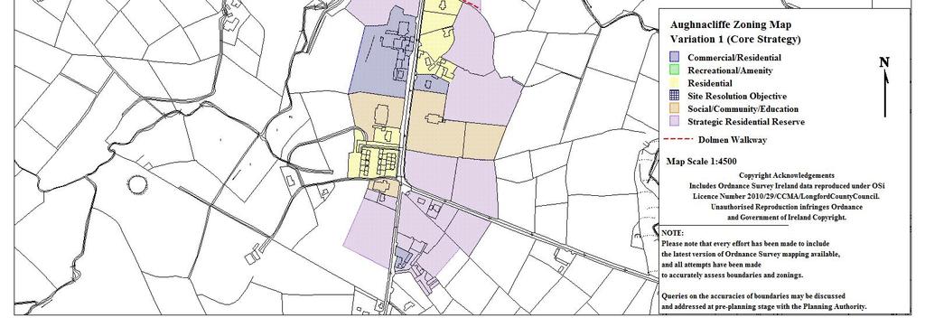
139 137
140 Ballinalee Ballinalee has developed around a central crossroads, with a strong and focused structure within the centre of the settlement that tapers off towards the settlement edge. Ballinalee takes its name from Beal atha na Laogh, meaning the mouth of the ford of the calves, and is situated on the River Camlin. Zoning Residential To primarily provide for residential development; to preserve and improve residential amenity, dwellings and compatible uses including social and community facilities, open spaces and local shopping facilities The principles of sustainable development shall be taken into account when considering applications for residential development in the area, including the use of appropriate housing densities, natural, locally sourced materials, energy efficiency and transport implications, the impact on the existing ecology and compatibility with local environmental conditions. Strategic Residential Reserve To provide for the longer term housing requirements of the town Residential development, other than that set out below, will not be permitted on these lands during the lifetime of the Plan (It should be noted that lands zoned for the purposes of strategic residential reserve may be released for development over future plan periods). The following residential type development may be considered acceptable; 1) Where there is a live permission for residential development that has not been activated. 138
141 The life of these permissions may be extended in accordance with the provisions of Section 42A of the Planning & Development Act 2010, as amended. Proposals for new developments will not be considered over the lifetime of the current plan period. 2) A proposal for a single dwelling house may be considered under this zoning where: a) the unit to be provided will serve as the permanent place of residence of the landowner or a member of his/her immediate family b) and where it can be clearly demonstrated that the provision of such a unit would not compromise the ability of the wider area of zoned land to be developed in the future, c) and the dwelling would easily integrate with the existing and future development of the lands and those in the vicinity. 3) In exceptional circumstances where it can be clearly demonstrated by the developer that there is a significant difficulty in the release or identification of lands for a specific residential type development, consideration will be given to the release of lands zoned Strategic Residential Reserve, subject to established planning criteria and including in particular; a) The requirement to remain within the overall residential land use targets as set out in the Core Strategy; b) The lands are being developed in a sequential manner; c) It has been clearly justified and demonstrated, to the satisfaction of the Planning Authority, that there is a clear discrepancy between the supply and release of residentially zoned lands and the demand for residential units. Certain developments that can demonstrate a strategic element, (e.g. a significant commercial or social element), may be deemed acceptable. 139
142 Social/Community/Education To primarily provide for educational, health, social, cultural, religious and community facilities This zoning provides for facilities that serve the community as a whole such as schools, community centres, crèches, nursing homes, churches etc. Commercial/Residential To primarily provide for commercial/retail development with a possible element of residential development Development carried out under this zoning should have regard to the dual use of the zoning, and, in particular, shall have regard to the retail policy for the County. Developers should be cognisant of the high profile locations of this zoning and design, whereas siting and materials should be chosen accordingly to ensure that any additional developments enhance the existing attractive streetscape. Recreational / Amenity To primarily provide for recreational open space, environmental buffers and ancillary structures This zoning provides for sport and leisure facilities such as a clubhouse, changing rooms, meeting rooms, a gym, sports training halls, catering facilities and caretaker accommodation. The zoning also provides for the reservation of environmental buffers at strategic corridors throughout the town in order to provide a visual barrier between different land uses and ensure the protection of the town s watercourse, maintaining an important wildlife corridor and enhancing the aesthetics of the area. 140
143 Light Industrial/Commercial/Servicing To primarily provide for small scale industrial/workshop and warehouse development including compatible uses such as offices and distribution This zoning provides for small scaled light industrial/commercial warehousing facilities and ancillary business uses. 141

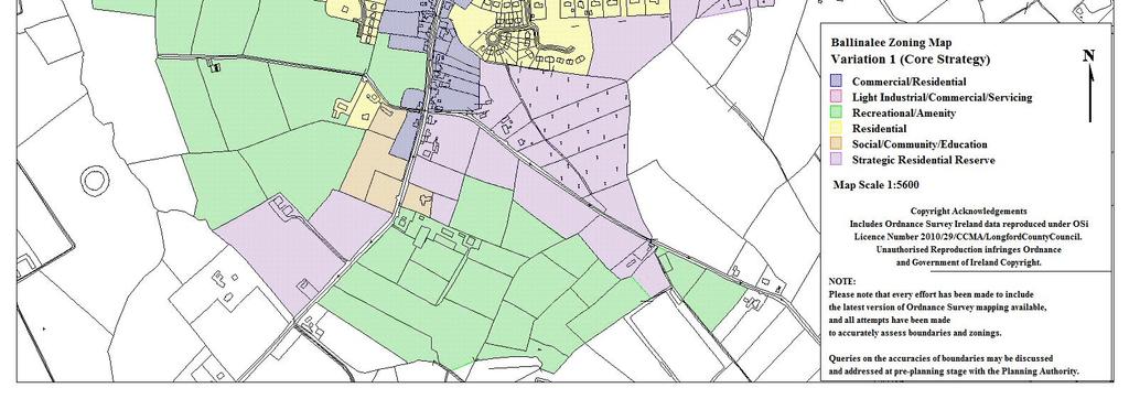
144 142
145 Ballinamuck Ballinamuck is a settlement located in the north west of the County. The settlement was the scene of the Battle of Ballinamuck, where a French army aiding the United Irishmen rebellion of 1798, was defeated. Ballinamuck or Béal Átha na Muc, means "mouth of the pig's ford". Zoning Residential To primarily provide for residential development; to preserve and improve residential amenity, dwellings and compatible uses including social and community facilities, open spaces and local shopping facilities The principles of sustainable development shall be taken into account when considering applications for residential development in the area, including the use of appropriate housing densities, natural, locally sourced materials, energy efficiency and transport implications, the impact on the existing ecology and compatibility with local environmental conditions. Strategic Residential Reserve To provide for the longer term housing requirements of the town Residential development, other than that set out below, will not be permitted on these lands during the lifetime of the Plan (It should be noted that lands zoned for the purposes of strategic residential reserve may be released for development over future plan periods). The following residential type development may be considered acceptable; 1) Where there is a live permission for residential development that has not been activated. 143
146 The life of these permissions may be extended in accordance with the provisions of Section 42A of the Planning & Development Act 2010, as amended. Proposals for new developments will not be considered over the lifetime of the current plan period. 2) A proposal for a single dwelling house may be considered under this zoning where: a) the unit to be provided will serve as the permanent place of residence of the landowner or a member of his/her immediate family b) and where it can be clearly demonstrated that the provision of such a unit would not compromise the ability of the wider area of zoned land to be developed in the future, c) and the dwelling would easily integrate with the existing and future development of the lands and those in the vicinity. 3) In exceptional circumstances where it can be clearly demonstrated by the developer that there is a significant difficulty in the release or identification of lands for a specific residential type development, consideration will be given to the release of lands zoned Strategic Residential Reserve, subject to established planning criteria and including in particular; a) The requirement to remain within the overall residential land use targets as set out in the Core Strategy; b) The lands are being developed in a sequential manner; c) It has been clearly justified and demonstrated, to the satisfaction of the Planning Authority, that there is a clear discrepancy between the supply and release of residentially zoned lands and the demand for residential units. Certain developments that can demonstrate a strategic element, (e.g. a significant commercial or social element), may be deemed acceptable. 144
147 Social/Community/Education To primarily provide for educational, health, social, cultural, religious and community facilities This zoning provides for facilities that serve the community as a whole such as schools, community centres, crèches, nursing homes, churches, burial grounds etc. Commercial/Residential To primarily provide for commercial/retail development with a possible element of residential development Development carried out under this zoning should have regard to the dual use of the zoning, and, in particular, shall have regard to the retail policy for the County. Developers should be cognisant of the high profile locations of this zoning and design, whereas siting and materials should be chosen accordingly to ensure that any additional developments enhance the existing attractive streetscape. Recreational / Amenity To primarily provide for recreational open space, environmental buffers and ancillary structures This zoning provides for the reservation of an environmental buffer in order to provide a visual barrier between different land uses and ensure the protection of the town s natural assets, maintaining an important wildlife corridor and enhancing the aesthetics of the area. 145
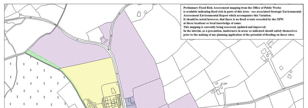
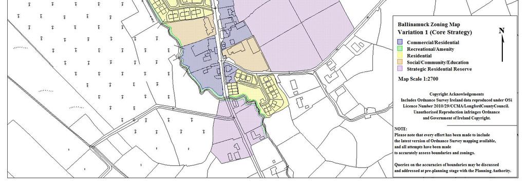
148 146
149 Carriglass Carrickglass Demesne, established in the 17 th century comprises a walled parcel of land with an area of 650 acres approximately 4km adjacent and to the northeast of Longford Town. Zoning Site Resolution Objective To provide a mix of uses for the sustainable regeneration of the area. This zoning allows for a redevelopment of the site to better provide for the community and residents needs including the provision of housing which is more in line with the traditional character and scale of development in the area, having regard for market demand, family accommodation requirements or the needs of older people or those with disabilities. Any development proposal for the land will only be permitted where the development proposed is compatible with the existing development on the site and should aim to incorporate any of the following elements, that are appropriate to the site, in addition to the provision of residential accommodation; Community or resident needs (including education, childcare, healthcare, special needs housing etc); Opportunities for local business and enterprise; Active and passive recreation and amenity; Community facilities (properties could be rented for community development, crèches, childcare, drop-in centres, education, after-school care, training); Local shop facilities where such facilities would be commercially viable. Any development proposal for the site must be accompanied by a phasing scheme for the works including proposals for the protection of the residential amenities of existing residents in the area. 147
150 Potential developers are advised to consult with the Planning Authority regarding any proposed site resolution developments at preplanning stage. Tourism To provide of high quality tourism products and services. This zoning provides for tourist related development including tourist accommodation, hospitality and entertainment. Proposals such as hotel and golf courses, entertainment events, eco-tourism, health centres, horse-riding, walking and cycling and facilities that relate to the special qualities of the surrounding natural environment will all be considered under this zoning. Development proposals will be required to respect the scenic amenity and limited environmental capacity (existing protected areas and archaeology) for development and encourage good design. Flood Plain / Protected Trees Flood Plain Building will not be permitted in the flood plain of the Camlin River, with the exception of any proposed reed-bed treatment system or similar suitable alternative, which will be protected from, or designed to safely cater for periodic inundation. Protected Trees The area is designated as a Natural Heritage Area due to the importance of the mixed woodland that borders the estate, its mainly mature nature and the lack of similar habitats in the north midlands. These trees are also protected under Appendix 10 of the County Development Plan. Preservation and enhancement of existing biodiversity through retention of existing mature trees and woodland and supplementing this with additional native planting will be required as 148
151 part of any development proposal. Wildlife corridors should also be facilitated and detailed in all plans. Protected Structures/Areas The Manor House itself is a protected structure, and, as such, under Part IV of the Planning and Development Act, 2000, all structures within the curtilege of the house are also protected. These include the following important elements: Manor House Gandon Stable and Farmyard Complexes Gandon Gates on the Eastern entrance / triumphal arch Associated walls and Lodges The conservation and preservation of the protected structures within the estate will be carried out in tandem with proposed residential and commercial development. This shall be laid out in a phasing plan to be submitted as part of any development proposal. Preservation and conservation works shall be carried out to an agreed works programme, drawn up and administered by suitably qualified personnel, in consultation with the Heritage Council. The final uses of these structures, particularly the Manor House, once restored, should be considered as part of any application for development in the area. It should be noted that an active use, where possible, is considered most appropriate in terms of the Architectural Heritage Protection Guidelines for Planning Authorities, DoEHLG, Archaeology There are three recorded archaeological artefacts within the boundary of the demesne, including two ring forts and a church. These features are included in the sites and monuments record for the area. Regard should be had to existing archaeological features on the site when submitting any proposals for development. 149

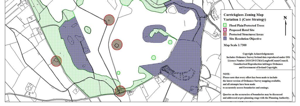
152 150
153 Clondra Clondra, located on the County boundary with Roscommon is located close to the River Shannon, from where there is a link to the Royal Canal which, along with the River Camlin, bisects the vsettlement. Resulting from its strategic location at the confluence point of the River Shannon, Camlin, Royal and Cloondara Canal, Clondra is an important historic village. The core of the present village dates from the time of the construction of the Royal Canal. Consequently the village developed around the watercourses and many traditional village functions, such as the Corn Mill, were a direct result of this. Accordingly, the settlement retains an interesting group of Canal related buildings in Ireland. Zoning Residential To primarily provide for residential development; to preserve and improve residential amenity, dwellings and compatible uses including social and community facilities, open spaces and local shopping facilities The principles of sustainable development shall be taken into account when considering applications for residential development in the area, including the use of appropriate housing densities, natural, locally sourced materials, energy efficiency and transport implications, the impact on the existing ecology and compatibility with local environmental conditions. Commercial/Residential To primarily provide for commercial/retail development with a possible element of residential development Development carried out under this zoning should have regard to the dual use of the zoning, and, in particular, shall have regard to the retail policy for the County. Developers should be cognisant of the high profile locations of this zoning and design, whereas siting and materials 151
154 should be chosen accordingly to ensure that any additional developments enhance the existing attractive streetscape. The Bull House has been included in this zoning so that it can be retained and if possible could be repaired and used for commercial activities, subject to sensitive design and restoration. Any development should consider the visual impact on the harbour area and be designed to the highest architectural standards. Social/Community/Education To primarily provide for social, community and educational facilities This zoning provides for facilities that serve the community as a whole such as schools, community centres, crèches, nursing homes, churches etc. Recreational/Amenity To primarily provide for passive recreational open space The areas around the Royal Canal, Clondra Canal and River Camlin are zoned for recreational and amenity use. This will prevent privatisation of this important public resource and will ensure that the area remains an accessible and attractive place for both locals and visitors. Canal Redevelopment Area The zoning caters for the use of the Canal as an amenity area and facilitates improvements in the level of services available for Canal users increasing the tourism potential of the area. The zoning is intended to facilitate environmental improvement works, including the provision of enhanced pedestrian facilities, street furniture and play areas etc. In addition to this, the zoning will facilitate the provision of a service building/interpretative centre, with a multi- 152
155 function purpose including (but not limited to) a water controllers office, a stores depot, a service block (toilets, showers, laundry, pump out), a marketing suite (small scale shop, tourist office), the provision of small-scale commercial facilities (such as a coffee shop) and other uses that benefit the community. Tourism / Mixed Use with Provision of Marina To primarily provide for mixed use and marina development, including residential uses, compatible social and community facilities, local shopping and commercial facilities, recreational facilities, open spaces and supporting tourism development. This shall be in tandem with the creation and provision of a Marina at the developer s expense on developing the site and be subject to the provision of a site for educational purposes. The principles of sustainable development shall be taken into account when considering applications for residential development in the area, including the use of appropriate housing densities, naturally, locally sourced materials, energy efficiency and transport implications, the impact on the existing ecology and compatibility with local environmental conditions. No other development will be permitted on the site in the absence of the development of a marina. Proposals for development on the site shall clearly demonstrate adequate access proposals as part of any application for development. Required future roads are intended to be achieved through the development management process, as conditions on any future planning permissions and shall be provided at the developer s expense on developing the site. Pedestrian linkages shall also be included as part of any development proposal. Development carried out under this zoning shall give consideration to the natural landscape setting of the site and in particular to the adjoining River Camlin, Cloondara Canal and River Shannon. 153

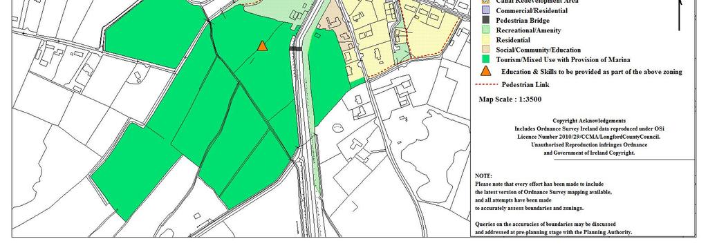
156 154
157 Drumlish Drumlish is situated in the north of the County. The settlement s organic development around a central crossroads provides a compact core for Drumlish and lends the village a sense of cohesion. Historically, Drumlish takes its name from the Irish meaning for sheltered hillside. Originally part of the ancient parish of Killoe, Drumlish obtained independence and became known as the parish of Monaduff in In 1834, the parish then became known as Drumlish. Zoning Residential To primarily provide for residential development; to preserve and improve residential amenity, dwellings and compatible uses including social and community facilities, open spaces and local shopping facilities The principles of sustainable development shall be taken into account when considering applications for residential development in the area, including the use of appropriate housing densities, natural, locally sourced materials, energy efficiency and transport implications, the impact on the existing ecology and compatibility with local environmental conditions. Where appropriate, development design proposals shall provide for further access to adjacent zones of residential lands in order to facilitate their future access and development. Strategic Residential Reserve To provide for the longer term housing requirements of the town Residential development, other than that set out below, will not be permitted on these lands during the lifetime of the Plan (It should be noted that lands zoned for the purposes of 155
158 strategic residential reserve may be released for development over future plan periods). The following residential type development may be considered acceptable; 1) Where there is a live permission for residential development that has not been activated. The life of these permissions may be extended in accordance with the provisions of Section 42A of the Planning & Development Act 2010, as amended. Proposals for new developments will not be considered over the lifetime of the current plan period. 2) A proposal for a single dwelling house may be considered under this zoning where: a) the unit to be provided will serve as the permanent place of residence of the landowner or a member of his/her immediate family b) and where it can be clearly demonstrated that the provision of such a unit would not compromise the ability of the wider area of zoned land to be developed in the future, c) and the dwelling would easily integrate with the existing and future development of the lands and those in the vicinity. 3) In exceptional circumstances where it can be clearly demonstrated by the developer that there is a significant difficulty in the release or identification of lands for a specific residential type development, consideration will be given to the release of lands zoned Strategic Residential Reserve, subject to established planning criteria and including in particular; a) The requirement to remain within the overall residential land use targets as set out in the Core Strategy; b) The lands are being developed in a sequential manner; c) It has been clearly justified and demonstrated, to the satisfaction of the Planning Authority, that there is a clear discrepancy between the supply and release of residentially zoned lands and the demand for residential units. 156
159 Certain developments that can demonstrate a strategic element, (e.g. a significant commercial or social element), may be deemed acceptable. Commercial/Residential To primarily provide for commercial/retail development with a possible element of residential development Development carried out under this zoning should have regard to the dual use of the zoning, and, in particular, shall have regard to the retail policy for the County. Developers should be cognisant of the high profile locations of this zoning and design, whereas siting and materials should be chosen accordingly. Industrial/Warehousing To primarily provide for industrial/workshop and warehouse development including compatible uses such as offices and distribution. Zonings of industrial nature are indicative and are adaptable to the nature, size and requirements of future employment/industrial development. The creation of local employment is the primary aim of this zoning. Hi-tech business/office, and light industrial developments will be considered within this zoning. Where appropriate, development design proposals shall provide for further access to adjacent zones of industrial lands in order to facilitate their future access and development. Strategic Industrial Reserve To provide for the longer term industrial/workshop, warehouse and commercial or business development including compatible uses such as offices and distribution 157
160 Where there is a live permission for industrial development that has not been activated, the life of these permissions may be extended in accordance with the provisions of Section 42A of the Planning & Development Act 2010, as amended. New permission will not be considered. Proposals for single small scale industrial units <500m 2 are considered appropriate on these lands where it can be demonstrated that such provision would not compromise the future ability of the adjoining lands to be developed as part of an overall scheme and that the development would integrate successfully with any future development. In addition where it has been clearly justified and demonstrated, to the satisfaction of the Planning Authority, that there is a clear discrepancy between the supply and release of industrial zoned lands and the demand for specific industrial development, consideration will be given to the release of lands zoned Strategic Industrial Reserve for these purposes. Social/Community/Education To primarily provide for social, community and educational facilities This zoning provides for facilities that serve the community as a whole such as schools, community centres, crèches, nursing homes, churches etc. Recreational/Amenity To primarily provide for recreational open space and ancillary structures The village walkway would provide a recreational backbone to the town which would provide a wildlife corridor and a potential link to other walking routes, facilitating the establishment of a pedestrian network of pathways. 158

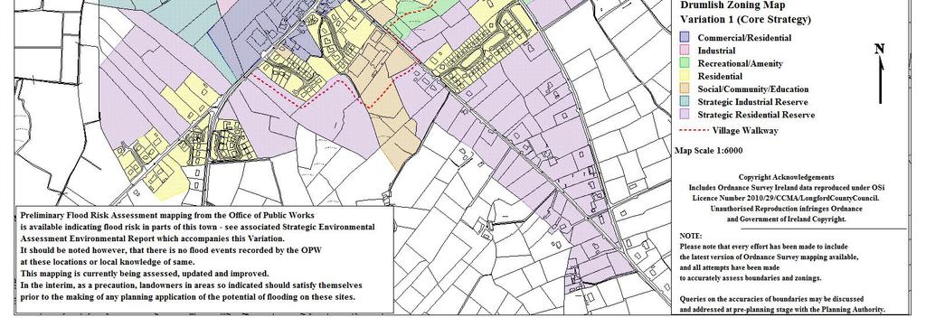
161 159
162 Kenagh Kenagh situated in the south of the County adjacent to the Royal Canal, is a picturesque settlement with a wide main street and relatively charming street frontage.the name Kenagh derives from the Irish word Caonach meaning moss. The village was accordingly named after acres of land on which moss grew on stone around the Mosstown Estate. The village itself was built around the estate by the Kingstons between the years of 1837 to Zoning Residential To primarily provide for residential development; to preserve and improve residential amenity, dwellings and compatible uses including social and community facilities, open spaces and local shopping facilities The principles of sustainable development shall be taken into account when considering applications for residential development in the area, including the use of appropriate housing densities, natural, locally sourced materials, energy efficiency and transport implications, the impact on the existing ecology and compatibility with local environmental conditions. Strategic Residential Reserve To provide for the longer term housing requirements of the town Residential development, other than that set out below, will not be permitted on these lands during the lifetime of the Plan (It should be noted that lands zoned for the purposes of strategic residential reserve may be released for development over future plan periods). The following residential type development may be considered acceptable; 1) Where there is a live permission for residential development that has not been activated. 160
163 The life of these permissions may be extended in accordance with the provisions of Section 42A of the Planning & Development Act 2010, as amended. Proposals for new developments will not be considered over the lifetime of the current plan period. 2) A proposal for a single dwelling house may be considered under this zoning where: a) the unit to be provided will serve as the permanent place of residence of the landowner or a member of his/her immediate family b) and where it can be clearly demonstrated that the provision of such a unit would not compromise the ability of the wider area of zoned land to be developed in the future, c) and the dwelling would easily integrate with the existing and future development of the lands and those in the vicinity. 3) In exceptional circumstances where it can be clearly demonstrated by the developer that there is a significant difficulty in the release or identification of lands for a specific residential type development, consideration will be given to the release of lands zoned Strategic Residential Reserve, subject to established planning criteria and including in particular; a) The requirement to remain within the overall residential land use targets as set out in the Core Strategy; b) The lands are being developed in a sequential manner; c) It has been clearly justified and demonstrated, to the satisfaction of the Planning Authority, that there is a clear discrepancy between the supply and release of residentially zoned lands and the demand for residential units. Certain developments that can demonstrate a strategic element, (e.g. a significant commercial or social element), may be deemed acceptable. 161
164 Commercial/Residential To primarily provide for commercial/retail development with a possible element of residential development Development carried out under this zoning should have regard to the dual use of the zoning, and, in particular, shall have regard to the retail policy for the County. Developers should be cognisant of the high profile locations of this zoning and design, whereas siting and materials should be chosen accordingly to ensure that any additional developments enhance the existing attractive streetscape. Expansion of existing enterprises and local level retail provision where appropriate, will be considered within this zoning. Social/Community/Education To primarily provide for educational, health, social, cultural, religious and community facilities This zoning provides for facilities that serve the community as a whole such as schools, community centres, crèches, nursing homes, churches etc. The zoning also provides for sport and leisure facilities such as a clubhouse, changing rooms, meeting rooms, a gym, sports training halls, catering facilities, caretaker accommodation. Recreational/Amenity To primarily provide for recreational open space, environmental buffers and ancillary structures The zoning facilitates the protection of existing green areas and public open spaces which provide for the passive and active recreational needs and also accommodates walking routes throughout the settlement. 162

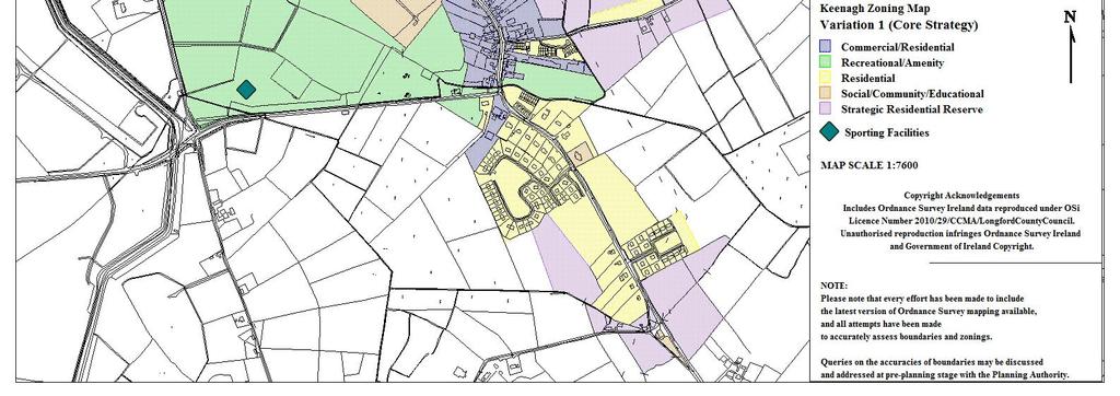
165 163
166 Legan Legan is situated to the south of the County with a river running around the extent of the settlement. The River Inny is situated two miles south east of the settlement. Zoning Residential To primarily provide for residential development; to preserve and improve residential amenity, dwellings and compatible uses including social and community facilities, open spaces and local shopping facilities The principles of sustainable development shall be taken into account when considering applications for residential development in the area, including the use of appropriate housing densities, natural, locally sourced materials, energy efficiency and transport implications, the impact on the existing ecology and compatibility with local environmental conditions. Strategic Residential Reserve To provide for the longer term housing requirements of the town Residential development, other than that set out below, will not be permitted on these lands during the lifetime of the Plan (It should be noted that lands zoned for the purposes of strategic residential reserve may be released for development over future plan periods). The following residential type development may be considered acceptable; 1) Where there is a live permission for residential development that has not been activated. The life of these permissions may be extended in accordance with the provisions of Section 42A of the Planning & Development Act 2010, as amended. Proposals for new developments will not be considered over the lifetime of the current plan period. 164
167 2) A proposal for a single dwelling house may be considered under this zoning where: a) the unit to be provided will serve as the permanent place of residence of the landowner or a member of his/her immediate family b) and where it can be clearly demonstrated that the provision of such a unit would not compromise the ability of the wider area of zoned land to be developed in the future, c) and the dwelling would easily integrate with the existing and future development of the lands and those in the vicinity. 3) In exceptional circumstances where it can be clearly demonstrated by the developer that there is a significant difficulty in the release or identification of lands for a specific residential type development, consideration will be given to the release of lands zoned Strategic Residential Reserve, subject to established planning criteria and including in particular; a) The requirement to remain within the overall residential land use targets as set out in the Core Strategy; b) The lands are being developed in a sequential manner; c) It has been clearly justified and demonstrated, to the satisfaction of the Planning Authority, that there is a clear discrepancy between the supply and release of residentially zoned lands and the demand for residential units. Certain developments that can demonstrate a strategic element, (e.g. a significant commercial or social element), may be deemed acceptable. Commercial/Residential To primarily provide for commercial/retail development with a possible element of residential development 165
168 Development carried out under this zoning should have regard to the dual use of the zoning, and, in particular, shall have regard to the retail policy for the County. Developers should be cognisant of the high profile locations of this zoning and design, whereas siting and materials should be chosen accordingly to ensure that any additional developments enhance the existing attractive streetscape. Social/Community/Education To primarily provide for educational, health, recreational, social, cultural, religious and community facilities This zoning provides for facilities that serve the community as a whole such as schools, community centres, crèches, nursing homes, churches etc. The zoning also provides for sport and leisure facilities such as a clubhouse, changing rooms, meeting rooms, a gym, sports training halls, catering facilities, caretaker accommodation. Recreational / Amenity To primarily provide for recreational open space and environmental buffers The zoning provides for the reservation of environmental buffers at strategic corridors throughout the town in order to provide a visual barrier between different landuses, allow for pedestrian walkways and ensuring the protection of the town s natural assets. The zoning further facilitates the protection of existing green areas and public open spaces which provide for the passive and active recreational needs. 166

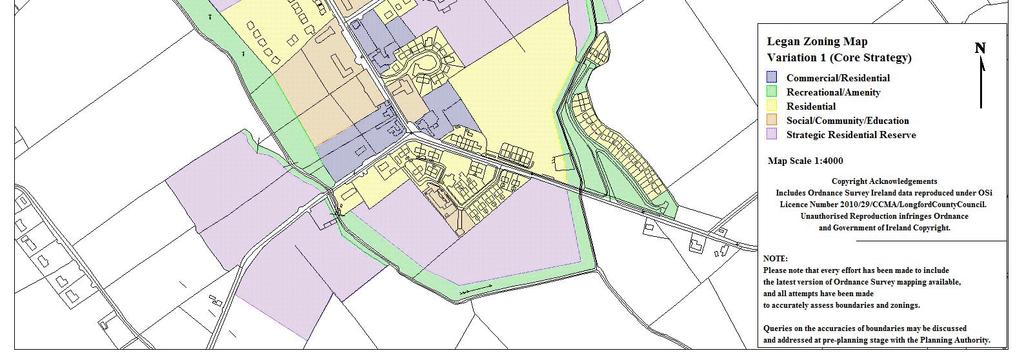
169 167
170 Newtownforbes Newtownforbes (Lios Breac, meaning "the speckled ringfort") is located along the N4 National primary route 4km to the northwest of Longford Town. Newtownforbes takes its name from the Forbes family, also known as the Earl of Granard, who originated in Aberdeen and were granted lands in the area around 1621, and have been resident in Castleforbes since Zoning Residential To primarily provide for residential development; to preserve and improve residential amenity, dwellings and compatible uses including social and community facilities, open spaces and local shopping facilities The principles of sustainable development shall be taken into account when considering applications for residential development in the area, including the use of appropriate housing densities, natural, locally sourced materials, energy efficiency and transport implications, the impact on the existing ecology and compatibility with local environmental conditions. Strategic Residential Reserve To provide for the longer term housing requirements of the town Residential development, other than that set out below, will not be permitted on these lands during the lifetime of the Plan (It should be noted that lands zoned for the purposes of strategic residential reserve may be released for development over future plan periods). The following residential type development may be considered acceptable; 1) Where there is a live permission for residential development that has not been activated. 168
171 The life of these permissions may be extended in accordance with the provisions of Section 42A of the Planning & Development Act 2010, as amended. Proposals for new developments will not be considered over the lifetime of the current plan period. 2) A proposal for a single dwelling house may be considered under this zoning where: a) the unit to be provided will serve as the permanent place of residence of the landowner or a member of his/her immediate family b) and where it can be clearly demonstrated that the provision of such a unit would not compromise the ability of the wider area of zoned land to be developed in the future, c) and the dwelling would easily integrate with the existing and future development of the lands and those in the vicinity. 3) In exceptional circumstances where it can be clearly demonstrated by the developer that there is a significant difficulty in the release or identification of lands for a specific residential type development, consideration will be given to the release of lands zoned Strategic Residential Reserve, subject to established planning criteria and including in particular; a) The requirement to remain within the overall residential land use targets as set out in the Core Strategy; b) The lands are being developed in a sequential manner; c) It has been clearly justified and demonstrated, to the satisfaction of the Planning Authority, that there is a clear discrepancy between the supply and release of residentially zoned lands and the demand for residential units. Certain developments that can demonstrate a strategic element, (e.g. a significant commercial or social element), may be deemed acceptable. 169
172 Commercial/Residential To primarily provide for commercial/retail development with a possible element of residential development Development carried out under this zoning should have regard to the dual use of the zoning, and, in particular, shall have regard to the retail policy for the County. Developers should be cognisant of the high profile locations of this zoning and design, whereas siting and materials should be chosen accordingly to ensure that any additional developments enhance the existing attractive streetscape. Social/Community/Education To primarily provide for educational, health, social, cultural, religious and community facilities This zoning provides for facilities that serve the community as a whole such as schools, community centres, crèches, nursing homes, churches etc. Recreational / Amenity To primarily provide for recreational open space, environmental buffers and ancillary structures This zoning provides for sport and leisure facilities such as a clubhouse, changing rooms, meeting rooms, a gym, sports training halls, catering facilities, caretaker accommodation. The zoning also provides for the reservation of environmental buffers at strategic corridors throughout the town in order to provide a visual barrier between different landuses, allow for pedestrian walkways and ensuring the protection of the town s natural assets. Tourism and Events To realise the tourism potential of the area 170
173 This objective provides for the development of Arts, culture and entertainment facilities. The zoning also provides for the facilitation of festivals and related events. Cognisance of the heritage of the site should be had as part of any proposal for development under this zoning. 171
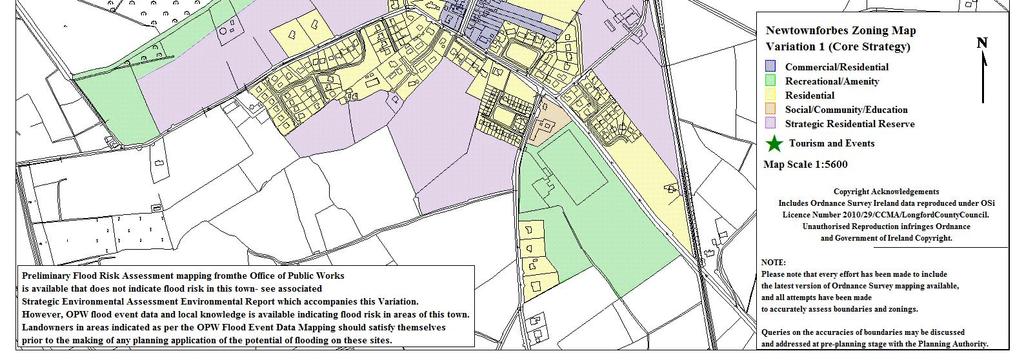
174 172
Chapter 3 Core Strategy
 Chapter 3 Core Strategy 3.0 Introduction The core strategy sets out how the development objectives in the Development Plan are consistent with the National Spatial Strategy and the Regional Planning Guidelines.
Great Easton Neighbourhood Plan Statement of Basic Conditions
 Great Easton Neighbourhood Plan 2017-2031 Statement of Basic Conditions OCTOBER 2016 GREAT EASTON PARISH COUNCIL Contents 1.0 Introduction....Page 2 2.0 Summary of Submission Documents and Supporting Evidence..
Meath County Development Plan. Variation No. 1 to Volume 1 Written Statement
 Meath County Development Plan 2013 2019 Variation No. 1 to Volume 1 Written Statement 2 Core Strategy Adopted Variation No. 1-04/11/2013 2.3.3 Residential Zoned Land Provision Table 2.4 details the requirement
Longford County Development Plan
 Longford County Development Plan 2015 2021 N55 14 35 7 35 2,000m 1,000m 500m N5 2 R198 16 19 16 N4 N55 14 35 2015 2021 7 35 2,000m 4 Longford County Development Plan 2015 2021 5 Contents 1. Introduction
Variation No 1: Dundalk & Environs Development Plan Core Strategy
 Variation No 1: Dundalk & Environs Development Plan 2009-2015 Core Strategy Adopted on 29 th August 2011 CONTENTS Page Section 1 1.0 Synopsis 1 1.1 Background Document 1 1.2 Variation of Dundalk and Environs
Meath County Development Plan. Proposed Draft Variation No. 1 to Volume 1 Written Statement
 Meath County Development Plan 2013 2019 Proposed Draft Variation No. 1 to Volume 1 Written Statement 2 Core Strategy Proposed Draft Variation No. 1!" #$ % & ' % $ ($ &' ) $) * (' &+( &' % $ * $ $ * %
Two national level strategies must also be considered in respect of formulating a comprehensive retail strategy for the county.
 2.0 INTRODUCTION Policy frameworks at the national, regional and local policy levels inform the preparation of a retail strategy. The purpose of this chapter is to highlight the principle documents guiding
Variation No. 2 Introduction & Explanatory Document Variation made on 19th May 2014
 Meath County Development Plan 2013 2019 Variation No. 2 Introduction & Explanatory Document Variation made on 19th May 2014 1.0 INTRODUCTION The Meath County Development was adopted on 17 th December
KELLS DEVELOPMENT PLAN
 KELLS DEVELOPMENT PLAN 2013-2019 J Statement Outlining Compliance with Ministerial Guidelines Adopted 7th October 2013 APPENDIX J STATEMENT OUTLINING COMPLIANCE WITH MINISTERIAL GUIDELINES Under section
Sustainability Statement. Whitby Business Park Area Action Plan
 Sustainability Statement Whitby Business Park Area Action Plan November 2014 Contents Page 1. Introduction 1 2. Scoping 3 3. Sustainability Appraisal of Options 6 4. Assessment of Draft Area Action Plan
Official Plan Review
 Official Plan Review Summary Report - The Built Environment August 2014 Part 1: Introduction Planning for a healthy, prosperous and sustainable community is an important goal for our municipality. From
Strategic Environmental Assessment Screening Report. Dublin Port Masterplan Review 2017
 Strategic Environmental Assessment Screening Report Dublin Port Masterplan Review 2017 Table of Contents 1 Introduction... 1 2 Purpose of the Masterplan... 2 3 Task 1.1 Pre-Screening Check... 5 4 Task
Chapter 1 Introduction & Vision
 Chapter 1 Introduction & Vision 1.0 Preamble This plan is a land use plan and overall strategy for the development of Birr town and environs over the period 2010-2016. For the purposes of this joint plan,
STATEMENT OF OBJECTION TO THE PROPOSED DEVELOPMENT OF LAND AT CHURCH CLIFF DRIVE FILEY
 STATEMENT OF OBJECTION TO THE PROPOSED DEVELOPMENT OF LAND AT CHURCH CLIFF DRIVE FILEY You will be aware that Scarborough borough council have adopted a new local plan that includes land at Church Cliff
Settlement Boundaries Methodology North Northumberland Coast Neighbourhood Plan (August 2016)
") Introduction This background paper sets out a methodology for the definition of settlement boundaries in the North Northumberland Coast Neighbourhood Plan. The neighbourhood plan is planning positively
Introduction This background paper sets out a methodology for the definition of settlement boundaries in the North Northumberland Coast Neighbourhood Plan. The neighbourhood plan is planning positively
Variation No.1 Galway County Development Plan Adopted: 24th April 2017
 Variation No.1 Galway County Development Plan 215-221 Adopted: 24th April 217 Chapter 2 - Spatial Strategy, Core & Settlement Strategy 2.1 Background In its simplest terms the County Development Plan s
Edenderry Local Area Plan
 Edenderry Local Area Plan 2017-2023 MATERIAL ALTERATIONS TO DRAFT EDENDERRY LOCAL AREA PLAN Public Display Document Section 1: Introduction 1.1 Introduction This report focuses on the proposed material
Kibworth Harcourt. Introduction. Introduction
 Introduction Introduction Welcome to this public exhibition on the proposals for the delivery of new homes on land at The Kibworths. The purpose of today s exhibition is to give you the opportunity to
Schedule of Planning Applications Committee Date: 23 May Reference: 06/17/0726/F Parish: Hemsby Officer: Mr J Beck Expiry Date:
 Schedule of Planning Applications Committee Date: 23 May 2018 Reference: 06/17/0726/F Parish: Hemsby Officer: Mr J Beck Expiry Date: 22-05-2018 Applicant: Proposal: Site: Mr Gillett Change of use to the
Plan Modification to Chapter B2 of the Auckland Unitary Plan(AUP) Operative in part (15 November 2016)
 Operative in part (15 November 2016)") UNITARY PLAN UPDATE REQUEST MEMORANDUM TO FROM Phill Reid Linley Wilkinson DATE 25 September 2018 SUBJECT Plan Modification to Chapter B2 of the Auckland Unitary Plan(AUP) Operative in part (15 November
UNITARY PLAN UPDATE REQUEST MEMORANDUM TO FROM Phill Reid Linley Wilkinson DATE 25 September 2018 SUBJECT Plan Modification to Chapter B2 of the Auckland Unitary Plan(AUP) Operative in part (15 November
ROSCREA LOCAL AREA PLAN
 ROSCREA LOCAL AREA PLAN 2012-2018 June 2012 Table of Contents Chapter 1:Introduction 1.1 How to use this plan 3 1.2 Purpose of the plan 3 1.3 What is a Local Area Plan 3 1.4 Composition of the Plan 4 1.5
TRIM DEVELOPMENT PLAN Volume 1 Written Statement
 TRIM DEVELOPMENT PLAN 2014 2020 Volume 1 Written Statement Table of Contents Trim Development Plan 2014-2020 Volume 1 Written Statement 1 Introduction to the Trim Development Plan 2014-2020. 1 1.1 Introduction...
elbridge Core Strategy
 C elbridge Core Strategy Celbridge is designated as a Moderate Growth Town in the RPGs. The County Development Plan reinforces this designation in its settlement strategy. Moderate Growth Towns within
3.0 Policy Context. 3.1 Introduction. 3.2 National Spatial Strategy, The Role of East Meath under the NSS
 3.0 Policy Context 52 Policy Context 3.0 Policy Context 3.1 Introduction There is an extensive range of strategic guidance and policy for land use planning in Ireland. This has been fully examined in the
Neighbourhood Planning Local Green Spaces
 Neighbourhood Planning Local Green Spaces Introduction... 2 1. Why green space is important... 4 2. Neighbourhood plans and green space... 6 3. Evidence... 8 Statutory designations... 9 Green space audit...
Dunboyne/Dunboyne North/ Clonee/ Local Area Plan
 Dunboyne/Dunboyne North/ Clonee/ Local Area Plan Strategic Policy SP 1 To operate an Order of Priority for the release of residential lands in compliance with the requirements of CS OBJ 6 of the County
Tāhuhu whakaruruhau ā-taone The sheltering ridge pole
 B2. Tāhuhu whakaruruhau ā-taone - Urban growth and form B2.1. Issues Tāhuhu whakaruruhau ā-taone The sheltering ridge pole Auckland s growing population increases demand for housing, employment, business,
9 CITY OF VAUGHAN OFFICIAL PLAN AMENDMENT NO BOCA EAST INVESTMENTS LIMITED
 9 CITY OF VAUGHAN OFFICIAL PLAN AMENDMENT NO. 631 - BOCA EAST INVESTMENTS LIMITED The Planning and Economic Development Committee recommends the adoption of the recommendations contained in the following
Chapter 2 Core Strategy
 Chapter 2 Core Strategy 11-24 2.1 Introduction 2.2 Strategic Planning Approach 2.3 Growth Consistency with the National Spatial Strategy & Regional Planning Guidelines 2.1 Introduction The overall strategy
Parish of Repton NEIGHBOURHOOD DEVELOPMENT PLAN
 Parish of Repton NEIGHBOURHOOD DEVELOPMENT PLAN BASIC CONDITIONS STATEMENT December 2018 CEF 4 Legal Requirements This statement has been produced by the NDP Working Group on behalf of Repton Parish Council
Ipswich Issues and Options for the Ipswich Local Plan Review, August 2017, Public Consultation
 Ipswich Issues and Options for the Ipswich Local Plan Review, August 2017, Public Consultation Having reviewed the issues and options documents, the Society has made the following response: Part 1 Strategic
A Growing Community Rural Settlement Areas
 Town of Huntsville Official Plan Review - POLICY BACKGROUND PAPER A Growing Community Rural Settlement Areas BACKGROUND: In addition to the fully municipally-serviced Urban Settlement Area and the Hidden
Guidelines for Planning Authorities and Part V of the Planning and Development Act 2000: December 2000
 Slide 1 Slide 2 Slide 3 Slide 4 As a planner in practice, whether within the Local Authority, private practice or An Bord Pleanala, due regard must be given to the guidance provided by the Department in
Incorporating Draft Amendment Number 1 Made on 2 nd of March 2015
 Incorporating Draft Amendment Number 1 Made on 2 nd of March 2015 Ratoath Local Area Plan CONTENTS CHAPTER 1 BACKGROUND INFORMATION 1.1 Introduction... 1 1.2 Scope of the Local Area Plan... 2 1.3 Ratoath
INCREMENTAL CHANGE AREA REVIEW March 2015 Page 1
 INCREMENTAL CHANGE AREA REVIEW March 2015 Page 1 Table of Contents Introduction... 3 Background to Review... 3 Comparison of the Schedules to the General Residential Zone... 7 Methodology... 7 Policy Context...
Draft Portumna Local Area Plan
 Draft Portumna Local Area Plan 2016-2022 Forward Planning Galway County Council Áras an Chontae Prospect Hill Galway Period of public display: Friday the 31 st of July 2015 until Friday the 11 th of September
Newcourt Masterplan. November Exeter Local Development Framework
 Newcourt Masterplan November 2010 Exeter Local Development Framework Background The Exeter Core Strategy Proposed Submission sets out the vision, objectives and strategy for the development of Exeter up
DRAFT Tuam Local Area Plan
 DRAFT Tuam Local Area Plan 2018-2024 January 2018 Table of Contents PAGE 1.0 Introduction.. 3 1.1 Preamble... 3 1.2 Profile of Tuam... 3 1.3 Local Area Plan... 4 1.4 Plan Informants & Key Considerations...
Site Assessment Technical Document Appendix A: Glossary
 Central Bedfordshire Council www.centralbedfordshire.gov.uk Site Assessment Technical Document Appendix A: Glossary July 2017 1.1.11-1 - ii Appendix A: Glossary Term Agricultural Land Classification AONB
Guide. Guide to Regional Planning Policies. Background
 Guide Guide to Regional Planning Policies January 2017 Background The Strategic Planning Policy Statement for NI - Planning for Sustainable Development - sets out the Department s regional planning policies
Cotswolds AONB Landscape Strategy and Guidelines. June 2016
 Cotswolds AONB Landscape Strategy and Guidelines June 2016 Cotswolds AONB Landscape Strategy and Guidelines Introduction The evolution of the landscape of the Cotswolds AONB is a result of the interaction
Appendix 1 Structure plan guidelines
 Appendix 1 Structure plan guidelines This appendix forms part of the regional policy statement [rps]. 1.1. Introduction Structure plans are an important method for establishing the pattern of land use
Offaly County Development Plan Volume 1: Written Statement
 Offaly County Development Plan 2014-2020 Volume 1: Written Statement Adopted 15 th September 2014 Table of Contents Introduction and Context 1 Chapter 1: Core Strategy and Settlement Strategy 7 1.0 Aim
PSRC REVIEW REPORT & CERTIFICATION RECOMMENDATION
 PSRC REVIEW REPORT & CERTIFICATION RECOMMENDATION KITSAP COUNTY COUNTYWIDE PLANNING POLICIES July 2, 2012 BACKGROUND A major emphasis of the Washington State Growth Management Act (GMA) is the need to
INTRODUCTION NORTH HEYBRIDGE GARDEN SUBURB
 INTRODUCTION This event is being hosted by the promoters of the proposed North Heybridge Garden Suburb who are working with Maldon District Council and other key stakeholders on the preparation of a comprehensive
Draft Island Development Plan
 Draft Island Development Plan February 2015 Written Statement Contents Part One 1 About the Island Development Plan What is the Island Development Plan? What is the Island Development Plan used for? Structure
3. Neighbourhood Plans and Strategic Environmental Assessment
 1. Introduction This report sets out a draft Screening Determination for the Preston Parish Council s Neighbourhood Plan and has been prepared by rth Hertfordshire District Council. The purpose of the
Rathmolyon Written Statement
 Settlement Rathmolyon Position in Settlement Hierarchy Village - Local centre for services and local enterprise development Position in Retail Strategy Fourth tier retail centre Population (2011) Census
Northern Territory Compact Urban Growth Policy
 Northern Territory Compact Urban Growth Policy A Reference Policy Document to clause 2.7 (Reference to Policy) of the NT Planning Scheme May 2015 Table of Contents 1 Policy Setting... 3 1.1 Context for
WHITELEY TOWN COUNCIL NORTH WHITELEY DEVELOPMENT SEPTEMBER 2014
 WHITELEY TOWN COUNCIL NORTH WHITELEY DEVELOPMENT SEPTEMBER 2014 Dear Resident This Special Edition of the Whiteley Voice which has been prepared in conjunction with the North Whiteley Consortium is to
Tiane Ltd Submission on Draft National Planning Framework Ireland 2040
 Tiane Ltd Submission on Draft National Planning Framework Ireland 2040 Date: 31 st March 2017 Authors: Ken Swaby / Ben Waite Approved By: Christy O'Sullivan ILTP Project Code & Reference: GOLDENATH Distribution:
OKEFORD FITZPAINE NEIGHBOURHOOD PLAN
 OKEFORD FITZPAINE NEIGHBOURHOOD PLAN Dear Parishioner, The Neighbourhood Plan Project Team have prepared this leaflet to summarise the full Neighbourhood Plan document. It provides a summary of the Vision,
GREATER CARLOW GRAIGUECULLEN URBAN AREA RETAIL STRATEGY 2012 TO Carlow County Council Laois County Council & Carlow Town Council
 GREATER CARLOW GRAIGUECULLEN URBAN AREA RETAIL STRATEGY 2012 TO 2018 Carlow County Council Laois County Council & Carlow Town Council 2012 Contents: Page 1. Introduction 3 2. Policy Review 5 3. Population
Chapter 1 Introduction and Vision
 Chapter 1 Introduction and Vision 1.0 Preamble This plan is a land use plan and overall strategy for the development of Tullamore town and environs over the period 2010-2016. For the purposes of this joint
DUNSFOLD NEIGHBOURHOOD PLAN Site Selection Policies
 DUNSFOLD NEIGHBOURHOOD PLAN Site Selection Policies The criteria for assessing sites for future housing and business development in Dunsfold are set out below. (Development criteria, covering what it is
2.0 Strategic Context 4
 2.0 Strategic Context 4 2.1 The Area Action Plan is a non-statutory plan, which forms a corporate policy document, expressing particular issues and areas of concern while also providing a vision for the
Appendix. Statement Outlining Compliance with Ministerial Guidelines
 18 Appendix Statement Outlining Compliance with Ministerial Guidelines A18 Statement Outlining Compliance with Ministerial Guidelines Under section 28 of the Planning and Development Act 2010, Meath County
Draft Clifden Local Area Plan July 2018
 Draft Clifden Local Area Plan 2018-2024 July 2018 2 Table of Contents 1.0 Introduction.. 3 1.1 Preamble... 3 1.2 Profile of Clifden... 3 1.3 Local Area Plan... 4 1.4 Plan Informants & Key Considerations...
WINCHESTER TOWN 3.1 LOCATION, CHARACTERISTICS & SETTING
 WINCHESTER TOWN 3.1 LOCATION, CHARACTERISTICS & SETTING 3.1.1 The area referred to by the City Council, as Winchester Town, consists of the Winchester Wards plus the adjoining built up areas of Badger
Sustainable Growth. Sustainable Growth
 2 Sustainable Growth Sustainable Growth SUSTAINABLE GROWTH 2.1 COMMUNITY VISION... 2-5 2.2 THE CITY SYSTEM... 2-7 2.2.1 AREAS... 2-7 2.2.2 CITY-WIDE SYSTEMS... 2-8 2.2.3 PROVINCIAL PLAN BOUNDARIES AND
Pre Draft Manager s Report Meath County Development Plan TABLE OF CONTENTS
 Pre Draft Manager s Report Meath County Development Plan 2013-2019 TABLE OF CONTENTS Section 1 Introduction and Overview of Pre Draft Consultation Report 1.1 Introduction... 1 1.2 Pre Draft Public Consultation...
Babergh and Mid Suffolk Joint Draft Local Plan Consultation, August 2017, Public Consultation
 Babergh and Mid Suffolk Joint Draft Local Plan Consultation, August 2017, Public Consultation Having reviewed the documents, the Society has made the following response: Housing Delivery Q 7. Do you agree
Stantonbury Neighbourhood Plan
 Stantonbury Neighbourhood Plan 2018-2031 Basic Conditions Statement October 2018 Intentionally blank 1.0 Basic Conditions Statement Introduction 1.1 This statement has been prepared by Stantonbury Parish
Plumpton Neighbourhood Development Plan Revised Pre Submission Document - Regulation 14 Consultation
 REPRESENTATIONS... Plumpton Parish Council Plumpton Neighbourhood Development Plan Revised Pre Submission Document - Regulation 14 Consultation Representations submitted on behalf of: Cala Homes (South
APPENDIX I STATEMENT OF COMPLIANCE. Plean Forbartha Chontae na Gaillimhe // Galway County Development Plan
 APPENDIX I STATEMENT OF COMPLIANCE Plean Forbartha Chontae na Gaillimhe // Galway County Development Plan Statement of Compliance Pursuant to Section 28 of the Planning and Development Act 2000 (as amended),
Appendix A: Retail Planning Assessment
 Rotherham Town Centre Masterplan Appendix A: Retail Planning Assessment 139 Appendix A Rotherham Town Centre Masterplan Retail Planning Background and Policy Context 1. Introduction 1.1 The Masterplan
The Gwennap Parish Vision Statement
 QUICK GUIDE What is a Neighbourhood Development Plan? Ultimately it is a document used by developers or anyone wishing to submit a planning application that describes the vision, strategy, plans, regeneration,
ROCHFORD LOCAL DEVELOPMENT FRAMEWORK: Sustainability Appraisal/ Strategic Environmental Assessment. Rochford Core Strategy Preferred Options Document
 ROCHFORD LOCAL DEVELOPMENT FRAMEWORK: Sustainability Appraisal/ Strategic Environmental Assessment Non Technical Summary Rochford Core Strategy Preferred Options Document October 2008 SUSTAINABILITY APPRAISAL
1.0 PLANNING MARKHAM S FUTURE CONTENTS
 1-1 Planning Markham s Future 1.0 PLANNING MARKHAM S FUTURE CONTENTS 1.1 THE PURPOSE OF THE OFFICIAL PLAN 1.2 THE MARKHAM CONTEXT 1.3 THE REGULATORY CONTEXT 1.3.1 Province of Ontario 1.3.2 York Region
The targets do not adhere to the government projections or methodology, being aspirational rather than achievable.
 Question 1: Preferred Growth Option (see pages 7-9 of the consultation document) Do you agree with the preferred growth option for the Joint Local Plan? The targets do not adhere to the government projections
FINDINGS OF NO SIGNIFICANT EFFECTS REPORT. of the
 FINDINGS OF NO SIGNIFICANT EFFECTS REPORT of the Listowel/Ballybunion Functional Area Local Area Plan (FALAP) (2013-2019) and related 10 th Variation of the Kerry County Development Plan (2009-2015) IN
CONTENTS 8.0 LAND USE 8.1 GENERAL LAND USE 8.2 RESIDENTIAL 8.3 MIXED USE 8.4 COMMERCIAL 8.5 EMPLOYMENT LANDS
 8-2 Land Use 8.0 LAND USE CONTENTS 8.1 GENERAL LAND USE 8.1.1 Uses provided for in all Land Use Designations 8.1.2 Uses prohibited in Hazardous Lands, Hazardous Sites and Special Policy Areas 8.1.3 Uses
2A District-wide Policies
 2A Introduction This Chapter contains policies which are relevant to subdivision, use and development activities occurring across all zones and areas of the District. The policies in this Chapter implement
Planning and Sustainability Statement
 Land adjacent to Manor Farm, Catterick Village Pallett Hill Sand and Gravel Co Ltd Proposed 10 new dwellings, (6 No market dwellings and 4 No affordable dwellings) with access, associated car parking and
Development of land adjacent to Braggs Farm Lane and Rumbush Lane, Dickens Heath. Welcome. Today s exhibition. The proposal site
 Welcome Welcome to this event to discuss the development of land adjacent to Braggs Farm Lane. is currently in the preliminary stages of designing proposals to sensitively develop this site with high-quality
Town of Cobourg Heritage Master Plan. Statutory Public Meeting
 Town of Cobourg Heritage Master Plan Statutory Public Meeting April 25 th 2016 Presentation Overview 1. Introduction 2. Project background and schedule overview 3. Review of strategic direction content
Oranmore Local Area Plan * Forward Planning Galway County Council Áras an Chontae Prospect Hill Galway
 Oranmore Local Area Plan 2012-2022* Forward Planning Galway County Council Áras an Chontae Prospect Hill Galway Adopted 24 th September 2012. *Deferral of Notice under 19(1)(d) for a period of 5 years
Neighbourhood Plan Representation
 Date: 10 th November 2017 Neighbourhood Plan Representation Land to the east of Callow Hill Road, Alvechurch Introduction This representation has been prepared by RPS Planning and Development on behalf
6 Growth Management Challenges and Opportunities
 6 Growth Management Challenges and Opportunities The Town has established a goal of attaining a 50% participation rate with respect to employment opportunities versus residential population. The Town s
14.5 HOPEFIELD: (REFER PLAN 39 AND PLAN 40)
") URBAN DYNAMICS WESTERN CAPE INC. 248 14.5 HOPEFIELD: (REFER PLAN 39 AND PLAN 40) FIGURE 83: LOCALITY - HOPEFIELD Within the context of the Saldanha Bay Municipal area, Hopefield, an historical agricultural
URBAN DYNAMICS WESTERN CAPE INC. 248 14.5 HOPEFIELD: (REFER PLAN 39 AND PLAN 40) FIGURE 83: LOCALITY - HOPEFIELD Within the context of the Saldanha Bay Municipal area, Hopefield, an historical agricultural
Killarney Town Development Plan ISSUES PAPER
 Killarney Town Development Plan 2015-2021 ISSUES PAPER 1 Introduction The Killarney Town Development Plan sets out the overall strategy for the proper planning and development of the town. The existing
FOREWORD. Cllr Seamus O'Domhnaill
 FOREWORD On behalf of the Elected Members of Donegal County Council, I am delighted to introduce the Seven Strategic Towns Local Area Plan, 2018-2024. The Plan has been prepared in the context of the recently
NEW REGIONAL OFFICIAL PLAN HIGH LEVEL PROCESS & FRAMEWORK
 NEW REGIONAL OFFICIAL PLAN HIGH LEVEL PROCESS & FRAMEWORK Why A New Official Plan Originally the role of Regionally Planning and content of Regional Official Plan (1970s) primarily focused on protecting
5 PLANNING ANALYSIS 5.1 THE SITE AND ITS DEVELOPMENT CONTEXT
 5 PLANNING ANALYSIS 5.1 THE SITE AND ITS DEVELOPMENT CONTEXT The Azuri IRS River Villa Complex site is situated on the western margin of Azuri Phase 1, inland. The whole site borders Rivière du Rempart
and services The protection and conservation of environmentally significant and sensitive natural heritage features and functions.
 6. Land Use 6.0 Preamble A healthy and livable city is one in which people can enjoy a vibrant economy and a sustainable healthy environment in safe, caring and diverse neighbourhoods. In order to ensure
WELCOME GYPSY LANE. Wider Site Location plan. Proposals for the development of LAND OFF FOXLYDIATE LANE WEBHEATH. Proposals for the development of
 WELCOME The developers are preparing an outline planning application for a residential led development and need the community s views in order to develop the proposals further WHAT IS PROPOSED? A high
Rochford District Council. Adopted 16 December Local Development Framework. Development Management Plan LDF.
 Rochford District Council Adopted 16 December 2014 Local Development Framework Development Management LDF www.rochford.gov.uk Contents Page 1 Introduction... 3 The Role of the Development Management...
Submission to the Kildare County Council Development Plan North Kildare Chamber. Executive Summary
 ` 28 th May 2015 Submission to the Kildare County Council Development Plan 2017-2023 North Kildare Chamber Executive Summary North Kildare Chamber s mission is to work with businesses, community groups,
DEVELOPMENT MANAGEMENT REPORT
 ITEM A08-1 DEVELOPMENT MANAGEMENT REPORT TO: BY: DATE: DEVELOPMENT: SITE: WARD: APPLICATION: APPLICANT: Development Management Committee Development Manager Proposed live/work unit in connection with existing
INTRODUCTION BACKGROUND
 INTRODUCTION 1 1 INTRODUCTION 18 INTRODUCTION 1 1.1 BACKGROUND The Dublin Docklands Development Authority (DDDA) is required to conduct a Strategic Environmental Assessment (SEA) of the review of the Draft
Land Use Amendment in Southwood (Ward 11) at and Elbow Drive SW, LOC
 at and Elbow Drive SW, LOC") 2018 November 15 Page 1 of 10 EXECUTIVE SUMMARY This land use amendment application was submitted by Rick Balbi Architect on 2017 August 31 on behalf of Sable Developments Ltd, and with authorization from
2018 November 15 Page 1 of 10 EXECUTIVE SUMMARY This land use amendment application was submitted by Rick Balbi Architect on 2017 August 31 on behalf of Sable Developments Ltd, and with authorization from
Introduction. Grounds of Objection
 Planning application ref. number 18/04496/APP Planning application to Aylesbury Vale District Council for the erection of 17 dwellings and associated works to the South of Hogshaw Road Granborough. Granborough
Chapter 2: OUTLINE PLANNING APPLICATION PROPOSALS. A New Garden Neighbourhood Matford Barton 17
 Chapter 2: OUTLINE PLANNING APPLICATION PROPOSALS A New Garden Neighbourhood Matford Barton 17 2.1. SUMMARY AND STATUS OF THE PROPOSALS 2.1.1. The parameter plans and associated wording in this chapter
Wallingford Neighbourhood Plan
 Wallingford Neighbourhood Plan Introduction What is neighbourhood planning? Neighbourhood planning was introduced by the Localism Act 2011 to give local people more influence over how development comes
Suffolk Coastal Local Plan Review Issues and Options, August 2017, Public Consultation
 Suffolk Coastal Local Plan Review Issues and Options, August 2017, Public Consultation Having reviewed the issues and options documents, the Society has made the following response: Part 1 - Strategic
Vigo Neighbourhood Plan Basic Conditions Statement
 Vigo Neighbourhood Plan Basic Conditions Statement Plan Period: 2016 to 2028 Status: Submission Version Qualifying Body: Vigo Parish Council Glossary of Some Terms & Abbreviations Used in this Document
BLEWBURY NEIGHBOURHOOD DEVELOPMENT PLAN STATEMENT OF BASIC CONDITIONS
 BLEWBURY NEIGHBOURHOOD DEVELOPMENT PLAN STATEMENT OF BASIC CONDITIONS Introduction 1.1 This statement has been prepared to accompany the submission of the Blewbury Neighbourhood Development Plan ( the
Local Development Scheme
 Local Development Scheme 2012 2016 The Local Development Scheme (LDS) is a project plan that outlines how and when the Authority will update its planning policies and other associated documents. It ensures
Basic Conditions Statement Exmouth Neighbourhood Plan
 Exmouth Neighbourhood Plan 2018-2031. On behalf Exmouth Neighbourhood Plan Steering Group July 2018 Table of Contents 1. Introduction... 4 2. Legal Requirements... 5 3. Why there is a need for a Neighbourhood
Clonard Written Statement
 Settlement Clonard Position in Settlement Hierarchy Village - Local centre for services and local enterprise development Position in Retail Strategy Fourth tier retail centre Population (2011) Census 339