Oranmore Local Area Plan * Forward Planning Galway County Council Áras an Chontae Prospect Hill Galway
|
|
|
- Ralf Manning
- 6 years ago
- Views:
Transcription


1 Oranmore Local Area Plan * Forward Planning Galway County Council Áras an Chontae Prospect Hill Galway Adopted 24 th September *Deferral of Notice under 19(1)(d) for a period of 5 years from 22 nd May 2017
2 Table of Contents Page 1. Introduction Preamble Profile of Oranmore Local Area Plan Plan Informants & Key Considerations Strategic Vision and Development Strategy Strategic Vision Development Strategy Development Policies, Objectives and Guidelines Land Use Management Residential Development Social and Community Development Economic Development Transportation Infrastructure Utilities & Environmental Infrastructure Urban Design and Landscape Built Heritage & Cultural Heritage Natural Heritage & Biodiversity Local Area Plan Maps... 51

3 1. Introduction 1.1 Preamble This Local Area Plan is a land use plan and overall strategy for the development of Oranmore over the period This Plan shall have effect from the date of adoption by the members of Galway County Council and shall cease to have effect at the expiration of 6 years from that date, unless the timeframe is extended by resolution in accordance with Section 12 (d) to (f) of the Planning and Development (Amendment) Act The successful implementation of the plan will have a positive impact on Oranmore ensuring it develops in a sustainable manner, and will also complement the implementation of the current Galway County Development Plan. 1.2 Profile of Oranmore Oranmore is located 7km east of Galway City centre, at the inner shoreline of Galway Bay. The rural character of the surrounding landscape, with rich, varied heritage and proximity to the sea, provides many amenity opportunities. The heart of the town is located at the junction of two roads, Main Street and the Old Dublin Road, which meet at a T-Junction. The town offers significant employment opportunities and has a viable commercial core. Together with its pleasant, coastal setting, its proximity to Galway City, its relative convenience to the Dublin Motorway Route, and the Limerick & Sligo national routes, the area has become an attractive and desirable place to live. The landscape, topography and natural features of the area have influenced the pattern and form of development of the town over the years. The lower lying areas throughout the town, which provide natural drainage systems and areas of environmental and ecological significance have generally remained undeveloped, while new residential development has predominantly taken place in the southern area of the town. The new Oranmore Railway Station, in the townland of Garraun to the northwest of the town, is due to be operational by This will be a welcome addition to the town s transport infrastructure and will provide a significant opportunity to focus future development around integrated land use and public transport, while at the same time providing an important potential link to the southern reach of the Ardaun area, an area identified for longer term future strategic growth for both the Galway county and city areas. As the pace of development has been significant in recent years, the population of the Oranmore has risen rapidly. According to the 2006 Census, the population of the town was 3,513, a 107% increase from the 2002 Census figure. Notably from the Census data available, the education levels of Oranmore residents were one of the best in Ireland, people who live here or moved here for work, were recorded as having a good level of education, with just 4.64% of the people educated to primary school level or with no formal education, while people with a third level degree or a higher qualification made up 38.35% of the Oranmore workforce. This was the highest in any Irish town and over double the national average of 16.57%. Oranmore has been identified as a key town within the Core Strategy of the current Galway County Development Plan and a Galway Metropolitan Area Satellite town and in this regard, it is important that anticipated growth is plan led, so that Oranmore can enhance its vibrancy and grow in a sustainable manner. Page 3
4 1.3 Local Area Plan Background to the Local Area Plan This Local Area Plan has been prepared by Galway County Council to provide a statutory framework for the future growth and development of Oranmore. It is consistent with the policies and objectives contained in the current Galway County Development Plan, including the Core Strategy, and seeks to address the needs and requirements of the local community, service providers and other stakeholders. The purpose of the Local Area Plan is to guide future development within the town in a sustainable and equitable manner and to inform members of the public, the local community, stakeholders and developers of the policies and objectives that will shape the development of the town over the next 6 years. The policies and objectives for the development of the town include provisions in relation to land use management, community facilities, amenities, transport, infrastructure, urban design, built heritage, natural heritage and the environment. The plan period is for 6 years, from the date of adoption by Galway County Council, unless the timeframe is extended by resolution in accordance with Section 12(d) to (f) of the Planning and Development (Amendment) Act The plan area is comprised of the town and its immediate environs, and has been amended to include lands at Garraun near the new rail station. The plan area is considered to provide an appropriate development envelope for the anticipated growth of the town for the plan period Statutory Process A Local Area Plan is prepared under the provisions of Sections 18, 19 & 20 of the Planning & Development Act 2000, as amended by the Planning & Development Act 2002, the Planning & Development (Strategic Environmental Assessment) Regulations 2004 to 2011, and the Planning and Development (Amendment) Act A Local Area Plan is statutorily required to be consistent with the objectives of the Galway County Development Plan and consists of a written statement and plans, which may include objectives for the zoning of land in accordance with the proper planning and sustainable development of the area. The legislation also requires the provision of detail on community facilities, amenities and detail on standards for the design of developments and structures. Environmental assessments have also been undertaken to assess the potential impacts of the Local Area Plan on the environment, including a Strategic Environmental Assessment and Habitats Directive Assessment. The Strategic Environmental Assessment has been prepared in accordance with the EU Directive on SEA (2001/42/EC), the national Strategic Environmental Assessment Regulations (SI No. 436 of 2004), and (SI No. 200 of 2011) and the 2004 Strategic Environmental Assessment Guidelines Implementation of the SEA Directive (2001/42/EC): Assessment of the Effects of Certain Plans and Programmes on the Environment issued by the Department of Environment, Heritage and Local Government (DoEHLG) and had regard to Circular PSSP 6/2011 Further Transposition of the EU Directive 2001/42/EC on Strategic Environmental Assessment (SEA). A Strategic Environmental Assessment is required to assess the likely significant adverse effects on the environment of implementing the Local Area Plan, before a decision is made to adopt it. The relevant recommendations and mitigation measures from the Strategic Environmental Assessment process and Environmental Report have been incorporated into this Local Area Plan. A Habitats Directive Assessment has been prepared in accordance with Article 6(3) of the EU Habitats Directive (92/43/EEC), European Communities (Birds and Natural Habitats) Regulations 2011 and the Appropriate Assessment of Plans and Projects in Ireland-Guidance for Planning Authorities 2010 issued by the Department of Environment, Heritage and Local Government and the Planning and Development Act 2000, (as amended). A Habitats Directive Assessment (also referred to as an Appropriate Assessment ) is an assessment of the implications of the plan or project, alone and/or in combination with other plans and projects, on the integrity of a Natura 2000 site, in view of its conservation objectives. The relevant recommendations and mitigation measures from the Habitats Directive Assessment process and Natura Impact Report have been incorporated into this Local Area Plan. Page 4
5 A Strategic Flood Risk Assessment has been prepared for County Galway, which also considers the flood risk issues relevant to the Plan Area. The Strategic Flood Risk Assessment has been prepared in accordance with the EU Floods Directive (2007/60/EC), the national European Communities (Assessment and Management of Flood Risks) Regulations 2010 (SI No. 122 of 2010) and the Planning System and Flood Risk Management Guidelines for Planning Authorities 2009 issued by the DoEHLG. The Strategic Flood Risk Assessment has examined and confirmed the flood risk areas identified as part of the Preliminary Flood Risk Assessment mapping published by the Office of Public Works. The relevant flood risk data, recommendations and mitigation measures from the Strategic Flood Risk Assessment and Preliminary Flood Risk Assessment have been incorporated into the Local Area Plan Plan Structure The Local Area Plan has been structured into 4 main sections as outlined below: Section 1 Section 2 Section 3 Section 4 Introduction Preamble Profile of Oranmore Local Area Plan Plan Informants and Considerations. Strategic Vision and Development Strategy Strategic Vision Development Strategy Development Policies, Objectives and Guidelines Land Use Management Residential Development Social and Community Development Economic Development Transportation Infrastructure Urban Design and Landscape Built and Cultural Heritage Natural Heritage & Biodiversity LAP Maps Map 1A & 1B Land Use Zoning Map 2A & 2B Specific Objectives Map 3A & 3B Flood Risk Management Map 4 Designated Sites Supporting documents include the Habitats Directive Assessment - Natura Impact Report, the Strategic Environmental Assessment - Environmental Report and the Strategic Flood Risk Assessment for County Galway Conclusions for Oranmore Indicative Flood Risk Zones and are available separate to the plan. 1.4 Plan Informants & Key Considerations Plan Informants The preparation of the Local Area Plan has been informed by a wide range of inputs, including the following: Public Consultation Issues raised by the local community and other stakeholders through the publication of the Background Issues Paper, consideration of written submissions on same and pre-draft consultations. Page 5
6 Legislative Context Strategic Planning Context Statutory Planning Context Local Planning Context Environmental Assessment All relevant Irish and European planning and environmental legislation, in particular the Planning and Development Act , the Planning and Development Regulations ; EU Directives, including the Birds Directive (2009/147/EEC), Habitats Directive (92/43/EEC), Water Framework Directive (2000/60/EC), SEA Directive (2001/42/EC) and the Floods Directive (2007/60/EC) and associated Regulations. National and regional policy documents and guidelines, in particular: the Sustainable Development Strategy for Ireland 1997; the National Development Plan ; the National Spatial Strategy , the Regional Planning Guidelines for the West Region , Ireland National Climate Change , Smarter Travel - A Sustainable Transport Future , and a range of guidelines including the SEA Guidelines 2004, Sustainable Residential Development in Urban Areas Guidelines 2009, The Planning System and Flood Risk Management Guidelines for Planning Authorities 2009, Implementation of SEA Directive: Assessment of the Effects of Certain Plans and Programmes on the Environment Guidelines 2004, and the Appropriate Assessment of Plans and Projects in Ireland-Guidance for Planning Authorities, Statutory plans, in particular the previous Local Area Plan for the town and the need for compliance and consistency with the current Galway County Development Plan as varied, and the Regional Planning Guidelines for the West Region Local plans, strategies and studies, including: the Biodiversity Action Plan for County Galway ; the Galway County Heritage Plan ; Galway Transportation and Planning Study 2002; Developing Sustainable Tourism in Galway: A Framework for Action ; Water-Based Tourism A Strategic Vision for Galway 2002; and Working Together: Shaping Our Future: Galway County Strategy for Economic, Social and Cultural Development Assessment of potential environmental impacts of the Local Area Plan, including a Strategic Environmental Assessment, Habitats Directive Assessment and Strategic Flood Risk Assessment for County Galway Plan Issues, Considerations and Challenges The proper planning and sustainable development of Oranmore encompasses a wide range of issues, considerations and challenges, many of which have been highlighted through the consultation process. The plan seeks to balance the wide ranging, and sometimes competing needs of the local community, landowners and the environment, along with promoting the role of Oranmore as a key town within County Galway, as established within the Galway County Development Plan. Some of the plans key issues, considerations and challenges are set out hereunder: Common Vision: A common strategic vision needs to be developed that provides a positive framework for future growth, consolidation and enhancement of the town in accordance with the principles of proper planning and sustainable development. Adherence to the Core Strategy: The Core Strategy of the County Development Plan has identified a target population growth of up to 1,130 persons for Oranmore to 2015, which results in a requirement for 32.60ha of zoned residential land. Page 6
7 Population Growth: Oranmore has experienced significant growth patterns over the last two Census periods. Ensuring sustainable settlement patterns, including the provision of the necessary planning framework, to accommodate educational, community, leisure and recreational facilities to satisfactorily match the level of population growth, is a key issue in planning for the future. Building on Oranmore s Strategic Location: Oranmore s strategic location within the County, close to the National Gateway of Galway and major air, rail and road transport routes, provides it with a clear and strong basis to harness the area, as it grows into the future. The town s strategic location is enhanced by its proximity to the southern reach of the Ardaun area which is identified at regional level as a new growth centre for the metropolitan area. Key investments in transport infrastructure, including the development of an integrated transport hub at Garraun, will be critical in providing both public and private transport access to the Ardaun area and to the wider commuter population of the future. Maintaining & Enhancing Economic Activity: Ensuring the enhancement of Oranmore s role as one of the primary centres for industry, technology and innovation in the county, through maximising the opportunity presented by its proximity to the Strategic Economic Corridor. This also includes fostering and maintaining local and small scale businesses to protect the vitality and vibrancy of the town centre, while ensuring that Oranmore remains an attractive place to work, live, visit and do business. Infrastructure and Transportation: Working to ensure infrastructure keeps apace of servicing future developments, while ensuring compliance with the statutory obligations to achieve good water quality status under the EU Water Framework Directive and associated national legislation, is a priority. While the limited availability of public transport services to date has resulted in traffic congestion in the town centre, addressing the deficiencies in the existing pedestrian/cycling network, promoting walking/cycling and broader Smarter Travel initiatives, along with reducing car dependency are other key considerations in the Local Area Plan process. Heritage & Environment: Promoting and facilitating appropriate growth of the town, while protecting the built, cultural and natural heritage of Oranmore in accordance with applicable legislation and policy. This also includes consideration of the environmental designations adjacent to and within the plan boundary, some of which are partly zoned for residential and amenity uses in the current Oranmore Local Area Plan Flooding: Potential flood issues in the plan area are an important consideration in the preparation of the new Local Area Plan, particularly in zoning lands for various uses and as such the new Local Area Plan will be guided by the Strategic Flood Risk Assessment for County Galway. Page 7
8 2. Strategic Vision and Development Strategy 2.1 Strategic Vision This plan is underpinned by a strategic vision. This is intended to guide the future growth and development of Oranmore in a sustainable manner, achieving the overall objectives set out for the town in the Galway County Development Plan, in a way that reflects the existing character and amenity of the area, the surrounding landscape, heritage, environment and improves the quality of life of residents and the local community. The strategic vision is informed by guiding principles that will enable the overall vision to be achieved these include: Realising the town s potential as a Key Town as set out in the Galway County Development Plan and attracting the population target established in the Core Strategy up to 2015 and beyond. Acknowledging that regional policies have identified future strategic growth for the Galway Metropolitan Area in the Ardaun and Garraun areas and when immediate demand is satisfied, the medium term growth of Oranmore should focus on new sustainable communities surrounding the rail station at Garraun. Capitalising on the opportunity presented by the delivery of the new Oranmore railway station, so that sustainable travel, such as walking and cycling, and integrated land use and transportation become central to the development of new neighbourhoods and the future development of Oranmore. Maintaining a strong and vibrant town centre which sustains the ability to attract new businesses and meets the retailing and service needs of the town and its surrounding hinterland, in addition to offering a pleasant and attractive environment for shopping, business, recreation and living. Ensuring that there are a range of facilities, amenities and supporting services including educational, recreational, religious, social, community and civic requirements for children, youths, adults and the elderly, to serve a growing community. Optimising the potential of the town s strategic location, in close proximity to the economic corridor, motorway and airport, to encourage and foster appropriate economic development and enhancing Oranmore as a place of employment, by setting a positive and flexible framework for the creation of new employment opportunities. Seeking the delivery of the necessary infrastructure to facilitate the future growth and sustainable development of the town. Protecting the natural assets, environment, built heritage and public realm of the town, including its local character and coastal amenity, for the benefit of future generations to come. Promoting a strong sense of community spirit, civic pride and social inclusiveness among the local community and establishing a strong local identity separate from nearby areas, in particular Galway City to the west of the town. Vision Statement To promote Oranmore as a sustainable, self-sufficient and vibrant town, which maintains its unique, attractive character, capitalises on its accessibility strengths - in particular rail, while offering a pleasant environment for a growing community, for living, shopping, business, recreation and tourism, balanced against the need to safeguard and enhance the environmental sensitivities of the area, for present and future generations to come. Page 8
9 2.2 Development Strategy Core Strategy Context A Core Strategy is required under the Planning and Development Act 2000 (as amended) to ensure that the development objectives of Development Plans/Local Area Plans are consistent, as far as practicable, with national and regional development objectives set out in the National Spatial Strategy and with the West Regional Planning Guidelines The Regional Planning Guidelines prescribe that an additional 15,760 persons will be living in the County (not including Galway City) by Having regard to the population growth targets as set out in the West Regional Planning Guidelines, the County Core Strategy sets out the projected population growth for County Galway, the Tuam hub, key towns including Oranmore, other towns, other villages, and other settlements including rural areas up to Oranmore is considered a Key Town within the County Core Strategy/Settlement Strategy, seeking to sustain growth in order to achieve its potential as a self-sustaining town. A key component of the Oranmore Local Area Plan is to ensure that it aligns with the County Core Strategy/Settlement Strategy as proposed in the Galway County Development Plan The County Core Strategy indicates that Oranmore has been assigned a population growth target of 1,130 persons by 2015 with a housing land requirement of 32.6ha (including 50% over-zoning) in order to accommodate residential development over the Plan period. Under the previous Oranmore Local Area Plan , there was approximately 160ha of undeveloped zoned residential land within the plan boundary. The Plan considers different development, zoning and phasing options so as to comply with the Core Strategy in the Galway County Development Plan and to ensure that suitable lands are brought forward for development during the Plan period Development Options In order to achieve the strategic vision for Oranmore, it is important to examine a number of Development Strategy Options to ascertain which option can deliver most effectively on the vision for the town. Continuing with the current plan is not considered an appropriate approach as it would not take account of advances in planning guidance, best practice or recent changes to legislation or E.U. Directives. Such an approach would also conflict with the Regional Planning Guidelines and the County Core Strategy and therefore would not be in accordance with the proper planning and sustainable development of the town. A number of potential development options are outlined overleaf. These options have been developed having regard to a number of considerations including the Core Strategy, settlement hierarchy, the role of the town as envisaged in the County Development Plan, population and growth trends, the potential of the town, the existing development pattern and character of the town, the existing amenities and environmental sensitivities and the lands and services available for future development. These options have also been assessed against the Strategic Environmental Objectives developed for the Strategic Environmental Assessment Environmental Report. The strategy option maps overleaf are indicative, for presentation purposes only and not considered definitive. 1. A Local Area Plan Informed by Solely by Environmental Assessments. Page 9


10 Informed solely by the statutory environmental assessments required for Local Area Plans, including a Habitats Directive Assessment, Strategic Environmental Assessment and flood risk considerations, this option would likely direct future development away from areas of low lying land and lands with ecological sensitivity. In implementing the Core Strategy of the County Development Plan and ensuring the provision of the required level of zoned lands for future residential use, future growth would be directed towards the development and consolidation of appropriate sites from the town centre outwards, with the likely focus for new residential neighbourhoods on lands towards the north and northwest of Oranmore. This option would exclude consideration of the planned railway station at Garraun further northwest of Oranmore and the potential contribution it can make to the future sustainable development of the town. 2. New Development Area at Garraun. This option proposes a new development area around the rail station at Garraun, capitalising on the potential of new public transport infrastructure and the availability of lands for anticipated population growth in Oranmore, as outlined in the Core Strategy. It also progresses the Regional Planning Guidelines objective of future expansion of the Garraun area. This approach recognises the area as a prime development quarter in terms of integrating land use and public transportation and directs all new development to this area. However, given its strategic importance, a detailed master plan and/or Local Area Plan would be necessary to guide development to ensure that it does not progress in an ad hoc and piecemeal manner. Focussing on the growth of a new quarter could have the potential to shift the focus away from the established town of Oranmore, which would compromise the sustainable development of the overall area. Developing a detailed master plan and/or Local Area Plan for a new development quarter would be beyond the scope of this Local Area Plan process and therefore this option is not considered the most suitable approach to be pursued, at this time. Page 10

11 3. Consolidation of the Town Centre and Surrounding Areas with a Future Strategic Development Area, Informed by Environmental Assessments. Informed also by environmental assessments, this option focuses primarily on the established town of Oranmore, seeking to consolidate the existing town centre and emerging commercial centres and examining the residential provision to meet the requirements of the Core Strategy. Town centre consolidation is achievable through promoting appropriate densities at the right location and supporting the redevelopment of brownfield, derelict and back land sites within the urban core. Development within the remainder of the town is encouraged in a sequential manner, in order to maximise return on investment in services and to ensure the availability of optimal, residential lands to accommodate anticipated growth. Refinement and amendments to existing zonings are required to align with the Core Strategy. This option also takes cognisance of the planned railway station at Garraun. It protects the associated surrounding lands through identifying a Strategic Reserve Area subject to future master planning and/or a Local Area Plan, when high level decisions are made regarding the infrastructural investment necessary to open up the Ardaun and Garraun areas for joint Local Authority Development and so as to ensure that the opportunities associated with the development of same are planned in a sustainable and coordinated manner. In the interim, strong sustainable transportation connections between the railway station, the town centre and remainder of the town are key in establishing important connectivity between the areas, ensuring they are linked and complement each other. This approach appears to be the most sustainable and practical for the long term development of the town Preferred Development Option Option 3 is considered the preferred Development Option. It supports the consolidation of the town centre to accommodate future growth, promotes the sequential development of the remainder of the urban core including the development of vacant and under-utilised sites in the town centre, ensuring that serviced lands close to the centre and public transport options are the primary focus for development in the short to medium term. Simultaneously, it maximises the potential of the imminent rail station at Garraun, through promoting the development of strong sustainable transport linkages between the train station and the established town of Oranmore and provides the basis for an integrated transportation hub in this area. This preferred development strategy option also protects lands surrounding the rail station, so that future development associated with same can take place in a planned and timely manner, while at the same time building on the existing strengths of Oranmore town, providing for the more immediate development needs. This option would also recognise the important role that the Garraun area has in providing public transport access to the Ardaun area and in supporting the development of Ardaun which has been identified at regional level as a new growth centre for the Galway Metropolitan Area. This preferred Development Strategy Option is informed by the statutorily required environmental assessments; it aligns with and aims to deliver on the Core Strategy requirements set out for Oranmore in the County Development Plan. It also supports the objectives of the Regional Planning Guidelines to Page 11

12 provide for the sustainable, dynamic development of key towns and the Galway Metropolitan Area, to a level that can deliver the conditions for critical mass and drive overall regional development Land Use Management and Zoning In order to deliver on this preferred Development Strategy, a number of scenarios have been considered in relation to land use management and zoning: 1. Re-zoning of lands. 2. Specifying/introducing phased development on land zoned for residential uses. 3. De-zoning of lands. The phasing of residential development and the rezoning of certain lands for environmental reasons is considered the most appropriate approach at this time. Residential lands have generally been phased in a sequential manner, and Phase 1 residential lands have been identified for short to medium term growth in suitable locations that are serviceable and accessible. These lands include infill sites, extensions to the existing residential fabric and growth areas to the southeast and northwest of the Plan Area. The phasing as applied allows for some flexibility, as detailed by the policies and objectives in the plan, while adhering to the Core Strategy. Lands that are located within designated environmental sites have been zoned for Environmental Management. In general, greenfield/undeveloped lands not included within designated sites and located Page 12
13 within identified flood risk areas (in particular Indicative Flood Zone A and B) have generally been rezoned as Open Space in accordance with the Flood Risk Management Guidelines 2009 in order to avoid inappropriate development in high to moderate flood risk areas and to address the potential impacts of climate change. The Plan also includes policies and objectives to ensure that the sensitivities of the various environmental and flood risk areas are adequately considered, protected and managed, as appropriate, in the development management process. Large scale employment uses remain focussed in the northern area of the plan on Industry, Business/Enterprise and Business/Technology zonings. The town centre remains the primary target for the location of new retail development, with the land use zoning matrix providing further guidance on appropriate uses. Having regard to the findings of the Strategic Environmental Assessment, Habitats Directive Assessment and flood risk considerations, overall this is considered to be the most appropriate option at this time for securing the orderly and sequential development of Oranmore Policy and Objectives Development Strategy Policy Policy DS 1 Development Strategy It is the overarching policy of Galway County Council to support and facilitate the sustainable development of the Plan Area in line with the preferred development strategy option, Option 3 - A Combination of a Future Strategic Development Area with Consolidation of the Town Centre and Surrounding Areas, Informed by Environmental Assessments, which allows Oranmore to develop in a manner, that maintains and enhances the quality of life of local communities, promotes opportunities for economic development, sustainable transport options and social integration, protects the cultural, built, natural heritage and environment and complies with relevant statutory requirements. Development Strategy Objectives Objective DS 1 Orderly and Sequential Development Support the orderly and sequential development of the Plan Area, focussing on the consolidation and continued vitality and viability of the town centre and the protection and enhancement of the existing landscape setting, character and unique identity of the town. Objective DS 2 Consistency with the Core Strategy Galway County Council will ensure that developments permitted within the Plan Area are consistent with the revised zoned land allocations in the Core Strategy and associated provisions in the Galway County Development Plan. Objective DS 3 Natura 2000 Network and Habitats Directive Assessment Protect European sites that form part of the Natura 2000 network (including Special Protection Areas and Special Areas of Conservation) in accordance with the requirements in the EU Habitats Directive (92/43/EEC), EU Birds Directive (2009/147/EC), the Planning and Development (Amendment) Act 2010, the European Communities (Birds and Natural Habitats) Regulations 2011 (SI No. 477 of 2011) (and any subsequent amendments or updated legislation) and having due regard to the guidance in the Appropriate Assessment Guidelines 2010 (and any updated/superseding guidance). A plan or project (e.g. proposed development) within the Plan Area will only be authorised after the competent authority (Galway County Council) has ascertained, based on scientific evidence and a Habitats Directive Assessment where necessary, that: 1. The plan or project will not give rise to significant adverse direct, indirect or secondary impacts on the integrity of any Natura 2000 site (either individually or in combination with other plans or projects); or 2. The plan or project will adversely affect the integrity of any Natura 2000 site (that does not host a priority natural habitat type and/or a priority species) but there are no alternative solutions and the plan or project must nevertheless be carried out for imperative reasons of overriding public interest, including those of a social or economic nature. In this case, it will be a requirement to follow procedures set out in legislation and agree and undertake all compensatory measures necessary to ensure the protection of the overall coherence of Natura 2000; or Page 13
14 3. The plan or project will adversely affect the integrity of any Natura 2000 site (that hosts a priority natural habitat type and/or a priority species) but there are no alternative solutions and the plan or project must nevertheless be carried out for imperative reasons of overriding public interest, restricted to reasons of human health or public safety, to beneficial consequences of primary importance for the environment or, further to an opinion from the Commission, to other imperative reasons of overriding public interest. In this case, it will be a requirement to follow procedures set out in legislation and agree and undertake all compensatory measures necessary to ensure the protection of the overall coherence of Natura Objective DS 4 Development Management Standards and Guidelines The general development management standards and guidelines set out under the current Galway County Development Plan, or any subsequent variation/review, shall apply as appropriate in the Plan Area. In addition, any specific development management guidelines set out in Section 3 of this plan shall also be applied, as appropriate, to development proposals in the Plan Area. Objective DS 5 Service Led Development Development under the Plan shall be preceded by sufficient capacity in the public waste water infrastructure and potable water infrastructure. Objective DS 6 Residential Development Phasing Direct residential development into appropriately zoned and serviced areas in accordance with the phased development framework set out in Sections 3.1 and 3.2 and on Map 1A/1B - Land Use Zoning. Objective DS 7 Strategic Reserve Area Protect and safeguard the lands within the designated Strategic Reserve Area from any development that would prejudice their potential as a reserve for the future, longer term strategic growth of Oranmore, the County or the Region. Ensure that any future plan or project within the Strategic Reserve that has the potential to result in likely significant effects to the environment and/or Natura 2000 Sites undergo environmental and/or Habitats Directive assessments, including the evaluation of the cumulative/in combination effects. Any future plan or project within the Strategic Reserve Area will be subject to the requirements of The Planning System and Flood Risk Management Guidelines for Planning Authorities 2009, as appropriate. Objective DS 8 Flood Risk Management and Assessment (Refer to Map 3A and 3B) Ensure that proposals for new developments located within identified or potential flood risk areas, or which may exacerbate the risk of flooding elsewhere, are assessed in accordance with the provisions of The Planning System and Flood Risk Management Guidelines for Planning Authorities 2009 (or as updated) and the relevant policies and objectives of this Plan. 3. Development Policies, Objectives and Guidelines 3.1 Land Use Management Context The Core Strategy of the current Galway County Development Plan sets the context and parameters for the development of Oranmore as a key town in the County. Based on population projections, forecast Page 14
15 by the West Regional Authority, the amount of zoned residential land required to facilitate this target is set at 32.6 hectares for the time period up to Lands have also been zoned for other land uses, including town centre/commercial, commercial/mixed use, industrial, business/enterprise, business/technology, community facilities, open space/recreation and amenity, based on the designation of Oranmore in the Core Strategy/Settlement Strategy, existing land use patterns, and projected needs derived from medium and long term population targets. The optimum utilisation of existing and planned infrastructure is a key consideration in the development of this land use framework Policies and Objectives Land Use Management Policy Policy LU 1 Land Use Management It is the policy of Galway County Council to provide a land use zoning framework for the Plan Area, to direct the type, density and location of development, in a manner that contributes to the consolidation of the town centre, and is in compliance with the statutory requirements of the Planning and Development Acts 2000 (as amended). This framework shall allow for the orderly and sequential development of the town, is supported by a phased development framework, shall safeguard a Strategic Reserve Area in proximity to the new Oranmore Railway Station, while protecting and enhancing the existing landscape setting, environmental quality, character and unique identity of the town. The optimum utilisation of existing and planned infrastructure is a key consideration in the development of this land use framework. Land Use Zoning Objectives Objective LU 1 Town Centre/Commercial (C1) Promote the development of the Town Centre as an intensive, high quality, well-landscaped, humanscaled and accessible environment, with an appropriate mix of uses, including residential, commercial, service, tourism, enterprise, public and community uses as appropriate, that provide a range of retail, services, facilities and amenities to the local community and visitors to the town. The town centre and associated main streets shall remain the primary focus for retail and service activity within Oranmore. Objective LU 2 Commercial/Mixed Use (C2) Promote the development of commercial and complementary mixed uses, on suitable lands that can provide focal points for the provision of services to surrounding neighbourhoods/areas and opportunities for commercial enterprises, retail developments and employment creation and which do not undermine the vitality and viability of the town centre. Objective LU 3 Residential (R) Promote the development of appropriate and serviced lands to provide for high quality, well laid out and well landscaped sustainable residential communities with an appropriate mix of housing types and densities, together with complementary land uses such as community facilities, local services and public transport facilities, to serve the residential population of the area. Protect existing residential amenities and facilitate compatible and appropriately designed new infill development, in accordance with the proper planning and sustainable development of the area. A Phasing Scheme shall apply to residential uses on Residential (R) zoned lands, as set out under Objective RD1 in Section Objective LU 4 Industrial (I) Promote the development of industrial and industrial related uses, including manufacturing, processing of materials, warehousing and distribution on suitable lands, with adequate services and facilities and a high level of access to the major road/rail networks and public transport facilities. Adequate edge treatment and/or screening will be required to ensure high quality interfaces with public spaces and any adjoining residential areas or other sensitive land uses, as appropriate. Objective LU 5 Business & Enterprise (BE) Page 15
16 Promote the development of business and enterprise uses, light industry/warehousing and the facilitation of enterprise park/office park type uses to include incubation/start-up units and Small Medium Enterprises, on suitable lands with adequate services and facilities and with a high level of access to the major road/rail networks and to public transport facilities. Objective LU 6 Business & Technology (BT) Promote the development of high value business and technology uses to reinforce Oranmore s role as a growth centre for large, innovative, companies in sectors including, science and technology based industry in life sciences, bio-pharma, IT, internationally traded services and Research and Development. This zoning shall also provide for office park developments, storage facilities and logistics that are ancillary to the primary uses outlined above. Appropriate training facilities, such as Third Level Outreach facilities, may also be considered. The development of inappropriate or non-complementary uses, and which would be more appropriately located on lands zoned as Industry, Business & Enterprise and Town Centre/Commercial, Commercial/Mixed Use will not normally be permitted within this zoning. Objective LU 7 Community Facilities (CF) Promote the development of community facilities on suitable lands, with a high level of access to the local community, including educational, community, civic, public, institutional, recreational, cultural and other complementary uses, as appropriate. Objective LU 8 Open Spaces/Recreation & Amenity (OS) Promote the development of open spaces and recreational activities, in accordance with best practice, on suitable lands with adequate access to the local community and retain existing open space and recreational facilities, unless it can be clearly demonstrated to the satisfaction of Galway County Council that these uses are no longer required by the community and ensure that any flood risk areas within the OS zone are appropriately managed to avoid, reduce and/or mitigate, as appropriate, the risk and potential impact of flooding. Objective LU 9 Environmental Management (EM) Protect lands and sites with high biodiversity value and/or environmental sensitivity and promote their sustainable management and use. This will include the protection of the integrity of European sites that form part of the Natura 2000 network, in particular Special Protection Areas and Special Areas of Conservation, in accordance with the conservation management objectives of these sites and the requirements of the EU Habitats Directive (92/43/EEC). Objective LU 10 Agriculture (A) Protect the rural character of the area from inappropriate development and provide for agricultural uses and appropriate non-urban uses. Objective LU 11 Transport Infrastructure (TI) Facilitate the provision and maintenance of essential transportation infrastructure, including rail infrastructure, public roads, footpaths, cycle ways, bus stops and landscaping, together with any necessary associated works, as appropriate. Objective LU 12 Strategic Reserve Area (SR) Protect and safeguard the lands designated as a Strategic Reserve Area from any development that would prejudice their potential as the land reserve for the future strategic growth of Oranmore, including single house development. Objective LU13 Flood Risk Areas and Land Use Zones (Refer to Map 1A/1B and 3A/3B) Ensure that any proposed development that may be compatible with the land use zoning objectives/matrix but which includes a use that is not appropriate to the Flood Zone (as indicated on Map 3A/3B Flood Risk Management) and/or that may be vulnerable to flooding is subject to flood risk assessment, in accordance with The Planning System and Flood Risk Management Guidelines for Planning Authorities 2009 and the policies and objectives of this Plan. Land Use Density Objectives Page 16
17 Objective LU14 Development Densities Ensure that the density of new development is appropriate to the land use zone and site context, is in keeping with the development pattern of the area, does not unduly impact on the amenities of the area and that it results in a positive relationship between new developments and any adjoining public spaces. Promote the development of higher density development in appropriate locations, such as suitable sites within the town centre and adjacent to public transport facilities, where such development is compatible with heritage and urban design objectives and infrastructure capacity. The density of developments will generally be in accordance with the guidance set out under DM Guideline LU1, although the Planning Authority may consider higher density developments where this is considered appropriate to secure the urban design or other objectives of the Plan. Objective LU 15 Residential Densities Promote a range of residential densities within the Plan Area appropriate to the prevailing development pattern, supporting infrastructure, urban character and heritage resources in accordance with the guidance in Sustainable Residential Development in Urban Areas Guidelines 2009 (or as updated within the lifetime of this plan). Higher residential densities should be encouraged at locations where it is appropriate to the existing context and density of the Plan Area, for example around the town centre and within convenient walking distance of public transport facilities, and where it will not unduly impact on built or natural heritage or impact adversely on the integrity of Natura 2000 sites. The density of residential developments will generally be in accordance with the guidance set out under DM Guideline LU1, although the Planning Authority may consider higher residential densities where this is considered appropriate to the context and necessary to secure the urban design or other objectives of the Plan. Development will only be permitted where there is capacity and/or adequate services can be made available Development Management Guidelines Development Densities DM Guideline LU1 Development Densities The development of higher densities will need to be appropriate to the context and will be assessed based on the merits of the proposal and subject to good design, compliance with both qualitative and quantitative standards, location, capacity of the site and infrastructure to absorb development, existing character of the area, established densities on adjoining sites, protection of residential amenities, proximity to public transport, etc. The Planning Authority may use its discretion in varying these density standards. The development density guidance in the tables below indicate the range of densities generally considered appropriate in the various land use zones and in different residential locations within the Plan Area. Land Use Zone Plot Area Ratio Maximum Site Coverage Minimum Public Open Space Zone C to 1.25 PAR 80% Site Specific Zone C to 1.00 PAR 70% Site Specific Zone R 0.10 to 0.50 PAR 50% 15% Zone I 0.40 to 1.00 PAR 60% 15% Zone BE 0.40 to 1.00 PAR 60% 15% Zone BT 0.40 to 1.00 PAR 60% 15% Zone CF Site Specific Site Specific 15% Zone OS Site Specific Site Specific Site Specific Zone A Site Specific Site Specific Site Specific Zone EM N/A N/A N/A Zone SR N/A N/A N/A Zone TI N/A N/A N/A Page 17
18 Notes: 1. Plot Area Ratio Plot area ratio refers to the gross floor area of buildings on a site divided by the gross site area, where the gross floor area is expressed as a fraction of the gross site area. 2. Site Coverage Site coverage refers to the percentage of gross floor area of the building/s footprint on the site. Increased site coverage may be considered on sites where underground or part-basement parking is provided, subject to high standards of design, adequate natural lighting and the protection of the amenity of adjacent developments. 3. Public Open Space Public open space generally refers to usable, well-located green areas but in certain cases may also include paved areas that can be used for recreation, that are well-landscaped and that form an integral part of the development. Public open space would generally only be required in non-residential and multiple unit residential developments. Residential Density Medium to High Low to Medium Dwelling Units/Ha Dwelling Units/Acre Possible Appropriate Locations Town centre or immediately adjacent to public transport hubs Low Neighbourhood centres (typically within 400m walking distance of centre point), inner urban suburbs. Urban periphery, outlying lands, areas with capacity/environmental constraints. Land Use Zoning Matrix DM Guideline LU2 Land Use Zoning Matrix The land use zoning matrix indicates the types of land uses that are Permitted in Principle (P), Open for Consideration (O) and Not Normally Permitted (N), for the land use zones designated in Section above. Whilst the matrix does not provide an exhaustive list of potential uses, the uses listed in the matrix should be considered by applicants to provide a clear indication of the overall acceptability of a particular land use within a specific zoning category. Where a use is proposed that is not listed in the matrix, development proposals will be assessed on their individual merits in accordance with the general guidance provided by the matrix and having regard to the nature of existing and proposed uses, to the general policies and zoning objective/s for the area in the LAP and to the principles of proper planning and sustainable development. Where there is no perceived conflict between existing and proposed uses, favourable consideration will be given to the proposed development, subject to all other normal requirements and to the principles of the proper planning and sustainable development of the area. Land Uses C1 C2 R I BT BE CF OS A EM SR TI Abattoir N N N O N N N N O N N N Advertisements Freestanding O O N O O O O N N N N O Agricultural Building N N O O N N O O O N O N Apartments* P O* O N N N N N N N N N ATM P P O O O O O N N N N N Bank/Building Society P O N N N N N N N N N N Bar/Restaurant P O O N N N N N N N N N B&B (Bed & Breakfast)** O O O N N N N N O** N N N Betting Office O O N N N N N N N N N N Boarding Kennel N N N O N N N N O N N N Buildings for the Health, Safety & Welfare of the Public P O O O N O P O O N N N Café P P O O O O O N N N N N Car Park P P O P O O O N N N O O Car Park Multi-storey P P N O O O N N N N O N Cash & Carry N O N N N O N N N N N N Casual Trading/Market O O N N N N N N N N N N Cemetery N N O N N N P O O N N N Childcare Facilities (Crèche/Nursery) P P P O O P P N N N N N Page 18
19 Land Uses C1 C2 R I BT BE CF OS A EM SR TI Cinema P P N N N N N N N N N N Club House & Associated Facilities O O O N N N O O O N N N Community Facility P P O N N O P O O N N N Conference Centre P P N N O N N N N N N N Crematorium N O O O N O O N O N N N Cultural/Recreational Building P P O N N O O O N N N N Data-Centres/Web-Hosting Centres P P N O P P N N N N N N Drive-through Restaurant O O N N N N N N N N N N Education Primary/Secondary O O O O N O P O O N O N Education Other Education/Training P P N O O P O N N N N N Enterprise Centre O O N O O P N N N N N N Extractive Industry N N N N N N N N O N N N Funeral Home P P O N N O N N N N N N Garden Centre O P O N N O N N O N N N Golf Course N N N N N N N O O N N N GP & Medical Related Services P O O N N N N N N N N N Hair Dressing Salon/Personal/ Grooming P O O N N N N N N N N N Halting Site N N O N N N N N O N N N Hostel/Hotel/Guesthouse P P O N N N N N N N N N Household Fuel Depot O P O P N O N N N N N N Industrial Light Use N O N P N P N N N N N N Library P O O N N N P N N N N N Logistic, Storage & Distribution Units N O N P O O N N N N N N Mart/Co-op N O N P N N N N O N N N Media Recording & General Media Associated Uses O O O O O O N N N N N N Motor Sales Showroom O P N O N O N N N N N N Night-Club O O N N N N N N N N N N Office (<100m 2 ) P O O N N N O N N N N N Office (100m 2 to 1000m 2 ) O P N O P O N N N N N N Office Park (>1000m 2 ) N O N O P O N N N N N N Park & Ride Facility O O O P O P N N O N O N Petrol Station O O O O N O N N N N N N Place of Public Worship O O O N N O O N N N N N Professional /Other Services P P O N N O N N N N N N Recreational/Cultural Activities O O O O N O O O O N N N Refuse Landfill N N N N N N N N N N N N Residential O O P N N N N N O** N O N Retirement Home O O P N N N N N N N N N Science & Technology Based Business O O N O P O N N N N N N Scrap Yard N N N P N O N N N N N N Service Garage N O N P N O N N N N N N Shop Comparison P P N N N N N N N N N N Shop Convenience P O O N N N N N N N N N Shops Large Scale Convenience/ Comparison Centre P O N N N N N N N N N N Small Scale Manufacturing N O N P N P N N N N N N Storage Depot N O N P O O N N N N N N Take-Away O O O N N N N N N N N N Transport Depot N O N O N O N N N N O N Utilities Infrastructure & Public Service Installations O O O O O O O O O O O O Veterinary Surgery O O O O N O N N O N N N Warehousing (Incl. Wholesale) N N N P N O N N N N N N Warehousing (Retail/Non-Food <700m 2 )*** O O N N N O N N N N N N Warehousing (Retail/Non-Food/Bulky Household Goods 700m 2 5,000m 2 )*** N O N N N O N N N N N N Renewable Energy O O O O O O O O O N N N General Notes on Land Use Zoning Matrix: Page 19
20 1. Data Centre May be defined as a facility, which has information technology equipment installed and operated, as well as storing and distributing electronic data. 2. Zone R: Residential Phase 1 is phased for residential development within the lifetime of this Plan (Total undeveloped area: 32.6ha) and; -Phase 2 is generally not developable during the lifetime of this Local Area Plan, subject to the provisions and exceptions set out under Section Areas All areas noted in the above matrix are gross floor areas. 4. Apartments(*) Subject to a small percentage of overall floor area of development proposal and provided it is appropriate to the context and can be satisfactorily assimilated into the surrounding area. 5. General (**) These uses will be considered subject to Policy RD1, Objective RD1 or Objective RD10, as appropriate. 6. Warehousing (***) The development or subdivision of stores into less then 700m 2 shall not normally be permitted in edge-of centre and out-of-centre locations in accordance with the Guidelines for Planning Authorities Retail Planning 2012 (or any updated/superseding document). 7. These developments will only be considered as ancillary to an overall compatible development. 8. Consideration will only be given to an application for a dwelling house for their own use by a son or daughter of a landowner within the Strategic Reserve Area subject to meeting all Development Management requirements and subject to any such proposal not negatively impacting on the strategic development of that area. Notes on Land Use Classes in Land Use Zoning Matrix: The land use classes referred to in the land use zoning matrix have been defined as follows: 1. Permitted in Principle (P) A use that is classified as Permitted in Principle is one that the Local Authority accepts in theory in the relevant zone, subject to compliance with the relevant policies, objectives, standards and requirements set out in the Local Area Plan and the principles of proper planning and sustainable development. 2. Open for Consideration (O) A use that is classified as Open for Consideration is one that the Local Authority may permit where it is satisfied that the suggested form of development will be compatible with the policies and objectives for the zone, will not conflict with permitted uses and conforms to the proper planning and sustainable development of the area, including the policies and objectives set out in the Local Area Plan. 3. Not Normally Permitted (N) A use that is classified as Not Normally Permitted is one that, except in exceptional circumstances, will not be permitted by the Local Authority. This may be due to its perceived effect on existing and permitted uses, its incompatibility with the policies, objectives, standards and requirements contained in this Local Area Plan or the fact that it may be inconsistent with the proper planning and sustainable development of the area. The land use zones referred to in the land use zoning matrix are comprised of the following: 1. Zone C1 Town Centre/Commercial 2. Zone C2 Commercial/Mixed Use 3. Zone R Residential 4. Zone I Industrial 5. Zone BE Business & Enterprise 6. Zone BT Business & Technology 7. Zone CF Community Facilities 8. Zone OS Open Space/Recreation & Amenity 9. Zone A Agriculture 10. Zone EM Environmental Management 11. Zone TI Transport Infrastructure 12. Zone SR Strategic Reserve Areas of Zoned Land: Land Use Zoning Area of Zoned Developed Land (Ha) Area of Zoned Undeveloped Land (Ha) Total Zoned Land (Ha) (Dev + Undev.) R Residential (Existing) R1 Residential (Phase 1) R2 Residential (Phase 2) C1 Town Centre/Commercial C2 Commercial/Mixed Use Page 20
21 BT Business & Technology BE Business & Enterprise I Industrial CF Community Facilities OS Open Space/Recreational & Amenity EM Environmental Management AG Agriculture SR Strategic Reserve TI Transport & Infrastructure Total Residential Development Context The principles of quality and sustainability must be foremost in future residential development in the plan area including private, social, affordable and voluntary housing proposals Policies and Objectives Residential Development Policies Policy RD 1 Residential Development It is the policy of Galway County Council to support the creation of sustainable communities and high quality residential areas at appropriate locations, with a range of housing options and adequate support services, facilities and amenities, having regard to the guidance contained in the following policy/guidance documents or any updated/amended versions: Joint Galway County Council and Ballinasloe Town Council Housing Strategy Sustainable Residential Developments in Urban Areas: Guidelines for Planning Authorities,2009. Urban Design Manual: A Best Practice Guide A Companion Document to the Guidelines for Planning Authorities on Sustainable Residential Development in Urban Areas, Galway Clustered Housing Guidelines, where appropriate, in the assessment of any proposals of new multiple unit housing developments within the Oranmore Local Area Plan area. Galway County Council Traveller Accommodation Programme. Smarter Travel A Sustainable Transport Future - A New Transport Policy for Ireland including the National Cycle Policy Framework and any other related national documents. Water Framework Directive and The Planning System and Flood Risk Management, Guidelines for Planning Authorities Policy RD 2 Phased Development on Residential Zoned Lands It is the policy of Galway County Council to encourage orderly, sequential and phased residential development in accordance with the Preferred Development Strategy and the land use management and zoning provisions set out in this Local Area Plan. This shall include a positive presumption in favour of the sequential development of suitably serviced Residential (Phase 1) lands in order to align the Local Area Plan with the Core Strategy/Settlement Strategy in the current Galway County Development Plan, subject to compliance with the policies and objectives in this Local Area Plan and the principles of proper planning and sustainable development. There will be a general presumption against residential development on lands zoned Residential (Phase 2) within the lifetime of the Local Area Plan, subject to the exceptions provided for under the Residential Development Objective RD1. Page 21
22 Residential Development Objectives Objective RD1 Phased Residential Development (Refer to Map 1A/1B Land Use Zoning) Support the development of lands designated as Residential (Phase 1) within the lifetime of the Local Area Plan, subject to normal planning, access and servicing requirements, and reserve the lands designated as Residential (Phase 2) for the longer term growth needs of the town. Residential (Phase 2) lands are generally not developable within the lifetime of this Plan, with the exception of the following developments, which may be considered by the Planning Authority within the lifetime of this Local Area Plan subject to a suitable case being made for the proposal: 1. Single house developments for family members on family owned lands. 2. Non-residential developments that are appropriate to the site context, any existing residential amenity and the existing pattern of development in the area. 3. Where it is apparent that Residential (Phase 1) lands cannot or will not be developed within the plan period, residential development may be considered in a phased manner on some Residential (Phase 2) lands. The above exceptions will be subject to compliance with the Core Strategy in the Galway County Development Plan, the policies and objectives in this Local Area Plan, the principles of proper planning and sustainable development and to meeting normal planning, access and servicing requirements. Developments will only be permitted where a substantiated case has been made to the satisfaction of the Planning Authority and the development will not prejudice the future use of the lands for the longer term growth needs of the town. Objective RD 2 Quality Housing Environments Encourage the development of sustainable residential communities through the promotion of innovative, high quality building design and appropriate layouts, that prioritise walking, cycling and public transport options and provide for a high level of permeability, accessibility and connectivity to the existing built environment, services and facilities. In this regard, future residential development proposals will be in accordance with the principles set out in the DoEHLG document Sustainable Residential Development in Urban Areas 2009 and its companion document Urban Design Manual: A Best Practice Guide for Planning Authorities 2009, or any updated version of these documents published during the lifetime of this Plan. Objective RD 3 Housing Options Require that a suitable variety and mix of dwelling types and sizes are provided in developments to meet different needs, having regard to demographics and social changes, social inclusion, life time changes, smaller household sizes, lower formation age, immigration, etc. Objective RD 4 Open Space in Residential Areas Ensure the provision of adequate areas of high quality, safe and overlooked open space within residential developments and support the provision of play and recreational areas in all new large residential developments. Objective RD 5 Social and Affordable Housing Require that 20% of all new eligible residential sites are set aside for the development of new social and affordable units, unless addressed through suitable alternative arrangements by agreement with the Planning Authority, in accordance with Galway County Council s Housing Strategy and Part V of the Planning and Development Act 2000 (as amended). Objective RD 6 Traveller Accommodation Provide adequate accommodation facilities for the traveller community in accordance with the Traveller Accommodation Programme , or any updated version of this document. Objective RD 7 Compatible Development Facilitate the development of appropriate, compatible uses within residential areas, subject to ensuring that adequate Residential zoned lands are retained and can be developed for residential uses to meet the growth needs of the town within the plan period. Non-compatible uses include those uses that may generate large amounts of traffic, emissions, pollution, noise, odour, etc., or uses that can impact negatively on residential amenity. Objective RD 8 Other Residential Development Page 22
23 There shall be a general presumption in favour of the development of nursing homes and retirement facilities and community/day care centres on residential zoned lands or adjacent to the established town centre or as suitable re-use for protected structures or other buildings (e.g. institutional or educational buildings) that would have limited re-development potential given their size and architectural character, subject to normal planning, access and servicing requirements. Objective RD 9 Strategic Reserve Area Protect and safeguard the lands designated as the Strategic Reserve Area from any development that would prejudice their potential as the land reserve for the future strategic growth of Oranmore and the wider Garraun and Ardaun area. It is an objective of Galway County Council to bring forward a Master Plan and Local Area Plan for a new development area, centred on the proposed rail stop and any future integrated transport hub at Garraun, which will assist in realising the full long-term potential of the Ardaun and Garraun area, in a plan led manner. Planning for the development of the Garraun area will commence within the lifetime of this Local Area Plan with development of these lands realised in a plan led manner, through the preparation of a Master Plan which will subsequently inform the Local Area Plan process, prior to development being considered in this area. Any Local Area Plan undertaken shall be subject to the requirements of the Habitats Directive and Strategic Environmental Assessment Regulations , as appropriate. Refer to Map 2A/2B Specific Objectives. Objective RD10 Agricultural Zoned Lands There will be a general presumption against residential development on Agricultural (A) zoned lands, with the exception of single house developments for family members on family owned lands, which may be considered subject to compliance with the Policy RD1, as appropriate, normal planning, access and servicing requirements and the principles of proper planning and sustainable development. Developments will only be permitted where a substantiated case has been made to the satisfaction of the Planning Authority and the development will not prejudice the future use of the lands for the longer term growth needs of the town. An enurement clause will be applied in the case of any permissions for single house developments for family members on family owned lands. Objective RD 11 Neighbourhood Centre at Oranhill Ensure that a Neighbourhood Centre is provided/completed as part of the development of the lands at Oranhill. Refer to Map 2A/2B Specific Objectives Development Management Guidelines Residential Development Management Guidelines DM Guideline RD1 Open Access Fibre Ducting Request that all new build residential developments have open access fibre connections installed for high speed technologies, where practicable, in accordance with the Department of Communications Energy and Natural Resources document Recommendations for Open Access Fibre Ducting and Interior Cabling for New Residential Buildings Making Homes Fibre Ready, Social and Community Development Context Social Inclusion Social inclusion refers to a series of positive actions to achieve equality of access to services and goods, to assist all individuals to participate in their community and society, to encourage the contribution of all persons to social and cultural life and to be aware of and to challenge all forms of discrimination. Social inclusion seeks the creation of an inclusive and fair society, combating inequality, social exclusion and poverty. Community Facilities A growing population, such as that in Oranmore, generates increased demand for the provision of services, school places, community facilities, and amenities. It is desirable that these essential facilities are provided in tandem with new development and as new communities emerge. In this regard, Galway Page 23
24 County Council s role is to ensure the adequate provision of appropriately zoned areas, to meet future demands for community facilities within the plan area, while providing a framework for the development of such uses through the policies and objectives contained within the Local Area Plan. Policies and Objectives Social Inclusion and Universal Access Policies Policy SI 1 Social Inclusion and Universal Access It is the policy of Galway County Council to support the principles of social inclusion and universal access, to ensure that all individuals have access to goods, services and buildings, in order to assist them to participate in and contribute to social and cultural life within Oranmore. Social Inclusion and Universal Access Objectives Objective SI 1 Social Inclusion Support the implementation of the provisions of the Galway County Council Social Inclusion Action Plan 2010 and Social Inclusion Work Programme 2011 and any subsequent updates to these documents. Objective SI 2 Universal Access Ensure that housing developments, community facilities, public spaces, public roads, public footpaths and transport services give due consideration to the needs of disabled or mobility impaired people and the requirements of the Disability Act 2005, the Council s Disability Action Plan , and Traffic Management Guidelines 2003 (and any subsequent reviews/updates to these documents). Community Facilities and Amenities Policies Policy CF 1 Community Facilities and Amenities It is the policy of the Council to support the provision of an adequate level and equitable distribution of community facilities and amenities in the plan area that: Meets the needs of the local community as they arise and as resources permit. Are located in appropriate, accessible locations to serve the residential population in the plan area. Are clustered or linked together wherever facilities and amenities are complementary and it is practicable to do so, to allow for shared and multi-purpose use of facilities. Community Facilities Objectives and Amenities Objectives Objective CF 1 Lands for Community/Recreation & Amenity Facilities Ensure that there are adequate lands zoned and services to cater for the establishment, improvement or expansion of educational, community, recreation and amenity facilities within the Plan Area. Objective CF 2 Educational Facilities Support the provision of adequate educational facilities for the local community including primary, post primary, third level outreach programmes, R&D facilities, and including other training facilities, in order to meet the needs of the widest range of residents within Oranmore and its environs. Objective CF 3 Childcare Facilities Facilitate and promote the development of childcare facilities in suitable locations and in accordance with national policy and the Department of the Environment, Heritage and Local Government Childcare Facilities-Guidelines for Planning Authorities 2001, (or any updated/amended version of this document). Page 24
25 Objective CF 4 Open Spaces Protect existing open spaces from inappropriate development, so as to maintain their attractiveness and role in enhancing the residential amenity and overall character of Oranmore and facilitate the development of open spaces and civic spaces at suitable locations within the Plan Area. Objective CF 5 Sports, Play and Recreation Facilities Support the provision of new sports, play and recreational facilities to service the needs of the local community and require the provision of play/recreation facilities in new large residential developments, and facilitate the development of same in other appropriate locations in the town, including supporting public/community initiatives to provide same. Objective CF 6 Community, Recreation and Amenity Facilities Retain existing facilities and lands zoned for such uses, and prevent their change of use or redevelopment, unless it can be clearly demonstrated that the facility/lands are no longer required and that the new use or development contributes to the overall community needs and recreation and amenity needs of the Oranmore area. Objective CF 7 Amenity Network Support the establishment of an accessible network of greenway linkages and amenities that provide safe and attractive circulation routes for pedestrians and cyclists and for the enjoyment and recreational use of the entire community. Objective CF 8 Provision of Recreation and Amenity Facilities in Oranhill Ensure the provision of recreational and amenity facilities as an integral part of any development proposals for Oranhill. Refer to Map 2A/2B Specific Objectives. Objective CF 9 Riverside Networks Encourage and support the development of riverside walkways and cycleways throughout the plan area where feasible and ensure that such proposals are considered or incorporated into the development of adjacent lands, as appropriate. Impacts on natural heritage and designated conservation areas arising from recreational activities will be considered as part of any proposal. Refer to Map 2A/2B Specific Objectives. Objective CF 10 Coastal Park Encourage and support the development of a coastal park in Oranmore for the purpose of passive and active recreation, having regard to flood risk and requirements under the Habitats Directive. Such developments will be encouraged and facilitated where they will not result in likely significant effects to the integrity of Galway Bay csac and SPA. Refer to Map 2A/2B Specific Objectives. Objective CF 11 Coastal Walkway/Cycleway Facilitate the development of a coastal amenity walkway/cycle route and ancillary development along Galway Bay (or in close proximity to the coast) towards Galway City. This walk/cycle way will link to the town centre and other recreation/amenity/community facilities, and shall be carried out in an environmentally sensitive manner, in consultation with all relevant stakeholders. Such developments will only be facilitated where they will not result in likely significant effects to the integrity of Galway Bay csac and SPA. Refer to Map 2A/2B Specific Objectives. Objective CF 12 Social/Cultural/Youth Centre & Facilities Facilitate the development/provision of a social/cultural/youth multi-purpose centre in the town centre of Oranmore, or other appropriate location, which can provide a range of facilities for the local community, including meeting rooms, youth facilities, games rooms, senior citizen facilities, indoor/outdoor sports, exercise and recreational facilities. Page 25
26 3.4 Economic Development Context In the current Galway County Development Plan, Oranmore is identified as a Key Town. This means that it serves as a commuter town with regard to the Galway Gateway but it also has the ability to become increasingly self-sufficient by the creation of new, large scale employment opportunities, while still accommodating small scale and start-up businesses, including the retail sector. Enterprise, Retail & Services Oranmore is the western focus point of the Strategic Economic Corridor identified in the County Development Plan. It is intended that this corridor will be developed/promoted and serviced to high international standards, attracting Foreign Direct Investment and indigenous businesses, building on its strategic location and availability of infrastructure. The Plan identifies ample lands zoned for industrial, business and enterprise, business and technology uses to facilitate and cater for a variety of enterprises. Notably, a 21 hectare site is located to the north-eastern area of Oranmore, within the Strategic Economic Corridor. It is owned by the IDA and zoned for Business and Technology uses. This site has planning permission for a biopharmaceutical manufacturing and research facility and has the potential to become a large employer for the area, should it develop as proposed. In addition, the Town Centre/Commercial (C1) and Commercial/Mixed Use (C2) zoned lands provide for a range of suitable retail and service facilities throughout the town, which protect the vitality and viability of the town centre, while providing a strong base for employment opportunities. There are also Business/Enterprise (BE) lands available which can facilitate a variety of enterprise and business type uses. Tourism Tourism is an important sector in the local area, as a driver of the local economy as well as a mechanism for the preservation and enhancement of local heritage. Oranmore has a significant number of tourist attractions focussing on its archaeological, architectural, natural heritage and water-based recreation Policies and Objectives Economic Development Policy Policy ED 1 Economic Development It is the policy of Galway County Council to support sustainable economic development and employment creation in Oranmore through the identification of appropriately located and adequately serviced lands for business and technology, business and enterprise, retail, industrial, commercial and tourism developments, the promotion of investment in transportation and other support infrastructure and the creation of a high quality environment to encourage economic investment. The promotion of economic development and employment creation will be appropriately guided to ensure the protection of residential amenities, built and natural heritage, landscape/townscape/streetscape character and the vitality and viability of the town centre. Economic Development Objectives Objective ED 1 Employment & Economic Development Support the Economic Development Strategy of the West Regional Authority Regional Planning Guidelines and the economic development and tourism policies and objectives as set out in the current County Development Plan. Objective ED 2 Business & Technology Development Promote and encourage the establishment of Business and Technology activities, which can be developed in a campus style park, on Business and Technology zoned lands in tandem with the delivery of essential infrastructural requirements and continue to co-operate with the relevant stakeholders/other agencies for the timely delivery of same. Objective ED 3 Business/Enterprise & Industrial Development Page 26
27 Facilitate and encourage the establishment of business/enterprise and industry uses, which are considered compatible with surrounding uses, on suitably zoned sites. Where such uses are developed adjacent to residential areas and community facilities, buffer zones shall be provided as well as adequate screening in the form of planting and landscaping, as appropriate. Objective ED 4 Retail Development Support the development of appropriate types, scales and patterns of retail development in suitable locations within the town and with high quality designs that: Comply with the Guidelines for Planning Authorities Retail Planning 2012 (and any updated/superseding document), including the need for a sequential test and the Retail Design Manual A Good Practice Guide Companion Document to the Guidelines for Planning Authorities. Support the vitality and viability of the existing town centre and associated main streets. Protect investment in strategic roads and infrastructure and that are easily accessible, particularly in terms of public transport. Contribute to the creation of a high quality retail environment. The Town Centre (C1) zoning will remain the primary focus for the location of new retail development and on Commercial/Mixed Use (C2) zoning where appropriate. The Planning Authority will ensure that the location of future retail development is consistent with the key policy principles and order of priority as set out under Section 4.4 to 4.6 of the Guidelines for Planning Authorities Retail Planning 2012 (and any updated/superseding document) and will require Retail Impact Assessments, including details of the sequential approach and Design Statements, where appropriate, for retail developments in accordance with the Retail Planning Guidelines and DM Guideline ED1 and ED2. Objective ED 5 Tourism Development Encourage and assist the development of the sustainable tourism potential within Oranmore in a manner that respects the architectural, archaeological and cultural significance of the town and its environs. Objective ED 6 Quality Working Environments Encourage the provision of high quality designs (including variations in design and scale), layout, boundary treatment and arrival views of development within Industrial (I), Business and Enterprise (BE) Business and Technology (BT) and Commercial/Mixed Use (C2) zones, in order to positively contribute to the character and visual amenity of the area. Objective ED 7 Non Conforming Uses Where existing uses do not conform with the land use zoning objectives or matrix of the plan, the Planning Authority shall facilitate/support their relocation to more sustainable and appropriately zoned lands. Objective ED 8 Proliferation of Any Individual Uses Protect and enhance the vitality and viability of the town centre by ensuring that it remains the primary retail, commercial and mixed use centre in the town and prohibiting a proliferation of any individual use which, in the opinion of the Planning Authority, does not contribute to the vitality and viability of the town centre Development Management Guidelines Economic Development Management Guidelines DM Guideline ED1 Retail Impact Assessments Retail Impact Assessments will be required with planning applications for large retail developments (such as shopping centres or large food/grocery chain stores), mixed use developments with a large retail component, developments that may have a significant effect on the vitality and viability of the town centre or as otherwise considered appropriate by the Planning Authority. Retail Impact Assessments will be in accordance with the Retail Planning Guidelines, including details of the sequential test. DM Guideline ED2 Design Statements Page 27
28 Design Statements may be required with planning applications for major retail proposals, retail proposals that are located within a sensitive area or as otherwise considered appropriate by the Planning Authority. Design Statements should address the issues raised in Section 5.3 of Guidelines for Planning Authorities Retail Planning 2012 (and any updated/superseding document), including an appraisal of the character of the area adjoining the site and proposals for high quality design that integrates successfully with the context. Design Statements should also take account of the design and layout guidance set out in the Retail Design Manual-A Good Practice Guide Companion Document to the Guidelines for Planning Authorities. 3.5 Transportation Infrastructure Context Major transportation projects have recently been developed or are being developed, such as the M6, Oranmore rail station and the anticipated M18, which have and will dramatically change and improve the patterns of movement within Oranmore town and its surrounding area. In this regard, it is important that the focus remains on sustainable public transport options and facilitating the improvement of same. Oranmore was included in the Smarter Travel Areas Competition which was a joint bid in conjunction with Galway City Council and Galway County Council to the Department of Transport for funding for a range of sustainable transport or Smarter Travel initiatives. It included a number of actions/measures in relation to improving and promoting walking, cycling, public transport and traffic management within Oranmore, which can be further supported through the framework of this Local Area Plan. Public Transport The development of the rail stop at Oranmore Station, along the Galway to Dublin mainline, provides an important opportunity to improve linkages between the town centre, residential areas and the rail station and to encourage and promote sustainable transportation throughout the town. It also remains an objective of the current County Development Plan to investigate the potential of an integrated transport hub at Garraun and to support dual tracking of the rail line between Galway City and Athenry, which would improve public transport options and shorten travel times. The integrated transport hub at Garraun is designed to complement the public transport facilities for the identified growth area at Ardaun, serving both the local and wider commuter catchment. Bus links to and through Oranmore remain strong and are predominantly interregional with some specific local services continuing to play a vital role in connecting Oranmore and its environs to Galway City, as well as to other important national and local destinations. Park & Ride Park and Ride facilities can intercept commuter traffic and induce a modal shift from the private motor vehicle to public transport, thus reducing traffic congestion and through traffic in the town. A park & ride facility serving the rail stop at Oranmore will attract commuter traffic from Oranmore and its environs, while complementing the facilitation of an integrated transportation hub in this area. Walking & Cycling Given the relatively compact urban form of Oranmore there is significant potential for modal shift from the private car to walking and cycling as a mode of transport, particularly if improved linkages between the rail stop, town centre and residential areas are realised and new developments focus on connectivity, legibility and permeability. The joint bid prepared with the City Council for the Smarter Travel Areas Competition promotes a number of integrated walking and cycling routes within the area and the Galway City & Environs Walking and Cycling Strategy and the Galway County Walking and Cycling Strategy seek to encourage and promote the importance of walking and cycling as sustainable modes of transportation, including the promotion of a network of integrated routes. Roads, Traffic Management & Parking The aim of Galway County Council is to promote efficiency of traffic circulation and management around Oranmore and to facilitate the appropriate provision of parking convenient to the town centre. A Traffic Management Plan for Oranmore is currently being implemented, while there are proposals to provide a dual carriageway on the N18 north of the town, a road connection from the coast road to the rail station Page 28
29 and in time continuing north to the R446, and a possible distributor route through Oranhill seeking to alleviate traffic congestion on the Maree Road and town centre Policies and Objectives Sustainable Transportation Policies Policy TI 1 Sustainable Transport, Walking and Cycling It is the policy of Galway County Council to promote the use of public transport, walking and cycling as safe, convenient and environmentally sustainable alternatives to private transport and to implement the key goals, policy guidance and relevant actions set out in the Department of Transport s policy document Smarter Travel: A Sustainable Transport Future A New Transport Policy for Ireland (and any subsequent amendments or updates) and to any Smarter Travel Plan(s) adopted by Galway County Council. Sustainable Transportation Objectives Objective TI 1 Integrated Land Use and Transport Ensure that land use planning is integrated with transportation planning and reduce the need to travel, particularly by private transport, by: Promoting the consolidation of development; Encouraging intensification and mixed use development along public transport corridors and at public transport hubs and nodes; Prioritising walking, cycling and public transport within new development proposals, as appropriate; Ensuring that land use and zoning are fully integrated with the provision and development of a comprehensive, sustainable, efficient, high quality transportation network that accommodates the movement needs of residents, businesses and visitors. Objective TI 2 Sustainable Transportation Facilitate any Smarter Travel initiatives that will improve sustainable transportation within the Plan Area and facilitate sustainable transportation options including public transportation, rail freight, electric vehicles, car clubs, public bike schemes, as appropriate. Objective TI 3 Public Transport Promote Oranmore as an integrated transportation location, which supports the provision of improved and enhanced public transport services and facilities, including rail, bus services, the Rural Transport Initiative services, park and ride facilities and all associated ancillary requirements that serve both the local and wider commuter catchment. Objective TI 4 Walking Facilitate the improvement of the pedestrian environment and network so that it is safe and accessible to all, through the provision of the necessary infrastructure such as footpaths, lighting, pedestrian crossings etc. New development shall promote and prioritise walking, shall be permeable, adequately linked and connected to neighbouring areas, the town centre, recreational, educational, residential and employment destinations and shall adhere to the principles contained within the national policy document Smarter Travel A Sustainable Transport Future , or as updated or with any associated guidance document. See Specific Objectives TI 12, TI 13, TI 14, TI 30 & Refer to Map 2A/2B - Specific Objectives. Page 29
30 Objective TI 5 Cycling Facilitate the improvement of the cycling environment/network so that it is safe and accessible, through the provision of the necessary infrastructure, such as surface treatment, junction treatment, cycle track(s), cycle lane(s), lighting, road crossings etc. New development shall promote and prioritise cycling, shall be permeable, adequately linked and connected to neighbouring areas, the town centre, recreational, educational, residential and employment destinations and shall adhere to the principles contained within the national policy document Smarter Travel A Sustainable Transport Future , and the National Cycle Policy Framework document or updated/amended guidance document. The Local Area Plan shall also facilitate the implementation/delivery of the National Cycle Routes identified in the National Cycle Network Scoping Document August 2010 (or any superseding version), which relate to the Plan area, having regard to the necessary environmental considerations. See Specific Objectives TI 12, TI 13, TI 14, TI 30 & Refer to Map 2A/2B - Specific Objectives. Objective TI 6 Bicycle Parking Seek to provide adequate levels of bicycle parking throughout the Plan area, in accordance with the standards as set out in the current County Development Plan, or as varied/updated, and ensure that new private developments provide safe, secure and sheltered bicycle parking facilities. Objective TI 7 Walking & Cycling Strategy Support the preparation of a County Walking & Cycling Strategy and the preparation of the Galway City and Environs Walking and Cycling Strategy which includes the Oranmore area, and support the implementation of any specified objectives for the town of Oranmore and its environs, as resources permit. Objective TI 8 Mobility Management Plans Require Mobility Management Plans for all medium to large scale residential, commercial, mixed use or business/enterprise, industrial, business and technology developments, as appropriate. Objective TI 9 Charging Points for Electric Vehicles Facilitate the provision and delivery of recharging points for electric powered vehicles within public car parks and at other appropriate locations in Oranmore for domestic, transition and end of journey type travel. Objective TI 10 Integrated Transport Hub Support the provision of an integrated public transportation hub and required ancillary services, in consultation with public/private transport providers and local landowners. Refer to Map 2A/2B - Specific Objectives. Objective TI 11 Commuter Rail & Rail Station with Park & Ride Support the development of commuter rail between Galway City and Athenry, including dual tracking, and the reservation of adequate lands within the Plan Area to provide for same, facilitate the opening of a Rail Station and Park and Ride facilities in Garraun, and prohibit inappropriate development that would encroach on the Strategic Reserve Area. Refer to Map 2A/2B - Specific Objectives. Objective TI 12 Improved Sustainable Transportation Linkages between the Rail Station & Oranmore & City Seek to provide safe, public access and improved sustainable transportation links such as walking and cycling between the Rail Station, Oranmore and onwards towards Galway City. Refer to Map 2A/2B - Specific Objectives. Objective TI 13 Pedestrian Crossings Facilitate the provision of pedestrian crossings adjacent to schools and at other appropriate locations within the Plan area, as required, and specifically a pedestrian/cycle crossing from Station Road to Carrowmoneash at the R446 Eastern Approach Road. Refer to Map 2A/2B - Specific Objectives. Objective TI 14 Linkages for Pedestrians & Cyclists at Pairc an Clochar Facilitate the creation of new linkages for pedestrians and cyclists linking Castle Road with Main Street. Refer to Map 2A/2B - Specific Objectives. Objective TI 15 Quality Bus Corridor Page 30
31 Co-operate with Galway City Council in facilitating the development of adequate public transport services between Oranmore and Galway City, particularly in relation to Quality Bus Corridor provision, and co-operate with transport providers and community groups in facilitating the improvement of the public transport system and the creation of a public transport network. Consideration shall be given, where appropriate, to the creation of additional lanes or alterations to existing lanes for Quality Bus Corridors on the R446, R338 (the Coast Road) and the N18. Refer to Map 2A/2B - Specific Objectives. Roads, Streets and Parking Policies Policy TI 2 Roads, Streets and Parking It is the policy of Galway County Council to ensure that the road and street network is safe and convenient, that it has adequate capacity to accommodate motorised traffic and non-motorised movements, that it has a high environmental quality with appropriate adjacent development and built form, particularly in the case of urban streets and streetscapes, and that adequate parking facilities are provided to serve the needs of the town. This policy and its associated objectives will be guided by relevant national policy, including the Spatial Planning and National Roads Guidelines, the Sustainable Residential Development in Urban Areas Guidelines and accompanying Urban Design Manual, the Traffic Management Guidelines, the Traffic and Transport Assessment Guidelines and any forthcoming guidelines in relation to street design and cycling facilities. Policy TI 3 County Development Plan Policies, Objectives & Development Management Standards New developments including developments proposed onto and in proximity to National and Class II Controlled roads shall be assessed, as appropriate, in relation to details including the provision of a safe means of access/egress, provision of sightlines, car and bicycle parking, loading bay provision, building setbacks from routes/roads etc., in accordance with the policies, objectives and Development Management Standards set out in the current County Development Plan (or any varied or updated version). Roads, Streets and Parking Objectives Objective TI 16 National Road Network Protect the national road network and safeguard the efficiency, safety, capacity and strategic investment in the N18 national route having regard to the Spatial Planning and National Roads Guidelines for Planning Authorities Direct access from future development to this national road should be avoided outside of the speed limit zones for the town and there will be a presumption against large retail centres located adjacent or close to existing, new or planned national roads. Proposals for large scale developments will be required, where appropriate, to submit Traffic and Transport Assessments to assess the impact of the proposed development and associated traffic movements on the efficiency, safety and capacity of the national road network. Objective TI 17 Urban Street Network Support the treatment of the route network within the built areas of the town as urban streets that prioritise the needs of pedestrians, that facilitate cyclists wherever possible and that support public and private transport movements, stopping and parking, as appropriate. Where appropriate, new developments will be required to facilitate the extension of the urban street network and/or the provision of improved connectivity and permeability, particularly for pedestrians and cyclists. Objective TI 18 Transport Network Facilitate improvements to the existing transportation network and the implementation of Traffic Management measures, subject to normal planning and environmental considerations, Objective TI 19 Road Schemes/Road Improvements Page 31
32 Support the development of appropriately approved schemes/road improvements in and around the Plan Area. Objective TI 20 Preservation of Routes, Road Upgrades & Infrastructure Provision Prohibit development on lands which are reserved for the proposed road corridors and associated buffers and where development would affect a route, line, level or layout of any proposed new roadway. Objective TI 21 Road Safety Audits, Traffic Impact Assessment Require all proposed new commercial, industrial and retail developments and residential development greater than 4 units, or where significant changes are proposed to existing commercial, industrial or larger retail developments, to submit Road Safety Audits and Traffic Impact Assessments as part of their planning application documentation. Objective TI 22 Noise All new proposed development, within 300m of roadways with traffic volumes greater than 8220AADT, major railways which have more than 60,000 passengers per year and major airports, shall include a noise assessment and mitigation measures if necessary with the planning application documentation. Objective TI 23 Schools Promote and facilitate greater ease of traffic movement and safe routes to schools in partnership with local schools and ensure that schools have a safe drop off/collection facilities for pedestrians, cyclists and vehicles and adequate and appropriately located staff parking. Objective TI 24 Oranhill Distributor Route Provide a link, including pedestrian and cycling facilities, from the Maree Road to the existing roundabout at the N18 at Rocklands. Refer to Map 2A/2B - Specific Objectives. Objective TI 25 Oranhill Distributor Route - (Maree Road) Preserve sufficient lands to facilitate any potential future link from the Maree Road to the existing roundabout at the N18, at Rocklands. Refer to Map 2A/2B - Specific Objectives. Objective TI 26 Junction of Oranhill Distributor Route & Maree Road Provide for junction arrangements between the Oranhill Distributor Route and the Maree Road and prohibit any development that would encroach on same. Refer to Map 2A/2B - Specific Objectives. Objective TI 27 Maree Road Preserve & improve the Maree Road. Refer to Map 2A/2B - Specific Objectives. Objective TI 28 Roundabout at Deerpark Provide a roundabout to the north of the plan area as per Map 2A/2B-Specific Objectives, and prohibit development which would encroach on it and its associated buffer. Refer to Map 2A/2B - Specific Objectives. Objective TI 29 Northern Route from Deerpark Roundabout Facilitate a link road from the proposed Deerpark Roundabout to the Garraun, Ardaun area. This link road should make provision for pedestrians and cyclists. Refer to Map 2A/2B - Specific Objectives. Objective TI 30 Dual Carriageway and Pedestrian/Cycling Facilities Provide for the dualling of the N18 from the Carrowmoneash roundabout to the proposed northern roundabout at Deerpark and provide for the safe passage of pedestrians and cyclists along the proposed dual carriageway including safe crossing facilities. Refer to Map 2A/2B - Specific Objectives. Objective TI 31 Upgrade of R446 and Interchange Provision Upgrade the existing regional roadway R446, and provide a new road interchange. Refer to Map 2A/2B - Specific Objectives. Objective TI 32 Access Road to Rail Station Page 32
33 Provide for a new access road with pedestrian and cycling facilities, from the R338 Coast Road to serve the rail stop, which makes provision to pass/cross the rail line and which continues north to the R446 linking to the proposed road interchange on the R446. Route considerations shall be informed by an ecological impact assessment or Habitats Directive Assessment, as appropriate. Refer to Map 2A/2B - Specific Objectives. Objective TI 33 Developer Provision of Busways/Footpaths/Cycleways Require that proposed developments incorporate provisions for busways, footpaths and cycleways where properties bound main arterial routes, new link routes or other routes determined by the NRA. Airport Policy Policy TI 4 Airport Safeguarding Area The Planning Authority shall have regard to the recommendations of the Irish Aviation Authority and will control inappropriate development in the vicinity of the Airport which may have technical or other implications for safety or the normal operation of the airport. Proposed developments, within the Safeguarding Area may be required to carry out a Safeguarding Assessment and developers/applicants may be required to consult with Galway Airport. 3.6 Utilities & Environmental Infrastructure Context The sustainable growth of Oranmore is dependent on the satisfactory provision of service infrastructure, utilities, energy, and communication networks, requiring a need to plan for all of these elements so as to ensure that there is adequate availability to support future development, in a manner that is environmentally appropriate, cost effective, efficient and protects public health. In accordance with the requirement of the Water Framework Directive, there is a Water Framework Directive Register of Protected Areas which consists of an inventory of protected area sites representing area categories to include waters used for the abstraction of drinking water, areas designated to protect economically significant aquatic species, recreational waters, nutrient sensitive areas, and areas designated for the protection of habitat and species. Water Supply Oranmore receives its water supply from the Tuam Regional Water Supply Scheme, and in this regard water supply is not a limiting factor for development. Wastewater Disposal Until such time as the East Galway Main Drainage Scheme is constructed and operational, Oranmore is served by the Galway City sewerage system at Mutton Island, a modern wastewater collection and treatment system which complies with the E.U. Urban Waste Water Directive. There are network capacity issues at present and this system has been granted a discharge license approval from the EPA, providing for increased capacity. Some residences/developments at the outer areas of the town are connected to individual septic tanks or proprietary wastewater treatment systems. Surface Water Drainage Sustainable Drainage Systems (SuDS) in developments can contribute to surface water retention and help reduce and prevent flooding. In order to ensure that surface water is disposed of in a controlled and sustainable manner, future developments will be required to address surface water disposal through on-site systems, (depending on site characteristics), discharge to adjacent surface water (where available), or discharge to an existing surface water sewer if available. Proposals for SuDS (which can include permeable surfaces, retention ponds and rainwater harvesting, to restrict surface water runoff in new developments to greenfield levels and to minimise flood risks and potential impacts) shall be in accordance with the recommendations as contained within the EPA document entitled Page 33
34 Guidance on Authorisation of Discharges to Groundwater 2011 (or any updated version of this document). Flood Risk Management and Assessment The Department of the Environment and the OPW published national flood risk management guidelines in 2009 entitled The Planning System and Flood Risk Management: Guidelines for Planning Authorities These Guidelines require Planning Authorities to ensure that, where relevant, flood risk is a key consideration in preparing development plans, local area plans and the assessment of planning applications. The aim of the Guidelines is to avoid flood risk where possible, substitute less vulnerable uses when avoidance is not possible and mitigate and manage the risk where avoidance and substitution are not possible. The Guidelines provide guidance on identifying areas where the probability of flood risk is high (Flood Zone A), moderate (Flood Zone B) and low (Flood Zone C) and identifies the types of land use that are appropriate within each Flood Zone. The Guidelines also highlight the need to assess the potential impacts of climate change as part of a Strategic Flood Risk Assessment for a plan. The Guidelines suggest that where mathematical models are not available, climate change flood extents can be assessed by using the Flood Zone B outline as a surrogate for Flood Zone A with allowance for the possible impacts of climate change. The OPW has produced flood maps as part of the Preliminary Flood Risk Assessment that identify areas at risk of flooding, including fluvial, coastal, pluvial and groundwater flooding, for the entire country. Galway County Council has also carried out a Strategic Flood Risk Assessment for County Galway, including a specific assessment for the Oranmore Plan Area. As part of the specific assessment for Oranmore, the historic flood risk areas have been identified and a number of local level assessments have also been carried out, including local knowledge of flood events and site walkovers. The Strategic Flood Risk Assessment for County Galway generally confirms the flood extents identified in the OPW Preliminary Flood Risk Assessment mapping. The Local Area Plan takes due consideration of The Planning System and Flood Risk Management: Guidelines for Planning Authorities 2009 and the recommendations emanating from the Strategic Flood Risk Assessment for County Galway. The Local Area Plan identifies Flood Zones in accordance with the Guidelines (shown on Map 3A/3B Flood Risk Management), designates land use zones (see Map 1A/1B Land Use Zoning) considered appropriate to each Flood Zone and includes policies and objectives dealing with flood risk assessment and management (see also Map 2A/2B Specific Objectives). The Flood Zones identified are: Flood Zone Probability of Flooding Flood Risk Areas Included Flood Zone A High > 1:100 for river flooding > 1:200 for coastal flooding Flood Zone B Moderate 1:100 to 1:1000 for river flooding 1:200 to 1:1000 for coastal flooding Flood Zone C Low < 1:1000 for river flooding < 1:1000 for coastal flooding The Local Area Plan also promotes the use of Sustainable Drainage Systems (SuDS) in developments, which can contribute to surface water retention and help reduce and prevent flooding. Water Quality The E.U. Water Framework Directive 2000/60/EC adopted in 2000 requires member states to ensure that all their waters (including surface and groundwater) achieve at least good status by 2015 and to ensure that the current status does not deteriorate in any waters. The Western River Basin Management Plan has recently been prepared and recognises the need to integrate water protection measures with land use planning at regional and local level, as responsibility for taking measures within the plan lies with all public bodies whose activities impact on water quality or who regulate such activities. Oranmore is underlain by limestone and a regionally important karst aquifer, and the Groundwater Protection Scheme identifies the majority of the plan area as having a vulnerability rating of extreme and high. Therefore it is essential that this resource is sufficiently protected in line with the Groundwater Directive & the Water Framework Directive. Page 34
35 Waste Management The Connaught Waste Management Plan provides policy guidance on waste management in County Galway. Best practice in terms of waste management recommends that as much waste as possible is dealt with through reduction, reuse and recycling, with as little as possible remaining to be disposed of. The Council promotes environmental awareness measures, initiatives and campaigns in the local communities through involvement with various groups and organisations and through the implementation of the Green Schools programme - an international programme designed to encourage and acknowledge whole school action for the environment. Energy Infrastructure & Telecommunications Developments require adequate power, energy and telecommunications services, including electricity, gas supply, telephone services and high speed broadband, which are provided in Oranmore by the various service providers. The Plan aims to seek a balance between the need to maintain and develop energy & telecommunications infrastructure while having regard to amenities, protected areas and sensitive landscapes. Galway County Council will continue to implement the Council s Energy Action Plan regarding energy efficiency and conservation in existing and future residential, commercial and industrial buildings within Oranmore. Climate Change Climate change refers to changes in climatic conditions whether through natural variations or as a result of anthropogenic influences. The impacts of climate change present very serious global risks and threaten the basic components of life, including health, access to water, food production and the use of land. Climate change also poses threats in terms of likelihood and severity of flooding and impacts on water resources, biodiversity, natural habitats and species distribution. The National Strategy on Climate Change sets out the cross-sectoral measures necessary to achieve Ireland s Kyoto Protocol commitments. The national target under the Kyoto Protocol is to limit greenhouse gas emissions for to 13% above the 1990 level as part of its commitment to the overall EU target. At a local level, Galway County Council must contribute to the stabilisation and reduction of national greenhouse gas emissions and including climate change adaptation through the promotion of renewable energy sources and energy conservation in policies and objectives regarding the environment, housing and infrastructure. The policies and objectives within the Local Area Plan will contribute to the national commitment to limit the impact of climate change and reduce energy consumption and greenhouse gas emissions. This includes support for measures aimed at reducing travel demand by integrating land use and transportation, facilitating an increased modal share of sustainable travel modes, encouraging passive solar design and energy efficient buildings, promoting greater use of renewable energy and energy conservation, re-use of existing building stock, promoting waste reduction and addressing increased flooding risks due to climate change. Air Quality and Radon Gas The EU CAFE Directive was transposed into Irish legislation by the Air Quality Standards Regulations 2011 (SI No. 180 of 2011). The Plan contains a number of policies and objectives that focus on air quality, including ensuring adherence to relevant air quality standards and promoting planting and landscaping, enhanced public transport and energy efficiency buildings. Radon is a naturally occurring radioactive and carcinogenic gas that originates from the decay of uranium in rocks and soils. Radon has no smell, colour or taste and can only be detected using special detectors. The Radon Protection Institute of Ireland has identified Oranmore as a high radon area, estimating that greater than 20% of homes are above the Reference Level. The Radon Protection Institute of Ireland highlights the dangers of exposure to radon, including increased risk of lung cancer. Their website provides details with regard to assessing homes for the risk of radon ( Seveso Site Page 35
36 CHEMORAN in Oranmore manufactures emulsifiers, adhesive agents and micro surfacing agents in three reactors in their facility in Oranmore. The Chemoran site has been identified as a Lower Tier Seveso II site to which the European Communities (Control of Major Accident Hazards Involving Dangerous Substances) Regulations 2006 applies. In this regard, a zone of 800 metres has been delineated around this site, as indicated on the Map 1A/1B - Land Use Zoning and Map 2A/2B - Specific Objectives. Development proposals in this area shall be referred to the Health and Safety Authority for consultation Policies and Objectives Water Supply, Wastewater, Surface Water Policies Policy UI 1 Water Supply, Wastewater And Surface Water Infrastructure It is the policy of Galway County Council to support the provision and maintenance of adequate wastewater disposal, water supply and surface water drainage infrastructure, in accordance with EU Directives, to service the development of Oranmore. This will include adequate capacity for public wastewater and storm-water sewers as appropriate, an adequate quantity and quality of water supply and the promotion of Sustainable Drainage System approaches and techniques within the Plan Area. Water, Wastewater, Surface Water Objectives Objective UI 1 Water Supply & Water Conservation Ensure that new developments are adequately serviced with a suitable quantity and quality of drinking water supply, promote water conservation to reduce the overall level of water loss in the public supply and require that new domestic developments provide for water supply metering. Objective UI 2 Galway Main Drainage Scheme Continue to support the delivery of the Galway Main Drainage Scheme in relation to the Oranmore Local Area Plan area. Objective UI 3 Wastewater Disposal. New developments shall only be permitted where it can be clearly demonstrated that they can be serviced and that there is adequate capacity in the wastewater disposal infrastructure in accordance with applicable requirements and standards, including urban wastewater treatment disposal standards, in order to protect the Galway Bay Natura 2000 sites and their respective qualifying interests. Objective UI 4 Development Not Connecting to Public Sewer Restrict development that does not connect to the public sewer and discourage the proliferation of individual septic tanks and treatment plants, in order to protect ground waters, consolidate the town structure and control ribbon development along approach roads into Oranmore. Objective UI 5 Surface Water Drainage and Sustainable Drainage Systems Maintain, and enhance as appropriate, the existing surface water drainage system throughout the Plan Area and ensure that new developments are adequately serviced with surface water drainage infrastructure and promote the use of Sustainable Drainage Systems in new developments. Surface water runoff from development sites will be limited to pre-development levels and planning applications for new developments will be required to provide details of surface water drainage and Sustainable Drainage Systems proposals Objective UI 6 Provision of Infrastructural Corridor Identify and reserve a strategic infrastructural corridor at Garraun, which will include provision for the future surface water disposal of the Ardaun/Garraun catchment, subject to the requirements of the Habitats Directive, as appropriate. Refer to Map 2A/2B - Specific Objectives. Water Quality Policy Policy UI 2 Water Quality It is the policy of Galway County Council to protect and improve water quality in all waters, in conjunction with other agencies and stakeholders in accordance with the EU Water Framework Page 36
37 Directive (2006/60/EC),and other relevant EU Directives, including associated national legislation and policy guidance, (including any superseding versions of same), and to support the implementation of the Western River Basin District Management Plan and consider the above when assessing new development proposals. Water Quality Objectives Objective UI 7 Western River Basin District Management Plan and Protection of Waters Support the implementation of the relevant recommendations and measures as outlined in the Western River Basin Management Plan or any other plan that may supersede same during the lifetime of this Local Area Plan. Development shall only be permitted where it can be clearly demonstrated that the proposal would not have an unacceptable impact on the water environment, including surface water, groundwater quality and quantity, river corridors and associated wetlands, estuarine waters and coastal waters. Objective UI 8 Groundwater & Aquifer Support the protection of groundwater resources and dependent wildlife/habitats in accordance with the Groundwater Directive 2006/118/EC and the European Communities Environmental Objectives (Groundwater) Regulations, 2010 (S.I. No. 9 of 2010) or any updates. Protect the regionally important aquifer that under lays the Plan Area from risk of environmental pollution and have regard to any groundwater protection schemes and groundwater source protection zones where data has been made available by the Geological Survey of Ireland. Climate Change and Air Quality Policy UI 3 Climate Change & Air Quality It is the policy of Galway County Council to support and promote, in conjunction with other agencies, local, national and international initiatives for limiting emissions of greenhouse gases and encouraging the development of renewable energy sources in accordance with The National Climate Change Strategy (or any superseding document). Climate Change, Air Quality & Radon Objectives Objective UI 9 Climate Change & Air Quality Continue to implement Galway County Council s Energy Action Plan regarding energy efficiency and conservation in existing and future buildings, in energy use and procurement activities and in raising awareness and stimulating action within local communities. Promote the preservation of best ambient air quality compatible with sustainable development throughout the Plan Area by seeking to protect and maintain the regulatory standards contained with the EPA s Air Quality in Ireland 2009 Key Indicators of Ambient Air Quality (Environmental Protection Agency 2010, or any superseding document) and ensure that all air emissions associated with new developments are within Environmental Quality Standards as set out in statutory regulations, namely SI 180/2011 Air Quality Standards Regulations Objective UI 10 Air Purification Encourage landscaping and deciduous tree planting in an environmentally sensitive manner within the Plan Area as a means of air purification, the filtering of suspended particles and the improvement of Oranmore s micro- climate. Objective UI 11 Radon Galway County Council shall have regard to and implement as appropriate the specific guidance on radon prevention measures for new homes as contained within the Building Regulations. Flood Policy Policy UI4 Flood Risk Management It is the policy of Galway County Council to support, in co-operation with the OPW, the implementation of the EU Flood Risk Directive (2007/60/EC), the Flood Risk Regulations (SI No. 122 of 2010) and the Page 37
38 DoEHLG/OPW publication The Planning System and Flood Risk Management Guidelines for Planning Authorities 2009 (or any updated/superseding legislation or policy guidance). Galway County Council will also take account of the OPW Catchment Flood Risk Management Plans (CFRAMs), Preliminary Flood Risk Assessment (PFRA) and the Strategic Flood Risk Assessment for County Galway 2012 and any recommendations and outputs arising from same that relate to or impact on the Plan Area. Flood& Flood Related Objectives Objective UI 12 Flood Risk Management and Assessment Ensure the implementation of the DoEHLG/OPW publication The Planning System and Flood Risk Management Guidelines for Planning Authorities 2009 (or any updated/superseding document) in relation to flood risk management within the Plan Area. This will include the following: 1. Avoid, reduce and/or mitigate, as appropriate in accordance with The Planning System and Flood Risk Management Guidelines for Planning Authorities 2009, the risk of flooding within the flood risk areas indicated on Map 3A/3B Flood Risk Management, including fluvial, coastal/tidal, pluvial and groundwater flooding, and any other flood risk areas that may be identified during the period of the Plan or in relation to a planning application. 2. Development proposals in areas where there is an identified or potential risk of flooding or that could give rise to a risk of flooding elsewhere may be required to carry out a Site-Specific Flood Risk Assessment, and justification test where appropriate, in accordance with the provisions of The Planning System and Flood Risk Management Guidelines for Planning Authorities 2009, (or any superseding document). Any flood risk assessment should include an assessment of the potential impacts of climate change, such as an increase in the extent or probability of flooding, and any associated measures necessary to address these impacts. 3. Development that would be subject to an inappropriate risk of flooding or that would cause or exacerbate such a risk at other locations shall not normally be permitted. 4. Where certain measures proposed to mitigate or manage the risk of flooding associated with new developments are likely to result in significant effects to the environment or Natura 2000 sites downstream, such measures will undergo environmental assessment and Habitats Directive Assessment, as appropriate. Objective UI 13 Flood Zones and Appropriate Land Uses (Refer to Map 3A/3B) Protect Flood Zone A and Flood Zone B from inappropriate development and direct developments/land uses into the appropriate Flood Zone in accordance with The Planning System and Flood Risk Management Guidelines for Planning Authorities 2009 (or any superseding document) and the guidance contained in DM Guidance UI 1- Flood Zones and Appropriate Land Uses. Where a development/land use is proposed that is inappropriate within the Flood Zone, then the development proposal will need to be accompanied by a Development Management Justification Test and Site- Specific Flood Risk Assessment in accordance with the criteria set out under with The Planning System and Flood Risk Management Guidelines for Planning Authorities Objective UI 14 Coastal Flooding Ensure that any development proposals within/near areas at risk of coastal flooding assess the implications of predicted sea level rise, and prohibit development that would be at unacceptable risk from coastal erosion or inundation, or that may result in an increased risk in coastal erosion or inundation elsewhere. Adherence to the following will be a requirement: The Planning System and Flood Risk Management Guidelines 2009 (or any superseding document) Habitats Directive Water Framework Directive. Page 38
39 Objective UI 15 Water Bodies and Watercourses Protect water bodies and watercourses within the Plan Area from inappropriate development, including rivers, streams, associated undeveloped riparian strips, wetlands and natural floodplains. This will include a 10 metre protection buffer from rivers within the Plan Area, measured from the near river bank. Promote the sustainable management and uses of water bodies and avoid culverting or realignment of these features. Refer to Map 2A/2B - Specific Objectives. Objective UI 16 Lands North of Frenchfort Stream. Ensure that development proposals on Residential(R) zoned lands located to the north of the Frenchfort Stream are accompanied by a Detailed Flood Risk Assessment that is carried out in accordance with The Planning System and Flood Risk Management Guidelines for Planning Authorities The flood risk assessment should also specifically take account of and address climate change and potential impacts, such as an increase in the extent or probability of flooding, and any associated measures necessary to address these impacts. The assessment should also address issues in relation to access to and egress from these lands through any flood risk area. The assessment would need to demonstrate that the development would not be subject to an inappropriate risk of flooding and that it would not cause or exacerbate such a risk at other locations. Any assessment should be prepared by a suitably qualified expert with hydrological experience and should quantify the risks and the effects of any necessary mitigation, together with the measures needed or proposed to manage any residual risks. Refer to Map 2A/2B - Specific Objectives. Waste Management Policy Policy UI5 Waste Management It is the policy of the Council to support waste reduction and sustainable waste management through prevention, reduction and recycling. Waste Management Objectives Objective UI 17 Waste Prevention, Reduction & Recycling Promote the prevention, reduction and recycling of waste in new developments, new development proposals shall be required to submit proposals demonstrating how this is to be achieved. Objective UI 18 Bring Bank Facility Facilitate the installation of bring bank(s) at suitable locations within the Plan area. Energy & Communications Policy Policy UI 6 Energy and Communications It is the policy of Galway County Council to support the provision of adequate energy and communications infrastructure to service developments including gas, electricity, broadband, and telephone services. In particular, the Council supports the increased use of renewable energy and the aims of sustainable energy use and conservation in building design and construction. Energy & Communications Objectives Objective UI 19 Broadband & Telecommunications Facilitate the provision of adequate telecommunication infrastructure within the Plan Area, including telephone and broadband services, to the requirements of the relevant service providers and in accordance with the principles of proper planning and sustainable development. Objective UI 20 Gas & Electricity Supply Facilitate the provision of an adequate supply of electricity and gas to developments in the Plan Area, to the requirements of the relevant service provider, and in accordance with the principles of proper planning and sustainable development. Page 39
40 Objective UI 21 Energy Conservation & Efficiency New buildings shall be sustainable in their siting, orientation, design and construction. Passive solar design techniques, high energy efficiency, low impact construction methods and the use of local building materials shall be encouraged to ensure that new developments minimise their environmental impacts and long term costs. Objective UI 22 Renewable Energy Promote and facilitate the development of renewable sources of energy within the Plan Area and encourage the integration of micro-renewable energy sources into the design and construction of new developments, as appropriate. Seveso Site Objective Objective UI 23 Seveso Site Galway County Council shall consult with the Health and Safety Authority when assessing any proposed relevant developments in or in the vicinity of sites identified under the Control of Major Accident Hazards Directive (Seveso II Directive), in order to prevent major accidents involving dangerous substances and to limit their consequences to the environment and community. Refer to Map 2A/2B - Specific Objectives Development Management Guidelines Flood Risk Management Guideline DM Guideline UI1 Flood Zones and Appropriate Land Uses The table below indicates the types of land uses that are appropriate in each of the Flood Zones identified within the Plan Area, in accordance with the Flood Risk Management Guidelines Where developments/land uses are proposed that are considered inappropriate to the Flood Zone, then a Development Management Justification Test and Site-Specific Flood Risk Assessment will be required in accordance with the Flood Risk Management Guidelines Land Uses Flood Zone A Flood Zone B Flood Zone C HVD Highly Vulnerable Development Inappropriate (if proposed then Justification Test & detailed FRA required) Inappropriate (if proposed then Justification Test & detailed FRA required) Appropriate (screen for flood risk) LVD Less Vulnerable Development WCD Water- Compatible Development Inappropriate (if proposed then Justification Test & detailed FRA required) Appropriate (detailed FRA may be required) Inappropriate due to climate change (if proposed then Justification Test & detailed FRA required) Appropriate (detailed FRA may be required) Appropriate (screen for flood risk) Appropriate (screen for flood risk) Notes (refer to Flood Risk Management Guidelines 2009 for additional detail): 1. HVD Houses, schools, hospitals, residential institutions, emergency services, essential infrastructure, etc. 2. LVD Economic uses (retail, leisure, warehousing, commercial, industrial, non-residential institutions, etc.), land and buildings used for agriculture or forestry, local transport infrastructure, etc. 3. WCD Docks, marinas, wharves, water-based recreation and tourism (excluding sleeping accommodation), amenity open space, sports and recreation, flood control infrastructure, etc. Refer to separate supporting document Conclusions for Oranmore Indicative Flood Risk Zones, which forms part of the Strategic Flood Risk Assessment for County Galway Water Quality Development Management Guideline DM Guideline UI2 Water Bodies and Watercourses Require all relevant applications, which are located in close proximity to water bodies or watercourses to submit measures to reduce and prevent pollution to the water body/watercourse, both during construction and after completion of the scheme. Page 40
41 Energy and Communications Development Management Guideline DM Guideline UI3 Energy Statements All proposals for new non-residential developments with a floor area of 1,000m 2 or more and residential developments comprised of 10 or more units may be required to submit an Energy Statement outlining the methods proposed to minimise energy use in the development, such as building orientation and passive solar design, materials and insulation, renewable/alternative energy sources, etc. 3.7 Urban Design and Landscape Context Urban design refers to the theory and practice of creating urban places and involves buildings but focuses particularly on the spaces between buildings, including the streets, frontages, civic spaces and overall place-making, such as building types and arrangements, urban block types and patterns, mix of uses and activities, etc. Successful urban design is essential in the creation of attractive and sustainable living and working environments and the establishment of a unique identity and sense of place for the town. The Oranmore Architectural Conservation Area Appraisal and Management Plan will seek to strengthen the visual character of the town and its historic built environment, to reinforce the urban character while ensuring that traditional features and sites are protected retained and, where desirable, enhanced. Such improvements are crucial to the vitality and success of the town centre. Landscape, Townscape and Visual Amenity In terms of landscape sensitivity, the Galway County Development Plan classifies landscapes in the Plan Area as being a combination of Class 1 Low Sensitivity (generally the northern areas of the plan), Class 2 Moderate Sensitivity (north eastern area), Class 3 High Sensitivity (western areas) and Class 4 Special (coastal area & Creganna Marsh). The views of the coast and to and from Oranmore Castle from the nearby surrounding areas are also of local importance and should be protected. The townscape and streetscapes of Oranmore are an important part of the built heritage and visual amenity of the town. The protection and enhancement of the townscape, streetscapes and historic street pattern would all need to be considered with respect to the future conservation and development of the town Policies and Objectives Urban Design and Landscape Policy Policy UD1 Urban Design and Landscape It is the policy of Galway County Council to promote the use of sustainable urban design principles and approaches that will help to create high quality built and natural environments appropriate to the context and landscape setting of the town, having regard to the guidance contained in the Sustainable Residential Development in Urban Areas Guidelines 2009 and the accompanying Urban Design Manual 2009 (or any superseding guidance document). This will focus on the development of a high quality, well landscaped and appropriately scaled built environment with a strong civic and commercial core, responsive building frontages, appropriate building forms, heights, designs and materials and high quality civic, community, recreational and amenity facilities. The creation of a high quality natural environment will also be supported through the protection of the landscape sensitivities, views and prospects in the town and the promotion of the development of a green network and high quality landscaping. Urban Design and Place-Making Objectives Page 41
42 Objective UD 1 High Quality, Context Sensitive Design Ensure that new developments are responsive to their site context and in keeping with the character, amenity, heritage, environment and landscape of the area. New development proposals will be required to complement the existing character of the town centre/area in terms of scale, height, massing, building line, urban grain and definition and through high quality design proposals for buildings/structures/shop fronts, the use of high quality, appropriate materials and the provision of appropriate signage, lighting, landscaping proposals and other such details. Objective UD 2 Public Spaces and Streets Promote the development of high quality public spaces consisting of streets, squares, parks and amenities connected by a network of pedestrian and cycling routes. Public spaces should have a high standard of design and street furniture that will create a coherent character for the area. This would include appropriately designed and located park benches, bus shelters, cycle storage facilities, refuse bins, signage, street sculpture, etc. but should avoid the over-proliferation of different elements and/or cluttering of public spaces. Objective UD 3 Spatial Definition and Animation Ensure that new developments are designed to provide spatial definition and animation to public spaces and streets through the use of appropriate building lines and built forms, responsive building frontages and passive surveillance and high quality streetscapes and/or landscaping edges to enclose and address public spaces. Perimeter block typologies provide a useful approach in generating good spatial definition, adequate enclosure and a high quality public realm and the creation of focal points, such as landmark buildings and gateways, help to improve spatial definition and legibility and will be encouraged in appropriate locations. Objective UD 4 Green Network and Landscaping Support the development of a network of amenities, open spaces and natural areas that support biodiversity, that incorporate existing landscape features such as local rivers, streams, trees, stone walls and hedgerows, that provide pedestrian and cycling linkages and active and passive recreation opportunities, that help to structure and provide relief from the built environment and that can provide areas for surface water attenuation and flood risk management. Objective UD 5 Street-Oriented Development and Responsive Frontages Promote street-oriented development along the urban street network within the built areas of the town and along the approach routes to the town. This will include improved facilities for pedestrians, cyclists and public transport as appropriate and the promotion of high quality building or landscaping edges to these routes. Buildings and spaces should be designed to provide a human scale along street frontages with the use of appropriate building heights and responsive ground floor treatments. Intensive, fine-grained developments will generally be encouraged to provide a diversity of building forms and public spaces. Objective UD 6 Design Statements Require design statements with all large scale or sensitively located development proposals, such as in close proximity to an Architectural Conservation Area, protected structure, natural heritage designation, significant public amenity, elevated position or visually vulnerable area, and in the case of any other development proposals where this is considered necessary by the planning authority. Design statements should include a site appraisal examining the location, context, landscape/townscape setting, accessibility, features and characteristics of the development site, which should be used to inform the selection of appropriate development forms and design responses and the incorporation and provision of any important landscape features in the layout and design of the development. Design statements should be succinct documents that include both text and supporting graphics demonstrating how the site context and characteristics and design principles, policies and objectives have been addressed in the design and layout of the development proposal. Objective UD 7 Landscape Character, Values, Sensitivity and Views/Prospects Protect the landscape character, values, sensitivities, focal points and views in the Plan Area, including those identified in the Galway County Development Plan, included in the Landscape Character Assessment for County Galway 2002, and as those shown on Map 2A/2B - Specific Objectives. a) Ensure that new developments are responsive to the high and special sensitivity landscapes within the Plan Area, visually vulnerable areas, elevated areas or locally important townscape contexts. Page 42
43 b) Require Visual Impact Assessment for developments with potential to impact on areas of significant landscape character, value or sensitivity, including both urban and natural features, such as the coast and historic buildings, as appropriate. c) Prohibit development that will block or interfere with a significant view or prospect. Where it is considered that a development may impact on views or prospects, have regard to the significance of any such impact and any appropriate mitigation measures that should be incorporated. Protect the sea views over the coastal landscape and Galway Bay from the main public spaces, roads and other areas as appropriate, and protect existing views to and from Oranmore Castle and pier and as viewed from the coast. Refer to Map 2A/2B - Specific Objectives. 3.8 Built Heritage & Cultural Heritage Context The built and cultural heritage within Oranmore contributes to the character and local distinctiveness of the area. The built heritage includes both architectural and archaeological heritage and Oranmore has a number of significant elements of both, that form part of the history and character of the village. Architectural Heritage The compact town of Oranmore is characterised by a narrow main street with a unique character that is derived from the combination of buildings of significant architectural and historic value and of simple vernacular architecture. Galway County Council recognises the value that the built heritage contributes to the character and vitality of Oranmore. The Council is committed to the protection and enhancement of this heritage through the measures contained in planning legislation, through the implementation of appropriate conservation led policies, as well as sensitive land use objectives, urban design principles and development standards, which will significantly enhance the architectural setting within Oranmore. The Record of Protected Structures The current Galway County Development Plan incorporates the Record of Protected Structures, which protects structures which are considered to be of special architectural, historical, archaeological, artistic, cultural, scientific, social, technical interest or value. A statutory framework for protecting, managing and enhancing historic towns is set out in the Planning and Development Act 2000, (as amended). The inclusion of a structure on the RPS does not preclude appropriate use or development. There are a number of protected structures located within the Oranmore Plan area, an example includes Oranmore Castle. Planning permission must be obtained before significant works which would materially alter the character of a protected structure can be carried out. Refer to the Record of Protected Structures which forms part of the current County Development Plan. Architectural Conservation Area An Architectural Conservation Area is a place, area, group of structures or townscape, which is of special architectural, historical, archaeological, artistic, cultural, scientific, social, or technical interest. The Architectural Conservation Area can also include areas which contribute to the appreciation of a Protected Structure and may or may not include Protected Structures. Planning permission must be obtained before significant works, which might alter the character of a structure/or Architectural Conservation Area, can be carried out to the exterior. The designation of the historic town centre as an Architectural Conservation Area and the associated management of both individual buildings and the public realm in that area will significantly enhance the quality of the local environment within Oranmore. Statement of Significance for the Architectural Conservation Area Page 43
44 Oranmore has a designated Architectural Conservation Area and its principal significance lies in its development as a predominantly 19th century settlement. Landmark buildings, such as the former Catholic Church in the core of the town continue to contribute to the streetscape of the town. The street pattern, plot sizes and architectural coherence span the late 18th century to late 19th centuries and share many characteristics. The form and character which Oranmore has developed reflects its history. The core of the town demonstrates a strong sense of enclosure, created by a loosely knit arrangement of plots and buildings. This is created by terraces, pairs and detached houses, with occasional gaps, providing glimpses to outbuildings to the rear. The typical plot widths are narrow, with buildings fronting directly onto the footpath in the core of the town, and large rear gardens. The majority of the older buildings are of two storeys, with some examples of thatched or formerly thatched single storey cottages. The Architectural Conservation Area is derived from the perceived age, quality and continuity of buildings and sites within the historic core area and is set out in Map 1A/1B Land Use Zoning and in Map 2A/2B- Specific Objectives. Archaeological Heritage Oranmore also has a rich archaeological heritage, with a number of recorded monuments, providing evidence of early settlement in the area.the National Monuments Acts provides for the protection of archaeological heritage, including the establishment of a Record of Monuments and Places, which is a national inventory of archaeological sites and monuments, under Section 12 of the National Monuments (Amendment) Act Some archaeological sites and monuments may also be of significant architectural heritage value and may be afforded dual protection as a Recorded/National Monument under the National Monuments Acts and as Protected Structure under the Planning and Development Acts. The Archaeological Constraint Maps prepared for County Galway as part of the Record of Monuments & Places identify the approximate locations of archaeological sites and monuments and give an indication of the extent of the site or monument, although the area around the site or monument may also have archaeological potential and significance. Accordingly, the Zone of Archaeological Potential around Recorded Monuments and Places is typically 30m from the outline indicated on the Archaeological Constraint Maps. In advance of any new development on a site of archaeological significance or within a Zone of Archaeological Potential, there is a requirement for consultation with the Monument Service of the Department of Arts, Heritage and the Gaeltacht. The Galway County Development Plan also provides that, where developments are located within areas of archaeological potential or within close proximity to a Recorded Monument, then further archaeological assessment and/or mitigation may be necessary. The Minister for Arts, Heritage and Gaeltacht is responsible for the protection of our archaeological heritage, including the licensing of archaeological excavations under the National Monuments Acts When the owner or occupier of a property, or any other person proposes to carry out, or to cause, or to permit the carrying out of any work at or in relation to a Recorded Monument or Place they are required to give notice in writing to the Minister two months before commencing that work. Refer to the Archaeological Constraints Map for County Galway and the website of the National Monuments Service ( in relation to Recorded Monuments and Places on the RMP. Cultural Heritage The cultural heritage of an area is a general term that includes cultural services, such as public buildings (e.g. libraries and museums) and also encompasses a range of characteristics that help to define an area and its population, including local customs and traditions, language and literature. It is important to acknowledge the unique cultural identity that a town like Oranmore displays and ensure that new development supports and complements same Policies and Objectives Built Heritage & Cultural Heritage Policies Page 44
45 Policy HC 1 Built Heritage It is the policy of Galway County Council to support the protection and conservation of the architectural and archaeological heritage in the Plan Area, including the Protected Structures, Architectural Conservation Area, Recorded Monuments and Places and other important features of architectural or archaeological heritage. Galway County Council will ensure the implementation of the legislative, statutory and policy provisions relevant to the conservation of the built heritage including the following (and any updated/superseding documents): Legislative provisions in the Planning and Development Act 2000 (as amended) and National Monuments Act 1930 (as amended). Statutory provisions in the Galway County Development Plan, including the Record of Protected Structures. Policy guidance in Government Policy on Architecture , the Architectural Heritage Protection Guidelines 2004, the Archaeology and Development: Guidelines for Good Practice for Developers. Policy HC 2 Cultural Heritage It is the policy of Galway County Council to acknowledge and promote awareness of the origins, historical development and cultural heritage of the town and to generally support high quality developments that relate to local heritage and to ensure that new development respects and is responsive to same. Built Heritage & Cultural Heritage Objectives Objective HC 1 Architectural Heritage and Protected Structures Ensure the protection and conservation of the architectural heritage in the Plan Area, in particular by implementing the relevant legislative provisions of the Planning and Development Act 2000 (as amended) in relation to architectural heritage and policy guidance contained within the Architectural Heritage Protection Guidelines 2004, (or any superseding document). Objective HC 2 Protected Structures Ensure the protection and sympathetic enhancement of structures included and proposed for inclusion in the Record of Protected Structures that are of special architectural, historical, archaeological, artistic, cultural, scientific, social or technical interest, together with the integrity of their character and setting. Objective HC 3 Architectural Conservation Areas Protect, conserve and enhance the essential character of the Architectural Conservation Area, through the appropriate management and control of the design, location and layout of new development, alterations or extensions to existing structures, and/or modifications to the setting of the structure and the character of the Architectural Conservation Area. Objective HC 4 Development Relating to Protected Structures and ACAs Ensure that any development, modifications, alterations, or extensions materially affecting the character of a protected structure, or structure adjoining a protected structure, or structure within or adjacent to an Architectural Conservation Area, is sited and designed appropriately and is not detrimental to the character or setting of the protected structure, or the Architectural Conservation Area. This will include the following: Works materially affecting the character of a Protected Structure or the exterior of a building/structure within an Architectural Conservation Area will require planning permission. Any works/development carried out to a protected structure or the exterior of a building/structure within an Architectural Conservation Area shall be in accordance with best conservation practice and use sustainable and appropriate materials. Works/development within the Architectural Conservation Area shall ensure the conservation of traditional features and building elements which contribute to the character of the area. New proposals shall have appropriate regard to scale, plot, form, mass, design, materials, and colours and function. Objective HC 5 Demolition Prohibit development proposals, either in whole or in part, for the demolition of protected structures or structures within an Architectural Conservation Area, save in exceptional circumstances. Page 45
46 Objective HC 6 Vernacular Architecture & Structures of Local Interest Recognise the importance of the contribution of vernacular architecture to the character of Oranmore and ensure the protection, retention, and appropriate revitalisation and use of vernacular heritage, including structures of local interest that contribute to the local distinctiveness, built heritage and/or streetscape character and resist the demolition of same. Objective HC 7 Archaeological Heritage Ensure the protection and sympathetic enhancement of archaeological heritage in the Plan Area, in particular by implementing the relevant provisions of the Planning and Development Act 2000 (as amended), the National Monuments Act 1930 (as amended), and the Archaeology and Development: Guidelines for Good Practice for Developers. Objective HC 8 Monuments and Places Ensure the protection and sympathetic enhancement of the monuments and places included and proposed for inclusion in the Record of Monuments and Places, as well as any monument that may be designated as a National Monument, together with the integrity of their character and setting, by implementing the relevant provisions of the Planning and Development Act 2000 (as amended) and the National Monuments Act 1930 (as amended) and the Archaeology and Development: Guidelines for Good Practice for Developers. This will include the protection of Monuments on the list provided by the National Monument Service, Department of Arts, Heritage and the Gaeltacht, which has statutory responsibility in this area. Objective HC 9 Archaeological Assessment Ensure that all planning applications for development within close proximity (30m) of Recorded Monuments and Places and any monuments that may be designated as National Monuments, and within Zones of Archaeological Potential are referred to the Department of Arts, Heritage and the Gaeltacht (DAHG) and take account of the archaeological heritage of the area, any advice received from the DAHG and the need for archaeological assessments and, where appropriate, mitigation measures. Objective HC 10 Architectural Conservation Area Appraisal and Management Plan Prepare and publish an Architectural Conservation Area Appraisal and Management Plan for Oranmore over the lifetime of the Plan, to preserve, protect and enhance the character of this area, including the public realm and implement any recommendations arising from same. Refer to Map 2A/2B - Specific Objectives. Objective HC 11 Conservation Works to Graveyard & Church Ruins Facilitate the carrying out of conservation works on the graveyards and church ruins between Main Street and Castle Road. Refer to Map 2A/2B - Specific Objectives. Objective HC 12 Cultural Heritage: Local Place Names Protect local place names as an important part of the cultural heritage and unique character of the Plan Area, and support the use of appropriate names for new developments that reflect the character/heritage of the area and that contribute to the local distinctiveness of the village. New developments will be required to consult with Coiste Logainmneacha Chontae na Gaillimhe, Galway County Council Placename Committee, and to identify an appropriate name for new developments that reflect the local character and heritage of the area. 3.9 Natural Heritage & Biodiversity Context Natural heritage includes the variety of life we see around us every day and also includes the landscape and its geological foundation. The variety of life is often referred to as biological diversity or biodiversity. Biodiversity is a word used to describe the natural world that includes people, animals, plants, microbes as well as the places they live which are called habitats. European Directives, the Natura 2000 Network and Environmental Assessments Page 46
47 At European level, the Habitats Directive (92/43/EEC) and the Birds Directive (2009/147/EC) mandate the identification and protection of Special Areas of Conservation (SACs) and Special Protection Areas (SPAs), which together create a network of protected wildlife areas, known as Natura 2000 network, across the European Union. The designation of these sites forms part of a range of measures aimed at conserving important or threatened habitats and species. The Water Framework Directive Register of Protected Areas as required under the Directive also contains an inventory of protected area sites representing area categories to include areas designated for the protection of habitat and species. There is a legal requirement that all land use plans comply with the Birds and Habitats Directives, in particular through the preparation of a Habitats Directive Assessment. The Strategic Environmental Assessment Directive (2001/42/EC) also requires that all land-use plans legally comply with the Strategic Environmental Assessment Directive, including the preparation of a Strategic Environmental Assessment. Further details regarding the Habitats Directive Assessment and the Strategic Environmental Assessment are available separately as supporting documents to this Plan. Oranmore has a number of such designated sites within the Plan area including both (candidate) Special Areas of Conservation and Special Protection Areas. Natural Heritage Areas and Associated Legislation The national designation for wildlife are Natural Heritage Areas (NHA), which are protected under the Wildlife Acts, These areas are considered important for the habitats present or hold species of plants and animals whose habitat needs protection under national legislation. Oranmore also has a number of proposed natural heritage areas forming part of the Galway Bay Complex and Creganna Marsh. Ecological Networks Ecological networks are supported at EU level through the European Spatial Development Perspective and Natura 2000 and underpin the Pan-European Biological and Landscape Diversity Strategy, which has been ratified by Ireland. Inland and coastal waterways, which include lakes, rivers, and streams, are living systems of high local biodiversity value due to the habitats associated with them, and function as ecological corridors that connect related habitats/designated sites, enabling species to move between them. The various streams and rivers in the plan area perform such an ecological network function before they drain into a designated site the Galway Bay Complex csac, pnha & SPA. Trees and hedgerows are also of high local biodiversity value and contribute to ecological connectivity. Features that contribute to the creation of an ecological network should be retained and included in the design plans for development proposals Policies and Objectives Natural Heritage & Biodiversity Policies Policy NH 1 Natural Heritage, Landscape and Environment It is the policy of Galway County Council, to support the conservation and enhancement of natural heritage and biodiversity, including the protection of the integrity of Natura 2000 sites, the protection of Natural Heritage Areas and proposed Natural Heritage Areas and the promotion of the development of a green/ecological network within the Plan Area, in order to support ecological functioning and connectivity, create opportunities in suitable locations for active and passive recreation and to structure and provide visual relief from the built environment. The protection of natural heritage and biodiversity, including Natura 2000 sites, will be implemented in accordance with relevant EU environmental directives and applicable national legislation, policies, plans and guidelines, including the following (and any updated/superseding documents): EU Directives, including the Habitats Directive (92/43/EEC), the Birds Directive (2009/147/EC codified version of Directive), the Environmental Impact Assessment Directive (85/337/EEC), the Water Framework Directive (2000/60/EC) and the Strategic Environmental Assessment Directive (2001/42/EC). National legislation, including the Wildlife Act 1976, the European Communities (Environmental Impact Assessment) Regulations 1989 (SI No. 349 of 1989) (as amended), the Wildlife (Amendment) Act 2000, the European Union (Water Policy) Regulations 2003 (as amended), the Page 47
48 Planning and Development (Amendment) Act 2010 and the European Communities (Birds and Natural Habitats) Regulations 2011 (S.I. No. 477 of 2011). National policy guidelines, including the Landscape and Landscape Assessment Draft Guidelines 2000, the Environmental Impact Assessment Sub-Threshold Development Guidelines 2003, Strategic Environmental Assessment Guidelines 2004 and the Appropriate Assessment Guidelines Catchment and water resource management plans, including the Western River Basin District Management Plan Biodiversity plans and guidelines, including Actions for Biodiversity : Ireland s National Biodiversity Plan, the Biodiversity Action Plan for County Galway and the Biodiversity Guidelines produced by Galway County Council. Natural Heritage & Biodiversity Objectives Objective NH 1 Natura 2000 Sites Protect European sites that form part of the Natura 2000 network (including Special Protection Areas and Special Areas of Conservation) in accordance with the requirements in the EU Habitats Directive (92/43/EEC), EU Birds Directive (2009/147/EC), the Planning and Development (Amendment) Act 2010, the European Communities (Birds and Natural Habitats) Regulations 2011 (SI No. 477 of 2011) (and any subsequent amendments or updated legislation) and having due regard to the guidance in the Appropriate Assessment Guidelines 2010 (and any updated/superseding guidance). A plan or project (e.g. proposed development) within the Plan Area will only be authorised after the competent authority (Galway County Council) has ascertained, based on scientific evidence and a Habitats Directive Assessment where necessary, that: 1. The plan or project will not give rise to significant adverse direct, indirect or secondary impacts on the integrity of any Natura 2000 site (either individually or in combination with other plans or projects); or 2. The plan or project will adversely affect the integrity of any Natura 2000 site (that does not host a priority natural habitat type and/or a priority species) but there are no alternative solutions and the plan or project must nevertheless be carried out for imperative reasons of overriding public interest, including those of a social or economic nature. In this case, it will be a requirement to follow procedures set out in legislation and agree and undertake all compensatory measures necessary to ensure the protection of the overall coherence of Natura 2000; or 3. The plan or project will adversely affect the integrity of any Natura 2000 site (that hosts a priority natural habitat type and/or a priority species) but there are no alternative solutions and the plan or project must nevertheless be carried out for imperative reasons of overriding public interest, restricted to reasons of human health or public safety, to beneficial consequences of primary importance for the environment or, further to an opinion from the Commission, to other imperative reasons of overriding public interest. In this case, it will be a requirement to follow procedures set out in legislation and agree and undertake all compensatory measures necessary to ensure the protection of the overall coherence of Natura Objective NH 2 Protected Habitats and Species Support the protection of protected habitats and species listed in the annexes to the EU Habitats Directive 1992 (92/43/EEC) and the Birds Directive (2009/147/EC) and regularly occurring-migratory birds and their habitats, and species protected under the Wildlife Acts. This includes the protection of bats and their roosts, and the maintenance of woodland, hedgerows, treelines, ecological networks and corridors which serve as feeding areas, flight paths and community routes for bats. Objective NH 3 Natural Heritage Areas and Proposed Natural Heritage Areas Protect Natural Heritage Areas and proposed Natural Heritage Areas in accordance with the requirements of the Wildlife Act 1976, the Wildlife (Amendment) Act 2000 and the Planning and Development Act 2000 (as amended). Where a proposed development within the Plan Area may give Page 48
49 rise to likely significant effects on any Natural Heritage Area or proposed Natural Heritage Area an Ecological Impact Assessment or an Environmental Impact Assessment, as appropriate, may be required. Objective NH 4 Impact Assessments Ensure full compliance with the requirements of the EU Habitats Directive (92/43/EEC), SEA Directive (2001/42/EC) and EIA Directive 2011/92/EU and associated legislation/regulations, including the associated European Communities (Birds and Natural Habitats) Regulations 2011 (SI No. 477 of 2011), European Communities (Environmental Assessment of Certain Plans and Programmes) Regulations , Planning and Development (Strategic Environmental Assessment) Regulations and the European Communities (Environmental Impact Assessment) Regulations (or any updated/superseding legislation). Planning applications for proposed developments within the Plan Area that may give rise to likely significant effects on the environment may be need to be accompanied by one or more of the following: an Environmental Impact Statement, an Ecological Impact Assessment Report, a Habitats Directive Assessment Screening Report or a Natura Impact Statement, as appropriate. Ensure that Natura Impact Statements and any other environmental or ecological impact assessments submitted in support of proposals for development are carried out according to best practice methodologies and contain all necessary baseline assessments. Objective NH 5 Biodiversity & Ecological Networks Support the protection of biodiversity and ecological connectivity within the Plan area including woodlands, trees, hedgerows, rivers, streams, natural springs, wetlands, stonewalls, fens, salt marshes, geological and geo-morphological systems, other landscape features and associated wildlife, where these form part of the ecological network. Seek to retain and incorporate these natural features into developments, in order to avoid ecological fragmentation and maintain ecological corridors. Objective NH 6 Water Resources Protect all water resources in the Plan Area, including rivers, streams, springs, surface waters, coastal waters, designated shellfish waters, estuarine waters and groundwater quality, in accordance with the requirements and guidance in the EU Water Framework Directive 2000 (2000/60/EC), the European Union (Water Policy) Regulations 2003 (as amended), the Western River Basin Management Plan , and other relevant EU Directives, including associated national legislation and policy guidance (including any superseding versions of same). Support the application and implementation of a catchment planning and management approach to development and conservation, including the implementation of Sustainable Drainage System techniques for new development in the Plan Area. Objective NH 7 Wetlands, Springs, Rivers and Streams Seek to preserve the wetlands of Oranmore, identify and protect natural springs, streams/rivers, where possible and ensure that any plans/projects with the potential to adversely affect groundwater, springs, streams or rivers, identify the presence of these features and adequately assess the impacts to them. Protect springs identified on Ordnance Survey mapping or any springs newly identified during project assessment, so that they are not impeded. Objective NH 8 Frenchfort Stream Ecological Corridor Protect land for an Ecological Corridor linking two disjoint parts of the Galway Bay Complex candidate Special Area of Conservation and proposed Natural Heritage Area, along Frenchfort Stream (and require a Screening for Appropriate Assessment and/or Natura Impact Statement and an Ecological Management Plan to be produced for any new development along this area). The Ecological Management Plan will ensure no disruption to the conservation management objectives of the Natura 2000 sites and pnhas. Refer to the Map 2A/2B - Specific Objectives. Objective NH 9 Trees and Hedgerows Protect important tree clusters and hedgerow in the plan area, including those at Bluebell Woods, and ensure that development proposals take cognisance of significant trees/tree stands and seek to retain natural boundaries including stonewall, hedgerow and tree boundaries, where possible. Refer to the Map 2A/2B - Specific Objectives. Objective NH 10 Geological and Geomorphological Systems Page 49
50 Protect and conserve geological and geomorphological systems, sites and features from inappropriate development that would detract from their heritage value and interpretation and ensure that any plan or project affecting karst formations are adequately assessed with regard to their potential geophysical, hydrological, hydrogeological or ecological impacts on the environment. Objective NH 11 Summer Botanical Survey for Lands at Moneyduff Ensure that a Summer Botanical Survey is undertaken and submitted as part of any planning application for development of lands beside the csac/pnha designated site in Moneyduff. Refer to the Map 2A/2B - Specific Objectives. Objective NH 12 Control of Invasive and Alien Species Seek to prevent and promote measures to prevent the spread of invasive and alien invasive species. Require a landscaping plan to be produced for developments near water bodies and ensure that such plans do not include invasive species. Objective NH 13 Consultation with Environmental Authorities Ensure that all development proposals are screened to determine whether they are likely to have a significant direct, indirect or cumulative effect on the integrity or conservation objectives of any Natura 2000 site and, where significant effects are likely or uncertain, there will be a requirement for consultation with the relevant environmental authorities as part of any Habitats Directive Assessment that may be required. 4. Local Area Plan Maps The following maps form part of the Local Area Plan: Map 1A Land Use Zoning Map 1B Land Use Zoning (Town Centre) Map 2A Specific Objectives Map 2B Specific Objectives (Town Centre) Map 3A Flood Risk Management Map 3B Flood Risk Management (Town Centre) Map 4 Designated Sites Page 50
51 22
52 22
53 22
54 22
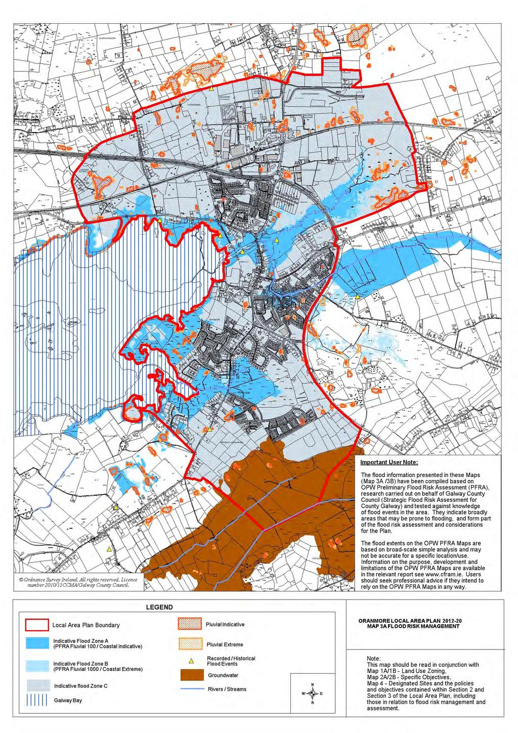
55 22
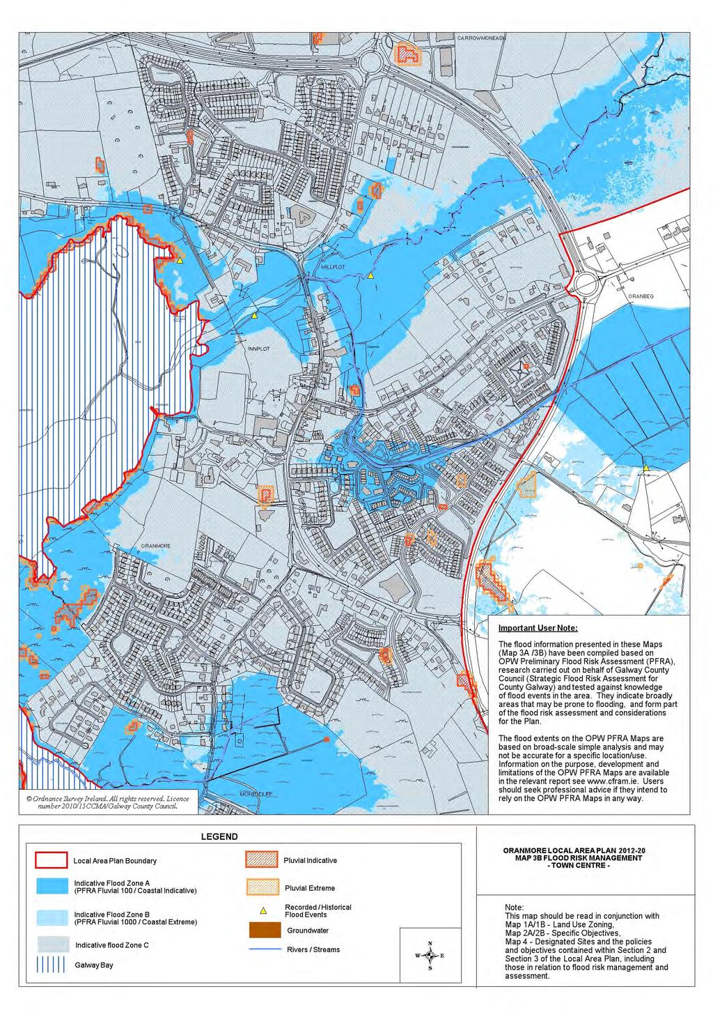
56 22
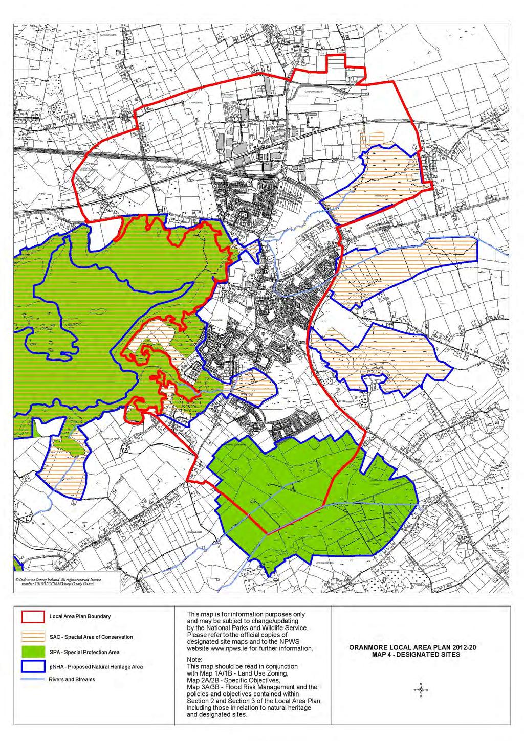
57 22
DRAFT Tuam Local Area Plan
 DRAFT Tuam Local Area Plan 2018-2024 January 2018 Table of Contents PAGE 1.0 Introduction.. 3 1.1 Preamble... 3 1.2 Profile of Tuam... 3 1.3 Local Area Plan... 4 1.4 Plan Informants & Key Considerations...
Draft Portumna Local Area Plan
 Draft Portumna Local Area Plan 2016-2022 Forward Planning Galway County Council Áras an Chontae Prospect Hill Galway Period of public display: Friday the 31 st of July 2015 until Friday the 11 th of September
Draft Clifden Local Area Plan July 2018
 Draft Clifden Local Area Plan 2018-2024 July 2018 2 Table of Contents 1.0 Introduction.. 3 1.1 Preamble... 3 1.2 Profile of Clifden... 3 1.3 Local Area Plan... 4 1.4 Plan Informants & Key Considerations...
Athenry Local Area Plan *
 Athenry Local Area Plan 2012-2022* Plan Adopted 25 th June 2012 Forward Planning Galway County Council Áras an Chontae Prospect Hill Galway Adopted 25 th June. *Deferral of Notice under 19(1)(d) for a
Gort Local Area Plan 2013
 Gort Local Area Plan 2013 Adopted 22 nd July 2013 Forward Planning Galway County Council Áras an Chontae Prospect Hill Galway Table of Contents Page 1. Introduction... 1 1.1 Preamble... 1 1.2 Profile of
Edenderry Local Area Plan
 Edenderry Local Area Plan 2017-2023 MATERIAL ALTERATIONS TO DRAFT EDENDERRY LOCAL AREA PLAN Public Display Document Section 1: Introduction 1.1 Introduction This report focuses on the proposed material
elbridge Core Strategy
 C elbridge Core Strategy Celbridge is designated as a Moderate Growth Town in the RPGs. The County Development Plan reinforces this designation in its settlement strategy. Moderate Growth Towns within
Variation No.1 Galway County Development Plan Adopted: 24th April 2017
 Variation No.1 Galway County Development Plan 215-221 Adopted: 24th April 217 Chapter 2 - Spatial Strategy, Core & Settlement Strategy 2.1 Background In its simplest terms the County Development Plan s
Chapter 3 Core Strategy
 Chapter 3 Core Strategy 3.0 Introduction The core strategy sets out how the development objectives in the Development Plan are consistent with the National Spatial Strategy and the Regional Planning Guidelines.
Variation No 1: Dundalk & Environs Development Plan Core Strategy
 Variation No 1: Dundalk & Environs Development Plan 2009-2015 Core Strategy Adopted on 29 th August 2011 CONTENTS Page Section 1 1.0 Synopsis 1 1.1 Background Document 1 1.2 Variation of Dundalk and Environs
Strategic Environmental Assessment Screening Report. Dublin Port Masterplan Review 2017
 Strategic Environmental Assessment Screening Report Dublin Port Masterplan Review 2017 Table of Contents 1 Introduction... 1 2 Purpose of the Masterplan... 2 3 Task 1.1 Pre-Screening Check... 5 4 Task
2.0 Strategic Context 4
 2.0 Strategic Context 4 2.1 The Area Action Plan is a non-statutory plan, which forms a corporate policy document, expressing particular issues and areas of concern while also providing a vision for the
ROCHFORD LOCAL DEVELOPMENT FRAMEWORK: Sustainability Appraisal/ Strategic Environmental Assessment. Rochford Core Strategy Preferred Options Document
 ROCHFORD LOCAL DEVELOPMENT FRAMEWORK: Sustainability Appraisal/ Strategic Environmental Assessment Non Technical Summary Rochford Core Strategy Preferred Options Document October 2008 SUSTAINABILITY APPRAISAL
Variation No. 2 Introduction & Explanatory Document Variation made on 19th May 2014
 Meath County Development Plan 2013 2019 Variation No. 2 Introduction & Explanatory Document Variation made on 19th May 2014 1.0 INTRODUCTION The Meath County Development was adopted on 17 th December
Dunboyne/Dunboyne North/ Clonee/ Local Area Plan
 Dunboyne/Dunboyne North/ Clonee/ Local Area Plan Strategic Policy SP 1 To operate an Order of Priority for the release of residential lands in compliance with the requirements of CS OBJ 6 of the County
Sustainability Statement. Whitby Business Park Area Action Plan
 Sustainability Statement Whitby Business Park Area Action Plan November 2014 Contents Page 1. Introduction 1 2. Scoping 3 3. Sustainability Appraisal of Options 6 4. Assessment of Draft Area Action Plan
Submission to the Kildare County Council Development Plan North Kildare Chamber. Executive Summary
 ` 28 th May 2015 Submission to the Kildare County Council Development Plan 2017-2023 North Kildare Chamber Executive Summary North Kildare Chamber s mission is to work with businesses, community groups,
Tāhuhu whakaruruhau ā-taone The sheltering ridge pole
 B2. Tāhuhu whakaruruhau ā-taone - Urban growth and form B2.1. Issues Tāhuhu whakaruruhau ā-taone The sheltering ridge pole Auckland s growing population increases demand for housing, employment, business,
Great Easton Neighbourhood Plan Statement of Basic Conditions
 Great Easton Neighbourhood Plan 2017-2031 Statement of Basic Conditions OCTOBER 2016 GREAT EASTON PARISH COUNCIL Contents 1.0 Introduction....Page 2 2.0 Summary of Submission Documents and Supporting Evidence..
A Growing Community Rural Settlement Areas
 Town of Huntsville Official Plan Review - POLICY BACKGROUND PAPER A Growing Community Rural Settlement Areas BACKGROUND: In addition to the fully municipally-serviced Urban Settlement Area and the Hidden
Site Assessment Technical Document Appendix A: Glossary
 Central Bedfordshire Council www.centralbedfordshire.gov.uk Site Assessment Technical Document Appendix A: Glossary July 2017 1.1.11-1 - ii Appendix A: Glossary Term Agricultural Land Classification AONB
Plan Modification to Chapter B2 of the Auckland Unitary Plan(AUP) Operative in part (15 November 2016)
 Operative in part (15 November 2016)") UNITARY PLAN UPDATE REQUEST MEMORANDUM TO FROM Phill Reid Linley Wilkinson DATE 25 September 2018 SUBJECT Plan Modification to Chapter B2 of the Auckland Unitary Plan(AUP) Operative in part (15 November
UNITARY PLAN UPDATE REQUEST MEMORANDUM TO FROM Phill Reid Linley Wilkinson DATE 25 September 2018 SUBJECT Plan Modification to Chapter B2 of the Auckland Unitary Plan(AUP) Operative in part (15 November
Meath County Development Plan. Variation No. 1 to Volume 1 Written Statement
 Meath County Development Plan 2013 2019 Variation No. 1 to Volume 1 Written Statement 2 Core Strategy Adopted Variation No. 1-04/11/2013 2.3.3 Residential Zoned Land Provision Table 2.4 details the requirement
Welcome to our exhibition
 Welcome to our exhibition The Homes & Communities Agency (HCA) welcomes you to this public exhibition explaining our proposals for the redevelopment of the former Lea Castle Hospital site. About the Homes
City Regions Ireland
 City Regions Ireland 01 CITY REGIONS IRELAND COMPRISES OF CORK CHAMBER, DUBLIN CHAMBER, LIMERICK CHAMBER, WATERFORD CHAMBER AND GALWAY CHAMBER, ALL MEMBERS OF CHAMBERS IRELAND. 5 CITIES 8 PRINCIPLES A
Newcourt Masterplan. November Exeter Local Development Framework
 Newcourt Masterplan November 2010 Exeter Local Development Framework Background The Exeter Core Strategy Proposed Submission sets out the vision, objectives and strategy for the development of Exeter up
EVALUATION OF MASTER PLAN ALTERNATIVES
 7 The Environmental Report is required to identify, describe and evaluate reasonable alternatives, taking into account the objectives and geographical scope of the Master Plan 2008. Three plan alternatives
DUBLIN DOCKLANDS MASTER PLAN AND RELATIONSHIP WITH OTHER PLANS
 .1 National Policy and Programmes.1.1 Sustainable Development A Strategy for Ireland, 1997.1.2 National Climate Change Strategy, 2007-2012.1. National Development Plan 2007-201.1.4 National Spatial Strategy,
Official Plan Review
 Official Plan Review Summary Report - The Built Environment August 2014 Part 1: Introduction Planning for a healthy, prosperous and sustainable community is an important goal for our municipality. From
Rochford District Council Allocations Development Plan Document: Discussion and Consultation Document Sustainability Appraisal
 Option SWH1 Balanced Communities Option SWH1 1 To ensure the delivery of high quality sustainable communities where people want to live and work Will it ensure the phasing of infrastructure, including
Rathmolyon Written Statement
 Settlement Rathmolyon Position in Settlement Hierarchy Village - Local centre for services and local enterprise development Position in Retail Strategy Fourth tier retail centre Population (2011) Census
Neighbourhood Planning Local Green Spaces
 Neighbourhood Planning Local Green Spaces Introduction... 2 1. Why green space is important... 4 2. Neighbourhood plans and green space... 6 3. Evidence... 8 Statutory designations... 9 Green space audit...
Ipswich Issues and Options for the Ipswich Local Plan Review, August 2017, Public Consultation
 Ipswich Issues and Options for the Ipswich Local Plan Review, August 2017, Public Consultation Having reviewed the issues and options documents, the Society has made the following response: Part 1 Strategic
A VISION FOR SOUTH DUBLIN S FUTURE. Proposed Variation No. 2. Vacant Site Levy. Planning Report
 A VISION FOR SOUTH DUBLIN S FUTURE Proposed Variation No. 2 Vacant Site Levy Planning Report February 2018 Proposed Variation No. 2 South Dublin County Council County Development Plan 2016-2022 This is
INCREMENTAL CHANGE AREA REVIEW March 2015 Page 1
 INCREMENTAL CHANGE AREA REVIEW March 2015 Page 1 Table of Contents Introduction... 3 Background to Review... 3 Comparison of the Schedules to the General Residential Zone... 7 Methodology... 7 Policy Context...
Parish of Repton NEIGHBOURHOOD DEVELOPMENT PLAN
 Parish of Repton NEIGHBOURHOOD DEVELOPMENT PLAN BASIC CONDITIONS STATEMENT December 2018 CEF 4 Legal Requirements This statement has been produced by the NDP Working Group on behalf of Repton Parish Council
WINCHESTER TOWN 3.1 LOCATION, CHARACTERISTICS & SETTING
 WINCHESTER TOWN 3.1 LOCATION, CHARACTERISTICS & SETTING 3.1.1 The area referred to by the City Council, as Winchester Town, consists of the Winchester Wards plus the adjoining built up areas of Badger
Appendix. Statement Outlining Compliance with Ministerial Guidelines
 18 Appendix Statement Outlining Compliance with Ministerial Guidelines A18 Statement Outlining Compliance with Ministerial Guidelines Under section 28 of the Planning and Development Act 2010, Meath County
Stantonbury Neighbourhood Plan
 Stantonbury Neighbourhood Plan 2018-2031 Basic Conditions Statement October 2018 Intentionally blank 1.0 Basic Conditions Statement Introduction 1.1 This statement has been prepared by Stantonbury Parish
MAYFIELD WEST SECONDARY PLAN PHASE 2
 MAYFIELD WEST SECONDARY PLAN PHASE 2 Public Open House #3 February 25, 2010 Draft Preferred Land Use Scenario TOWN OF CALEDON PLANNING & DEVELOPMENT DEPARTMENT Open House Agenda TOWN OF CALEDON 1. Welcome
DAREBIN PLANNING SCHEME AMENDMENT C137
 Who is the planning authority? Planning and Environment Act 1987 DAREBIN PLANNING SCHEME AMENDMENT C137 EXPLANATORY REPORT This amendment has been prepared by the Darebin City Council, who is the planning
DRAFT WESTERN CITY DISTRICT PLAN PLANNING PRIORITIES AND ACTIONS
 Greater Sydney Commission DRAFT WESTERN CITY DISTRICT PLAN PLANNING PRIORITIES AND ACTIONS Issued: 26 OCTOBER 2017 Version: 1 Subject: Greater Sydney Region and District Plans This information note is
Settlement Boundaries Methodology North Northumberland Coast Neighbourhood Plan (August 2016)
") Introduction This background paper sets out a methodology for the definition of settlement boundaries in the North Northumberland Coast Neighbourhood Plan. The neighbourhood plan is planning positively
Introduction This background paper sets out a methodology for the definition of settlement boundaries in the North Northumberland Coast Neighbourhood Plan. The neighbourhood plan is planning positively
Vacant Site Levy. Proposed Variation No. 2. Strategic Environmental Assessment (SEA) Screening Report and Determination
 Screening Report and Determination") A VISION FOR SOUTH DUBLIN S FUTURE Proposed Variation No. 2 Vacant Site Levy Strategic Environmental Assessment (SEA) Screening Report and Determination February 2018 SEA Screening Determination Report
A VISION FOR SOUTH DUBLIN S FUTURE Proposed Variation No. 2 Vacant Site Levy Strategic Environmental Assessment (SEA) Screening Report and Determination February 2018 SEA Screening Determination Report
Meath County Development Plan. Proposed Draft Variation No. 1 to Volume 1 Written Statement
 Meath County Development Plan 2013 2019 Proposed Draft Variation No. 1 to Volume 1 Written Statement 2 Core Strategy Proposed Draft Variation No. 1!" #$ % & ' % $ ($ &' ) $) * (' &+( &' % $ * $ $ * %
Appendix A. Planning Processes. Introduction
 1 Planning Processes Introduction This appendix outlines a number of planning processes which are used in the Auckland Region to support the effective management of development in the region s rural and
Appendix A: Retail Planning Assessment
 Rotherham Town Centre Masterplan Appendix A: Retail Planning Assessment 139 Appendix A Rotherham Town Centre Masterplan Retail Planning Background and Policy Context 1. Introduction 1.1 The Masterplan
I615. Westgate Precinct
 I615. Westgate Precinct I615.1. Precinct Description The Westgate Precinct is located approximately 18km west of the Auckland city centre. There are seven Sub-precincts in the Westgate Precinct: Sub-precinct
Aebhin Cawley (Scott Cawley Ltd.) Appropriate Assessment in Practice A Consultant s Perspective
 Appropriate Assessment in Practice A Consultant s Perspective") Aebhin Cawley (Scott Cawley Ltd.) Appropriate Assessment in Practice A Consultant s Perspective Natura 2000 sites in Ireland 423 SACs (including 4 Marine) 153 SPAs Habitats Directive Article 6 (3) Any
Aebhin Cawley (Scott Cawley Ltd.) Appropriate Assessment in Practice A Consultant s Perspective Natura 2000 sites in Ireland 423 SACs (including 4 Marine) 153 SPAs Habitats Directive Article 6 (3) Any
WHITELEY TOWN COUNCIL NORTH WHITELEY DEVELOPMENT SEPTEMBER 2014
 WHITELEY TOWN COUNCIL NORTH WHITELEY DEVELOPMENT SEPTEMBER 2014 Dear Resident This Special Edition of the Whiteley Voice which has been prepared in conjunction with the North Whiteley Consortium is to
Glossary of Terms. 430 Kildare County Development Plan Kildare County Development Plan
 Glossary of Terms 430 431 Glossary of Terms Appropriate Assessment A requirement to consider the possible nature conservation implications of any plan or project on the Natura 2000 site network before
2. The application, which is a full plans application, is for a commercial development comprising B1, D1, D2 and A3 uses.
 Former Taff Vale Shopping Centre, Taff Street, Pontypridd, CF37 4TR PLANNING APPLICATION SUPPORTING STATEMENT May 2017 Ref.11431/1 INTRODUCTION AND APPLICATION CONTEXT 1. This planning application statement
The Proposed Auckland Unitary Plan (notified 30 September 2013)
") 3 Business zones Introduction There are 10 business zones in the Unitary Plan: City Centre Metropolitan Centre Town Centre Local Centre Neighbourhood Centre Mixed Use General Business Business Park Light
3 Business zones Introduction There are 10 business zones in the Unitary Plan: City Centre Metropolitan Centre Town Centre Local Centre Neighbourhood Centre Mixed Use General Business Business Park Light
Appendix 1 Structure plan guidelines
 Appendix 1 Structure plan guidelines This appendix forms part of the regional policy statement [rps]. 1.1. Introduction Structure plans are an important method for establishing the pattern of land use
DUNSFOLD NEIGHBOURHOOD PLAN Site Selection Policies
 DUNSFOLD NEIGHBOURHOOD PLAN Site Selection Policies The criteria for assessing sites for future housing and business development in Dunsfold are set out below. (Development criteria, covering what it is
Woodbrook - Shanganagh
 Section 4: Key Sites Framework Strategy Woodbrook - Shanganagh Local Area Plan 2017-2023 4. Site Framework Strategies The Master Plans shall have regard to the thematic objectives under the LAP Development
Draft Eastern District Plan
 Draft Eastern District Plan Submission_id: 31238 Date of Lodgment: 13 Dec 2017 Origin of Submission: Online Organisation name: Turrulla Gardens Pty Ltd C/- Mecone Organisation type: Industry First name:
9 Pershore. Introduction. Pershore Abbey
 118 Introduction 9.1 The historic town of Pershore lies on the River Avon and has a population of 7,000 (2009 Mid-Term Population Estimates). The main areas of the town are centred on the Abbey, the bustling
OKEFORD FITZPAINE NEIGHBOURHOOD PLAN
 OKEFORD FITZPAINE NEIGHBOURHOOD PLAN Dear Parishioner, The Neighbourhood Plan Project Team have prepared this leaflet to summarise the full Neighbourhood Plan document. It provides a summary of the Vision,
Page 1 of 19 URBAN DESIGN FRAMEWORK FOR BOLTON STREET WATERFORD
 Page 1 of 19 URBAN DESIGN FRAMEWORK FOR BOLTON STREET WATERFORD 1.0 Introduction: The relocation of the City Council stores and depot from Bolton Street creates an exciting opportunity for development
Core Strategy LONGFORD COUNTY DEVELOPMENT PLAN VARIATION NO. 1. Prepared by the Planning Section Longford Local Authorities
 Core Strategy LONGFORD COUNTY DEVELOPMENT PLAN 2009-2015 VARIATION NO. 1 Prepared by the Planning Section Longford Local Authorities Adopted on 19 September 2012 Introduction and Explanatory Note V ariation
Guidelines for Planning Authorities and Part V of the Planning and Development Act 2000: December 2000
 Slide 1 Slide 2 Slide 3 Slide 4 As a planner in practice, whether within the Local Authority, private practice or An Bord Pleanala, due regard must be given to the guidance provided by the Department in
Ballivor Written Statement
 Settlement Ballivor Position in Settlement Hierarchy Village - Local centre for services and local enterprise development Position in Retail Strategy Fourth tier retail centre Population (2011) Census
Chapter 5 Urban Design and Public Realm
 5.1 Introduction Public realm is all areas of the urban fabric to which the public have access. It is where physical interaction takes place between people. It therefore, includes buildings and their design,
14.5 HOPEFIELD: (REFER PLAN 39 AND PLAN 40)
") URBAN DYNAMICS WESTERN CAPE INC. 248 14.5 HOPEFIELD: (REFER PLAN 39 AND PLAN 40) FIGURE 83: LOCALITY - HOPEFIELD Within the context of the Saldanha Bay Municipal area, Hopefield, an historical agricultural
URBAN DYNAMICS WESTERN CAPE INC. 248 14.5 HOPEFIELD: (REFER PLAN 39 AND PLAN 40) FIGURE 83: LOCALITY - HOPEFIELD Within the context of the Saldanha Bay Municipal area, Hopefield, an historical agricultural
Kibworth Harcourt. Introduction. Introduction
 Introduction Introduction Welcome to this public exhibition on the proposals for the delivery of new homes on land at The Kibworths. The purpose of today s exhibition is to give you the opportunity to
2040 LUP is a part of the Comprehensive Plan and carries the same legal authority. Economic Challenges
 1.1. Guiding Anchorage s Growth Where will new residents settle over the next two decades? Where will people work, shop, and play? Will there be enough room to grow? How will Anchorage look? Will growth
Chapter 2 Core Strategy
 Chapter 2 Core Strategy 11-24 2.1 Introduction 2.2 Strategic Planning Approach 2.3 Growth Consistency with the National Spatial Strategy & Regional Planning Guidelines 2.1 Introduction The overall strategy
Draft Western District Plan
 Powered by TCPDF (www.tcpdf.org) Draft Western District Plan Submission_id: 31440 Date of Lodgment: 15 Dec 2017 Origin of Submission: Online Organisation name: Goodman Property Services Australia Pty Ltd
Droitwich Spa 6. Reasoned Justification
 87 Droitwich Spa 6 Reasoned Justification 6.1 Droitwich Spa is identified in the settlement hierarchy (Policy SWDP1) as a main town being the largest settlement in Wychavon District with an estimated population
Chapter 2: OUTLINE PLANNING APPLICATION PROPOSALS. A New Garden Neighbourhood Matford Barton 17
 Chapter 2: OUTLINE PLANNING APPLICATION PROPOSALS A New Garden Neighbourhood Matford Barton 17 2.1. SUMMARY AND STATUS OF THE PROPOSALS 2.1.1. The parameter plans and associated wording in this chapter
Submission to Dublin City Council regarding the proposed Poolbeg West SDZ Planning Scheme
 Submission to Dublin City Council regarding the proposed Poolbeg West SDZ Planning Scheme 25 th July 2016 Introduction The Poolbeg West Strategic Development Zone (SDZ) was established by Government on
Tiane Ltd Submission on Draft National Planning Framework Ireland 2040
 Tiane Ltd Submission on Draft National Planning Framework Ireland 2040 Date: 31 st March 2017 Authors: Ken Swaby / Ben Waite Approved By: Christy O'Sullivan ILTP Project Code & Reference: GOLDENATH Distribution:
Vigo Neighbourhood Plan Basic Conditions Statement
 Vigo Neighbourhood Plan Basic Conditions Statement Plan Period: 2016 to 2028 Status: Submission Version Qualifying Body: Vigo Parish Council Glossary of Some Terms & Abbreviations Used in this Document
DRAFT GREATER SYDNEY REGION PLAN OBJECTIVES, STRATEGIES AND ACTIONS
 Greater Sydney Commission DRAFT GREATER SYDNEY REGION PLAN OBJECTIVES, STRATEGIES AND ACTIONS Issued: 26 OCTOBER 2017 Version: 1 Subject: Greater Sydney Region and District Plans This information note
6 Growth Management Challenges and Opportunities
 6 Growth Management Challenges and Opportunities The Town has established a goal of attaining a 50% participation rate with respect to employment opportunities versus residential population. The Town s
4 RESIDENTIAL ZONE. 4.1 Background
 4 RESIDENTIAL ZONE 4.1 Background The residential areas within the City are characterised by mainly lowrise dwellings sited on individual allotments. Past architectural styles, settlement patterns and
INTRODUCTION BACKGROUND
 INTRODUCTION 1 1 INTRODUCTION 18 INTRODUCTION 1 1.1 BACKGROUND The Dublin Docklands Development Authority (DDDA) is required to conduct a Strategic Environmental Assessment (SEA) of the review of the Draft
9 CITY OF VAUGHAN OFFICIAL PLAN AMENDMENT NO BOCA EAST INVESTMENTS LIMITED
 9 CITY OF VAUGHAN OFFICIAL PLAN AMENDMENT NO. 631 - BOCA EAST INVESTMENTS LIMITED The Planning and Economic Development Committee recommends the adoption of the recommendations contained in the following
KELLS DEVELOPMENT PLAN
 KELLS DEVELOPMENT PLAN 2013-2019 J Statement Outlining Compliance with Ministerial Guidelines Adopted 7th October 2013 APPENDIX J STATEMENT OUTLINING COMPLIANCE WITH MINISTERIAL GUIDELINES Under section
BRE Strategic Ecological Framework LI Technical Information Note 03/2016
 BRE Strategic Ecological Framework Technical Information Note 03/2016 September 2016 Contents 1. Introduction 2. Aims of BRE s Strategic Ecological Framework 3. How SEF is different from previous approaches
1.0 Purpose of a Secondary Plan for the Masonville Transit Village
 Report to Planning and Environment Committee To: Chair and Members Planning & Environment Committee From: John M. Fleming Managing Director, Planning and City Planner Subject: Masonville Transit Village
Town of Cobourg Heritage Master Plan. Statutory Public Meeting
 Town of Cobourg Heritage Master Plan Statutory Public Meeting April 25 th 2016 Presentation Overview 1. Introduction 2. Project background and schedule overview 3. Review of strategic direction content
CONTENTS 2.0 A FRAMEWORK FOR SUSTAINABLE GROWTH 2.1 MANAGING SUSTAINABLE GROWTH THE VISION TO GOALS AND OBJECTIVES 2.3 MARKHAM STRUCTURE
 2 A Framework for Sustainable Growth 2.0 A FRAMEWORK FOR SUSTAINABLE GROWTH CONTENTS 2.1 MANAGING SUSTAINABLE GROWTH THE VISION TO 2031 2.2 GOALS AND OBJECTIVES 2.2.1 Protecting the Natural Environment
Pre Draft Manager s Report Meath County Development Plan TABLE OF CONTENTS
 Pre Draft Manager s Report Meath County Development Plan 2013-2019 TABLE OF CONTENTS Section 1 Introduction and Overview of Pre Draft Consultation Report 1.1 Introduction... 1 1.2 Pre Draft Public Consultation...
Maynooth. Local Area Plan Plean Cheantar Aitiuil Mháigh Nuad. 26th August 2013
 Maynooth Local Area Plan 2013 2019 Plean Cheantar Aitiuil Mháigh Nuad 26th August 2013 Table of Contents PART A Introduction and Context 1.0 Introduction 5 1.1 Local Area Plans Status and Process 6 1.2
MEATH COUNTY COUNCIL Dunboyne, Clonee & Pace Local Area Plan
 MEATH COUNTY COUNCIL Dunboyne, Clonee & Pace Local Area Plan 2009-2015 Adopted 22 September 2009 Planning Department Dunboyne/Clonee/Pace Local Area Plan 2009-2015 Adopted 22 nd September 2009 Prepared
Edward R. Sajecki Commissioner of Planning and Building
 Corporate Report Clerk s Files Originator s Files CD.03.POR DATE: TO: FROM: SUBJECT: Chair and Members of Planning and Development Committee Meeting Date: February 27, 2012 Edward R. Sajecki Commissioner
Balcombe Neighbourhood Plan. Habitats Regulations Assessment Screening Report
 Balcombe Neighbourhood Plan Habitats Regulations Assessment Screening Report Produced for Regulation 14 of the Neighbourhood Planning (General) Regulations 2012 17 th July 2015 1.0 Introduction 1.1 This
13 THORNHILL YONGE STREET STUDY IMPLEMENTATION CITY OF VAUGHAN OPA 669 AND TOWN OF MARKHAM OPA 154
 13 THORNHILL YONGE STREET STUDY IMPLEMENTATION CITY OF VAUGHAN OPA 669 AND TOWN OF MARKHAM OPA 154 The Planning and Economic Development Committee recommends the adoption of the recommendations contained
Paignton Neighbourhood Plan (Submission version 2017)
") Paignton Neighbourhood Plan (Submission version 2017) Introduction This brief statement covers the views of the TDA, only in relation to its role as adviser to the Council on delivery of town centre regeneration.
Paignton Neighbourhood Plan (Submission version 2017) Introduction This brief statement covers the views of the TDA, only in relation to its role as adviser to the Council on delivery of town centre regeneration.
Dréacht Phlean Ceantair Áitiúil na hardáin Draft Ardaun Local Area Plan
 Galway City Council Comhairle Cathrach na Gaillimhe Dréacht Phlean Ceantair Áitiúil na hardáin Draft Ardaun Local Area Plan 2018-2024 September 2017 Development Plan and Policy Section Contents 1. Context...
STATEMENT OF OBJECTION TO THE PROPOSED DEVELOPMENT OF LAND AT CHURCH CLIFF DRIVE FILEY
 STATEMENT OF OBJECTION TO THE PROPOSED DEVELOPMENT OF LAND AT CHURCH CLIFF DRIVE FILEY You will be aware that Scarborough borough council have adopted a new local plan that includes land at Church Cliff
3. Neighbourhood Plans and Strategic Environmental Assessment
 1. Introduction This report sets out a draft Screening Determination for the Preston Parish Council s Neighbourhood Plan and has been prepared by rth Hertfordshire District Council. The purpose of the
heuston gateway: summary report
 Significant View: Royal Hospital Kilmainham to Phoenix Park. hoenix Park to Royal Hospital: view of Royal Hospital from Phoenix Park to Wellington Monument view of Royal Hospital rail bridge from Conyngham
WELCOME GYPSY LANE. Wider Site Location plan. Proposals for the development of LAND OFF FOXLYDIATE LANE WEBHEATH. Proposals for the development of
 WELCOME The developers are preparing an outline planning application for a residential led development and need the community s views in order to develop the proposals further WHAT IS PROPOSED? A high
THAT the attached Terms of Reference for the Thornhill Centre Street Study be approved.
 COMMITTEE OF THE WHOLE AUGUST 18, 2003 THORNHILL CENTRE STREET STUDY PLANNING FILE: 15.92 Recommendation The Commissioner of Planning recommends: THAT the attached Terms of Reference for the Thornhill
Schedule of Planning Applications Committee Date: 23 May Reference: 06/17/0726/F Parish: Hemsby Officer: Mr J Beck Expiry Date:
 Schedule of Planning Applications Committee Date: 23 May 2018 Reference: 06/17/0726/F Parish: Hemsby Officer: Mr J Beck Expiry Date: 22-05-2018 Applicant: Proposal: Site: Mr Gillett Change of use to the
Colchester Northern Gateway Master Plan Vision Review Draft. July 2016
 Colchester Northern Gateway Master Plan Vision Review Draft July 2016 Contents Introduction 4 Context 8 Purpose of the Report 8 Strategic Position 9 Overview of the Process 11 2012 Master Plan Vision 12
SECTION ONE: INTRODUCTION. introduction
 introduction 1 INTRODUCTION Since it was first established in 1843 as a trading post for the Hudson s Bay Company, Victoria has evolved into a Provincial capital city that is recognized across Canada and