Planning and Design Commission Report 915 I Street, 1 st Floor Sacramento, CA
|
|
|
- Willa Baldwin
- 5 years ago
- Views:
Transcription
 (Noticed on 10-13-17) (Noticed on 10-13-17) Location: 1325 and 1327 65 th Street; APNs:")
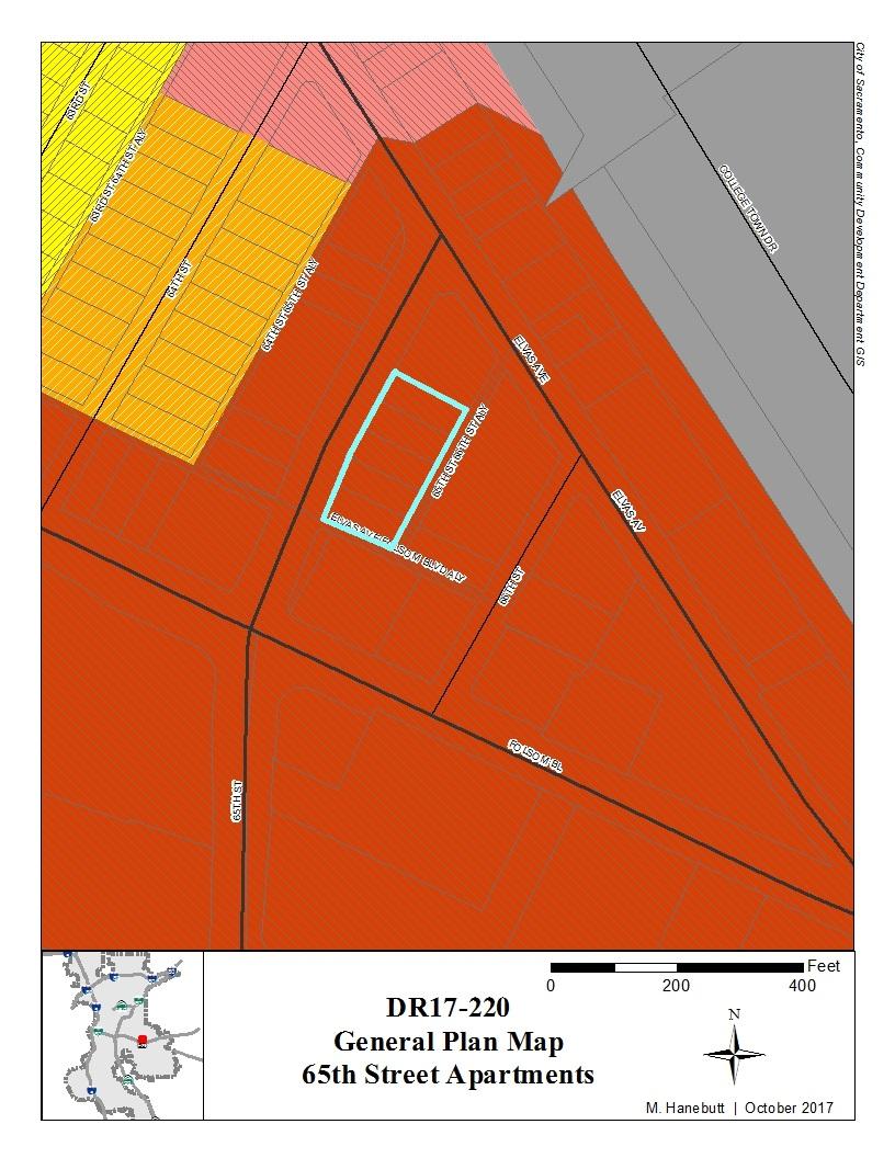
1 Planning and Design Commission Report 915 I Street, 1 st Floor Sacramento, CA File ID: October 26, 2017 Public Hearing Item 04 Title: 65 th Street Apartments (DR17-220) (Noticed on ) (Noticed on ) Location: 1325 and th Street; APNs: , -018, -019, -020, and -023 (Council District 3) Recommendation: Conduct a public hearing and upon conclusion approve: Item A. Environmental Exemption (Per CEQA Guidelines Section Infill Development); Item B. Site Plan and Design Review to construct a new mixed-use building with ground floor commercial and 90 residential units on approximately 0.75 acres in the Residential Mixed-Use (RMX-TO) zone and within the Transit Overlay zone, with deviations for height, front setback, and open space. Contact: Michael Hanebutt, Assistant Planner, (916) , mhanebutt@cityofsacramento.org; Luis Sanchez, Senior Architect, (916) , lsanchez@cityofsacramento.org; Evan Compton, Senior Planner, (916) , ecompton@cityofsacramento.org. Presenter: Michael Hanebutt, Assistant Planner, (916) , mhanebutt@cityofsacramento.org Applicant: Phillip Harvey, Kuchman Architects, PC, th Street, Sacramento, CA Property Owner: Ken King, TriCap Partners 65, LLC, 4501 Auburn Boulevard, Sacramento, CA Attachments: 2-Background 3-Findings of Fact and Conditions of Approval 4-Exhibit A: Project Plans 5-Community Comments 6-General Plan Map 7-Aerial and Zoning Map City of Sacramento October 26, 2017 powered by Legistar

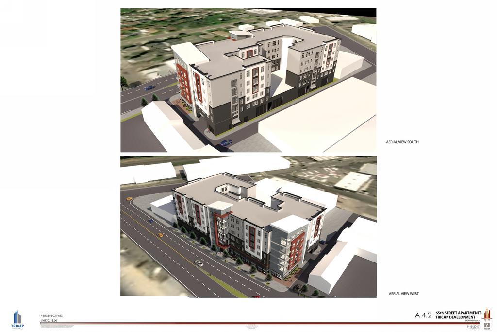
2 File ID: Public Hearing Item 04 Description/Analysis Issue Detail: The property is currently developed with two commercial buildings that most recently operated as a pool service company and an accessory storage building. The commercial and storage buildings are separated by a surface parking lot. The buildings have been vacant for over three years. The proposal includes demolition of the existing commercial buildings and surface parking lot and the construction of a new six-story mixed-use building with 90 dwelling units and a parking garage accessed from the public alley. This request requires Site Plan and Design Review with deviations. The project proposes to deviate from height, front setback, and open space standards, and staff supports these deviations as further discussed in the background section of this report. As part of the conditions from Public Works, the applicant will be required to dedicate a portion of their parcel along 65 th Street (varying 8 to 11 feet in width as shown on the attached exhibits) and to construct upgraded frontage improvements including a new protected bike lane and wider sidewalk. The project also includes removing an existing driveway curb cut on 65th Street. Staff finds that the site layout and improvements, as well as the architectural design and materials are consistent with the 65 th Street/University Transit Village Plan and Citywide Design Guidelines, as the building helps to activate the street frontage and the exterior finishes integrate the project into the existing neighborhood while also defining a sense of place. Figure 1: 65 th Street Rendering Looking East City of Sacramento October 26, 2017 powered by Legistar

3 File ID: Public Hearing Item 04 Figure 2: Vicinity Map City of Sacramento October 26, 2017 powered by Legistar
4 File ID: Public Hearing Item 04 Policy Considerations: General Plan: The 2035 General Plan Update was adopted by City Council on March 3, The 2035 General Plan s goals, policies, and implementation programs define a roadmap to achieving Sacramento s vision to be the most livable city in America. The project site is designated in the General Plan as Urban Center Low, which provides for smaller urban areas throughout the city. Each center includes employment-intensive uses, a mix of housing, and a wide variety of retail uses. Urban Center Low is located around light rail stations, along local arterials, and in other key areas of the city. Building heights for Urban Center Low tend toward low- and mid-rise structures. Key urban form characteristics found in the Urban Center Low designation include: Building heights generally ranging from two to seven stories (taller heights are acceptable if supported by context and market) Buildings sited at or near the sidewalk along the primary street frontage and typically abut one another with limited side yard setbacks Building entrances set at the sidewalk along the primary street frontage Rear alleys and secondary streets providing vehicular and service access, with limited driveways and curb cuts on primary streets Parking provided on-street as well as in individual or shared lots at the rear of structures, or in screened parking structures Transparent building frontages with pedestrian-scaled articulation and detailing Moderately wide sidewalks (e.g., 6 to 10 feet), furnished with street trees, public seating areas, and other amenities that create inviting streetscapes Public streetscapes serving as the area s primary open space, complemented by plazas, courtyards, and sidewalk dining areas The proposed project would support the characteristics listed above, as well as many of the goals and policies in the General Plan, including: Policy LU Neighborhood Enhancement. The City shall promote infill development, reuse, rehabilitation, and reuse efforts that contribute positively (e.g., architectural design) to existing neighborhoods and surrounding areas. Policy LU Unique Sense of Place. The City shall promote quality site, architectural and landscape design that incorporates those qualities and characteristics that make Sacramento desirable and memorable including: walkable blocks, distinctive parks and open spaces, tree-lined streets, and varied architectural styles. Policy LU Buildings that Engage the Street. The City shall require buildings to be oriented to and actively engage and complete the public realm through such features as building orientation, build-to and setback lines, façade articulation, ground-floor transparency, and location of parking. Policy LU Centers Served by Transit. The City shall promote the development of City of Sacramento October 26, 2017 powered by Legistar
5 File ID: Public Hearing Item 04 commercial mixed-use centers that are located on existing or planned transit stops in order to facilitate and take advantage of transit service, reduce vehicle trips, and enhance community access. Policy LU Urban Centers. The City shall promote the development of a series of urban centers, as designated in the Land Use & Urban Form Diagram, that create significant opportunities for employment, housing, and commercial activity in areas outside of the Central Business District (CBD). Policy LU Vertical and Horizontal Mixed-Use. The City shall encourage and, where feasible, require the vertical and horizontal integration of uses within commercial centers and mixed-use centers, particularly residential and office uses over ground floor retail. The proposed project supports these policies by proposing a high density, mixed-use project less than a quarter of a mile from the 65 th Street light rail station, which includes active groundfloor uses and building entries facing the street, and parking accessed from the public alley and appropriately screened from street views. In addition, the 65th Street/University Transit Village Plan is included as part of the East Sacramento Community Plan which includes the following policies supported by the project: Policy ES.TV 1.2 Transit Supportive Uses The City shall encourage uses in the 65th Street/University Transit Village that have daily or frequent patronage, such as offices, hotels, or high-density residential development. Policy ES.TV 1.6 Ground Floor Visibility The City shall require windows to be provided on the street level of new buildings in the 65th Street/University Transit Village as a visual link between business and pedestrians. A minimum of 60% of ground-floor commercial facades facing streets, sidewalks, pedestrian routes and public plazas shall be nonreflective, transparent glazing. The proposed project is consistent with the East Sacramento Community Plan and the 65 th Street/University Transit Village Plan in that it provides a high-density, mixed-use development between the light rail station and Sacramento State campus, provides a large outdoor terrace for residents and plazas in front of the building, and active uses with large storefronts on the ground floor facing 65 th Street. The project also includes dedication of additional public right-ofway along 65 th Street to allow for larger pedestrian and bicycle facilities, as envisioned in the Transit Village Plan. 200-Year Flood Protection: Provisions of the State Law (SB 5) and the City Code (17.810) require that beginning on July 1, 2016, the City shall make specific findings prior to approving certain entitlements for projects within a flood hazard zone. The purpose is to ensure that new development will have protection from a 200-year flood event or will achieve that protection by This project site is not located within any designated flood hazard zone. Environmental Considerations: The Community Development Department, Environmental Planning Services Division has reviewed the project and determined that the project is exempt City of Sacramento October 26, 2017 powered by Legistar
6 File ID: Public Hearing Item 04 from the provisions of the California Environmental Quality Act (CEQA) pursuant to CEQA Guidelines Section 15332, Infill Development. The project is consistent with the provisions of the 2035 General Plan and the zoning designation of RMX-TO. The project site is located in the city limits on a site of less than five acres and is substantially surrounded by urban uses. The project site has no value as habitat for endangered, rare or threatened species as it currently is developed with commercial buildings and a surface parking lot. The project would have no significant effect on traffic, noise, air, or water quality because the project is consistent with the anticipated floor area ratios for the area and will provide housing near an existing light rail station. The site is adequately served with all urban services and utilities. Therefore, the project would not have a significant effect on the environment. On September 20, 2017, the Preservation Director made a preliminary determination that the buildings at 1325 and th Street, Sacramento, are not eligible for listing in either the Sacramento or the California Registers, and therefore their demolition would not have a significant impact upon historical resources. Public/Neighborhood Outreach and Comments: The site has been posted and all the property owners within 300 feet have been notified for the hearing. Additionally, staff has notified various business and neighborhood groups including East Sac Give Back, East Sacramento Chamber of Commerce, East Sacramento Improvement Association, East Sacramento Preservation, and Preservation Sacramento. These groups along with Walk Sacramento and the Sacramento Area Bicycle Advocates (SABA) were included as part of the initial routing of the project documents. The applicant team has reached out to neighborhood groups in the area. Staff received three letters regarding the project, all of which are in support and are included as Attachment 5. The applicant has incorporated some of the attached suggestions from SABA and Walk Sacramento into the project and overall the improvements include bicycle and pedestrian enhancements to benefit future residents and the surrounding neighborhood. Rationale for Recommendation: Staff recommends the Planning and Design Commission approve the requests based on findings of fact and subject to conditions of approval listed in Attachment 3. Staff supports the project because it is: a) consistent with the Urban Center Low designation in the General Plan and the East Sacramento Community Plan/65 th Street/University Transit Village Plan; b) is consistent with both the Residential Mixed-Use (RMX-TO) zone and the Transit Overlay; c) provides additional residential opportunities and commercial activation near light rail and the California State University, Sacramento campus; d) enhances the streetscape with additional bicycle and pedestrian facilities; e) provides additional pedestrian facilities along both alley frontages; f) provides parking in an internal garage screened from view; and h) provides three bike rooms and in-unit racks for residents. City of Sacramento October 26, 2017 powered by Legistar
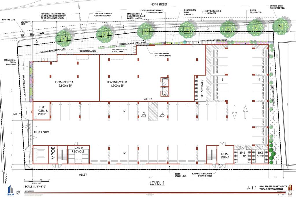
7 BACKGROUND INFORMATION The project site is currently occupied by vacant commercial buildings and surface parking. The buildings on site, which would be demolished as part of the project scope, were constructed between 1955 and The Preservation Director reviewed these buildings for historic significance and has determined that they do not meet the requirements for listing on the Sacramento Register. The project would redevelop several underutilized properties, and includes ground-floor retail, amenity, and garage parking, with five floors and an outdoor terrace above. Table 1: Project Information General Plan Designation: Urban Center Low (FAR ) Design Review District: Citywide Existing zoning of site: RMX-TO (Residential Mixed-Use/Transit Overlay) Property area: 32,539 square feet (0.75 acres) Parking District Urban District 111,175 Total Square Footage; Gross Square Footage: (Commercial: 2,800 square feet; Residential/Amenity Space: 108,375 square feet, 90 units) Proposed Height: 71 6 (roof), (overall) Floors: 6 levels (5 residential, 1 retail/parking) Proposed Floor Area Ratio (FAR): 3.42 Parking Spaces - Vehicles 46 spaces Parking Spaces - Bicycle 52 long term spaces, 15 short term spaces Project Context The proposed project is located on 65 th Street between Folsom Boulevard and Elvas Avenue. The site is within the 65 th Street/University Transit Village Plan area, and across the elevated rail line from the Sacramento State campus. U.S. Highway 50 also cuts through the area, with 65 th Street providing access to the highway just to the south. The immediate surroundings of the project include a mix of commercial and industrial uses to the north, east, and south, retail, apartments, and SMUD headquarters to the southwest, residential neighborhoods further to the west, in addition to the 65 th Street light rail station near Highway 50. The area is a transitioning urban center with a variety architectural styles, heights, and uses. The height of existing buildings in the area range from one and two-story buildings, up to taller office and industrial buildings, some up to 85 feet in height. Sacramento State s proximity to the area and desire to be less of a commuter school has spurred development of many new housing projects in the recent past, including F65, The Foundation, and the Ramona Avenue apartments currently under construction. Land Use The site is zoned Residential Mixed Use (RMX-TO) and it is within the Transit Overlay. The project includes a mixed use building with ground floor commercial and upper floor with 90 apartments. The ground floor commercial and apartments are permitted in the
8 RMX-TO zone. The city code requires that there be an onsite manager since there are over 15 apartments. However, staff notes the location of the site near the CSU, Sacramento campus will be very desirable for students. Given past experiences with housing projects that appeal to the student market, staff wants to support best management practices for this type of housing. As such, staff has included an additional condition to require a minimum of two Community Assistants, in addition to the mandatory onsite manager, as an added security measure. This is consistent with the conditions of approval placed on similar apartment projects in the area on the south side of 65 th Street. The applicant has reviewed and accepted this condition of approval. Table 2: Dwelling Unit Summary Number of Bedrooms Unit Count Studio / 1 Bedroom 20 dwelling units 2 Bedrooms 15 dwelling units 3 Bedrooms 10 dwelling units 4 Bedrooms 45 dwelling units Total 90 dwelling units ENTITLEMENT REVIEW Site Plan and Design Review Project Architectural Design The project occupies a nearly half-block length of 65 th Street between Folsom Boulevard and Elvas Avenue, and bound by alley on the south and east sides. The site allows the project to conceal parking from street views with garage access from the east/west alley. The building meets the street with a distinct design including retail with space for outdoor seating, resident amenity spaces, and garage access for pedestrians and cyclists. Materials also vary at the ground level and include fiber cement panels, concrete podium, and metal storefront systems, and change where the form of the building articulates along the bend in the street. The combination of materials and planar changes add interest at the street level and breaks up the length of the building along the street. Pedestrian enhancements continue around the south and east side of the building, with dedicated space given to walk around the building outside of the alley itself. This space also gives access to the stair towers for the building, allowing residents access to their units who don t want to use the elevator.


9 Pedestrian Tunnel


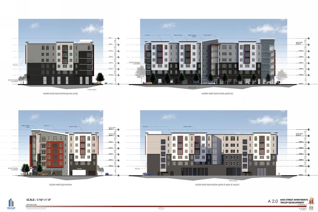
10 Figure 3: Rendering looking Northeast along 65 th Street Continuing up the residential portion of the building, materials and planar changes continue, with the additions of metal panels and four colors of cement plaster in addition to the fiber cement panels. A metal panel picture frame element with a reddish accent color also helps to define multiple pop-outs on the upper floors, as well as the common spaces for each floor just outside the elevator lobby and facing 65 th Street. The three main corners of the building closest to 65 th also vary in their materials and articulation with the end corners including eyebrow elements at each floor, and the common area near the elevator featuring a glass curtain wall or similar element. The material, color, and planar changes around the building create visual interest and break up the mass into smaller and more human-scale elements. The articulation of the building continues to the roof and parapet of the building, with different treatments and forms. Where the rectangular pop-outs around the building finish with a traditional parapet top, the elements with fiber cement materiality feature a lowsloped roof design. This design element helps highlight the enhanced material at this portion of the building and create further visual interest and articulation to the top of the building. By including variation at the roof, the building will further define its own sense of place. This is especially important for this part of the city as seen in other nearby projects and their unique design elements. The alley-side of the building includes a significant break in the building to allow light and air for residents into the outdoor terrace at the second floor. In addition to creating a more open feeling for the terrace, the break helps to further reduce the massing of the building from many angles both inside and outside of the property. Oversized windows are also


11 included for the stair towers to provide visual interest to those on the street as well as the residents using them (Figure 5). These elements combine to create a visually interesting building and one that functions well for residents and pedestrians alike. Figure 4: Rending Looking South Across 65 th Street Figure 5: Rendering Looking Northwest from Alley

12 The second-level terrace is provided for resident amenities and is accessed from three points around the common hallway. These materials include continuing the extensive use of glass, brick, metal panels, stucco, and durable materials on the ground floor with brick of different shades for each building. Along with the different brick colors for each section of the building, the accent color for the interior courtyard changes from amber to red. Interior balconies also use a metal railing type, as opposed to the exterior balconies which have a glass railing. Figure 6: 2nd-Level Outdoor Terrace Plan Design Guidelines The project site is within the Citywide Design Review area, which is reviewed under the Citywide Design Guidelines. These guidelines intend to articulate a vision for future development, promote the reuse and revitalization of existing commercial centers, promote mixed use development, encourage intensification of land use on development opportunity sites and in areas appropriate for higher densities, promote a positive environment for the residents of multifamily developments with sustained quality and adequate amenities, and encourage safe pedestrian access to adjacent transit and activity center locations.
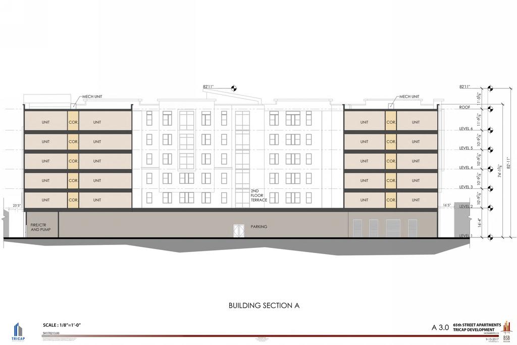
13 Key Design Principles Nodes: Site planning and project density must be appropriate for the project location. Projects located in areas near major intersections (arterial & collector streets), transit stations, or activity centers such as high activity businesses are areas referred to as nodes. At these locations, designs should support the higher density, pedestrian- and transit-friendly goals that are appropriate for these areas. Building Location and Site Organization: Site planning and building location must address continuity of the urban environment, consistency of the public streetscape, and potential impacts on existing and planned adjacent uses. Scale/Massing/Articulation: Projects must relate to the surrounding existing or emerging context with respect to building scale, mass, setbacks, and articulation. Materials/Textures/Colors: Building facades must feature high-quality materials and coordinated colors. Most design motifs should utilize multiple materials, colors and textures, in a coordinated way. Vehicle Circulation: The location and design of driveways and entryways shall minimize the impact of automobile parking and driveways on the pedestrian environment, adjacent properties and pedestrian safety. The proposed project meets the intent of the Citywide Design Guidelines in that the building engages the street with retail space and primary resident entry along 65 th Street, provides a unique architectural design, and has clearly defined entries. The proposed project is also pedestrian friendly by providing a large outdoor terrace, walking paths and landscaped planters around the building, includes stair access from the alley into the building, and architectural massing, articulation, and fenestration that breaks up building façades. Building Height, Setbacks, and Open Space The 65 th Street Apartments project proposes to have five floors of apartments above ground floor retail and single-story parking garage. The roof height of the building is 71 6, with some architectural features topping out at The development standards for height, setback, and open space and the proposed deviations are summarized in Table 3 below.
 Height (overall) 45 feet maximum 54 feet maximum 71 6 82 11 Yes, 26 5 Yes, 28 11 Setbacks; Front (65 th 0 feet up to15 feet; 1 3 No Street) 10 feet above 15 feet 1 3 Yes, 8 9")
14 Table 3: Height, Setback, and Open Space Standards Standard Required Proposed Deviation? Height (plate height) Height (overall) 45 feet maximum 54 feet maximum Yes, 26 5 Yes, Setbacks; Front (65 th 0 feet up to15 feet; 1 3 No Street) 10 feet above 15 feet 1 3 Yes, 8 9 Setbacks; Rear (N/S alley) 5 feet 5 feet No Setbacks; Side-yard (North 0 feet 5 feet No side; E/W alley) Open Space 9,000 square feet 6,575 square feet Yes, 2,425 sqft* *The open space calculation only includes the outdoor terrace and balconies. The interior amenities are not included per the code, although these spaces provide justification for the requested deviation. Figure 7: 65 th Street Elevation Height Deviation The 45-foot maximum height standard in the RMX-TO zone is the same as the base RMX zone, and is set at a more conservative height to ensure compatibility citywide between new development proposed in the zone and adjacent uses. However, the General Plan designation for this site is Urban Center Low which envisions new construction between 2 to 7 stories and up to a 4.0 floor area ratio. The proposal is consistent with these urban form characteristics in the General Plan. The building is within the scale of envisioned development for this transit area of the City. Staff finds that although the base zoning has a lower standard height, the site is in a prime location to accommodate additional height
15 between the 65 th Street Transit Station and the pedestrian tunnel into the CSU, Sacramento campus. Recently built mixed-use projects in the area include those at 6601 Folsom Boulevard and F65, each of which include buildings of 3-4 stories and continue the urban renaissance of the Transit Village Plan area. Additionally, Sacramento State and the SMUD campus just to the south of the light rail tracks includes buildings over 80 feet in height. These projects along with the proposed project represent a more transit supportive scale for this area of the city. Staff finds that the increase in height at this site will maintain a sensitive transition with the single-unit dwellings on 64 th Street to the west of the project site and the height deviation is appropriate given the purpose and intent of the applicable design guidelines and development standards. Front Setback Deviation The 10-foot stepback requirement on the upper floors of a building in the RMX-TO zone were designed to allow storefronts up to 15 foot in height at back of sidewalk thereby increasing the pedestrian friendliness along the street frontage and to preserve street tree canopies. The project proposes a reduced front stepback for the building. The reason for this site layout is the required dedication for 65 th Street improvements and the resulting narrow depth of the property. In accordance with the 65 th Street/University Transit Village Plan, the project is required to dedicate between 8 and 11 feet at various points along the street frontage. This constrains the developable area for a mixed-use project, however it will allow for enhanced on-street bicycle lanes and wider sidewalks and street tree planters. After this dedication, the narrowest portion of the site will be 110 feet in depth. Despite the right of way dedication, the project maintains space for ground floor retail, required on-site parking, and appropriate density and open space programming. Staff finds the deviation to be appropriate given the ground-floor retail and amenity spaces will activate the sidewalk and the form and massing of the building is similar to many other mixed-use projects and streetscapes throughout the city. Furthermore, it will not negatively impact public sidewalks, bike lanes, or tree canopy areas which have benefited from the right of way dedication requirements.

16 Figure 8: Right-of-Way and Setback Exhibit Open Space Deviation Open space requirements for the proposed project are 100 square feet per dwelling unit, which results in a required 9,000 square feet of outdoor open space. The project proposes a mix of private and common spaces, with the majority of space provided by the shared outdoor terrace at the second level. Private open space is divided between two vertical rows of balconies facing the terrace at each level for use by one unit each, and totaling 10 balconies. In total, approximately 6,575 square feet of private and open space is provided in the project for use by the future residents. In addition to these open spaces, the project provides approximately 5,600 square feet of interior shared spaces within the building for amenity and gathering places. Although the interior areas cannot be counted toward the open space requirement, these areas are important to enhance livability. The ground level amenity space will provide shared facilities for the residents of the building and the study corners facing 65 th Street at each level will provide smaller space to congregate, meeting the intent of the open space requirement. Staff finds that the combination of the outdoor and indoor spaces are appropriate and consistent with the intent of providing open space for multi-unit projects. The spaces are proposed to be well-programmed, provide a variety of desirable amenities, and will be equally accessible to all units within the building.
 Bicycle Long Term 0.5 per unit (45 spaces) +2 52+unit No for retail use racks Bicycle Short Term 0.")

17 Figure 9: Aerial Rendering Looking Northwest Parking Vehicle and Bicycle The required and proposed parking is summarized below in Table 4. Table 4: Parking Requirements Required Provided Deviation? Vehicle Retail 0 0 No Vehicle Residential 0.5 per unit (45 spaces 46 No minimum) Bicycle Long Term 0.5 per unit (45 spaces) unit No for retail use racks Bicycle Short Term 0.1 per unit (9 spaces) +2 for retail use 12 No The 65 th Street Apartments project is located in the Urban Parking District, and the Planning and Development Code requires vehicle parking to be provided for the residential use. One vehicle parking space for every two residential units is required. Bicycle parking requirements for multi-unit buildings without private garages or dedicated storage space require one long term bicycle parking space for every two units, and a minimum of one short term bicycle parking space per 10 units. The project is proposing bicycle storage rooms within the garage for the residents as long-term parking, as well as wall racks in the dwelling units to supplement for anticipated use of the ground-floor rooms. Short-term bicycle parking spaces will be provided at a number that meet or
18 exceed the code requirement. The long term bike parking in the garage is accessible through a door along the 65 th Street frontage, and residents storing bicycles in their units may use the elevator. Short term bike parking would be provided along 65 th Street between street lights and trees.
19 Attachment 3 PROPOSED FINDINGS OF FACT AND CONDITIONS OF APPROVAL 65 th Street Apartments Project (DR17-220) 1325 & th Street, Sacramento, CA FINDINGS OF FACT A. Environmental Determination: Exemption: Infill Development (15322) The Community Development Department, Environmental Planning Services Division has reviewed this project and determined that it is exempt from the provisions of the California Environmental Quality Act (CEQA) under Class 32, CEQA Guidelines Section number 15332, In-fill Development Projects; in that the project is consistent with the applicable general plan designation and all applicable general plan policies as well as with applicable zoning designation and regulations; the proposed development occurs within city limits on a project site of no more than five acres substantially surrounded by urban uses; the project site has no value as habitat for endangered, rare or threatened species; approval of the project would not result in any significant effects relating to traffic, historic resources, noise, air quality, or water quality; and the site can be adequately served by all required utilities and public services. B. Site Plan and Design Review to construct a new mixed-use building with ground floor commercial and 90 residential units on approximately 0.75 acres in the Residential Mixed-Use (RMX-TO) zone and within the Transit Overlay zone. The Site Plan and Design Review with deviations for height, front setback, and open space as noted in the staff report, is approved based on the following findings, and consistent with section (B): 1. The design, layout, and physical characteristics of the proposed development are consistent with the general plan and the 65 th Street/University Transit Village Plan, in that the project provides a mix of housing and retail to increase transit ridership and pedestrian activity in the neighborhood. The building height is consistent with the urban form vision for the General Plan designation of the Urban Center Low, the maximum floor area ratio, and the location near the university and light rail station. 2. The design, layout, and physical characteristics of the proposed development are consistent with the purpose and intent of the applicable design guidelines and development standards, in that the building engages the street frontage with active ground floor commercial uses and vehicle parking is accessed from the public alley within an enclosed parking structure which is appropriately screened from street view. The deviation for height (allowed increase) at this site will maintain a sensitive transition
20 between single-unit dwellings and any other sensitive uses in the surrounding area meeting the purpose and intent of the standard. The reduction in building setback and stepback will not negatively impact public sidewalks, bike lanes, or tree canopy areas, which will benefit from the right of way dedication requirements. The combination of the outdoor and indoor open spaces is appropriate and consistent with the intent of providing adequate open space for multi-unit projects. The spaces are proposed to be well-programmed, provide a variety of desirable amenities, and will be equally accessible to all units within the building, consistent with the purpose and intent of the open space requirement. 3. All streets and other public access ways and facilities, parking facilities, and utility infrastructure are adequate to serve the proposed development and comply with all applicable design guidelines and development standards, in that the project will dedicate additional public right-of-way along the frontage of the development to facilitate the construction of a new protected bicycle lane and pedestrian infrastructure as envisioned in the 65 th Street/University Transit Village Plan. All other sidewalk and alley infrastructure will be repaired/replaced to meet City standards and appropriate utility infrastructure is available to service the site for the proposed project. 4. The design, layout, and physical characteristics of the proposed development are visually and functionally compatible with the surrounding neighborhood, in that the building incorporates a mix of building materials with articulated facades on all sides to help break up the overall massing, and the project provides needed housing within walking distance of a transit station and university. 5. The design, layout, and physical characteristics of the proposed development ensure energy consumption is minimized, along with direct and indirect use of renewable energy sources for the proposed project. 6. The design, layout, and physical characteristics of the proposed development are not detrimental to the public health, safety, convenience, or welfare of persons residing, working, visiting, or recreating in the surrounding neighborhood and will not result in the creation of a nuisance, in that adequate private and common outdoor open space has been provided for the apartments along with interior resident amenities, and onsite parking is provided to work in concert with enhanced bicycle and pedestrian amenities to encourage use of alternate modes of transportation. Active ground floor retail uses, the outdoor terrace, and abundant windows increase eyes on the street and contribute positively toward neighborhood safety.
21 CONDITIONS OF APPROVAL Planning Site Design B1. The building shall be sited as shown on the exhibits and final approved plans. B2. The buildings shall have building setbacks, entries, and concrete hardscape at the alleys as shown on the exhibits and final approved plans. B3. The project shall have a landscape design as shown on the final approved plans. B4. Auto access and parking layout shall be as shown on the exhibits and final approved plans. B5. The project shall provide vehicle and bicycle parking as indicated on the final approved plans and consistent with city code requirements. The design and location of the bicycle parking facilities for long-term and short-term parking shall be reviewed and approved by Planning Staff. B6. Each residential unit shall have a minimum of one bicycle wall rack. Residential units with three or more bedrooms shall provide bicycle wall racks at a ratio of 1 per 2 bedrooms. B7. The trash enclosures shall be located at the interior of the building as shown on the final approved plans. B8. No signage has been reviewed or approved through the Site Plan and Design Review process. All building signage shall conform to the sign code standards found in City Code section , and shall be reviewed under the separate sign permitting process. Building Design B9. Building façades shall vary in material application and color as shown on the final approved plans. B10. Each building elevation shall have a consistency of detail, material quality, and articulation as indicated on the final approved plans.
22 B11. The building materials, color, and their application shall be as indicated on the final approved plans and color/material board, and shall include fiber cement panels, metal panels, metal grills, board form concrete, and cement plaster. Any changes shall require additional Planning and Design Review staff review and approval. B12. All cement plaster used for exterior finishes shall be of a smooth finish. B13. Provide glazing as clear as possible at all ground level fenestration and the study corners facing 65 th Street, or as approved by design staff. B14. The two balconies at each residential level constituting approximately 130 square feet each, shall be constructed as shown on the final approved plans. B15. The building base shall include planters and have a color consistent with the final approved plans. B16. The building shall include a minimum of 6,575 square feet of outdoor open space for all building residents as shown on the final approved plans. B17. The building shall not exceed an overall height of 83 feet as provided in the reports and exhibits. B18. Any site or rooftop mechanical equipment proposed shall be screened as necessary to fit in with the design of the project, and not be visible from any street views. Equipment such as new SMUD boxes, etc. shall be screened from pedestrian views, and not in the city planter strip or sidewalk. The applicant shall submit final mechanical locations and screening to Planning and Design Review staff for review and approval as part of building plan check. B19. The building shall comply with the vertical chase requirements for mixed use buildings, per Section (A) of the Sacramento City Code. B20. Lighting: a. The type and location of the outdoor and exterior lighting (buildings, parking areas, etc.) shall be approved by Planning and Design Review staff during building plan check. Lighting shall be provided at the ground-level on all sides of the building and at each building entry. b. Per Section (B), exterior lighting shall reflect away from residential areas and public streets. Fixtures shall be unobtrusive and complementary to the architectural design of the building. Lighting shall be
23 General designed so as not to produce hazardous and annoying glare to motorists and building occupants, adjacent residents, or the general public. c. The design of the light fixtures of the parking garages shall be reviewed and approved by Planning and Design Staff. Standard ceiling pack light fixtures visible from pedestrian sidewalk view shall be avoided. B21. Development of this site shall be in compliance with the attached final approved plans and exhibits, except as otherwise conditioned. Any changes to the final set of plans shall be subject to additional review and approval. B22. The mixed-use project shall have an on-site manager per Section of the Sacramento City Code. B23. A minimum of two (2) Community Assistants shall reside on the site as an added security measure. B24. A sign indicating a 24-hour emergency phone number and contact person shall be kept current and posted on the building in a clearly visible place as a Good Neighbor Policy. B25. No building permit shall be applied for until after the expiration of the 10-day appeal period, unless approved through a concurrent review. If an appeal is filed, no permit shall be issued until final approval is received. B26. The applicant shall obtain all necessary building, sign, and/or encroachment permits prior to construction. B27. The applicant shall merge the parcels of the project site before final certificate of occupancy. B28. Final occupancy shall be subject to approval an involve an on-site inspection by Planning Staff. B29. The approval shall be deemed automatically revoked unless required permits have been issued and construction begun within three years of the date of approval. Prior to expiration, an extension of time may be processed by request of the applicant.
24 Police B30. Exterior lighting shall be white light using LED lamps with full cutoff fixtures to limit glare and light trespass. Color temperature shall be between 2700K and 4100K with a color rendering index of 75 or better and a light loss factor of.95 or better. B31. Entry drives, drive aisles, parking and bicycle parking shall be illuminated to a maintained minimum of 1.5 foot candles per square foot of parking area at a 6:1 average to minimum ratio. B32. Exterior walkways, alcoves and passageways shall be illuminated to a maintained minimum of 1/3 foot candles per square foot of surface area at a 6:1 average to minimum ratio. B33. Exterior lighting distribution and fixtures shall be approved by the Sacramento Police Department CPTED Sergeant (or designee) prior to issuance of a building permit. B34. All mature landscaping shall follow the two-foot, six-foot rule. All landscaping shall be ground cover, two feet or less and lower tree canopies of mature trees shall be above six feet. This increases natural surveillance and eliminates hiding areas within the landscape. B35. Tree canopies shall not interfere with or block lighting. This creates shadows and areas of concealment. The landscaping plan shall allow for proper illumination and visibility regarding lighting and surveillance cameras through the maturity of trees and shrubs. B36. No more than 33 percent of the square footage of the windows and clear doors shall be blocked by advertising, signs, shelves or anything else. All advertising, signs, and shelving shall be placed and maintained in a manner that ensures that law enforcement personnel have a clear and unobstructed view of the interior of the premises, including the area in which the cash registers are maintained, from the exterior public sidewalk or entrance to the premises. All signs shall comply with the City Code. B37. Applicant shall install a Knox Box for police access to the common areas of the property after hours.
25 Public Works B38. Dedicate additional right-of-way (if needed) and construct an 8-ft wide buffered bike lane, relocate the vertical curb and gutter and construct a 15-ft wide pedestrian zone along 65th Street adjacent to the subject property consistent with the 65th Street Station Area Plan as shown on the preliminary off-site plan dated 9/26/2017 to the satisfaction of the Department of Public Works. B39. All right-of-way and street improvement transitions that result from changing the right-of-way of any street shall be located, designed and constructed to the satisfaction of the Department of Public Works. The center lines of such streets shall be aligned. B40. The applicant shall repair, or replace/reconstruct (in concrete) any deteriorated portion of the alleys adjacent to the subject property (from the subject property to the nearest intersection) per City standards to the satisfaction of the Department of Public Works. B41. All new and existing driveways shall be designed and constructed to City Standards to the satisfaction of the Department of Public Works. B42. The applicant shall apply for and obtain an encroachment permit for any portions of the building that will be encroaching into the public right-of-way. B43. The site plan shall conform to the parking requirements set forth in City Code (Development standards for off-street parking facilities, Zoning Ordinance). B44. The applicant shall pay a fair share contribution to fund the City s Traffic Operation Center to implement ITS improvements on all major streets including Elvas Avenue, Folsom Boulevard and 65th Street per the 65th Street Station Area Plan and to the satisfaction of the Department of Public Works. Contact Sheri Smith from the Special District unit at for more information. B45. The applicant shall pay a fair share contribution to fund the designated pedestrian and bicycle improvements in the 65th Street Station Area Plan to the satisfaction of the Department of Public Works. Contact Sheri Smith from the Special District unit at for more information. B46. The applicant shall pay fair share contributions to fund the cost of widening the westbound U.S. 50 off ramp at 65th Street to the satisfaction of the Department of
26 Public Works per the 65th Street Station Area Plan. Contact Sheri Smith from the Special District unit at for more information. B47. The design of walls fences and signage near intersections and driveways shall allow stopping sight distance per Caltrans standards and comply with City Code Section (25' sight triangle). Walls shall be set back 3' behind the sight line needed for stopping sight distance to allow sufficient room for pilasters. Landscaping in the area required for adequate stopping sight distance shall be limited 3.5' in height at maturity. The area of exclusion shall be determined by the Department of Public Works. Public Works, Electrical Division B48. The developer shall relocate the existing street lights to the new sites. The final new sites will be determined when civil plans are submitted for review. The City may assist the developer in phasing the relocation, if requested. Regional San B49. Developing this property will require the payment of Regional San sewer impact fees (connection fees). Regional San sewer impact fees shall be paid prior to the issuance of building permits. For questions pertaining to Regional San sewer impact fees, please contact the Sewer Fee Quote Desk at (916) SMUD B50. In the event the Applicant requires the relocation or removal of existing SMUD facilities on or adjacent to the subject property, the Applicant shall coordinate with SMUD. The Applicant shall be responsible for the cost of relocation or removal. B51. SMUD reserves the right to use any portion of its easements on or adjacent to the subject property that it reasonably needs and shall not be responsible for any damages to the developed property within said easement that unreasonably interferes with those needs. B52. The Applicant shall not place any building foundations within 5-feet of any SMUD trench to maintain adequate trench integrity. The Applicant shall verify specific clearance requirements for other utilities (e.g., Gas, Telephone, etc.). B53. The Applicant shall comply with SMUD siting requirements (e.g., panel size/location, clearances from SMUD equipment, transformer location, service conductors). Information regarding SMUD siting requirements can be found at:
27 B54. The Applicant shall provide all-weather vehicular access for service vehicles that are up to 26,000 pounds. At a minimum: (a) the drivable surface shall be 20-feet wide; and (b) all SMUD underground equipment and appurtenances shall be within 15-feet from the drivable surface. Utilities B55. Per City Code Section, , multiple water service to a single lot or parcel may be allowed if approved by DOU Development Review and Operations and Maintenance staff. Any new water services (other than fire) shall be metered. Excess services shall be abandoned to the satisfaction of the DOU. B56. Prior to or concurrent with the submittal of improvement plans, prepare a project specific water study for review and approval by the DOU. The water distribution system shall be designed to satisfy the more critical of the two following conditions: (1) at maximum day peak hour demand, the operating or "residual" pressure at all water service connections shall be at least 30 pounds per square inch, (2) at average maximum day demand plus fire flow, the operating or "residual" pressure in the area of the fire shall not be less than 20 pounds per square inch. The water study shall determine if the existing and proposed water distribution system is adequate to supply fire flow demands for the project. A water supply test may be required for this project. The applicant is advised to contact the City of Sacramento Utilities Department Water Planning Section ( ) at the early planning stages to address any water related requirements. B57. Common landscaping areas over 5,000 square feet shall have a separate street tap for a metered irrigation service. B58. Projects that generates 25 ESD s or more will require a sanitary sewer Plan Study as described in Section 9 of the City Design and Procedures Manual. This study and shed map shall be approved by the DOU. The applicant is advised to contact the City of Sacramento Utilities Department Sewer Planning Section ( ) at the early planning stages to address any sewer related requirements. B59. This project is served by the Combined Sewer System (CSS). Therefore, the developer/property owner will be required to pay the Combined Sewer System Development Fee prior to the issuance of building permit. The fee will be used for
28 improvements to the CSS. The applicant is recommended to contact the Department of Utilities Development Services at for a CSS fee estimate. B60. The existing City drainage system that fronts this project is severely undersized with a history of localized street flooding. Therefore, if the development of this site increases imperviousness, the site will be required to comply with the current drainage design standards. To meet this requirement 8,200 cubic feet of detention must be provided per each additional acre of impervious area. The maximum discharge rate must be limited to 0.16 cfs/acre. The required detention volume can be partially or fully mitigated by implementing Low Impact Development (LID) features such as Stormwater planters and porous pavement, provided these features conform to the DOU s Hydromodification Management Plan (HMP) requirements. Designer shall utilize the latest edition of the Sacramento Area Hydrology Model (SAHM) when using LID features. The applicant is advised to contact the City of Sacramento Utilities Department Drainage Planning Section ( ) at the early planning stages to address any drainage related requirements. (Note: A maintenance agreement may be required for detention and Low Impact Development (LID) features.) B61. The onsite water, sewer, and storm drain systems shall be private systems maintained by the owner or other approved entity. B62. Finished floor elevations shall be a minimum of 6-inches above the 100-year HGL or 1-foot above the overland flow release elevation, whichever is higher or as approved by the DOU. B63. Per City Code, the applicant may not develop the project in any way that obstructs, impedes, or interferes with the natural flow of existing off-site drainage that crosses the property. The project shall construct the required public and/or private infrastructure to handle off-site runoff to the satisfaction of the DOU. If private infrastructure is constructed to handle off-site runoff, the applicant shall dedicate the required private easements and/or, at the discretion of the DOU, the applicant shall enter into and record an Agreement for Maintenance of Drainage with the City, in a form acceptable to the City Attorney. B64. No more than 6,000 square feet is allowed to sheet drain over a public sidewalk. If the area is larger than 6,000 square feet then an on-site surface drainage system is required and shall be connected to the street drainage system by means of a storm drain service tap. All on-site systems shall be designed to the standard specified in the DOU onsite manual.
29 B65. A grading plan showing existing and proposed elevations is required. Adjacent off-site topography shall also be shown to the extent necessary to determine impacts to existing surface drainage paths. No grading shall occur until the grading plan has been reviewed and approved by the DOU. B66. The applicant must comply with the City of Sacramento's Grading, Erosion and Sediment Control Ordinance. This ordinance requires the applicant to show erosion and sediment control methods on the construction drawings. These plans shall also show the methods to control urban runoff pollution from the project site during construction. B67. Foundation or basement dewatering discharges to the CSS will not be allowed. The CSS does not have adequate capacity to allow for dewatering discharges for foundations or basements. Foundations and basements shall be designed without the need for dewatering. Urban Forestry B68. As part of the future offsite improvement plan review for this project, the applicant shall consult with Urban Forest Services to review and approve any necessary tree removals and proposed tree species and average spacing standards as required to implement the 65 th Street/University Transit Village Plan. Advisory Notes Planning ADV 1 Filtration should be certified by the American Society of Heating, Refrigerating and Air-Conditioning Engineers (ASH RAE), and equivalent to or greater than that provided by MERV 13 filters (as defined by ASHRAE standard 52.2). Enhanced filtration should be provided to all units in the building. A licensed mechanical engineer, or an individual authorized by California Business and Professions Code Sections to design mechanical ventilation systems, should be consulted. Building permit documents should incorporate all designs and details necessary for the construction of the enhanced ventilation system. The ventilation systems installed should be properly maintained as specified by the manufacturer. A fixed notice should be placed on the filter compartment door of each ventilation unit advising that MERV 13 (or greater), or equivalent filters should be used.
30 Fire ADV 2 All turning radii for fire access shall be designed as 35 inside and 55 outside. CFC ADV 3 ADV 4 ADV 5 Roads used for Fire Department access shall have an unobstructed width of not less than 20 and unobstructed vertical clearance of 13 6 or more. CFC Fire Apparatus access roads shall be designed and maintained to support the imposed loads of fire apparatus and shall be surfaced to provide allweather driving capabilities. CFC Provide the required fire hydrants in accordance with CFC 507 and Appendix C, Section C105. Note: Appendix C, Table C105.1 has been amended by the City of Sacramento so that the required number of hydrants is based on the required GPM of Table B105.1 before any allowed fire sprinkler reduction with modified spacing distances between hydrants. ADV 6 ADV 7 ADV 8 Fire service mains shall not cross property lines unless a reciprocal easement agreement is provided. A reciprocal ingress egress agreement shall be provided for review by City Attorney for all shared driveways being used for Fire Department access. Maintenance agreements shall be provided for the interior roadways of the proposed complex and for the fire protection systems. The agreement shall be record with the Public Recorders Office having jurisdiction and shall provide for the following: a. Provisions for the necessary repair and maintenance of the roadway surface b. Removal of vegetation overgrowing the roadway and infringing on the roadway clear vertical height of thirteen feet six inches (13 6 ) and/or width of twenty feet (20 ) c. Provisions for the maintenance, repair, and/or replacement of NO PARKING-FIRE LANE signage or striping d. Provisions for the necessary repair and maintenance of vehicle and pedestrian access gates and opening systems
31 e. Unrestricted use of and access to the roadways covered by the agreements. f. Provisions for the control of vehicle parking in prohibited areas and a mechanism for the removal of vehicles illegally parked. g. Maintenance and timely repair of all fire protection systems, including but not limited to hydrants, fire alarm systems and fire sprinklers. ADV 9 ADV 10 ADV 11 Timing and Installation. When fire protection, including fire apparatus access roads and water supplies for fire protection, is required to be installed, such protection shall be installed and made serviceable prior to and during the time of construction. CFC Provide a water flow test. (Make arrangements at the Permit Center walkin counter: 300 Richards Blvd, Sacramento, CA 95814). CFC The furthest projection of the exterior wall of a building shall be accessible from within 150 ft of an approved Fire Department access road and water supply as measured by an unobstructed route around the exterior of the building. (CFC ) ADV 12 Provide appropriate Knox access for site. CFC Section 506 ADV 13 ADV 14 ADV 15 An automatic fire sprinkler system shall be installed in any portion of a building when the floor area of the building exceeds 3,599 square feet. CFC Fire Code Amendments (a) Locate and identify Fire Department Connections (FDCs) on address side of building no further than 50 feet and no closer than 15 feet from a fire hydrant and not more than 30 feet from a paved roadway. An approved fire control room shall be provided for all buildings protected by an automatic fire extinguishing system. The room shall contain all system control valves, fire alarm control panels and other fire equipment required by the Fire Code Official. Fire Control rooms shall be located within the building at a location approved by the Fire Code Official, and shall be provided with a means to access the room directly from the exterior. Durable signage shall be provided on the exterior side of the access door to identify the fire control room. Fire Control rooms shall not be less than 50 square feet for rooms without a fire pump and 200 square feet when a fire pump is present. CFC Amendments
32 ADV 16 ADV 17 ADV 18 Provide a secondary access. The chief is authorized to require two means of access for sites serving 40 or more dwelling units and/or when it is determined by the chief that access by a single road might be impaired by vehicle congestion... CFC Provide at least 5 setback for second story bedroom windows to allow for fire ladder rescue operations. Provide clear access to buildings openings, free to landscaping and other obstructions. Exterior doors and openings required by this code or the Building Code shall be maintained readily accessible for emergency access by the Fire Department. CFC 504. Minimum gate width shall provide 20 feet clear access. Gate shall have AC power and be provided with Key override switch (Knox) and Radio operated controller (Click2Enter). For gates that do not fail safe in the open position upon loss of AC power or are provided with battery back-up power, an approved pedestrian gate shall be installed within 10 feet of all vehicle gates. An approved key box (Knox) shall be installed at least 48 inches above grade on the outside of the gate. It shall be provided with a key to open the pedestrian gate. Finance ADV 19 This project is located within the 65th Street Area Fee District and, depending on the credit given for the existing use, will be required to pay the fee prior to building permit. Regional San ADV 20 The City of Sacramento (City) is responsible for providing local sewer service to the proposed project site via their local sanitary sewer collection system. Regional San is responsible for the conveyance of wastewater from the City s collection system to the Sacramento Regional Wastewater Treatment Plant (SRWTP). SMUD ADV 21 Any necessary future SMUD facilities located on the Applicant s property shall require a dedicated SMUD easement. This will be determined prior to SMUD performing work on the Applicant s property.
33 Utilities ADV 22 ADV 23 The proposed project is located in a Zone X on the Federal Emergency Management Agency (FEMA) Flood Insurance Rate Maps (FIRMs). Accordingly, the project site lies in an area with no requirements to elevate or flood proof. Currently, two types of groundwater discharges are recognized by the DOU; limited term) discharges and long-term discharges. These types of discharges are described as follows: a. "limited discharges" are short groundwater discharges of 30- daysduration or less. Limited discharges must be approved through the DOU by an approval letter. b. "long-term discharges" are groundwater discharges of greater duration than 30-days. Long-term discharge must be approved through the DOU and the City Manager through a Memorandum of Understanding (MOU) process. Note: All discharges must also be permitted by the Sacramento Regional Sanitation Sewer District. Table of Contents: Exhibit A: Project Plans

34
35
36
37 COMPACT COMPACT COMPACT COMPACT COMPACT COMPACT COMPACT COMPACT COMPACT COMPACT COMPACT 65TH STREET 65TH STREET FOLSOM BOULEVARD ALLEY FIRE CTR. & PUMP COMMERCIAL 2,800 ± SF RAISED PLANTER WALL LEASING/CLUB 4,900 ± SF 17 RED BAND ABOVE 14-8" TO UNDERSIDE BIKE STORAGE COMPACT COMPACT COMPACT COMPACT COMPACT COMPACT 6 11 ELVAS AVENUE DECK ENTRY MPOE TRASH/ RECYCLE 12 DOM. PUMP BIKE STOR BIKE STOR ALLEY NOTES 1. All distances shown hereon ar 2. This survey was prepared from Old Republic Title Company d liability is assumed for matters affect the boundary lines, exce LEGEND 3. The types, locations, sizes and topographic survey were obtai cautioned that only actual exc of such underground utilities. ( unknown underground utilities completeness or accuracy of i encountered, but which are no ROW TAKE AREA 65TH STREET SECTION- WEST HALF HORIZONTAL SCALE: 1"=5' VERTICAL SCALE: NTS CARTWRIGHT PRELIMINARY OFF-SITE PLAN - 65TH ST FRONTAGE IMPROVEMENTS C1.0 E N G I N E E R S 4180 Douglas Blvd, Suite 200 Granite Bay, California T (916) TH STREET APARTMENTS SACRAMENTO, CA 09/26/2017 SCALE: 1'=20' DRAWN BY: WY
38

39
40
41
42
43
44
45

46
47

48 S2 S1
49 P. O. Box Sacramento, CA July 15, 2017 Michael Hanebutt Assistant Planner City of Sacramento Dear Michael, Thank you for sending us the project application DR th Street Apartments. Before receiving your communication, the ESIA Board had already heard a presentation on the project from Phil Harvey, representing the project applicants. We were favorably impressed with his description of the project, and we are glad to have the opportunity to review and comment on the complete application. At its monthly meeting held on July10, 2017, the ESIA Board was generally supportive of the project. It provides a significant amount of housing in an area well served by public transit, and since it is located within a commercial area it should not have negative impacts on East Sacramento residents. We think that the project might be even more successful if it were directed more explicitly towards students at Sacramento State. Despite recent residential construction on campus, there remains a real shortage of conveniently located student housing. If you should have any questions, please send me an or give me a call. Thank you for giving us the opportunity to comment. Sincerely, Paul Noble, President East Sacramento Improvement Association noblep5@comcast.net (916)
50 Michael Hanebutt From: Sent: To: Cc: Subject: Jordan Lang Thursday, July 20, :15 AM Michael Hanebutt 'Molly Wagner'; Jim Brown RE: DR th Street Apartments: project routing -- comments from SABA Hello Michael: Thank you for routing this project to SABA for review. We appreciate the proposed project s intent to increase residential density in the transit oriented corridor between the light rail station and the Sacramento State campus. The project applicant proposes to provide the required amount of long term bicycle parking for building residents. However, because the project is located within a ¼ mile bicycle ride to the university campus, we believe a greater amount of long term bicycle parking should be provided. Many if not most of the project s residents will be able to function easily without a personal motor vehicle. We request that better access for bicycles be provided to the interior bicycle storage room closest to 65 th Street. As shown on Sheet A 1.1, bicyclists will need to squeeze between parked cars to get to either set of entry doors to the storage room. We suggest an access corridor at least 6 feet wide be provided to the storage room for walking bicycles to or from the room. Also, we suggest that the project provide space and common tools for minor bicycle maintenance and repair in one of the bicycle storage rooms (e.g. tire inflation and flat fixing tools). Such a facility will greatly enhance the residents ability to rely on bicycles for transportation. Thank you for considering our comments, Jordan Lang Project Analyst SABA From: Michael Hanebutt [mailto:mhanebutt@cityofsacramento.org] Sent: Friday, June 23, :24 PM Subject: DR th Street Apartments: project routing Please find the attached application and plans for the 65 th Street Apartments project, located at th Street. This proposal requests to develop a residential mixed use project with 90 apartments, community space, and approximately 2,800 square feet of retail uses with internal garage parking access from the adjacent alleys. The site currently has vacant commercial buildings and is within The 65th Street/University Transit Village between Sac State and the 65 th Street light rail station. This project requires Site Plan and Design Review with deviations for height and open space. Initial comments for this project are due to staff by July 21, Please let me know if you have any questions or concerns. Thanks, Michael Hanebutt Assistant Planner for Central City and East Sacramento 1
 and we offer the following comments.")
51 7/23/2017 VIA Michael Hanebutt City of Sacramento Community Development Department 300 Richards Boulevard, 3 rd Floor Sacramento, CA RE: 65 th Street Apartments (DR17-220) Dear Mr. Hanebutt: WALKSacramento has reviewed the routing for 65 th Street Apartments (DR17-220) and we offer the following comments. The project consists of 90 market rate apartments with 5,000 square feet of outdoor community space, outdoor patio space behind the public sidewalk, 45 long-term and 10 short-term bike parking spaces, 46 vehicle parking spaces on the first floor with access from an alley, and approximately 2,800 square feet of retail. The project will require the demolition of two existing single-story existing commercial buildings. The 65 th Street Apartment project is proposed for a site within the 65 th Street/University Transit Village plan area. The area is transforming into a mixed-use district with new restaurants, stores, services and housing filling vacant sites and replacing older buildings. In addition to being close to many walkable destinations, the project site is less than 600 feet north of the University/65 th Street Station and about 300 feet south of the Hornet Crossing pedestrian and bicycle tunnel to Sacramento State. WALKSacramento recommendations to improve the walking- and biking-supportive elements of 65 th Street Apartments are summarized in the following bullet points. Include Juliette balconies, built-in window seats or built-in window desks that might lead to more activity at the bedroom windows and provide more eyes on the street. Add a stairwell in the lobby, preferably with the landing between the street entrance and the elevators, to encourage use of the stairs for better health. Add stairwell doors within the garage to allow stairs at the rear of the building to be accessed without exiting the building to encourage use of the stairs for better health. Additional outdoor seating and bike racks should be installed near the commercial space without encroaching upon the pedestrian space to further activate the street. Retain or replace 65 th Street pedestrian lights for pedestrian safety. Provide illumination on the alley for safer night-time walking. Mark a pedestrian crossing at the south leg of 65th Street at Elvas Avenue to safely accommodate future pedestrian demand. New development that facilitates, encourages and motivates people to walk and bike, combined with streets that are walkable and bikeable, is needed to improve the health of our residents th Street, Suite 203 Sacramento, CA
52 Page 2 of 3 July 23, 2017 Many people don t achieve the recommended minimal amount of daily physical activity, often due to the obstacles to walking and biking created by the built environment in which they live. 65 th Street Apartments will be in a prime location, but there are a few elements of the site and building design that won t achieve the same level of support for daily physical activity. These elements involve natural surveillance, access, patio seating and bike parking, lighting, and street crossing. Goal 15 of the 65 th Street/University Transit Village Plan is to Create a lively, pedestrian oriented public environment by clearly defining public areas, increasing safety, and adding interest to building frontage. The planters and low fencing around the residential patio area on the 65 th Street side will help define public and private areas, and the building elevation will greatly improve the streetscape over what it is today. Eyes on the street, a type of natural surveillance, is important because it not only helps people in the public space feel safer and therefore use the public space more, but it improves the sense of ownership and community membership of the people within the building, provided they have a view of the outdoor public space. It appears that more than half of the building s 65 th Street and Elvas Ave Folsom Blvd Alley ground-level frontages will be windows and the lobby entrance will face the street. Therefore, the ground floor will provide some eyes on the street and alley that will increase safety, assuming the windows are sufficiently transparent to allow views both from within and from outside. Floors 2-6 have primarily bedroom windows facing 65 th Street, the two adjacent alleys, and the 2 nd floor terrace. There are also windows between each floor in the stairwells at the rear of the building, and floor-to-ceiling windows in each apartment common room and the study alcove on each floor. Considering that these apartments are intended for Sac State students and the public, and that the apartments have up to four nearly equal-sized bedrooms and no master bedrooms, the bedrooms might be used for significantly more than just sleeping and dressing. In that case, the bedrooms contribution to eyes on the street could be enhanced by including Juliette balconies, built-in window seats or built-in window desks that might lead to more activity at the bedroom windows. Stairwells can be an important element of the built environment that facilitates daily physical activity. Stair use can be encouraged by locating the stairs in a prominent position relative to the elevator. For stairs to support daily physical activity, residents must be able to easily access stairs both leaving and arriving. However, the 65 th Street Apartments project doesn t include a stairwell in the lobby that could be conveniently used instead of the elevator. Although the stairwells at the rear of the building contain windows which encourage greater stair use by providing daylighting and views of the outside, the placement of the stairs at the alley discourages, or prevents, access from the lobby. Daily physical activity could be significantly increased by adding a stairwell in the lobby, preferably with the landing between the street entrance and the elevators, and adding stairwell doors within the garage. The 65 th Street sidewalk has adequate clear space for pedestrians while also providing sufficient space for shade trees and pedestrian lighting between the street and the walkway. Outdoor seating for apartment residents is behind the pedestrian walkway. The commercial space is lacking outdoor seating and bike racks, though. The street could be more activated if patrons of the commercial space were to occupy outdoor space. Additional outdoor seating and bike racks th Street, Suite 203 Sacramento, CA
53 Page 3 of 3 July 23, 2017 should be installed near the commercial space without encroaching upon the pedestrian space. Lighting is important to increase safety at night, from both a Crime Prevention Through Environmental Design (CPTED) perspective and a mobility perspective. People walking at night should be able to see their surroundings and be seen by people in the area for personal safety. They should also be able to see the surface they are walking on the prevent falls. There appears to be three pedestrian lights along the project s 65 th Street frontage. These lights provide illumination not only for pedestrians, but may also illuminate the bike lane between street lights. We recommend that the 65 th Street pedestrian lights remain or are replaced with new pedestrian lights. The plans don t seem to indicate locations for pedestrian lights in the alleys, but alley lighting will be very important for pedestrian and personal safety. WALKSacramento recommends the project provide illumination sufficient for pedestrian travel on the alley for safer night-time walking. We are pleased to see that both alleys will have sidewalks. The Elvas Ave Folsom Blvd Alley has a sidewalk that is generously wide, narrowing to about 6 feet at the corner of the transition to the 65 th St 66 th St Alley sidewalk in the rear. We re also pleased to see that a sidewalk is on the project side of the rear alley. Unfortunately, it s width is only four feet between the curb and the greenscreen planter. The vegetation covering the garage venting is a good pedestrian amenity and it will present a much more pleasant view than without the greenscreens. In consideration of the narrow alley sidewalk that provide access to the stairwells, WALKSacramento recommends adding a stairwell to the lobby. The 65t Street Apartments project will increase pedestrian traffic along 65 th Street, and there will be more people from west of 65 th Street and south of Elvas Avenue. Pedestrians are currently prohibited from crossing 65 th Street at the south side of Elvas Avenue. WALKSacramento recommends allowing and marking a pedestrian crossing at the south leg of 65 th Street at Elvas Avenue. WALKSacramento is working to support increased physical activity such as walking and bicycling in local neighborhoods as well as helping to create community environments that support walking and bicycling. The benefits include improved physical fitness, less motor vehicle traffic congestion, better air quality, and a stronger sense of cohesion and safety in local neighborhoods. Thank you for your consideration of these comments and recommendations. If you have questions or need additional information, please don t hesitate to contact me. Sincerely, Chris Holm Project Manager Attachment: Development Checklist for Biking and Walking th Street, Suite 203 Sacramento, CA
54 Page 1 of 3 DEVELOPMENT CHECKLIST for BIKING and WALKING Prepared by WALKSacramento and SABA (Sacramento Area Bicycle Advocates) September 2012 This checklist is provided to give an indication of design, engineering, and policy elements that we consider when reviewing development projects. POLICIES Walking and biking is a priority Adopted a policy to develop a full multi-modal and ADA accessible transportation system Project Review and Comment POLICY CONSIDERATIONS Pedestrian Master Plan Bicycle Master Plan Regional Blueprint Regional Blueprint Consistent General Plans Adopted Climate Action Plans Subdivision ordinances to support pedestrian and bicycle access and safety Zoning ordinance to support pedestrian and bicycle access and safety ENGINEERING SIDEWALKS & BIKELANES ON BOTH SIDES OF MAJOR ROADWAYS o Pedestrian Level of Service C or better on arterials o Bicycle Level of Service C or better on arterials SAFE CROSSINGS FOR PEDESTRIANS o every feet on major arterials o well lit, marked crosswalks o audible signals & count-down signals o median refuge islands SPEED MANAGEMENT o Speed limits based on safety of pedestrians and bicyclists o Implement road diets where there is excess lane capacity STREET DESIGN STANDARDS o Maximize pedestrian and bicyclist safety o Sidewalks buffered by trees and landscaping on major arterials o Vertical curbs o 5 minimum sidewalk widths, 8 in front of schools o 6 minimum bike lanes on busy streets th Street, Suite 203 Sacramento, CA
55 Page 2 of 3 INTERSECTIONS o Median refuge islands for pedestrians o Signal timing to enable safe passage o Signal detection for bicyclists o Crossings on all 4 legs of intersections ELIMINATE BARRIERS o Freeway, railroad, river and creek crossings o Obstructions in sidewalks and bike lanes NEW DEVELOPMENT REQUIRE Walking & bicycling circulation plans for all new development Direct and convenient connections to activity centers, including schools, stores, parks, transit Mixed uses and other transit supporting uses within ¼ mile of light rail stations or bus stops with frequent service Minimum width streets Maximum block length of lane maximum for arterials; Recommend 2 lanes wherever possible NEW DEVELOPMENT DISCOURAGE Cul-de-sacs (unless it includes bike/ped connections) Gated and/or walled communities Meandering sidewalks Inappropriate uses near transit (gas stations, drive-thru restaurants, mini storage and other auto dependent uses) BUILDINGS REQUIRE Direct access for pedestrians from the street Attractive and convenient stairways Bicycle parking long & short term Shower & clothing lockers OLDER NEIGHBORHOODS Improve street crossings Reduce speeds Provide new connections Create short cuts for walkers and bicyclists by purchase of properties or other means Provide sidewalks on both sides of major streets th Street, Suite 203 Sacramento, CA
56 Page 3 of 3 Policy Review and Comment ENFORCEMENT & MAINTENANCE Enforce speed limits Enforce crosswalk rules conduct crosswalk sting operations Enforce restrictions against parking on sidewalks Enforce bicycle rules including riding with traffic, lights at night, stopping at red lights Implement CVC 267 setting speed limits based on pedestrian and bicyclist safety Sweep streets and fix hazards Repair and replace broken sidewalks EDUCATION Train staff on pedestrian and bicycle facility design. Train development community about pedestrian and bicycle planning and safety issues Bicycle skills training FUNDING Include pedestrian and bicycle facilities in capital improvement programs Include pedestrian and bicycle facilities as a part of roadway widening and improvement projects Support Measure A pedestrian and bicycle facility allocation Set priorities based on safety and latent demand SACOG Community Design grants & Bike/Ped grants California Bicycle transportation Account Safe Routes to School WALKSacramento th Street, Suite 203 Sacramento, CA (916) Sacramento Area Bicycle Advocates th Street, Suite 116 Sacramento, CA (916) th Street, Suite 203 Sacramento, CA
57

58
I Street, Sacramento, CA
 REPORT TO PLANNING COMMISSION City of Sacramento 12 915 I Street, Sacramento, CA 95814-2671 To: Members of the Planning Commission PUBLIC HEARING March 10, 2011 Subject: El Dorado Savings Sign Variance
REPORT TO PLANNING AND DESIGN COMMISSION City of Sacramento
 REPORT TO PLANNING AND DESIGN COMMISSION City of Sacramento 5 PUBLIC HEARING June 12, 2014 To: Members of the Planning and Design Commission Subject: Newman Center Sign (P14-017) A request to construct
DRAFT Northeast Quadrant of Kipling Avenue and Highway 7 DRAFT AUGUST 29, Goals Land Use. The goals of this Plan are to:
 AUGUST 29, 2017 12.15 Northeast Quadrant of Kipling Avenue and Highway 7 12.15.1 Goals 12.15.2 Land Use The goals of this Plan are to: 12.15.2.1 General Provisions: a) Ensure the development of a compact
DRAFT. 10% Common Open Space
 % OF CHARLOTTE IS CATEGORIZED AS A. LAND USES : Placeholder map displaying location of Place Type GOALS: Accommodate XX% of future growth. Provide a concentration of primarily commercial and civic activity
Harmony Technology Park Third Filing, Second Replat Custom Blending, Project Development Plan/Final Development Plan - FDP #130021
 ITEM NO FDP #130021 MEETING DATE July 23, 2013 STAFF Pete Wray ADMINISTRATIVE TYPE I HEARING STAFF REPORT PROJECT: APPLICANT: OWNER: Harmony Technology Park Third Filing, Second Replat Custom Blending,
Chapter PEDESTRIAN COMMERCIAL (PC) ZONING DISTRICT
 ZONING DISTRICT") Chapter 11-17 PEDESTRIAN COMMERCIAL (PC) ZONING DISTRICT Sections: 11-17-01 GENERAL PURPOSE 11-17-02 PERMITTED BUILDING TYPES 11-17-03 USES PERMITTED WITH DESIGN REVIEW 11-17-04 USES PERMITTED BY CONDITIONAL
Chapter 11-17 PEDESTRIAN COMMERCIAL (PC) ZONING DISTRICT Sections: 11-17-01 GENERAL PURPOSE 11-17-02 PERMITTED BUILDING TYPES 11-17-03 USES PERMITTED WITH DESIGN REVIEW 11-17-04 USES PERMITTED BY CONDITIONAL
URBAN DESIGN BRIEF URBAN DESIGN BRIEF 721 FRANKLIN BLVD, CAMBRIDGE August 2018
 URBAN DESIGN BRIEF URBAN DESIGN BRIEF 721 FRANKLIN BLVD, CAMBRIDGE August 2018 DESIGN BRIEF CONTENTS PART A 1.0 INTRODUCTION 2.0 DESCRIPTION & ANALYSIS OF SITE CONTEXT 3.0 DESIGN CONSTRAINTS AND OPPORTUNITIES
(DC1) Direct Development Control Provision DC1 Area 4
 Direct Development Control Provision DC1 Area 4") . General Purpose (DC) Direct Development Control Provision DC Area 4 The purpose of this Provision is to provide for an area of commercial office employment and residential development in support of the
. General Purpose (DC) Direct Development Control Provision DC Area 4 The purpose of this Provision is to provide for an area of commercial office employment and residential development in support of the
Request Change in Nonconformity. Staff Recommendation Approval. Staff Planner Jonathan Sanders
 Applicant & Owner Public Hearing April 11, 2018 City Council Election District Beach Agenda Item 5 Request Change in Nonconformity Staff Recommendation Approval Staff Planner Jonathan Sanders Location
Clairtrell Area Context Plan
 Clairtrell Area Context Plan March 2005 Urban Development Services City Planning Contents 1. Introduction... 4 2. Development Structure... 6 2.1 Streets... 7 2.1.1 Sheppard Avenue and Bayview Avenue...
Planning Commission Staff Report June 5, 2008
 Owner/Applicant Taylor Village Sacramento Investments Partners, LP c/o Kim Whitney 1792 Tribute Road #270 Sacramento, CA 95815 Staff Recommendation Planning Commission Staff Report Project: File: Request:
8 October 14, 2015 Public Hearing
 8 October 14, 2015 Public Hearing APPLICANT & PROPERTY OWNER: PRICE S HOLDINGS, LLC STAFF PLANNER: Karen Lasley REQUEST: A. Conditional Use Permit (Automobile Repair Garage) B. Change in Nonconforming
WEST LOOP DESIGN GUIDELINES CHECKLIST
 WEST LOOP DESIGN GUIDELINES CHECKLIST Section 1.0 General Strategies 1.1 DESIGN EXCELLENCE: ENCOURAGE HIGH QUALITY AND INNOVATIVE DESIGN OF NEW BUILDINGS WITHIN THE WEST LOOP WITHOUT BEING PRESCRIPTIVE
4. INDUSTRIAL 53 CASTLE ROCK DESIGN
 4. INDUSTRIAL 53 CASTLE ROCK DESIGN CASTLE ROCK DESIGN 54 4. INDUSTRIAL Overview Well-designed and attractive industrial centers are the product of blending economic realities with both functional and
SMALL LOT DESIGN STANDARDS. An Illustrated Working Draft for Test Implementation
 SMALL LOT DESIGN STANDARDS An Illustrated Working Draft for Test Implementation SMALL LOT DESIGN STANDARDS ILLUSTRATED WORKING FOR TEST IMPLEMENTATION OVERVIEW SMALL LOT CODE AMENDMENT & POLICY UPDATE
Design Review Application *Please call prior to submittal meeting to determine applicable fees*
 CITY OF EAGLE 660 E. Civic Lane, Eagle, ID 83616 Phone#: (208) 939-0227 Fax: (208) 938-3854 Design Review Application *Please call prior to submittal meeting to determine applicable fees* FILE NO.: CROSS
REQUEST Current Zoning: O-15(CD) (office) Proposed Zoning: TOD-M(CD) (transit oriented development mixed-use, conditional)
 (office) Proposed Zoning: TOD-M(CD) (transit oriented development mixed-use, conditional)") Rezoning Petition 2016-117 Zoning Committee Recommendation January 4, 2017 REQUEST Current Zoning: O-15(CD) (office) Proposed Zoning: TOD-M(CD) (transit oriented development mixed-use, conditional) LOCATION
Rezoning Petition 2016-117 Zoning Committee Recommendation January 4, 2017 REQUEST Current Zoning: O-15(CD) (office) Proposed Zoning: TOD-M(CD) (transit oriented development mixed-use, conditional) LOCATION
MULTIFAMILY RESIDENTIAL DESIGN PRINCIPLES Site Plan and Design Review Principles Checklist
 MULTIFAMILY RESIDENTIAL DESIGN PRINCIPLES Site Plan and Design Review Principles Checklist Applicant s Name: Project Address: Phone: Email: Applicant shall fill out the design guidelines checklist for
REPORT TO PLANNING AND DESIGN COMMISSION City of Sacramento
 REPORT TO PLANNING AND DESIGN COMMISSION City of Sacramento 915 I Street, Sacramento, CA 95814-2671 www. CityofSacramento.org 10 To: Members of the Planning and Design Commission PUBLIC HEARING November
D1 September 11, 2013 Public Hearing APPLICANT:
 D1 September 11, 2013 Public Hearing APPLICANT: BEACH MUNICIPAL FEDERAL CREDIT UNION PROPERTY OWNER: SISTERS II, LLC STAFF PLANNER: Karen Prochilo REQUEST: Conditional Change of Zoning (AG-2 Agriculture
FLORIN ROAD CORRIDOR Site Plan and Design Review Guidelines Checklist
 FLORIN ROAD CORRIDOR Site Plan and Design Review Guidelines Checklist Applicant s Name: Project Address: Phone: Email: Applicant shall fill out the design guidelines checklist for all guidelines applicable
MONTGOMERY COUNTY PLANNING DEPARTMENT THE MARYLAND-NATIONAL CAPITAL PARK AND PLANNING COMMISSION
 MONTGOMERY COUNTY PLANNING DEPARTMENT THE MARYLAND-NATIONAL CAPITAL PARK AND PLANNING COMMISSION MCPB Item No. Date: 3.10.2016 Site Plan 820160040 Nora School Parker Smith, Planning Technician, Area 1,
Request Conditional Rezoning (R-15 Residential to Conditional A-24 Apartment) Staff Recommendation Approval. Staff Planner Jimmy McNamara
 Staff Recommendation Approval. Staff Planner Jimmy McNamara") Applicant Franklin Johnston Group Management & Development, LLC Property Owner Virginia Wesleyan College Public Hearing July 12, 2017 City Council Election District Bayside Agenda Item 3 Request Conditional
Applicant Franklin Johnston Group Management & Development, LLC Property Owner Virginia Wesleyan College Public Hearing July 12, 2017 City Council Election District Bayside Agenda Item 3 Request Conditional
DRAFT DESIGN GUIDELINES
 IHZ Booklet #7 May 6, 2010 DRAFT DESIGN GUIDELINES CANTERBURY 7 Overview During the recent planning process for the Plan of Conservation and Development community character was identified as an important
CHAPTER 3. Design Standards for Business, Commercial, Industrial, Recreational and Institutional Uses
 CHAPTER 3 Design Standards for Business, Commercial, Section Number Title Ordinance Number Date of Ordinance 16-3-1 Applicability 2006-11 2008-04 07-01-08 16-3-2 Uniform Standards for Architectural Design
Future Five. Design/ Development Guidelines. January 2008 Amended June 08 per City Council motion
 Future Five Design/ Development Guidelines January 2008 Amended June 08 per City Council motion 5-Points Design Guidelines Table of Contents I. Introduction 3 II. Area boundaries 4 III. Review Process
4 January 11, 2012 Public Hearing APPLICANT:
 . 4 January 11, 2012 Public Hearing APPLICANT: MID-ATLANTIC AUTO PROPERTY OWNER: DZR, LLC STAFF PLANNER: Leslie Bonilla REQUEST: Conditional Use Permit (truck rental, automobile service, and automotive/bulk
The Village. Chapter 3. Mixed Use Development Plan SPECIFIC PLAN
 The Village SPECIFIC PLAN Chapter 3 3.1 INTRODUCTION 3.1.1 Purpose This Chapter describes the development regulations applicable to the Mixed-Use and Transit Center Planning Areas. These form-based regulations
Highland Village Green Design Guidelines
 Highland Village Green Design Guidelines Publishing Information Title Highland Village Green Design Guidelins Author The City of Calgary Status DRAFT - Proposed document subject to changes Additional Copies
12 January 12, 2011 Public Hearing APPLICANT: TAILWIND DEVELOPMENT GROUP,LLC PROPERTY OWNER: CITY OF VIRGINIA BEACH
 12 January 12, 2011 Public Hearing APPLICANT: TAILWIND DEVELOPMENT GROUP,LLC PROPERTY OWNER: CITY OF VIRGINIA BEACH STAFF PLANNER: Faith Christie REQUEST: Conditional Change of Zoning (from PD-H1 Planned
Buildings may be set back to create small plazas provided that these setbacks do not substantially disrupt the street wall s continuity.
 6-22 Community Design Street Walls and Street-front Setbacks The siting of buildings will play a critical role in establishing the character and sense of place for the District. Siting buildings at the
DEVELOPMENT CONTROLS MEDICAL DISTRICT
 6.01. GENERAL DESIGN GUIDELINES A. Site Planning B. Architectural Design C. Medical Facility Signage & Lighting D. Exhibit 48. ARCHITECTURAL DESIGN CONCEPTS 6.02. MEDICAL FACILITY STANDARDS & GUIDELINES
VILLAGE OF SKOKIE Design Guidelines for Mixed-Use Districts NX Neighborhood Mixed-Use TX Transit Mixed-Use CX Core Mixed-Use
 VILLAGE OF SKOKIE Design Guidelines for Mixed-Use Districts NX Neighborhood Mixed-Use TX Transit Mixed-Use CX Core Mixed-Use TABLE OF CONTENTS CHAPTER 1 SITE DESIGN Purpose 1 CHAPTER 2 SITE DESIGN Streetscape
CENTRAL CITY NEIGHBORHOOD Site Plan and Design Review Guidelines Checklist
 Applicant s Name: Project Address: NEIGHBORHOOD Phone: Email: Applicant shall fill out the design guidelines checklist for all guidelines applicable to the project. Check the box if meets guideline. Indicate
SUBJECT: PREDEVELOPMENT PLAN REVIEW OF PROJECT LOCATED AT 2632 EAST WASHINGTON BOULEVARD ('ST. LUKE MEDICAL CENTER')
") TO: FROM: Honorable Mayor and City Council Planning & Community Development Department SUBJECT: PREDEVELOPMENT PLAN REVIEW OF PROJECT LOCATED AT 2632 EAST WASHINGTON BOULEVARD ('ST. LUKE MEDICAL CENTER')
TO: FROM: Honorable Mayor and City Council Planning & Community Development Department SUBJECT: PREDEVELOPMENT PLAN REVIEW OF PROJECT LOCATED AT 2632 EAST WASHINGTON BOULEVARD ('ST. LUKE MEDICAL CENTER')
Landscape and Streetscape Design 2.5
 Landscape and Streetscape Design 2.5 2.5.1 Goals 2.5.2 Planting 2.5.3 Sidewalks and Pavement 2.5.4 Furnishings 2.5.5 Walls 2.5.6 Lighting 2.5.7 Stormwater 2.5.8 Street Cross Sections 2.5 LANDSCAPE AND
3.0 URBAN DESIGN. December 6, OVERVIEW
 Urban Design 3.0 URBAN DESIGN December 6, 2007 3.1 OVERVIEW The highly urban character of Easton Place is defined by the overall design of the community. The following sections provide an overview of the
Policies and Code Intent Sections Related to Town Center
 Policies and Code Intent Sections Related to Town Center The Town Center Vision is scattered throughout the Comprehensive Plan, development code and the 1994 Town Center Plan. What follows are sections
Request Alternative Compliance to the prescribed criteria of the Oceanfront Resort District Form- Based Code. Staff Recommendation Approval
 Applicant Property Owner Steven H. Murden Public Hearing June 14, 2017 City Council Election District Beach Agenda Item 8 Request Alternative Compliance to the prescribed criteria of the Oceanfront Resort
Walnut Creek Transit Village Design Guidelines. Part Three III - 25
 C. General Design Criteria Part Three DRAFT 0/6/ III - 5 Frontage Types Frontage is a semi-public transition zone at the ground level where public and private realms meet. An understanding of various frontage
URBAN DESIGN BRIEF 181 Burloak Drive, Oakville
 URBAN DESIGN BRIEF 181 Burloak Drive, Oakville February 2017 Our File: 1730B 230-7050 WESTON ROAD / WOODBRIDGE / ONTARIO / L4L 8G7 / T: 905 761 5588/ F: 905 761 5589/WWW.MHBCPLAN.COM TABLE OF CONTENTS
PLANNED DEVELOPMENT (MASTER PLAN & UNIT PLAN)
") Central Permit Center 555 Santa Clara Street Vallejo CA 94590 Business License Building Fire Prevention Planning Public Works 707.648.4310 707.648.4374 707.648.4565 707.648.4326 707.651.7151 PLANNED DEVELOPMENT
Central Permit Center 555 Santa Clara Street Vallejo CA 94590 Business License Building Fire Prevention Planning Public Works 707.648.4310 707.648.4374 707.648.4565 707.648.4326 707.651.7151 PLANNED DEVELOPMENT
CENTERS AND CORRIDORS
 INITIAL DESIGN STANDARDS AND GUIDELINES for CENTERS AND CORRIDORS City of Spokane Planning Services Third Floor, City Hall 808 W. Spokane Falls Blvd. Spokane, WA 99201-3329 (509) 625-6300 www.spokaneplanning.org
Planning Commission Staff Report February 19, 2009
 Planning Commission Staff Report February 19, 2009 Project: Warda Warehouse File: EG-08-051 Request: Design Review Location: 9260 Bendel Place APNs: 134-0660-004 Planner: Gerald Park Property Owner/Applicant
lot flankage Y street 16m 6m landscape strip for large site 3m landscape strip for small medium site
 Commercial General Commercial Objectives Create developments compatible with adjacent land uses in scale, function and character Define a consistent and attractive street edge with quality landscaping,
Architectural Review Board Report
 Architectural Review Board Report To: From: CC: Subject: Architectural Review Board Architectural Review Board Meeting: May 21, 2018 Agenda Item: 8-A Grace Page, Senior Planner Stephanie Reich, AIA, LEED
Urban Design Brief Fanshawe Park Road. Competition Toyota
 Urban Design Brief 1300 Fanshawe Park Road Competition Toyota May 2, 2014 TABLE OF CONTENTS Page No. INTRODUCTION... 1 SECTION 1 LAND USE PLANNING CONTEXT... 1 1.1 The Subject Lands... 1 1.2 The Proposal...
PROPOSED WATERFRONT DISTRICT DESIGN STANDARDS
 PROPOSED WATERFRONT DISTRICT DESIGN STANDARDS 20.25 DESIGN REVIEW. 20.25.080 WATERFRONT DISTRICT A. Purpose. This section is intended to implement The Waterfront District Subarea Plan by: 1. Creating a
ARLINGTON COUNTY, VIRGINIA
 ARLINGTON COUNTY, VIRGINIA County Board Agenda Item Meeting of January 27, 2007 DATE: January 12, 2007 SUBJECT: U-3101-04-2 Use Permit Review for drive-through facilities; premises known as 5222 Lee Highway
B L A C K D I A M O N D D E S I G N G U I D E L I N E S for Multi-family Development
 B L A C K D I A M O N D D E S I G N G U I D E L I N E S for Multi-family Development Adopted June 18, 2009 This section of the Design and focuses on site planning and design guidance for new multi-family
SUBCHAPTER 4-B GUIDELINES FOR THE B-3 COMMERCIAL CHARACTER AREA
 1 SUBCHAPTER 4-B GUIDELINES FOR THE B-3 COMMERCIAL CHARACTER AREA Downtown Bozeman should be the location of buildings of greatest height and intensity in the community. The following guidelines apply
WATERFRONT DISTRICT DESIGN STANDARDS
 WATERFRONT DISTRICT DESIGN STANDARDS 20.25.080 WATERFRONT DISTRICT A. Purpose. This section is intended to implement The Waterfront District Subarea Plan by: 1. Creating a safe, vibrant mixed-use urban
Regency Developments. Urban Design Brief. Holyrood DC2 Rezoning
 Regency Developments Urban Design Brief Holyrood DC2 Rezoning Stantec Consulting Ltd. 7-31-2017 1. Overview Regency Developments intends to rezone the lands located at 8510 and 8511 93 Avenue, within the
Resolution : Exhibit A. Downtown District Design Guidelines March 2003
 Resolution 03-011: Exhibit A Downtown District Design Guidelines March 2003 DOWNTOWN DISTRICT DESIGN GUIDELINES CITY OF SOUTHLAKE, TEXAS Adopted March 2003 1 DOWNTOWN DISTRICT DESIGN GUIDELINES Adopted
Application for Site Plan Review
 Application for Site Plan Review City of Pontiac Office of Land Use and Strategic Planning 47450 Woodward Ave, Pontiac, MI 48342 T: 248.758.2800 F: 248.758.2827 Property/Project Address: Sidwell Number:
Transit Station Area Development Guidelines
 Transit Station Area Development Guidelines Adopted June 2017 Transit Station Area Development Guidelines Table of Contents Development Around Transit Stations Using the Guidelines Thresholds and Procedures
MIDTOWN MIXED-USE VILLAGE. TECHNICAL DATA SHEET COMPONENT C-1 FOR PUBLIC HEARING - PETITION NUMBER Project No RZ1.1. Issued.
 N MIDTOWN MIXED-USE VILLAGE TECHNICAL DATA SHEET COMPONENT C- FOR PUBLIC HEARING - PETITION NUMBER 04-00 Project No. 496 Issued Revised SCALE: " = 0' N 0 0 0 40 RZ. c GENERAL PROVISIONS: a. SITE LOCATION.
D. Landscape Design. 1. Coverage Intent: To provide adequate landscaping materials that enhance the appearance of development projects.
 D. Landscape Design The standards and guidelines in this section give design guidance for the landscaping components of industrial and office projects. City regulations require that all landscaping be
B. Blocks, Buildings and Street Networks
 B. Blocks, Buildings and Street Networks Figure IV.4 A rational block pattern with connected streets Introduction The single most important element in the physical and functional integration of mixed use
ARLINGTON COUNTY, VIRGINIA
 ARLINGTON COUNTY, VIRGINIA County Board Agenda Item Meeting of April 23, 2019 DATE: April 12, 2019 SUBJECT: SP #413 SITE PLAN AMENDMENT to permit a fixed bar in a private outdoor café space with associated
PARKLET PROPOSAL PACKAGE & PROCESS
 500.3 I PARKLETS The term parklet refers to a small temporary constructed seating or community gathering area over an on-street parking space or an extension of the sidewalk into the operating State highway
DESIGN REVIEW COMMITTEE AGENDA ITEM
 DESIGN REVIEW COMMITTEE AGENDA ITEM AGENDA DATE: AUGUST 2, 2017 TO: THRU: FROM: SUBJECT: Chair Imboden and Members of the Design Review Committee Anna Pehoushek, Assistant Community Development Director
BOULEVARD AND PARKWAY STANDARDS
 88-323 BOULEVARD AND PARKWAY STANDARDS 88-323-01 PURPOSE Considerable public and private investment exists and is expected to occur adjacent to boulevards and parkways within the city. The following standards
VEHICULAR AND PEDESTRIAN CIRCULATION
 This perspective sketch communicates the intended character and quality of a proposed streetscape design. Locate benches near a major intersection where people tend to gather. Seating and lighting provide
PLNPCM Carl s Jr. Commercial Parking Lot at Redwood Road and 1700 South
 Staff Report PLANNING DIVISION COMMUNITY & NEIGHBORHOODS To: Salt Lake City Planning Commission From: Casey Stewart; 801-535-6260 Date: November 4, 2016 Re: PLNPCM2015-00874 Carl s Jr. Commercial Parking
5.1.1 The streetscape along US Highway 64 (Brevard Road); and, The built environment within new residential developments; and,
; and, The built environment within new residential developments; and,") Article 5. Landscaping 5.1 Purpose The Town of Laurel Park s landscape standards are designed to create a beautiful, aesthetically pleasing built environment that will complement and enhance community
Article 5. Landscaping 5.1 Purpose The Town of Laurel Park s landscape standards are designed to create a beautiful, aesthetically pleasing built environment that will complement and enhance community
Design Review Application
 Design Review Application OFFICIAL USE ONLY File Number: Date Received: By: Pre-Application Fee Paid: Design Review Fee Paid: Approved Date: Denied Date: By: ADRE: Yes No APPLICANT INFORMATION Project
ELMVALE ACRES SHOPPING CENTRE MASTER PLAN
 ELMVALE ACRES SHOPPING CENTRE MASTER PLAN Contents 1.0 INTRODUCTION... 2 2.0 LOCATION... 2 3.0 EXISTING CONTEXT... 2 4.0 VISION & GUIDING PRINCIPLES... 2 5.0 LAND USE AND BUILT FORM... 4 5.1 St. Laurent
R E S O L U T I O N. Single-Family Residence/ Church. 2,488 sq. ft. 2,488 sq. ft. Area Parking Required: Church
 R E S O L U T I O N WHEREAS, the Prince George s County Planning Board is charged with the approval of Detailed Site Plans pursuant to Part 3, Division 9 of the Zoning Ordinance of the Prince George s
Planning and Design Commission Report
 Planning and Design Commission Report 915 I Street, 1 st Floor Sacramento, CA 95814 www.cityofsacramento.org File ID: 2018-0560 May 10, 2018 Public Hearing Item 03 Higher Ground Apostolic Church (P16-027)
1. General Purpose. 3. Uses
 1. General Purpose The purpose of this DC1 Provision is to facilitate the development of a pedestrian friendly Community Commercial Centre that may accommodate a range of commercial, residential, office,
SECTION TWO: Overall Design Guidelines
 SECTION TWO: Overall Design Guidelines This section provides overall design principles and guidelines for the Gardnerville Mixed-use Overlay. They provide criteria for mixed-use places consisting of residential,
KEIZER STATION PLAN INTRODUCTION
 KEIZER STATION PLAN INTRODUCTION Planning for this area began in 1987 when the Keizer Comprehensive Plan established the Chemawa Activity Center and McNary Activity Center. The first Chemawa Activity Center
FRUITVALE TRANSIT VILLAGE (Phase 2) Residential Project
 Residential Project") FRUITVALE TRANSIT VILLAGE (Phase 2) Residential Project DEVELOPER: SIGNATURE PROPERTIES ARCHITECT: HKIT ARCHITECTS April 23, 2010 TABLE OF CONTENTS 3 Vision 4 Description of Site 5 Guiding Concepts 6
FRUITVALE TRANSIT VILLAGE (Phase 2) Residential Project DEVELOPER: SIGNATURE PROPERTIES ARCHITECT: HKIT ARCHITECTS April 23, 2010 TABLE OF CONTENTS 3 Vision 4 Description of Site 5 Guiding Concepts 6
Urban Design Brief December 23, 2015 Southside Construction Group Official Plan & Zoning By-Law Amendment
 Urban Design Brief Proposed Official Plan & Zoning By-Law Amendment 3244, 3263 and 3274 Wonderland Road South Southside Group December 23, 2015 TABLE OF CONTENTS Page No. INTRODUCTION... 1 SECTION 1 LAND
DRAFT. 1. General Purpose. 2. Area of Application. 3. Uses CLIFTON PLACE AREA A DC2 (DRAFT)
") CLIFTON PLACE AREA A DC2 () May 1, 2017 1. General Purpose To accommodate a high rise, high density residential Tower and podium that will accommodate a potential mix of commercial and residential uses,
CLIFTON PLACE AREA A DC2 () May 1, 2017 1. General Purpose To accommodate a high rise, high density residential Tower and podium that will accommodate a potential mix of commercial and residential uses,
4.9 Mendocino Avenue Corridor Plan Design Guidelines
 4.9 Mendocino Avenue Corridor Plan Design Guidelines The Mendocino Avenue Corridor Plan addresses the area between College Avenue and Steele Lane. Mendocino Avenue is a busy arterial that runs parallel
Chapter 11. Industrial Design Guidelines 11.1 INTRODUCTION AND PURPOSE 11.3 SITE PLANNING GUIDELINES 11.2 GENERAL DESIGN OBJECTIVES
 Chapter 11 Industrial Design Guidelines 11.1 INTRODUCTION AND PURPOSE The following industrial/design guidelines seek to assure high quality development in Santa Ana s industrial districts by: The design
MONTGOMERY COUNTY PLANNING DEPARTMENT THE MARYLAND-NATIONAL CAPITAL PARK AND PLANNING COMMISSION
 MONTGOMERY COUNTY PLANNING DEPARTMENT THE MARYLAND-NATIONAL CAPITAL PARK AND PLANNING COMMISSION MCPB Item No. Date: 12-10-15 Leisure World Clubhouse II Addition Fitness Center, Limited Site Plan Amendment
ARLINGTON COUNTY, VIRGINIA
 ARLINGTON COUNTY, VIRGINIA County Board Agenda Item Meeting of September 19, 2015 DATE: September 11, 2015 SUBJECTS: Outdoor Café at Citizen Burger Bar A. SP# 418 Site Plan Amendment to modify an approved
EXHIBIT A. Chapter 2.7 SPECIAL PLANNED DISTRICTS. Article XVIII 15th Street School Master Planned Development
 EXHIBIT A Chapter 2.7 SPECIAL PLANNED DISTRICTS Article XVIII 15th Street School Master Planned Development Sections: 2.7.3600 15 th Street School Master Planned Development 2.7.3610 Purpose 2.7.3620 Definitions
FREEWAY/TOURIST DISTRICT
 FREEWAY/TOURIST DISTRICT DESIGN STANDARDS FOR THE CITY OF MOUNTLAKE TERRACE March, 2014 MOUNTLAKE TERRACE FREEWAY/TOURIST DESIGN STANDARDS March, 2014 1 TABLE OF CONTENTS Introduction...1 Design Site Design
Gold Line Bus Rapid Transit Transit Oriented Development (BRTOD) Helmo Station Area Plan
 Helmo Station Area Plan") Appendix F Gold Line Bus Rapid Transit Transit Oriented Development (BRTOD) Helmo Station Area Plan Introduction and Purpose of the Plan The Gold Line Bus Rapid Transit facility is an eleven-mile dedicated
Appendix F Gold Line Bus Rapid Transit Transit Oriented Development (BRTOD) Helmo Station Area Plan Introduction and Purpose of the Plan The Gold Line Bus Rapid Transit facility is an eleven-mile dedicated
599 Kennedy Road - Official Plan Amendment and Zoning Amendment Application - Preliminary Report
 STAFF REPORT ACTION REQUIRED 599 Kennedy Road - Official Plan Amendment and Zoning Amendment Application - Preliminary Report Date: March 7, 2017 To: From: Wards: Reference Number: Scarborough Community
I. Introduction. Prior Approvals
 Statement of Justification First National Bank 19790 Crystal Rock Drive, Germantown, Maryland Application for Site Plan and Limited Preliminary Plan Amendment I. Introduction DPH Architecture, for First
Bloor St. W. Rezoning - Preliminary Report
 STAFF REPORT ACTION REQUIRED 1638-1644 Bloor St. W. Rezoning - Preliminary Report Date: April 1, 2008 To: From: Wards: Reference Number: Toronto and East York Community Council Acting Director, Community
Planning Board Briefing
 Planning Board Briefing Why Now? The Sector Plan Implementation Chapter States: Before Stage 1 begins, the following must occur: Approval of the Sectional Map Amendment. Approval of the Greater Lyttonsville
Residential Design Standards Stakeholders Meeting
 Residential Design Standards Stakeholders Meeting CHARLOTTE-MECKLENBURG PLANNING DEPARTMENT JULY 29 TH, 2008 Agenda Introductions Housekeeping Recap of 1 st meeting Presentation-Planning Policies and Regulations
4.1.3 LAND USE CATEGORIES
 4.1.3 LAND USE CATEGORIES a. City Center District The City Center District incorporates the existing character and mix of uses in downtown Belmont to encourage redevelopment and new development in keeping
This Review Is Divided Into Two Phases:
 Semiahmoo Town Centre Review The purpose of this review: To review the Semiahmoo Town Centre Concept Plan, originally approved in 1993, to ensure that this centre will continue to serve the needs of South
Staff Report and Recommendation
 Community Planning and Development Planning Services 201 W. Colfax Ave., Dept. 205 Denver, CO 80202 p: 720.865.2915 f: 720.865.3052 www.denvergov.org/cpd TO: City Council Neighborhoods and Planning Committee
ARLINGTON COUNTY, VIRGINIA
 ARLINGTON COUNTY, VIRGINIA County Board Agenda Item Meeting of October 23, 2004 DATE: October 6, 2004 SUBJECT: SP #106-3 Site Plan Amendment for changes to façade, plaza deck, landscaping, number of units,
MIXED-USE ZONING DISTRICT DESIGN GUIDELINES
 MIXED-USE ZONING DISTRICT DESIGN GUIDELINES In addition to the development regulations contained in the Mixed-Use Zoning District, design guidelines are presented here to provide an added level of definition
Major Subdivision Sketch Plan Checklist
 This checklist provides specific requirements that are apart of the Sketch process. The entire process is described by the Huntersville Subdivision Review Process which details all the submittal and resubmittal
Complete Neighbourhood Guidelines Review Tool
 Complete Neighbourhood Guidelines Review Tool Prepared By: City of Regina Planning Department October 2014 Page 1 of 14 Community Development Review Checklist for Secondary Plans and Concept Plans The
Developer s Program. The Station at East 54
 Developer s Program The Station at East 54 Existing Conditions The Station at East 54 is proposed for a 1.12 acre site at the northeast corner of Hamilton Road and Prestwick Road, tucked between the East
July 6 th, Re: The Sugarmont Apartments Planned Development. Dear John,
 July 6 th, 2016 Planning Division Community And Economic Development Salt Lake City Corporation c/o John Anderson 451 South State Street, Room 215 Salt Lake City, Utah 84114 Re: The Sugarmont Apartments
II. SINGLE FAMILY RESIDENTIAL
 II. SINGLE FAMILY RESIDENTIAL Castle Rock is made up of numerous individually built houses and subdivision tracts that have been developed during the past century. Some of the tracts are diverse in architectural
CITY OF MERCER ISLAND DESIGN COMMISSION STAFF REPORT
 CITY OF MERCER ISLAND DESIGN COMMISSION STAFF REPORT Agenda Item: 2 March 9, 2011 Project: Description: Applicant: DSR11-004 The applicant is requesting approval to replace the existing exterior wood framed
Request Alternative Compliance to the prescribed criteria of the Oceanfront Resort District Form-Based Code. Staff Planner Kristine Gay
 Applicant/Owner Ocean Rental Properties, LLC Public Hearing April 13, 2016 City Council Election District Beach Agenda Item 1 Request Alternative Compliance to the prescribed criteria of the Oceanfront