Oaksey Neighbourhood Plan
|
|
|
- Jonas York
- 5 years ago
- Views:
Transcription
1 Oaksey Neighbourhood Plan Oaksey Parish Council Housing Site Selection Methodology March 2018
2 Oaksey Neighbourhood Plan Housing Site Selection Methodology March 2018 Pre-Submission draft of the Neighbourhood Plan in accordance with Regulation 14 of Neighbourhood Planning Regulations 2012 The Neighbourhood Plan Steering Group on behalf of Oaksey Parish Council: Councillor Professor Richard Moody (Chair) Tony Fleming Colonel Nick Mangnall Mike Martin Nigel Nicholls Miriam Nicholls Fred Price Councillor David Spurrier-Kimbell Councillor Roger Squance The Parish Council received professional planning support from NEIGHBOURHOOD-PLAN.CO.UK during the production of this Neighbourhood Plan. NEIGHBOURHOOD-PLAN.CO.UK For any query relating to the Neighbourhood Plan contact: Veronica Hourihane Clerk to the Council Tel parishclerk@oaksey.com 2
3 Oaksey Neighbourhood Plan Documents Forming the Neighbourhood Plan The Neighbourhood Plan Supporting Documents SEA Screening Basic Conditions Statement Consultation Statement Designated Area Plan HRA Screening Evidence Base Links Document Housing Site Selection Methodology Settlement Boundary Methodology 3
4 This page is intentionally blank 4

5 Contents Oaksey Neighbourhood Plan Housing Site Selection Methodology Introduction Page 6 Overall Approach Page 8 Wiltshire SHLAA/SHELAA Page 10 Wiltshire Housing Site Allocations Plan Site Assessment Process Page 20 Wiltshire Housing Site Allocations Plan Consultation Page 31 Sites Suggested Through the Neighbourhood Plan Process Page 33 Potential Other Sites Not Suggested Through the Development Plan Process Page 33 The Neighbourhood Plan Site Selection Process Page 34 Stage 1 Identify Potential Sites Page 34 Stage 2 Identify Broad Spatial Planning Constraints Page 35 Stage 3 Assess List of Sites Page 38 Stage 4 Identify Preferred Site Page 40 Fit Against The Neighbourhood Plan Policy Framework Page 40 Appendix 1 Map of Sites Assessed Page 41 5
6 Introduction Oaksey Neighbourhood Plan Housing Site Selection Methodology 1. The process of preparing a Neighbourhood Plan for the parish of Oaksey has concluded, in consultation with the public, that there is a need within the Parish for additional affordable housing or lower cost market housing. Given the fact that Oaksey is a designated Large Village the Neighbourhood Plan needs to consider whether a limited amount of land for new residential development should be identified. In accordance with strategic planning policy such land needs to be located in or around the existing village of Oaksey and not elsewhere in the Parish. 2. The approach that the Neighbourhood Plan has taken towards housing and the selection of a housing allocation is explained in this document. 3. The Neighbourhood Plan must reflect both wider strategic pressures and local needs or demand whilst also restricting potential excessive and inappropriate development. 4. The census shows that during the period between 2001 and 2011 the number of young adults in Oaksey aged 16 to 29 years increased from 55 to 72 (31% increase). Likewise the number of older adults over 65 years of age increased from 79 to 116 (47% increase). Since the population of the village has steadily increased since then, there is no reason to expect this trend to have slackened. 5. A survey was carried out in Oaksey in 2013 to determine the needs of parishioners regarding housing. Of the 220 copies delivered to each home by hand, 86 (39%) responded and gave clear guidance on housing provision and the future development of the village over the next years. 6. The house-to-house survey carried out in 2013 showed that of the total dwellings in the village only 5% were one bedroom and 17% were two. The remainder, which were three bedrooms and above, made up 78%. Housing Stock in Oaksey One Bedroom Two Bedroom Three Bedroom + 7. Although 70% of respondents saw no need for affordable housing for themselves, 62% wanted this to be available for other Oaksey families, against 13% who did not. The reason for this is that there is a strong community view in Oaksey that local people should be able 6
7 to stay in the village throughout their lifetime if they wish to. Their needs of course will change, ranging from young people wanting to leave home and have a place of their own, through to those having to pay bedroom tax but with no suitable accommodation to move to, and finally older residents wanting to downsize. All this points to one need above all else and that is for one or two bedroom dwellings of which Oaksey is demonstrably short, as the above paragraph shows. The Steering Group have identified this need as a very powerful community issue and wish to make redressing this imbalance a dominant theme of the plan. These one or two bedroom dwellings could be a mix of those for rent or social (affordable) housing, shared equity or for sale Number of Dwellings 0 Housing Association Open Market Number of Dwellings Should Affordable Housing Be Provided to Meet Needs of Oaksey Residents Yes No 8. A large majority of residents do not want to see the village over-developed by infill or back fill housing which, as well as changing the character of the village, would result in village sprawl. They also want to preserve the integrity of the built environment which includes protecting historic structures and listed buildings, together with their environment. It also 7
8 follows that new development should be of high quality design and built to a high sustainability standard which reinforces local distinctiveness. Local Residents - Preferred Housing Growth in Oaksey (Percentage) Years 5-10 Years Years None Up to 10 Dwellings Dwellings 30+ Dwellings Overall Approach 9. Oaksey village is an important heritage asset and parishioners are committed to retaining its unique character whilst developing the village in line with the local needs it has identified. 10. Oaksey is a linear village, oriented east-west along its main street, and much of this lies in a Conservation area. The style of housing varies widely both because the buildings range in age from five hundred years to the present day and because they reflect the changing style of architecture and building materials used over that period. The older buildings, a number of which are listed, are typical of the Cotswolds having coursed rubble stone walls and stone tiled roofs while many boundaries are marked by dry stone walls or hedges. It is interesting that much of the development which has taken place recently has reverted to walls of natural rubble stone which respects the character of the village. 11. Over the period since 2011, in Oaksey consents have been granted for 7 (net) additional dwellings (2 at Church Farm; 1 at Hill Farm; and 4 at The Pond ), in addition the removal of holiday accommodation occupancy restrictions at Oaksey Golf and Leisure has generated an effective additional 8 new dwellings into the housing provision of Oaksey. The emerging Wiltshire Housing Site Allocations Plan does not propose any further housing for Oaksey. 12. The Wiltshire Core Strategy provides the context for the Neighbourhood Plan in relation to the Malmesbury Community Area. Core Policy 1 (Settlement Strategy) and Core Policy 13 (Malmesbury Area Strategy) sets out: the settlement hierarchy for sustainable development in the Malmesbury Community Area, and associated indicative housing requirements. 13. The Neighbourhood Plan has undertaken a site selection exercise, this builds on the previous work undertaken by Wiltshire Council in both the Strategic Housing Land Availability Assessment and the emerging Wiltshire Housing Site Allocations Plan Presubmission draft plan. In addition the Neighbourhood Plan has considered a site at Bendy 8
9 Bow which has been suggested during early consultation on the Neighbourhood Plan. The site selection process has also examined whether there are other potential sites which need to be considered which have not been suggested through either the Neighbourhood Plan or the Wiltshire Housing Site Allocations Plan. In addition previously a site was evaluated in some detail as a potential rural exception site for affordable homes but was eventually discounted because the costings for the proposal did not work out and access difficulties. 14. The Wiltshire Housing Site Allocations Plan Pre-submission draft plan Topic Paper 3 Housing Land Supply (June 2017), as at April 2017 confirms that the Malmesbury Community Area Remainder which covers a number of parishes including Oaksey still has an indicative housing requirement to be met. This can be met through the emerging Wiltshire Housing Site Allocations Plan and through Neighbourhood Plans including this Plan. The indicative housing requirement for the plan period is as follows: Housing Already Provided (as at April 2017) Indicative Requirement Malmesbury Community Area Remainder* Completions Developable Commitments Indicative Remaining Requirement * Note The Malmesbury Community Area Remainder covers a larger number of villages than the parish of Oaksey (Large Villages: Ashton Keynes, Crudwell, Great Somerford, Oaksey and Sherston and Small Villages: Brinkworth, Charlton, Corston, Dauntsey, Lea, Luckington, Milbourne, Minety and Upper Minety) 15. Given the latest housing supply position the emerging Wiltshire Housing Site Allocations Plan is proposing to allocate 40 dwellings in Crudwell. This goes towards meeting the indicative remaining requirement of 70 dwellings but does not meet it fully. Oaksey Parish Council agreed with the Wiltshire Housing Site Allocations Plan Pre-submission draft plan assessment to exclude all of the sites in Oaksey that had been identified in the SHLAA/SHELAA process. They further identified that the Neighbourhood Plan was proposing to allocate a housing site following a site assessment process. 16. The developable commitments figure takes into account proposals already contained in Neighbourhood Plans in the Malmesbury Community Area Remainder. The made Ashton Keynes Neighbourhood Plan (May 2017) allocates land for 11 dwellings; and the Great Somerford Neighbourhood Plan which has completed its Examination allocates land for approximately 35 dwellings. These proposals in other Neighbourhood Plans total approximately 46 dwellings. 17. These proposals do not exceed the residual housing requirement for the Malmesbury Community Area Remainder. Consequently there remains a strategic need to provide land for further housing within the Malmesbury Community Area Remainder. This can be met from a variety of sources including windfall, allocations in the emerging Wiltshire Housing Site Allocations Plan, and through emerging Neighbourhood Plans. The Wiltshire Housing Site Allocations Plan is still under preparation and the steering group considers it prudent to allocate land for housing in Oaksey which fulfils an identified local need and to contribute towards the indicative housing requirements prescribed in the Wiltshire Core Strategy. 18. Wiltshire Core Strategy policies CP1 & CP2 provide the bases on which any housing site allocation in the Neighbourhood Plan will be progressed. The Wiltshire Core Strategy at paragraph 4.33 acknowledges: Neighbourhood Plans should not be constrained by the specific housing requirements within the Core Strategy and additional growth may be 9
10 appropriate and consistent with the Settlement Strategy (Core Policies 1 and 2). But further it is stated (paragraph 4.17): Proposals for improved local employment opportunities, housing growth (over and above that allowed by this Core Strategy) and/or new services and facilities outside the defined limits of development will not be supported unless they arise through community-led planning documents, such as neighbourhood plans, which are endorsed by the local community and accord with the provision of this plan. 19. The Neighbourhood Plan firstly took into account the comprehensive housing site assessment undertaken by Wiltshire Council in the emerging Wiltshire Housing Site Allocations Plan Pre-submission draft plan. Wiltshire SHLAA/SHELAA 20. The Strategic Housing and Economic Land Availability Assessment (SHELAA) provides information on a range of potential housing sites and gives an indication of how dwelling requirements could potentially be met. The 2017 SHELAA, this SHELAA updates and replaces the earlier Strategic Housing Land Availability Assessment (SHLAA) and has been expanded to also include economic uses for sites. All sites previously considered within the SHLAA reports are now considered within the SHELAA. 21. Paragraph 159 of the National Planning Policy Framework (NPPF) requires local planning authorities (LPAs) to prepare a Strategic Housing Land Availability Assessment (SHLAA) to establish realistic assumptions about the availability, suitability, and the likely economic viability of land to meet the identified need for housing over the plan period. Paragraph 161 (second bullet point) identifies the advantages of carrying out land assessments for housing and economic development in tandem, to ensure that sides can be considered for the most appropriate use. 22. Wiltshire Council has therefore prepared a 2017 Strategic Housing and Economic Land Availability Assessment (SHELAA) of the suitability, availability, and achievability of land for both housing and economic development. 23. While forming an important part of the evidence base for the plan-making process the report in itself does not determine whether a site is allocated for future development. Consequently, those sites included in the SHELAA will have very limited weight in decision making. 24. This evidence will be used to inform the Local Development Framework (LDF) Core Strategy and Site Allocation Development Plan Documents and Neighbourhood Plans. The following 7 sites are included in the 2017 SHELAA: Site 684 Land off The Street Site 3128 Land off Wick Road Site 3316 Haywards, The Street Site 3347 James Ground, The Street Site 3348 Paddock, The Street Site 3349 Street Farm Paddocks, The Street Site 3350 Sproutings, The Street 10
11 11
12 12
13 13
14 14
15 15
16 16
17 17
18 18

19 19

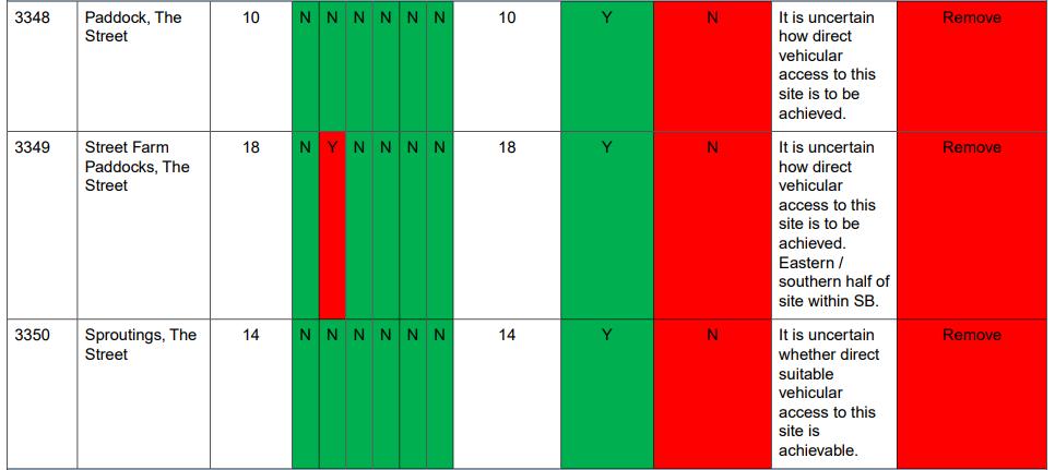
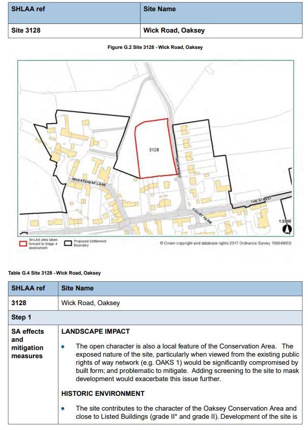
20 25. In the SHELAA Assessment, Wiltshire Council determine all 7 sites to be suitable having regard to the broad constraints assessment. Wiltshire Housing Site Allocations Plan Site Assessment Process 26. The Wiltshire Housing Site Allocations Plan is undergoing its preparations, as part of this Wiltshire Council has undertaken an assessment of the SHLAA (now SHELAA) sites in each of the Community Areas. In relation to Oaksey the relevant Community Area is Malmesbury. In the evidence base Wiltshire Council has published the Malmesbury Community Area topic paper, this analyses the 7 sites in Oaksey. 27. Notwithstanding the Wiltshire Housing Site Allocations Plan site assessment process it is noted that SHLAA site 684 has in fact been granted planning permission for 4 dwellings initially under consent 16/04578/FUL and then for an amended scheme under 17/05197/FUL granted on the 23 August In summary terms the Wiltshire site assessment process excluded 6 of the 7 sites at stage 2 of the assessment before excluding the final site at stage 4. Therefore the emerging Housing Site Allocations Plan does not propose to allocate any sites in Oaksey. 29. The Stage 2a assessment is set out below: 20
21 21
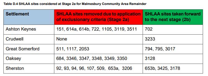
22 22


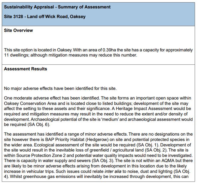
23 30. Site 3128 Land off Wick Road was then considered at Stage 3 by Wiltshire Council against the Sustainability Appraisal objectives: 23
24 24
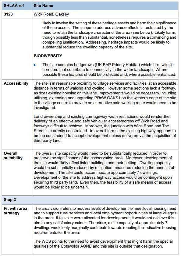
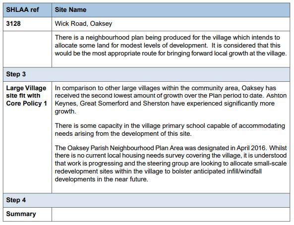
 resulting from the assessment in Stage 3 were individually assessed in more detail for suitability and fit with the area strategy.")
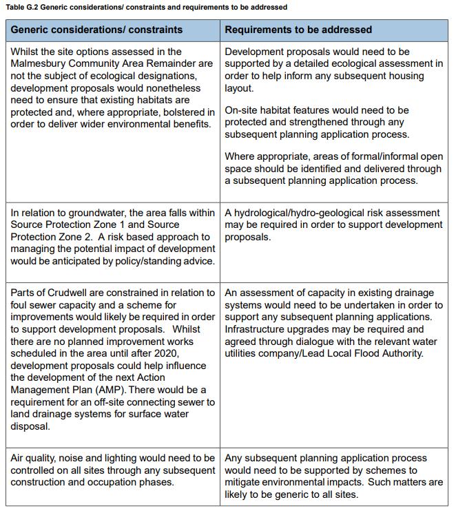
25 31. The Wiltshire assessment then moved to stage 4, which involves five steps, this involved selecting those SHLAA sites that can be site allocations. The 'more sustainable' sites (site options) resulting from the assessment in Stage 3 were individually assessed in more detail for suitability and fit with the area strategy. A range of Community Areas concerns and considerations were been raised by consultees at Stage 4A. They are listed in the following table: 25
26 26

27 32. The site specific analysis by Wiltshire Council of site 3128 Land off Wick Road in the emerging Wiltshire Housing Site Allocations document is set out below: 27
28 28
29 29
30 30

31 33. As an outcome the emerging Wiltshire Housing Site Allocations chooses not to allocate site 3128 on Wick Road. The detailed Wiltshire assessment concludes that site 3128 has considerable issues which would be problematic to address. As such, there is no merit in allocating the site for development within this Plan period. Wiltshire Housing Site Allocations Plan Consultation 34. We have considered the comments made by interested parties on the emerging Wiltshire Housing Site Allocations. From a search of the comments on the consultation system using the keyword Oaksey we note that a third party suggests that SHLAA site 3128 on Wick Road may no longer be deliverable due to an ownership change. However this claim is not supported by any cogent evidence to dispute availability and deliverability, as such in this assessment process we attach weight to the current SHELAA position relating to this site. 31
 accessed from Cargill Place.")
32 35. Of the other SHLAA/SHLEAA sites we can only find a record of site 3349 (Street Farm Paddocks) being promoted in response to consultation. The representation indicates that the owner is now looking at a smaller number of dwellings (3-5) accessed from Cargill Place. The plan submitted to the emerging Wiltshire Housing Site Allocations consultation is set out below: Site 3349 as Put Forward to Consultation on the Emerging Wiltshire Housing Site Allocations 36. In relation to other non-shlaa/shelaa sites being promoted by parties during the consultation on the emerging Wiltshire Housing Site Allocations Plan there is land at Greenacres Farm, which lies immediately to the south of Bendy Bow. The promoter does not indicate how many dwellings they are seeking. The site measures approximately 1.03 Hectares, taking the same density assumptions as the Wiltshire SHLAA/SHELAA this could accommodate approximately 37 dwellings. Site at Greenacres Farm Put Forward to Consultation on the Emerging Wiltshire Housing Site Allocations Plan 32
33 Sites Suggested Through the Neighbourhood Plan Process 37. The early consultation on the early community engagement provided an opportunity for other parties to identify land which may be available, suitable and deliverable through the plan period. This process identified a possible site at Bendy Bow for a redevelopment scheme which would offer the potential for a net supply of 10/12 additional dwellings. In the early stages a local survey of landowners was undertaken to ascertain the options for a rural exception site for building smaller affordable homes. After preliminary discussions only one site, was considered to represent a potential option well connected to the village. After the site was evaluated in some detail it was eventually discounted because the costings for the proposal did not work out and the site had access difficulties. Land at Bendy Bow Potential Other Sites Not Suggested Through the Development Plan Process 38. In addition to the sites suggested through the SHLAA/SHLEAA process and through the consultation on the Neighbourhood Plan and Wiltshire Housing Site Allocations Plan it is necessary to consider whether any other reasonable alternative sites exist that need to be considered. Looking at the existing built form, there would appear just to be two other reasonable alternatives to consider for inclusion, namely: the Recreation Ground; and Land East of Court Farm. The Recreation Ground can be immediately dismissed as it is held in trust and cannot be developed. The Land East of Court Farm provides an important open vista within the Conservation Area, it is considered that any proposed development here would result in substantial harm to the designated heritage asset such that it warrants no further consideration. 33
34 The Neighbourhood Plan Site Selection Process 39. The Neighbourhood Plan has therefore undertaken a four stage approach towards site selection as follows: Stage 1 - Identify Potential Sites Stage 2 - Identify Broad Spatial Planning Factors Stage 3 - Assess List of Sites Stage 4 - Identify Preferred Site Stage 1 Identify Potential Sites 40. Taking into account the views of local people, a site of around 10 dwellings or less is considered to be a possibility for allocation in the Neighbourhood Plan. Any allocation however has to meet the wider Neighbourhood Plan objectives and be in general conformity with the Wiltshire Core Strategy and National Planning Policy. The findings and conclusions of Wiltshire Council in the emerging Housing Site Allocations Plan are considered to be of significant importance in the Neighbourhood Plan assessment process. 41. Clearly there are very large numbers of sites that, in theory, could be built upon. However, the Plan requires only a small number of sites, or just a single site to be identified in order to meet the projected need of the community. As any site must be available and 34
35 deliverable within the plan period, the starting point was the SHLAA and SHELAA which is the appropriate document to indicate land which has been offered as available and deliverable. Given the early exclusions of 6 of the 7 sites in the emerging Housing Site Allocations Plan, only site 3128 on Wick Road which reached the latter stages is considered appropriate to be assessed in the Neighbourhood Plan based on the Housing Site Allocations Plan conclusions. 42. Taking into account the consultation responses to the emerging Wiltshire Housing Site Allocations Plan it is considered appropriate to consider site 3349 at Street Farm Paddocks and the Land at Greenacres Farm given their active promotion. 43. In addition the early community engagement has provided an opportunity for other parties to identify land which may be available, suitable and deliverable through the plan period. This process identified a possible site at Bendy Bow for a redevelopment scheme which would offer the potential for a net supply of 10/12 additional dwellings. 44. The assessment process therefore moved forward on the basis of four site options referred to as Wick Road ; Bendy Bow ; The Street ; and Greenacres Farm in this document moving forward. Stage 2 Identify Broad Spatial Planning Factors 45. The following factors have been developed for the assessment process: 1. PRACTICAL IMPLEMENTATION CRITERIA Assessment Objective No. Assessment Criteria RAG Scoring Approach Protect people and property from the risk of flooding. 1 Site at risk of flooding (from surface water and fluvial sources)? Fluvial Zone 2 or 3 Red Surface Water Amber None Green Conserve and enhance the character and quality of rural and urban landscapes, maintaining and strengthening local distinctiveness and sense of place. Ensure efficient and effective use of land and the use of suitably located previously developed land and buildings. 2 3 Is the site physically attached to the settlement? Is the site previously developed> Is the site affected by topographic constraints (e.g. steeply sloping land; poor ground conditions etc.)? No Red Yes but not well related Amber Yes and well related or within the settlement - Green Greenfield with constraints Red Greenfield with no constraints Amber Brownfield with constraints Amber Brownfield with no constraints Green 35
36 Reduce the need to travel, promote more sustainable transport choices and improve road safety, reduce accidents and help reduce traffic speeds 4 5 Can the site be accessed practicably? Will the site affect wider area road safety? No Red Yes - Green Yes Red Maybe Amber No - Green 2. ENVIRONMENTAL PROTECTION CRITERIA Assessment Objective No. Assessment Criteria RAG Scoring Approach Protect and enhance all biodiversity and geological features and avoid irreversible losses. Improve air quality and minimise all sources of environmental pollution. 3. DISTANCE TO FACILITIES CRITERIA Accessibility to key services and facilities in Oaksey. 6 7 Can the site be developed without affecting existing natural features such as trees, hedgerows, watercourses or other features contributing to biodiversity? Is site likely to be contaminated or affected by other sources of pollution? No Site Will Impact - Red Yes Some Impact Amber Yes No Impact - Green Yes Red Maybe Amber No - Green Assessment Objective No. Assessment Criteria RAG Scoring Approach Red 400m+ Proximity to public 8 Amber m transport stop (bus) Green 0-200m Improve equality of access to, and engagement in local, high-quality community services and facilities. 9 Distance to village shop 10 Distance to primary school 11 Distance to public house 12 Distance to village hall LANDSCAPE AND VIEWS CRITERIA Distance to sports field and public open space Red 400m+ Amber m Green 0-200m Red 400m+ Amber m Green 0-200m Red 400m+ Amber m Green 0-200m Red 400m+ Amber m Green 0-200m Red 400m+ Amber m Green 0-200m Assessment Objective No. Assessment Criteria RAG Scoring Approach Conserve and enhance the character and Would development affect Yes - Red quality of rural and 14 views to/from surrounding Limited Impact Amber urban landscapes, countryside? No - Green maintaining and strengthening local Would development lead to Yes - Red distinctiveness and the loss of open land which Limited Impact Amber 15 sense of place. contributes to the No - Green character? 36
37 5. VILLAGE CHARACTER AND HERITAGE CRITERIA Assessment Objective No. Assessment Criteria RAG Scoring Approach Within Conservation Area / Yes Red 16 Listed Building curtilage or Adjacent Amber setting? No - Green Protect, maintain and enhance the historic and natural environment. Provide everyone with the opportunity to live in good quality, affordable housing, and ensure an appropriate mix of dwelling sizes, types and tenures Within curtilage of archaeological heritage asset (SAMs and nonprotected sites) or setting? Impact on setting of statutorily protected heritage assets not assessed elsewhere (LBs etc.)? Within an Environmental Designated Site? Capable of delivering appropriate mix Yes Red Potentially - Amber No - Green Significant impact Red Limited impact Amber No impact - Green Yes Statutory Site Red Yes Local Site Amber No - Green No Red Maybe Amber Yes - Green 6. CRITERIA FOR SUBSEQUENT CONSIDERATION AT SITE SPECIFIC PROPOSAL STAGE Assessment Objective No. Assessment Criteria RAG Scoring Approach Will the site deliver Promote more affordable housing and/or No Red inclusive and selfcontained quality of life for residents improvements to the 21 Maybe - Amber Yes - Green communities. (existing / future) or other benefits? 37
38 Stage 3 Assess List of Sites 46. The four sites Wick Road; Bendy Bow; The Street; and Greenacres Farm are considered against the twenty one criteria: Assessment Objective No. Wick Road Site Bendy Bow Site The Street Site Greenacres Farm Site 1 Green Amber Green Green 2 Amber Green Green Amber 3 Red Green Amber Red 4 Red Green Red Red 5 Amber Green Amber Amber 6 Amber Green Amber Amber 7 Green Amber Amber Amber 8 Red Green Amber Amber 9 Red Green Amber Amber 10 Amber Red Amber Red 11 Amber Red Amber Red 12 Amber Amber Green Red 13 Amber Amber Green Red 14 Amber Green Amber Red 15 Red Green Amber Red 16 Red Amber Red Green 17 Amber Green Amber Green 18 Amber Green Amber Amber 19 Green Green Green Green 20 Amber Green Red Green 21 Red Green Red Amber Total Scores Red = 1 Amber = 2 Green = 3 Score 38 Score 54 Score 43 Score The sites can be summarised as follows: Wick Road A small greenfield site of 7 dwellings which would not offer the opportunity to deliver an element of affordable housing or a mix of dwellings. The site lies within the Conservation Area and the loss of openness is considered to be harmful to the character and appearance of the Conservation Area. It also lies within or adjacent to the medieval village identified in the Sites and Monuments Record. The site abuts the Tudor House Grade II Listed Building and the development has the potential to affect its setting. Wick Road is a narrow road which is not considered suitable to accommodate additional development without improvement which would adversely affect its rural character and that of the Conservation Area. Overall the site is considered to substantially harm designated and non-designated heritage assets, it will also harm the landscape setting and the benefits it could deliver would not outweigh that harm. Bendy Bow A brownfield redevelopment site that will result in replacement affordable housing stock and a net gain of 10/12 dwellings. The site will deliver a greater proportion of affordable housing due to Housing Association ownership. The site offers the opportunity to enhance the setting of the adjacent Conservation Area through removal of inappropriately designed dwellings and replacement with a street frontage constructed of appropriate 38
39 materials. Overall the site is considered to enhance designated heritage assets, it will also protect the landscape setting and the benefits it will deliver would be substantial. The Street A small greenfield site of 3-5 dwellings. It would not offer the opportunity to deliver an element of affordable housing or a mix of dwellings. The site lies mostly within the Conservation Area and the loss of openness is considered to be harmful to the character and appearance of the Conservation Area. It is a partially extant 19th century farmstead identified on the Sites and Monuments Record. It lies opposite 7,8,9,10,11, The Street, a Grade II Listed Building. Cargill Place is a private drive which currently serves 3 dwellings, as such this access would be unsuitable to serve a further 3 5 dwellings. Development here would not reflect the linear form of development, the impact on the trees on site is unclear. Overall the site is considered to substantially harm designated and non-designated heritage assets, it will also harm the landscape setting and the benefits it could deliver would not outweigh that harm. Greenacres Farm A large greenfield site which is larger than might be reasonably expected in a village the size of Oaksey. It would offer the opportunity to deliver a mix of dwellings and the relevant percentage of affordable housing. It potentially lies within the setting of Woodfolds Farmhouse a Grade II Listed Building. The site has no clear access, it is suggested that it could be developed in collaboration with the redevelopment scheme at Bendy Bow. The site lies distant from the Conservation Area and is therefore unlikely to have an impact. Development here would not reflect the linear form of development, the impact on the biodiversity of the site is unclear. Development here would adversely affect the landscape setting of the village from the south. Overall the site is considered to substantially harm the landscape setting and perpetuate a built form out of character with the village, the benefits it could deliver would not outweigh that harm. 48. The sites are also assessed against the three main aspects of sustainable development: Sustainability Factor Wick Road Site Bendy Bow Site The Street Site Greenacres Farm Site Social Neutral Major Positive Minor Adverse Major Positive Economic Neutral Minor Positive Neutral Minor Positive Environmental Major Adverse Major Positive Minor Adverse Major Adverse 49. A summary of the impact on heritage and environmental assets is also set out below: Assets Wick Road Site Bendy Bow Site The Street Site Greenacres Farm Site Heritage (Designated) Harm Enhance Harm Potential Harm Heritage (Non- Harm Neutral Harm Neutral Designated) Environmental Neutral Neutral Neutral Neutral (Designated) Environmental (Non- Designated Potential Harm Neutral Potential Harm Harm 50. In addition the Neighbourhood Plan has developed a Character Appraisal which identifies important aspects of character which make up how Oaksey looks and feels to local residents. This underpins many of the policies in the Neighbourhood Plan. An assessment as to how the sites relate to the policy framework is set out overleaf. 39
40 Stage 4 Identify Preferred Site 51. A simple scoring mechanism using the RAG approach converted into a scoring mechanism indicates that the Bendy Bow site meets substantially more of the assessment criteria. Consequently it has been taken forward as the housing site allocation in the Neighbourhood Plan. Fit Against The Neighbourhood Plan Policy Framework 52. Having selected the preferred site it is appropriate to assess how the preferred site and the others considered relate to the policy framework in the Neighbourhood Plan. The contribution that a housing allocation can make towards wider Neighbourhood Plan objectives such as the delivery of additional affordable housing to meet the needs of local residents is important. Whilst the best site for housing should be chosen it must fit with the wider objectives and policies of the Neighbourhood Plan. This assessment is set out below: Neighbourhood Plan Policy Policy 1 Settlement Boundary Policy 2 Design of New Development and Local Distinctiveness Policy 3 Highway Impact Policy 4 - Heritage Assets Policy 5 New Housing Policy 6 Community Facilities Policy 7 Setting of Oaksey Village Wick Road Site Bendy Bow Site The Street Site Greenacres Farm Site Major Adverse Major Positive Minor Adverse Major Adverse Minor Adverse Minor Positive Major Adverse Major Adverse Minor Adverse Neutral Neutral Major Adverse Major Adverse Minor Positive Major Adverse Neutral Minor Positive Major Positive Minor Positive Minor Positive Neutral Neutral Neutral Neutral Major Adverse Neutral Minor Adverse Major Adverse 53. When assessed against the policies of the Neighbourhood Plan the Bendy Bow site is the only one which does supports all of the policies. This further supports its choice as the housing allocation to be taken forward in the Neighbourhood Plan. 40
 Sites Discounted by Wiltshire SHLAA/SHELAA (General")
41 Appendix 1 Map of Sites Assessed Bendy Bow Site (Broad Location) Other Sites Assessed Wick Road; The Street; and Greenacres Farm Sites Discounted and Not Assessed (General Location) Sites Discounted by Wiltshire SHLAA/SHELAA (General Location) 41
42 Oaksey Neighbourhood Plan Housing Site Selection Methodology March 2018 Pre-Submission draft of the Neighbourhood Plan in accordance with Regulation 14 of Neighbourhood Planning Regulations 2012 Oaksey Neighbourhood Plan is led by a Steering Group made up of Parishioners and Parish Councillors supported by Oaksey Parish Council Oaksey Parish Council NEIGHBOURHOOD-PLAN.CO.UK Oaksey Parish Council
Plumpton Neighbourhood Development Plan Revised Pre Submission Document - Regulation 14 Consultation
 REPRESENTATIONS... Plumpton Parish Council Plumpton Neighbourhood Development Plan Revised Pre Submission Document - Regulation 14 Consultation Representations submitted on behalf of: Cala Homes (South
Site Assessment Technical Document Appendix A: Glossary
 Central Bedfordshire Council www.centralbedfordshire.gov.uk Site Assessment Technical Document Appendix A: Glossary July 2017 1.1.11-1 - ii Appendix A: Glossary Term Agricultural Land Classification AONB
Settlement Boundaries Methodology North Northumberland Coast Neighbourhood Plan (August 2016)
") Introduction This background paper sets out a methodology for the definition of settlement boundaries in the North Northumberland Coast Neighbourhood Plan. The neighbourhood plan is planning positively
Introduction This background paper sets out a methodology for the definition of settlement boundaries in the North Northumberland Coast Neighbourhood Plan. The neighbourhood plan is planning positively
SOUTH EAST LINCOLNSHIRE LOCAL PLAN: HOUSING PAPER DONINGTON (JUNE 2016)
") SOUTH EAST LINCOLNSHIRE LOCAL PLAN: HOUSING PAPER DONINGTON (JUNE 2016) 1 DONINGTON S PLACE IN THE SPATIAL STRATEGY 1.1 Policy 2 of the South East Lincolnshire Local Plan 2011-2036 Draft for Public Consultation
SOUTH EAST LINCOLNSHIRE LOCAL PLAN: HOUSING PAPER DONINGTON (JUNE 2016) 1 DONINGTON S PLACE IN THE SPATIAL STRATEGY 1.1 Policy 2 of the South East Lincolnshire Local Plan 2011-2036 Draft for Public Consultation
Neighbourhood Plan Representation
 Date: 10 th November 2017 Neighbourhood Plan Representation Land to the east of Callow Hill Road, Alvechurch Introduction This representation has been prepared by RPS Planning and Development on behalf
Draft Hailey Neighbourhood Plan
 Persimmon Homes (Wessex) Draft Hailey Neighbourhood Plan Representations to West Oxfordshire District Council s Regulation 16 Consultation December 2018 2 Copyright 2018 Persimmon Homes Ltd. All rights
Parish of Repton NEIGHBOURHOOD DEVELOPMENT PLAN
 Parish of Repton NEIGHBOURHOOD DEVELOPMENT PLAN BASIC CONDITIONS STATEMENT December 2018 CEF 4 Legal Requirements This statement has been produced by the NDP Working Group on behalf of Repton Parish Council
Babergh and Mid Suffolk Joint Draft Local Plan Consultation, August 2017, Public Consultation
 Babergh and Mid Suffolk Joint Draft Local Plan Consultation, August 2017, Public Consultation Having reviewed the documents, the Society has made the following response: Housing Delivery Q 7. Do you agree
Neighbourhood Planning Site Assessment Pro-forma and Guide Version 2
 Neighbourhood Planning Site Assessment Pro-forma and Guide Version 2 September 2014 Site HNP 006 Land East of Stanbridge Road and North of Lower Road 1. Background information Site location and use Site
LONGDEN VILLAGE DEVELOPMENT STATEMENT
 LONGDEN VILLAGE DEVELOPMENT STATEMENT 2017-2027 1 Longden Development Statement 2017-2027 15/01/18 1. Background 1.1 Longden Village Longden village is a very rural and traditional community first mentioned
DUNSFOLD NEIGHBOURHOOD PLAN Site Selection Policies
 DUNSFOLD NEIGHBOURHOOD PLAN Site Selection Policies The criteria for assessing sites for future housing and business development in Dunsfold are set out below. (Development criteria, covering what it is
Briefing Document of CNP. June 2017
 Cholsey Parish Council Cholsey Neighbourhood Plan Briefing Document of CNP June 2017 Cholsey Neighbourhood Plan Page! 1 of! 8 Cholsey Plan Briefing v1.4 Page Left Intentionally Blank Cholsey Neighbourhood
STATEMENT OF OBJECTION TO THE PROPOSED DEVELOPMENT OF LAND AT CHURCH CLIFF DRIVE FILEY
 STATEMENT OF OBJECTION TO THE PROPOSED DEVELOPMENT OF LAND AT CHURCH CLIFF DRIVE FILEY You will be aware that Scarborough borough council have adopted a new local plan that includes land at Church Cliff
Everton s Neighbourhood Plan. Site Allocation - Assessment Criteria
 Everton s Neighbourhood Plan Site llocation - ssessment Criteria Introduction 1.1 This report assesses all the sites identified through the emerging Neighbourhood Plan for Everton and their potential for
Land at Fiddington Hill Nursery, Market Lavington
 Land at Fiddington Hill Nursery, Market Lavington Briefing Report for Market Lavington Parish Council Persimmon Homes (Wessex) April 2016 Background This brief report has been prepared following the Market
Great Easton Neighbourhood Plan Statement of Basic Conditions
 Great Easton Neighbourhood Plan 2017-2031 Statement of Basic Conditions OCTOBER 2016 GREAT EASTON PARISH COUNCIL Contents 1.0 Introduction....Page 2 2.0 Summary of Submission Documents and Supporting Evidence..
Copyright Nigel Deeley and licensed for reuse under this Creative Commons Licence
 1 Copyright Nigel Deeley and licensed for reuse under this Creative Commons Licence Prepared by the Neighbourhood Plan Steering Group on behalf of Garway Parish Council with assistance from 2 Table of
3. Neighbourhood Plans and Strategic Environmental Assessment
 1. Introduction This report sets out a draft Screening Determination for the Preston Parish Council s Neighbourhood Plan and has been prepared by rth Hertfordshire District Council. The purpose of the
Sustainability Statement. Whitby Business Park Area Action Plan
 Sustainability Statement Whitby Business Park Area Action Plan November 2014 Contents Page 1. Introduction 1 2. Scoping 3 3. Sustainability Appraisal of Options 6 4. Assessment of Draft Area Action Plan
Wallingford Neighbourhood Plan
 Wallingford Neighbourhood Plan Introduction What is neighbourhood planning? Neighbourhood planning was introduced by the Localism Act 2011 to give local people more influence over how development comes
Copyright Nigel Deeley and licensed for reuse under this Creative Commons Licence
 1 Copyright Nigel Deeley and licensed for reuse under this Creative Commons Licence Prepared by the Neighbourhood Plan Steering Group on behalf of Garway Parish Council with assistance from 2 Table of
Joint Core Strategy Rushden Sustainable Urban Extension
 Date Page 1 of 18 Report Originator Title Planning Manager Joint Core Strategy Rushden Sustainable Urban Extension 1. PURPOSE OF REPORT 1.1 To consider representations received on the emerging Joint Core
OKEFORD FITZPAINE NEIGHBOURHOOD PLAN
 OKEFORD FITZPAINE NEIGHBOURHOOD PLAN Dear Parishioner, The Neighbourhood Plan Project Team have prepared this leaflet to summarise the full Neighbourhood Plan document. It provides a summary of the Vision,
The Gwennap Parish Vision Statement
 QUICK GUIDE What is a Neighbourhood Development Plan? Ultimately it is a document used by developers or anyone wishing to submit a planning application that describes the vision, strategy, plans, regeneration,
Neighbourhood Planning Guidance Local Green Spaces
 Neighbourhood Planning Guidance Local Green Spaces Introduction This guidance note has been produced for communities preparing neighbourhood plans in North Dorset to help them to identify, assess and designate
Effingham Neighbourhood Plan 1. Basic Conditions Statement
 Effingham Neighbourhood Plan 1 Basic Conditions Statement Effingham Neighbourhood Plan 2016: Basic Conditions Statement 2 Contents This statement has been prepared by Effingham Parish Council to accompany
Statement of Community Involvement LAND OFF SOUTHDOWN ROAD HORNDEAN, HAMPSHIRE
 LAND OFF SOUTHDOWN ROAD HORNDEAN, HAMPSHIRE CONTENTS Page 1. Introduction 3 2. Pre-application Discussions 4 3. The Consultation Process 5 4. Consultation Feedback 7 5. Responses to Consultation Feedback
Plumpton Neighbourhood Plan Site Assessment Report
 Plumpton Neighbourhood Plan Site Assessment Report May 2016 1 Contents 1. Introduction 3 2. Methodology 4 2.1 Identification of Potential Sites 4 2.2 Assessment Process 5 2.3 Assessment Criteria 6 2.4
Welford-on-Avon Neighbourhood Plan Consultation Event Sunday, 6 April Your name Your address
 Welford-on-Avon Neighbourhood Plan Consultation Event Sunday, 6 April 2014 Your name Your email address Please either: - complete this feedback form and put it in the box before leaving the Memorial Hall
APP/G1630/W/15/
 Appeal Decision Site visit made on 20 October 2015 by William Fieldhouse BA (Hons) MA MRTPI an Inspector appointed by the Secretary of State for Communities and Local Government Decision date: 20 November
Stantonbury Neighbourhood Plan
 Stantonbury Neighbourhood Plan 2018-2031 Basic Conditions Statement October 2018 Intentionally blank 1.0 Basic Conditions Statement Introduction 1.1 This statement has been prepared by Stantonbury Parish
Bradleys Both Parish Council
 Bradleys Both Parish Council Bradleys Both Housing Site Assessments April 2015 Contents 1.0 Introduction... 2 2.0 BR001 Health Lea and Land to Rear, Skipton Road... 2 3.0 BR002 Holly Tree House and Land
Sutton cum Lound Neighbourhood Plan
 Sutton cum Lound Parish Neighbourhood Plan 2016-2031 Pre-Submission Consultation Version Sutton cum Lound Neighbourhood Plan 2016-2031 Sutton cum Lound Neighbourhood Plan Steering Group on behalf of Sutton
Introduction. Grounds of Objection
 Planning application ref. number 18/04496/APP Planning application to Aylesbury Vale District Council for the erection of 17 dwellings and associated works to the South of Hogshaw Road Granborough. Granborough
DEVELOPMENT MANAGEMENT REPORT
 ITEM A08-1 DEVELOPMENT MANAGEMENT REPORT TO: BY: DATE: DEVELOPMENT: SITE: WARD: APPLICATION: APPLICANT: Development Management Committee Development Manager Proposed live/work unit in connection with existing
Schedule of Planning Applications Committee Date: 23 May Reference: 06/17/0726/F Parish: Hemsby Officer: Mr J Beck Expiry Date:
 Schedule of Planning Applications Committee Date: 23 May 2018 Reference: 06/17/0726/F Parish: Hemsby Officer: Mr J Beck Expiry Date: 22-05-2018 Applicant: Proposal: Site: Mr Gillett Change of use to the
Cookham Parish Council s Response to The Draft Local Borough Plan
 Cookham Parish Council s Response to The Draft Local Borough Plan As Agreed at the Planning Committee Meeting on 10 th January 2017. Designation of Poundfield as a Local Green Space The Parish Council
LEEDS SITE ALLOCATIONS PLAN MATTER 3 GREEN BELT KCS DEVELOPMENT AUGUST 2017
 LEEDS SITE ALLOCATIONS PLAN MATTER 3 GREEN BELT KCS DEVELOPMENT AUGUST 2017 Smith Limited Suite 9C Joseph s Well Hanover Walk Leeds LS3 1AB T: 0113 2431919 F: 0113 2422198 E: planning@peacockandsmith.co.uk
LETTER OF OBJECTION LAND TO THE SOUTH WEST OF FORGE GARAGE, HIGH STREET, PENSHURST, KENT, TN11 8BU
 Senior Planning Officer Andrew Byrne Sevenoaks District Council Community & Planning Services PO Box 183 Argyle Road Sevenoaks Kent TN13 1GN 04 November 2011 Your Ref: 11/02258/FUL For the attention of
BLEWBURY NEIGHBOURHOOD DEVELOPMENT PLAN STATEMENT OF BASIC CONDITIONS
 BLEWBURY NEIGHBOURHOOD DEVELOPMENT PLAN STATEMENT OF BASIC CONDITIONS Introduction 1.1 This statement has been prepared to accompany the submission of the Blewbury Neighbourhood Development Plan ( the
2014/0590 Reg Date 26/06/2014 Chobham
 2014/0590 Reg Date 26/06/2014 Chobham LOCATION: PROPOSAL: TYPE: APPLICANT: OFFICER: ASCOT PARK POLO CLUB, WESTCROFT PARK FARM, WINDLESHAM ROAD, CHOBHAM, WOKING, GU24 8SN Erection of a two storey detached
ROCHFORD LOCAL DEVELOPMENT FRAMEWORK: Sustainability Appraisal/ Strategic Environmental Assessment. Rochford Core Strategy Preferred Options Document
 ROCHFORD LOCAL DEVELOPMENT FRAMEWORK: Sustainability Appraisal/ Strategic Environmental Assessment Non Technical Summary Rochford Core Strategy Preferred Options Document October 2008 SUSTAINABILITY APPRAISAL
Case Officer: Sarah Kay File No: CHE/14/00515/REM Tel. No: (01246) Plot No: 2/6132 Ctte Date: 15 th September 2014 ITEM 1
 Plot No: 2/6132 Ctte Date: 15 th September 2014 ITEM 1") Case Officer: Sarah Kay File No: CHE/14/00515/REM Tel. No: (01246) 345786 Plot No: 2/6132 Ctte Date: 15 th September 2014 ITEM 1 APPROVAL OF RESERVED MATTERS FROM APPLICATION CHE/12/00234/OUT (1) LAYOUT,
Case Officer: Sarah Kay File No: CHE/14/00515/REM Tel. No: (01246) 345786 Plot No: 2/6132 Ctte Date: 15 th September 2014 ITEM 1 APPROVAL OF RESERVED MATTERS FROM APPLICATION CHE/12/00234/OUT (1) LAYOUT,
DRAFT STRATEGIC ENVIRONMENTAL ASSESSMENT REPORT
 DRAFT STRATEGIC ENVIRONMENTAL ASSESSMENT REPORT Published by Limpsfield Parish Council in accordance with EU Directive 2001/42 on Strategic Environmental Assessment and with the Environmental Assessment
Rochford District Council Allocations Development Plan Document: Discussion and Consultation Document Sustainability Appraisal
 Option SWH1 Balanced Communities Option SWH1 1 To ensure the delivery of high quality sustainable communities where people want to live and work Will it ensure the phasing of infrastructure, including
South Worcestershire Development Plan. South Worcestershire Design Guide Supplementary Planning Document
 South Worcestershire Development Plan South Worcestershire Design Guide Supplementary Planning Document Statement of Consultation: Early Engagement Scoping Paper February 2017 1. Introduction 1.1 This
INTRODUCTION NORTH HEYBRIDGE GARDEN SUBURB
 INTRODUCTION This event is being hosted by the promoters of the proposed North Heybridge Garden Suburb who are working with Maldon District Council and other key stakeholders on the preparation of a comprehensive
Planning and Sustainability Statement
 Land adjacent to Manor Farm, Catterick Village Pallett Hill Sand and Gravel Co Ltd Proposed 10 new dwellings, (6 No market dwellings and 4 No affordable dwellings) with access, associated car parking and
About 10% of the Borough's population lives in the seven rural parishes. Population figures from the 1991 census are given below:-
 8. THE DISTRICT VILLAGES 8.1 Population About 10% of the Borough's population lives in the seven rural parishes. Population figures from the 1991 census are given below:- Village No. of Persons Cottingham
Cottenham Civil Parish. Neighbourhood Development Plan to 2031
 Cottenham Civil Parish Neighbourhood Development Plan 2017 to 2031 Cottenham Parish Council Basic Conditions Statement December 2018 In 2031 Cottenham will still be an attractive safe rural village, proud
Neighbourhood Planning Local Green Spaces
 Neighbourhood Planning Local Green Spaces Introduction... 2 1. Why green space is important... 4 2. Neighbourhood plans and green space... 6 3. Evidence... 8 Statutory designations... 9 Green space audit...
an Inspector appointed by the Secretary of State for Communities and Local Government
 Appeal Decision Site visit made on 14 July 2015 by I Radcliffe BSc(Hons) MCIEH DMS an Inspector appointed by the Secretary of State for Communities and Local Government Decision date: 18 August 2015 Appeal
LAVANT NEIGHBOURHOOD DEVELOPMENT PLAN
 LAVANT NEIGHBOURHOOD DEVELOPMENT PLAN 2016-2032 PRE-SUBMISSION NEIGHBOURHOOD PLAN SUSTAINABILITY APPRAISAL Lavant Parish Council March 2016 2 INTRODUCTION TABLE OF CONTENTS INTRODUCTION... 4 What is a
Plaistow and Ifold Neighbourhood Plan Pre-Submission Consultation Draft
 Mrs Beverley Weddell Clerk to Plaistow And Ifold Parish Council Lock House Lodge Knightons Lane Dunsfold, GU8 4NU. Dear Mrs Weddell, Our ref: Your ref: Telephone Fax HD/P5402/ 01483 252040 18 th October
Great Easton Sustainable Housing Development Sites - Site Seven, Broadgate extension site SHLAA Ref HSG/03)
") Great Easton Sustainable Housing Development Sites - Site Seven, Broadgate extension site SHLAA Ref HSG/03) 1. Introduction The Great Easton Neighbourhood Plan Group are preparing a Neighbourhood Plan
Great Easton Sustainable Housing Development Sites - Site Seven, Broadgate extension site SHLAA Ref HSG/03) 1. Introduction The Great Easton Neighbourhood Plan Group are preparing a Neighbourhood Plan
NEW SCARBOROUGH BOROUGH LOCAL PLAN
 NEW SCARBOROUGH BOROUGH LOCAL PLAN OBJECTION TO THE INCLUSION OF SITE HA 21 (LAND OFF CHURCH CLIFF DRIVE, FILEY) AS AN ALLOCATED SITE FOR NEW HOUSING DELIVERY Prepared by: Emily Agus MEng (Hons), PhD,
an Inspector appointed by the Secretary of State for Communities and Local Government
 Appeal Decision Site visit made on 23 January 2017 by Gareth Wildgoose BSc (Hons) MSc MRTPI an Inspector appointed by the Secretary of State for Communities and Local Government Decision date: 6 February
What do you like about South Marston?
 What do you like about South Marston? What you have said so far: Strong and separate identity, distinct from Swindon Village character (Church, School, Green and Hall) Surrounding working countryside and
PLANNING DECISION NOTICE
 PLANNING DECISION NOTICE TOWN AND COUNTRY PLANNING ACT, 1990 Applicant WILLITON VILLAGE HALL STEERING COMM. C/O ALISON CALLOWWAY 54 NORTHCROFT WILLITON TAUNTON TA4 4RT Date Registered 11/08/2006 Application
WINCHESTER TOWN 3.1 LOCATION, CHARACTERISTICS & SETTING
 WINCHESTER TOWN 3.1 LOCATION, CHARACTERISTICS & SETTING 3.1.1 The area referred to by the City Council, as Winchester Town, consists of the Winchester Wards plus the adjoining built up areas of Badger
Repton Parish Neighbourhood Development Plan - Consultation March 2017
 Repton Parish Neighbourhood Development Plan - Consultation March 2017 25 replies Policy No Comments Response H1 Agree 22 Amend to include Milton Road & footpath but exclude above footpath. Neither agree
Derry City and Strabane District Council Planning Committee Report
 Derry City and Strabane District Council Planning Committee Report COMMITTEE DATE: 23 rd March 2016 APPLICATION No: APPLICATION TYPE: PROPOSAL: LOCATION: APPLICANT: LA11/2015/0395/F Residential Development
Oxford Green Belt Study. Summary of Final Report Prepared by LUC October 2015
 Oxford Green Belt Study Summary of Final Report Prepared by LUC October 2015 Project Title: Oxford Green Belt Study Client: Oxfordshire County Council Version Date Version Details Prepared by Checked by
Called-in by Cllr Richard Stay for the following reasons: DETERMINE. Application recommended for refusal
 Item No. 13 APPLICATION NUMBER CB/15/00275/OUT LOCATION Prebendal Farm, Grove Road, Slip End, Luton, LU1 4BZ PROPOSAL Outline Development: Redevelopment of land previously used as a farm yard to residential
SOUTH CAMBRIDGESHIRE DISTRICT COUNCIL. Planning and New Communities Director
 SOUTH CAMBRIDGESHIRE DISTRICT COUNCIL REPORT TO: Planning Committee 5 June 2013 AUTHOR/S: Planning and New Communities Director S/0747/13/FL HISTON Construction of Car Park at Histon Baptist Church, Station
12 TH ANNUAL CHILTERNS AONB PLANNING CONFERENCE ENGLISH HERITAGE: HISTORIC ENVIRONMENT GOOD PRACTICE ADVICE
 12 TH ANNUAL CHILTERNS AONB PLANNING CONFERENCE ENGLISH HERITAGE: HISTORIC ENVIRONMENT GOOD PRACTICE ADVICE MARTIN SMALL HISTORIC ENVIRONMENT PLANNING ADVISER ENGLISH HERITAGE Policy ENGLISH HERITAGE GOOD
Land at Rampton Road. Cottenham
 Land at Rampton Road Cottenham Introduction TEP is preparing an outline planning application for 54 dwellings on 6.9 hectares of land adjacent to Rampton Road, Cottenham on behalf of the owners Cambridgeshire
INTRODUCTION CURRENT APPLICATION
 05/01805/FUL & 05/01807/LBC ERECTION OF A SINGLE DWELLING HOUSE WITH ANCILLARY ACCOMMODATION AT Flamingo Zoological Gardens, Olney Road, Weston Underwood FOR Mr A J Crowther (as amended by letter dated
Response by The Dartington Hall Trust
 Consultation Response by The Dartington Hall Trust Site Reference: (T6 in DPD) 14_56/2246/13/f Contents Introduction 1 Site Description 2 Development Proposal and Context 3 Site Technical Assessment 4
EXTRACT FROM THE CUDDINGTON NEIGHBOURHOOD PLAN The Policies
 EXTRACT FROM THE CUDDINGTON NEIGHBOURHOOD PLAN The Policies Environment and Landscape Policy 1 - Landscape Setting Development should respect and wherever possible enhance the landscape setting of Cuddington
Reserved Matters application for a site that straddles the boundary between CBC and BBC
 BBC APPLICATION 15/02682/MAR NUMBER CBC APPLICATION CB/15/04294/RM NUMBER LOCATION Wixams Land at former storage depot, Bedford Road, Wilstead Bedfordshire PROPOSAL Reserved Matters Application for Strategic
Site ref: AS06 Site Name or Address: Murreys Court, Agates Lane
 Site ref: AS06 Site Name or Address: Murreys Court, Agates Lane Proposed Land Use: Total Site Area (Ha): Housing 1.85 Ha Description: It is understood that the owner has no plans to dispose of the site
Newcourt Masterplan. November Exeter Local Development Framework
 Newcourt Masterplan November 2010 Exeter Local Development Framework Background The Exeter Core Strategy Proposed Submission sets out the vision, objectives and strategy for the development of Exeter up
26 September 2014 CONSULTATION EXPIRY : APPLICATION EXPIRY : 22 July 2014 SUMMARY RECOMMENDATION: PERMISSION
 Item No.: 5 The information, recommendations and advice contained in this report are correct as at the date of preparation, which is more than one week in advance of the Committee meeting. Because of the
Reporter: Section 3 Place, Drymen, pp reference: Body or person(s) submitting a representation raising the issue (including reference number):
 submitting a representation raising the issue (including reference number):") Issue 10 Drymen Development plan Reporter: Section 3 Place, Drymen, pp.66-69 reference: Body or person(s) submitting a representation raising the issue (including reference number): Nadja Ray (85) Stuart
Issue 10 Drymen Development plan Reporter: Section 3 Place, Drymen, pp.66-69 reference: Body or person(s) submitting a representation raising the issue (including reference number): Nadja Ray (85) Stuart
Perth and Kinross Council Development Management Committee 8 June Pre-Application Report by Development Quality Manager
 Perth and Kinross Council Development Management Committee 8 June 2016 5(3)(i) 16/259 Pre-Application Report by Development Quality Manager Residential development at St Martins Road, Land 120 metres West
Form to Submit Land for Residential Evidence Gathering Shepway Strategic Housing Land Availability Assessment (SHLAA) Partial Review
 Partial Review") Form to Submit Land for Residential Evidence Gathering Shepway Strategic Housing Land Availability Assessment (SHLAA) Partial Review All organisations and individuals who wish to put forward land for consideration
Form to Submit Land for Residential Evidence Gathering Shepway Strategic Housing Land Availability Assessment (SHLAA) Partial Review All organisations and individuals who wish to put forward land for consideration
UTT/17/2075/FUL - (BERDEN) (Referred to Committee by Councillor Janice Loughlin. Reason: In the Public Interest)
 (Referred to Committee by Councillor Janice Loughlin. Reason: In the Public Interest)") UTT/17/2075/FUL - (BERDEN) (Referred to Committee by Councillor Janice Loughlin. Reason: In the Public Interest) PROPOSAL: LOCATION: APPLICANT: Amendments to the design of a scheme for a 49.99MW battery
UTT/17/2075/FUL - (BERDEN) (Referred to Committee by Councillor Janice Loughlin. Reason: In the Public Interest) PROPOSAL: LOCATION: APPLICANT: Amendments to the design of a scheme for a 49.99MW battery
SITE ASSESSMENTS. September 2018 SOUTHWATER PARISH COUNCIL BEESON HOUSE, 26 LINTOT SQUARE, SOUTHWATER, RH13 9LA
 September 2018 SITE ASSESSMENTS PREPARED TO ASSIST THE PREPERATION OF THE SOUTHWATER NEIGHBOURHOOD PLAN SOUTHWATER PARISH COUNCIL BEESON HOUSE, 26 LINTOT SQUARE, SOUTHWATER, RH13 9LA INTRODUCTION TABLE
Basic Conditions Statement Exmouth Neighbourhood Plan
 Exmouth Neighbourhood Plan 2018-2031. On behalf Exmouth Neighbourhood Plan Steering Group July 2018 Table of Contents 1. Introduction... 4 2. Legal Requirements... 5 3. Why there is a need for a Neighbourhood
9 Pershore. Introduction. Pershore Abbey
 118 Introduction 9.1 The historic town of Pershore lies on the River Avon and has a population of 7,000 (2009 Mid-Term Population Estimates). The main areas of the town are centred on the Abbey, the bustling
National Planning Policy Framework
 National Planning Policy Framework February 2019 Ministry of Housing, Communities and Local Government ( ( (!"#$%&"'()'"&&$&*()%'$+,( -."/01%.2( ( ( @$"0"/1"9(12(@&$
Development Plan Review Strategic Housing Land Availability Assessment June 2014
 Development Plan Review Strategic Housing Land Availability Assessment June 2014 Contents 1. Introduction... 3 2. Summary of existing strategic policy... 4 3. SHLAA preparation methodology... 8 4. Assessment
WILMCOTE NEIGHBOURHOOD PLAN
 WILMCOTE NEIGHBOURHOOD PLAN 1. Introduction. 1.1 David Holmes Planning Ltd has been instructed to advise Wilmcote Parish Council, who wish to prepare a Neighbourhood Plan. In particular we are asked to
Public Consultation. Land at Monks Farm, North Grove. Welcome
 Welcome Welcome to our public exhibition for development on Land at Monks Farm, orth Grove. Gallagher Estates and Gleeson Strategic Land are preparing an outline planning application for new homes, open
ALLERTHORPE NEIGHBOURHOOD PLAN
 Allerthorpe s Neighbourhood Plan sets out a vision for the Parish for the next 15 years (2018 2033) that builds on and reflects the opinions and views of parish residents. VISION In 2033 Allerthorpe will
Development in the setting of the Cotswolds AONB
 COTSWOLDS CONSERVATION BOARD POSITION STATEMENT Development in the setting of the Cotswolds AONB.1. Introduction Areas of Outstanding Natural Beauty (AONBs) are designated by the Government for the purpose
Development in the Green Belt
 Supplementary Planning Document: Development in the Green Belt Consultation Draft February 2013 Local Development Framework How to comment This document was published on 21st March 2013 and comments should
EAST LANGTON PARISH NEIGHBOURHOOD PLAN. Submission version
 EAST LANGTON PARISH NEIGHBOURHOOD PLAN Submission version 2011 2031 Contents Chapter heading Page Introduction from Chair 3 1. Why Neighbourhood Plans are important 5 2. Why we need a Neighbourhood Plan
Local Development Scheme
 Local Development Scheme 2012 2016 The Local Development Scheme (LDS) is a project plan that outlines how and when the Authority will update its planning policies and other associated documents. It ensures
Tisbury and West Tisbury Neighbourhood Plan. Site Assessment
 Tisbury and West Tisbury Neighbourhood Plan Site Assessment 16 th June 2017 This page is intentionally blank. Quality information Project Role Name Position Actions Summary Signature Date Researcher and
Replacement Golf Course Facilities and Residential Development, Churston. Environmental Statement Non-Technical Summary
 Replacement Golf Course Facilities and Residential Development, Churston Environmental Statement Non-Technical Summary July 2011 Reproduced from the Ordnance Survey s map with the permission of the Controller
Welford-on-Avon. Neighbourhood Development Plan Welford-on-Avon Parish Council
 Welford-on-Avon Neighbourhood Development Plan 2011-2031 Welford-on-Avon Parish Council Parish Consultation: Summary Version December 2014 January 2015 Foreword This is the latest version of the Welford
Variation No 1: Dundalk & Environs Development Plan Core Strategy
 Variation No 1: Dundalk & Environs Development Plan 2009-2015 Core Strategy Adopted on 29 th August 2011 CONTENTS Page Section 1 1.0 Synopsis 1 1.1 Background Document 1 1.2 Variation of Dundalk and Environs
Kibworth Harcourt. Introduction. Introduction
 Introduction Introduction Welcome to this public exhibition on the proposals for the delivery of new homes on land at The Kibworths. The purpose of today s exhibition is to give you the opportunity to
Designations protecting the historic designed landscape
 Historic Landscape Project Designations protecting the historic designed landscape A. Key national designations affecting the historic environment: 1. Listed buildings 2. Scheduled Monuments (generally
Suffolk Coastal Local Plan Review Issues and Options, August 2017, Public Consultation
 Suffolk Coastal Local Plan Review Issues and Options, August 2017, Public Consultation Having reviewed the issues and options documents, the Society has made the following response: Part 1 - Strategic
STATEMENT OF CASE. Interested party. Whitmore Parish Council and Baldwins Gate Action Group. 15 July 2014
 Site address Land at the end of Gateway Avenue, Baldwins Gate, Newcastleunder-Lyme, Staffordshire Description of development Erection of up to 113 dwellings and associated works Application reference 13/00426/OUT
Planning Position Statement Dunsfold Park. Dunsfold Airport Ltd
 Planning Position Statement Dunsfold Park Dunsfold Airport Ltd Quality Assurance Site name: Client name: Dunsfold Park Dunsfold Airport Ltd Type of report: Planning Position Statement Prepared by: Tim
Droitwich Spa 6. Reasoned Justification
 87 Droitwich Spa 6 Reasoned Justification 6.1 Droitwich Spa is identified in the settlement hierarchy (Policy SWDP1) as a main town being the largest settlement in Wychavon District with an estimated population