CITY OF CAMBRIDGE STORMWATER MANAGEMENT. POLICIES and GUIDELINES
|
|
|
- Amy Cooper
- 5 years ago
- Views:
Transcription
1 CITY OF CAMBRIDGE STORMWATER MANAGEMENT POLICIES and GUIDELINES August 2011
2 Stormwater Management Policies and Guidelines August 2011
3 TABLE OF CONTENTS Stormwater Management Policies and Guidelines August SUMMARY INTRODUCTION STORMWATER MANAGEMENT OBJECTIVES STORMWATER MANAGEMENT GUIDELINES & POLICIES Subwatershed Plans Stormwater Management Practices Planning Major-Minor Drainage System Minor Drainage System Major Drainage System Infiltration Facilities Erosion and Sediment Control Measures AESTHETIC AND LANDSCAPE DESIGN PRINCIPLES Plans of Subdivision and Site Plans Dry Ponds Wetlands Wet Ponds General Requirements IMPLEMENTATION Subdivision Stormwater Management Plans Stormwater Management Concept Plans Final Stormwater Management Report and Landscape Plan Site Plan Stormwater Management Plans MAINTENANCE DEFINITIONS REFERENCES...32 List of Tables Table 1. Depth of Street Flooding...9 Table 2. Design Flood Frequency...10 List of Figures Figure 1. Traditional Channelization versus Bioengineering Approach...11 Figure 2. Typical Cross Sections...16 Figure 3. Micropool Detail...17 Figure 4. Forebay Detail...19 Figure 5. Coverage Intensity of Shrub Plantings...20 Figure 6. Stormwater Management Information Sign...22 Figure 7. Community Trail Detail...23 Figure 8. Preferred Pond Inlet Detail...24 Appendix A - City of Cambridge IDF Relationships Appendix B Provincial Criteria for Stormwater Quality Facility Design Appendix C Native Shrubs and Trees of Waterloo Region
4 Stormwater Management Policies and Guidelines August 2011
5 Stormwater Management Policies and Guidelines August 2011 FORWARD TO USERS The City of Cambridge originally established a City-wide Stormwater Management Policy in 1983, and subsequently updated the Policy in While the 1997 Policy provides information to direct practitioners in the design of stormwater management facilities (i.e. side slopes, fencing requirements, landscaping), it also provides direction to City staff and departments on matters such as maintenance and the planning of stormwater management facilities. As part of the Stormwater Management Master Plan which was initiated in 2007, the City s Stormwater Management Policy (1997) has been updated to reflect current standards of practice and Regional/Provincial guidelines, as well as to address some noted deficiencies in the 1997 standards which have been recognized since its application within the City of Cambridge. Specific comments and the associated revisions to the 1997 policy are summarized in the following table. Summary of Comments and Revisions to City of Cambridge Stormwater Management Policy Comment 1. Fencing of facilities should control encroachment and debris in low-visibility, lowuse areas such as employment zones and should demark the limits between non-municipal and private lands. In all other instances, the use of safety benching, terracing, and deterrent planting should be applied. 2. The City requires sufficient detail at the planning level in order to account for appurtenances (i.e. access, decanting zones, etc.). The Stormwater Management Policy should reference the City s Planning Policy 3. The Stormwater Management Policy should distinguish between Site Plans and Plans of Subdivision with respect to the planning of private facilities. 4. Rooftop and parking lot storage should include requirements for a control structure within a Manhole within the City s right-of-way, or the MTO approach of having a short pipe within the ground to act as the control. 5. Private stormwater management facilities should require an annual report and an easement placed over the facility to allow for the municipality to conduct the work in the event that the owner is delinquent. Revision Policy 7 h) has been revised accordingly. Policy 2 and Section 4.2 have been revised accordingly. Policy 2 has been revised accordingly. Section has been revised accordingly. Further revisions recommended to be implemented following further dialogue with City Legal. Section d has been revised accordingly. Further revisions recommended to be implemented following further dialogue with senior City Staff regarding overall Site Plan compliance requirements.
6 Stormwater Management Policies and Guidelines August 2011 Summary of Comments and Revisions to City of Cambridge Stormwater Management Policy Comment 6. The use of natural areas for stormwater quantity control should be discouraged for controlling frequent storm events. The use of natural areas for stormwater quantity control may be acceptable for mitigating existing flooding issues for less frequent events (i.e. above 10 year) or for controlling Regional Storms, subject to City and GRCA approval, and the submission of a Terrestrial Impact Assessment. 7. Specifics regarding acceptable practices for groundwater control should be reflected in the Stormwater Management Policy. 8. Multi-developer facilities need to be maintained by the first developer constructing the system until the facility is assumed by the City. 9. The Stormwater Management Policy should indicate that specific criteria for quantity and quality controls for future development should be embedded within the Master Drainage Plans, Subwatershed Plans, and associated Class Environmental Assessments rather than Policy and Guidelines. 10. Dry ponds are generally not part of the formal water quality control system; nevertheless, the extended detention component as well as any swales through the dry pond could contribute to the overall water quality improvements through the treatment train approach. 11. Reference to the MOE Stormwater Management Planning and Design Manual 2003 should be incorporated into the City s Stormwater management Policy. 12. Minimum length-to-width ratios for Stormwater Management Facilities should be included. 13. Section a) should reflect a need to demonstrate safe conveyance from the site to the receiving watercourse. 14. The Erosion and Sediment Control Guidelines for Urban Construction (2006) should be included. 15. The Water Balance approach needs to be incorporated along with an overall discussion on Low Impact Development measures. Revision Policy 7 i) and Section d) have been revised accordingly. Section b) revised according to the information provided. Section d and Section 7 have been revised accordingly. Policy 1 and Section 4.1 have been revised accordingly. Policy 7 a) and Section have been revised accordingly. Section d) has been revised accordingly; Table from the current MOE Guidelines is to be included in Appendix B. Policies 7 b), 7 c), and 7 f), as well as Sections 5.1.1, 5.1.2, and have been revised accordingly. Section a) has been revised accordingly. Section 4.5 has been revised to include reference to the Greater Golden Horseshoe Conservation Authorities Publication. Section a) has been revised accordingly
7 Stormwater Management Policies and Guidelines August 2011 Summary of Comments and Revisions to City of Cambridge Stormwater Management Policy Comment 16. The Glossary of Terms needs to include definitions of pre-development, postdevelopment, on-line facility, off-line facility, infill, and intensification. 17. The generic reference to stormwater management pond should be changed to stormwater management facility. 18. Prohibiting/discouraging surface storage within parking lots may preclude the application of onlot measures (i.e. bio-retention facilities). 19. Silt fences and dust suppressants should be included as erosion and sediment control measures. 20. The Stormwater Management Policy should specify that requirements for wetlands pertain specifically to constructed wetlands. 21. Children s play equipment should not be permitted within stormwater management facilities. Revision Glossary of Terms has been revised accordingly. Changes incorporated throughout the document. Policy 7 k) has been revised accordingly. Section 4.5 has been revised accordingly. Section has been revised accordingly. References to wetlands within the document have been revised to specify constructed wetlands. Policy 7 n) has been added accordingly.
8 Stormwater Management Policies and Guidelines August 2011
9 Stormwater Management Policies and Guidelines August SUMMARY The following policies and guidelines are to be used to assist the development industry and City staff with the technical and aesthetic design of stormwater management systems in the City of Cambridge. They do not comprise detailed engineering design parameters but are rather to be considered as principles to direct design. The City of Cambridge stormwater management guidelines were originally developed in 1997 to incorporate the work of an inter-municipal committee which brought the guidelines into conformity with the Ministry of Environment and Energy s Stormwater Management Practices Planning and Design Manual at that time (1994). Those guidelines incorporated extensive landscaping principles in an attempt to improve the aesthetic design and reduce ongoing maintenance costs of the facilities. The 1997 policies and guidelines were reviewed and updated in 2011 as part of the City s Stormwater Management Master Plan in order to incorporate current design standards and practice for stormwater management and address emerging issues. The update to the City s Stormwater Management Policies and Guidelines has been reviewed by the Technical Team, which included representatives from various City Departments as well as the Grand River Conservation Authority. Guidelines related to each policy are detailed in the document to clarify implementation. These policies and guidelines are to be applied by the practitioner, in conjunction with current Provincial and Regional standards of practice. Stormwater Management Policies 1. The City of Cambridge will participate in the development of subwatershed plans in cooperation with other local municipalities, the public, the Grand River Conservation Authority, the Regional Municipality of Waterloo, the Ministry of Natural Resources, the Ministry of the Environment and any other appropriate agencies. The stormwater management planning and design process shall include verification that the proposed facility design complies with the stormwater quality, erosion, and quantity control criteria prescribed in the governing Master Drainage Plans, Subwatershed Studies, and/or Class Environmental Assessments. 2. Stormwater management planning and design shall assess and address specific requirements for stormwater quality, quantity, and erosion control, with the objective of preserving the hydrologic cycle and an emphasis on source controls. All stormwater management plans and designs for Site Plans and Plans of Subdivision shall be reviewed in conjunction with the City of Cambridge s Planning Policy in order to ensure that sufficient detail is provided at the site planning level to provide the requisite land for various stormwater management facility appurtenances (i.e. access, decanting zones, etc.). 3. Stormwater management practices planning principles will be incorporated into the design of the major-minor drainage system. 4. For subdivision developments, wetlands and wet ponds will be on lands dedicated to the City of Cambridge in addition to any lands required to be dedicated for park purposes under the Planning Act. Lands for dry ponds may be accepted as parkland dedication, at the sole discretion of the City of Cambridge. The acceptability of these lands as parkland dedication will be primarily based on the need, location, design and usability of the stormwater management facility as a functional park space. Only lands a minimum elevation 0.3 m above the five year storm elevation and consisting primarily of relatively flat area (<5% grade)will be considered for acceptance by the City of Cambridge as parkland dedication. All cost for the provision of park amenities within dry ponds shall be borne by the developer. Under no circumstances shall children s play equipment be permitted within stormwater management facilities. 5. Developers of new plans of subdivision and industrial, commercial, institutional and multi-residential site plans shall implement erosion and sediment control measures. souwant/stormwater MANAGEMENT Aug 2011.doc8/24/20119:23 AM 1
10 Stormwater Management Policies and Guidelines August In all cases, implementation of the Aesthetic and Landscape Design Criteria shall have regard for approved master drainage plans and subwatershed plans, which plans shall take precedence over these criteria in the event of conflict. 7. Aesthetic and Landscape Design Criteria - Plans of Subdivision and Site Plans - Dry Ponds, Wetlands, and Wet Ponds a) Stormwater management dry ponds shall be designed to limit the maximum depth of water to 1.8 m above the lowest point of the stormwater basin. An additional 0.3 m freeboard is required above the maximum operating water surface elevation. The maximum depth of the extended detention zone shall not exceed 1.0 m above the lowest point of the pond. Stormwater Management dry ponds are not considered to provide formal stormwater quality control, although the extended detention component for erosion control and any swales within the facility could contribute to overall water quality improvements as part of an overall treatment train. b) Maximum side slope will be 5:1 from the bottom of the dry pond to the limit of maximum extended detention, with a minimum horizontal length of 3.0 m. The minimum allowable gradient on the bottom of the basin shall be 1.0 % and the maximum gradient shall be 5 %. The length-to-width ratio of dry ponds shall be a minimum of 4:1. c) Stormwater management wetlands shall be designed to limit the maximum depth of water to 2.1 m above the lowest point of the stormwater basin excluding micropools. An additional 0.3 m freeboard is required above the maximum operating water surface elevation. The maximum depth of the extended detention zone shall not exceed 1.0 m above the permanent pool elevation. Maximum depth of detention storage zone (including extended detention storage) shall not exceed 1.8 m above the permanent pool elevation. The permanent pool depth shall range between a minimum average depth of 0.15 m to a maximum average depth of 0.3 m. The length-to-width ratio of wetlands shall be a minimum of 3:1. d) A maximum 5:1 slope below the permanent pool level shall be permitted around the entire stormwater management wetland. A maximum 5:1 slope above the permanent pool level shall be permitted around the entire stormwater management wetland. The slope shall extend from the permanent pool level, to the limit of maximum extended detention. The horizontal distance of this slope must be a minimum of 3.0 m. e) Micropools shall not exceed an additional maximum depth of 0.3 m below the permanent pool level. Micropools shall not exceed 5% of the total wetland permanent pool surface area. f) Stormwater management wet ponds shall be designed to limit the maximum depth of water to 3.3m above the lowest point of the stormwater basin. An additional 0.3 m freeboard is required above the maximum peak flow flood level. The maximum depth of the extended detention zone shall not exceed 1.8 m above the permanent pool elevation. The permanent pool depth shall range between a minimum depth of 1.0 m to a maximum depth of 1.5 m. The length-to-width ratio of wet ponds shall be a minimum of 4:1. g) A maximum 5:1 slope below the permanent pool level shall be permitted around the entire stormwater management wet pond. The horizontal distance of this slope must be a minimum of 3.0 m. A slope commencing from this point to the lowest point of the stormwater basin shall be a maximum of 3:1. A maximum 5:1 slope above the permanent pool level shall be permitted around the entire stormwater management wet pond. The slope shall extend from the permanent pool level to the limit of maximum extended detention. The horizontal distance of this slope shall be a minimum of 3.0 m. h) Fencing of stormwater management facilities shall be implemented in low-visibility and low-use areas (i.e. employment zones) in order to control encroachment and debris, and shall be implemented elsewhere in order to demark the limits between municipal and private lands. In all other instances, the use of fencing shall be minimized, and other techniques (i.e. benching, terracing, deterrent planting) shall be implemented. Fencing and/or property demarcation shall be to City standards. 2
11 Stormwater Management Policies and Guidelines August 2011 i) Existing natural areas may only be used for stormwater quantity control, in order to mitigate existing flooding issues and to control storm events greater than the 10 year frequency, subject to the completion of a Terrestrial Impact Assessment and the approval of the City of Cambridge and the Grand River Conservation Authority. Under no circumstances shall natural areas be considered to provide formal stormwater quality control. In situations where existing natural areas are proposed to be used for stormwater management, exemptions to the depth and slope criteria may be provided to minimize disturbance to the natural feature, at the discretion of the City of Cambridge. Subdivisions Only j) A landscaping plan approved by the City of Cambridge will be required for all stormwater management facilities. As part of the landscaping plan, the developer shall be required to provide a permanent sign in easily accessible, visible areas to inform the public of the function, use and maintenance of the stormwater management area and park, if applicable. All required landscaping, in accordance with the approved plan shall be installed at the developer's cost as set out in the subdivision agreement. Site Plans Only k) Surface storage for stormwater quantity control (i.e. parking lot and rooftop storage) shall be considered only if it is demonstrated that no other measures for stormwater quantity control can be reasonably implemented. Surface ponding within LID measures, such as bioretention swales, may be acceptable. l) Should any on-site stormwater management measures be implemented for site plans, an easement to each facility and outlet structure shall be dedicated to the City from the nearest vehicular entrance off of the City s right-of-way and extending to the control structure. m) Surface storage for stormwater management (i.e. parking lot and rooftop storage) shall be designed for stormwater quantity control only; under no circumstances shall surface storage be applied for stormwater quality or erosion control. Stormwater quantity controls located in parking areas shall be designed such that the maximum depth of water, at any time, shall not exceed 0.3 m. n) Under no circumstances shall children s play equipment be permitted within designated stormwater management facilities. 8. Implementation a) New draft plans of subdivision shall consider the effects of the proposed subdivision on the existing drainage area, including proposed mitigative measures as required. The design of subdivision stormwater management plans will implement the recommendations of master drainage plans and subwatershed plans where they exist. b) New industrial, commercial, institutional and multi-residential site plans shall consider the effects of the proposed development on the existing drainage area, including proposed mitigative measures as required. The design of stormwater management plans through site plan approval will implement the recommendations of master drainage plans and subwatershed plans where they exist. Stormwater quality control for infills and redevelopment shall be provided through the cash-in-lieu program for the construction of retrofit facilities to provide stormwater quality control. The following sections comprise guidelines which will be used to implement the above listed policies. souwant/stormwater MANAGEMENT Aug 2011.doc8/24/20119:23 AM 3
12 Stormwater Management Policies and Guidelines August INTRODUCTION The objective of stormwater management is to provide an effective method to convey and control stormwater runoff in developing areas. Traditional design practices focused on the efficient conveyance of stormwater runoff from the developing site to the receiving water course, the conversion of sheetflow conveyance to concentrated flow at a single outlet, as well as the provision of on-site measures to control peak flows (i.e. quantity) of storm runoff. Although the storm drainage systems were aimed at providing a high level of convenience during more frequently occurring storms, little consideration was given to the more intense but less frequent storms for urban drainage system design. The results of such a major occurrence would cause flooding, erosion and water quality problems throughout the drainage basin. Rather than shifting or solving such potentially expensive problems downstream, the emphasis of stormwater management is to control stormwater runoff at, or near, its source. The specified level of control for subject lands is typically designated by a Watershed/Subwatershed or Master Drainage Plan where they exist. Such plans account for additional constraints (i.e. economic and physical limitations) which may limit the capacity of proposed stormwater management systems. Such plans may also demonstrate that the existing downstream capacities are sufficient to accommodate local increases in postdevelopment peak flows (i.e. oversized sewers or watercourse reaches with adequate capacity and resistance to flow increases). Concern for the protection and enhancement of the aquatic environment has grown in recent years to encompass a broad range of issues to be addressed, beyond flooding and erosion. These issues include the maintenance of base flow, low water temperature and stream geomorphology. Added to this is the protection of terrestrial resources and ground water systems, resulting in the current practice of planning for land use and resource management on a subwatershed basis. Subwatershed plans aim to develop an ecosystem-based resources management strategy, using subwatershed boundaries for technical studies and land use planning (Subwatershed Planning, 1993). In order to effectively implement the recommendations of subwatershed plans, the City of Cambridge has developed stormwater management policies and guidelines. Stormwater management provides an integrated approach to water management (water quality, flooding, erosion, recharge) recognizing that stormwater management solutions must be economically efficient to construct and maintain. Good planning integrates site design and stormwater management measures design into one process (MOEE, 2003). Through the implementation of the policies and guidelines outlined in this document, the City has established the framework for sound stormwater management practices acceptable to the community. 4
13 Stormwater Management Policies and Guidelines August STORMWATER MANAGEMENT OBJECTIVES The prime goal of this document is to provide stormwater management policies and guidelines which are technically effective and also result in environmentally and aesthetically acceptable control of urban stormwater runoff. In support of this goal, the City of Cambridge Official Plan, General City Plan (Section and ) outlines several stormwater management policies and objectives. The City of Cambridge Stormwater Management Guidelines (1997) summarized the official plan's stormwater management objectives as follows: 1. Prevent loss of life, minimize property damage and health hazards. 2. Protect receiving water courses by minimizing the effect of increased runoff due to new developments and assist in ground water recharge wherever possible. 3. Minimize flooding and erosion of lands. 4. Reduce or eliminate inconvenience from surface ponding or flooding. 5. Minimize sedimentation, siltation and other forms of pollution on receiving water courses which may result from new developments during all stages of construction. 6. Minimize the total capital and operation and maintenance cost of drainage works related to the drainage basin. 7. Apply adaptive management principles for future adjustments to facility functions. These objectives remain valid today, with the understanding that there has been a shift in approach from remediating existing environmental problems to proactively stressing protection and enhancement of the environment. This is aided through the multidisciplinary efforts of subwatershed planning which emphasize the protection of the form and function of the natural environment. Contemporary stormwater management is expected to operate within this new ecological framework. The stormwater management policies, guidelines and aesthetic design criteria established within this report have been formulated in such a manner as to help achieve the objectives described above, within the new ecological framework. They will assist the City of Cambridge in implementing provincial policies and guidelines as well. In 1997, the original document was updated to include the work of a joint municipal committee report on design principles for stormwater management facilities. The purpose of its report was to,...provide principles to augment the MOEE Storm Water Management Practices Planning and Design Manual to achieve the highest level of utilization, aesthetics, environmental benefits and ease of maintenance for stormwater management facilities in our community. souwant/stormwater MANAGEMENT Aug 2011.doc8/24/20119:23 AM 5
14 Stormwater Management Policies and Guidelines August STORMWATER MANAGEMENT GUIDELINES & POLICIES The following guidelines and policies shall be followed wherever feasible to ensure the satisfactory management of stormwater runoff in an environmentally sound manner. 4.1 Subwatershed Plans Policy 1. The City of Cambridge will participate in the development of subwatershed plans in cooperation with other local municipalities, the public, the Grand River Conservation Authority, the Regional Municipality of Waterloo, the Ministry of Natural Resources, the Ministry of the Environment and any other appropriate agencies. The stormwater management planning and design process shall include verification that the proposed facility design complies with the stormwater quality, erosion, and quantity control criteria prescribed in the governing Master Drainage Plans, Subwatershed Studies, and/or Class Environmental Assessments. The objective of the overall process of subwatershed planning is to develop an understanding of the biological resources and physical systems, their inter-dependencies, and their linkages. This understanding is then translated into management decisions and direction to developers wishing to proceed with land developments. The subwatershed plan is normally carried out under public proponency, generally by the Municipality in support of a Secondary Planning Process or by Conservation Authority, supported by a multi-agency steering committee of which the City of Cambridge is a member. A completed subwatershed plan will require the approval of the affected authorities and then be adopted by the City of Cambridge Council as an implementation plan. Subwatershed planning fundamentally changes the way developments is dealt with through the planning process. Subwatershed plan approval must precede individual subdivision approvals in order that the individual subdivision plan can be assessed against the goals and objectives set out for the entire drainage basin. The City of Cambridge uses the Ministries of Natural Resources and Environment and Energy's "Subwatershed Planning" document dated June 1993 as guidance for participation in subwatershed planning exercises. In cases where no Master Drainage Plan (MDP) or Watershed/Subwatershed Planning has been completed or development lands are considered as external drainage areas to a MDP, watershed/subwatershed planning areas, consultation with the City shall determine if runoff peak flows shall be controlled to predevelopment levels or alternative stormwater management is required. Discussion with the City s Planning Services Department shall be required to determine the scope of assessment based on the potential impact on the receiving storm system. Should the proponent establish, to the satisfaction of the City s Planning Services Department, that the potential impact of the proposed development would be minimal, the City s Planning Services Department could decide that detailed modelling and analysis may not be required. Should the City s Planning Services Department deem a more detailed assessment appropriate, the proponent would need to demonstrate through appropriate modelling and analysis, that uncontrolled flow will not cause detrimental impacts on downstream properties and watercourse systems. At the development application stage, before the City s Planning Services Department will accept an increase in runoff rates, the proponent must also receive endorsement from the agencies having jurisdiction. Overcontrol of runoff (i.e. less than pre-development runoff), may also be required as it relates to downstream constraints. 4.2 Stormwater Management Practices Planning Policy 2. Stormwater management planning and design shall assess and address specific requirements for stormwater quality, quantity, and erosion control, with the objective of preserving the hydrologic cycle and an emphasis on source controls. All stormwater management plans and designs for Site Plans and Plans of Subdivision shall be reviewed in conjunction with the City of Cambridge s Planning Policy in order to 6
15 Stormwater Management Policies and Guidelines August 2011 ensure that sufficient detail is provided at the site planning level to provide the requisite land for various stormwater management facility appurtenances (i.e. access, decanting zones, etc.). The preservation of the hydrologic cycle minimizes the potential for cumulative downstream flooding, erosion, and baseflow impact. No one stormwater management technique is universally applicable to achieve stormwater management targets. Stormwater management practices are applied within the majorminor drainage systems to address both the local and downstream targets. The application of stormwater management measures are preferred in the following hierarchy: 1. Stormwater Lot Level (Source) Controls; 2. Stormwater Conveyance (Transport) Controls; and 3. End-of-pipe SWM Facilities. Generally, a combination of techniques will be required to address the overall set of stormwater management concerns. 4.3 Major-Minor Drainage System Policy 3. Stormwater management practices planning principles will be incorporated into the design of the major-minor drainage system. Through stormwater management techniques, urban drainage can occur in two distinct ways. The minor drainage system is comprised of swales, open ditches, gutters, catchbasins and storm sewers. The minor system is designed to accommodate the runoff from the more frequent, less intense storms, varying from the 1 year to 5 year return period event. The minor system s principal function is to reduce the inconvenience of the storm to pedestrians, motorists and property owners due to minor flooding. The major drainage system is comprised of natural streams, valleys, constructed channels, ponds and roads. The major system is the route of the stormwater runoff when the capacity of the minor system has been exceeded, such as in the occurrence of a major storm event greater than the 5 year return period storm. This drainage system will exist whether it has been designed or not. It should be designed to the Regulatory Storm event (the greater of the 100 year or the Regional Storm). The major system s function is to minimize property damage and loss of life due to major flooding Minor Drainage System The minor drainage system shall be comprised of the storm sewers, swales and minor ditches. The minor drainage system for all developments shall be designed to accommodate the 5 year return period storm and discharge to an approved outlet or to the major drainage system a) Surface Runoff Control Where downstream constraints exist in the minor system, the peak post-development runoff shall not exceed the peak pre-development flow for up to the 5 year return period storm. It is the developer s responsibility to ensure that all runoff generated in excess of that amount, such as for the more intense less frequent storm, be controlled on site in a manner acceptable to the City. In situations where no minor system exists, the developer will be required to control runoff to predevelopment quantity. The design of stormwater runoff control measures shall include provisions for the safe conveyance of storm runoff from the site to the receiving watercourse. Methods which the developer will implement to achieve this goal may include lot level (source) controls, conveyance (transport) controls, and end-of-pipe facilities. Recently, Low Impact Development practices have emerged as an approach toward stormwater management planning and design (ref. TRCA, CVC, 2010). This approach emphasizes the application of source souwant/stormwater MANAGEMENT Aug 2011.doc8/24/20119:23 AM 7
16 Stormwater Management Policies and Guidelines August 2011 controls, which would intercept (capture) runoff, filter runoff, and allow runoff to infiltrate into the native soil, or convey runoff. The benefits derived from this practice include stormwater quality control, maintaining water balance, and, in some instances, erosion protection for the receiving system. Provincial standards regarding the planning and design of each of these techniques is currently under development; guidelines are available in the Low Impact Development Stormwater Management Planning and Design Guide (CVC and TRCA, 2010). Stormwater Lot Level (Source) Controls The following are source controls which should be considered in the design of the minor system: Discharging all rain water leaders to grassed areas. Rooftop storage with hoppers. Parking lot storage. Lot grading. Soak away pits. Cisterns. Bioretention and special bioretention. Green roofs. Soil amendments. Tree clusters. Filter strips. Permeable pavement. Stormwater Conveyance (Transport) Controls The use of the following will reduce the rate of runoff by prolonging the time of concentration and increasing groundwater recharge: Inlet control such as catchbasin pacing and flow control devices. Seepage trenches. Grassed swales. French drains. Natural channels. End-of-Pipe Stormwater Management Facilities End-of-pipe stormwater management facilities generally receive stormwater from a conveyance system (ditches, sewers) and discharge it to the receiving waters. Dry Ponds, Wetlands, Wet Ponds and Hybrids (Refer to Section d)) Underground Storage Tanks Superpipes b) Ground Water Control Foundation drains or weeping tiles shall be serviced by sump pumps and shallow storm sewers; third pipe foundation drain collectors or direct gravity drainage of foundation drains to storm sewers shall not be permitted. Sump drainage is preferred to discharge to the surface; however, if soil conditions are frequently saturated and/or surface water conveyance constraints exist, a gooseneck design over the foundation which is directed to the storm sewer may be permitted. Under no circumstances shall the foundation drains be connected to the sanitary sewer. It will be the responsibility of the developer to prepare a hydrogeological report for the proposed subdivision indicating the levels of the existing high ground water table. This report shall be taken into account when designing the storm sewer system and lots or blocks that may require a storm sewer connection. The base of all footings must be a minimum of 0.75 metres above the water table as indicated in the hydrogeological report. 8
17 Stormwater Management Policies and Guidelines August c) Streets and Gutters The depth of flooding permitted on streets while acting as part of the minor drainage system (5 year storm) is given in the following table. This table also lists the depths of flooding which may occur on streets during the major storm such as the 100 year return period storm. TABLE 1. Depth of Street Flooding ROADS MINOR STORMS (2 TO 5 YEAR) MAJOR STORMS (100 YEAR) local roads to crown collector roads one lane free arterial roads one lane in each direction depth of water at crown shall not exceed 0.15 metres all roads no curb overtopping no flow across intersection depth of flow at gutter (m) x velocity of flow (m/s) not greater than 0.65 m 2 /s Major Drainage System The major drainage system consists of the natural streams, ditches, channels, streets and retentiondetention ponds. For new developments, the major drainage system shall be designed to accommodate the run off from the less frequent rainfall events up to and including the 100 year return period storm or regional storm, whichever is greater. Areas of existing development which have not been designed for the major-minor storm system shall be reviewed on an individual basis a) Degree of Runoff Control The subdivision/site plan designer should aim at reducing or preventing the adverse impact of development instead of mitigating or remediating it with stormwater management practices. The developer is responsible to ensure that the post-development peak storm runoff will not exceed the pre-development peak runoff from the 2 year through 100 year events. This condition may be waived if it can be demonstrated through engineering or hydrological studies that the receiving watercourse can accommodate the increased flow as well as limiting any detrimental effects. If it is found that the receiving system cannot convey the post-development flow up to the 100 year event, the post development runoff for that storm shall not exceed the capacity of the receiving system. Peak flows from areas of new development shall also be controlled where existing downstream flooding and/or erosion constraints have been determined in the master drainage plan, subwatershed plan or other studies and reports. In this case, the minimum requirement is for the developer to design the stormwater management system within the development such that the post-development flow will not exceed the maximum allowable pre-development runoff rate before flood damage occurs downstream. A hypothetical example of this may be that the 50 year return storm at the pre-development level is the limit of the discharge rate before flooding occurs. This may necessitate the implementation of oversized detention facilities to release the excess runoff to an acceptable level. The additional costs to oversize and construct such works over and above the developer's standard requirements will be shared with the City through the Development Charges reserve fund. The capacity available in the receiving watercourses will be shared among the various lands within the drainage basin (as determined in the subwatershed plan where one exists). souwant/stormwater MANAGEMENT Aug 2011.doc8/24/20119:23 AM 9
18 Stormwater Management Policies and Guidelines August 2011 In areas which do not have a master drainage plan or subwatershed plan, post-development peak flows in the major system shall not exceed the pre-development peak flows for the 2 year to the Regulatory storm. Several Municipal jurisdictions have implemented a zero increase in peak runoff rate policy for controlling post-development runoff from the subject site. While this type of policy provides simple and clear direction regarding stormwater management flood control, a uniform application of this type of policy does not consider the potentially negative effects on watercourses from extended periods of controlled peak discharge (i.e. increased erosion). Moreover, the strict adherence to this policy may, in fact, result in increased peak flow rates online the receiving watercourse due to the timing of the peak flow from the stormwater management facility and the time of the peak online the receiving watercourse, in comparison to the predeveloped or uncontrolled scenario b) Culvert and Bridge Hydraulic Capacity The capacity of culverts and bridges for road crossings of major system water courses in an urban area have commonly been designed for freeboard and clearance for the following frequencies. TABLE 2. Design Flood Frequency Road Culverts Up to a 6.0 Metre Bridges or Culverts Over a 6.0 Metre Span Classification Span Arterial Collector Local Temporary Detour Driveway 50 year 25 year 10 year 5 year 2 to 5 year 100 year to Regional 50 year 25 year 5 year 5 to 10 year * Subject to Change. Please refer to the latest version of the Ministry of Transportation Guidelines Please note that on regulated watercourses, the effect of culvert and bridge structures on major flows up to the greater of the 100 year or Regional Storm flood must be considered to the satisfaction of the Grand River Conservation Authority. When a developer requires a culvert or bridge over a watercourse that will only benefit the developer's lands, the entire cost of the culvert or bridge shall be borne by the developer. If it is determined that the culvert or bridge must be oversized to accommodate external drainage areas over and above the developer's standard requirements, the City will cost share on the additional works through the Development Charges reserve fund. All cost sharing involving the construction or oversizing of these facilities must receive the approval of the City c) Creek Channelization Creek channelization or rechannelization shall be avoided wherever possible. If these works are necessary, they shall be designed for the Regulatory event and provide suitable measures to maintain stability under the design event. The use of a natural channel design principles is encouraged. This means restoring the channel to a natural function, while maintaining the hydraulic properties of the watercourse. An example of use of this technique is the Groff Mill Creek between the railway, downstream of the Dumfries Conservation Area to the Galt Country Club. In the design of channels, consideration shall be given to the ease of maintenance, hydraulic efficiency and environmental and aesthetic impact on the natural state of the water course and its receiver. Any proposed channelization of a watercourse may be subject to approval by the 10

19 Stormwater Management Policies and Guidelines August 2011 Department of Fisheries and Oceans through the Fisheries Act and alteration to water course regulations of the Grand River Conservation Authority. Figure 1. Traditional Channelization versus Bioengineering Approach d) Dry Ponds, Wet Ponds, Wetlands and Hybrids (Stormwater Management Facilities) All stormwater management facilities are generally designed to accommodate the 100 year return period storm and to convey flows during the Regional Storm event, except where off-site impacts to the Regulatory Flood are apparent. Forebays and extended detention are generally required for water quality control and erosion control, allowing additional time to permit sediment to settle out. Stormwater management facilities typically occur off line of both the major and minor systems, including watercourses. On-line facilities for watercourses may be acceptable, subject to approval from the Grand River Conservation Authority, the Ministry of Natural Resources, and the Ministry of the Environment for the purposes of providing flood control for the Regulatory event for new development areas or for mitigating existing flooding issues. Stormwater management facilities may serve one or more of the following functions: flood control erosion control water quality control ground water recharge aesthetic amenity recreation Where a wetland or wet pond is proposed, the developer must demonstrate that flow can be maintained to ensure acceptable water quality and thermal impacts are properly mitigated. Other factors that are to be considered by the developer in the design are evaporation, exfiltration, and seepage. Wet ponds and wetlands shall be designed such that they would maintain a permanent pool component within the main cell of the facility; any groundwater recharge is to be provided at the facility outlet. In addition, current standards for stormwater management (ref. MOE, 2003) include a hybrid facility, which would be partially a wetland and partially a wet pond configuration. The current Provincial standards for the sizing of constructed wet ponds, wetlands, and hybrid facilities for the provision of stormwater quality control, as provided by the Ministry of the Environment, are provided in Appendix B. Where a stormwater management facility only services those lands within a developer's control, the land required for the pond shall be dedicated to the City, including an easement for access from the nearest vehicular entrance off of the City s right-of-way and extending to the control structure. The cost of constructing the pond and all associated works shall be borne by the developer. Upon service acceptance of all the underground facilities and completion of the pond, souwant/stormwater MANAGEMENT Aug 2011.doc8/24/20119:23 AM 11
20 Stormwater Management Policies and Guidelines August 2011 it will become the maintenance responsibility of the City. The owner shall submit an annual report for the inspection and maintenance of the facility to the City of Cambridge prior to assumption by the City. The cost for completing the necessary cleanout and reinstatement of the facility to the approved design condition, prior to assumption by the City, shall be borne by the owner. If a stormwater management facility or structure is designed to serve only one property, such as a multiple housing complex or commercial site, the land required for the pond or structure is to be retained by the owner. All costs for constructing and maintaining the pond or structure shall be the responsibility of the owner. An easement shall be placed over the private facility, including an easement for access from the nearest vehicular entrance off of the City s right-of-way and extending to the facility, and shall be dedicated to the City of Cambridge. Where a stormwater management facility is required to serve a number of developers or external drainage areas, the additional cost of land and construction to provide the ultimate facility will be financed by the Development Charges reserve fund. The cost of the additional land required will be determined by the City. All cost sharing involving the construction of the facility or oversizing of the major or minor systems must receive the approval of the City. Maintenance of the facility will be the responsibility of the first developer constructing the system; responsibility for the maintenance of the facility will be transferred to the City upon service acceptance of the underground facilities and completion of the facility, and upon the completion of the full development areas serviced by the facility. Policy 4. For subdivision developments, wetlands and wet ponds will be on lands dedicated to the City of Cambridge in addition to any lands required to be dedicated for park purposes under the Planning Act. Lands for dry ponds may be accepted as parkland dedication, at the sole discretion of the City of Cambridge. The acceptability of these lands as parkland dedication will be primarily based on the need, location, design and usability of the stormwater management facility as a functional park space. Only lands a minimum elevation one foot above the five year storm elevation and consisting primarily of relatively flat area will be considered for acceptance by the City of Cambridge as parkland dedication. All cost for the provision of park amenities within dry ponds shall be borne by the developer. Under no circumstances shall children s play equipment be permitted within stormwater management facilities. Dry ponds, wetlands and wet ponds for stormwater management are unique to each situation and must therefore be designed on specific criteria governing the area of development as well as the safety of the general public. In recognition of diverse development conditions, consideration by the City of Cambridge will be given to all innovative approaches and/or techniques that can be demonstrated to meet its stormwater management policies and guidelines. Section 5 gives the aesthetic and landscape design criteria for stormwater management facilities. Section 7 details the maintenance responsibilities for these facilities. 12
21 Stormwater Management Policies and Guidelines August Infiltration Facilities Infiltration of stormwater into the ground may be recommended in some areas to increase or maintain stream base flows, improve water quality, or to recharge the aquifer. Infiltration methods can include: buffer strips, seepage trenches, and soak-away pits, as well as dry detention ponds with permeable bottoms. Maintenance of these facilities is critical to their successful operation, and as such, design of the facility must take into account this aspect, or a high failure rate can be expected. The Stormwater Management Planning Practices and Design Manual (MOE 2003) indicates that regular maintenance of the pre-treatment zone (sediment capture) is crucial toward better ensuring proper performance of the infiltration basin. Standards for the design of infiltration facilities are currently provided within the Stormwater Management Planning Practices and Design Manual (MOE, 2003). Due to the above limitations, the City of Cambridge will approve the use of infiltration facilities only after the need is fully substantiated, and the design has been subject to rigorous review. Infiltration facilities will be limited to accommodate the drainage of roofed and grassed areas in the interest of minimizing potential for groundwater contamination. A soils report will be required to accompany the design of infiltration facilities to ensure adequate soil permeability and depth to the seasonally high water table. Also, an overflow connection to the storm sewer will be required. 4.5 Erosion and Sediment Control Measures Policy 5. Developers of new plans of subdivision and industrial, commercial, institutional and multiresidential site plans shall implement erosion and sediment control measures. Erosion and sediment control shall be carried out for all major land disturbing activities such as land clearing, excavating, filling or stockpiling of earth materials. The City of Cambridge requires the developer to submit a proposed erosion and sediment control plan as part of the stormwater management concept plan (see Section 6.1.1). The erosion and sediment control plan must be prepared and certified by a qualified professional engineer. The plan shall assess the proposed construction scheduling of the subdivision and indicate the mitigative measures to be implemented. Guidance should be sought from the provincial "Guidelines on Erosion and Sediment Control for Urban Construction Sites", May, 1987, and the Greater Golden Horseshoe Area Conservation Authorities Erosion and Sediment Control Guideline for Urban Construction, December, The plan should incorporate any number or combination of erosion and sediment control practices that will optimize coordination with construction activities. Some of the erosion and sediment control measures that should be implemented are: Silt fence Sediment traps or temporary retention ponds Seeding of topsoil stock piles Isolated and controlled stripping of development lands Vegetation screens Interceptor swales Filtering mediums at inlets or strategic locations Street cleaning programs during housing construction Schedule of maintenance programs Dust suppressants for wind erosion Through the abatement of erosion and soil loss within a subdivision, environmental effects and concerns are drastically reduced both internally and downstream of the development. The final detailed control measures chosen by the developer shall be shown on the erosion and sediment control plan and form part of the detailed engineering design drawings. souwant/stormwater MANAGEMENT Aug 2011.doc8/24/20119:23 AM 13
22 Stormwater Management Policies and Guidelines August AESTHETIC AND LANDSCAPE DESIGN PRINCIPLES It is the intent of these design principles to achieve a coordinated effort between the planner, landscape architect, engineer and architect to ensure pleasing aesthetics and harmony with the rest of the site development. These principles have been fashioned after those developed by an intermunicipal committee in Through the use of the principles, the establishment of diverse, ecologically appropriate, and selfsustaining plant and wetland communities is promoted. In this way, stormwater management systems will become extensions of natural water systems into the urban areas. An additional benefit is that early consideration of stormwater management facility design and integration into the natural environment will improve marketability of developments, making them more visually appealing to prospective purchasers. Policy 6. In all cases, implementation of the Aesthetic and Landscape Design principles shall have regard for approved master drainage plans and subwatershed plans which plans shall take precedence over these principles in case of conflict. 5.1 Plans of Subdivision and Site Plans The following sections describe the slope and depth criteria for dry ponds, wetlands and wet ponds. Please see Figure 2 for typical cross sections of each type of stormwater management facility Dry Ponds Policy 7 a) Stormwater management dry ponds shall be designed to limit the maximum depth of water to 1.8 m above the lowest point of the stormwater basin. An additional 0.3 m freeboard is required above the maximum operating water surface elevation. The maximum depth of the extended detention zone shall not exceed 1.0 m above the lowest point of the pond. Stormwater Management dry ponds are not considered to provide formal stormwater quality control, although the extended detention component and any swales within the facility could contribute to overall water quality improvements as part of an overall treatment train. Policy 7 b) Maximum side slope will be 5:1 from the bottom of the dry pond to the limit of maximum extended detention, with a minimum horizontal length of 3.0 m. The minimum allowable gradient on the bottom of the basin shall be 1.0 % and the maximum gradient shall be 5 %. The length-to-width ratio of dry ponds shall be a minimum of 4: Constructed Wetlands Policy 7 c) Stormwater management wetlands shall be designed to limit the maximum depth of water to 2.1 m above the lowest point of the stormwater basin excluding micropools. An additional 0.3 m freeboard is required above the maximum operating water surface elevation. The maximum depth of the extended detention zone shall not exceed 1.0 m above the permanent pool elevation. Maximum depth of detention storage zone (including extended detention storage) shall not exceed 1.8 m above the permanent pool elevation. The permanent pool depth shall range between a minimum average depth of 0.15 m to a maximum average depth of 0.3 m. The lengthto-width ratio of constructed wetlands shall be a minimum of 3:1. Policy 7 d) A maximum 5:1 slope below the permanent pool level shall be permitted around the entire stormwater management wetland. A maximum 5:1 slope above the permanent pool level shall be permitted around the entire stormwater management wetland. The slope shall extend from the permanent pool level, to the limit of maximum extended detention. The horizontal distance of this slope must be a minimum of 3.0 m. 14
23 Stormwater Management Policies and Guidelines August 2011 Policy 7 e) Micropools shall not exceed an additional maximum depth of 0.3 m below the permanent pool level. Micropools shall not exceed 5% of the total wetland permanent pool surface area (see Figure 3) Wet Ponds Policy 7 f) Stormwater management wet ponds shall be designed to limit the maximum depth of water to 3.3 m above the lowest point of the stormwater basin. An additional 0.3 m freeboard is required above the maximum peak flow flood level. The maximum depth of the extended detention zone shall not exceed 1.8 m above the permanent pool elevation. The permanent pool depth shall range between a minimum depth of 1.0 m to a maximum depth of 1.5 m. The length-to-width ratio of wet ponds shall be a minimum of 4:1. Policy 7 g) A maximum 5:1 slope below the permanent pool level shall be permitted around the entire stormwater management wet pond. The horizontal distance of this slope must be a minimum of 3.0 m. A slope commencing from this point to the lowest point of the stormwater basin shall be a maximum of 3:1. A maximum 5:1 slope above the permanent pool level shall be permitted around the entire stormwater management wet pond. The slope shall extend from the permanent pool level to the limit of maximum extended detention. The horizontal distance of this slope shall be a minimum of 3.0 m. souwant/stormwater MANAGEMENT Aug 2011.doc8/24/20119:23 AM 15
24 Stormwater Management Policies and Guidelines August
25 Stormwater Management Policies and Guidelines August 2011 souwant/stormwater MANAGEMENT Aug 2011.doc8/24/20119:23 AM 17
26 Stormwater Management Policies and Guidelines August General Requirements Forebays Forebays are required for all of the above described stormwater management facilities (dry ponds, wetlands, and wet ponds). The permanent pool depth shall range between a minimum depth of 1.0 m to a maximum depth of 1.5 m in which a maximum depth of 0.5 m shall be used for sediment accumulation. Forebays shall not exceed 33% of the total wet pond surface area and 20% of the wetland permanent pool surface area. All other aspects regarding the design of forebays shall conform to the above wet pond standards. Excluding maintenance access routes, all access to forebays shall be discouraged through shrub plantings (see Figure 4). Varying Slopes From the point of maximum extended detention, to the lower limits of the Safety Separation area, or property line where it abuts private property, slopes shall vary between 2:1 to 6:1 and have a maximum average slope of 4:1, not including the maximum 10:1 maintenance access slope (see Figure 2). Planting Native and non-invasive trees, shrubs, groundcovers and aquatic plants are required in a low maintenance landscape design which has regard for the ecology of the site and the eco-region (see Appendix A). For wet ponds and wetlands, all slopes 5:1 and steeper ranging from a minimum horizontal distance of 3.0 m from the permanent pool level to the property line (not including walkways and trails) shall be planted. For dry ponds, all slopes 5:1 and steeper ranging from a minimum horizontal distance of 3.0 m from the pond bottom level to the property line (not including walkways and trails) shall be planted. Incorporating a wide range of slopes and ponding depths into facility design that conform to the design principles is strongly encouraged and desirable in order to facilitate a wide range of flora and fauna habitat conditions. Where trees are to be planted, they must be planted at a minimum rate of 1 tree (40 mm caliper) per 50 square metres. The density of shrub plantings, for safety purposes, shall vary, depending on the degree of slope (see Figure 5). Shrub plantings shall prevent public access on all 2:1 slopes and discourage access on all 3:1 slopes. 18
27 Stormwater Management Policies and Guidelines August 2011 souwant/stormwater MANAGEMENT Aug 2011.doc8/24/20119:23 AM 19
28 Stormwater Management Policies and Guidelines August 2011 Coverage Intensity of Shrub Plantings Figure 5. Coverage Intensity of Shrub Plantings *100% density equals 1 shrub per square metre, 25% density equals 1 shrub per 4 square metres. The purpose of the bar scale is not to encourage repetitive landscape design but to act as a relative guide to associate shrub plant densities with the appropriate slope. Pedestrian Access Designed pedestrian access areas shall not exceed a maximum slope of 6:1. Headwalls Notwithstanding the above slope and depth criteria, in the case of headwall designs, the depth of water related to adjoining sideslopes may vary and fencing is required for safety purposes. Oil Grit Separators Areas subject to the collection of contaminants or spills shall be fitted with adequate oil/grit separators. Fencing Percentage of Density Policy 7h) Fencing of stormwater management facilities shall be implemented in low-visibility and low-use areas (i.e. employment zones) in order to control encroachment and debris, and shall be implemented elsewhere in order to demark the limits between non-municipal and private lands. In all other instances, fencing shall be minimized, and other techniques (i.e. benching, terracing, deterrent planting) shall be implemented. Fencing and/or property demarcation shall be to City standards. Natural Areas :1 5:1 4:1 3:1 2.5:1 2:1 Slope Range Policy 7 i) Existing natural areas may only be used for stormwater quantity control, in order to mitigate existing flooding issues and to control events above the 10 year frequency, subject to the completion of a Terrestrial Impact Assessment and the approval of the City of Cambridge and the 20
29 Stormwater Management Policies and Guidelines August 2011 Grand River Conservation Authority. Under no circumstances shall natural areas be considered to provide formal stormwater quality control. In situations where existing natural areas are proposed to be used for stormwater management, exemptions to the depth and slope criteria may be provided to minimize disturbance to the natural feature, at the discretion of the City of Cambridge Subdivisions Only Policy 7 j) A landscaping plan approved by the City of Cambridge will be required for all stormwater management facilities. As part of the landscaping plan, the developer shall be required to provide a permanent sign in easily accessible, visible areas to inform the public of the function, use and maintenance of the stormwater management area and park, if applicable (see Figure 6). All required landscaping, in accordance with the approved plan shall be installed at the developer's cost as set out in the subdivision agreement. Timing of Plantings All landscaping of areas above the 5 year storm level shall be installed at the subdivider s cost, in accordance with the approved plan, during the first planting season after occupancy of the first unit. The remainder of the planting shall commence at such time as required by the Community Services Department. The subdivider shall maintain the planting for a period of one year from the completion of final planting. Landscape plans are to be prepared by an Environmental Professional acceptable to the City of Cambridge (see Appendix A for native shrubs and trees). Community Trails In the event that a community trail has been identified and/or required by the City in the vicinity or adjacent to a stormwater management facility, they shall be implemented above the maximum extended detention level or 5 year storm level, whichever is greater, in order to prevent frequent flooding. Trails shall have a minimum width of 3.0 m (see Figure 7). To enhance user comfort and safety, a 3.0 m zone on each side of the community trail shall be designed in such a way that sightlines are preserved. If barriers are required, they must not interfere with visibility or create entrapment areas. In situations where a community trail is designed within the maximum peak flow depth zone, the 3.0 m separation above the trail shall have a maximum slope of 3:1. Below the trail, the 3.0 m separation shall have a maximum slope of 6:1. This zone shall be planted with low ground covers (see Figure 7). Deciduous trees should be planted at a minimum distance of 1.5 m from the edge of the trail. Maintenance is required to ensure that tree canopies are raised to a minimum of 2.2 m and shrubs must be regularly prevented from naturalizing this zone. The planting of coniferous trees within this zone is not recommended (see Figure 7). Maintenance Access Maintenance access requirements are to be determined on a site-by-site basis, however, the following general criteria are recommended: Controlled maintenance access routes shall be provided to both inlet and outlet structures and forebays. A minimum 3.0 m wide surface to accommodate maintenance vehicles within a minimum 10 m turning radius (inside radius) and a flat 10 m loading area is required. Maintenance access routes shall not exceed a maximum slope of 10:1. The design of maintenance routes and loading areas shall be to the approval of the Engineering and Public Works Department. Where feasible, maintenance accesses are to be constructed of permeable material to reduce surface runoff. souwant/stormwater MANAGEMENT Aug 2011.doc8/24/20119:23 AM 21
30 Stormwater Management Policies and Guidelines August 2011 Pond Inlets In order to prevent surcharging of storm sewers upstream, pond inlet inverts shall not be lower than the maximum extended detention level (see Figure 8). Minimize the number of inlets/forebays to one, where possible. 22
31 Stormwater Management Policies and Guidelines August 2011 souwant/stormwater MANAGEMENT Aug 2011.doc8/24/20119:23 AM 23
32 Stormwater Management Policies and Guidelines August
33 Stormwater Management Policies and Guidelines August Multiple Residential, Commercial, Industrial and Institutional Site Plans Only These criteria are to apply to all site plans under Section 41 of the Planning Act, other than those that are within plans of subdivision already serviced by stormwater management facilities. They include all development subject to the City of Cambridge site plan control by-law including multiple-unit residential, commercial, industrial, and institutional land uses. Parking Lot Storage Policy 7k) Surface storage for stormwater quantity control (i.e. parking lot and rooftop storage) shall be considered only if it is demonstrated that no other measures for stormwater quantity control can be reasonably implemented. Surface ponding within LID measures, such as bioretention swales, may be acceptable. Policy 7l) Should any on-site stormwater management measures be implemented for site plans, an easement to each facility and outlet structure shall be dedicated to the City from the nearest vehicular entrance off of the City s right-of-way and extending to the control structure. Policy 7m) Surface storage for stormwater management (i.e. parking lot and rooftop storage) shall be designed for stormwater quantity control only; under no circumstances shall surface storage be applied for stormwater quality or erosion control. Stormwater quantity controls located in parking areas shall be designed such that the maximum depth of water, at any time, shall not exceed 0.3 m; under no circumstances shall children s play equipment be permitted within designated stormwater management facilities. Oil grit separators may only be used in conjunction with alternate methods for water quality management (i.e. in a treatment train). Parking lot storage should be established in the lowest area of the site. Stormwater should drain to the traveled portion (aisles) of the parking lot. In cases where stormwater management facilities cannot be aesthetically accommodated at grade, rooftop, parking lot, and underground storage shall be considered as alternatives. Control structures for rooftop or parking lot storage shall be placed within a manhole located within the City s right-of way, where feasible; in all other instances, the control shall be provided by underground pipes appropriately sized in order to provide the requisite quantity control. Rooftop Storage Roof design must be determined by a structural engineer. Design must allow for emergency overflows to ensure loads do not exceed structural design. Rooftop storage is generally effective if the majority of the site is covered by a flat roof. Rooftop runoff shall be considered as clean stormwater and shall be infiltrated as appropriate. souwant/stormwater MANAGEMENT Aug 2011.doc8/24/20119:23 AM 25
34 Stormwater Management Policies and Guidelines August 2011 Underground Storage On space-limited sites, underground storage may be the most aesthetically pleasing form of stormwater management, but may not be the most economically preferred. The design must always ensure adequate fall to reach the municipal storm drain. Stormwater Management Wet Facilities Stormwater management wet facilities (i.e. wet ponds, constructed wetlands, hybrids) are not recommended for small scale projects with contributing drainage areas less than 5 hectares. Policy 7n) Children s play equipment shall not be permitted within SWM facilities. 26
35 Stormwater Management Policies and Guidelines August IMPLEMENTATION The successful implementation of the above noted guidelines and policies for stormwater management are dependent on early and careful consideration of this aspect of subdivision and site plan design. To this end, when reviewing subdivision applications, the City of Cambridge uses a two phase approach. A concept stormwater management plan is required in support of draft plan submission, in order to ensure that the developer's consultants have fully considered how stormwater will be dealt with both during and after construction. A final detailed stormwater management report will be required as a final step towards registration of the subdivision plan. Site plans generally cover smaller areas of land and are often within subdivisions for which stormwater management parameters have been set. In many cases, a concept stormwater management plan will not be required. However, it is to the applicant's advantage to discuss stormwater management options and requirements with City of Cambridge engineering staff prior to submission of the detailed stormwater management plan. 6.1 Subdivision Stormwater Management Plans Policy 8a) New draft plans of subdivision shall consider the effects of the proposed subdivision on the existing drainage area, including proposed mitigative measures as required. The design of subdivision stormwater management plans will implement the recommendations of master drainage plans and subwatershed plans where they exist Stormwater Management Concept Plans All draft plan of subdivision submissions are to be accompanied by a stormwater management concept plan. This stormwater management concept plan must show the potential effects of stormwater runoff on the existing drainage basin they are located in. The stormwater management concept plan must be prepared by a certified engineer and show the following general requirements applicable to the developer's subdivision. layout of subdivision with proposed land use(s) location of minor drainage system location of major drainage system location and approximate size of stormwater storage facilities (meeting the City s Aesthetic and Landscape Design Principles) proposed channelization or rechannelization works major erosion or sedimentation control areas locations of environmentally sensitive areas locations of existing "natural" detention areas such as wetlands, wooded areas, ponds an explanation of how the stormwater management for the site implements there commendations of any applicable master drainage plans or subwatershed plans Final Stormwater Management Report and Landscape Plan The final stormwater management report is generally prepared by the developer's engineering consultant as a final step towards registration of the plan of subdivision. The landscape plan is prepared by an Environmental Professional acceptable to the City of Cambridge. The final stormwater management report and landscape plan should include the following: souwant/stormwater MANAGEMENT Aug 2011.doc8/24/20119:23 AM 27
36 Stormwater Management Policies and Guidelines August Construction plans showing: phasing of construction lot and road grading plan minor drainage system (storm sewer and sub-drainage area plans) major drainage system (roads and overland flow route design) detailed groundwater contours SWM facilities grading plan Storm sewer outfall details SWM facilities control structure, overflow and landscaping plans and details, fencing/property demarcation plans and details, sediment control details subdivision sediment and erosion control plan 2. Tables showing: sub-drainage area hydrologic parameters major and minor system flows at points of interest SWM facilities stage-storage-discharge relationship and design performance 3. Maintenance schedule showing: maintenance timing for stormwater management facilities during construction planting schedule for landscaping of stormwater management facilities post-construction maintenance considerations 6.2 Site Plan Stormwater Management Plans Policy 8b) New industrial, commercial, institutional and multi-residential site plans shall consider the effects of the proposed development on the existing drainage area, including proposed mitigative measures as required. The design of stormwater management plans through site plan approval will implement the recommendations of master drainage plans and subwatershed plans where they exist. Stormwater quality control for infills and redevelopment shall be provided through the cash-in-lieu program for the construction of retrofit facilities to provide stormwater quality control. In many cases, there are not as many options in site plan stormwater management design as with that for subdivisions. Consequently, a stormwater concept plan may not be required to support an application for site plan approval. However, applicants are advised to discuss stormwater management practices planning with City engineering and planning staff prior to submission. A detailed stormwater management report incorporating the same or similar requirements for subdivision applications will be required prior to site plan approval. In principle, cash-in-lieu on-site of stormwater management would involve a Development Proponent providing a designated financial contribution towards off-site stormwater management infrastructure, elsewhere in the City, in lieu of providing on-site stormwater management. The prerequisites to such an approach include a low sensitivity receiver, or limited rehabilitation opportunity and typically small or infill development form. The proponent is to provide a report that outlines where the cash-in-lieu can be applied. 28
37 Stormwater Management Policies and Guidelines August MAINTENANCE The maintenance of stormwater management facilities, especially ponds and infiltration structures, is essential to their successful operation. The responsibility for maintenance varies according to ownership and stage of completion. The following general guidelines outline the responsibilities of those involved in stormwater management facility construction and operation: Developer The developer is responsible to ensure that sediment and erosion control measures are in place and functioning as designed from the start of site development for a period of three years after the date of approval for maintenance. The developer is responsible to ensure that stormwater management facilities are constructed at the proper time and any cleanouts necessary during the construction phase are conducted in a timely manner. As with sediment and erosion control measures, the developer is responsible to ensure that the stormwater management system is maintained from the time of construction for a period of three years after the date of approval for maintenance. The first developer constructing a stormwater management facility which is ultimately required to service multiple developers, is responsible for the maintenance of that facility; responsibility for the maintenance of the facility will be transferred to the City upon service acceptance of the underground facilities and completion of the facility, and upon the completion of the full development areas serviced by the facility. City of Cambridge Engineering and Public Works Department Engineering and Public Works is responsible to implement a regular inspection and maintenance program for those stormwater management facilities on City lands. The City will take over maintenance of the facilities after the three years have elapsed from the date of approval for maintenance. This maintenance may include dredging of ponds, repair of fences, and other structural repairs. City of Cambridge Community Services Department Community Services is responsible to implement a regular inspection and maintenance program for those stormwater management facilities on City lands. The City will take over maintenance of the facilities after the three years have elapsed from the date of approval for maintenance. This maintenance includes activities such as weed control, litter removal, and grass cutting where necessary. The landscaping design of the stormwater management facility should be such that maintenance requirements are minimized. Where portions of the stormwater management facilities are to be used as parkland (i.e. play structures, mowed turf areas) the City will take over maintenance (litter removal, grass cutting, weed control, etc.) within one month of the date of approval for maintenance. Private Owner In cases where the stormwater management facilities will remain in ownership other than the City, the owner will be responsible to implement a regular inspection and maintenance program. souwant/stormwater MANAGEMENT Aug 2011.doc8/24/20119:23 AM 29
38 Stormwater Management Policies and Guidelines August DEFINITIONS base flow - That component of stream flow derived from ground water inflow and seepage springs. As such, its rate is relatively constant at any point in the stream and is not directly dependent upon precipitation inputs. erosion - The combined weathering of material by wind, water and gravity. ground water - That component of the world water supply that is located below the surface. It is derived primarily from infiltration of precipitation. hydrogeology or hydrogeologic - The study of ground water movement beneath the earth's surface. hydrology or hydrologic - The study of the movement of water both on the surface and underground. infill development Development which occurs within a gap in an otherwise developed area. infiltration - (1) The entering of water through the interstices or pores of a soil or other porous medium. (2) The quantity of ground water which leaks into a sanitary or combined sewer or drains through defective joints. (3) The entrance of water from the ground into a sewer or drain through breaks, defective joints, or porous walls. (4) Absorption of water by the soil, either as it falls as precipitation, or from a stream flowing over the surface. intensification development The re-development of an existing urban developed area to accommodate a greater number of people within the given area. major-minor system design - The dual design typical of urban drainage systems. The minor system consists of ditch or pipe networks to accommodate frequently occurring flow rates. The major system is typically designed to accommodate infrequent storms (i.e., 100 year storm) without damage to structures and consists of road networks, overland swales and stream systems. master drainage plan - These studies involved the analysis of specific developments within their respective drainage areas rather than on an individual basis. These studies typically analyzed the hydrologic and hydraulic implications of development such as flooding and erosion although most recent reports have encompassed other environmental factors. off-line stormwater management facility A stormwater management facility which is located adjacent to its receiving watercourse. operating water surface elevation the elevation of a water level within the stormwater management facility which corresponds to key operation and functional design components of the facility (i.e. permanent pool, extended detention, 100 year, and maximum operating elevation). on-line stormwater management facility A stormwater management facility which is located along its receiving watercourse. Unlike the off-line stormwater management facility, the on-line stormwater management facility has the receiving watercourse flowing through the facility itself. post-development The land use and surface conditions of an area which are proposed to be constructed or implemented as part of a development application. The post-development condition is required to have stormwater management measures to control the impacts to storm runoff which result from the proposed development. 30
39 Stormwater Management Policies and Guidelines August 2011 pre-development The land use and surface conditions of an area which exist before a proposed change to the land use and surface conditions. The pre-development conditions are used to set targets for stormwater management. subwatershed - A subwatershed is a smaller watershed unit within a larger watershed. For example, the catchment area of a tributary to a major river would be a subwatershed and the drainage area of the river would be a watershed. subwatershed plan - Subwatershed plans combine many of the attributes of watershed planning but are generally completed on a smaller area. Subwatershed plans provide a natural and logical boundary to study the impacts of urban development on the natural environment. surface water - That component of precipitation that results in runoff and becomes a temporary part of stream flow. watershed - The geographic region within which water drains into a particular river, stream, or body of water. A watershed includes hills, lowlands, and the body of water into which the land drains. Watershed boundaries are defined by the ridges which separate watercourses. souwant/stormwater MANAGEMENT Aug 2011.doc8/24/20119:23 AM 31
40 Stormwater Management Policies and Guidelines August REFERENCES City of Cambridge, March "Storm Water Management Guidelines". City of Kitchener, November "Aesthetic Guidelines and Policies for Stormwater Management". City of Kitchener, August Design Principles for Storm Water Management Facilities. Grand River Conservation Authority, May "Storm Water Management Guidelines". Greater Golden Horseshoe Area Conservation Authorities, December, 2006, Erosion and Sediment Control Guideline for Urban Construction. Marshall Macklin Monaghan Limited, December "Stormwater Quality Best Management Practices Planning and Design Manual - Draft of Module 1 - Watershed and Subwatershed Planning". Prepared for the Ontario Ministry of the Environment. Ontario Ministry of Environment, March Stormwater Management Planning and Design Manual. Ontario Ministries of Natural Resources and Environment and Energy, June "Water Management on a Watershed Basis: Implementing an Ecosystem Approach". Ontario Ministries of Natural Resources and Environment and Energy, June "Subwatershed Planning". Ontario Ministries of Natural Resources and Environment and Energy, June "Integrating Water Management Objectives into Municipal Planning Documents". Ontario Ministries of Natural Resources, Environment, Municipal Affairs et. al., May "Guidelines on Erosion and Sediment control for Urban Construction Sites". Ontario Ministries of Natural Resources, Environment, Municipal Affairs et. al., February "Urban Drainage Design Guidelines". Credit Valley Conservation and Toronto and Region Conservation Authority, Low Impact Development Stormwater Management Planning and Design Guide. 32
41 APPENDIX A Stormwater Management Policies and Guidelines August 2011 CITY OF CAMBRIDGE IDF RELATIONSHIPS souwant/stormwater MANAGEMENT Aug 2011.doc8/24/20119:23 AM 33
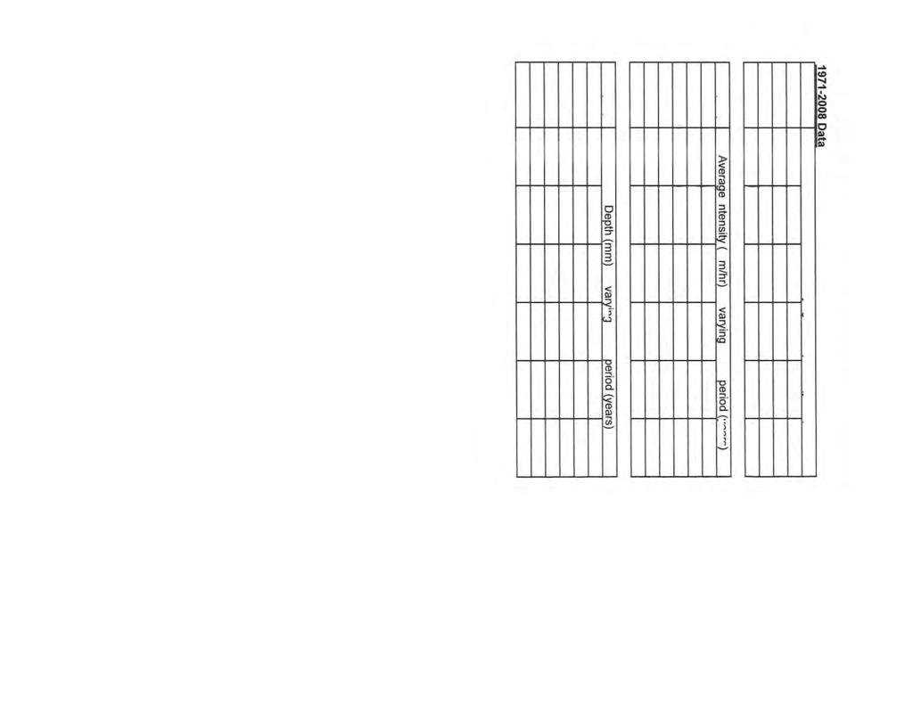
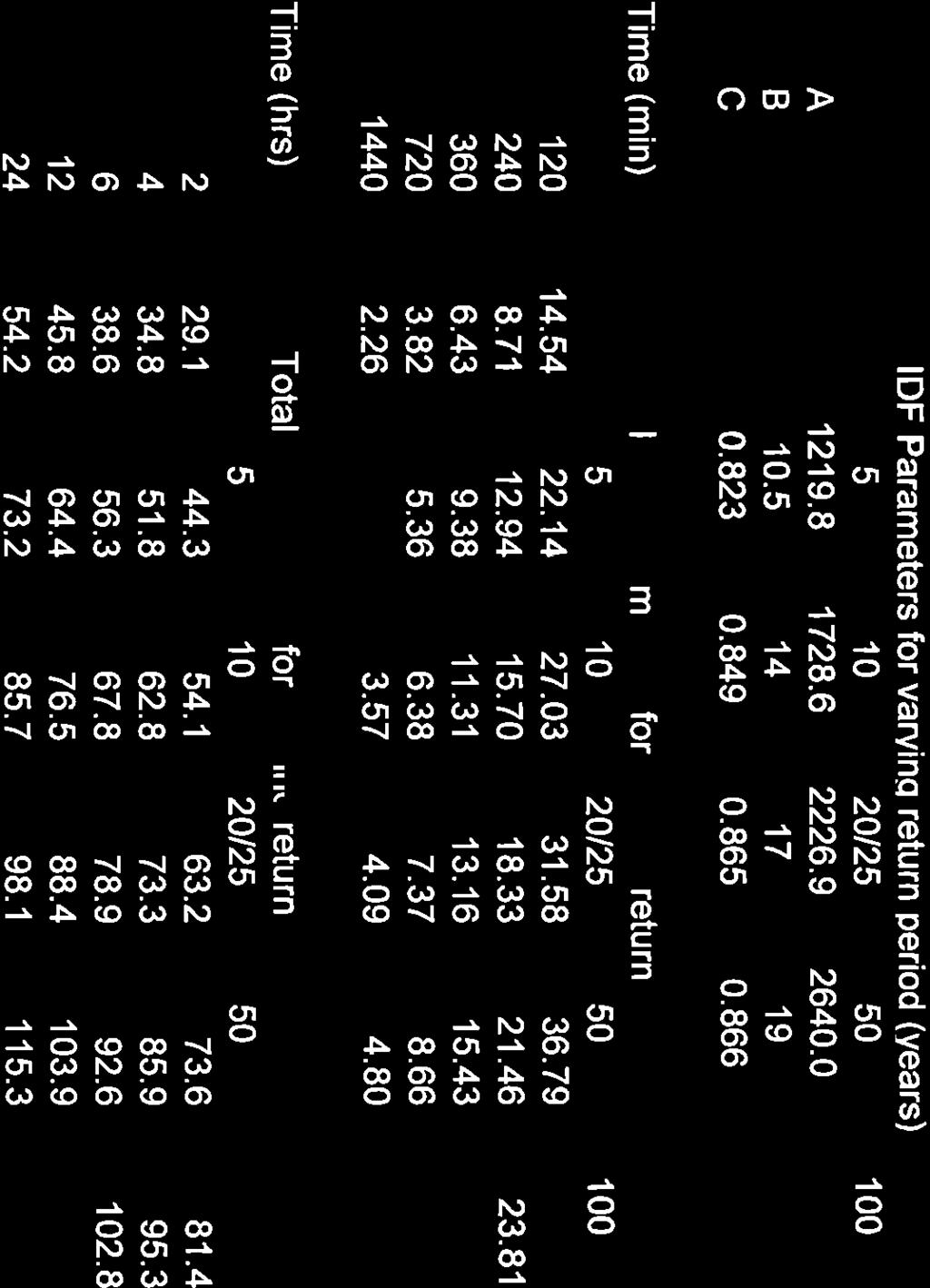
42
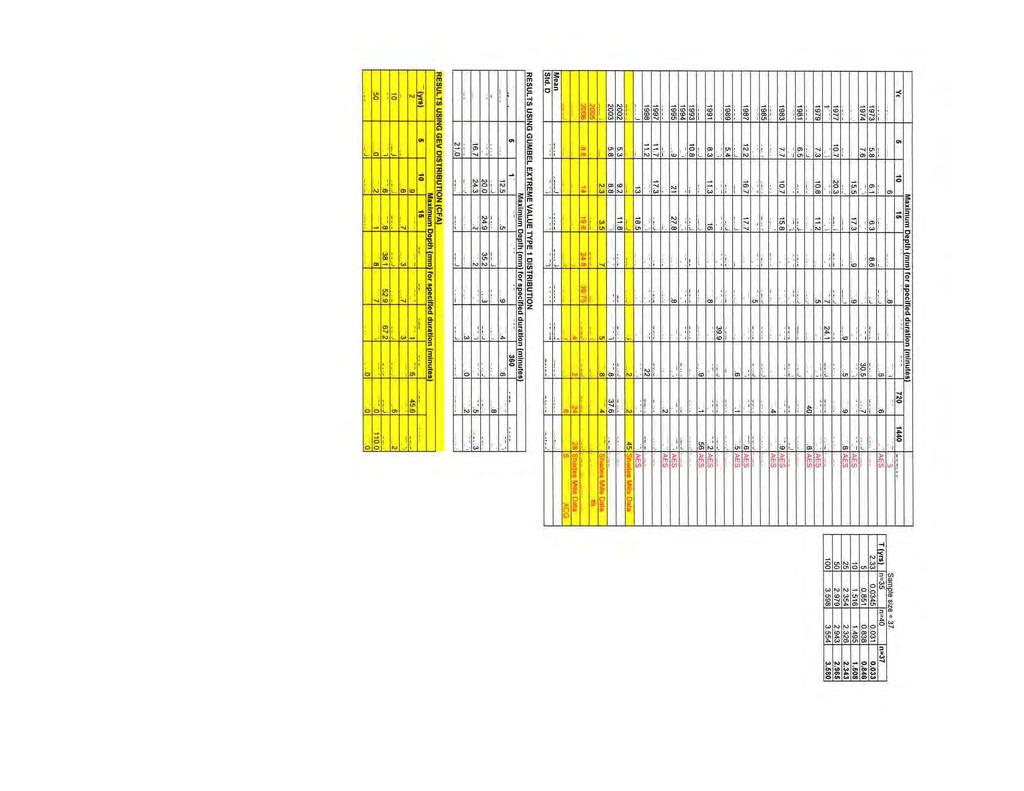
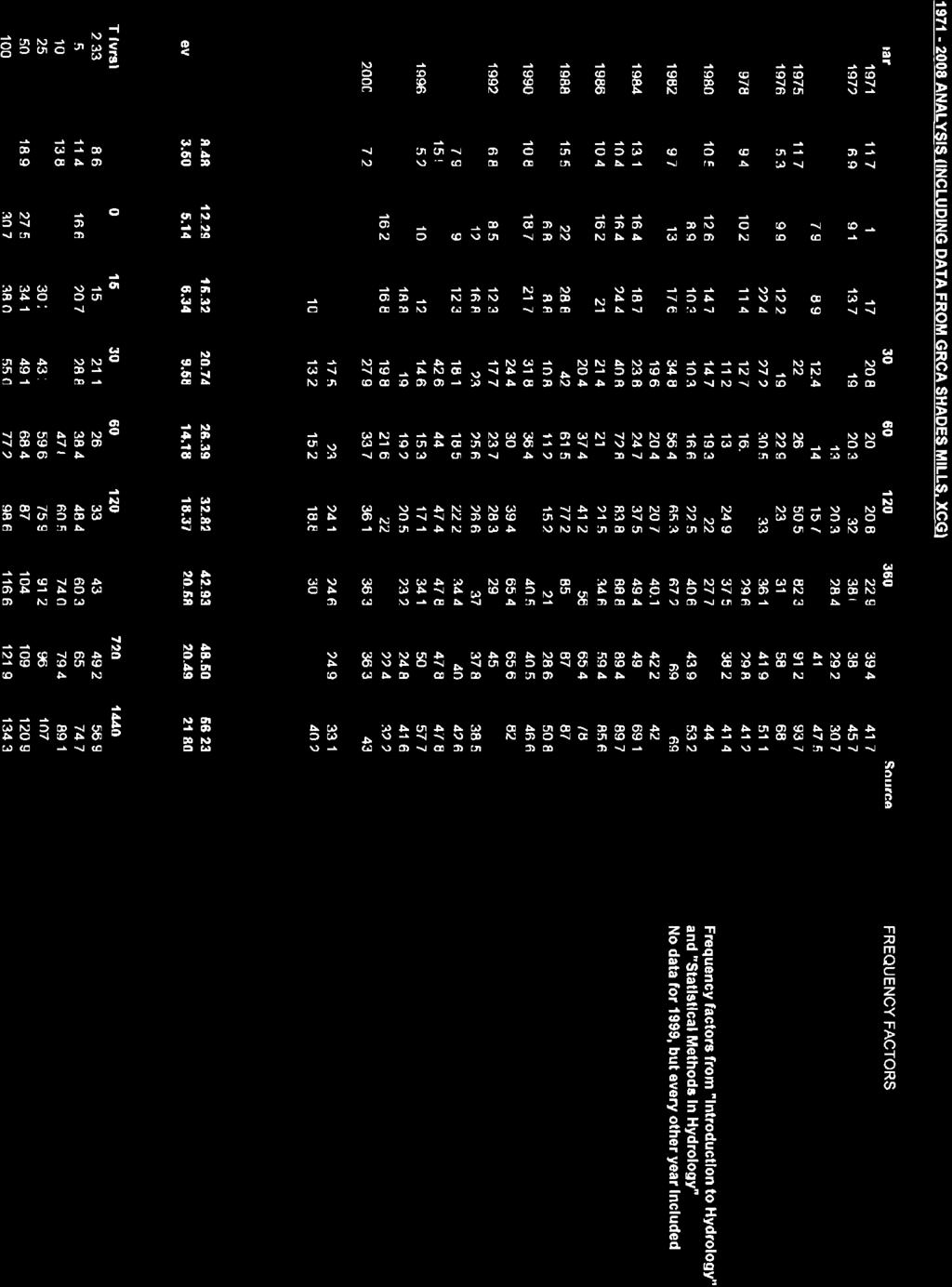
43
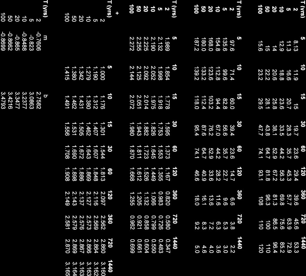
44
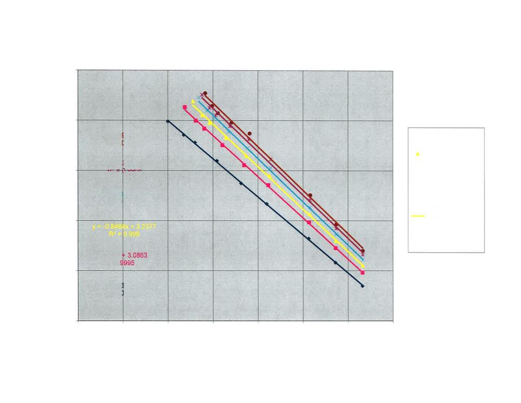

45
46 Stormwater Management Policies and Guidelines August 2011 APPENDIX B PROVINCIAL CRITERIA FOR STORMWATER QUALITY FACILITY DESIGN 34

47
48
49

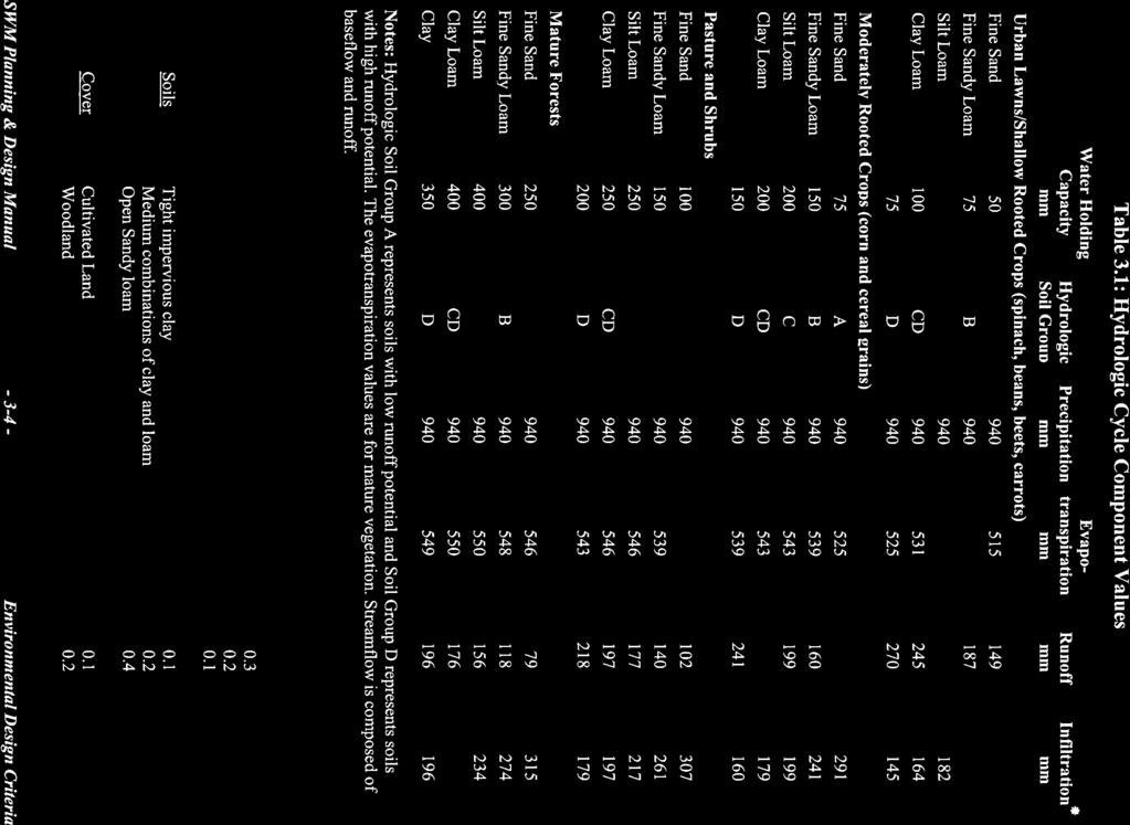
50
51
52

53
54
55
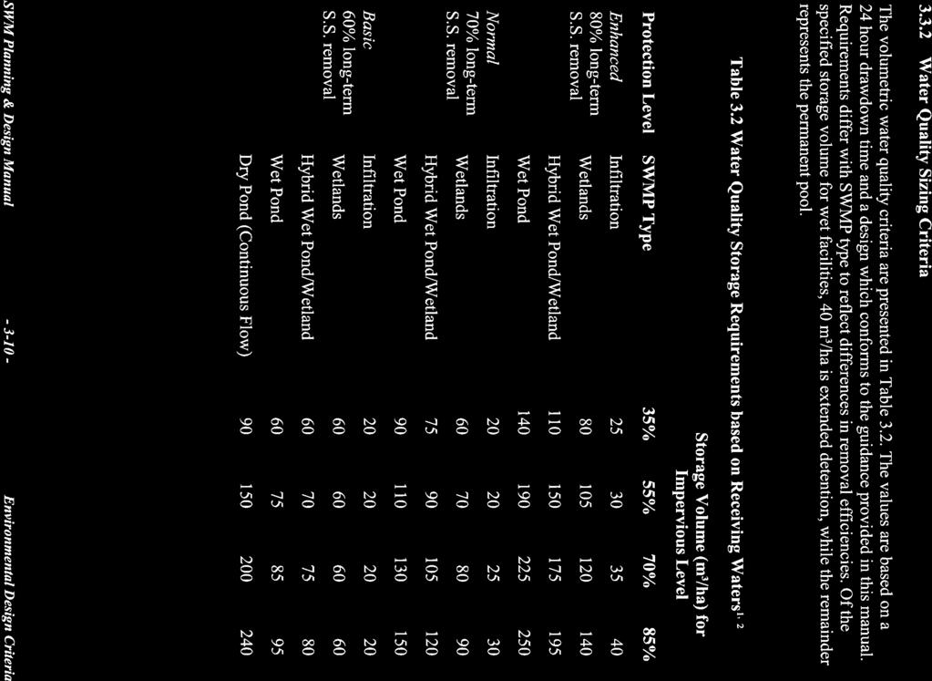
56
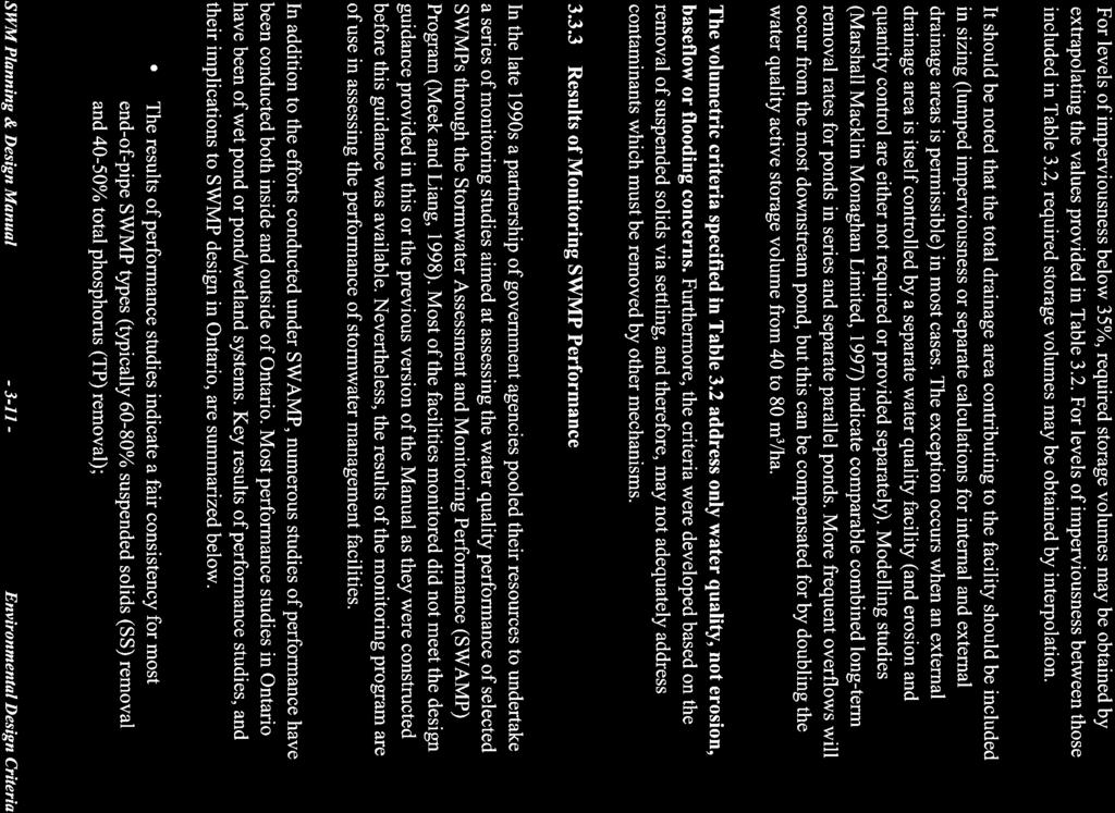
57
58
59
60
61
62
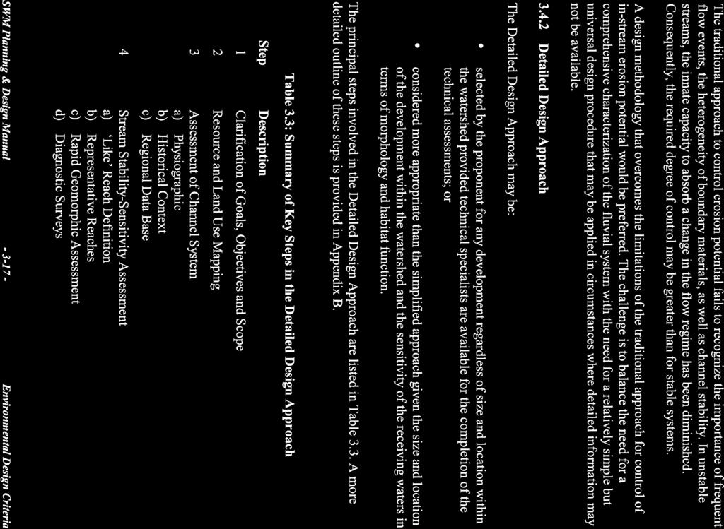
63
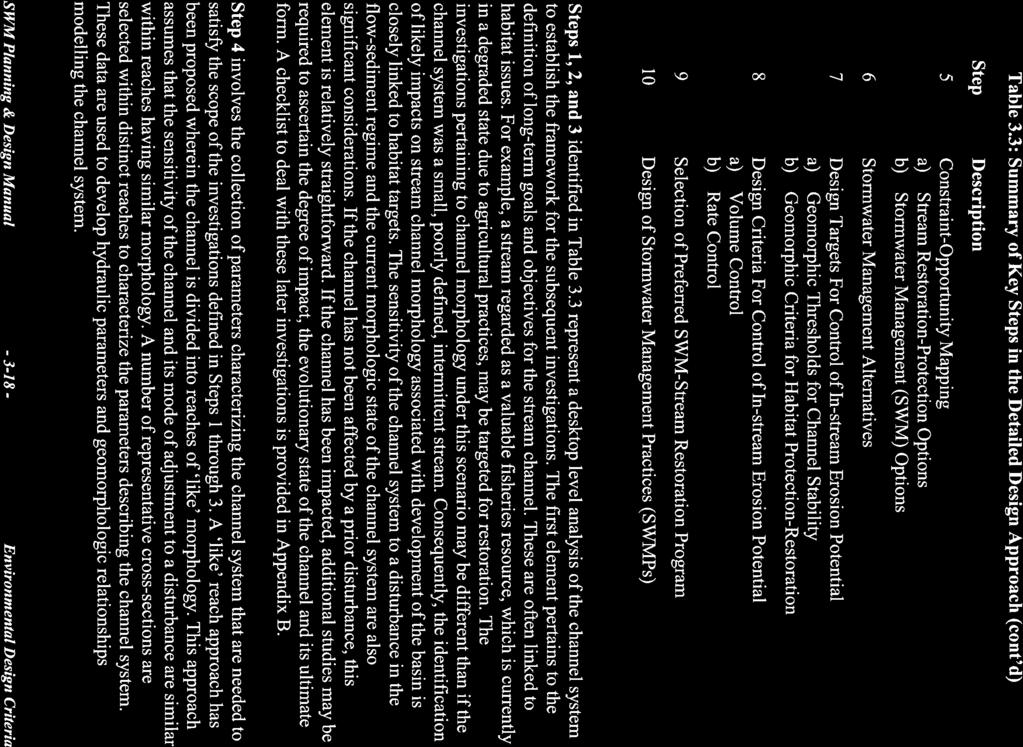
64

65
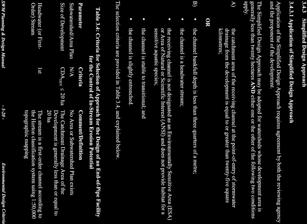
66
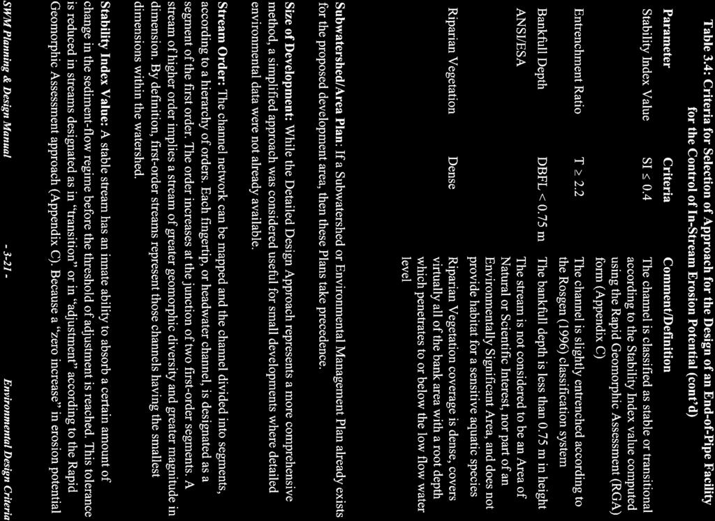
67
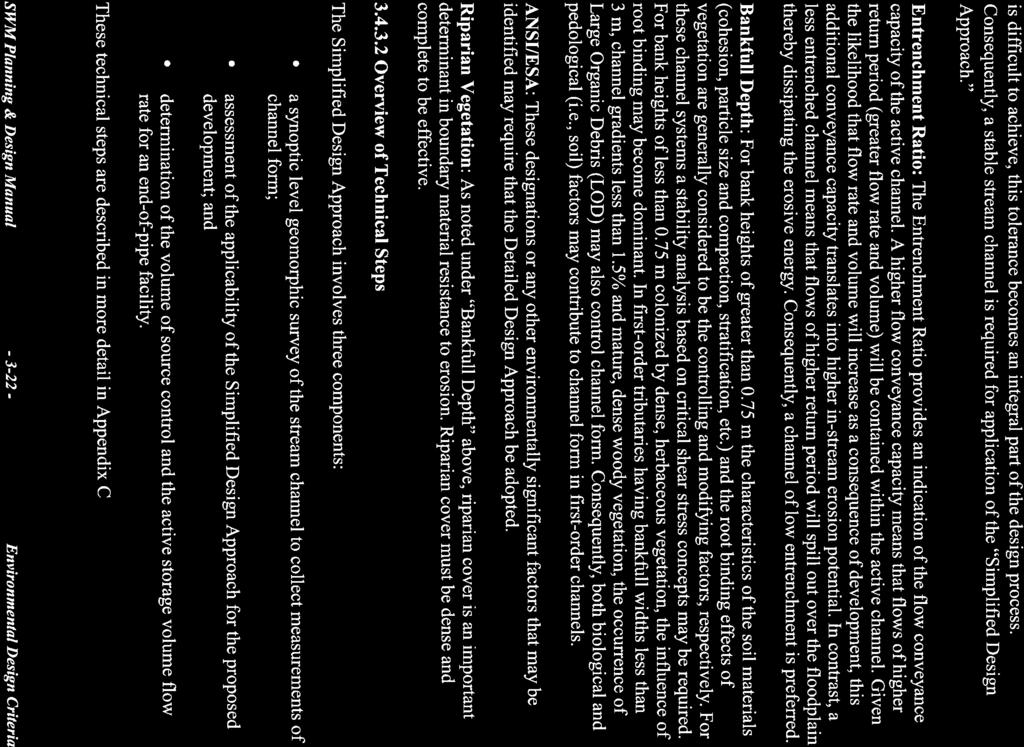
68
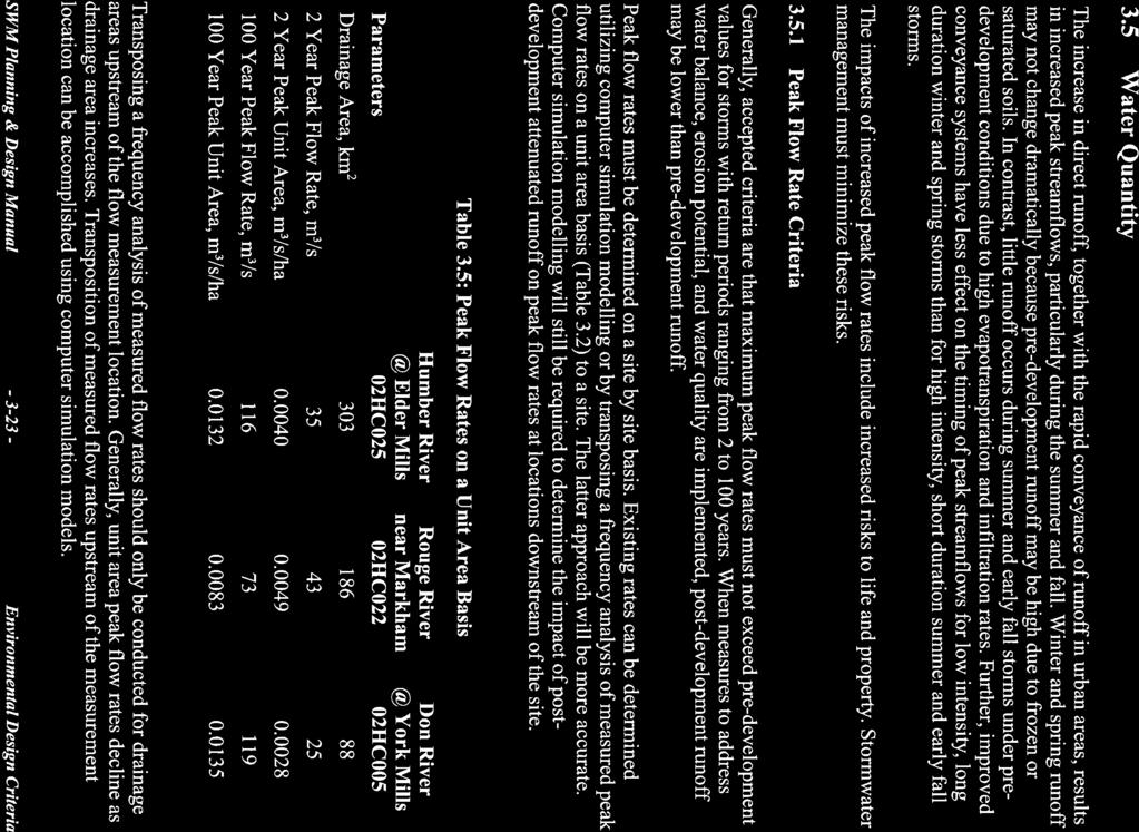
69
70
71

72
73
74
75

76
77
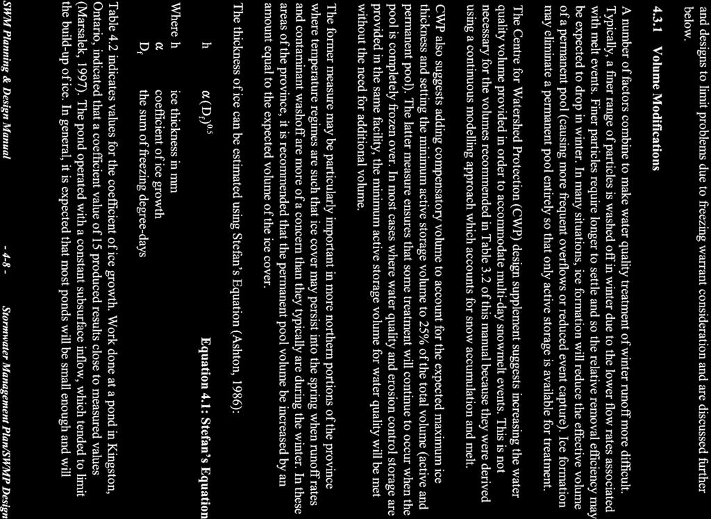
78
79

80
81
82

83
84
85

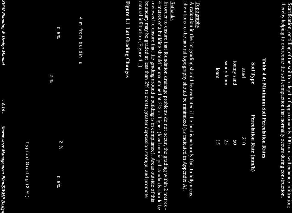
86

87
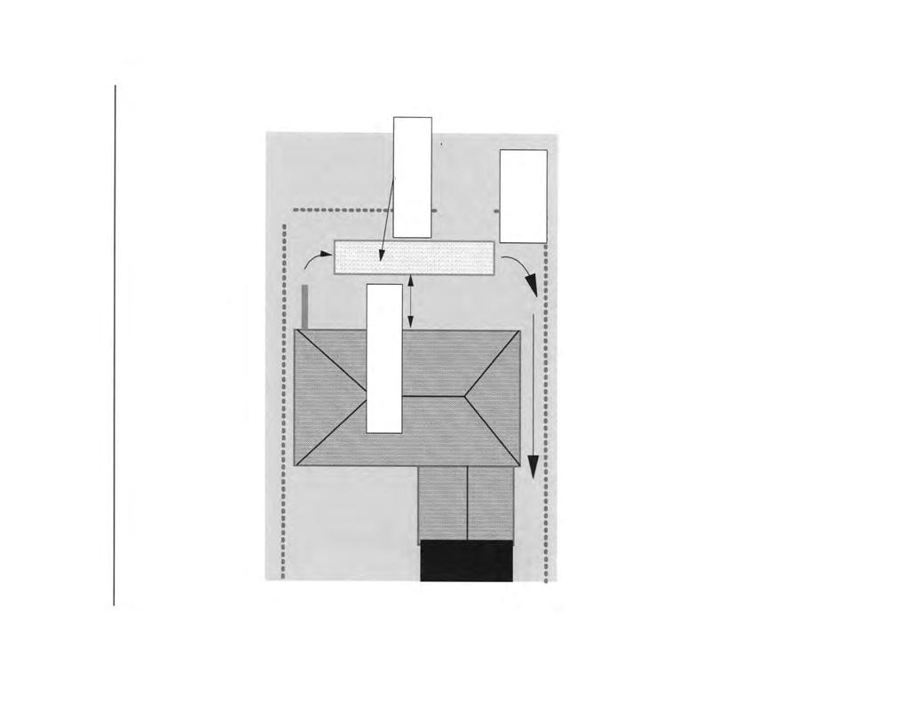
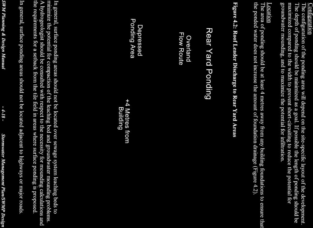
88

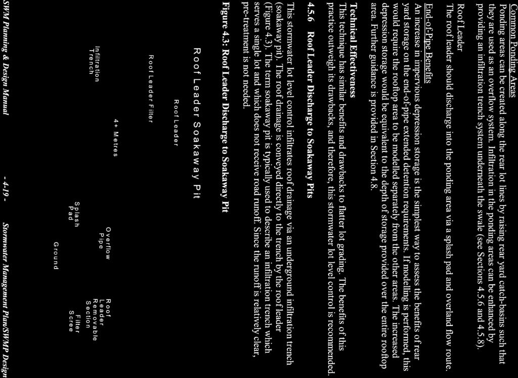
89

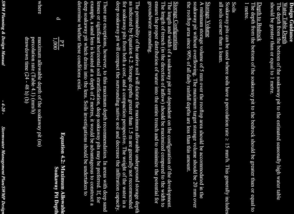
90
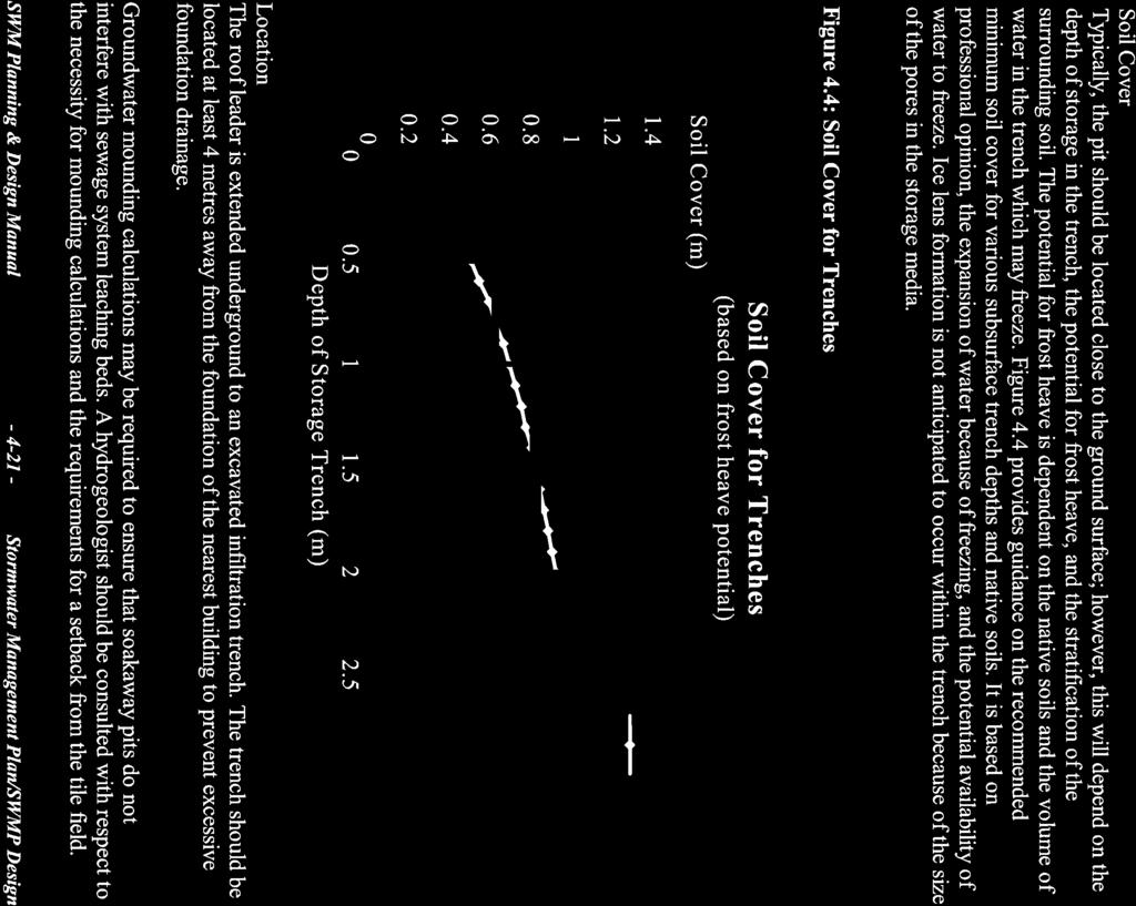
91
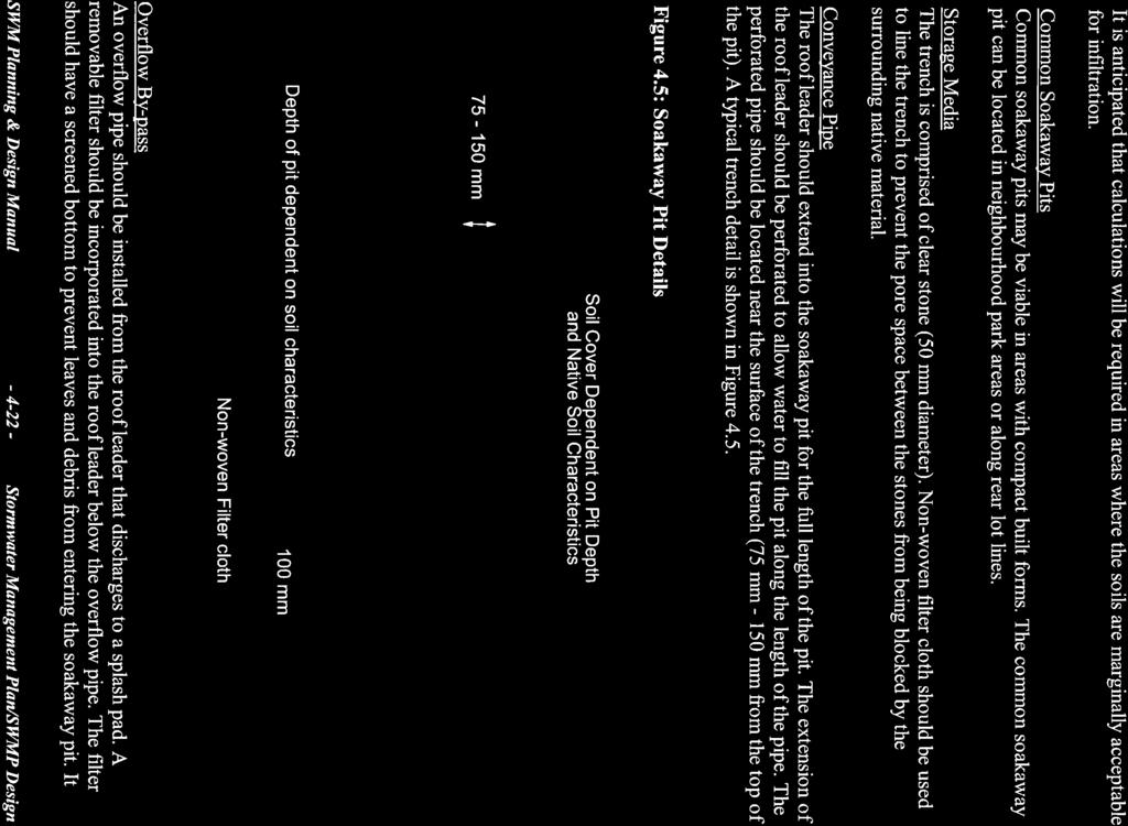
92
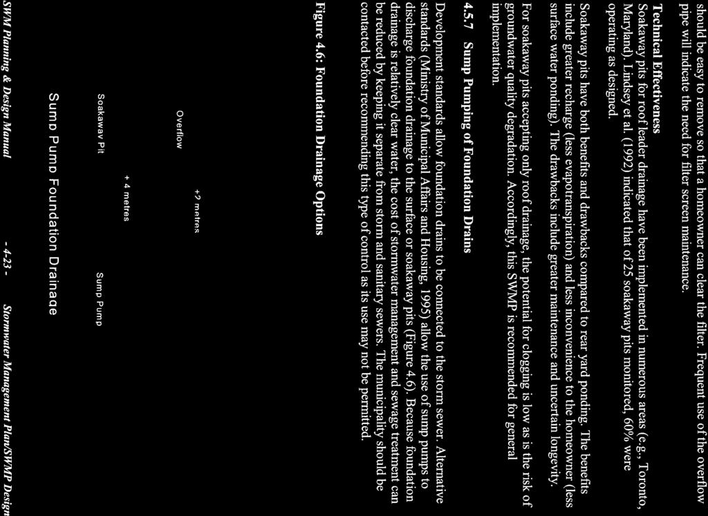
93
94

95

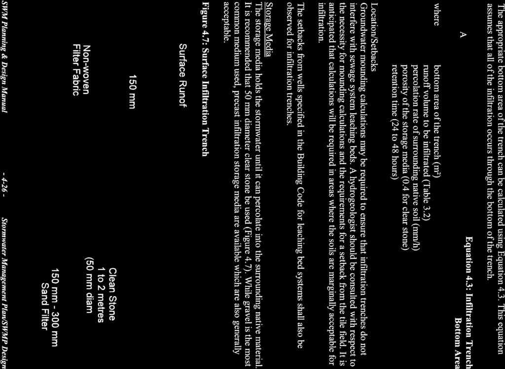
96
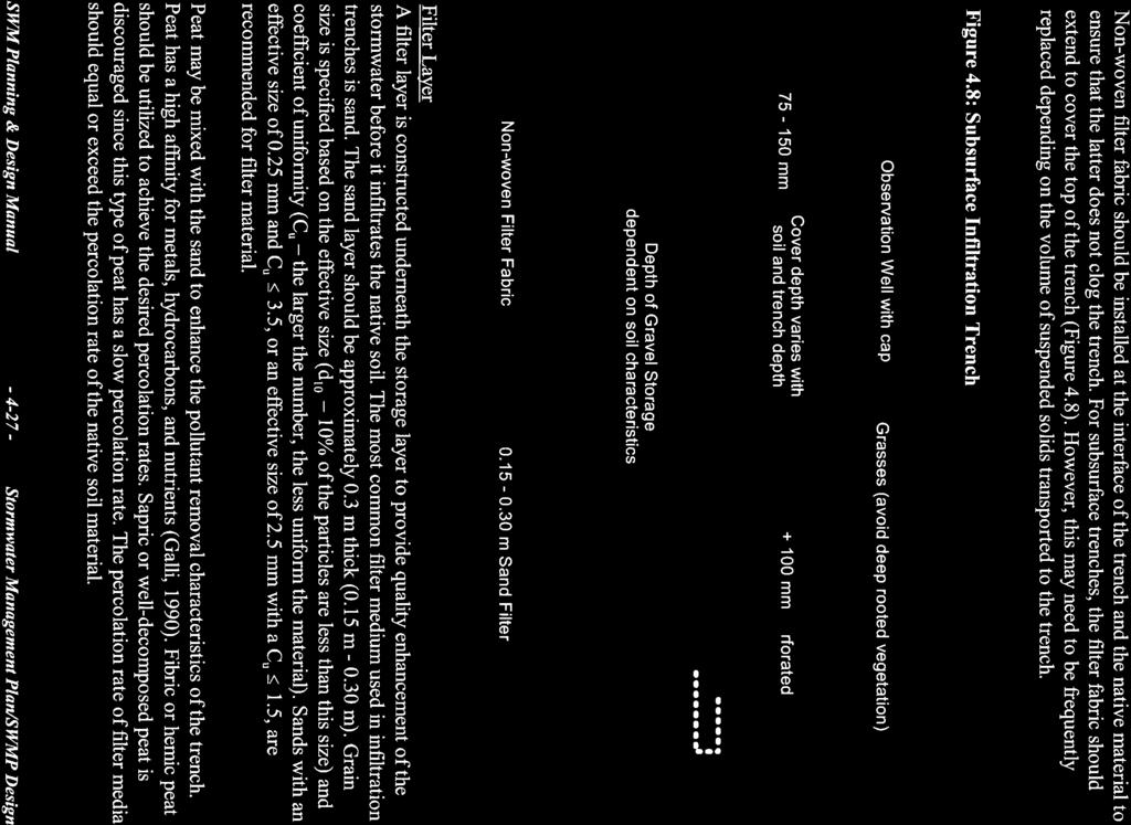
97

98
99

100

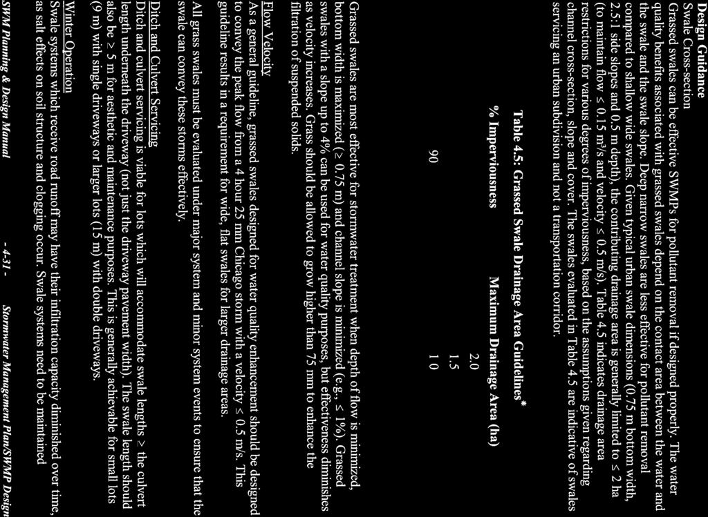
101
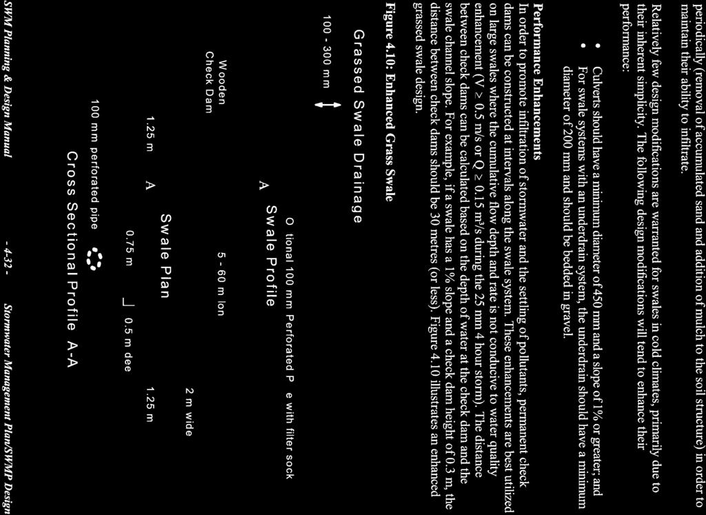
102
103

104
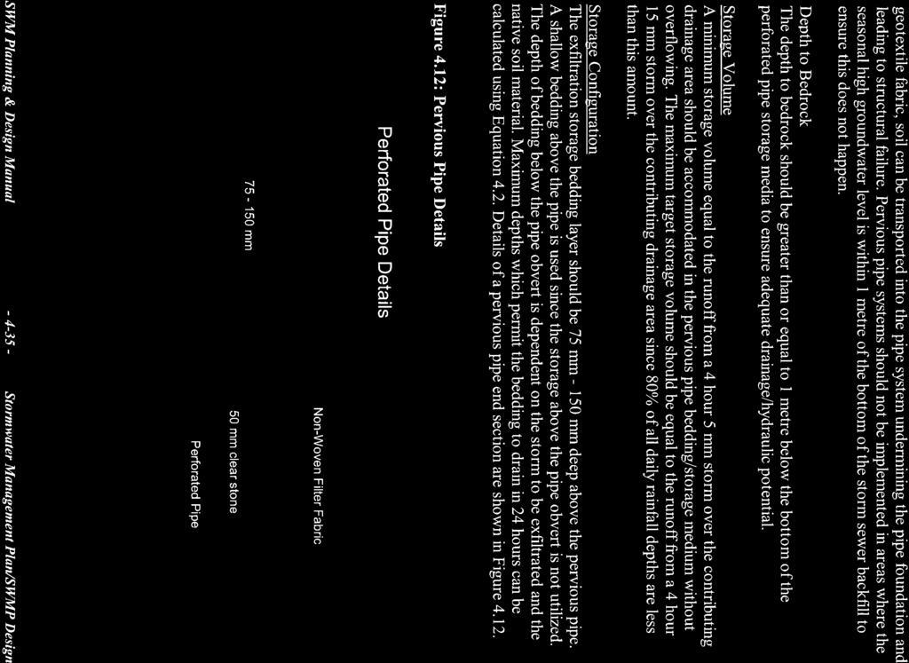
105
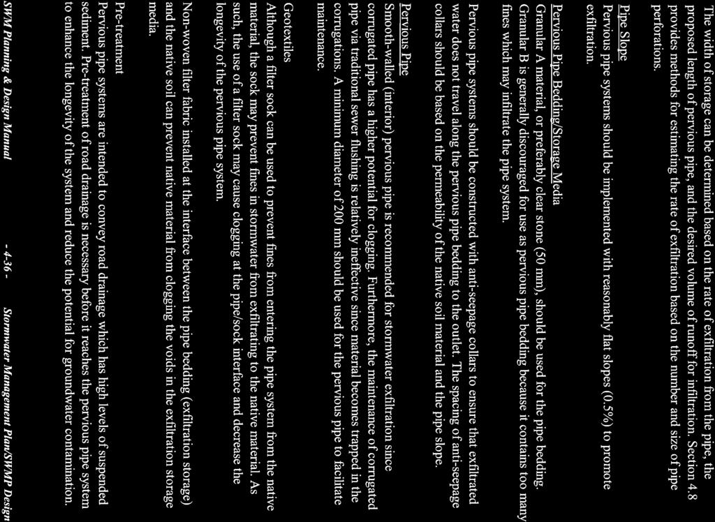
106
107
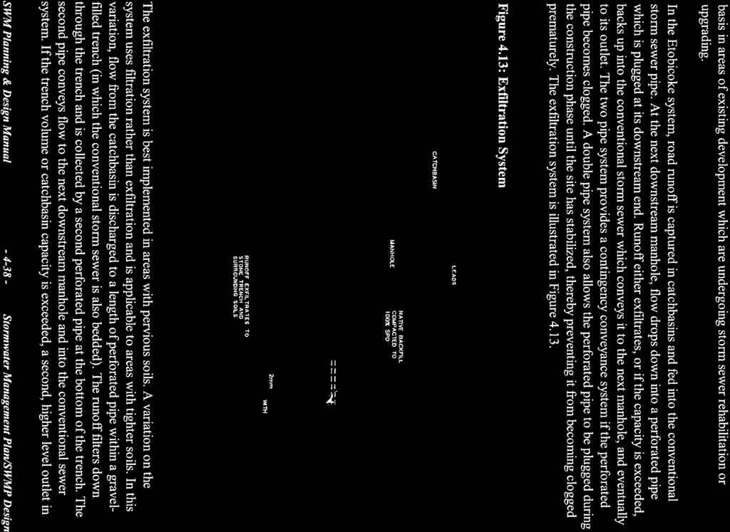
108

109

110
111
112
113
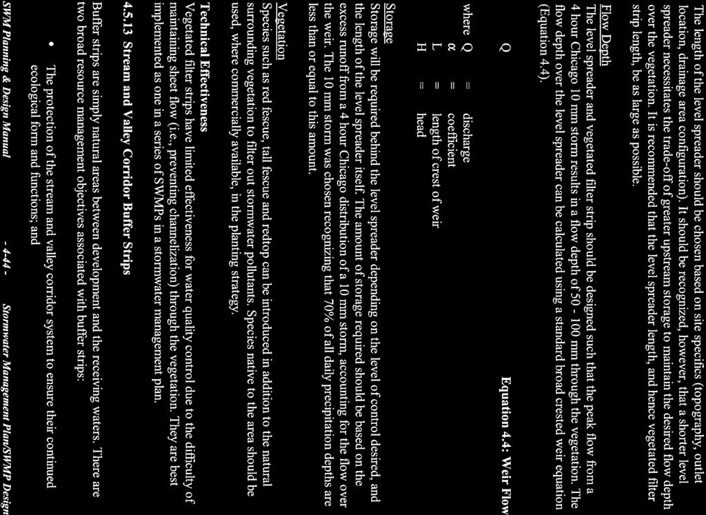
114
115
116
117
118

119
120
121
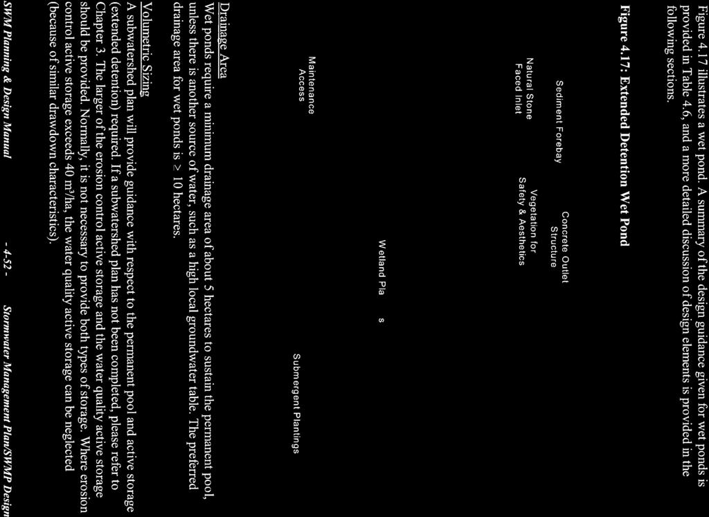
122
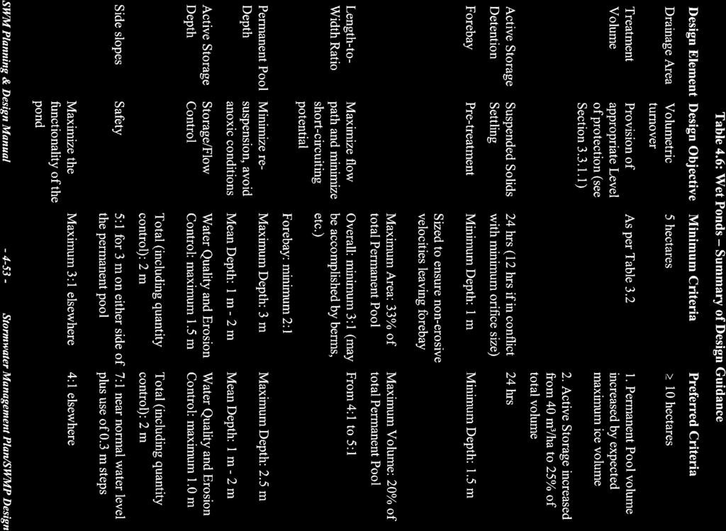
123
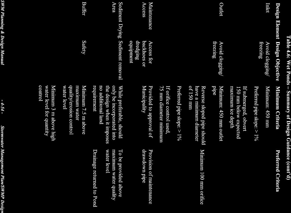
124
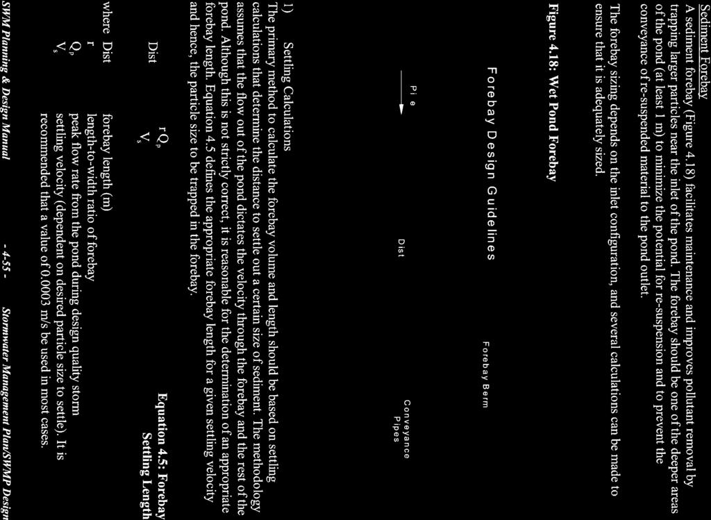
125
126
127
128
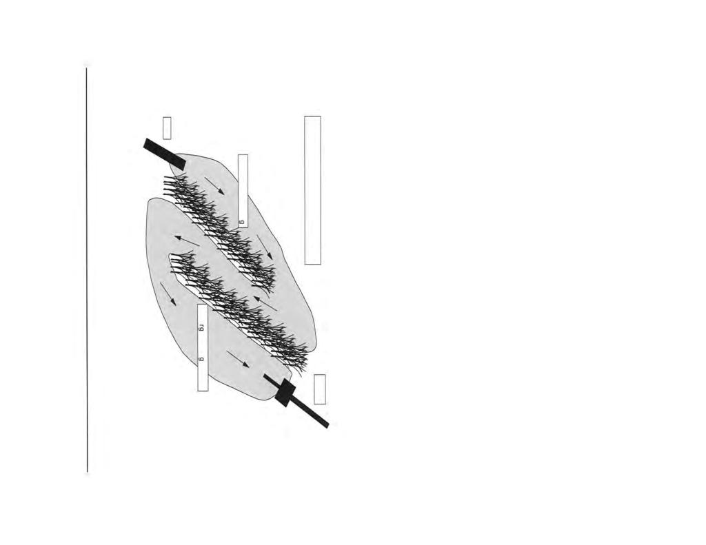

129

130
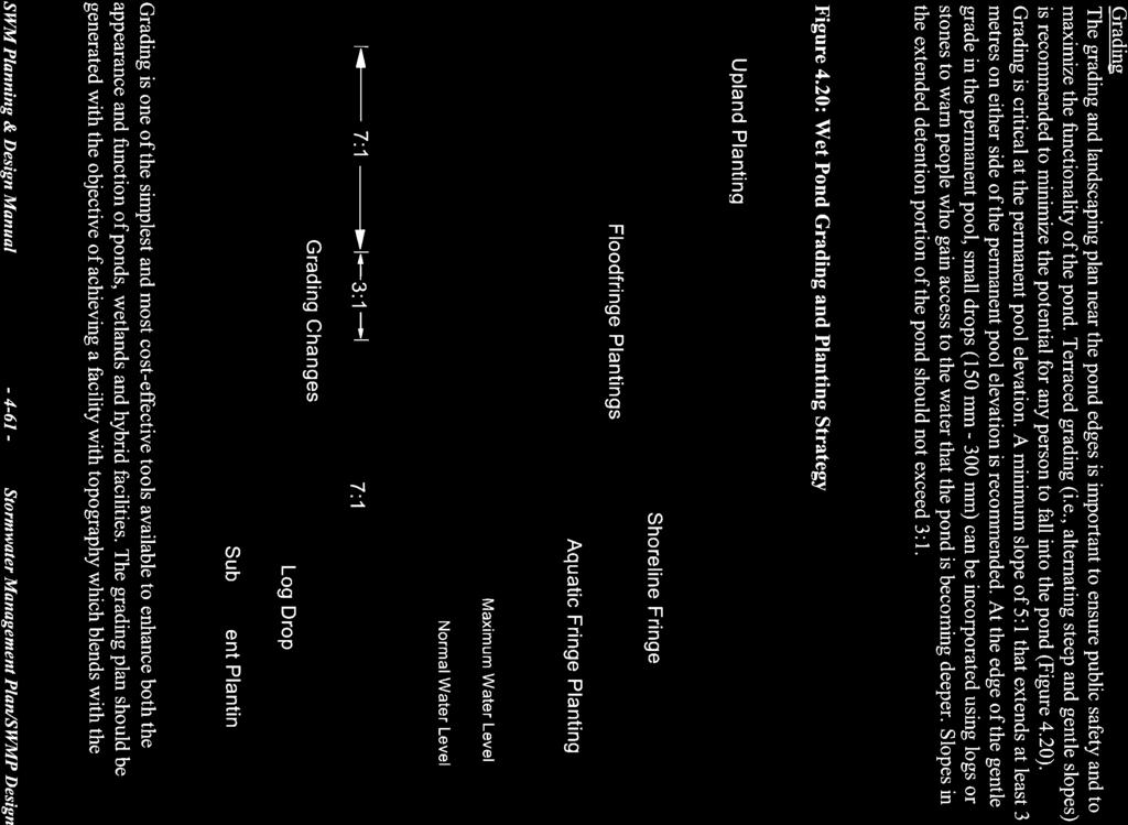
131
132
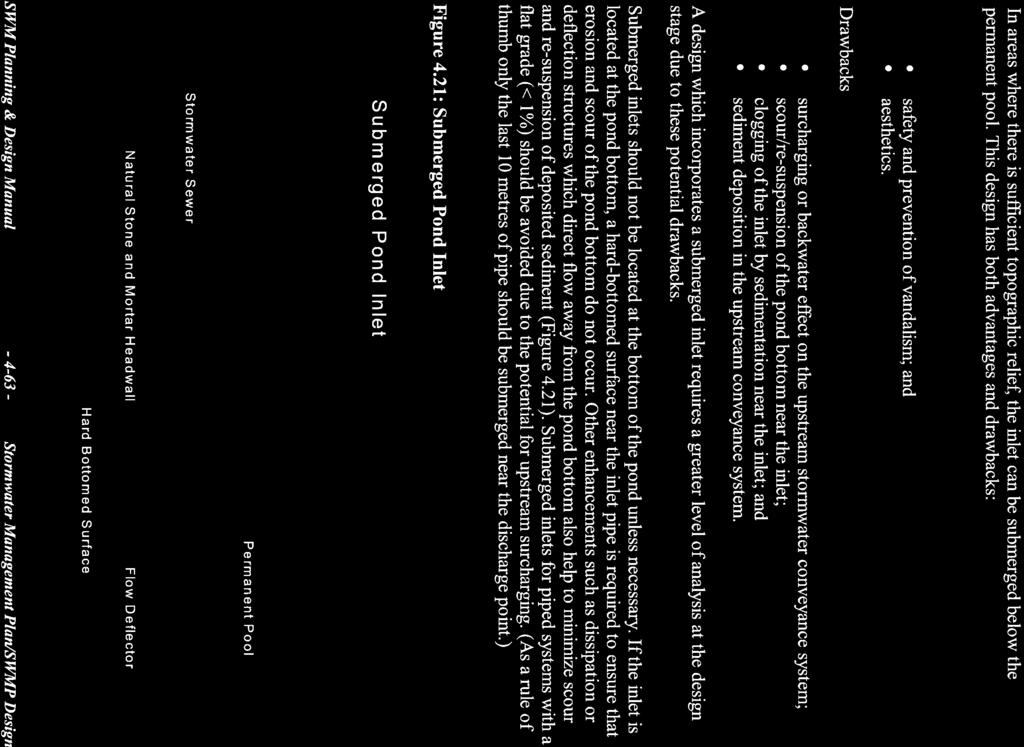
133
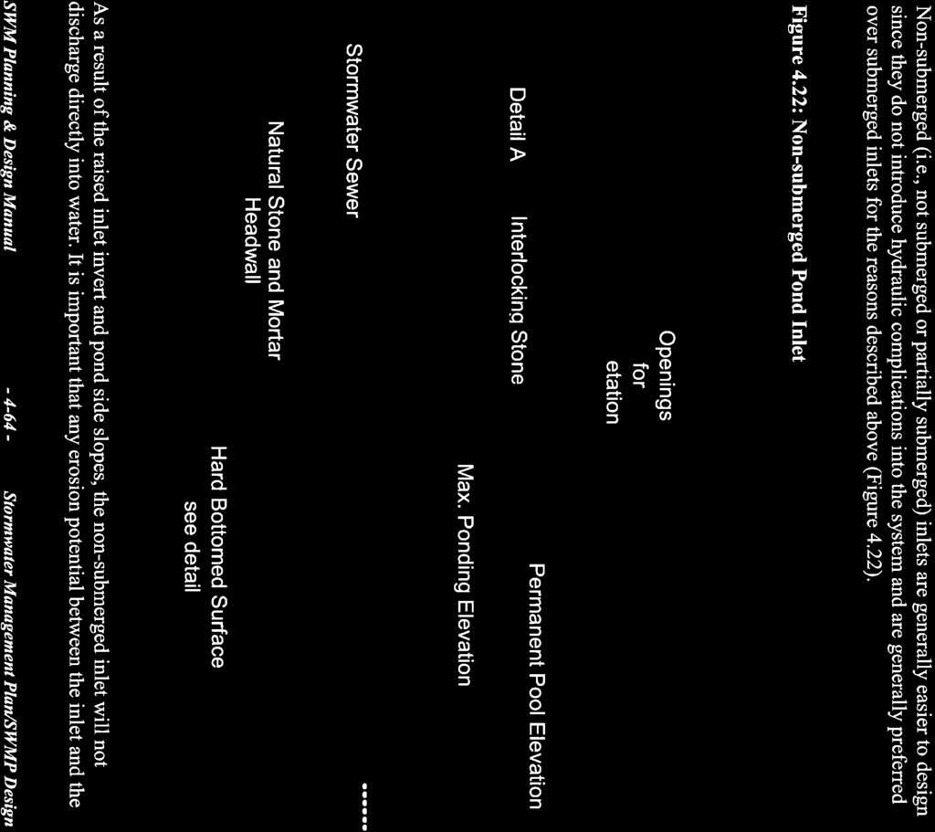
134
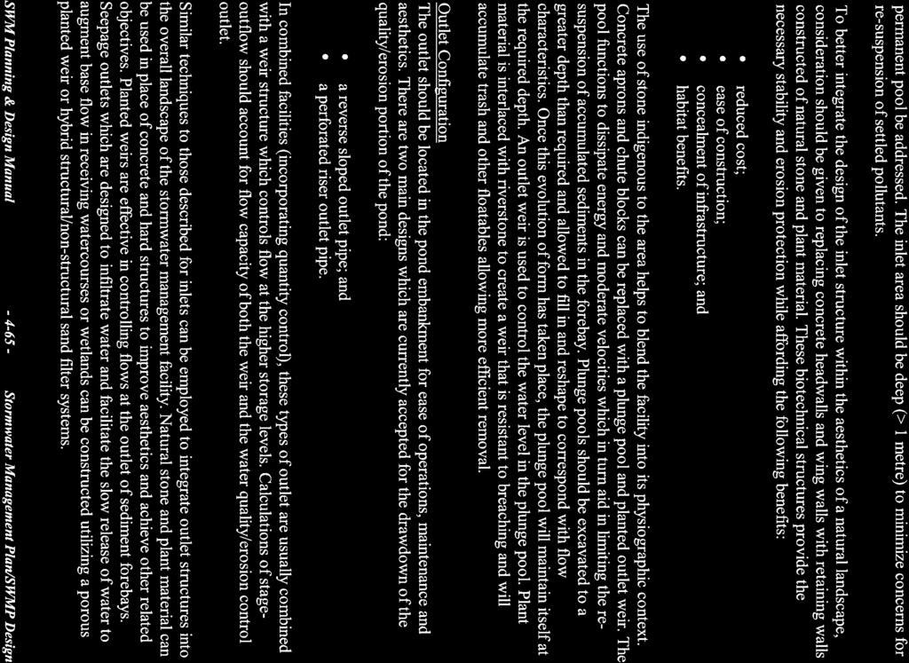
135
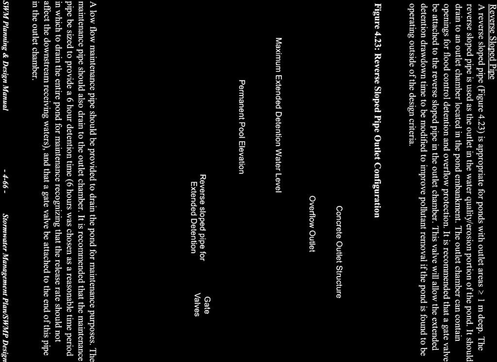
136

137
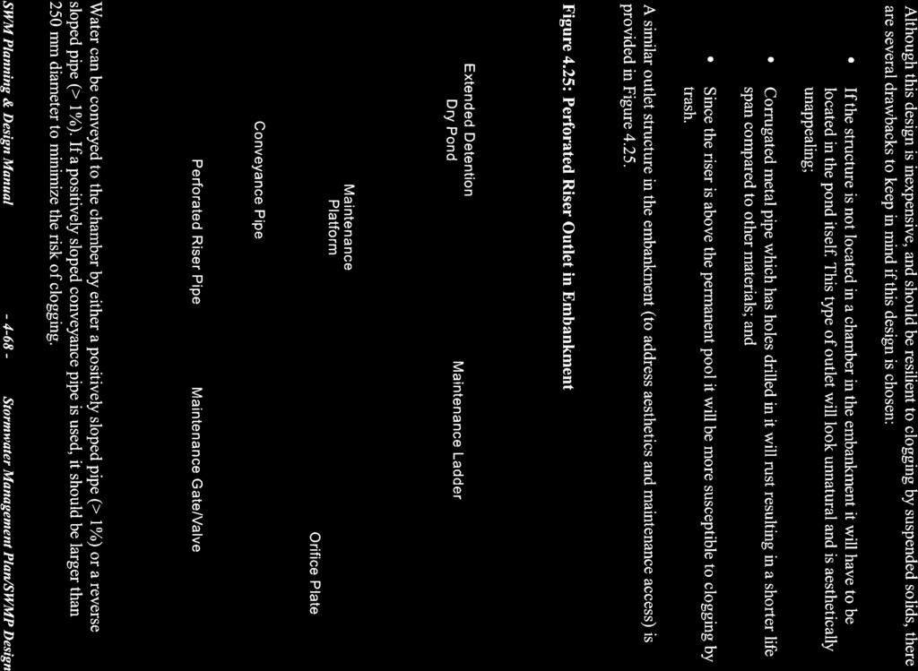
138

139
140
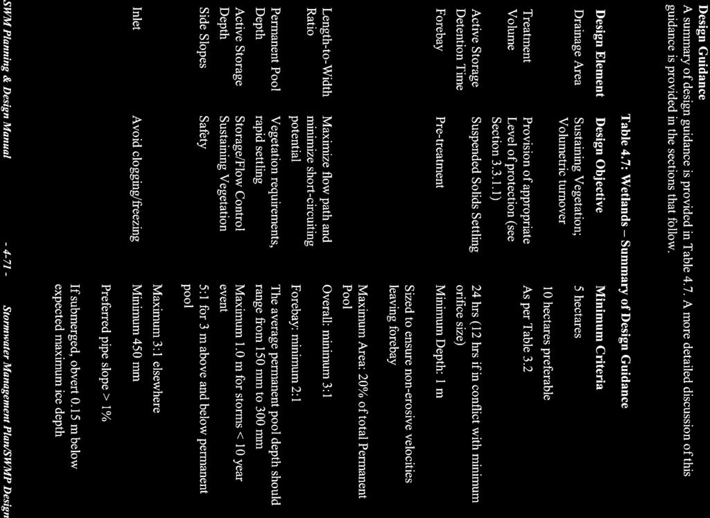
141

142

143

144

145
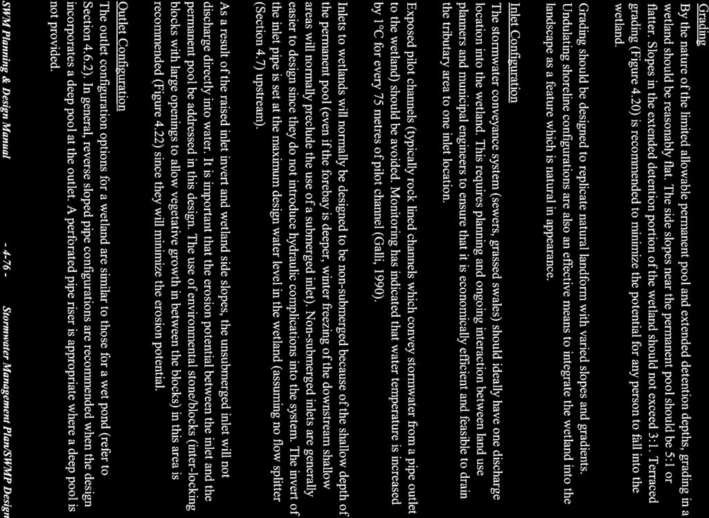
146

147

148
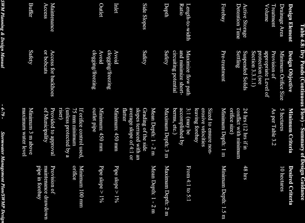
149

150
151

152
153
154
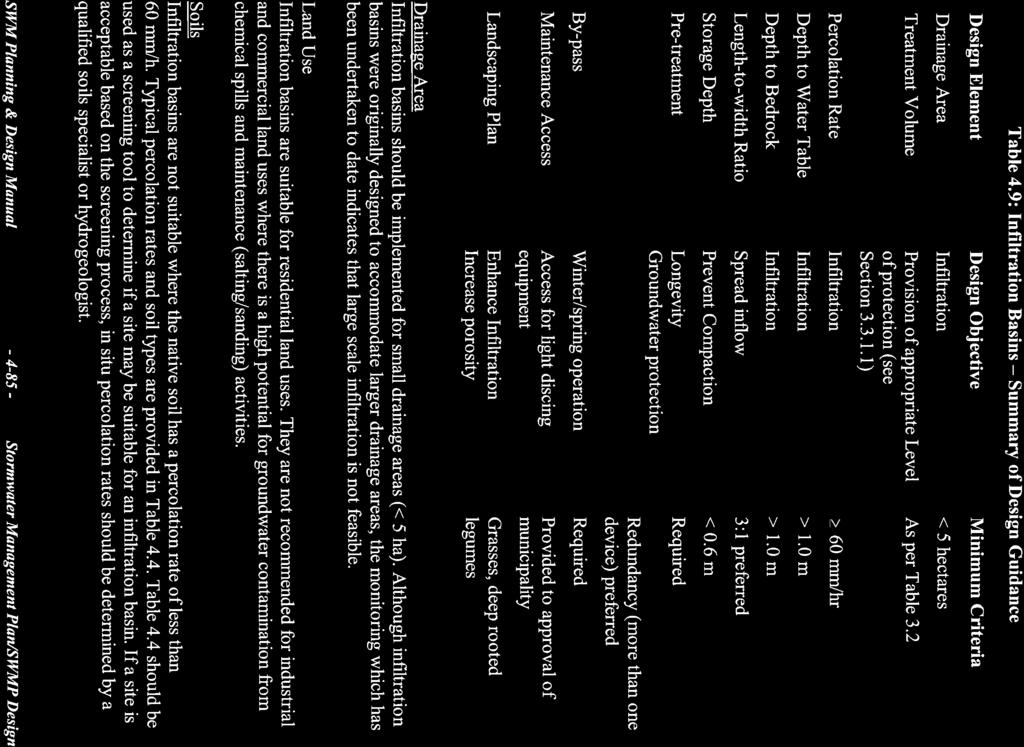
155
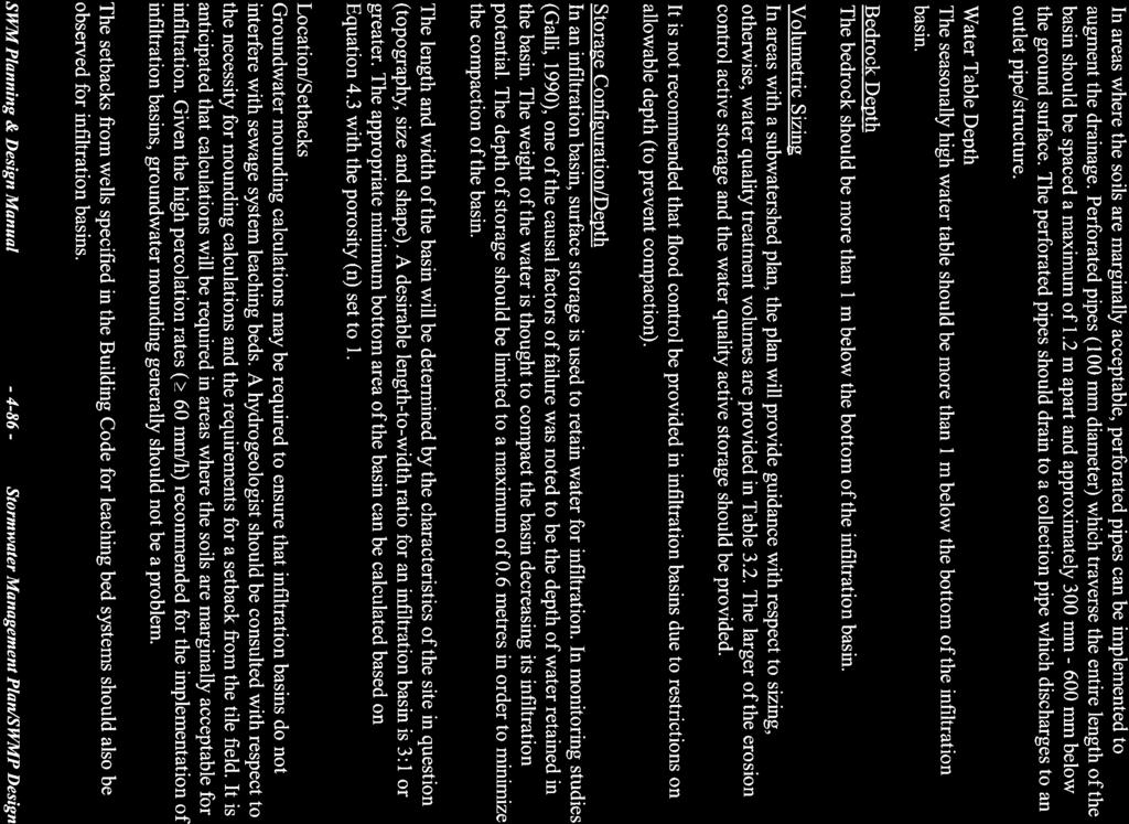
156
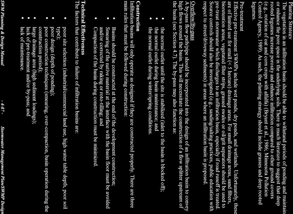
157
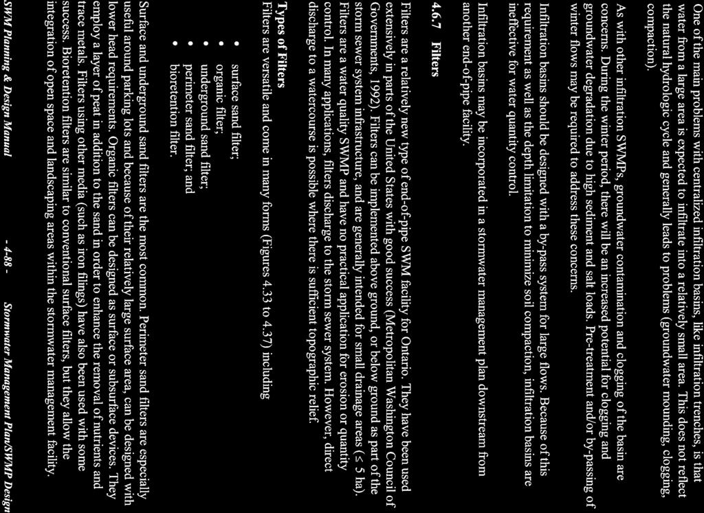
158
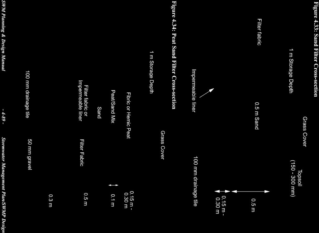
159
160
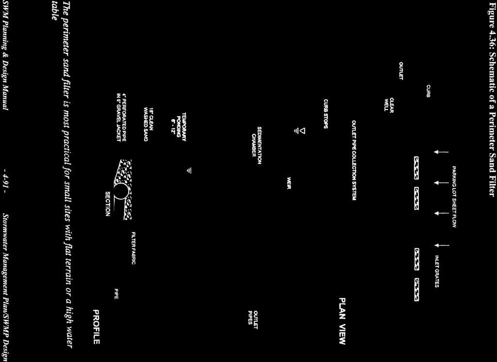
161
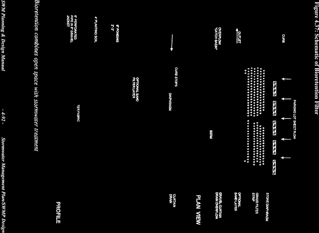
162
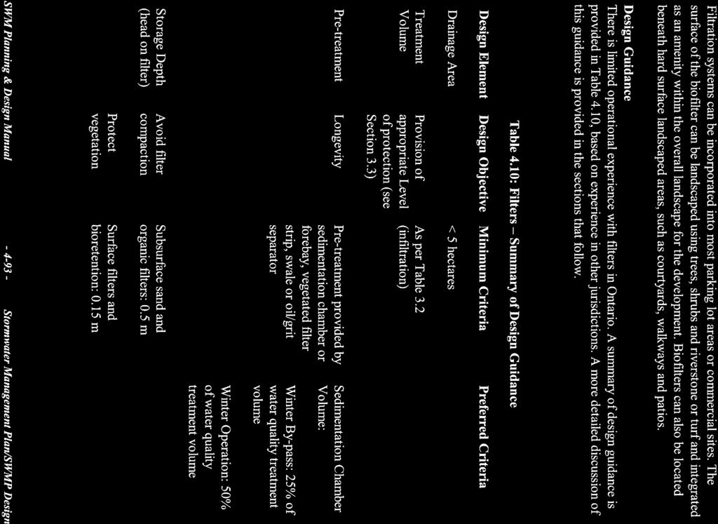
163

164
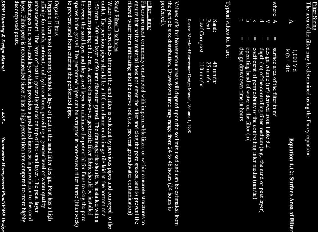
165
166
167
168

169
170
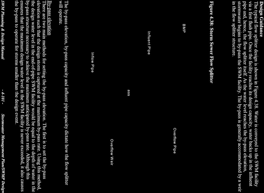
171
172
173
174
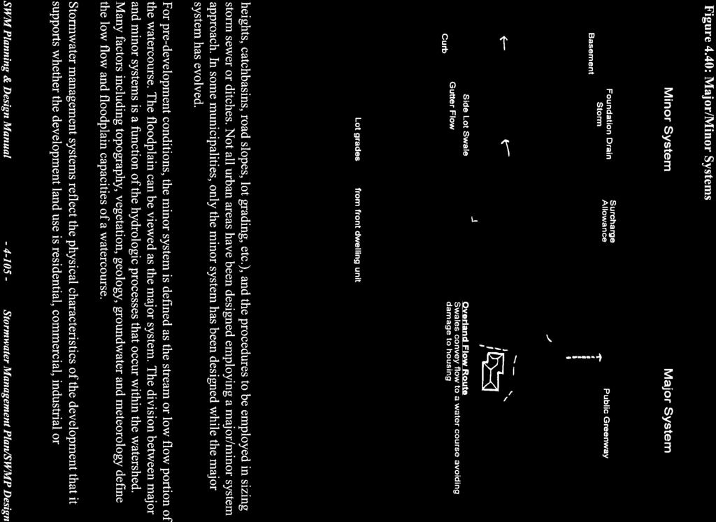
175
176
177
178
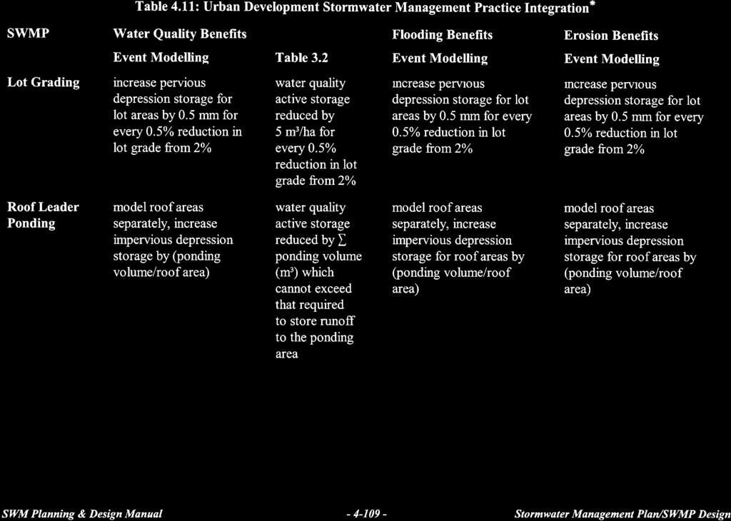
179
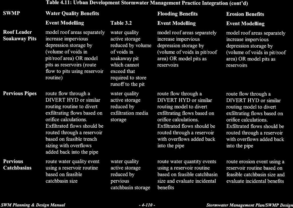
180
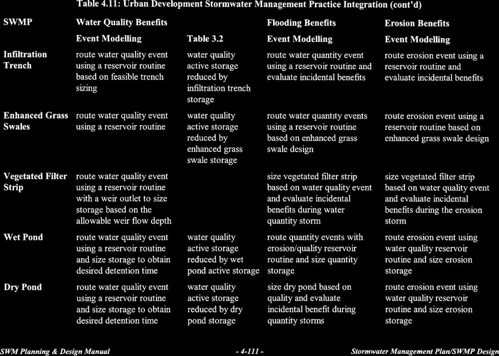
181

182
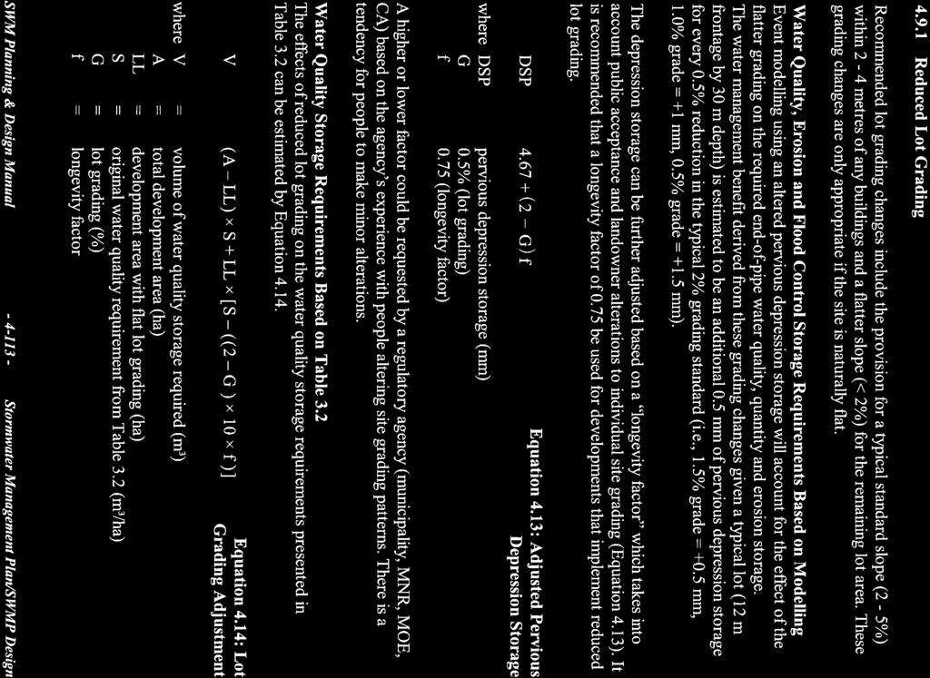
183
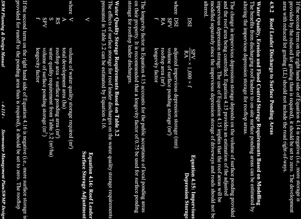
184
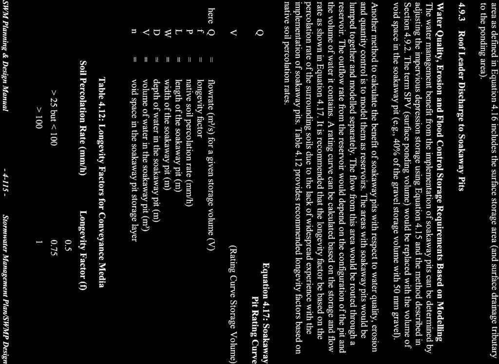
185
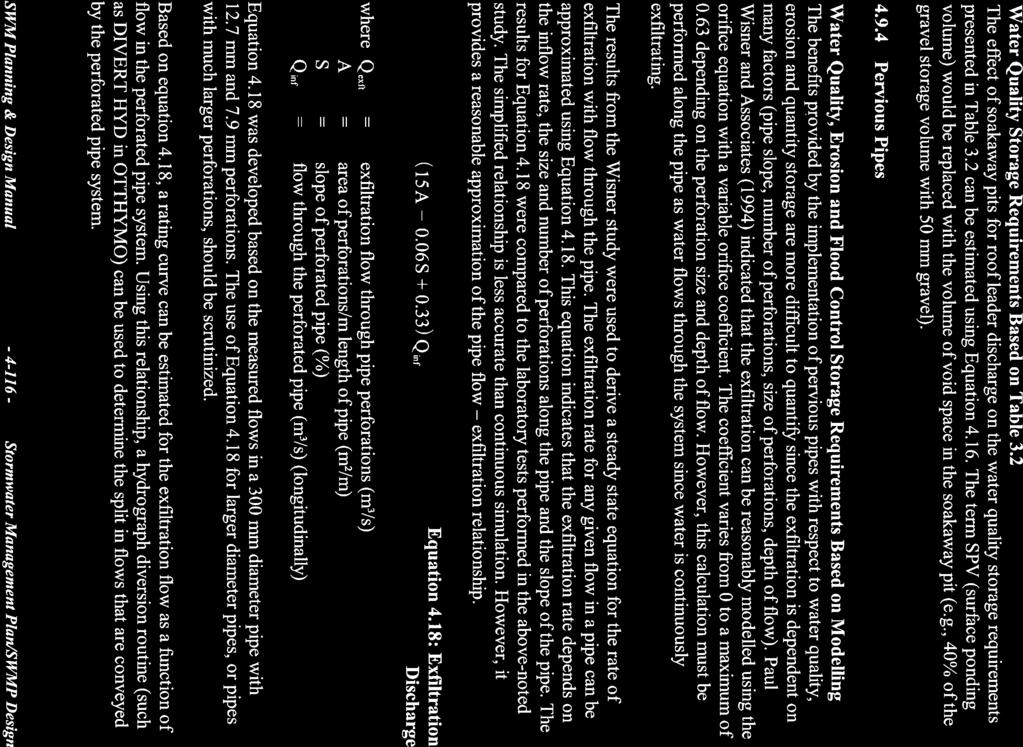
186
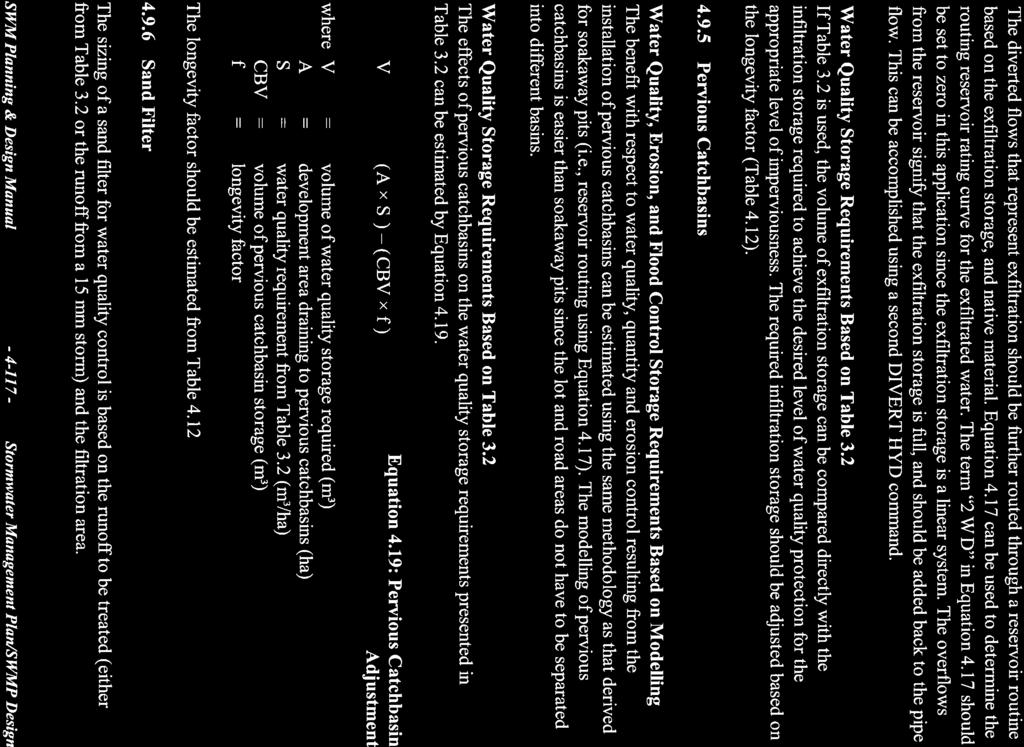
187
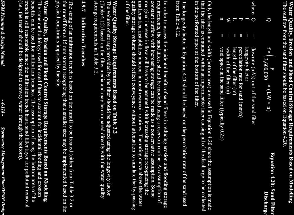
188
189
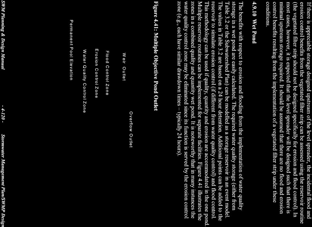
190
191

192
When planning stormwater management facilities, the following principles shall be applied where possible.
 2.0 Principles When planning stormwater management facilities, the following principles shall be applied where possible. 2.0.1 Drainage is a regional phenomenon that does not respect the boundaries between
MANUAL OF DESIGN, INSTALLATION, AND MAINTENANCE REQUIREMENTS FOR STORMWATER MANAGEMENT PLANS
 MANUAL OF DESIGN, INSTALLATION, AND MAINTENANCE REQUIREMENTS FOR STORMWATER MANAGEMENT PLANS May 2007 SECTION 1 Responsibility of Applicant TABLE OF CONTENTS A. Stormwater Management Plan Required Information
STORMWATER MANAGEMENT CODES ANALYSIS RICHLAND COUNTY, SC SITE PLANNING ROUNDTABLE
 STORMWATER MANAGEMENT CODES ANALYSIS RICHLAND COUNTY, SC SITE PLANNING ROUNDTABLE Codes analyses for each subcommittee were completed to assist participants of the Richland County Site Planning Roundtable.
APPENDIX A SIMPLIFIED APPROACH TO STORMWATER MANAGEMENT FOR SMALL PROJECTS. In West Sadsbury Township, Chester County, Pennsylvania
 APPENDIX A SIMPLIFIED APPROACH TO STORMWATER MANAGEMENT FOR SMALL PROJECTS In West Sadsbury Township, Chester County, Pennsylvania TABLE OF CONTENTS I. Introduction 3 II. Importance of Stormwater Management
5. LOW IMPACT DEVELOPMENT DESIGN STANDARDS
 5. LOW IMPACT DEVELOPMENT DESIGN STANDARDS Low Impact Development (LID) requires a shift in stormwater management away from conveying runoff to a small number of downstream points through hydraulically
Draft Rhode Island Stormwater Design and Installation Standards Manual
 Draft Rhode Island Stormwater Design and Installation Standards Manual Summary The May 2009 Public Review Draft version of the RI Stormwater Design and Installation Standards Manual consists of approximately
WQ-23 MOUNTAINOUS AND STEEP SLOPE SITES
 Greenville County Technical Specification for: WQ-23 MOUNTAINOUS AND STEEP SLOPE SITES 1.0 Mountainous and Steep Slope Sites 1.1 Description The geographic locations of portions of Greenville County are
Appendix I. Checklists
 Appendix I Checklists Town of Greenwich Drainage Manual Department of Public Works - Engineering Division Town Hall - 101 Field Point Road, Greenwich, CT 06836-2540 Phone 203-622-7767 - Fax 203-622-7747
Appendices: Glossary. General Terms. Specific Terms. Low Impact Development Approaches Handbook
 67 67 General Terms Specific Terms 66 Low Impact Development Approaches Handbook The vocabulary of low impact development is evolving, and many terms are used interchangeably and to describe the same or
APPENDIX F: EXTERNAL APPROVALS
 1.0 RESPONSIBILITIES When the City is constructing the Park or Open Space Development lands (OPTION I), after the subdivision construction process is completed by the Developer, Open Space Development
Chapter 1: General Program Information
 Chapter 1: General Program Information 1.1 Introduction The Montgomery County Stormwater Management Resolution (#03-1-5) was adopted by the County Board of Commissioners on January 22, 2003. The purpose
City of Waco Stormwater Management Regulations
 1.0 Applicability: City of Waco Stormwater Management Regulations These regulations apply to all development within the limits of the City of Waco as well as to any subdivisions within the extra territorial
Zoning Regulation Amendments Adopted December 19, 2018 effective date January 7, 2019
 Zoning Regulation Amendments Adopted December 19, 2018 effective date January 7, 2019 Article 2 General Provisions Section 2.2 Definitions Definitions- FIRE LANE The aisle immediately adjacent to a building
Huntington Stormwater Utility
 Huntington Stormwater Utility Stormwater Management & Sediment and Erosion Control Requirements for Construction Sites Authorized by Huntington City Code Articles: 971, 970, 930, 935, 955, Revised April
Chapter 3 Site Planning and Low Impact Development
 CHAPTER 3 Site Planning and Low Impact Development Chapter 3 Site Planning and Low Impact Development 3.0 Introduction The City of Charleston requires that major residential, large commercial (>1 acre),
4.6. Low Impact and Retentive Grading
 4.6. Low Impact and Retentive Grading Low Impact Grading techniques focus on utilizing existing topography during Site layout to minimize cost. Proposing structures, roads, and other impervious surfaces
Low Impact Development (LID) Techniques. Associate BD Presentation, October 7, 2014
 Techniques. Associate BD Presentation, October 7, 2014") Low Impact Development (LID) Techniques Associate BD Presentation, October 7, 2014 Low Impact Development (LID) Techniques What are LIDs? Why are they used? Where are they used? How are they designed or
Low Impact Development (LID) Techniques Associate BD Presentation, October 7, 2014 Low Impact Development (LID) Techniques What are LIDs? Why are they used? Where are they used? How are they designed or
Appendix D - Technical Design Criteria for BMPs
 Appendix D - Technical Design Criteria for BMPs City of Wayzata Page 3 On-site infiltration features Definitions and Scope: Infiltration facilities are constructed basins or depressions located in permeable
Urban Conservation Practice Physical Effects ESTABLISHMENT, GROWTH, AND HARVEST NUTRIENT MANAGEMENT
 NOT WELL 800 - Urban Stormwater Wetlands A constructed system of shallow pools that create growing conditions for wetland plants to lessen the impacts of stormwater quality and quantity in urban areas.
CHAPTER 9 STORM DRAINAGE. Minimum Requirements for New Development and Redevelopment
 CHAPTER 9 STORM DRAINAGE 9.01 General The standards established by this chapter are intended to represent the minimum standards for the design and construction of storm drainage facilities. 9.02 Design
Stormwater Management Techniques WMPF LAND USE TRAINING INSTITUTE MARCH 14, 2018
 Stormwater Management Techniques WMPF LAND USE TRAINING INSTITUTE MARCH 14, 2018 Potential Impacts of New Development Urban development can significantly increase stormwater runoff Water quality considerations
County of Prince Edward. Stormwater Management Plan. Agreement in lieu of a Stormwater Management Plan
 County of Prince Edward Stormwater Management Program Date: E-Permitting Number: This stormwater management plan (Agreement) is hereby submitted by the Owner to specify the methods that will be implemented
4. CONCEPT PLAN DEVELOPMENT
 4. CONCEPT PLAN DEVELOPMENT Concept Plan Step 1: Identify Site Constraints and Opportunities Review the existing site to identify constraints and opportunities for GI Practices to meet the RRv. Constraints
Chapter 4 - Preparation of Stormwater Site Plans
 Chapter 4 - Preparation of Stormwater Site Plans The Stormwater Site Plan is the comprehensive report containing all of the technical information and analysis necessary for the City to evaluate a proposed
TERRESTRIAL NATURAL HERITAGE SYSTEM STRATEGY APPENDIX F: MODEL POLICIES FOR THE IMPLEMENTATION OF THE TARGET TERRESTRIAL NATURAL HERITAGE SYSTEM
 TERRESTRIAL NATURAL HERITAGE SYSTEM STRATEGY APPENDIX F: MODEL POLICIES FOR THE IMPLEMENTATION OF THE TARGET TERRESTRIAL NATURAL HERITAGE SYSTEM C H A P T E R 1 M O D E L P O L I C I E S F O R I M P L
Introduction to Low Impact Development. Fred Milch. East Central Florida Regional Planning Council
 Introduction to Low Impact Development Fred Milch East Central Florida Regional Planning Council Low Impact Development (LID) Low impact development (LID) is a term used to describe a land planning and
Keele Campus Storm Drainage. Presented by Mark Hagesteijn September 24, 2013
 Keele Campus Storm Drainage Presented by Mark Hagesteijn September 24, 2013 1 Presentation Overview Urbanization Impact on the Hydrologic Cycle Why Do We Manage Stormwater? Typical Stormwater Management
Red Fox Commercial Outline Plan
 Red Fox Commercial Outline Plan City of Cold Lake, Alberta Prepared by Durrance Projects Ltd and Ross W. Sharp & Associates Ltd October 2014 Rupert 1 Table of Contents 1. PURPOSE...3 1.1. Location...4
Article 20 Stormwater Management
 Article 20 Section 20.01 Intent Article 20 The purpose of this Article is to protect the health, safety, and general welfare of the citizens by requiring compliance with accepted standards and practices
Post Construction BMPs
 Post Construction BMPs Why are Post Construction BMPs important? With increased development brings the increase of impervious cover Parking lots, rooftops, driveways Storm water runoff volume increases
SOIL EROSION AND SEDIMENT CONTROL
 SOIL EROSION AND SEDIMENT CONTROL SECTION 1: AUTHORITY, TITLE AND PURPOSE 11. STATUTORY AUTHORIZATION This ordinance is adopted pursuant to the provisions of the Federal Water Pollution Control Act 86
OFFICE CONSOLIDATION SECONDARY PLAN AREA 22 THE BRAMALEA SOUTH INDUSTRIAL SECONDARY PLAN
 OFFICE CONSOLIDATION SECONDARY PLAN AREA 22 THE BRAMALEA SOUTH INDUSTRIAL SECONDARY PLAN November 2010 EXPLANATORY NOTES (Secondary Plan Area 22) General (pertaining to all secondary plan office consolidations)
New Development Stormwater Guidelines
 New Development Stormwater Guidelines CITY OF MOUNTLAKE TERRACE Table of Contents Introduction... 2 Ecology s Minimum Requirements for stormwater management... 2 Description of the 9 Minimum Requirements...
FORMER CANADIAN FORCES BASE (CFB) ROCKCLIFFE SECONDARY PLAN. Official Plan Amendment XX to the Official Plan for the City of Ottawa
 ROCKCLIFFE SECONDARY PLAN. Official Plan Amendment XX to the Official Plan for the City of Ottawa") FORMER CANADIAN FORCES BASE (CFB) ROCKCLIFFE SECONDARY PLAN Official Plan Amendment XX to the Official Plan for the City of Ottawa 1 INDEX THE STATEMENT OF COMPONENTS PART A THE PREAMBLE PAGE Purpose...
FORMER CANADIAN FORCES BASE (CFB) ROCKCLIFFE SECONDARY PLAN Official Plan Amendment XX to the Official Plan for the City of Ottawa 1 INDEX THE STATEMENT OF COMPONENTS PART A THE PREAMBLE PAGE Purpose...
CHAPTER 11 SITE DESIGN AND LOW IMPACT DEVELOPMENT
 CHAPTER 11 SITE DESIGN AND LOW IMPACT DEVELOPMENT Source: City of Bend Chapter Organization 11.1 Purpose... 11-1 11.2 Applicability... 11-1 11.3 Low Impact Development Overview... 11-2 11.3.1 Key Strategies...
3. VISION AND GOALS. Vision Statement. Goals, Objectives and Policies
 Vision Statement Queen Creek s interconnected network of parks, trails, open spaces and recreation opportunities provide safe and diverse activities and programs that sustain its unique, small town, equestrian
Green City, Clean Waters
 Green City, Clean Waters Green Infrastructure Maintenance Manual Consent Order & Agreement Deliverable VIII City of Philadelphia Combined Sewer Overflow Long Term Control Plan Update Submitted to The Commonwealth
ST. MARY S SOIL CONSERVATION DISTRICT (SMSCD) AND DPW&T CONCEPT EROSION AND SEDIMENT CONTROL AND STORMWATER MANAGEMENT GUIDELINES AND CHECKLIST
 AND DPW&T CONCEPT EROSION AND SEDIMENT CONTROL AND STORMWATER MANAGEMENT GUIDELINES AND CHECKLIST") St. Mary s Soil Conservation District 26737 Radio Station Way, Suite B Leonardtown, MD 20650 Phone: 301-475-8402 ext. 3 Fax: 301-475-8391 www.stmarysscd.com St. Mary s County Government Department of Public
St. Mary s Soil Conservation District 26737 Radio Station Way, Suite B Leonardtown, MD 20650 Phone: 301-475-8402 ext. 3 Fax: 301-475-8391 www.stmarysscd.com St. Mary s County Government Department of Public
Urban Stormwater: Best Practice Environmental Management Guidelines. CSIRO This electronic edition published by CSIRO PUBLISHING, 2006.
 Urban Stormwater: Best Practice Environmental Management Guidelines. Chapter 5 Water Sensitive Urban Design Key references Department of Planning, 1993, Better Drainage: Guidelines for the Multiple Use
DEALING WITH STORM WATER MANAGEMENT
 December 2012 DEALING WITH STORM WATER MANAGEMENT This fact sheet provides information on the guiding principles of storm water management practices, explains the difference between structural and non-structural
SUPPORTING DOCUMENT STORMWATER POLLUTION PREVENTION PLAN (SWPPP) NARRATIVE
 NARRATIVE") SUPPORTING DOCUMENT STORMWATER POLLUTION PREVENTION PLAN (SWPPP) NARRATIVE Please complete this narrative form and submit with your SWPPP drawings. Refer to Kitsap County Stormwater Design Manual Vol.
SUPPORTING DOCUMENT STORMWATER POLLUTION PREVENTION PLAN (SWPPP) NARRATIVE Please complete this narrative form and submit with your SWPPP drawings. Refer to Kitsap County Stormwater Design Manual Vol.
12/7/2007. Christopher B. Burke Engineering West, Ltd Aux Sable Creek Watershed Plan Update 1
 The ABC s of BMP s Aux Sable Watershed Plan St. Charles, IL Why are BMP s Important Best Management Practices (BMPs) developed as a set of practices which help to achieve goals of the Clean Water Act and
Kearney Post-Construction Stormwater Program
 Kearney Post-Construction Stormwater Program Stormwater Treatment Facilities (STFs) Kearney Public Works Office August 10 and 17, 2017 Stormwater Treatment Facility (STF) Session Goals Understand STF Function
RAIN GARDEN ILLINOIS URBAN MANUAL PRACTICE STANDARD. (feet) CODE 897 DEFINITION
 CODE 897 DEFINITION") ILLINOIS URBAN MANUAL PRACTICE STANDARD RAIN GARDEN (feet) CODE 897 Source: Kendall County Soil and Water Conservation District DEFINITION Rain gardens are small, shallow, flat bottomed depressions constructed
ILLINOIS URBAN MANUAL PRACTICE STANDARD RAIN GARDEN (feet) CODE 897 Source: Kendall County Soil and Water Conservation District DEFINITION Rain gardens are small, shallow, flat bottomed depressions constructed
STORMWATER SITE PLAN INSTRUCTIONS AND SUBMITTAL TEMPLATE Medium and Large Projects
 DEPARTMENT OF COMMUNITY DEVELOPMENT 621 Sheridan Street, Port Townsend, WA 98368 Tel: 360.379.4450 Fax: 360.379.4451 Web: www.co.jefferson.wa.us/communitydevelopment E-mail: dcd@co.jefferson.wa.us STORMWATER
CITY OF KITCHENER CONDITIONS REQUIRED FOR ISSUANCE OF SITE PLAN APPROVAL
 CITY OF KITCHENER CONDITIONS REQUIRED FOR ISSUANCE OF SITE PLAN APPROVAL The following is a list of conditions requiring completion to the City s Satisfaction prior to Site Plan Approval being granted
Planning the BMP. Region 2000 Planning District Commission Lynchburg, VA December 13, 20013
 Planning the BMP Region 2000 Planning District Commission Lynchburg, VA December 13, 20013 PLANNING THE BMP AGENDA BMP Selection BMP Design SWM Plan Preparation 2 BMP SELECTION Types of BMPs Structural
HURON COMMUNITY PLAN
 CITY OF KITCHENER DEPARTMENT OF DEVELOPMENT AND TECHNICAL SERVICES PD 94/7 HURON COMMUNITY PLAN Recommended by Planning and Economic Development Committee: October 31, 1994 Adopted by Kitchener City Council:
Pollutant Removal Benefits
 Bioswales Bioswales Similar to biocells, but have a slight, but positive grade toward an outlet Designed to convey the WQv event at very low velocities Promote filtration through native vegetation, infiltration
STORMWATER GREEN INFRASTRUCTURE AND PLANNING/ZONING BOARDS
 STORMWATER GREEN INFRASTRUCTURE AND PLANNING/ZONING BOARDS Source: Center for Watershed Protection, 2007 Southern Tier Central Regional Planning & Development Board Chemung County Stormwater Team OUTLINE
Title 11 Streets and Sidewalks
 Chapter 11.01 - Definitions Title 11 Streets and Sidewalks Low Impact Development (LID) - A stormwater and land use management strategy that strives to mimic predisturbance hydrologic processes of infiltration,
J. Paul Guyer, P.E., R.A.
 J. Paul Guyer, P.E., R.A. Paul Guyer is a registered civil engineer, mechanical engineer, fire protection engineer, and architect with over 35 years experience in the design of buildings and related infrastructure.
A. Install all temporary erosion control measures (in accordance with MNDOT General Conditions 2573) prior to site disturbance.
 prior to site disturbance.") The language provided in these specifications is meant to serve as a reminder and provide a generic example of the type of language that should be provided in final construction documents. This language
The language provided in these specifications is meant to serve as a reminder and provide a generic example of the type of language that should be provided in final construction documents. This language
Leduc Industrial Outline Plan SE W4
 Leduc Industrial Outline Plan SE 1-50-25-W4 Within the North Leduc Industrial ASP Prepared for: Leduc Energy Park Ltd. Prepared by: Stantec Consulting Ltd. File No. 1161 104655 V5 Table of Contents 1.0
Use of Best Management Practices
 Use of Best Management Practices Presented at the ANJEC Flood Hazard Workshop Bordentown, NJ March 13, 2008 Stormwater BMPs "a technique, measure or structural control that is used for a given set of conditions
13. VANDORF-PRESTON LAKE SECONDARY PLAN 13.1 INTRODUCTION
 13. VANDORF-PRESTON LAKE SECONDARY PLAN 13.1.1 Purpose 13.1 INTRODUCTION The Vandorf-Preston Lake Secondary Plan establishes the principles, objectives and general policies, as well as specific strategies
A. INTRODUCTION AND SUMMARY OF FINDINGS B. EXISTING CONDITIONS. Table 10-1 Adjacent Storm Drains
 Chapter 10: Stormwater Management A. INTRODUCTION AND SUMMARY OF FINDINGS This chapter describes existing and proposed stormwater management on the Site. Potential impacts to stormwater infrastructure
Chapter 6. Green Streets
 Chapter 6. Green Streets Description Green streets are designed in a holistic manner that minimizes impervious surfaces, emphasizes landscaped elements, includes measures for enhancing water quality, while
Putting a LID on Stormwater Pollution. Michele Loudenback, RPES Stormwater Enforcement Water Quality Division
 Putting a LID on Stormwater Pollution Michele Loudenback, RPES Stormwater Enforcement Water Quality Division Outline Brief Regulatory History Conventional vs. Green Practices LID/GI Controls in Use Clean
C-12. Dry Pond. Design Objective
 C-12. Dry Pond Design Objective The primary purpose of dry pond is to attenuate and delay stormwater runoff peaks. Dry ponds hold water immediately after a storm event and drain to be almost complete dry
Homeowners Guide to Stormwater BMP Maintenance
 Homeowners Guide to Stormwater BMP Maintenance What You Need to Know to Take Care of Your Property Rain Barrel Dry Well Rain Garden Pervious Asphalt Porous Pavers City of El Monte Stormwater BMP Management
Stormwater Prevention and Control
 Stormwater Prevention and Control Principles of Stormwater Management Stormwater Fact Sheet No. 4 This fact sheet is No. 4 of a eight-part series focused on stormwater runoff problems and control strategies.
PRELIMINARY DRAINAGE REPORT LATHAM 200 MMSCFD GAS PROCESSING PLANT
 PRELIMINARY DRAINAGE REPORT LATHAM 200 MMSCFD GAS PROCESSING PLANT LOTS B, RECORDED EXEMPTION 1211-2-1, RECX13-0096 LOCATED IN THE NORTH 1/2 OF SECTION 2, TOWNSHIP 3 NORTH, RANGE 66 WEST, 6 TH PRINCIPAL
The West Vaughan Employment Area Secondary Plan Policies
 Part 2: The West Vaughan Employment Area Secondary Plan Policies 2.1 General Policies It is the policy of Council: 2.1.1. That the West Vaughan Employment Area (the WVEA), identified on Schedule 1, will
Key elements : Filter Strips must be designed within parameters required by the Fort Wayne s Development Standards/Criteria Manual.
 4.4. Filter Strips Filter Strips are densely vegetated lands that treat sheet flow storm water from adjacent pervious and impervious areas. They function by slowing runoff, trapping sediment and pollutants,
LOUISIANA STATE UNIVERSITY COMPREHENSIVE & STRATEGIC CAMPUS MASTER PLAN. APPENDIX G - Stormwater Study Findings & Stormwater Solutions
 LOUISIANA STATE UNIVERSITY COMPREHENSIVE & STRATEGIC CAMPUS MASTER PLAN APPENDIX G - Stormwater Study Findings & Stormwater Solutions LSU: MP Narrative July 2017 3.5 Open Space Existing Conditions The
Shelbyville, KY Stormwater Best Management Practices. Section 2 EROSION PREVENTION AND SEDIMENT CONTROL PLAN
 Section 2 EROSION PREVENTION AND SEDIMENT CONTROL PLAN 2.1 Requirements The City of Shelbyville, KY will require an Erosion Prevention and Sediment Control (EPSC) Plan for most types of development construction.
COMMUNITY DEVELOPMENT DEPARTMENT POLICY DRAINAGE FOR RESIDENTIAL PROJECTS WITH ONE OR TWO UNITS REVISED JANUARY 4, 2018
 COMMUNITY DEVELOPMENT DEPARTMENT POLICY DRAINAGE FOR RESIDENTIAL PROJECTS WITH ONE OR TWO UNITS REVISED JANUARY 4, 2018 A. California Residential Code Requirement - Construction plans shall indicate how
AMENDMENT NO. 30 TO THE OFFICIAL PLAN OF THE TOWN OF MILTON
 AMENDMENT NO. 30 TO THE OFFICIAL PLAN OF THE TOWN OF MILTON Subject: Boyne Survey Secondary Plan and Related Official Plan Amendments The following text and schedules constitute Amendment No. 30 to the
Bioswales: A Guide to Low-Impact Development Design and Maintenance. Introduction and Compilation by: Leslie D. Bartsch And Jennifer S.
 Bioswales: A Guide to Low-Impact Development Design and Maintenance Introduction and Compilation by: Leslie D. Bartsch And Jennifer S. Raible Biological Engineering University of Arkansas Fayetteville,
City of Surrey PLANNING & DEVELOPMENT REPORT File:
 City of Surrey PLANNING & DEVELOPMENT REPORT File: 7916-0362-00 Planning Report Date: July 10, 2017 PROPOSAL: Development Permit Development Variance Permit to allow a truck/trailer staging area and to
NAPA COUNTY PUBLIC WORKS Standards & Specifications
 Roadway Design & Construction Manual (Table of Contents) 1. Chapter 1: General Provisions 1.1 Short Title 1.2 Jurisdiction 1.3 Purpose and Effect 1.4 Enactment Authority 1.5 Amendment and Revisions 1.6
LID. Low Impact Development: Protecting Oregon s waters as we grow
 LID Low Impact Development: Protecting Oregon s waters as we grow LID Low Impact Development (LID) is an approach to land development that preserves natural resources and mimics natural systems for managing
DRAFT DESIGN CRITERIA STORMWATER TREATMENT STANDARDS CITY OF OVERLAND PARK
 DRAFT DESIGN CRITERIA STORMWATER TREATMENT STANDARDS CITY OF OVERLAND PARK A. Authority As set forth in the Overland Park Municipal Code (OPMC), Chapter 16.210, the Director of Planning and Development
City of Richmond. Engineering Design Specifications
 City of Richmond Design Specifications June 2008 CITY OF RICHMOND ENGINEERING DESIGN SPECIFICATIONS JUNE 2008 THIS DOCUMENT DETAILS THE MINIMUM STANDARDS TO BE USED FOR THE DESIGN OF ENGINEERING PROJECTS
HEALTH SCIENCES BUILDING REDEVELOPMENT PROJECT
 INTRODUCTION In recent years, the University of Cincinnati (University) has demonstrated a commitment to identifying and implementing sustainable goals and objectives throughout University s Uptown Campuses.
Low Impact Development Ideas and Effects in the Built Environment
 Low Impact Development Ideas and Effects in the Built Environment Joe Sewards UF/IFAS Extension, Volusia county Urban Horticulture agent and Master gardener coordinator Presentation Outline Predevelopment
Erosion & Sediment Control Plan Application Form & Checklist
 Erosion & Sediment Control Plan Application Form & Checklist GENERAL INFORMATION Application Date: Project Address: Tax Map / Parcel Number(s): PROPERTY OWNER / DEVELOPER Firm Name: Contact Person: Title:
Bioretention cell schematic key
 Bioretention Cells Bioretention cell schematic key 1 3 Hardwood mulch 2 Curb cut 3 18-30 Modified soil 4 Stone aggregate choker layer 5 Stone aggregate base layer 6 Subdrain 7 Undisturbed soil 8 Overflow/Cleanout
4.5 City of Indianapolis Stormwater Green Infrastructure Guidance: Bioretention (rain gardens) Bioretention Fact Sheet Bioretention Technical Design
 Bioretention Fact Sheet Bioretention Technical Design") 4.5 City of Indianapolis Stormwater Green Infrastructure Guidance: Bioretention (rain gardens) Bioretention Fact Sheet Bioretention Technical Design Specification Bioretention O & M Manual Draft Green
4.5 City of Indianapolis Stormwater Green Infrastructure Guidance: Bioretention (rain gardens) Bioretention Fact Sheet Bioretention Technical Design Specification Bioretention O & M Manual Draft Green
CITY OF TUMWATER 555 ISRAEL RD. SW, TUMWATER, WA (360) (360) (FAX)
 (360) (FAX)") CITY OF TUMWATER 555 ISRAEL RD. SW, TUMWATER, WA 98501 (360) 754-4180 (360) 754-4126 (FAX) Email: cdd@ci.tumwater.wa.us APPENDIX II-C SHORT FORM CONSTRUCTION STORMWATER POLLUTION PREVENTION PLAN (SWPPP)
CITY OF TUMWATER 555 ISRAEL RD. SW, TUMWATER, WA 98501 (360) 754-4180 (360) 754-4126 (FAX) Email: cdd@ci.tumwater.wa.us APPENDIX II-C SHORT FORM CONSTRUCTION STORMWATER POLLUTION PREVENTION PLAN (SWPPP)
POLICY SRT/D4 STORMWATER MANAGEMENT
 POLICY SRT/D4 STORMWATER MANAGEMENT BACKGROUND Increasing population, decreasing rainfall and increasing community expectations regarding environmental issues have led to increasing recognition of the
Stormwater Management Plan (SWMP) Revision Date: 11/05
 Revision Date: 11/05") Stormwater Management Plan (SWMP) Revision Date: 11/05 SWMP Purpose: Sustainable stormwater management principles are adopted as Portland State University s (PSU) preferred approach for the management
Stormwater Management Plan (SWMP) Revision Date: 11/05 SWMP Purpose: Sustainable stormwater management principles are adopted as Portland State University s (PSU) preferred approach for the management
Structural Stormwater Best Management Practices
 Structural Stormwater Best Management Practices for Small Commercial and Residential Applications Timothy Bruno Watershed Manager PA Department of Environmental Protection What are STRUCTURAL BMPs? Physical
USF System Campus Master Plan Updates Goals, Objectives and Policies
 2015-2025 USF System Campus Master Plan Updates Goals, Objectives and Policies Tampa Goals, Objectives, and Policies Table of Contents Executive Summary 2015 2025 USF Campus Master Plan Update Introduction
SIMPLIFIED APPROACH TO STORMWATER MANAGEMENT FOR SMALL PROJECTS
 SIMPLIFIED APPROACH TO STORMWATER MANAGEMENT FOR SMALL PROJECTS Introduction As required by federal and state law, the Borough of Swarthmore has adopted regulations that affect stormwater runoff and surface
Toronto Complete Streets Guidelines
 Toronto Complete Streets Guidelines 108 110 7.1 Green Infrastructure Design Principles 112 7.2 Context-Sensitive Green Streets 114 7.3 Key Green Street Elements Green infrastructure refers to natural and
2012 Saginaw Bay Watershed Conference
 2012 Saginaw Bay Watershed Conference March 16, 2012 Russ Beaubien, P.E., CFM Low Impact Development Fundamentals Summary LID overview Education on LID Fundamentals of LID Examples of LID practices Other
Lincoln 270. City of Lincoln. Stormwater Management Plan. April 2, 2013
 Lincoln 270 City of Lincoln Stormwater Management Plan April 2, 2013 # 2005.48 Prepared By: Civil Engineering Solutions, Inc. 590 E Street Lincoln, Ca 95648 (916) 645 5700 1.0 Background: The project site
Using the Updated RI Soil Erosion and Sediment Control Handbook. The Introductory Workshop for RIDEM/CRMC Staff January 23, 2015
 Using the Updated RI Soil Erosion and Sediment Control Handbook The Introductory Workshop for RIDEM/CRMC Staff January 23, 2015 URI Cooperative Extension NEMO URI Cooperative Extension NEMO White Oak,
County of Fairfax, Virginia
 County of Fairfax, Virginia To protect and enrich the quality of life for the people, neighborhoods, and diverse communities of Fairfax County DATE: July 16, 2007 TO: SUBJECT: All Architects, Attorneys,
Urban Water Management and Soils (ESRM 311 & SEFS 507)
") Urban Water Management and Soils (ESRM 311 & SEFS 507) Cougar Mtn Regional Wildland Park & Lakemont Blvd, Bellevue WA Lecture Today Some Urban Water management terms Examples of water management in urban
Urban Water Management and Soils (ESRM 311 & SEFS 507) Cougar Mtn Regional Wildland Park & Lakemont Blvd, Bellevue WA Lecture Today Some Urban Water management terms Examples of water management in urban
SITE PLAN REVIEW APPLICATION AND CHECKLIST
 SITE PLAN REVIEW APPLICATION AND CHECKLIST PROJECT SUMMARY: Project Name: City/ETA Location: City ETA (Application fee & number of copies needed are based on location) Property Location (Legal Description
Rule D Wetland and Creek Buffers
 Rule D Wetland and Creek Buffers 1 Policy It is the policy of the Board of Managers to ensure the preservation of the natural resources, recreational, habitat, water treatment and water storage functions
City of Sun Prairie Wetland Buffer Reduction Request
 City of Sun Prairie Wetland Buffer Reduction Request Westside Development Area January 9, 2017 Prepared by: City of Sun Prairie 300 E. Main Street Sun Prairie, WI 53590 BACKGROUND The City of Sun Prairie
Table 4.7.1: Swales Potential Application and Storm Water Regulation
 4.7. Swales A swale is a vegetated open channel, planted with a combination of grasses and other herbaceous plants, shrubs, or trees. A traditional swale reduces peak flow at the discharge point by increasing
North Oakville East Parks Facilities Distribution Plan. November, 2009
 North Oakville East November, 2009 POLICY CONTEXT 1) Purpose a) The purpose of this document is to be a guide for the location, configuration, design and development of the parks system for the North Oakville
City of Grande Prairie Development Services Department KENNEDY DEVELOPMENTS LTD. OUTLINE PLAN OP-09-01
 City of Grande Prairie Development Services Department KENNEDY DEVELOPMENTS LTD. OUTLINE PLAN OP-09-01 July 27, 2009 TABLE OF CONTENTS 1.0 Introduction... 1 1.1 Plan Area Location & Context... 1 1.2 Ownership
KING CITY COMMUNITY PLAN
 KING CITY COMMUNITY PLAN TOWNSHIP OF KING JANUARY 27, 2000 AMENDMENT NO. 54 to the OFFICIAL PLAN for the TOWNSHIP OF KING PLANNING AREA THE COMMUNITY PLAN TABLE OF CONTENTS PAGE PART 1 INTRODUCTION 1.1
ORDINANCE NUMBER DRAFT. An ordinance amending Title 12 Environmental Protection of the Los Angeles County
 ORDINANCE NUMBER DRAFT 1 1 1 1 1 1 0 1 An ordinance amending Title 1 Environmental Protection of the Los Angeles County Code, establishing Low Impact Development standards. The Board of Supervisors of