MONTGOMERY COUNTY PLANNING DEPARTMENT THE MARYLAND-NATIONAL CAPITAL PARK AND PLANNING COMMISSION
|
|
|
- Charles Turner
- 5 years ago
- Views:
Transcription
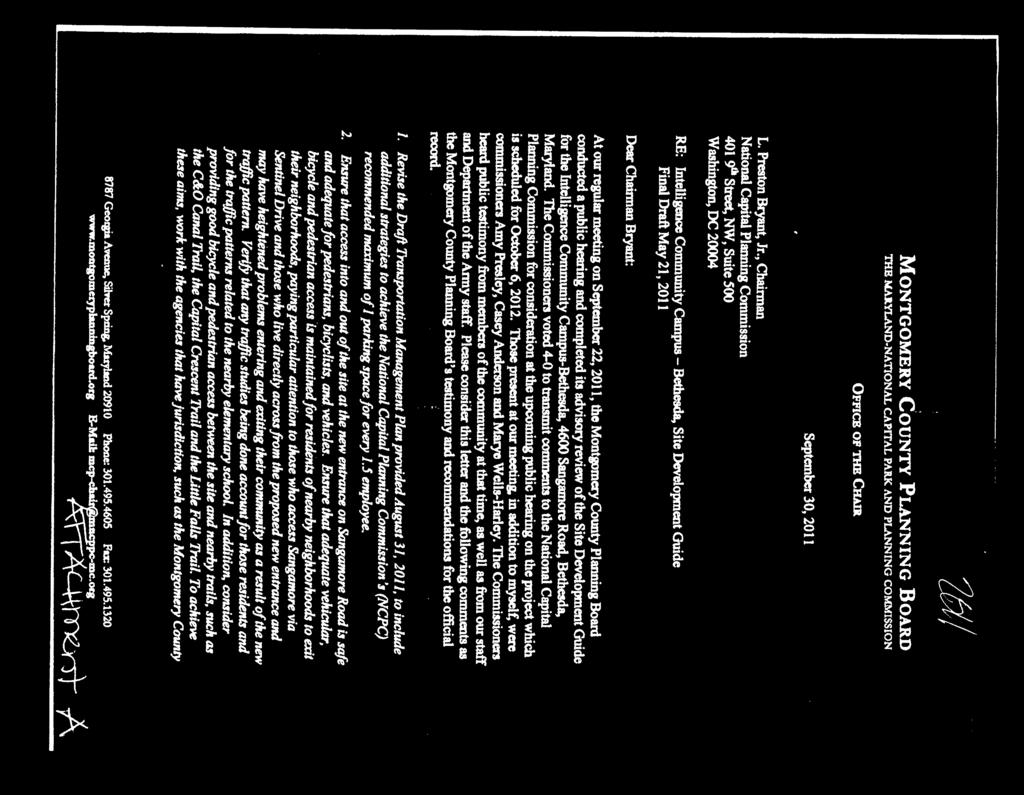
1 MONTGOMERY COUNTY PLANNING DEPARTMENT THE MARYLAND-NATIONAL CAPITAL PARK AND PLANNING COMMISSION MCPB Item No. 5 Date: MR MDP-4 Pedestrian Walkway and Bridge, and the Preliminary submission of the ICC-B Site Development Plan Robert Kronenberg, Chief, Area 1. Robert.Kronenberg@montgomeryplanning.org (301) Marc DeOcampo, Master Planning Supervisor, Area 1. Marc.DeOcampo@montgomeryplanning.org (301) Tina Schneider, Senior Environmental Planner, Area 1. Tina.Schneider@montgomeryplanning.org (301) Staff Report Date: The Planning staff received two voluntary submittals for comment from the United States Department of Defense, & the Army Corps of Engineers, on behalf of the Defense Intelligence Agency pertaining to the Intelligence Community Campus, Bethesda (ICC-B) South Campus. The campus is located at 4600 Sangamore Road and is approximately 30 acres. It is in ther-90 Zone within the Bethesda-Chevy Chase Master Plan area. Summary The Planning Board is being asked to provide advisory comments on the Pedestrian Bridge and Walkway; and the Preliminary Master Site Development Submission for the ICC -B campus. Staff is recommending the Board support the plan and transmit the recommendations to the Defense Intelligence Agency for their consideration. This is the fourth submittal of campus redevelopment that began with the Site Development Guide which was a general overview for the entire campus intentions. Additional plans were submitted in stages as funding became available for the North Campus Improvements, South Campus Improvements, and the current two part submittal. The first is the design of a pedestrian bridge from the existing parking garage to the Centrum main facility entrance, concrete walkway, lighting, and green-screen for the PEPCO substation. The second is the preliminary Master Site Development Plan that includes unifying the site through landscaping, hardscaping, stormwater management, and access controls and fencing. A final submittal is scheduled for mid-2015

2 SITE DESCRIPTION This 30 acre campus sits above the Potomac River on a river bluff. The drop to the Potomac River is approximately 150 vertical feet on the west side, or rear, of this site. Although forested, there is a filtered view from the river to two campus buildings: Roberdeau and Erskine Hall. The land between the ICC-B and the Potomac River is owned by the National Park Service. The campus shares its northern boundary with the Waldorf School which rents the Montgomery County public school building. It also shares a northern boundary with Sangamore Local Park, owned by MNCPPC. Across the Sangamore Road is a neighborhood of townhouses and beyond them garden apartments. Also across the street is a local shopping center, the Shops at Sumner Place previously known as Little Falls Mall. Next to the shopping center are the Sumner Highlands garden apartments. The only access to the campus for vehicles and pedestrians is from Sangamore Road onto Sentinel Drive. ICC-B Campus PURPOSE OF REVIEW There have been various stages associate with this plan. The first took place on September 22, The Planning Board reviewed the Site Development Guide (SDG) which set up the phasing for the ICC-B campus. On September 30, 2011, the M-NCPPC Planning Board Chair sent the National Capital Planning Commission Board comments (see Attachment A). At that time, the Planning Board requested the opportunity to review each phase of the campus design: Comment # 5 Submit site and landscape designs for mandatory referral review for each phase of the project. At that time, address consistency with the development standards in the zoning ordinance and, in consultation with the neighboring communities, the compatibility of the design with the community character. Include: Massing articulation and materials of the visible buildings; Landscape design to include the proposed fence;
3 Streetscape design subject to approval of the Montgomery County Department of Transportation; Setbacks and screening of views from the residential property to the south. [note: High Acres Limited Site Plan Amendment A May 2, 2013 Agenda] The National Capital Planning Commission responded by conveying and supporting our request. The Defense Intelligence Agency/United State Army Corps of Engineers (DIA/USACE) then agreed to voluntarily submit the designs for each phase of the project to the Planning Board for review. This submittal is part of the multi-step review process for the unification of the entire ICC-B Campus. All M-NCPPC comments will be submitted to the National Capital Planning Commission as a courtesy for use during their review process. PROCESS The Federal Workplace Element encourages federal agencies to consult with local agencies to ensure that federal workplaces enhance the design qualities and vitality of their communities and are compatible with the character of the surrounding properties, where feasible. Throughout the process, the Department of Defense has voluntarily and extensively coordinated with the community, its leaders, representatives, and multiple public agencies at all levels of government. The chart below outlines the phases and review by M-NCPPC and the National Capital Planning Commission. Previous Submittals September 2011 DIA/DIA Submittal Required 2012 Voluntary June January 16, 2014 January 2015 Voluntary Voluntary Voluntary Summary of Submittal Site Development Guidelines., Master Plan, for the ICC-B as a guide for future reviews of individual site and building projects. Preliminary and final site and building plans for ICC-B Phase 1, the North Campus with Parking Garage South Campus Improvements: The Centrum Building and Illustrations of Future Submittals. South Campus façade improvements to Roberdeau and Erskine Halls 1. Final site plan for the Pedestrian Walkway and Bridge. 2. Preliminary Submission of ICC-B Master Site Plan Development: overall community context; final site landscaping; hardscaping; perimeter access & fencing; and stormwater management
4 COMMENTS FOR TRANSMITTAL Bridge and Walkway Staff recommends improving uniformity and site integration by architecturally matching the columns and railing supporting the bridge with the pedestrian walkway columns between Erskine Hall and the Centrum Building. Staff recommends to improve uniformity and site integration by matching the exterior of the bridge girder with the spandrel panels supporting the pedestrian walkway between Erskine Hall and the Centrum Buildings As proposed, the Maury Hall and the Substation will be painted gray in color to match the colors of the Centrum, Erskine, and Roberdeau Hall. Consider an alternate color that integrates better with the naturalistic colors of the newly renovated campus buildings. Staff commends the Defense Intelligence Agency and the Corps for responding to the public s concern over the proposed covered walkway from the parking garage to the Centrum building. At the same time, the removal of any shelters along the path will pose future problems for visitors and employees during inclement weather. Consider a more discrete cover or shelters along the walkway. Staff recommends using porous concrete or other porous materials for the walkway instead of the proposed concrete surface. Master Site Development Staff recommends planting native groundcovers and/or shrubs along the interior pedestrian walkway path to enhance the experience and integrate plantings for a more naturalized landscape and improved site biodiversity. Ten feet of river rock and gravel treatment is proposed along the security fence line adjacent to the National Park Service boundary on the western side of the site, where no grass currently exists. The topography slopes west and north of the fence and contains a native plant forest. Staff is concerned that the proposed 2 or smaller gravel will migrate during storm events down the slope and into the NPS forest which could smother and kill native plant understory. We defer and support the preferences of the National Capital Planning Commission to make alternative recommendations in this sensitive area. Staff recommends supporting future recommendations by the National Capital Planning Commission regarding the proposed discharge of stormwater overflow from Area 3 that exceeds the 25-year storm event onto National Park property. Staff recommends additional native tree plantings on the north side of the parking facility, along the length of the north property line, and along Brooks Lane. Staff recommends the continuation of the partnership and ICC-B s sharing of the design progress with the surrounding community associations and citizens. SUBMISSION DESCRIPTION: Bridge and Walkway The major components of the Pedestrian Bridge and Walkway submittal include the bridge, concrete sidewalk, lighting, and green-screen at the substation. The project is intended to provide a connection between the existing parking garage, the Visitor Control Center building and the newly finished Centrum Hall. The preliminary design is envisioned to enhance the feel of one common, contiguous complex


5 and to emphasize the aesthetic goal of unity on the campus. The objective as stated in the report is for a coherent identity utilizing a minimal palette of materials and repeating the assembly components. The bridge installation will be a precast concrete bridge to span over the garage access roadway and the connecting sidewalk to the Visitor Control Center Building and the entrance to the newly completed Centrum. As noted in the Master Site Development Plan, the use of neutral colors for the materials is intended to allow for a minimal visual disruption and respect the building and campus aesthetics. The new bridge will enable pedestrians to traverse the roadway at the grade of the main campus from the multistory parking garage. Along with the bridge installation will be the addition of a new connecting concrete sidewalk from the bridge across the campus. The limit of disturbance for the Pedestrian Walkway and Bridge are approximately 5,000 square feet. In addition there will be minor re grading necessary to allow for the installation of the concrete sidewalk on grade and the installation of the precast bridge support structure. View of Bridge from the East View of Bridge from the Southeast
6 Lighting Light poles and cameras will be installed at approximately 150 foot intervals around the perimeter or as needed to provide a complete view of the perimeter and required lighting levels while minimizing light trespass outside the boundaries. Although not stated in the Master Site Development Plan, the project manager for the Defense Intelligence Agency indicated that the perimeter pole lighting is operational, will not be used for ambient light, and will remain off unless required during an emergency. The fixtures will be designed with directional elements and shielding to minimize up-lighting and glow which enable directional control of illumination, reducing light trespass around the perimeter. Cameras will be mounted on the side of the poles and will not add to the proposed 15 foot height. Green-Screen at Substation The existing PEPCO Substation building on the campus will receive a façade update with the installation of greenscreen wire mesh panels. The panels will cover the entire façade on three exposed sides of the substation and planted with Bignonia capreolata, a native perennial vine with a maximum height of feet. It is staff s request that the greenwall ensure screening of the entire PEPCO substation from the communities view. Stormwater Management The Planning staff reviewed a modified version of the 35% design concept for stormwater management. The preliminary design achieves compliance with the Maryland Department of the Environment regulations and the Energy Independence and Security Act (EISA). The EISA instructs federal agencies to "use site planning, design, construction, and maintenance strategies for the property to maintain or restore, to the maximum extent technically feasible, the predevelopment hydrology with regard to the temperature and rate of runoff for projects exceeding 5,000 square feet 1. The EISA federal guidelines require on-site retention of runoff from the 95 th percentile rainfall event, which equates to an on-site retention of runoff for the 1.7 inch storm event. The Maryland Department of Environment has two sizing criteria: one for new development; and one for redevelopment. Under MDE, new development requires the retention of the 1.0 inch storm event. MDE redevelopment standards require stormwater treatment for 50 percent of the existing impervious area, plus the net increase in impervious area within the stormwater management area. Significant stormwater (SW) has been integrated into the three major ICC-B campus redevelopment efforts: North Campus, Centrum Building façade, and the Roberdeau Hall/Erskine Hall Renovations. The Master Site Development stormwater concept achieves regulatory compliance through a combination of green infrastructure, and low impact development practices. Significant reductions in removing onsite impervious cover, reduced and attenuated peak runoff rates, and an increase in campus infiltratation have been made. Through the use of these techniques, the entire campus meets both MDE and EISA s stormwater requirements. The stormwater management design goals are to: Integrate the North Campus and South Campus into one coherent campus plan to mimic natural drainage conditions as economically practical Address MDE and EISA requirements and incorporate community input into the campus wide stormwater management strategy 1

7 Capture, infiltrate, and detain runoff from hardscape areas using integrated landscape principles to the maximum extent practical Treat, detain, and infiltrate runoff from new site pavements Integrate bioretention, infiltration, and underground storage into campus landscape development plan The stormwater management treatments are significant, diverse, and resolve the wrongs of past construction projects when treatment was not required on site. Not only will stormwater be treated, but the planted bioretention systems will improve biodiversity, habitat, and onsite beauty. Infiltration practices using underground chambers will significantly improve groundwater recharge and reduce stormwater runoff from the site. These treatments will quantifiably reduce peak flow stormwater runoff into the receiving streams and drainage swales surrounding the perimeter. Drainage Area 1 (North Campus): Both Energy Independence and Security Act (EISA) and Maryland Department of Environment (MDE) stormwater requirements have been met (MDE-Permit #11SF0359). Treatment was provided via mechanical filtration and underground stormwater detention storage. Due to the compaction of existing soil stormwater infiltration was not feasible. In an effort to improve overall on-site infiltration treatments (above EISA standards) overcompensation in Drainage Area 3 has been achieved using an underground infiltration chamber. Drainage Area 2: Treatment requirements meet MDE and EISA standards via the removal of impervious hardscape surfaces, the installation of bioretention ponds, green roofs (Roberdeau Hall and Centrum building), and rooftop rainwater harvesting. Drainage Area 3: Drainage Area 3 is treatments needs have been reduced through the removal of existing impervious parking areas east of Roberdeau Hall; the removal of the Emory Building and its associated parking; rerouting of runoff from the Erskine Hall loading dock to on-site bioretention areas via a grass swale; bioretention, and underground infiltration chambers. Campus Drainage Areas
, or its agent, that significant erosion and stability problems for which the campus is at least partially responsible must be addressed by DIA.")
, as former operator of the site, and the Department of the Army.")
8 Stormwater Treatment provided for each Drainage Bioretention Systems OFFSITE STORMWATER MANAGEMENT On September 4, 2012, the Maryland Department of the Environment informed the Defense Intelligence Agency (DIA), or its agent, that significant erosion and stability problems for which the campus is at least partially responsible must be addressed by DIA. The DIA commissioned a study to investigate the potential downstream drainage channel impacts resulting from development of the ICC-B site over time. The study was completed in early-april 2013 with input provided by MDE, National Park Service, the National Geospatial Agency (NGA), as former operator of the site, and the Department of the Army. The proposed treatment will reduce peak flow rates at each outfall for storms up to and including the 25- year storm event and will reduce flows to the drainage systems that carry flow across Brooke s Lane to Little Falls Branch. There will continue to be comprehensive analysis and coordination with National Parks Service to improve and mitigate channels along Wapakoneta Road, the Mid-Site Channel, and Southwest Channel along the southwest boundary of the ICC-B site. The Department of Defense has committed to provide further evaluation for the potential additional discharge reductions to the stormdrain crossing Brookes Lane.

9 LANDSCAPING The landscape design responds to the sites natural setting as requested by the Community, NCPC, and M-NCPPC. The plan will maintain the heavily forested areas to the site from the south, west, and northwestern borders. As noted in the original 2011 Master Site Development Guide, the landscape intent will be to incorporate native species endemic to the region to accentuate connectivity to the adjacent parkland. Part of the intent of the redevelopment is to be sensitive to the context and improve the appearance of the neighborhood. Efforts to provide compatible aesthetic to the residential and commercial neighborhoods east and south of Sangamore Road and Brooke s Lane have been made. This was accomplished through buffer planting and the elimination of surface parking along Sangamore Road. However, there are buffer gaps around the circumference of the property enabling views to the internal campus. Staff recommends additional native tree plantings on the north side of the parking facility, along the length of the north property line, and along Brooks Lane. Native canopy trees should be planted to provide a visual barrier to the campus. Internally, the differing site conditions, intentions of maintaining historical context, screening, operational requirements, community and security needs resulted in a series of ten different planting zones throughout the campus. The zones are woven into the site conditions including specimen tree protection, bioretention plantings, streetscape plantings, tree plantings (with and without security restrictions), and gateway plantings. Each zone has a native plant species palette with stratified plantings in the areas without security restrictions. GATEWAY The Gateway along Sangamore Road will have ornamental plantings of deciduous and coniferous trees, shrubs and groundcovers. The plantings are not intended to be visual barrier to the internal campus, but instead provide filtered views from the public sidewalk. Stone pillars faced with sandstone recovered from the demolition of the Erskine Hall façade frame the fencing and entry gateway to accentuate the historic interpretive elements of the site. Cross section of the ICC-B Gateway along Sangamore Road. HERITAGE INTEPRETIVE TRAIL AND SIGNAGE Interpretive exhibits will be configured into the landscape to provide both publicly accessible interpretation as well as campus monuments. There will be three principal public viewing areas along Sangamore Road coordinated with the existing public bus stops and employee pedestrian entrance areas. The exhibits are still evolving but presently envisioned to provide a chronology of the site development and interpretive record of the significant contributions of the cartographic research and production professions housed at the site from 1942-present.

10 The Maryland Historic Trust and the Maryland State Historic Preservation Office (SHPO) reviewed the master plan. In an effort to preserve many of the sites historic buildings, the Defense Intelligence Agency and SHPO have entered into a Memorandum of Agreement to ensure that the project is implemented in accordance with certain stipulations including the retention of Erskine, Maury, and Roberdeau Halls (excluding the brick facades); the retention of the Flagpole and Globe; and the development and implementation of a landscape plan that maintains the integrity of the Flagpole and Globe Memorial s setting. SECURITY FENCE Ten feet of river rock and gravel treatment is proposed along 6,000 linear feet of the security fence line adjacent to the National Park Service boundary on the western side of the site, where no grass currently exists. The topography slopes west and north of the fence and contains a native plant forest. Staff is concerned that the proposed 2 or smaller gravel will migrate down the slope and into the NPS forest which could smother and kill native plant understory. We defer and support the preferences of the National Capital Planning Commission to make alternative recommendations in this sensitive area. SITE DEMOLITION & ENTRY RECONFIGURATION The Emory Building and the Central Energy Plant are proposed for demolition during the latter part of The Erskine Utility Plant is being coordinated with a broader energy performance contract and will be accomplished as an independent effort projected. The main entrance to the campus will be reconfigured to create a serpentine configuration which will allow for traffic queuing inside of the campus rather than along Sangamore Road. This will significantly reduce the traffic along Sangamore Road that occurs as staff and guests enter and leave the campus. As requested by the community, the entrance off Sangamore Road will remain at Sentinel Drive.
11 OUTREACH The Defense Intelligence Agency/United State Army Corps of Engineers (DIA/USACE) has held a series of outreach meetings. These began shortly after the September 2011 public hearing at the Planning Board on the Site Development Guide, which is the campus master plan (see Attachment B). The outreach has since included regular meetings with a group of community leaders, meetings with a separate Traffic Committee, and nearly monthly meetings with the Community Stormwater Committee. Large public meetings for the entire community are also held at key points in the process. The development of this Master Site Design (MSD) submittal included a serious of local meetings facilitated by the ICC-B project team between March May The meetings were used to develop the 35% drawings and plan submitted to M-NCPPC in December 2014 for comments. CONCLUSION Staff recommends the Planning Board advise the Defense Intelligence Agency and the Department of the Army to continue to working with the community, the NCPC, and Planning staff to address items of concern raised in from the Preliminary Master Site Design plan and outlined in the Comments for Transmittal portion of this report. ATTACHMENTS A. September 30, 2011 memo from the M-NCPPC Planning Board Chair sent the National Capital Planning Commission Board B. List of public meeting conducted by the Defense Intelligence Agency

12
13

14 Department of Defense Community Outreach
Intelligence Community Campus- Bethesda (ICC-B)
") Intelligence Community Campus- Bethesda (ICC-B) MNCPPC Presentation June 20, 2013 US Army Corps of Engineers 1 NCPC Informational Agenda ICC-B Project Opening Remarks Community Engagement ICC-B Development
Intelligence Community Campus- Bethesda (ICC-B) MNCPPC Presentation June 20, 2013 US Army Corps of Engineers 1 NCPC Informational Agenda ICC-B Project Opening Remarks Community Engagement ICC-B Development
HEALTH SCIENCES BUILDING REDEVELOPMENT PROJECT
 INTRODUCTION In recent years, the University of Cincinnati (University) has demonstrated a commitment to identifying and implementing sustainable goals and objectives throughout University s Uptown Campuses.
MONTGOMERY COUNTY PLANNING DEPARTMENT
 MONTGOMERY COUNTY PLANNING DEPARTMENT THE MARYLAND-NATIONAL CAPITAL PARK AND PLANNING COMMISSION MCPB Item No.: Date: 5-03-18 Pike and Rose, Phase I: Site Plan Amendment No. 82012002D Rhoda Hersson-Ringskog,
5. LOW IMPACT DEVELOPMENT DESIGN STANDARDS
 5. LOW IMPACT DEVELOPMENT DESIGN STANDARDS Low Impact Development (LID) requires a shift in stormwater management away from conveying runoff to a small number of downstream points through hydraulically
COMMUNITY DESIGN. GOAL: Create livable and attractive communities. Intent
 COMMUNITY DESIGN Intent An attractive, well-designed County will attract quality development, instill civic pride, improve the visual character of the community, and create a strong, positive image for
Landscape and Streetscape Design 2.5
 Landscape and Streetscape Design 2.5 2.5.1 Goals 2.5.2 Planting 2.5.3 Sidewalks and Pavement 2.5.4 Furnishings 2.5.5 Walls 2.5.6 Lighting 2.5.7 Stormwater 2.5.8 Street Cross Sections 2.5 LANDSCAPE AND
STORMWATER MANAGEMENT CODES ANALYSIS RICHLAND COUNTY, SC SITE PLANNING ROUNDTABLE
 STORMWATER MANAGEMENT CODES ANALYSIS RICHLAND COUNTY, SC SITE PLANNING ROUNDTABLE Codes analyses for each subcommittee were completed to assist participants of the Richland County Site Planning Roundtable.
Chapter 3 Site Planning and Low Impact Development
 CHAPTER 3 Site Planning and Low Impact Development Chapter 3 Site Planning and Low Impact Development 3.0 Introduction The City of Charleston requires that major residential, large commercial (>1 acre),
Description. Summary. MCPB Item No. Date: 01/17/13. Bethesda Crescent, Limited Site Plan Amendment, A, A
 THE MARYLAND-NATIONAL CAPITAL PARK AND PLANNING COMMISSION MCPB Item No. Date: 01/17/13 Bethesda Crescent, Limited Site Plan Amendment, 81984005A, 81984003A Parag Agrawal, Senior Planner, parag.agrawal@montgomeryplanning.org,
APPENDIX A SIMPLIFIED APPROACH TO STORMWATER MANAGEMENT FOR SMALL PROJECTS. In West Sadsbury Township, Chester County, Pennsylvania
 APPENDIX A SIMPLIFIED APPROACH TO STORMWATER MANAGEMENT FOR SMALL PROJECTS In West Sadsbury Township, Chester County, Pennsylvania TABLE OF CONTENTS I. Introduction 3 II. Importance of Stormwater Management
ST. MARY S SOIL CONSERVATION DISTRICT (SMSCD) AND DPW&T CONCEPT EROSION AND SEDIMENT CONTROL AND STORMWATER MANAGEMENT GUIDELINES AND CHECKLIST
 AND DPW&T CONCEPT EROSION AND SEDIMENT CONTROL AND STORMWATER MANAGEMENT GUIDELINES AND CHECKLIST") St. Mary s Soil Conservation District 26737 Radio Station Way, Suite B Leonardtown, MD 20650 Phone: 301-475-8402 ext. 3 Fax: 301-475-8391 www.stmarysscd.com St. Mary s County Government Department of Public
St. Mary s Soil Conservation District 26737 Radio Station Way, Suite B Leonardtown, MD 20650 Phone: 301-475-8402 ext. 3 Fax: 301-475-8391 www.stmarysscd.com St. Mary s County Government Department of Public
Chapter 4 - Preparation of Stormwater Site Plans
 Chapter 4 - Preparation of Stormwater Site Plans The Stormwater Site Plan is the comprehensive report containing all of the technical information and analysis necessary for the City to evaluate a proposed
Introduction to Low Impact Development. Dr Kathy Chaston Coral & Coastal Management Specialist NOAA Office of Ocean & Coastal Resource Management
 Introduction to Low Impact Development Dr Kathy Chaston Coral & Coastal Management Specialist NOAA Office of Ocean & Coastal Resource Management http://hawaii.gov/dbedt/czm/resource/publication.php A Comprehensive
4. INDUSTRIAL 53 CASTLE ROCK DESIGN
 4. INDUSTRIAL 53 CASTLE ROCK DESIGN CASTLE ROCK DESIGN 54 4. INDUSTRIAL Overview Well-designed and attractive industrial centers are the product of blending economic realities with both functional and
LID Permit Requirements. Lisa Austin. Geosyntec Consultants
 LID Permit Requirements Lisa Austin Geosyntec Consultants Presentation Outline Types of LID Permit Requirements Specified site design Specified LID BMPs LID performance metrics Specified Site Design (San
MONTGOMERY COUNTY PLANNING DEPARTMENT THE MARYLAND-NATIONAL CAPITAL PARK AND PLANNING COMMISSION
 MONTGOMERY COUNTY PLANNING DEPARTMENT THE MARYLAND-NATIONAL CAPITAL PARK AND PLANNING COMMISSION MCPB Item No. Date: 12-10-15 Leisure World Clubhouse II Addition Fitness Center, Limited Site Plan Amendment
Harmony Technology Park Third Filing, Second Replat Custom Blending, Project Development Plan/Final Development Plan - FDP #130021
 ITEM NO FDP #130021 MEETING DATE July 23, 2013 STAFF Pete Wray ADMINISTRATIVE TYPE I HEARING STAFF REPORT PROJECT: APPLICANT: OWNER: Harmony Technology Park Third Filing, Second Replat Custom Blending,
MONTGOMERY COUNTY PLANNING DEPARTMENT THE MARYLAND-NATIONAL CAPITAL PARK AND PLANNING COMMISSION
 MONTGOMERY COUNTY PLANNING DEPARTMENT THE MARYLAND-NATIONAL CAPITAL PARK AND PLANNING COMMISSION MCPB Item No. xxxxx Date:10-18-12 NIH-Bethesda Campus Draft 2013 Comprehensive Master Plan Mandatory Referral,
Green Infrastructure & Low Impact Development
 Green Infrastructure & Low Impact Development CITY OF COVINGTON STORMWATER MANAGEMENT WHAT IS GREEN INFRASTRUCTURE? Green infrastructure uses vegetation, soils and natural processes to manage water and
Chapter 1: General Program Information
 Chapter 1: General Program Information 1.1 Introduction The Montgomery County Stormwater Management Resolution (#03-1-5) was adopted by the County Board of Commissioners on January 22, 2003. The purpose
CHAPTER 11 SITE DESIGN AND LOW IMPACT DEVELOPMENT
 CHAPTER 11 SITE DESIGN AND LOW IMPACT DEVELOPMENT Source: City of Bend Chapter Organization 11.1 Purpose... 11-1 11.2 Applicability... 11-1 11.3 Low Impact Development Overview... 11-2 11.3.1 Key Strategies...
When planning stormwater management facilities, the following principles shall be applied where possible.
 2.0 Principles When planning stormwater management facilities, the following principles shall be applied where possible. 2.0.1 Drainage is a regional phenomenon that does not respect the boundaries between
VEHICULAR AND PEDESTRIAN CIRCULATION
 This perspective sketch communicates the intended character and quality of a proposed streetscape design. Locate benches near a major intersection where people tend to gather. Seating and lighting provide
SITE PLAN REVIEW ITEMS - REFERENCE CHECKLIST
 City of Seminole 9199 113 th Street N. Seminole, FL 33772 Ph: (727) 392-1966 Fx: (727) 319-6583 SITE PLAN REVIEW ITEMS - REFERENCE CHECKLIST Note: This checklist is designed to aid designers in the review
MONTGOMERY COUNTY PLANNING DEPARTMENT THE MARYLAND-NATIONAL CAPITAL PARK AND PLANNING COMMISSION
 MONTGOMERY COUNTY PLANNING DEPARTMENT THE MARYLAND-NATIONAL CAPITAL PARK AND PLANNING COMMISSION MCPB Item No. Date: 3.10.2016 Site Plan 820160040 Nora School Parker Smith, Planning Technician, Area 1,
Post-Construction Stormwater Management Checklist* (5,000 SF or Greater)
") Applicability: Required for projects that create and/or replace 5,000 square feet or greater of impervious surface (i.e. asphalt roads, concrete structures, building area, sidewalks, etc.). Impervious
Applicability: Required for projects that create and/or replace 5,000 square feet or greater of impervious surface (i.e. asphalt roads, concrete structures, building area, sidewalks, etc.). Impervious
Sector Plan Briefing October 16, 2014
 Sector Plan Briefing October 16, 2014 M-NCPPC Greater Lyttonsville Team Robert Kronenberg, Chief Marc DeOcampo, Supervisor Erin Banks, Project Manager Melissa Williams, Outreach Matt Folden, Transportation
Prepared for: Central Coast Low Impact Development Initiative centralcoastlidi.org
 Page 1 of 37 USER GUIDE & TEMPLATE: Municipal Landscape Gap Analysis Tool for Planning & Development Review Standards and Procedures Prepared for: Central Coast Low Impact Development Initiative centralcoastlidi.org
5.1.1 The streetscape along US Highway 64 (Brevard Road); and, The built environment within new residential developments; and,
; and, The built environment within new residential developments; and,") Article 5. Landscaping 5.1 Purpose The Town of Laurel Park s landscape standards are designed to create a beautiful, aesthetically pleasing built environment that will complement and enhance community
Article 5. Landscaping 5.1 Purpose The Town of Laurel Park s landscape standards are designed to create a beautiful, aesthetically pleasing built environment that will complement and enhance community
EXISTING COMPREHENSIVE PLAN
 EXISTING COMPREHENSIVE PLAN Town Center Land Use Element: V. LAND USE POLICIES Town Center Mercer Island's business district vision as described in "Your Mercer Island Citizen-Designed Downtown" was an
MONTGOMERY COUNTY PLANNING DEPARTMENT THE MARYLAND NATIONAL CAPITAL PARK AND PLANNING COMMISSION
 MONTGOMERY COUNTY PLANNING DEPARTMENT THE MARYLAND NATIONAL CAPITAL PARK AND PLANNING COMMISSION MCPB Item No. 8 Date: 3.30.2017 Project Name: Lot 31/31A Bethesda, Site Plan Amendment, No. 82007018C Elza
MONTGOMERY COUNTY PLANNING DEPARTMENT
 MONTGOMERY COUNTY PLANNING DEPARTMENT THE MARYLAND-NATIONAL CAPITAL PARK AND PLANNING COMMISSION Ashburton Elementary School Addition, Mandatory Referral, MR2018009 MCPB Item No. Date: 02-15-18 Troy Leftwich,
MONTGOMERY COUNTY PLANNING DEPARTMENT THE MARYLAND NATIONAL CAPITAL PARK AND PLANNING COMMISSION
 MONTGOMERY COUNTY PLANNING DEPARTMENT THE MARYLAND NATIONAL CAPITAL PARK AND PLANNING COMMISSION Bethesda Downtown Sector Plan, Work Session #8 MCPB Item No.8 Date: 02-25-16 Leslye Howerton, Planner Coordinator,
Transportation. Strategies for Action
 Transportation A major priority for the Overlake Neighborhood is to develop a multimodal transportation system. To achieve this system, a balance has to be found among travel, circulation and access needs;
The subject site plan amendment proposes the following revisions to the approved site plan:
 PROPOSED AMENDMENT The subject site plan amendment proposes the following revisions to the approved site plan: 1. The building footprint was modified to accommodate the revised architectural design. 2.
STORMWATER REPORT FOR WALMART SUPERCENTER STORE # SIOUX FALLS, LINCOLN COUNTY, SOUTH DAKOTA BFA PROJECT NO
 STORMWATER REPORT FOR WALMART SUPERCENTER STORE # 2443-00 SIOUX FALLS, LINCOLN COUNTY, SOUTH DAKOTA BFA PROJECT NO. 3286 March 1, 2012 I hereby certify that this engineering document was prepared by me
City of Sun Prairie Wetland Buffer Reduction Request
 City of Sun Prairie Wetland Buffer Reduction Request Westside Development Area January 9, 2017 Prepared by: City of Sun Prairie 300 E. Main Street Sun Prairie, WI 53590 BACKGROUND The City of Sun Prairie
DESIGN REVIEW COMMITTEE AGENDA ITEM
 DESIGN REVIEW COMMITTEE AGENDA ITEM AGENDA DATE: DECEMBER 16, 2015 TO: THRU: FROM: SUBJECT: Chair McCormick and Members of the Design Review Committee Leslie Aranda Roseberry, Planning Manager Kelly Christensen
LANDSCAPING. Design. Development of the site shall not unreasonably impair the ability of adjoining properties to utilize solar energy.
 Landscape design is an integral component of Site Planning and Building. The current pattern of walkways, driveways and landscape elements such as fences, hedges, and retaining walls in the neighborhood
Green Infrastructure and Low-Impact Development Technologies
 Green Infrastructure and Low-Impact Development Technologies The guiding principles of these technologies is to manage stormwater at their sources using natural means, and establish conditions so that
City of Waco Stormwater Management Regulations
 1.0 Applicability: City of Waco Stormwater Management Regulations These regulations apply to all development within the limits of the City of Waco as well as to any subdivisions within the extra territorial
Appendices: Glossary. General Terms. Specific Terms. Low Impact Development Approaches Handbook
 67 67 General Terms Specific Terms 66 Low Impact Development Approaches Handbook The vocabulary of low impact development is evolving, and many terms are used interchangeably and to describe the same or
Introduction to Low Impact Development. Fred Milch. East Central Florida Regional Planning Council
 Introduction to Low Impact Development Fred Milch East Central Florida Regional Planning Council Low Impact Development (LID) Low impact development (LID) is a term used to describe a land planning and
Toronto Complete Streets Guidelines
 Toronto Complete Streets Guidelines 108 110 7.1 Green Infrastructure Design Principles 112 7.2 Context-Sensitive Green Streets 114 7.3 Key Green Street Elements Green infrastructure refers to natural and
Stormwater Management Techniques WMPF LAND USE TRAINING INSTITUTE MARCH 14, 2018
 Stormwater Management Techniques WMPF LAND USE TRAINING INSTITUTE MARCH 14, 2018 Potential Impacts of New Development Urban development can significantly increase stormwater runoff Water quality considerations
WATER QUALITY IMPACT ASSESSMENT (WQIA) FORM
 FORM") WATER QUALITY IMPACT ASSESSMENT (WQIA) FORM Name: CCW Development Associates, L.L.C. Street Address: Telephone Number(s): 1209 Laskin Road, Virginia Beach, VA 23451 (757) 491-1996 Email: chris@vbhomesliving.com
WATER QUALITY IMPACT ASSESSMENT (WQIA) FORM Name: CCW Development Associates, L.L.C. Street Address: Telephone Number(s): 1209 Laskin Road, Virginia Beach, VA 23451 (757) 491-1996 Email: chris@vbhomesliving.com
APPENDIX A. Proposed Guidance and LID checklists for UConn and Town of Mansfield
 APPENDIX A. Proposed Guidance and LID checklists for UConn and Town of Mansfield 22 Guidance Document for Low Impact Development Best Management Practices for UConn June, 2011 In 2007, the Connecticut
MONTGOMERY COUNTY PLANNING DEPARTMENT THE MARYLAND-NATIONAL CAPITAL PARK AND PLANNING COMMISSION
 MONTGOMERY COUNTY PLANNING DEPARTMENT THE MARYLAND-NATIONAL CAPITAL PARK AND PLANNING COMMISSION MCPB Item No. Date: 05/12/2016 North Bethesda Conference Center Parking Structure, Mandatory Referral No.
I. Introduction. Prior Approvals
 Statement of Justification First National Bank 19790 Crystal Rock Drive, Germantown, Maryland Application for Site Plan and Limited Preliminary Plan Amendment I. Introduction DPH Architecture, for First
Duplex Design Guidelines
 Duplex Design Guidelines Adopted by Council May 29, 2006 Prepared By: Table of Contents 1.0 Application and Intent 1 2.0 Areas of Application 2 3.0 Design Principles 3 4.0 Design Guidelines 4 4.1 Site
KASPER. City of Georgetown, Texas PUD Planned Unit Development. December 30, 2015 Revised January 27, 2016
 KASPER City of Georgetown, Texas PUD Planned Unit Development December 30, 2015 Revised January 27, 2016 Applicant: Sentinel Land Company, LLC 4910 Campus Drive Newport Beach, CA Prepared by: SEC Planning
Importance of Master Planning Marcy Colclough
 Importance of Master Planning Marcy Colclough Senior Planner Southwest Michigan Planning Commission WHERE and HOW we develop Land affects Water Quality! 43.2 Acres total 20 Homes 35.8 Acres of open space
4. CONCEPT PLAN DEVELOPMENT
 4. CONCEPT PLAN DEVELOPMENT Concept Plan Step 1: Identify Site Constraints and Opportunities Review the existing site to identify constraints and opportunities for GI Practices to meet the RRv. Constraints
Town of Windham. Planning Department 8 School Road Windham, ME voice fax
 Town of Windham Planning Department 8 School Road Windham, ME 04062 voice 207.864-5960 fax 207.892.1916 MEMO DATE: TO: Staff Review Committee FROM: Amanda Lessard, Planner Cc: Ellen Rathbone, St. Germain
LOUISIANA STATE UNIVERSITY COMPREHENSIVE & STRATEGIC CAMPUS MASTER PLAN. APPENDIX G - Stormwater Study Findings & Stormwater Solutions
 LOUISIANA STATE UNIVERSITY COMPREHENSIVE & STRATEGIC CAMPUS MASTER PLAN APPENDIX G - Stormwater Study Findings & Stormwater Solutions LSU: MP Narrative July 2017 3.5 Open Space Existing Conditions The
2012 Saginaw Bay Watershed Conference
 2012 Saginaw Bay Watershed Conference March 16, 2012 Russ Beaubien, P.E., CFM Low Impact Development Fundamentals Summary LID overview Education on LID Fundamentals of LID Examples of LID practices Other
DEVELOPMENT CONTROLS MEDICAL DISTRICT
 6.01. GENERAL DESIGN GUIDELINES A. Site Planning B. Architectural Design C. Medical Facility Signage & Lighting D. Exhibit 48. ARCHITECTURAL DESIGN CONCEPTS 6.02. MEDICAL FACILITY STANDARDS & GUIDELINES
J. Paul Guyer, P.E., R.A.
 J. Paul Guyer, P.E., R.A. Paul Guyer is a registered civil engineer, mechanical engineer, fire protection engineer, and architect with over 35 years experience in the design of buildings and related infrastructure.
SEATTLE PUBLIC UTILITIES Drainage Design Options for street right of ways.
 SEATTLE PUBLIC UTILITIES Drainage Design Options for street right of ways. Numerous ecosystem-based functional stormwater quantity and quality design alternatives are possible within the street ROW. Several
Westwood Shopping Center Sketch Plan, Plan # February 23, 2017 Item # 9
 Westwood Shopping Center Sketch Plan, Plan # 320170010 February 23, 2017 Item # 9 Westwood II Site 64,111 s.f. Manor Care site: vacant two story building HOC-Westwood Towers, 15 story tower To be considered
One County s Success in Linking Watershed Protection and Land Use Planning
 One County s Success in Linking Watershed Protection and Land Use Planning Bob Thompson Porter County Plan Commission March 28, 2012 Indiana Watershed Leadership Academy Population 160,000 Approximately
County of Prince Edward. Stormwater Management Plan. Agreement in lieu of a Stormwater Management Plan
 County of Prince Edward Stormwater Management Program Date: E-Permitting Number: This stormwater management plan (Agreement) is hereby submitted by the Owner to specify the methods that will be implemented
Charles County, MD Low Impact Development (LID)/ Environmental Site Design (ESD) Ordinance & Design Manual
/ Environmental Site Design (ESD) Ordinance & Design Manual") Charles County, MD Low Impact Development (LID)/ Environmental Site Design (ESD) Ordinance & Design Manual Presentation Highlights Background What is LID / ESD? Why adopt LID/ESD MD SWM Act 2007 Planning
Charles County, MD Low Impact Development (LID)/ Environmental Site Design (ESD) Ordinance & Design Manual Presentation Highlights Background What is LID / ESD? Why adopt LID/ESD MD SWM Act 2007 Planning
Design Guidelines for Residential Subdivisions
 Design Guidelines for Residential Subdivisions Development Services 972-466-3225 cityofcarrollton.com This page intentionally left blank. Table of Contents Purpose... 1 Design Objectives... 1 Design Guidelines
COMMUNITY DEVELOPMENT DEPARTMENT POLICY DRAINAGE FOR RESIDENTIAL PROJECTS WITH ONE OR TWO UNITS REVISED JANUARY 4, 2018
 COMMUNITY DEVELOPMENT DEPARTMENT POLICY DRAINAGE FOR RESIDENTIAL PROJECTS WITH ONE OR TWO UNITS REVISED JANUARY 4, 2018 A. California Residential Code Requirement - Construction plans shall indicate how
Karen Wiggen, RLA PGM/Planning Bob Harrington, P.E. PGM/CPIS Michael Clar, P.E. - ECOSITE
 Karen Wiggen, RLA PGM/Planning Bob Harrington, P.E. PGM/CPIS Michael Clar, P.E. - ECOSITE Presentation Highlights Background of Grant Award What are the County s grant requirements? Maryland Stormwater
Appendix I. Checklists
 Appendix I Checklists Town of Greenwich Drainage Manual Department of Public Works - Engineering Division Town Hall - 101 Field Point Road, Greenwich, CT 06836-2540 Phone 203-622-7767 - Fax 203-622-7747
12 January 12, 2011 Public Hearing APPLICANT: TAILWIND DEVELOPMENT GROUP,LLC PROPERTY OWNER: CITY OF VIRGINIA BEACH
 12 January 12, 2011 Public Hearing APPLICANT: TAILWIND DEVELOPMENT GROUP,LLC PROPERTY OWNER: CITY OF VIRGINIA BEACH STAFF PLANNER: Faith Christie REQUEST: Conditional Change of Zoning (from PD-H1 Planned
3. Are there any projects exempt from the definition of Regulated Projects?
 STORMWATER REQUIREMENTS: OVERVIEW OF PROVISION C.3 Background: On October 14, 2009, the Regional Water Quality Control Board, San Francisco Bay Region, issued a municipal regional stormwater permit (MRP)
APPENDIX J PERFORMANCE STANDARDS FOR GRAVEL MINE, PIT MINE, OR QUARRY
 APPENDIX J PERFORMANCE STANDARDS FOR GRAVEL MINE, PIT MINE, OR QUARRY A. Purpose: 1. Regulatory Requirement and Use Mitigation: The purpose of this appendix is to provide a regulatory context (standards)
ARLINGTON COUNTY, VIRGINIA
 ARLINGTON COUNTY, VIRGINIA County Board Agenda Item Meeting of January 27, 2007 DATE: January 12, 2007 SUBJECT: U-3101-04-2 Use Permit Review for drive-through facilities; premises known as 5222 Lee Highway
Pennsylvania Stormwater Best Management Practices Manual. Chapter 1. Introduction and Purpose
 Pennsylvania Stormwater Best Management Practices Manual Chapter 1 Introduction and Purpose Chapter 1 Introduction and Purpose 1.1 Purpose of this Manual 1 1.2 How to Use this Manual...1 1.3 Overview
Introduction Post Construction Stormwater Management Performance Requirements
 Introduction Post Construction Stormwater Management Performance Requirements The primary objective of these Post Construction Stormwater Management Performance Requirements is to minimize the downstream
Working Group Meeting
 April 4,, 2017 Parks Operations Bldg Working Group Meeting Arts Districts Overview Stormwater/RPA/Stream Considerations First Principles Agenda 7:00pm 7:05pm 7:10pm 7:40pm 8:30pm 9:40pm 9:45pm Welcome
HIGHLAND LAKES WATERSHED ORDINANCE WATER QUALITY MANAGEMENT TECHNICAL MANUAL
 Effective July 1, 2007 HIGHLAND LAKES WATERSHED ORDINANCE WATER QUALITY MANAGEMENT TECHNICAL MANUAL EFFECTIVE JULY 1, 2007 FIFTH EDITION Lower Colorado River Authority TABLE OF CONTENTS DESIGN SPREADHEET
River Corridor Overlay Zone (RCOZ) Article 5
 Article 5") River Corridor Overlay Zone (RCOZ) Article 5 The site is in one of two designated districts. The first is the CBD (central business district) River District, which recognizes the urban character and unique
River Corridor Overlay Zone (RCOZ) Article 5 The site is in one of two designated districts. The first is the CBD (central business district) River District, which recognizes the urban character and unique
6.1. INTRODUCTION AND SUMMARY OF FINDINGS
 Chapter 6: Stormwater Management 6.1. INTRODUCTION AND SUMMARY OF FINDINGS A Stormwater Pollution Prevention Plan (SWPPP) has been prepared for the Proposed Project in accordance with the requirements
F. The following uses in the HR District: attached single-family dwellings, condominiums, and institutional uses; and
 1102 DESIGN REVIEW 1102.01 PURPOSE AND APPLICABILITY Section 1102 is adopted to provide standards, criteria, and procedures under which design review may be approved. Design review is required for: A.
BUILDING SCALE AND SETBACKS 5 ELEMENTS:... 5 FAÇADES (COMMERCIAL/RESIDENTIAL) 5
 5") VISION STATEMENT 3 UTILIZATION OF THE GUIDELINES 3 IMPLEMENTATION 3 PROCEDURES FOR DESIGN REVIEW 3 LAND USE AND ZONING 4 LAND USE 4 ELEMENTS:... 4 ZONING 4 ELEMENTS:... 4 BUILDING SCALE AND SETBACKS 5
VISION STATEMENT 3 UTILIZATION OF THE GUIDELINES 3 IMPLEMENTATION 3 PROCEDURES FOR DESIGN REVIEW 3 LAND USE AND ZONING 4 LAND USE 4 ELEMENTS:... 4 ZONING 4 ELEMENTS:... 4 BUILDING SCALE AND SETBACKS 5
U.S. Highway 377 North Overlay District. 1. General Purpose and Description
 U.S. Highway 377 North Overlay District 1. General Purpose and Description The purpose of the U.S. Highway 377 North Overlay District is to implement the recommendations within the U.S. Highway 377 North
Catawba Area Plan Advisory Group
 Catawba Area Plan Advisory Group Meeting #3 Natural Environment, Part I September 23, 2008 Advisory Group Meeting #3 Welcome and Introductions Review Handouts Vision Statement GDP - Environment Draft Vision
Can Urban Redevelopment Restore Aquatic Resources
 Can Urban Redevelopment Restore Aquatic Resources with Standards for Stormwater Retention and Landscape Performance? Rebecca C. Stack District of Columbia Department of the Environment Industry, Agriculture,
The open space system should provide connective elements, relate to natural resources, and enhance the suburban character of the landscape..
 The open space system should provide connective elements, relate to natural resources, and enhance the suburban character of the landscape.. Mixed-use and infill development should maintain or enhance
A P P E N D I X D. Project Stormwater Plan Worksheets
 A P P E N D I X D Worksheets for Section 1: Basic Project Information This worksheet must be filled out for all projects required to implement the 2015 Post- Construction Stormwater Standards Manual. A
City of Vaughan Urban Design Guidelines for Infill Development in Established Low-Rise Residential Neighbourhoods
 City of Vaughan Urban Design Guidelines for Infill Development in Established Low-Rise Residential Neighbourhoods DRAFT - September 2016 Contents 1. Introduction 1 2. Policy Context 3 3. Characteristics
Lincoln 270. City of Lincoln. Stormwater Management Plan. April 2, 2013
 Lincoln 270 City of Lincoln Stormwater Management Plan April 2, 2013 # 2005.48 Prepared By: Civil Engineering Solutions, Inc. 590 E Street Lincoln, Ca 95648 (916) 645 5700 1.0 Background: The project site
Post Construction BMPs
 Post Construction BMPs Why are Post Construction BMPs important? With increased development brings the increase of impervious cover Parking lots, rooftops, driveways Storm water runoff volume increases
CHAPTER 26 LANDSCAPING (Chapter added in its entirety 05-08)
") CHAPTER 26 LANDSCAPING (Chapter added in its entirety 05-08) 26.01 DESCRIPTION AND PURPOSE. Landscaping is an important element of the use, development and preservation of land, and a significant factor
CHAPTER 26 LANDSCAPING (Chapter added in its entirety 05-08) 26.01 DESCRIPTION AND PURPOSE. Landscaping is an important element of the use, development and preservation of land, and a significant factor
PG&E WINTERS GAS OPERATIONS AND TECHNICAL TRAINING CENTER
 PG&E WINTERS GAS OPERATIONS AND TECHNICAL TRAINING CENTER CEQA scoping Meeting March 19 th, 2014 Winters City Council Chambers - 6:30 pm AGENDA FOR THE MEETING 6:30 Welcome (John Donlevy) 6:40 Overview
Chesapeake Bay Critical Area Conservation Plan
 The Maryland-National Capital Park and Planning Commission Prince George s County Planning Department Development Review Division 301-952-3530 Note: Staff reports can be accessed at www.mncppc.org/pgco/planning/plan.htm.
SANTA CRUZ COUNTY REGULATORY IMPEDIMENT GAP ANALYSIS TOOL
 SANTA CRUZ COUNTY REGULATORY IMPEDIMENT GAP ANALYSIS TOOL BENCHMARK/OBJECTIVE Street Width Is the minimum pavement width allowed for streets in low density residential developments that have less than
BARD COLLEGE REGIONAL GREEN INFRASTRUCTURE DEMONSTRATION PROJECT A Case Study Addressing Stormwater Management for a Small Watershed
 BARD COLLEGE REGIONAL GREEN INFRASTRUCTURE DEMONSTRATION PROJECT A Case Study Addressing Stormwater Management for a Small Watershed Presenter: Barbara Z. Restaino, RLA, ASLA Restaino Design Landscape
D. Landscape Design. 1. Coverage Intent: To provide adequate landscaping materials that enhance the appearance of development projects.
 D. Landscape Design The standards and guidelines in this section give design guidance for the landscaping components of industrial and office projects. City regulations require that all landscaping be
Kittson Parkway / Watershed Park Parking Lot
 Kittson Parkway / Watershed Park Parking Lot Date Constructed: Summer 2005 Site Location / Description: Kittson Parkway, North Delta, British Columbia. Permeable parking lot adjacent to Watershed Park;
MEMORANDUM. This memo deals with proposed amendments to previously issued Development Permit No for Park Royal North.
 MEMORANDUM Date: August 28, 2015 Our File: 1010-20-15-062 To: Design Review Committee From: Lisa Berg, Senior Community Planner Re: Amendment to Development Permit for Park Royal North This memo deals
Going Green with the NYS Stormwater Design Standards
 Going Green with the NYS Stormwater Design Standards Shohreh Karimipour, P.E. NYSDEC History of Stormwater Management Ancient Greek Cisterns Water Cistern Systems in Greece from Minoan to Hellenistic Period,
ADDENDUM TO BIOLOGICAL SCOPING SURVEY REPORT, BOTANICAL SURVEY AND WETLAND DELINEATION
 ADDENDUM TO BIOLOGICAL SCOPING SURVEY REPORT, BOTANICAL SURVEY AND WETLAND DELINEATION FOR AVALON INN (APN 069-241-27 & -04) 1201 & 1211 NORTH MAIN STREET FORT BRAGG, CA MENDOCINO COUNTY prepared for:
At Your Disposal CUP Amendment, Lot 20, Village Service Commercial, at 128 Bastille Dr. (PLN17-208)
") MEMORANDUM Archuleta County Development Services Planning Department 1122 HWY 84 P. O. Box 1507 Pagosa Springs, Colorado 81147 970-264-1390 Fax 970-264-3338 TO: Archuleta County Planning Commission FROM:
MEMORANDUM Archuleta County Development Services Planning Department 1122 HWY 84 P. O. Box 1507 Pagosa Springs, Colorado 81147 970-264-1390 Fax 970-264-3338 TO: Archuleta County Planning Commission FROM:
Planning Board Briefing
 Planning Board Briefing Why Now? The Sector Plan Implementation Chapter States: Before Stage 1 begins, the following must occur: Approval of the Sectional Map Amendment. Approval of the Greater Lyttonsville
What does LEED characterize?
 LEED Certification What does LEED characterize? Leadership in Energy and Environmental Development How was it created? Created by United States Green Building Council (USGBC) in 1998 Developed by architects