FUTURE LAND USE & DEVELOPMENT
|
|
|
- Tabitha Farmer
- 5 years ago
- Views:
Transcription

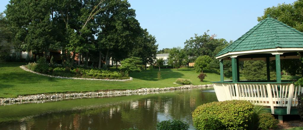
1 CHAPTER 4 FUTURE LAND USE & DEVELOPMENT Brentwood s neighborhoods are well-established and present a unified character in each area. In general, Brentwood has compatible land uses throughout the City. However, there are pockets of incompatible uses, such as along Hanley Industrial Court and along Mary Avenue. The Future Land Use & Development Plan builds upon the existing conditions within the City and is intended to promote a sustainable and holistic approach to development that protects and enhances existing neighborhoods, strengthens commercial areas, and bolsters employment centers. It is a guide for future land use and development that acknowledges the City is a mature and established community. The Future Land Use & Development Plan provides an overview of establishing a Mixed-Use land use designation, which would be predominantly located in the Town Center and extend along S. Brentwood Boulevard. The Town Center is a district being proposed along Brentwood Boulevard between Madge Avenue and White Avenue, which would essentially serve as Brentwood s downtown. For Brentwood to establish the proposed Town Center, the City must amend its zoning code to create an overlay district to accommodate the proposed uses and building heights recommended in the Comprehensive Plan. Additional information on the Town Center can be found in Chapter 5: Subarea Plans. The Future Land Use & Development Plan aims to maintain and enhance the City s distinguishing features while accommodating high-quality and compatible improvements and redevelopment in targeted areas. Additionally, the Plan addresses land use conflicts that may have arisen as the community has matured. 32 Comprehensive Plan Brentwood
2 Middlesex Dr FUTURE LAND USE & DEVELOPMENT PLAN 170 RICHMOND HEIGHTS EAGER RD LADUE Wrenwood Ln STRASSNER DR MCKNIGHT RD Sonora Ave Park Ridge Ave Saint Clair Ave MIDDLE & HIGH HIGH SCHOOL DR Pine Ave Bridgeport Ave MEMORIAL HANLEY BUSINESS POLICE DEPARTMENT MAPLEWOOD MT. CALVARY LUTHERAN PRESCHOOL BOULEVARD White Ave Hanley Industrial Ct MCGRATH ELEMENTARY Harrison Ave LITZSINGER RD CITY HALL BROUGHTON FIRE DPT. Rosalie Ave Eulalie Ave ROCK HILL Bremerton Rd 100 Manderly Dr Madge Ave Powell Ave MANCHESTER RD Russell Ave Collier Ave Annalee Ave BLVD ST. MARY MAGDALEN GRADE SCHOOL NORM WEST Brazeau Ave Kentland Dr Dorothy Ave ROGERS WAY MARK TWAIN ELEMENTARY Joseph Ave Helen Ave Cecelia Ave MANCHEST ROAD PUBLIC WORKS Louis Ave OAK TREE HANLEY RD WEBSTER GROVES LAND USE CLASSIFICATIONS Single-Family Multi-Family Mixed-Use Corridor Commercial Regional Commercial Business; Retail / Office Public / Semi-Public Parks & Open Space Industrial / Technology Subarea Boundary Brentwood Comprehensive Plan 33


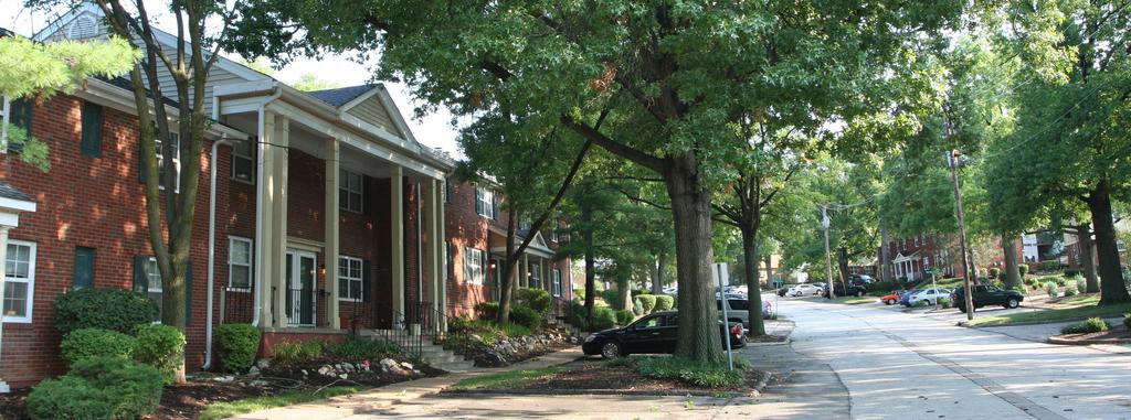
3 IMAGE & IDENTITY The City can strengthen its image and identity through land use planning and supporting recommendations and policies. Identified below is a list of ways the City can improve upon its image and character as it relates to land use and development. Promote compatible infill residential development. Separate incompatible land uses along Brentwood Blvd, Manchester Road, and Hanley Industrial Court by screening and attractive landscaping. Improve the image of the community through better architecture and higher quality construction for future Town Center and potential Manchester Road redevelopment site. Expand the signage standard and color scheme, recently developed by Parks and Recreation department, to other City branding effort. Promote redevelopment and reinvestment along Manchester Road as the flood mitigation projects are being developed and implemented. The development needs to be of highest quality addressing sustainable infrastructure and latest technology. Transform area between City Hall and the Recreation Complex into an attractive town center and exciting destination for residents and visitors from the city and beyond. Support community service providers to provide necessary, high-quality facilities throughout the City that strengthen the image and identity of Brentwood for residents and visitors. LAND USE PLAN SINGLE-FAMILY The Single-Family residential land use designation should be comprised of single-family homes organized into neighborhoods based on a unifying development pattern. At present, single-family detached homes are the City s predominant residential land use, most of which are well served by schools and parks. The City should ensure that a variety of single-family detached and attached housing is adequately provided throughout the community and are affordable to residents of various incomes. Single-family attached homes typically include townhouses, duplexes, and row houses. Detailed policies for the City s residential areas are provided in Chapter 6: Residential Area Framework. MULTI-FAMILY The Multi-Family land use designation includes residential homes comprised of several units or households per lot. Examples include condominiums, apartments, senior housing, and residences as part of a mixed-use development. Most of Brentwood s multi-family homes exist around Wrenwood Lane and High School Drive, known as Brentwood Forest. Hanley Station is the most recent multi-family development in Brentwood. The development of additional multi-family homes should be prioritized as elements of mixed-use, transit-oriented development around bus stops and the MetroLink. The City should continue supporting the development of multi-family homes to promote affordable, diverse housing options available to residents of various incomes as well as density around commercial corridors. CORRIDOR COMMERCIAL The City of Brentwood s Corridor Commercial uses exist along Manchester Road, Hanley Road, and the far southern and northern sections of Brentwood Boulevard. The Corridor Commercial land use designation includes, but is not limited to, retail, entertainment, and service businesses within large developments, retail centers, or as standalone businesses along major arterial roadways. Although Corridor Commercial areas are generally auto-oriented by nature, they should be enhanced with parking lot and perimeter landscaping as well as pedestrian-friendly transportation infrastructure to foster an inviting environment for all users. City should address shallow lot depth and limited development opportunities along Brentwood Blvd. and Manchester Road. 34 Comprehensive Plan Brentwood


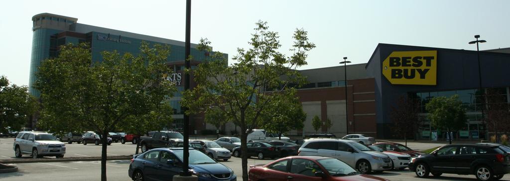
4 REGIONAL COMMERCIAL The Regional Commercial land use designation accommodates larger shopping centers and developments that serve a more regional population. These shopping centers and developments typically draw a customer base that extends beyond the City limits and often are comprised of a mix of big box stores and national retailers set among large, shared parking lots. Most of Brentwood s regional commercial uses should be concentrated along I-64 in the northeast quadrant of the City; however, City should not expand retail district on Eager and Hanley Road any further. MIXED-USE The City should prioritize mixed-use development along Brentwood Boulevard throughout the Town Center as well as along the northeast side of Hanley Industrial Court. The Mixed-Use land use designation should be comprised of multi-story structures featuring retail, restaurant, and service uses on the ground floor and office or residential uses on the upper floors. The City of Brentwood should continue to encourage vertical, multi-story, mixed-use development throughout the Town Center to increase foot traffic and create a denser, more vibrant atmosphere. Additional discussion of mixed-use development in the Town Center is located in Chapter 5: Sub-Area Plans. BUSINESS RETAIL/OFFICE The Business Retail/Office land use designation includes retail, restaurants, professional offices, medical offices, research facilities, and light industrial/office flex businesses. The majority of these uses will be concentrated in the Hanley Business Park, located around Hanley Industrial Court. Business park developments should be of high quality and should reflect positively on the image of the City using high quality architecture, signage, and landscaping. The Business Park land use designation is intended to enhance and support economic and business development within the City. These uses should also include pedestrian-friendly infrastructure and amenities to take advantage of adjacent MetroLink and MetroBus routes. Additional discussion of the Hanley Industrial Business Park is in Chapter 5: Sub-Area Plans. INDUSTRIAL/TECHNOLOGY The Industrial/Technology land uses designation includes areas that accommodate a variety of uses, ranging from light manufacturing, and research development, to service and consumer-oriented businesses. Industrial/Technology uses should be concentrated between Deer Creek and Manchester Road, as well as south of the intersection of Hanley Road and Litzsinger Road. The City should ensure that industrial/ technology uses are accompanied with infrastructure that mitigates flooding and erosion associated with stormwater, as well as adequate buffering around Deer Creek and Black Creek. Additionally, industrial/technology uses should be appropriately buffered and screened from commercial districts, public and semi-public uses, and residential neighborhoods to mitigate potential negative impacts. The areas accompanying industrial/technology uses should also serve as the City s larger employment centers. PUBLIC/SEMI-PUBLIC The Public/Semi-Public land use category include uses that provide public services and facilities to Brentwood s residents and businesses. Public and semi-public uses include schools, hospitals, government-owned and recreational facilities, and religious institutions. The City should continue to expand and enhance its public uses as it continues to grow and develop, ensuring that both public and semi-public uses remain adequately connected with nearby neighborhoods, schools, and parks through the City s pedestrian and trail system. Additional information on Brentwood s public and semi-public facilities can be found in Chapter 8: Community Facilities Plan. S & OPEN SPACE Brentwood s parks and open space predominantly exist along Black Creek, Deer Creek, and Dorothy Avenue. The Parks & Open Space land use category includes parks, open spaces, natural areas, greenways, and natural features, such as rivers and creeks. Parks and open spaces can be either private or public, and should be connected through the City s pedestrian and trail network. Additional information on the City s parks and open space system is found in Chapter 9: Open Space, Recreation & Environmental Features Plan. Brentwood Comprehensive Plan 35
5 FUTURE GROWTH & DEVELOPMENT Although Brentwood had been extremely successful during the worst years of the recession and has a strong position in the regional St. Louis market, the City needs to carefully decide whether or not it should continue to identify new areas for major commercial redevelopment to expand Brentwood s local economy or focus on more local businesses and quality of life. In addition, the City should investigate its zoning and subdivision regulations to ensure that future development allows for diverse commercial uses as well as a variety of housing options throughout Brentwood. DEVELOPMENT REGULATIONS Due to the current economic climate and the complex redevelopment challenges faced in some of Brentwood s key commercial and industrial districts, the City should consider establishing more sophisticated zoning tools, like overlay districts and Form Based Codes, to either accelerate or incentivize new investment. This will be particularly necessary when moving forward with the creation of a Town Center on Brentwood Boulevard as well as the Hanley Business Park, which may need to be incorporated in the Code of Ordinances as an overlay districts to accommodate the building heights and uses recommended in Chapter 5: Subarea Plans. This will also help to clearly articulate to the development community what the City and its residents aim to achieve in these areas. In addition, site-specific capacity assessments may be needed to examine whether smaller multi-story, mixed-use buildings, perhaps along Brentwood Boulevard and Manchester Road, would be competitive within the Class A office market. At present, the Manchester Road corridor is split by zoning districts, with the north side being zoned for general commercial uses and the south side being considered industrial property. This contrast still exists at the Manchester and Hanley Road intersection. Although there is a strong desire to see Manchester Road redeveloped as a small business and neighborhood destination district, industrial uses and zoning appear incompatible with that vision. Once the flood control efforts are underway, the City should strongly consider changing the zoning to Planned Development or Urban Development for a more compatible mix of uses in this area to complement the future land use plan. COMMERCIAL AREA OBJECTIVES Minimize the impact of commercial redevelopment on existing residential neighborhoods Provide adequate transitions/buffers from nonresidential districts to singlefamily and multi-family neighborhoods. Transitions to residential neighborhoods should be provided to alleviate visual and physical impacts, such as excessive traffic, noise, and light, from commercial districts. The elements of transitional areas will differ depending on the scale and intensity of commercial development. For example, the transition from a Corridor Commercial District may require a wider buffer area than a typical Mixed Use District. Consolidate existing commercial properties along Brentwood Boulevard and Manchester Road for redevelopment. Where feasible, encourage business and/or land owner partnering or consolidation of existing parcels to achieve the required parcel depth and width for contemporary commercial redevelopment or development. These corridors include a number of residential structures that were converted to commercial uses and other obsolete commercial forms. As the market dictates, these structures/parcels should be consolidated and redeveloped with new structures that meet the new Mixed Use District design guidelines, described in more detail in Chapter 5, Sub-Area Plans. 36 Comprehensive Plan Brentwood
6 Build financial support mechanisms for commercial mixed-use districts. Facilitate or establish funding program(s) to retain and improve existing commercial buildings, businesses, and commercial corridors/districts. Much-used programs in Missouri include Tax Increment Financing Districts (TIF), Transportation Development Districts (TDD), Business Improvement Districts (BID), Neighborhood Improvement Districts (NID), and locally sponsored loan and grant programs. In addition to retaining and improving existing businesses, enhanced commercial district maintenance and security services could be funded through these programs. Provide walkable pedestrian-oriented development and interconnections between commercial and mixed-use districts. Enhance the marketability of commercial districts by requiring pedestrian and social amenities within and between commercial projects and districts. Pedestrian connections that are enhanced with amenities such as landscaping, benches and small plazas would improve community connectivity, reduce the number of trips in automobiles, provide for a healthier lifestyle, and encourage customers to spend more time in the commercial and mixed-use districts. Design places and activities for community interaction. New commercial developments should provide amenities for community interaction. Social spaces will vary by character and density of development, however these spaces should be provided in all commercial and mixed-use districts. Social spaces should be connected by sidewalks and bike trails that lead to other commercial districts, parks and residential neighborhoods. Other Objectives: Encourage and promote shared parking programs and policies in commercial areas wherever possible. Work with property owners to enhance commercial areas along Brentwood Boulevard and Manchester Road with planters and landscaping to better separate the sidewalks and street, and increase the pedestrian-friendliness of the area. A Streetscape Enhancement Plan for Manchester Road Corridor is under development as part of MODOT s Manchester Road resurfacing and sidewalk project. The City should develop a streetscape enhancement plan for S. Brentwood Boulevard Encourage and promote the redevelopment of the vacant sites. Work with the development community to encourage and promote mixed-use commercial, office, and residential developments for Town Center and Hanley Business Park and Manchester Road frontage. Amend the City Code to require the installation of green infrastructure and best management practices (BMPs) for new development. Work with commercial property owners to retrofit their sites with green infrastructure to mitigate flooding and enhance their curb appeal. Update the City s zoning code to encourage mixeduse development in which the first floor should be used for commercial development. Brentwood Comprehensive Plan 37
7 INDUSTRIAL/ TECHNOLOGY AREA OBJECTIVES Encourage the growth of startups and technology-based companies in Brentwood to provide area residents with employment opportunities, bolster the local economy, and generate revenue for the continued delivery of a high level of municipal services. Work with property owners to enhance existing industrial buildings and sites with perimeter landscaping around parking lots and foundation landscaping against buildings. Encourage the use of green technology and best management practices (BMPs) in the development and redevelopment of industrial/technology uses. Encourage and promote the rehabilitation of older industrial buildings in areas that are becoming functionally obsolete or undesirable, including improvements to loading docks, technology infrastructure, access, building facades, signage, streetscaping, landscaping, and parking areas to accommodate more appropriate and market-viable uses. Identify industrial properties that may be potential brownfield sites to assess key redevelopment sites and seek funding for redevelopment. Identify strategic partnerships between local employers and educational providers for workforce development programs. Review L1 District and existing code requirements to encourage land use compatibility. LANDSCAPE OBJECTIVES Develop standards for landscaping and building design to enhance the appearance of public facilities, public institutions, roadways, rights-of-way, bridges, parks, and gateways that complement the local open space landscape. Smaller parcels or developments require a more intimate feel from the streetscape amenities. Larger, regional-oriented commercial or light manufacturing developments require a higher level of intensity for landscape and hardscape design. SUSTAINABILITY Through land use and development plans, policies, and recom mendations, the City of Brentwood can promote and support sustainability. Identified below is a list of ways the City can become more sustainable through land use and development decisions. Promote a mix of land uses throughout the community to support economic sustainability. Encourage public agencies and private developers to implement best management practices (BMPs). Encourage public agencies and private developers to use green building techniques and encourage Leadership in Energy and Environmental Design (LEED) certification. Ensure that key community service providers such as City Hall, Library and Post Office remain along Brentwood Boulevard to strengthen the proposed town center area. Promote mixed-use developments and multifamily units in the future town center area which can reduce reliance on the automobile, support local businesses, and improve resident health by promoting walkability. 38 Encourage new parks and open space to protect high-quality environmental features such as creeks, floodplain and heavily wooded areas. Comprehensive Plan Brentwood
8 Brentwood Comprehensive Plan 39
The transportation system in a community is an
 7 TRANSPORTATION The transportation system in a community is an important factor contributing to the quality of life of the residents. Without a sound transportation system to bring both goods and patrons
C. Westerly Creek Village & The Montview Corridor
 C. Westerly Creek Village & The VISION Community Vision When the goals of the city are achieved Westerly Creek Village, a distinctive community defined by Montview Boulevard and Westerly Creek, is a strong
Planning Districts INTRODUCTION
 INTRODUCTION To facilitate detailed examination of development prospects for all areas of the community, Delano has been divided into 14 planning districts. The location of these planning districts is
The Five Components of the McLoughlin Area Plan
 The Five Components of the McLoughlin Area Plan This documents contains the complete language of the five components of the McLoughlin Area Plan: The Vision Statement The Values The Guiding Principles
Gold Line Bus Rapid Transit Transit Oriented Development (BRTOD) Helmo Station Area Plan
 Helmo Station Area Plan") Appendix F Gold Line Bus Rapid Transit Transit Oriented Development (BRTOD) Helmo Station Area Plan Introduction and Purpose of the Plan The Gold Line Bus Rapid Transit facility is an eleven-mile dedicated
Appendix F Gold Line Bus Rapid Transit Transit Oriented Development (BRTOD) Helmo Station Area Plan Introduction and Purpose of the Plan The Gold Line Bus Rapid Transit facility is an eleven-mile dedicated
VICTORIA DOWNTOWN DEVELOPMENT PLANNING
 VICTORIA DOWNTOWN DEVELOPMENT PLANNING A Vision & Guide for the Future Downtown Victoria thrives as a center for the community, offering a great mix of entertainment, culture, business, and recreational
4.1.3 LAND USE CATEGORIES
 4.1.3 LAND USE CATEGORIES a. City Center District The City Center District incorporates the existing character and mix of uses in downtown Belmont to encourage redevelopment and new development in keeping
Plano Tomorrow Vision and Policies
 Plano Tomorrow Vision and Policies PLANO TOMORROW PILLARS The Built Environment The Social Environment The Natural Environment The Economic Environment Land Use and Urban Design Transportation Housing
SUMMERSIDE / MT. CARMEL REINVESTMENT CORRIDOR COMMUNITY DEVELOPMENT STRATEGY
 SUMMERSIDE / MT. CARMEL REINVESTMENT CORRIDOR COMMUNITY DEVELOPMENT STRATEGY FEBRUARY 2013 I. Location of the Summerside/Mt. Carmel Reinvestment Corridor The Summerside/Mt. Carmel Reinvestment Corridor
CHAPTER 7: Transportation, Mobility and Circulation
 AGLE AREA COMMUNITY Plan CHAPTER 7 CHAPTER 7: Transportation, Mobility and Circulation Transportation, Mobility and Circulation The purpose of the Transportation, Mobility and Circulation Chapter is to
EXISTING COMPREHENSIVE PLAN
 EXISTING COMPREHENSIVE PLAN Town Center Land Use Element: V. LAND USE POLICIES Town Center Mercer Island's business district vision as described in "Your Mercer Island Citizen-Designed Downtown" was an
URBAN DESIGN BRIEF. 2136&2148 Trafalgar Road. Town of Oakville
 URBAN DESIGN BRIEF 2136&2148 Trafalgar Road Town of Oakville Prepared By: METROPOLITAN CONSULTING INC For 2500674 Ontario Inc November 2016 TABLE OF CONTENTS Page No. 1.0 Introduction/Description of Subject
Implementation Guide Comprehensive Plan City of Allen
 Implementation Guide 2030 Comprehensive Plan City of Allen DRAFT 2015 Implementation Guide Allen 2030 Comprehensive Plan INTRODUCTION The Comprehensive Plan serves as a guide for the growth and development
Pedestrian and Bike Bridge LOGO
 6.2.2 Pedestrian and Bike Bridge The proposed pedestrian and bike crossing re-envisions the existing bridge at Pismo Creek on Cypress Street. The bridge is currently underutilized by vehicular through
Today Land & People. Northeast Nampa Gateway District. Employment. Land Use Characteristics. Demographics. Current Zoning
 Today Land & People Employment Major employers include Saint Alphonsus, the College of Western Idaho, the Auto Mall, Sorrento Lactalis and Walmart. 3,004 jobs in 2010 (COMPASS-CIM 2040 TAZ data) 4,345
CHAPTER 3 VISION, GOALS, & PLANNING PRINCIPLES. City of Greensburg Comprehensive Plan. Introduction. Vision Statement. Growth Management Goals.
 CHAPTER 3 VISION, GOALS, & PLANNING PRINCIPLES Introduction The Greensburg Comprehensive Plan is intended as a working community document. A combination of long and short-term goals, this document is intended
Civic Center District
 Civic Center District The Civic Center district is the civic and social heart of Warrenville, containing such public buildings as the City Hall, Warrenville Public Library, Police Station, Park District
East Central Area Plan
 East Central Area Plan Steering Committee Meeting March 8 th, 2018 CHUN Tears McFarlane House Vision Statement Development Opportunities Analysis Vision Elements 1. Equitable, Affordable and Inclusive
Silverdale Regional Center
 Silverdale Regional Center Vision for Silverdale Regional Center The Silverdale Regional Center Plan (Plan) will guide the evolution of the Silverdale Regional Center from a collection of strip malls and
Commercial Node Plan Devine Street/Jackson Blvd. COLUMBIA, SC
 Commercial Node Plan Devine Street/Jackson Blvd. COLUMBIA, SC 9.17.13 AGENDA 1 Introductions 2 Project Update 3 Concepts 4 Recommendations 5 Next Steps Introductions Project Update Process 5-Phase Process
FUTURE LAND USE ELEMENT
 FUTURE LAND USE ELEMENT GOAL I: To create and sustain a great place to live, play, and prosper Objective 1: The City of Ocala shall incorporate the principles and strategies of the Ocala 2035 Vision into
EXECUTIVE SUMMARY DRAFT CHAPTER 1 INTRODUCTION EXECUTIVE SUMMARY
 CHAPTER 1 EXECUTIVE SUMMARY INTRODUCTION Through the joint efforts of the City of Tulsa planning staff and the Land Services division of Indian Nations Council of Governments (INCOG), the Berryhill Land
V. Vision and Guiding Principles
 V. Vision and Guiding Principles The Master Plan for the Powers Ferry Corridor seeks a foundation in the desires of the community. At times, various elements of the community offered opposing viewpoints,
Cumberland Region Tomorrow is a private, non-profit, citizen based regional organization working with Greater Nashville Regional Council
 Cumberland Region Tomorrow is a private, non-profit, citizen based regional organization working with Greater Nashville Regional Council and others in the public and private sectors, dedicated to planning
Metro. Activity Center Design Guidelines. Recommendations For Developing Focused, Mixed-Use Commercial/Residential Centers
 Metro Activity Center Design Guidelines Recommendations For Developing Focused, Mixed-Use Commercial/Residential Centers Metro Activity Centers What is a MAC? Legacy, the adopted guide for the future growth
THEMES, VISION, + PRINCIPLES
 CHAPTER 2: THEMES, VISION, + PRINCIPLES This page intentionally left blank. 20 VISION DRAFT AUGUST 2018 2 2 THEMES, VISION, + GUIDING PRINCIPLES The Key Themes, Vision, and Guiding Principles presented
Lower Merion Commercial Districts Issues and Characteristics Handbook November 2013
 Lower Merion Commercial Districts Issues and Characteristics Handbook November 2013 DRAFT TOWNSHIP-WIDE VISION: To maintain and enhance commercial areas to complement the surrounding high-quality residential
2030 Comprehensive Plan VISION STATEMENT
 RESOURCE DOCUMENT for Steering Committee Meeting #2 July 12, 2017 2030 Comprehensive Plan VISION STATEMENT Steering Committee from 2008 Established the Lauderdale s Vision as: Creating a livable, lovable
DRAFT Land Use Chapter
 Stevens Creek Urban Village DRAFT 1 18 17 Land Use Chapter INTRODUCTION This Land Use Chapter describes how the Stevens Creek Urban Village will accommodate the growth that is planned for it in the Envision
TEMPLE MEDICAL & EDUCATION DISTRICT
 City of Temple, Texas TEMPLE MEDICAL & EDUCATION DISTRICT 1 Description. The City of Temple joined in partnership with key public and private entities to jointly promote education and medical activities
QUEEN-RIVER SECONDARY PLAN
 34 QUEEN-RIVER SECONDARY PLAN 34. QUEEN RIVER SECONDARY PLAN 1. INTRODUCTION The Queen-River area is approximately 6.4 hectares and is located at the eastern edge of the Downtown as shown on Map 34-1.
BRENTWOOD PARKS SYSTEM MASTER PLAN INITIAL ASSESSMENT
 BRENTWOOD PARKS SYSTEM MASTER PLAN INITIAL ASSESSMENT Prepared by Planning Design Studio Prepared for City of Brentwood Parks & Recreation September 4, 2013 Brentwood Parks System Master Plan Initial Assessment
and services The protection and conservation of environmentally significant and sensitive natural heritage features and functions.
 6. Land Use 6.0 Preamble A healthy and livable city is one in which people can enjoy a vibrant economy and a sustainable healthy environment in safe, caring and diverse neighbourhoods. In order to ensure
Subarea 4 Indian Creek. Vision The combination of park networks and transportation amenities make Subarea 4 the greenest hub in the Corridor.
 indian creek 180 extends south from 101st Street to I-435. The I-435 and Metcalf intersection is one of the primary intersections in the Kansas City Metro Area. The area includes several residential neighborhoods
Ivywild On The Creek PRELIMINARY CREEK DISTRICT MASTER PLAN
 Ivywild On The Creek PRELIMINARY CREEK DISTRICT MASTER PLAN Introduction: Rejuvenating an extraordinary Creekside neighborhood THE CREEKSIDE DISTRICT The Ivywild On The Creek Neighborhood District Master
178 Carruthers Properties Inc.
 178 Carruthers Properties Inc. Planning Rationale for 178 Carruthers Avenue Site Plan Control Application June 2014 Table of Contents 1.0 Introduction 2.0 Overview of Subject Property 3.0 Current Zoning
Town Center (part of the Comprehensive Plan)
") Town Center (part of the Comprehensive Plan) Mercer Island Town Center Looking North (2014) In 1994, a year-long process culminated in a set of design guidelines and code requirements for the Town Center
Town Center (part of the Comprehensive Plan) Mercer Island Town Center Looking North (2014) In 1994, a year-long process culminated in a set of design guidelines and code requirements for the Town Center
ROBBINSDALE LRT STATION CDI DEVELOPMENT GUIDELINES
 August 2018 OVERVIEW The City of Robbinsdale has a prime-opportunity site in the middle of the 13 mile stretch of the Bottineau LRT corridor / Blue Line extension. Robbinsdale offers a prominent, vital,
ANC 2A Presentation. November 9, 2006
 ANC 2A Presentation November 9, 2006 Introduction & Overview Applicants Boston Properties and KSI Services (project developers) The George Washington University (land owner) 2.66 acre site (former GW hospital
BROOKHILL NEIGHBORHOOD MODEL ZONING MAP AMENDMENT PREFACE TO APPLICATION
 BROOKHILL NEIGHBORHOOD MODEL ZONING MAP AMENDMENT PREFACE TO APPLICATION June 15, 2015 Revised: August 1, 2016 I. VISION Brookhill is a proposed community based upon the principles of Albemarle County
4- PA - LD - LIVELY DOWNTOWN. LD - Background
 4- PA - LD - LIVELY DOWNTOWN LD - Background The downtown has been the service centre for the community since the city s inception and the area continues to supply people with their personal services,
Vision Statement for the Town of Flower Mound Master Plan The Town of Flower Mound Master Plan furthers the established community based vision to:
 Vision Statement for the The furthers the established community based vision to: Preserve the country atmosphere and natural environment that makes Flower Mound a unique and desirable community; Mitigate
hermitage town center
 hermitage town center A Community Vision prepared by Strada for The City of Hermitage and The Mercer County Regional Planning Commission January 2007 table of contents introduction 3 design principles
Hockessin Community Redevelopment Plan
 Hockessin Community Redevelopment Plan 3.1 Introduction The Community Redevelopment Plan for the Village of Hockessin is the result of the people s vision for a distinct village center that serves as the
DRAFT City of Titusville 2040 Comprehensive Plan Future Land Use, Housing, and Transportation Elements April 16, 2018
 DRAFT City of Titusville 2040 Comprehensive Plan Future Land Use, Housing, and Transportation Elements April 16, 2018 Prepared by Canin Associates for the City of Titusville About the Comprehensive Plan:
Policies and Code Intent Sections Related to Town Center
 Policies and Code Intent Sections Related to Town Center The Town Center Vision is scattered throughout the Comprehensive Plan, development code and the 1994 Town Center Plan. What follows are sections
Table of Contents. Elm Avenue Improvement Plan City of Waco, Texas. Introduction 1. Existing Context 1 Figure 1 2.
 Table of Contents Introduction 1 Existing Context 1 Figure 1 2 Plan Guidelines 3 Future Urban Form 4 The West-End 4 Main Street 6 The East-End 7 Figure 2 9 Public Improvement Recommendations 7 General
SECTION TWO: Urban Design Concepts
 SECTION TWO: Urban Design Concepts The Gardnerville Plan for Prosperity shapes economic opportunities presented by regional growth. The Urban Design Concepts provide policies and concepts for land use,
5.1 Site Plan Guidelines
 5. Community Core Guidelines Development of the Community Core will take place by plan of subdivision and site plan approval. It will occur in a phased manner that will reflect the timing of residential
NEIGHBORHOOD DESIGN ELEMENT
 NEIGHBORHOOD DESIGN ELEMENT INTRODUCTION The following recommendations constitute an urban design oriented "neighborhood analysis" of Plantation. It is an optional Comprehensive Plan Element. The five
EXHIBIT A. Tax Increment Reinvestment Zone No. 1 (Town Center) First Amended Project Plan 1
 First Amended Project Plan 1") EXHIBIT A Tax Increment Reinvestment Zone No. 1 (Town Center) First Amended Project Plan 1 1 As amended by Resolution No. 2008-02-001(TR1R) of the Tax Increment Reinvestment Zone No.1, and approved to
EXHIBIT A Tax Increment Reinvestment Zone No. 1 (Town Center) First Amended Project Plan 1 1 As amended by Resolution No. 2008-02-001(TR1R) of the Tax Increment Reinvestment Zone No.1, and approved to
CHARLES PUTMAN CHARLES PUTMAN AND ASSOCIATES, INC
 MEMORANDUM CHARLES PUTMAN & ASSOCIATES, INC. LAND DEVELOPMENT CONSULTANTS PLANNING ZONING PERMITTING 4722 NW Boca Raton Boulevard, Suite C-106 Boca Raton, Florida 33431 Phone: 561/994-6411 FAX: 561/994-0447
Corridors. Re-vitalize our Corridors and Gateways
 Corridors Re-vitalize our Corridors and Gateways Artist s rendering from the 287 Strategic Plan, 2015 Corridors are the major throughways of Loveland but they also provide important commercial, community
Robbinsdale LRT Station. CDI Development Guidelines. August Overview
 Robbinsdale LRT Station August 2018 Overview The City of Robbinsdale may have the coolest opportunity site along the 13 mile stretch of the Bottineau LRT corridor / Blue Line extension. Located a block
Sahuarita District & Phase 1 Master Plan. Town Council December 11, 2017
 Sahuarita District & Phase 1 Master Plan Town Council December 11, 2017 Visioning Study Visioning Process Advisory Group Meetings Community Questionnaire Town Center Case Studies Community Analysis The
FLORIN ROAD CORRIDOR Site Plan and Design Review Guidelines Checklist
 FLORIN ROAD CORRIDOR Site Plan and Design Review Guidelines Checklist Applicant s Name: Project Address: Phone: Email: Applicant shall fill out the design guidelines checklist for all guidelines applicable
Town Center. Block 5 Existing multifamily residential units are expected to remain.
 Area Guidelines Germantown s districts should be developed as distinct communities with unique features that are supported through the guidelines. The guidelines not only help distinguish these districts
CITY OF COLWICH COMPREHENSIVE PLAN LAND USE LAND USE 1
 LAND USE LAND USE 1 WHAT YOU WILL FIND IN THIS CHAPTER: Discussion of today s conditions and tomorrow s projections Discussion of challenges and opportunities Discussion of the environmental quality goals,
I. Introduction. Prior Approvals
 Statement of Justification First National Bank 19790 Crystal Rock Drive, Germantown, Maryland Application for Site Plan and Limited Preliminary Plan Amendment I. Introduction DPH Architecture, for First
COMMUNITY DESIGN. GOAL: Create livable and attractive communities. Intent
 COMMUNITY DESIGN Intent An attractive, well-designed County will attract quality development, instill civic pride, improve the visual character of the community, and create a strong, positive image for
URBAN DESIGN BRIEF URBAN DESIGN BRIEF 721 FRANKLIN BLVD, CAMBRIDGE August 2018
 URBAN DESIGN BRIEF URBAN DESIGN BRIEF 721 FRANKLIN BLVD, CAMBRIDGE August 2018 DESIGN BRIEF CONTENTS PART A 1.0 INTRODUCTION 2.0 DESCRIPTION & ANALYSIS OF SITE CONTEXT 3.0 DESIGN CONSTRAINTS AND OPPORTUNITIES
2.0 Strategic Context 4
 2.0 Strategic Context 4 2.1 The Area Action Plan is a non-statutory plan, which forms a corporate policy document, expressing particular issues and areas of concern while also providing a vision for the
Welcome! to Keller Town Hall
 Welcome! to Keller Town Hall Keller Town Center Planning a New Downtown What is Keller Town Center? A new, growing downtown district planned as an urban village A combination of retail and office spaces,
PLAN ELEMENTS WORKSHOP. April 5, 2016
 PLAN ELEMENTS WORKSHOP April 5, 2016 needs more housing. But there is no one-size fits-all solution. Every neighborhood has its own character. In some places, density is not only appropriate it is badly
Small Area Plan. South Gateway
 Small Area Plan Adopted May 12, 2008 South Gateway Purpose. The South Gateway Small Area Plan defines the City s expectations for the future of the southern entrance to the City at Interstate 85 and Highway
CHAPTER 1. Ms. Guajardo s Class - Central Elementary CH 1 1
 INTRODUCTION CHAPTER 1 Ms. Guajardo s Class - Central Elementary CH 1 1 1.1 SETTING South Centre City is a linear corridor south of Downtown Escondido paralleling Centre City Parkway and South Escondido
Westwind Developments Ltd. PIONEER LANDS AREA STRUCTURE PLAN - PROPOSED AMENDMENT
 FEBRUARY 2013 TABLE OF CONTENTS 1.0 BACKGROUND... 1 1.1 Amendment... 1 2.0 LOCATION & CONTEXT... 2 2.1 Land Ownership... 2 3.0 POLICY CONTEXT... 3 3.1 Municipal Development Plan... 3 3.2 Capital Region
2.0 AREA PLANS. Lakeside Business District. Lakeside Business District Land Use Categories:
 Lakeside Business District Lakeside Business District Land Use Categories: Campus Commercial Campus Commercial means a mixture of uses which includes corporate offices, office parks, hotels, commercial,
Status Update (2006 vs. Now) Citizen s Advisory Committee February Plan for Prosperity
 Citizen s Advisory Committee February Plan for Prosperity") Status Update (2006 vs. Now) Citizen s Advisory Committee February 2018 Plan for Prosperity 2000 2017 2000 2017 Gardnerville Population 6,000 5,760 5746 5,500 5,000 5,067 5,550 5,165 5,394 5,412 5,250
Status Update (2006 vs. Now) Citizen s Advisory Committee February 2018 Plan for Prosperity 2000 2017 2000 2017 Gardnerville Population 6,000 5,760 5746 5,500 5,000 5,067 5,550 5,165 5,394 5,412 5,250
Draft Memorandum #1: Goals and Vision for Revitalization
 Keizer Revitalization Plan Draft Memorandum #1: Goals and Vision for Revitalization Submitted to: City of Keizer April 12, 2018 (revised) Prepared By: Angelo Planning Group and Otak, Inc. Project No. 17482.A
Welcome to the Oakridge Centre Open House
 Welcome to the Oakridge Centre Open House Why is the City hosting this event? This open house is to inform you of a rezoning application submitted to the City of Vancouver to amend the existing CD-1 (Comprehensive
A BLUEPRINT FOR BROCKTON A CITY-WIDE COMPREHENSIVE PLAN
 A BLUEPRINT FOR BROCKTON A CITY-WIDE COMPREHENSIVE PLAN Public Meeting October 2016 1 Plan Summary and Discussion Public Meeting May 4 2017 City of Brockton Bill Carpenter, Mayor Department of Planning
The University District envisions, in its neighborhood
 Envisioning the University District Link Light Rail in Seattle s neighborhoods CIY OF SEALE CONCEP-LEVEL SAION AREA PLANNING RECOMMENDAION RESOLUION # 30165 EXHIBI L Vision 08.2000 he University District
Visioning Statement and Guiding Principles
 Visioning Statement and Guiding Principles Planning for the Future The General Plan The General Plan represents Woodland's shared vision of the future and defines a path to lead the community toward its
Neighborhood Districts
 NEIGHBORHOOD DISTRICTS SEVEN MAIN DISTRICTS Neighborhood Districts While the Development Plan provides a broad-scale overview of the neighborhood, this section focuses on uses and relationships at the
Status Report: MD 355 Project
 Status Report: MD 355 Project OCTOBER 2006 M-NCPPC MONTGOMERY COUNTY PLANNING DEPARTMENT Summary of Community Comments, and break to the Results of the MD 355 Participation Session Brookside Gardens -
Sub Area 2: Downtown Overland Park
 Downtown 132 2.12 encompasses over 600 acres and extends between 71st Street and 87 th Street including Downtown Overland Park. The area is home to several individual historic sites and structures, including
DRAFT ROOSEVELT ROAD. District Recommendations. Figure 5.23 The Roosevelt Road Corridor
 CHAPTER 5 Figure 5.23 The Road Corridor Road will develop as a mixed-use corridor, emphasizing regional retail, west of the river and mixed-use development east of the river. KEY RECOMMENDATIONS 1. High
CHAPTER 7: VISION AND ACTION STATEMENTS. Noble 2025 Vision Statement
 CHAPTER 7: VISION AND ACTION STATEMENTS This chapter presents the vision, policy and action statements that transform the comprehensive planning study, an analysis of Noble s past, future trends and community
2136 & 2148 Trafalgar Road Town of Oakville Region of Halton
 PLANNING JUSTIFICATION REPORT 2136 & 2148 Trafalgar Road Town of Oakville Region of Halton Zoning By-Law Amendment Application 2500674 Ontario Inc. November 2016 Table of Contents Page 1.0 Location/Summary
City of Bristol Route 6 Corridor Implementation Program
 City of Bristol Route 6 Corridor Implementation Program FITZGERALD & HALLIDAY, INC. Innovative Planning, Better Communities June 2017 Route 6 Corridor Plan IMPLEMENTATION PROGRAM The following Implementation
Sheridan Boulevard S TAT I O N A R E A P L A N S H E R I D A N B O U L E VA R D S TAT I O N A R E A P L A N
 Sheridan Boulevard S TAT I O N A R E A P L A N 1 City of Lakewood Adopted November, 2006 S H E R I D A N B O U L E VA R D S TAT I O N A R E A P L A N The Vision The City of Lakewood s overall vision is
3.1 Existing Land Use
 3.0 Land Use This strategy has been developed taking into account the position of the Town of Sidney as the economic center of the Saanich Peninsula. It acknowledges existing land use patterns in the downtown
Urban Planning and Land Use
 Urban Planning and Land Use 701 North 7 th Street, Room 423 Phone: (913) 573-5750 Kansas City, Kansas 66101 Fax: (913) 573-5796 Email: planninginfo@wycokck.org www.wycokck.org/planning To: From: City Planning
Table L-1 Summary Action Strategy. Action Item Timing Status Responsible Agency
 CHAPTER 4: CIRCULATION ELEMENT ISSUE #1: MAJOR THOROUFARES AND TRANSPORTATION ROUTES A balanced transportation system for Fontana is provided that meets the mobility needs of current and future residents
Glenborough at Easton Land Use Master Plan
 Vision Statement Sunrise Blvd. Hazel Ave. Prairie City Rd. Gencorp Property Lincoln Regional Airport 1.0 VISION STATEMENT The identifies City of the principles, goals, policies, and standards Lincoln that
WEST LOOP DESIGN GUIDELINES CHECKLIST
 WEST LOOP DESIGN GUIDELINES CHECKLIST Section 1.0 General Strategies 1.1 DESIGN EXCELLENCE: ENCOURAGE HIGH QUALITY AND INNOVATIVE DESIGN OF NEW BUILDINGS WITHIN THE WEST LOOP WITHOUT BEING PRESCRIPTIVE
Tonight s Agenda. 7:45 p.m. Next Steps 8:00 p.m. Close
 Community Workshop #3 January 28, 2016 Team Tonight s Agenda 6:00 p.m. Welcome and Introductions! 6:15 p.m. Draft Specific Plan Overview Project Process Update Vision and Objectives Overview Key Findings
3 Vision and Goals. Vision and Goals. Blueprint for Bloomsburg. Vision. Town of Bloomsburg Comprehensive Plan,
 Vision and Goals 3 Vision and Goals Citizens of the Town of Bloomsburg clearly value their natural and cultural heritage, the walkable, mixed use pattern of downtown, the access to education, and the community
Potential Green Infrastructure Strategies May 6, 2015 Workshop
 Potential Green Infrastructure Strategies May 6, 2015 Workshop Background The City of Cortland is developing the Tioughnioga Urban Headwaters Green Infrastructure Action Plan with funding from the National
LAND USE ELEMENT. Purpose. General Goals & Policies
 LAND USE ELEMENT Purpose This Land Use Element contains the goals and policies necessary to support the City s responsibility for managing land resources and guiding development through implementing regulations,
Additional information about land use types is given in Chapter 5. Design guidelines for Centers and Neighborhoods are given in Chapter 7.
 4. Place Types Introduction In Albemarle County s Development Areas, the Neighborhood is the fundamental unit of community planning. The County s Neighborhood Model, an adopted part of the Comprehensive
Official Plan Review
 Official Plan Review Summary Report - The Built Environment August 2014 Part 1: Introduction Planning for a healthy, prosperous and sustainable community is an important goal for our municipality. From
THE 355/270 CORRIDOR:
 THE 355/270 CORRIDOR: Strategic Ideas for Sustaining a Livable Work Place Project Summary ACCESS LIFE DESIGN HEALTH WORK Montgomery County Planning Department The Maryland-National Capital Park and Planning
City of Farmington. Downtown Plan. Amendment to the 1998 Master Plan Adopted October 11, 2004
 City of Farmington Amendment to the 1998 Master Plan Adopted October 11, 2004 Introduction Planning Background 1 Scope and Components of the Plan Amendment 2 Concept Introduction 3 Plan Concepts 3 Conceptual
The Vision. Photo provided by The Minervini Group. 46 Vision, Objectives & Strategies
 Vision, Objectives & Strategies The is the public framework and guide for future development of the Grand Traverse Commons. The establishes public polices for infrastructure, the preservation of natural
Danvers High Street I-1 District Study
 Danvers High Street I-1 District Study Presentation of Final Recommendations Planning Board Presentation June 26 th, 2018 1 Introductions Metropolitan Area Planning Council Sam Cleaves AICP, Principal
GUIDING PRINCIPLES IN THIS CHAPTER
 GUIDING PRINCIPLES The guiding principles and design concepts in this chapter work together with the Chapel Hill 2020 Comprehensive Plan to support new public places that can be enjoyed by all while also
DRAFT. 10% Common Open Space
 % OF CHARLOTTE IS CATEGORIZED AS A. LAND USES : Placeholder map displaying location of Place Type GOALS: Accommodate XX% of future growth. Provide a concentration of primarily commercial and civic activity
Rio/29 Small Area Plan. Design Plan & Implementation Framework Open House - January 25, 2018
 Rio/29 Small Area Plan Design Plan & Implementation Framework Open House - January 25, 2018 MEETING PURPOSE PRESENTATION 1. Orient to the updated design plans 2. Introduce implementing options 3. Explain