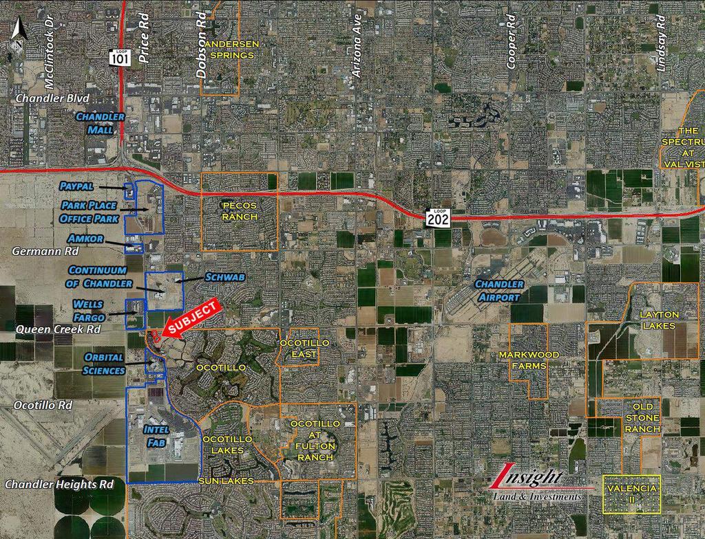
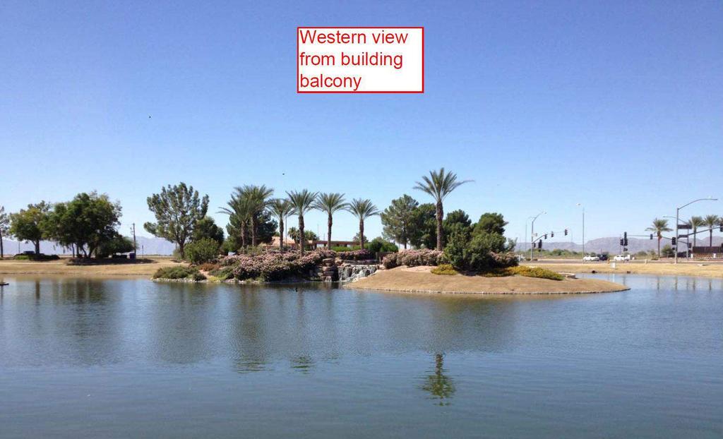
TRACY GLASS. Location : Queen Creek Road east of Price Road- Chandler, Az.
|
|
|
- Lindsay Wiggins
- 5 years ago
- Views:
Transcription


 Insight Land & Investments 7400 E McDonald Dr, Ste 121 Scottsdale, Arizona 85250")


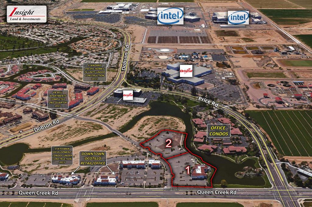
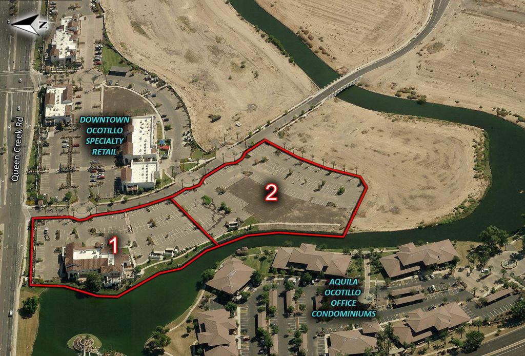
1 Location : Queen Creek Road east of Price Road- Chandler, Az. Subject: 10,933 sf single story retail building on 2.56 acres Improved retail pad on 2.62 acres Zoning: PAD Commercial Parcel 1-10,993 SF retail building Parcel 2- Conceptual site plan approval for a 2 story, 21,310 SF office building Price: Parcel 1- $2,900,000 Parcel 2- $1,650,000 ($14.46/sf) Insight Land & Investments 7400 E McDonald Dr, Ste 121 Scottsdale, Arizona All information furnished regarding property for sale, rental or financing is from sources deemed reliable, but no warranty or representation is made to the accuracy thereof and same is subject to errors, omissions, change of price, rental or other conditions prior to sale, lease or financing or withdrawal without notice. No liability of any kind is to be imposed on the broker herein. TRACY GLASS tglass@insightland.com


2 Located at the gateway to Downtown Ocotillo the commercial hub of the 1500 acre Ocotillo Lake master plan. Approaching build out Downtown Ocotillo encompasses 220,000 SF of commercial including boutique retail, Class A office, luxury for sale condos now under construction and entitlements for a 5 story hotel. Subject properties are within the geographic center of the Price Road employment corridor yet have a distinctively different setting than much of the multi story corporate campus environment associated with the corridor. Framed by 800 of frontage on the signature Ocotillo lake and surrounded by boutique retail and 1 and 2 story office give the site a greater feeling of exclusivity and identity. Parcel #1 is the last available retail building and Parcel #2 is the last available office site in the Downtown Ocotillo development. Parcels are divisible No onsite retention is required as water runoff is accommodated within the lake The 10,993 SF building on Parcel #1 is in shell condition allowing for greater flexibility
3
4
5

6 P ARCE L# 1 P ARCE L# 2
7

8
9
10

11

12 PARCEL#2 CONCEPTUALELEVATIONS

13 PARCEL#2 CONCEPTUALELEVATIONS
14
15
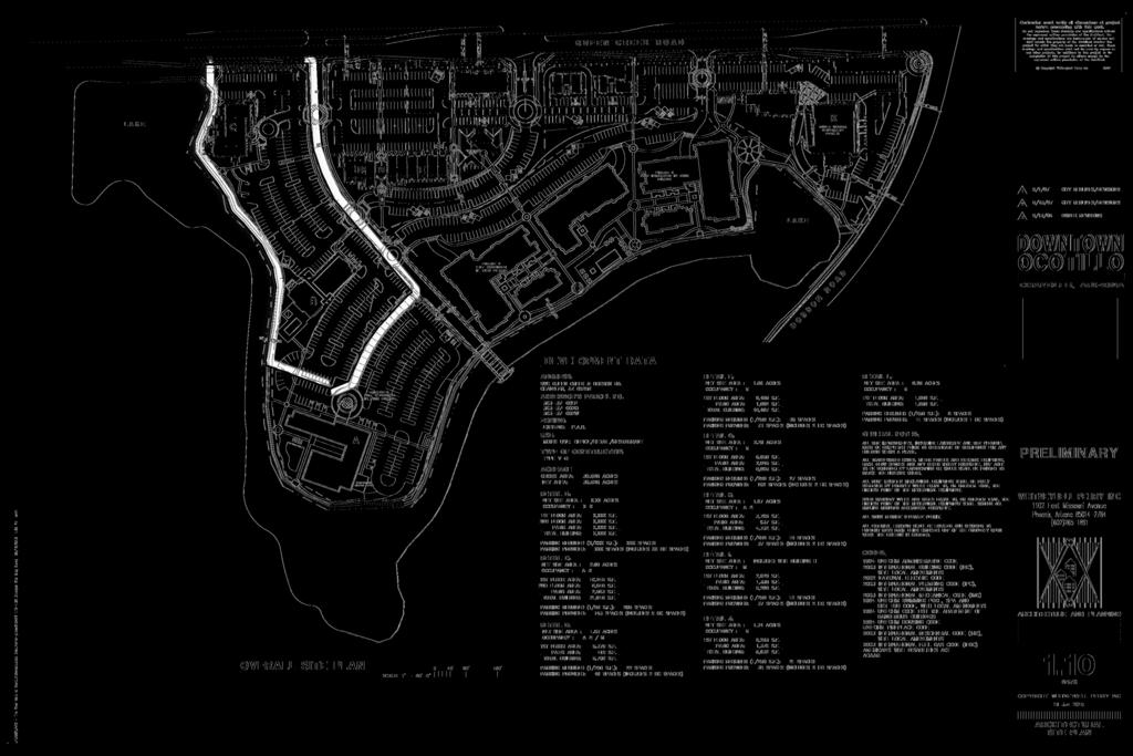
16 PROTECT NARRATIVE Executive Summary On the corner of Queen Creek and Dobson Road, we are proposing an exciting Mixed Use development that will provide a remarkable new destination for Chandler. With a mix of commercial and residential uses, we envision Downtown Ocotillo to be a vibrant, work-live community that will both energize and complement the Ocotillo area. This application will present the design components of Downtown Ocotillo as well as request an amendment to the Area Plan. This application is also requesting approval of Rezoning, Preliminary Development Plan, and Mid-rise Overlay (see Mid-rise Area Exhibit for location). Downtown Ocotillo is located at the southwest corner of Queen Creek and Dobson Roads and is adjacent to the lake on its southern and eastern side. This waterside setting and proximity to a major thoroughfare creates a unique opportunity for development of a fully integrated town center. Downtown Ocotillo will maximize this proximity to the lake in both commercial and residential development. The commercial section of Downtown Ocotillo will consist of retail, specialty grocer, day spa, restaurants, office space, and a hotel. Approximately 19 acres of the 25 acre site will be commercial in nature with the remaining 6 acres as residential. Instead of separating the two uses, the office and retail space in Downtown Ocotillo has been artfully combined in single and two story buildings and will have the charm of a small town Santa Barbara main street. The residential area will complement the shopping district by providing elegant formal connections and easy pedestrian access. Residents will have a unique opportunity to work and shop while enjoying beautiful lakeside amenities and breathtaking views of the Ocotillo community. To further embrace the work-live opportunity, residential units adjacent to the main drive have been creatively designed to allow residents to run their own business in work-live units. Existing Zoning & Land Usage The existing Area Plan has designated the Downtown Ocotillo site as Employment. The proposed plan has kept elements of this with the integration of office space, but seeks amendment to include mixed use of retail, residential, and hotel. The addition of a residential and retail element is critical to the creation of a work-live community. The original Ocotillo Area Plan was approved for 8130 residential dwellings. The projected build out including the proposed dwelling units in both "Downtown Ocotillo" and "The Waters" is 5495 residential units. This proposal and area plan amendment will still have 2635 fewer residential dwellings than originally approved. The elimination of much of the currently approved C-2 commercial designation will actually reduce overall potential traffic and result in a viable mixed use (livable and walkable) community. With an Employment only designation, the site would be effectively limited only to daytime use and would be isolated from the adjacent residential community after business hours. With the addition of retail, residential, and hotel on site, a whole new dynamic can be achieved with evening and weekend activity that keeps Downtown Ocotillo continually connected to The Waters and the rest of the Ocotillo residential community. By amending the Area Plan, this will open the door to development of a truly unique area to work, live, dine, and shop. To ensure an active and vibrant community that allows direct interchange between residential and retail environments, this truly mixed use community is providing "for sale" luxury condominiums and a new upscale hotel. This will provide a consumer base only a short stroll away from the restaurants and retail. To provide this critical piece of the puzzle, we are requesting a mid-rise overlay for the hotel and luxury condominiums. This location adjacent to the Price Road corridor is identified as an acceptable location for the mid-rise designation. The overall residential densities for both "The Waters" and "Downtown Ocotillo" fall within the Multi-family designations for the ordinance. As noted above, the overall Ocotillo Area Plan will fall substantially short of meeting the original proposed residential units. The location of our proposed mid-rise overlay is perfectly located in what has become known as the "Golden Triangle". Buffered on all sides away from single family communities and enclosed by three major arterial streets. "Downtown Ocotillo" is the ideal location for the proposed six story hotel and the two, four, and five story luxury condominiums. Currently the Downtown Ocotillo parcel is undeveloped. A vehicular connection is proposed to connect to the neighboring development of The Waters at Ocotillo.

17 , PROJECT NARRATIVE Site Design When traveling east on Queen Creek Road, drivers and pedestrians are greeted by distinctive landscape and Santa Barbara influenced signage. Turning into the western drive, visitors are surrounded by tree-lined boulevards, above which are views of the towers of Downtown Ocotillo shops and restaurants. To the immediate right is a building that we envision to be a lakeside restaurant. To the left is the west end of the retail center shops and restaurants that front Queen Creek Road. Each building is connected by landscaped pedestrian paths and rows of cypress trees provide a formal pedestrian connection from Queen Creek Road to the front of the retail center. Visitors to the retail center will be able to meander through the colonnades from building to building and experience a sequence of water features and courtyards. In order to maintain this experience, we are requesting relief from the building setback for building G, H, and I. By building into the setback, we are able to enhance the features of the building, adding additional towers and other items of visual interest. At the northeast corner of the development we envision a small, upscale grocery store. This store, if included in the development, would be a key element in the realization of a work-live community. Residents, employees, and visitors will have convenient pedestrian access to the store. In the development of the site, building and parking area have been restricted by the amount of pre-existing utilities running through the site. In order to provide access to the store and maintain the pedestrian paths along the lake, we would like to request relief from the landscape setback on both the Queen Creek and Dobson sides. To supplement the adjacent landscaping, a green open area has been dedicated next to the lake as well as an exquisite water feature for the corner next to the intersection. Along the southwestern side of the development will be a hotel where guests, in addition to enjoying the hotel amenities, will have the opportunity for close shopping and dining. As the hotel and retail will be integrally connected, we would like to ask relief from the 1.3 spaces/room requirement for guest parking and use a rate of 1.19 spaces per room. In the event that additional parking is needed, there is comfortable pedestrian access from the adjacent parking lot of retail B. At the southern lakeside edge is the residential community. The Downtown Ocotillo residential community features a combination of two, four, and five story buildings, surrounding a central courtyard with formal landscaping and open areas. To the northwest of the residential community is a grassy open area for recreation. In order to provide the maximum amount of open area adjacent to the lake, all resident parking for the community has been placed underground. In order to facilitate this, we are requesting relief from the 19'x 9' parking requirement for the underground parking and would like to make the spaces 18'x 9'. Adjacent to the lake are walking and biking trails that span the entire lake edge uniting the commercial, hotel, and residential areas. Within the trails are seating areas and water features where visitors and residents can stop and enjoy the views of the lake. The capstone, at the corner of Queen Creek and Dobson Roads, will be a unique water feature that will signify to visitors and residents their arrival at Downtown Ocotillo. Architectural Character In its design, Downtown Ocotillo will fully embrace Santa Barbara style architecture. In the early 20 1 h century and again in the late 1980s, California architects drew upon both Italian and Spanish architecture as inspiration for their design. The details of these classic themes were reinvented to complement the Southern California environment. Over time, the method of detailing has evolved into a unique style known as 'Santa Barbara'. Santa Barbara architecture is most readily identified by application of materials and the programmatic relationship between interior and exterior living space. The most distinctive exterior features of Santa Barbara architecture is red clay tile roofing and smooth white stucco walls. Every building, architectural pedestrian feature, and monument sign in Downtown Ocotillo will embrace this style. When walking in Santa Barbara, a pedestrian's view includes tall, distinctive elements rising above trees and framing the skyline. Visitors to Downtown Ocotillo will experience this through a variety of towers, spires, and domes. Another distinctive feature of Santa Barbara architecture is the acute attention to the placement and construction of windows, openings, and architectural recesses. Traditional Santa Barbara style windows are recessed into the walls and include heavier frames. Variation of window size and placement are also characteristic of the style as well as the complement of shutters and wrought iron. Great care has been taken in the detailing of all recessed openings in Downtown Ocotillo in both retail and residential buildings to hold true to Santa Barbara style. Other adornments of Santa Barbara style that have been incorporated in Downtown Ocotillo include ceramic tile, Cantera stone accents, and ornate columns. Another important element of Santa Barbara style is the connection between interior and exterior space. In Santa Barbara style architecture, exterior space is a large programmatic function of the building. Downtown Ocotillo has taken this element and incorporated it into many of the buildings. Outside of the retail and office buildings are colonnades and vine covered trellises. Several buildings have wood standing balconies on upper floors. The two buildings on the western side of the development take advantage of lake views by the addition of extensive open terraces for sitting and dining. These buildings also enhance the lakeside experience with large ground level patios immediately adjacent to the water. Interior buildings have also maximized adjacent open areas and incorporated patio seating with lush landscape and water features.
18 PROJECT NARRATIVE Landscape Design The landscape design for Downtown Ocotillo is inspired by two unique site features: pedestrian axes and lake edge conditions. The overall intent of the landscape design is to provide a lush oasis here in the Arizona desert and complement the surrounding Ocotillo area. With the adjacent source of reclaimed water, Downtown Ocotillo will be able to accomplish this goal without taxing local water resources. The proposed landscape aims to provide a sense of arrival to Downtown Ocotillo as well as a uniform streetscape and is designed to sustain seasonal interest. It knits together planting and hardscape with specialty elements like shady trellis structures and water features. The plant palette for the project includes the plant species listed in the Ocotillo Community Standards, the City of Chandler landscape standards, as well as other varieties that complement the design intent of providing a shady, lush landscape. Selected plants include a combination of canopy trees, palms, shrubs, groundcovers and turf; all chosen for their adaptation to the local climate, growth patterns, form, and color. The planting design works in conjunction with circulation patterns throughout the development. Pedestrian areas are defined through specialty paving materials for paths, plazas, courts, and cross walks. Vehicular entry nodes are emphasized through special paving patterns and materials. Specialty accent bands and patterns in the roadway help in highlighting exclusive areas like the retail corridor and the entry to the conference center and hotel. Pedestrian paths and planting lead one from different parts of Downtown Ocotillo to the lake. Plantings along the lake are strategically placed so that they do not block the view of the water or restrict access. Along the path next to the residential community and the hotel are numerous water features and seating areas shaded with designed trellis structures. Where pedestrian paths cross, the intersection is accentuated with paving and planting features. The landscape design for "Downtown Ocotillo", also includes special features like a fountain at the corner of Price and Dobson Roads and a public park. The park is proposed adjacent to the restaurant/retail building J, the grocery store in building K and the residential area. It links the eastern entry to the lake, culminating at a palm lined circular court with water jets. The park is a multi-use destination with waterside seating that provides opportunities for a variety of activities. Two major landscape axes connect the residential to the retail site. Between the center and east residential building, there is a pedestrian path that physically connects the residential buildings to retail buildings Hand I, eventually terminating at Queen Creek Road. Travel along the axis is pleasantly interrupted by landscape elements such as fountains, runnels, and accent paving. Between the west and center residential buildings is another axis that directly connects the residential community to the front entrance of the office/retail building F. These two axes provide a formal connection through the greenbelt of trees that screen the residential drive from the commercial area. Vision In the community of Downtown Ocotillo, we envision an exciting mixed use community where residents can work, dine, and shop in a pleasant Santa Barbara style setting. Through creative design and careful planning, we feel that we can accomplish a unique destination for both Ocotillo and Chandler. We are proud to present Downtown Ocotillo and look forward to the continuation of this exciting development.
19 PARCEL#1 PARCEL#2 PARCEL#2 PARCEL#1
20 Several large-hiring announcements have been made in Chandler. Figures include companies new to the city, in addition to expansion projects by existing companies Job Creation Number of Jobs Nationstar 1,200 General Motors 1,000 OnTrac 850 QBE 700-1,200 Intel 350 Infusionsoft 300 Element Payment 150 Services Garmin 150 Phacil 120 Wells Fargo 2500 Chandler Regional 350 expansion CyrusOne 50 Clearcall Solutions 100 IO manufacturing (8mi 100 from subject) Banner Health 50 Santan Brewery 35 TOTAL Job Creation Number of Jobs DaVitaRx (Early ) CVS 700 HealthPlanOne 200 Chandler Fashion 30 Center Paypal 150 Wells Fargo 2600 FedEx 200 TOTAL 4430
21 The City As a city, Chandler has been the powerhouse of job generation in the metro Phoenix area for the last 2 years. General Motors, Garmin, and the expansions of both Chandler Regional Hospital and Wells Fargo account for close to 5000 to 9000 jobs created in the city since the fall of Chandler Area Highlights Average Household Income: $83,296 (2015) Population - 247,979 in September % of population have associate degrees or better vs. 56% in Phoenix Between 1990 and 2000, Chandler was the 7 th fastest growing city in the United States of those with a population more than 100,000 Young population median age is 34.9 At a Glance Chandler Demographic Profile: Source: City of Chandler (2013) Chandler Demographic Profile: Source: City of Chandler (2013)
Policies and Code Intent Sections Related to Town Center
 Policies and Code Intent Sections Related to Town Center The Town Center Vision is scattered throughout the Comprehensive Plan, development code and the 1994 Town Center Plan. What follows are sections
The Village. Chapter 3. Mixed Use Development Plan SPECIFIC PLAN
 The Village SPECIFIC PLAN Chapter 3 3.1 INTRODUCTION 3.1.1 Purpose This Chapter describes the development regulations applicable to the Mixed-Use and Transit Center Planning Areas. These form-based regulations
SECTION V: DESIGN GUIDELINE EXAMPLES
 SECTION V: DESIGN GUIDELINE EXAMPLES Introduction The Syracuse Town Center is envisioned as an area that creates a sense of place, a community downtown. As such, the Town Center Committee recommended the
Ivywild On The Creek PRELIMINARY CREEK DISTRICT MASTER PLAN
 Ivywild On The Creek PRELIMINARY CREEK DISTRICT MASTER PLAN Introduction: Rejuvenating an extraordinary Creekside neighborhood THE CREEKSIDE DISTRICT The Ivywild On The Creek Neighborhood District Master
PC RESOLUTION NO ARCHITECTURAL CONTROL (AC)
") PC RESOLUTION NO. 16-07-26- ARCHITECTURAL CONTROL (AC) 15-035 A RESOLUTION OF THE PLANNING COMMISSION OF THE CITY OF SAN JUAN CAPISTRANO, CALIFORNIA APPROVING ARCHITECTURAL CONTROL (AC) 15-035, INN AT
PC RESOLUTION NO. 16-07-26- ARCHITECTURAL CONTROL (AC) 15-035 A RESOLUTION OF THE PLANNING COMMISSION OF THE CITY OF SAN JUAN CAPISTRANO, CALIFORNIA APPROVING ARCHITECTURAL CONTROL (AC) 15-035, INN AT
Community Design Plan
 Gardena General Plan 2006 Authority While the is not a required element of a General Plan, it is included because improving the community appearance and image is paramount to the overall quality of life
4.9 Mendocino Avenue Corridor Plan Design Guidelines
 4.9 Mendocino Avenue Corridor Plan Design Guidelines The Mendocino Avenue Corridor Plan addresses the area between College Avenue and Steele Lane. Mendocino Avenue is a busy arterial that runs parallel
ELMVALE ACRES SHOPPING CENTRE MASTER PLAN
 ELMVALE ACRES SHOPPING CENTRE MASTER PLAN Contents 1.0 INTRODUCTION... 2 2.0 LOCATION... 2 3.0 EXISTING CONTEXT... 2 4.0 VISION & GUIDING PRINCIPLES... 2 5.0 LAND USE AND BUILT FORM... 4 5.1 St. Laurent
The transportation system in a community is an
 7 TRANSPORTATION The transportation system in a community is an important factor contributing to the quality of life of the residents. Without a sound transportation system to bring both goods and patrons
ELK GROVE TOWN CENTER DESIGN GUIDELINES
 ......... ELK GROVE TOWN CENTER DESIGN GUIDELINES LAGUNA RIDGE SPECIFIC PLAN... June 2008 ............ DESIGN GUIDELINES Table of Contents Contents Section A: Town Center Overview...1 A.1. Purpose and
Standards (R-3) Figure B-11: R-3 Residential Standards Exhibit
 Figure B-11: R-3 Residential Standards Exhibit") Avila Ranch Avila Ranch Specific Plan Development Standards High Medium Density - High Residential Density Residential Lot and Building Lot and Standards Building (R-3) Standards (R-3) EXAMPLES These sketches
Avila Ranch Avila Ranch Specific Plan Development Standards High Medium Density - High Residential Density Residential Lot and Building Lot and Standards Building (R-3) Standards (R-3) EXAMPLES These sketches
Gateway commercial MIXED USE MASTER SITE PLAN. CITILAND AIrDRIE GATEWAY VENTURE INC. airdrie GATEWAY COMMERCE CENTRE. airdrie, ALBERTA FEBRUARY 2012
 Gateway commercial MIXED USE MASTER SITE PLAN 1914 CENTRE STREET NORTH CALGARY, AB CANADA T2E 2S8 T. 403.264.7177 F. 403.264-7175 WWW.CITILAND.CA CITILAND AIrDRIE GATEWAY VENTURE INC. airdrie GATEWAY COMMERCE
Table of Contents. Elm Avenue Improvement Plan City of Waco, Texas. Introduction 1. Existing Context 1 Figure 1 2.
 Table of Contents Introduction 1 Existing Context 1 Figure 1 2 Plan Guidelines 3 Future Urban Form 4 The West-End 4 Main Street 6 The East-End 7 Figure 2 9 Public Improvement Recommendations 7 General
PUBLIC RIGHT-OF-WAY IN THIS CHAPTER PUBLIC REALM
 PUBLIC RIGHT-OF-WAY This section provides design guidelines for improvements in the public right-of-way. The public right-of-way refers to streets, sidewalks, non-vehicular thoroughfares, parks and greenways
The Anaheim Resort Public Realm Landscape Program. City of Anaheim. Adopted September 1994 (94R-239)
") Public Realm Landscape Program City of Anaheim Adopted September 1994 (94R-239) Amendment No. 1 October 1996 (96R-178) Amendment No. 2 June 1999 (99R-137) Amendment No. 3 February 2001 (2002R-56) Amendment
Public Realm Landscape Program City of Anaheim Adopted September 1994 (94R-239) Amendment No. 1 October 1996 (96R-178) Amendment No. 2 June 1999 (99R-137) Amendment No. 3 February 2001 (2002R-56) Amendment
3.1 community vision. 3.3 required plan elements
 Chapter 3 Community Form 3.1 community vision 3.2 Parks & landscaping concepts 3.3 required plan elements D R A F T 20 Community Form Chapter 3 3.0 Community form 3.1 community vision The Specific Plan
Campus Master Plan Description Section 6 Storm water management and people places at campus buildings. Section 6 Campus MP Description
 Campus Master Plan Description Section 6 Storm water management and people places at campus buildings Section 6 Campus MP Description THIS PAGE INTENTIONALLY LEFT BLANK. appendix The following provides
Sierra Springs Regional Commercial Master Site Plan Airdrie, Alberta Hopewell Development Corporation Project No May 26, 2010
 Sierra Springs Regional Commercial Master Site Plan Airdrie, Alberta Hopewell Development Corporation Project No. 205-077 May 26, 2010 TABLE OF CONTENTS Purpose... 2 Master Site Plan Guidelines... 3 Overall
VICTORIA DOWNTOWN DEVELOPMENT PLANNING
 VICTORIA DOWNTOWN DEVELOPMENT PLANNING A Vision & Guide for the Future Downtown Victoria thrives as a center for the community, offering a great mix of entertainment, culture, business, and recreational
a new urban landscape class a office & retail district murfreesboro, tennessee
 a new urban landscape class a office & retail district murfreesboro, tennessee Fountains at Gateway Is Open For Business Fountains at Gateway is a new 31-acre Class A multitenant office and retail development
DESIGN REVIEW COMMITTEE AGENDA ITEM
 DESIGN REVIEW COMMITTEE AGENDA ITEM AGENDA DATE: AUGUST 2, 2017 TO: THRU: FROM: SUBJECT: Chair Imboden and Members of the Design Review Committee Anna Pehoushek, Assistant Community Development Director
Lehigh Acres Land Development Regulations Community Planning Project
 Lehigh Acres Land Development Regulations Planning Effort Summary In July, 2010 Commissioner Frank Mann invited the Lehigh Acres community to start discussing how to achieve their recently adopted community
Pedestrian and Bike Bridge LOGO
 6.2.2 Pedestrian and Bike Bridge The proposed pedestrian and bike crossing re-envisions the existing bridge at Pismo Creek on Cypress Street. The bridge is currently underutilized by vehicular through
2.0 AREA PLANS. Lakeside Business District. Lakeside Business District Land Use Categories:
 Lakeside Business District Lakeside Business District Land Use Categories: Campus Commercial Campus Commercial means a mixture of uses which includes corporate offices, office parks, hotels, commercial,
public review draft Key objectives for this chapter are:
 5 - parks & open space Providing a rich collection of outdoor places for informal gathering and recreation, as well as planned promotional activities and community events, is a key concept for Midtown.
Planning Commission Staff Report June 5, 2008
 Owner/Applicant Taylor Village Sacramento Investments Partners, LP c/o Kim Whitney 1792 Tribute Road #270 Sacramento, CA 95815 Staff Recommendation Planning Commission Staff Report Project: File: Request:
chapter DESIGN GUIDELINES NEW RIVER MASTER PLAN REPORT
 chapter DESIGN GUIDELINES NEW RIVER MASTER PLAN REPORT .76 DESIGN GUIDELINES An Overview design guidelines NEW RIVER MASTER PLAN Design Guidelines can transform the image of a city. Specific, design-based
DINING ENTERTAINMENT SHOPPING
 DINING ENTERTAINMENT SHOPPING Proscenium is a unique community that combines the ease of upscale living with the luxury of retail shops and dining options right outside your front door. Perfect for young
The Ritz-Carlton, Paradise Valley
 The Ritz-Carlton, Paradise Valley 7000 E. Lincoln Drive Keys to Success Community Conversation II June 4, 2015 RITZ-CARLTON PARADISE VALLEY Town Council Study Session June 4, 2015 General Plan 2012 Land
V. Gateways GATEWAYS / V-1
 V. GATEWAYS / V-1 Many of Chesapeake s gateways are located on highways and call for bold and attractive designs that motorists can understand, appreciate, and enjoy. can also take the form of natural
a vibrant office and retail development enters the gateway to rutherford county
 a vibrant office and retail development enters the gateway to rutherford county PF UP Introducing Fountains at Gateway in Rutherford County Fountains at Gateway is a new 31-acre Class A multi-tenant office
New Street Proposed Redevelopment Architecture & Urban Design Brief
 2130 2136 New Street Proposed Redevelopment Architecture & Urban Design Brief Prepared By: Cynthia Zahoruk Architect Inc. 3077 New Street, Burlington, ON, L7N 1M6 TABLE OF CONTENTS Background and Objective
Today Land & People. Northeast Nampa Gateway District. Employment. Land Use Characteristics. Demographics. Current Zoning
 Today Land & People Employment Major employers include Saint Alphonsus, the College of Western Idaho, the Auto Mall, Sorrento Lactalis and Walmart. 3,004 jobs in 2010 (COMPASS-CIM 2040 TAZ data) 4,345
Carlsbad Village Redevelopment Concept Summary of Features
 Carlsbad Village Redevelopment Concept Summary of Features Calthorpe Associates November 5, 2003 The Redevelopment Concept illustrates a vision for the future of Carlsbad Village. The overall vision of
ARLINGTON COUNTY, VIRGINIA
 ARLINGTON COUNTY, VIRGINIA County Board Agenda Item Meeting October 15, 2005 DATE: September 28, 2005 SUBJECT: Request to Advertise the adoption of the 2005 Clarendon Sector Plan C. M. RECOMMENDATION:
Neighborhood Districts
 NEIGHBORHOOD DISTRICTS SEVEN MAIN DISTRICTS Neighborhood Districts While the Development Plan provides a broad-scale overview of the neighborhood, this section focuses on uses and relationships at the
Micco Park Village Development
 FOR SALE Call For Pricing Micco Park Village Development Proposed Project Property Details Micco Park Village Development PRICE Call For Pricing A monumental development opportunity of a lifetime! The
Mark-up of the effect of the proposed Bronte Village Growth Area OPA No.18 on the text of section 24, Bronte Village, of the Livable Oakville Plan
 Mark-up of the effect of the proposed Bronte Village Growth Area OPA No.18 on the text of section 24, Bronte Village, of the Livable Oakville Plan Notes: This document is provided for information purposes
Port Lavaca Future Land Use
 Port Lavaca Future Land Use Introduction The City of Port Lavaca is beginning to see sustained growth, after many years of relative stable population. New single family homes, apartments, and businesses
Buildings may be set back to create small plazas provided that these setbacks do not substantially disrupt the street wall s continuity.
 6-22 Community Design Street Walls and Street-front Setbacks The siting of buildings will play a critical role in establishing the character and sense of place for the District. Siting buildings at the
AMITY STATION Revised Concept Plan Review West Rosemary Street Chapel Hill, NC September 27, 2016
 AMITY STATION Revised Concept Plan Review West Rosemary Street Chapel Hill, NC September 27, 2016 DEVELOPER'S PROGRAM Introduction This is a request for review of a Revised Concept Plan by Chapel Hill
a new urban landscape class a office & retail district murfreesboro, tennessee
 a new urban landscape class a office & retail district murfreesboro, tennessee Fountains at Gateway Is Open For Business Fountains at Gateway is a new 31-acre Class A multitenant office and retail development
Developer s Program. The Station at East 54
 Developer s Program The Station at East 54 Existing Conditions The Station at East 54 is proposed for a 1.12 acre site at the northeast corner of Hamilton Road and Prestwick Road, tucked between the East
BROOKLYN PARK / 85TH AVE LRT STATION CDI DEVELOPMENT GUIDELINES DRAFT
 August 2018 Page intentionally left blank The Brooklyn Park Library adjacent to the 85th Ave LRT Station Area. OVERVIEW The Blue Line LRT Extension / Bottineau corridor offers a unique opportunity to leverage
appendix and street interface guidelines
 appendix five: building and street interface guidelines appendix 5 building and street interface guidelines BOULEVARDS Boulevards are generally characterized by higher levels of traffic movement at higher
TEMPLE MEDICAL & EDUCATION DISTRICT
 City of Temple, Texas TEMPLE MEDICAL & EDUCATION DISTRICT 1 Description. The City of Temple joined in partnership with key public and private entities to jointly promote education and medical activities
4. INDUSTRIAL 53 CASTLE ROCK DESIGN
 4. INDUSTRIAL 53 CASTLE ROCK DESIGN CASTLE ROCK DESIGN 54 4. INDUSTRIAL Overview Well-designed and attractive industrial centers are the product of blending economic realities with both functional and
4 C OMMUNITY D ISTRICTS
 4 C OMMUNITY D ISTRICTS N ew development in the Area will include many different types of land uses, including a destination retail area that attracts people from all over the region; recreation opportunities
McCowan Precinct Plan Study Background & Deliverables
 1 DRAFT & WITHOUT PREJUDICE McCowan Precinct Plan Study Background & Deliverables In September, 2011, City Planning (Scarborough District) began a study of an area within the Scarborough Centre, identified
EXISTING COMPREHENSIVE PLAN
 EXISTING COMPREHENSIVE PLAN Town Center Land Use Element: V. LAND USE POLICIES Town Center Mercer Island's business district vision as described in "Your Mercer Island Citizen-Designed Downtown" was an
Overview of the Plan. The Building Blocks of Centers, Neighborhoods and Network INTERNAL DRAFT
 Overview of the Plan 4 East Davidson Ramah Church Rd June Washam Rd Bradford District Park Bradford Shearer Rd Campus District NC 73 Davidson-Concord North Rocky River This Master Plan projects an approximate
2. Form and Character. 2.1 Introduction. 2.2 The Downtown Addition Plan. 2.1 Introduction
 2.1 Introduction 2.1 Introduction This section of the Specific Plan describes and illustrates the desired form, character and uses of the Downtown Addition and explains the underlying design principles.
WINDSOR GLEN DESIGN GUIDELINES
 WINDSOR GLEN DESIGN GUIDELINES Adopted by Council, 2006 WINDSOR GLEN REDEVELOPMENT DESIGN GUIDELINES August 2006 1.0 Master Plan Organization For this area of the Coquitlam Town Centre, a mix of high,
E L L I O T R O A D T E C H N O L O G Y C O R R I D O R
 E L L I O T R O A D T E C H N O L O G Y C O R R I D O R Light Industrial Planned Area Development (LI PAD) Rezoning Application Narrative SUBMITTED TO: CITY OF MESA PLANNING DIVISION Mesa, Arizona Page
SYRINGA VALLEY SPECIFIC PLAN NARRATIVE
 SYRINGA VALLEY SPECIFIC PLAN NARRATIVE Introduction With this application, Pleasant Valley South LLC ( Pleasant Valley ) seeks the City of Boise s approval of a new Specific Plan Ordinance to be added
ORDINANCE WHEREAS, this Ordinance is consistent with the City of Winter Garden Comprehensive Plan; and
 ORDINANCE 17-06 AN ORDINANCE OF THE CITY COMMISSION OF THE CITY OF WINTER GARDEN, FLORIDA, CREATING ARTICLE XIV OF CHAPTER 118 OF THE CITY OF WINTER GARDEN CODE OF ORDINANCES PROVIDING FOR THE EAST PLANT
DEVELOPMENT CONTROLS MEDICAL DISTRICT
 6.01. GENERAL DESIGN GUIDELINES A. Site Planning B. Architectural Design C. Medical Facility Signage & Lighting D. Exhibit 48. ARCHITECTURAL DESIGN CONCEPTS 6.02. MEDICAL FACILITY STANDARDS & GUIDELINES
Gold Line Bus Rapid Transit Transit Oriented Development (BRTOD) Helmo Station Area Plan
 Helmo Station Area Plan") Appendix F Gold Line Bus Rapid Transit Transit Oriented Development (BRTOD) Helmo Station Area Plan Introduction and Purpose of the Plan The Gold Line Bus Rapid Transit facility is an eleven-mile dedicated
Appendix F Gold Line Bus Rapid Transit Transit Oriented Development (BRTOD) Helmo Station Area Plan Introduction and Purpose of the Plan The Gold Line Bus Rapid Transit facility is an eleven-mile dedicated
Establish a network of streetscaped vehicle and pedestrian routes that connect within and outside the Plan area.
 This Plan s urban design goals are to create an urban scale, walkable community with connections to transit, parks, and services and with amenities and facilities for residents and employees. The 1992
lot flankage Y street 16m 6m landscape strip for large site 3m landscape strip for small medium site
 Commercial General Commercial Objectives Create developments compatible with adjacent land uses in scale, function and character Define a consistent and attractive street edge with quality landscaping,
THE CIVIC DISTRICT DEVELOPMENT OPPORTUNITIES
 1 THE CIVIC DISTRICT DEVELOPMENT OPPORTUNITIES The Civic District is the physical and emotional heart of the downtown. It is also a major gateway into the central core, establishing the image and identity
2.0 THE PLATINUM TRIANGLE VISION
 2.0 THE PLATINUM TRIANGLE VISION The envisions an exciting future for the area surrounding Angel Stadium of Anaheim, the Honda Center and The Grove of Anaheim. 2.1 Planning Principles In order to further
East Central Area Plan
 East Central Area Plan Steering Committee Meeting March 8 th, 2018 CHUN Tears McFarlane House Vision Statement Development Opportunities Analysis Vision Elements 1. Equitable, Affordable and Inclusive
KEY MAP DEVELOPMENT PERMIT AREA MAP. Sunnymede North Sub-Area Plan
 Richmond Official Community Plan BROADMOOR AREA SUNNYMEDE NORTH SUB-AREA PLAN Bylaw 7100 Schedule 2.6C SUNNYMEDE NORTH SUB-AREA PLAN SUNNYMEDE NORTH SUB-AREA PLAN SUNNYMEDE NORTH SUB-AREA PLAN KEY MAP
B L A C K D I A M O N D D E S I G N G U I D E L I N E S for Multi-family Development
 B L A C K D I A M O N D D E S I G N G U I D E L I N E S for Multi-family Development Adopted June 18, 2009 This section of the Design and focuses on site planning and design guidance for new multi-family
4.1.3 LAND USE CATEGORIES
 4.1.3 LAND USE CATEGORIES a. City Center District The City Center District incorporates the existing character and mix of uses in downtown Belmont to encourage redevelopment and new development in keeping
Figure 3-1: Public Realm Plan
 3 Public Realm Figure 3-1: Public Realm Plan 3.1 Public Realm Concept The public realm concept for the Little Mountain site integrates a clear and accessible movement network with public spaces for social
WEST LOOP DESIGN GUIDELINES CHECKLIST
 WEST LOOP DESIGN GUIDELINES CHECKLIST Section 1.0 General Strategies 1.1 DESIGN EXCELLENCE: ENCOURAGE HIGH QUALITY AND INNOVATIVE DESIGN OF NEW BUILDINGS WITHIN THE WEST LOOP WITHOUT BEING PRESCRIPTIVE
RESIDENTIAL PLANNED UNIT DEVELOPMENT / SUBDIVISION AND REZONING CONCEPT AND DEVELOPMENT STAGE PLAN SUBMITTAL NARRATIVE
 RESIDENTIAL PLANNED UNIT DEVELOPMENT / SUBDIVISION AND REZONING CONCEPT AND DEVELOPMENT STAGE PLAN SUBMITTAL NARRATIVE DEVELOPMENT TEAM DONEGAL SOUTH Maple Grove, Minnesota March 27, 2017 Applicant/Developer/Builder:
V. Vision and Guiding Principles
 V. Vision and Guiding Principles The Master Plan for the Powers Ferry Corridor seeks a foundation in the desires of the community. At times, various elements of the community offered opposing viewpoints,
Town Center. Block 5 Existing multifamily residential units are expected to remain.
 Area Guidelines Germantown s districts should be developed as distinct communities with unique features that are supported through the guidelines. The guidelines not only help distinguish these districts
A. Background Summary of Existing Challenges and Potential Possibilities. 1. Summary of Existing Assets and Potential Opportunities
 A. Background 1 A Main Street Master Plan Study was performed and completed in October of 2007. The study was initiated to review current land uses and development patterns along Main Street, from Parrish
CHAPTER 7 I NDUSTRIAL
 CHAPTER 7 I NDUSTRIAL PURPOSE... 7:1 ORGANIZATION... 7:1 APPLICABILITY AND USE TYPES... 7:1 Light Industrial Development... 7:2 Heavy Industrial Development... 7:3 SITE DESIGN... 7:4 Circulation... 7:6
Millbrae TOD #2 Project Analysis
 Millbrae TOD #2 Project Analysis Project Description A Site Development Permit and Conditional Use Permit are proposed to allow for a mixed-use transitoriented development on approximately 9 Acres located
CITY OF MERCER ISLAND DESIGN COMMISSION STAFF REPORT
 CITY OF MERCER ISLAND DESIGN COMMISSION STAFF REPORT Agenda Item: 2 March 9, 2011 Project: Description: Applicant: DSR11-004 The applicant is requesting approval to replace the existing exterior wood framed
Regency Developments. Urban Design Brief. Holyrood DC2 Rezoning
 Regency Developments Urban Design Brief Holyrood DC2 Rezoning Stantec Consulting Ltd. 7-31-2017 1. Overview Regency Developments intends to rezone the lands located at 8510 and 8511 93 Avenue, within the
Bourne Downtown Site Planning
 Prepared for: The Town of Bourne, MA In Cooperation with: Bourne Financial Development Corporation Prepared by:, Inc. June 24, 2009 Table of Contents Introduction and Summary... 1 Site Existing Conditions...
Sahuarita District & Phase 1 Master Plan. Town Council December 11, 2017
 Sahuarita District & Phase 1 Master Plan Town Council December 11, 2017 Visioning Study Visioning Process Advisory Group Meetings Community Questionnaire Town Center Case Studies Community Analysis The
DRAFT. October Wheaton. Design Guidelines
 October 2011 DRAFT Wheaton Design Guidelines 2 Draft - Design Guidelines - Wheaton Sector Plan Contents 04 Section 1: Introduction 06 Section 2: Context 08 Section 3: Design Guidelines 09 Goal 1: Create
Residential Design Guidelines
 Residential Design Guidelines Single-Family Residential Design Guidelines Introduction These guidelines seek to provide property owners, designers and developers with a clear understanding of the City
Brampton. Secondary Plan. Review. Bram West. A New Direction in Planning & Public Consultation
 Brampton Bram West Secondary Plan Review A New Direction in Planning & Public Consultation Introduction The Bram West Secondary Plan Review offers an important opportunity for the community to define a
WATERFRONT DISTRICT DESIGN STANDARDS
 WATERFRONT DISTRICT DESIGN STANDARDS 20.25.080 WATERFRONT DISTRICT A. Purpose. This section is intended to implement The Waterfront District Subarea Plan by: 1. Creating a safe, vibrant mixed-use urban
Chapter 1: Introduction
 Chapter 1: Introduction The Penn Avenue Community Works Corridor Vision and Implementation Framework presents an integrated communitybased vision and a coordinated, long-term implementation framework for
VILLAGE OF SKOKIE Design Guidelines for Mixed-Use Districts NX Neighborhood Mixed-Use TX Transit Mixed-Use CX Core Mixed-Use
 VILLAGE OF SKOKIE Design Guidelines for Mixed-Use Districts NX Neighborhood Mixed-Use TX Transit Mixed-Use CX Core Mixed-Use TABLE OF CONTENTS CHAPTER 1 SITE DESIGN Purpose 1 CHAPTER 2 SITE DESIGN Streetscape
Design Guidelines and Development Standards for Southwood Ranch. Prepared February, 2016 by
 Design Guidelines and Development Standards for Southwood Ranch D e s i g n D i s t r i c t Prepared February, 2016 by Table of Contents Introduction 2 District Overlay Map. 3 Development Standards. 4
The Lower SaLuda Greenway
 The Lower SaLuda Greenway InITIaTIve a FLourIShInG Greenway. a hub For economic GrowTh. a ConneCTIon BeTween CoMMunITIeS. In April 2017 the Michael J. Mungo Foundation and Lexington County commissioned
3. Project Description
 3.1 PROJECT LOCATION The Platinum Triangle (herein after also referred to as the Project Area ) is located at the confluence of the Interstate 5 (I-5 Freeway) and the State Route 57 (SR-57 Freeway), in
[PLANNING RATIONALE] For Site Plan Control and Lifting of Holding Zone By-Law 101 Champagne Avenue. May 23, 2014
![[PLANNING RATIONALE] For Site Plan Control and Lifting of Holding Zone By-Law 101 Champagne Avenue. May 23, 2014](/thumbs/75/71599615.jpg "[PLANNING RATIONALE] For Site Plan Control and Lifting of Holding Zone By-Law 101 Champagne Avenue. May 23, 2014") [PLANNING RATIONALE] For Site Plan Control and Lifting of Holding Zone By-Law 101 Champagne Avenue May 23, 2014 Contents 1.0 Introduction... 2 2.0 Site Context... 2 2.1 Adjacent Uses... 2 Figure 1: Site
[PLANNING RATIONALE] For Site Plan Control and Lifting of Holding Zone By-Law 101 Champagne Avenue May 23, 2014 Contents 1.0 Introduction... 2 2.0 Site Context... 2 2.1 Adjacent Uses... 2 Figure 1: Site
Section 9 NEIGHBORHOOD DESIGN
 Section 9 NEIGHBORHOOD DESIGN City of Lancaster Comprehensive Plan D u n k i n, S e f k o & A s s o c i a t e s, I n c. NEIGHBORHOOD DESIGN INTRODUCTION There are many ways in which a neighborhood can
Clairtrell Area Context Plan
 Clairtrell Area Context Plan March 2005 Urban Development Services City Planning Contents 1. Introduction... 4 2. Development Structure... 6 2.1 Streets... 7 2.1.1 Sheppard Avenue and Bayview Avenue...
CHAPTER 2: FUTURE LAND USE CONCEPTS
 CHAPTER 2: FUTURE LAND USE CONCEPTS INTRODUCTION The future land use concepts presented in this chapter are an expression of community support for a viable and vital US 50 Corridor. Land use recommendations
Subarea 4 Indian Creek. Vision The combination of park networks and transportation amenities make Subarea 4 the greenest hub in the Corridor.
 indian creek 180 extends south from 101st Street to I-435. The I-435 and Metcalf intersection is one of the primary intersections in the Kansas City Metro Area. The area includes several residential neighborhoods
Small Area Plan. South Gateway
 Small Area Plan Adopted May 12, 2008 South Gateway Purpose. The South Gateway Small Area Plan defines the City s expectations for the future of the southern entrance to the City at Interstate 85 and Highway
LIVE. WORK. ENTERTAIN.
 LIVE. WORK. ENTERTAIN. A Charming, Mixed-use Development in Midlothian, Virginia BLACKWOOD DEVELOPMENT COMPANY, INC. d e s i g n s t u d i o 5701 grove avenue richmond va 23226 804.740.7500 www.1hg.net
Town Center (part of the Comprehensive Plan)
") Town Center (part of the Comprehensive Plan) Mercer Island Town Center Looking North (2014) In 1994, a year-long process culminated in a set of design guidelines and code requirements for the Town Center
Town Center (part of the Comprehensive Plan) Mercer Island Town Center Looking North (2014) In 1994, a year-long process culminated in a set of design guidelines and code requirements for the Town Center
ATTACHMENT A. SILVERDALE DESIGN STANDARDS Amendments to the Waaga Way Town Center Chapter
 ATTACHMENT A SILVERDALE DESIGN STANDARDS Amendments to the Waaga Way Town Center Chapter Chapter 10. Waaga Way Town Center 10.1 Physical Identity Elements & Opportunities The Waaga Way Town Center includes
PROPOSED WATERFRONT DISTRICT DESIGN STANDARDS
 PROPOSED WATERFRONT DISTRICT DESIGN STANDARDS 20.25 DESIGN REVIEW. 20.25.080 WATERFRONT DISTRICT A. Purpose. This section is intended to implement The Waterfront District Subarea Plan by: 1. Creating a
178 Carruthers Properties Inc.
 178 Carruthers Properties Inc. Planning Rationale for 178 Carruthers Avenue Site Plan Control Application June 2014 Table of Contents 1.0 Introduction 2.0 Overview of Subject Property 3.0 Current Zoning
DRAFT Land Use Chapter
 Stevens Creek Urban Village DRAFT 1 18 17 Land Use Chapter INTRODUCTION This Land Use Chapter describes how the Stevens Creek Urban Village will accommodate the growth that is planned for it in the Envision
AIRPORT BUSINESS PARK
 PIER MAC PETROLEUM INSTALLATION LTD. AIRPORT BUSINESS PARK DEVELOPMENT APPLICATIONS March 2003 4.1 Airport Business Park Development Permit Area 4.1.1 Justification/Design Concept The design concept envisioned