Wednesday, September 23 rd
|
|
|
- Lauren McDaniel
- 5 years ago
- Views:
Transcription
1 NC COASTAL RESOURCES COMMISSION September 23, 2015 New Hanover County Government Complex Wilmington, NC The State Government Ethics Act mandates that at the beginning of any meeting the Chair remind all the members of their duty to avoid conflicts of interest and inquire as to whether any member knows of any conflict of interest or potential conflict with respect to matters to come before the Commission. If any member knows of a conflict of interest or potential conflict, please state so at this time. Wednesday, September 23 rd 9:00 COASTAL RESOURCES ADVISORY COUNCIL MEETING (HR Training Room) Debbie Smith, Chair 10:15 Commission Call to Order* (HR Training Room) Frank Gorham, Chair Roll Call Chair s Comments Approval of July 16, 2015 Meeting Minutes Frank Gorham, Chair Executive Secretary s Report Braxton Davis CRAC Report Debbie Smith 10:30 Action Items Approval of Fiscal Analysis Development Line and Static Ken Richardson Line Amendments (CRC-15-24) CRAC Appointments (CRC-15-15) Daniel Govoni Town of Pine Knoll Shores LUP Certification (CRC-15-16) Mike Lopazanski City of Jacksonville LUP Amendment (CRC-15-17) Mike Lopazanski 11:00 Beach Management Sandbag Rules and Policies (CRC-15-18) Mike Lopazanski Update on USACE & Carteret County MOA Justin McCorkle, USACE Commission Discussion 12:00 LUNCH 1:15 Public Input and Comment 1:30 CRC Rule Development State Ports Inlet Management AEC Sandbag Use & Boundaries (CRC-15-19) Heather Coats Amendments to Ocean Erodible AEC Recession Line (CRC-15-20) Mike Lopazanski Pile Supported Signs in Coastal Wetlands (CRC-15-21) Tancred Miller 3:00 BREAK 3:15 CRC Rule & Policy Discussion Minor Modifications to Major Projects (CRC-15-22) Doug Huggett Grandfathering of Multi-family Structures Steve Shuttleworth, Shuttleworth Realty 4:15 Old/New Business Frank Gorham, Chair 4:30 Adjourn Executive Order 34 mandates that in transacting Commission business, each person appointed by the governor shall act always in the best interest of the public without regard for his or her financial interests. To this end, each appointee must recuse himself or herself from voting on any matter on which the appointee has a financial interest. Commissioners having a question about a conflict of interest or potential conflict should consult with the Chairman or legal counsel. * Times indicated are only for guidance and will change. The Commission will proceed through the agenda until completed. N.C. Division of Coastal Management Next Meeting: November 17-18, 2015; Double Tree Atlantic Beach
2

3

4

5
6

7
8
9

10
11
12
13
14 North Carolina Department of Environment and Natural Resources Pat McCrory Governor Donald R. van der Vaart Secretary September 8, 2015 MEMORANDUM CRC TO: FROM: Coastal Resources Commission Ken Richardson, Shoreline Management Specialist SUBJECT: Fiscal Analysis Update for the Proposed Development Line Procedures & Amendments to the General Use Standards for Ocean Hazard Areas and Static Vegetation Line Exception Procedures Staff have prepared and submitted the fiscal analysis for the proposed Development Line Procedures (15A NCAC 07J.1301, 15A NCAC 07J.1302, and 15A NCAC 07J.1303), and amendments to the General Use Standards for Ocean Hazard Areas (15A NCAC 07H.0306) and Static Vegetation Line Exception Procedures (15A NCAC 07J.1201) to both the Department of Environment and Natural Resources (DENR) and Office of State Budget and Management (OSBM). Once the fiscal analysis has been approved by both DENR and OSBM, the CRC will have the opportunity to approve it. The proposed rules will then be published in the North Carolina Register, followed by a public hearing/comment period of sixty days. Once the comment period has closed, the CRC will review all comments and may adopt the proposed rules. The proposed rules will then be submitted to the Rules Review Commission (RRC) for their approval. Depending on timing, the RRC will review the proposed rule within one to two months. If RRC approves, the rules go into effect; and if they object, then changes are required. Assuming no major changes are needed, the rule will go into effect in late spring or early summer. 127 Cardinal Drive Ext, Wilmington, North Carolina Phone: \ Internet: An Equal Opportunity \ Affirmative Action Employer Made in part by recycled paper
15 ATTACHMENT A: Relevant Procedural Rules PROPOSED DEVELOPMENT LINE PROCEDURES AND AMENDMENTS TO THE GENERAL USE STANDARDS FOR OCEAN HAZARD AREAS AND STATIC VEGETATION LINE EXCEPTION PROCEDURES 15A NCAC 07H.0304 AECS WITHIN OCEAN HAZARD AREAS The ocean hazard AECs contain all of the following areas: (1) Ocean Erodible Area. This is the area in which there exists a substantial possibility of excessive erosion and significant shoreline fluctuation. The oceanward boundary of this area is the mean low water line. The landward extent of this area is determined as follows: (a) a distance landward from the first line of stable and natural vegetation as defined in 15A NCAC 07H.0305(a)(5) to the recession line that would be established by multiplying the long-term annual erosion rate times 60, provided that, where there has been no long-term erosion or the rate is less than two feet per year, this distance shall be set at 120 feet landward from the first line of stable natural vegetation. For the purposes of this Rule, the erosion rates are the long-term average based on available historical data. The current long-term average erosion rate data for each segment of the North Carolina coast is depicted on maps entitled 2011 Long-Term Average Annual Shoreline Rate Update and approved by the Coastal Resources Commission on May 5, 2011 (except as such rates may be varied in individual contested cases, declaratory or interpretive rulings). In all cases, the rate of shoreline change shall be no less than two feet of erosion per year. The maps are available without cost from any Local Permit Officer or the Division of Coastal (b) Management on the internet at and a distance landward from the recession line established in Sub-Item (1)(a) of this Rule to the recession line that would be generated by a storm having a one percent chance of being equaled or exceeded in any given year. (2) The High Hazard Flood Area. This is the area subject to high velocity waters (including hurricane wave wash) in a storm having a one percent chance of being equaled or exceeded in any given year, as identified as zone V1-30 on the flood insurance rate maps of the Federal Insurance Administration, U.S. Department of Housing and Urban Development. (3) Inlet Hazard Area. The inlet hazard areas are natural-hazard areas that are especially vulnerable to erosion, flooding and other adverse effects of sand, wind, and water because of their proximity to dynamic ocean inlets. This area extends landward from the mean low water line a distance sufficient to encompass that area within which the inlet shall migrate, based on statistical analysis, and shall consider such factors as previous inlet territory, structurally weak areas near the inlet and external influences such as jetties and channelization. The areas identified as suggested Inlet Hazard Areas included in the report entitled INLET HAZARD AREAS, The Final Report and Recommendations to the Coastal Resources Commission, 1978, as amended in 1981, by Loie J. Priddy and Rick Carraway are incorporated by reference and are hereby designated as Inlet Hazard Areas except for: (a) the Cape Fear Inlet Hazard Area as shown on the map does not extend northeast of the Bald Head Island marina entrance channel; and (b) the former location of Mad Inlet, which closed in In all cases, the Inlet Hazard Area shall be an extension of the adjacent ocean erodible areas and in no case shall the width of the inlet hazard area be less than the width of the adjacent ocean erodible area. This report is available for inspection at the Department of Environment and Natural Resources, Division of Coastal Management, 400 Commerce Avenue, Morehead City, North Carolina or at the website referenced in Sub-item (1)(a) of this Rule. Photo copies are available at no charge. (4) Unvegetated Beach Area. Beach areas within the Ocean Hazard Area where no stable natural vegetation is present may be designated as an Unvegetated Beach Area on either a permanent or temporary basis as follows: (a) An area appropriate for permanent designation as an Unvegetated Beach Area is a dynamic area that is subject to rapid unpredictable landform change from wind and wave action.
16 (b) The areas in this category shall be designated following studies by the Division of Coastal Management. These areas shall be designated on maps approved by the Coastal Resources Commission and available without cost from any Local Permit Officer or the Division of Coastal Management on the internet at the website referenced in Sub-item(1)(a) of this Rule. An area that is suddenly unvegetated as a result of a hurricane or other major storm event may be designated as an Unvegetated Beach Area for a specific period of time. At the expiration of the time specified by the Coastal Resources Commission, the area shall return to its pre-storm designation. History Note: Authority G.S. 113A-107; 113A-107.1; 113A-113; 113A-124; Eff. September 9, 1977; Amended Eff. December 1, 1993; November 1, 1988; September 1, 1986; December 1, 1985; Temporary Amendment Eff. October 10, 1996; Amended Eff. April 1, 1997; Temporary Amendment Eff. October 10, 1996 Expired on July 29, 1997; Temporary Amendment Eff. October 22, 1997; Amended Eff. May 1, 2014; February 1, 2013; January 1, 2010, February 1, 2006; October 1, 2004; April 1, 2004; August 1, A NCAC 7H.0305 GENERAL IDENTIFICATION AND DESCRIPTION OF LANDFORMS (a) This section describes natural and man-made features that are found within the ocean hazard area of environmental concern. (1) Ocean Beaches. Ocean beaches are lands consisting of unconsolidated soil materials that extend from the mean low water line landward to a point where either: (A) the growth of vegetation occurs, or (B) a distinct change in slope or elevation alters the configuration of the landform, whichever is farther landward. (2) Nearshore. The nearshore is the portion of the beach seaward of mean low water that is characterized by dynamic changes both in space and time as a result of storms. (3) Primary Dunes. Primary dunes are the first mounds of sand located landward of the ocean beaches having an elevation equal to the mean flood level (in a storm having a one percent chance of being equaled or exceeded in any given year) for the area plus six feet. The primary dune extends landward to the lowest elevation in the depression behind that same mound of sand (commonly referred to as the dune trough). (4) Frontal Dunes. The frontal dune is deemed to be the first mound of sand located landward of the ocean beach having sufficient vegetation, height, continuity and configuration to offer protective value. (5) Vegetation Line. The vegetation line refers to the first line of stable and natural vegetation, which shall be used as the reference point for measuring oceanfront setbacks. This line represents the boundary between the normal dry-sand beach, which is subject to constant flux due to waves, tides, storms and wind, and the more stable upland areas. The vegetation line is generally located at or immediately oceanward of the seaward toe of the frontal dune or erosion escarpment. The Division of Coastal Management or Local Permit Officer shall determine the location of the stable and natural vegetation line based on visual observations of plant composition and density. If the vegetation has been planted, it may be considered stable when the majority of the plant stems are from continuous rhizomes rather than planted individual rooted sets. The vegetation may be considered natural when the majority of the plants are mature and additional species native to the region have been recruited, providing stem and rhizome densities that are similar to adjacent areas that are naturally occurring. In areas where there is no stable natural vegetation present, this line may be established by interpolation between the nearest adjacent stable natural vegetation by on ground observations or by aerial photographic interpretation.
17 (6) Static Vegetation Line. In areas within the boundaries of a large-scale beach fill project, the vegetation line that existed within one year prior to the onset of initial project construction shall be defined as the static vegetation line. A static vegetation line shall be established in coordination with the Division of Coastal Management using on-ground observation and survey or aerial imagery for all areas of oceanfront that undergo a large-scale beach fill project. Once a static vegetation line is established, and after the onset of project construction, this line shall be used as the reference point for measuring oceanfront setbacks in all locations where it is landward of the vegetation line. In all locations where the vegetation line as defined in this Rule is landward of the static vegetation line, the vegetation line shall be used as the reference point for measuring oceanfront setbacks. A static vegetation line shall not be established where a static vegetation line is already in place, including those established by the Division of Coastal Management prior to the effective date of this Rule. A record of all static vegetation lines, including those established by the Division of Coastal Management prior to the effective date of this Rule, shall be maintained by the Division of Coastal Management for determining development standards as set forth in Rule.0306 of this Section. Because the impact of Hurricane Floyd (September 1999) caused significant portions of the vegetation line in the Town of Oak Island and the Town of Ocean Isle Beach to be relocated landward of its pre-storm position, the static line for areas landward of the beach fill construction in the Town of Oak Island and the Town of Ocean Isle Beach, the onset of which occurred in 2000, shall be defined by the general trend of the vegetation line established by the Division of Coastal Management from June 1998 aerial orthophotography. (7) Beach Fill. Beach fill refers to the placement of sediment along the oceanfront shoreline. Sediment used solely to establish or strengthen dunes shall not be considered a beach fill project under this Rule. A large-scale beach fill project shall be defined as any volume of sediment greater than 300,000 cubic yards or any storm protection project constructed by the U.S. Army Corps of Engineers. The onset of construction shall be defined as the date sediment placement begins with the exception of projects completed prior to the effective date of this Rule, in which case the award of contract date will be considered the onset of construction. (8) Erosion Escarpment. The normal vertical drop in the beach profile caused from high tide or storm tide erosion. (9) Measurement Line. The line from which the ocean hazard setback as described in Rule.0306(a) of this Section is measured in the unvegetated beach area of environmental concern as described in Rule.0304(4) of this Section. Procedures for determining the measurement line in areas designated pursuant to Rule.0304(4)(a) of this Section shall be adopted by the Commission for each area where such a line is designated pursuant to the provisions of G.S. 150B. These procedures shall be available from any local permit officer or the Division of Coastal Management. In areas designated pursuant to Rule.0304(4)(b) of this Section, the Division of Coastal Management shall establish a measurement line that approximates the location at which the vegetation line is expected to reestablish by: (A) determining the distance the vegetation line receded at the closest vegetated site to the proposed development site; and (B) locating the line of stable natural vegetation on the most current pre-storm aerial photography of the proposed development site and moving this line landward the distance determined in Subparagraph (g)(1) of this Rule. The measurement line established pursuant to this process shall in every case be located landward of the average width of the beach as determined from the most current pre-storm aerial photography. (10) Development Line. The line established in accordance with 15A NCAC 07J.1300 by local governments representing the seaward-most allowable location of oceanfront development. In areas that have approved development lines, the vegetation line or measurement line shall be used as the reference point for measuring oceanfront setbacks instead of the static vegetation line, subject to the provisions of 15A NCAC 07H.0306(a)(2). (b) For the purpose of public and administrative notice and convenience, each designated minor development permitletting agency with ocean hazard areas may designate, subject to CRC approval in accordance with the local implementation and enforcement plan as defined 15A NCAC 07I.0500, a readily identifiable land area within which the ocean hazard areas occur. This designated notice area must include all of the land areas defined in Rule.0304 of this Section. Natural or man-made landmarks may be considered in delineating this area.
18 History Note: Authority G.S. 113A-107; 113A-113(b)(6); 113A-124; Eff. September 9, 1977; Amended Eff. December 1, 1992; September 1, 1986; December 1, 1985; February 2, 1981; Temporary Amendment Eff. October 10, 1996; Amended Eff. January 1, 1997; Temporary Amendment Eff. October 10, 1996 Expired on July 29, 1997; Temporary Amendment Eff. October 22, 1997; Amended Eff. April 1, 2008; August 1, 2002; August 1, A NCAC 07H.0306 GENERAL USE STANDARDS FOR OCEAN HAZARD AREAS (a) In order to protect life and property, all development not otherwise specifically exempted or allowed by law or elsewhere in the Coastal Resources Commission s Rules shall be located according to whichever of the following is applicable: (1) The ocean hazard setback for development is measured in a landward direction from the vegetation line, the static vegetation line, or the measurement line whichever is applicable. (2) In areas with a development line, the ocean hazard setback line shall be set at a distance in accordance with sub-sections (a)(3) through (9) of this Rule. In no case shall new development be sited seaward of the development line. (3) In no case shall a development line be created or established below the mean high water line. (4) The setback distance is determined by both the size of development and the shoreline erosion rate as defined in 15A NCAC 07H Development size is defined by total floor area for structures and buildings or total area of footprint for development other than structures and buildings. Total floor area includes the following: (A) The total square footage of heated or air-conditioned living space; (B) The total square footage of parking elevated above ground level; and (C) The total square footage of non-heated or non-air-conditioned areas elevated above ground level, excluding attic space that is not designed to be load-bearing. Decks, roof-covered porches and walkways are not included in the total floor area unless they are enclosed with material other than screen mesh or are being converted into an enclosed space with material other than screen mesh. (2)(5) With the exception of those types of development defined in 15A NCAC 07H.0309, no development, including any portion of a building or structure, shall extend oceanward of the ocean hazard setback distance. This includes roof overhangs and elevated structural components that are cantilevered, knee braced, or otherwise extended beyond the support of pilings or footings. The ocean hazard setback is established based on the following criteria: (A) A building or other structure less than 5,000 square feet requires a minimum setback of 60 feet or 30 times the shoreline erosion rate, whichever is greater; (B) A building or other structure greater than or equal to 5,000 square feet but less than 10,000 square feet requires a minimum setback of 120 feet or 60 times the shoreline erosion rate, whichever is greater; (C) A building or other structure greater than or equal to 10,000 square feet but less than 20,000 square feet requires a minimum setback of 130 feet or 65 times the shoreline erosion rate, whichever is greater; (D) A building or other structure greater than or equal to 20,000 square feet but less than 40,000 square feet requires a minimum setback of 140 feet or 70 times the shoreline erosion rate, whichever is greater; (E) A building or other structure greater than or equal to 40,000 square feet but less than 60,000 square feet requires a minimum setback of 150 feet or 75 times the shoreline erosion rate, whichever is greater; (F) A building or other structure greater than or equal to 60,000 square feet but less than 80,000 square feet requires a minimum setback of 160 feet or 80 times the shoreline erosion rate, whichever is greater; (G) A building or other structure greater than or equal to 80,000 square feet but less than 100,000 square feet requires a minimum setback of 170 feet or 85 times the shoreline erosion rate, whichever is greater;
19 (H) A building or other structure greater than or equal to 100,000 square feet requires a minimum setback of 180 feet or 90 times the shoreline erosion rate, whichever is greater; (I) Infrastructure that is linear in nature such as roads, bridges, pedestrian access such as boardwalks and sidewalks, and utilities providing for the transmission of electricity, water, telephone, cable television, data, storm water and sewer requires a minimum setback of 60 feet or 30 times the shoreline erosion rate, whichever is greater; (J) Parking lots greater than or equal to 5,000 square feet requires a setback of 120 feet or 60 times the shoreline erosion rate, whichever is greater; (K) Notwithstanding any other setback requirement of this Subparagraph, a building or other structure greater than or equal to 5,000 square feet in a community with a static line exception in accordance with 15A NCAC 07J.1200 requires a minimum setback of 120 feet or 60 times the shoreline erosion rate in place at the time of permit issuance, whichever is greater. The setback shall be measured landward from either the static vegetation line, the vegetation line or measurement line, whichever is farthest landward; and (L) Notwithstanding any other setback requirement of this Subparagraph, replacement of single-family or duplex residential structures with a total floor area greater than 5,000 square feet shall be allowed provided that the structure meets the following criteria: (i) the structure was originally constructed prior to August 11, 2009; (ii) the structure as replaced does not exceed the original footprint or square footage; (iii) it is not possible for the structure to be rebuilt in a location that meets the ocean hazard setback criteria required under Subparagraph (a)(2)(5) of this Rule; (iv) the structure as replaced meets the minimum setback required under Part (a)(2)(5)(a) of this Rule; and (v) the structure is rebuilt as far landward on the lot as feasible. (3)(6) If a primary dune exists in the AEC on or landward of the lot on which the development is proposed, the development shall be landward of the crest of the primary dune, or the ocean hazard setback, or development line, whichever is farthest from vegetation line, static vegetation line, or measurement line, whichever is applicable. For existing lots, however, where setting the development landward of the crest of the primary dune would preclude any practical use of the lot, development may be located oceanward of the primary dune. In such cases, the development may be located landward of the ocean hazard setback but shall not be located on or oceanward of a frontal dune or the development line. The words "existing lots" in this Rule shall mean a lot or tract of land which, as of June 1, 1979, is specifically described in a recorded plat and which cannot be enlarged by combining the lot or tract of land with a contiguous lot(s) or tract(s) of land under the same ownership. (4)(7) If no primary dune exists, but a frontal dune does exist in the AEC on or landward of the lot on which the development is proposed, the development shall be set landward of the frontal dune, or landward of the ocean hazard setback, or development line, whichever is farthest from the vegetation line, static vegetation line, or measurement line, whichever is applicable. (5)(8) If neither a primary nor frontal dune exists in the AEC on or landward of the lot on which development is proposed, the structure shall be landward of the ocean hazard setback or development line, whichever is more restrictive. (6)(9) Structural additions or increases in the footprint or total floor area of a building or structure represent expansions to the total floor area and shall meet the setback requirements established in this Rule and 15A NCAC 07H.0309(a). New development landward of the applicable setback may be cosmetically, but shall not be structurally, attached to an existing structure that does not conform with current setback requirements. (7)(10) Established common law and statutory public rights of access to and use of public trust lands and waters in ocean hazard areas shall not be eliminated or restricted. Development shall not encroach upon public accessways, nor shall it limit the intended use of the accessways. (8)(11) Beach fill as defined in this Section represents a temporary response to coastal erosion, and compatible beach fill as defined in 15A NCAC 07H.0312 can be expected to erode at least as fast as, if not faster than, the pre-project beach. Furthermore, there is no assurance of future funding or beach-compatible sediment for continued beach fill projects and project maintenance. A vegetation line that becomes established oceanward of the pre-project vegetation line in an area that has received beach fill may be more vulnerable to natural hazards along the oceanfront if the beach fill
20 project is not maintained. A development setback measured from the vegetation line provides may provide less protection from ocean hazards. Therefore, development setbacks in areas that have received large-scale beach fill as defined in 15A NCAC 07H.0305 shall be measured landward from the static vegetation line as defined in this Section unless a development line has been approved by the Coastal Resources Commission. (9)(12) However, in In order to allow for development landward of the large-scale beach fill project that is less than 2,500 square feet and cannot meet the setback requirements from the static vegetation line, but can or has the potential to meet the setback requirements from the vegetation line set forth in Subparagraphs (1) and (2)(A)(5) of this Paragraph, a local government or community, group of local governments involved in a regional beach fill project, or qualified owner s association defined in NCGS 47F (3) that has the authority to approve the locations of structures on lots within the territorial jurisdiction of the association, and has jurisdiction over at least one (1) mile of ocean shoreline, may petition the Coastal Resources Commission for a static line exception in accordance with 15A NCAC 07J The static line exception applies to development of property that lies both within the jurisdictional boundary of the petitioner and the boundaries of the largescale beach fill project. This static line exception shall also allow development greater than 5,000 square feet to use the setback provisions defined in Part (a)(2)(k) of this Rule in areas that lie within the jurisdictional boundary of the petitioner as well as the boundaries of the large-scale beach fill project. The procedures for a static line exception request are defined in 15A NCAC 07J If the request is approved, the Coastal Resources Commission shall allow development setbacks to be measured from a vegetation line that is oceanward of the static vegetation line under the following conditions: (A) Development meets all setback requirements from the vegetation line defined in Subparagraphs (a)(1) and (a)(5) of this Rule; (B) Total floor area of a building is no greater than 2,500 square feet; (C)(B) Development setbacks are calculated from the shoreline erosion rate in place at the time of permit issuance; (D)(C) No portion of a building or structure, including roof overhangs and elevated portions that are cantilevered, knee braced or otherwise extended beyond the support of pilings or footings, extends oceanward of the landward-most adjacent building or structure. When the configuration of a lot precludes the placement of a building or structure in line with the landward-most adjacent building or structure, an average line of construction shall be determined by the Division of Coastal Management on a case-by-case basis in order to determine an ocean hazard setback that is landward of the vegetation line, a distance no less than 30 times the shoreline erosion rate or 60 feet, whichever is greater; (E)(D) With the exception of swimming pools, the development defined in 15A NCAC 07H.0309(a) is allowed oceanward of the static vegetation line; and (F)(E) Development is not eligible for the exception defined in 15A NCAC 07H.0309(b). (b) In order to avoid weakening the protective nature of ocean beaches and primary and frontal dunes, no development is permitted that involves the removal or relocation of primary or frontal dune sand or vegetation thereon which would adversely affect the integrity of the dune. Other dunes within the ocean hazard area shall not be disturbed unless the development of the property is otherwise impracticable. Any disturbance of these other dunes is allowed only to the extent permitted by 15A NCAC 07H.0308(b). (c) Development shall not cause irreversible damage to historic architectural or archaeological resources documented by the Division of Archives and History, the National Historical Registry, the local land-use plan, or other sources with knowledge of the property. (d) Development shall comply with minimum lot size and set back requirements established by local regulations. (e) Mobile homes shall not be placed within the high hazard flood area unless they are within mobile home parks existing as of June 1, (f) Development shall comply with general management objective for ocean hazard areas set forth in 15A NCAC07H (g) Development shall not interfere with legal access to, or use of, public resources nor shall such development increase the risk of damage to public trust areas. (h) Development proposals shall incorporate measures to avoid or minimize adverse impacts of the project. These measures shall be implemented at the applicant's expense and may include actions that: (1) minimize or avoid adverse impacts by limiting the magnitude or degree of the action;
21 (2) restore the affected environment; or (3) compensate for the adverse impacts by replacing or providing substitute resources. (i) Prior to the issuance of any permit for development in the ocean hazard AECs, there shall be a written acknowledgment from the applicant to the Division of Coastal Management that the applicant is aware of the risks associated with development in this hazardous area and the limited suitability of this area for permanent structures. By granting permits, the Coastal Resources Commission does not guarantee the safety of the development and assumes no liability for future damage to the development. (j) All relocation of structures requires permit approval. Structures relocated with public funds shall comply with the applicable setback line as well as other applicable AEC rules. Structures including septic tanks and other essential accessories relocated entirely with non-public funds shall be relocated the maximum feasible distance landward of the present location; septic tanks may not be located oceanward of the primary structure. All relocation of structures shall meet all other applicable local and state rules. (k) Permits shall include the condition that any structure shall be relocated or dismantled when it becomes imminently threatened by changes in shoreline configuration as defined in 15A NCAC 07H.0308(a)(2)(B). Any such structure shall be relocated or dismantled within two years of the time when it becomes imminently threatened, and in any case upon its collapse or subsidence. However, if natural shoreline recovery or beach fill takes place within two years of the time the structure becomes imminently threatened, so that the structure is no longer imminently threatened, then it need not be relocated or dismantled at that time. This permit condition shall not affect the permit holder's right to seek authorization of temporary protective measures allowed under 15A NCAC 07H.0308(a)(2). History Note: Authority G.S. 113A-107; 113A-113(b)(6); 113A-124; Eff. September 9, 1977; Amended Eff. December 1, 1991; March 1, 1988; September 1, 1986; December 1, 1985; RRC Objection due to ambiguity Eff. January 24, 1992; Amended Eff. March 1, 1992; RRC Objection due to ambiguity Eff. May 21, 1992; Amended Eff. February 1, 1993; October 1, 1992; June 19, 1992; RRC Objection due to ambiguity Eff. May 18, 1995; Amended Eff. August 11, 2009; April 1, 2007; November 1, 2004; June 27, 1995; Temporary Amendment Eff: January 3, 2013; Amended Eff. September 1, 2013.
22 SECTION.1200 STATIC VEGETATION LINE EXCEPTION PROCEDURES 15A NCAC 07J.1201 REQUESTING THE STATIC LINE EXCEPTION (a) Any local government, group of local governments involved in a regional beach fill project, qualified owner s association defined in NCGS 47F (3) that has the authority to approve the locations of structures on lots within the territorial jurisdiction of the association, and has jurisdiction over at least one (1) mile of ocean shoreline, or permit holder of a large-scale beach fill project, herein referred to as the petitioner, that is subject to a static vegetation line pursuant to 15A NCAC 07H.0305, may petition the Coastal Resources Commission for an exception to the static line in accordance with the provisions of this Section. (b) A petitioner is eligible to submit a request for a static vegetation line exception after five years have passed since the completion of construction of the initial large-scale beach fill project(s) as defined in 15A NCAC 07H.0305 that required the creation of a static vegetation line(s). For a static vegetation line in existence prior to the effective date of this Rule, the award-of-contract date of the initial large-scale beach fill project, or the date of the aerial photography or other survey data used to define the static vegetation line, whichever is most recent, shall be used in lieu of the completion of construction date. (c) A static line exception request applies to the entire static vegetation line within the jurisdiction of the petitioner including segments of a static vegetation line that are associated with the same large-scale beach fill project. If multiple static vegetation lines within the jurisdiction of the petitioner are associated with different large-scale beach fill projects, then the static line exception in accordance with 15A NCAC 07H.0306 and the procedures outlined in this Section shall be considered separately for each large-scale beach fill project. (d) A static line exception request shall be made in writing by the petitioner. A complete static line exception request shall include the following: (1) A summary of all beach fill projects in the area for which the exception is being requested including the initial large-scale beach fill project associated with the static vegetation line, subsequent maintenance of the initial large-scale projects(s) and beach fill projects occurring prior to the initial large-scale projects(s). To the extent historical data allows, the summary shall include construction dates, contract award dates, volume of sediment excavated, total cost of beach fill project(s), funding sources, maps, design schematics, pre-and post-project surveys and a project footprint; (2) Plans and related materials including reports, maps, tables and diagrams for the design and construction of the initial large-scale beach fill project that required the static vegetation line, subsequent maintenance that has occurred, and planned maintenance needed to achieve a design life providing no less than 3025 years of shore protection from the date of the static line exception request. The plans and related materials shall be designed and prepared by the U.S. Army Corps of Engineers or persons meeting applicable State occupational licensing requirements for said work; (3) Documentation, including maps, geophysical, and geological data, to delineate the planned location and volume of compatible sediment as defined in 15A NCAC 07H.0312 necessary to construct and maintain the large-scale beach fill project defined in Subparagraph (d)(2) of this Rule over its design life. This documentation shall be designed and prepared by the U.S. Army Corps of Engineers or persons meeting applicable State occupational licensing requirements for said work; and (4) Identification of the financial resources or funding sources necessary to fund the large-scale beach fill project over its design life. (e) A static line exception request shall be submitted to the Director of the Division of Coastal Management, 400 Commerce Avenue, Morehead City, NC Written acknowledgement of the receipt of a completed static line exception request, including notification of the date of the meeting at which the request will be considered by the Coastal Resources Commission, shall be provided to the petitioner by the Division of Coastal Management. (f) The Coastal Resources Commission shall consider a static line exception request no later than the second scheduled meeting following the date of receipt of a complete request by the Division of Coastal Management, except when the petitioner and the Division of Coastal Management agree upon a later date. History Note: Authority G.S. 113A-107; 113A-113(b)(6); 113A-124 Eff. March 23, A NCAC 07J.1202 REVIEW OF THE STATIC LINE EXCEPTION REQUEST
23 (a) The Division of Coastal Management shall prepare a written report of the static line exception request to be presented to the Coastal Resources Commission. This report shall include: (1) A description of the area affected by the static line exception request; (2) A summary of the large-scale beach fill project that required the static vegetation line as well as the completed and planned maintenance of the project(s); (3) A summary of the evidence required for a static line exception; and (4) A recommendation to grant or deny the static line exception. (b) The Division of Coastal Management shall provide the petitioner requesting the static line exception an opportunity to review the report prepared by the Division of Coastal Management no less than 10 days prior to the meeting at which it is to be considered by the Coastal Resources Commission. History Note: Authority G.S. 113A-107; 113A-113(b)(6); 113A-124 Eff: March 23, A NCAC 07J.1203 PROCEDURES FOR APPROVING THE STATIC LINE EXCEPTION (a) At the meeting that the static line exception is considered by the Coastal Resources Commission, the following shall occur: (1) The Division of Coastal Management shall orally present the report described in 15A NCAC 07J (2) A representative for the petitioner may provide written or oral comments relevant to the static line exception request. The Chairman of the Coastal Resources Commission may limit the time allowed for oral comments. (3) Additional parties may provide written or oral comments relevant to the static line exception request. The Chairman of the Coastal Resources Commission may limit the time allowed for oral comments. (b) The Coastal Resources Commission shall authorize a static line exception request following affirmative findings on each of the criteria presented in 15A NCAC 07J.1201(d)(1) through (d)(4). The final decision of the Coastal Resources Commission shall be made at the meeting at which the matter is heard or in no case later than the next scheduled meeting. The final decision shall be transmitted to the petitioner by registered mail within 10 business days following the meeting at which the decision is reached. (c) The decision to authorize or deny a static line exception is a final agency decision and is subject to judicial review in accordance with G.S. 113A-123. History Note: Authority G.S. 113A-107; 113A-113(b)(6); 113A-124 Eff. March 23, A NCAC 07J.1204 REVIEW OF THE LARGE-SCALE BEACH-FILL PROJECT AND APPROVED STATIC LINE EXCEPTIONS (a) Progress Reports. The petitioner that received the static line exception shall provide a progress report to the Coastal Resources Commission at intervals no greater than every five years from date the static line exception is authorized. The progress report shall address the criteria defined in 15A NCAC 07J.1201(d)(1) through (d)(4) and be submitted in writing to the Director of the Division of Coastal Management, 400 Commerce Avenue, Morehead City, NC The Division of Coastal Management shall provide written acknowledgement of the receipt of a completed progress report, including notification of the meeting date at which the report will be presented to the Coastal Resources Commission to the petitioner. (b) The Coastal Resources Commission shall review a static line exception authorized under 15A NCAC 07J.1203 at intervals no greater than every five years from the initial authorization in order to renew its findings for the conditions defined in 15A NCAC 07J.1201(d)(2) through (d)(4). The Coastal Resources Commission shall also consider the following conditions: (1) Design changes to the initial large-scale beach fill project defined in 15A NCAC 07J.1201(d)(2) provided that the changes are designed and prepared by the U.S. Army Corps of Engineers or persons meeting applicable State occupational licensing requirements for the work; (2) Design changes to the location and volume of compatible sediment, as defined by 15A NCAC 07H.0312, necessary to construct and maintain the large-scale beach fill project defined in 15A NCAC 07J.1201(d)(2), including design changes defined in this Rule provided that the changes have been
24 designed and prepared by the U.S. Army Corps of Engineers or persons meeting applicable State occupational licensing requirements for the work; and (3) Changes in the financial resources or funding sources necessary to fund the large-scale beach fill project(s) defined in 15A NCAC 07J.1201(d)(2). If the project has been amended to include design changes defined in this Rule, then the Coastal Resources Commission shall consider the financial resources or funding sources necessary to fund the changes. (c) The Division of Coastal Management shall prepare a written summary of the progress report and present it to the Coastal Resources Commission no later than the second scheduled meeting following the date the report was received, except when a later meeting is agreed upon by the local government or community submitting the progress report and the Division of Coastal Management. This written summary shall include a recommendation from the Division of Coastal Management on whether the conditions defined in 15A NCAC 07J.1201(d)(1) through (d)(4) have been met. The petitioner submitting the progress report shall be provided an opportunity to review the written summary prepared by the Division of Coastal Management no less than 10 days prior to the meeting at which it is to be considered by the Coastal Resources Commission. (d) The following shall occur at the meeting at which the Coastal Resources Commission reviews the static line exception progress report: (1) The Division of Coastal Management shall orally present the written summary of the progress report as defined in this Rule. (2) A representative for the petitioner may provide written or oral comments relevant to the static line exception progress report. The Chairman of the Coastal Resources Commission may limit the time allowed for oral comments. (3) Additional parties may provide written or oral comments relevant to the static line exception progress report. The Chairman of the Coastal Resources Commission may limit the time allowed for oral comments. History Note: Authority G.S. 113A-107; 113A-113(b)(6); 113A-124 Eff. March 23, A NCAC 07J.1205 REVOCATION AND EXPIRATION OF THE STATIC LINE EXCEPTION (a) The static line exception shall be revoked immediately if the Coastal Resources Commission determines, after the review of the petitioner s progress report identified in 15A NCAC 07J.1204, that any of the criteria under which the static line exception is authorized, as defined in 15A NCAC 07J.1201(d)(2) through (d)(4) are not being met. (b) The static line exception shall expire immediately at the end of the design life of the large-scale beach fill project defined in 15A NCAC 07J.1201(d)(2) including subsequent design changes to the project as defined in 15A NCAC 07J.1204(b). (c) In the event a progress report is not received by the Division of Coastal Management within five years from either the static line exception or the previous progress report, the static line exception shall be revoked automatically at the end of the five-year interval defined in 15A NCAC 07J.1204(b) for which the progress report was not received. (d) The revocation or expiration of a static line exception is considered a final agency decision and is subject to judicial review in accordance with G.S. 113A-123. History Note: Authority G.S. 113A-107; 113A-113(b)(6); 113A-124 Eff. March 23, A NCAC 07J.1206 LOCAL GOVERNMENTS AND COMMUNITIES WITH STATIC VEGETATION LINES AND STATIC LINE EXCEPTIONS A list of static vegetation lines in place for petitioners and the conditions under which the static vegetation lines exist, including the date(s) the static line was defined, shall be maintained by the Division of Coastal Management. A list of static line exceptions in place for petitioners and the conditions under which the exceptions exist, including the date the exception was granted, the dates the progress reports were received, the design life of the large-scale beach fill project and the potential expiration dates for the static line exception, shall be maintained by the Division of
25 Coastal Management. Both the static vegetation line list and the static line exception list shall be available for inspection at the Division of Coastal Management, 400 Commerce Avenue, Morehead City, NC History Note: Authority G.S. 113A-107; 113A-113(b)(6), 113A-124 Eff. March 23, 2009.
26 SECTION.1300 DEVELOPMENT LINE PROCEDURES 15A NCAC 07J.1301 REQUESTING THE DEVELOPMENT LINE (a) Any local government, group of local governments involved in a regional beach fill project or qualified owner s association with territorial jurisdiction over an area that is subject to ocean hazard area setbacks pursuant to 15A NCAC 07H.0305, may petition the Coastal Resources Commission for a development line for the purposes of siting oceanfront development in accordance with the provisions of this Section. A qualified owner s association is an owner s association defined in NCGS 47F (3) that has authority to approve the locations of structures on lots within the territorial jurisdiction of the association and has jurisdiction over at least one (1) mile of ocean shoreline. (b) A development line request applies to the entire large scale project area as defined in 15A NCAC 7H.0305(a)(7), and at the petitioner s request may be extended to include the entire oceanfront jurisdiction or legal boundary of the petitioner. (c) The petitioner shall utilize an adjacent neighbor sight-line approach, resulting in an average line of structures. In areas where the seaward edge of existing development is not linear, the petitioner may determine an average line of construction on a case-by-case basis. In no case shall a development line be established seaward of the most seaward structure within the petitioner s oceanfront jurisdiction. (d) An existing structure that is oceanward of an approved development line can remain in place until damaged greater than fifty percent in accordance with 15A NCAC 7J.0210; and can only be replaced landward of the development line, and must meet the applicable ocean hazard setback requirements as defined in 15A NCAC 067 H.0309(a). (e) A request for a development line or amendment shall be made in writing by the petitioner and submitted to the CRC by sending the written request to the executive director of the DCM. A complete request shall include the following: (1) A detailed survey of the development line using on-ground observation and survey, or aerial imagery along the oceanfront jurisdiction or legal boundary; any local regulations associated with the development line; a record of local adoption of the development line by the petitioner; and documentation of incorporation of development line into local ordinances or rules and regulations of an owner s association. (2) The survey shall include the development line and static vegetation line. (3) Surveyed development line spatial data in a geographic information systems (GIS) format referencing North Carolina State Plane North American Datum 83 US Survey Foot, to include Federal Geographic Data Committee (FGDC) compliant metadata; (f) Once a development line is approved by the Coastal Resources Commission, only the petitioner can request a change or reestablishment of the position of the development line. (g) A development line request shall be submitted to the Director of the Division of Coastal Management, 400 Commerce Avenue, Morehead City, NC Written acknowledgement of the receipt of a completed development line request, including notification of the date of the meeting at which the request will be considered by the Coastal Resources Commission, shall be provided to the petitioner by the Division of Coastal Management. (h) The Coastal Resources Commission shall consider a development line request no later than the second scheduled meeting following the date of receipt of a complete request by the Division of Coastal Management, except when the petitioner and the Division of Coastal Management agree upon a later date. History Note: Authority G.S. 113A-107; 113A-113(b)(6); 113A-124 Eff. 15A NCAC 07J.1302 PROCEDURES FOR APPROVING THE DEVELOPMENT LINE (a) At the meeting that the development line request is considered by the Coastal Resources Commission, the following shall occur: (1) A representative for the petitioner shall orally present the request described in 15A NCAC 07J The Chairman of the Coastal Resources Commission may limit the time allowed for oral presentations. (2) Additional persons may provide written or oral comments relevant to the development line request. The Chairman of the Coastal Resources Commission may limit the time allowed for oral comments. (b) The Coastal Resources Commission shall approve a development line request if the request contains the information required and meets the standards set forth in 15A NCAC 7J The final decision of the Coastal Resources Commission shall be made at the meeting at which the matter is heard or in no case later than the next
27 scheduled meeting. The final decision shall be transmitted to the petitioner by registered mail within 10 business days following the meeting at which the decision is reached. (c) The decision to authorize or deny a development line is a final agency decision and is subject to judicial review in accordance with G.S. 113A-123. History Note: Authority G.S. 113A-107; 113A-113(b)(6); 113A-124 Eff.. 15A NCAC 07J.1303 LOCAL GOVERNMENTS AND COMMUNITIES WITH DEVELOPMENT LINES A list of development lines in place for petitioners and any conditions under which the development lines exist, including the date(s) the development lines were approved, shall be maintained by the Division of Coastal Management. The list of development lines shall be available for inspection at the Division of Coastal Management, 400 Commerce Avenue, Morehead City, NC History Note: Authority G.S. 113A-107; 113A-113(b)(6), 113A-124 Eff..
28 Fiscal Analysis General Identification and Description of Landforms 15A NCAC 7H.0305 General Use Standards for Ocean Hazard Areas 15A NCAC 07H.0306 Requesting the Static Line Exception 15A NCAC 07J.1201 Development Line Procedures 15A NCAC 07J A NCAC 07J A NCAC 07J.1303 Prepared by Ken Richardson Shoreline Management Specialist Policy & Planning Section NC Division of Coastal Management (252) September 8, 2015
29 Basic Information Agency Title Citation Description of the Proposed Rule Agency Contact DENR, Division of Coastal Management (DCM) Coastal Resources Commission (CRC) PROPOSED DEVELOPMENT LINE PROCEDURES AND AMENDMENTS TO THE GENERAL USE STANDARDS FOR OCEAN HAZARD AREAS AND STATIC VEGETATION LINE EXCEPTION PROCEDURES 15A NCAC 7H.0305, 15A NCAC 07H.0306, 15A NCAC 07J.1201, and 15A NCAC 07J A NCAC 07J.1300 (1301, 1302, and 1303) creates procedures for requesting, approving, and managing an oceanfront Development Line, and establishes an alternative to the Static Vegetation Line Exception 15A NCAC 07J.1200 for oceanfront communities receiving a large scale beach fill project. Amendments to the General Use Standards for Ocean Hazard Areas 15A NCAC 07H.0306 and Static Vegetation Line Exception Procedures 15A NCAC 07J.1200 are proposed for the purpose of easing requirements by eliminating the mandatory 5-year waiting period and the 2,500 maximum square footage limit on structures. Ken Richardson Shoreline Management Specialist Ken.Richardson@ncdenr.gov (252) ext 225 Authority G.S. 113A-107; 113A-113; 113A-124 Necessity The Coastal Resources Commission proposes the Development Line Procedures and amendments to current rules collectively allow local government to have less restrictive management options following a large scale beach fill project. Impact Summary State government: No Local government: Yes Substantial impact: No Federal government: No 1
30 Summary The North Carolina Coastal Resources Commission (CRC) requires that oceanfront development be set back from a defined reference line that is generally either the oceanward edge of natural vegetation, or a surveyed line for communities that have completed large beach nourishment projects. The CRC is proposing amendments to create another reference line called a Development Line that would allow a local government to delineate the most oceanward location for new development. Development Line Procedures will be contained in Title 15A NCAC 7J This action also requires an amendment to 15A NCAC 07H.0305, General Description of Landforms, which is the CRC s rule that defines various coastal features and reference lines, and 15A NCAC 07H.0306 to establish use standards for the Development Line. In addition to establishing the Development Line procedures and use standards, the CRC is also amending their existing rules governing Static Line Exception Procedures contained in 15A NCAC 07J.1201 and 15A NCAC 07H The intent of these amendments is to provide local governments with additional flexibility in managing oceanfront development. Should a local government choose to adopt a Development Line for CRC approval, the costs to do so are anticipated to be minor. The economic benefits of adopting a Development Line for private property owners can range from moderate to significant depending on where a local government s chooses to site the Development Line, but are not accurately quantifiable. This proposal will have no impact on Department of Transportation projects or on DCM permit receipts. The estimated effective date of these rules is July 01, Description of Proposed Actions Residential and commercial development built adjacent to the ocean shoreline may be vulnerable to erosion and storm surge. Under the NC Coastal Area Management Act (CAMA), hardened erosion protection structures are generally not allowed on the ocean shoreline; therefore, local governments use beach fill (nourishment) as a means to protect oceanfront property from storm damage and to address chronic erosion issues. While the first line of stable-natural vegetation (FLSNV) has been used as an oceanfront setback measurement line since 1979, the CRC determined that the vegetation on nourished beaches was not stable and natural and should not be used for measuring oceanfront setbacks. In 1995 the CRC codified a method of measuring setbacks on nourished beaches that utilizes the surveyed preproject vegetation line, which became known as the static line. The CRC s static line rule was based on three primary issues: 1) evidence that nourished beaches can have higher erosion rates than natural ones, 2) no assurance that funding for future nourishment projects would be available for maintenance work as the original project erodes away, and 3) structures could be more vulnerable to erosion damage since their siting was tied to an artificially-forced system. The intent of the static line provisions has been to recognize that beach nourishment is an erosion response necessary to protect existing development but should not be a stimulus for new development on sites that are not otherwise suitable for building. Once a static line is established it does not expire. 2
31 Prior to 2009, a community that completed construction of a large-scale beach fill project was required to measure construction setbacks from the static line or the first line of stable-natural vegetation, whichever was more landward. Over time, the Commission found that some communities had demonstrated a long-term commitment to beach nourishment and maintenance of their nourished beaches. Due to this long-term commitment, the vegetation had become stable and migrated oceanward of the static line. In many cases, proposed development on lots within these communities could meet the required setback from the natural vegetation line, but could not be permitted since they did not meet the setback from the static vegetation line. To recognize local government efforts to address erosion through long-term beach nourishment and offer relief from the static line requirements, the CRC adopted Static Vegetation Line Exception Procedures in The procedures require local communities to petition the CRC for an exception to the static line that allows property owners within that community to measure construction setbacks from the first line of stable-natural vegetation instead of the static line, under specific conditions. To qualify for the exception, communities must demonstrate that they have a source of sand and a funding mechanism to continue beach nourishment for at least 30 years. The CRC also requires communities to update this information every five years in order to maintain the exception. Several local governments have applied for and received Static Line Exceptions, and have now had them in place for up to six years. Some of these local governments have since expressed concerns regarding difficulties and costs associated with the static vegetation line rules and its exception procedures. The CRC is proposing new Development Line rules and amendments to the Static Vegetation Line Exception procedures to address these concerns. DEVELOPMENT LINE (new) The CRC is adding a new section for Development Line Procedures, 15A NCAC 07J A NCAC 07J.1301 Requesting the Development Line Describes the procedures for who may request a Development Line, how it is to be delineated, what information needs to be provided to the CRC, and who may request changes to the Development Line. Also explains where requests are to be submitted and when the CRC will consider them A NCAC 07J.1302 Procedures for Approving the Development Line Describes the process for presenting requests to the CRC, and the criteria and timeframe for a CRC decision. Specifies how and when petitioners will be notified of the CRC s decision. Indicates how petitioners may appeal a CRC decision A NCAC 07J.1303 Local Governments and Communities with Development Lines States that the Division of Coastal Management will maintain a list of approved development lines and related information about them, and make this information available for public inspection upon request. STATIC VEGETATION LINE EXCEPTION (amendments) Additional amendments to the General Use Standards for Ocean Hazard Areas 15A NCAC 07H.0306 and Static Vegetation Line Exception Procedures 15A NCAC 07J.1201 are proposed for the purpose of easing regulatory burdens. The amendments eliminate the mandatory 5-year waiting 3
32 period before communities can apply for a Static Line Exception, and remove the 2,500 maximum square footage limit on structures built under the exception. An amendment to 07J.1201 also allows groups of local governments to petition the CRC jointly for a Static Line Exception in order to benefit adjacent communities such as those on Bogue Banks by enabling them to share costs. The most significant proposed amendments to the static line exception rules are as follows: 1. Waiting period. The rule currently requires communities to wait at least five years after they receive a static vegetation line before they may submit a request for a Static Vegetation Line Exception. The proposed amendment eliminates this waiting period, allowing communities to apply immediately after their static line is established. 2. Building size restriction. Total floor area for new construction authorized under a Static Vegetation Line Exception is currently limited to 2,500 square feet. The proposed amendment removes this limitation. 3. Requesting an exception. Only individual local governments may currently request a Static Vegetation Line Exception from the CRC. The proposed amendments will allow groups of local governments and qualified property owners associations to request exceptions. Anticipated Impacts Local Governments: The primary cost impacts to local government are the one-time costs of adopting a Development Line, versus the initial and recurring five-year reporting costs of requesting and maintaining a Static Vegetation Line Exception. Requesting a Development Line or Static Vegetation Line Exception is voluntary for communities; therefore, these new rules do not require local governments to incur any additional expenditures unless they choose to do so. Under the proposed amendments, local governments will have three oceanfront development setback options: 1) continue to measure setbacks from the Static Vegetation Line or FLSNV, whichever is applicable; 2) request a Static Vegetation Line Exception from the CRC and measure setbacks from first FLSNV or Static Line, whichever is more restrictive, and no construction oceanward of the landward-most adjacent neighbor; or 3) request a Development Line from the CRC and measure setbacks from first line of stable-natural vegetation, with no construction oceanward of the Development Line. The proposed Static Vegetation Line Exception rule amendments and Development Line Rule are two voluntary options offered to local governments that want to utilize the existing first line of stable and natural vegetation rather than the pre-project static vegetation for the siting of oceanfront development. Therefore, the fiscal impact of this proposal to local governments is a result of choosing between the two options for utilizing the existing vegetation and the comparative costs involved. Currently there are 16 communities with static vegetation lines; Ocean Isle, Oak Island, Caswell Beach, Bald Head Island, Kure Beach, Carolina Beach, Wrightsville Beach, Topsail Beach, North Topsail Beach, Emerald Isle, Indian Beach, Salter Path, Pine Knoll Shores, Atlantic Beach, Rodanthe, and Nags Head. Of those, eight have CRC-approved Static Vegetation Line Exceptions (Ocean Isle, Carolina Beach, Wrightsville Beach, Emerald Isle, Indian Beach, Salter Path, Pine 4
33 Knoll Shores, and Atlantic Beach). If a local government elected to use the Development Line option, they would bear the costs for a one-time adoption and surveying of the Development Line at an estimated range between $1,000 and $12,000 depending on length of line, compared to the initial authorization costs (average $9,000) and five-year reauthorization report costs (average $3,500) for the Static Vegetation Line Exception (Table 1). Location Initial SVL Exception SVL Exception Costs SVL Exception Reauthorization SVL Exception (Total) Estimated DL Costs Development Line Survey Ocean Isle $300 $159 $459 $3,840 Oak Island N/A N/A N/A $10,060 Caswell Beach N/A N/A N/A $2,830 Bald Head Island N/A N/A N/A $3,324 Kure Beach N/A N/A N/A $3,382 Carolina Beach $13,250 $0 $13,250 $3,987 Wrightsville Beach $13,250 $2,320 $15,570 $3,891 Topsail Beach N/A N/A N/A $5,457 North Topsail Beach N/A N/A N/A $5,570 Emerald Isle $13,775 $5,120 $18,895 $6,671 Indian Beach $5,800 $5,120 $10,920 $2,285 Salter Path $5,800 $5,120 $10,920 $1,009 Pine Knoll Shores $11,600 $5,120 $16,720 $5,961 Atlantic Beach $7,000 $5,120 $12,120 $5,055 Rodanthe (Mirlo Beach) N/A N/A N/A $3,079 Nags Head N/A N/A N/A $12,430 Sum 70,775 28,079 98,854 78,830 Average 8,847 3,510 12,357 4,927 Table 1. This table illustrates costs associated with compiling necessary information needed to generate reports to the CRC for Static Vegetation Line Exception requests; and compares estimated costs 1 (length of SVL in miles times $1,200) associated with surveying a Development Line. Towns with not applicable (N/A) costs are those that currently do not have a SVL Exception. Assumptions: SVL Exception costs are real expenditures reported by communities with Static Vegetation Line Exceptions (Table 1), and are used for the following assumptions to estimate costs for those communities without an exception, or those considering the Development Line option. All other costs and benefits between a Static Vegetation Line Exception and a Development Line are equal except for the initial costs to adopt, and ongoing reporting costs for a Static Vegetation Line Exception. Communities without an Exception can anticipate an average first-time cost of approximately $9,000 to assemble require information to be submitted to the CRC for an approval based on current information. 1 Cost to survey a Development Line are not quotes, and should only be used as guidance based on feedback from contractors; $270 per hour, or $4,000 per day (Geodynamics, 2015); and $1,200 per mile (CB&I, 2015). 5
34 Communities choosing to seek a SVL re-authorization every five-years can anticipate average costs to be approximately $3,500. Based on estimated costs (CB&I and Geodynamics), a Development Line is likely to cost approximately $1,200 per mile, or $4,000 per day to survey. Averaging lengths of current static vegetation lines, it is assumed that an average total cost to survey a Development Line to be approximately $5,000. The Static Vegetation Line Exception and the Development Line address non-conforming lots similarly in that each have to meet construction setbacks measured from the first line of stable and natural vegetation. Local governments interested in Static Vegetation Line Exceptions and Development Lines are already undertaking beach fill projects and in some cases already assuming the costs of long-term commitments to beach nourishment. Public infrastructure (e.g., parking lots and public utilities) has a minimum setback factor of sixty (60) feet or thirty (30) times the shoreline erosion rate (whichever is greater) as defined by 07H.0306(a)(2)(I). In the event that local governments need to replace or rebuild public infrastructure within an Ocean Hazard AEC, the proposed amendments will not change the CRC s approach to permitting that activity. Private Property Owners: The static vegetation rules apply only when oceanfront property owners are seeking a Coastal Area Management Act (CAMA) permit for the purpose of development. Development includes construction of new a structure, or replacement of an existing structure defined as requiring more than fifty percent (50%) repair or re-construction. Private property owners may experience some unquantified loss of value or opportunity cost if the community in which their property is located has a static line and chooses not to apply for a static line exception or a adopt Development Line that they would benefit from. Forgoing a Static Line Exception or Development Line could leave private property owners in nonconforming status; potentially impacting their property value and development options. These proposed amendments to the Static Line Exception and new Development Line rules will benefit oceanfront property owners by allowing the potential utilization of a more favorable measurement line for new or re-development. These potential benefits are tied to complex factors that drive local, regional, national and global real estate markets, and any attempt to estimate them would be speculative on the part of the Division. If a community with a Static Vegetation Line Exception or Development Line maintains its beach fill project and vegetation grows oceanward, oceanfront property owners could see a positive effect on their property value. NC Department of Transportation (DOT): Pursuant to G.S. 150B-21.4, no impacts to NCDOT permitting are anticipated from the proposed amendments to 15A NCAC 7H.0305, 15A NCAC 07H.0306 and the proposed new Development Line rule 15A NCAC 07J The new and amended rules do not create any new procedures or restrictions that would affect NCDOT permits. Development such as roads, parking lots, and other public infrastructure such as utilities continue to have a minimum setback factor of sixty feet (60) or thirty (30) times the shoreline erosion rate (whichever is greater) as defined by 07H.0306(a)(2)(I). In the event NC DOT needs to build or maintain a road located within an Ocean 6
35 Hazard AEC, the proposed amendments will not change the CRC s approach to permitting that activity. Division of Coastal Management: The Division of Coastal Management s permit review process will not be changed by these amendments and DCM does not anticipate changes in permitting receipts due to the proposed action. Cost/Benefit Summary The proposed amendments to 15A NCAC 7H.0305, 15A NCAC 07H.0306, 15A NCAC 07J.1201 and adding the proposed Development Line rule 15A NCAC 07J.1300, will have modest cost impacts on local governments depending on whether they choose to adopt a Development Line or apply for a Static Line Exception. The benefits to local governments and private property owners are assumed to be the same regardless of which option is selected, as are the opportunity costs if neither option is chosen. Development Line requires an estimated initial cost of $5,000 to adopt; and no cost to maintain. Static Line Exception requires average initial cost of $9,000 to adopt; and an average fiveyear recurring cost of $3,500 to maintain. 7
36 Appendix A PROPOSED DEVELOPMENT LINE PROCEDURES AND AMENDMENTS TO THE GENERAL USE STANDARDS FOR OCEAN HAZARD AREAS AND STATIC VEGETATION LINE EXCEPTION PROCEDURES 15A NCAC 7H.0305 GENERAL IDENTIFICATION AND DESCRIPTION OF LANDFORMS (a) This section describes natural and man-made features that are found within the ocean hazard area of environmental concern. (1) Ocean Beaches. Ocean beaches are lands consisting of unconsolidated soil materials that extend from the mean low water line landward to a point where either: (A) the growth of vegetation occurs, or (B) a distinct change in slope or elevation alters the configuration of the landform, whichever is farther landward. (2) Nearshore. The nearshore is the portion of the beach seaward of mean low water that is characterized by dynamic changes both in space and time as a result of storms. (3) Primary Dunes. Primary dunes are the first mounds of sand located landward of the ocean beaches having an elevation equal to the mean flood level (in a storm having a one percent chance of being equaled or exceeded in any given year) for the area plus six feet. The primary dune extends landward to the lowest elevation in the depression behind that same mound of sand (commonly referred to as the dune trough). (4) Frontal Dunes. The frontal dune is deemed to be the first mound of sand located landward of the ocean beach having sufficient vegetation, height, continuity and configuration to offer protective value. (5) Vegetation Line. The vegetation line refers to the first line of stable and natural vegetation, which shall be used as the reference point for measuring oceanfront setbacks. This line represents the boundary between the normal dry-sand beach, which is subject to constant flux due to waves, tides, storms and wind, and the more stable upland areas. The vegetation line is generally located at or immediately oceanward of the seaward toe of the frontal dune or erosion escarpment. The Division of Coastal Management or Local Permit Officer shall determine the location of the stable and natural vegetation line based on visual observations of plant composition and density. If the vegetation has been planted, it may be considered stable when the majority of the plant stems are from continuous rhizomes rather than planted individual rooted sets. The vegetation may be considered natural when the majority of the plants are mature and additional species native to the region have been recruited, providing stem and rhizome densities that are similar to adjacent areas that are naturally occurring. In areas where there is no stable natural vegetation present, this line may be established by interpolation between the nearest adjacent stable natural vegetation by on ground observations or by aerial photographic interpretation. (6) Static Vegetation Line. In areas within the boundaries of a large-scale beach fill project, the vegetation line that existed within one year prior to the onset of initial project construction shall be defined as the static vegetation line. A static vegetation line shall be established in coordination with the Division of Coastal Management using on-ground observation and survey or aerial imagery for all areas of oceanfront that undergo a large-scale beach fill project. Once a static vegetation line is established, and after the onset of project construction, this line shall be used as the reference point for measuring oceanfront setbacks in all locations where it is landward of the vegetation line. In all locations where the vegetation line as defined in this Rule is landward of the static vegetation line, the vegetation line shall be used as the reference point for measuring oceanfront setbacks. A static vegetation line shall not be established where a static vegetation line is already in place, including those established by the Division of Coastal Management prior to the effective date of this Rule. A record of all static vegetation lines, including those established by the Division of Coastal Management prior to the effective date of this Rule, shall be maintained by the Division of Coastal Management for determining development standards as set forth in Rule.0306 of this Section. Because the impact of Hurricane Floyd (September 1999) caused significant portions of the vegetation line in the Town of Oak Island and the Town of Ocean Isle Beach to be relocated 8
37 landward of its pre-storm position, the static line for areas landward of the beach fill construction in the Town of Oak Island and the Town of Ocean Isle Beach, the onset of which occurred in 2000, shall be defined by the general trend of the vegetation line established by the Division of Coastal Management from June 1998 aerial orthophotography. (7) Beach Fill. Beach fill refers to the placement of sediment along the oceanfront shoreline. Sediment used solely to establish or strengthen dunes shall not be considered a beach fill project under this Rule. A large-scale beach fill project shall be defined as any volume of sediment greater than 300,000 cubic yards or any storm protection project constructed by the U.S. Army Corps of Engineers. The onset of construction shall be defined as the date sediment placement begins with the exception of projects completed prior to the effective date of this Rule, in which case the award of contract date will be considered the onset of construction. (8) Erosion Escarpment. The normal vertical drop in the beach profile caused from high tide or storm tide erosion. (9) Measurement Line. The line from which the ocean hazard setback as described in Rule.0306(a) of this Section is measured in the unvegetated beach area of environmental concern as described in Rule.0304(4) of this Section. Procedures for determining the measurement line in areas designated pursuant to Rule.0304(4)(a) of this Section shall be adopted by the Commission for each area where such a line is designated pursuant to the provisions of G.S. 150B. These procedures shall be available from any local permit officer or the Division of Coastal Management. In areas designated pursuant to Rule.0304(4)(b) of this Section, the Division of Coastal Management shall establish a measurement line that approximates the location at which the vegetation line is expected to reestablish by: (A) determining the distance the vegetation line receded at the closest vegetated site to the proposed development site; and (B) locating the line of stable natural vegetation on the most current pre-storm aerial photography of the proposed development site and moving this line landward the distance determined in Subparagraph (g)(1) of this Rule. The measurement line established pursuant to this process shall in every case be located landward of the average width of the beach as determined from the most current pre-storm aerial photography. (10) Development Line. The line established in accordance with 15A NCAC 07J.1300 by local governments representing the seaward-most allowable location of oceanfront development. In areas that have approved development lines, the vegetation line or measurement line shall be used as the reference point for measuring oceanfront setbacks instead of the static vegetation line, subject to the provisions of 15A NCAC 07H.0306(a)(2). (b) For the purpose of public and administrative notice and convenience, each designated minor development permitletting agency with ocean hazard areas may designate, subject to CRC approval in accordance with the local implementation and enforcement plan as defined 15A NCAC 07I.0500, a readily identifiable land area within which the ocean hazard areas occur. This designated notice area must include all of the land areas defined in Rule.0304 of this Section. Natural or man-made landmarks may be considered in delineating this area. History Note: Authority G.S. 113A-107; 113A-113(b)(6); 113A-124; Eff. September 9, 1977; Amended Eff. December 1, 1992; September 1, 1986; December 1, 1985; February 2, 1981; Temporary Amendment Eff. October 10, 1996; Amended Eff. January 1, 1997; Temporary Amendment Eff. October 10, 1996 Expired on July 29, 1997; Temporary Amendment Eff. October 22, 1997; Amended Eff. April 1, 2008; August 1, 2002; August 1, A NCAC 07H.0306 GENERAL USE STANDARDS FOR OCEAN HAZARD AREAS (a) In order to protect life and property, all development not otherwise specifically exempted or allowed by law or elsewhere in the Coastal Resources Commission s Rules shall be located according to whichever of the following is applicable: (1) The ocean hazard setback for development is measured in a landward direction from the vegetation line, the static vegetation line, or the measurement line whichever is applicable. (2) In areas with a development line, the ocean hazard setback line shall be set at a distance in accordance with sub-sections (a)(3) through (9) of this Rule. In no case shall new development be sited seaward of the development line. (3) In no case shall a development line be created or established below the mean high water line. 9
38 (4) The setback distance is determined by both the size of development and the shoreline erosion rate as defined in 15A NCAC 07H Development size is defined by total floor area for structures and buildings or total area of footprint for development other than structures and buildings. Total floor area includes the following: (A) The total square footage of heated or air-conditioned living space; (B) (C) The total square footage of parking elevated above ground level; and The total square footage of non-heated or non-air-conditioned areas elevated above ground level, excluding attic space that is not designed to be load-bearing. Decks, roof-covered porches and walkways are not included in the total floor area unless they are enclosed with material other than screen mesh or are being converted into an enclosed space with material other than screen mesh. (2)(5) With the exception of those types of development defined in 15A NCAC 07H.0309, no development, including any portion of a building or structure, shall extend oceanward of the ocean hazard setback distance. This includes roof overhangs and elevated structural components that are cantilevered, knee braced, or otherwise extended beyond the support of pilings or footings. The ocean hazard setback is established based on the following criteria: (A) (B) (C) (D) (E) (F) (G) A building or other structure less than 5,000 square feet requires a minimum setback of 60 feet or 30 times the shoreline erosion rate, whichever is greater; A building or other structure greater than or equal to 5,000 square feet but less than 10,000 square feet requires a minimum setback of 120 feet or 60 times the shoreline erosion rate, whichever is greater; A building or other structure greater than or equal to 10,000 square feet but less than 20,000 square feet requires a minimum setback of 130 feet or 65 times the shoreline erosion rate, whichever is greater; A building or other structure greater than or equal to 20,000 square feet but less than 40,000 square feet requires a minimum setback of 140 feet or 70 times the shoreline erosion rate, whichever is greater; A building or other structure greater than or equal to 40,000 square feet but less than 60,000 square feet requires a minimum setback of 150 feet or 75 times the shoreline erosion rate, whichever is greater; A building or other structure greater than or equal to 60,000 square feet but less than 80,000 square feet requires a minimum setback of 160 feet or 80 times the shoreline erosion rate, whichever is greater; A building or other structure greater than or equal to 80,000 square feet but less than 100,000 square feet requires a minimum setback of 170 feet or 85 times the shoreline erosion rate, whichever is greater; (H) A building or other structure greater than or equal to 100,000 square feet requires a minimum setback of 180 feet or 90 times the shoreline erosion rate, whichever is greater; (I) Infrastructure that is linear in nature such as roads, bridges, pedestrian access such as boardwalks and sidewalks, and utilities providing for the transmission of electricity, water, telephone, cable television, data, storm water and sewer requires a minimum setback of 60 feet or 30 times the shoreline erosion rate, whichever is greater; (J) Parking lots greater than or equal to 5,000 square feet requires a setback of 120 feet or 60 (K) (L) times the shoreline erosion rate, whichever is greater; Notwithstanding any other setback requirement of this Subparagraph, a building or other structure greater than or equal to 5,000 square feet in a community with a static line exception in accordance with 15A NCAC 07J.1200 requires a minimum setback of 120 feet or 60 times the shoreline erosion rate in place at the time of permit issuance, whichever is greater. The setback shall be measured landward from either the static vegetation line, the vegetation line or measurement line, whichever is farthest landward; and Notwithstanding any other setback requirement of this Subparagraph, replacement of single-family or duplex residential structures with a total floor area greater than 5,000 square feet shall be allowed provided that the structure meets the following criteria: (i) the structure was originally constructed prior to August 11, 2009; (ii) (iii) (iv) (v) the structure as replaced does not exceed the original footprint or square footage; it is not possible for the structure to be rebuilt in a location that meets the ocean hazard setback criteria required under Subparagraph (a)(2)(5) of this Rule; the structure as replaced meets the minimum setback required under Part (a)(2)(5)(a) of this Rule; and the structure is rebuilt as far landward on the lot as feasible. 10
39 (3)(6) If a primary dune exists in the AEC on or landward of the lot on which the development is proposed, the development shall be landward of the crest of the primary dune, or the ocean hazard setback, or development line, whichever is farthest from vegetation line, static vegetation line, or measurement line, whichever is applicable. For existing lots, however, where setting the development landward of the crest of the primary dune would preclude any practical use of the lot, development may be located oceanward of the primary dune. In such cases, the development may be located landward of the ocean hazard setback but shall not be located on or oceanward of a frontal dune or the development line. The words "existing lots" in this Rule shall mean a lot or tract of land which, as of June 1, 1979, is specifically described in a recorded plat and which cannot be enlarged by combining the lot or tract of land with a contiguous lot(s) or tract(s) of land under the same ownership. (4)(7) If no primary dune exists, but a frontal dune does exist in the AEC on or landward of the lot on which the development is proposed, the development shall be set landward of the frontal dune, or landward of the ocean hazard setback, or development line, whichever is farthest from the vegetation line, static vegetation line, or measurement line, whichever is applicable. (5)(8) If neither a primary nor frontal dune exists in the AEC on or landward of the lot on which development is proposed, the structure shall be landward of the ocean hazard setback or development line, whichever is more restrictive. (6)(9) Structural additions or increases in the footprint or total floor area of a building or structure represent expansions to the total floor area and shall meet the setback requirements established in this Rule and 15A NCAC 07H.0309(a). New development landward of the applicable setback may be cosmetically, but shall not be structurally, attached to an existing structure that does not conform with current setback requirements. (7)(10) Established common law and statutory public rights of access to and use of public trust lands and waters in ocean hazard areas shall not be eliminated or restricted. Development shall not encroach upon public accessways, nor shall it limit the intended use of the accessways. (8)(11) Beach fill as defined in this Section represents a temporary response to coastal erosion, and compatible beach fill as defined in 15A NCAC 07H.0312 can be expected to erode at least as fast as, if not faster than, the pre-project beach. Furthermore, there is no assurance of future funding or beach-compatible sediment for continued beach fill projects and project maintenance. A vegetation line that becomes established oceanward of the pre-project vegetation line in an area that has received beach fill may be more vulnerable to natural hazards along the oceanfront if the beach fill project is not maintained. A development setback measured from the vegetation line provides may provide less protection from ocean hazards. Therefore, development setbacks in areas that have received large-scale beach fill as defined in 15A NCAC 07H.0305 shall be measured landward from the static vegetation line as defined in this Section unless a development line has been approved by the Coastal Resources Commission. (9)(12) However, in In order to allow for development landward of the large-scale beach fill project that is less than 2,500 square feet and cannot meet the setback requirements from the static vegetation line, but can or has the potential to meet the setback requirements from the vegetation line set forth in Subparagraphs (1) and (2)(A)(5) of this Paragraph, a local government or community, group of local governments involved in a regional beach fill project, or qualified owner s association defined in NCGS 47F (3) that has the authority to approve the locations of structures on lots within the territorial jurisdiction of the association, and has jurisdiction over at least one (1) mile of ocean shoreline, may petition the Coastal Resources Commission for a static line exception in accordance with 15A NCAC 07J The static line exception applies to development of property that lies both within the jurisdictional boundary of the petitioner and the boundaries of the largescale beach fill project. This static line exception shall also allow development greater than 5,000 square feet to use the setback provisions defined in Part (a)(2)(k) of this Rule in areas that lie within the jurisdictional boundary of the petitioner as well as the boundaries of the large-scale beach fill project. The procedures for a static line exception request are defined in 15A NCAC 07J If the request is approved, the Coastal Resources Commission shall allow development setbacks to be measured from a vegetation line that is oceanward of the static vegetation line under the following conditions: (A) Development meets all setback requirements from the vegetation line defined in Subparagraphs (a)(1) and (a)(5) of this Rule; (B) Total floor area of a building is no greater than 2,500 square feet; (C)(B) Development setbacks are calculated from the shoreline erosion rate in place at the time of permit issuance; (D)(C) No portion of a building or structure, including roof overhangs and elevated portions that 11
40 are cantilevered, knee braced or otherwise extended beyond the support of pilings or footings, extends oceanward of the landward-most adjacent building or structure. When the configuration of a lot precludes the placement of a building or structure in line with the landward-most adjacent building or structure, an average line of construction shall be determined by the Division of Coastal Management on a case-by-case basis in order to determine an ocean hazard setback that is landward of the vegetation line, a distance no less than 30 times the shoreline erosion rate or 60 feet, whichever is greater; (E)(D) With the exception of swimming pools, the development defined in 15A NCAC 07H.0309(a) is allowed oceanward of the static vegetation line; and (F)(E) Development is not eligible for the exception defined in 15A NCAC 07H.0309(b). (b) In order to avoid weakening the protective nature of ocean beaches and primary and frontal dunes, no development is permitted that involves the removal or relocation of primary or frontal dune sand or vegetation thereon which would adversely affect the integrity of the dune. Other dunes within the ocean hazard area shall not be disturbed unless the development of the property is otherwise impracticable. Any disturbance of these other dunes is allowed only to the extent permitted by 15A NCAC 07H.0308(b). (c) Development shall not cause irreversible damage to historic architectural or archaeological resources documented by the Division of Archives and History, the National Historical Registry, the local land-use plan, or other sources with knowledge of the property. (d) Development shall comply with minimum lot size and set back requirements established by local regulations. (e) Mobile homes shall not be placed within the high hazard flood area unless they are within mobile home parks existing as of June 1, (f) Development shall comply with general management objective for ocean hazard areas set forth in 15A NCAC07H (g) Development shall not interfere with legal access to, or use of, public resources nor shall such development increase the risk of damage to public trust areas. (h) Development proposals shall incorporate measures to avoid or minimize adverse impacts of the project. These measures shall be implemented at the applicant's expense and may include actions that: (1) minimize or avoid adverse impacts by limiting the magnitude or degree of the action; (2) restore the affected environment; or (3) compensate for the adverse impacts by replacing or providing substitute resources. (i) Prior to the issuance of any permit for development in the ocean hazard AECs, there shall be a written acknowledgment from the applicant to the Division of Coastal Management that the applicant is aware of the risks associated with development in this hazardous area and the limited suitability of this area for permanent structures. By granting permits, the Coastal Resources Commission does not guarantee the safety of the development and assumes no liability for future damage to the development. (j) All relocation of structures requires permit approval. Structures relocated with public funds shall comply with the applicable setback line as well as other applicable AEC rules. Structures including septic tanks and other essential accessories relocated entirely with non-public funds shall be relocated the maximum feasible distance landward of the present location; septic tanks may not be located oceanward of the primary structure. All relocation of structures shall meet all other applicable local and state rules. (k) Permits shall include the condition that any structure shall be relocated or dismantled when it becomes imminently threatened by changes in shoreline configuration as defined in 15A NCAC 07H.0308(a)(2)(B). Any such structure shall be relocated or dismantled within two years of the time when it becomes imminently threatened, and in any case upon its collapse or subsidence. However, if natural shoreline recovery or beach fill takes place within two years of the time the structure becomes imminently threatened, so that the structure is no longer imminently threatened, then it need not be relocated or dismantled at that time. This permit condition shall not affect the permit holder's right to seek authorization of temporary protective measures allowed under 15A NCAC 07H.0308(a)(2). History Note: Authority G.S. 113A-107; 113A-113(b)(6); 113A-124; Eff. September 9, 1977; Amended Eff. December 1, 1991; March 1, 1988; September 1, 1986; December 1, 1985; RRC Objection due to ambiguity Eff. January 24, 1992; Amended Eff. March 1, 1992; RRC Objection due to ambiguity Eff. May 21, 1992; Amended Eff. February 1, 1993; October 1, 1992; June 19, 1992; RRC Objection due to ambiguity Eff. May 18, 1995; Amended Eff. August 11, 2009; April 1, 2007; November 1, 2004; June 27, 1995; Temporary Amendment Eff: January 3, 2013; Amended Eff. September 1,
41 SECTION.1200 STATIC VEGETATION LINE EXCEPTION PROCEDURES 15A NCAC 07J.1201 REQUESTING THE STATIC LINE EXCEPTION (a) Any local government, group of local governments involved in a regional beach fill project, qualified owner s association defined in NCGS 47F (3) that has the authority to approve the locations of structures on lots within the territorial jurisdiction of the association, and has jurisdiction over at least one (1) mile of ocean shoreline, or permit holder of a large-scale beach fill project, herein referred to as the petitioner, that is subject to a static vegetation line pursuant to 15A NCAC 07H.0305, may petition the Coastal Resources Commission for an exception to the static line in accordance with the provisions of this Section. (b) A petitioner is eligible to submit a request for a static vegetation line exception after five years have passed since the completion of construction of the initial large-scale beach fill project(s) as defined in 15A NCAC 07H.0305 that required the creation of a static vegetation line(s). For a static vegetation line in existence prior to the effective date of this Rule, the award-of-contract date of the initial large-scale beach fill project, or the date of the aerial photography or other survey data used to define the static vegetation line, whichever is most recent, shall be used in lieu of the completion of construction date. (c) A static line exception request applies to the entire static vegetation line within the jurisdiction of the petitioner including segments of a static vegetation line that are associated with the same large-scale beach fill project. If multiple static vegetation lines within the jurisdiction of the petitioner are associated with different large-scale beach fill projects, then the static line exception in accordance with 15A NCAC 07H.0306 and the procedures outlined in this Section shall be considered separately for each large-scale beach fill project. (d) A static line exception request shall be made in writing by the petitioner. A complete static line exception request shall include the following: (1) A summary of all beach fill projects in the area for which the exception is being requested including the initial large-scale beach fill project associated with the static vegetation line, subsequent maintenance of the initial large-scale projects(s) and beach fill projects occurring prior to the initial large-scale projects(s). To the extent historical data allows, the summary shall include construction dates, contract award dates, volume of sediment excavated, total cost of beach fill project(s), funding sources, maps, design schematics, pre-and post-project surveys and a project footprint; (2) Plans and related materials including reports, maps, tables and diagrams for the design and construction of the initial large-scale beach fill project that required the static vegetation line, subsequent maintenance that has occurred, and planned maintenance needed to achieve a design life providing no less than 3025 years of shore protection from the date of the static line exception request. The plans and related materials shall be designed and prepared by the U.S. Army Corps of Engineers or persons meeting applicable State occupational licensing requirements for said work; (3) Documentation, including maps, geophysical, and geological data, to delineate the planned location and volume of compatible sediment as defined in 15A NCAC 07H.0312 necessary to construct and maintain the large-scale beach fill project defined in Subparagraph (d)(2) of this Rule over its design life. This documentation shall be designed and prepared by the U.S. Army Corps of Engineers or persons meeting applicable State occupational licensing requirements for said work; and (4) Identification of the financial resources or funding sources necessary to fund the large-scale beach fill project over its design life. (e) A static line exception request shall be submitted to the Director of the Division of Coastal Management, 400 Commerce Avenue, Morehead City, NC Written acknowledgement of the receipt of a completed static line exception request, including notification of the date of the meeting at which the request will be considered by the Coastal Resources Commission, shall be provided to the petitioner by the Division of Coastal Management. (f) The Coastal Resources Commission shall consider a static line exception request no later than the second scheduled meeting following the date of receipt of a complete request by the Division of Coastal Management, except when the petitioner and the Division of Coastal Management agree upon a later date. History Note: Authority G.S. 113A-107; 113A-113(b)(6); 113A-124 Eff. March 23, SECTION.1300 DEVELOPMENT LINE PROCEDURES 15A NCAC 07J.1301 REQUESTING THE DEVELOPMENT LINE 13
42 (a) Any local government, group of local governments involved in a regional beach fill project or qualified owner s association with territorial jurisdiction over an area that is subject to ocean hazard area setbacks pursuant to 15A NCAC 07H.0305, may petition the Coastal Resources Commission for a development line for the purposes of siting oceanfront development in accordance with the provisions of this Section. A qualified owner s association is an owner s association defined in NCGS 47F (3) that has authority to approve the locations of structures on lots within the territorial jurisdiction of the association and has jurisdiction over at least one (1) mile of ocean shoreline. (b) A development line request applies to the entire large scale project area as defined in 15A NCAC 7H.0305(a)(7), and at the petitioner s request may be extended to include the entire oceanfront jurisdiction or legal boundary of the petitioner. (c) The petitioner shall utilize an adjacent neighbor sight-line approach, resulting in an average line of structures. In areas where the seaward edge of existing development is not linear, the petitioner may determine an average line of construction on a case-by-case basis. In no case shall a development line be established seaward of the most seaward structure within the petitioner s oceanfront jurisdiction. (d) An existing structure that is oceanward of an approved development line can remain in place until damaged greater than fifty percent in accordance with 15A NCAC 7J.0210; and can only be replaced landward of the development line, and must meet the applicable ocean hazard setback requirements as defined in 15A NCAC 067 H.0309(a). (e) A request for a development line or amendment shall be made in writing by the petitioner and submitted to the CRC by sending the written request to the executive director of the DCM. A complete request shall include the following: (1) A detailed survey of the development line using on-ground observation and survey, or aerial imagery along the oceanfront jurisdiction or legal boundary; any local regulations associated with the development line; a record of local adoption of the development line by the petitioner; and documentation of incorporation of development line into local ordinances or rules and regulations of an owner s association. (2) The survey shall include the development line and static vegetation line. (3) Surveyed development line spatial data in a geographic information systems (GIS) format referencing North Carolina State Plane North American Datum 83 US Survey Foot, to include Federal Geographic Data Committee (FGDC) compliant metadata; (f) Once a development line is approved by the Coastal Resources Commission, only the petitioner can request a change or reestablishment of the position of the development line. (g) A development line request shall be submitted to the Director of the Division of Coastal Management, 400 Commerce Avenue, Morehead City, NC Written acknowledgement of the receipt of a completed development line request, including notification of the date of the meeting at which the request will be considered by the Coastal Resources Commission, shall be provided to the petitioner by the Division of Coastal Management. (h) The Coastal Resources Commission shall consider a development line request no later than the second scheduled meeting following the date of receipt of a complete request by the Division of Coastal Management, except when the petitioner and the Division of Coastal Management agree upon a later date. History Note: Authority G.S. 113A-107; 113A-113(b)(6); 113A-124 Eff. 15A NCAC 07J.1302 PROCEDURES FOR APPROVING THE DEVELOPMENT LINE (a) At the meeting that the development line request is considered by the Coastal Resources Commission, the following shall occur: (1) A representative for the petitioner shall orally present the request described in 15A NCAC 07J The Chairman of the Coastal Resources Commission may limit the time allowed for oral presentations. (2) Additional persons may provide written or oral comments relevant to the development line request. The Chairman of the Coastal Resources Commission may limit the time allowed for oral comments. (b) The Coastal Resources Commission shall approve a development line request if the request contains the information required and meets the standards set forth in 15A NCAC 7J The final decision of the Coastal Resources Commission shall be made at the meeting at which the matter is heard or in no case later than the next scheduled meeting. The final decision shall be transmitted to the petitioner by registered mail within 10 business days following the meeting at which the decision is reached. (c) The decision to authorize or deny a development line is a final agency decision and is subject to judicial review in accordance with G.S. 113A-123. History Note: Authority G.S. 113A-107; 113A-113(b)(6); 113A-124 Eff.. 14
43 15A NCAC 07J.1303 LOCAL GOVERNMENTS AND COMMUNITIES WITH DEVELOPMENT LINES A list of development lines in place for petitioners and any conditions under which the development lines exist, including the date(s) the development lines were approved, shall be maintained by the Division of Coastal Management. The list of development lines shall be available for inspection at the Division of Coastal Management, 400 Commerce Avenue, Morehead City, NC History Note: Authority G.S. 113A-107; 113A-113(b)(6), 113A-124 Eff.. 15
44 North Carolina Department of Environment and Natural Resources Pat McCrory Governor Donald R. van der Vaart Secretary September 8, 2015 CRC MEMORANDUM TO: FROM: SUBJECT: Coastal Resources Commission Daniel Govoni Coastal Resources Advisory Council Appointments The Coastal Resources Advisory Council (CRAC) was created by the N.C. Coastal Area Management Act (CAMA) of The CRAC originally was a 45-member standing stakeholder group with representatives from each of the 20 coastal counties and was intended to be a statelocal advisory board to guide the development of coastal policies and regulations. Session Law vacated the membership of the CRAC and reduced the council to 20 members. The law gave the CRC the sole authority to appoint CRAC members, and allows local governments to nominate individuals. At the February 2014 CRC meeting in Nags Head, the CRC appointed 10 individuals to the CRAC. Since that time, additional members have been appointed to the council, which now totals 13 members. At your July meeting the council recommended two additional members; Johnny Martin and Beth Midgett, whose information is included in your meeting materials. As directed by the session law, terms for all CRAC members expired on June 30, The CRC has the sole discretion to reappoint council members, provided that one-half of the membership at the beginning of any two-year term are residents of counties in the coastal area. The Chair and Vice-Chair of the CRAC are to be elected annually by the council. Staff is requesting that the Commission discuss reappointments and new appointments for the next two-year terms. New terms will be presumed to expire on June 30, Current council members: Debbie Smith, Chair Spencer Rogers, Vice Chair 16 Causeway Dr Marvin Moss Lane Ocean Isle Beach, NC Wilmington, NC Greg Rudi Rudolph, Vice Chair John Brodman P.O. Box 4297 P.O. Box 2649 Emerald Isle, NC Atlantic Beach, NC Mail Service Center, Raleigh, North Carolina Phone: \ Internet: An Equal Opportunity \ Affirmative Action Employer Made in part by recycled paper
45 Jett Ferebee J. Michael Moore 701 Treybrooke Circle 103 Pelican Court Greenville, NC Surf City, NC David Moye Kris Noble 2241 Jane Dr. 30 Oyster Creek Rd. Greenville, NC P.O. Box 188 Swan Quarter, NC Robert Outten Frank Rush P.O. Box Emerald Dr. Manteo, NC Emerald Isle, NC Ray Sturza Dave Weaver P.O. Box Pine St. Kill Devil Hills, NC Wilmington, NC Lee Wynns P.O. Box 6 Colerain, NC 27924
46 113A-105. Coastal Resources Advisory Council. (a) Creation. -- There is hereby created and established a council to be known as the Coastal Resources Advisory Council. (b) Membership and Terms. -- The Coastal Resources Advisory Council shall consist of not more than 20 members appointed or designated by the Coastal Resources Commission. Counties and cities in the coastal area may nominate candidates for consideration by the Commission. The terms of all Council members serving on the Council on January 1, 2013, shall expire on July 31, A new Council shall be appointed in the manner provided by this subsection with terms beginning on August 1, 2013, and expiring on June 30, Members may be reappointed at the discretion of the Commission, provided that one-half of the membership at the beginning of any two-year term are residents of counties in the coastal area. (c) Functions and Duties. -- The Advisory Council shall assist the Secretary and the Secretary of Administration in an advisory capacity: (1) On matters which may be submitted to it by either of them or by the Commission, including technical questions relating to the development of rules, and (2) On such other matters arising under this Article as the Council considers appropriate. (d) Multiple Offices. -- Membership on the Coastal Resources Advisory Council is hereby declared to be an office that may be held concurrently with other elective or appointive offices (except the office of Commission member) in addition to the maximum number of offices permitted to be held by one person under G.S (e) Chairman and Vice-Chairman. -- A chairman and vice- chairman shall be elected annually by the Council. (f) Compensation. -- The members of the Advisory Council who are not State employees shall receive per diem and necessary travel and subsistence expenses in accordance with the provisions of G.S (1973, c. 1284, s. 1; 1975, c. 452, s. 5; 1977, c.771, s. 4; 1981, c. 932, s. 2.1; 1983, c. 249, ss. 1, 2; 1989, c.727, s. 127; c. 751, s. 8(14a); 1991 (Reg. Sess., 1992), c. 959, s. 26; 1995, c. 123, s. 4; c. 504, s. 7.)
47 Name Appointment Date May 2014 July 2014 Oct 2014 Dec 2014 Feb 2015 April 2015 July 2015 Kristen Noble February 2014 Yes No Yes No Yes Yes Yes mtg Bobby Outten February 2014 Yes Yes Yes No Yes Yes Yes mtg Ray Sturza February 2014 Yes Yes No No Yes Yes No mtg Rudi Rudolph February 2014 Yes Yes Yes No Yes Yes Yes mtg Spencer Rogers February 2014 Yes No Yes No Yes Yes Yes mtg Debbie Smith February 2014 Yes Yes Yes No Yes No Yes mtg Dave Weaver February 2014 Yes Yes Yes No Yes Yes Yes mtg Jett Ferebee July 2014 Yes No Yes Yes Yes mtg Frank Rush December 2014 No No Yes Yes mtg John Brodman February 2015 Yes Yes J. Michael February 2015 No Yes Moore David Moye February 2015 No Yes Lee Wynns February 2015 Yes Yes

48
49
50
51
52
53 North Carolina Department of Environment and Natural Resources Pat McCrory Governor Donald R. van der Vaart Secretary MEMORANDUM CRC To: Coastal Resources Commission From: Mike Lopazanski, Policy and Planning Section Chief Date: September 2, 2015 Subject: Certification of an Update to the 2008 Pine Knoll Shores CAMA Land Use Plan Recommendation: Certification of the Town of Pine Knoll Shores Land Use Plan with the determination that the Town has met the substantive requirements outlined in the 15 NCAC 7B Land Use Plan Guidelines and that there are no conflicts with either state or federal law or the State s Coastal Management Program. Overview The Town of Pine Knoll Shores is requesting Certification of their updated Land Use Plan. The Town is located centrally on Bogue Banks in Carteret County. The Town is located between the towns of Atlantic Beach and Indian Beach. The Town s current plan was certified by the CRC on November 20, The update of the Pine Knoll Shores Land Use Plan was initiated in 2014 when it was recognized that more recent background data and local input on development patterns within the town were available. The plan being considered for certification builds on the existing certified plan. Goals, objectives, and policies remain based on the existing plan, but further shape the Town s needs and vision for the future. To gain the views of the citizens that live and work in Pine Knoll Shores, the Town created a land use plan working group, which held open meetings and recommended amendments to the plan. After amendments were agreed upon, the Town of Pine Knoll Shores held a duly advertised public hearing and voted unanimously by resolution to adopt the Land Use Plan. DCM Staff reviewed the Plan and has determined that the Town has met the substantive requirements outlined in the 15A NCAC 7B Land Use Plan Guidelines and that there are no conflicts with either state or federal law or the State s Coastal Management Program. The Pine Knoll Shores Land Use Plan may be viewed at: 7df9f9d4aafe&groupId= Commerce Ave., Morehead City, NC Phone: \ FAX:
54 North Carolina Department of Environment and Natural Resources Pat McCrory Governor Donald R. van der Vaart Secretary MEMORANDUM CRC To: Coastal Resources Commission From: Michael Christenbury, Wilmington District Planner Date: September 2, 2015 Subject: Certification of a 2nd Amendment to the 2011 City of Jacksonville CAMA Land Use Plan Recommendation: Certification of an Amendment to the 2011 City of Jacksonville CAMA Land Use Plan, as amended through August 30, 2012 with the determination that the City has met the substantive requirements outlined in the 15 NCAC 7B Land Use Plan Guidelines and that there are no conflicts with either state or federal law or the State s Coastal Management Program. Overview The City of Jacksonville is seeking Certification of a 2nd amendment to the 2011 Jacksonville CAMA Land Use Plan (LUP). The City amended the LUP to modify the Future Land Use Map designations on 39 parcels of land to reflect previously adopted rezoning requests since the LUP was last amended and Certified by the CRC on August 30, The City of Jacksonville held a duly advertised public hearing on July 21, 2015 and voted unanimously by resolution to adopt the Land Use Plan Amendment. DCM Staff reviewed the amendment and has determined that the City has met the substantive requirements outlined in the CRC s 15A NCAC 7B Land Use Plan Guidelines and that there are no conflicts with either state or federal law or the State s Coastal Management Program. Staff recommends Certification of the amendment to the 2011 City of Jacksonville CAMA Land Use Plan. Attachments: Resolution of Adoption City Staff Report Changes to Future Land Use Map designations N.C. Division of Coastal Management 127 Cardinal Drive Ext., Wilmington, NC Phone: \ FAX: Internet: An Equal Opportunity \ Affirmative Action Employer

55
56
57 Request for City Council Action Agenda Item: Date: 7/21/2015 Subject: Public Hearing (legislative) CAMA Land Use Plan - Land Use Map Amendment Annual Update Department: Development Services Presented by: Abagail Barman, Senior Planner Presentation: Yes Issue Statement The City of Jacksonville is requesting amendments to the CAMA Future Land Use Plan- Land Use Map pursuant to previously adopted rezoning requests, mapping errors, and changing development patterns. In total, 39 parcels consisting of acres designations are requested to be changed. The City of Jacksonville is requesting amendments to the CAMA Future Land Use Plan- Land Use Map pursuant to previously adopted rezoning requests, mapping errors, and changing development patterns. In total, 39 parcels consisting of acres designations are requested to be changed. Financial Impact None Action Needed Conduct Public Hearing Consideration of the CAMA Land Use Plan- Land Use Map amendments Recommendation Planning Advisory Board and City staff recommend approval of the request to amend the Land Use Map as outlined in the resolution. Approved: City Manager City Attorney Exhibits: A Proposed Resolution B Planning Advisory Board Draft Minutes June 2, 2015 C CAMA Land Use Table D 1-9 Existing CAMA Land Use Map E 1-9 Proposed CAMA Land Use Map
58 Staff Report Agenda Item: Public Hearing (legislative) CAMA Land Use Plan - Land Use Map Amendment Annual Update Introduction The City of Jacksonville is requesting amendments to the CAMA Future Land Use Plan- Land Use Map pursuant to previously adopted rezoning requests, mapping errors, and changing development patterns. In total, 39 parcels consisting of acres within the City of Jacksonville limits would be changed as shown on the table below: Location 1. Sherwood Rd. 2. Western Blvd. 3. Drummer Kellum Rd. 4. Bayshore Blvd. 5. Ward St. 6. Jacksonville Landing Area Number of parcels and acreage 1,.24 acres 2, acres 3, 4.66 acres 3, 3.37 acres 3,.89 acres 15, acres 7. Gateway Dr. South 1, 2.01 acres Park 8. South Marine Blvd. 9. Leonard St. 7, acres 4, 3.77 acres Existing FLU Low Density Residential High Density Residential Medium Density Residential Low Density Residential High Density Residential Conversation and Mixed Use Conversation and Neighborhood Commercial Conversation and Medium Density Residential Proposed FLU Neighborhood Commercial Mixed Use Mixed Use Public/Institutional Mixed Use Mixed Use Regional Commercial Neighborhood Commercial Medium Density Residential Sherwood Road, Western Boulevard, Drummer Kellum Road, Bayshore Boulevard, Ward Street, and Gateway South Drive, and requests are pursuant to a previously adopted rezonings. The Jacksonville Landing Area and South Marine Boulevard requests are pursuant previously adopted rezonings and changing development patterns in the respective area. The Leonard Street request will correct a mapping error.
59 Procedural History On September 4, 2012 City Council conducted a public hearing and rezoned 105 Sherwood Rd. from R-7 to B-1. On February 4, 2014 City Council conducted public hearings and rezoned a portion of a property located off Western Blvd. from TCA and B-1 to increase the portion of B-1. On May 7, 2014 City Council conducted public hearings and rezoned 211 Drummer Kellum Rd. from CU-B2 to B-2. On June 17, 2014 City Council conducted a public hearing and rezoned 4 parcels on Bayshore Blvd. from R-7 to O&I. On August 19, 2014 City Council conducted public hearings and rezoned 3 parcels on Ward St. from DTR to DTB On August 19, 2014 City Council conducted public hearings and rezoned 110 South Marine Blvd. from RSF-7 and CC to CC. On November 11, 2014 City Council conducted public hearings and rezoned property located on Gateway DR. South. from OI to CC. On March 3, 2015 City Council conducted public hearings and rezoned property near 242 South Marine Blvd. from RSF-7 to CC. On June 8, 2015 the Planning Advisory Board will provide a recommendation on this request. On July 21, 2015 City Council will conduct a public hearing and then consider this request. Stakeholders Owners of the 39 parcels City of Jacksonville - Administrator of the CAMA Future Land Use Plan. Surrounding property owners Land Use Assessment CAMA Future Land Use Plan The CAMA Future Land Use Plan represents a long range vision for community growth 20 to 30 years in to the future. Created by staff, professional consultants and community stakeholders, the CAMA Future Land Use Plan is the most comprehensive depiction of future growth for the City and its ETJ. The following describes the contexts for which amendments to the Future Land Use Map are requested.
60 1) 105 Sherwood Road- The CAMA Future Land Use Map identifies the subject parcels as low density residential (LDR). The properties to the North, West and East (across Sherwood Road) are designated LDR as well. To the South of the subject property, the area is designated as Neighborhood Commercial (NC). This property was acquired by an adjacent property to expand the commercial site. Due to the existing development activity and land uses on the site, the most complimentary future land use is Neighborhood Commercial. Amending the Future Land Use Map from LDR to NC will most accurately reflect existing development patterns. 2) Property located off Western Boulevard - The CAMA Future Land Use Map identifies the subject parcels as High Density Residential (HDR). The properties to the North, South and East are designated mixed use (MX). The properties to the East are also HDR. Mixed Use designations allow for integration of residential and commercial uses. Western Blvd. generates a lot of commercial interest. The subject parcels are of adequate size and depth to support commercial development along Western Blvd. and incorporated residential uses behind. Staff recommends MX as a more fitting future land use designation for the recently rezoned parcel and adjacent parcel. 3) Parcels off Drummer Kellum Road- The CAMA Future Land Use Map identifies the subject parcels as Medium Density Residential (MDR). All of the surrounding properties are MDR. The properties further to the South are Mixed Use (MX). Due to the surrounding commercial development patterns, and recently approved rezoning staff believes that MX is a more appropriate designation for these parcels. 4) Parcels located off Bayshore Boulevard- The CAMA Future Land Use Map identifies the subject parcels as Low Density Residential (LDR). All of the surrounding properties are designated as Office (O) or LDR. 400 Bayshore is under the same ownership as the subject parcels and is currently designated Institutional/Public (P). The CAMA states Institutional/Public includes uses owned and maintained by government at all levels, including schools, maintenance facilities, and public utilities; and semi-public uses such as churches and nonprofit organizations where the public is generally invited. Given the approval of the rezoning request and the common ownership with 400 Bayshore Boulevard staff recommends changing these parcels P. 5) Properties on Ward Street- The CAMA Future Land Use Map identifies the subject parcels as High Density Residential (HDR). The properties to the North across Ward are designated as Mixed Use. To the West and South the properties are HDR as well. The property to the East is designated as Institutional/Public (P). The recently approved rezoning request supports changing the future land use designation to MX. 6) Properties including and surrounding Jacksonville Landing- The CAMA Future Land Use Map identifies the subject parcels as Mixed Use (MX) and Conversation (C). The properties to the South, East, and West are designated as Mixed Use as well. Staff believes Mixed Use is a better future land use designation based on recent rezonings and development interest in the area.
61 7) Properties off Gateway Dr. South- The CAMA Future Land Use Map identifies the subject parcel as Park (P). The properties to the North are designated as Park as well. The parcels to the South, East, and West are designated Regional Commercial (RC). The CAMA states Park includes uses owned and maintained by the City of Jacksonville and/ or Onslow County in which recreation, sports and leisure activities take place. These places are open to the public. Regional Commercial is intended for services, large-scale retail and wholesaling activities that serve the entire community and the region. RC areas should have access to a major thoroughfare. The subject parcel was recently sold to an adjacent property owner and rezoned for commercial use. Therefore staff believes RC is a better Future Land Use designation. 8) Properties off South Marine Boulevard- The CAMA Future Land Use Map identifies the subject parcels as Neighborhood Commercial (NC) and Conservation (CVS). The properties to the South, East and West are designated as NC. To the North the property is identified as CVS. Staff believes given the recent rezoning approvals, the development interest in this area, and the proximity to other NC designations these parcels should also be designated NC. 9) Properties off Leonard Street- The CAMA Plan identifies the subject parcel as Medium Density Residential (MDR) and Conversation (CVS). Unfortunately, it was recently discovered that a portion of this parcel was designated CVS by a mapping error. Changing the future land use designation to MDR will correct this error. Public Hearing Notification In accordance with the North Carolina General Statutes, public Hearing Notifications were advertised within the Jacksonville Daily News. Options Approve the Amendment as requested (RECOMMENDED). Pros: The amendment request will create designations that will compliment recently established zoning districts and existing and future development. City Council directed staff to include these amendments within our updates as a result of the previous rezoning decisions. Cons: Future land use designations will not follow previous rezoning decisions by City Council. Deny the Amendment Request. Pros: None. Cons: Denial of the amendment request will create land use designations that are in conflict with existing, planned development patterns and previous rezonings. Defer Consideration of the Amendment Request (Provide staff with direction on the specific information Planning Advisory Board would like to receive). Pros: Would allow Staff time to address any concerns the Board, nearby property owners or applicants may have. Cons: None.

62 RESOLUTION (2015-) RESOLUTION OF JACKSONVILLE, NORTH CAROLINA, AUTHORIZING AN AMENDMENT TO THE CAMA LAND USE PLAN WHEREAS, the City desires to amend its 2011 CAMA Land Use Plan, specifically the Future Land Use Map, to designate 0.24 acres of the Future Land Use Map as Neighborhood Commercial from Low Density Residential, and WHEREAS, the City desires to amend its 2011 CAMA Land Use Plan, specifically the Future Land Use Map, to designate acres of the Future Land Use Map as Mixed Use from High Density Residential, and WHEREAS, the City desires to amend its 2011 CAMA Land Use Plan, specifically the Future Land Use Map, to designate 4.66 acres of the Future Land Use Map as Mixed Use from Medium Density Residential, and WHEREAS, the City desires to amend its 2011 CAMA Land Use Plan, specifically the Future Land Use Map, to designate 3.37 acres of the Future Land Use Map as Public/Institution from Low Density Residential, and WHEREAS, the City desires to amend its 2011 CAMA Land Use Plan, specifically the Future Land Use Map, to designate.89 acres of the Future Land Use Map as Mixed Use from High Density Residential, and WHEREAS, the City desires to amend its 2011 CAMA Land Use Plan, specifically the Future Land Use Map, to designate acres of the Future Land Use Map as Mixed Use from Conservation and Mixed Use, and WHEREAS, the City desires to amend its 2011 CAMA Land Use Plan, specifically the Future Land Use Map, to designate 2.01 acres of the Future Land Use Map as Regional Commercial from Park, and WHEREAS, the City desires to amend its 2011 CAMA Land Use Plan, specifically the Future Land Use Map, to designate acres of the Future Land Use Map as Neighborhood Commercial from Conservation and Neighborhood Commercial, and WHEREAS, the City desires to amend its 2011 CAMA Land Use Plan, specifically the Future Land Use Map, to designate 3.77 acres of the Future Land Use Map as Medium Density Residential from Conservation and Medium Density Residential, and WHEREAS, the City conducted a duly advertised public hearing on the draft amendment to the CAMA Land Use Plan at the Regular Meeting of the City Council on July 17, 2015; and Exhibit A
63 WHEREAS, the amendment to the Future Land Use Map has been evaluated for its consistency with other existing policies and no internal inconsistencies exist; and WHEREAS, the amendment is consistent with the currently approved North Carolina Coastal Management Program and the rules of the Coastal Resources Commission; and WHEREAS, the amendment is consistent with the management topics outlined in the City s Land Use Plan; and WHEREAS, the amendment does not violate any state or federal laws, NOW, THEREFORE, BE IT RESOLVED THAT the City Council of Jacksonville, North Carolina, has unanimously adopted the draft CAMA Land Use Plan amendment; and BE IT FURTHER RESOLVED that the City Manger of Jacksonville, North Carolina is hereby authorized to submit the adopted CAMA Future Land Use Plan amendment to the State for certification as described above. Adopted this 17 th day of July ATTEST: Sammy Phillips, Mayor Carmen K. Miracle, City Clerk

64 Draft Planning Board Minutes June 8, 2015 Agenda Item: Public Hearing (legislative) Map Amendment CAMA Land Use Plan - Land Use Map Amendment Annual Update The City of Jacksonville is requesting amendments to the CAMA Future Land Use Plan- Land Use Map pursuant to previously adopted rezoning requests, mapping errors, and changing development patterns. In total, 39 parcels consisting of acres within the City of Jacksonville limits would be changed as shown on the table below: Location Number of parcels and acreage 10. Sherwood Rd. 1,.24 acres 11. Western Blvd. 2, acres 12. Drummer Kellum Rd. 3, 4.66 acres 13. Bayshore Blvd. 3, 3.37 acres 14. Ward St. 3,.89 acres 15. Jacksonville Landing Area 16. Gateway Dr. South 17. South Marine Blvd. 15, acres 1, 2.01 acres Park 7, acres 18. Leonard St. 4, 3.77 acres Existing FLU Low Density Residential High Density Residential Medium Density Residential Low Density Residential High Density Residential Conversation and Mixed Use Conversation and Neighborhood Commercial Conversation and Medium Density Residential Proposed FLU Neighborhood Commercial Mixed Use Mixed Use Public/Institutional Mixed Use Mixed Use Regional Commercial Neighborhood Commercial Medium Density Residential Sherwood Road, Western Boulevard, Drummer Kellum Road, Bayshore Boulevard, Ward Street, and Gateway South Drive, and requests are pursuant to a previously adopted rezonings. The Jacksonville Landing Area and South Marine Boulevard requests are pursuant previously adopted rezonings and changing development patterns in the respective area. The Leonard Street request will correct a mapping error. Exhibit B
65 Public Hearing Notifications will be advertised within the Jacksonville Daily News. City staff recommends the Planning Advisory Board move to recommend approval of the request to amend the Land Use Map as outlined in the resolution. Thomasine Moore moved to approve the CAMA Future Land Use Map amendment as outlined in the resolution. Theresa VanderVere seconded the motion. The motion to approve the CAMA Future Land Use Map amendment as outlined in the resolution was unanimously approved by the Board Members present.
66 CAMA Land Use Plan City of Jacksonville Category Low Density Residential (LDR) Moderate Density Residential (MDR) High Density Residential (HDR) Neighborhood Commercial (NC) Exhibit 38: Future Land Uses Description Lot Average DUs/Acre (Predominate and Supporting Land Uses) Size Lot Size Primarily single-family detached residential development with home occupations, schools, churches and other non-profit organizations. Composed of moderate-density residential development serving as a transition between commercial and low-density residential land uses. Mixed use residential and commercial development may occur adjacent to NC, RC and IND areas. Consists of high-density residential structures and mixed use structures with commercial and service establishments on the lower floors. HDR areas shall be located within downtown and adjacent to Regional Commercial centers. Provides small areas for office and professional services combined with limited retail uses, designed in scale with surrounding residential uses. Land allocated to NC uses shall have access to a thoroughfare and be integrated with the adjacent residential uses. 10,000 sq. ft. to 40,000 sq. ft. 5,000 sq. ft. to 10,000 sq. ft. Up to 5,000 sq. ft. 5,000 sq. ft. to 20,000 sq. ft. 20,000 sq. ft. 7,500 sq. ft. 2,500 sq. ft. 12,500 sq. ft. 1-6 DUs/Acre 7-15 DUs/Acre 16+ DUs/Acre 50% building coverage Wastewater / Water Infrastructure Centralized water service with adequate fire flow. Centralized wastewater service. Centralized water service with adequate fire flow. Centralized wastewater service. Centralized water service with adequate fire flow. Centralized wastewater service. Centralized water service with adequate fire flow. Centralized wastewater service. Transportation Streets designed for lower level of service appropriate for lowtraffic, single-family areas. Streets and roadways arranged to provide adequate flow for commercial areas, while maintaining moderate-density appropriate design. Streets and roadways arranged generally in a traditional street grid, more focus on pedestrian activity. Streets and roadways arranged generally in a traditional street grid, more focus on pedestrian activity. June 24, 2011 Review Draft 118
67 CAMA Land Use Plan City of Jacksonville Category Mixed Use (MX) Regional Commercial (RC) Office (O) Industrial (IND) Description (Predominate and Supporting Land Uses) Intended for development that blends two or more of the following uses: residential, commercial, cultural and institutional. Mixeduse development should allow for greater variety and density, reduce distances between housing, workplaces, retail businesses and other destinations, encourages more compact development, strengthen neighborhood character, and promote pedestrian and bicycle friendly environments. MX development can be vertically or horizontally integrated. However, horizontal MX should ensure that the differing uses are located close enough that they are walkable and accessible in ways that the users are not dependent on independent auto travel. Intended for services, large-scale retail and wholesaling activities that serve the entire community and the region. RC areas should have access to a major thoroughfare. Provides areas for single buildings and office parks of several buildings. Small retail components may be included to serve on-site employees. O areas should have access to a major thoroughfare Provides sites for light industrial activities adjacent to commercial districts and major thoroughfares. IND areas will fulfill economic development strategies by providing opportunities for base employment activities. Lot Size None None None None Average Lot Size None None None None DUs/Acre 50%+ building coverage 25% building coverage 30% building coverage 30% building coverage Wastewater / Water Infrastructure Centralized water service with adequate fire flow. Centralized wastewater service. Centralized water service with adequate fire flow. Centralized wastewater service. Centralized water service with adequate fire flow. Centralized wastewater service. Centralized water service with adequate fire flow. Centralized wastewater service. (Pre-treatment?) Transportation Streets and roadways arranged generally in a traditional street grid, more focus on pedestrian activity. Shared access between developments encouraged. Priority on major thoroughfares, easy access. Shared access between developments encouraged. Access to rest of the transportation system emphasized. Shared access between developments encouraged. Access to major thoroughfares and transportation systems emphasized. June 24, 2011 Review Draft 119
68 CAMA Land Use Plan City of Jacksonville Category Public / Institutional (P) Conservation (C) Park (P) Regional Commercial Node Community Commercial Node Description (Predominate and Supporting Land Uses) Includes uses owned and maintained by government at all levels, including schools, maintenance facilities, and public utilities; and semi-public uses such as churches and nonprofit organizations where the public is generally invited Includes land of significant environmental or conservation value, including floodplains and wetlands. Allowable uses include piers, dock, boat ramps, parks and the like. Includes uses owned and maintained by the City of Jacksonville and/ or Onslow County in which recreation, sports and leisure activities take place. These places are open to the public Lot Size Average Lot Size DUs/Acre None N/A N/A None N/A N/A N/A N/A N/A Wastewater / Water Infrastructure Centralized water service with adequate fire flow. Centralized wastewater service. Wells or rural water. On-site wastewater systems. Centralized water service with adequate fire flow. Centralized wastewater service. Occasionally wells or rural water for areas outside of the city. Transportation Transportation demands in this category are very use-specific, requiring individual analysis and planning. Streets generally discouraged to preserve the area and discourage development. Access to rest of the transportation system emphasized with easily identifiable paths or roadways to the facility. Commercial Nodes Category Description Located at the intersections of highways and principal thoroughfares these nodes will attract the highest density development. This is the most desirable location for land uses including: Regional Commercial, Mixed Use, High Density Residential, Office and Downtown. Located at the intersections of principal thoroughfares these nodes will attract high and moderate density development. This is the most desirable location for land uses including: Mixed Use, Moderate Density Residential, Office, Public/ Institutional and Neighborhood Commercial. Neighborhood Commercial Node Located at the intersections of collector streets these nodes will attract moderate density development. This is the most desirable location for land uses that serve a primarily local neighborhood network. Land uses in these nodes include: Neighborhood Commercial, Office, Public/ Institutional and Moderate Density Residential. June 24, 2011 Review Draft 120
69 Sherwood Rd. Existing ROOSEVELT RD SHERWOOD RD City of Jacksonville QUEENS RD Camp Lejeune Subject Parcel N MARINE BLVD Legend Parcels selection Conservation Park Low Density Residential Medium Density Residential High Density Residential Public/Institutional Office Mixed Use Neighborhood Commerical Regional Commercial Industrial Disclaimer: This Map is intended to use for planning purposes only. City of Jacksonville µ or its individual departments are not liable for any data inacuracies. Once again this map should not be used for any legal boundary determinations and data displayed on this map is collected from various different sources. 1 inch = 83 feet
70 Western Blvd. Existing MAYNARD BLVD City of Jacksonville Camp Lejeune Legend Parcels selection GUM BRANCH RD Subject Parcels Conservation Park COASTAL LN WESTERN BLVD WILLIAM SB U R G PKWY ARLINGTON MEADOWS DR W I NDSOR CIR BILTMARK DR LAKEWOOD DR Low Density Residential Medium Density Residential High Density Residential Public/Institutional Office Mixed Use Neighborhood Commerical Regional Commercial Industrial Disclaimer: This Map is intended to use for planning purposes only. City of Jacksonville µ or its individual departments are not liable for any data inacuracies. Once again this map should not be used for any legal boundary determinations and data displayed on this map is collected from various different sources. 1 inch = 500 feet
71 Drummer Kellum Rd. Existing OSAG E LN NEWHAN PACTOLOUS DR Subject Parcels M ISTYS LN Camp Lejeune City of Jacksonville GRANTHA M LN COROLLA CT LN CHASTAIN DRUMMER KELLUM RD S TEP HENS LN ELWOOD RD Legend Parcels selection Conservation Park Low Density Residential ALTAVISTA LOOP BILLS LN Medium Density Residential JAVELAN High Density Residential COMMONS DR N MURVILLE CT Public/Institutional Office DELOSS CT L N Mixed Use Neighborhood Commerical Regional Commercial Industrial DR Disclaimer: This Map is intended to use for planning purposes only. City of Jacksonville µ or its individual departments are not liable for any data inacuracies. Once again this map should not be used for any legal boundary determinations and data displayed on this map is collected from various different sources. 1 inch = 333 feet

72 Bayshore Blvd. Existing WARN ST City of Jacksonville JOHNSON BLVD BRENTWOOD AVE Camp Lejeune Subject Parcels N BAYSHORE BLVD GLENDALE RD Legend Parcels selection Conservation Park Low Density Residential Medium Density Residential High Density Residential Public/Institutional Office Mixed Use Neighborhood Commerical Regional Commercial Industrial Disclaimer: This Map is intended to use for planning purposes only. City of Jacksonville µ or its individual departments are not liable for any data inacuracies. Once again this map should not be used for any legal boundary determinations and data displayed on this map is collected from various different sources. 1 inch = 116 feet
73 Ward St. Existing MILL AVE E RAILROAD ST COLLEGE ST City of Jacksonville THIRD ST W RAILROAD ST HICKORY ST Camp Lejeune Legend L P WILLINGHAM PKY COURT ST CHURCH ST WARD ST Subject Parcels Parcels selection Conservation Park Low Density Residential Medium Density Residential High Density Residential Public/Institutional Office Mixed Use Neighborhood Commerical KERR ST NEWBERRY ST Regional Commercial Industrial Disclaimer: This Map is intended to use for planning purposes only. City of Jacksonville µ or its individual departments are not liable for any data inacuracies. Once again this map should not be used for any legal boundary determinations and data displayed on this map is collected from various different sources. 1 inch = 97 feet

74 Jacksonville Landing Area Existing City of Jacksonville L EONA RD ST S MARINE BLVD Subject Parcels OLD BRIDGE ST BLUFF ST ANNE ST THIRD ST TALLMAN ST RIVERVIEW ST Disclaimer: This Map is intended to use for planning purposes only. City of Jacksonville µ or its individual departments are not liable for any data inacuracies. Once again this map should not be used for any legal boundary determinations and data displayed on this map is collected from various different sources. Subject Parcels COURT ST COLLEGE ST 1 inch = 387 feet RUTH ST E RAILROAD ST CIRCLE DR MURRILL AVE MARINE BLVD MILDRED AVE NEW BRIDGE ST JOHNSON BLVD CHANEY AVE CANNA ST WARLICK ST Camp Lejeune Legend Parcels selection Conservation Park Low Density Residential Medium Density Residential High Density Residential Public/Institutional Office Mixed Use Neighborhood Commerical Regional Commercial Industrial
75 Gateway Dr. South Existing WESTERN BLVD RECREATION LOOP N G AT EW A Y DR City of Jacksonville COM MO NS DR Camp Lejeune S Legend Parcels selection WESTERN PKWY HAMPTON INN WAY Subject Parcel GATEWAY DR S Conservation Park Low Density Residential Medium Density Residential High Density Residential Public/Institutional Office Mixed Use Neighborhood Commerical Regional Commercial Industrial Disclaimer: This Map is intended to use for planning purposes only. City of Jacksonville µ or its individual departments are not liable for any data inacuracies. Once again this map should not be used for any legal boundary determinations and data displayed on this map is collected from various different sources. 1 inch = 250 feet
76 South Marine Blvd. Existing City of Jacksonville Camp Lejeune Legend Parcels selection Subject Parcels S MARINE BLVD Conservation Park Low Density Residential Medium Density Residential High Density Residential Public/Institutional Office Mixed Use Neighborhood Commerical Regional Commercial Industrial OLD BRIDGE ST Disclaimer: This Map is intended to use for planning purposes only. City of Jacksonville µ or its individual departments are not liable for any data inacuracies. Once again this map should not be used for any legal boundary determinations and data displayed on this map is collected from various different sources. 1 inch = 366 feet
77 Leonard St. Existing S MARINE BLVD City of Jacksonville OLD BRIDGE ST Camp Lejeune Legend Parcels selection Conservation Park Low Density Residential Medium Density Residential COLLINS ST LEONARD S T Subject Parcels High Density Residential Public/Institutional Office Mixed Use Neighborhood Commerical Regional Commercial Industrial Disclaimer: This Map is intended to use for planning purposes only. City of Jacksonville µ or its individual departments are not liable for any data inacuracies. Once again this map should not be used for any legal boundary determinations and data displayed on this map is collected from various different sources. 1 inch = 167 feet
78 Sherwood Rd. Proposed ROOSEVELT RD SHERWOOD RD City of Jacksonville QUEENS RD Camp Lejeune Subject Parcel N MARINE BLVD Legend Parcels selection Conservation Park Low Density Residential Medium Density Residential High Density Residential Public/Institutional Office Mixed Use Neighborhood Commerical Regional Commercial Industrial Disclaimer: This Map is intended to use for planning purposes only. City of Jacksonville µ or its individual departments are not liable for any data inacuracies. Once again this map should not be used for any legal boundary determinations and data displayed on this map is collected from various different sources. 1 inch = 83 feet
79 Western Blvd. Proposed MAYNARD BLVD City of Jacksonville Camp Lejeune Legend Parcels selection GUM BRANCH RD Subject Parcels Conservation Park COASTAL LN WESTERN BLVD WILLIAM SB U R G PKWY ARLINGTON MEADOWS DR W I NDSOR CIR BILTMARK DR LAKEWOOD DR Low Density Residential Medium Density Residential High Density Residential Public/Institutional Office Mixed Use Neighborhood Commerical Regional Commercial Industrial Disclaimer: This Map is intended to use for planning purposes only. City of Jacksonville µ or its individual departments are not liable for any data inacuracies. Once again this map should not be used for any legal boundary determinations and data displayed on this map is collected from various different sources. 1 inch = 500 feet
80 Drummer Kellum Rd. Proposed OSAG E LN NEWHAN PACTOLOUS DR Subject Parcels M ISTYS LN Camp Lejeune City of Jacksonville GRANTHA M LN COROLLA CT LN CHASTAIN DRUMMER KELLUM RD S TEP HENS LN ELWOOD RD Legend Parcels selection Conservation Park Low Density Residential ALTAVISTA LOOP BILLS LN Medium Density Residential JAVELAN High Density Residential COMMONS DR N MURVILLE CT Public/Institutional Office DELOSS CT L N Mixed Use Neighborhood Commerical Regional Commercial Industrial DR Disclaimer: This Map is intended to use for planning purposes only. City of Jacksonville µ or its individual departments are not liable for any data inacuracies. Once again this map should not be used for any legal boundary determinations and data displayed on this map is collected from various different sources. 1 inch = 333 feet
81 Bayshore Blvd. Proposed WARN ST City of Jacksonville JOHNSON BLVD BRENTWOOD AVE Camp Lejeune Subject Parcels N BAYSHORE BLVD GLENDALE RD Legend Parcels selection Conservation Park Low Density Residential Medium Density Residential High Density Residential Public/Institutional Office Mixed Use Neighborhood Commerical Regional Commercial Industrial Disclaimer: This Map is intended to use for planning purposes only. City of Jacksonville µ or its individual departments are not liable for any data inacuracies. Once again this map should not be used for any legal boundary determinations and data displayed on this map is collected from various different sources. 1 inch = 116 feet
82 Ward St. Proposed MILL AVE E RAILROAD ST COLLEGE ST City of Jacksonville THIRD ST W RAILROAD ST HICKORY ST Camp Lejeune Legend L P WILLINGHAM PKY COURT ST CHURCH ST WARD ST Subject Parcels Parcels selection Conservation Park Low Density Residential Medium Density Residential High Density Residential Public/Institutional Office Mixed Use Neighborhood Commerical KERR ST NEWBERRY ST Regional Commercial Industrial Disclaimer: This Map is intended to use for planning purposes only. City of Jacksonville µ or its individual departments are not liable for any data inacuracies. Once again this map should not be used for any legal boundary determinations and data displayed on this map is collected from various different sources. 1 inch = 97 feet
83 Jacksonville Landing Area Proposed City of Jacksonville L EONA RD ST S MARINE BLVD Subject Parcels OLD BRIDGE ST BLUFF ST ANNE ST THIRD ST TALLMAN ST RIVERVIEW ST Disclaimer: This Map is intended to use for planning purposes only. City of Jacksonville µ or its individual departments are not liable for any data inacuracies. Once again this map should not be used for any legal boundary determinations and data displayed on this map is collected from various different sources. Subject Parcels COURT ST COLLEGE ST 1 inch = 387 feet RUTH ST E RAILROAD ST CIRCLE DR MURRILL AVE MARINE BLVD MILDRED AVE NEW BRIDGE ST JOHNSON BLVD CHANEY AVE CANNA ST WARLICK ST Camp Lejeune Legend Parcels selection Conservation Park Low Density Residential Medium Density Residential High Density Residential Public/Institutional Office Mixed Use Neighborhood Commerical Regional Commercial Industrial
84 Gateway Dr. South Proposed WESTERN BLVD RECREATION LOOP N G AT EW A Y DR City of Jacksonville COM MO NS DR Camp Lejeune S Legend Parcels selection WESTERN PKWY HAMPTON INN WAY Subject Parcel GATEWAY DR S Conservation Park Low Density Residential Medium Density Residential High Density Residential Public/Institutional Office Mixed Use Neighborhood Commerical Regional Commercial Industrial Disclaimer: This Map is intended to use for planning purposes only. City of Jacksonville µ or its individual departments are not liable for any data inacuracies. Once again this map should not be used for any legal boundary determinations and data displayed on this map is collected from various different sources. 1 inch = 250 feet
85 South Marine Blvd. Proposed City of Jacksonville Camp Lejeune Legend Parcels selection Subject Parcels Conservation Park Low Density Residential Medium Density Residential High Density Residential Public/Institutional RICHLANDS HWY S MARINE BLVD Office Mixed Use Neighborhood Commerical SYBIL ST OLD BRIDGE ST ANNE ST Regional Commercial Industrial Disclaimer: This Map is intended to use for planning purposes only. City of Jacksonville µ or its individual departments are not liable for any data inacuracies. Once again this map should not be used for any legal boundary determinations and data displayed on this map is collected from various different sources. 1 inch = 417 feet
86 Leonard St. Proposed S MARINE BLVD City of Jacksonville OLD BRIDGE ST Camp Lejeune Legend Parcels selection Conservation Park Low Density Residential Medium Density Residential COLLINS ST LEONARD S T Subject Parcels High Density Residential Public/Institutional Office Mixed Use Neighborhood Commerical Regional Commercial Industrial Disclaimer: This Map is intended to use for planning purposes only. City of Jacksonville µ or its individual departments are not liable for any data inacuracies. Once again this map should not be used for any legal boundary determinations and data displayed on this map is collected from various different sources. 1 inch = 167 feet
87 Pat McCory Governor North Carolina Department of Environment and Natural Resources Division of Coastal Management Donald R. van der Vaart Secretary September 8, 2015 CRC MEMORANDUM TO: FROM: SUBJECT: Coastal Resources Commission Mike Lopazanski Sandbag Rules and Policies As you are aware, the Coastal Area Management Act and your rules prohibit most permanent erosion control structures along oceanfront beaches due to the likelihood of a gradual loss of the intertidal beach and the potential for increased erosion along adjacent and downdrift properties. Sandbags have been allowed as a temporary erosion control measure since 1985 and the CRC has struggled with balancing the needs of property owners to protect oceanfront structures with protecting the public s use of the state s ocean beaches ever since. Sandbags were intended to provide temporary protection to imminently threatened structures and were not envisioned as a permanent protective measure for chronic oceanfront erosion. You will recall from our earlier review of the development and evolution of the CRC s sandbag rules, that the CRC has maintained an understanding that coastal property owners need a way to temporarily protect their homes from beach erosion and has generally been accommodating of property owners and local government as more permanent solutions, such as beach nourishment or inlet relocation have been pursued. This accommodation has often been perceived as a lack of enforcement of the temporary erosion control rules on the part of the Division and Commission. From a policy standpoint, the Commission has tried to manage sand bags from a time limit perspective, keeping in mind that both by rule and law, they are a temporary erosion control measure requiring justifiable limits. The Commission has also attempted to address protection of the public s use of the state s ocean beaches by limiting the dimensions of temporary erosion control structures. Since local governments have been pursuing beach nourishment as a viable solution to chronic erosion issues, the policy focus has shifted from time limits to a discussion of necessity and at what point do sandbags need to be removed. Your current rules require them to be removed in event of a beach nourishment project which has brought up the question of covering them during the project. As was discussed during the April, 2015 meeting, this is complicated by the necessity of easements being granted by private property owners as well as the involvement of public funds. Discussions of covering sand bags has also called into question the necessity and practicality of requiring them to be covered and vegetated in order to remain in place. Sand bags have also recently been a focus of the proposed State Ports Inlet Management AEC use standards which have included an expanded use of sand bags to protect natural features (dunes) in addition to structures, expanding the definition of imminently threatened, and to allow the use of geo-textile tubes. 400 Commerce Ave., Morehead City, NC Phone: \ FAX: Internet: An Equal Opportunity \ Affirmative Action Employer
88 While erosion at inlet areas are still a major concern, recent beach nourishment projects and the lack of major hurricanes have alleviated some of the issues surrounding the use of sandbags on the oceanfront compared to five years ago. The Commission is in a position to address its overall policy on use of sandbags in a manner that considers when they should be used, what can be protected, and the circumstances under which they should be removed or left in place. To facilitate discussion at the upcoming meeting, I have summarized your rules regarding temporary erosion control structures below and included the evolution of the rules you may recall from our February 2015 meeting. I have also attached the rules as well. I looking forward to this important policy discussion at our meeting in Wilmington. Summary of Current Sandbag Rules Use of Sandbags Under your current rules, sandbags may be used to protect imminently threatened roads and right of ways as well as buildings along with their associated septic systems. A structure is considered imminently threatened if its foundation or septic system is less than 20 feet from the erosion scarp. Buildings and roads more than 20 feet from the erosion or in areas where there is no erosion scarp may also be consider imminently threatened when sites conditions such as a flat beach profile or accelerate erosion increase the risk of imminent damage to the structure. This determination is at the discretion of the DCM Director. Sandbags may not be used to protect structures such as pools, decks, gazebos, or any amenity that is not the principal structure. Siting and Size of Sandbags Your rules also govern the siting and size of sandbags structures as well as the dimensions of individual bags. Sandbags are required to be located landward of mean high water and be parallel to the shoreline. The sandbag structure cannot extend more than 20 feet past the building being protected and the dimensions of the sandbag structure are limited to 20 feet wide at the base and six feet in height. Soldier pilings and other anchoring devices are not allowed. The bags themselves are required to be tan in color and 7-15 long when measured flat. Sand Bag Time Limits Sand bags may remain in place for two years if they are protecting a structure that is less than 5,000 square feet floor area or up to five years for structures greater than 5,000 square feet and for bridges and roads. The time limit is extended to eight years if the sand bags are located in a community that is actively pursuing a beach nourishment or an inlet relocation or stabilization project (terminal groin). To be consider actively pursuing one of these projects, a community must have one of the following; an active CAMA permit; identified in an USACE Beach Nourishment Reconnaissance Study, General Reevaluation Report, Coastal Storm Damage Reduction Study or an ongoing feasibility study with a commitment of local or federal money; a favorable economic evaluation report for a federal project; or in the planning stages for a project designed by the USACE, or a locally contracted engineer with a commitment of local or state fund and identification of funding sources to complete the project. Time limits on sand bag permits are calculated from the date of the placement of the first bag(s). Removal of Sand Bags Sand bags must be removed within 30 days of notification by the Division if: Time has expired. 2
89 The community is no longer considered to be pursuing a beach nourishment or inlet relocation/stabilization project (standard time limits applied). The sand bags are no longer necessary due to relocation or removal of the threatened structure. Completion of a beach nourishment or inlet relocation/stabilization project. Removal of sand bags is not required if they are covered by dunes with stable and natural vegetation. Evolution of Sandbag Rules As the CRC began development of rules prohibiting the placement of permanent shoreline stabilization structures along the oceanfront, sandbags were allowed to be used as a temporary means of protecting imminently threatened structures. This policy was in accordance with the 1984 recommendations of the CRC Outer Banks Erosion Task Force that stated: Temporary measures to counteract erosion, such as beach nourishment, sandbag bulkheads and beach pushing, should be allowed, but only to the extent necessary to protect property for a short period of time until threatened structures may be relocated or until the effects of a short-term erosion event are reversed. In all cases, temporary stabilization measures should be compatible with public use and enjoyment of the beach. The purpose of allowing the sandbags was to provide for the temporary protection of a structure until the owner could make arrangements to move the structure or until the beach and dune system could naturally repair itself. As the CRC developed the rule, it was noted that temporary would normally require time limits on projects. At that time, Staff explained that due to enforcement problems, limits on structural types, including the ephemeral nature of materials used for sandbags, was a more practical method of ensuring removal of the structure from the beach. The original 1985 rule included some of the current provisions such as the definition of imminently threatened, the 20 seaward limit, adjacent property owner notification and no interference with use of the beach. The rule also included a provision requiring removal if the sandbag structure remained exposed for more than six months. The only other limit on the dimension of the structure was that it be no more than 15 wide and that it be above the high tide line In March of 1987, the CRC requested information on the effects of sandbag structure design and placement were having on the beach. 3
90 During the early 1990 s, the Commission began hearing numerous complaints that sandbags were not being used as a temporary measure but as a permanent shoreline erosion measure. Many citizens complained that sandbags were blocking pedestrian access along the beach and in some cases sandbags were being fortified to become massive immovable structures. The temporary nature of sandbags was indirectly addressed in September 1991 when the CRC discussed the definition of threatened structures and considered requiring the relocation or demolition of a threatened structure 2-3 years from its designation. A 1994 inventory of sandbags showed that approximately 15,000 linear feet of ocean shoreline were protected by sandbag structures with some of the structures being in place for as long as eight years. While most sandbag structures complied with the rules, some were installed without authorization and did not comply with the standards. Staff provided the CRC with an analysis of the problems associated with the sandbag rules including what types of structures can be protected by sandbags, when do sandbags interfere with the public use of the beach, monitoring burial, the limitation on width of the sandbag structure but not the height and most importantly, how long is temporary. In 1995, the CRC amended the rules to address the size and physical location of sandbags, the types of structures that were eligible for protection, as well as the time they could remain in place if they were not covered by dunes with stable, natural vegetation. The rule was amended to allow a sandbag structure to remain in place up to two years if it was protecting a small structure (less than 5,000 square feet floor area) and up to five years for larger structures. The rule also allowed the sandbags to remain for five years if they were located in a community actively pursuing a beach nourishment project. Existing sandbags installed prior to May 1, 1995 were grandfathered and allowed the full time period prior to removal While most of the beachfront communities qualified for the five-year time period, some sandbags structures in unincorporated areas were subject to removal in However, due to Hurricanes Bertha and Fran in 1996, the CRC extended the deadline to May 1998 for those areas declared federal disasters. This deadline was again extended to September 1998 after Hurricane Bonnie. In 1997, four sites in Dare and Currituck Counties were subject to having their sandbags removed. Several of the owners applied for variances from the CRC but their petitions were denied and all the sandbag structures were subsequently removed. Over the next couple of years the CRC began to receive variance requests from property owners wanting their sandbag structures to remain in place. In Onslow County, six property owners were granted variances to allow their sandbags to remain in place until August 31,
91 2000 With the majority of sandbags subject to removal in 2000, the Division began preparing to notify property owners of the approaching deadline. Records indicated that 141 properties were to be subject to removal. The Division believed this number to be low since prior to 1995, the majority of sandbag permits were processed by local governments and their record keeping abilities varied greatly and in some cases, was nonexistent. A post Hurricane Floyd inventory revealed that 236 temporary sandbag structures had been permitted since the early 1980 s. In January 2000, Dare County submitted a Petition for Rule Making to the CRC requesting that properties protected by sandbags in communities pursuing beach nourishment be given an additional extension to The Division consulted with the CRC Science Panel and received a recommendation to grant an extension, but only to sandbag structures that currently conform to the size limits. Given the time it takes for communities to complete the necessary steps for a beach nourishment project, the CRC granted a coast-wide extension on sandbag permits in these areas to May The CRC also refined what it meant for a community to be actively pursuing beach nourishment. A community is considered to be actively pursuing beach nourishment if it has: 1. been issued a CAMA permit, where necessary, approving such project, or 2. been deemed worthy of further consideration by a U.S. Army Corps of Engineers' Beach Nourishment Reconnaissance Study, or an ongoing feasibility study by the U.S. Army Corps of Engineers and a commitment of local money, when necessary, or 3. received a favorable economic evaluation report on a federal project approved prior to The CRC further added the stipulation that if beach nourishment is rejected by the sponsoring agency or community, or ceases to be actively planned for a section of shoreline, the time extension is void and existing sandbags are subject to all applicable time limits The majority of sandbag structures were located in areas included in beach nourishment projects or studies, however, some structures needed to be removed by their owners prior to the May of 2008 deadline. In North Topsail Beach, an area within the Coastal Barriers Resource Act (CoBRA) Zone containing a significant number of sandbag structures was dropped by the US Army Corps of Engineers from further study. North Topsail Beach applied for permits to conduct a privately funded nourishment project to cover this area as was the case on the east end of Ocean Isle Beach and in the vicinity of The Point in Emerald Isle. At this time, staff reported to the CRC that 251 sandbag structures had been permitted since 1996, 146 of these since Prior to 1995, local governments permitted 5
92 sandbag structures and there was some question as to the accuracy of record keeping. For this reason, staff estimated that there were approximately 320 sandbag structures on the coast Staff reported that enforcement of the six-foot height limitation on structures had become an issue. Owners were allowed to maintain the six-foot height of the structure as the bags become damaged or sink into the sand. During erosion episodes, the submerged bags once again became exposed, greatly increasing the overall height of the structure. Enforcement was also further being complicated by the fact that the bags can become covered or exposed before any enforcement action can be taken. The CRC directed the DCM staff, to measure the height of the sandbag wall from the base of the structure to the top rather than from the existing beach to the top, in order to ensure sandbag structures do not exceed six feet in height, unless otherwise permitted With the May 2008 deadline approaching, the Division once again prepared to notify property owners of the requirement for removal. However, the situation along the ocean beaches was somewhat different than in The extensive beach nourishment that occurred along the coast during the intervening years presented a new set of challenges to ensuring compliance with the Commission s rules. Many sand bags structures were not removed prior to nourishment activities so the bags became covered with sand. Technically, these sand bag structures were out of compliance since the rule requires them to be covered and vegetated. It had also become typical to find sand bag structures where the bags are inter-laced across properties as adjoining properties become imminently threatened. Since the removal date is dictated by when the first bags are placed, long sand bag structures often have varying expiration dates across properties. Varying expiration dates could also be found when sand bags protecting large structures (5 years) are tied in with those protecting a small structure (2 years). Given the intricacies of ensuring compliance with the current rule, staff sought guidance from the Commission on how to address the upcoming deadline, the nuances of enforcement and compliance with the current rule and how aggressively to pursue removal of buried bags or bags that become exposed. In addition to the current time limits and removal deadlines, the Commission discussed the possible utilization of degradable materials rather than polypropylene as a means of ensuring the eventual removal of sandbags from the oceanfront. DCM research revealed issues associated with the use of biodegradable textiles for sandbags, primarily concern over the length of time biodegradable bags can withstand the combination of elements present in the coastal environment. The complex nature of coastal beaches makes it difficult to predict how long a biodegradable sandbag would last, as a variety of assailants including; microorganisms, temperature, moisture, humidity, seawater composition and wave energy act upon beaches. In addition, pathogenic viruses, bacteria, and fungi are present in stormwater runoff. The combination of these reactants leads to the increased degradability of natural fibers used in sandbag installations. 6
93 The CRC ultimately decided that the current rule would be enforced and all uncovered sandbags would have to be removed in May Sandbag permits could still be applied for throughout this process and there was interest modifying the sandbag rules. November 2007 DCM sent letters to 371 property owners with active sandbag structure permits in preparation for the May 1, 2008 deadline for the removal of certain sandbag structures. March DCM begins to inventory sandbag structures, to determine which ones will need to be removed. Sandbags structures subject to removal are prioritize based on how long they have been in place, condition of the bags, and whether they are an impediment to the public's use of the beach. This prioritization is used to notify property owners that their sandbags must be removed. The CRC receives a Petition for Rulemaking from the Landmark Hotel Group requesting amendments to the sandbag rules that would allow specific provisions for their use in protecting commercial structures and to allow indefinite maintenance of the structures. The CRC denied the petition. May 2008 The CRC receives a Petition for Rulemaking from the law firm Kennedy Covington Lodbell & Hickman L.L.P. representing property owners from Figure Eight Island, Nags Head and Ocean Isle Beach. The petition requested amendments to the sandbag rules to remove the time limits on sandbags and change the "actively pursuing beach nourishment" provision to a long-term erosion response plan that is modeled after the proposed static line exception. The petition also created a new sandbag management strategy for the inlet hazard areas where the maintenance of sandbags would be tied to an inlet relocation plan or an inlet-monitoring plan. The Division was supportive of the request to create a new strategy inside inlet hazard areas due to limited effectiveness of beach fill project and while the petition was denied, the CRC directed staff to incorporate some provisions of the petition that would improve the current rule language. Variance Requests: By the May 2008 CRC meeting, the Division had received 29 sandbag variances requests. Comprehensive Beach Management Task Force Subcommittee Report: Recommends from the subcommittee include conditioning certain CAMA permits to preclude the use of sandbags under the single-family exception and consideration of alternative sandbag structure design. 7
94 July 2008 The CRC approves amendments to the sandbag rules [15A NCAC 7H.0308(a)(2)] to allow sandbags to remain in place for eight years if the community is actively seeking an inlet relocation project; require sandbags to be removed when the structure is no longer threatened, when the structure is removed or relocated, or upon completion of an inlet relocation or beach nourishment project; and to allow structures to be protected more than one time in an inlet area. Additional language was also added to the criteria by which a community would be considered pursuing a beach nourishment or inlet relocation project. September 2008 DCM sends 20 letters to property owners requesting removal of sandbag structures that have exceeded their time limits. In addition, the GIS map depicting sandbag locations is made available on the Division s web site. October 2008 As a result of Hurricane Hanna and an unnamed storm, Senator Basnight's office submitted a letter to the CRC stating, "If a storm exposes sandbags that had been covered and vegetated, I believe the affected property owner should be allowed to return his or her property to its pre-storm condition." In response to the storms, the CRC, under the authority of the Secretary's Emergency General Permit that was issued September 29, 2008, allowed sandbags which were previously covered and vegetated that became exposed and were in compliance prior to either Hurricane Hanna or the unnamed storm, to be re-covered with sand under Emergency General Permit 15A NCAC 7H January 2009 Administrative Law Judge dismissed a motion to stay enforcement by 18 recipients of sandbag removal letters. The homeowners sought permission to repair their sandbag structures while they pursue variance relief, and also sought to keep DCM from going forward with enforcement. After the ruling, the Division sent Notices of Violation to homeowners who received the first round of sandbag removal letters in September August 2009 Session Law (House Bill 709) establishes a moratorium on certain actions of the Coastal Resources Commission (primarily enforcing time limits) preventing the removal of a temporary erosion control structure that is located in a community that is actively pursuing a beach nourishment project or an inlet relocation project. The moratorium did not prohibit the Commission from: Granting permit modifications to allow the replacement, within the originally permitted dimensions, of temporary erosion control structures that have been damaged or destroyed. 8
95 Requiring the removal of temporary erosion control structures installed in violation of its rules. Requiring that a temporary erosion control structure be brought back into compliance with permit conditions. Requiring the removal of a temporary erosion control structure that no longer protects an imminently threatened road and associated right-of-way or an imminently threatened building and associated septic system. While the imposition of the moratorium stopped enforcement action on sandbag structures due to time limits, it did not prevent the removal of sandbags that were out of compliance with other provisions of rules, such as structure dimensions and lack of necessity. Due to the large number of sandbag structures with expiring permits, the Division developed a protocol for prioritizing structures for removal in a rational and orderly manner. Structures were prioritized based on whether or not they were covered, vegetated, or impeded public access, as well as their age and physical condition. Of the 19 structures with sandbags initially prioritized by the Division for removal (one of the 20 was a duplicate) prior to the moratorium: Five had been demolished. Two were relocated. Nine were condemned. One was abandoned and condemned. Two remained occupied Sandbag Stakeholder Committee Division engage stakeholders which included representatives of the Commission, Advisory Council, local government, and property owner representatives in an effort to discuss how sandbag structures were being managed, nuances of the temporary erosion control structure rules and to facilitate possible changes in the implementation of the Commission s sandbag policy. The Committee focused on specific issues including the requirement for removal of sandbags prior to nourishment projects, the covered and vegetated requirements and the possible use of other criteria in the permitting and removal of sandbags such as beach elevation and shoreline recession. Refinement of the issues led to discussions of FEMA and how insurance payouts related to the National Flood Insurance Program (NFIP) as well as building standards (piling depths) may be contributing to the problem. There was general agreement that while the focus has been on the sandbag structures protecting houses, it is houses on the public beach that continues to be the core issue. Since the NFIP does not pay the insurance claim until there is a loss, there is no incentive for the property owner to remove the structure prior to that event. Adding to the problem is the fact many of the structures are held by out of state owners or are owned by LLCs. In most cases it is the local government s responsibility to pursue removal of structures once they are condemned and there is considerable difficulty in locating owners, or the structures are simply abandoned. There has been little financial help for local governments as the state is under no obligation to assist the local government with removal of the structures from the public beach. 9
96 While many of the issues were more thoroughly considered during the stakeholder meetings, no specific recommendations were offered. See attached Sandbag Stakeholder Committee Summary Report (CRC-11-09). August 2011 Recognizing that the state has had a great deal more experience with the timeframes involved in securing a beach fill project and the degree of effort and commitment involved on the part of the beach communities in securing the funding and easements, the CRC amended the sandbag rules to: Extend the eight-year timeframe to the oceanfront in communities actively pursuing a beach nourishment project. Remove the one time per property restriction for oceanfront structures (under the same conditions already applied in the Inlet Hazard Areas). Expanded the activities a community could be actively pursuing that would warrant an extended permit time limit to include an inlet stabilization project in accordance with G.S. 113A (CAMA amendment associated with terminal groin legislation). Retained the two- and five-year timeframes for structures located outside of areas seeking nourishment projects. 10
97 15A NCAC 07H.0308 SPECIFIC USE STANDARDS FOR OCEAN HAZARD AREAS (a)(2) Temporary Erosion Control Structures: (A) Permittable temporary erosion control structures shall be limited to sandbags placed landward of mean high water and parallel to the shore. (B) Temporary erosion control structures as defined in Part (2)(A) of this Subparagraph shall be used to protect only imminently threatened roads and associated right of ways, and buildings and their associated septic systems. A structure is considered imminently threatened if its foundation, septic system, or right-of-way in the case of roads, is less than 20 feet away from the erosion scarp. Buildings and roads located more than 20 feet from the erosion scarp or in areas where there is no obvious erosion scarp may also be found to be imminently threatened when site conditions, such as a flat beach profile or accelerated erosion, increase the risk of imminent damage to the structure. (C) Temporary erosion control structures shall be used to protect only the principal structure and its associated septic system, but not appurtenances such as pools, gazebos, decks or any amenity that is allowed as an exception to the erosion setback requirement. (D) Temporary erosion control structures may be placed seaward of a septic system when there is no alternative to relocate it on the same or adjoining lot so that it is landward of or in line with the structure being protected. (E) Temporary erosion control structures shall not extend more than 20 feet past the sides of the structure to be protected. The landward side of such temporary erosion control structures shall not be located more than 20 feet seaward of the structure to be protected or the right-of-way in the case of roads. If a building or road is found to be imminently threatened and at an increased risk of imminent damage due to site conditions such as a flat beach profile or accelerated erosion, temporary erosion control structures may be located more than 20 feet seaward of the structure being protected. In cases of increased risk of imminent damage, the location of the temporary erosion control structures shall be determined by the Director of the Division of Coastal Management or their designee in accordance with Part (2)(A) of this Subparagraph. (F) Temporary erosion control structures may remain in place for up to two years after the date of approval if they are protecting a building with a total floor area of 5000 sq. ft. or less and its associated septic system, or, for up to five years for a building with a total floor area of more than 5000 sq. ft. and its associated septic system. Temporary erosion control structures may remain in place for up to five years if they are protecting a bridge or a road. The property owner shall be responsible for removal of the temporary structure within 30 days of the end of the allowable time period. (G) Temporary sandbag erosion control structures may remain in place for up to eight years from the date of approval if they are located in a community that is actively pursuing a beach nourishment project, or if they are located in an Inlet Hazard Area adjacent to an inlet for which a community is actively pursuing an inlet relocation or stabilization project in accordance with G.S. 113A For purposes of this Rule, a community is considered to be actively pursuing a beach nourishment, inlet relocation or stabilization project if it has: (i) an active CAMA permit, where necessary, approving such project; or (ii) been identified by a U.S. Army Corps of Engineers' Beach Nourishment Reconnaissance Study, General Reevaluation Report, Coastal Storm Damage Reduction Study or an ongoing feasibility study by the U.S. Army Corps of Engineers and a commitment of local or federal money, when necessary; or (iii) received a favorable economic evaluation report on a federal project; or (iv) is in the planning stages of a project designed by the U.S. Army Corps of Engineers or persons meeting applicable State occupational licensing requirements and initiated by a local government or community with a commitment of local or state funds to construct the project and the identification of the financial resources or funding bases necessary to fund the beach nourishment, inlet relocation or stabilization project. 11
98 North Carolina Department of Environment and Natural Resources Pat McCrory Governor Donald R. van der Vaart Secretary CRC TO: Coastal Resources Commission FROM: Heather Coats, Assistant Major Permits Coordinator, Wilmington Office SUBJECT: Proposed State Port Inlet Management Area of Environmental Concern (AEC) At the July 2014 CRC meeting, the Commission directed DCM staff to develop management objectives and use standards for new a AEC associated with the two inlets in North Carolina with federally maintained shipping channels, Beaufort Inlet and the Cape Fear River Inlet. This was in response to one of the recommended priorities of the Inlet Management Study. Staff first met with representatives from the adjacent local governments to solicit input regarding the application of current rules and new management strategies they believe would address the unique circumstances experienced at these inlets. Discussion with the Village of Bald Head Island revolved around needs previously discussed as part of the Cape Fear River AEC Feasibility Study. Essentially, the Village expressed an interest in more flexible sandbag rulesparticularly the ability to protect dunes in addition to primary structures and infrastructure as well as the allowable location and size of sandbags and sandbag structures. They also stated that new rules for the AEC should advocate the beneficial use of dredged material as part of CZMA (Coastal Zone Management Act) federal consistency concurrence. The discussion with representatives from the Town of Caswell Beach and the NC Baptist Assembly at Ft. Caswell primarily focused on the federal designation of Ft. Caswell as a national historic site and the need for more flexibility on the property to address erosion and other issues including the potential AEC boundaries. The main topic of discussion with Carteret County s Shore Protection Manager was beneficial use of beach-compatible dredged material and the limitations of the current federal Dredged Material Management Plan (DMMP) at Beaufort Inlet. It was expressed that the US Army Corps of Engineers should not be allowed to degrade the inlet environment simply because of a lack of funding. 127 Cardinal Drive Ext, Wilmington, North Carolina Phone: \ Internet: An Equal Opportunity \ Affirmative Action Employer Made in part by recycled paper
99 Staff then drafted an AEC definition and rule language for a new State Port Inlet Management AEC for CRC discussion at your October 2014 meeting. The draft rule language also addressed action taken by the legislature (SL ) to remove the Inlet Hazard Area designation for inlets providing access to a State Port via a channel maintained by the United States Army Corps of Engineers. Over the past year, much discussion focused on the beneficial use rule language requiring beachcompatible dredged materials to be placed on active nearshore, beach or inlet shoal system and whether the rule should further require all sand be placed on adjacent beaches. Strong objections were received from the US Army Corps of Engineers, who stated that removing flexibility for channel maintenance would be a serious detriment to the continued operation of the NC State Port at Morehead City. Much discussion with the US Army Corps of Engineers has since occurred, resulting in an interest in developing a Memorandum of Agreement (MOA) which would allow the state and local governments to provide supplemental funding to place additional sand on the beach. A working group was created to initiate development of a draft MOA. Pending development of a long-term MOA to help resolve this issue, the Commission directed DCM staff to tentatively delete the beneficial use language from the draft rule (Justin McCorkle with the USACE will provide an update on the development of a long-term MOA). The Coastal Resources Advisory Council (CRAC) also discussed the remaining components of the draft AEC rule language including the sandbag provisions at their April and July, 2015 meetings. They recommended the AEC definition specify that it included the Cape Fear Inlet and Beaufort Inlet. It was also recommended that a minimum sandbag size be established, in accordance with current sandbag rule language. At the July, 2015 CRC meeting, the Commission directed DCM staff to amend the draft boundaries of the proposed AEC to include all of Caswell Beach and revise the use standards for the proposed AECs. This latest draft (attached) reflects requested changes from both the May and July meetings as well as staff edits to address consistency with your other rules. Per the Chairman s request, the State Ports Inlet Management AEC draft rule language has been sent to the Commission in advance of the September meeting packet. Staff is looking forward to discussing the details of the proposed AEC, including AEC boundaries, at the upcoming meeting in Wilmington.
100 Draft - State Ports Inlet Management AEC (August 20, 2015) 15A NCAC 7H.0304 AECS WITHIN OCEAN HAZARD AREAS The ocean hazard AECs contain all of the following areas: (1) Ocean Erodible Area. This is the area in which there exists a substantial possibility of excessive erosion and significant shoreline fluctuation. The oceanward boundary of this area is the mean low water line. The landward extent of this area is determined as follows: (a) a distance landward from the first line of stable and natural vegetation as defined in 15A NCAC 07H.0305(a)(5) to the recession line that would be established by multiplying the long-term annual erosion rate times 60, provided that, where there has been no long-term erosion or the rate is less than two feet per year, this distance shall be set at 120 feet landward from the first line of stable natural vegetation. For the purposes of this Rule, the erosion rates are the long-term average based on available historical data. The current long-term average erosion rate data for each segment of the North Carolina coast is depicted on maps entitled 2011 Long-Term Average Annual Shoreline Rate Update and approved by the Coastal Resources Commission on May 5, 2011 (except as such rates may be varied in individual contested cases, declaratory or interpretive rulings). In all cases, the rate of shoreline change shall be no less than two feet of erosion per year. The maps are available without cost from any Local Permit Officer or the Division of Coastal Management on the internet at and (b) a distance landward from the recession line established in Sub-Item (1)(a) of this Rule to the recession line that would be generated by a storm having a one percent chance of being equaled or exceeded in any given year. (2) The High Hazard Flood Area. This is the area subject to high velocity waters (including hurricane wave wash) in a storm having a one percent chance of being equaled or exceeded in any given year, as identified as zone V1-30 on the flood insurance rate maps of the Federal Insurance Administration, U.S. Department of Housing and Urban Development. (3) Inlet Hazard Area. The inlet hazard areas are natural-hazard areas that are especially vulnerable to erosion, flooding and other adverse effects of sand, wind, and water because of their proximity to dynamic ocean inlets. This area extends landward from the mean low water line a distance sufficient to encompass that area within which the inlet shall migrate, based on statistical analysis, and shall consider such factors as previous inlet territory, structurally weak areas near the inlet and external influences such as jetties and channelization. The areas identified as suggested Inlet Hazard Areas included in the report entitled INLET HAZARD AREAS, The Final Report and Recommendations to the Coastal Resources Commission, 1978, as amended in 1981, by Loie J. Priddy and Rick Carraway are incorporated by reference and are hereby designated as Inlet Hazard Areas except for: (a) the Cape Fear Inlet Hazard Area as shown on the map does not extend northeast of the Bald Head Island marina entrance channel; and (b) the former location of Mad Inlet, which closed in (a) the location of a former inlet which has been closed for at least 15 years, (b) inlets that due to shoreline migration, no longer include the current location of the inlet, (c) inlets providing access to a State Port via a channel maintained by the United States Army Corps of Engineers. In all cases, the Inlet Hazard Area shall be an extension of the adjacent ocean erodible areas and in no case shall the width of the inlet hazard area be less than the width of the adjacent ocean erodible area. This report is available for inspection at the Department of Environment and Natural Resources, Division of Coastal Management, 400 Commerce Avenue, Morehead City, North Carolina or at the website referenced in Sub-item (1)(a) of this Rule. Photo copies are available at no charge. (4) Unvegetated Beach Area. Beach areas within the Ocean Hazard Area where no stable natural vegetation is present may be designated as an Unvegetated Beach Area on either a permanent or temporary basis as follows: (a) An area appropriate for permanent designation as an Unvegetated Beach Area is a dynamic area that is subject to rapid unpredictable landform change from wind and wave action. The areas in this category shall be designated following studies by the Division of Coastal Management. These areas shall be designated on maps approved by the Coastal Resources
101 Commission and available without cost from any Local Permit Officer or the Division of Coastal Management on the internet at the website referenced in Sub-item (1)(a) of this Rule. (b) An area that is suddenly unvegetated as a result of a hurricane or other major storm event may be designated as an Unvegetated Beach Area for a specific period of time. At the expiration of the time specified by the Coastal Resources Commission, the area shall return to its prestorm designation. (5) State Ports Inlet Management Area. Areas adjacent to and within the Beaufort and Cape Fear Inlets, providing access to a State Port via a channel maintained by the United States Army Corps of Engineers. These areas are unique due to the influence of a federally mandated fixed maintained channel location and the critical nature of maintaining adequate shipping access to North Carolina s State Ports. As such, these areas may require specific management strategies not warranted at other inlets to address erosion and shoreline stabilization., and the beneficial use of sand within the littoral system. The State Ports Inlet Management Areas shall be designated on maps approved by the Coastal Resources Commission and available without cost from the Division of Coastal Management or the internet at the website referenced in Sub-item(1)(a) of this Rule. 15A NCAC 07H.0309 USE STANDARDS FOR OCEAN HAZARD AREAS: EXCEPTIONS (a) The following types of development shall be permitted seaward of the oceanfront setback requirements of Rule.0306(a) of the Subchapter if all other provisions of this Subchapter and other state and local regulations are met: (1) campsites; (2) driveways and parking areas with clay, packed sand or gravel; (3) elevated decks not exceeding a footprint of 500 square feet; (4) beach accessways consistent with Rule.0308(c) of this Subchapter; (5) unenclosed, uninhabitable gazebos with a footprint of 200 square feet or less; (6) uninhabitable, single-story storage sheds with a foundation or floor consisting of wood, clay, packed sand or gravel, and a footprint of 200 square feet or less; (7) temporary amusement stands; (8) sand fences; and (9) swimming pools. In all cases, this development shall be permitted only if it is landward of the vegetation line or static vegetation line, whichever is applicable; involves no alteration or removal of primary or frontal dunes which would compromise the integrity of the dune as a protective landform or the dune vegetation; has overwalks to protect any existing dunes; is not essential to the continued existence or use of an associated principal development; is not required to satisfy minimum requirements of local zoning, subdivision or health regulations; and meets all other non-setback requirements of this Subchapter. (b) Where application of the oceanfront setback requirements of Rule.0306(a) of this Subchapter would preclude placement of permanent substantial structures on lots existing as of June 1, 1979, buildings shall be permitted seaward of the applicable setback line in ocean erodible areas and State Ports Inlet Management Areas, but not inlet hazard areas or unvegetated beach areas, if each of the following conditions are met: (1) The development is set back from the ocean the maximum feasible distance possible on the existing lot and the development is designed to minimize encroachment into the setback area; (2) The development is at least 60 feet landward of the vegetation line or static vegetation line, whichever is applicable; (3) The development is not located on or in front of a frontal dune, but is entirely behind the landward toe of the frontal dune; (4) The development incorporates each of the following design standards, which are in addition to those required by Rule.0308(d) of this Subchapter. (A) All pilings shall have a tip penetration that extends to at least four feet below mean sea level; (B) The footprint of the structure shall be no more than 1,000 square feet, and the total floor area of the structure shall be no more than 2,000 square feet. For the purpose of this Section, roof covered decks and porches that are structurally attached shall be included in the calculation of footprint; (C) Driveways and parking areas shall be constructed of clay, packed sand or gravel except in those cases where the development does not abut the ocean and is located landward of a paved public street or highway currently in use. In those cases concrete, asphalt or turfstone may also be used; (D) No portion of a building s total floor area, including elevated portions that are cantilevered,
102 knee braced or otherwise extended beyond the support of pilings or footings, may extend oceanward of the total floor area of the landward-most adjacent building. When the geometry or orientation of a lot precludes the placement of a building in line with the landward most adjacent structure of similar use, an average line of construction shall be determined by the Division of Coastal Management on a case-by-case basis in order to determine an ocean hazard setback that is landward of the vegetation line, static vegetation line or measurement line, whichever is applicable, a distance no less than 60 feet. (5) All other provisions of this Subchapter and other state and local regulations are met. If the development is to be serviced by an on-site waste disposal system, a copy of a valid permit for such a system shall be submitted as part of the CAMA permit application. (c) Reconfiguration and development of lots and projects that have a grandfather status under Paragraph (b) of this Rule shall be allowed provided that the following conditions are met: (1) Development is setback from the first line of stable natural vegetation a distance no less than that required by the applicable exception; (2) Reconfiguration shall not result in an increase in the number of buildable lots within the Ocean Hazard AEC or have other adverse environmental consequences. For the purposes of this Rule, an existing lot is a lot or tract of land which, as of June 1, 1979, is specifically described in a recorded plat and which cannot be enlarged by combining the lot or tract of land with a contiguous lot(s) or tract(s) of land under the same ownership. The footprint is defined as the greatest exterior dimensions of the structure, including covered decks, porches, and stairways, when extended to ground level. (d) The following types of water dependent development shall be permitted seaward of the oceanfront setback requirements of Rule.0306(a) of this Section if all other provisions of this Subchapter and other state and local regulations are met: (1) piers providing public access; and (2) maintenance and replacement of existing state-owned bridges and causeways and accessways to such bridges. (e) Replacement or construction of a pier house associated with an ocean pier shall be permitted if each of the following conditions is met: (1) The ocean pier provides public access for fishing and other recreational purposes whether on a commercial, public, or nonprofit basis; (2) Commercial, non-water dependent uses of the ocean pier and associated pier house shall be limited to restaurants and retail services. Residential uses, lodging, and parking areas shall be prohibited; (3) The pier house shall be limited to a maximum of two stories; (4) A new pier house shall not exceed a footprint of 5,000 square feet and shall be located landward of mean high water; (5) A replacement pier house may be rebuilt not to exceed its most recent footprint or a footprint of 5,000 square feet, whichever is larger; (6) The pier house shall be rebuilt to comply with all other provisions of this Subchapter; and (7) If the pier has been destroyed or rendered unusable, replacement or expansion of the associated pier house shall be permitted only if the pier is being replaced and returned to its original function. (f) In addition to the development authorized under Paragraph (d) of this Rule, small scale, non-essential development that does not induce further growth in the Ocean Hazard Area, such as the construction of single family piers and small scale erosion control measures that do not interfere with natural oceanfront processes, shall be permitted on those nonoceanfront portions of shoreline that exhibit features characteristic of an Estuarine Shoreline. Such features include the presence of wetland vegetation, and lower wave energy and erosion rates than in the adjoining Ocean Erodible Area. Such development shall be permitted under the standards set out in Rule.0208 of this Subchapter. For the purpose of this Rule, small scale is defined as those projects which are eligible for authorization under 15A NCAC 07H.1100,.1200 and 07K (g) Transmission lines necessary to transmit electricity from an offshore energy-producing facility may be permitted provided that each of the following conditions is met: (1) The transmission lines are buried under the ocean beach, nearshore area, and primary and frontal dunes, all as defined in Rule 07H.0305, in such a manner so as to ensure that the placement of the transmission lines involves no alteration or removal of the primary or frontal dunes; and (2) The design and placement of the transmission lines shall be performed in a manner so as not to endanger the public or the public's use of the beach.
103 15A NCAC 07H.0313 USE STANDARDS FOR STATE PORTS INLET MANAGEMENT AREAS (a) State Ports Inlet Management areas as defined by Rule.0304 of this Section are areas adjacent to and within the Beaufort and Cape Fear Inlets, providing access to a State Port via a channel maintained by the United States Army Corps of Engineers. Due to the unique influence of a federally mandated fixed maintained channel location and the critical nature of maintaining adequate access to North Carolina s state ports, development within these areas shall be permitted in accordance with the following standards: 1. Clean, beach-quality material dredged from navigational channels within State Ports Inlet Management Areas shall not be removed permanently from the active nearshore, beach or inlet shoal system. This dredged material shall be disposed of on the ocean beach or shallow active nearshore area where it is environmentally acceptable and compatible with other uses of the beach; Alternate (1) To the maximum extent practicable, clean, beach-quality material, as defined by 15A NCAC 07H.0312(3), dredged from navigation channels within State Ports Inlet Management Areas shall be placed on the adjacent ocean beaches where: (i) it is environmentally acceptable and compatible with other uses of the beach and (ii) in a manner that minimizes shoaling and replicates the natural littoral system and avoids detrimental changes in the littoral and sediment transport processes; 1. All development in the State Ports Inlet Management Areas shall be set back from the first line of stable natural vegetation or static vegetation line a distance equal to the setback required in the ocean hazard area, except for development exempted from the ocean setback rules in 15A NCAC 7H Notwithstanding the use standards for temporary erosion control structures described in 15A NCAC 07H.0308(a)(2), a local government may apply for a permit to seek protection of an imminently threatened frontal or primary dune, public structures and/or infrastructure within a State Ports Inlet Management Area. For the purpose of this rule, a frontal or primary dune or infrastructure shall be considered imminently threatened in a State Ports Inlet Management Area if: i. its foundation, septic system, right-of-way in the case of roads, or waterward toe of dune is less than 20 feet away from the erosion scarp; or ii. site conditions, such as flat beach profile or accelerated erosion, increase the risk of imminent damage to the structure as determined by the Director of the Division of Coastal Management; or iii. the frontal or primary dune or infrastructure will be imminently threatened within six (6) months as certified by persons meeting applicable State occupational licensing requirements ; or iv. the rate of erosion from the erosion scarp or shoreline within 100 feet of the infrastructure, frontal or primary dune was greater than 20 feet over the preceding 30 days. 3. Sandbags structures used to construct temporary erosion control structures shall have a base width not exceeding 20 feet, and a height not to exceed six feet. Individual sandbags shall be tan in color and be a minimum of three feet wide and seven feet in length when measured flat. 4. Temporary sandbag erosion control structures constructed by a local government may remain in place for up to eight years from the date of approval. The local government shall be responsible for removal of the temporary erosion structure within 30 days of the end of the allowable time period. Removal of temporary erosion control structures is not required if they are fully covered by sand and found not to be interfering with or negatively impacting public use and enjoyment of the public trust beach. 5. Once the temporary erosion control structure is determined by the Division of Coastal Management to be unnecessary due to relocation or removal of the threatened structure, a storm protection project constructed by the U.S. Army Corps of Engineers, a large-scale beach nourishment project, an inlet relocation or stabilization project, it shall be removed by the local government within 30 days of official notification from the Division of Coastal Management regardless of the time limit placed on the temporary erosion control structure. 5. Established common-law and statutory public rights of access to the public trust lands and waters in deep draft inlet management areas shall not be eliminated or restricted. Development shall not encroach upon public accessways nor shall it limit the intended use of the accessways; 6. Except where inconsistent with the above standards, all other rules in this Subchapter pertaining to development in the ocean hazard areas shall be applied to development within the State Ports Inlet Management Areas. 7. In addition to the types of development excepted under Rule.0309 of this Section, small scale, nonessential development that does not induce further growth in the State Ports Inlet Management Area, such
104 as the construction of single-family piers and small scale erosion control measures that do not interfere with natural inlet movement, may be permitted on those portions of shoreline within a designated State Ports Inlet Management Area that exhibit features characteristic of Estuarine Shoreline. Such features include the presence of wetland vegetation, lower wave energy, and lower erosion rates than in the adjoining Ocean Erodible Area. Such development shall be permitted under the standards set out in Rule.0208 of this Subchapter. For the purpose of this Rule, small scale is defined as those projects which are eligible for authorization under 15A NCAC 7H.1100, and.1200.
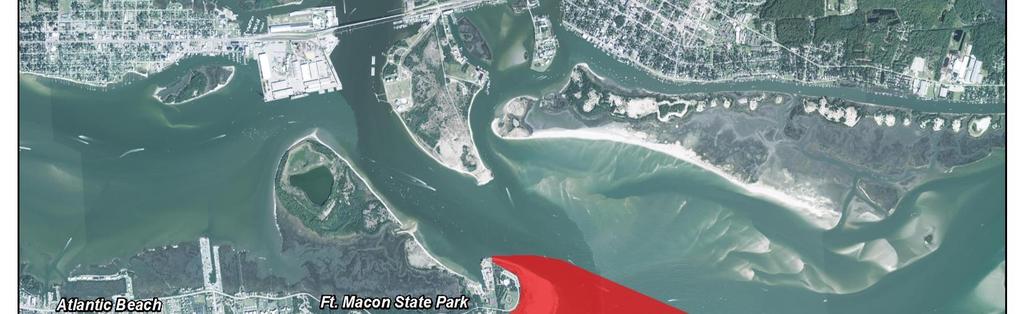

105
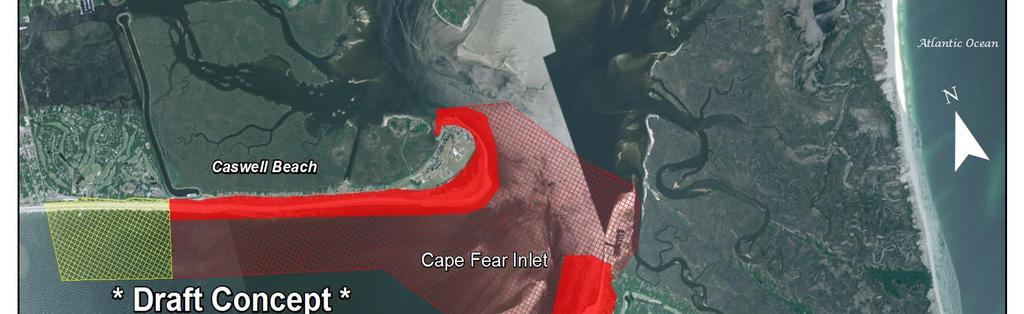
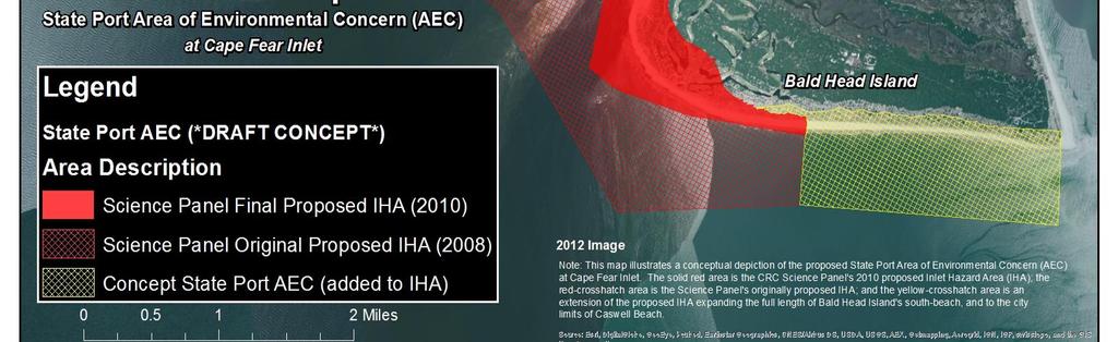
106
107 Pat McCrory Governor North Carolina Department of Environment and Natural Resources Division of Coastal Management Donald R. van der Vaart Secretary September 3, 2015 CRC MEMORANDUM TO: FROM: Coastal Resources Commission Mike Lopazanski SUBJECT: Amendments to 15A NCAC 07H.0304 Extent of the Ocean Erodible AEC and the 100-year Storm Recession Line within Ocean Hazard Areas The Coastal Area Management Act (CAMA; G.S. 113A) requires permits for development in Areas of Environmental Concern (AEC) as designated by the CRC. AECs are the foundation of the CRC's permitting program for coastal development and are defined in CAMA (G.S. 113A-113) as areas of natural importance that may be susceptible to erosion or flooding; or may have environmental, social, economic, or aesthetic values that make it valuable to the state. The CRC classifies areas as AECs to protect them from incompatible development that may cause irreversible damage to property, public health, or the environment. AECs cover almost all coastal waters and about three percent of the land in the 20 coastal counties. The CRC has established four broad categories of AECs: The Estuarine and Ocean System; The Ocean Hazard System; Public Water Supplies; and Natural and Cultural Resource Areas. The Ocean Hazard System is comprised of oceanfront lands and the inlets that connect the ocean to the sounds. The CRC has designated three subcategories within the ocean hazard AEC (you will recall that the High Hazard Flood AEC was repealed this year): 1. The Ocean Erodible AEC (15A NCAC 7H.0304(1)) covers North Carolina's beaches and any other oceanfront lands that are subject to long-term erosion and significant shoreline changes. The seaward boundary of this AEC is the mean low Division of Coastal Management 400 Commerce Ave., Morehead City, NC Phone: \ FAX: Internet: An Equal Opportunity \ Affirmative Action Employer
108 water line. The landward limit of the AEC is measured from the first line of stable natural vegetation and is determined by adding a distance equal to 60 times the long-term, average annual erosion rate for that stretch of shoreline, to the distance of erosion expected during a major storm (100-year storm) which varies from feet. 2. The Inlet Hazard AEC (15A NCAC 7H.0304(2)) covers the lands next to ocean inlets. Each area is mapped based on a statistical analysis of inlet migration, previous inlet locations, narrow or low lands near the inlet, and the influence of man-made features, such as jetties and channel dredging projects. 3. Unvegetated Beach Area. (15A NCAC 7H.0304(3)) Beach areas within the Ocean Hazard Area where no stable natural vegetation is present may be designated as an Unvegetated Beach Area on either a permanent or temporary basis The Ocean Hazard AEC includes General (7H.0306) and Specific (7H.0308) Use Standards for the siting of development along the state s ocean shoreline. These standards include provisions for setbacks, dune protection, erosion control activities, sandbags, beach nourishment, beach bulldozing, dune establishment and stabilization, accessways, and construction standards. Several changes have been proposed to 15A NCAC 07H.0304 AECs within Ocean Hazard Areas over the last couple of years including repeal of the High Hazard Flood AEC, de-designation of Mad Inlet as an Inlet Hazard Area and the proposed creation of the State Ports Inlet Management AEC. Staff is now proposing an additional amendment to 7H.0304(1)(a) Ocean Erodible Area of Environmental Concern (OEA) to alter the formula used to calculate the width of the OEA that is necessary for consistency with the setback factors found in 15A NCAC 07H.0306 General Use Standards for Ocean Hazard Areas. The OEA boundary is delineated oceanward by mean low water (MLW) and landward by a distance measured from the first line of stable and natural vegetation (FLS&NV) equal to 60 times the long-term annual erosion rate (ER). The landward extent of the OEA also includes the distance of shoreline recession (SR) that would be generated from a 100-year storm event. The shoreline recession model used to calculate the SR has a minimum and maximum value of 25 and 330 feet, respectively. The current OEA width formula can be simplified as: OEA = [(60 x ER) + SR]. However, simply changing the OEA formula erosion rate factor from 60 to 90 may substantially increased the AEC and therefore the Commission s permitting jurisdiction. Upon further consideration and analysis, the Division believes that the extent of this increase is beyond what is necessary to achieve the management objectives of the Ocean Hazard Area reduction of the loss of life and property due to hazards associated with the Atlantic shoreline. Staff believes that while the OEA formula does need to be changed for consistency with the 7H.0306 setback rules, use of the 100-year storm recession line may no longer be needed. An increase from 60 to 90 times the erosion rate would provide the necessary CAMA jurisdiction to implement the management objectives of the Ocean Hazard Area. Division of Coastal Management 400 Commerce Ave., Morehead City, NC Phone: \ FAX: Internet: An Equal Opportunity \ Affirmative Action Employer
109 The Ocean Hazard AEC includes General (7H.0306) and Specific (7H.0308) Use Standards for the siting of development along the state s ocean shoreline. These standards include provisions for setbacks, dune protection, erosion control activities, sandbags, beach nourishment, beach bulldozing, dune establishment and stabilization, accessways, and construction standards. Reducing the OEA, will not impact the implementation of these standards. The inclusion of the 100-year storm recession line is linked to the early days of the coastal program and the initial development of AECs. The intent of the recession line was to protect the dunes after 30 years of erosion based on modeling. The effort was a precursor to the development of erosion rates along the coast and was intended to delineate the Commission s regulatory area of the OEA. The recession line has not been updated and the FEMA revisions to the V-zones during the 1990 s added dune erosion to the modeling. As this proposed action concerns the permitting jurisdiction of the Commission, particularly the landward edge as opposed to the seaward edge, Staff believes this recession line can be removed from the calculation without significantly affecting the management objectives. By increasing the OEA erosion rate multiplier 90, large development (greater than 100,000 square feet) will be sited beyond the OEA and therefore, meeting the setback requirement. Removing the recession line from the calculation will also provide a degree of regulatory relief to some areas of the coast, most notably Brunswick County where approximately 3,200 lots will no longer be within the OEA. The most modest decrease in jurisdiction will be in Currituck County where the OEA will encompass 44 fewer properties. Coastwide, there will be a net reduction of approximately 7,500 that fall within the Ocean Hazard AEC. Again, it is important to keep in mind that the impact of this action is on the landward edge of the OEA affecting large scale development. At the upcoming meeting in Wilmington, I will have specific examples of how this amendment would change the width of the AEC from its current dimensions. Attached is a copy of 7H.0304 with this proposed amendment highlighted. I have also included an analysis of the number of properties affected by this action. I look forward to answering any questions you may have regarding this action at our upcoming meeting. Division of Coastal Management 400 Commerce Ave., Morehead City, NC Phone: \ FAX: Internet: An Equal Opportunity \ Affirmative Action Employer
110 Number of Properties Affected by Proposed AEC Modification Brunswick County Current Ocean Hazard AEC [(60*ER)+ SR] Potential Ocean Hazard AEC [(90*ER) + SR] Proposed Ocean Hazard AEC (90*ER) Difference Between Current and Proposed Number of Lots Number of Lots Number of Lots Number of Lots Sunset Beach Ocean Isle Holden Beach Oak Island Caswell Beach/Ft Caswell Bald Head Island TOTAL: New Hanover County Current Ocean Hazard AEC [(60*ER)+SR] Potential Ocean Hazard AEC [(90*ER) + SR] Proposed Ocean Hazard AEC (90*ER) Difference Between Current and Proposed Number of Lots Number of Lots Number of Lots Number of Lots Kure Beach Carolina Beach Wrightsvill e Beach Figure Eight Island TOTAL: Pender County Current Ocean Hazard AEC [(60*ER)+SR] Potential Ocean Hazard AEC [(90*ER) + SR] Proposed Ocean Hazard AEC (90*ER) Difference Between Current and Proposed Number of Lots Number of Lots Number of Lots Number of Lots Topsail Beach Surf City TOTAL:
111 Onslow County Current Ocean Hazard AEC [(60*ER)+SR] Potential Ocean Hazard AEC [(90*ER) + SR] Proposed Ocean Hazard AEC (90*ER) Difference Between Current and Proposed Number of Lots Number of Lots Number of Lots Number of Lots Surf City North Topsail Beach TOTAL: Carteret County Current Ocean Hazard AEC [(60*ER)+SR] Potential Ocean Hazard AEC [(90*ER) + SR] Proposed Ocean Hazard AEC (90*ER) Difference Between Current and Proposed Number of Lots Number of Lots Number of Lots Number of Lots Emerald Isle Indian Beach Salter Path Pine Knoll Shores Atlantic Beach Fort Macon State Park TOTAL: Hyde County Current Ocean Hazard AEC [(60*ER)+SR] Potential Ocean Hazard AEC [(90*ER) + SR] Proposed Ocean Hazard AEC (90*ER) Difference Between Current and Proposed Number of Lots Number of Lots Number of Lots Number of Lots Ocracoke TOTAL: Dare County Current Ocean Hazard AEC [(60*ER)+SR] Potential Ocean Hazard AEC [(90*ER) + SR] Proposed Ocean Hazard AEC (90*ER) Difference Between Current and Proposed Number of Lots Number of Lots Number of Lots Number of Lots Hatteras- Buxton Avon Salvo - Rodanthe Whalebone - Nags Head Kill Devil Hills Kitty Hawk
112 Southern Shores Duck - Dare County Line TOTAL: Currituck County Current Ocean Hazard AEC [(60*ER)+SR] Potential Ocean Hazard AEC [(90*ER) + SR] Proposed Ocean Hazard AEC (90*ER) Difference Between Current and Proposed Number of Lots Number of Lots Number of Lots Number of Lots Currituck County Line Corolla Wildlife Refuge - VA TOTAL: Statewide Totals:
113 15A NCAC 07H.0304 AECS WITHIN OCEAN HAZARD AREAS The ocean hazard AECs contain all of the following areas: (1) Ocean Erodible Area. This is the area where there exists a substantial possibility of excessive erosion and significant shoreline fluctuation. The oceanward boundary of this area is the mean low water line. The landward extent of this area is determined as follows: (a) a distance landward from the first line of stable and natural vegetation as defined in 15A NCAC 07H.0305(a)(5) to the recession line established by multiplying the long-term annual erosion rate times 60; 90; provided that, where there has been no long-term erosion or the rate is less than two feet per year, this distance shall be set at 120 feet landward from the first line of stable natural vegetation. For the purposes of this Rule, the erosion rates are the long-term average based on available historical data. The current long-term average erosion rate data for each segment of the North Carolina coast is depicted on maps entitled 2011 Long-Term Average Annual Shoreline Rate Update and approved by the Coastal Resources Commission on May 5, 2011 (except as such rates may be varied in individual contested cases, declaratory, or interpretive rulings). In all cases, the rate of shoreline change shall be no less than two feet of erosion per year. The maps are available without cost from any Local Permit Officer or the Division of Coastal Management on the internet at and (b) a distance landward from the recession line established in Sub-Item (1)(a) of this Rule to the recession line that would be generated by a storm having a one percent chance of being equaled or exceeded in any given year. (2) Inlet Hazard Area. The inlet hazard areas are natural-hazard areas that are especially vulnerable to erosion, flooding and other adverse effects of sand, wind, and water because of their proximity to dynamic ocean inlets. This area extends landward from the mean low water line a distance sufficient to encompass that area within which the inlet shall migrate, based on statistical analysis, and shall consider such factors as previous inlet territory, structurally weak areas near the inlet, and external influences such as jetties and channelization. The areas on the maps identified as suggested Inlet Hazard Areas included in the report entitled INLET HAZARD AREAS, The Final Report and Recommendations to the Coastal Resources Commission, 1978, as amended in 1981, by Loie J. Priddy and Rick Carraway are incorporated by reference and are hereby designated as Inlet Hazard Areas except for: (a) the Cape Fear Inlet Hazard Area as shown on the map does not extend northeast of the Bald Head Island marina entrance channel; and (b) the former location of Mad Inlet, which closed in In all cases, the Inlet Hazard Area shall be an extension of the adjacent ocean erodible areas and in no case shall the width of the inlet hazard area be less than the width of the adjacent ocean erodible area. This report is available for inspection at the Department of Environment and Natural Resources, Division of Coastal Management, 400 Commerce Avenue, Morehead City, North Carolina or at the website referenced in Sub-item (1)(a) of this Rule. Photocopies are available at no charge. (3) Unvegetated Beach Area. Beach areas within the Ocean Hazard Area where no stable natural vegetation is present may be designated as an Unvegetated Beach Area on either a permanent or temporary basis as follows: (a) (b) An area appropriate for permanent designation as an Unvegetated Beach Area is a dynamic area that is subject to rapid unpredictable landform change from wind and wave action. The areas in this category shall be designated following studies by the Division of Coastal Management. These areas shall be designated on maps approved by the Coastal Resources Commission and available without cost from any Local Permit Officer or the Division of Coastal Management on the internet at the website referenced in Sub-Item (1)(a) of this Rule. An area that is suddenly unvegetated as a result of a hurricane or other major storm event may be designated by the Coastal Resources Commission as an Unvegetated Beach Area for a specific period of time, or the vegetation has re-established in accordance with 15A NCAC 07H.0305(a)(5). At the expiration of the time specified, or re-establishment of the vegetation, the area shall return to its pre-storm designation. History Note: Authority G.S. 113A-107; 113A-107.1; 113A-113; 113A-124; Eff. September 9, 1977; Amended Eff. December 1, 1993; November 1, 1988; September 1, 1986; December 1, 1985; Temporary Amendment Eff. October 10, 1996; Amended Eff. April 1, 1997; Temporary Amendment Eff. October 10, 1996 Expired on July 29, 1997; Temporary Amendment Eff. October 22, 1997; 5
114 Amended Eff. September 1, 2015; May 1, 2014; February 1, 2013; January 1, 2010, February 1, 2006; October 1, 2004; April 1, 2004; August 1,
115 North Carolina Department of Environment and Natural Resources Pat McCrory Governor Donald R. van der Vaart Secretary September 2, 2015 CRC MEMORANDUM TO: FROM: SUBJECT: Coastal Resources Commission Tancred Miller Pile-Supported Signs in Coastal Wetlands At the July meeting you heard a request for a variance to your Coastal Wetlands rule, 07H Following that hearing the Commission asked staff to propose an amendment to the rule that would enable staff to issue permits for similar types of projects instead of making applicants go through the variance process. A proposed amendment is attached that would make pile-supported signs an allowable use in the Coastal Wetlands Area of Environmental Concern. Only local governments would be eligible to receive a permit from the division. The rule drafting process revealed some issues about this potential amendment that staff would like to discuss with the Commission: The Commission s rule, 07H.0208, states in section (a)(1) that Uses which are not water dependent shall not be permitted in coastal wetlands, estuarine waters, and public trust areas. The rule goes on to describe water-dependent uses as including: utility crossings, wind energy facilities, docks, wharves, boat ramps, dredging, bridges and bridge approaches, revetments, bulkheads, culverts, groins, navigational aids, mooring pilings, navigational channels, access channels and drainage ditches. Staff does not interpret the Commission s intent as wanting to make pile-supported signs a water-dependent use, as little justification exists to do so on an unrestricted basis, especially in coastal wetlands. The Commission s buffer rule, 07H.0208(d)(10), describes the types of development that is allowable inside the 30-foot buffer, including pile-supported signs. The buffer rule does not, however, authorize those types of development within coastal wetlands. The Commission s Coastal Wetlands rule 07H.0205(c) states that the management objective of the CRC for coastal wetlands is to conserve and manage them so as to safeguard and perpetuate their biological, social, economic and aesthetic values, and to coordinate and establish a management system capable of conserving and utilizing coastal wetlands as a natural resource essential to the functioning of the entire estuarine system. Staff wants to confirm whether the Commission views pile-supported signs as consistent with this objective, and, that they should be permittable by staff. Staff does not appear to have the authority to regulate sign content. Other concerns with the potential amendment for pile-supported signs in coastal wetlands include deciding what criteria should be used to create development standards; for example, sign dimensions, lighting, density, and wetlands alteration at the sign location. Staff looks forward to a discussion with the Commission at the September meeting Mail Service Center, Raleigh, North Carolina Phone: \ Internet: An Equal Opportunity \ Affirmative Action Employer Made in part by recycled paper
116 15A NCAC 07H.0205 COASTAL WETLANDS (a) Description. Coastal wetlands are defined as any salt marsh or other marsh subject to regular or occasional flooding by tides, including wind tides (whether or not the tide waters reach the marshland areas through natural or artificial watercourses), provided this does not include hurricane or tropical storm tides. Regular or occasional flooding shall be established through field indicators including but not limited to the observation of tidal water (including wind tides) on the site, changes in elevation, presence of periwinkle (Littoraria spp.), presence of crab burrows, staining, or wrack lines. Coastal wetlands may contain the following marsh plant species: (1) Cord Grass (Spartina alterniflora), (2) Black Needlerush (Juncus roemerianus), (3) Glasswort (Salicornia spp.), (4) Salt Grass (Distichlis spicata), (5) Sea Lavender (Limonium spp.), (6) Bulrush (Scirpus spp.), (7) Saw Grass (Cladium jamaicense), (8) Cat-tail (Typha spp.), (9) Salt Meadow Grass (Spartina patens), (10) Salt Reed Grass (Spartina cynosuroides). The coastal wetlands AEC includes any contiguous lands designated by the Secretary of DENR pursuant to G.S (a).5. (b) Significance. The unique productivity of the estuarine and ocean system is supported by detritus (decayed plant material) and nutrients that are exported from the coastal marshlands. The amount of exportation and degree of importance appears to be variable from marsh to marsh, depending primarily upon its frequency of inundation and inherent characteristics of the various plant species. Without the marsh, the high productivity levels and complex food chains typically found in the estuaries could not be maintained. Man harvests various aspects of this productivity when he fishes, hunts, and gathers shellfish from the estuary. Estuarine dependent species of fish and shellfish such as menhaden, shrimp, flounder, oysters, and crabs make up over 90 percent of the total value of North Carolina's commercial catch. The marshlands, therefore, support an enormous amount of commercial and recreational businesses along the seacoast. The roots, rhizomes, stems, and seeds of coastal wetlands act as good quality waterfowl and wildlife feeding and nesting materials. In addition, coastal wetlands serve as the first line of defense in retarding estuarine shoreline erosion. The plant stems and leaves tend to dissipate wave action, while the vast network of roots and rhizomes resists soil erosion. In this way, the coastal wetlands serve as barriers against flood damage and control erosion between the estuary and the uplands. Marshlands also act as nutrient and sediment traps by slowing the water which flows over them and causing suspended organic and inorganic particles to settle out. In this manner, the nutrient storehouse is maintained, and sediment harmful to marine organisms is removed. Also, pollutants and excessive nutrients are absorbed by the marsh plants, thus providing an inexpensive water treatment service. (c) Management Objective. It is the objective of the Coastal Resources Commission to conserve and manage coastal wetlands so as to safeguard and perpetuate their biological, social, economic and aesthetic values, and to coordinate and establish a management system capable of conserving and utilizing coastal wetlands as a natural resource essential to the functioning of the entire estuarine system. (d) Use Standards. Suitable land uses are those consistent with the management objective in this Rule. Highest priority of use is allocated to the conservation of existing coastal wetlands. Second priority of coastal wetland use is given to those types of development activities that require water access and cannot function elsewhere. Examples of unacceptable land uses include restaurants, businesses, residences, apartments, motels, hotels, trailer parks, parking lots, private roads, highways and factories. Examples of acceptable land uses include utility easements, fishing piers, docks, wildlife habitat management activities, and agricultural uses such as farming and forestry drainage as permitted under North Carolina's Dredge and Fill Law or other applicable laws. Pile-supported signs may be allowed when requested by a local government. In every instance, the particular location, use, and design characteristics shall be in accord with the general use standards for coastal wetlands, estuarine waters, and public trust areas described in Rule.0208 of this Section. (e) Alteration of Coastal Wetlands. Alteration of coastal wetlands includes mowing or cutting of coastal wetlands vegetation whether by mechanized equipment or manual means. Alteration of coastal wetlands by federal or state resource management agencies as a part of planned resource management activities is exempt from the requirements of this paragraph. Mowing or cutting of coastal wetlands by academic institutions associated with research efforts is
117 allowed subject to approval from the Division of Coastal Management. Alteration of coastal wetlands is governed according to the following provisions: (1) Alteration of coastal wetlands is exempt from the permit requirements of the Coastal Area Management Act (CAMA) when conducted in accordance with the following criteria: (A) Coastal wetlands may be mowed or cut to a height of no less than two feet, as measured from the coastal wetland substrate, at any time and at any frequency throughout the year; (B) Coastal wetlands may be mowed or cut to a height of no less than six inches, as measured from the coastal wetland substrate, once between each December 1 and March 31; (C) Alteration of the substrate is not allowed; (D) All cuttings/clippings shall remain in place as they fall; (E) Coastal wetlands may be mowed or cut to a height of no less than six inches, as measured from the coastal wetland substrate, to create an access path four feet wide or less on waterfront lots without a pier access; and (F) Coastal wetlands may be mowed or cut by utility companies as necessary to maintain utility easements. (2) Coastal wetland alteration not meeting the exemption criteria of this Rule requires a CAMA permit. CAMA permit applications for coastal wetland alterations are subject to review by the North Carolina Wildlife Commission, North Carolina Division of Marine Fisheries, U.S. Fish and Wildlife Service, and National Marine Fisheries Service in order to determine whether or not the proposed activity will have an adverse impact on the habitat or fisheries resources. History Note: Authority G.S. 113A-107(a); 113A-107(b); 113A-113(b)(1); 113A-124; Eff. September 9, 1977; Amended Eff. November 1, 2009; August 1, 1998; October 1, 1993; May 1, 1990; January 24, Amended Eff. TBD, 2016
118 North Carolina Department of Environment and Natural Resources Pat McCrory Governor Donald R. van der Vaart Secretary September 8, 2015 CRC MEMORANDUM TO: FROM: SUBJECT: Coastal Resources Commission Doug Huggett Major Permits Coordinator Minor Modifications to CAMA Major Permits At times, permittees wish to modify their CAMA Major Permits after the permit has been issued. These modifications may be due to design and/or engineering recommendations, change in the purpose and need, or even a change in economic conditions or project funding. From time to time questions arise as to how modification requests are processed. The first factor in determining processing procedures is to assess whether the proposed modification is considered major or minor. When determining whether a modification request is considered a major modification, several factors are considered, including the scope and scale of the proposed modifications, number of resource and permit agencies that may have an interest in the proposed changes, public interest and/or need for additional public review and comment, etc. If a project is considered to be a major modification, processing of the request is driven by the Commission s rules stating that Modification requests which, in the opinion of the Department, are major will require a new application. Thus, major modification requests follow the same processing requirements as a new permit application. If it is determined that the proposed changes are not considered major, then staff is allowed some discretion on processing requirements, specifically as they relate to notification requirements and agency coordination. These types of modifications are deemed Minor Modifications. Examples and considerations required in determining minor modifications are as follows: - Depending on the additional impacts associated with proposed changes, staff will determine what additional agency coordination requirements are needed. For example, a proposed project change that will impact additional wetlands usually involves additional coordination with wetland permitting agencies. - If a proposed location of a docking facility is moving closer to an adjacent riparian property, or potentially represents an impact to navigation rights of neighboring properties, additional adjacent property owner notifications are generally required. - Staff will review the original permit file to determine if public or adjacent property owner concerns were raised on the original project that would necessitate additional notification requirements Mail Service Center, Raleigh, North Carolina Phone: \ Internet: An Equal Opportunity \ Affirmative Action Employer Made in part by recycled paper
119 - Based upon the knowledge of their work areas, field staff will determine if additional coordination with the local government and/or CAMA land use plan review is necessary. In making these decisions on minor permit processing requirements, staff must balance the need for the thorough review of the proposed project versus the need of the applicant to obtain rapid approval of the proposed changes. Therefore, staff attempt to require adjacent property notifications only in those cases where such notifications would appear to serve a valid purpose. If notification is required, 30 days is required by 15A NCAC 07J.0204(b)(5)(A) to allow landowners to comment. Given the subjective nature of this decision process, staff acknowledges that from time to time decisions may be made that do not satisfy all concerned parties. However, such occasions are relatively rare, and lessons learned from such occasions are then factored into future decisions on minor modification processing procedures. I look forward to answering any questions you may have at the upcoming meeting.

120
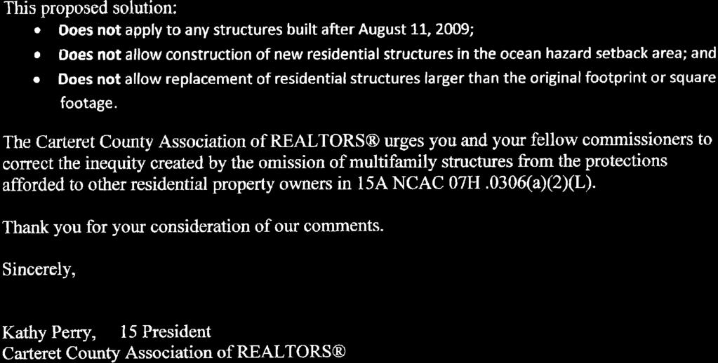
121

122 WRAR OFFICERS September 4, 2015 President Sherri Pickard, CDPE, GRI, SFR President-Elect Don Harris, CRS, GRI, SRES Vice President Ryan Crecelius Past President Jody Wainio, SFR, WHS RCASENC President Elise Rocks WRAR DIRECTORS Term Expires 2015 Shari Cutting, ABR Debbie Lariviere Sherri Pridgen, ABR, GRI, SRES Term Expires 2016 Clinton Howlett, CRB, CRS, GRI Chris Livengood Patrice Willetts, ABR, GRI, SRES Term Expires 2017 Jeff Lesley Lori Speight Chief Executive Officer Jerry Panz, CAE, epro, RCE Organized February 16, 1922 Chartered June 2, 1924 Location 1826 Sir Tyler Drive, Suite 100 Wilmington, NC Phone (910) Fax (910) The Honorable Frank Gorham NC Coastal Resources Commission 400 Commerce Avenue Morehead City, NC RE: Grandfathering of Multifamily Structures Dear Chairman Gorham: On behalf of the 2,225 members of the Wilmington Regional Association of REALTORS, I am writing to express our support for amending the General Use Standards for Ocean Hazard Areas as proposed by our association and the North Carolina Association of REALTORS. The proposed change is scheduled for consideration at the Coastal Resources Commission meeting on September 23. An oversight in the wording of the ocean hazard setback rules unfairly renders certain residential properties as legal non-conforming based upon the property s number of individual units, rather than its use or size. This oversight causes tremendous difficulty for sellers and buyers of affected residential properties, as Fannie Mae and Freddie Mac will not insure mortgage loans on legal non-conforming residential property. Part (a)(2)(l) of 15A NCAC 07H.0306 allows replacement of a single family or duplex residential structure with a total floor area greater than 5,000 square feet, provided that the structure meets the following criteria:
123 WRAR Letter to Chairman Frank Gorman Page 2 (i) the structure was originally constructed prior to August 11, 2009; (ii) the structure as replaced does not exceed the original footprint or square footage; (iii) it is not possible for the structure to be rebuilt in a location that meets the ocean hazard setback criteria required under Subparagraph (a)(2) of this Rule; (iv) the structure as replaced meets the minimum setback required under Part (a)(2)(a) of this Rule; and (v) the structure is rebuilt as far landward on the lot as feasible. DENR legal counsel has opined that residential structures with more than two attached units even though they meet the criteria in (i)-(v) above do not qualify for the protections afforded by part (a)(2)(l) to other residential properties of the same total floor area and use. Part (a)(2)(l) should be amended to apply to all residential structures with a total floor area greater than 5,000 square feet, regardless of the number of attached units. This proposed solution: Does not apply to any structures built after August 11, 2009; Does not allow construction of new residential structures in the ocean hazard setback area; and Does not allow replacement of residential structures larger than the original footprint or square footage. The Wilmington Regional Association of REALTORS urges you and your fellow commissioners to correct the inequity created by the omission of multifamily structures from the protections afforded to other residential property owners in 15A NCAC 07H.0306(a)(2)(L). Thank you for your consideration of our comments. Sherri Pickard, President Will Leonard Will Leonard, Chair Govt. Affairs Committee
 Implementation")
124 North Carolina Department of Environment and Natural Resources Pat McCrory Governor MEMORANDUM September 9, 2015 Donald R. van der Vaart Secretary CRC Information Only TO: FROM: SUBJECT: Coastal Resources Commission Charlan Owens, AICP, DCM Elizabeth City District Planner Camden County Land Use Plan (LUP) Implementation Status Report Background Local governments submit an implementation status report every two (2) years following the date of LUP certification per the following: 15A NCAC 07L.0511 REQUIRED PERIODIC IMPLEMENTATION STATUS REPORTS (a) To be eligible for future funding each local government engaged in CAMA land use planning shall complete a CAMA land use plan Implementation Status Report every two years as long as the current plan remains in effect. DCM shall provide a standard implementation report form to local governments. This report shall be based on the action plan and schedule provided in 15A NCAC 07B -Tools for Managing Development. (b) The Implementation Status Report shall identify: (1) All local, state, federal, and joint actions that have been undertaken successfully to implement its certified CAMA land use plan; (2) Any actions that have been delayed and the reasons for the delays; (3) Any unforeseen land use issues that have arisen since certification of the CAMA land use plan; (4) Consistency of existing land use and development ordinances with current CAMA land use plan policies; and (5) Current policies that create desired land use patterns and protection of natural systems. (c) Results shall be made available to the public and shall be forwarded to DCM. The Camden County implementation status report is available on DCM s Land Use Planning web page at: It is not included in the CRC packet. Discussion The implementation status report does not require approval by the CRC, but must be made available to the public and forwarded to DCM. The report is based on the LUP Action Plan and identifies activities that the local government has undertaken in support of the LUP s policies and implementation actions. Staff has reviewed the submitted report and finds that the community has met the minimum requirements US 17 South, Elizabeth City, NC Phone: \ FAX: ; Internet: An Equal Opportunity \ Affirmative Action Employer Made in part by recycled paper
Fact Sheet Regulating Oceanfront Accessory Structures Updated June 10, 2013
 What is being considered? Fact Sheet Regulating Oceanfront Accessory Structures Updated June 10, 2013 The Town of Duck is considering an ordinance that would limit how close pools, decks, and other accessory
NC Coastal Management Program Update. Mike Lopazanski Policy & Planning Section Chief April 3, 2015
 NC Coastal Management Program Update Mike Lopazanski Policy & Planning Section Chief April 3, 2015 NC Coastal Area Management Act (1974) Balances competing coastal pressures through development permitting
NC Division of Coastal Management
 November 14, 2016 NC Division of Coastal Management NCBIWA Update NC Coastal Area Management Act (1974) Balances competing coastal pressures through development permitting and creation of a Coastal Resources
CHAPTER Committee Substitute for Senate Bill No. 1472
 CHAPTER 2007-99 Committee Substitute for Senate Bill No. 1472 An act relating to beaches and shores; amending s. 161.021, F.S.; amending a definition; amending s. 161.085, F.S.; restricting the use of
SHORE PROTECTION ACT STAFF S FINDINGS & RECOMMENDATIONS
 SHORE PROTECTION ACT STAFF S FINDINGS & RECOMMENDATIONS TO: FROM: Shore Protection Committee: Commissioner Mark Williams, Chairman Mr. Richard Gardner Mr. Henry Morgan Mr. Zach Harris Mr. Bill Hodges Department
GENERAL ASSEMBLY OF NORTH CAROLINA SESSION 2007 SESSION LAW SENATE BILL 1967
 GENERAL ASSEMBLY OF NORTH CAROLINA SESSION 2007 SESSION LAW 2008-211 SENATE BILL 1967 AN ACT TO PROVIDE FOR IMPROVEMENTS IN THE MANAGEMENT OF STORMWATER IN THE COASTAL COUNTIES IN ORDER TO PROTECT WATER
SHORE PROTECTION ACT STAFF S FINDINGS & RECOMMENDATIONS
 SHORE PROTECTION ACT STAFF S FINDINGS & RECOMMENDATIONS TO: FROM: APPLICANT: AGENT: Shore Protection Committee: Commissioner Mark Williams, Chairman Mr. Richard Gardner Mr. Henry Morgan Mr. Zach Harris
ARTICLE 17 SITE PLAN REVIEW
 ARTICLE 17 SITE PLAN REVIEW 17.01 INTENT AND PURPOSE The intent of this section is to provide for consultation and cooperation between the applicant and the township planning commission so that the applicant
Broward County Shore Protection Project Segment II. Physical Monitoring Plan
 Broward County Shore Protection Project Segment II USACE File No. SAJ-1999-05545 Broward County Shore Protection Project -Segment II Submitted To: Florida Department of Environmental Protection Office
ARTICLE IV: DEVELOPMENT STANDARDS 404 MASTER PLANNING
 IV 13 404 MASTER PLANNING Master Planning through the Site Analysis (Master Planning Site Analysis) or Planned Development (Master Planning Planned Development) is provided to encourage development which
COUNTY COUNCIL OF PRINCE GEORGE'S COUNTY, MARYLAND SITTING AS THE DISTRICT COUNCIL 2010 Legislative Session. Council Members Dernoga and Olson
 DR- COUNTY COUNCIL OF PRINCE GEORGE'S COUNTY, MARYLAND SITTING AS THE DISTRICT COUNCIL 00 Legislative Session Bill No. CB--00 Chapter No. Proposed and Presented by Introduced by Co-Sponsors The Chairman
Project phasing plan (if applicable) 12 copies of site plan
 12 copies of site plan") SITE PLAN REVIEW PERMIT APPLICATION City of Grand Haven, 11 N. Sixth Street, Grand Haven, MI 49417 Phone: (616) 847-3490 Fax: (616) 844-2051 Website: www.grandhaven.org 1. Project Information Address/location
SITE PLAN REVIEW PERMIT APPLICATION City of Grand Haven, 11 N. Sixth Street, Grand Haven, MI 49417 Phone: (616) 847-3490 Fax: (616) 844-2051 Website: www.grandhaven.org 1. Project Information Address/location
R E S O L U T I O N. Designation: R-2A (1-Family, 2-acre Minimum Lot Size)
") PLANNING BOARD Arthur Adelman, Chair TOWN OF NORTH CASTLE WESTCHESTER COUNTY 17 Bedford Road Armonk, New York 10504-1898 R E S O L U T I O N Telephone: (914) 273-3542 Fax: (914) 273-3554 www.northcastleny.com
PLANNING BOARD Arthur Adelman, Chair TOWN OF NORTH CASTLE WESTCHESTER COUNTY 17 Bedford Road Armonk, New York 10504-1898 R E S O L U T I O N Telephone: (914) 273-3542 Fax: (914) 273-3554 www.northcastleny.com
STAFF REPORT FOR STANDARD COASTAL DEVELOPMENT PERMIT #CDP FEBRUARY 26, 2015 CPA - 1 PO BOX 238 APTOS, CA 94001
 STAFF REPORT FOR STANDARD COASTAL DEVELOPMENT PERMIT #CDP 2014-0030 FEBRUARY 26, 2015 CPA - 1 OWNER/APPLICANT: AGENT: REQUEST: HANS HEIM PO BOX 238 APTOS, CA 94001 JAMES HAY PO BOX 762 MENDOCINO, CA 95460
Coastal Construction Setback Line Review
 City of New Smyrna Beach City Council Meeting January 23, 2018 Scope of Work Comparison of the City's Coastal Construction Setback Line (CCSL) to that of the Florida Department of Environmental Protection
STREAM BUFFERS
 88-415 STREAM BUFFERS 88-415-01 PURPOSE In the Kansas City region and throughout the nation, vegetated stream buffers have been clearly shown to protect stream stability and related infrastructure, improve
BEACH AND INLET PROJECTS UPDATE
 BEACH AND INLET PROJECTS UPDATE USACE DELTA PROJECT USACE Delta Project Project Extents Elevation Elevation (ft NAVD88) (ft NAVD88) USACE Delta Project Project Cross-Section 20 18 20 16 18 14 16 12 14
TOWNSHIP OF LOGAN SOIL & FILL IMPORTATION AND PLACEMENT APPLICATION SUBMITTAL CHECKLIST
 TOWNSHIP OF LOGAN SOIL & FILL IMPORTATION AND PLACEMENT APPLICATION SUBMITTAL CHECKLIST Applications: 5 copies of application - Applicant will reproduce the copies at his/her costs. The Township Clerk
PLANNED UNIT DEVELOPMENT STAFF REPORT Date: June 2, 2016
 # 9 ZON2016-01032 PLANNED UNIT DEVELOPMENT STAFF REPORT Date: June 2, 2016 DEVELOPMENT NAME JJT Properties LLC LOCATION 1147 & 1151 East I-65 Service Road South and 1180 Sledge Drive (Southeast corner
ARTICLE IX SPECIAL PERMIT USES
 ARTICLE IX SPECIAL PERMIT USES All special permit uses cited in Article IX and Attachment A of this Ordinance or any other Section of this Ordinance shall be subject to Site Plan Review. The procedures
Re: Application Type: Proposed Highlands Redevelopment Area Designation
 CHRIS CHRISTIE Governor KIM GUADAGNO Lt. Governor State of New Jersey Highlands Water Protection and Planning Council 100 North Road (Route 513) Chester, New Jersey 07930-2322 (908) 879-6737 (908) 879-4205
CHESAPEAKE LANDSCAPE ORDINANCE
 CHESAPEAKE LANDSCAPE ORDINANCE CONSERVATION PRESERVATION CZO 19-600 Effective October 16, 2008 BUFFER YARD C PARKING LOT REFORESTATION YEAR 1 REFORESTATION YEAR 4 BUFFER YARD F CBPA REFORESTATION Page
Mayor Leon Skip Beeler and Members of the City Commission. Anthony Caravella, AICP, Director of Development Services
 CITY COMMISSION BRIEFING & Planning Board Report For Meeting Scheduled for June 7, 2012 Inner Room Cabaret Site Plan/Architectural Review Downtown Overlay District/Primary Downtown Area Site Plan Consent
Venice Pumping Plant Dual Force Main Project Draft EIR
 City of Los Angeles 5.9 LAND USE PLANS 5.9.1 Environmental Setting Venice Pumping Plant Dual Force Main Project Draft EIR The Project lies within the bounds of Los Angeles County and the City of Los Angeles.
Example Codes. City of Brentwood, Tennessee Brentwood Hillside Protection Overlay District Summary
 Example Codes City of Brentwood, Tennessee Brentwood Hillside Protection Overlay District Summary The City of Brentwood in July 2007 adopted a Hillside Protection (HP) Overlay District to address the problems
LICENSES FOR UTILITY CROSSINGS OF PUBLIC LANDS AND WATERS ACCORDING TO MINNESOTA RULES CHAPTER [Rules Effective July 1, 2004]
![LICENSES FOR UTILITY CROSSINGS OF PUBLIC LANDS AND WATERS ACCORDING TO MINNESOTA RULES CHAPTER [Rules Effective July 1, 2004]](/thumbs/78/77546780.jpg "LICENSES FOR UTILITY CROSSINGS OF PUBLIC LANDS AND WATERS ACCORDING TO MINNESOTA RULES CHAPTER [Rules Effective July 1, 2004]") LICENSES FOR UTILITY CROSSINGS OF PUBLIC LANDS AND WATERS ACCORDING TO MINNESOTA RULES CHAPTER 6135 [Rules Effective July 1, 2004] Minnesota Department of Natural Resources Division of Lands and Minerals
LICENSES FOR UTILITY CROSSINGS OF PUBLIC LANDS AND WATERS ACCORDING TO MINNESOTA RULES CHAPTER 6135 [Rules Effective July 1, 2004] Minnesota Department of Natural Resources Division of Lands and Minerals
IFLA Regional Office for Latin America and the Caribbean: Call for Applications to host the Regional Office
 IFLA Regional Office for Latin America and the Caribbean: Call for Applications to host the Regional Office Introduction The International Federation of Library Associations and Institutions http://www.ifla.org
R E S O L U T I O N. Designation: Section 2, Block 17, Lot 20.G-1 ( ) R-2A (1-Family, 2-acre Minimum Lot Size) 46 North Greenwich Road
 R-2A (1-Family, 2-acre Minimum Lot Size) 46 North Greenwich Road") PLANNING BOARD Arthur Adelman, Chair TOWN OF NORTH CASTLE WESTCHESTER COUNTY 17 Bedford Road Armonk, New York 10504-1898 R E S O L U T I O N Telephone: (914) 273-3542 Fax: (914) 273-3554 www.northcastleny.com
PLANNING BOARD Arthur Adelman, Chair TOWN OF NORTH CASTLE WESTCHESTER COUNTY 17 Bedford Road Armonk, New York 10504-1898 R E S O L U T I O N Telephone: (914) 273-3542 Fax: (914) 273-3554 www.northcastleny.com
DEPARTMENT OF PUBLIC SAFETY DIVISION OF FIRE PREVENTION AND CONTROL
 DEPARTMENT OF PUBLIC SAFETY DIVISION OF FIRE PREVENTION AND CONTROL RULES AND REGULATIONS CONCERNING 8 CCR 1507-57 BUILDING AND FIRE CODE ENFORCEMENT AND CERTIFICATION OF INSPECTORS FOR LIMITED GAMING
Town of Florence Florence County, WI DRIVEWAY ORDINANCE
 Town of Florence Florence County, WI 08-10-09 DRIVEWAY ORDINANCE 1.01 PURPOSE The purpose of this Ordinance is to regulate the establishment, construction, improvement, modification or reworking of a driveway
HISTORIC LANDMARK COMMISSION STAFF REPORT. Front Yard Terracing PLNHLC South 1200 East Meeting Date: August 7, 2014
 HISTORIC LANDMARK COMMISSION STAFF REPORT Front Yard Terracing PLNHLC2014-00362 259 South 1200 East Meeting Date: August 7, 2014 Planning Division Department of Community and Economic Development Applicant:
A. INTRODUCTION B. CUMULATIVE EFFECTS ANALYSIS
 Chapter 4: Cumulative Effects A. INTRODUCTION The New York City Department of Parks and Recreation plans to reconstruct the Rockaway Beach Boardwalk in the borough of Queens, New York City, which Hurricane
Low Density Projects. Design Objective
 E-1. Low Density Projects Design Objective Low density projects are not required to be equipped with Stormwater Control Measures (SCMs) in exchange for limiting their built-upon area, maximizing dispersed
Procedures IV. V. Rural Road Design Option
 i IV. Procedures A. All applicants required to prepare a Conservation Design Subdivision shall provide the Planning Board with a conceptual conventional subdivision design as well as a proposed layout
Presentation Item C Annotated Model Outline for a Framework for a Green Infrastructure Plan
 Date: August 17, 2016 To: From: Subject: Management Committee Dan Cloak, Consultant Presentation Item C Annotated Model Outline for a Framework for a Green Infrastructure Plan Recommendation: Receive the
Chapter 1: General Program Information
 Chapter 1: General Program Information 1.1 Introduction The Montgomery County Stormwater Management Resolution (#03-1-5) was adopted by the County Board of Commissioners on January 22, 2003. The purpose
Exhibit A. 8:9 Scuffletown Rural Conservation District
 Exhibit A 8:9 Scuffletown Rural Conservation District 8:9.1 Intent and Purpose The Scuffletown Rural Conservation (SRC) District is intended to provide for residential development that supports the development
ARTICLE 3. LARGE-SCALE SOLAR PHOTOVOLTAIC INSTALLATIONS SECTION XXI
 ARTICLE 3. LARGE-SCALE SOLAR PHOTOVOLTAIC INSTALLATIONS SECTION XXI 1.1 PURPOSE The purpose of this by-law is to regulate the installation of solar photovoltaic installations that are to produce 250 kw
EXHIBIT A CITY OF FORT WALTON BEACH, FLORIDA COASTAL MANAGEMENT & CONSERVATION
 EXHIBIT A CITY OF FORT WALTON BEACH, FLORIDA INTRODUCTION The Coastal Management and the Conservation Elements required by Chapter 9J-5.012 and 5.013, F.A.C., respectively, have been combined into one
CITY OF LOS ANGELES DEPARTMENT OF CITY PLANNING ZONING INFORMATION FILE Z.I. NO POTRERO CANYON
 COUNCIL DISTRICT: 11 CITY OF LOS ANGELES DEPARTMENT OF CITY PLANNING ZONING INFORMATION FILE Z.I. NO. 2422 POTRERO CANYON BACKGROUND: The single-family lots that surround the rim of the Potrero Canyon
CITY OF PORTSMOUTH PLANNING DEPARTMENT. MEMORANDUM To: From:
 CITY OF PORTSMOUTH PLANNING DEPARTMENT MEMORANDUM To: From: Subject: Date: Planning Board Juliet T.H. Walker, Planning Director Jillian Harris, Planner 1 Staff Recommendations for the August 23, 2018 Planning
LOS ANGELES AIRPORT/EL SEGUNDO DUNES Specific Plan
 LOS ANGELES AIRPORT/EL SEGUNDO DUNES Specific Plan Ordinance No. 167,940 Effective June 28, 1992 TABLE OF CONTENTS MAP Section 1. Section 2. Section 3. Section 4. Section 5. Section 6. Specific Plan Area
Nick Sigmund, Sr. Zoning Officer
 Nick Sigmund, Sr. Zoning Officer Wisconsin Department of Natural Resources Administrative Code NR 115 under the authority of Wisconsin Statute 59.692, establishes and provides that shoreland zoning regulations
Folly Beach Planning Commission
 Folly Beach Planning Commission July 2, 2018 6:00 PM WORK SESSION 7:00 PM REGULAR MEETING ---------------------------------------------------------------------------------------------------- Commission
SUBCHAPTER 6L - BARBER SHOPS
 SUBCHAPTER 6L - BARBER SHOPS 21 NCAC 06L.0101 RESIDENTIAL BUILDING Authority G.S. 86A-25; Repealed Eff. February 8, 1978. 21 NCAC 06L.0102 MEASUREMENTS OF BARBER SHOP (a) Each barber shop shall be a minimum
ORDINANCE NO WHEREAS, the City of Kalama has many areas of timberland and open areas inside its City limits adjacent to residential areas;
 ORDINANCE NO. 1342 AN ORDINANCE OF THE CITY OF KALAMA, WASHINGTON ADOPTING A NEW KALAMA MUNICIPAL CODE CHAPTER 17.20 ESTATE LOT FLOATING ZONE TO PROVIDE TRANSITIONAL ZONING OPTIONS FOR RESIDENTIAL DEVELOPMENT
Stock-Taking on Integrated Coastal Zone Management (ICZM) in the Black Sea IMPLEMENTATION AUDIT QUESTIONNAIRE 2010
 in the Black Sea IMPLEMENTATION AUDIT QUESTIONNAIRE 2010") Stock-Taking on Integrated Coastal Zone Management (ICZM) in the Black Sea IMPLEMENTATION AUDIT QUESTIONNAIRE 2010 PURPOSE The purposes of this questionnaire are: (a) to perform the policy, legal and institutional
Stock-Taking on Integrated Coastal Zone Management (ICZM) in the Black Sea IMPLEMENTATION AUDIT QUESTIONNAIRE 2010 PURPOSE The purposes of this questionnaire are: (a) to perform the policy, legal and institutional
Goal 1 To establish and follow land use patterns for the long-range development of the campus.
 ELEMENT 4 FUTURE LAND USE Goal 1 To establish and follow land use patterns for the long-range development of the campus. Objective 1A Correct existing incompatible campus land uses. Policy 1A-1 Reduce
Glenborough at Easton Land Use Master Plan
 Implementation 114 9.0 IMPLEMENTATION 9.1 OVERVIEW This chapter summarizes the administrative procedures necessary to implement the proposed land use plan, infrastructure improvements, development standards,
CRC-VR ATTACHMENT A RELEVANT STATUTES OR RULES
 CRC-VR-15-07 RELEVANT STATUTES OR RULES ATTACHMENT A 113A-102. Legislative findings and goals of the Coastal Area Management Act of 1974 (CAMA). (a) Findings. -- It is hereby determined and declared as
RESOLUTION NO. R Refining the route, profile and stations for the Downtown Redmond Link Extension
 RESOLUTION NO. R2018-32 Refining the route, profile and stations for the Downtown Redmond Link Extension MEETING: DATE: TYPE OF ACTION: STAFF CONTACT: Capital Committee Board PROPOSED ACTION 09/13/2018
THE CITY OF VAUGHAN BY-LAW BY-LAW NUMBER
 THE CITY OF VAUGHAN BY-LAW BY-LAW NUMBER 123-2013 A By-law to designate the whole of the City of Vaughan as a Site Plan Control Area, and to adopt site development guidelines and rules of procedure for
Folly Beach Planning Commission
 Folly Beach Planning Commission June 4, 2018 6:00 PM WORK SESSION 7:00 PM REGULAR MEETING ---------------------------------------------------------------------------------------------------- Commission
GENERAL INFORMATIONaaaaaaaaaaaaaaaaaaaaaaaaaaaaaaaa
 To: Planning and Zoning Commission From: City Staff Date: November 15, 2016 Re: Case #16026 Raymore Activity Center Site Plan GENERAL INFORMATIONaaaaaaaaaaaaaaaaaaaaaaaaaaaaaaaa Applicant/ Property Owner:
DRIVEWAY REGULATIONS
 TOWN OF NEW LONDON PLANNING BOARD DRIVEWAY REGULATIONS INSTRUCTIONS TO APPLICANTS FOR THE CONSTRUCTION OR ALTERATION OF DRIVEWAYS IMPORTANT: READ CAREFULLY BEFORE FILLING OUT ATTACHED APPLICATION Revised
WASHINGTON COUNTY OREGON
 WASHINGTON COUNTY OREGON LONG RANGE PLANNING DIVISION North Bethany Subarea Stream Corridors: Existing Regulations In Oregon, there is a distinct difference between the land use rules that apply in rural
5.1 Commercial and Industrial Development. (Effective April 1, 2006)
") 5.1 Commercial and Industrial Development. (Effective April 1, 2006) A. Applicability: The requirements of this section (5.10) shall apply to all uses within the LB Local Business; HB Highway Business;
5.1 Commercial and Industrial Development. (Effective April 1, 2006) A. Applicability: The requirements of this section (5.10) shall apply to all uses within the LB Local Business; HB Highway Business;
V-5 TREE PROTECTION AND LANDSCAPING REQUIREMENTS
 V-5 TREE PROTECTION AND LANDSCAPING REQUIREMENTS V-5.1 General A. Intent: It is the intent of this section to establish protective regulations for trees within the City of Milton, in order to better control
ARTICLE VI: SITE PLAN REVIEW
 Section 6.01 - Site Plan Review (All Districts) ARTICLE VI: SITE PLAN REVIEW Site plans give the Planning commission an opportunity to review development proposals in a concise and consistent manner. The
Proposed Walkability Ordinance for City of Knoxville (6/16/17)
") Proposed Walkability Ordinance for City of Knoxville (6/16/17) New or revised text is highlighted Section 1: Purpose The purpose of this ordinance is to set requirements for walkability and pedestrian
Proposed Walkability Ordinance for City of Knoxville (6/16/17) New or revised text is highlighted Section 1: Purpose The purpose of this ordinance is to set requirements for walkability and pedestrian
F. The following uses in the HR District: attached single-family dwellings, condominiums, and institutional uses; and
 1102 DESIGN REVIEW 1102.01 PURPOSE AND APPLICABILITY Section 1102 is adopted to provide standards, criteria, and procedures under which design review may be approved. Design review is required for: A.
Palmdale Municipal Code (Excerpts) Title 14: ENVIRONMENTAL MANAGEMENT Chapter 14.04: JOSHUA TREE AND NATIVE DESERT VEGETATION PRESERVATION
 Title 14: ENVIRONMENTAL MANAGEMENT Chapter 14.04: JOSHUA TREE AND NATIVE DESERT VEGETATION PRESERVATION") Palmdale Municipal Code (Excerpts) Title 14: ENVIRONMENTAL MANAGEMENT Chapter 14.04: JOSHUA TREE AND NATIVE DESERT VEGETATION PRESERVATION 14.04.010 Purpose and intent. It is determined by the City Council
Palmdale Municipal Code (Excerpts) Title 14: ENVIRONMENTAL MANAGEMENT Chapter 14.04: JOSHUA TREE AND NATIVE DESERT VEGETATION PRESERVATION 14.04.010 Purpose and intent. It is determined by the City Council
PLANNED UNIT DEVELOPMENT Date: April 5, 2018
 PLANNED UNIT DEVELOPMENT Date: April 5, 2018 DEVELOPMENT NAME SUBDIVISION NAME LOCATION Robert Myers Robert Myers 2955 and 2989 Dauphin Street (Southeast corner of Dauphin Street and Sage Avenue) CITY
CITY OF DEERFIELD BEACH Request for City Commission Agenda
 Item: CITY OF DEERFIELD BEACH Request for City Commission Agenda Agenda Date Requested: February 7, 2012 Contact Person: Gerald R. Ferguson - Director of Planning & Development Services Description: 3901
HISTORIC LANDMARK COMMISSION STAFF REPORT
 HISTORIC LANDMARK COMMISSION STAFF REPORT Park Strip Raised Planter Boxes Minor Alteration PLNHLC2014-00603 163 D Street Meeting Date: November 6, 2014 Planning Division Department of Community and Economic
The Town Board of the Town of Vienna, County of Dane, State of Wisconsin, does ordain and adopt as follows.
 ORDINANCE DRIVEWAYS AND CULVERTS NO. 6-5-06 ORDINANCE CONCERNING DRIVEWAY AND CULVERT REQUIREMENTS 1-1-1 Driveway Permits; Culvert Requirements 1-1-2 Driveway and Culvert Location, Design and Construction
ZONING AMENDMENT & PLANNED UNIT DEVELOPMENT STAFF REPORT Date: April 4, 2013
 ZONING AMENDMENT & PLANNED UNIT DEVELOPMENT STAFF REPORT Date: April 4, 2013 NAME DEVELOPMENT NAME LOCATION DIP Exchange, LLC DIP Exchange, LLC 93 Sidney Phillips Drive (West side of Sidney Phillips Drive,
PARK CITY MUNICIPAL CODE TABLE OF CONTENTS TITLE 15 LAND MANAGEMENT CODE - CHAPTER 2.21
 PARK CITY MUNICIPAL CODE TABLE OF CONTENTS TITLE 15 LAND MANAGEMENT CODE - CHAPTER 2.21 TITLE 15 - LAND MANAGEMENT CODE CHAPTER 2.21 - SENSITIVE LAND OVERLAY ZONE (SLO) REGULATIONS 15-2.21-1. PURPOSE...1
-MENDOCINO COUNTY PLANNING AND BUILDING SERVICES- DIVISION II OF TITLE 20--COASTAL ZONING CODE
 CHAPTER 20.504 VISUAL RESOURCE AND SPECIAL TREATMENT AREAS Sec. 20.504.005 Applicability. Sec. 20.504.010 Purpose. Sec. 20.504.015 Highly Scenic Areas. Sec. 20.504.020 Special Communities and Neighborhoods.
Zoning Ordinance Chapter 10
 CHAPTER 10 - WASHES SECTION 10.0 GENERAL: A. The purpose of this Ordinance is to establish standards for development in or near Major and Minor Washes as defined in Appendix A Glossary of Terms and Definitions
CITY OF MALIBU PLANNING COMMISSION RESOLUTION NO
 CITY OF MALIBU PLANNING COMMISSION RESOLUTION NO. 16-54 A RESOLUTION OF THE PLANNING COMMISSION OF THE CITY OF MALIBU, CONSIDERING AN ADDENDUM TO THE CERTIFIED CRUMMER SITE SUBDIVISION FINAL EIR AND MAKING
AWH REPORT OF THE PLANNING AND DEVELOPMENT DEPARTMENT FOR APPLICATION FOR REZONING ORDINANCE TO PLANNED UNIT DEVELOPMENT
 AWH REPORT OF THE PLANNING AND DEVELOPMENT DEPARTMENT FOR APPLICATION FOR REZONING ORDINANCE TO PLANNED UNIT DEVELOPMENT MAY 8, 2014 The Planning and Development Department hereby forwards to the Planning
Chesapeake Bay Critical Area Conservation Plan
 The Maryland-National Capital Park and Planning Commission Prince George s County Planning Department Development Review Division 301-952-3530 Note: Staff reports can be accessed at www.mncppc.org/pgco/planning/plan.htm.
PLANNING APPROVAL & PLANNED UNIT DEVELOPMENT Date: November 2, 2017
 PLANNING APPROVAL & PLANNED UNIT DEVELOPMENT Date: November 2, 2017 DEVELOPMENT NAME LOCATION Mobile Christian School 5900 Cottage Hill Road (North side of Cottage Hill Road, 230 ± West of Freemont Drive
GREGORY D. LETICA Mayor Village of Asharoken. FRANK P. PETRONE Supervisor Town of Huntington. August 25, 2016
 FRANK P. PETRONE Supervisor Town of Huntington August 25, 2016 GREGORY D. LETICA Mayor Village of Asharoken Hon. Charles Schumer United States Senate 322 Hart Senate Office Building Washington D.C. 20510
ORDINANCE AN ORDINANCE OF THE TOWN COUNCIL OF THE TOWN OF LONG BEACH, LAPORTE COUNTY, INDIANA ESTABLISHING REGULATION GOVERNING:
 ORDINANCE 2018- AN ORDINANCE OF THE TOWN COUNCIL OF THE TOWN OF LONG BEACH, LAPORTE COUNTY, INDIANA ESTABLISHING REGULATION GOVERNING: LAKE MICHIGAN SHORELINE PRESERVATION AND ENHANCEMENT OVERLAY ZONING
R E S O L U T I O N. Single-Family Residence/ Church. 2,488 sq. ft. 2,488 sq. ft. Area Parking Required: Church
 R E S O L U T I O N WHEREAS, the Prince George s County Planning Board is charged with the approval of Detailed Site Plans pursuant to Part 3, Division 9 of the Zoning Ordinance of the Prince George s
 CRC-VR-15-04 RELEVANT STATUTES OR RULES ATTACHMENT A 15A NCAC 07H.0205 COASTAL WETLANDS (a) Description. Coastal wetlands are defined as any salt marsh or other marsh subject to regular or occasional flooding
Mayor Leon Skip Beeler and Members of the City Commission. Anthony Caravella, AICP, Director of Development Services
 CITY COMMISSION BRIEFING & Planning Board Report For Meeting Scheduled for January 6, 2011 Chickie Hair Salon Site Plan/Architectural Review Downtown Overlay District/Cottage Row Area Site Plan Consent
Goals and Strategies. Goals. Strategies. Long-term Beach and Shoreline Management Program
 Goals and Strategies Goals Long-term Beach and Shoreline Management Program Qualify for and Maintain Static-line Exception Qualify for and Maintain FEMA Engineered Beach Lockwoods Folly Inlet Management
REQUEST Current Zoning: O-15(CD) (office) Proposed Zoning: TOD-M(CD) (transit oriented development mixed-use, conditional)
 (office) Proposed Zoning: TOD-M(CD) (transit oriented development mixed-use, conditional)") Rezoning Petition 2016-117 Zoning Committee Recommendation January 4, 2017 REQUEST Current Zoning: O-15(CD) (office) Proposed Zoning: TOD-M(CD) (transit oriented development mixed-use, conditional) LOCATION
Rezoning Petition 2016-117 Zoning Committee Recommendation January 4, 2017 REQUEST Current Zoning: O-15(CD) (office) Proposed Zoning: TOD-M(CD) (transit oriented development mixed-use, conditional) LOCATION
At Your Disposal CUP Amendment, Lot 20, Village Service Commercial, at 128 Bastille Dr. (PLN17-208)
") MEMORANDUM Archuleta County Development Services Planning Department 1122 HWY 84 P. O. Box 1507 Pagosa Springs, Colorado 81147 970-264-1390 Fax 970-264-3338 TO: Archuleta County Planning Commission FROM:
MEMORANDUM Archuleta County Development Services Planning Department 1122 HWY 84 P. O. Box 1507 Pagosa Springs, Colorado 81147 970-264-1390 Fax 970-264-3338 TO: Archuleta County Planning Commission FROM:
RULES OF DEPARTMENT OF COMMERCE AND INSURANCE DIVISION OF FIRE PREVENTION CHAPTER FIRE EXTINGUISHERS TABLE OF CONTENTS
 RULES OF DEPARTMENT OF COMMERCE AND INSURANCE DIVISION OF FIRE PREVENTION CHAPTER 0780-02-14 FIRE EXTINGUISHERS TABLE OF CONTENTS 0780-02-14-.01 Definitions 0780-02-14-.09 Restrictions 0780-02-14-.02 Standards
7 May 9, 2012 Public Hearing APPLICANT AND PROPERTY OWNER: COASTAL ENTERPRISES, LLC
 7 May 9, 2012 Public Hearing APPLICANT AND PROPERTY OWNER: COASTAL ENTERPRISES, LLC REQUEST: Variance to Section 5B of the Site Plan Ordinance (Floodplain Regulations) ADDRESS / DESCRIPTION: 601 Sandbridge
14825 Fruitvale Ave.
 REPORT TO THE PLANNING COMMISSION Meeting Date: August 26, 2015 Application: PDR14-0017 Location/APN: 14825 Fruitvale Ave. / 397-18-028 Applicant/Owner: Staff Planner: Sin Yong Michael Fossati 14825 Fruitvale
Stormwater Fast-Track Permitting Stormwater Rules Review Re-Adoption
 Stormwater Fast-Track Permitting Stormwater Rules Review Re-Adoption Annette Lucas, PE NC Division of Energy, Mineral and Land Resources Stormwater Program PERMIT Stormwater Fast Track Permitting Fast
WATER QUALITY IMPACT ASSESSMENT (WQIA) FORM
 FORM") WATER QUALITY IMPACT ASSESSMENT (WQIA) FORM Name: CCW Development Associates, L.L.C. Street Address: Telephone Number(s): 1209 Laskin Road, Virginia Beach, VA 23451 (757) 491-1996 Email: chris@vbhomesliving.com
WATER QUALITY IMPACT ASSESSMENT (WQIA) FORM Name: CCW Development Associates, L.L.C. Street Address: Telephone Number(s): 1209 Laskin Road, Virginia Beach, VA 23451 (757) 491-1996 Email: chris@vbhomesliving.com
Empowering Local Action for Coastal Resilience in Massachusetts. Bruce K. Carlisle MA Office of Coastal Zone Management
 Empowering Local Action for Coastal Resilience in Massachusetts Bruce K. Carlisle MA Office of Coastal Zone Management Context Coastal communities continue to face both chronic and acute storm surge, erosion,
PURPOSE: The purpose is to provide commercial facilities in the Vancouver and Clark County vicinity.
 US Army Corps of Engineers Seattle District Joint Public Notice Application for a Department of the Army Permit and a Washington Department of Ecology Water Quality Certification and/or Coastal Zone Management
CHAPTER The title of P.L.1983, c.337 is amended to read as follows:
 CHAPTER 77 AN ACT concerning landscape architects, amending the title and body of, and supplementing, P.L.1983, c.337 and revising various parts of the statutory law. BE IT ENACTED by the Senate and General
ARTICLE V PLANNED UNIT DEVELOPMENT DISTRICT
 ARTICLE V PLANNED UNIT DEVELOPMENT DISTRICT A. Purpose and Objective The Planned Unit Development (PUD) procedure provides a flexible land use and design regulation through the use of performance criteria
1. Request: The subject application requests the construction of a single-family home in the R-R Zone.
 R E S O L U T I O N WHEREAS, the Prince George's County Planning Board is charged with the approval of Detailed Site Plans pursuant to Part 3, Division 9 of the Zoning Ordinance of the Prince George's
Deb Grube, Sr. Zoning Officer
 Deb Grube, Sr. Zoning Officer Wisconsin Department of Natural Resources Administrative Code NR 115 under the authority of Wisconsin Statute 59.692, establishes and provides that shoreland zoning regulations
MONTGOMERY COUNTY PLANNING DEPARTMENT
 MONTGOMERY COUNTY PLANNING DEPARTMENT THE MARYLAND-NATIONAL CAPITAL PARK AND PLANNING COMMISSION MCPB Item No.: Date: 5-03-18 Pike and Rose, Phase I: Site Plan Amendment No. 82012002D Rhoda Hersson-Ringskog,
Chapter Master Planned Communities (MPC) District
 District") Sections 14.53.010 Purpose and Intent 14.53.020 Applicability 14.53.030 Procedure 14.53.040 MPC Standards 14.53.050 Required Findings 14.53.010 Purpose and Intent Chapter 14.53 Master Planned Communities
Sections 14.53.010 Purpose and Intent 14.53.020 Applicability 14.53.030 Procedure 14.53.040 MPC Standards 14.53.050 Required Findings 14.53.010 Purpose and Intent Chapter 14.53 Master Planned Communities
AGENDA ITEM: IOWA. west] that were not FISCAL IMPACT. the City of Clive. STAFF REVIEW. Resolution II. Amendment PREPARED BY: REVIEWED BY:
![AGENDA ITEM: IOWA. west] that were not FISCAL IMPACT. the City of Clive. STAFF REVIEW. Resolution II. Amendment PREPARED BY: REVIEWED BY:](/thumbs/93/112428810.jpg "AGENDA ITEM: IOWA. west] that were not FISCAL IMPACT. the City of Clive. STAFF REVIEW. Resolution II. Amendment PREPARED BY: REVIEWED BY:") AGENDA ITEM: CITY OF WAUKEE, IOWA CITY COUNCIL MEETING COMMUNICATION MEETING DATE: March 7, 2016 AGENDA ITEM: Consideration of approval of a resolution approving Engineering Services Amendment No. 1 with
AGENDA ITEM: CITY OF WAUKEE, IOWA CITY COUNCIL MEETING COMMUNICATION MEETING DATE: March 7, 2016 AGENDA ITEM: Consideration of approval of a resolution approving Engineering Services Amendment No. 1 with
Memorandum Planning. Thursday, January 8, 2015
 Memorandum Planning Thursday, January 8, 2015 7.A. To: Coastal Advisory Committee From John Ciampa, Associate Planner Subject: Review Draft Local Coastal Program Copies: James Pechous, City Planner Purpose
BOARD OF EXAMINERS OF LANDSCAPE ARCHITECTS
 STATE OF RHODE ISLAND AND PROVIDENCE PLANTATIONS BOARD OF EXAMINERS OF LANDSCAPE ARCHITECTS RULES AND REGULATIONS Revised RHODE ISLAND STATE BOARD OF EXAMINERS OF LANDSCAPE ARCHITECTS RULES OF THE BOARD
CHARLES COUNTY GOVERNMENT RFP NO POPES CREEK RAIL TRAIL DESIGN
 CHARLES COUNTY GOVERNMENT Department of Fiscal and Administrative Services Purchasing Division Telephone: 301-645-0656 July 7, 2015 RFP NO. 16-02 POPES CREEK RAIL TRAIL DESIGN ADDENDUM NUMBER ONE TO: All
2013 Summer Recap. Rockaway Beach
 2013 Summer Recap and Discussion on Rockaway Beach Reconstruction Tonight s Agenda Summer Beach Update Phase 2 Assumptions, Constraints and Regulations Rebuilding the Boardwalk Coastal Protection Rockaway