|
|
|
- Cory Gray
- 5 years ago
- Views:
Transcription
1
2
3
4
5
6
7
8
9
10
11
12

13
14
15
16
17
18
19
20
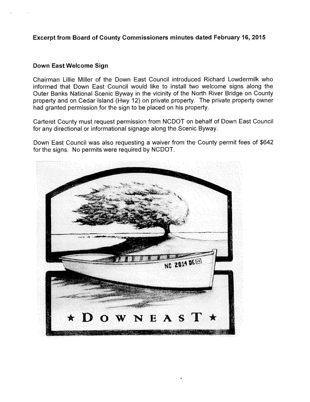
21 CRC-VR RELEVANT STATUTES OR RULES ATTACHMENT A 15A NCAC 07H.0205 COASTAL WETLANDS (a) Description. Coastal wetlands are defined as any salt marsh or other marsh subject to regular or occasional flooding by tides, including wind tides (whether or not the tide waters reach the marshland areas through natural or artificial watercourses), provided this does not include hurricane or tropical storm tides. Coastal wetlands may contain the following marsh plant species: (1) Cord Grass (Spartina alterniflora), (2) Black Needlerush (Juncus roemerianus), (3) Glasswort (Salicornia spp.), (4) Salt Grass (Distichlis spicata), (5) Sea Lavender (Limonium spp.), (6) Bulrush (Scirpus spp.), (7) Saw Grass (Cladium jamaicense), (8) Cat-tail (Typha spp.), (9) Salt Meadow Grass (Spartina patens), (10) Salt Reed Grass (Spartina cynosuroides). The coastal wetlands AEC includes any contiguous lands designated by the Secretary of DENR pursuant to G.S (a). (b) Significance. The unique productivity of the estuarine and ocean system is supported by detritus (decayed plant material) and nutrients that are exported from the coastal marshlands. The amount of exportation and degree of importance appears to be variable from marsh to marsh, depending primarily upon its frequency of inundation and inherent characteristics of the various plant species. Without the marsh, the high productivity levels and complex food chains typically found in the estuaries could not be maintained. Man harvests various aspects of this productivity when he fishes, hunts, and gathers shellfish from the estuary. Estuarine dependent species of fish and shellfish such as menhaden, shrimp, flounder, oysters, and crabs make up over 90 percent of the total value of North Carolina's commercial catch. The marshlands, therefore, support an enormous amount of commercial and recreational businesses along the seacoast. The roots, rhizomes, stems, and seeds of coastal wetlands act as good quality waterfowl and wildlife feeding and nesting materials. In addition, coastal wetlands serve as the first line of defense in retarding estuarine shoreline erosion. The plant stems and leaves tend to dissipate wave action, while the vast network of roots and rhizomes resists soil erosion. In this way, the coastal wetlands serve as barriers against flood damage and control erosion between the estuary and the uplands. Marshlands also act as nutrient and sediment traps by slowing the water which flows over them and causing suspended organic and inorganic particles to settle out. In this manner, the nutrient storehouse is maintained, and sediment harmful to marine organisms is removed. Also, pollutants and excessive nutrients are absorbed by the marsh plants, thus providing an inexpensive water treatment service. 2
22 CRC-VR (c) Management Objective. It is the objective of the Coastal Resources Commission to conserve and manage coastal wetlands so as to safeguard and perpetuate their biological, social, economic and aesthetic values, and to coordinate and establish a management system capable of conserving and utilizing coastal wetlands as a natural resource essential to the functioning of the entire estuarine system. (d) Use Standards. Suitable land uses are those consistent with the management objective in this Rule. Highest priority of use is allocated to the conservation of existing coastal wetlands. Second priority of coastal wetland use is given to those types of development activities that require water access and cannot function elsewhere. Examples of unacceptable land uses include restaurants, businesses, residences, apartments, motels, hotels, trailer parks, parking lots, private roads, highways and factories. Examples of acceptable land uses include utility easements, fishing piers, docks, wildlife habitat management activities, and agricultural uses such as farming and forestry drainage as permitted under North Carolina's Dredge and Fill Law or other applicable laws. In every instance, the particular location, use, and design characteristics shall be in accord with the general use standards for coastal wetlands, estuarine waters, and public trust areas described in Rule.0208 of this Section. (e) Alteration of Coastal Wetlands. Alteration of coastal wetlands includes mowing or cutting of coastal wetlands vegetation whether by mechanized equipment or manual means. Alteration of coastal wetlands by federal or state resource management agencies as a part of planned resource management activities is exempt from the requirements of this paragraph. Mowing or cutting of coastal wetlands by academic institutions associated with research efforts is allowed subject to approval from the Division of Coastal Management. Alteration of coastal wetlands is governed according to the following provisions: (1) Alteration of coastal wetlands is exempt from the permit requirements of the Coastal Area Management Act (CAMA) when conducted in accordance with the following criteria: (A) Coastal wetlands may be mowed or cut to a height of no less than two fee as measured from the coastal wetland substrate, at any time and at any frequency throughout the year; (B) Coastal wetlands may be mowed or cut to a height of no less than six inches, as measured from the coastal wetland substrate, once between each December 1 and March 31; (C) Alteration of the substrate is not allowed; (D) All cuttings/clippings shall remain in place as they fall; (E) Coastal wetlands may be mowed or cut to a height of no less than six inches, as measured from the coastal wetland substrate, to create an access path four feet wide or less on waterfront lots without a pier access; and (F) Coastal wetlands may be mowed or cut by utility companies as necessary to maintain utility easements. 3
23 CRC-VR (2) Coastal wetland alteration not meeting the exemption criteria of this Rule requires a CAMA permit. CAMA permit applications for coastal wetland alterations are subject to review by the North Carolina Wildlife Commission, North Carolina Division of Marine Fisheries, U.S. Fish and Wildlife Service, and National Marine Fisheries Service in order to determine whether or not the proposed activity will have an adverse impact on the habitat or fisheries resources. 4
24 CRC-VR STIPULATED FACTS ATTACHMENT B 1. The Petitioner in this case is Carteret County. 2. Carteret County (or County ) is a Body Politic. The property subject to this variance is owned by Carteret County, a Body Politic and is located in Carteret County, North Carolina. The County is represented by County Attorney, C. R. Wheatly, III, who has agreed to the stipulated facts in this case. 3. The Down East Council (the Council ) acted as the County s agent in seeking the CAMA permit and in filing this variance request. The Council is a registered, non-incorporated non-profit organization, whose stated purpose on its website is that it is a representative group of all thirteen communities in the area with the goal of serving as a unifying voice to promote our livelihood in a growing economy, celebrate and honor the heritage of the people as well as protect our fragile coastal environment. Down East is also unique in that our communities do not have the benefits afforded by being structured like towns or municipalities, and therefore has lacked a means to voice its needs, concerns, and desires for the future. The Framework of the council is to have two representatives from each community. Meetings are held monthly and are open to the public. According to the NC Secretary of State s filing information, Lillie Chadwick Miller is the Council s Registered Agent. Council Member Richard Lowdermilk has been handling this welcome sign project on behalf of the Council. 4. Carteret County owns a piece of property located at 201 North Point Drive in Beaufort, just west of the bridge over the North River ( Site ). The County was deeded this land in 2012 from the Duke-Sea Level Partnership, LLC through a deed recorded at Book 1411, Page 149 of the Carteret County Registry, a copy of which is attached. 5. As seen in site photographs attached, much of the Site is covered in coastal wetlands species, including Black Needlerush (Juncus romerianus) predominantly. 6. The area of Down East is defined in the Carteret County Ordinances at Appendix E. There are two highways in Down East, being US Highway 70 at North River Bridge where you enter the community of Bettie, and NC Highway 12 from Sea Level to the ferry at Cedar Island. 7. On October 16, 2009, the Outer Banks National Scenic Byway was designated, including US Highway 70 and North Carolina Highway 12 from Beaufort to Cedar Island. This designation by the Federal Highway Association is part of the National Scenic Byways Program, which is a grass-roots collaborative effort established to help recognize, preserve and enhance selected roads throughout the United States. The U.S. Secretary of Transportation recognizes certain roads as All- American Roads or National Scenic Byways based on one or more archeological, cultural, historic, natural, recreational and scenic qualities. 5
25 CRC-VR On October 1, 2014, Richard Lowdermilk of the Down East Council contacted Roy Grasse, an Outdoor Advertising Coordinator at the North Carolina Department of Transportation ( DOT ), seeking permission to install welcome signs as people enter Down East Carteret County. Mr. Grasse of DOT responded that only municipal or county governments could request directional or informational signs along the Outer Banks National Scenic Byway. 9. On January 12, 2015, the Down East Council, through a letter from Lillie Miller, Chairperson of the Council, asked the Carteret County Board of Commissioners (1) to allow the Down East Council to install two Down East welcome signs on county property near the North River Bridge and near the Cedar Island Ferry, (2) to ask DOT, on the Down East Council s behalf, for permission to install a Down East welcome sign at the preferred location on county property near North River Bridge, and (3) to waive the county s permit fee. The Down East Council agreed to pay all costs for the sign. A copy of this letter is attached. 10. On February 16, 2015, at their regularly scheduled meeting, the Carteret County Board of Commissioners approved all three of the Down East Council s requests. A copy of the meeting agenda and a relevant excerpt of the meeting minutes are attached. 11. Through an chain dated February 18, 2015, Roy Grasse, the Outdoor Advertising Coordinator for the State Maintenance Operations department of DOT, confirmed to Eugene Foxworth, Carteret County s Planning and Development Director, that the sign was approved, and that they just needed the final location which has to be outside of the state s right-of-way and that it not contain advertising. Later in this same chain, Mr. Foxworth confirms that the Board of County Commissioners supports this project. A copy of this chain is attached as a stipulated exhibit. 12. On March 2, 2015, Richard Lowdermilk of the Down East Council, Gene Foxworth, the Carteret County Planning and Development Director, J.D. O Neal, the Carteret County Building Inspector, Stephen Gardner of DOT (and another DOT employee) met on Site and the DOT representatives verbally approved the sign s proposed location. 13. By application to the Division of Coastal Management (DCM) dated May 18, 2015, Carteret County, through Down East Council s Richard Lowdermilk acting as its agent, requested a CAMA minor permit in order to install a Down East welcome sign at the Site. A copy of the CAMA minor permit application is attached as a stipulated exhibit. 6
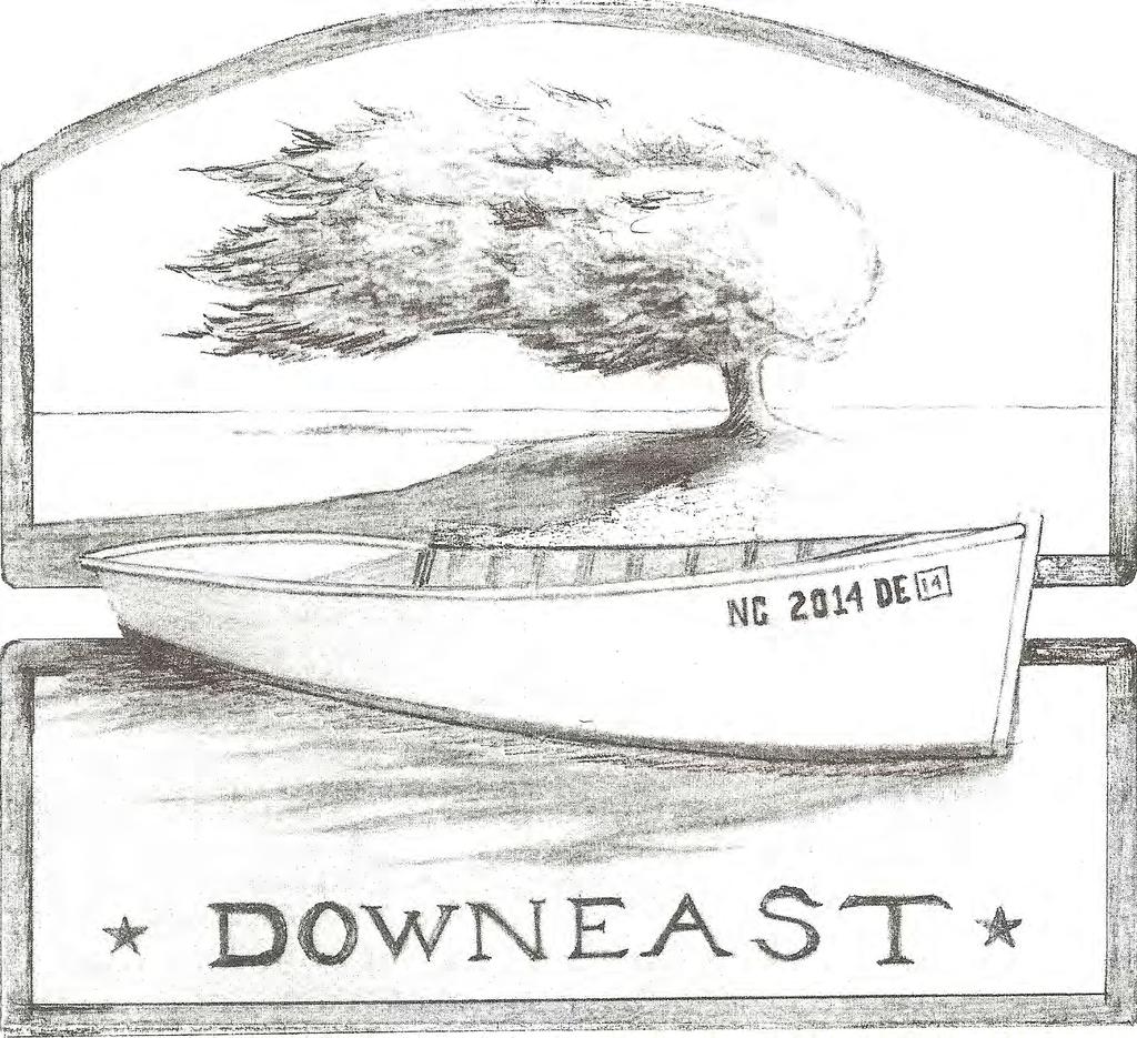
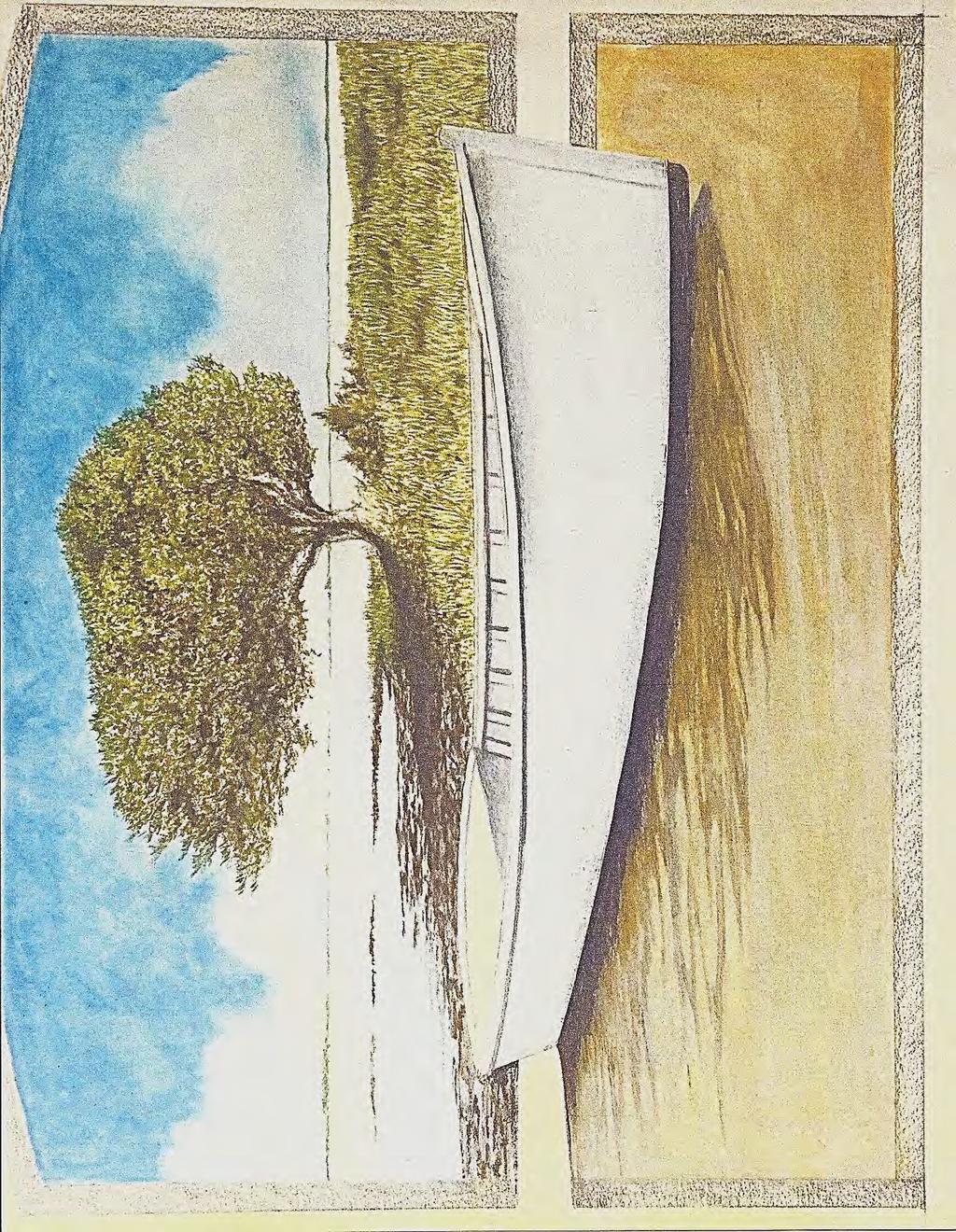
26 CRC-VR The proposed welcome sign includes the installation of an 8 by 6 pile-supported sign. The six pilings total are proposed to be tied with rope in two groups of three 8 diameter pilings on each side of the sign. The pilings are proposed to be driven 10 below grade and the top of the sign is proposed to be 11 above grade. Drawings of the sign s dimensions and a mock-up of the sign are included in the permit application materials, attached as stipulated exhibits. 15. The proposed location of the sign on the Site, is within the Coastal Wetlands Area of Environmental Concern. The proposed location of the sign is more than 75 landward of normal high water level, and so is outside the Coastal Shorelines AEC. The driving of pilings is specifically included in the definition of development found in the CAMA at NCGS 113A- 103(5)a., and so pursuant to NCGS 113A-118, the development of the sign installation within a designated AEC requires a CAMA permit. 16. As part of the CAMA minor permit review process, notice of the proposed development was advertised in the Carteret News Times on May 22, No comments were received by DCM, though Staff fielded one phone call asking where the site for the proposed sign was going to be. Notice of the proposed development was also posted on site on June 17, 2015 after the permit denial and during the variance process. If any comments come in before the Commission s July 15, 2015 hearing, the parties agree to provide them as a supplement to the stipulated facts/exhibits. 17. As part of the CAMA minor permit process, notice was sent to the two riparian owners adjacent to the Site. No comments were received by DCM from these owners. 18. Through a letter dated May 28, 2015, DCM denied Carteret County CAMA permit application, a copy of which is attached as a stipulated exhibit. The Commission s rules for the Coastal Wetlands AEC generally prohibit development within the Coastal Wetlands AEC, except for the development of water-dependent structures such as docks and piers. See 15A NCAC 7H.0205(d). As a pile-supported sign is not a water-dependent structure (which does not require water access to function), the rules required denial of the CAMA permit application. 19. On June 3, 3015, DCM received Carteret County petition though Down East Council, for a variance in order to construct the welcome sign as proposed in its application. As part of their petition, Carteret County stipulated that the sign is inconsistent with 15A NCAC 7H.0205(d). 20. In order to save resources, Carteret County and Down East Council have decided not to pay counsel to argue their petition to the Commission, but have agreed to the stipulated facts and written arguments made herein. 7
27 CRC-VR Petitioner s and Staff s Positions ATTACHMENT C I. Will strict application of the applicable development rules, standards, or orders issued by the Commission cause the petitioner unnecessary hardships? If so, the petitioner must identify the hardships. Petitioner s Position: Yes. -If our sign is placed anywhere on this lot other than in the low growing marsh area it will not be seen by travelers on Hwy 70 because of trees and bushes that will block the view. Our sign has to be a minimum of 60 ft. from the centerline of Hwy 70 to meet DOE and county set back requirements. To be seen by travelers along this section of Hwy 70 requires a clear line of sight of 200 to 300 ft. with natural vegetation no more than 5 ft. high. -This lot was chosen because of its North River bridge gateway location to Down East. There are two much smaller privately owned lots near the North River bridge, however, the effects of the soon to start construction of a new North River bridge on these lots is unknown. -What we are trying to portray with our sign is the unique natural scenic areas of Down East that includes marsh, water, and undeveloped shoreline along Core Sound. Being able to place our Down East welcome sign in the marsh helps to reinforce what we want travelers to experience as they travel our section of the Scenic Byway. -Landscaping and the potential for vandalism are also significantly less with a marsh location. Staffs Position: Yes. Staff agrees that Petitioner has unnecessary hardships due to the strict application of the rules limiting development within the Coastal Wetlands AEC. While the use of this Down East welcome sign is not water-dependent, the combination of factors, including DOT right-of-way and county setbacks, public ownership of the land, sight lines, and the location near the western entrance to Down East at the North River bridge, make this the best site for this project. Combined with the de minimis nature of the impacts and the public and cultural nature of the project, Staff agrees that the strict application of the Commission s limitations on development in Coastal Wetlands causes Petitioner unnecessary hardships. 8
28 CRC-VR II. Do such hardships result from conditions peculiar to the petitioner s property, such as location, size, or topography of the property? Explain. Petitioner s Position: Yes. -The County lot we are proposing for our sign has a 2,425 ft. road frontage length along Hwy 70. The average width of the lot is 250 ft. the first 350. ft. of length is high ground with tall pine trees. The next 250 ft. is a transition area with fewer smaller trees and more bushes. The remaining 1,835 ft. is marsh grass. If the marsh was located at the front of the lot instead of the back, if the high ground was longer in length, if the bushes and vegetation along the DOT right of way was much less, or if the road curved to provide a line of sight, then our sign could be located in an area other than the marsh. Staffs Position: Yes. Staff agrees that conditions peculiar to the large County-owned lot near the North River bridge and its location as the gateway to Down East cause Petitioner s hardships. These include the locations of the different types of vegetation on the lot, and the long area needed for visitors and drivers to be able to see the sign with a sufficient sight line for the welcome sign. III. Do the hardships result from the actions taken by the Petitioner? Explain. Petitioner s Position: No. -No actions have been taken by Down East Council or Carteret Count on this property. Staff s Position: No. Petitioner has evaluated various alternatives, and Staff agrees with Petitioner that in order to place a welcome sign on this lot where visitors and drivers can see it and be welcomed to Down East, they were limited by several factors in choosing a location for the sign, and would have a difficult time avoiding Coastal Wetlands. 9
29 CRC-VR IV. Will the variance requested by the petitioner (1) be consistent with the spirit, purpose, and intent of the rules, standards or orders issued by the Commission; (2) secure the public safety and welfare; and (3) preserve substantial justice? Explain. Petitioner s Position: Yes. -Our sign also seeks to emphasize the scenic beauty and promote conservation of our unique coastal landscape. Staffs Position: Yes. The variance would be consistent with the spirit, purpose, and intent of the rules, standards or orders of the Commission, because on balance, the benefits to the public outweigh the minimal impacts to the resources. While the limitations on building in Coastal Wetlands is an important rule of the Commission, and generally limits such development to water-dependent structures, the de minimis nature of the proposed disturbance here, combined with the public and cultural nature of the welcome sign help justify the de minimis impacts. Once any construction-related impacts are over, the only impacts would be the 6 8 diameter posts. Contrast this with the pride that Carteret County and Down East will have in welcoming visitors to their part of the County, sharing Down East s boat-building culture, and highlighting US Highway 70 s inclusion in the Scenic Byways program. Public Safety and welfare is helped by keeping the sign a safe distance from the road and minimizing the impacts to the wetland, while supporting the cultural identity of Down East and welcoming visitors to this special part of our coast. 10
30 CRC-VR Attachment D: Petitioners Variance Request Materials 11
31
32
33
34
35
36
37
38
39
40
41 CRC-VR Attachment E: Stipulated Exhibits including Powerpoint -Deed to the Site (Book 1411, Page 149) -January 12, 2015 letter from Miller of DEC to Carteret County -February 16, 2015 Carteret County Board of Commissioners meeting minutes -February 18, chain between DOT and Carteret County officials -May 18, 2015 CAMA minor permit application from Carteret County -May 28, 2015 CAMA permit denial letter -Site Photographs in powerpoint presentation 12
42
43
44
45
46
47
48
49
50
51
52
53
54
55
56
57
58
59
60
61
62
63
64
65
66
67
68 Down East Council, Agent for Carteret County (CRC-VR-15-04) Non Water-Dependent Use in Coastal Wetlands Variance Request Bettie Township Carteret County July 15, 2015

69 Proposed Sign Location

70 Vicinity of County Property and Proposed Location for Down East Council Sign

71 Approximate Proposed Sign Location

72 Approximate proposed sign location (looking south)
73
74 Proposed Down East Sign Dimensions from Permit Application
75
76
77
78
79
80
81
82
")
83 North Carolina Department of Environment and Natural Resources Pat McCrory Governor MEMORANDUM July 1, 2015 Donald R. van der Vaart Secretary CRC Information Only TO: FROM: SUBJECT: Coastal Resources Commission Charlan Owens, AICP, DCM Elizabeth City District Planner Currituck County Land Use Plan (LUP) Implementation Status Report Background Local governments submit an implementation status report every two (2) years following the date of LUP certification per the following: 15A NCAC 07L.0511 REQUIRED PERIODIC IMPLEMENTATION STATUS REPORTS (a) To be eligible for future funding each local government engaged in CAMA land use planning shall complete a CAMA land use plan Implementation Status Report every two years as long as the current plan remains in effect. DCM shall provide a standard implementation report form to local governments. This report shall be based on the action plan and schedule provided in 15A NCAC 07B -Tools for Managing Development. (b) The Implementation Status Report shall identify: (1) All local, state, federal, and joint actions that have been undertaken successfully to implement its certified CAMA land use plan; (2) Any actions that have been delayed and the reasons for the delays; (3) Any unforeseen land use issues that have arisen since certification of the CAMA land use plan; (4) Consistency of existing land use and development ordinances with current CAMA land use plan policies; and (5) Current policies that create desired land use patterns and protection of natural systems. (c) Results shall be made available to the public and shall be forwarded to DCM. The Currituck County implementation status report is available on DCM s Land Use Planning web page at: It is not provided in the CRC packet. Discussion The implementation status report does not require approval by the CRC, but must be made available to the public and forwarded to DCM. The report is based on the LUP Action Plan and identifies activities that the local government has undertaken in support of the LUP s policies and implementation actions. Staff has reviewed the submitted report and finds that the community has met the minimum requirements US 17 South, Elizabeth City, NC Phone: \ FAX: ; Internet: An Equal Opportunity \ Affirmative Action Employer Made in part by recycled paper
NC Coastal Management Program Update. Mike Lopazanski Policy & Planning Section Chief April 3, 2015
 NC Coastal Management Program Update Mike Lopazanski Policy & Planning Section Chief April 3, 2015 NC Coastal Area Management Act (1974) Balances competing coastal pressures through development permitting
NC Division of Coastal Management
 November 14, 2016 NC Division of Coastal Management NCBIWA Update NC Coastal Area Management Act (1974) Balances competing coastal pressures through development permitting and creation of a Coastal Resources
Fact Sheet Regulating Oceanfront Accessory Structures Updated June 10, 2013
 What is being considered? Fact Sheet Regulating Oceanfront Accessory Structures Updated June 10, 2013 The Town of Duck is considering an ordinance that would limit how close pools, decks, and other accessory
Procedures IV. V. Rural Road Design Option
 i IV. Procedures A. All applicants required to prepare a Conservation Design Subdivision shall provide the Planning Board with a conceptual conventional subdivision design as well as a proposed layout
PURPOSE: The purpose is to provide commercial facilities in the Vancouver and Clark County vicinity.
 US Army Corps of Engineers Seattle District Joint Public Notice Application for a Department of the Army Permit and a Washington Department of Ecology Water Quality Certification and/or Coastal Zone Management
Shoreline Master Program Town of La Conner, Washington
 Shoreline Master Program Town of La Conner, Washington Department of Ecology approval effective Adopted September 24, 2013 by Town of La Conner Ordinance No.1106 Amended May 13, 2014 by Town of La Conner
Hunts Point Landing, Bronx, New York
 Hunts Point Landing, Bronx, New York Sustainable Shorelines in an Urban Environment John Roebig, PhD. HDR Engineering, Inc. John.Roebig@hdrinc.com Promoting Resilient Shorelines along the Hudson River
SHORE PROTECTION ACT STAFF S FINDINGS & RECOMMENDATIONS
 SHORE PROTECTION ACT STAFF S FINDINGS & RECOMMENDATIONS TO: FROM: APPLICANT: AGENT: Shore Protection Committee: Commissioner Mark Williams, Chairman Mr. Richard Gardner Mr. Henry Morgan Mr. Zach Harris
GENERAL INFORMATIONaaaaaaaaaaaaaaaaaaaaaaaaaaaaaaaa
 To: Planning and Zoning Commission From: City Staff Date: November 15, 2016 Re: Case #16026 Raymore Activity Center Site Plan GENERAL INFORMATIONaaaaaaaaaaaaaaaaaaaaaaaaaaaaaaaa Applicant/ Property Owner:
Urban Planning and Land Use
 Urban Planning and Land Use 701 North 7 th Street, Room 423 Phone: (913) 573-5750 Kansas City, Kansas 66101 Fax: (913) 573-5796 Email: planninginfo@wycokck.org www.wycokck.org/planning To: From: Board
ME DOT Route 3. File No.: City and State: Bar Harbor, ME
 ME DOT Route 3 File No.: 199600361 City and State: Bar Harbor, ME General Impacts: 0.28 acre tidal emergent 0.77 acre non-tidal forested 0.15 acre non-tidal emergent 0.51 acre non-tidal scrub-shrub Functions
The Town Board of the Town of Vienna, County of Dane, State of Wisconsin, does ordain and adopt as follows.
 ORDINANCE DRIVEWAYS AND CULVERTS NO. 6-5-06 ORDINANCE CONCERNING DRIVEWAY AND CULVERT REQUIREMENTS 1-1-1 Driveway Permits; Culvert Requirements 1-1-2 Driveway and Culvert Location, Design and Construction
STREAM BUFFERS
 88-415 STREAM BUFFERS 88-415-01 PURPOSE In the Kansas City region and throughout the nation, vegetated stream buffers have been clearly shown to protect stream stability and related infrastructure, improve
Urban Planning and Land Use
 Urban Planning and Land Use 701 North 7 th Street, Room 423 Phone: (913) 573-5750 Kansas City, Kansas 66101 Fax: (913) 573-5796 Email: planninginfo@wycokck.org www.wycokck.org/planning To: From: City Planning
ORDINANCE NO WHEREAS, a primary opportunity identified in the Plan is to Re-Connect the Uncompahgre River:
 ORDINANCE NO. 17 - AN ORDINANCE OF THE TOWN OF RIDGWAY, COLORADO AMENDING THE OFFICIAL ZONING MAP TO PROVIDE FOR THE UNCOMPAHGRE RIVER OVERLAY DISTRICT AND CREATING RIVER CORRIDOR DEVELOPMENT REGULATIONS.
STEWARDSHIP OF LONG ISLAND SOUND S ECOLOGICAL AND RECREATIONAL RESOURCES
 STEWARDSHIP OF LONG ISLAND SOUND S ECOLOGICAL AND RECREATIONAL RESOURCES Robin Kriesberg, Save the Sound, Inc. Thomas Halavik, US Fish and Wildlife Service Coastal Program An Initiative to Identify, Protect
Memorandum Planning. Thursday, January 8, 2015
 Memorandum Planning Thursday, January 8, 2015 7.A. To: Coastal Advisory Committee From John Ciampa, Associate Planner Subject: Review Draft Local Coastal Program Copies: James Pechous, City Planner Purpose
Re: Application Type: Proposed Highlands Redevelopment Area Designation
 CHRIS CHRISTIE Governor KIM GUADAGNO Lt. Governor State of New Jersey Highlands Water Protection and Planning Council 100 North Road (Route 513) Chester, New Jersey 07930-2322 (908) 879-6737 (908) 879-4205
Best Practices Appendix: Waterfront Communities
 Redevelopment Ready Communities Best Practices Appendix: Waterfront Communities revised September 2014 Waterfront RRC defined The purpose of these additional criteria is to provide waterfront communities
LU Encourage schools, institutions, and other community facilities that serve rural residents to locate in neighboring cities and towns.
 Application No. 891627: Comprehensive Plan Text Amendment - Rural School Policies - Amend policies consistent with State Legislation allowing schools in the rural area and extension of sewer service to
To qualify for federal Transportation Enhancement (TE) funds a project must meet two basic federal requirements:
 funds a project must meet two basic federal requirements:") Eligibility Requirements To qualify for federal Transportation Enhancement (TE) funds a project must meet two basic federal requirements: 1) Relate to surface transportation and 2) Be one of the 12 designated
Eligibility Requirements To qualify for federal Transportation Enhancement (TE) funds a project must meet two basic federal requirements: 1) Relate to surface transportation and 2) Be one of the 12 designated
North Carolina Coastal Federation
 North Carolina Coastal Federation Erosion Control: Non-Structural Alternatives A Shorefront Property Owner s Guide Shoreline erosion and landward migration of marshes are natural processes, and are important
DISCUSSION TOPIC: ST JOHNS RIVER & ITS TRIBUTARIES (BPII) 2030 COMPREHENSIVE PLAN POLICES AND REGULATORY FRAMEWORK
 2030 COMPREHENSIVE PLAN POLICES AND REGULATORY FRAMEWORK") DISCUSSION TOPIC: ST JOHNS RIVER & ITS TRIBUTARIES (BPII) 2030 COMPREHENSIVE PLAN POLICES AND REGULATORY FRAMEWORK St. John s River & Its Tributaries Issue Summary: The St. Johns River is an important
DISCUSSION TOPIC: ST JOHNS RIVER & ITS TRIBUTARIES (BPII) 2030 COMPREHENSIVE PLAN POLICES AND REGULATORY FRAMEWORK St. John s River & Its Tributaries Issue Summary: The St. Johns River is an important
CHAPTER Committee Substitute for Senate Bill No. 1472
 CHAPTER 2007-99 Committee Substitute for Senate Bill No. 1472 An act relating to beaches and shores; amending s. 161.021, F.S.; amending a definition; amending s. 161.085, F.S.; restricting the use of
Zoning and Development Considerations in the Boothbay Harbor Maritime/Water Dependent District
 Zoning and Development Considerations in the Boothbay Harbor Maritime/Water Dependent District Bob Faunce Lincoln County Planner Lincoln County Regional Planning Commission Board of Selectmen and Planning
ALTERNATIVE SHORELINE MANAGEMENT IN COASTAL MISSISSIPPI
 ALTERNATIVE SHORELINE MANAGEMENT IN COASTAL MISSISSIPPI Project supported via financial assistance provided by the Coastal Zone Management Act of 1972, as amended, administered by the Office of the Ocean
GENERAL ASSEMBLY OF NORTH CAROLINA SESSION 2007 SESSION LAW SENATE BILL 1967
 GENERAL ASSEMBLY OF NORTH CAROLINA SESSION 2007 SESSION LAW 2008-211 SENATE BILL 1967 AN ACT TO PROVIDE FOR IMPROVEMENTS IN THE MANAGEMENT OF STORMWATER IN THE COASTAL COUNTIES IN ORDER TO PROTECT WATER
Kevin M. Rampe, President -- Lower Manhattan Development Corporation
 For Internal Use Only: Date Received: WRP no. DOS no. NEW YORK CITY WATERFRONT REVITALIZATION PROGRAM Consistency Assessment Form Proposed actions that are subject to CEQR, ULURP or other local, state
Wednesday, September 23 rd
 NC COASTAL RESOURCES COMMISSION September 23, 2015 New Hanover County Government Complex Wilmington, NC The State Government Ethics Act mandates that at the beginning of any meeting the Chair remind all
SHORE PROTECTION ACT STAFF S FINDINGS & RECOMMENDATIONS
 SHORE PROTECTION ACT STAFF S FINDINGS & RECOMMENDATIONS TO: FROM: Shore Protection Committee: Commissioner Mark Williams, Chairman Mr. Richard Gardner Mr. Henry Morgan Mr. Zach Harris Mr. Bill Hodges Department
City of Fort Lupton Site Plan Process
 Form WKBK001 City of Fort Lupton Site Plan Process Purpose The Site Plan process is meant to promote orderly and sound development standards as they apply to the City. These site development standards
STATE OF NORTH CAROLINA DECLARATION OF
 Prepared by and Return to: Orange County Parcel Identification Number(s): STATE OF NORTH CAROLINA COUNTY OF ORANGE DECLARATION OF RESTRICTIVE COVENANTS THIS DECLARATION OF RESTRICTIVE COVENANTS ( Declaration
STAFF REPORT FOR STANDARD COASTAL DEVELOPMENT PERMIT #CDP FEBRUARY 26, 2015 CPA - 1 PO BOX 238 APTOS, CA 94001
 STAFF REPORT FOR STANDARD COASTAL DEVELOPMENT PERMIT #CDP 2014-0030 FEBRUARY 26, 2015 CPA - 1 OWNER/APPLICANT: AGENT: REQUEST: HANS HEIM PO BOX 238 APTOS, CA 94001 JAMES HAY PO BOX 762 MENDOCINO, CA 95460
Riparian Buffer on the Bushkill Creek. Policies
 Riparian Buffer on the Bushkill Creek Riparian buffers provide numerous benefits to landowners and the community by protecting groundwater recharge areas, providing flood control, providing stormwater
Chelsea Creek Municipal Harbor Plan
 Chelsea Creek Municipal Harbor Plan Public Meeting #1 June 11th, 2018 1 Presentation outline I. Introduction: Why are we doing this plan? II. Evolution of Chelsea Creek III. State of Chelsea Creek IV.
LICENSES FOR UTILITY CROSSINGS OF PUBLIC LANDS AND WATERS ACCORDING TO MINNESOTA RULES CHAPTER [Rules Effective July 1, 2004]
![LICENSES FOR UTILITY CROSSINGS OF PUBLIC LANDS AND WATERS ACCORDING TO MINNESOTA RULES CHAPTER [Rules Effective July 1, 2004]](/thumbs/78/77546780.jpg "LICENSES FOR UTILITY CROSSINGS OF PUBLIC LANDS AND WATERS ACCORDING TO MINNESOTA RULES CHAPTER [Rules Effective July 1, 2004]") LICENSES FOR UTILITY CROSSINGS OF PUBLIC LANDS AND WATERS ACCORDING TO MINNESOTA RULES CHAPTER 6135 [Rules Effective July 1, 2004] Minnesota Department of Natural Resources Division of Lands and Minerals
LICENSES FOR UTILITY CROSSINGS OF PUBLIC LANDS AND WATERS ACCORDING TO MINNESOTA RULES CHAPTER 6135 [Rules Effective July 1, 2004] Minnesota Department of Natural Resources Division of Lands and Minerals
EXHIBIT A CITY OF FORT WALTON BEACH, FLORIDA COASTAL MANAGEMENT & CONSERVATION
 EXHIBIT A CITY OF FORT WALTON BEACH, FLORIDA INTRODUCTION The Coastal Management and the Conservation Elements required by Chapter 9J-5.012 and 5.013, F.A.C., respectively, have been combined into one
Master Plan for Preservation and Scenic Conservation (1995)
") 3.2 Master Plan for Preservation and Scenic Conservation (1995) The Master Plan for Preservation and Scenic Conservation was developed under the direction of the Guilford Preservation Alliance in the 1980s
3.2 Master Plan for Preservation and Scenic Conservation (1995) The Master Plan for Preservation and Scenic Conservation was developed under the direction of the Guilford Preservation Alliance in the 1980s
City of Petersburg, VA Stormwater Utility Frequently Asked Questions
 Q. What is stormwater runoff? A. Stormwater runoff is the water that flows off roofs, driveways, parking lots, streets and other hard surfaces during rain storms. Stormwater runoff is also the rain that
ADDENDUM TO BIOLOGICAL SCOPING SURVEY REPORT, BOTANICAL SURVEY AND WETLAND DELINEATION
 ADDENDUM TO BIOLOGICAL SCOPING SURVEY REPORT, BOTANICAL SURVEY AND WETLAND DELINEATION FOR AVALON INN (APN 069-241-27 & -04) 1201 & 1211 NORTH MAIN STREET FORT BRAGG, CA MENDOCINO COUNTY prepared for:
JOINT PUBLIC NOTICE. 26 June United States Army Corps of Engineers State of Louisiana
 JOINT PUBLIC NOTICE 26 June 2017 United States Army Corps of Engineers State of Louisiana New Orleans District Department of Environmental Quality Regulatory Branch Office of Environmental Services 7400
SOUTH CAMBRIDGESHIRE DISTRICT COUNCIL. Planning and New Communities Director
 SOUTH CAMBRIDGESHIRE DISTRICT COUNCIL REPORT TO: Planning Committee 9 January 2013 AUTHOR/S: Planning and New Communities Director S/2270/12/FL FEN DRAYTON 850m long flood defence embankment ranging in
ELIGIBILITY CRITERIA CHECKLIST OPEN SPACE CLASSIFICATION
 THURSTON COUNTY DEVELOPMENT SERVICES OPEN SPACE TAX PROGRAM ELIGIBILITY CRITERIA CHECKLIST OPEN SPACE CLASSIFICATION Use this checklist to help you determine whether your property is eligible for open
Project phasing plan (if applicable) 12 copies of site plan
 12 copies of site plan") SITE PLAN REVIEW PERMIT APPLICATION City of Grand Haven, 11 N. Sixth Street, Grand Haven, MI 49417 Phone: (616) 847-3490 Fax: (616) 844-2051 Website: www.grandhaven.org 1. Project Information Address/location
SITE PLAN REVIEW PERMIT APPLICATION City of Grand Haven, 11 N. Sixth Street, Grand Haven, MI 49417 Phone: (616) 847-3490 Fax: (616) 844-2051 Website: www.grandhaven.org 1. Project Information Address/location
CONSERVATION ELEMENT GOALS, OBJECTIVES, AND POLICIES
 CONSERVATION ELEMENT GOALS, OBJECTIVES, AND POLICIES Goal 4 To conserve, manage, appropriately use and protect the natural resources of the City ensuring continued resource availability and environmental
PSRC REVIEW REPORT & CERTIFICATION RECOMMENDATION
 PSRC REVIEW REPORT & CERTIFICATION RECOMMENDATION KITSAP COUNTY COUNTYWIDE PLANNING POLICIES July 2, 2012 BACKGROUND A major emphasis of the Washington State Growth Management Act (GMA) is the need to
A. General Information
 Important: When filling out forms on the computer, use only the tab key to move your cursor - do not use the return key. Massachusetts Department of Environmental Protection A. General Information 1. Project
PLANNING COMMISSION AGENDA REPORT APRIL 7, 2016
 PLANNING COMMISSION AGENDA REPORT APRIL 7, 2016 TO: FROM: Members of the Planning Commission Talyn Mirzakhanian, Senior Planner FILE NO.: 160001710 PROPOSAL: APPLICANT: RECOMMENDATION: A request for a
HAZARD MITIGATION GOALS AND OBJECTIVES
 SEWRPC Community Assistance Planning Report No. 282, 2nd Edition CITY OF MILWAUKEE ALL HAZARDS MITIGATION PLAN UPDATE Chapter IV HAZARD MITIGATION GOALS AND OBJECTIVES [NOTE: Throughout this plan update
{Best Practices. Summary of Tools, Strategies and Best Practices from 11 Michigan Case Study Communities
 Case Studies Michigan Coastal Community Working Waterfronts { Summary of Tools, Strategies and from 11 Michigan Case Study Communities Table of Contents Zoning...2 Community and Stakeholder Collaboration
R.O.M. = Rough Order of Magnitude
 3. SITE DEVELOPMENT GENERAL LOCATION The City of Corpus Christi is located on Texas coast of the Gulf of Mexico about a third of the way from the Mexican border to the Louisiana border. It is on the west
Introducing Green Infrastructure for Coastal Resilience
 Introducing Green Infrastructure for Coastal Resilience National Oceanic and Atmospheric Administration (NOAA) Office for Coastal Management Gloucester, MA Office of Travel Courtesy, Tim Grafft What Is
Rule D Wetland and Creek Buffers
 Rule D Wetland and Creek Buffers 1 Policy It is the policy of the Board of Managers to ensure the preservation of the natural resources, recreational, habitat, water treatment and water storage functions
Northeast Ohio Regional Sewer District Stormwater Management Plan Review Policy
 Northeast Ohio Regional Sewer District Stormwater Management Plan Review Policy Introduction As a component of the Northeast Ohio Regional Sewer District s (District) Regional Stormwater Management Program,
138 ATTACHMENT 17. DEPARTMENT OF THE ARMY WlLMlNGTON DISTRICT, CORPS OF ENGINEERS
 138 ATTACHMENT 17 DEPARTMENT OF THE ARMY WlLMlNGTON DISTRICT, CORPS OF ENGINEERS B. EVERETT JORDAN DAM AND LAKE P.O. Box 144 MONCURE, NORTH CAROLINA 27559 April 11, 2007 Mr. Scott Radway Radway Design
City of Fort Lupton Administrative Site Plan Process
 City of Fort Lupton Administrative Site Plan Process Purpose The Site Plan process is meant to promote orderly and sound development standards as they apply to the City. These site development standards
Natural Resource Adaptation Action Area Addressing Sea Level Rise in Estuarine Ecosystems TO: TOWN OF YANKEETOWN MAY
 Natural Resource Adaptation Action Area Addressing Sea Level Rise in Estuarine Ecosystems TO: TOWN OF YANKEETOWN MAY 6 2013 University of Florida Conservation Clinic Vivek Babbar, Student Associate, J.D.
Planning Commission Report
 Planning Commission Report To: From: Subject: Planning Commission Meeting: January 6, 2016 Agenda Item: 8-B Planning Commission David Martin, Planning & Community Development Director Introduction to the
City of Westbrook. 2 York Street Westbrook, Maine (207) Fax:
 Fax:") City of Westbrook DEPARTMENT OF PLANNING & CODE ENFORCEMENT 2 York Street Westbrook, Maine 04092 (207) 854-0638 Fax: 1-866-559-0642 WESTBROOK PLANNING BOARD TUESDAY, JANUARY 2, 2018, 7:00 P.M. WESTBROOK
City of Westbrook DEPARTMENT OF PLANNING & CODE ENFORCEMENT 2 York Street Westbrook, Maine 04092 (207) 854-0638 Fax: 1-866-559-0642 WESTBROOK PLANNING BOARD TUESDAY, JANUARY 2, 2018, 7:00 P.M. WESTBROOK
NEW CASTLE COUNTY S ZONING DISTRICTS
 NEW CASTLE COUNTY S ZONING DISTRICTS This is general information about New Castle County s zoning districts. The information included is by no means exhaustive or complete. Before designing plans to develop
Sierra Club Comments on ACOE Public Notice NAE Re: Proposed Town Neck Beach Project at Sandwich, Massachusetts
 August 27, 2015 US Army Corps of Engineers New England District 696 Virginia Road Concord, MA 01742-2751 Attn: Phillip W. Nimeskern Dear Mr. Nimeskern, Sierra Club Comments on ACOE Public Notice NAE-2014-259
Landscape Act. (Act No. 110 of June 18, 2004)
") Landscape Act (Act No. 110 of June 18, 2004) INDEX Chapter I General Provisions (Articles 1 to 7) Chapter II Landscape Plans and Measures Based on Them Section 1 Formulation, etc. of Landscape Plans (Articles
Landscape Act (Act No. 110 of June 18, 2004) INDEX Chapter I General Provisions (Articles 1 to 7) Chapter II Landscape Plans and Measures Based on Them Section 1 Formulation, etc. of Landscape Plans (Articles
CRC-VR ATTACHMENT A RELEVANT STATUTES OR RULES
 CRC-VR-15-07 RELEVANT STATUTES OR RULES ATTACHMENT A 113A-102. Legislative findings and goals of the Coastal Area Management Act of 1974 (CAMA). (a) Findings. -- It is hereby determined and declared as
Urban Planning and Land Use
 Urban Planning and Land Use 701 North 7 th Street, Room 423 Phone: (913) 573-5750 Kansas City, Kansas 66101 Fax: (913) 573-5796 Email: planninginfo@wycokck.org www.wycokck.org/planning To: From: City Planning
PLANNED UNIT DEVELOPMENT & SUBDIVISION STAFF REPORT Date: March 15, 2012
 PLANNED UNIT DEVELOPMENT & SUBDIVISION STAFF REPORT Date: March 15, 2012 DEVELOPMENT NAME SUBDIVISION NAME LOCATION OSR Subdivision OSR Subdivision 5559 Old Shell Road (South side of Old Shell Road, 570
Pontchartrain Coastal Lines of Defense Program Figure 1 Figure 2 Figure 1
 Pontchartrain Coastal Lines of Defense Program Coastal Sustainability Program February 2006 The Pontchartrain Coastal Lines of Defense Program consists of ten priority project areas within the Pontchartrain
1. Planning and Development Approvals Commissioner s report dated 06 Oct 2000 is immediately attached.
 3. STATUS UPDATE ON PETRIE ISLAND COMMITTEE RECOMMENDATION AS AMENDED That Council approve that: the status quo continue with the annual lease with the Sand extraction operations (Grandmaitre); and further
Stock-Taking on Integrated Coastal Zone Management (ICZM) in the Black Sea IMPLEMENTATION AUDIT QUESTIONNAIRE 2010
 in the Black Sea IMPLEMENTATION AUDIT QUESTIONNAIRE 2010") Stock-Taking on Integrated Coastal Zone Management (ICZM) in the Black Sea IMPLEMENTATION AUDIT QUESTIONNAIRE 2010 PURPOSE The purposes of this questionnaire are: (a) to perform the policy, legal and institutional
Stock-Taking on Integrated Coastal Zone Management (ICZM) in the Black Sea IMPLEMENTATION AUDIT QUESTIONNAIRE 2010 PURPOSE The purposes of this questionnaire are: (a) to perform the policy, legal and institutional
Regulation Changes for Open Space and Similar Uses
 Regulation Changes for Open Space and Similar Uses What is the Project? This project is an analysis of the Zoning Ordinance relating to public lands and open space regulations. The proposed text amendments
Appendix E Section 4(f) Evaluation
 Evaluation") Appendix E Section 4(f) Evaluation Appendix E Draft Section 4(f) Evaluation E.1 Introduction This appendix addresses a federal regulation known as Section 4(f), which protects parks, recreation areas,
Appendix E Section 4(f) Evaluation Appendix E Draft Section 4(f) Evaluation E.1 Introduction This appendix addresses a federal regulation known as Section 4(f), which protects parks, recreation areas,
Six Mile Lake GFA Policies Official Plan Amendment
 MEMO KITCHENER WOODBRIDGE LONDON KINGSTON BARRIE BURLINGTON To: From: Nick Popovich Jamie Robinson Date: December 20, 2017 File: Subject: 09165AW Six Mile Lake GFA Policies Official Plan Amendment This
Natural & Nature-Based Solutions for Risk Reduction & Resilience
 University of Massachusetts Amherst ScholarWorks@UMass Amherst International Conference on Engineering and Ecohydrology for Fish Passage International Conference on Engineering and Ecohydrology for Fish
Chapter 1: General Program Information
 Chapter 1: General Program Information 1.1 Introduction The Montgomery County Stormwater Management Resolution (#03-1-5) was adopted by the County Board of Commissioners on January 22, 2003. The purpose
RECOMMENDATION REPORT
 DEPARTMENT OF CITY PLANNING RECOMMENDATION REPORT City Planning Commission Case No.: CPC-2012-1165-GPA-ZC Date: August 9, 2012 Time: After 8:30 AM Place: City Hall, Room 350 Public Hearing: Required CEQA
-MENDOCINO COUNTY PLANNING AND BUILDING SERVICES- DIVISION II OF TITLE 20--COASTAL ZONING CODE
 CHAPTER 20.504 VISUAL RESOURCE AND SPECIAL TREATMENT AREAS Sec. 20.504.005 Applicability. Sec. 20.504.010 Purpose. Sec. 20.504.015 Highly Scenic Areas. Sec. 20.504.020 Special Communities and Neighborhoods.
DRIVEWAY REGULATIONS
 TOWN OF NEW LONDON PLANNING BOARD DRIVEWAY REGULATIONS INSTRUCTIONS TO APPLICANTS FOR THE CONSTRUCTION OR ALTERATION OF DRIVEWAYS IMPORTANT: READ CAREFULLY BEFORE FILLING OUT ATTACHED APPLICATION Revised
Deb Grube, Sr. Zoning Officer
 Deb Grube, Sr. Zoning Officer Wisconsin Department of Natural Resources Administrative Code NR 115 under the authority of Wisconsin Statute 59.692, establishes and provides that shoreland zoning regulations
Planning for Staten. Habitat Restoration and Green Infrastructure. Island s North Shore
 Habitat Restoration and Green Infrastructure Planning for Staten Island s North Shore Community Board 1 March 1, 2018 NYC Parks Forestry, Horticulture, and Natural Resources Funded by the NYS Department
Sustainability Statement. Whitby Business Park Area Action Plan
 Sustainability Statement Whitby Business Park Area Action Plan November 2014 Contents Page 1. Introduction 1 2. Scoping 3 3. Sustainability Appraisal of Options 6 4. Assessment of Draft Area Action Plan
ARLINGTON COUNTY, VIRGINIA
 ARLINGTON COUNTY, VIRGINIA County Board Agenda Item Meeting of April 23, 2019 DATE: April 12, 2019 SUBJECT: SP #413 SITE PLAN AMENDMENT to permit a fixed bar in a private outdoor café space with associated
CITY OF ZEELAND PLANNING COMMISSION
 APPLICATION FOR SITE PLAN REVIEW AND SPECIAL LAND USE Date City Official App. Filing Fee Rec'd ($350) NOTE TO APPLICANT: Please submit this application for Site Plan Review along with twenty (20) copies
TOWN OF BETHLEHEM OPEN SPACE CONSERVATION PLAN PUBLIC MEETING: OCTOBER 12, 2017
 TOWN OF BETHLEHEM OPEN SPACE CONSERVATION PLAN PUBLIC MEETING: OCTOBER 12, 2017 Welcome and Agenda 6:00 6:45: Open House, Part One 6:45 7:15: Presentation and Questions 7:15 8:00: Open House, Part Two
SOIL EROSION AND SEDIMENT CONTROL
 SOIL EROSION AND SEDIMENT CONTROL SECTION 1: AUTHORITY, TITLE AND PURPOSE 11. STATUTORY AUTHORIZATION This ordinance is adopted pursuant to the provisions of the Federal Water Pollution Control Act 86
Questions for Carlsbad City Council Members and Candidates (July 1, 2016)
") Ponto is Carlsbad s Southern Coastal Gateway Questions for Carlsbad City Council Members and Candidates (July 1, 2016) 1. Are you aware of the 3 proposed developments in Ponto? What are your most important
Ponto is Carlsbad s Southern Coastal Gateway Questions for Carlsbad City Council Members and Candidates (July 1, 2016) 1. Are you aware of the 3 proposed developments in Ponto? What are your most important
Lawrencetown Beach & Rainbow Haven Beach
 Lawrencetown Beach & Rainbow Haven Beach Public Engagement Session Wednesday, September 27 th, 2017 6:00pm 8:00pm Cole Harbour Place 51 Forest Hills Pkwy, Dartmouth Agenda Welcome & Introductions Overview
Nick Sigmund, Sr. Zoning Officer
 Nick Sigmund, Sr. Zoning Officer Wisconsin Department of Natural Resources Administrative Code NR 115 under the authority of Wisconsin Statute 59.692, establishes and provides that shoreland zoning regulations
I. STAFF POLICY RECOMMENDATIONS. The following RMP policy strategies are proposed by staff in support of a Scenic Resource Protection Program:
 Policy Consideration: Scenic Resource Protection Program Status: For Consideration by the Highlands Council at September 14, 2006 Work session Date: September 12, 2006 I. STAFF POLICY RECOMMENDATIONS The
Designation Process: Step One
 WATERFRONTS FLORIDA P A R T N E R S H I P P R O G R A M Community Statement of Interest Designation Process: Step One The Waterfronts Florida Partnership Program is a program of the Department of Economic
DEVELOPMENT PERMIT SENSITIVE ECOSYSTEMS
 DEVELOPMENT PERMIT SENSITIVE ECOSYSTEMS What is the Sensitive Ecosystem Development Permit Area (SEDPA)? Surrey s SEDPA is made up of two distinct classifications of the natural environment: Streamside
Appendix to Amicus Curiae Brief: Selected Provisions of the South Carolina Beachfront Management Act
 Loyola Marymount University and Loyola Law School Digital Commons at Loyola Marymount University and Loyola Law School Loyola of Los Angeles Law Review Law Reviews 6-1-1992 Appendix to Amicus Curiae Brief:
Minnesota Department of Natural Resource - Natural Resource Guidance Checklist Conserving Natural Resources through Density Bonuses
 Minnesota Department of Natural Resource - Natural Resource Guidance Checklist Conserving Natural Resources through Density Bonuses NRDB Why Use Density Bonuses & This Checklist Local units of government
Draft Planning Commission Resolution Proposed Commission Policy and Planning Code Amendment
 Draft Planning Commission Resolution Proposed Commission Policy and Planning Code Amendment HEARING DATE: JULY 14, 2011 Project Name: Case Number: Staff Contact: Reviewed by: Recommendation: Standards
Project Name: MELWOOD HOTEL. Date Accepted: 1/12/04. Waived. Planning Board Action Limit: Plan Acreage: 1.7 Zone: Dwelling Units:
 The Maryland-National Capital Park and Planning Commission Prince George's County Planning Department Development Review Division 301-952-3530 Note: Staff reports can be accessed at www.mncppc.org/pgco/planning/plan.htm.
Town of Malta Planning Board 2540 Route 9 Malta, NY (518) Fax: (518)
 Fax: (518)") William Smith - Chairman Dave Bowman Kyle Kordich Roger Laime Jean Loewenstein John Viola David Wallingford Joseph Lopez (Alt) Town of Malta Planning Board 2540 Route 9 Malta, NY 12020 (518) 899-2685 Fax:
William Smith - Chairman Dave Bowman Kyle Kordich Roger Laime Jean Loewenstein John Viola David Wallingford Joseph Lopez (Alt) Town of Malta Planning Board 2540 Route 9 Malta, NY 12020 (518) 899-2685 Fax:
APPLICATION BRIEFING Prepared For: Submitted by: Date: Subject:
 Planning & Development APPLICATION BRIEFING Prepared For: Submitted by: Date: Subject: Planning Advisory Committee Jason Fox, Director of Planning & Development Development Agreement application by Godfrey
Coastal Planning in Texas. Tony Williams Senior Director of Planning Coastal Resources Division Texas General Land Office
 Coastal Planning in Texas Tony Williams Senior Director of Planning Coastal Resources Division Texas General Land Office e The Texas General Land Office (GLO) and the Texas Coast Since 1836: Manager of
Using a Citizen s Wetland Education Workshop As A Tool in Regulatory Compliance
 Using a Citizen s Wetland Education Workshop As A Tool in Regulatory Compliance (A Driver s Safety Course for Wetland Violators) Kevin R. Du Bois, P.W.S. ASWM Wetlands 2007 National Symposium August 28-30,
Folly Beach Planning Commission
 Folly Beach Planning Commission September 10, 2018 7:00 PM REGULAR MEETING ---------------------------------------------------------------------------------------------------- Commission Members: Greg
APPENDIX K WINDSOR OFFICIAL PLAN
 CEAA ENVIRONMENTAL ENVIRONMENTAL IMPACT ASSESSMENT AMBASSADOR BRIDGE ENHANCEMENT PROJECT Replacement Span and Plaza Expansion APPENDIX K WINDSOR OFFICIAL PLAN Avalon Consulting Professionals of Ontario,
ARTICLE VI: SITE PLAN REVIEW
 Section 6.01 - Site Plan Review (All Districts) ARTICLE VI: SITE PLAN REVIEW Site plans give the Planning commission an opportunity to review development proposals in a concise and consistent manner. The