CAIRNGORMS NATIONAL PARK AUTHORITY
|
|
|
- Philomena Bradford
- 5 years ago
- Views:
Transcription
1 CAIRNGORMS NATIONAL PARK AUTHORITY Title: Prepared by: CONSULTATION FROM SCOTTISH GOVERNMENT KATHERINE DONNACHIE PLANNING OFFICER (DEVELOPMENT MANAGEMENT) DEVELOPMENT PROPOSED: REFERENCE: APPLICANT: RECOMMENDATION: Application to Extend and Vary the Section 36 Consent and Deemed Planning Permission for Dorenell Wind Farm, Dorenell Hill, Near Dufftown 2015/0014/PAC DORENELL LTD OBJECTION 1
2 2
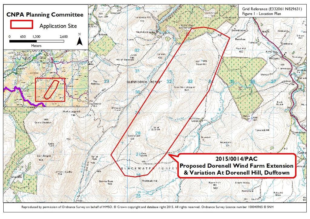
3 PURPOSE OF REPORT 1. The purpose of this report is to provide a consultation response to the Scottish Government Energy Consents Unit (the determining Authority for this application as the output is more than 50 MW) on this proposed wind farm, which lies to the north east of the Cairngorms National Park. The application is accompanied by an Environmental Impact Assessment (EIA). 2. The planning issues being considered in relation to this consultation are whether there are any impacts upon the qualities of the National Park. SITE DESCRIPTION AND PROPOSED DEVELOPMENT Site Description 3. The application site is located within the Moray Council administrative area at Dorenell. It is situated on the Glenfiddich Estate approximately 8 km south west of Dufftown, to the north east of Braes of Glenlivet, and to the south west of the Cabrach to Dufftown A941 road, off which access is proposed via two access points. 4. It is located within the Blackwater Forest and Glenfiddich forest areas, spanning the summits of Thief s Bush Hill, Hill of Dorenell, Carn Allt a Chlaiginn and Scaut Hill. The elevation of the site ranges from approximately 400 to 750m AOD. The site largely comprises moorland with a number of watercourses crossing the site. There are also various walking routes crossing the site, including two that start in Glenlivet and Ladderfoot. 5. The closest point of the wind farm is some 2.25km to the north east of the Cairngorms National Park boundary at the Braes of Glenlivet as shown in Figure 1 and the context of the site is shown in Figure 2. (The blue line on this figure indicates the extension area referred to in paragraph 6 below) 3

4 Figure 2 Context of Site Proposed Development 6. Planning permission is in place for a wind farm at Dorenell comprising 59 turbines of height up to 126 metres to tip and generation capacity of 177 MW. Two separate applications have now been submitted to the Scottish Government: one for variation of the original consent to reduce the number to 53 and reconfigure the layout and the other to extend the site to accommodate a further 10 turbines to give a total of 63 turbines. The height of the proposed turbines will be greater. It is understood that two separate planning applications are required in order to avoid any element of double subsidy under Contracts of Difference (allocation) Regulations 2014 and this is the approach agreed between the applicants and the determining authority (Scottish Government). 7. The proposal will effectively create a single wind farm development. A combined Environmental Statement has been submitted covering all the proposals with the intention that the proposed development will be authorised by the combination of the two applications. The consultation to the Cairngorms National Park Authority (CNPA) from Scottish Government covers this entire scheme. 4
5 8. The applicants advise that the rationale for the proposed change to the approved proposals is because wind turbine technology has advanced rapidly since the original scheme was submitted in 2008 and this, coupled with delays in connecting any wind farm to the national grid, has prompted them to revisit the design of the original scheme with the aim of increasing electricity generating capacity. 9. The scheme now proposes the erection of 63 wind turbines, 15 of which will be 125 metres high to blade tip, with the remaining 48 to be 150 metres high to blade tip. Hub height will be 75 metres and 100 metres respectively. Rotor diameter for both heights of turbines is up to 101 metres and the total generating capacity is 207 MW. 10. Other components of the development are as follows: a) Crane hardstanding areas b) Access roads including upgrades to existing tracks and 38 km of new tracks of running width 5 metres c) Four permanent wind monitoring masts d) Sub stations including underground cables and transformers. The grid connection would be via the new substation. Details of the connection from the site to the wider network would be the subject of a separate consents procedure. The anticipated grid connection point is at Blackhillock near Keith. e) Five on-site borrow pits 11. Figure 3 illustrates the proposed layout as compared to the consented layout where the red markers are the proposed turbine location and the blue are the consented locations. 5

6 Figure 3 Proposed Layout Compared to Consented Layout 6
7 12. As stated previously, the application was accompanied by an Environmental Statement (ES), which covered the following key areas: a) Landscape and visual impact assessment b) Wild land assessment c) Land use, recreation and access d) Ecology and Ornithology e) Hydrology, geology and hydrogeology f) Cultural heritage - which referred to impacts upon the Roman Catholic seminary at Scalan and concluded that indirect impacts were not significant. All impacts upon cultural heritage considered to be directly comparable with those presented by the consented scheme and not significant g) Telecommunications and aviation h) Noise i) Traffic j) Socio Economic Impacts including tourism and recreation. This concluded that the creation and upgrading of the network of access tracks would improve access on the Glenfiddich estate and encourage recreation. 13. A statement of Community Consultation and a Planning Statement were also provided. The Planning Statement outlines how it is considered the development complies with relevant planning policies although it does not identify the National Park Partnership Plan which contains relevant policies relating to development affecting the setting and special landscape qualities of the National Park. It refers instead to the Cairngorms Local Plan and Local Development Plan which are not relevant in this case. 14. The Landscape and Visual Impact Assessment (LVIA) information sought to identify the effects of the proposed development on the landscape and visual resource in the Study Area (defined as 35 km radius of the site centre) and assess the significance of effects. This covered three main areas: (a) Effects on landscape (b) Effects on views (c) Cumulative effects 7
8 15. The LVIA included photomontages and visualisations from a number of viewpoints (VPs) including seven from within the National Park at: (1) Morven (VP19 at 22.6 km distant) (2) Ladder Hills (VP11 at 6 km) (3) Meall Gaineimh (VP12 at 24.8 km) (4) Tom Trumper (VP14 at 10 km) (5) Meal a Bhuachaille (VP16 at 34.1 km) (6) Cromdale Hills (VP17 at 16.2km (7) A939 Tomintoul (VP15 at 15 km) A further wire frame visualisation to show impacts from Scalan, the category A Listed Roman Catholic seminary in the Braes of Glenlivet to the south of the site, was provided following a request from the CNPA Landscape Advisor and Scottish Natural Heritage (SNH) along with wireframes from Braes of Glenlivet and the heritage path. 16. The LVIA concluded that, despite the scale of the development, the significant effects occur in a relatively contained core of the study area, which includes a small part of the north east area of the Cairngorms National Park at the Ladder Hills. It also concluded that in all remaining parts of the study area, (including the remaining parts of the National Park, the Cairngorms National Scenic Area and the Cairngorms Wild Land Area) effects will not be significant largely because of their distance from the development and also because of the wider influence on the character of these areas especially from the Cairngorms Mountains, which in contrast to the Dorenell Hills, form a much more remarkable and scenic landscape influence. 17. It also concluded that in comparing the consented and the proposed schemes the impacts were broadly similar with the scale of change not sufficient to change the significance of effects. RELEVANT PLANNING HISTORY 18. Some Members may recall the previous application for a wind farm at Dorenell (as referred to earlier in this report) and which was considered at the September 2008 meeting of the CNPA Planning Committee. At this time the Committee objected to the application (in line with officer recommendation) raising the following concerns: a) the cumulative impact with other windfarms upon the quality of the National Park and its setting b) impacts upon wild land value c) potential impacts upon golden eagle d) economic impacts arising from reduction in quality of tourism experience for walkers and those taking part in traditional sporting activities e) the need to consider the carbon footprint balance between construction and energy benefits 8
9 19. This application progressed to a public inquiry in October 2010 and consent was granted by the Scottish Government in December 2011 in line with the recommendations of the Directorate of Planning and Environmental Appeals Reporter. The Reporter concluded that the landscape and visual impacts, including cumulative impacts and the effects upon the National Park, were not unacceptable. A copy of the Scottish Ministers decision letter is included in Appendix More recently in 2013, CNPA officers provided advice at the Environmental Impact Assessment scoping stage as to key issues to be addressed with any submission for an extension to the consented development. These issues included the need to assess the effect on the special landscape qualities experienced in the Ladder Hills and the vicinity of Braes of Glenlivet, the setting of Scalan, and impacts upon wildness. At this scoping stage the proposal was to extend the site to accommodate a total of 68 turbines of maximum height up to 150 metres. The scoping response highlighted that the proposal risked having significant adverse landscape and visual effects, and these impacts may affect the landscape setting of the National Park and the experiences of its special landscape qualities to a significant degree. 21. As Members are aware there has been some pressure for new wind farms around the National Park and in the vicinity of Dorenell two key sites, both located to the east of Dorenell, are as follows: a) Kildrummy where 8 wind turbines of height 93 metres to tip have been approved and installed following public inquiry. The CNPA Planning Committee considered this application at the May 2005 meeting and objected to the proposal. b) Clashindarroch where 18 wind turbines of height 110 to tip have been approved and are being installed 22. These sites are shown in Appendix 2 Wind Farm Map which shows key sites at planning and pre planning stage around the National Park. DEVELOPMENT PLAN CONTEXT National Policy and Guidance 23. Scottish Planning Policy (SPP, revised 2014) sets out national planning policies that reflect Scottish Ministers priorities for the operation of the planning system and for the development and use of land. Under planning law, planning applications must be determined according to the development plan unless material considerations indicate otherwise. The content of SPP is a material consideration in planning decisions that carries significant weight. The SPP promotes consistency in the application of policy across Scotland while allowing sufficient flexibility to reflect local circumstances. 9
10 24. SPP specifically sets out that the planning system should support the transformational change to a low carbon economy, support the development of a diverse range of electricity generation from renewable energy technologies, and guide development to appropriate locations. In paragraph 154, it sets out the Scottish Government s commitment to increasing the overall amount of energy generated from renewable sources to 30% by 2020 with the equivalent of 100% of electricity demand being met by renewable sources by this date. In terms of policy principles, paragraph 154 requires the planning system to guide renewable energy development to appropriate locations and to advise on the issues that would need to be taken into account when specific proposals are being assessed. 25. Paragraph 169 sets out the issues to be considered when considering energy infrastructure development proposals including the need to consider likely cumulative impacts and landscape and visual impacts, including effects on wild land. Further advice on wind energy is contained in the Scottish Government online information note on onshore wind turbines which sets out issues to be considered and references the range of SNH publications and guidance on wind energy and planning. 26. National Parks are highlighted in paragraphs of the SPP under the promoting rural development section. These paragraphs re-state the aims of the National Parks and the need to pursue these collectively. SPP highlights that if there is a conflict between the first aim (conserving and enhancing the natural and cultural heritage of the area) and any of the others then greater weight must be given to the first aim. Planning decisions are expected to reflect this weighting and be consistent with these aims. 27. Paragraph 212 of the SPP highlights that where development affects a National Park it should only be permitted where the objectives of the designation and the overall integrity of the area will not be compromised, or any significant adverse impacts on the qualities for which the area has been designated are clearly outweighed by social, environmental or economic benefits of national importance. 28. SPP also highlights in paragraph 85 that these aims and requirements apply to development outwith a National Park that affects the Park. 29. Wild Land Areas are addressed in paragraph 200 of the SPP which are identified as being very sensitive to any form of intrusive human activity and have little or no capacity to accept development with the requirement set out for Plans to identify and safeguard the character of areas of wild land as identified in the Scottish Natural Heritage 2014 map of wild land areas. In relation to development management, it is highlighted in paragraph 215 that development may be appropriate in some circumstances, and further consideration is required to demonstrate that any significant effects on the qualities of these areas can be substantially overcome by siting, design or other mitigation. 10
11 Strategic Policy Cairngorms National Park Partnership Plan The Cairngorms National Park Partnership Plan sets out the vision and overarching strategy for managing the Park and provides focus and priorities at a time of limited financial resources. The Plan also provides a strategic context for the Local Development Plan and shows how the four aims of the National Park can be achieved together. It sets out the strategic direction and priorities for the Park. 31. Three long term outcomes for the Park are set out as follows: 1) A sustainable economy supporting thriving businesses and communities 2) A special place for people and nature with natural and cultural heritage enhanced and 3) People enjoying the park through outstanding visitor and learning experiences 32. These outcomes address the interaction of the three main characteristics of the National Park these being; that the Park is an internationally important area for nature conservation; a fragile rural economy; and an internationally known tourism destination. Recognising the relationship of these outcomes is at the heart of the National Park. A series of work programmes to help deliver the outcomes is set out in the Plan. 33. Specific policies of the Plan seek to promote and enhance the special qualities of the Park. In particular Policy 1.3 sets out that large scale commercial wind turbines (defined as more than one turbine and more than 30 metres in height) are not compatible with the special qualities of the National Park and are not considered to be appropriate within the National Park, or where outside the Park they affect its landscape setting. 34. Also relevant is Policy 2.3 which seeks to conserve and enhance the special landscape qualities of the National Park, with a particular focus on conserving and enhancing wildness qualities and enhancing opportunities to enjoy and experience the landscapes of the Park. CONSULTATIONS 35. The Scottish National Park Authorities have agreed an arrangement with Scottish Natural Heritage (SNH) on respective roles in advisory casework. This sets out that SNH will take the lead role in considering the impacts on the National Park designation of proposals outside the Park, with the National Park Authority supporting. Accordingly the views of both SNH and the CNPA Landscape Advisor have been included in this report. 36. Scottish Natural Heritage landscape advice concludes that the extent of significant landscape and visual impacts upon sensitive receptors, in particular 11
12 the National Park, indicates that the scale of the proposed development has exceeded the capacity of the site landscape. In summary, it is considered that: a) The introduction of 150m high turbines onto the hills of the site, physically and visually dominate the scale of the landscape and is contrary to fundamental design principles and the consideration of scale within SNH siting and design guidance b) The horizontal extent of the development is not contained within the ridgeline landscape c) Whilst the development broadly appears as one large group, in many views the turbines ranging from south to north increase in vertical and horizontal spacing, skylining and overlap, creating an overall unbalanced layout with respect to the underlying simplicity of the landscape. 37. SNH conclude that the proposed wind farm would have a significant adverse effect on the special landscape qualities in areas close to the wind farm, for which the Park was designated, to the extent that it would fail to meet Scottish Planning or National Park Partnership Plan policy. SNH have formally objected to the application on the grounds of the significant adverse impacts on the Cairngorms National Park, and a copy of their objection is attached as Appendix The CNPA Landscape Advisor has assessed this application and a copy of the full response is attached as Appendix The officer advises that the Zone of Theoretical Visibility (ZTV) information demonstrates that the development will be visible from within the National Park in the Ladder Hills and hills of the connecting Blackwater Forest; summits and slopes west of Glen Buchat; Braes of Glenlivet and hills to the south of the Braes; Ben Avon and nearby hills; Morven; Hills of Cromdale; Meal a Bhuachaille and some visibility at Cairngorm at 35 km away. 40. In terms of Landscape Character, the application site is in the Uplands Moray Landscape Character Area (LCA), which in terms of landform, landcover and altitude is a continuation of the north eastern hills Cairngorms National Park landscape character area. This LCA, along with the Braes of Glenlivet LCA, is the most likely to be affected by the development. 41. The applicants Landscape and Visual Impact Assessment (LVIA) has concluded that there will be significant adverse effects on the north eastern hills LCA (namely the Ladder Hills) and our Landscape Advisor agrees with this conclusion whilst noting that the sensitivity and magnitude of effect is higher than has been assessed due to the fact that the LCA is within the National Park and also the proximity of the turbines to the National Park. 12
13 42. The LVIA also concludes that the impact upon the Braes of Glenlivet LCA will not be significant. Our Landscape Advisor does not agree with this conclusion pointing out that there is no wind farm development within this LCA and there is currently little visibility of any wind farm development from here. The Landscape Advisor highlights the specific landscape qualities of the Braes of Glenlivet arising from its hidden, secluded nature which is very susceptible to the kind of development proposed. As a result, the sensitivity of this landscape is considered to be high. The ZTV illustrates that there will be almost continuous visibility across the central and southern part of the Braes of Glenlivet LCA with turbines visible from the low lying areas as well as higher parts. Turbines will be seen along the horizon of the hill ridge as tips, partial blades, whole blades, hubs and partial towers at distances from 6 km to 10.5 km away. The diameter of the blades is 100 metres with a swept area of 7,823 square metres the moving blades will be clearly visible at these distances. 43. Consequently the magnitude of the impacts will also be medium to high with the turbines substantially changing the natural skyline and the experiential characteristics of history, sense of seclusion and secrecy, and resulting in a significant adverse effect upon the Braes of Glenlivet. The officer considers that the magnitude of change as compared to the originally consented scheme constitutes a step change on the character and experience of the Braes of Glenlivet. As well as an increase in height, there is a significant increase in blade dimensions and swept area which adds to the apparent stature of the turbines. 44. Visual Impacts have also been assessed in relation to consideration of the visualisations provided from the 7 viewpoints from within the National Park. These comprise photomontages and wireframes of the proposed development on its own, in comparison to the consented scheme and also in relation to cumulative impacts with other consented schemes. A detailed assessment is contained within the CNPA Landscape report as attached as Appendix 4. Key points are as follows: a) Viewpoint 19 Morven (at 22.6 km): extent of development will be similar to consented scheme, but increase in mass and height makes the scheme more prominent. Effects will be significant, increasing the perceived dominance in the landscape b) Viewpoint 11 Little Geal Charn/Ladder Hills (at 6 km): this view will be similar to views from the northern summits of the Ladder Hills. The changed height will affect more of the skyline with the greater size of blades increasing visual contrast and massing with a significant effect on walkers c) Viewpoint 12 Meall Gaineimh (at 24.8 km): this viewpoint lies within a wild land area on the Ben Avon ridge. The proposal will be more of a prominent focal feature than the consented scheme due to the increased massing of turbines on the skyline and again there will be a significant effect on walkers 13
14 d) Viewpoint 14 Tom Trumper (at 10 km): located to the south of the Braes of Glenlivet west of the Ladder Hills. Again the proposed scheme is considered to have a greater magnitude of change than the consented scheme due to the greater visibility and prominence, altering the perception of scale within the Braes of Glenlivet e) Viewpoint 16 Meal a Bhuachaille (at 34.1 km): this viewpoint is distant from the proposed development near Glenmore. Visibility will be slightly greater due to increased stature, but it is considered that the proposal is unlikely to be particularly prominent f) Viewpoint 17 Carn Eachie/ Cromdale Hills (at 16.2km): this viewpoint is located on the National Park boundary and is likely to be similar to views further south on the Cromdale range. From here the proposal will read as two groups - one of turbines, one of blades split by the intervening hill ridge causing a confusing relationship to landform as opposed to the previous scheme where only blade tips would have been visible 45. In respect of Impacts on National Park Setting from the Ladder Hills, the upland character remains consistent as it crosses the Park boundary and extends into the Blackwater and Glenfiddich forest with this area being a key contributor to the setting of the National Park around its north east edge. The wind farm will appear very much within the setting of the National Park and will have a significant adverse effect upon this setting and would fail to meet policy 1.3 of the National Park Partnership Plan. The immediate setting in this part of the National Park also contributes to some of the Special Qualities experienced within the Park. 46. Impacts upon the Special Landscape Qualities of the National Park have been assessed in the ES with a focus on surrounding hills, moorlands, wild land and grand panoramas, concluding that there will be adverse impacts, but only in the Ladder Hills area. However, there is no assessment of the special landscape qualities of the more settled parts of the National Park and in particular the Braes of Glenlivet which is a landscape both cultural and natural. The proposed development will impinge upon these special qualities to a significant degree resulting in an adverse effect upon the experience of this place. These impacts mean that the development fails to meet Policy 2.3 of the National Park Partnerhip Plan. 47. In terms of the Integrity of the National Park designation and the Qualities for which it was designated, the officer advises that whilst the wind farm would be experienced from a number of locations in the north/north eastern part of the National Park it could not be said to significantly affect the integrity of the Park. However, it would have a significant adverse effect on some of the special landscape qualities for which the Park was designated to the extent that it would fail to meet Scottish Planning Policy. 48. Finally with regard to Wildness, whilst the officer concurs that there would be no significant effect on the Cairngorms Wild Land Area 15, there are high areas of wildness within the Ladder Hills where the special qualities of wildness/experience will be compromised if not lost. 14
15 49. In conclusion, it is considered that the proposed development on its own would impact significantly on the landscape setting of the National Park and have significant adverse landscape and visual impacts ion the Ladder Hills and Braes of Glenlivet, and Morven. This means it fails to comply with National Park Partnership Plan and Scottish Planning policy. 50. The magnitude of change, landscape and visual effects and effects on special landscape qualities arising out of the proposed development in relation to the consented development is considered to be significant and adverse as a result of the increase in scale and swept blade area, as well as greater visual mass/density. APPRAISAL 51. As noted earlier the proposed wind farm is located on a site which lies around 2.2 km (at its closest point) away from the north east boundary of the National Park. The key planning issue for consideration is that of the visual and landscape impact of the development upon the National Park and its setting, with both national planning policy and the National Park Partnership Plan setting out the need to consider the impacts of such development upon the setting of the National Park. 52. These policies expressly set out that where development affects a National Park it should only be permitted where the objectives of the designation and the overall integrity of the area will not be compromised, or any significant adverse impacts on the qualities for which the area has been designated are clearly outweighed by social, environmental or economic benefits of national importance. Scottish Planning Policy highlights that this policy approach applies to development outwith a National Park which affects the Park, whilst National Park Partnership Plan Policy 1.3 sets out the requirement to ensure that large scale commercial wind turbines do not affect the landscape setting of the National Park. Finally Policy 2.3 of the National Park Partnership Plan seeks to conserve and enhance the special landscape qualities of the National Park, with a particular focus on conserving and enhancing wildness qualities and enhancing opportunities to enjoy and experience the landscapes of the Park. 53. Set against this background it is essential to fully consider the impacts of the proposed development on the setting of the National Park. These impacts have been assessed in terms of the proposal in its own right, but also in relation to the proposal against the baseline of the existing consented wind farm, i.e. whether the additional impacts of the development as proposed are acceptable. When the NPA objected to the original application in 2008 it was considered that it would adversely impact upon the National Park. This view was not upheld by the Directorate of Environmental and Planning Appeals or Scottish Ministers and the fact remains that there is a valid planning consent at Dorenell for 59 wind turbines. The current proposal to vary and extend the approved layout - by both increasing numbers and height of turbines - now requires to be considered against the baseline of the consented scheme and also in the light of current National Park Partnership 15
16 Plan and Scottish planning policies which set out a clear requirement to consider the setting of National Parks and its special landscape qualities, which is more clearly expressed now than in The applicant s Environmental Statement suggests that the overall impacts are not significant being limited to a small part of the National Park. Following careful consideration and taking into account the landscape advice of our consultees it is considered however that the impacts are significant and adverse in this case. 55. There is no doubt that the proposal will be more visible from the Braes of Glenlivet than the previous submission with the applicants own visualisations illustrating this. Visibility will not be restricted to the higher summits of the National Park, but will extend into the lower slopes of the Braes of Glenlivet and Scalan the former Roman Catholic seminary used for training priests in the 1700s and known as Glenlivet s hidden college. 56. The new proposal will effectively spill over into the secluded Glenlivet bowl with the large rotor blades and increased height of the proposed turbines being out of scale and character with the landscape here. This effect will also impact adversely on the experience of parties visiting Scalan which is an important cultural destination in the National Park, of national importance being a Category A listed building of architectural and historic importance, as well as the cultural background and history it offers to the area. The experience of visiting a hidden valley will be lost if infrastructure of this scale is introduced to its setting. It will also impact adversely on the Braes of Glenlivet Landscape character area all as set out in the CNPA Landscape Advisor and SNH comments. This will impact adversely upon the special qualities of the National Park and thus fail to comply with planning policies. 57. The proposed development will also be more visible from a number of key viewpoints within the National Park, specifically the Ladder Hills and Morven and will adversely impact upon the special landscape qualities, the enjoyment and experience of walkers in these areas and the sense of wildness. 58. Overall these impacts mean that the proposed development will adversely impact upon the special landscape qualities for which the Cairngorms National Park was designated, contrary to planning policies. 16
17 59. In terms of impacts upon the setting of the National Park it is clear from the landscape assessments by both SNH and the CNPA Landscape Advisor that application site is part of a landscape character area which contributes to the setting of the National Park on its north eastern edge and will be seen within this setting. The magnitude of change resulting from the proposed development as compared to the consented development is considered to be significant and adverse as a result of the increase in scale, swept blade area and greater visual mass and density resulting in an adverse impact upon the setting of the Cairngorms National Park, again contrary to Scottish Planning policy and the policies of the Cairngorms National Park Partnership Plan. CONCLUSION 60. In these overall circumstances the proposed development is considered to be contrary to the aims of the National Park, Scottish Planning Policy and the policies of the Cairngorms National Park Partnership Plan. It is therefore recommended that the CNPA object to this proposed development on the basis of the adverse impacts upon the National Park. RECOMMENDATION That Members of the Committee support a recommendation of OBJECTION to the Application to Extend and Vary the Section 36 Consent and Deemed Planning Permission for Dorenell Wind Farm, Dorenell Hill, Near Dufftown for the following reasons : 1. The proposed development is contrary to Scottish Planning Policy, the aims of the Cairngorms National Park and the policies of the Cairngorms National Park Partnership Plan in that it will not conserve the natural and cultural heritage of the National Park in the Braes of Glenlivet landscape character area, where the increased dominance and layout of the proposed development will adversely impact upon the setting, seclusion and qualities of the Braes of Glenlivet and Scalan. 2. The proposed development is contrary to Scottish Planning Policy and to Policy 2.3 of the Cairngorms National Park Partnership Plan in that it will adversely affect the qualities for which the National Park is designated in relation to the significant adverse landscape and visual impacts upon the Ladderhills, Braes of Glenlivet and Morven arising out of the layout, scale, massing and density of the proposed development. 3. The proposed development is contrary to Scottish Planning Policy and to Policy 1.3 of the Cairngorms National Park Partnership Plan in that it will adversely affect the setting of the Cairngorms National Park on its north eastern edge. 17
18 4. The proposed development is contrary to Scottish Planning Policy and to Policy 2.3 of the Cairngorms National Park Partnership Plan in that it will adversely affect the wildness of the Cairngorms National Park and opportunities to enjoy and experience the landscapes of the Cairngorms National Park due to the magnitude of change arising out of the increased scale, swept blade area and greater visual mass and density of the proposed development, whereby it will visually dominate the landscape. Katherine Donnachie 25 March 2015 The map on the first page of this report has been produced to aid in the statutory process of dealing with planning applications. The map is to help identify the site and its surroundings and to aid Planning Officers, Committee Members and the Public in the determination of the proposal. Maps shown in the Planning Committee Report can only be used for the purposes of the Planning Committee. Any other use risks infringing Crown Copyright and may lead to prosecution or civil proceedings. Maps produced within this Planning Committee Report can only be reproduced with the express permission of the Cairngorms National Park Authority and other Copyright holders. This permission must be granted intu advance. 18
CAIRNGORMS NATIONAL PARK AUTHORITY
 Title: Prepared by: CONSULTATION FROM ANGUS COUNCIL KATHERINE DONNACHIE, PLANNING OFFICER (DEVELOPMENT MANAGEMENT) DEVELOPMENT PROPOSED: (1) ERECTION OF GAIA TURBINE OF 18 M. HUB HEIGHT AND 23.5 M. TO
CAIRNGORMS NATIONAL PARK AUTHORITY
 Title: REPORT ON CALLED-IN PLANNING APPLICATION Prepared by: KATHERINE DONNACHIE (SENIOR PLANNING OFFICER, DEVELOPMENT MANAGEMENT) DEVELOPMENT PROPOSED: FULL PLANNING PERMISSION FOR REPLACEMENT BRIDGE
Definition of Cumulative Landscape and Visual Effects
 SECTION 5: GUIDANCE FOR ASSESSING CUMULATIVE LANDSCAPE AND VISUAL EFFECTS 5.1 Although this landscape sensitivity and capacity study has identified that parts of the National Park may be able to accommodate
Change Paper / Date CAIRNGORMS NATIONAL PARK AUTHORITY
 Change Paper / Date CAIRNGORMS NATIONAL PARK AUTHORITY Title: Prepared by: REPORT ON CALLED-IN PLANNING APPLICATION FIONA MURPHY (PLANNING OFFICER DEVELOPMENT MANAGEMENT) DEVELOPMENT PROPOSED: REFERENCE:
Assessing the impact of smallscale wind energy proposals on the natural heritage
 Scottish Natural Heritage Assessing the impact of smallscale wind energy proposals on the natural heritage Guidance March 2016 Version 3 1 Contents 1. Introduction. 3 2. Encouraging a spatial approach
TOWN AND COUNTRY PLANNING (SCOTLAND) ACT 1997
 ACT 1997") TOWN AND COUNTRY PLANNING (SCOTLAND) ACT 1997 APPEAL AGAINST REFUSAL OF PLANNING PERMISSION FOR CONSTRUCTION OF WIND FARM, CONSISTING OF ERECTION OF 12 NO. WIND TURBINES, HEIGHT OF 70 METRES TO HUB, ASSOCIATED
TOWN AND COUNTRY PLANNING (SCOTLAND) ACT 1997 APPEAL AGAINST REFUSAL OF PLANNING PERMISSION FOR CONSTRUCTION OF WIND FARM, CONSISTING OF ERECTION OF 12 NO. WIND TURBINES, HEIGHT OF 70 METRES TO HUB, ASSOCIATED
List of Policies. SESPlan. None applicable. Consolidated Scottish Borders Local Plan 2011: POLICY G1 - QUALITY STANDARDS FOR NEW DEVELOPMENT
 List of Policies Local Review Reference: 15/00021/RREF Planning Application Reference: 15/00616/FUL Development Proposal: Installation of 16no solar photovoltaic (PV) panels to roof Location: Raebank,
Wind energy development in the South Pennines landscape
 Wind energy development in the South Pennines landscape Programme for today Background Policy context South Pennines landscape Impacts of wind energy development The South Pennines Wind Energy Landscape
North York Moors National Park Authority Planning Committee
 Item 8 North York Moors National Park Authority Planning Committee 12 December 2013 Consultation from Redcar and Cleveland Borough Council on proposed Wind Farm at Bank Field Guisborough 1. Purpose of
CAIRNGORMS NATIONAL PARK AUTHORITY
 Title: REPORT ON CALLED-IN PLANNING APPLICATION Prepared by: ANDREW TAIT, PLANNING OFFICER (DEVELOPMENT MANAGEMENT) DEVELOPMENT PROPOSED: ERECTION OF A CAMERA OBSCURA WITHIN MOUNTAIN GARDEN AREA, CAIRNGORM
Perth and Kinross Council Development Management Committee 20 February 2013 Report of Handling by Development Quality Manager
 Perth and Kinross Council Development Management Committee 20 February 2013 Report of Handling by Development Quality Manager 4(4)(iii) 13/81 Erection of sports hall, associated changing facilities, offices
Perth and Kinross Council Development Management Committee 8 June Pre-Application Report by Development Quality Manager
 Perth and Kinross Council Development Management Committee 8 June 2016 5(3)(i) 16/259 Pre-Application Report by Development Quality Manager Residential development at St Martins Road, Land 120 metres West
PLANNING COMMITTEE DATE: 07/09/2015 REPORT OF THE SENIOR MANAGER PLANNING AND ENVIRONMENT SERVICE CAERNARFON. Number: 4
 Number: 4 Application Number: C15/0034/37/LL Date Registered: 21/05/2015 Application Type: Full - Planning Community: Llanaelhaearn Ward: Llanaelhaearn Proposal: Location: Summary of the Recommendation:
Scottish Natural Heritage consultation on draft guidance: Assessing impacts on Wild Land Areas technical guidance
 Scottish Natural Heritage consultation on draft guidance: Assessing impacts on Wild Land Areas technical guidance Summary This consultation invites comment on the draft document Assessing impacts on Wild
9 Archaeology & Cultural Heritage
 High Clachaig Wind Farm Scoping Report Page 56 9 Archaeology & Cultural Heritage 9.1 Introduction Cultural heritage in this context means the above- and below-ground archaeological resources, built heritage,
TOPIC PAPER 2: Links to other sustainability tools
 TOPIC PAPER 2: INTRODUCTION 1.1 Landscape Character Assessment can inform a range of other sustainability tools and methodologies. Equally these other tools may assist in reaching decisions concerning
SgurrEnergy Ltd Linfairn Wind Farm: Environmental Statement: Chapter 6
 6 LANDSCAPE AND VISUAL 6.1 INTRODUCTION This chapter of the ES evaluates the impacts of the Project on the landscape character and visual amenity. It achieves this by describing and evaluating the potential
Lower Sensitivity. VS Classification Level 2: Exposed Upland/Plateau
 S05 Y Moelwynion Reproduced from the Ordnance Survey map with the permission of Ordnance Survey on behalf of the Controller of Her Majesty s Stationery Office, Crown copyright Licence No. 100023387 Location
WilloWind Linfairn Limited Linfairn Wind Farm - Addendum. Planning Statement
 WilloWind Linfairn Limited Linfairn Wind Farm - Addendum Planning Statement December 2014 Report Summary The has been prepared by SgurrEnergy Ltd on behalf of WilloWind Linfairn Limited. The document provides
Lower Sensitivity. VS Classification Level 2: Exposed Upland/Plateau
 S02 Y Carneddau Reproduced from the Ordnance Survey map with the permission of Ordnance Survey on behalf of the Controller of Her Majesty s Stationery Office, Crown copyright Licence No. 100023387 Location
CAIRNGORMS NATIONAL PARK AUTHORITY
 CAIRNGORMS NATIONAL PARK AUTHORITY Title: Prepared by: REPORT ON CALLED-IN PLANNING APPLICATION ROBERT GRANT, PLANNING OFFICER (DEVELOPMENT MANAGEMENT) DEVELOPMENT PROPOSED: USE OF LAND FOR THE PURPOSES
Longmore House Salisbury Place Edinburgh EH9 1SH. 18 January 2008
 We safeguard the nation s historic environment and promote its understanding and enjoyment Martin Dean Access and Countryside Projects Officer Development and Environmental Services Clackmannanshire Council
Reporter: Section 3 Place, Drymen, pp reference: Body or person(s) submitting a representation raising the issue (including reference number):
 submitting a representation raising the issue (including reference number):") Issue 10 Drymen Development plan Reporter: Section 3 Place, Drymen, pp.66-69 reference: Body or person(s) submitting a representation raising the issue (including reference number): Nadja Ray (85) Stuart
Issue 10 Drymen Development plan Reporter: Section 3 Place, Drymen, pp.66-69 reference: Body or person(s) submitting a representation raising the issue (including reference number): Nadja Ray (85) Stuart
Newcourt Masterplan. November Exeter Local Development Framework
 Newcourt Masterplan November 2010 Exeter Local Development Framework Background The Exeter Core Strategy Proposed Submission sets out the vision, objectives and strategy for the development of Exeter up
Environmental Impact Assessment
 Environmental Impact Assessment Environmental impact assessment (EIA) is the process of systematically drawing together an assessment of the likely significant environmental effects of a development project.
Lower Sensitivity. VS Classification Level 2: Exposed Upland/Plateau (86%)/ Upland Valleys (10%)
/ Upland Valleys (10%)") S09 Y Mignient Reproduced from the Ordnance Survey map with the permission of Ordnance Survey on behalf of the Controller of Her Majesty s Stationery Office, Crown copyright Licence No. 100023387 Location
S09 Y Mignient Reproduced from the Ordnance Survey map with the permission of Ordnance Survey on behalf of the Controller of Her Majesty s Stationery Office, Crown copyright Licence No. 100023387 Location
VOLUME 2 APPENDIX 3.2. Scoping Opinion from Brecon Beacons National Park Authority
 C A N T R E F A D V E N T U R E F A R M L U G E E N V I R O N M E N T A L S T A T E M E N T VOLUME 2 APPENDIX 3.2 Scoping Opinion from Brecon Beacons National Park Authority Mr Wynne Davies Cantref Adventure
EAST OF ENGLAND OFFICE
 Mr Philip Isbell Direct Dial: 01223 582751 Mid Suffolk District Council 131 high Street Our ref: P00524468 Needham Market Ipswich Suffolk IP6 8DL 18 January 2017 Dear Mr Isbell T&CP (Development Management
Replacement Golf Course Facilities and Residential Development, Churston. Environmental Statement Non-Technical Summary
 Replacement Golf Course Facilities and Residential Development, Churston Environmental Statement Non-Technical Summary July 2011 Reproduced from the Ordnance Survey s map with the permission of the Controller
Decision by Trevor A Croft, a Reporter appointed by the Scottish Ministers
 Appeal Decision Notice T: 01324 696 400 F: 01324 696 444 E: dpea@scotland.gsi.gov.uk Decision by Trevor A Croft, a Reporter appointed by the Scottish Ministers Planning appeal reference: PPA-170-2107 Site
SECTION 36 OF THE ELECTRICITY ACT 1989 AND SECTION 57 OF TOWN AND COUNTRY PLANNING (SCOTLAND) ACT 1997
 ACT 1997") Planning and Environmental Appeals Division Report to the Scottish Ministers SECTION 36 OF THE ELECTRICITY ACT 1989 AND SECTION 57 OF TOWN AND COUNTRY PLANNING (SCOTLAND) ACT 1997 Report by Dan Jackman,
Planning and Environmental Appeals Division Report to the Scottish Ministers SECTION 36 OF THE ELECTRICITY ACT 1989 AND SECTION 57 OF TOWN AND COUNTRY PLANNING (SCOTLAND) ACT 1997 Report by Dan Jackman,
Reference: 15/06961/RCU Received: 13th November 2015 Accepted: 17th November 2015 Ward: Coppetts Expiry 12th January 2016
 Location 91 Manor Drive London N20 0XD Reference: 15/06961/RCU Received: 13th November 2015 Accepted: 17th November 2015 Ward: Coppetts Expiry 12th January 2016 Applicant: Mr Christos Papadopoulos Proposal:
Request for a Scoping Opinion by Provectus. Proposed Surface Mining of Coal on Land west off the A61, Hill Top Farm, Clay Cross, Derbyshire
 Request for a Scoping Opinion by Provectus Proposed Surface Mining of Coal on Land west off the A61, Hill Top Farm, Clay Cross, Derbyshire January 2012 Contents 1 Introduction & Background... 1 2 Site
The Town and Country Planning (Environmental Impact Assessment) (Wales) Regulations 2016, Regulation 13 Scoping Opinion
 (Wales) Regulations 2016, Regulation 13 Scoping Opinion") Mr Graham Clark Berrys Newchurch Farm Kinnersley Hereford HR3 6QQ BY EMAIL The Town and Country Planning (Environmental Impact Assessment) (Wales) Regulations 2016, Regulation 13 Scoping Opinion SC/2017/0001
Mr Graham Clark Berrys Newchurch Farm Kinnersley Hereford HR3 6QQ BY EMAIL The Town and Country Planning (Environmental Impact Assessment) (Wales) Regulations 2016, Regulation 13 Scoping Opinion SC/2017/0001
Natural Heritage Guidance and Information. 6 th of December 2007 Brendan Turvey
 Natural Heritage Guidance and Information 6 th of December 2007 Brendan Turvey Outline Guidance available New guidance Guidance in the pipeline Revision of SLG Sitelink / Natural spaces Wind farm footprint
S18 Mynyddoedd Yr Aran
 S18 Mynyddoedd Yr Aran Reproduced from the Ordnance Survey map with the permission of Ordnance Survey on behalf of the Controller of Her Majesty s Stationery Office, Crown copyright Licence No. 100023387
Planning and Regulatory Committee 20 May Applicant Local Councillor Purpose of Report
 Planning and Regulatory Committee 20 May 2014 7. APPLICATION FOR PLANNING PERMISSION FOR THE CARRYING-OUT OF DEVELOPMENT PURSUANT TO PLANNING PERMISSION REFERENCE NUMBER 603451 DATED 28 FEBRUARY 2007 WITHOUT
UTT/17/2075/FUL - (BERDEN) (Referred to Committee by Councillor Janice Loughlin. Reason: In the Public Interest)
 (Referred to Committee by Councillor Janice Loughlin. Reason: In the Public Interest)") UTT/17/2075/FUL - (BERDEN) (Referred to Committee by Councillor Janice Loughlin. Reason: In the Public Interest) PROPOSAL: LOCATION: APPLICANT: Amendments to the design of a scheme for a 49.99MW battery
UTT/17/2075/FUL - (BERDEN) (Referred to Committee by Councillor Janice Loughlin. Reason: In the Public Interest) PROPOSAL: LOCATION: APPLICANT: Amendments to the design of a scheme for a 49.99MW battery
Derry City and Strabane District Council Planning Committee Report
 Derry City and Strabane District Council Planning Committee Report COMMITTEE DATE: 23 rd March 2016 APPLICATION No: APPLICATION TYPE: PROPOSAL: LOCATION: APPLICANT: LA11/2015/0395/F Residential Development
12 TH ANNUAL CHILTERNS AONB PLANNING CONFERENCE ENGLISH HERITAGE: HISTORIC ENVIRONMENT GOOD PRACTICE ADVICE
 12 TH ANNUAL CHILTERNS AONB PLANNING CONFERENCE ENGLISH HERITAGE: HISTORIC ENVIRONMENT GOOD PRACTICE ADVICE MARTIN SMALL HISTORIC ENVIRONMENT PLANNING ADVISER ENGLISH HERITAGE Policy ENGLISH HERITAGE GOOD
Lower Sensitivity. VS Classification Level 2: Exposed Upland/Plateau
 S04 Moel Hebog Reproduced from the Ordnance Survey map with the permission of Ordnance Survey on behalf of the Controller of Her Majesty s Stationery Office, Crown copyright Licence No. 100023387 Location
Longbridge Town Centre Phase 2 Planning Application
 Longbridge Town Centre Phase 2 Planning Application Non-Technical Summary of the Environmental Statement December 2013 Introduction A full application for Planning Permission has been submitted to Birmingham
Cotswolds AONB Landscape Strategy and Guidelines. June 2016
 Cotswolds AONB Landscape Strategy and Guidelines June 2016 Cotswolds AONB Landscape Strategy and Guidelines Introduction The evolution of the landscape of the Cotswolds AONB is a result of the interaction
STATEMENT OF OBJECTION TO THE PROPOSED DEVELOPMENT OF LAND AT CHURCH CLIFF DRIVE FILEY
 STATEMENT OF OBJECTION TO THE PROPOSED DEVELOPMENT OF LAND AT CHURCH CLIFF DRIVE FILEY You will be aware that Scarborough borough council have adopted a new local plan that includes land at Church Cliff
1. Listed Building and Conservation Area considerations 2. Protection of Known Archaeological Remains 3. Parking
 08/01222/FUL ERECTION OF SINGLE STOREY SIDE EXTENSION TO CHURCH TO PROVIDE FOR PARISH HALL (RESUBMISSION OF 08/00206/FUL) AT St Mary And St Giles Church, Church Street, Stony Stratford FOR Rev R Northing
Lower Sensitivity. VS Classification Level 2: Hills, Lower Plateau & Scarp Slopes (74%)/ Lowland Valleys (17%) / Exposed Upland/Plateau (7%)
/ Lowland Valleys (17%) / Exposed Upland/Plateau (7%)") S06 Coedwig Gwydyr Reproduced from the Ordnance Survey map with the permission of Ordnance Survey on behalf of the Controller of Her Majesty s Stationery Office, Crown copyright Licence No. 100023387 Location
S06 Coedwig Gwydyr Reproduced from the Ordnance Survey map with the permission of Ordnance Survey on behalf of the Controller of Her Majesty s Stationery Office, Crown copyright Licence No. 100023387 Location
Keirs Hill Windfarm. Section 36 Application. Review of Environmental Statement - Landscape and Visual Impact Assessment
 Keirs Hill Windfarm Section 36 Application Review of Environmental Statement - Landscape and Visual Impact Assessment Objection on behalf of Save Straiton for Scotland Mark Steele Consultants Limited Phone:
PLANNING COMMITTEE REPORT
 PLANNING COMMITTEE REPORT TO: BY: Planning Committee South Head of Development DATE: 19 December 2017 DEVELOPMENT: SITE: WARD: APPLICATION: APPLICANT: Conversion of existing water storage reservoir to
Ebbsfleet Development Corporation
 Title of Paper Planning and Housing Delivery Report September 2018 Presented by Sub-Committee Mark Pullin, Chief Planning Officer Planning Committee Purpose of Paper and Executive Summary This paper provides
7. The Landscape. 7.1 Introduction. Environmental Impact Statement (EIS) Scoping Report
 Scoping Report") 7. The Landscape 7.1 Introduction The purpose of this section of the EIS Scoping Report is to describe the scope of work and methods to be applied in the identification and assessment of landscape and
7. The Landscape 7.1 Introduction The purpose of this section of the EIS Scoping Report is to describe the scope of work and methods to be applied in the identification and assessment of landscape and
CAIRNGORMS NATIONAL PARK AUTHORITY
 CAIRNGORMS NATIONAL PARK AUTHORITY Title: Prepared by: REPORT ON CALLED-IN PLANNING APPLICATION KATHERINE DONNACHIE (PLANNING OFFICER, DEVELOPMENT MANAGEMENT) DEVELOPMENT PROPOSED: REFERENCE: APPLICANT:
Linfairn Wind Farm Addendum Chapter A6: LVIA
 A6. Landscape and Visual 6.1 Introduction The purpose of this chapter is to review amendments to the Project design and to advise of any consequent alterations to the landscape and visual effects as previously
Plumpton Neighbourhood Development Plan Revised Pre Submission Document - Regulation 14 Consultation
 REPRESENTATIONS... Plumpton Parish Council Plumpton Neighbourhood Development Plan Revised Pre Submission Document - Regulation 14 Consultation Representations submitted on behalf of: Cala Homes (South
Rannoch 132 / 33 kv Substation Extension
 Who we are Scottish and Southern Energy Power Distribution is part of the SSE plc group of companies. We own, maintain and invest in the networks in the north of Scotland the electricity transmission network
DEVELOPMENT MANAGEMENT REPORT
 ITEM A08-1 DEVELOPMENT MANAGEMENT REPORT TO: BY: DATE: DEVELOPMENT: SITE: WARD: APPLICATION: APPLICANT: Development Management Committee Development Manager Proposed live/work unit in connection with existing
Tables of Criteria and Matrices for Landscape Assessment (LSCA & LVIA)
") Carly Tinkler CMLI Environmental, Landscape and Colour Consultancy 46 Jamaica Road, Malvern, Worcestershire WR14 1TU Tel +44 (0)7711 538854 carlytinkler@hotmail.co.uk Tables of Criteria and Matrices for
Carly Tinkler CMLI Environmental, Landscape and Colour Consultancy 46 Jamaica Road, Malvern, Worcestershire WR14 1TU Tel +44 (0)7711 538854 carlytinkler@hotmail.co.uk Tables of Criteria and Matrices for
Visualisations for aquaculture
 Scottish Natural Heritage Visualisations for aquaculture Draft Guidance Note draft 1 Contents Section 1 1 Summary of recommendations 1 Section 2 4 Introduction 4 Landscape and Visual Impact Assessment
volume 11 environmental assessment section 2 environmental impact assessment Part 7 ha 218/08
 DESIGN MANUAL FOR ROADS AND BRIDGES volume 11 environmental assessment section 2 environmental impact assessment Part 7 ha 218/08 glossary of terms Used in DMRB Volume 11, Sections 1 and 2 SUMMARY This
Ref: A073350/SM/sm Date: 13 September 2013
 Ref: A073350/SM/sm Date: 13 September 2013 Ian Parkinson Development Control Team Leader Planning Portsmouth City Council Civic Offices Guildhall Square Portsmouth PO1 2AY Dear Ian LIGHT & GLEAVE VILLA
Perth and Kinross Council Development Management Committee 24 April 2013 Report of Handling by Development Quality Manager
 Perth and Kinross Council Development Management Committee 24 April 2013 Report of Handling by Development Quality Manager Alterations,Carpenter House, Carpenter Street, Perth, PH1 5GB Ref. No: 13/00303/FLL
WHITELEY TOWN COUNCIL NORTH WHITELEY DEVELOPMENT SEPTEMBER 2014
 WHITELEY TOWN COUNCIL NORTH WHITELEY DEVELOPMENT SEPTEMBER 2014 Dear Resident This Special Edition of the Whiteley Voice which has been prepared in conjunction with the North Whiteley Consortium is to
LEEDS SITE ALLOCATIONS PLAN MATTER 3 GREEN BELT KCS DEVELOPMENT AUGUST 2017
 LEEDS SITE ALLOCATIONS PLAN MATTER 3 GREEN BELT KCS DEVELOPMENT AUGUST 2017 Smith Limited Suite 9C Joseph s Well Hanover Walk Leeds LS3 1AB T: 0113 2431919 F: 0113 2422198 E: planning@peacockandsmith.co.uk
Derry City and Strabane District Council Planning Committee Report
 Derry City and Strabane District Council Planning Committee Report COMMITTEE DATE: 20.12.2017 APPLICATION No: APPLICATION TYPE: PROPOSAL: LOCATION: APPLICANT: AGENT: A/2014/0495/F Full Construction of
Guidance for Wind Turbine Development in the Dorset AONB
 Photo 1: Rew Manor Farm, West Dorset, chalk downland landscape (Planning application ref: 1/D/09/001280 1 ) Scale & siting: 12m to hub / 16m to blade tip. A well sited small scale turbine, grouped with
Kier Infrastructure and Overseas Limited Greenburn Surface Mine, Dalgig Farm Site
 Kier Infrastructure and Overseas Limited Greenburn Surface Mine, Dalgig Farm Site Planning application pursuant to s.42 Town and Country Planning (Scotland) Act 1997 to amend the restoration scheme Volume
Derry City and Strabane District Council Planning Committee Report. Amended layout from approval A/2004/0462/F with reduction from 166 units
 Derry City and Strabane District Council Planning Committee Report COMMITTEE DATE: 1 st February 2017 APPLICATION No: APPLICATION TYPE: PROPOSAL: LOCATION: APPLICANT: AGENT: Full Planning application Amended
CAIRNGORMS NATIONAL PARK AUTHORITY
 CAIRNGORMS NATIONAL PARK AUTHORITY DEVELOPMENT PROPOSED: Installation of beginner and intermediate artificial ski slopes with associated services at Cairngorm Mountain Glenmore Aviemore PH22 1RB REFERENCE:
University Park, Worcester Non Technical Summary December 2011
 University Park, Worcester Non Technical Summary December 2011 Introduction UW Wrenbridge LLP, a Joint Venture Company of the University of Worcester and Wrenbridge Land Ltd (the Applicants ) intend to
Sustainability Statement. Whitby Business Park Area Action Plan
 Sustainability Statement Whitby Business Park Area Action Plan November 2014 Contents Page 1. Introduction 1 2. Scoping 3 3. Sustainability Appraisal of Options 6 4. Assessment of Draft Area Action Plan
Examination of South Cambridgeshire Local Plan
 Matter SC6A - Policy SS/5 Waterbeach New Town Historic England( formerly English Heritage) 874 Rep Nos 59748, 60250, 60253 Examination of South Cambridgeshire Local Plan Historic England, Hearing Statement
Summary Note on Landscape and Visual Impact and Mitigation
 East Anglia TWO Offshore Windfarm Appendix 4.4 Summary Note on Landscape and Visual Impact and Mitigation Preliminary Environmental Information Volume 3 Document Reference EA2-DEVWF-ENV-REP-IBR- 000799_004
Velindre Cancer Centre Environmental Statement Vol.1: Environmental Statement Text. Chapter 1: Introduction
 Velindre Cancer Centre Environmental Statement Vol.1: Environmental Statement Text Chapter 1: Introduction Draft - March 2017 Prepared by: Address: Email: Website: Mott McDonald, The Urbanists and HLM
Genex Kidston Connection Project: Draf t Environmental Assessment Report Powerlink Queensland
 : Draf t Environmental Assessment Report Powerlink Queensland Chapter 14 \\autsv1fp001\projects\605x\60577456\6. Draft Docs\6.1 Reports\4. Compiled draft 17 September\Covers\Chapters\Ch 14.docx Rev ision
Development in the setting of the Cotswolds AONB
 COTSWOLDS CONSERVATION BOARD POSITION STATEMENT Development in the setting of the Cotswolds AONB.1. Introduction Areas of Outstanding Natural Beauty (AONBs) are designated by the Government for the purpose
Schedule of Planning Applications Committee Date: 23 May Reference: 06/17/0726/F Parish: Hemsby Officer: Mr J Beck Expiry Date:
 Schedule of Planning Applications Committee Date: 23 May 2018 Reference: 06/17/0726/F Parish: Hemsby Officer: Mr J Beck Expiry Date: 22-05-2018 Applicant: Proposal: Site: Mr Gillett Change of use to the
HeritageCollectiveLLP
 Appendix C, Review of Archaeology and Cultural Heritage Assessment Introduction 1. This information (SEI) addresses the likely significant impacts of a six-turbine development in which T6 is removed from
Cardiff International Sports Village Waterfront Development Volume IV : Non-Technical Summary of the Environmental Statement
 Greenbank Partnerships Ltd October 2012 Cardiff International Sports Village Waterfront Development Volume IV : Non-Technical Summary of the Environmental Statement Environmental Statement - Non Technical
Guidance for Wind Turbine Development in the Dorset Area of Outstanding Natural Beauty
 DRAFT January 2012 Guidance for Wind Turbine Development in the Dorset Area of Outstanding Natural Beauty Photo 1: Rew Manor Farm, West Dorset, chalk downland landscape (Planning application ref: 1/D/09/001280
LAND AT WEST YELLAND. Environmental Statement Non-Technical Summary Welbeck Strategic Land LLP
 LAND AT WEST YELLAND Environmental Statement Non-Technical Summary Welbeck Strategic Land LLP May 2014 Quality Management Issue/revision Issue 1 Revision 1 Revision 2 Revision 3 Remarks Draft FINAL Date
1 The development hereby permitted shall be carried out in accordance with the following approved plans:
 Location 59 Greenway Close London N20 8ES Reference: 16/00011/HSE Received: 30th December 2015 Accepted: 7th January 2016 Ward: Totteridge Expiry 3rd March 2016 Applicant: Mr Ankit Shah Proposal: Part
Route Alignment Options Summary Report
 Brechfa Forest Connection Project February 2014 Summary report 1. RSK Environment Ltd (RSK) was commissioned by Western Power Distribution (WPD) to provide environmental consultancy support services for
REFERENCE: B/00601/12 Received: 11 February 2012 Accepted: 21 February 2012 WARD(S): High Barnet Expiry: 17 April 2012
: High Barnet Expiry: 17 April 2012") LOCATION: 37 Kings Road, Barnet, Herts, EN5 4EG REFERENCE: B/00601/12 Received: 11 February 2012 Accepted: 21 February 2012 WARD(S): High Barnet Expiry: 17 April 2012 Final Revisions: APPLICANT: PROPOSAL:
LOCATION: 37 Kings Road, Barnet, Herts, EN5 4EG REFERENCE: B/00601/12 Received: 11 February 2012 Accepted: 21 February 2012 WARD(S): High Barnet Expiry: 17 April 2012 Final Revisions: APPLICANT: PROPOSAL:
Salhouse Parish Council, 11 th November Response to Planning Application
 Salhouse Parish Council, 11 th November 2013 Response to Planning Application 20131408 Summary Salhouse Parish Council (SPC) has received via Broadland District Council a Planning Application for a 5MWp
RULE 6 (6) STATEMENT OF CASE
 STATEMENT OF CASE") RULE 6 (6) STATEMENT OF CASE Former Allerthorpe Park Golf Club, Allerthorpe, YO42 4RL Submitted on Behalf of Allerthorpe Parish Council Appeal by Turnwalk Ltd. and Park Leisure 2000 Ltd. Appeal Reference:
RULE 6 (6) STATEMENT OF CASE Former Allerthorpe Park Golf Club, Allerthorpe, YO42 4RL Submitted on Behalf of Allerthorpe Parish Council Appeal by Turnwalk Ltd. and Park Leisure 2000 Ltd. Appeal Reference:
ROCHFORD LOCAL DEVELOPMENT FRAMEWORK: Sustainability Appraisal/ Strategic Environmental Assessment. Rochford Core Strategy Preferred Options Document
 ROCHFORD LOCAL DEVELOPMENT FRAMEWORK: Sustainability Appraisal/ Strategic Environmental Assessment Non Technical Summary Rochford Core Strategy Preferred Options Document October 2008 SUSTAINABILITY APPRAISAL
- - - Key Characteristics
 S23 Dyffryn Dysynni Reproduced from the Ordnance Survey map with the permission of Ordnance Survey on behalf of the Controller of Her Majesty s Stationery Office, Crown copyright Licence No. 100023387
LETTER OF OBJECTION LAND TO THE SOUTH WEST OF FORGE GARAGE, HIGH STREET, PENSHURST, KENT, TN11 8BU
 Senior Planning Officer Andrew Byrne Sevenoaks District Council Community & Planning Services PO Box 183 Argyle Road Sevenoaks Kent TN13 1GN 04 November 2011 Your Ref: 11/02258/FUL For the attention of
My role and specialisms. Worked at spawforths for nearly 13 years. Worked on EIA projects for approx. 10 years and had co-ordinator role for approx.
 My role and specialisms. Worked at spawforths for nearly 13 years. Worked on EIA projects for approx. 10 years and had co-ordinator role for approx. 9 years. Lead EIA activities in the company. The majority
BREEDON NORTHERN LIMITED
 Non Technical Summary CONTENTS 1 INTRODUCTION... 1 2 SITE DESCRIPTION... 1 3 DESCRIPTION OF THE DEVELOPMENT... 6 4 NEED FOR THE DEVELOPMENT... 8 5 KEY ISSUES CONSIDERED IN THE ENVIRONMENTAL IMPACT ASSESSMENT...
CORRECTIONS WITHIN DESIGN MANUAL FOR ROADS AND BRIDGES AUGUST 2009
 DESIGN MANUAL FOR ROADS AND BRIDGES CORRECTIONS WITHIN DESIGN MANUAL FOR ROADS AND BRIDGES AUGUST 2009 SUMMARY OF CORRECTION HA 200/08 VOLUME 11, SECTION 1, PART 1 AIMS AND OBJECTIVES OF ENVIRONMENTAL
Former North Works, Lickey Road, Longbridge, Birmingham
 Committee Date: 14/11/2013 Application Number: 2013/06431/PA Accepted: 27/08/2013 Application Type: Full Planning Target Date: 26/11/2013 Ward: Longbridge Former North Works, Lickey Road, Longbridge, Birmingham
SOUTH CAMBRIDGESHIRE DISTRICT COUNCIL. Planning and New Communities Director
 SOUTH CAMBRIDGESHIRE DISTRICT COUNCIL REPORT TO: Planning Committee 5 June 2013 AUTHOR/S: Planning and New Communities Director S/0747/13/FL HISTON Construction of Car Park at Histon Baptist Church, Station
3(iv)(b) TCP/11/16(29)
(b) TCP/11/16(29)") 3(iv)(b) TCP/11/16(29) TCP/11/16(29) Planning Application 09/02229/AML Erection of a dwellinghouse, garage with upper floor accommodation and stables (Approval of Matters Specified by Conditions) at land
3(iv)(b) TCP/11/16(29) TCP/11/16(29) Planning Application 09/02229/AML Erection of a dwellinghouse, garage with upper floor accommodation and stables (Approval of Matters Specified by Conditions) at land
11. ISLINGTON ROUTE SECTION ENVIRONMENTAL BASELINE AND ASSESSMENT OF IMPACTS OVERVIEW OF ISLINGTON ROUTE SECTION... 2
 11. ISLINGTON ROUTE SECTION ENVIRONMENTAL BASELINE AND ASSESSMENT OF IMPACTS... 2 11.1 OVERVIEW OF ISLINGTON ROUTE SECTION... 2 11.2 POLICIES RELEVANT TO ALL WORKSITES IN ISLINGTON... 3 11.3 FARRINGDON
Statement of Community Involvement LAND OFF SOUTHDOWN ROAD HORNDEAN, HAMPSHIRE
 LAND OFF SOUTHDOWN ROAD HORNDEAN, HAMPSHIRE CONTENTS Page 1. Introduction 3 2. Pre-application Discussions 4 3. The Consultation Process 5 4. Consultation Feedback 7 5. Responses to Consultation Feedback
CAIRNGORMS NATIONAL PARK AUTHORITY
 DEVELOPMENT PROPOSED: Removal of Gravel Embankments at Allt an t-slugain, Invercauld Estate, Braemar REFERENCE: 2016/0082/DET APPLICANT: Scottish Natural Heritage DATE CALLED-IN: 5 th April 2016 RECOMMENDATION:
Development in the Green Belt
 Supplementary Planning Document: Development in the Green Belt Consultation Draft February 2013 Local Development Framework How to comment This document was published on 21st March 2013 and comments should
Re: planning application no Galetech Energy Developments Ltd, Butter Mountain, Manor Kilbride, Co. Wicklow
 Planning Department, Wicklow County Council, County Buildings, Station Rd, Wicklow Town, Co. Wicklow 12 th December 2013 Re: planning application no. 138844 Galetech Energy Developments Ltd, Butter Mountain,
6. THE COAST POLICY INDEX
 6. THE COAST POLICY INDEX LP/C1 Development within the Coastal Zone Page 90 LP/C2 Piers & Harbours Page 92 LP/C3 Fish Farms Page 94 LP/C4 Coastal Erosion Page 96 THE ORKNEY LOCAL PLAN - Coastal Policies
Appendix 9.D: Additional Landscape Character Survey Sheets
 9D1 Appendix 9.D: Character Survey Sheets 9.1 Introduction 9.1.1 A further five additional Character Survey Sheets have been provided in addition to those provided in the ES. The Character Survey Sheets