The program was developed with the active participation of a sign committee representing a cross-section of stakeholder groups on campus, including:
|
|
|
- Donald Nicholson
- 5 years ago
- Views:
Transcription

1 AUBURN UNIVERSITY FEBRUARY 3, 2009
2
3
4
5 The Auburn University Sign & Wayfinding program is a component of the 2007 Auburn University Campus Master Plan, and as such serves to acknowledge the substantial impact signs have on the campus landscape as well as on the ability of visitors to successfully navigate the Auburn environment. Disorganized and inconsistent signs can actually detract from a campus environment, leading to the complaint of sign clutter on campus while risking confusion of campus visitors. In the absence of a formally documented sign program, inconsistency of execution over time can cause campus signs to evolve to this state despite the best efforts of those who maintain (or more appropriately, contain) them. The program summarized in this manual sets out to formalize a family of signs to enhance the campus environment and improve wayfinding. Beyond a collection of sign designs, this manual as a component of the Master Plan, serves as a definitive sign policy for Auburn University. The sign design is a response to the character of the main campus, and is envisioned as a reinforcement of the guidelines identified by The Image and Character of Auburn University by providing an effective yet low-key presence in the landscape. At the same time, the design builds on Auburn s graphic identity, and provides a means to consistently apply that identity to facilities statewide. Components of the program are designed to be applied flexibly to a variety of installation conditions, and to leverage the capabilities of the Auburn sign shop for cost benefits and ease of upkeep. The program was developed with the active participation of a sign committee representing a cross-section of stakeholder groups on campus, including: Campus Planning & Space Management Student Life Landscape Architecture Industrial Design Communications & Marketing Parking and Transit Services Facilities Division Program for Students with Disabilities Department of Intercollegiate Athletics Auburn-Opelika Airport Alabama Agricultural Experiment Station Freshman Year Experience
6 Build on the Auburn identity established by the Office of Communications & Marketing through careful use of standard colors, wordmark, tower logo Reinforce The Image and Character of Auburn University through color and material Reinforce Auburn University identity at entrances and along edges Consistency of information: online, in print, on campus and beyond Consider the organization of campus for wayfinding ease Provide direction for an increasingly pedestrian campus Flexibility and a foundation for future campus growth Extend Auburn University identity to properties throughout the state Academics and athletics are connected through color : Auburn bronze, Blue, Orange (highlights) Design character complements The Image and Character of Auburn University Bronze is maintained as a predominant color on campus, shared with railings, lamp posts, and the like, to blend into the campus landscape. Graphic orange & blue colors are used for remote sites and campus edges, to express the Auburn University identity. Strong typographic treatment for clean, legible, distinctive signs. Whitney is the standard typeface because it is fresh, yet classic. Sign forms emphasize classic character, but with modern refinement Emphasis on simplicity through pristine, clean lines; not overly ornamental Each element has been designed to coordinate with all the other elements, so that all components will function together as a unified system. Shared components help keep initial costs reasonable and maintenance practical
7 The Auburn University Sign & Wayfinding Program Manual establishes standards for design, programming, implementation and upkeep of all permanent exterior signs in the University system, as well as guidelines for appropriate use of temporary exterior signs. These standards must be adhered to in order to promote a consistent and easily navigable environment for members of the campus community and guests alike. Non conforming or non-approved signs will be subject to immediate removal. Implementation and maintenance of the sign system is the responsibility of the Office of Campus Planning. All proposals or requests for installation of exterior signs on campus should be addressed to the Office of Campus Planning and are subject to its approval. Regulatory and safety related signs require the input of the Office of Campus Planning. Updates, replacement, or new sign orders on a small scale may be fabricated by the University Sign Shop or implemented by the sign shop from stock-on-hand. Requests which qualify will be released by the Office of Campus Planning directly to the sign shop for implementation. Larger sign orders may be issued as contract documents for bidding by commercial sign fabricators. This process requires collaboration with the Office of Campus Planning to prepare a full bid package, which will reference the Sign & Wayfinding Program Manual and set explicit requirements for shop drawings, sample submittal, and performance specifications.
8 The Sign and Wayfinding program manual is available for all to review from the Office of Campus Planning website. It is intended for use by administrators, consultants, planners and the University Sign Shop. When special conditions arise which are not addressed in this manual, consult with the Office of Campus Planning. The main body of the manual explains the design of each sign in the program, along with guidelines for its application and implementation. As such it should be consulted for information regarding the appropriate use for a given sign, standards for sign messages, and location and orientation in the campus environment. Consistent application of these guidelines over time will ensure a coherent, uncluttered and easily navigable sign system. The manual appendix contains fabrication details for each sign type, and can form the foundation for project bid documents. Some signs in this manual have been adopted for design intent, but have yet to be constructed. The first implementation of these signs should incorporate a prototype review phase in order to confirm design details and standardize fabrication methods. Design refinements as a result of prototype review should be incorporated into future revisions of this document.
9

10
11 A strategy of design standards, applied throughout the sign program, helps to maintain consistency of look and feel as well as presenation of information. Standards have been developed for the following design elements:
12 The University logo should appear on signs only as specifically designated in this manual. Use of the Auburn University logo in the sign and wayfinding program follows standards outlined in the Auburn University Style Guide and Identification Standards Manual as published by the Office of Communications and Marketing. The University wordmark should appear on signs only as specifically designated in this manual. Use of the Auburn University wordmark in the sign and wayfinding program follows standards outlined in the Auburn University Style Guide and Identification Standards Manual. The cropped tower is a adaptation of the official university logo which has been approved by the Office of Communications and Marketing exclusively for use in the sign and wayfinding program. Its consistent use is critical to preserve the integrity of the overall Auburn University identity. Do not crop the tower logo other than as shown here Do not render the cropped tower in colors other than specifically called out in this manual Do not invert the cropped tower Third-party logos, including commercial logos, shall not appear on any sign in the sign program without prior written approval of the Office of Campus Planning.
13 Whitney Semibold Whitney Medium The standard typeface for the sign program is Whitney. Specific fonts are used for various applications and are called out for each sign type. Characters from each font are shown here for visual reference. Whitney is available in PC and Macintosh formats from: Hoefler & Frere-Jones, Inc. 611 Broadway, Room 725 New York, NY Tel Fax Whitney Book Whitney Semibold Italic Whitney Medium Italic Do not distort or squeeze letterforms to fit a limited space Do not substitute a different typeface that looks similar to Whitney Do not apply effects to letters, such as drop shadows For italic text, use the actual italic font. Do not apply an italic style or distort the roman font
14 AUBURN BRONZE Paint: MP37092 Paints are Matthews Acrylic Polyurethane, available from LakeView Corporate Park th Street Pleasant Prairie, WI Vinyls are 3M, available from 3M Center, Building E-04 St. Paul, MN USA ORANGE Paint: MP00204 Vinyl: Brick is matched to campus location and is available from multiple sources. Stone is Indiana Buff Limestone available from multiple sources. Generally, signs located in the core campus are predominantly colored Auburn Bronze in order to blend into the campus landscape and coordinate with other painted elements which adhere to the same standard (bollards, railings, etc.) Signs located outside of the core campus, or at other facilities throughout the state, may be bronze or colored blue and orange for increased association with the Auburn University identity. Authority for color determination rests with the Office of Campus Planning. BLUE Paint: MP00355 Vinyl: % AUBURN BRONZE Paint: MP56184 WHITE Paint: MP37092 Vinyl: / BLACK Paint: MP37092 BRICK STONE The colors shown here are for visual reference only and are not to be used for color matching. Due to the limitations of the printing process, colors on this page may not be accurate.
15 Symbols used in the system are custom designed for Auburn or are accepted standards established by: Federal Highway Administration Society for Environmental Graphic Design American Institute of Graphic Arts
16 Guidelines for sign messaging are provided in order to consistently represent individual facilities by name - important for ease of wayfinding, and for moderating the amount of text on an individual sign. The authority for final determination of sign messages lies with the Office of Campus Planning. Buildings are typically known by two names: a long, formal name ( Charles E. Davis Aerospace Engineering Hall ) and a short, informal name ( Davis Hall ). Building mounted letters (sign type BL) should display the long name at their primary location, and may display the short name at secondary entrances. Freestanding facility Identification signs (sign type BI series) may display either long or short name. Building addresses appear on signs to aid in wayfinding and in emergency response. Addresses should be consistent in format throughout the university and are determined by the Office of Campus Planning Individual destinations are limited to those included in the master wayfinding list (page 13). These messages are short and simple by design for ease of wayfinding and to require minimal sign space. In general, individual departments are not to be identified in the exterior sign program. Exceptions may be made for individual academic departments or unversity functions which generate significant off-campus visitor traffic, or for cases where a historic building displays an outdated department name in text integrated into the architecture. In both of these cases, the intent is to assist in wayfinding and reduce visitor confusion. Sign types BL-3 and BL-4 are designed for this purpose. BI-series (facility identification) signs allow for including a satellite facility name beneath the individual building name. Examples of such satellite facilities include North Auburn Campus, Pebble Hill, Auburn Research Park, etc.
17 Campus-wide destinations are limited to those included in the master wayfinding list developed by the sign committee and falling under the authority of the Office of Campus Planning. Destinations were selected based on frequency of visits by off-campus guests as well as members of the University and greater Auburn communities. Pedestrian destinations should be emphasized on campus maps and pedestrian directionals. Vehicular destinations should be emphasized on vehicular directionals.
18
19 The components of the sign system were designed individually for optimal functionality while complementing each other in form and finish to create a unified sign family. Signs fall within the following functional categories: Signs and structures distinguishing campus edges or entry portals. Signs identifying the name and address of a building or facility, including building-mounted and freestanding configurations. Signs and maps intended to orient and direct individuals on foot throughout the campus. Signs serving the needs of travelers utilizing Tiger Transit or the network of bicycle trails. Signs serving to direct vehicular traffic to campus as well as within, culminating in a clear system of regulatory parking signs. Banners and other short-term sign standards.

.")
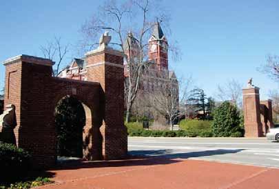
20 KEY: Vehicular circulation Existing gateway Potential gateway ground plaque A family of gateways exists at major entry points to campus as well as at key pedestrian portals within campus. Toomer s Corner is the oldest and most storied, and serves as a fitting archetype for other statements of arrival on campus. More recently, additional gateways have been installed in two configurations: a standard gateway (Magnolia Ave./Donahue Dr.), and a larger gateway with extended pillars and sidewalls (College St./Thach Ave.). These gateways contribute to the image and character of the campus landscape through their scale and traditional materials, while supporting pedestrian and vehicular wayfinding by accentuating entries and prominent paths. Opportunities for additional gateways exist at present-day portals noted above. Potential for future gateways should be considered along key corridors identified in the Campus Mater Plan Update. In addition, a smaller ground plaque is proposed to designate entrances to campus from the surrounding city without the formality of a gate.


21


22 Limestone or terra cotta panels, affixed to gateway columns. Inlay panels in gateway columns are intended to display the Auburn University wordmark as a form of formal identification at the pedestrian level. The gateway at College St. and Thach Ave. should have the wordmark without the tower. All other gateways should use the watermark containing the tower. Inlay panels may also be a sculptural design by commissioned artists which reflects an academic discipline of the University, preferably one which is located near to the panel location. Authority for content determination rests with the Office of Campus Planning.

23 Inlaid stone panels with incised (V-cut) lettering. Lettering in large gateway sidewalls are intended to display the Auburn University wordmark as a form of formal identification at the vehicular level. Plantings surrounding the sidewalls should be composed to accentuate the lettering, and maintained to allow the message to be read during all seasons.

24 1/4" Cast aluminum plaque with (black/grey) infill, inset into the sidewalk. Ground plaques are embedded in pedestrian pathways at the edge of campus, formalizing a transition from the city to campus environment while maintaining the open edge which allows for freeflowing passage between the University and city communities. The design provides an opportunity for donor recognition. TEXT: Whitney Medium Ground plaques should be installed centered in a segment of concrete sidewalk, sufficiently interior to the campus to clear any public right-of-way. Suitable locations are indicated in the accompanying campus plan (page 14).
25 E.Q. E.Q. Sidewalk Roadway E.Q. E.Q. Typical location: pedestrian path Placement: centered in sidewalk segment Roadway Sidewalk Typical location: sidewalks on either side of street
.")
26 Two-sided, fabricated aluminum cabinet painted Auburn bronze with stone base and side orange reveal. This configuration of facility identification should be used by default, unless special circumstances warrant the use of an alternate version (described on subsequent pages). NAME: Whitney Semibold ADDRESS & DETAIL: Whitney Medium Italic At minimum, building name should be displayed, along with address if applicable. Shorthand or informal building names are preferred, with full formal name reserved for sign type BL-1. When located outside of the core campus, the local campus name may appear in orange italics beneath the building name. Additionally, under certain circumstances a major public destination may be listed in white italics beneath the building name. Normally this function is reserved for sign type BL-3 (department identification) and exceptions must be approved in writing by the Office of Campus Planning.
27 Orange text; Immediately below last line of name text The small vertical facility identification sign is intended for use in the core campus, or for other facilities where transit between buildings is primarily by foot. Signs should be oriented perpendicular to the building face by default, unless this orientation would obscure the message from the primary pedestrian approach to the building. When a series of buildings face a major walkway or street, effort should be made to ensure that identification signs for each building are consistently set back from the pavement edge. The ground around the sign should be finished for a neat appearance and to protect the sign from splashing dirt, grass clippings, damage from mower impact, etc. Acceptable treatments include mulch or pine straw with plant material; or crushed stone.

28 Two-sided, fabricated aluminum cabinet painted Auburn bronze with brick and stone base and side orange reveal. NAME: Whitney Semibold ADDRESS & DETAIL: Whitney Medium Italic At minimum, building name should be displayed, along with address where applicable. Shorthand or informal building names are preferred, with full formal name reserved for sign type BL-1. When located outside of the core campus, the local campus name may appear in orange italics beneath the building name. Additionally, under certain circumstances a major public destination may be listed in white italics beneath the building name. Normally this function is reserved for sign type BL-3 (department identification) and exceptions must be approved by the Office of Campus Planning.

29 Orange Text The small horizontal facility identification sign is intended for use in the core campus, or for other facilities where transit between buildings may be by foot or by car at a slow speed. Use the horizontal version in wide areas of open lawn where the building is significantly set back, or other conditions where a more formal sign installation is desired due to the scale of the surrounding environment. Signs should be oriented perpendicular to the building face by default, unless this orientation would obscure the message from the primary approach to the building. When a series of buildings face a major walkway or street, effort should be made to ensure that identification signs for each building are consistently set back from the pavement edge. The ground around the sign should be finished for a neat appearance and to protect the brick base from splashing dirt, grass clippings, damage from mower impact, etc. Acceptable treatments include mulch or pine straw with plant material; or crushed stone. When installed on a slope, the foundation and brick base should be buried such that 4-5 courses of brick are visible at the center of the sign.
30 Two-sided, fabricated aluminum cabinet painted Auburn bronze with brick and stone base and side orange reveal. NAME: Whitney Semibold ADDRESS & DETAIL: Whitney Medium Italic At minimum, building name should be displayed, along with building address where applicable. Shorthand or informal building names are preferred, with full formal name reserved for sign type BL-1. When located outside of the core campus, the local campus name may appear in orange italics beneath the building name. Additionally, under certain circumstances a major public destination may be listed in white italics beneath the building name. Normally this function is reserved for sign type BL-3 (department identification) and exceptions must be approved by the Office of Campus Planning.

31 Alternate graphic layout for Auburn Research Park shown The large horizontal facility identification sign is intended for use outside the core campus, where transit between buildings is primarily by car at a moderate speed. Use the horizontal version in wide areas of open lawn where the building is significantly set back, or other conditions where a more formal sign installation is desired due to the scale of the surrounding environment. Signs should be oriented perpendicular to the street by default, unless this orientation would obscure the message from the primary approach to the building. When a series of buildings face the same street, effort should be made to ensure that identification signs for each building are consistently set back from the pavement edge. The ground around the sign should be finished for a neat appearance and to protect the brick base from splashing dirt, grass clippings, damage from mower impact, etc. Acceptable treatments include mulch or pine straw with plant material; or crushed stone. When installed on a slope, the foundation and brick base should be buried such that 5-6 courses of brick are visible at the center of the sign.
32 Two-sided, fabricated aluminum cabinet painted either Auburn bronze or blue & orange with brick and stone base and side orange reveal. NAME: Whitney Semibold ADDRESS & DETAIL: Whitney Medium Italic At minimum, building name should be displayed, along with address if applicable. Shorthand or informal building names are preferred, with full formal name reserved for sign type BL-1. When located outside of the core campus, the local campus name may appear in orange italics beneath the building name. Additionally, under certain circumstances a major public destination may be listed in white italics beneath the building name. Normally this function is reserved for sign type BL-3 (department identification) and exceptions must be approved by the Office of Campus Planning.

33 Orange text; Immediately below last line of name text The large vertical facility identification sign is intended for use at outlying facilities, where it will be viewed by car at a fast speed. Signs should be oriented perpendicular to the roadway. When a series of facilities face the same street, effort should be made to ensure that identification signs for each building are consistently set back from the pavement edge. The ground around the sign should be finished for a neat appearance and to protect the brick base from splashing dirt, grass clippings, damage from mower impact, etc. Acceptable treatments include mulch or pine straw with plant material; or crushed stone. The standard color scheme is Auburn bronze with a light bronze tower graphic. At the discretion of the Office of Campus Planning, remote facilities and those outside of the core campus may utilize an alternate scheme of blue with an orange tower graphic (as shown), for increased identification with the Auburn University identity. When installed on a slope, the foundation and brick base should be buried such that 5-6 courses of brick are visible at the center of the sign.
34 Two-sided, fabricated aluminum cabinet painted Auburn bronze with side orange reveal, internally illuminated with push-through letters. This study demonstrates potential adaptation of the facility identification vocabulary to a more service-oriented off-campus public destination. Third-party logos are used to show shared ownership of the facilility.
35 Fabricated aluminum panels painted blue and suspended ( tiled ) from an exposed orange support frame. This study demonstrates potential adaptation of the facility identification vocabulary to a scale appropriate for location adjacent to an interstate highway, with room for additional future messaging.
36 Individual cast or fabricated letters, pinned off of the building face. Text may be 8, 10 or 12 depending on message length and location on the building TEXT: Whitney Semibold, tracking 75/1000 em. On new construction, the building architect should consider the graphic standard and incorporate a suitable location into the façade design. The building name may be centered over an entrance, or centered or left justified on an open wall either next to an entrance or visible from a key view. On parking decks, the name should be centered over each vehicular entrance.
37 Text should consist of the full official name of the building. Dark letters are the campus standard and should be used by default to coordinate with existing lettering (match Auburn Bronze or use Matthews Paint MP56184 deep bronze). At the determination of the Office of Campus Planning, light letters may be used dark backgrounds (use aluminum or Matthews Paint MP30136).
38 Individual cast or fabricated numerals, pinned off of the building face. Vinyl numerals may be used for mounting to glass. Building Numbering is not required if the Building Name is visible from the street for emergency response. TEXT: Whitney Semibold Building numbering should be located above, or immediately to the right of the main entrance, or at another prominent location when the main entrance does not face the street. Text should consist of the numeric portion of the street address of the facility. Pinned numbers should match the color used for the Building Lettering. On glass use 3M matte white vinyl.
39 Directory of destinations ( tenants ) within a building, in the form of vinyl graphics applied to glazing, or a painted aluminum reverse pan mounted to the right of the primary building entrance. TEXT: Whitney Semibold, Whitney Medium Individual academic departments or university functions which generate significant off-campus visitor traffic may qualify for inclusion in the department identification sign. The sign is intended to assist in wayfinding, and as such should be utilized only in cases where display of the department will alleviate visitor confusion. On buildings with a storefront glazing entrance, the specified typographic layout may be implemented in vinyl directly on the glass to the right of the rightmost entrance door. On buildings with no such glass surface adjacent to the door, use the panel version instead. Install the message so that the orange rule is 5 above the ground, or aligned to nearby architectural features if such features interfere with mounting at the preferred height.
40 Two-sided post-mounted painted aluminum blade with orange reveal on post cap. Located at key pedestrian crossroads, this sign directs to major campus destinations and provides a campus map for orientation. TEXT: Whitney Medium Each sign features two maps: one of the full campus with a comprehensive index of destinations, the other of the immediate surroundings with building names indicated on the map itself. Each should be derived from the standard campus map.(see Campus Map guidelines, p.40)

41 4" Destinations indicated on the directional portion of the sign are limited to those included in the master wayfinding list developed by the sign committee and falling under the authority of the Office of Campus Planning. Destinations were selected based on frequency of visits by guests as well as members of the University and greater Auburn communities. Locate the pedestrian directional adjacent to a pathway or sidewalk, set back 6 from the edge with blade facing away from the path. The placement must not obstruct any accessible path.

42 Four-sided fabricated aluminum kiosk with integrated bench, lockable cabinets and tack surface. Painted Auburn bronze with orange reveal on bench edge. Located at major centers of pedestrian activity, this kiosk concept consolidates multiple sources of generalinterest information into a single unit. Further design development of this sign type is necessary, and future versions may make use of technology-based information systems (touch-screen wayfinding, ATM machines, etc). One face is reserved for a large scale campus map with comprehensive index of destinations, derived from the standard campus map (see Campus Map guidelines, p.40) Tackable surfaces may be used for a single copy of any posting which is approved in advance by the Dean of Students. Lockable cabinets will be administered by the Dean of Students and may be turned over for an entire semester to a single organization sponsoring regular events or may be reserved by organizations on a short-term basis to promote one-time events.
43 Because of its scale and four-sided configuration, the bulletin kiosk should be located in a planned plaza space with ample room allocated to circulate around the structure. The placement must not obstruct any accessible path.
44 One- or two-sided post mounted painted aluminum blade with orange reveal on post cap. TEXT: Whitney Medium Locate the regulatory accessibility sign adjacent to every building entrance or path where a separate accessible entrance is used. Set back 6 from the path edge with blade facing away from path. The placement must not obstruct any accessible path.
45 Symbol area Symbol area One- or two-sided post mounted painted aluminum blade with orange reveal on post cap. Flexible grid for single regulatory messages as they become necessary. TEXT: Whitney Medium Locate the regulatory sign as needed to achieve regulatory goals. If located along a path, set back 6 from the path edge with blade facing away from path. Sign placement must not obstruct any accessible path.
46 A well designed and consistently implemented map is a key component of Auburn s institutional identity, as well as a critical navigational tool for visitors to the campus and members of the community. To this end, the Office of Campus Planning will produce and maintain an up-to-date campus map base which will be available to all departments. All campus map applications should be derived from this standard, and may include: Posted wayfinding maps Folding maps distributed on campus and in the mail Downloadable online maps Parking zone maps Game day regulation maps Maps distributed by individual departments Requests for individual map adaptations for official University applications should be directed to the Office of Campus Planning.
47
48 8 x x x 10.5 opening opening opening Two-sided post-mounted painted aluminum blade, with orange reveal on post cap and clear windows for changeable 8.5 x 11 paper inserts. Located at relatively major bus stops, where the posting of schedule information is desired as determined by Parking and Transit Services. Locate the shuttle stop sign adjacent to a sidewalk, set back 6 from the edge with blade facing away from the street. The placement must not obstruct any accessible path. If no sidewalk is present, locate at least 20 minimum back from front of curb, with blade facing away from the street. The Tiger Transit logo should be located at the top of every sign panel to enhance the bus system identity. Vinyl decals with route names or numbers may be applied as shown.
49 Two-sided post-mounted painted aluminum blade, with orange reveal on post cap. Located at relatively minor bus stops, where the posting of schedule information is unnecessary as determined by Parking and Transit Services. The Tiger Transit logo should be located at the top of every single panel to enhance the bus system identity. Decals with route names or numbers may be applied as shown. Locate the shuttle stop sign adjacent to a sidewalk, set back 6 from the edge with blade facing away from the street. The placement must not obstruct any accessible path. If no sidewalk is present, locate at least 20 minimum back from front of curb, with blade facing away from the street.
50 To encourage use of bicycles as an alternative mode of transportation, akin to transit services, a family of bike trail signs with a consistent look and feel has been developed. Central to this system is the Auburn Bikes icon featuring a biking Aubie glyph. Repeated use of this emblem throughout campus will reinforce the presence of biking facilities and focus the attention of bike riders on relevant regulatory signs.
51
52 Two-sided post-mounted painted aluminum blade with orange reveal on post cap. Located at key bike trail crossroads, or intersections of bike trails with streets, this sign directs to major destinations city-wide and provides distance to those destinations. TEXT: Whitney Medium, Whitney Medium Italic Locate the bike trail directional adjacent to a dedicated bike path, mixed use path, or street, set back 6 from the edge (or 20 minimum from the street front curb edge) with blade facing away from the path. The placement must not obstruct any accessible path. Appropriate destinations include: Destinations within the University included in the master wayfinding list developed by the sign committee and falling under the authority of the Office of Campus Planning. These destinations were selected based on frequency of visits by off-campus guests as well as members of the University and greater Auburn communities. Landmark destinations within the greater Auburn community which are safely accessible by bike using the bike trail network The beginning or end of a given stretch of a signed bike trail.
53 Two-sided post-mounted painted aluminum blade with orange reveal on post cap. This identification sign draws attention to the presence of a bike trail or reinforces the path of a trail where it is unclear or disconnected. It should be located at bike trailheads or intersections of bike trails with streets where drawing attention to the presence of the trail is warranted. Locate the bike trail directional adjacent to a dedicated bike path, mixed use path, or street, set back 6 from the edge (or 20 minimum from the street front curb edge) with blade facing away from the path. The placement must not obstruct any accessible path.
54 Painted pavement graphic used to denote direction of travel on a two-lane bike path, or to identify a bike lane on a street.
55 Center circle stencil (orange) Text & icon stencil (white) Arrow stencil (white)
56 One- or two-sided post-mounted painted aluminum blade with orange reveal on post cap. Use this regulatory sign for messages to be read by cyclists while riding. TEXT: Whitney Medium, Whitney Medium Italic Locate the large bike regulatory adjacent to a dedicated bike path, mixed use path, or street, set back 6 from the edge (or 20 minimum from the street front curb edge) with blade facing away from the path. The placement must not obstruct any accessible path.
57 One- or two-sided post-mounted painted aluminum blade with orange reveal on post cap. Use this regulatory sign for messages to be read by cyclists while walking (for instance, at locations where bikes are parked). Alternately, the message panel alone may be mounted to a building, fence, or railing if this is a more practical than utilizing the post-mounted version. TEXT: Whitney Medium, Whitney Medium Italic Locate the small bike regulatory sign as necessary to be most visible to the intended audience. The placement must not obstruct any accessible path.
58 One-sided painted aluminum panel, strap-mounted to an existing pole. Vehicular trailblazers are intended to reinforce the path of travel for vehicles arriving at an Auburn University campus. Large vehicular trailblazers are designed for wide, higher speed roadways such as South College. As a general rule of thumb, large vehicular trailblazers should be located every mile or so, and in advance of major intersections to reinforce the appropriate direction of travel. When meant to indicate a turn, a trailblazer with turned arrow should occur twice once in advance of the turn and again as close as possible to the turn itself.
59 One-sided painted aluminum panel, strap-mounted to an existing pole. Vehicular trailblazers are intended to reinforce the path of travel for vehicles arriving at an Auburn University campus. Small vehicular trailblazers are designed for slower, two-lane vehicular environments such as downtown Auburn. As a general rule of thumb, small vehicular trailblazers should be located every half-mile to mile, and in advance of major intersections to reinforce the appropriate direction of travel. When meant to indicate a turn, a trailblazer with turned arrow should occur twice once in advance of the turn and again as close as possible to the turn itself.
60 Front Back One-sided painted aluminum post-and-panel with orange striped brake-formed returns. Located in advance of key vehicular intersections, the large vehicular directional directs to major University destinations via preferred vehicular route. The 4-inch text is scaled for legibility on public roads. TEXT: Whitney Medium Vehicular directional should be located in advance of the intersection to which they refer, in order to give direction in time to execute the desired maneuver. Where possible, 200 minimum in advance of the turn is preferred. Maintain a minimum of 30 approach clearance between small trees and signs. Destinations are limited to those included in the master wayfinding list (page 13).
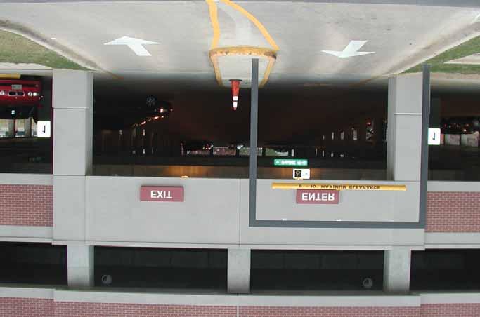
61 Front Back One-sided painted aluminum post-and-panel with orange striped brake-formed returns. The 3-inch text is a practical minimum for vehicular legibility. As such, the small vehicular directional is most appropriate for directing within campus facilities, or to major destinations along slow-speed intracampus streets. TEXT: Whitney Medium minimum in advance of the turn is preferred. Maintain a minimum of 30 approach clearance between small trees and signs.. Campus-wide destinations are limited to those included in the master wayfinding list (page 13). When directing within a specific facility that has vehicular access (e.g., the School of Veterinary Medicine), destinations may be programmed specifically to suit the needs of that site. Vehicular directional should be located in advance of the intersection to which they refer, in order to give direction in time to execute the desired maneuver. Where possible, 200
62 Two-sided painted aluminum panel with reflective lettering. Panel length varies depending on message. ST-6 has 6 high text, ST-4 has 4 high text. TEXT: Whitney Semibold Use ST-6 at roads with posted speeds greater than 25 MPH. Use ST-4 at roads with posted speeds 25 MPH or less (most interior campus roads). Locate street signs on opposite corners of the intersection of all named streets for wayfinding and emergency response purposes. Leading edge of signs must be set back at least 20 minimum from front of curb, and blades should point away from the intersection.
63 minimum height 7'-0" One-sided painted aluminum panel with applied reflective vinyl graphics. The Office of Campus Planning is responsible for programming and locating all traffic regulatory signs. Sign message, design, and scale is to be as recommended by the current edition of the MUTCD.
64 One-sided post-mounted painted aluminum blade with orange reveal on post cap. Refer to parking overview section for message & location guidelines. Used to designate a single parking space or a range of space which are zoned identically. TEXT: Whitney Medium
65 One-sided post-mounted painted aluminum blades (2) with orange reveal on post cap. Refer to parking overview section for message & location guidelines. Used to designate parking where adjacent spaces are zoned differently. TEXT: Whitney Medium
66 Symbol area Parking signs accommodate a variety of parking zones and detailed regulatory messages. Elements of the design are to be utilized as follows: The SINGLE ARROW is used on a sign located on the left or right end of a range of spaces to which identical regulations apply. If the range contains more than four spaces, a DOUBLE ARROW should be used on a single sign centered between the two ends, or on several signs located at even intervals. A sign with NO ARROW is appropriate for identifying a single space. Accessible parking and visitor parking spaces should always be identified individually. The HEADLINE MESSAGE is the primary parking information and relates directly to the symbol -- this message should be consistent for all signs displaying a given symbol. BODY TEXT should be used to elaborate on hours of enforcement, special permit requirements, and the like. The SUBHEADING TEXT may also be used to communicate enforcement when there is additional content beyond what the body text will accommodate. Accessible parking signs shall comply with all applicable codes, including displaying the minimum fine as required by Code of Alabama (d)
67 KEY: Single panel sign with no arrow or single arrow Single panel sign with double arrow Double panel sign These parking location examples show a few parking zones scenarios. These should not limit parking layouts but should be use as a guideline of where to place single flag and double flag parking signs. TOP: Accessible parking shall be one sign per stall at all times. Zone C demonstrates the use of a double arrow at the center of a range of spaces, with ends marked by single arrows. Zone C/A demonstrates the use of a double flag sign at the transition point between two ranges. MIDDLE: Meters and reserved parking are both a range of three spaces; between them a double flag sign is used. Ext. Dorm parking is two adjacent spaces; these may either be two signs without arrows, or with arrows as shown here to make use of the double flag sign. BOTTOM: Visitor parking shall be one sign per stall at all times. The four reserved spaces are identified by individual signs because the regulation differs from space to space. Zone B is marked by two individual signs, one at each end of the range. A double flag sign is inappropriate between the reserved space and Zone B since the reserved space has no arrow.

68 Each garage entrance should be designated by three signs: BL-1 Building Lettering, PG-C Garage Clearance, and PG-R Garage Regulatory Panel. The parking deck name should be centered over each vehicular entrance, and consistent in design with other Building Lettering applications as noted on pages xxxx
69
70 The clearance sign is used to clarify entry and exit lanes and denote the maximum height of a vehicle that can enter the parking deck. Overall sign length will vary depending on the width of the garage entrance. TEXT: Whitney Medium The Garage Clearance sign should be located immediately above the opening at each parking deck entrance. It may be used in conjunction with a freestanding headache bar.
71 The Garage Regulatory Panel consolidates all traffic and parking regulations for a parking deck onto a single sign. All specialty parking deck regulations, including those intended for enforcement on game days, should be located on this sign. TEXT: Whitney Medium, Whitney Semibold The Garage Clearance sign should be located on a column immediately to the right of the drive lane at each parking deck entrance, so as to be easily visible to all vehicles entering the facility.

72 WEEKEND HOMECOMING OCTOBER WAR EAGLE! Two indivudually set posts with orange reveal on post cap, spaced 54 apart, intended to for temporary display of consistently-sized banners. Banner poles should be removed when not in use. Permisson to mount banners to these posts must be authorized by the Dean of Students, which governs the practice of their use. Post-mounted banners are intended to be temporary in nature, and when permitted shall remain in place for no longer than two weeks.

 is an important component of maintaining a strong and coherent campus character, streetscape (Pole")
73 Because keeping building facades free of visual clutter is an important component of maintaining a strong and coherent campus character, banners mounted to buildings are prohibitied without specific written authorization from the Office of Campus Planning. When permitted, building mounted banners shall be temporary in nature, and remain in place for no longer than four months. Because defining significant corridors (both vehicular and pedestrian) is an important component of maintaining a strong and coherent campus character, streetscape (Pole mounted) banners shall be permitted only with written authorization from the Office of Campus Planning, who is responsible for determining approp

74
75 Phase I implementation will be executed in conjunction with the construction of the Village housing project, to include all relevant sign types within the boundaries of Magnolia, Donahue, Roosevelt and Wire. Phase I is anticipated to be completed in the Fall of 2009, or with the opening of the completed Village project. Future phases may be implemented as funds become available and may follow either of the following strategies: As with the Village project, an area of campus may be selected for implementation of every relevant sign type within a specific geographic boundary. This approach allows for a complete application of the sign standard and may also allow for budgeting as part of a greater capital project. Signs may also be implemented one sign type at a time; for instance, all street signs, all parking signs, or all building identification signs. This approach creates an opportunity for cost savings through mass production of a single sign type in large quantity. In order to have the maximum positive impact on the user experience at Auburn University, as well as the maximum positive impact on the campus landscape, it is recommended that the following sign types be given priority attention for early implementation: Vehicular wayfinding, specifically to parking for visitor information Pedestrian wayfinding signs Parking regulatory signs
76
77
78
Sign System Recommendations
 4.1 Sign System Recommendations 4.2 Recommended sign types required for a complete wayfinding system on the TCNJ campus are described below. Detailed sign messages and their typical locations are included
Chapter 7: Streetscape & Design Elements
 OVERVIEW Chapter 7: Streetscape & Design Elements During the public input phase of The Dixie Fix, the area of streetscape generated much interest. While safety and traffic flow are primary objectives of
Campus Sign Plan. Adopted by the Campus Planning Committee Adopted: June 26, 2006 Revised: April 14, 2016
 Campus Sign Plan Adopted by the Campus Planning Committee Adopted: June 26, 2006 Revised: April 14, 2016 INTRODUCTION Oregon State University requires an effective system of visual communication that projects
CAMPUS MASTER PLAN UPDATE
 CAMPUS MASTER PLAN UPDATE Wayf inding and Signage DISCLAIMER: The following presentation represents in-progress work generated to test various elements of the ongoing campus planning effort along with
V. Gateways GATEWAYS / V-1
 V. GATEWAYS / V-1 Many of Chesapeake s gateways are located on highways and call for bold and attractive designs that motorists can understand, appreciate, and enjoy. can also take the form of natural
4. INDUSTRIAL 53 CASTLE ROCK DESIGN
 4. INDUSTRIAL 53 CASTLE ROCK DESIGN CASTLE ROCK DESIGN 54 4. INDUSTRIAL Overview Well-designed and attractive industrial centers are the product of blending economic realities with both functional and
COMMERCIAL DESIGN REVIEW APPLICATION
 CITY OF LACEY Community Development Department 420 College Street Lacey, WA 98503 (360) 491-5642 COMMERCIAL DESIGN REVIEW APPLICATION OFFICIAL USE ONLY Case Number: Date Received: By: Related Case Numbers:
Streetscape Patterns. Design Guidelines, Ridgewood Village Center Historic District, Ridgewood, N.J. page 20
 North Broad Street has a unique streetscape pattern with broad curving street, tight enclosure on the east side with attached commercial buildings aligned with the sidewalk, and landscaped open space on
Landscape and Streetscape Design 2.5
 Landscape and Streetscape Design 2.5 2.5.1 Goals 2.5.2 Planting 2.5.3 Sidewalks and Pavement 2.5.4 Furnishings 2.5.5 Walls 2.5.6 Lighting 2.5.7 Stormwater 2.5.8 Street Cross Sections 2.5 LANDSCAPE AND
BUSINESS DISTRICT DESIGN GUIDELINES
 Des Plaines, Illinois Prepared for the City of Des Plaines by: The Lakota Group Laurie Marston, AICP March 2005 Section 5: Streetscape Elements Business District Design Guidelines STREETSCAPE ELEMENTS
The Vision. Photo provided by The Minervini Group. 46 Vision, Objectives & Strategies
 Vision, Objectives & Strategies The is the public framework and guide for future development of the Grand Traverse Commons. The establishes public polices for infrastructure, the preservation of natural
VILLAGE OF SKOKIE Design Guidelines for Mixed-Use Districts NX Neighborhood Mixed-Use TX Transit Mixed-Use CX Core Mixed-Use
 VILLAGE OF SKOKIE Design Guidelines for Mixed-Use Districts NX Neighborhood Mixed-Use TX Transit Mixed-Use CX Core Mixed-Use TABLE OF CONTENTS CHAPTER 1 SITE DESIGN Purpose 1 CHAPTER 2 SITE DESIGN Streetscape
Wayfinding. North Gateway: Integrate a vertical gateway marker on the west side of Ward Street at the south corner of Vernon Street.
 3.3.6.2 Wayfinding Existing Conditions Wayfinding signage is important to direct visitors and tourists to different locations in the downtown. A significant part of the wayfinding signage in the downtown
SUBCHAPTER 4-B GUIDELINES FOR THE B-3 COMMERCIAL CHARACTER AREA
 1 SUBCHAPTER 4-B GUIDELINES FOR THE B-3 COMMERCIAL CHARACTER AREA Downtown Bozeman should be the location of buildings of greatest height and intensity in the community. The following guidelines apply
Resolution : Exhibit A. Downtown District Design Guidelines March 2003
 Resolution 03-011: Exhibit A Downtown District Design Guidelines March 2003 DOWNTOWN DISTRICT DESIGN GUIDELINES CITY OF SOUTHLAKE, TEXAS Adopted March 2003 1 DOWNTOWN DISTRICT DESIGN GUIDELINES Adopted
New-Cast Mixed-use Development Proposal King Street West, Newcastle, Ontario
 URBAN DESIGN BRIEF New-Cast Mixed-use Development Proposal King Street West, Newcastle, Ontario TABLE OF CONTENTS: 1.0 Executive Summary 2.0 Creating Vibrant and Sustainable Urban Places: Excerpts from
City of Farmington. Downtown Plan. Amendment to the 1998 Master Plan Adopted October 11, 2004
 City of Farmington Amendment to the 1998 Master Plan Adopted October 11, 2004 Introduction Planning Background 1 Scope and Components of the Plan Amendment 2 Concept Introduction 3 Plan Concepts 3 Conceptual
13. New Construction. Context & Character
 13. New Construction Context & Character While historic districts convey a sense of time and place which is retained through the preservation of historic buildings and relationships, these areas continue
A. Background Summary of Existing Challenges and Potential Possibilities. 1. Summary of Existing Assets and Potential Opportunities
 A. Background 1 A Main Street Master Plan Study was performed and completed in October of 2007. The study was initiated to review current land uses and development patterns along Main Street, from Parrish
DEVELOPMENT CONTROLS MEDICAL DISTRICT
 6.01. GENERAL DESIGN GUIDELINES A. Site Planning B. Architectural Design C. Medical Facility Signage & Lighting D. Exhibit 48. ARCHITECTURAL DESIGN CONCEPTS 6.02. MEDICAL FACILITY STANDARDS & GUIDELINES
BUILDING SCALE AND SETBACKS 5 ELEMENTS:... 5 FAÇADES (COMMERCIAL/RESIDENTIAL) 5
 5") VISION STATEMENT 3 UTILIZATION OF THE GUIDELINES 3 IMPLEMENTATION 3 PROCEDURES FOR DESIGN REVIEW 3 LAND USE AND ZONING 4 LAND USE 4 ELEMENTS:... 4 ZONING 4 ELEMENTS:... 4 BUILDING SCALE AND SETBACKS 5
VISION STATEMENT 3 UTILIZATION OF THE GUIDELINES 3 IMPLEMENTATION 3 PROCEDURES FOR DESIGN REVIEW 3 LAND USE AND ZONING 4 LAND USE 4 ELEMENTS:... 4 ZONING 4 ELEMENTS:... 4 BUILDING SCALE AND SETBACKS 5
4.1.3 LAND USE CATEGORIES
 4.1.3 LAND USE CATEGORIES a. City Center District The City Center District incorporates the existing character and mix of uses in downtown Belmont to encourage redevelopment and new development in keeping
18 May 2016 CAMPUS MASTER PLAN UPATE
 18 May 2016 CAMPUS MASTER PLAN UPATE Council of the Deans ( Over view) AGENDA Engagement & What We Heard Focus Elements: 1. Development Framework Plan 2. Campus Mobility 3. Campus Guidelines 4. Wayfinding
City of Kingston Heritage Commemoration Program Guidelines: 7 May 2010
 MHC-13-010 Exhibit B City of Kingston Heritage Commemoration Program Guidelines: 7 May 2010 These guidelines cover three separate types of city heritage commemoration: small markers on designated property.
Table of Contents. Elm Avenue Improvement Plan City of Waco, Texas. Introduction 1. Existing Context 1 Figure 1 2.
 Table of Contents Introduction 1 Existing Context 1 Figure 1 2 Plan Guidelines 3 Future Urban Form 4 The West-End 4 Main Street 6 The East-End 7 Figure 2 9 Public Improvement Recommendations 7 General
STAFF BRIEF. Design Guidelines for Lower Downtown Historic District, Appendix A: Standards and Guidelines for Signs (2014), pg.
, pg.") Community Planning and Development Denver Landmark Preservation 201 West Colfax, Dept. 205 Denver, CO 80202 p: 720.865.2709 f: 720.865.3050 www.denvergov.org/preservation STAFF BRIEF This document is the
Community Planning and Development Denver Landmark Preservation 201 West Colfax, Dept. 205 Denver, CO 80202 p: 720.865.2709 f: 720.865.3050 www.denvergov.org/preservation STAFF BRIEF This document is the
AIRPORT BUSINESS PARK
 PIER MAC PETROLEUM INSTALLATION LTD. AIRPORT BUSINESS PARK DEVELOPMENT APPLICATIONS March 2003 4.1 Airport Business Park Development Permit Area 4.1.1 Justification/Design Concept The design concept envisioned
38 Queen s University Campus Master Plan Part 1
 38 Queen s University Campus Master Plan Part 1 46 The Campus at the City Scale Chapter 4 The Campus at the City Scale 39 Queen s is an urban University centrally located in Kingston. Decisions made by
WEST LOOP DESIGN GUIDELINES CHECKLIST
 WEST LOOP DESIGN GUIDELINES CHECKLIST Section 1.0 General Strategies 1.1 DESIGN EXCELLENCE: ENCOURAGE HIGH QUALITY AND INNOVATIVE DESIGN OF NEW BUILDINGS WITHIN THE WEST LOOP WITHOUT BEING PRESCRIPTIVE
5.1 Site Plan Guidelines
 5. Community Core Guidelines Development of the Community Core will take place by plan of subdivision and site plan approval. It will occur in a phased manner that will reflect the timing of residential
Fifth and Detroit Street Design May 2017 Capital Improvements Committee. DOWNTOWN Street Design
 1 Fifth and Detroit Street Design May 2017 Capital Improvements Committee Agenda 2 Review Street Configuration Prior Meeting Review Outreach Synopsis Functional Street Design Refinements Curb Edge, Turning
This is the East Carolina University Comprehensive Facilities Master Plan Final Draft Plan Review. This workbook reviews the campus draft master plan
 This is the East Carolina University Comprehensive Facilities Master Plan Final Draft Plan Review. This workbook reviews the campus draft master plan first presented on campus on June 29 and June 30, 2011.
F. Driveways. Driveways which provide access to off-street parking or loading from public streets shall comply with the following:
 Section 20.945.040 General Design Standards for Surface Parking Areas. A. Review Authority. Parking lot design and drainage shall be subject to review and approval of the City Transportation Manager. B.
DRAFT. October Wheaton. Design Guidelines
 October 2011 DRAFT Wheaton Design Guidelines 2 Draft - Design Guidelines - Wheaton Sector Plan Contents 04 Section 1: Introduction 06 Section 2: Context 08 Section 3: Design Guidelines 09 Goal 1: Create
PARKLET PROPOSAL PACKAGE & PROCESS
 500.3 I PARKLETS The term parklet refers to a small temporary constructed seating or community gathering area over an on-street parking space or an extension of the sidewalk into the operating State highway
Future Five. Design/ Development Guidelines. January 2008 Amended June 08 per City Council motion
 Future Five Design/ Development Guidelines January 2008 Amended June 08 per City Council motion 5-Points Design Guidelines Table of Contents I. Introduction 3 II. Area boundaries 4 III. Review Process
Phase 1 : Understanding the Campus Context. Phase 2 : APPROACHES - Alternates & Preferred Plan
 Introduction MASTER PLAN PURPOSE WHY A CAMPUS MASTER PLAN? The purpose of the Master Plan at the University of Illinois at Chicago is to translate UIC s strategic goals and objectives into a compelling
NEIGHBORHOOD 3: UNIVERSITY EDGE
 NEIGHBORHOOD 3: UNIVERSITY EDGE Aerial View of North Indiana Avenue EXISTING CHARACTER The University Edge neighborhood represents the primary town/gown interface between the campus and the city of Bloomington,
Supplement 3 NYU IDENTITY INTERIOR SIGNAGE
 Supplement 3 NYU IDENTITY INTERIOR SIGNAGE Table of Contents Start Here Why Interior Sign Guidelines Are Needed... 3 Steps for Ordering Signs... 3 Important to Know... 3 Elements Logos... 4 Typography....
CHAPTER 5 Public Realm Improvements
 5.1 OVERVIEW This chapter focuses on the public realm, that is, spaces within and directly adjacent to public rights-of-way (ROWs), including streets, Oso Creek, the rail corridor, and the freeway edge.
CENTERS AND CORRIDORS
 INITIAL DESIGN STANDARDS AND GUIDELINES for CENTERS AND CORRIDORS City of Spokane Planning Services Third Floor, City Hall 808 W. Spokane Falls Blvd. Spokane, WA 99201-3329 (509) 625-6300 www.spokaneplanning.org
LOS ANGELES MISSION COLLEGE MASTER PLAN Master Plan DESIGN & DEVELOPMENT PRINCIPLES
 LOS ANGELES MISSION COLLEGE MASTER PLAN DESIGN & DEVELOPMENT PRINCIPLES 34 Quality Learning Along the Arroyo PROGRAM SUMMARY BY PROJECT The following are program summaries for each of the projects planned
PROJECTS AND THE PUBLIC ART MASTER PLAN
 MEMO TO: PUBLIC ART STEERING COMMITTEE MEMBERS FROM: SHARI COOPER, DEVELOPMENT PROJECT COORDINATOR DATE: FEBRUARY 24, 2017 SUBJECT: AGENDA ITEM 5.A: PUBLIC ART PROJECT FOR 2017-18 BACKGROUND One of the
Attachment 1 TOWN OF NEW TECUMSETH. Manual for the Preparation of an Urban Design Report
 Attachment 1 TOWN OF NEW TECUMSETH Manual for the Preparation of an Urban Design Report July 2010 TABLE OF CONTENTS Background, Policy Framework and the Preparation of Urban Design Reports 1. Introduction
WINDSOR GLEN DESIGN GUIDELINES
 WINDSOR GLEN DESIGN GUIDELINES Adopted by Council, 2006 WINDSOR GLEN REDEVELOPMENT DESIGN GUIDELINES August 2006 1.0 Master Plan Organization For this area of the Coquitlam Town Centre, a mix of high,
REVIEW AND APPROVAL OF FINAL ART PLAN FOR THE SIERRA MADRE VILLA CORRIDOR PUBLIC ART PROJECT
 TO: FROM: SUBJECT: Honorable Mayor and City Council Planning & Community Development Department REVIEW AND APPROVAL OF FINAL ART PLAN FOR THE SIERRA MADRE VILLA CORRIDOR PUBLIC ART PROJECT RECOMMENDATION:
CAMPUS MASTER PLAN UPATE
 19 MAY 2016 CAMPUS MASTER PLAN UPATE Metropolitan Planning Organization AGENDA Introductions Planning Scope Observation & Analysis: Mobility Systems Campus Development Plan Mobility Planning Scenarios
FRONT STREET STREETSCAPE
 FRONT STREET STREETSCAPE DESIGN DEVELOPMENT UPDATE & MARTIN PLAZA ALTERNATIVE REVIEW JUNE 26, 2017 PREPARED BY DESIGN DEVELOPMENT REVISIONS REVISIONS APPLIED AFTER 4/24/2017 COUNCIL PRESENTATION 1. Lane
6-GATEWAYS, WAYFINDING & PUBLIC SIGNS
 6-GATEWAYS, Wayfinding & ublic Signs 6-GATEWAYS, WAYFINDING & UBLIC SIGNS Downtown Georgetown has a strong base of local users as well as seasonal tourists and visitors. Many first-time visitors, and those
general corridor design guidelines gen-0.0
 general corridor design guidelines gen-0.0 facades gen-1.0 GEN-1.1: TRANSPARENCY GEN-1.1.1: WALL OPENINGS In order to create buildings that are visually interesting for passers-by, blank ground floor
SECTION TWO: Overall Design Guidelines
 SECTION TWO: Overall Design Guidelines This section provides overall design principles and guidelines for the Gardnerville Mixed-use Overlay. They provide criteria for mixed-use places consisting of residential,
URBAN DESIGN BRIEF. 2136&2148 Trafalgar Road. Town of Oakville
 URBAN DESIGN BRIEF 2136&2148 Trafalgar Road Town of Oakville Prepared By: METROPOLITAN CONSULTING INC For 2500674 Ontario Inc November 2016 TABLE OF CONTENTS Page No. 1.0 Introduction/Description of Subject
Town Center (part of the Comprehensive Plan)
") Town Center (part of the Comprehensive Plan) Mercer Island Town Center Looking North (2014) In 1994, a year-long process culminated in a set of design guidelines and code requirements for the Town Center
Town Center (part of the Comprehensive Plan) Mercer Island Town Center Looking North (2014) In 1994, a year-long process culminated in a set of design guidelines and code requirements for the Town Center
Interior signs are an extension of the exterior sign system and their content and design should take this into consideration.
 General Guideline The Interior Sign standard is developed to address the need for a cost effective, functional, flexible and serviceable sign system. The intent is to assure code compliance, consistency
INTRODUCTION BACKGROUND. Signage Goals
 V. SIGNAGE Introduction V-1 Sign Design V-2 Sign Content V-5 Facade-Mounted Signs V-6 Multi-Tenant Properties V-7 Externally Lit Signs V-9 Internally Lit Signs V-10 Temporary Signs V-11 Salem Signs V-12
Urban Design 9Identity
 Urban Design 9Identity URBAN DESIGN IDENTITY Urban design is about connecting people to their places through the built environment, nature, and overall urban form. Done well, it creates a memorable space
Urban Design Manual PLANNING AROUND RAPID TRANSIT STATIONS (PARTS) Introduction. Station Study Areas
 Introduction. Station Study Areas") 111111 PLANNING AROUND RAPID TRANSIT STATIONS (PARTS) Introduction The ION rapid transit system will link Waterloo, Kitchener and Cambridge through a central transit corridor (CTC). There are a number
111111 PLANNING AROUND RAPID TRANSIT STATIONS (PARTS) Introduction The ION rapid transit system will link Waterloo, Kitchener and Cambridge through a central transit corridor (CTC). There are a number
SDOT DPD. SDOT Director s Rule DPD Director s Rule DCLU DR SED DR of 7 CITY OF SEATTLE
 SDOT SDOT Director s Rule 2-07 DPD Applicant: CITY OF SEATTLE Page 1 of 7 Supersedes: DCLU DR 11-93 SED DR 93-4 Seattle Department of Transportation (SDOT) Department of Planning and Development (DPD)
CITY OF CHARLOTTESVILLE, VIRGINIA CITY COUNCIL AGENDA
 CITY OF CHARLOTTESVILLE, VIRGINIA CITY COUNCIL AGENDA Agenda Date: December 16, 2013 Action Required: Adoption of Resolution Presenter: Staff Contacts: Title: James E. Tolbert, AICP, Director of NDS James
Community Design Plan
 Gardena General Plan 2006 Authority While the is not a required element of a General Plan, it is included because improving the community appearance and image is paramount to the overall quality of life
WAYFINDING & SIGNAGE DESIGN GUIDELINE
 WAYFINDING & SIGNAGE DESIGN GUIDELINE Introduction The purpose of developing an exterior signage and wayfinding design guide is to better promote the Pittsburg State University brand and to enhance the
Nassau University Medical Center Exterior Sign System Campus Wayfinding & Emergency Bid Document Set
 Nassau University Medical Center Exterior Sign System Campus Wayfinding & Emergency Bid Document Set ARCHITECTURE CANNONDESIGN 360 Madison Avenue New York NY 007 22.972.9800 PEER REVIEW Boston MA 0220
CHAPTER 3 DOWNTOWN COMMERCIAL DISTRICT CHARACTER AREA
 CHAPTER 3 DOWNTOWN COMMERCIAL DISTRICT CHARACTER AREA 3.1 INTRODUCTION The Downtown Commercial District Character Area of Grass Valley comprises all of the city's core historic commercial district, including
PROPOSED REDEVELOPMENT OF THE GLEN ABBEY GOLF CLUB. STREETSCAPE DESIGN STUDY (excerpt from the Urban Design Brief) TOWN OF OAKVILLE.
 TOWN OF OAKVILLE.") PROPOSED REDEVELOPMENT OF THE GLEN ABBEY GOLF CLUB STREETSCAPE DESIGN STUDY (excerpt from the Urban Design Brief) TOWN OF OAKVILLE OCTOBER, 2016 for 2.4.2 STREETS Streets are the single largest component
PROPOSED REDEVELOPMENT OF THE GLEN ABBEY GOLF CLUB STREETSCAPE DESIGN STUDY (excerpt from the Urban Design Brief) TOWN OF OAKVILLE OCTOBER, 2016 for 2.4.2 STREETS Streets are the single largest component
East Bayshore Road Neighbourhood
 East Bayshore Road Neighbourhood Northridge Property Management Urban Design Brief 3195 East Bayshore Road City of Owen Sound January 2016 East Bayshore Road Neighbourhood Northridge Property Management
NEIGHBORHOOD 7: FEE LANE AREA. Aerial View of Briscoe and McNutt Dormitories
 NEIGHBORHOOD 7: FEE LANE AREA Aerial View of Briscoe and McNutt Dormitories Fee Lane Area Map Briscoe Dormitory 278 neighborhoods NEIGHBORHOOD 7: FEE LANE AREA EXISTING CHARACTER The Fee Lane Area neighborhood
5.0 WAYFINDING STREETSCAPE DESIGN MASTER PLAN 55
 OVERVIEW 57 SIGN TYPE A: GATEWAY 57 SIGN TYPES B & C: WAYFINDING KIOSKS & BOLLARDS 58 SIGN TYPES D: POLE MOUNTED ELEMENTS 59 SIGN TYPE E: LARGE-SCALE TYPOGRAPHIC INSTALLATION 60 SIGN TYPE F: VERTICAL CHOPSTICKS
PUBLIC RIGHT-OF-WAY IN THIS CHAPTER PUBLIC REALM
 PUBLIC RIGHT-OF-WAY This section provides design guidelines for improvements in the public right-of-way. The public right-of-way refers to streets, sidewalks, non-vehicular thoroughfares, parks and greenways
\\ Comprehensive Facilities Master Plan. Design Guidelines
 Design Guidelines CU-Boulder What are Design Guidelines? Institution Character Continuity of Fabric Accelerate Design Process, constrained options MIT Descriptive Buildings on the campus reflect many styles,
FLORIN ROAD CORRIDOR Site Plan and Design Review Guidelines Checklist
 FLORIN ROAD CORRIDOR Site Plan and Design Review Guidelines Checklist Applicant s Name: Project Address: Phone: Email: Applicant shall fill out the design guidelines checklist for all guidelines applicable
DENVER DESIGN DISTRICT GDP
 DENVER DESIGN DISTRICT GDP Urban Design Standards and Guidelines November 17, 2008 Amended February 3, 2016 City and County of Denver CF Property Management, Inc. C/O Denver Design District - Starboard
4.9 Mendocino Avenue Corridor Plan Design Guidelines
 4.9 Mendocino Avenue Corridor Plan Design Guidelines The Mendocino Avenue Corridor Plan addresses the area between College Avenue and Steele Lane. Mendocino Avenue is a busy arterial that runs parallel
appendix and street interface guidelines
 appendix five: building and street interface guidelines appendix 5 building and street interface guidelines BOULEVARDS Boulevards are generally characterized by higher levels of traffic movement at higher
Good Design Guidelines for Downtown. Preliminary Findings and Recommendations
 Good Design Guidelines for Downtown Preliminary Findings and Recommendations City Council Meeting - February 5, 2017 Advisory Committee Team: Larry Paul: Planning Commission /Architect Bruce Bagnoli: Business
UAA School of Engineering Parking Garage Master Plan Amendment. 1. Purpose
 UAA School of Engineering Parking Garage Master Plan Amendment 1. Purpose Since the UAA campus master plan was drafted in 2003, adopted in 2004, and amended in 2009 a number of significant changes regarding
Small Area Plan. South Gateway
 Small Area Plan Adopted May 12, 2008 South Gateway Purpose. The South Gateway Small Area Plan defines the City s expectations for the future of the southern entrance to the City at Interstate 85 and Highway
CHAPTER 7: Transportation, Mobility and Circulation
 AGLE AREA COMMUNITY Plan CHAPTER 7 CHAPTER 7: Transportation, Mobility and Circulation Transportation, Mobility and Circulation The purpose of the Transportation, Mobility and Circulation Chapter is to
CITY OF PUYALLUP. Background. Development Services
 CITY OF PUYALLUP Development Services 333 South Meridian Puyallup WA 98371 To: City Council From: Katie Baker, AICP, Planning Division Re: South Hill Neighborhood Plan Adoption Date: (Meeting date: February
Corridor Identity. Section 9. Introduction. Corridor Guiding Principles
 Corridor Identity An attractive and healthy community is a critical element of a quality place, and the design of quality places is a balance between environmental, economic, and social considerations.
Long Branch Neighbourhood Character Guidelines Final Report
 STAFF REPORT ACTION REQUIRED Long Branch Neighbourhood Character Guidelines Final Report Date: October 26, 2017 To: From: Wards: Reference Number: Etobicoke York Community Council Director, Community Planning,
GUIDELINES REPLACEMENT HOUSING GUIDELINES LOCATION INTRODUCTION URBAN DESIGN GUIDELINES
 Replacement housing in the former City of North York will be consistent with the following urban design guidelines. They provide a framework for residential re-development in the former City of North York
Worthington Scranton. Campus Exterior Architectural Plan
 Contents Introduction and Purpose Existing Conditions Inventory s Introduction and purpose The stated mission, vision and strategic goals of Penn State clearly define the University s responsibility to
The transportation system in a community is an
 7 TRANSPORTATION The transportation system in a community is an important factor contributing to the quality of life of the residents. Without a sound transportation system to bring both goods and patrons
Appendix D North Road/N. Leroy Street Subarea Plan
 North Road/N. Leroy Street Subarea Plan INTRODUCTION The City of Fenton Master Plan was updated in 1996 and included a subarea plan for the North Leroy Street area of the City. It was recognized at that
Contact: Alex Taranu ( ) or Karl Walsh ( )
 or Karl Walsh ( )") Date: 09 September 2005 File: Subject: P03.DUDS Downtown Urban Design Vision Study Report Contact: Alex Taranu (905 874 3454) or Karl Walsh (905 874 2331) OVERVIEW Staff has produced an Urban Design Vision
Date: 09 September 2005 File: Subject: P03.DUDS Downtown Urban Design Vision Study Report Contact: Alex Taranu (905 874 3454) or Karl Walsh (905 874 2331) OVERVIEW Staff has produced an Urban Design Vision
MEMORANDUM. I2 District Downtown Parking Overlay District 24,000 square feet /.55 acres. Industrial Employment District North Loop Small Area Plan
 Department of Community Planning & Economic Development 50 South 4th Street, Room 300 Minneapolis, MN 5545-385 MEMORANDUM To: City Planning Commission, Committee of the Whole Prepared By: Peter Crandall,
Creating Complete Roadway Corridors:
 Creating Complete Roadway Corridors: The AASHTO Guide to Transportation Landscape Architecture and Environmental Design NCHRP Project 15-33 Status Report AASHTO Standing Committee on Design Technical Committee
CHAPTER 11 DESIGN GUIDELINES FOR SIGNS. Also consult Chapters and of the Truckee Municipal Code.
 CHAPTER 11 DESIGN GUIDELINES FOR SIGNS Introduction This chapter presents design guidelines for the treatment of signs associated with commercial uses. The design guidelines are organized into relevant
II. SINGLE FAMILY RESIDENTIAL
 II. SINGLE FAMILY RESIDENTIAL Castle Rock is made up of numerous individually built houses and subdivision tracts that have been developed during the past century. Some of the tracts are diverse in architectural
Landscaping And Site Details
 Landscaping And Site Details Adopted by the Barrio Latino Commission on August 20, 1996 Addition to Ybor City Design Guidelines, Street Furniture. The City of Tampa maintains and is responsible for installation
KEY MAP DEVELOPMENT PERMIT AREA MAP. Sunnymede North Sub-Area Plan
 Richmond Official Community Plan BROADMOOR AREA SUNNYMEDE NORTH SUB-AREA PLAN Bylaw 7100 Schedule 2.6C SUNNYMEDE NORTH SUB-AREA PLAN SUNNYMEDE NORTH SUB-AREA PLAN SUNNYMEDE NORTH SUB-AREA PLAN KEY MAP
The Auburn Plan Designing the Future of Auburn February 28, 2005
 The Auburn Plan Designing the Future of Auburn February 28, 2005 Block-by-Block Bicycle Tour Aerial survey Focus Group Meetings September 7 and 8 Design Workshops October 11, 14, and 21 Revitalization
DRAFT Subject to Modifications
 TREASURE COAST REGIONAL PLANNING COUNCIL M E M O R A N D U M To: Council Members AGENDA ITEM 8 From: Date: Subject: Staff May 19, 2017 Council Meeting Florida Department of Transportation Complete Streets
12 February CAMPUS MASTER PLAN UPDATE Focus Group - Wayfinding & Signage
 12 February 2016 CAMPUS MASTER PLAN UPDATE Focus Group - Wayfinding & Signage AGENDA Introductions Planning Scope The 2004 Campus Plan Observations SWOT Exercise Analysis Goals and Advice Questions & Discussion
ELK GROVE TOWN CENTER DESIGN GUIDELINES
 ......... ELK GROVE TOWN CENTER DESIGN GUIDELINES LAGUNA RIDGE SPECIFIC PLAN... June 2008 ............ DESIGN GUIDELINES Table of Contents Contents Section A: Town Center Overview...1 A.1. Purpose and
County of Loudoun. Department of Planning MEMORANDUM. SUBJECT: ZMOD , Dulles North Business Park Comprehensive Sign Plan, 2 nd Referral
 County of Loudoun Department of Planning MEMORANDUM DATE: May 30, 2014 TO: FROM: Ginny Rowen, Project Manager Land Use Review Pat Giglio, Planner III Community Planning SUBJECT: ZMOD 2013-0001, Dulles
GUIDELINE FOR SIGNAGE IN HISTORIC BROOKLIN AND WHITBY
 GUIDELINE FOR SIGNAGE IN HISTORIC BROOKLIN AND WHITBY The Corporation of the Town of Whitby TAYLOR HAZELL ARCHITECTS LTD TABLE OF CONTENTS 1.0 Introduction 2.0 Goals 3.0 By-Law and Building Code 4.0 Signs
2.11 Submittal Guidelines for Emergency Evacuation Signs (2016)
") 2.11 Submittal Guidelines for Emergency Evacuation Signs (2016) Reference: California Code of Regulations, Title 19, Section 3.09, the California Health and Safety Code Section 13220, the SFFC, Section
2.11 Submittal Guidelines for Emergency Evacuation Signs (2016) Reference: California Code of Regulations, Title 19, Section 3.09, the California Health and Safety Code Section 13220, the SFFC, Section
5.1.1 The streetscape along US Highway 64 (Brevard Road); and, The built environment within new residential developments; and,
; and, The built environment within new residential developments; and,") Article 5. Landscaping 5.1 Purpose The Town of Laurel Park s landscape standards are designed to create a beautiful, aesthetically pleasing built environment that will complement and enhance community
Article 5. Landscaping 5.1 Purpose The Town of Laurel Park s landscape standards are designed to create a beautiful, aesthetically pleasing built environment that will complement and enhance community
FRUITVALE TRANSIT VILLAGE (Phase 2) Residential Project
 Residential Project") FRUITVALE TRANSIT VILLAGE (Phase 2) Residential Project DEVELOPER: SIGNATURE PROPERTIES ARCHITECT: HKIT ARCHITECTS April 23, 2010 TABLE OF CONTENTS 3 Vision 4 Description of Site 5 Guiding Concepts 6
FRUITVALE TRANSIT VILLAGE (Phase 2) Residential Project DEVELOPER: SIGNATURE PROPERTIES ARCHITECT: HKIT ARCHITECTS April 23, 2010 TABLE OF CONTENTS 3 Vision 4 Description of Site 5 Guiding Concepts 6