DEVELOPMENT PERMIT AREAS
|
|
|
- Primrose McCoy
- 5 years ago
- Views:
Transcription

1 DEVELOPMENT PERMIT AREAS JUSTIFICATION AND GUIDELINES THE CORPORATION OF THE DISTRICT OF SAANICH BRITISH COLUMBIA References to General Plan, 1993 throughout this document means the Official Community Plan, 2008 as adopted by Bylaw 8940 on July 8, 2008.
2
3 DEVELOPMENT PERMIT AREAS, JUSTIFICATION & GUIDELINES Appendix "N" to Official Community Plan Bylaw, 8940 References to General Plan, 1993 throughout this document means the Official Community Plan, 2008 as adopted by Bylaw 8940 on July 8, Prepared by the Planning Department The Corporation of the District of Saanich
4
5 THE CORPORATION OF THE DISTRICT OF SAANICH BYLAW NO TO ADOPT AN OFFICIAL COMMUNITY PLAN WHEREAS Section 875 of the Local Government Act provides that an official community plan is a statement of objectives and policies to guide decisions on planning and land use management, within the area covered by the plan, respecting the purposes of local government; AND WHEREAS under Section 876 of the Local Government Act, a local government may adopt an official community plan; AND WHEREAS under Section 876 of the Local Government Act, an official community plan must designate the area covered by the plan; AND WHEREAS an official community plan has been prepared for all areas of the District of Saanich consisting of the General Plan, twelve Local Area Plans, and Development Permit Areas Justifications and Guidelines, attached hereto as Schedule "A" and comprising the following appendices: Appendix "A" - General Plan Appendix "B" - Blenkinsop Local Area Plan Appendix C - Cadboro Bay Local Area Plan Appendix D - Carey Local Area Plan Appendix E - Cordova Bay Local Area Plan Appendix F - Gordon Head Local Area Plan Appendix G - North Quadra Local Area Plan Appendix H - Quadra Local Area Plan Appendix I - Royal Oak Local Area Plan Appendix J - Rural Saanich Local Area Plan Appendix K - Saanich Core Local Area Plan Appendix L - Shelbourne Local Area Plan Appendix M - Tillicum Local Area Plan Appendix N - Development Permit Areas, Justification and Guidelines NOW THEREFORE the Municipal Council of The Corporation of the District of Saanich in open meeting assembled enacts as follows: 1. The official community plan attached hereto as Schedule "A" comprising appendices "A" to "N" inclusive and made a part of this Bylaw is hereby designated as the Official Community Plan for the District of Saanich. /2 Official Community Plan Bylaw, 2008, No Page 2
6 2. Bylaw No. 7044, being the "Official Community Plan Bylaw, 1993" is hereby repealed except insofar as it may repeal any other bylaw. 3. This Bylaw may be cited as the "Official Community Plan Bylaw, 2008, No. 8940". Read a first time this 23 rd day of June, Public Hearing held at the Municipal Hall on the 8 th day of July, Read a second time this 8 th day of July, Read a third time this 8 th day of July, Adopted by Council, signed by the Mayor and Clerk and sealed with the Seal of The Corporation on the 8 th day of July, CARRIE MacPHEE Municipal Clerk FRANK LEONARD Mayor CONTENTS
7 Background... 1 Exemptions Saanich General Floodplain Hamsterly Road Mattick's Farm Cordova Bay Village Elk Lake Drive West Saanich Road Broadmead Strawberry Vale Royal Oak Industrial Park Blenkinsop Christmas Hill Swan Lake Quadra / McKenzie Shelbourne / McKenzie Cadboro Bay Village Portage Road Tillicum Road Obed South Little Eldon / Burnside Saanich Core Sayward Hill Trio Gravel Pit South Wilkinson Valley Streamside Rural Saanich Interface Fire Hazard References Schedule 1: Floodplain Development Permit Area Schedule 2: Streamside Development Permit Area
8 BACKGROUND The Local Government Act, Section 879(1), permits Council, in an Official Community Plan, to designate development permit areas. Within a development permit area, an owner must obtain a development permit before subdividing land or constructing, adding to, or altering a building or specifications unless specifically exempted by the Plan. Council may issue a development permit which may vary or supplement a regulation of the Subdivision or Zoning Bylaw. A development permit cannot vary use, density, or flood plain specifications. The Official Community Plan may contain objectives and guidelines affecting the form and character of commercial, industrial, or multi-family development within a designated development permit area. Development permit guidelines may also specify the means of protecting the natural environment, its eco-systems, and biological diversity or areas of hazardous conditions. The District of Saanich is divided into development permit areas as indicated on Map 1. Specific development permit areas relate to major commercial, industrial, and multifamily residential areas, and areas which may be subject to flooding or hazardous conditions. Scattered commercial, industrial, and multi-family dwelling uses (includes two-family dwelling uses) are included with the Saanich General Development Permit Area. EXEMPTIONS Where a community plan designates development permit areas, it may for these areas, specify conditions under which a development permit would not be required. Where a site is located in a designated development permit area, a development permit is not required where: a) only internal alterations are made to buildings and structures; b) glass enclosures are added to the balconies of an existing multi-family development provided that the enclosures conform to an acceptable overall scheme of enclosures approved in the original permit or a subsequent amendment; c) land is subdivided except within the Portage Road Development Permit Area, Floodplain Development Permit Area, Streamside Development Permit Area, or the Environmental Development Permit Area; d) a single family dwelling or accessory building or structure is constructed or altered in any RS zone, except in the Portage Road Development Permit Area, the Floodplain Development Permit Area, Streamside Development Permit Area, or the Environmental Development Permit Area; e) a building or structure which intrudes partially or entirely within a floodplain designated under category (b) "hazardous conditions", is damaged or destroyed through natural or unnatural causes, and it is to be repaired or reconstructed upon its original foundation or new foundations occupying an area equal to or less than the original building area within the floodplain. 1
9 f) (i) the development permit area has been designated under Section 919.1(f) of the Local Government Act, 1996 RSBC c23 and, (ii) no development permit has been issued for the development existing on the site, and (iii) it is proposed to carry out minor alterations or additions to the existing development that do not change the overall character of the development. g) (i) that the land proposed for development is in the Saanich General Development Permit Area and, (ii) the land proposed for development is in a P Zone and, (iii) the proposed development is the construction, addition or alteration of a building or structure causing the increase of impervious surface area of less than 250 m 2 in area and, (iv) the proposed development contains no riparian zone nor areas (including buffers) that contain plant or animal habitat which are designated as red listed (endangered) or blue listed (vulnerable) by the Conservation Data Centre and, (v) the land proposed for development is not subject to the Streamside Development Permit Area or Environmental Development Permit Area. h) ecological restoration and enhancement projects are undertaken or authorized by the District of Saanich. i) Notwithstanding the provisions of this bylaw, a development permit is not required under the Environmental Development Permit Area for development carried out on a parcel of land in a Single Family Dwelling (RS) zone in the Saanich Zoning Bylaw 8200 except a subdivision. 2

10 3
11 1. SAANICH GENERAL DEVELOPMENT PERMIT AREA CATEGORIES a (protection of the natural environment, its eco-systems, and biological diversity) e (commercial, industrial, and multi-family) AREA All lands zoned A-3, RD, RC, RT, RM, RA, C, M, P, and RP except those lands within specific development permit areas identified on Maps 2-23 and JUSTIFICATION Saanich is predominately a single family area; however, introduction of multi-family developments may be acceptable in some locations and existing developments may have potential for change. Care must be taken to integrate new proposals and redevelopment of existing uses with the surrounding neighbourhood. The objective of the designation is to achieve a high standard of appearance to ensure that site development is sensitive to adjoining property and the surrounding neighbourhood, and to protect major transportation corridors. Outdoor lighting can be the source of light pollution which can seriously affect the night sky in terms of astrophysical research or casual observations by the general public. To minimize these impacts, outdoor lighting should be regulated to control both the quantity and quality of night lighting. The municipality includes many important plant and wildlife habitat areas. Protection of these areas will ensure that a portion of the biological diversity within the municipality is maintained. Limits to impervious cover will ensure that runoff volumes and peaks to receiving streams are affected as little as possible as well as providing reduction in sedimentation of receiving waters. Stormwater runoff controls shall be installed in any new development so as to replicate the natural runoff regime. The controls could include, among others: on-site infiltration, storage in ponds or constructed wetland, sand filtration, creative road/curb configurations, etc. 4
12 GUIDELINES Development Permits issued in these areas shall be issued in accordance with the following guidelines designated under category "a" (protection of the natural environment, its eco-systems, and biodiversity) unless specifically exempted (see p. 1): 1. Major or significant wooded areas and native vegetation should be retained wherever possible. 2. The total impervious cover of the site should minimize impact on the receiving aquatic environment. Consideration should be given to reducing impervious cover through reduction in building footprint and paved areas and use of on-site infiltration. Development Permits issued in these areas shall be issued in accordance with the following guidelines designated under category "e" (commercial, industrial, and multifamily) unless specifically exempted (see page 1): 3. Building profiles should follow the natural topography with as little change as possible to accommodate construction. 4. Buildings should reflect the character of surrounding development with special attention to the height of new dwellings in relationship to the height of existing buildings on adjoining parcels. 5. The design and scale of above grade parking structures should be sympathetic and complementary to the surroundings. 6. As many of the existing trees, as practicable, should be retained as part of the overall landscape design. 7. Setbacks adjacent to major roads should be determined based on the ultimate width of the right-of-way as established by the Director of Engineering Services to provide for future road widening. 8. Design Plans shall meet the intent of the standards set out in the Landscape and Screening Guidelines for commercial, industrial, multi-family and public uses in Development Permit Areas adopted by Council on December 21, Design plans adjacent to Cordova Bay/Fowler/Sayward Road from Pat Bay Highway to Royal Oak Drive should acknowledge the guiding principles in the Cordova Bay Streetscape Action Plan, Streetscape improvements on Cordova Bay Road between Fowler Road and Gloria Place shall be consistent with the streetscape concept endorsed by Council as part of the Action Plan. 5
13 10. Exterior lighting shall comply with the Municipal Outdoor Lighting Standards to Control Light Pollution. 11. Design plans shall meet the intent of the standards set out in the "Saanich Bicycle Parking Guidelines. 12. Buildings for commercial or mixed uses should be designed for a human scale to increase street level opportunities for social interaction and the creation of a vibrant, pedestrian environment. This may include expanding the pedestrian environment onto the development site, treating the buildings as an integral component of the streetscape and ensuring windows are provided and not blanked out. Where the primary purpose of a building is residential, street level entrances, landscaped courtyards, urban porches, integrating paving with sidewalks or other architectural or landscape features should be incorporated. 13. Pedestrian networks, through and adjacent to the site should be designed to welcome people, encourage pedestrian activity, and integrate with and link to larger public spaces. Pedestrian amenities must be of sufficient width for an urban environment, have appropriate lighting, and be well landscaped to create a safe walking environment for people of all ages and levels of mobility. Street furniture, paving materials, traffic calming devices, sign plans and public art are examples of elements that should be considered. 14. Public spaces should be created adjoining the street and/or within the site as a complementary extension of the pedestrian network and connect to ground floor access where possible. These spaces should provide both sunny and shaded spaces, a range of seating opportunities, have natural surveillance from adjacent buildings and create spaces that foster gathering, contemplation, relaxation and celebration. Wherever possible public spaces should be sited to respect and enhance important view corridors. 15. Transportation and parking provisions of a site design should include elements that recognize, respect, and balance the needs of all transportation modes, including but not limited to cyclists, scooter users, disabled persons, commercial vehicles, public transit, pedestrians and motor vehicles as well as considering environmental and visual impacts. Measures to encourage public transit and bicycle use are encouraged. Traffic calming elements should be integrated into site plans. Underground parking should be provided where possible and where provided at grade, should include a high standard of landscape screening, a variety of surface treatments, and also provide for pedestrian movement through the parking area. CPTED (Crime Prevention Through Environmental Design) principles should be used in designing all public areas, especially enclosed parking areas. 16. Architecture should be of a high quality that is contemporary and authentic. Innovative use of durable and high quality materials is expected. Elevations of buildings adjacent to a street should incorporate varied architectural elements and landscaping or smaller store-front businesses to avoid big blank walls. 6
14 17. Site design should incorporate, where appropriate, design elements to protect and enhance remnant riparian zones, watercourses and urban forests within major centres. 18. Design plans shall comply with the recommendations set out in the Access to Transit Guidelines. 19. Wherever possible, preserve areas (including buffers) that contain plants and animal habitat which are designated as red listed (endangered) or blue listed (vulnerable) by the Conservation Data Centre (Ministry of Environment). 20. Generally, the riparian zone should remain free of development and restoration of the riparian zone undertaken as part of the new development, if the vegetation is not intact and healthy (diversity of native shrubs and trees). 7
15 2. FLOODPLAIN DEVELOPMENT PERMIT AREA CATEGORIES "a" (protection of the natural environment, its eco-systems, and biological diversity) "b" (hazardous conditions) AREA Development Permit Area shown on Map 2. JUSTIFICATION Extensive areas of the municipality are subject to periodic flooding. They generally contain environmentally sensitive landscapes. These areas should be protected from development and guidelines are necessary to control the extent and siting of buildings and structures to minimize the potential for damage that could be caused by flooding. The municipality includes many important plant and wildlife habitat areas. Protection of these areas will ensure that a portion of the biological diversity within the municipality is maintained. Limits to impervious cover will ensure that runoff volumes and peaks to receiving streams are affected as little as possible as well as providing reduction in sedimentation of receiving waters. Stormwater runoff controls shall be installed in any new development so as to replicate the natural runoff regime. The controls could include, among others: on-site infiltration, storage in ponds or constructed wetland, sand filtration, creative road/curb configurations, etc. GUIDELINES Development Permits issued in these areas shall be issued in accordance with the following guidelines designated under category "a" (protection of the natural environment, its eco-systems, and biodiversity) unless specifically exempted (see p. 1): 1. Major or significant wooded areas and native vegetation should be retained wherever possible. 2. The total impervious cover of the site should minimize impact on the receiving aquatic environment. Consideration should be given to reducing impervious cover through reduction in building footprint and paved areas and use of on-site infiltration. 8
16 9
17 3. No alteration of land should be allowed unless demonstrated through environmental studies that it would not adversely affect the natural environment, nor conflict with the provisions of the Deposit of Fill and the Soil Removal Bylaws. 4. Where a building or structure intrudes partially or completely within a floodplain any modification to the building foundation should be designed to minimize the loss of floodplain storage. Development Permits issued in these areas shall be issued in accordance with the following guidelines designated under category "b" (hazardous conditions) unless specifically exempted (see page 1): 5. Subdivision should not be allowed except where the realignment of lot lines would improve building location and lessen the impact of flooding. 6. Land should remain free of buildings and structures for human habitation except where: a) the foundations are at least partially out of the area of the floodplain, and b) those portions of a building or structure capable of being used for human habitation are located above the floodplain elevation, and c) those portions of a building or structure not capable of being used for human habitation or the storage or placement of goods or equipment extend below the boundary of the flood plain to a maximum of 60 cm (2.0 ft) measured vertically. 7. Minor modifications to an existing building or structure may be considered provided the area of the addition does not exceed 20% of the existing gross floor area and the foundations within the floodplain are designed to minimize the loss of floodplain storage. 8. Wherever possible, preserve areas (including buffers) that contain plants and animal habitat which are designated as red listed (endangered) or blue listed (vulnerable) by the Conservation Data Centre (Ministry of Environment). 9. Generally, the riparian zone should remain free of development and restoration of the riparian zone undertaken as part of the new development, if the vegetation is not intact and healthy (diversity of native shrubs and trees). 10
18 3. HAMSTERLY ROAD DEVELOPMENT PERMIT AREA CATEGORIES a (protection of the natural environment, its eco-systems, and biological diversity) "e" (commercial, industrial, and multi-family) AREA Development Permit area as shown on Map 3. JUSTIFICATION This commercial area is sandwiched between Pat Bay Highway and Hamsterly Road. It is transected by Sayward Road. The existing development is a combination of highway commercial, tourist attraction, and specialized retail commercial uses. The area is highly visible from Pat Bay Highway which is designated by the Provincial Capital Commission as a "Capital Way" and warrants special consideration as a major entrance to the City. The objective of the designation is to ensure that future development respects the scenic access corridor philosophy. Outdoor lighting can be the source of light pollution which can seriously affect the night sky in terms of astrophysical research or casual observations by the general public. To minimize these impacts, outdoor lighting should be regulated to control both the quantity and quality of night lighting. The municipality includes many important plant and wildlife habitat areas. Protection of these areas will ensure that a portion of the biological diversity within the municipality is maintained. Limits to impervious cover will ensure that runoff volumes and peaks to receiving streams are affected as little as possible as well as providing reduction in sedimentation of receiving waters. Stormwater runoff controls shall be installed in any new development so as to replicate the natural runoff regime. The controls could include, among others: on-site infiltration, storage in ponds or constructed wetland, sand filtration, creative road/curb configurations, etc. GUIDELINES Development Permits issued in these areas shall be issued in accordance with the following guidelines designated under category "a" (protection of the natural environment, its eco-systems, and biodiversity) unless specifically exempted (see p. 1): 1. Major or significant wooded areas and native vegetation should be retained wherever possible. 2. The total impervious cover of the site should minimize impact on the receiving aquatic environment. Consideration should be given to reducing impervious cover through reduction in building footprint and paved areas and use of on-site infiltration. 11
19 12
20 Development Permits issued in these areas shall be issued in accordance with the following guidelines designated under category "e" (commercial, industrial, and multifamily) unless specifically exempted (see page 1): 3. The massing and scale of buildings should be compatible with adjacent development. 4. The scale and design of above grade parking structures should be sympathetic and complementary to the surroundings. 5. No outside storage should be visible from Pat Bay Highway. 6. All vehicular access should be off Hamsterly Road or Sayward Road. There will be no new access to Pat Bay Highway. 7. A 3 m landscape strip should be provided along Pat Bay Highway. Plant material should be in scale with the existing planting along the highway to the north and south. 8. As many of the existing trees, as practicable, should be retained as part of the overall landscape design. 9. Awning signs should be encouraged facing all road frontages. 10. Design plans shall meet the intent of the standards set out in the "Landscaping and Screening Guidelines for Commercial, Industrial, Multi-Family and Public Uses in Development Permit Areas" adopted by Council on December 21, Buildings should be setback at least 4.5 m from Pat Bay Highway. 12. Exterior lighting shall comply with the Municipal Outdoor Lighting Standards to Control Light Pollution. 13. Design plans shall meet the intent of the standards set out in the "Saanich Bicycle Parking Guidelines". 14. Design plans shall comply with the recommendations set out in the Access to Transit Guidelines. 15. Wherever possible, preserve areas (including buffers) that contain plants and animal habitat which are designated as red listed (endangered) or blue listed (vulnerable) by the Conservation Data Centre (Ministry of Environment). 13
21 4. MATTICK'S FARM DEVELOPMENT PERMIT AREA CATEGORIES a (protection of the natural environment, its eco-systems, and biological diversity) "e" (commercial, industrial, and multi-family) AREA Development Permit Area as shown on Map 4. JUSTIFICATION Mattick's Farm complex includes a golf course and related facilities and a commercial centre. The golf course is located in the Agricultural Land Reserve at the interface between the suburban and rural area and is adjacent to single family dwellings and a municipal park. The owners propose to expand the commercial centre and to construct multi-family dwelling adjacent to the golf course. The owners propose to expand the commercial centre and to construct multi-family dwellings adjacent to the golf course. The Mattick's Farm complex has a special character that reflects the agricultural significance of the area. Its character, scale and mixture of uses make it a special attraction for tourists and local residents. The objective of the designation is to ensure that future development reflects the scale and special character of Mattick's Farm and the surrounding neighbourhood and is sensitive to the natural environment. Outdoor lighting can be the source of light pollution which can seriously affect the night sky in terms of astrophysical research or casual observations by the general public. To minimize these impacts, outdoor lighting should be regulated to control both the quantity and quality of night lighting. The municipality includes many important plant and wildlife habitat areas. Protection of these areas will ensure that a portion of the biological diversity within the municipality is maintained. GUIDELINES Development Permits issued in these areas shall be issued in accordance with the following guidelines designated under category "a" (protection of the natural environment, its eco-systems, and biodiversity) unless specifically exempted (see p. 1): 1. Major or significant wooded areas and native vegetation should be retained wherever possible. Development Permits issued in these areas shall be issued in accordance with the following guidelines designated under category "e" (commercial, industrial, and multifamily) unless specifically exempted (see page 1): 14
22 15
23 2. The massing and scale of buildings should be compatible with the established commercial complex at Mattick's Farm. 3. The design of buildings should reflect the location on the fringe of the rural area and the established character of Mattick's Farm. 4. Buildings and parking should be located to minimize the impact on adjacent single family dwellings and on Lochside Park. 5. The design and scale of above grade parking structures should be sympathetic and complementary to the surrounding. 6. No vehicle access should be permitted from Parker Avenue or Lochside Drive. 7. As many of the existing trees as practicable should be retained as part of the overall landscape design. 8. Setbacks from Cordova Bay Road should be determined based on the ultimate width of the right-of-way as determined by the Municipal Engineer to provide for future road widening. 9. Design plans shall meet the intent of the standards set out in the "Landscaping and Screening Guidelines for commercial, industrial, multi-family, and public uses in Development Permit Areas" adopted by Council on December 21, Design plans adjacent to Cordova Bay/Fowler/Sayward Road from Pat Bay Highway to Royal Oak Drive should acknowledge the guiding principles in the Cordova Bay Streetscape Action Plan, Streetscape improvements on Cordova Bay Road between Fowler Road and Gloria Place shall be consistent with the streetscape concept endorsed by Council as part of the Action Plan. 11. Exterior lighting shall comply with the Municipal Outdoor Lighting Standards to Control Light Pollution. 12. Design plans shall meet the intent of the standards set out in the "Saanich Bicycle Parking Guidelines". 13. Design plans shall comply with the recommendations set out in the Access to Transit Guidelines. 14. Wherever possible, preserve areas (including buffers) that contain plants and animal habitat which are designated as red listed (endangered) or blue listed (vulnerable) by the Conservation Data Centre (Ministry of Environment). 15. Generally, the riparian zone should remain free of development and restoration of the riparian zone undertaken as part of the new development, if the vegetation is not intact and healthy (diversity of native shrubs and trees). 16
24 5. CORDOVA BAY VILLAGE DEVELOPMENT PERMIT AREA CATEGORIES a (protection of the natural environment, its eco-systems, and biological diversity) "e" (commercial, industrial, and multi-family) AREA Development Permit Area as shown on Map 5. JUSTIFICATION The Village Core is the focal point of the local area and contains neighbourhood commercial facilities, churches, and the community hall. Residential development policies provide for the construction of multi family housing and there is potential to expand the shopping centre. The objective of the designation is to strengthen the core as a focal point in the local area and to offer a visually attractive living environment. New development should reflect the historical character of the Village and be integrated so as to minimize the impact on existing single family uses. Pedestrian and traffic circulation should be convenient. Outdoor lighting can be the source of light pollution which can seriously affect the night sky in terms of astrophysical research or casual observations by the general public. To minimize these impacts, outdoor lighting should be regulated to control both the quantity and quality of night lighting. The municipality includes many important plant and wildlife habitat areas. Protection of these areas will ensure that a portion of the biological diversity within the municipality is maintained. GUIDELINES Development Permits issued in these areas shall be issued in accordance with the following guidelines designated under category "a" (protection of the natural environment, its eco-systems, and biodiversity) unless specifically exempted (see p. 1): 1. Major or significant wooded areas and native vegetation should be retained wherever possible. Development Permits issued in these areas shall be issued in accordance with the following guidelines designated under category "e" (commercial, industrial, and multifamily) unless specifically exempted (see page 1): 2. The massing and scale of buildings should be compatible with adjacent development and should reflect a small scale village-like character. New development should be low level in scale, pedestrian and bicycle friendly, and be well landscaped. Generally, new buildings should not exceed 7.5 m in height, except on the site in the extreme southwest corner of the area, higher buildings may be considered provided that adequate setbacks are maintained to prevent overshadowing of adjacent single family dwellings. 17
25 18
26 3. Exterior treatment should emphasis the use of natural materials and colours should be subtle to compliment the natural surroundings. 4. Signs should be low key, utilizing natural materials and complimentary colours that emphasize the village-like character. They should indirectly illuminated and the number of free standing signs should be limited. 5. Buildings should be designed and oriented on the site to create a strong pedestrian focus. This could include locating buildings to have a presence on the street as opposed to setting them back behind a massive parking lot, and/or incorporating a public square or pedestrian arcade. Pedestrian circulation within each new development should be delineated with design elements and provide continuity as part of an overall pedestrian system in the Village Core with particular emphasis on linkages to the beach and the Lochside regional trail. Where practicable, buildings should be designed to take advantage of the views of Cordova Bay. 6. Parking and access should be designed to be convenient and safe while minimizing intrusion into the residential neighbourhood and maintaining a safe pedestrian environment. Above grade parking structures, if provided, should be sympathetic and complementary to the surroundings and designed to effectively screen vehicles from view. 7. Primary vehicular access should be to Sutcliffe Road, Doumac Avenue, or Cordova Bay Road. 8. As many of the existing trees as practicable should be retained as part of the overall landscape design. Landscaping should emphasis the use of native species. 9. Additions, alterations or replacement of existing structures shall require the entire project to meeting the requirements of the Zoning Bylaw with regard to parking, landscaping screening, and signs. 10. Setbacks from major roads should be determined based on the ultimate width of the right-of-way as established by the Director of Engineering Services to provide for future road widening. 11. Design plans shall meet the intent of the standards set out in the Landscaping and Screening Guidelines for Commercial, Industrial, Multi-family and Public Uses in Development Permit Areas adopted by Council on December 21, Design plans adjacent to Cordova Bay/Fowler/Sayward Road from Pat Bay Highway to Royal Oak Drive should acknowledge the guiding principles in the Cordova Bay Streetscape Action Plan, Streetscape improvements on Cordova Bay Road between Fowler Road and Gloria Place shall be consistent with the streetscape concept endorsed by Council as part of the Action Plan. 13. Exterior lighting shall comply with Municipal Outdoor Lighting Standards to Control Light Pollution. 14. Design plans shall meet the intent of the standards set out in the "Saanich Bicycle Parking Guidelines". 19
27 15. Design plans shall comply with the recommendations set out in the Access to Transit Guidelines. 16. Wherever possible, preserve areas (including buffers) that contain plants and animal habitat which are designated as red listed (endangered) or blue listed (vulnerable) by the Conservation Data Centre (Ministry of Environment). 20
28 6. ELK LAKE DRIVE DEVELOPMENT PERMIT AREA CATEGORIES a (protection of the natural environment, its eco-systems, and biological diversity) "e" (commercial, industrial, and multi-family) AREA Development Permit Areas as shown on Map 6. JUSTIFICATION The area is located immediately west of Pat Bay Highway on the rural/urban fringe. Access is from Elk Lake Drive which serves as a frontage road. Existing land use is a mixture of single family dwellings, multi-family dwellings, commercial, and institutional uses. Elk/Beaver Lake Park is to the north. The area is highly visible from Pat Bay Highway which is designated by the Provincial Capital Commission as a "Capital Way" and warrants special consideration as a major entrance to the City. The objective of the designation is to ensure that future development respects the scenic access policies and principles and that the scale and massing is compatible with adjacent land uses. Outdoor lighting can be a source of light pollution which can seriously affect the night sky in terms of astrophysical research or casual observations by the general public. To minimize these impacts, outdoor lighting should be regulated to control both the quantity and quality of night lighting. The municipality includes many important plant and wildlife habitat areas. Protection of these areas will ensure that a portion of the biological diversity within the municipality is maintained. Limits to impervious cover will ensure that runoff volumes and peaks to receiving streams are affected as little as possible as well as providing reduction in sedimentation of receiving waters. Stormwater runoff controls shall be installed in any new development so as to replicate the natural runoff regime. The controls could include, among others: on-site infiltration, storage in ponds or constructed wetland, sand filtration, creative road/curb configurations, etc. 21
29 22
30 GUIDELINES Development Permits issued in these areas shall be issued in accordance with the following guidelines designated under category "a" (protection of the natural environment, its eco-systems, and biodiversity) unless specifically exempted (see p. 1): 1. Major or significant wooded areas and native vegetation should be retained wherever possible. 2. The total impervious cover of the site should minimize impact on the receiving aquatic environment. Consideration should be given to reducing impervious cover through reduction in building footprint and paved areas and use of on-site infiltration. Development Permits issued in these areas shall be issued in accordance with the following guidelines designated under category "e" (commercial, industrial, and multifamily) unless specifically exempted (see p. 1): 3. The massing and scale of new buildings and structures should be compatible with adjacent structures so as not to overshadow adjacent single family dwellings. 4. Site design should recognize access requirements of surrounding development as a consideration of future growth in the area. 5. Buildings and parking areas should be setback at least 15.0 m from the top of the bank of all streams and rivers. 6. The design and scale of above grade parking structures should be sympathetic and complementary to the surroundings. 7. No outside storage of goods or materials associated with a permitted use should be visible from Pat Bay Highway Developments should preserve and protect the biological integrity of all streams and water bodies. Holding ponds may be required as part of the on-site storm drain systems. 9. Development proposals should incorporate substantial landscape planting along Elk Lake Drive frontages and property lines adjacent to residential uses. 10. Substantial screening between residential and commercial uses should be provided, especially between parking areas and residential areas. 11. As many of the major trees, as practicable, should be retained as part of the overall landscape design. 12. Free standing signs shall be limited to one per development. 23
31 13. Lighting and signs should be unobtrusive and be in scale and character with their surroundings and recognize its setting on the urban/rural fringe adjacent to Elk/Beaver Lake Regional Park. 14. Setbacks from major roads should be determined based on the ultimate width of the right-of-way as established by the Director of Engineering Services to provide for future road widening. 15. Design plans shall meet the intent of the standards set out in the "Landscaping and Screening Guidelines for Commercial, Industrial, Multi Family and Public Uses in Development Permit Areas" adopted by Council on December 21, Exterior lighting shall comply with the Municipal Outdoor Lighting Standards to Control Light Pollution. 17. Design plans shall meet the intent of the standards set out in the "Saanich Bicycle Parking Guidelines". 18. Design plans shall comply with the recommendations set out in the Access to Transit Guidelines. 19. Wherever possible, preserve areas (including buffers) that contain plants and animal habitat which are designated as red listed (endangered) or blue listed (vulnerable) by the Conservation Data Centre (Ministry of Environment). 24
32 7. WEST SAANICH ROAD DEVELOPMENT PERMIT AREA CATEGORIES a (protection of the natural environment, its eco-systems, and biological diversity) "e" (commercial, industrial, and multi-family) AREA Development Permit Area as shown on Map 7. JUSTIFICATION West Saanich Road and Royal Oak Drive are important transportation corridors. The Local Area Plan identifies areas where change will be considered along West Saanich Road. In addition, there are significant opportunities to redevelop existing commercially zoned properties. When change does occur, then it should happen in a physical and functional manner which respects not only established uses, traffic and circulation patterns, but also establishes a high quality design given the visibility of this area from Pat Bay Highway. Outdoor lighting can be the source of light pollution which can seriously affect the night sky in terms of astrophysical research or casual observations by the general public. To minimize these impacts, outdoor lighting should be regulated to control both the quantity and quality of night lighting. The municipality includes many important plant and wildlife habitat areas. Protection of these areas will ensure that a portion of the biological diversity within the municipality is maintained. Limits to impervious cover will ensure that runoff volumes and peaks to receiving streams are affected as little as possible as well as providing reduction in sedimentation of receiving waters. Stormwater runoff controls shall be installed in any new development so as to replicate the natural runoff regime. The controls could include, among others: on-site infiltration, storage in ponds or constructed wetland, sand filtration, creative road/curb configurations, etc. 25
33 26
34 GUIDELINES Development Permits issued in these areas shall be issued in accordance with the following guidelines designated under category "a" (protection of the natural environment, its eco-systems, and biodiversity) unless specifically exempted (see p. 1): 1. Major or significant wooded areas and native vegetation should be retained wherever possible. 2. The total impervious cover of the site should minimize impact on the receiving aquatic environment. Consideration should be given to reducing impervious cover through reduction in building footprint and paved areas and use of on-site infiltration. Development Permits issued in these areas shall be issued in accordance with the following guidelines designated under category "e" (commercial, industrial, and multifamily) unless specifically exempted (see p. 1): 3. The massing and scale of buildings should be compatible with adjacent development. 4. The design and scale of above grade parking structures should be sympathetic and compatible to the surroundings. 5. The rear yard setback relaxations will be considered for buildings and structures immediately adjacent to Royal Oak School but in no case should be less than 7.5 m. 6. New development proposals for commercial uses should incorporate substantial landscape planting along West Saanich Road and Elk Lake Drive frontages. 7. Substantial screening should be provided adjacent to parking areas which are adjacent to existing or proposed single family or multi-family properties. 8. As many of the existing trees, as practicable, should be retained as part of the overall landscape design. 9. Freestanding signs should be regulated in terms of numbers and design to be unobtrusive and of a scale and character with surrounding development. 10. Buildings and structures adjacent to West Saanich Road should be set back a minimum of 10 m from the boundary common to the lot and West Saanich Road. 11. Setbacks adjacent to other major roads should be determined based on the ultimate width of the right-of-way as established by the Director of Engineering Services to provide for future road widening. 12. Design plans shall meet the intent of the standards set out in the "Landscaping and Screening Guidelines for Commercial, Industrial, Multi-Family and Public Uses in Development Permit Areas" adopted by Council on December 21,
35 13. Exterior lighting shall comply with the Municipal Outdoor Lighting Standards to Control Light Pollution. 14. Design plans shall meet the intent of the standards set out in the "Saanich Bicycle Parking Guidelines". 15. Development design plans for parcels adjacent to West Saanich Road from Quadra Street overpass to Wilkinson Road should address the committee Goals and Design Principles in the West Saanich Road Streetscape Study, April Road improvements on West Saanich shall be consistent with the streetscape concept endorsed by Council. 16. Buildings for commercial or mixed uses should be designed for a human scale to increase street level opportunities for social interaction and the creation of a vibrant, pedestrian environment. This may include expanding the pedestrian environment onto the development site, treating the buildings as an integral component of the streetscape and ensuring windows are provided and not blanked out. Where the primary purpose of a building is residential, street level entrances, landscaped courtyards, urban porches, integrating paving with sidewalks or other architectural or landscape features should be incorporated. 17. Pedestrian networks, through and adjacent to the site should be designed to welcome people, encourage pedestrian activity, and integrate with and link to larger public spaces. Pedestrian amenities must be of sufficient width for an urban environment, have appropriate lighting, and be well landscaped to create a safe walking environment for people of all ages and levels of mobility. Street furniture, paving materials, traffic calming devices, sign plans and public art are examples of elements that should be considered. 18. Public spaces should be created adjoining the street and/or within the site as a complementary extension of the pedestrian network and connect to ground floor access where possible. These spaces should provide both sunny and shaded spaces, a range of seating opportunities, have natural surveillance from adjacent buildings and create spaces that foster gathering, contemplation, relaxation and celebration. Wherever possible public spaces should be sited to respect and enhance important view corridors. 19. Transportation and parking provisions of a site design should include elements that recognize, respect, and balance the needs of all transportation modes, including but not limited to cyclists, scooter users, disabled persons, commercial vehicles, public transit, pedestrians and motor vehicles as well as considering environmental and visual impacts. Measures to encourage public transit and bicycle use are encouraged. Traffic calming elements should be integrated into site plans. Underground parking should be provided where possible and where provided at grade, should include a high standard of landscape screening, a variety of surface treatments, and also provide for pedestrian movement through the parking area. CPTED (Crime Prevention Through Environmental Design) principles should be used in designing all public areas, especially enclosed parking areas. 28
36 20. Architecture should be of a high quality that is contemporary and authentic. Innovative use of durable and high quality materials is expected. Elevations of buildings adjacent to a street should incorporate varied architectural elements and landscaping or smaller store-front businesses to avoid big blank walls. 21. Site design should incorporate, where appropriate, design elements to protect and enhance remnant riparian zones, watercourses and urban forests within major centres. 22. Design plans shall comply with the recommendations set out in the Access to Transit Guidelines. 23. Wherever possible, preserve areas (including buffers) that contain plants and animal habitat which are designated as red listed (endangered) or blue listed (vulnerable) by the Conservation Data Centre (Ministry of Environment). 24. Generally, the riparian zone should remain free of development and restoration of the riparian zone undertaken as part of the new development, if the vegetation is not intact and healthy (diversity of native shrubs and trees). 29
37 8. BROADMEAD DEVELOPMENT PERMIT AREA CATEGORIES a (protection of the natural environment, its eco-systems, and biological diversity) e (commercial, industrial, and multi-family) AREA Development Permit Area as shown on Map 8. JUSTIFICATION The area includes land on the southern slopes of Broadmead which is identified in the 1978 Land Protection Analysis as being worthy of special consideration. Besides the ecological/environmental significance of this area, it is also visually important, particularly from the perspective of scenic access as the sites are viewed from Pat Bay Highway. Special features should be recognized, and wherever possible protected from unsuitable development activity. The objective in designating the area is to preserve and/or enhance the key landscape, ecological, and visual features in the area when implementing the objectives of a longstanding land use development plan. Outdoor lighting can be the source of light pollution which can seriously affect the night sky in terms of astrophysical research or casual observations by the general public. To minimize these impacts, outdoor lighting should be regulated to control both the quantity and quality of night lighting. The municipality includes many important plant and wildlife habitat areas. Protection of these areas will ensure that a portion of the biological diversity within the municipality is maintained. Limits to impervious cover will ensure that runoff volumes and peaks to receiving streams are affected as little as possible as well as providing reduction in sedimentation of receiving waters. Stormwater runoff controls shall be installed in any new development so as to replicate the natural runoff regime. The controls could include, among others: on-site infiltration, storage in ponds or constructed wetland, sand filtration, creative road/curb configurations, etc. 30
38 31
39 GUIDELINES Development Permits issued in these areas shall be issued in accordance with the following guidelines designated under category "a" (protection of the natural environment, its eco-systems, and biodiversity) unless specifically exempted (see p. 1): 1. Major or significant wooded areas and native vegetation should be retained wherever possible. 2. The total impervious cover of the site should minimize impact on the receiving aquatic environment. Consideration should be given to reducing impervious cover through reduction in building footprint and paved areas and use of on-site infiltration. Development Permits issued in these areas shall be issued in accordance with the following guidelines designated under category "e" (commercial, industrial, and multifamily) unless specifically exempted (see p. 1): 3. Building profiles should follow the natural rhythms of the topography with minimum alterations made to existing grades to accommodate development. 4. The exterior design and finish of new buildings should complement the existing character of houses in the area using earth tones, similar building materials, and roof lines. 5. The design and scale of above grade parking structures should be sympathetic and complementary to the surroundings. 6. New developments adjacent to Pat Bay Highway should acknowledge existing vistas from Pat Bay Highway of Rithet Bog, the Rithet slopes and the Rithet Reservoir upland. 7. Ditches, and holding ponds should be required as part of the storm drain system where necessary to protect the biological integrity of the Rithet Bog ecosystem. As many of the existing trees as practicable should be retained as part of the overall landscape design. 8. Setbacks adjacent to major roads should be determined based on the ultimate width of the right-of-way as established by the Director of Engineering Services to provide for future road widening. 9. Design plans shall meet the intent of the standards set out in the "Landscaping and Screening Guidelines for Commercial, Industrial, Multi-family and Public Uses in Development Permit Areas" adopted by Council on December 21, Exterior lighting shall comply with the Municipal Outdoor Lighting Standards to Control Light Pollution. 11. Design plans shall meet the intent of the standards set out in the "Saanich Bicycle Parking Guidelines". 32
40 12. Buildings for commercial or mixed uses should be designed for a human scale to increase street level opportunities for social interaction and the creation of a vibrant, pedestrian environment. This may include expanding the pedestrian environment onto the development site, treating the buildings as an integral component of the streetscape and ensuring windows are provided and not blanked out. Where the primary purpose of a building is residential, street level entrances, landscaped courtyards, urban porches, integrating paving with sidewalks or other architectural or landscape features should be incorporated. 13. Pedestrian networks, through and adjacent to the site should be designed to welcome people, encourage pedestrian activity, and integrate with and link to larger public spaces. Pedestrian amenities must be of sufficient width for an urban environment, have appropriate lighting, and be well landscaped to create a safe walking environment for people of all ages and levels of mobility. Street furniture, paving materials, traffic calming devices, sign plans and public art are examples of elements that should be considered. 14. Public spaces should be created adjoining the street and/or within the site as a complementary extension of the pedestrian network and connect to ground floor access where possible. These spaces should provide both sunny and shaded spaces, a range of seating opportunities, have natural surveillance from adjacent buildings and create spaces that foster gathering, contemplation, relaxation and celebration. Wherever possible public spaces should be sited to respect and enhance important view corridors. 15. Transportation and parking provisions of a site design should include elements that recognize, respect, and balance the needs of all transportation modes, including but not limited to cyclists, scooter users, disabled persons, commercial vehicles, public transit, pedestrians and motor vehicles as well as considering environmental and visual impacts. Measures to encourage public transit and bicycle use are encouraged. Traffic calming elements should be integrated into site plans. Underground parking should be provided where possible and where provided at grade, should include a high standard of landscape screening, a variety of surface treatments, and also provide for pedestrian movement through the parking area. CPTED (Crime Prevention Through Environmental Design) principles should be used in designing all public areas, especially enclosed parking areas. 16. Architecture should be of a high quality that is contemporary and authentic. Innovative use of durable and high quality materials is expected. Elevations of buildings adjacent to a street should incorporate varied architectural elements and landscaping or smaller store-front businesses to avoid big blank walls. 33
41 17. Site design should incorporate, where appropriate, design elements to protect and enhance remnant riparian zones, watercourses and urban forests within major centres. 18. Design plans shall comply with the recommendations set out in the Access to Transit Guidelines. 19. Wherever possible, preserve areas (including buffers) that contain plants and animal habitat which are designated as red listed (endangered) or blue listed (vulnerable) by the Conservation Data Centre (Ministry of Environment). 20. Generally, the riparian zone should remain free of development and restoration of the riparian zone undertaken as part of the new development, if the vegetation is not intact and healthy (diversity of native shrubs and trees). 34
42 9. STRAWBERRY VALE DEVELOPMENT PERMIT AREA CATEGORIES a (protection of the natural environment, its eco-systems, and biological diversity) e (commercial, industrial and multi-family) AREA Development Permit Area as shown on Map 9. JUSTIFICATION The road pattern in Carey focuses traffic to the three way intersection at Interurban, Wilkinson and Hastings. Helmcken/Wilkinson Road will become an increasingly important traffic route connecting Pat Bay Highway and Trans Canada Highway. As the area grows, this corner will increase in importance as a focal point for commercial uses. There may be opportunity for additional multi family development nearby. The objective of the designation is to protect the traffic capacity of Helmcken/Wilkinson Road, to achieve a high standard of design for new development, and to minimize the negative impact of traffic and redevelopment on the existing single family areas. Outdoor lighting can be the source of light pollution which can seriously affect the night sky in terms of astrophysical research or casual observations by the general public. To minimize these impacts, outdoor lighting should be regulated to control both the quantity and quality of night lighting. The municipality includes many important plant and wildlife habitat areas. Protection of these areas will ensure that a portion of the biological diversity within the municipality is maintained. Limits to impervious cover will ensure that runoff volumes and peaks to receiving streams are affected as little as possible as well as providing reduction in sedimentation of receiving waters. Stormwater runoff controls shall be installed in any new development so as to replicate the natural runoff regime. The controls could include, among others: on-site infiltration, storage in ponds or constructed wetland, sand filtration, creative road/curb configurations, etc. 35
43 36
44 GUIDELINES Development Permits issued in these areas shall be issued in accordance with the following guidelines designated under category "a" (protection of the natural environment, its eco-systems, and biodiversity) unless specifically exempted (see p. 1): 1. Major or significant wooded areas and native vegetation should be retained wherever possible. 2. The total impervious cover of the site should minimize impact on the receiving aquatic environment. Consideration should be given to reducing impervious cover through reduction in building footprint and paved areas and use of on-site infiltration. Development Permits issued in these areas shall be issued in accordance with the following guidelines designated under category "e" (commercial, industrial, and multifamily) unless specifically exempted (see p. 1): 3. Comprehensive development of the designated commercial area at Wilkinson and Interurban Roads should be encouraged. 4. The design and scale of above grade parking structures should be sympathetic and complementary to the surroundings. 5. Relaxation of building setbacks should not be permitted where overshadowing of single family parcels will occur. 6. New vehicular access should be kept as far from the five way intersection as possible. 7. Reciprocal parking and access agreements should be required between all commercial parcels bounded by Wilkinson, Interurban, and Roy Roads. 8. Consideration should be given to closing Dunsterville Avenue on the east side of Wilkinson Road and obtaining accesses through to Roy Road. 9. Pedestrian access to the Colquitz River should be incorporated into development proposals where applicable. 10. Boulevard tree planting should be incorporated into landscape plans. 11. As many of the existing trees, as practicable, should be retained as part of the overall landscape design. 12. A 22.5 m minimum building setback is required from the centre line of Wilkinson Road. 13. A 15.5 m minimum setback for parking areas is required from the centre line of Wilkinson Road. 37
45 14. Setbacks from other major roads should be determined based on the ultimate width of the right-of-way as established by the Director of Engineering Services to provide for future road widening. 15. Design plans shall meet the intent of the standards set out in the "Landscaping and Screening Guidelines for Commercial, Industrial, Multi family and Public Uses in Development Permit Areas" adopted by Council on December 21, Exterior lighting shall comply with the Municipal Outdoor Lighting Standards to Control Light Pollution. 17. Design plans shall meet the intent of the standards set out in the "Saanich Bicycle Parking Guidelines". 18. Design plans shall comply with the recommendations set out in the Access to Transit Guidelines. 19. Wherever possible, preserve areas (including buffers) that contain plants and animal habitat which are designated as red listed (endangered) or blue listed (vulnerable) by the Conservation Data Centre (Ministry of Environment). 20. Generally, the riparian zone should remain free of development and restoration of the riparian zone undertaken as part of the new development, if the vegetation is not intact and healthy (diversity of native shrubs and trees). 38
46 10. ROYAL OAK INDUSTRIAL PARK DEVELOPMENT PERMIT AREA CATEGORIES a (protection of the natural environment, its eco-systems, and biological diversity) e (commercial, industrial, and multi-family) AREA Development Permit Area as shown on Map 10. JUSTIFICATION The Industrial Park is located adjacent to Pat Bay Highway on the edge of an established residential neighbourhood. The area is highly visible from Pat Bay Highway which is designated by the Provincial Capital Commission as a "Capital Way" and warrants special consideration as a major entrance to the City. A high standard of building design, exterior finishing materials, site planning, and landscaping has been established. The objective is to ensure that future proposals meet the established standards and are compatible with the form and character of existing buildings in the Park, honour the good neighbour policy with the adjoining residential neighbourhood, and recognize the impact on the Scenic Access Corridor. Outdoor lighting can be the source of light pollution which can seriously affect the night sky in terms of astrophysical research or casual observations by the general public. To minimize these impacts, outdoor lighting should be regulated to control both the quantity and quality of night lighting. The municipality includes many important plant and wildlife habitat areas. Protection of these areas will ensure that a portion of the biological diversity within the municipality is maintained. Limits to impervious cover will ensure that runoff volumes and peaks to receiving streams are affected as little as possible as well as providing reduction in sedimentation of receiving waters. Stormwater runoff controls shall be installed in any new development so as to replicate the natural runoff regime. The controls could include, among others: on-site infiltration, storage in ponds or constructed wetland, sand filtration, creative road/curb configurations, etc. 39
47 40
48 GUIDELINES Development Permits issued in these areas shall be issued in accordance with the following guidelines designated under category "a" (protection of the natural environment, its eco-systems, and biodiversity) unless specifically exempted (see p. 1): 1. Major or significant wooded areas and native vegetation should be retained wherever possible. 2. The total impervious cover of the site should minimize impact on the receiving aquatic environment. Consideration should be given to reducing impervious cover through reduction in building footprint and paved areas and use of on-site infiltration. Development Permits issued in these areas shall be issued in accordance with the following guidelines designated under category "e" (commercial, industrial, and multifamily) unless specifically exempted (see p. 1): 3. The range of building materials used in the existing developments are complementary, of an industrial nature, and have low maintenance. An industrial character should be maintained by the use of similar materials for new buildings. 4. Roof top equipment should be kept to a minimum and integrated into the overall building design. 5. The scale and design of above grade parking structures should be sympathetic and complementary to the surroundings. 6. Zero building setbacks should be used adjacent to the landscape buffer area except where a lot abuts the creek area north of Commerce Circle. There, buildings should be set back 7.5 m from the rear property line to prevent the landscape buffer being in constant shadow. 7. Parking, loading, access, and egress areas should be designed to accommodate commercial vehicles and ensure safe vehicular movement. 8. Projects abutting Pat Bay Highway should provide large scale industrial buildings and respect the open vistas of the highway approaches to Greater Victoria in an effort to create a high streetscape standard in accordance with the Scenic Access Study. Boundary landscaping along Pat Bay Highway should recognize the scale of the highway rather than that of the Industrial Park. 9. Landscape design and the choice of plant materials should ensure low maintenance. Landscape areas and plant massing should be large and bold enough to be in scale with the industrial nature of the development. 10. The design of freestanding signs should emphasize either a vertical or horizontal element and be in scale with the building and site. 41
49 11. Design plans shall meet the intent of the standards set out in the Landscaping and Screening Guidelines for Commercial, Industrial, Multi family and Public Uses in Development Permit Areas adopted by Council on December 21, Exterior lighting shall comply with the Municipal Outdoor Lighting Standards to Control Light Pollution. 13. Design plans shall meet the intent of the standards set out in the Saanich Bicycle Parking Guidelines. 14. Design plans shall comply with the recommendations set out in the Access to Transit Guidelines. 15. Wherever possible, preserve areas (including buffers) that contain plants and animal habitat which are designated as red listed (endangered) or blue listed (vulnerable) by the Conservation Data Centre (Ministry of Environment). 42
50 11. BLENKINSOP DEVELOPMENT PERMIT AREA CATEGORIES a (protection of the natural environment, its eco-systems, and biological diversity) e (commercial, industrial, and multi-family) AREA Development Permit Area as shown on Map 11. JUSTIFICATION The Blenkinsop Valley is a rural enclave within a suburban area. The natural environment characterized by Blenkinsop Lake, the forest of Mt. Douglas and the hedgerows along the Lochside right-of-way is an important component of this local area. However, the land use within the Valley is changing. During the last few years, the number of dwelling units has increased, a large, modern, mixed-farming operation has moved into the Valley, and commercial uses such as nurseries, home occupations, and recreation facilities have developed. The location of the Blenkinsop Valley makes it extremely attractive for the introduction of a wide variety of land uses that need large site area and easy access for users. The objective of the designation is to retain the agricultural open space and natural amenities of the Blenkinsop Valley. New proposals should respect this character and be compatible with it. Outdoor lighting can be the source of light pollution which can seriously affect the night sky in terms of astrophysical research or casual observations by the general public. To minimize these impacts, outdoor lighting should be regulated to control both the quantity and quality of night lighting. The municipality includes many important plant and wildlife habitat areas. Protection of these areas will ensure that a portion of the biological diversity within the municipality is maintained. Limits to impervious cover will ensure that runoff volumes and peaks to receiving streams are affected as little as possible as well as providing reduction in sedimentation of receiving waters. Stormwater runoff controls shall be installed in any new development so as to replicate the natural runoff regime. The controls could include, among others: on-site infiltration, storage in ponds or constructed wetland, sand filtration, creative road/curb configurations, etc. 43
51 44
52 GUIDELINES Development Permits issued in these areas shall be issued in accordance with the following guidelines designated under category "a" (protection of the natural environment, its eco-systems, and biodiversity) unless specifically exempted (see p. 1) 1. Major or significant wooded areas and native vegetation should be retained wherever possible. 2. The total impervious cover of the site should minimize impact on the receiving aquatic environment. Consideration should be given to reducing impervious cover through reduction in building footprint and paved areas and use of on-site infiltration. Development Permits issued in these areas shall be issued in accordance with the following guidelines designated under category "e" (commercial, industrial, and multifamily) unless specifically exempted (see p. 1): 3. Massing, scale, and building profiles should follow the natural rhythm of the topography with minimal alterations made to existing grades to accommodate development. 4. The design and scale of above grade parking structures should be sympathetic and complementary to the surroundings. 5. As many of the existing trees as practicable should be retained. 6. The exterior design and finish of new buildings should complement the rural agricultural character of the area using traditional colours, building materials, and roof lines. 7. No outside storage of goods or materials associated with a permitted commercial use shall be visible from Blenkinsop Road excluding agricultural operations. 8. Development should preserve and protect the biological integrity of all streams and water bodies. Holding ponds may be required as part of the onsite storm drain systems. 9. Substantial screening between residential and commercial uses should be provided. 10. Lighting and signs should be unobtrusive and in scale with the rural character. 11. Buildings should be set back at least 20 m from the centre line of Blenkinsop Road. Buildings and parking should be set back a minimum of 7.5 m from any watercourse or tree cluster. 12. Design plans should meet the intent of the standards set out in the Landscape and Screening Guidelines for Commercial, Industrial, Multi-family and Public Uses in Development Permit Areas adopted by Council on December 21,
53 13. Exterior lighting shall comply with the Municipal Outdoor Lighting Standards to Control Light Pollution. 14. Design plans shall meet the intent of the standards set out in the "Saanich Bicycle Parking Guidelines". 15. Wherever possible, preserve areas (including buffers) that contain plants and animal habitat which are designated as red listed (endangered) or blue listed (vulnerable) by the Conservation Data Centre (Ministry of Environment). 46
54 12. CHRISTMAS HILL DEVELOPMENT PERMIT AREA CATEGORIES a (protection of the natural environment, its eco-systems, and biological diversity) e (commercial, industrial, and multi-family) AREA Development Permit Area as shown on Map 12. JUSTIFICATION The area on the southwest slopes of Christmas Hill is designated in the Local Area Plan for the mixture of residential uses. It is next to a major highway corridor into the city, near a busy highway interchange, and adjacent to Christmas Hill Nature Sanctuary. The slopes are visually dominant. They provide a municipally and regionally significant viewscape. Special attention to the form and character of the development will be necessary to ensure compatibility with Scenic Access Corridor objectives. Parts of the site are environmentally sensitive, particularly near the interface with the Nature Sanctuary and will warrant special design considerations. Highway 17 and McKenzie Avenue must be protected as major transportation corridors. Christmas Hill should be protected as an historical landmark. Outdoor lighting can be the source of light pollution which can seriously affect the night sky in terms of astrophysical research or casual observations by the general public. To minimize these impacts, outdoor lighting should be regulated to control both the quantity and quality of night lighting. The municipality includes many important plant and wildlife habitat areas. Protection of these areas will ensure that a portion of the biological diversity within the municipality is maintained. Limits to impervious cover will ensure that runoff volumes and peaks to receiving streams are affected as little as possible as well as providing reduction in sedimentation of receiving waters. Stormwater runoff controls shall be installed in any new development so as to replicate the natural runoff regime. The controls could include, among others: on-site infiltration, storage in ponds or constructed wetland, sand filtration, creative road/curb configurations, etc. GUIDELINES Development Permits issued in these areas shall be issued in accordance with the following guidelines designated under category "a" (protection of the natural environment, its eco-systems, and biodiversity) unless specifically exempted (see p. 1): 1. Major or significant wooded areas and native vegetation should be retained wherever possible. 47
55 48
56 2. The total impervious cover of the site should minimize impact on the receiving aquatic environment. Consideration should be given to reducing impervious cover through reduction in building footprint and paved areas and use of on-site infiltration. Development Permits issued in these areas shall be issued in accordance with the following guidelines designated under category "e" (commercial, industrial, and multifamily) unless specifically exempted (see p. 1): 3. The architectural and landscape theme should reflect the context of North Quadra within the Region and should be sensitive to the location adjacent to a "Capital Way", the Christmas Hill Nature Sanctuary, and the significance of the viewscape. 4. Building profiles should be low enough to maintain the dominance of Christmas Hill. 5. Building setbacks from McKenzie Avenue and Pat Bay Highway should be sufficient to provide for effective landscaping and noise attenuation. 6. West of Douglas Street, buildings should be sited, and of a scale, to maintain views to Christmas Hill and minimize the visual impact from the highway. 7. Exterior finishes and colours should be sensitive to the natural topography, employing stepped designs, low roof forms, and landscaped terraces to reduce the overall impact of height and minimize the need for massive retaining walls. 8. Building profiles and site design should follow the natural topography, employing stepped designs, low roof forms, and landscaped terraces to reduce the overall impact of height and minimize the need for massive retaining walls. 9. The impact of retaining walls should be softened by using natural materials and overhanging vegetation. 10. Trees and vegetation screens, consistent with the native vegetation of the hill, should be planted between and behind buildings, particularly in steeply sloping areas, and should be large enough to break up the overall building mass. The landscape design should incorporate boulevard tree planting along Douglas Street. 11. The existing trees including the heritage English oak tree should be retained within a natural setting and native plantings as part of the overall landscape design. 12. A tree/vegetation retention plan should be prepared for all development proposals. Trees to be retained should be protected during construction by fencing at the drip line of the trees. 13. Individual developments should include pedestrian linkages to an overall pedestrian circulation network. 49
57 14. The required parking for apartments should be concealed parking. 15. Design plans should meet the intent of the standards set out in the Landscape and Screening Guidelines for Commercial, Industrial, Multi-Family and Public Uses in Development Permit Areas, adopted by Council on December 21, Exterior lighting shall comply with the Municipal Outdoor Lighting Standards to Control Light Pollution. 17. Design plans shall meet the intent of the standards set out in the Saanich Bicycle Parking Guidelines. 18. Design plans shall comply with the recommendations set out in the Access to Transit Guidelines. 19. Wherever possible, preserve areas (including buffers) that contain plants and animal habitat which are designated as red listed (endangered) or blue listed (vulnerable) by the Conservation Data Centre (Ministry of Environment). 50
58 13. SWAN LAKE DEVELOPMENT PERMIT AREAS CATEGORIES a (protection of the natural environment, its eco-systems, and biological diversity) e (commercial, industrial, and multi-family) AREA Development Permit Area as shown on Map 13. JUSTIFICATION The Swan Lake neighbourhood is a residential enclave located adjacent to the Swan Lake Nature Sanctuary and characterized by large lots, modest single family dwellings, and limited access resulting from construction of the McKenzie Interchange. Land adjacent to Douglas Street has potential for redevelopment for attached housing and many lots in the area conform with the duplex lot size policies of the Saanich General Plan. The objective of the designation is to ensure that new development recognizes the location adjacent to the Nature Sanctuary and two busy roads and is in keeping with the general scale and character of the neighbourhood. Outdoor lighting can be the source of light pollution which can seriously affect the night sky in terms of astrophysical research of casual observations by the general public. To minimize the impacts, outdoor lighting should be regulated to control both the quantity and quality of night lighting. The municipality includes many important plant and wildlife habitat areas. Protection of these areas will ensure that a portion of the biological diversity within the municipality is maintained. Limits to impervious cover will ensure that runoff volumes and peaks to receiving streams are affected as little as possible as well as providing reduction in sedimentation of receiving waters. Stormwater runoff controls shall be installed in any new development so as to replicate the natural runoff regime. The controls could include, among others: on-site infiltration, storage in ponds or constructed wetland, sand filtration, creative road/curb configurations, etc. 51
59 52
60 GUIDELINES Development Permits issued in these areas shall be issued in accordance with the following guidelines designated under category "a" (protection of the natural environment, its eco-systems, and biodiversity) unless specifically exempted (see p. 1): 1. Major or significant wooded areas and native vegetation should be retained wherever possible. 2. The total impervious cover of the site should minimize impact on the receiving aquatic environment. Consideration should be given to reducing impervious cover through reduction in building footprint and paved areas and use of on-site infiltration. Development Permits issued in these areas shall be issued in accordance with the following guidelines designated under category "e" (commercial, industrial, and multifamily) unless specifically exempted (see p. 1): 3. Building profiles should follow the natural topography with as little change as possible to accommodate construction. 4. Buildings should reflect the character of surrounding development with special attention to the height of new dwellings in relationship to the height of existing buildings on adjourning parcels. 5. As many of the existing trees, as practicable, should be retained as part of the overall landscape design. 6. Where practicable, duplexes should be constructed by maintaining and adding to existing dwellings. 7. Attached housing adjacent to Douglas Street should generally reflect a decrease in density from north to south. Building height and site design should acknowledge the location close to a busy highway and the Nature Sanctuary. 8. Consider permitting attached dwellings to have direct driveway access to Douglas Street. 9. Design plans shall meet the intent of the standards set out in the Landscape and Screening Guidelines for commercial, industrial, multi-family, and public uses in Development Permit Areas, adopted by Council on December 21, Exterior lighting shall comply with the Municipal Outdoor Standards to Control Light Pollution. 11. Design plans shall meet the intent of the standards set out in the Saanich Bicycle Parking Guidelines. 12. Design plans shall comply with the recommendations set out in the Access to Transit Guidelines. 53
61 13. Wherever possible, preserve areas (including buffers) that contain plants and animal habitat which are designated as red listed (endangered) or blue listed (vulnerable) by the Conservation Data Centre (Ministry of Environment). 14. Generally, the riparian zone should remain free of development and restoration of the riparian zone undertaken as part of the new development, if the vegetation is not intact and healthy (diversity of native shrubs and trees). 54
62 14. QUADRA/MCKENZIE DEVELOPMENT PERMIT AREA CATEGORIES a (protection of the natural environment, its eco-systems, and biological diversity) e (commercial, industrial, and multi-family) AREA Development Permit Area as shown on Map 14. JUSTIFICATION This area, located at the intersection of two major roads, includes a mixture of commercial uses, light industrial uses, the municipal public works yard, and multi-family dwellings. The Local Area Plans provide for development of commercial and industrial uses and for additional multi-family housing. The objective of the designation is to ensure that redevelopment reflects the suburban form and character of adjacent development and that Quadra Street and McKenzie Avenue are protected as major transportation corridors. Outdoor lighting can be the source of light pollution which can seriously affect the night sky in terms of astrophysical research or casual observations by the general public. To minimize these impacts, outdoor lighting should be regulated to control both the quantity and quality of night lighting. The municipality includes many important plant and wildlife habitat areas. Protection of these areas will ensure that a portion of the biological diversity within the municipality is maintained. Limits to impervious cover will ensure that runoff volumes and peaks to receiving streams are affected as little as possible as well as providing reduction in sedimentation of receiving waters. Stormwater runoff controls shall be installed in any new development so as to replicate the natural runoff regime. The controls could include, among others: on-site infiltration, storage in ponds or constructed wetland, sand filtration, creative road/curb configurations, etc. 55
63 56
64 GUIDELINES Development Permits issued in these areas shall be issued in accordance with the following guidelines designated under category "a" (protection of the natural environment, its eco-systems, and biodiversity) unless specifically exempted (see p. 1): 1. Major or significant wooded areas and native vegetation should be retained wherever possible. 2. The total impervious cover of the site should minimize impact on the receiving aquatic environment. Consideration should be given to reducing impervious cover through reduction in building footprint and paved areas and use of on-site infiltration. Development Permits issued in these areas shall be issued in accordance with the following guidelines designated under category "e" (commercial, industrial, and multifamily) unless specifically exempted (see p. 1): 3. The massing and scale of new buildings should be compatible with adjacent land uses and should reflect the suburban character of the area. 4. The design and scale of above grade parking structures should be sympathetic and complementary to the surroundings. 5. Landscaping adjacent to major roads should be designed and maintained to complement the high standard established by Saanich Centre and BC Telephone Company. 6. As many of the major trees, as practicable, should be retained as part of the overall landscape design. 7. Freestanding signs should be compatible in size and height to the development. 8. Buildings and structures should be set back at least 27.5 m from the centre line of McKenzie Avenue to provide for future road widening. 9. Setbacks adjacent to other major roads should be determined based on the ultimate width of the right-of-way as established by the Director of Engineering Services to provide for future road widening. 10. Design plans shall meet the intent of the standards set out in the Landscaping and Screening Guidelines for Commercial, Industrial, Multi-Family and Public Uses in Development Permit Areas adopted by Council on December 21, Exterior lighting shall comply with the Municipal Outdoor Lighting Standards to Control Light Pollution. 12. Design plans shall meet the intent of the standards set out in the "Saanich Bicycle Parking Guidelines". 57
65 13. Buildings for commercial or mixed uses should be designed for a human scale to increase street level opportunities for social interaction and the creation of a vibrant, pedestrian environment. This may include expanding the pedestrian environment onto the development site, treating the buildings as an integral component of the streetscape and ensuring windows are provided and not blanked out. Where the primary purpose of a building is residential, street level entrances, landscaped courtyards, urban porches, integrating paving with sidewalks or other architectural or landscape features should be incorporated. 14. Pedestrian networks, through and adjacent to the site should be designed to welcome people, encourage pedestrian activity, and integrate with and link to larger public spaces. Pedestrian amenities must be of sufficient width for an urban environment, have appropriate lighting, and be well landscaped to create a safe walking environment for people of all ages and levels of mobility. Street furniture, paving materials, traffic calming devices, sign plans and public art are examples of elements that should be considered. 15. Public spaces should be created adjoining the street and/or within the site as a complementary extension of the pedestrian network and connect to ground floor access where possible. These spaces should provide both sunny and shaded spaces, a range of seating opportunities, have natural surveillance from adjacent buildings and create spaces that foster gathering, contemplation, relaxation and celebration. Wherever possible public spaces should be sited to respect and enhance important view corridors. 16. Transportation and parking provisions of a site design should include elements that recognize, respect, and balance the needs of all transportation modes, including but not limited to cyclists, scooter users, disabled persons, commercial vehicles, public transit, pedestrians and motor vehicles as well as considering environmental and visual impacts. Measures to encourage public transit and bicycle use are encouraged. Traffic calming elements should be integrated into site plans. Underground parking should be provided where possible and where provided at grade, should include a high standard of landscape screening, a variety of surface treatments, and also provide for pedestrian movement through the parking area. CPTED (Crime Prevention Through Environmental Design) principles should be used in designing all public areas, especially enclosed parking areas. 17. Architecture should be of a high quality that is contemporary and authentic. Innovative use of durable and high quality materials is expected. Elevations of buildings adjacent to a street should incorporate varied architectural elements and landscaping or smaller store-front businesses to avoid big blank walls. 18. Site design should incorporate, where appropriate, design elements to protect and enhance remnant riparian zones, watercourses and urban forests within major centres. 19. Design plans shall comply with the recommendations set out in the Access to Transit Guidelines. 58
66 20. Wherever possible, preserve areas (including buffers) that contain plants and animal habitat which are designated as red listed (endangered) or blue listed (vulnerable) by the Conservation Data Centre (Ministry of Environment). 21. Generally, the riparian zone should remain free of development and restoration of the riparian zone undertaken as part of the new development, if the vegetation is not intact and healthy (diversity of native shrubs and trees). 59
67 15. SHELBOURNE/MCKENZIE DEVELOPMENT PERMIT AREA CATEGORIES a (protection of the natural environment, its eco-systems, and biological diversity) e (commercial, industrial, and multi-family) AREA Development Permit Area as shown on Map 15. JUSTIFICATION The area comprises predominantly strip commercial and multi-family uses and includes the University Heights and Shelbourne Plaza shopping centres. The Shelbourne Street and McKenzie Avenue corridors are significant traffic arteries in Saanich and their intersection is a major transit node around which higher density development is supported. There is opportunity for some new development or redevelopment of existing commercial and multi-family residential uses. The objective of the designation is to achieve a high standard of appearance for redevelopment and new developments, to minimize negative impacts of traffic flow on existing single family dwellings, to protect the traffic capacity of Shelbourne Street and McKenzie Avenue, and to emphasize the commercial area as the service centre for the area. Outdoor lighting can be the source of light pollution which can seriously affect the night sky in terms of astrophysical research or casual observations by the general public. To minimize these impacts, outdoor lighting should be regulated to control both the quantity and quality of night lighting. The municipality includes many important plant and wildlife habitat areas. Protection of these areas will ensure that a portion of the biological diversity within the municipality is maintained. GUIDELINES Development Permits issued in these areas shall be issued in accordance with the following guidelines designated under category "a" (protection of the natural environment, its eco-systems, and biodiversity) unless specifically exempted (see p. 1): 1. Major or significant wooded areas and native vegetation should be retained wherever possible. Development Permits issued in these areas shall be issued in accordance with the following guidelines designated under category "e" (commercial, industrial, and multifamily) unless specifically exempted (see p. 1): 60
68 61
69 2. New buildings should be designed to reflect the suburban character of the area with respect to scale and massing. 3. The design and scale of above grade parking structures should be sympathetic and complementary to the surroundings. 4. Overshadowing of adjoining single family dwellings should be avoided. 5. Rear yard setback relaxations will be considered for buildings and structures in cases where no overshadowing would occur and the entire rear yard area would be devoted to landscape uses. 6. Reciprocal access agreements between individual projects may be required to minimize disruption and reduce the need for individual automobile accesses to and from Shelbourne Street and to allow unencumbered pedestrian movement between uses. 7. No vehicular access from multi-family housing should be permitted to Birchwood Street or the constructed portion of Teakwood Road. 8. Pedestrian access from Teakwood Road to Shelbourne Street should be retained. 9. Parking areas located in the front or exterior sideyards, except for entranceways and exits, should be landscaped in a manner which will effectively screen vehicles from view from Shelbourne Street, McKenzie Avenue, and flanking streets. 10. Development proposals shall incorporate substantial landscape planting along McKenzie Avenue, Shelbourne Street, and Cedar Hill Cross Road frontages and property lines adjacent to single family areas. 11. Tree planting should be incorporated into front yard landscape areas to reintroduce the tree line boulevard effect which formerly existed along Shelbourne Street. 12. As many trees, as practicable, should be retained as part of the overall landscape design. 13. Freestanding signs should be regulated in terms of numbers and design to be unobtrusive and in scale and character with surrounding development. 14. A 20 m minimum building setback, and a 13.5 m minimum setback for parking areas is required from the centre line of Shelbourne Street. 15. Setbacks from other major roads should be determined based on the ultimate width of the right-of-way as established by the Director of Engineering Services. 62
70 16. Design plans shall meet the intent of the standards set out in the Landscaping and Screening Guidelines for Commercial, Industrial, Multi-Family and Public Uses in Development Permit Areas adopted by Council on December 21, Exterior lighting shall comply with the Municipal Outdoor Lighting Standards to Control Light Pollution. 18. Design plans shall meet the intent of the standards set out in the "Saanich Bicycle Parking Guidelines". 19. Buildings for commercial or mixed uses should be designed for a human scale to increase street level opportunities for social interaction and the creation of a vibrant, pedestrian environment. This may include expanding the pedestrian environment onto the development site, treating the buildings as an integral component of the streetscape and ensuring windows are provided and not blanked out. Where the primary purpose of a building is residential, street level entrances, landscaped courtyards, urban porches, integrating paving with sidewalks or other architectural or landscape features should be incorporated. 20. Pedestrian networks, through and adjacent to the site should be designed to welcome people, encourage pedestrian activity, and integrate with and link to larger public spaces. Pedestrian amenities must be of sufficient width for an urban environment, have appropriate lighting, and be well landscaped to create a safe walking environment for people of all ages and levels of mobility. Street furniture, paving materials, traffic calming devices, sign plans and public art are examples of elements that should be considered. 21. Public spaces should be created adjoining the street and/or within the site as a complementary extension of the pedestrian network and connect to ground floor access where possible. These spaces should provide both sunny and shaded spaces, a range of seating opportunities, have natural surveillance from adjacent buildings and create spaces that foster gathering, contemplation, relaxation and celebration. Wherever possible public spaces should be sited to respect and enhance important view corridors. 22. Transportation and parking provisions of a site design should include elements that recognize, respect, and balance the needs of all transportation modes, including but not limited to cyclists, scooter users, disabled persons, commercial vehicles, public transit, pedestrians and motor vehicles as well as considering environmental and visual impacts. Measures to encourage public transit and bicycle use are encouraged. Traffic calming elements should be integrated into site plans. Underground parking should be provided where possible and where provided at grade, should include a high standard of landscape screening, a variety of surface treatments, and also provide for pedestrian movement through the parking area. CPTED (Crime Prevention Through Environmental Design) principles should be used in designing all public areas, especially enclosed parking areas. 63
71 23. Architecture should be of a high quality that is contemporary and authentic. Innovative use of durable and high quality materials is expected. Elevations of buildings adjacent to a street should incorporate varied architectural elements and landscaping or smaller store-front businesses to avoid big blank walls. 24. Site design should incorporate, where appropriate, design elements to protect and enhance remnant riparian zones, watercourses and urban forests within major centres. 25. Design plans shall comply with the recommendations set out in the Access to Transit Guidelines. 26. Wherever possible, preserve areas (including buffers) that contain plants and animal habitat which are designated as red listed (endangered) or blue listed (vulnerable) by the Conservation Data Centre (Ministry of Environment). 64
72 16. CADBORO BAY VILLAGE DEVELOPMENT PERMIT AREA CATEGORIES a (protection of the natural environment, its eco-systems, and biological diversity) e (commercial, industrial, and multi-family) AREA Development Permit Area as shown on Map 16. JUSTIFICATION The Village forms the retail and commercial focus in Cadboro Bay. New projects should be integrated with existing development in terms of scale, access, circulation, and heights of buildings in order to preserve the historical character of the Village. Outdoor lighting can be the source of light pollution which can seriously affect the night sky in terms of astrophysical research or casual observations by the general public. To minimize these impacts, outdoor lighting should be regulated to control both the quantity and quality of night lighting. The municipality includes many important plant and wildlife habitat areas. Protection of these areas will ensure that a portion of the biological diversity within the municipality is maintained. GUIDELINES Development Permits issued in these areas shall be issued in accordance with the following guidelines designated under category "a" (protection of the natural environment, its eco-systems, and biodiversity) unless specifically exempted (see p. 1): 1. Major or significant wooded areas and native vegetation should be retained wherever possible. Development Permits issued in these areas shall be issued in accordance with the following guidelines designated under category "e" (commercial, industrial, and multifamily) unless specifically exempted (see p. 1): 2. The massing and scale of new development should be compatible with adjacent development. 3. The height of new buildings shall be limited to 9 m. 4. The design and scale of above grade parking structures should be sympathetic and complementary to the surroundings. 65
73 66
74 5. New developments should maximize the opportunity for pedestrian access and minimize potential conflicts between pedestrians and automobiles. 6. Substantial screening between residential and commercial uses should be provided, especially between parking areas and residential uses. 7. As many of the existing trees, as practicable, should be retained as part of the overall landscape design. 8. Signs should be unobtrusive and should be in scale and character with their surroundings. 9. Setbacks from major roads should be determined based on the ultimate width of the right-of-way as established by the Director of Engineering Services to provide for future road widening. 10. Design plans shall meet the intent of the standards set out in the Landscaping and Screening Guidelines for Commercial, Industrial, Multi-Family and Public Uses in Development Permit Areas adopted by Council on December 21, Exterior lighting shall comply with the Municipal Outdoor Lighting Standards to Control Light Pollution. 12. Design plans shall meet the intent of the standards set out in the Saanich Bicycle Parking Guidelines. 13. Design plans shall comply with the recommendations set out in the Access to Transit Guidelines. 14. Wherever possible, preserve areas (including buffers) that contain plants and animal habitat which are designated as red listed (endangered) or blue listed (vulnerable) by the Conservation Data Centre (Ministry of Environment). 67
75 17. PORTAGE ROAD DEVELOPMENT PERMIT AREA CATEGORY a (protection of the natural environment, its eco-systems, and biological diversity) AREA Development Permit Area as shown on Map 17. JUSTIFICATION The entire Portage Inlet/Colquitz Creek and Gorge Waterway is of regional significance as a visual, environmental, and recreational resource. In order to protect the natural habitat and vegetation adjacent to the waterway and to maintain the integrity of the shoreline, visual and physical intrusion of upland development should be minimized. Public access to the waterfront should be provided consistent with the overall philosophy of the Colquitz Linear Park System. The municipality includes many important plant and wildlife habitat areas. Protection of these areas will ensure that a portion of the biological diversity within the municipality is maintained. Limits to impervious cover will ensure that runoff volumes and peaks to receiving streams are affected as little as possible as well as providing reduction in sedimentation of receiving waters. Stormwater runoff controls shall be installed in any new development so as to replicate the natural runoff regime. The controls could include, among others: on-site infiltration, storage in ponds or constructed wetland, sand filtration, creative road/curb configurations, etc. GUIDELINES Development Permits issued in these areas shall be issued in accordance with the following guidelines designated under category "a" (protection of the natural environment, its eco-systems, and biodiversity) unless specifically exempted (see p. 1): 1. Major or significant wooded areas and native vegetation should be retained wherever possible. 2. The total impervious cover of the site should minimize impact on the receiving aquatic environment. Consideration should be given to reducing impervious cover through reduction in building footprint and paved areas and use of on-site infiltration. 3. A 25 m wide strip of land adjacent to Colquitz Creek and extending west of Admirals bridge for approximately 250 m should remain undisturbed either through acquisition by the Municipality, or by securing easements. 68
76 69
77 4. For the remaining waterfront area, a minimum 15 m building setback from the mean high water mark should be maintained. 5. Wherever possible, preserve areas (including buffers) that contain plants and animal habitat which are designated as red listed (endangered) or blue listed (vulnerable) by the Conservation Data Centre (Ministry of Environment). 70
78 18. TILLICUM ROAD DEVELOPMENT PERMIT AREA CATEGORIES a (protection of the natural environment, its eco-systems, and biological diversity) e (commercial, industrial, and multi-family) AREA Development Permit Area as shown on Map 18. JUSTIFICATION The area includes a mixture of single-family, multi-family and commercial land uses. The relative proximity of the area to established single-family dwelling neighbourhoods, topographic considerations, pressure for ad hoc redevelopment, and increased traffic resulting from more intensive land uses are major concerns. Designated areas are anticipated to change from single-family to multi-family and commercial land uses. New development should take place in a manner compatible with the form and character of adjacent development and should recognize the role of Tillicum, Burnside, and Gorge Roads as part of a major transportation network. Outdoor lighting can be the source of light pollution which can seriously affect the night sky in terms of astrophysical research or casual observations by the general public. To minimize these impacts, outdoor lighting should be regulated to control both the quantity and quality of night lighting. The municipality includes many important plant and wildlife habitat areas. Protection of these areas will ensure that a portion of the biological diversity within the municipality is maintained. Limits to impervious cover will ensure that runoff volumes and peaks to receiving streams are affected as little as possible as well as providing reduction in sedimentation of receiving waters. Stormwater runoff controls shall be installed in any new development so as to replicate the natural runoff regime. The controls could include, among others: on-site infiltration, storage in ponds or constructed wetland, sand filtration, creative road/curb configurations, etc. GUIDELINES Development Permits issued in these areas shall be issued in accordance with the following guidelines designated under category "a" (protection of the natural environment, its eco-systems, and biodiversity) unless specifically exempted (see p. 1): 71
79 72
80 1. Major or significant wooded areas and native vegetation should be retained wherever possible. 2. The total impervious cover of the site should minimize impact on the receiving aquatic environment. Consideration should be given to reducing impervious cover through reduction in building footprint and paved areas and use of on-site infiltration. Development Permits issued in these areas shall be issued in accordance with the following guidelines designated under category "e" (commercial, industrial, and multifamily) unless specifically exempted (see page 1): 3. The massing and scale of buildings should be compatible with adjacent development. 4. Redevelopment proposals should employ design features which reflect and utilize existing grade opportunities such as stepped design concepts and underground parking as opposed to altering existing grades through large deposits of fill. 5. The redevelopment of any property fronting Tillicum Road between Walter Avenue and Arena Way should include those properties adjacent to them immediately to the west. 6. Low profile structures should be maintained east of Tillicum Road in the area between Maddock Avenue and the commercial area south of Obed Avenue so as not to exceed three levels of habitable space in order to minimize visual and physical impacts and provide a transition to adjacent single family uses. 7. Between Maddock Avenue and Burnside Road, building heights should not exceed four storeys along Tillicum Road and three storeys along Albina Street. 8. New development on the west side of Albina Street between Maddock Avenue and Obed Avenue should be consistent with the scale of existing dwellings on the east side. 9. West of Tillicum Road, building heights should be gradually reduced from east to west to avoid overshadowing of single family dwellings. 10. Small land packages, pitched roofs and smaller roof systems that reflect a single family residential scale should be encouraged. 11. Generally, cantilevered porches and balconies should be set back at least 7.5 m (24.6 ft) from Tillicum Road. 12. The design and scale of above grade parking structures should be sympathetic and complementary to the surroundings. 73
81 13. All portions of a site which abut a street shall be considered as a front yard for purposes of determining setbacks, siting and the location of parking. 14. On the west side of Tillicum Road, the property line most distant from and parallel to Tillicum Road should be considered as a rear yard for establishing setbacks. 15. Adjacent to major roads the use of reciprocal access agreements between individual projects should be encouraged to reduce the disruption caused to traffic circulation and to allow unencumbered pedestrian movement between uses. 16. West of Tillicum Road, access should be from streets which intersect with Tillicum Road. 17. Generous landscaping and screening should be provided between parking areas and adjacent single family areas to reduce noise and visual impacts. 18. Generally, west of Tillicum Road, a 3.0 m (10 ft) landscape buffer should be provided along the property line opposite and parallel to Tillicum Road. 19. Tree planting and privacy screens should be encouraged in rear yards. 20. Parking areas located in front or exterior side yards, except for entrance ways and exits to parking areas, should be landscaped in a manner which will effectively screen vehicles from view. 21. As many of the existing trees, as practicable, should be retained as part of the overall landscape design. 22. Freestanding signs should be unobtrusive and in scale and character with surrounding development. 23. Setbacks adjacent to major should be determined based on the ultimate width of the right-of-way as established by the Director of Engineering Services to provide for future road widening. 24. Design plans shall meet the intent of the standards set out in the Landscaping and Screening Guidelines for Commercial, Industrial, Multi-Family and Public Uses in Development Permit Areas as adopted by Council, December 21, Exterior lighting shall comply with the Municipal Outdoor Lighting Standards to Control Light Pollution. 26. Design plans shall meet the intent of the standards set out in the Saanich Bicycle Parking Guidelines. 74
82 27. Buildings for commercial or mixed uses should be designed for a human scale to increase street level opportunities for social interaction and the creation of a vibrant, pedestrian environment. This may include expanding the pedestrian environment onto the development site, treating the buildings as an integral component of the streetscape and ensuring windows are provided and not blanked out. Where the primary purpose of a building is residential, street level entrances, landscaped courtyards, urban porches, integrating paving with sidewalks or other architectural or landscape features should be incorporated. 28. Pedestrian networks, through and adjacent to the site should be designed to welcome people, encourage pedestrian activity, and integrate with and link to larger public spaces. Pedestrian amenities must be of sufficient width for an urban environment, have appropriate lighting, and be well landscaped to create a safe walking environment for people of all ages and levels of mobility. Street furniture, paving materials, traffic calming devices, sign plans and public art are examples of elements that should be considered. 29. Public spaces should be created adjoining the street and/or within the site as a complementary extension of the pedestrian network and connect to ground floor access where possible. These spaces should provide both sunny and shaded spaces, a range of seating opportunities, have natural surveillance from adjacent buildings and create spaces that foster gathering, contemplation, relaxation and celebration. Wherever possible public spaces should be sited to respect and enhance important view corridors. 30. Transportation and parking provisions of a site design should include elements that recognize, respect, and balance the needs of all transportation modes, including but not limited to cyclists, scooter users, disabled persons, commercial vehicles, public transit, pedestrians and motor vehicles as well as considering environmental and visual impacts. Measures to encourage public transit and bicycle use are encouraged. Traffic calming elements should be integrated into site plans. Underground parking should be provided where possible and where provided at grade, should include a high standard of landscape screening, a variety of surface treatments, and also provide for pedestrian movement through the parking area. CPTED (Crime Prevention Through Environmental Design) principles should be used in designing all public areas, especially enclosed parking areas. 31. Architecture should be of a high quality that is contemporary and authentic. Innovative use of durable and high quality materials is expected. Elevations of buildings adjacent to a street should incorporate varied architectural elements and landscaping or smaller store-front businesses to avoid big blank walls. 32. Site design should incorporate, where appropriate, design elements to protect and enhance remnant riparian zones, watercourses and urban forests within major centres. 33. Design plans shall comply with the recommendations set out in the Access to Transit Guidelines. 75
83 34. Wherever possible, preserve areas (including buffers) that contain plants and animal habitat which are designated as red listed (endangered) or blue listed (vulnerable) by the Conservation Data Centre (Ministry of Environment). 35. Generally, the riparian zone should remain free of development and restoration of the riparian zone undertaken as part of the new development, if the vegetation is not intact and healthy (diversity of native shrubs and trees). 76
84 19. OBED SOUTH DEVELOPMENT PERMIT AREA CATEGORIES a (protection of the natural environment, its eco-systems, and biological diversity) e (commercial, industrial, and multi-family) AREA Development Permit Area as shown on Map 19. JUSTIFICATION The Obed South area is undergoing a transition from single family dwellings to attached dwellings and apartments. The south facing slopes offer views over the Gorge Waterway. The objective of the designation is to ensure that new development is compatible with adjacent uses is sensitive to the overall character of the neighbourhood, and respects existing viewscapes. Outdoor lighting can be the source of light pollution which can seriously affect the night sky in terms of astrophysical research or casual observations by the general public. To minimize these impacts, outdoor lighting should be regulated to control both the quantity and quality of night lighting. The municipality includes many important plant and wildlife habitat areas. Protection of these areas will ensure that a portion of the biological diversity within the municipality is maintained. GUIDELINES Development Permits issued in these areas shall be issued in accordance with the following guidelines designated under category "a" (protection of the natural environment, its eco-systems, and biodiversity) unless specifically exempted (see p. 1): 1. Major or significant wooded areas and native vegetation should be retained wherever possible. Development Permits issued in these areas shall be issued in accordance with the following guidelines designated under category "e" (commercial, industrial, and multifamily) unless specifically exempted (see p. 1): 2. Development proposals should incorporate design and development concepts which reflect existing topographic and landscape features as opposed to major grade alterations and the use of massive retaining walls. 3. A gradual reduction in building heights and densities should occur from existing multi-family developments along Gorge Road to the existing single family area north of Obed Avenue. 77
85 78
86 4. Along the west side of Orillia Street and the south side of Obed Avenue, new development should incorporate design features such as dropping the building into the site, smaller and lower roof systems, and gradual height reductions to the street to mirror single family development. 5. At the southwest corner of Albina Street and Obed Avenue, new development should be gradually reduced in height towards the intersection to a maximum of three stories along Obed Avenue to ensure a sympathetic transition to surrounding development. 6. Where developments include additional parking for nearby commercial uses, it should be separate and located underground to alleviate potential impacts to residential. 7. Generally, cantilevered porches and balconies should be set back at least 7.5 m (24.6 ft) from Albina Street. 8. Setbacks adjacent to major roads should be determined based on the ultimate width of the right-of-way as established by the Director of Engineering Services to provide for future road widening. 9. Design plans shall meet the intent of the standards set out in the Landscaping and Screening Guidelines for Commercial, Industrial, Multi-Family and Public Uses in Development Permit Areas as adopted by Council, December 21, Exterior lighting shall comply with the Municipal Outdoor Lighting Standards to Control Light Pollution. 11. Design plans shall meet the intent of the standards set out in the Saanich Bicycle Parking Guidelines. 12. Design plans shall comply with the recommendations set out in the Access to Transit Guidelines. 13. Wherever possible, preserve areas (including buffers) that contain plants and animal habitat which are designated as red listed (endangered) or blue listed (vulnerable) by the Conservation Data Centre (Ministry of Environment). 79
87 20. LITTLE ELDON/BURNSIDE ROAD DEVELOPMENT PERMIT AREA CATEGORIES a (protection of the natural environment, its eco-systems, and biological diversity) "e" (commercial, industrial, and multi-family) AREA Development Permit Area as shown on Map 20. JUSTIFICATION The Little Eldon and Burnside Road areas are identified in the Tillicum Plan as areas where new commercial and/or residential development would be considered. The Little Eldon residential area exhibits unusual subdivision and road patterns which create situations warranting special attention when considering new development proposals. The Burnside commercial/apartment area continues to undergo change and redevelopment. This has tended to occur in an ad hoc manner with little thought given to coordinating common elements between independent projects. When change does occur it should happen in a physical and functional manner which respects not only established uses, traffic and circulation patterns, but also promotes a higher quality of design given the visibility of these areas. Outdoor lighting can be the source of light pollution which can seriously affect the night sky in terms of astrophysical research or casual observations by the general public. To minimize these impacts, outdoor lighting should be regulated to control both the quantity and quality of night lighting. The municipality includes many important plant and wildlife habitat areas. Protection of these areas will ensure that a portion of the biological diversity within the municipality is maintained. Limits to impervious cover will ensure that runoff volumes and peaks to receiving streams are affected as little as possible as well as providing reduction in sedimentation of receiving waters. Stormwater runoff controls shall be installed in any new development so as to replicate the natural runoff regime. The controls could include, among others: on-site infiltration, storage in ponds or constructed wetland, sand filtration, creative road/curb configurations, etc. 80
88 81
89 GUIDELINES Development Permits issued in these areas shall be issued in accordance with the following guidelines designated under category "a" (protection of the natural environment, its eco-systems, and biodiversity) unless specifically exempted (see p. 1): 1. Major or significant wooded areas and native vegetation should be retained wherever possible. 2. The total impervious cover of the site should minimize impact on the receiving aquatic environment. Consideration should be given to reducing impervious cover through reduction in building footprint and paved areas and use of on-site infiltration. Development Permits issued in these areas shall be issued in accordance with the following guidelines designated under category "e" (commercial, industrial, and multifamily) unless specifically exempted (see p. 1): 3. The scale and height of new development should be compatible with surrounding development. 4. Design and scale of above grade parking structures should be sympathetic and complementary to the surroundings. 5. The use of reciprocal access agreements between individual projects should be encouraged to reduce the disruption caused to Burnside Road traffic circulation and to allow unencumbered pedestrian movement between uses. 6. A coordinated boulevard and/or front yard tree planting scheme should be implemented for projects fronting Burnside and Harriet Roads to create a tree lined boulevard effect, soften the harshness of the extensive asphalt/concrete surfaces in the area, and provide shade during summer months. 7. Parking areas located in front or exterior yards except for entranceways and exits to parking areas should be landscaped in a manner which will effectively screen vehicles from view from Burnside Road and flanking streets. 8. As many of the existing trees, as practicable, should be retained as part of the overall landscape plan. 9. Freestanding signs shall be regulated in terms of numbers and design to be unobtrusive and in scale and character with surrounding development. 10. Setbacks adjacent to major roads should be determined based on the ultimate width of the right-of-way as established by the Director of Engineering Services to provide for future road widening. 11. Design plans shall meet the intent of the standards set out in the Landscaping and Screening Guidelines for Commercial, Industrial, Multi-Family and Public Uses in Development Permit Areas as adopted by Council, December 21,
90 12. Exterior lighting shall comply with the Municipal Outdoor Lighting Standards to Control Light Pollution. 13. Design plans shall meet the intent of the standards set out in the Saanich Bicycle Parking Guidelines. 14. Design plans shall comply with the recommendations set out in the Access to Transit Guidelines. 15. Wherever possible, preserve areas (including buffers) that contain plants and animal habitat which are designated as red listed (endangered) or blue listed (vulnerable) by the Conservation Data Centre (Ministry of Environment). 83
91 21. SAANICH CORE DEVELOPMENT PERMIT AREA CATEGORIES a (protection of the natural environment, its eco-systems, and biological diversity) e (commercial, industrial, and multi-family) AREA Development Permit Area as shown on Map 21. JUSTIFICATION This area is the commercial/industrial core of the Municipality. The two major transportation corridors which link Victoria with the airport, the ferries, and the rest of Vancouver Island pass through the Saanich Core as does the Galloping Goose Regional Trail. Older single family residential areas are being redeveloped for commercial, industrial, and multi-family residential uses. The objectives of the designation is to ensure that new development will enhance the scenic highway access to the City and strengthen the image of the area as the Urban Core of the Municipality. Outdoor lighting can be the source of light pollution which can seriously affect the night sky in terms of astrophysical research or casual observations by the general public. To minimize these impacts, outdoor lighting should be regulated to control both the quantity and quality of night lighting. The municipality includes many important plant and wildlife habitat areas. Protection of these areas will ensure that a portion of the biological diversity within the municipality is maintained. Limits to impervious cover will ensure that runoff volumes and peaks to receiving streams are affected as little as possible as well as providing reduction in sedimentation of receiving waters. Stormwater runoff controls shall be installed in any new development so as to replicate the natural runoff regime. The controls could include, among others: on-site infiltration, storage in ponds or constructed wetland, sand filtration, creative road/curb configurations, etc. GUIDELINES Development Permits issued in these areas shall be issued in accordance with the following guidelines designated under category "a" (protection of the natural environment, its eco-systems, and biodiversity) unless specifically exempted (see p. 1): 84
92 85
93 1. Major or significant wooded areas and native vegetation should be retained wherever possible. 2. The total impervious cover of the site should minimize impact on the receiving aquatic environment. Consideration should be given to reducing impervious cover through reduction in building footprint and paved areas and use of on-site infiltration. Development Permits issued in these areas shall be issued in accordance with the following guidelines designated under category "e" (commercial, industrial, and multifamily) unless specifically exempted (see p. 1): 3. The scale of new development should reflect the urban character of the Saanich Core. 4. Multi-family housing should be in keeping with the general form and character of surrounding development. Site development should relate to topography and building heights should acknowledge significant views and view corridors. As many of the existing trees, as practicable, should be retained as part of the overall landscape plan. 5. Adjacent to Blanshard Street and Vernon Avenue buildings should be setback from the right-of-way or stepped so that generally, they do not penetrate a plane formed by a 45 angle measured vertically from the finished grade along the property line abutting the street. 6. The design and scale of above grade parking structures should be sympathetic and complementary to the surroundings. 7. No new vehicular accesses to Blanshard Street or Vernon Avenue should be permitted between Ravine Way and Tolmie Avenue. 8. No new commercial access should be permitted onto Linwood Avenue. 9. Landscaping should be provided along the east side of Whittier Avenue south of Boleskine Road. 10. Signs and landscaping of new developments along Douglas Street should be consistent with the Douglas Street Corridor Beautification scheme. Signs should be kept low to be visible below the tree canopy. 11. No new freestanding signs should be permitted along Blanshard Street from Saanich Road to Tolmie Avenue. 12. Buildings and structures should be set back at least 4.6 m from Blanshard Street, Douglas Street, and Vernon Avenue. 86
94 13. Setbacks adjacent to other major roads should be determined based on the ultimate width of the right-of-way as established by the Director of Engineering Services to provide for future road widening. 14. Design plans should meet the intent of the standards set out in the Landscape and Screening Guidelines for Commercial, Industrial, Multi-Family, and Public Uses in Development Permit Areas as adopted by Council on December 21, Exterior lighting shall comply with the Municipal Outdoor Lighting Standards to Control Light Pollution. 16. Design plans shall meet the intent of the standards set out in the Saanich Bicycle Parking Guidelines. 17. Buildings for commercial or mixed uses should be designed for a human scale to increase street level opportunities for social interaction and the creation of a vibrant, pedestrian environment. This may include expanding the pedestrian environment onto the development site; treating the buildings as an integral component of the streetscape and ensuring windows are provided and not blanked out. Where the primary purpose of a building is residential, street level entrances, landscaped courtyards, urban porches, integrating paving with sidewalks or other architectural or landscape features should be incorporated. 18. Pedestrian networks, through and adjacent to the site should be designed to welcome people, encourage pedestrian activity, and integrate with and link to larger public spaces. Pedestrian amenities must be of sufficient width for an urban environment, have appropriate lighting, and be well landscaped to create a safe walking environment for people of all ages and levels of mobility. Street furniture, paving materials, traffic calming devices, sign plans and public art are examples of elements that should be considered. 19. Public spaces should be created adjoining the street and/or within the site as a complementary extension of the pedestrian network and connect to ground floor access where possible. These spaces should provide both sunny and shaded spaces, a range of seating opportunities, have natural surveillance from adjacent buildings and create spaces that foster gathering, contemplation, relaxation and celebration. Wherever possible public spaces should be sited to respect and enhance important view corridors. 87
95 20. Transportation and parking provisions of a site design should include elements that recognize, respect, and balance the needs of all transportation modes, including but not limited to cyclists, scooter users, disabled persons, commercial vehicles, public transit, pedestrians and motor vehicles as well as considering environmental and visual impacts. Measures to encourage public transit and bicycle use are encouraged. Traffic calming elements should be integrated into site plans. Underground parking should be provided where possible and where provided at grade, should include a high standard of landscape screening, a variety of surface treatments, and also provide for pedestrian movement through the parking area. CPTED (Crime Prevention Through Environmental Design) principles should be used in designing all public areas, especially enclosed parking areas. 21. Architecture should be of a high quality that is contemporary and authentic. Innovative use of durable and high quality materials is expected. Elevations of buildings adjacent to a street should incorporate varied architectural elements and landscaping or smaller store-front businesses to avoid big blank walls. 22. Site design should incorporate, where appropriate, design elements to protect and enhance remnant riparian zones, watercourses and urban forests within major centres. 23. Design plans shall comply with the recommendations set out in the Access to Transit Guidelines. 24. Wherever possible, preserve areas (including buffers) that contain plants and animal habitat which are designated as red listed (endangered) or blue listed (vulnerable) by the Conservation Data Centre (Ministry of Environment). 25. Generally, the riparian zone should remain free of development and restoration of the riparian zone undertaken as part of the new development, if the vegetation is not intact and healthy (diversity of native shrubs and trees). 88
96 22. SAYWARD HILL DEVELOPMENT PERMIT AREA CATEGORIES a (protection of the natural environment, its eco-systems, and biological diversity) e (commercial, industrial, and multi-family) AREA Development Permit Area shown on Map 22. JUSTIFICATION The area is the site of the old Municipal gravel extraction operation. It is located adjacent to the Trio Cement and Gravel Extraction site in Cordova Bay. The land use in the neighbourhood is primarily residential with local commercial located at Mattick s Farm and in Cordova Bay Village. Cordova Bay Golf Course is also located nearby. Local residents have for many years expressed concern about the amount of heavy truck traffic which passes through the community to access the industrial operations. The decision of Council to close the gravel pit and make it available for development and the special topographic and geotechnical conditions limit potential uses to some form of multi-family housing and/or commercial. The desire is for a high quality development, with low impact on existing dwellings, that preserves established walking routes and re-establishes native vegetation in order to contribute positively to the single family dwelling dominated community. The municipality includes many important plant and wildlife habitat areas. Protection of these areas will ensure that a portion of the biological diversity within the municipality is maintained. Limits to impervious cover will ensure that runoff volumes and peaks to receiving streams are affected as little as possible as well as providing reduction in sedimentation of receiving waters. Stormwater runoff controls shall be installed in any new development so as to replicate the natural runoff regime. The controls could include, among others: on-site infiltration, storage in ponds or constructed wetland, sand filtration, creative road/curb configurations, etc. GUIDELINES Development Permits issued in these areas shall be issued in accordance with the following guidelines designated under category "a" (protection of the natural environment, its eco-systems, and biodiversity) unless specifically exempted (see p. 1): 1. Major or significant wooded areas and native vegetation should be retained wherever possible. 89
97 90
98 2. The total impervious cover of the site should minimize impact on the receiving aquatic environment. Consideration should be given to reducing impervious cover through reduction in building footprint and paved areas and use of on-site infiltration. Development Permits issued in these areas shall be issued in accordance with the following guidelines designated under category "e" (commercial, industrial, and multifamily) unless specifically exempted (see p. 1): 3. Plans submitted for Development Permit approval shall include documentation and certification from a geotechnical and a structural engineer on the safety of the proposal in terms of slope, building and soil stability. 4. Generally, buildings and parking areas should be sited to avoid the mixed forest areas and care should be taken during site preparation, installation of services, and trail construction to minimize tree loss. Planting with native vegetation should be undertaken to enhance the mixed forest. 5. Established neighbourhood pedestrian walkways and paths should be retained. The pedestrian circulation system should be designed to maximize new opportunities for pedestrian access and minimize potential conflicts between pedestrians and automobiles. 6. Ocean water views from existing dwellings surrounding the site should not be eliminated. 7. Building profiles and site design should follow the contours of the regraded site. 8. Stepped building designs and landscaped terraces should be used to reduce the overall impact of height and minimize the need for massive retaining walls. 9. The impact of retaining walls should be softened by using natural materials and overhanging vegetation on the exposed surface. 10. Rooftop equipment should be kept to a minimum and if required should be integrated into the overall building design so that it is effectively screened from view from surrounding street. 11. Building designs and slope regrading and rehabilitation, wherever possible, should incorporate underground or underbuilding parking. 12. Exterior lighting shall comply with the Municipal Outdoor Lighting Standards to Control Light Pollution. 91
99 13. Design plans should meet the intent of the standards set out in the Landscape and Screening Guidelines for Commercial, Industrial, Multi-family and Public Uses in Development Permit Areas adopted by Council on December 21, The use of native plant materials should be emphasized. 14. Design plans adjacent to Cordova Bay/Fowler/Sayward Road from Pat Bay Highway to Royal Oak Drive should acknowledge the guiding principles in the Cordova Bay Streetscape Action Plan, Streetscape improvements on Cordova Bay Road between Fowler Road and Gloria Place shall be consistent with the streetscape concept endorsed by Council as part of the Action Plan. 15. Design plans shall meet the intent of the standards set out in the Saanich Bicycle Parking Guidelines. 16. Development should generally conform with the illustrative site plan attached to the Cordova Bay Local Area Plan as Appendix C. 17. Design plans shall comply with the recommendations set out in the Access to Transit Guidelines. 18. Wherever possible, preserve areas (including buffers) that contain plants and animal habitat which are designated as red listed (endangered) or blue listed (vulnerable) by the Conservation Data Centre (Ministry of Environment). 92
100 23. TRIO GRAVEL PIT DEVELOPMENT PERMIT AREA CATEGORIES a (protection of the natural environment, its eco-systems, and biological diversity) e (commercial, industrial, and multi-family) AREA Development Permit Area shown on Map 23. JUSTIFICATION The area is a former gravel pit to be reclaimed for urban uses and may include ministorage, multi-family residential, and open space. It is located adjacent to Sayward Hill, another former gravel pit, which is being redeveloped for mixed residential and golf course use. The land use in the neighbourhood is primarily residential with local commercial located at Mattick s Farm and in Cordova Bay Village. Cordova Bay Golf Course is also located nearby. Redevelopment of the former gravel pit must acknowledge the special topographic and geotechnical conditions which limit potential uses. The desire is for a high quality development that contributes positively to the single family dwelling dominated community, that preserves established walking routes, and that re-establishes native vegetation. Outdoor lighting can be the source of light pollution which can seriously affect the night sky in terms of astrophysical research or casual observations by the general public. To minimize these impacts, outdoor lighting should be regulated to control both the quantity and quality of night lighting. The municipality includes many important plant and wildlife habitat areas. Protection of these areas will ensure that a portion of the biological diversity within the municipality is maintained. Limits to impervious cover will ensure that runoff volumes and peaks to receiving streams are affected as little as possible as well as providing reduction in sedimentation of receiving waters. Stormwater runoff controls shall be installed in any new development so as to replicate the natural runoff regime. The controls could include, among others: on-site infiltration, storage in ponds or constructed wetland, sand filtration, creative road/curb configurations, etc. 93
101 94
102 GUIDELINES Development Permits issued in these areas shall be issued in accordance with the following guidelines designated under category "a" (protection of the natural environment, its eco-systems, and biodiversity) unless specifically exempted (see p. 1): 1. Major or significant wooded areas and native vegetation should be retained wherever possible. 2. The total impervious cover of the site should minimize impact on the receiving aquatic environment. Consideration should be given to reducing impervious cover through reduction in building footprint and paved areas and use of on-site infiltration. Development Permits issued in these areas shall be issued in accordance with the following guidelines designated under category "e" (commercial, industrial, and multifamily) unless specifically exempted (see p. 1): 3. Plans submitted for development permit approval shall include documentation and certification from a geotechnical and a structural engineer on the safety of the proposal in terms of scope, building and soil stability. 4. Ocean water views from existing dwellings surrounding the site should not be eliminated. 5. Building profiles and site design should follow the contours of the regraded site. 6. Generally, buildings and structures for mini-storage use should not exceed one storey in height. 7. Stepped apartment building designs and landscaped terraces should be used to reduce the overall impact of height and minimize the need for massive retaining walls. 8. The impact of retaining walls should be softened by using natural materials and overhanging vegetation on the exposed surface. 9. Rooftop equipment should be kept to a minimum and if required should be integrated into the overall building. 10. Building designs and slope regrading and rehabilitation, wherever possible, should incorporate underground or under-building parking. 11. Exterior lighting shall comply with the Municipal Outdoor Lighting Standards to Control Light Pollution. 12. Design plans should meet the intent of the standards set out in the Landscape and Screening Guidelines for Commercial, Industrial, Multi-family and Public Uses in Development Permit Areas adopted by Council on December 21, The use of native plant materials should be emphasized. 95
103 13. Design plans shall meet the intent of the standards set out in the Saanich Bicycle Parking Guidelines. 14. Design plans shall comply with the recommendation set out in the Access to Transit Guidelines. 15. Wherever possible, preserve areas (including buffers) that contain plants and animal habitat which are designated as red listed (endangered) or blue listed (vulnerable) by the Conservation Data Centre (Ministry of Environment). 16. Generally, the riparian zone should remain free of development and restoration of the riparian zone undertaken as part of the new development, if the vegetation is not intact and healthy (diversity of native shrubs and trees). 96
104 26. SOUTH WILKINSON VALLEY DEVELOPMENT PERMIT AREA CATEGORY a (protection of the natural environment, its ecosystems, and biological diversity) e (commercial, industrial, multi-family) AREA Development Permit Area as shown on Map 26. JUSTIFICATION The Wilkinson Valley is a remnant area of large rural lots and agricultural character surrounded by urban single family development above the valley escarpments. The South Wilkinson Valley Action Plan provides consideration of multi-family residential redevelopment. The objective is for multi-family residential development to respect and incorporate elements of the rural character of the valley. Elements of rural character include viewscapes, open space, vegetation, and streetscape. Complementary site and building design can enhance the elements of rural character. The municipality includes many important plant and wildlife areas. Protection of these areas will ensure that a portion of the biological diversity in the municipality is maintained. Limits to impervious cover will ensure that runoff volumes and peaks to receiving streams are affected as little as possible, as well as providing reduction in sedimentation of receiving waters. Stormwater runoff controls could include, among others: on-site infiltration, storage in ponds or constructed wetlands, sand filtration, creative road/curb configurations, etc. GUIDELINES Development permits issued in this area shall be issued in accordance with the following guidelines designated under category Aa@ (protection of the natural environment, its ecosystems, and biological diversity), unless specifically exempted (see p. 1): 1. Major or significant wooded areas and native vegetation should be retained wherever possible. 2. The total impervious cover of the site should minimize impact on receiving aquatic environment. Consideration should be given to reducing impervious cover through reduction in building footprint and paved areas and use on on-site infiltration. Development permits issued in this area shall be issued in accordance with the following guidelines designated under category f (commercial, industrial, multi-family), unless specifically exempted (see p. 1): 97

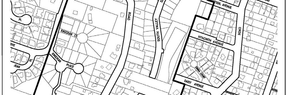
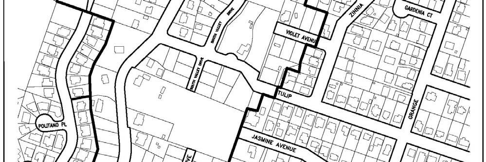
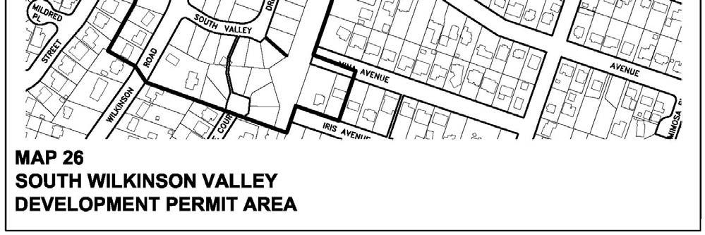
105 98
106 3. Preserve as many of the existing tress as practicable. Where trees are to be removed to facilitate development (ie. rights-of-way, driveways, site clearing, and building envelopes), replacement trees are required to be planted at a 2:1 ratio on-site. Where replacement trees cannot be successfully planted on-site, off-site planting in the boulevard and/or watercourse riparian zone is required. Tree is defined in Tree Bylaw No Preserve and enhance viewscapes of vegetation from adjacent properties and the surrounding community by preserving vegetation and incorporating natural landscaping in site design. 5. Cluster units to preserve open space and vegetation. 6. Promote the coordination of open space and vegetation preservation areas between adjacent properties to create areas of contiguous open space and vegetation. 7. Preserve open space and vegetation through dedication and/or the use of conservation and restrictive covenants. 8. Promote natural vegetation screening instead of fencing where private areas need to be screened and delineated 9. Support fencing of a wood open-rail design to incorporate rural character and permit the movement of wildlife. 10. Maintain and plant trees and natural vegetation in boulevards along lot frontages to enhance streetscapes. 11. Consider as part of site design future road access requirements to surrounding properties that have residential development potential, including consideration of joint access agreements between properties. 12. Provide pedestrian linkages from individual developments to the trails accesses and pedestrian walkways to the valley. 13. Design massing and scale of new buildings and structures to be compatible with adjacent lot sizes and buildings, viewscapes, open space, vegetation, and streetscape. 14. Design building profiles to follow the natural rhythms of topography with minimum alterations made to existing grades to accommodate development. 15. Design building profiles to minimize their presence in the valley by incorporating low roof forms and stepped designs which maintain the dominance of the east and west slopes of the valley. 16. Design the exterior finish of buildings and structures to be of natural building materials and earth tone colours which complement the surrounding vegetation and landscape. 99
107 17. Do not require engineering specification sidewalk construction along the road frontages of multi-family developments unless the road frontage is part of the valley trail system or a safe route to school. Where the road frontage is not part of the valley trail system or a safe route to school, apply the equivalent value of engineering specification sidewalk construction to construction of the valley trail system. 18. Design plans shall meet the intent of the standards set out in Landscaping and Screening Guidelines for commercial, industrial, and multi-family and public uses in Development Permit Areas adopted by Council on December 21, Exterior lighting shall comply with the Municipal Outdoor Lighting Standards to Control Light Pollution. 20. Design plans shall meet the intent of the standards set out in the Saanich Bicycle Parking Guidelines. 21. Design plans shall comply with the recommendations set out in the Access to Transit Guidelines. 22. Wherever possible, preserve areas (including buffers) that contain plants and animal habitat which are designated as red listed (endangered) or blue listed (vulnerable) by the Conservation Data Centre (Ministry of Environment). 100
108 27. STREAMSIDE DEVELOPMENT PERMIT AREA CATEGORY a (protection of the natural environment, its ecosystems and biological diversity) DEFINITIONS Refer to the Definitions section below for the meaning of the terms used. Defined terms are shown in italics. The definitions are specific to the Streamside Development Permit Area. AREA The Streamside Development Permit Area applies to those streams identified on Map 27. The Development Permit Area does not apply to streams that have been enclosed with the approval of the Municipality. For more detailed mapping, refer to Schedule 2 to Appendix N of the Official Community Plan By-law, 1993, No For a stream that is not located within a ravine, the Development Permit Area is 30 m wide (horizontal distance), measured from the high water mark, as shown in Figure 1. Where a stream is located within a ravine, the Development Permit Area extends from the high water mark to a point 30 m upslope of the top of the ravine bank as shown in Figure 2. Within the Development Permit Area (refer to Figure 3), there is a Streamside Protection and Enhancement Area (SPEA), the width of which is determined as specified in Guidelines 2 and 3. No development can occur within the SPEA except as outlined in Guideline 1. Within the remainder of the Development Permit Area (outside of the SPEA), measures to protect and maintain the integrity of the SPEA are required as outlined in Guidelines 4 and 5. JUSTIFICATION Streams and their adjacent riparian areas play a vital role in Saanich s natural environment. Streams provide fish habitat and aquatic habitat for wildlife. Riparian areas, when in a natural state, have dense and structurally complex vegetation that: has high biodiversity and supports a disproportionately large number of wildlife species, contributes to the ecological health of the adjacent stream and its fish habitat through shading, the provision of food, nutrients and organic matter, the provision of large woody debris, stream bank stabilization, the maintenance of water quality through the filtering of water-borne sediments and the uptake of nutrients and toxic materials by the vegetation and soil microorganisms, and prevents the loss of streamside land due to bank instability and soil erosion. 101
109 Development contributes to changes in the riparian area through the loss of trees and vegetation and the alteration of natural processes. These changes may greatly diminish the ability of riparian areas to function as described above. The Streamside Development Permit Area is intended to minimize the impacts of new development along streams and to maintain or restore important riparian functions and ecosystems. The alteration of land, subdivision, and construction are prohibited within an environmental development permit area unless an exemption applies or a development permit is issued. OBJECTIVES The objectives of this Development Permit Area are to: 1. protect streams, their riparian areas and the adjacent upland areas that exert an influence on streams from development; and 2. direct their restoration and enhancement so that they can provide biologically diverse wildlife habitat, corridors for wildlife movement and the natural features, functions and conditions that support fish life processes. EXEMPTIONS WHERE NO DEVELOPMENT PERMIT IS REQUIRED A Development Permit is not required for the following activities: a. gardening and yard maintenance activities within an existing landscaped area, such as mowing lawns, pruning trees and shrubs, planting vegetation and minor soil disturbance that does not alter the general contours of the land; b. the construction of a fence if no native trees are removed and the disturbance of native vegetation is restricted to 0.5 m either side of the fence; c. the construction of a small accessory building such as a pump house, gazebo, garden shed or playhouse if all of the following apply: the building is located within an existing landscaped area; no native trees are removed; the building is located a minimum 5 m from the high water mark of the stream; and the total area of small accessory buildings is less than 10 m 2 ; d. the construction of a private trail if all of the following apply: the trail is 1 meter wide or less; no native trees are removed; the surface of the trail is pervious (for example soil, gravel or wood chips); the trail is designed to prevent soil erosion where slopes occur; and 102
110 where the trail parallels the stream, the trail is more than 5 m away from the high water mark of the stream; e. agricultural use within the Agricultural Land Reserve; f. ecological restoration and enhancement projects undertaken or authorized by the Director of Planning or Manager of Environmental Services; g. construction, maintenance or operation of : municipal works and services undertaken or authorized by the Corporation of the District of Saanich, and parks works and services undertaken or authorized by the Capital Regional District; h. emergency actions required to prevent, control or reduce an immediate threat to human life, the natural environment or public or private property including: forest fire, flood and erosion protection works; protection, repair or replacement of public utilities; clearing of an obstruction from a bridge, culvert or stream; bridge repairs, and removal or modification of hazardous trees as authorized by a qualified Saanich municipal arborist of a QEP (Qualified Environmental Professional). i. Undeveloped properties adjacent to the Colquitz tributary within the South Wilkinson Valley when developed according to the principles established in the South Wilkinson Valley Action Plan. GUIDELINES Development permits issued in these areas shall be in accordance with the following guidelines: 1. No development shall occur within a Streamside Protection and Enhancement Area (SPEA) except for the following: works authorized by the Minister of Fisheries and Oceans or a regulation under the Fisheries Act (Canada); and works and activities that comply with the laws, regulations and best management practices of the Water Act, for example bank repairs, stormwater outfalls, road crossings, footbridges and pipeline crossings. 103
111 2. The width of the SPEA will be determined in one of the following two ways: a) as specified in Schedule 2 to Appendix N of the Official Community Plan By-law, 1993, No. 7044, measured horizontally from and at right angles to the high water mark of the stream (refer to Figure 4) except where the stream is located in a ravine; in which case the SPEA extends beyond the top of the ravine bank for the distance specified in Schedule 2 and includes the area between the top of the ravine bank and the high water mark (refer to Figure 5); or b) by a Qualified Environmental Professional (QEP) who has submitted an assessment report under Sections 4 (2) and 7 of the Riparian Areas Regulation of the Fish Protection Act. The QEP must also address the guidelines of this Development Permit Area. 3. Notwithstanding Guideline 2, where a minor intrusion into a SPEA determined in accordance with 2(a) or 2(b) is required and the SPEA is greater than 10 m wide, the SPEA boundary may be adjusted to accommodate the intrusion where all of the following apply: a) the SPEA intrusion is situated within an existing landscaped area; b) adjustment of the SPEA boundary does not result in any portion of the boundary being less than 10 m from the high water mark; c) terrain stability is not compromised; d) land is added to the SPEA equal in area to that removed, so that there is no reduction in the overall SPEA within the property (as calculated in square metres); e) new areas added to the SPEA to replace those removed are contiguous with the original SPEA and located as close to the stream as possible; f) there is no reduction in the quality of the fish and wildlife habitat provided by the SPEA; and g) a BCLS survey plan is provided that identifies the high water mark of the stream, top of the ravine bank and SPEA boundary in relation to the property lines and existing and proposed development. 104
112 4. The following measures should be taken to ensure that development outside the SPEA but within the Development Permit Area (refer to Figure 3) does not negatively impact the SPEA and the water quality and hydrology of the stream: a) maintain hydrological characteristics that emulate the pre-development state of the land: minimize impervious surfaces; return the storm water runoff from impervious surfaces of the development to natural hydrologic pathways in the ground to the extent reasonably permitted by site conditions, and treat, store and slowly release the remainder per the specifications of Schedule H to the Subdivision Bylaw; minimize alteration of the contours of the land outside the areas approved for buildings, structures and site accesses by minimizing the deposit of fill and the removal of soil; and minimize the removal of native trees outside the areas approved for buildings, structures and site accesses; b) develop and implement a soil erosion and sediment control plan as part of site design and construction to prevent the discharge of sediment-laden water into the stream; c) install temporary fencing and signage to prevent encroachment into the SPEA during construction; d) protect the protected root zones of trees located within the SPEA and those identified for retention outside the SPEA during construction; and e) address terrain stability concerns that may have an impact on the SPEA. 5. Additional measures may also be required depending on the degree of potential impacts of the development on the SPEA and the condition of the SPEA including but not limited to: a) provision of a BCLS survey plan that identifies the high water mark of the stream, top of the ravine bank and SPEA boundary in relation to the property lines and existing and proposed development; b) planting of native vegetation and removal of invasive non-native vegetation within the SPEA in accordance with an approved habitat restoration plan; c) environmental monitoring during the construction phase; d) installation of a permanent fence to demarcate the SPEA; e) reduction of windthrow hazard within the SPEA; 105
113 f) registration of a natural state covenant over the SPEA; and g) dedication of the stream to the Corporation of the District of Saanich. DEFINITIONS Active floodplain means an area of land that supports, or in an undisturbed condition would support floodplain plant species and is: adjacent to a stream that may be subject to temporary, frequent or seasonal inundation; or within a boundary that is indicated by the visible high water mark. Agricultural use means a farm operation conducted in a manner consistent with normal farm practice as defined in the Farm Practices Protection (Right to Farm) Act. Development means any activity referred to in Section 920(1) of the Local Government Act and includes the: removal, alteration, disruption or destruction of vegetation; removal, deposit or disturbance of soils; construction or erection of buildings and structures; creation of non-structural impervious or semi-impervious surfaces; construction of roads, trails, docks, wharves and bridges; provision and maintenance of sewer and water services; and subdivision of land except where a streamside development permit has been issued for the property. Fill means soil, sand, gravel, rock or other material that can be used to alter the contours of land. Fish means all life stages of salmonids, game fish and regionally significant fish. Fish bearing means a stream in which fish are present or potentially present if introduced barriers or obstructions could be removed or made passable for fish. Fish habitat means that the stream is either fish bearing or is connected by surface flow to a stream that is fish bearing. Floodplain plant species means plant species that are typical of an area of inundated or saturated soil conditions and that are distinct from plant species on freely drained adjacent upland sites. High water mark means the visible high water mark of a stream where the presence and action of water are so common and usual, and so long continued in all ordinary years as to leave a mark on the soil of the stream banks, above which there is a change in the character of the soil and vegetation. The high water mark is the edge of the active floodplain. 106
114 Landscaped area means an area significantly altered by human activity where there is the continuous maintenance of no vegetation, cultivated vegetation and/or landscape materials, including but not limited to stones, boulders, cobbles, pavers and decorative concrete. Native means a species that occurs naturally in the area and is not introduced. Natural features, functions and conditions that support fish life processes include, but are not limited to: streams and their active floodplains; the multi-canopied forest and ground cover adjacent to streams that; moderates water temperatures; provides a source of food, nutrients and organic matter to streams; establishes root matrices that stabilize soils and stream banks, thereby minimizing erosion; and buffers streams from sedimentation and pollution in surface runoff; large organic debris that falls into the stream or streamside area, including logs, snags and root wads; natural sources of stream bed substrates; and permeable surfaces that permit infiltration to moderate water volume, timing and velocity and maintain sustained water flows in streams, especially during low flow periods. Protected Root Zone means the area of land surrounding the trunk of a tree which has been specifically delineated on a plan by a: certified arborist or such other person as approved by permit issued by the Director of Parks and Recreation; or in the absence of such information, the area of land surrounding the trunk of a tree contained within a circle having a radius which is calculated by multiplying the diameter of the tree at breast height by 18. Qualified Environmental Professional (QEP) means an applied scientist or technologist, acting alone or together with another qualified environmental professional, if: the individual is registered and in good standing in British Columbia with an appropriate professional organization constituted under an Act, acting under that association s code of ethics and subject to disciplinary action by that association, the individual s area of expertise is recognized in the assessment methods as one that is acceptable for the purpose of providing all or part of an assessment report in respect of that development proposal, and the individual is acting within that individual s area of expertise. Ravine means a narrow, steep sided valley with slope grades greater than 3:1 (33%). Riparian areas are the moist, nutrient rich lands adjacent to streams. Riparian areas are transitional zones between aquatic and terrestrial (or upland) ecosystems and often exhibit vegetation characteristics of both; they are not as dry as upland environments and not as wet as aquatic or wetland systems. 107
115 Soil means the soil, sand, gravel rock or other substance of which land is composed. Stream includes any of the following that provides freshwater fish habitat: a. a watercourse, whether it usually contains water or not; b. a pond, lake, river, creek or brook; and c. a ditch, spring or wetland that is connected by surface flow, pipes, or culverts to something referred to in paragraph (a) or (b). Streamside Protection and Enhancement Area (SPEA) means the area adjacent to a stream that links aquatic to terrestrial ecosystems and includes both the riparian area and the adjacent upland area that exerts an influence on the stream, the width of which is determined in accordance with Guideline 2. Top of the ravine bank means the first significant break in a ravine slope where the grade beyond the break is flatter than 3:1 (33%) for a minimum distance of 15 m measured perpendicularly from the break, and the break does not include a bench within the ravine that could reasonably be developed. Any slope change greater than 3:1 must result in a greater than 1.0 m elevation gain between the points where the slope is less than 3:1. Tree means any living, erect, woody plant that is: 5 m or more in height; or 10 cm or more in diameter. Wetland means an area, not part of the active floodplain of a stream, which is water saturated for a sufficient length of time such that excess water and resulting low soil oxygen levels are the principal determinants of vegetation and soil development. A wetland has a relative abundance of hydrophytes (plants adapted to grow in water logged soils) and/or soils with hydric characteristics that reflect anaerobic conditions. There is a broad range of wetland ecosystem types including swamps, marshes, bogs, fens and estuaries. 108
116 Figure 1: Development Permit Area (DPA) determination for a stream that is not located within a ravine 109

117 FIGURE 2: Development Permit Area (DPA) determination for a stream that is located within a ravine 110

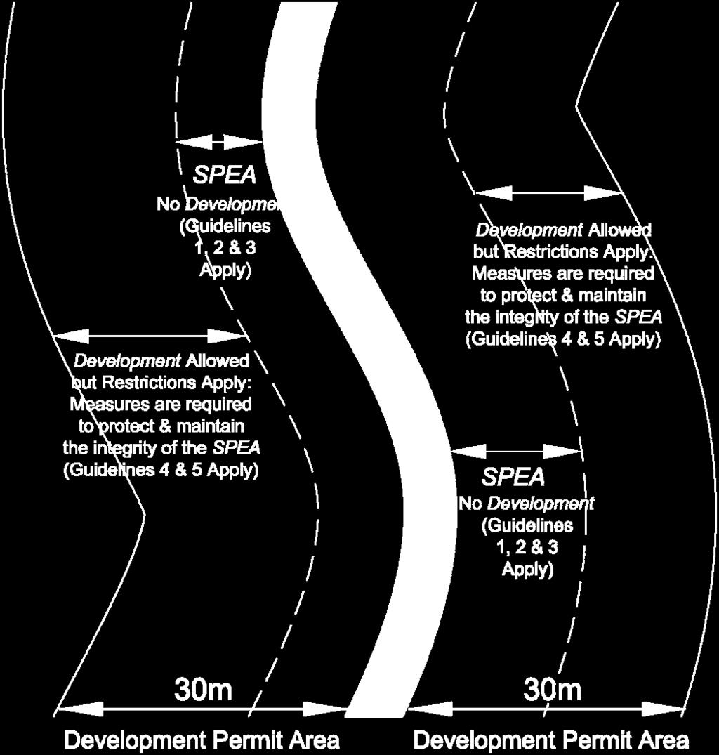
118 FIGURE 3: The Development Permit Area 111

119 FIGURE 4: Streamside Protection and Enhancement Area (SPEA) determination for a stream that is not located within a ravine 112

120 FIGURE 5: Streamside Protection and Enhancement Area (SPEA) determination for a stream that is located within a ravine 113
121 114
122 28. RURAL SAANICH INTERFACE FIRE HAZARD DEVELOPMENT PERMIT AREA CATEGORY b (hazardous conditions) AREA Development Permit Area shown on Map No. 28. EXEMPTIONS In the Rural Saanich Interface Fire Hazard Development Permit Area, a development permit is not required where conditions meet those outlined on Pages 1 and 2 of the Development Permit Areas, Justifications and Guidelines, Appendix N to the Official Community Plan Bylaw, In addition, a development permit is not required for the following activities: 1. Gardening. 2. Installation of fences. 3. Cutting down of hazardous trees that present an immediate danger to the safety of persons or are likely to damage public or private property. 4. Construction of a trail across or through the Development Permit Area. 5. Agricultural activity. 6. Construction of stand-alone gazebos, playhouses, tool and/or garden sheds having a gross floor area not exceeding 10 m Construction of additions that are 50 m 2 or less to existing buildings unless more than 50% of the existing roof will be replaced as part of the construction. 8. Subdivision. JUSTIFICATION Rural Saanich includes large rural residential land holdings that are located on land that is topographically steep, heavily forested, and have limited or no municipal water supply. Many of these areas are also adjacent to forested areas in the District of Highlands, Juan de Fuca Electoral Area, and Central Saanich. Using criteria adapted from the Provincial risk assessment methodology, the properties identified on Map No. 28 have been determined to be at high risk for interface wildfires. As a result, they have been designated as being within a Development Permit Area in order to establish guidelines that are intended to reduce the risk of hazard to persons and property as a result of wildfire. 115
123 Fire resistant roofing materials and exterior cladding on new buildings can mitigate the risk of hazard to persons and property by reducing the possible spread of wildfire. In addition, voluntary vegetation management (ground cover, shrubs and trees) in close proximity to dwelling units, other principle buildings and accessory buildings to ensure adequate clearance between buildings and trees and planting of species that are less susceptible to fire, all contribute to reducing wildfire risk. GUIDELINES Development permits issued in the areas identified on Map No. 28 shall be issued in accordance with the following guidelines designated under category (b) (protection of development from hazardous conditions) unless specifically exempt (see above and pages 1 and 2). 1. Buildings shall be constructed in accordance with the following: a) All roofing material and insulation requirements must meet the Class (B) fire rating requirements contained within the current B.C. Building Code. b) Building design and construction shall generally be consistent with the standards in the National Fire Protection Association (NFPA) Standard Standard for Protection of Life and Property from Wildfire. c) All eaves and attic vents shall be screened using 3 mm non-combustible wire mesh at a minimum to prevent the entry and accumulation of combustible materials and windblown embers. 2. Any building or structure used to store wood shall not be permitted to be located within 10 m of the dwelling unit/principal building unless it is constructed in accordance with guideline (a), (b) and (c) above. 3. All land clearing debris (wood and vegetation) resulting as a result of construction in accordance with a building permit shall be disposed of by removal or burning generally within 3 months of their accumulation and any such burning shall be undertaken in accordance with the Fire Prevention Bylaw. 4. Where building construction and/or the management of vegetation (trees, shrubs, and ground cover) is proposed to take place within the Streamside Development Permit Area, all work undertaken shall be consistent with the Streamside Development Permit Area Guidelines and all other relevant bylaws and regulations. 5. Where a Registered Professional Forester, Registered Forest Technician or Registered Professional Engineer qualified by training or experience in fire protection engineering, has undertaken an assessment of a proposed development and determined the fire hazard to be low provided specific conditions are met, the requirements of these guidelines may be relaxed provided the development is carried out in accordance with such conditions. 116

124 117
URBAN DESIGN BRIEF URBAN DESIGN BRIEF 721 FRANKLIN BLVD, CAMBRIDGE August 2018
 URBAN DESIGN BRIEF URBAN DESIGN BRIEF 721 FRANKLIN BLVD, CAMBRIDGE August 2018 DESIGN BRIEF CONTENTS PART A 1.0 INTRODUCTION 2.0 DESCRIPTION & ANALYSIS OF SITE CONTEXT 3.0 DESIGN CONSTRAINTS AND OPPORTUNITIES
DRAFT Northeast Quadrant of Kipling Avenue and Highway 7 DRAFT AUGUST 29, Goals Land Use. The goals of this Plan are to:
 AUGUST 29, 2017 12.15 Northeast Quadrant of Kipling Avenue and Highway 7 12.15.1 Goals 12.15.2 Land Use The goals of this Plan are to: 12.15.2.1 General Provisions: a) Ensure the development of a compact
6 PORT SYDNEY SETTLEMENT AREA
 Section 6 Port Sydney Page 61 6 PORT SYDNEY SETTLEMENT AREA 6.1 Basis and Principles Village of Port Sydney Waterfront Community Existing Services 6.1.1 Port Sydney is an historic settlement that has developed
URBAN DESIGN BRIEF. 2136&2148 Trafalgar Road. Town of Oakville
 URBAN DESIGN BRIEF 2136&2148 Trafalgar Road Town of Oakville Prepared By: METROPOLITAN CONSULTING INC For 2500674 Ontario Inc November 2016 TABLE OF CONTENTS Page No. 1.0 Introduction/Description of Subject
Official Community Plan Bylaw No. 4360, 2004, Amendment Bylaw No. 4897, 2016 (Sewell s Landing)
") District of West Vancouver Official Community Plan Bylaw No. 4360, 2004, Amendment Bylaw No. 4897, 2016 (Sewell s Landing) Effective Date: 1089612v1 District of West Vancouver Official Community Plan Bylaw
District of West Vancouver Official Community Plan Bylaw No. 4360, 2004, Amendment Bylaw No. 4897, 2016 (Sewell s Landing) Effective Date: 1089612v1 District of West Vancouver Official Community Plan Bylaw
Complete Neighbourhood Guidelines Review Tool
 Complete Neighbourhood Guidelines Review Tool Prepared By: City of Regina Planning Department October 2014 Page 1 of 14 Community Development Review Checklist for Secondary Plans and Concept Plans The
New-Cast Mixed-use Development Proposal King Street West, Newcastle, Ontario
 URBAN DESIGN BRIEF New-Cast Mixed-use Development Proposal King Street West, Newcastle, Ontario TABLE OF CONTENTS: 1.0 Executive Summary 2.0 Creating Vibrant and Sustainable Urban Places: Excerpts from
(DC1) Direct Development Control Provision DC1 Area 4
 Direct Development Control Provision DC1 Area 4") . General Purpose (DC) Direct Development Control Provision DC Area 4 The purpose of this Provision is to provide for an area of commercial office employment and residential development in support of the
. General Purpose (DC) Direct Development Control Provision DC Area 4 The purpose of this Provision is to provide for an area of commercial office employment and residential development in support of the
Toronto Complete Streets Guidelines
 Toronto Complete Streets Guidelines 108 110 7.1 Green Infrastructure Design Principles 112 7.2 Context-Sensitive Green Streets 114 7.3 Key Green Street Elements Green infrastructure refers to natural and
COMMUNITY DESIGN. GOAL: Create livable and attractive communities. Intent
 COMMUNITY DESIGN Intent An attractive, well-designed County will attract quality development, instill civic pride, improve the visual character of the community, and create a strong, positive image for
BYLAW C A Bylaw of Rocky View County to amend Land Use Bylaw C
 BYLAW C-7720-2017 A Bylaw of Rocky View County to amend Land Use Bylaw C-4841-97. The Council of Rocky View County enacts as follows: PART 1 TITLE This Bylaw shall be known as Bylaw C-7720-2017. PART 2
THE CITY OF VAUGHAN BY-LAW BY-LAW NUMBER
 THE CITY OF VAUGHAN BY-LAW BY-LAW NUMBER 123-2013 A By-law to designate the whole of the City of Vaughan as a Site Plan Control Area, and to adopt site development guidelines and rules of procedure for
A Growing Community Rural Settlement Areas
 Town of Huntsville Official Plan Review - POLICY BACKGROUND PAPER A Growing Community Rural Settlement Areas BACKGROUND: In addition to the fully municipally-serviced Urban Settlement Area and the Hidden
PORT WHITBY COMMUNITY
 PORT WHITBY COMMUNITY SECONDARY PLAN UPDATE COMMUNITY IMPROVEMENT PLAN URBAN DESIGN GUIDELINES September 2015 DRAFT PROPOSED AMENDMENT NUMBER # to the Whitby Official Plan PURPOSE: The intent of this Amendment
4 Sustainability and Growth Management
 4 Sustainability and Growth Management Introduction Traditionally, has assumed growth and development with limited consideration for the long-term negative social, environmental or economic impacts on
B L A C K D I A M O N D D E S I G N G U I D E L I N E S for Multi-family Development
 B L A C K D I A M O N D D E S I G N G U I D E L I N E S for Multi-family Development Adopted June 18, 2009 This section of the Design and focuses on site planning and design guidance for new multi-family
URBAN DESIGN BRIEF Gordon Street City of Guelph. Prepared on behalf of Ontario Inc. March 25, Project No. 1507
 URBAN DESIGN BRIEF 1131 Gordon Street City of Guelph Prepared on behalf of 1876698 Ontario Inc. March 25, 2016 Project No. 1507 423 Woolwich Street, Suite 201, Guelph, Ontario, N1H 3X3 Phone (519) 836-7526
The West Vaughan Employment Area Secondary Plan Policies
 Part 2: The West Vaughan Employment Area Secondary Plan Policies 2.1 General Policies It is the policy of Council: 2.1.1. That the West Vaughan Employment Area (the WVEA), identified on Schedule 1, will
Highland Village Green Design Guidelines
 Highland Village Green Design Guidelines Publishing Information Title Highland Village Green Design Guidelins Author The City of Calgary Status DRAFT - Proposed document subject to changes Additional Copies
FORMER CANADIAN FORCES BASE (CFB) ROCKCLIFFE SECONDARY PLAN. Official Plan Amendment XX to the Official Plan for the City of Ottawa
 ROCKCLIFFE SECONDARY PLAN. Official Plan Amendment XX to the Official Plan for the City of Ottawa") FORMER CANADIAN FORCES BASE (CFB) ROCKCLIFFE SECONDARY PLAN Official Plan Amendment XX to the Official Plan for the City of Ottawa 1 INDEX THE STATEMENT OF COMPONENTS PART A THE PREAMBLE PAGE Purpose...
FORMER CANADIAN FORCES BASE (CFB) ROCKCLIFFE SECONDARY PLAN Official Plan Amendment XX to the Official Plan for the City of Ottawa 1 INDEX THE STATEMENT OF COMPONENTS PART A THE PREAMBLE PAGE Purpose...
AMENDMENT NO. TO THE CITY OF BARRIE OFFICIAL PLAN HEWITT S SECONDARY PLAN
 AMENDMENT NO. TO THE CITY OF BARRIE OFFICIAL PLAN HEWITT S SECONDARY PLAN OFFICIAL PLAN FOR THE CITY OF BARRIE Amendment No. Amendment No. to the was prepared by the Barrie General Committee and was recommended
Mixed Use Centres Development Permit Guidelines
 1 Mixed Use Centres Development Permit Guidelines Area Commercial or Mixed Use development occurring in City Centre, Urban Centre, Neighbourhood Centre, or Institutional Complex land use designations is
ELMVALE ACRES SHOPPING CENTRE MASTER PLAN
 ELMVALE ACRES SHOPPING CENTRE MASTER PLAN Contents 1.0 INTRODUCTION... 2 2.0 LOCATION... 2 3.0 EXISTING CONTEXT... 2 4.0 VISION & GUIDING PRINCIPLES... 2 5.0 LAND USE AND BUILT FORM... 4 5.1 St. Laurent
Urban Design Brief Proposed Residential Development 5219 Upper Middle Road City of Burlington
 Urban Design Brief Proposed Residential Development 5219 Upper Middle Road City of Burlington Prepared by Weston Consulting Prepared for BLOOMFIELD DEVELOPMENT INC. Date: March 2017 Table of Contents 1.
*** DRAFT 2 FOR PUBLIC REVIEW ***
 6.7 The area is generally bounded by the Red Hill Valley Parkway to the west, Lake Avenue to the east, the Queen Elizabeth Way (QEW) to the north, and by the properties just south of Queenston Road to
13. VANDORF-PRESTON LAKE SECONDARY PLAN 13.1 INTRODUCTION
 13. VANDORF-PRESTON LAKE SECONDARY PLAN 13.1.1 Purpose 13.1 INTRODUCTION The Vandorf-Preston Lake Secondary Plan establishes the principles, objectives and general policies, as well as specific strategies
Chapter 13 Residential Areas: Appendices APPENDIX 1 Residential Areas
 Chapter 13 Residential Areas: Appendices Page 1 Chapter 13 Residential Areas: Appendices APPENDIX 1 Residential Areas Design Code for Intensive Housing INTRODUCTION DESIGN ELEMENTS A NEIGHBOURHOOD DESIGN
Community Design Guidelines. Port Wallace DRAFT
 Community Design Guidelines Port Wallace DRAFT Energy 1 2 3 Nature Movement Connections Built Form DRAFT Layout Energy 1 Nature Community Design Guidelines GREAT COMMUNITIES PROTECT, CELEBRATE, AND CONSERVE
Official Community Plan Bylaw No. 4360, 2004, Amendment Bylaw No. 4783,2014
 District of West Vancouver Official Community Plan Bylaw No. 4360, 2004, Amendment Bylaw No. 4783,2014 Effective Date: July 7,2014 Official Community Plan Bylaw No. 4360, 2004, Amendment Bylaw No. 4783,
I403 Beachlands 1 Precinct
 I403. Beachlands 1 I403.1. Precinct Description Beachlands is a rural and coastal village located on the eastern side of Auckland, adjoining the Tamaki Strait coastline. The original Beachlands village
CHAPTER 5: GUIDING PRINCIPLES
 CHAPTER 5: GUIDING PRINCIPLES The following 10 principles were developed based on public consultation, planning policy and the background analysis conducted during Phase 1. The Guiding Principles significantly
Westwind Developments Ltd. PIONEER LANDS AREA STRUCTURE PLAN - PROPOSED AMENDMENT
 FEBRUARY 2013 TABLE OF CONTENTS 1.0 BACKGROUND... 1 1.1 Amendment... 1 2.0 LOCATION & CONTEXT... 2 2.1 Land Ownership... 2 3.0 POLICY CONTEXT... 3 3.1 Municipal Development Plan... 3 3.2 Capital Region
QUEEN-RIVER SECONDARY PLAN
 34 QUEEN-RIVER SECONDARY PLAN 34. QUEEN RIVER SECONDARY PLAN 1. INTRODUCTION The Queen-River area is approximately 6.4 hectares and is located at the eastern edge of the Downtown as shown on Map 34-1.
Wide asphalt driveway abutting school property. garage built with incompatible materials, too close to park. incompatible fencing materials
 Wide asphalt driveway abutting school property incompatible fencing materials garage built with incompatible materials, too close to park Lack of plantings as a buffer between private property and open
Derry Green Corporate Business Park
 Town of Milton Derry Green Corporate Business Park Urban Design Guidelines BMI/Pace - June 2010 Draft 3 Prepared by: Brook McIlroy Planning + Urban Design / Pace Architects Suite 300-51 Camden Street Toronto,
Policies and Code Intent Sections Related to Town Center
 Policies and Code Intent Sections Related to Town Center The Town Center Vision is scattered throughout the Comprehensive Plan, development code and the 1994 Town Center Plan. What follows are sections
Clairtrell Area Context Plan
 Clairtrell Area Context Plan March 2005 Urban Development Services City Planning Contents 1. Introduction... 4 2. Development Structure... 6 2.1 Streets... 7 2.1.1 Sheppard Avenue and Bayview Avenue...
Chapter 5: Natural Resources and Environment
 NATURAL RESOURCES AND ENVIRONMENT 5-1 5 Chapter 5: Natural Resources and Environment BACKGROUND AND INTENT Urban expansion represents the greatest risk for the future degradation of existing natural areas,
DEVELOPMENT PERMIT SENSITIVE ECOSYSTEMS
 DEVELOPMENT PERMIT SENSITIVE ECOSYSTEMS What is the Sensitive Ecosystem Development Permit Area (SEDPA)? Surrey s SEDPA is made up of two distinct classifications of the natural environment: Streamside
11. BALLANTRAE-MUSSELMAN LAKE AND ENVIRONS SECONDARY PLAN
 11. BALLANTRAE-MUSSELMAN LAKE AND ENVIRONS SECONDARY PLAN 11.1 PURPOSE The Ballantrae-Musselman Lake and Environs Secondary Plan Area includes two small existing settlement areas, Ballantrae and Musselman
CONTENTS 6.1 URBAN DESIGN
 6-2 Urban Design and Sustainable Development 6.0 URBAN DESIGN AND SUSTAINABLE DEVELOPMENT CONTENTS 6.1 URBAN DESIGN 6.1.1 General Policies 6.1.2 The Public Realm 6.1.3 Streets and Blocks 6.1.4 Streetscapes
Mark-up of the effect of the proposed Bronte Village Growth Area OPA No.18 on the text of section 24, Bronte Village, of the Livable Oakville Plan
 Mark-up of the effect of the proposed Bronte Village Growth Area OPA No.18 on the text of section 24, Bronte Village, of the Livable Oakville Plan Notes: This document is provided for information purposes
Willamette Falls Downtown District Policies and Design Guidelines
 Willamette Falls Downtown District Policies and Design Guidelines The District Policies and Design Guidelines are mandatory for future development within the Willamette Falls Downtown District, and will
Bel-Air Lexus Automobile Service Station
 Bel-Air Lexus Automobile Service Station Design Brief 443-447 McArthur Avenue Ottawa April 30, 2015 14-1299-MCA Site Details Application: Site Plan Control Legal Description and Municipal Addresses: 443
1. General Purpose. 3. Uses
 1. General Purpose The purpose of this DC1 Provision is to facilitate the development of a pedestrian friendly Community Commercial Centre that may accommodate a range of commercial, residential, office,
SECTION UNIFIED DEVELOPMENT ORDINANCE SECTION Part 1 Ordinance. ARTICLE 1 Zoning Districts
 SECTION 1-100 UNIFIED DEVELOPMENT ORDINANCE SECTION 1-300 Part 1 Ordinance SECTION 1-100. Introduction. ARTICLE 1 Zoning Districts Crystal Lake strives to maintain a balance of various land uses for a
H7 Open Space zones. (a) provide for the needs of the wider community as well as the needs of the community in which they are located;
 provide for the needs of the wider community as well as the needs of the community in which they are located;") H7. Open Space zones H7.1. Background The majority of land zoned as open space is vested in the Council or is owned by the Crown. However some areas zoned open space are privately owned. While the open
H7. Open Space zones H7.1. Background The majority of land zoned as open space is vested in the Council or is owned by the Crown. However some areas zoned open space are privately owned. While the open
CHAPTER 13 DESIGN GUIDELINES
 CHAPTER 13 DESIGN GUIDELINES Section 1300.00 Section 1300.01 Design Guidelines Purpose The purposes of this section are to: A. The purpose of this Section is to establish procedures and standards to serve
THE CITY OF VAUGHAN BY-LAW BY-LAW NUMBER A By-law to adopt Amendment Number 1 to the Official Plan of the Vaughan Planning Area.
 THE CITY OF VAUGHAN BY-LAW BY-LAW NUMBER 015-2014 A By-law to adopt Amendment Number 1 to the Official Plan of the Vaughan Planning Area. NOW THEREFORE the Council of the Corporation of the City of Vaughan
East Bayshore Road Neighbourhood
 East Bayshore Road Neighbourhood Northridge Property Management Urban Design Brief 3195 East Bayshore Road City of Owen Sound January 2016 East Bayshore Road Neighbourhood Northridge Property Management
Revitalization Guidelines for Corridors, Villages and Town Centres
 Revitalization Guidelines for Corridors, Villages and Town Centres July 2017 Updated May, 2018 Publishing Information Title: Prepared by: Revitalization Guidelines for Corridors, Villages and Town Centres
APPENDIX K WINDSOR OFFICIAL PLAN
 CEAA ENVIRONMENTAL ENVIRONMENTAL IMPACT ASSESSMENT AMBASSADOR BRIDGE ENHANCEMENT PROJECT Replacement Span and Plaza Expansion APPENDIX K WINDSOR OFFICIAL PLAN Avalon Consulting Professionals of Ontario,
THE CORPORATION OF THE TOWN OF OAKVILLE BY-LAW NUMBER
 THE CORPORATION OF THE TOWN OF OAKVILLE BY-LAW NUMBER 2017-120 A by-law to adopt an amendment to the Livable Oakville Plan, Official Plan Amendment Number 20 (Downtown Oakville Growth Area) WHEREAS the
13 THORNHILL YONGE STREET STUDY IMPLEMENTATION CITY OF VAUGHAN OPA 669 AND TOWN OF MARKHAM OPA 154
 13 THORNHILL YONGE STREET STUDY IMPLEMENTATION CITY OF VAUGHAN OPA 669 AND TOWN OF MARKHAM OPA 154 The Planning and Economic Development Committee recommends the adoption of the recommendations contained
11.4 Highway 400 North Employment Lands Secondary Plan APPROVED BY THE ONTARIO MUNICIPAL BOARD ON NOVEMBER 21, 2011
 11.4 Highway 400 North Employment Lands Secondary Plan APPROVED BY THE ONTARIO MUNICIPAL BOARD ON NOVEMBER 21, 2011 11.4.1 General 11.4.1.1. as approved by the Ontario Municipal Board on November 21, 2011,
APPENDIX C. Architectural and Environmental Design Standards. Environmentally sensitive areas should be protected.
 APPENDIX C Architectural and Environmental Design Standards Environmentally Sensitive Areas Goal A. Environmentally sensitive areas should be protected. Development, such as roads, houses, and other structures,
URBAN DESIGN BRIEF 305, 309, & 315 SOUTHDALE ROAD WEST LONDON ONTARIO
 URBAN DESIGN BRIEF 305, 309, & 315 SOUTHDALE ROAD WEST LONDON ONTARIO CARVEST PROPERTIES LTD. December 2013 Section 1 - Land Use Planning Context 1.1 Subject Lands The subject lands are located immediately
6Natural. Environment Development Permit Guidelines
 6Natural Bylaw 2600-2016, being "Official Community Plan Bylaw, 2016" Schedule "A" CITY OF ABBOTSFORD OFFICIAL COMMUNITY PLAN Environment Development Permit Guidelines Part V - 6-1 Area Subdivision or
AMENDMENT NO. 30 TO THE OFFICIAL PLAN OF THE TOWN OF MILTON
 AMENDMENT NO. 30 TO THE OFFICIAL PLAN OF THE TOWN OF MILTON Subject: Boyne Survey Secondary Plan and Related Official Plan Amendments The following text and schedules constitute Amendment No. 30 to the
4 Residential and Urban Living Zones
 4 Residential and Urban Living Zones Refer to Chapters 11 to 20 for additional rules that may apply to these zones. 4.1 OBJECTIVES AND POLICIES Objective Res1 Policy 1 Policy 2 Policy 3 Policy 4 Policy
North Oakville East Parks Facilities Distribution Plan. November, 2009
 North Oakville East November, 2009 POLICY CONTEXT 1) Purpose a) The purpose of this document is to be a guide for the location, configuration, design and development of the parks system for the North Oakville
Be it enacted by the Town Board of the Town of Guilderland that the following new A (Transit Oriented Development (TOD) District) is adopted:
 District) is adopted:") Local Law No. 4 of 2018 (Adoption of 280-18A (Transit Oriented Development District) Be it enacted by the Town Board of the Town of Guilderland that the following new 280-18A (Transit Oriented Development
Local Law No. 4 of 2018 (Adoption of 280-18A (Transit Oriented Development District) Be it enacted by the Town Board of the Town of Guilderland that the following new 280-18A (Transit Oriented Development
11.4 Highway 400 North Employment Lands Secondary Plan
 11.4 Highway 400 North Employment Lands Secondary Plan APPROVED BY THE ONTARIO MUNICIPAL BOARD ON NOVEMBER 21, 2011 11.4.1 General 11.4.1.1. The following policies and Schedules A - I form Official Plan
LAND USE ELEMENT. Purpose. General Goals & Policies
 LAND USE ELEMENT Purpose This Land Use Element contains the goals and policies necessary to support the City s responsibility for managing land resources and guiding development through implementing regulations,
Exhibit A. 8:9 Scuffletown Rural Conservation District
 Exhibit A 8:9 Scuffletown Rural Conservation District 8:9.1 Intent and Purpose The Scuffletown Rural Conservation (SRC) District is intended to provide for residential development that supports the development
2136 & 2148 Trafalgar Road Town of Oakville Region of Halton
 PLANNING JUSTIFICATION REPORT 2136 & 2148 Trafalgar Road Town of Oakville Region of Halton Zoning By-Law Amendment Application 2500674 Ontario Inc. November 2016 Table of Contents Page 1.0 Location/Summary
Urban Design Brief. Watson Parkway North & Watson Road North Guelph, Ontario. Prepared by Coletara Development
 Urban Design Brief Watson Parkway North & Watson Road North Guelph, Ontario Prepared by Coletara Development December, 2013 Urban Design Brief, Coletara Development 1 Introduction This Urban Design Brief
Sierra Springs Regional Commercial Master Site Plan Airdrie, Alberta Hopewell Development Corporation Project No May 26, 2010
 Sierra Springs Regional Commercial Master Site Plan Airdrie, Alberta Hopewell Development Corporation Project No. 205-077 May 26, 2010 TABLE OF CONTENTS Purpose... 2 Master Site Plan Guidelines... 3 Overall
DEFINED VILLAGE CENTRES & NEIGHBOURHOODS
 DEFINED VILLAGE CENTRES & NEIGHBOURHOODS residents in Nanoose Bay support focusing attractive, planned future development in Red Gap Centre and the Area s neighbourhood centres. In addition, the development
HURON COMMUNITY PLAN
 CITY OF KITCHENER DEPARTMENT OF DEVELOPMENT AND TECHNICAL SERVICES PD 94/7 HURON COMMUNITY PLAN Recommended by Planning and Economic Development Committee: October 31, 1994 Adopted by Kitchener City Council:
Queensborough Eastern Neighbourhood Node. Community Open House
 Queensborough Eastern Community Open House The Vision The Queensborough Eastern will become the heart of eastern Queensborough. Through a sensitive mix of viable commercial and residential areas, the neighbourhood
The lands identified as Residential Areas on Schedule A1, Urban Structure, represent the areas that provide for stable residential communities.
 Livable Oakville Part D: Land Use Designations and Policies 11. RESIDENTIAL 11.1 General The lands identified as Residential Areas on Schedule A1, Urban Structure, represent the areas that provide for
URBAN DESIGN BRIEF 181 Burloak Drive, Oakville
 URBAN DESIGN BRIEF 181 Burloak Drive, Oakville February 2017 Our File: 1730B 230-7050 WESTON ROAD / WOODBRIDGE / ONTARIO / L4L 8G7 / T: 905 761 5588/ F: 905 761 5589/WWW.MHBCPLAN.COM TABLE OF CONTENTS
Duplex Design Guidelines
 Duplex Design Guidelines Adopted by Council May 29, 2006 Prepared By: Table of Contents 1.0 Application and Intent 1 2.0 Areas of Application 2 3.0 Design Principles 3 4.0 Design Guidelines 4 4.1 Site
FRASER LANDS CD-1 GUIDELINES (BLOCKS 68 AND 69) Adopted by City Council April 1989
 Adopted by City Council April 1989") $1 City of Vancouver Land Use and Development Policies and Guidelines Community Services, 453 W. 12th Ave Vancouver, BC V5Y 1V4 F 604.873.7344 fax 873.7060 planning@city.vancouver.bc.ca FRASER LANDS CD-1
$1 City of Vancouver Land Use and Development Policies and Guidelines Community Services, 453 W. 12th Ave Vancouver, BC V5Y 1V4 F 604.873.7344 fax 873.7060 planning@city.vancouver.bc.ca FRASER LANDS CD-1
Design Specifications & Requirements Manual
 11 PARKS & OPEN SPACES 11.1 DEFINITIONS... 1 11.1.1 Neighbourhood Parks... 1 11.1.2 District Parks... 1 11.1.3. Sport Parks... 1 11.1.4 Urban Parks... 1 11.1.5 Civic Spaces... 1 11.1.6 Open Space System...
Gold Line Bus Rapid Transit Transit Oriented Development (BRTOD) Helmo Station Area Plan
 Helmo Station Area Plan") Appendix F Gold Line Bus Rapid Transit Transit Oriented Development (BRTOD) Helmo Station Area Plan Introduction and Purpose of the Plan The Gold Line Bus Rapid Transit facility is an eleven-mile dedicated
Appendix F Gold Line Bus Rapid Transit Transit Oriented Development (BRTOD) Helmo Station Area Plan Introduction and Purpose of the Plan The Gold Line Bus Rapid Transit facility is an eleven-mile dedicated
WASHINGTON COUNTY OREGON
 WASHINGTON COUNTY OREGON July 9, 2009 Revisions to Chapter 2 of the Bethany Community Plan The North Bethany Subarea Plan Exhibit pages 7 and 8 The sections for the Core and Flexible Streets were amended
River Corridor Overlay Zone (RCOZ) Article 5
 Article 5") River Corridor Overlay Zone (RCOZ) Article 5 The site is in one of two designated districts. The first is the CBD (central business district) River District, which recognizes the urban character and unique
River Corridor Overlay Zone (RCOZ) Article 5 The site is in one of two designated districts. The first is the CBD (central business district) River District, which recognizes the urban character and unique
BROOKHILL NEIGHBORHOOD MODEL ZONING MAP AMENDMENT PREFACE TO APPLICATION
 BROOKHILL NEIGHBORHOOD MODEL ZONING MAP AMENDMENT PREFACE TO APPLICATION June 15, 2015 Revised: August 1, 2016 I. VISION Brookhill is a proposed community based upon the principles of Albemarle County
Division 13 Local Business and Industry Buffer Zone: Assessment Criteria and Assessment Tables
 Division 13 Local Business and Industry Buffer Zone: Assessment Criteria and Assessment Tables 4.13.1 Local Business and Industry Buffer Zone The provisions in this division relate to the Local Business
DAVENPORT VILLAGE SECONDARY PLAN
 27 DAVENPORT VILLAGE SECONDARY PLAN 27. DAVENPORT VILLAGE SECONDARY PLAN 1. VISION FOR THE DAVENPORT VILLAGE SECONDARY PLAN Davenport Village, municipally known as 830, 940, 980 and 1100 Lansdowne Avenue,
Chapter IV: Development Pattern
 Chapter IV: Development Pattern Introduction The 2002 Prince George s County Approved General Plan designates three growth policy tiers Developed, Developing, and Rural as well as three center designations
4.0 Design Guidelines For The Village Centre. South fields Community Architectural Design Guidelines Town of Caledon
 4.0 Design Guidelines For The Village Centre 4.0 Design Guidelines for the Village Centre The Village Centre is the focal point of the entire South Fields Community and is designed as a traditional commercial
Municipal Development Plan. Summer Village of ROCHON SANDS. Bylaw #241-18
 Municipal Development Plan Summer Village of ROCHON SANDS Bylaw #241-18 TABLE OF CONTENTS PART ONE: BACKGROUND AND PURPOSE 3 SECTION 1: BACKGROUND 3 SECTION 2: GOALS AND POLICIES 3 PART TWO: PHYSICAL ENVIRONMENT
KEY MAP DEVELOPMENT PERMIT AREA MAP. Sunnymede North Sub-Area Plan
 Richmond Official Community Plan BROADMOOR AREA SUNNYMEDE NORTH SUB-AREA PLAN Bylaw 7100 Schedule 2.6C SUNNYMEDE NORTH SUB-AREA PLAN SUNNYMEDE NORTH SUB-AREA PLAN SUNNYMEDE NORTH SUB-AREA PLAN KEY MAP
Proposed for Vic West Neighbourhood Plan. Design Guidelines for Intensive Residential Development - Townhouse and Attached Dwelling
 Proposed for Vic West Neighbourhood Plan Design Guidelines for Intensive Residential Development - Townhouse and Attached Dwelling Design Guidelines for Intensive Residential Development - Townhouse and
II. SINGLE FAMILY RESIDENTIAL
 II. SINGLE FAMILY RESIDENTIAL Castle Rock is made up of numerous individually built houses and subdivision tracts that have been developed during the past century. Some of the tracts are diverse in architectural
Urban Design Manual PLANNING AROUND RAPID TRANSIT STATIONS (PARTS) Introduction. Station Study Areas
 Introduction. Station Study Areas") 111111 PLANNING AROUND RAPID TRANSIT STATIONS (PARTS) Introduction The ION rapid transit system will link Waterloo, Kitchener and Cambridge through a central transit corridor (CTC). There are a number
111111 PLANNING AROUND RAPID TRANSIT STATIONS (PARTS) Introduction The ION rapid transit system will link Waterloo, Kitchener and Cambridge through a central transit corridor (CTC). There are a number
FARMING PROTECTION. The Farming Protection Development Permit Guidelines are organized into five main categories:
 Development Permits Farming Protection DP4 DEVELOPMENT PERMIT GUIDELINES: FARMING PROTECTION The Farming Protection Development Permit Guidelines are organized into five main categories: General Single
YONGE STEELES CORRIDOR SECONDARY PLAN. Young + Wright / IBI Group Architects Dillon Consulting Ltd. GHK International (Canada) Ltd.
 Ltd.") PART A: PREAMBLE 1.0 PURPOSE The purpose of this Secondary Plan is to provide a development framework for intensification of the Yonge/ Steeles corridor including the north side of Steeles Avenue West
PART A: PREAMBLE 1.0 PURPOSE The purpose of this Secondary Plan is to provide a development framework for intensification of the Yonge/ Steeles corridor including the north side of Steeles Avenue West
Planning Board Briefing
 Planning Board Briefing Why Now? The Sector Plan Implementation Chapter States: Before Stage 1 begins, the following must occur: Approval of the Sectional Map Amendment. Approval of the Greater Lyttonsville
Future Five. Design/ Development Guidelines. January 2008 Amended June 08 per City Council motion
 Future Five Design/ Development Guidelines January 2008 Amended June 08 per City Council motion 5-Points Design Guidelines Table of Contents I. Introduction 3 II. Area boundaries 4 III. Review Process
I539. Smales 2 Precinct
 I539. Smales 2 Precinct I539.1. Precinct Description The Smales 2 Precinct applies to a 4.8 hectare block of land located on the southern side of Northcote Road and fronting Lake Pupuke, Takapuna. The
Attachment 1 TOWN OF NEW TECUMSETH. Manual for the Preparation of an Urban Design Report
 Attachment 1 TOWN OF NEW TECUMSETH Manual for the Preparation of an Urban Design Report July 2010 TABLE OF CONTENTS Background, Policy Framework and the Preparation of Urban Design Reports 1. Introduction
Regional Context Statement
 Regional Context Statement REGIONAL CONTEXT STATEMENT 3. REGIONAL CONTEXT STATEMENT In 1995, the Provincial Government passed into law the Growth Strategies Act. The purpose of this provincial initiative
Planning & Development. Background. Subject Lands
 Planning & Development APPLICATION BRIEFING Prepared For: Planning Advisory Committee Submitted by: Jason Fox, Director of Planning & Development Date: Subject: Development Agreement Application by Brentwood
Town of Peru Comprehensive Plan Executive Summary
 Town of Peru Comprehensive Plan Executive Communities that plan grow by choice, not by chance. A plan makes growth thoughtful, understandable, and predictable. A plan shows that a community is managing
B. Blocks, Buildings and Street Networks
 B. Blocks, Buildings and Street Networks Figure IV.4 A rational block pattern with connected streets Introduction The single most important element in the physical and functional integration of mixed use
VILLAGE OF SKOKIE Design Guidelines for Mixed-Use Districts NX Neighborhood Mixed-Use TX Transit Mixed-Use CX Core Mixed-Use
 VILLAGE OF SKOKIE Design Guidelines for Mixed-Use Districts NX Neighborhood Mixed-Use TX Transit Mixed-Use CX Core Mixed-Use TABLE OF CONTENTS CHAPTER 1 SITE DESIGN Purpose 1 CHAPTER 2 SITE DESIGN Streetscape