Proposed Mixed Use Residential and Commercial Redevelopment
|
|
|
- Lora Parsons
- 5 years ago
- Views:
Transcription
1 PLANNING REPORT Proposed Mixed Use Residential and Commercial Redevelopment Proposed Zoning By-law Amendment Application 219 & 231 Dundas Street East City of Toronto PREPARED FOR: Dundas MEP Developments Inc. April 2016
2 PLANNING REPORT 219 & 231 DUNDAS STREET EAST PAGE i TABLE OF CONTENTS Page 1.0 Introduction Location and Description of the Site Description of Surrounding Area Context Description of the Proposal Applications Required to Implement the Proposal Policy Context of the Proposal Provincial Policy Statement 2014 (PPS) and the Growth Plan Provincial Policy Statement The Growth Plan for the Greater Golden Horseshoe Conclusions Concerning the Provincial Policies City of Toronto Official Plan Policies and Guidelines Growth Management Policies Mixed Use Areas Policies Built Form Policies Housing Policies Heritage Conservation Policies OPA 82 Garden District Site and Area Specific Policy Garden District Heritage Conservation District (HCD) Plan Tall Building Design Guidelines, May 2013 /Downtown Tall Buildings Vision and Supplementary Guidelines, July Tall Building Design Guidelines, May Conclusions Concerning the Tall Building Design Guidelines Downtown Tall Buildings: Vision and Supplementary Design Guidelines, July Conclusions Concerning the Downtown Tall Buildings: Vision and Supplementary Design Guidelines, July Overall Conclusions 33 GOLDBERG GROUP
3 PLANNING REPORT 219 & 231 DUNDAS STREET EAST PAGE ii LIST OF FIGURES Figure 1: Aerial Context Plan Figure 2: Location Plan and Surrounding Building Heights Figure 3: City of Toronto Official Plan Maps Figures 4-7: Site Photos Figure 8: Developments in Surrounding Area Figure 9: City of Toronto Zoning By-Law Maps Figure 10: City of Toronto Zoning By-Law Maps Figure 11: Survey Figure 12-13: Site Statistics Figure 14: Site Plan / Roof Plan Figure 15: Underground Level 4 Figure 16: Underground Level 3 Figure 17: Underground Level 2 Figure 18: Underground Level 1 Figure 19: Floor 1 Plan Figure 20: Floor 2 Plan Figure 21: Floor 3 Plan Figure 22: Floor 4-5 Plan Figure 23: Floor 6 Plan Figure 24: Floor 7 9 Plan Figure 25: Typical Floor Plans Figure 26: North and East Elevations Figure 27: South and West Elevations Figure 28: Building Sections Figure 29: 3D Views Figure 30: Landscape Master Plan Figure 31: 2 nd Floor Amenity Terrace Plan Figure 32 35: Shadow Study- March/September Figure 36 38: Shadow Study- June Figure 39: Maps from OPA 82 Figure 40: Proposed Garden District Heritage Conservation District (HCD) Figure 41: Maps from Downtown Tall Buildings Vision and Supplementary Design Guidelines July 2012 LIST OF APPENDICES Appendix A: Draft Zoning By Law Amendment to By-law Appendix B: Draft Zoning By Law Amendment to By-law GOLDBERG GROUP
4 1.0 Introduction Dundas MEP Developments Inc. has retained Goldberg Group as land use planners in relation to an application to amend the Zoning By-law (ZBA) to permit redevelopment of the lands known municipally as 219 and 231 Dundas Street East (the subject site) for a 29 storey mixed use residential building, with retail and service commercial uses at grade. The project consists of a mix of 295 residential units, 211 sq. m. of retail and service space and a Floor Space Index (FSI) of The site is 1,499 sq. m. (0.37 ac) in size and located on the south side of Dundas Street East, approximately 140 m (459.3ft) east of Jarvis Street, in Downtown Toronto. The subject site is currently occupied by a vacant 3-storey building at 231 Dundas Street East, and a surface commercial parking lot at 219 Dundas Street East. These properties are not listed or designated on the City s Heritage Property Inventory. This report reviews the existing land use context, the capability of this site within this context, the current Provincial and the City policies and guidelines. As a result, from both land use planning and urban design perspectives, the proposed redevelopment is a good and appropriate fit with the existing and planned context. It is also consistent with, conforms with, and is in keeping with, applicable policies and guidelines of the Province of Ontario and the City. In addition to this Planning Report, other experts have also been retained by the applicant as part of this application, whose reports and plans are being filed under separate cover. To the extent required, the information and conclusions of these experts are used as input into this Planning Report. The other experts include: Site Plan and Architectural Plans, Turner Fleischer Architects Inc. Landscape Plans, NAK Design Group Arborist/Tree Preservation Report, Bruce Tree Expert Company Ltd. Functional Servicing Report, Site Grading and Servicing Plans, Public Utilities Plan, Stantec Transportation Impact Study, LEA Consulting Limited Sun Shadow Study, Turner Fleischer Architects Inc. Pedestrian Level Wind Assessment, Theakston Environmental Consulting Engineers Archaeological Assessment, Amick Consultants Limited Noise & Vibration Study, HGC Engineering GOLDBERG GROUP
5 PLANNING REPORT 219 & 231 DUNDAS STREET EAST PAGE 2 Toronto Green Standards Checklist, Turner Fleischer Architects Inc. Heritage Impact Statement, Goldsmith, Borgel & Company Ltd. Architects Community Services and Faclities Study, Goldberg Group Boundary and Topographical Survey, Rady-Pentek & Edward Surveying Ltd. To the extent applicable, these plans and reports have been used as input into the facts and opinions expressed in this Planning Report. 2.0 Location and Description of the Site Figure 1 is an air photograph showing the area context of the subject property and Figure 2 is a property data plan providing the location of the site and building heights within a few block radius of the subject site. Figure 11 is the survey of the subject property. The subject site is an assembly of two lots (219 and 231 Dundas Street East), located on the south side of Dundas Street East, approximately 140 m (459.3 ft.) east of Jarvis Street and approximately 650 m (2,132.5 ft.) from Yonge Street and the Dundas Subway Station. The subject site is legally known as Part of Lots 4A, 5, 5B and 6A Registered Plan D-48 and Part of Lot 1, Registered Plan D-251 (Former Municipality of Metropolitan Toronto) City of Toronto. The subject site is located along a curved portion of Dundas Street East, is an irregular shaped lot and due to the curve in the road, has a front lot line orientated to the northwest. The subject site occupies approximately 1,499 sq. m (0.37 ac) of land and has m (145.6 ft.) of frontage on Dundas Street East. Dundas Street East is a 4 lane, 20 m wide, Major Street in the City of Toronto Official Plan (City OP). Driveway access to the site is to/from Dundas Street East. Figure 11 (Survey) shows the existing paved commercial parking lot at 219 Dundas Street East. At the eastern portion of the site, 231 Dundas Street East, is a 3-storey building that is currently vacant and was as such prior to acquisition by the current owner. The remainder of the site is occupied by the commercial parking lot, which is enclosed by a chain link fence and wood retaining wall at the east boundary of the site. GOLDBERG GROUP
6 PLANNING REPORT 219 & 231 DUNDAS STREET EAST PAGE 3 Included on the Survey (Figure 11) is a 2.29 m (7.5 ft) Right-of-way travelling in an eastwest direction, located to the east of 219 Dundas Street East and extending to Pembrooke Street. It is identified as Instruments Nos. CA663709, CA and CT This right-of-way is separated from the main portion of the subject site by a wood retaining wall and chain link fence. The topography of the subject site is generally flat. All tree related implications have been examined and filed under separate cover. The south and west property lines of the subject site abuts the L Ecole Publique Gabrielle Roy, a public French language school. There are mature trees currently existing on the school site that are lined along these shared property lines. The east property line of the subject site abuts various built form ranging from 3 3 ½ storeys in height, some of which with retail or commercial uses at grade and residential above, or are wholly residential. The site is located within the Downtown on the OP Urban Structure Map (Figure 3), where considerable growth is planned to be accommodated, and within the Mixed Use Areas designation, which permits a range of residential uses, offices, retail and services, institutions, entertainment, recreation and cultural activities, and parks and open spaces. Also, the site is in close proximity to the TTC Yonge Street subway line and the Dundas Street subway station and other surface transit routes. The former City of Toronto Zoning By-law zones the site Mixed Commercial Residential MCR T1.5, C1.0, R1.0 with a height permission of 12.0 m. The MCR zone permits a wide range of uses including: apartment buildings and other forms of residential dwellings, parks, community centres, schools and a range of commercial retail uses (Figures 9 and 10). City-wide By-law zones the property Commercial Residential CR (d1.0; C1.0; R1.0) SS2 (x.1248), subject to Standard Set 2, with a maximum height of 12.0 m, which zone provisions are generally the same as in By-law GOLDBERG GROUP
7 PLANNING REPORT 219 & 231 DUNDAS STREET EAST PAGE Description of Surrounding Area Context Figures 1 and 2 show that the subject site is very centrally located and in close proximity to the higher order transit, shops, services, restaurants, entertainment, institutional and commercial office uses. The area is characterized by mixed use streets and dense urban form with built forms including large commercial buildings, tall apartment buildings and pockets of low rise residential. Dundas Street East is a 20 m (65.6 ft) wide Major Street in the City OP and is a busy east/west commuter route providing one of the few connections over the Don Valley Parkway (DVP) between the Downtown area and neighbourhoods, located east of the DVP. Dundas Street East also includes the 505 Dundas streetcar route which operates at all times, seven days a week, and links with the Dundas West subway station on the Bloor- Danforth subway line in the west, the St. Patrick Station and the Dundas subway station on the Yonge University line and the Broadview Station in the east. Streetcar stops are located at the intersection of Dundas Street East and Jarvis Street, approximately 140 m (459 ft), or a 2 minute walk, east of the subject site. Figures 4-8 provide photographs of the site and surrounding area. The surrounding land uses are described as follows: To the West: Immediately to the west of the site is George Street and a range of 3-storey multi unit dwellings of varying architectural styles ranging from Gothic Revival, Edwardian and Second Empire. Along Dundas Street East, immediately west of George Street, are low rise 3-storey built form with commercial retail at grade and residential dwelling units above also with varying architectural styles. Further west, at the southeast corner of Dundas Street East and Jarvis Street, 175 Dundas Street East, there is a redevelopment approval for a 50 storey mixed use condominium building. Immediately south of this site, is the Grand Hotel at 225 Jarvis Street, also an approved redevelopment for a 45 storey mixed use condominium building. These sites were recently the subject of an Ontario Municipal Board (OMB) hearing. GOLDBERG GROUP
8 PLANNING REPORT 219 & 231 DUNDAS STREET EAST PAGE 5 On the southwest corner of Dundas Street East and Jarvis at Dundas Street East and 200 Jarvis Street, is an approved 42 storey mixed use condominium building (Pace Condos by Great Gulf) that is currently under construction. Directly abutting this site are 3-storey house form mixed use buildings with commercial at grade and residential dwellings above. Further south, at Jarvis Street, is an approved 30 storey residential building intended for a Ryerson University Student Residence that is currently under construction. At 200 Dundas Street East, Jarvis Street and 280 George Street, the northeast corner of Dundas Street East and Jarvis Street, is a redevelopment approval for a 45 storey mixed use condominium building with an 17-storey podium at the east end of the site at George Street (Dundas Square Gardens by Easton s Group). This site is currently occupied by former hotel building and is expected to commence construction in late Spring of Abutting this site to the north are Toronto Community Housing Corporation (TCHC) 7-10 storey apartment buildings fronting on Jarvis and George Streets with a central courtyard. At the northwest corner of Dundas Street East and Jarvis Street, 222 Jarvis Street, is a surface parking lot and a 9-storey building that is currently occupied by the offices of Infrastructure Ontario and the Ministry of Government Services (MGS) staff. Further to the southwest of the site, at Mutual Street, is a redevelopment proposal for a 38 storey residential building and a 4-storey office building. The proposal is currently pending an OMB hearing. Continuing west along Dundas Street East, are a range of residential apartment buildings with retail uses at grade and also a range of lower scale house form commercial buildings with some residential uses above. At the southeast corner of Dundas Street East and Church Street, Church Street and 117 Dundas Street East, is a redevelopment proposal for a 46 storey mixed use building with a 5-storey podium. This proposal is currently pending an Ontario Municipal Board (OMB) hearing. To the South: The abutting property to the south, is a public French language school, L Ecole Publique Gabrielle Roy, at 14 Pembroke Street. The building is located at the southerly portion of the site and is surrounded by paved and landscaped open space that is utilized as the school s outdoor play area. The north and west limits of the school site, that are directly adjacent to the subject site are lined with mature trees providing an effective screen and buffer between the school and the buildings fronting onto Dundas Street. The school site is listed, although not designated, on the City s Heritage Property Inventory. The Heritage Impact Statement has been filed under separate cover for reference and additional detail. GOLDBERG GROUP
9 PLANNING REPORT 219 & 231 DUNDAS STREET EAST PAGE 6 Further south of the school site are 3-storey row houses that front onto George and Shuter Streets. The row houses that front onto Shuter Street are listed on the City of Toronto Heritage Property Inventory. Also, at 102 Shuter Street is a 14 storey residential building that was approved at the Ontario Municipal Board (OMB). Directly adjacent to this site, at 203 Jarvis Street, is an existing surface parking lot that is approved for a 20 storey hotel building. Immediately south of Shuter Street, is Moss Park. Moss Park is comprised of a large open space with a baseball diamond, outdoor tennis and basketball courts, and various paths and seating areas for recreational use. Additional community facilities such as the John Innes Community Centre and Moss Park Arena are located in Moss Park. Immediately west, adjacent to Moss Park, is the Moss Park Armoury, which is primarily a training facility of the Canadian Forces. The facility is also utilized as event space. To the East: Immediately to the east of the subject site, fronting onto Dundas Street East, are 3 storey mixed use buildings with retail or commercial uses at grade with residential dwelling units above. Just southeast along Pembroke Street, are a range of 2-3 storey residential buildings of varying architectural styles, including detached dwellings containing multiple units to row housing. In addition, there are 3-4 storey apartment buildings located on Pembroke Street adding to the variety of built form. The buildings at Pembroke Street and 200 Sherbourne Street are listed on the Heritage Property Inventory and are also owned and operated by Toronto Community Housing Corporation (TCHC). Further east along Dundas Street East, are a range of 2-3 storey residential dwellings of varying architectural styles as mentioned above. Further east at the intersection of Dundas Street and Sherbourne Street, are a variety of existing apartment buildings ranging from 7 23 storeys, some of which include commercial retail and service uses at grade. On the southeast corner of Dundas Street East and Sherbourne is the All Saints Church Community Centre at 315 Dundas Street East. To the North: Immediately north of the subject site, on the opposite side of Dundas Street East, are a range of commercial and residential uses including: a hotel and adult entertainment complex, known as Filmore s, at 212 Dundas Street East. Immediately adjacent to this property to the east, is a paved surface parking lot and 2-3 storey mixed use buildings with retail at grade and residential units above. Further north along George Street, are a range of residential uses including 3 storey row houses and a 5-storey apartment building. There are several 3 storey GOLDBERG GROUP
10 PLANNING REPORT 219 & 231 DUNDAS STREET EAST PAGE 7 vacant dwellings along the east side of George Street that are currently fenced off to restrict access. The Seaton House, located at 339 George Street, is the City s largest and oldest homeless shelter for men. The City is currently undertaking steps for the revitalization of this portion of George Street to replace Seaton house to create a mix of housing and programming to address the diverse needs of the homeless, vulnerable seniors and other demographics in the surrounding area. Further north can be characterized by low rise residential uses ranging from single detached dwellings to row housing of 2-3 storeys. An 11 storey apartment building exists at 100 Pembroke Street. At the northeast corner of Dundas Street East and Pembrooke Street is an 11 storey, slab styled apartment building with its widest frame addressing Dundas Street East. 4.0 Description of Proposal The Site Plan, Project Statistics, Floor Plans, Elevation Plans, Sections and 3-D Views of the proposed redevelopment are shown in Figures of this Planning Report. The proposed redevelopment consists of a 29-storey residential condominium apartment building, including a 24-storey tower on top of a 5-storey podium, with a retail and service commercial component on the ground level. Indoor and outdoor amenity space is located on the second level of the podium and residential dwelling units on the remaining levels. A total of 295 residential units are proposed, comprised of: 19 studio units, 124 one bedroom units, 71 one bedroom plus den units, 49 two bedroom units, 3 two bedroom plus den units and 29 three bedroom units. The total gross floor area (GFA) is 20,012 sq. m. (215,411 sq. ft.), comprised of 211 sq. m. (2, sq. ft.) of non-residential GFA and 19,801 sq. m. (213,140 sq. ft.) of residential GFA, and an FSI of approximately The podium is located at the streetline of Dundas Street East and articulated to address the curvature of this portion of Dundas Street. The subject site is strategically located in that it is the approximate end-view when traveling east along Dundas Street East from the west. GOLDBERG GROUP
11 PLANNING REPORT 219 & 231 DUNDAS STREET EAST PAGE 8 The podium is 5 storeys in height along the Dundas Street frontage. From this vantage point, the podium is set back 6 m from the curb at the ground floor level to enable a wider sidewalk. Floors 2 5 of the podium are setback 1.70 m from the Dundas Street East lot line, which enables weather protection at the ground floor level. Floors 6 9 provide a minimum articulated setback of 3.0 m to a reveal at those levels, above which, the tower returns to a 1.70 m setback. These setbacks and articulation of the podium and lower tower elements provide architectural interest to the base, middle and top elements of this proposed tower. The southeastern and southern portion of the podium is 1 storey with the remaining floor levels setback a minimum of 5.0 m from these lots lines. The roof of this portion of the podium is utilized as sq. m. of outdoor amenity space. Floors 1 5 of the southwestern portion of the podium building is along the lot line and then sets back 10.0 m at the 6 th floor to the tower element. The 5 th floor roof in this location is used for sq. m. Green Roof. The residential lobby is located at the approximate mid-point of the Dundas Street East frontage. Adjacent to the residential lobby is the mail room, concierge desk and main elevators to access the residential and amenity components of the building. The driveway access to the underground parking and loading areas is located immediately west of the main lobby entrance, in the approximate location of the existing driveway servicing the existing surface parking lot. Exit stairs from the underground parking levels are located at the southwest corner of the ground level. Stacked bicycle storage (44 stacked bicycle spaces) is proposed internally and is accessed through the main driveway on the Ground level. The tower building has a floor plate ranging from sq. m. (6,999.8 sq. ft.) to sq. m. (7,699.4 sq. ft.). A total of 796 sq. m. (8,568 sq. ft.) of indoor amenity space is proposed on the 2 nd level of the podium. The indoor amenity space is connected to 290 sq. m. (3,121 sq. ft.) of outdoor amenity space located on the 2 nd level of the podium with a south facing orientation. A guest suite, gym and change rooms, games room, library, party room and theatre are included among the indoor amenity space. GOLDBERG GROUP
12 PLANNING REPORT 219 & 231 DUNDAS STREET EAST PAGE 9 The ground level service area includes one Type G loading space and access to the stacked bicycle storage room. A total of 96 vehicle parking spaces are proposed in a four level underground garage. Parking is provided as follows: Parking Level 1 Parking Level 2 Parking Level 3 Parking Level 4 TOTAL: 4 Car Share Spaces 4 Commercial Spaces 10 Residential Spaces 17 Commercial Spaces 30 Residential Spaces 31 Parking Spaces 96 Spaces A total of 296 bicycle parking spaces are provided, all of which are located indoors in the following locations: Ground floor Underground Level 1 TOTAL: 44 Spaces 252 Spaces 296 Spaces A total of 252 long-term bicycle parking spaces are located on Parking Level 1 of the underground. An additional 14 long-term bicycle parking spaces and 30 short-term bicycle spaces are provided on the Ground Floor. The bicycle parking provided meets the Toronto Green Standard requirements. 4.1 Applications Required to Implement the Proposal Amendments to City of Toronto Zoning By-law and City-wide By-law are required to permit increased building height and density and additional zoning regulations as necessary to permit the proposed redevelopment. Drafts of the proposed amending by-laws are contained in Appendix A and Appendix B of this Planning Report. As review of the application progresses, a revised version of the by-law may be discussed and additional revisions may be identified. The Site Plan application will be submitted at a later date. GOLDBERG GROUP
13 PLANNING REPORT 219 & 231 DUNDAS STREET EAST PAGE Policy Context of the Proposal The policy context that applies to consideration of the subject application is the Provincial Policy Statement 2014 (PPS), the Growth Plan of June 2006, the City of Toronto Official Plan and City of Toronto guidelines and standards regarding tall buildings. Those documents are reviewed in the sections below. 5.1 Provincial Policy Statement 2014 (PPS) and the Growth Plan The 2014 Provincial Policy Statement (PPS) came into effect on April 30, This document provides policy direction on matters of Provincial interest and all planning applications shall be consistent with the PPS. The Growth Plan came into effect on June 16, 2006 and derives its authority from the Places to Grow Act, The Growth Plan should be read in conjunction with the PPS yet in the event of a conflict between the Growth Plan and the PPS, the Growth Plan prevails. All applications are required to conform to the policies of the Growth Plan. The PPS and the Growth Plan direct municipalities to implement within their planning instruments the principles, goals and objectives expressed in these two important Provincial documents. For example, Section 4.7 of the PPS indicates that the official plan is the most important vehicle for implementation of the PPS. Section 4.7 of the PPS also indicates that the "policies of this Provincial Policy Statement continue to apply after adoption and approval of an official plan." Since official plan and zoning by-law documents are not static and evolve by way of amendment, each municipality must ensure that the official plan and zoning, and the related amendments, are consistent with the PPS and "conform to the Growth Plan. GOLDBERG GROUP
14 PLANNING REPORT 219 & 231 DUNDAS STREET EAST PAGE The Provincial Policy Statement 2014 The PPS provides a policy framework that promotes and encourages intensification in locations well served by municipal infrastructure. The important policies of the PPS relating to the subject application include the following: Promoting efficient development and land use patterns which sustain the financial well-being of the Province and municipalities over the long term (1.1.1(a)); Promoting cost-effective development patterns and standards to minimize land consumption and servicing costs (1.1.1(e)); Land use patterns within settlement areas shall be based on densities and a mix of land uses which efficiently use land and resources, are appropriate for and efficiently use available infrastructure and public service facilities, support active transportation and are transit-supportive ( (a)); Land use patterns within settlement areas shall be based on a range of uses and opportunities for intensification and redevelopment in accordance with the criteria in policy , where this can be accommodated ( (b)); Planning authorities shall identify appropriate locations and promote opportunities for intensification and redevelopment where this can be accommodated taking into account existing building stock or area, including brownfield sites, and the availability of suitable existing or planned infrastructure and public service facilities required to accommodate projected needs ( ); Appropriate development standards should be promoted which facilitate intensification, redevelopment and compact form, while avoiding or mitigating risks to public health and safety ( ); A land use pattern, density and mix of uses should be promoted that minimizes the length and number of vehicle trips and supports current and future use of transit and active transportation ( ); Transportation and land use considerations shall be integrated at all stages of the planning process ( ); Long term economic prosperity should be supported by promoting opportunities for economic development, optimizing the long-term availability and use of land, enhancing the vitality and viability of downtowns and mainstreets and encouraging a sense of place, by promoting well-designed built form (1.7.1 a, b, c); and To support energy conservation and efficiency, improved air quality, reduced GOLDBERG GROUP
15 PLANNING REPORT 219 & 231 DUNDAS STREET EAST PAGE 12 greenhouse gas emissions, and climate change adaptation through land use and development patterns which promote compact form and promote the use of active transportation and transit (1.8.1 a and b). The proposed development represents intensification of a vacant and underutilized site that is located in the Downtown area of the City where intensification and tall building growth exists and is contemplated. Development of the site as a tall apartment building will be an efficient use of land, with a more dense urban form that will cost-effectively utilize existing infrastructure and community facilities. The site is within walking distance of a subway station and regular surface transit service, contributing to the ongoing utilization of transit, minimizing vehicle trips and promoting energy efficiency. Section indicates that appropriate development standards should be promoted which facilitate intensification, redevelopment and compact form, while avoiding and/or minimizing risk to public health and safety. The proposed tall, high density, compact form of development is typical for the Downtown area and development standards will be evaluated on their merits consistent with the policies of the PPS. It is noteworthy that the increase in density, as promoted by the PPS, is in this circumstance, linked to the height that can be achieved for this proposed building. This proposed redevelopment utilizes the appropriate maximum podium height and is generally in keeping with the appropriate maximum tower floor plate of 750 sq. m. Therefore, the only other means of optimizing the use of the land and to make the most efficient use of this Downtown location and its related infrastructure, is to optimize its height, suitable for this context. In our opinion, the proposed 29 storeys is appropriate and suitable for this site and its surrounding context, as will be discussed later in this Planning Report, and it enables the optimization of the subject site. Section links economic prosperity with optimization of the use of land and enhancement of the vitality and viability of downtowns. The additional residential units and commercial retail space will contribute to the economic viability and support the employment base of the Downtown, as well as the shops, services and restaurants located west and east of the subject site in close proximity to the subject site. GOLDBERG GROUP
16 PLANNING REPORT 219 & 231 DUNDAS STREET EAST PAGE 13 In view of the forgoing analysis, it is concluded that the proposed development is consistent with the PPS The Growth Plan for the Greater Golden Horseshoe Section 2 of the Growth Plan relates to Where and How to Grow. The following quote from that section captures an important policy direction of the Growth Plan relating to the subject ZBA application: There is a large supply of land already designated for future urban development in the GGH. In most communities, there is enough land to accommodate projected growth based on the growth forecasts and intensification target and density targets of this Plan. It is important to optimize the use of existing land supply to avoid the over-designating of new land for future urban development. This Plan s emphasis on intensification and optimizing the use of the existing land supply represents a new approach to city-building in the GGH, one which concentrates more on making better use of our existing infrastructure, and less on continuously expanding the urban area." (emphasis added) The Growth Plan also aims to, among other things, create complete communities that offer more options for living, working, and playing; curb urban sprawl; and reduce traffic gridlock by improving access to a greater range of transportation choices. Similar to the PPS, the Growth Plan encourages compact, vibrant complete communities, optimizing the use of land and infrastructure in order to support growth in a compact efficient form. The site is located within an Urban Growth Centre, an Intensification Area and is within walking distance of a subway station. These are areas where the Growth Plan policies direct the most intensive forms of growth. As Section (e) of the Growth Plan indicates: "All municipalities will develop and implement through their official plans and other supporting documents, a strategy and policies to phase in and achieve intensification and the intensification target. This strategy and policies will - e) recognize urban growth centres, intensification corridors and major transit station areas as a key focus for development to accommodate intensification." Section indicates: "All intensification areas will be planned and designed to - GOLDBERG GROUP
17 PLANNING REPORT 219 & 231 DUNDAS STREET EAST PAGE 14 a) cumulatively attract a significant portion of population and employment growth b) provides a diverse and compatible mix of land uses, including residential and employment uses, to support vibrant neighbourhoods c) provide high quality public open spaces with site design and urban design standards that create attractive and vibrant places d) support transit, walking and cycling for everyday activities e) generally achieve higher densities than the surrounding areas f) achieve an appropriate transition of built form to adjacent areas. Sections and of the Growth Plan indicates: Urban Growth Centres will be planned to achieve by 2031 or earlier, a minimum gross density target of - a) 400 residents and jobs combined per hectare for each of the urban growth centres in the City of Toronto If at the time this Plan comes into effect, an urban growth centre is already planned to achieve, or has already achieved, a gross density that exceeds the minimum density target established in Policy , this higher density will be considered the minimum density target for that urban growth centre." The subject proposal implements the policies of the Growth Plan by: a) Accommodating a compact, intensified, transit-supportive, pedestrian oriented urban form. The proposed redevelopment also is supportive of alternative modes of transportation such was walking and cycling. b) Making more efficient use of, and optimizing the land base and infrastructure, in a location well served by high order public transit and within very close proximity to major areas of employment, recreation, shops and services. c) Introducing a mixed-use development with additional housing and commercial space on an underutilized site, contributing to a more 'complete community'. d) The Growth Plan policies encourage intensification in appropriate locations. The site is located Downtown, in an Urban Growth Centre, where high rise and high density mixed use developments conventionally co-exist comfortably and compatibly with lower forms of development. This central part of the City of Toronto is also rich with available public services for health, education, recreation, employment and entertainment uses and activities. GOLDBERG GROUP
18 PLANNING REPORT 219 & 231 DUNDAS STREET EAST PAGE 15 e) The proposal contributes to the municipality achieving its minimum growth targets as set out in the Growth Plan. In view of the foregoing analysis, the proposed redevelopment advances, and conforms with the policies of the Growth Plan Conclusions Concerning the Provincial Policies In view of the above, in our opinion, the subject proposal is consistent with the policies of the PPS and conforms to the policies of the Growth Plan. This suggests that, subject to local planning considerations, the site is an appropriate and optimal location to accommodate the proposed form of residential intensification. 5.2 City of Toronto Official Plan Policies and Guidelines The subject site is located within the Downtown and Central Waterfront on Map 2 of the OP and is designated as Mixed Use Areas on Map 18 of the Land Use Plan of the OP (Figure 3). Both of these policy areas promote the type of tall, high density, mixed use and transit-supportive development that is proposed Growth Management Policies Section 2 of the OP contains the growth management policies, with Section 2.2 entitled Structuring Growth in the City: Integrating Land Use and Transportation stating: Generally, the growth areas are locations where good transit access can be provided along bus and streetcar routes and at rapid transit stations. Areas that can best accommodate this growth are shown on Map 2: Downtown, including Central Waterfront, the Centers, the Avenues and the Employment Districts. A vibrant mix of residential and employment growth is seen for the Downtown and the Centres. Section 2.2(2) indicates that Growth shall be directed to the Centres, Avenues, Employment Districts and the Downtown on Map 2, to meet objectives that include: Use municipal land, infrastructure and services efficiently; Concentrate jobs and people in areas well served by surface transit and rapid transit stations; GOLDBERG GROUP
19 PLANNING REPORT 219 & 231 DUNDAS STREET EAST PAGE 16 Promote mixed use development to increase opportunities for living close to work and to encourage walking and cycling for local trips; Facilitate social interaction, public safety and cultural and economic activity; and Protect neighbourhoods, green spaces and natural heritage features and functions from the effects of nearby development. Section Downtown: the Heart of Toronto recognizes the importance of the Downtown and is where growth will be accommodated. The policies encourage residential intensification to increase opportunities for living close to work, supporting walking and cycling for local trips and transit usage. The location and form of the proposed redevelopment is supportive of these objectives and is consistent with the policies for growth in the Downtown Mixed Use Areas Policies The Mixed Use Areas designation permits a broad range of commercial, residential and institutional uses, in single use or mixed-use buildings, as well as parks and open spaces and utilities. Section 4.5 of the OP contains the following development criteria relating to developments in mixed use areas: In Mixed Use Areas development will: a) Create a balance of high quality commercial, residential, institutional and open space uses that reduce automobile dependency and meet the needs of the local community; b) Provide for new jobs and homes for Toronto s growing population on underutilized lands in the Downtown, the Central Waterfront, Centres, Avenues and other lands designated Mixed Use Areas, creating and sustaining well-paid, stable, safe and fulfilling employment opportunities for all Torontonians; c) Locate and mass new buildings to provide a transition between areas of different development intensity and scale, as necessary to achieve the objectives of this Plan, through means such as providing appropriate setbacks and/or a stepping down of heights, particularly towards lower scale Neighbourhoods; d) Locate and mass new buildings so as to adequately limit shadow impacts on adjacent Neighbourhoods, particularly during the spring and fall equinoxes; GOLDBERG GROUP
20 PLANNING REPORT 219 & 231 DUNDAS STREET EAST PAGE 17 e) Locate and mass new buildings to frame the edges of streets and parks with good proportion and maintain sunlight and comfortable wind conditions for pedestrians on adjacent streets, parks and open spaces; f) Provide an attractive comfortable and safe pedestrian environment; g) Take advantage of nearby transit services; h) Provide good site access and circulation and an adequate supply of parking for residents and visitors, and i) Locate and screen service areas, ramps and garbage storage to minimize the impact on adjacent streets and residences. The policies for Mixed Use Areas promote the type of high density, mixed use, transit supportive development proposed on the site. As indicated in Figure 3, the site is surrounded by Mixed Use Areas along the Dundas Street Corridor to the north, south and east and Neighbourhoods to the north and south beyond the Dundas Street Corridor. As noted in the surrounding area context section, the higher density and tall nature of built form along the Dundas Corridor is illustrative of the type of intensification that is contemplated by the City OP. In addition, although the Neighbourhood designation primarily focuses on low-rise built form, it is apparent that there are a wide range of built form that exist in the Neighbourhoods and the subject proposal has been designed so as not to bring rise to adverse planning impact on the adjacent Neighbourhoods. From a height perspective, Figure 2 of this Planning Report provides the heights of buildings in the nearby vicinity of the subject site in that part of the Downtown between Shuter Street in the south; Gerrard Street in the north; Church Street in the west; and Sherbourne Street in the east. An examination of the approved and constructed building heights in this part of the Downtown, as shown on Figure 2, indicate that 29 storeys or taller is commonplace and that buildings of similar and greater height have been authorized by the City and/or the Ontario Municipal Board in very similar contextual surrounding circumstances. It is commonplace in the Downtown to have similarly tall and/or taller buildings located adjacent to lower forms of buildings, near parks, other types of open spaces and institutions, such as schools. Figure 2 is illustrative of the number and distribution of tall buildings in this portion of the Downtown and the context within which these buildings are located. GOLDBERG GROUP
21 PLANNING REPORT 219 & 231 DUNDAS STREET EAST PAGE 18 Therefore, the location of a 29 storey building in close proximity to other tall buildings of various heights along the Dundas Corridor and surrounding area, provides a varied building height skyline of the Downtown, fulfills the objectives of the mixed use designation. As such, the proposed height of 29 storeys is a good fit on the subject site and within the Downtown context of tall buildings The proposed development is designed to frame the street edges in accordance with the respective policies. The orientation of the building addresses the curvature of the street, provides an enhanced end-view when traveling east on Dundas Street East from the west, and provides a widened 6 m sidewalk zone, that is weather-protected by the upper storeys of the podium, resulting in a generous and comfortable pedestrian environment. Site access is provided from a driveway to and from Dundas Street East at the approximate same location as the existing driveway servicing the existing surface parking lot. Ramps and loading areas are internal to the site and are functional and operational while limiting visibility from the street. In addition, the proposed parking standard is adequate for this Downtown location, recognizing that the objectives of the OP are to minimize automobile dependency, and to promote the use of walking and cycling. The site is very close to surface transit on Dundas Street that feeds directly into the subway system and is within walking distance to the Downtown Core. As such, the consideration of a lower parking standard is warranted. LEA Consulting Limited has examined the parking standards and parking provision and are satisfied that an adequate supply of parking is supplied for residents and visitors of this redevelopment. The policies also state that buildings are to be located and massed so as to adequately limit shadow impacts on adjacent Neighbourhoods, particularly during the spring and fall equinoxes, and also to maintain sunlight for pedestrians on adjacent streets, parks and open space. Figures illustrate the shadows for the proposed 29 storey building. Our analysis of the shadow drawings is as follows: GOLDBERG GROUP
22 PLANNING REPORT 219 & 231 DUNDAS STREET EAST PAGE 19 The proposed tall building is a point tower on a podium and the profile of the tower results in shadows cast on any one location for approximately one hour in duration, a length of time that adequately limits shadows, particularly in a Downtown context; The existing school site, L Ecole Publique Gabriele Roy, to the south are not shadowed by the subject proposal. The surrounding Neighbourhoods are subject to minimal incremental shadowing arising from this project in the Spring and Fall Equinoxes (March/September) or during the summer period (June). Other existing, approved and proposed buildings along Jarvis and Dundas Streets, as mentioned in the surrounding area context, have similar shadow implications for the Neighbourhoods to the north, along George and Pembroke Streets, at other times of the day, which is typical in the Downtown. It is our opinion that the short duration of sun shadowing due primarily to the slender nature of the tall building satisfies Sections 4.5.2(e) by adequately limiting sunlight on adjacent streets, parks and open spaces. As such, we are satisfied that the proposal adequately limits shadow impacts on adjacent Neighbourhoods. It is our opinion that the proposed redevelopment is in conformity with the City OP policies for Mixed Use Areas Built Form Policies Section of the City OP provides direction concerning a number of objectives relating to site development and built form. This section of the City OP directs that new development will be located and organized to fit with its existing and/or planned context. The following is a summary of the relevant policies contained in this section of the City OP: New development will be located and organized to fit with its existing and/or planned context. It will frame and support adjacent streets to improve the safety, pedestrian interest and casual views to these spaces from the development ( ); Generally locating buildings parallel to the street and along the edge of a park ( (a)); Locating main building entrances so that they are clearly visible and directly accessible from the public sidewalk ( (b)); GOLDBERG GROUP
23 PLANNING REPORT 219 & 231 DUNDAS STREET EAST PAGE 20 Providing ground floor uses that have views into and, where possible access to, adjacent streets, parks and opens spaces ( (c)); New development will locate and organize vehicle parking, vehicular access, service areas and utilities to minimize their impact on the property and on surrounding properties and to improve the safety and attractiveness of adjacent streets ( ) Massing new buildings to frame adjacent streets in a way that respects the existing and/or planned street proportion ( (a)); Creating appropriate transitions in scale to neighbouring existing and/or planned buildings for the purpose of achieving the objectives of this plan ( (b)); Adequately limited any resulting shadowing of and uncomfortable wind conditions on, neighbouring streets, properties and open spaces, having regard for the varied nature of such areas. The proposed development conforms with the Built Form policies of the OP by framing the streets, locating the building parallel to each of the public streets and providing a pedestrian oriented and animated street frontage located parallel to the unique curvature of the street. The retail component will have direct access to Dundas Street, providing retail and service commercial amenity to the residents of the area. Vehicle parking and service areas are located internal to the site, such that they will be functional and operational and will have no adverse impact on surrounding properties or the adjacent streets. With respect to the policy requiring that development fit in with its existing and planned context, the site is in a Downtown location characterized by existing and proposed tall apartment buildings with heights ranging from 8 storeys to 50 storeys, including the approved storey (200 Dundas Street East) and 50 storey (175 Dundas Street East) buildings located immediately to the west of the subject site at the northeast and southeast corners of Dundas Street East and Jarvis Street (Figure 2). Immediately south of these sites, at 225 Jarvis, there is an approved 48 storey building. In addition, the Pace Condominium at 155 Dundas Street East at 42 storeys, is nearing completion at the southwest corner of Dundas and Jarvis Streets. The context of many of these tall building sites can be compared to the subject site and proposal from land use, urban design and fit perspectives. In our opinion, there is nothing compelling that differentiates GOLDBERG GROUP
24 PLANNING REPORT 219 & 231 DUNDAS STREET EAST PAGE 21 many of those sites from the subject site. As such, we conclude that the proposed redevelopment is a good fit with its existing and planned context. Section of the City OP provides Built Form policies for tall buildings that provide built form principles to ensure that tall buildings fit within their existing and planned context and limit local impacts: Tall buildings are to be designed to consist of a base building, a middle (shaft) and a top. The base building is to be an appropriate scale for adjacent streets, open space and buildings. The middle is to have a floor plate size and shape that has appropriate dimensions for the site, building and adjacent buildings. The top is to contribute to the skyline character and integrate roof top mechanical systems ( a), 1b), 1c)). Key urban design principles include demonstrating how the proposed building will contribute to and reinforce the overall City structure, demonstrate how the proposed building relates to the existing and planned context, take into account other tall buildings and providing high quality, comfortable and usable publically accessible open space areas ( b), 2c), 2d) and 2e)). The proposed building is designed with a base building/podium that responds to the irregular shape of the lot and a tower with a top that integrates roof top mechanical equipment. The floor plate of the tower portion ranges from sq. m., which is within the tower floor plate size that is considered the appropriate size for point towers. The distinctive architectural style and articulation of the proposed point tower will make a positive contribution to the City s skyline and the strategic location of the subject site enhances the end-view along Dundas Street East from the west. As such, the building will fit into the broader area context that extends west and east along Dundas Street and south to Shuter Street, and will fit into the context of its immediate surroundings. In view of the above, the design of the proposed redevelopment satisfies the applicable Built Form policies of the OP and will be in keeping with the existing and planned context of this site and area. GOLDBERG GROUP
25 PLANNING REPORT 219 & 231 DUNDAS STREET EAST PAGE Housing Policies The City OP contains housing policies that encourage a full range of housing, in terms of form, tenure and affordability, across the City and within all types of neighbourhoods. As stated in Section , a full range of housing includes: ownership and rental housing, affordable and mid-range rental and ownership housing, social housing and other forms of housing for disadvantaged groups. In addition, the OP contains the following policy: The existing stock of housing will be maintained and replenished. New housing supply will be encouraged through intensification and infill that is consistent with this plan. The proposed development will add more residential units to the area through intensification, including the provision of additional two and three bedroom units, fulfilling an identified objective to accommodate and maintain families in the Downtown. As such, the proposal conforms to this policy of the OP Heritage Conservation Policies The City OP contains heritage conservation policies to recognize and promote the preservation of our cultural heritage, heritage properties, views, natural heritage system, and landscapes as the City continues to grow and intensify. A heritage impact assessment and archaeological study have been prepared and have addressed the necessary policies and provided associated commentary under separate cover OPA 82 - The Garden District Area Specific Policy Figure 39 includes maps from OPA 82 that delineate the boundaries of site specific and area policy (SASP) 461 and the Dundas Corridor Character Area (within which the subject site is located). The Garden District Area Specific Policy was adopted by City Council as OPA 82 on April 2, Following Council adoption, OPA 82 was appealed to the Ontario Municipal Board by a number of parties, including the owners of the subject site. GOLDBERG GROUP
26 PLANNING REPORT 219 & 231 DUNDAS STREET EAST PAGE 23 Through this firm, the owners of the subject site provided correspondence to the City outlining its concern with the proposed policies of OPA 82 as it effected the subject site. OPA 82, as adopted does not recognize the subject site as a tall building site notwithstanding our correspondence to the City and notwithstanding the planning and urban design merits of such a proposal, as set out in this Planning Report. For this reason, the owners of the subject site put OPA 82 under appeal. As such, OPA 82 is not in force and effect and is subject to change arising from the ongoing appeal process, and potentially, arising from the City s consideration of the subject Zoning By-law Amendment application Garden District Heritage Conservation District (HCD) Plan In March of 2012, City Council adopted the document titled Heritage Conservation Districts in Toronto: Procedures, Policies and Terms of Reference (HCDs in Toronto). According to this document, HCDs in Toronto create heritage conservation districts that are consistent in conservation expectations and responsive to the heritage significance and character of each district. The Garden District Study Area was identified by City Staff in 2012 as one of five areas that warranted study for a potential heritage conservation district plan in response to the level of development pressure in the area, importance of area in City s history, fragility of heritage resources, and the ability to formulate a HCD plan in tandem with a broader area-specific planning study (the Downtown East Planning Study). The purpose is to formulate a comprehensive planning framework to guide future development and heritage preservation for this area. The Garden District is bounded by: Gerrard Street East to the north, Seaton Street and Sherbourne Street south of Dundas Street to the East, Shuter Street to the South, and George Street and Jarvis Street south of Dundas Street to the west. Following the study findings the City has advanced from the study phase to the formulation of the HCD Plan phase. Currently, the City has conducted two community consultations to further refine the elements of the HCD plan. At the time of preparing this Planning Report, no HCD plan has been endorsed or adopted by City Council. GOLDBERG GROUP
27 PLANNING REPORT 219 & 231 DUNDAS STREET EAST PAGE 24 This process includes the inventory and classification of all properties in the district as Contributing and Non-Contributing (Figure 40). Contributing Properties are sites that contribute to the character of the district. The building form, typology and architectural style, according to the City, will be consistent with the HCD attributes. Alternatively, properties may be listed or designated on the City s Heritage Register. Similarly, Non- Contributing Properties, are sites that do not contribute to the character of the district. The subject site, comprised of 219 and 231 Dundas Street East, is not listed on the City s Heritage Register. During the community consultation, MHBC consultants and the City presented a graphic identifying all contributing properties. The property of 231 Dundas was included as a contributing property, although this property has sustained fire damage and is/was vacant for a period of time, prior to its acquisition by the current owner Tall Building Design Guidelines, May 2013; and Downtown Tall Buildings Vision and Supplementary Design Guidelines, July 2012 City Council endorsed updated City-wide Tall Building Design Guidelines in May 2013 pursuant to Section of the OP. These guidelines are intended to establish a unified set of performance measures for the evaluation of tall building development applications City-wide, including all areas within the Downtown. Previously, in July 2012, Council endorsed Downtown Tall Buildings Vision and Performance Standards Design Guidelines. Both of these documents are intended to be used together in evaluating new tall building proposals in the Downtown. The proposed development will therefore be evaluated in relation to the applicable individual tall building guidelines from both documents Tall Building Design Guidelines, May 2013 The important guideline statements, germane to the consideration of the subject application, and the manner in which the design guidelines are addressed, are as follows: GOLDBERG GROUP
28 PLANNING REPORT 219 & 231 DUNDAS STREET EAST PAGE 25 a) Section Context Analysis - Evaluate the existing and planned context and demonstrate how the proposed building responds to the patterns, opportunities, and challenges within the area. The site is an underutilized property that presents an opportunity for a transitsupportive and optimized development in a desirable location. The subject site has a height context when compared to the broader area which contains a range of existing, approved and planned tall buildings, similar to, and taller than, the subject application. b) Section Fit and Transition in Scale - Ensure tall buildings fit within the existing or planned context and provide an appropriate transition in scale down to lowerscaled buildings, parks and open space. The site is surrounded by tall buildings of varying heights and typologies, including lower form in the adjacent Neighbourhoods designation to the south and southeast. The base building design provides the appropriate transition to the lower forms, with a 5-storey podium similar to the proposed and approved buildings abutting to the west of the subject site. Further the reduction of the podium base building at the rear of the site, immediately adjacent to the school site is reduced to1 storey to provide for further transition down to the lower scale Neighbourhoods. c) Section Sunlight and Sky View - Locate and design tall buildings to protect access to sunlight and sky view within the surrounding context of streets, parks and private open space, and other shadow sensitive areas. As indicated in the preceding shadow analysis of this Planning Report, the incremental shadows cast, as a result of the proposed building on the neighbouring streets are transitional, short in duration and are adequately limited due to the slender design and profile of the tower element. The articulation of the tower design of the building also serves to adequately limit loss of skyview. d) Section Prominent Sites and Views from the Public Realm - Provide an appropriate, high quality design response for tall buildings on or adjacent to prominent site, and when framing views from the public realm to prominent sites. The proposed development will enhance easterly views of the subject building from points within the public realm west of the site along Dundas Street East. This endview is an important and unique characteristic of the subject site and the subject proposal responds well to this circumstance. e) Section Heritage Properties and Heritage Conservation Districts - Locate and design tall buildings to respect and complement the scale, character, form and setting of on-site and adjacent heritage properties and Heritage Conservation Districts (HCDs). The proposed building has a podium of 5 storeys in height along the Dundas Street frontage, similar to the podium design of many of the proposed and approved tall building redevelopments along Dundas and Jarvis Streets in the immediate GOLDBERG GROUP
29 PLANNING REPORT 219 & 231 DUNDAS STREET EAST PAGE 26 surrounding area. At the rear of the building, along the south and west portion of the subject site, the podium is reduced to 1 storey as a means of transition to the lower scale built form found in the abutting Neighbourhoods. The scale of the podium is respectful of the surrounding scale of built form and provides the appropriate transition to the lower scale built form in the surrounding Neighbourhoods. The proposed building will not adversely impact the heritage status and setting of the school site to the south. f) Section Building Placement - Locate the base of tall buildings to frame the edges of streets, parks and open space, reinforce corners, and to fit harmoniously within the existing context. The proposed building is located/deployed to frame the street and reinforce the unique curvature of the street at this portion of Dundas Street, both in design of the podium base building and tower element. This orientation supports the retail function of the sidewalk and street frontage. g) Section Building Address and Entrances - Organize tall buildings to use existing or new public streets for address and building entrances. The entrances to the proposed building front directly onto Dundas Street, are clearly visible and will be constructed to be universally accessible. h) Section Site Servicing, Access and Parking - Locate back of house activities, such as loading, servicing, utilities, and vehicle parking, underground or within the building mass, away from the public realm and public view. All vehicle parking is located underground and all loading, servicing and utilities are internal to the site within the podium building, accessed from the main driveway off of Dundas Street and located such that they are not visible from Dundas Street and the flanking George street and Pembroke Street. In so doing this, potential impacts on surrounding uses, including the school site to the south are minimized. i) Section Publically Accessible Open Space - Provide grade-related, publically accessible open space within the tall building site to complement, connect and extend the existing network of public streets, parks and open space. The proposed development has been designed to provide an additional 3 m of sidewalk width along Dundas Street to achieve a 6 m sidewalk zone measured from the curb to the front façade of the building. This landscaped setback will provide space for active uses at-grade as well as weather protection for pedestrians. j) Section Private Open Space - Provide a range of high-quality, comfortable private and shared outdoor amenity space throughout the tall building site. Outdoor amenity space is provided in conjunction with indoor amenity space on the 2 nd storey of the podium element of the building. GOLDBERG GROUP
30 PLANNING REPORT 219 & 231 DUNDAS STREET EAST PAGE 27 k) Section Pedestrian and Cycling Connections - Provide comfortable, safe and accessible pedestrian and cycling routes through and around the tall building site. The site fronts onto a city street that provides a safe and accessible routes for both pedestrians and cyclists. The site is also located approximately 200 m from Sherbourne Street on which there are bicycle lanes that have been implemented. l) Section Base Building Scale and Height - Design the base building to fit harmoniously within the existing context of neighbouring building heights at the street and to respect the scale and proportion of adjacent streets, parks, and public or private open spaces. The base building/ podium is 5 storeys in height at the Dundas Street frontage, a height that is similar in scale to the base buildings and podiums of other existing and approved tall building proposals surrounding the subject site within the Mixed Use Areas. The rear portion of the podium steps back at the second level providing an appropriate transition to the school site to the south and to the lower scale built form in the abutting Neighbourhoods. m) Section Street Animation - Line the base building with active, grade-related uses to promote a safe and animated public realm. The proposed development includes grade related retail fronting onto Dundas Street, providing for a safe and animated public realm and continuity of the vision for Dundas Street as a retail strip. The landscaping plans contemplate improved streetscaping along Dundas Street. n) Section First Floor Height - Provide a minimum first floor height of 4.5m, measured floor-to-floor from average grade. The proposed development contemplates a first floor height of 6.7m (21.98 ft.), meeting/exceeding this guideline standard. o) Section Façade Articulation and Transparency - Articulate the base building with high-quality materials and design elements that fit with the neighbouring buildings and contribute to the pedestrian scale. Provide clear, unobstructed views into and out from ground floor uses facing the public realm. The retail floor space proposed on the ground floor and main residential entrance allows the building to meet this design principle, with doors fronting directly onto Dundas Street. In addition, considerable window treatment, balconies, canopies and a mix of materials include stone, precast concrete and glass, provide for attractive elevations and animation around the building. Also the transition from the base building to the tower element provide for stepbacks and a reveal, above which balcony treatment provide for visual intrigue and interest using curvilinear geometrics. GOLDBERG GROUP
31 PLANNING REPORT 219 & 231 DUNDAS STREET EAST PAGE 28 p) Section Public-Private Transition - Design the base building and adjacent setback to promote an appropriate level of visual and physical access and overlook reflecting the nature of building use at grade. Both the retail and residential entrances on Dundas Street provide the necessary visual and physical access and public overlook to the street and pedestrian environment. q) Section Floor Plate Size and Shape - Limit the tower floor plate to 750 sq. m or less per floor, including all built area within the building, but excluding balconies. The proposed building meets this criterion. r) Section Tower Placement - Place towers away from streets, parks, open space, and neighbouring properties to reduce visual and physical impacts of the tower and allow the base building to be the primary defining element for the site and adjacent public realm. The proposed tower has an articulated setback of 5.0 m 7.6 m along the south and eastern limits of the site abutting the school site and lower scale residential uses along Pembroke Street. The tower is setback 8.25 m 10.0 m from the western boundary of the site. Situating the tower closer to Dundas Street provides a more interesting tower element closer to the public realm while also respecting an appropriate separation distance from the lower scale built form immediately south. s) Section Separation Distances - Setback tall buildings 12.5 m or greater from the side and rear property lines or centre line of an abutting lane. Provide separation distance between towers on the same site of 25m or greater, measured from the exterior wall of the buildings, excluding balconies. There are no towers expected to be adjacent to this site since the site is located next to the school, a mid-rise site to the east along Dundas Street East and the Neighbourhoods land use designation to the southeast. t) Section Tower Orientation and Articulation - Organize and articulate tall building towers to promote design excellence, innovation and sustainability. The building elevations show a highly articulated tower and podium, promoting design excellence on the site. The distinctive articulation of the podium and tower building addresses the curvature of this segment of the Dundas streetline and the unique architectural expression accentuates the tower and podium closer to the streetline. This, in our opinion will contribute to design excellence of both the skyline and streetscape level. u) Section Tower Top - Design the top of all buildings to make an appropriate contribution to the quality and character of the city skyline. Balance the use of decorative lighting with energy efficiency objectives, the protection of migratory birds, and the management of sky glow. GOLDBERG GROUP
32 PLANNING REPORT 219 & 231 DUNDAS STREET EAST PAGE 29 These items are conceptually shown on the elevation plans and are design details that will be addressed further during the processing of the Site Plan application. v) Section Streetscape and Landscape Design - Provide high quality, sustainable streetscape and landscape design between the tall building and adjacent streets, parks and open space. The current landscaping plans address and provide streetscaping and landscaping details at grade. w) Section Sidewalk Zone - Provide adequate space between the front of the building and adjacent street curbs to safely and comfortably accommodate pedestrian movement, streetscape elements and activities related to the uses at grade. The proposed development provides an additional 3m of sidewalk width (for an aggregate width of 6.0 m on Dundas Street) that will provide sufficient space to accommodate pedestrians and streetscape elements. x) Section Pedestrian Level Wind Effects - Locate, orient and design tall buildings to promote air circulation and natural ventilation, yet minimize adverse wind conditions on adjacent streets, parks and open space, at building entrances, and in public and private outdoor amenity areas. The pedestrian level wind study for the proposed development concluded that the orientation and configuration of the building relative to the surroundings and prevailing winds effectively mitigates winds from significant directions which are in turn mitigated upon approach by the existing and proposed urban development of the surrounding terrain, and as such are of reduced velocity at the site. Thus, pedestrian comfort conditions will be suitable to the area s intended purpose. In addition, the consultant concluded that the comfort conditions expected at the proposed development site are considered appropriate to the area and are as required to suit the urban context. Additional wind mitigation is not required at this point. y) Section Pedestrian Weather Protection - Ensure weather protection elements, such as overhangs and canopies, are well-integrated into building design, carefully designed and scaled to support the street, and positioned to maximize function and pedestrian comfort. The additional 3 m of sidewalk width at grade level will be protected from weather elements by the overhang of the second storey, contributing to overall pedestrian comfort. GOLDBERG GROUP
33 PLANNING REPORT 219 & 231 DUNDAS STREET EAST PAGE Conclusions Concerning the Tall Building Design Guidelines In view of the foregoing analysis of the design guidelines for tall buildings, it is our conclusion that the proposed building has been designed to generally satisfy this City guideline document Downtown Tall Buildings Vision and Supplementary Design Guidelines, July 2012 The Downtown Tall Buildings Vision and Supplementary Design Guidelines contain location specific design guidelines intended to be used in the evaluation of proposals within the Downtown Guideline area boundary. Although the subject site is located within the Downtown Guideline Boundary, there are no specific guidelines pertaining to this segment of Dundas Street East. A review and evaluation of these guidelines, in relation to the subject proposal is provided below: a) Section High Streets - Maps 1, Downtown Vision Height Map 2 and High Streets Typology Map 3 (Figure 41) High Streets Map 1 shows the segment of Dundas Street between University Avenue and Jarvis Street as a High Street where tall buildings are considered to be an appropriate form of development. The subject site is located immediately adjacent to this segment. Map 2 Downtown Vision Height Map identifies six height range categories applying to High Streets throughout the Downtown that are intended, according to the document, to reinforce the existing structure of Downtown s skyline and built form context. The site is shown on Map 2 immediately adjacent to two height categories along Dundas Street that permit a range of building heights and storeys from 62 m 107 m (20 Storeys to 35 Storeys) and 47 m 77m (15 Storeys to 25 Storeys). It is evident that a comparison between Map 2 (Figure 41) and Figure 2 indicate that existing and planned tall buildings in the immediate area exceed the suggested heights of the guideline document. In our opinion, the proposed height is in keeping with existing and approved heights in the area, as shown on Figure 2. Exceptions or exceedances to the heights set out on Map 2 of the guidelines exist on a number of streets, highlighting that the guidelines are a flexible tool for more recent projects. Notwithstanding the pre-existing condition that existed on some sites, the context includes those taller buildings and those taller buildings will be part of the context for the foreseeable future. GOLDBERG GROUP
34 PLANNING REPORT 219 & 231 DUNDAS STREET EAST PAGE 31 When looked at cumulatively, together with the detailed documentation analyzed as part of this site specific application, the proposed height is one element where flexibility from the guidelines Map is warranted in the circumstance. As such, the subject proposal for a 29 storey mixed use building is a natural and appropriate fit providing a suitable transition extending beyond the Downtown Vision Height Map b) Section Factors Mitigating Height - The guidelines indicate three mitigating or limited factors that could function to further restrict a site's ability to achieve height. These limiting factors include the following: Heritage properties located on or adjacent to the development site; Sunlight on parks and open spaces; and Views of prominent and heritage properties, structures and landscapes These factors have been considered in preceding sections of this Planning Report, with the conclusions being that the adjacent heritage property (L Ecole Gabriele Roy) and the view thereof, is not adversely impacted by the proposed redevelopment. The analysis of the sunlight implications on the open space of the school yard to the south concludes that there is no impact on the school site. c) Section Downtown Typologies, High Street Forms, Map 3 - High Streets Typologies Map identifies the site as adjacent to an area as a Tower Base Form type of building, characterized by slender point towers spaced apart and set atop pedestrian-scaled base buildings that define the street edge. The proposed building is designed in this manner. d) Section Supplementary Design Guideline #1 - Fit and Transition in Scale - When a tall building abuts a low scale neighbourhood area, the tower portion should be setback at least 20m from abutting property boundaries. In addition, the base building is to be no higher than the height of adjacent lower scale buildings, transitioning into a higher base as the distance from the area increases. In this instance, there is a Neighbourhoods area abutting the site to the south and southeast. The building form is similarly deployed to many other Downtown projects that are in close proximity to, or are adjacent with, a low scale neighbourhood. The supplementary guideline regarding designing the base building to be no higher than adjacent buildings is also adhered to, with the 5-storey base building similar in height to other existing or approved redevelopment applications in the surrounding area and also a reduction in the podium height at the rear of the site to provide an appropriate transition to the lower scale built form to the south and southeast. GOLDBERG GROUP
35 PLANNING REPORT 219 & 231 DUNDAS STREET EAST PAGE 32 e) Section Supplementary Design Guideline #2 - Sunlight and Sky View - Locate and design tall buildings to not cast new net shadows on: a) Parks and open space identified as Signature Parks/Open Spaces between 10am and 4pm on Sept. 21 st ; b) All other parks located within and adjacent to the Downtown Tall Buildings: Vision and Supplementary Design Guideline boundary area, between 12 Noon and 2pm on Sept. 21 st ; and c) Locate and design tall buildings to best mitigate all new net shadowing of Jesse Ketchum Park, School Playground and Open Space and Ramsden Park in the Bloor-Yorkville/North Midtown Area and St. James Cathedral s park lawn and spire, throughout the entire day for all seasons of the year. The proposed development casts no shadows on the locations noted in this guideline. f) Section Supplementary Design Guideline #4 - Heritage Properties and Heritage Conservation Districts - Locate and design tall buildings to: a) Respect and complement the scale, character, form and setting of on-site and adjacent heritage buildings; b) Respect the character and values of downtown area Heritage Conservation Districts; and c) Respect the history and character of downtown streets (corridors) identified in the Waterfront Culture and Heritage Infrastructure Plan, 2001 and complement any initiatives affecting these streets stemming from this Plan. As previously indicated, in our view, the 5-storey podium height at the Dundas frontage and reduction at the rear of the podium that abuts the school site and further tower setback design of the proposed building appropriately respects the scale of the lower scale built form and Neighbourhoods to the south and southeast. The site is located within the ongoing study for the Heritage Conservation District Garden District Heritage Conservation District. The Waterfront Culture and Heritage Infrastructure Plan lists seven cultural corridors and Dundas Street is not one of these corridors. g) Section Supplementary Design Guideline #6 - Street Animation - At least 60 percent of the total building frontage along Priority Retail Street segments shown on Map 4 Priority Retail Streets of this Supplementary Guideline contains active retail uses. GOLDBERG GROUP
36 PLANNING REPORT 219 & 231 DUNDAS STREET EAST PAGE 33 The proposal provides active retail space on approximately 47 percent of the frontage along Dundas Street Conclusions Concerning the Downtown Tall Buildings: Vision and Supplementary Design Guidelines, July 2012 In general, the subject application satisfies the intent and vision of this guideline document. The subject site is located adjacent to an area identified for a tower podium built form and that is what the subject application has proposed. Having analyzed the detailed information provided as part of this Planning Report, a higher building than what is suggested by the guideline is proposed for this site. In our view, this additional information supports the higher building while the remainder of the important built form suggestions of the guidelines are, generally and specifically satisfied. In view of the above, the general intent of this guideline document has been satisfied. 6.0 Overall Conclusions The Provincial policies contained in the PPS and the Growth Plan actively promote and encourage compact urban form, intensification, optimization of the existing land base and infrastructure, and development which will take better advantage of existing public transit. It is concluded that the proposal advances the policy imperatives expressed in these two Provincial policy documents and is therefore, consistent with the PPS and conforms to the Growth Plan. From a local planning perspective, the subject proposal, if approved, implements and satisfies the applicable Growth Management, Mixed Use Areas, Housing, and Built Form provisions and policies of the City OP. The proposal also generally satisfies the visions for this site as expressed in the applicable City guidelines for tall buildings. As such, the subject proposal is an appropriate development for this location and will be compatible with the existing and planned context of the site. In view of the above, the subject application represents good planning that is in the public interest and therefore warrants the support of City Staff and the approval of City Council. GOLDBERG GROUP
37 FIGURES GOLDBERG GROUP
38 SUBJECT SITE Source: Google earth AREA CONTEXT PLAN Figure 1


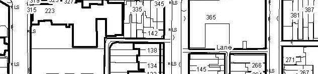


39 LEGEND 15 SEATON HOUSE 10 * ** *** 11 5 # UNDER CONSTRUCTION APPROVED / NOT BUILT PROPOSED NUMBER OF STOREYS STOREYS *** STOREYS STOREYS STOREYS AND MORE 45 ** *** * 38 *** *** SUBJECT SITE 50 ** 23 6 E COLE GABRIELE ROY 45 ** ** JOHN INNES COMMUNITY RECREATION CENTRE MOSS PARK ARMOURY MOSS PARK ARENA Source: City of Toronto, Geospatial Competency Centre, December, 2014 LOCATION MAP AND SURROUNDING BUILDING HEIGHTS Figure 2


40 GERRARD CHUR RCH SUBJECT SITE JARVI IS SHERB BOUR RNE DUNDAS QUEEN PQ PARLIA AMEN NT SUBJECT SITE SUBJECT SITE CITY OF TORONTO OFFICIALPLAN MAPS Figure 3
41 SUBJECT SITE 231 SUBJECT SITE View southeasterly t towards 219 and 231 Dundas Street t East t(subject Site) 212 DUNDAS ST E 218 DUNDAS ST E 2. View northerly from the Subject Site across Dundas Street East towards 212 and 218 Dundas Street East SUBJECT SITE View northeasterlytowards 231 Dundas Street East SITE PICTURES Figure 4
42 48 PEMBROKE ST 46 PEMBROKE ST 4. View easterly from219 Dundas Street East towards the rear yards of46 48 Pembroke Street 14 PEMBROKE ST 5. View southeasterly towards 14 Pembroke Street from the subject Site 14 PEMBROKE ST 6. View southerly towards 14 Pembroke Street (Ecole Gabrielle Roy) from the Subject Site SITE PICTURES Figure 5


.")

43 SUBJECT SITE 219 & PEMBROKE ST 48 PEMBROKE ST 7. View southerly across Dundas Street East towards Dundas Street East. 8. View towards Pembroke Street 14 PEMBROKE ST SUBJECT SITE & 231 PEMBROKE ST 9. View westerly towards 14 Pembroke St (Ecole Gabrielle Roy). SUBJECT SITE 219 & 231 SUBJECT SITE 219 & PEMBROKE ST 10. View northeasterly from George Street along Dundas Street East 11. View northeasterly from George Street towards the Subject Site and the northwest corner of 14 Pembroke St (E cole Gabrielle Roy). SITE PICTURES Figure 6
44 14 PEMBROKE ST 225 JARVIS ST DUNDAS ST E & 200 JARVIS ST 200 DUNDAS ST E 12. View easterly from George Street towards the rear of Ecole Gabrielle Roy (14 Pembroke St.). 13. View westerly acrossgeorge Street fromthe Subject Site SITE PICTURES Figure 7


 3.")

")


45 Rendering Rendering Rendering Rendering Dundas St. E, Jarvis St & 280 George St (Dundas Square Gardens 45 and 17 Storeys) Dundas St. E & 235 Jarvis St (Dundas Residences Inc. 50 Storeys) Jarvis St (Manga Hotels Inc. 20 Storeys) Jarvis St (Ryerson University Student Residence 30 Storeys) Under Construction Dundas St E & 200 Jarvis St (Pace Condos By Great Gulf 42 Storeys) DEVELOPMENTS IN SURROUNDING AREA Figure 8
46 SUBJECT SITE SUBJECT SITE Figure 9 CITY OF TORONTO ZONING BY LAW BY LAW


47 SUBJECT SITE CITY OF TORONTO ZONING BY LAW SUBJECT SITE Figure 10
Bloor St. W. Rezoning - Preliminary Report
 STAFF REPORT ACTION REQUIRED 1638-1644 Bloor St. W. Rezoning - Preliminary Report Date: April 1, 2008 To: From: Wards: Reference Number: Toronto and East York Community Council Acting Director, Community
5959 Yonge Street Rezoning Application - Preliminary Report
 STAFF REPORT ACTION REQUIRED 5959 Yonge Street Rezoning Application - Preliminary Report Date: February 23, 2011 To: From: Wards: Reference Number: North York Community Council Director, Community Planning,
TABLE OF CONTENTS 1.0 INTRODUCTION... 3
 TABLE OF CONTENTS 1.0 INTRODUCTION... 3 1.1. BACKGROUND... 3 1.2. THE PROPOSAL... 5 2.0 EXISTING POLICY FRAMEWORK... 5 2.1. PROVINCIAL POLICY STATEMENT (PPS)... 5 2.2. CITY OF LONDON OFFICIAL PLAN (OP)...
30 and 44 Zorra Street - Zoning By-law Amendment Application - Preliminary Report
 STAFF REPORT ACTION REQUIRED 30 and 44 Zorra Street - Zoning By-law Amendment Application - Preliminary Report Date: March 14, 2016 To: From: Wards: Reference Number: Etobicoke York Community Council Director,
599 Kennedy Road - Official Plan Amendment and Zoning Amendment Application - Preliminary Report
 STAFF REPORT ACTION REQUIRED 599 Kennedy Road - Official Plan Amendment and Zoning Amendment Application - Preliminary Report Date: March 7, 2017 To: From: Wards: Reference Number: Scarborough Community
ONTARIO MUNICIPAL BOARD
 PL 120483 ONTARIO MUNICIPAL BOARD Applicant/Appellant: 2124123 Ontario Limited Subject: OPA, Rezoning and Draft Plan of Subdivision Municipal Address: 3940 Highway 7 East Municipality: City of Markham
2136 & 2148 Trafalgar Road Town of Oakville Region of Halton
 PLANNING JUSTIFICATION REPORT 2136 & 2148 Trafalgar Road Town of Oakville Region of Halton Zoning By-Law Amendment Application 2500674 Ontario Inc. November 2016 Table of Contents Page 1.0 Location/Summary
1071 King Street West Zoning Amendment Application - Preliminary Report
 STAFF REPORT ACTION REQUIRED 1071 King Street West Zoning Amendment Application - Preliminary Report Date: August 9, 2012 To: From: Wards: Reference Number: Toronto and East York Community Council Director,
1296 Kennedy Road - Zoning Amendment Application - Preliminary Report
 STAFF REPORT ACTION REQUIRED 1296 Kennedy Road - Zoning Amendment Application - Preliminary Report Date: January 15, 2016 To: From: Wards: Reference Number: Scarborough Community Council Acting Director,
[PLANNING RATIONALE] For Site Plan Control and Lifting of Holding Zone By-Law 101 Champagne Avenue. May 23, 2014
![[PLANNING RATIONALE] For Site Plan Control and Lifting of Holding Zone By-Law 101 Champagne Avenue. May 23, 2014](/thumbs/75/71599615.jpg "[PLANNING RATIONALE] For Site Plan Control and Lifting of Holding Zone By-Law 101 Champagne Avenue. May 23, 2014") [PLANNING RATIONALE] For Site Plan Control and Lifting of Holding Zone By-Law 101 Champagne Avenue May 23, 2014 Contents 1.0 Introduction... 2 2.0 Site Context... 2 2.1 Adjacent Uses... 2 Figure 1: Site
[PLANNING RATIONALE] For Site Plan Control and Lifting of Holding Zone By-Law 101 Champagne Avenue May 23, 2014 Contents 1.0 Introduction... 2 2.0 Site Context... 2 2.1 Adjacent Uses... 2 Figure 1: Site
YONGE STEELES CORRIDOR SECONDARY PLAN. Young + Wright / IBI Group Architects Dillon Consulting Ltd. GHK International (Canada) Ltd.
 Ltd.") PART A: PREAMBLE 1.0 PURPOSE The purpose of this Secondary Plan is to provide a development framework for intensification of the Yonge/ Steeles corridor including the north side of Steeles Avenue West
PART A: PREAMBLE 1.0 PURPOSE The purpose of this Secondary Plan is to provide a development framework for intensification of the Yonge/ Steeles corridor including the north side of Steeles Avenue West
and Richmond Street West - Official Plan Amendment Application - Preliminary Report
 STAFF REPORT ACTION REQUIRED 822-838 and 860-862 Richmond Street West - Official Plan Amendment Application - Preliminary Report Date: August 14, 2017 To: From: Wards: Reference Number: Toronto and East
ELMVALE ACRES SHOPPING CENTRE MASTER PLAN
 ELMVALE ACRES SHOPPING CENTRE MASTER PLAN Contents 1.0 INTRODUCTION... 2 2.0 LOCATION... 2 3.0 EXISTING CONTEXT... 2 4.0 VISION & GUIDING PRINCIPLES... 2 5.0 LAND USE AND BUILT FORM... 4 5.1 St. Laurent
URBAN DESIGN BRIEF. 2136&2148 Trafalgar Road. Town of Oakville
 URBAN DESIGN BRIEF 2136&2148 Trafalgar Road Town of Oakville Prepared By: METROPOLITAN CONSULTING INC For 2500674 Ontario Inc November 2016 TABLE OF CONTENTS Page No. 1.0 Introduction/Description of Subject
393, 395, 397, 399, 401 and 403 Spring Garden Avenue Official Plan and Zoning By-law Amendment Application Preliminary Report
 STAFF REPORT ACTION REQUIRED 393, 395, 397, 399, 401 and 403 Spring Garden Avenue Official Plan and Zoning By-law Amendment Application Preliminary Report Date: March 29, 2010 To: From: Wards: Reference
2161 Yonge Street - Zoning Amendment Application - Preliminary Report
 STAFF REPORT ACTION REQUIRED 2161 Yonge Street - Zoning Amendment Application - Preliminary Report Date: September 29, 2017 To: From: Wards: Reference Number: Toronto and East York Community Council Director,
7437, 7439 and 7441 Kingston Road - Zoning By-law Amendment and Site Plan Control Applications - Preliminary Report
 STAFF REPORT ACTION REQUIRED 7437, 7439 and 7441 Kingston Road - Zoning By-law Amendment and Site Plan Control Applications - Preliminary Report Date: August 13, 2015 To: From: Wards: Reference Number:
Eglinton Avenue East & 50 Thermos Road - Official Plan Amendment Application Preliminary Report
 STAFF REPORT ACTION REQUIRED 1966 2050 Eglinton Avenue East & 50 Thermos Road - Official Plan Amendment Application Preliminary Report Date: March 15, 2016 To: From: Wards: Reference Number: Scarborough
Figure 1- Site Plan Concept
 Figure 1- Site Plan Concept Parking will be provided underground on three levels at rate of 1.0 space/ unit; this rate includes all visitors parking. MMM Group has prepared a parking assessment (April,
2494 Danforth Avenue - Official Plan Amendment and Zoning Amendment Application - Preliminary Report
 STAFF REPORT ACTION REQUIRED 2494 Danforth Avenue - Official Plan Amendment and Zoning Amendment Application - Preliminary Report Date: March 15, 2018 To: From: Wards: Reference Number: Toronto and East
PLANNING JUSTIFICATION REPORT
 PLANNING JUSTIFICATION REPORT 55 DELHI STREET CITY OF GUELPH PREPARED FOR: VESTERRA PROPERTY MANAGEMENT PREPARED BY: LABRECHE PATTERSON & ASSOCIATES INC. SCOTT PATTERSON, BA, CPT, MCIP, RPP PRINCIPAL,
178 Carruthers Properties Inc.
 178 Carruthers Properties Inc. Planning Rationale for 178 Carruthers Avenue Site Plan Control Application June 2014 Table of Contents 1.0 Introduction 2.0 Overview of Subject Property 3.0 Current Zoning
Broadview Avenue Zoning Amendment Application Final Report
 STAFF REPORT ACTION REQUIRED 796-802 Broadview Avenue Zoning Amendment Application Final Report Date: May 26, 2017 To: From: Wards: Reference Number: Toronto and East York Community Council Director, Community
Queen Street West - Zoning Amendment Application - Preliminary Report
 STAFF REPORT ACTION REQUIRED 944-952 Queen Street West - Zoning Amendment Application - Preliminary Report Date: February 6, 2013 To: From: Wards: Reference Number: Toronto and East York Community Council
5 TOWN OF MARKHAM OFFICIAL PLAN AMENDMENT NO. 144 MILLIKEN MAIN STREET SECONDARY PLAN
 5 TOWN OF MARKHAM OFFICIAL PLAN AMENDMENT NO. 144 MILLIKEN MAIN STREET SECONDARY PLAN The Planning and Economic Development Committee recommends the following: 1. The communication from Brendan O Callaghan,
From: Director, Community Planning, Etobicoke York District
 STAFF REPORT ACTION REQUIRED 4208, 4210 and 4214 Dundas Street West - Official Plan Amendment and Zoning By-law Amendment Application - Preliminary Report Date: July 22, 2014 To: Etobicoke York Community
Official Plan Review: Draft Built Form Policies
 PG.30.1 REPORT FOR ACTION Official Plan Review: Draft Built Form Policies Date: May 15, 2018 To: Planning and Growth Management Committee From: Chief Planner and Executive Director, City Planning Division
Clairtrell Area Context Plan
 Clairtrell Area Context Plan March 2005 Urban Development Services City Planning Contents 1. Introduction... 4 2. Development Structure... 6 2.1 Streets... 7 2.1.1 Sheppard Avenue and Bayview Avenue...
2655 Lawrence Ave East - Rezoning Application - Preliminary Report
 STAFF REPORT ACTION REQUIRED 2655 Lawrence Ave East - Rezoning Application - Preliminary Report Date: June 17, 2008 To: From: Wards: Reference Number: Scarborough Community Council Director, Community
Yonge Street Zoning Amendment Application - Preliminary Report
 STAFF REPORT ACTION REQUIRED 341-355 Yonge Street Zoning Amendment Application - Preliminary Report Date: March 24, 2011 To: From: Wards: Reference Number: Toronto and East York Community Council Director,
Planning and Growth Management Committee. Chief Planner and Executive Director, City Planning Division. Pg12013 (File No NNY 34 OZ)
") 865 York Mills Road Official Plan Amendment Application Preliminary Report STAFF REPORT ACTION REQUIRED Date: February 28, 2012 To: From: Wards: Reference Number: Planning and Growth Management Committee
865 York Mills Road Official Plan Amendment Application Preliminary Report STAFF REPORT ACTION REQUIRED Date: February 28, 2012 To: From: Wards: Reference Number: Planning and Growth Management Committee
St. Lawrence Neighbourhood Focused Area - Official Plan Amendment Status Report
 STAFF REPORT ACTION REQUIRED St. Lawrence Neighbourhood Focused Area - Official Plan Amendment Status Report Date: May 21, 2015 To: From: Wards: Reference Number: Toronto and East York Community Council
Bayview Avenue Official Plan Amendment, Zoning Amendment and Site Plan Control Applications Request for Direction Report
 STAFF REPORT ACTION REQUIRED 2425 2427 Bayview Avenue Official Plan Amendment, Zoning Amendment and Site Plan Control Applications Request for Direction Report Date: May 28, 2015 To: From: Wards: Reference
770 Don Mills Road and 805 Don Mills Road - Official Plan Amendment and Zoning By-law Amendment Application Preliminary Report
 REPORT FOR ACTION 770 Don Mills Road and 805 Don Mills Road - Official Plan Amendment and Zoning By-law Amendment Application Preliminary Report Date: To: From: Wards: June 22, 2018 North York Community
QUEEN-RIVER SECONDARY PLAN
 34 QUEEN-RIVER SECONDARY PLAN 34. QUEEN RIVER SECONDARY PLAN 1. INTRODUCTION The Queen-River area is approximately 6.4 hectares and is located at the eastern edge of the Downtown as shown on Map 34-1.
13 THORNHILL YONGE STREET STUDY IMPLEMENTATION CITY OF VAUGHAN OPA 669 AND TOWN OF MARKHAM OPA 154
 13 THORNHILL YONGE STREET STUDY IMPLEMENTATION CITY OF VAUGHAN OPA 669 AND TOWN OF MARKHAM OPA 154 The Planning and Economic Development Committee recommends the adoption of the recommendations contained
280 Manse Road - Official Plan Amendment, Zoning Amendment, Draft Plan of Subdivision Applications - Preliminary Report
 STAFF REPORT ACTION REQUIRED 280 Manse Road - Official Plan Amendment, Zoning Amendment, Draft Plan of Subdivision Applications - Preliminary Report Date: March 11, 2014 To: From: Wards: Reference Number:
1151 Queen Street East - Zoning Amendment Application - Preliminary Report
 STAFF REPORT ACTION REQUIRED 1151 Queen Street East - Zoning Amendment Application - Preliminary Report Date: June 12, 2018 To: From: Wards: Reference Number: Toronto and East York Community Council Acting
60-64 Queen Street East and Church Street - Zoning Amendment Application - Preliminary Report
 STAFF REPORT ACTION REQUIRED 60-64 Queen Street East and 131-135 Church Street - Zoning Amendment Application - Preliminary Report Date: March 15, 2018 To: From: Wards: Reference Number: Toronto and East
646 Kingston Road - Official Plan Amendment and Zoning Amendment Applications - Preliminary Report
 STAFF REPORT ACTION REQUIRED 646 Kingston Road - Official Plan Amendment and Zoning Amendment Applications - Preliminary Report Date: December 8, 2014 To: From: Wards: Reference Number: Toronto and East
4155 Yonge Street Official Plan Amendment and Rezoning Application Preliminary Report
 STAFF REPORT ACTION REQUIRED 4155 Yonge Street Official Plan Amendment and Rezoning Application Preliminary Report Date: May 5, 2011 To: From: Wards: Reference Number: North York Community Council Director,
4800 Yonge Street - Official Plan Amendment, Zoning Amendment and Site Plan Applications - Request for Direction Report
 STAFF REPORT ACTION REQUIRED 4800 Yonge Street - Official Plan Amendment, Zoning Amendment and Site Plan Applications - Request for Direction Report Date: April 16, 2018 To: From: Wards: Reference Number:
2901 Bayview Avenue and 630 Sheppard Avenue East - Official Plan Amendment and Zoning Amendment Application - Preliminary Report
 STAFF REPORT ACTION REQUIRED 2901 Bayview Avenue and 630 Sheppard Avenue East - Official Plan Amendment and Zoning Amendment Application - Preliminary Report Date: September 27, 2017 To: From: Wards: Reference
50 Wellesley Street East and Dundonald Street Official Plan Amendment and Zoning Amendment Applications Request for Direction Report
 STAFF REPORT ACTION REQUIRED 50 Wellesley Street East and 31-35 Dundonald Street Official Plan Amendment and Zoning Amendment Applications Request for Direction Report Date: November 2, 2015 To: From:
333 College Street and 303 Augusta Avenue - Official Plan Amendment, Zoning Amendment Applications - Preliminary Report
 STAFF REPORT ACTION REQUIRED 333 College Street and 303 Augusta Avenue - Official Plan Amendment, Zoning Amendment Applications - Preliminary Report Date: March 12, 2015 To: From: Wards: Reference Number:
KANATA CENTRUM 255 KANATA AVENUE OFFICIAL PLAN AMENDMENT ZONING BY-LAW AMENDMENT
 KANATA CENTRUM 255 KANATA AVENUE OFFICIAL PLAN AMENDMENT ZONING BY-LAW AMENDMENT JUNE 2015 PREPARED BY: FOTENN Consultants Inc. 223 Mcleod Street Ottawa, ON K2P OZ8 (613) 730-5709 PREPARED FOR: Kanata
Director, Community Planning, North York District
 STAFF REPORT ACTION REQUIRED 5925 5997 Yonge Street, 11 25 Wedgewood Drive, 1 8 Doverwood Court, and 42 54 Cummer Avenue Official Plan Amendment Application Request for Direction Report Date: April 21,
150 Eighth Street Zoning By-law Amendment Application Preliminary Report
 REPORT FOR ACTION 150 Eighth Street Zoning By-law Amendment Application Preliminary Report Date: March 27, 2019 To: Etobicoke York Community Council From: Director, Community Planning, Etobicoke York District
808 Mount Pleasant Road Zoning Amendment Application Request for Interim Direction Report
 STAFF REPORT ACTION REQUIRED 808 Mount Pleasant Road Zoning Amendment Application Request for Interim Direction Report Date: June 15, 2018 To: From: Wards: Reference Number: Toronto and East York Community
Uptown Rideau Street Secondary Plan [Amendment #166, January 12, 2016]
![Uptown Rideau Street Secondary Plan [Amendment #166, January 12, 2016]](/thumbs/76/73760497.jpg "Uptown Rideau Street Secondary Plan [Amendment #166, January 12, 2016]") [Amendment #166, January 12, 2016] The policies of this Secondary Plan are in effect, save and except for the property at 560 Rideau Street, for which there remains a site specific appeal to this Secondary
[Amendment #166, January 12, 2016] The policies of this Secondary Plan are in effect, save and except for the property at 560 Rideau Street, for which there remains a site specific appeal to this Secondary
Director, Community Planning, Etobicoke York District
 STAFF REPORT ACTION REQUIRED Baby Point Gates Planning Study 227-430 Jane Street, 665-685 Annette Street, 494 Armadale Avenue, 143 Evans Avenue and 502 504 Willard Avenue Status Report Date: August 11,
1141 Bloor Street West, 980 Dufferin Street, and 90 Croatia Street Combined Official Plan and Zoning Amendment Application - Preliminary Report
 STAFF REPORT ACTION REQUIRED 1141 Bloor Street West, 980 Dufferin Street, and 90 Croatia Street Combined Official Plan and Zoning Amendment Application - Preliminary Report Date: January 30, 2018 To: From:
Planning Rationale Fernbank Road, Ottawa. Major Zoning By-law Amendment and Site Plan Control Application Ontario Inc.
 Planning Rationale Major Zoning By-law Amendment and Site Plan Control Application 5264 Fernbank Road, Ottawa 1872089 Ontario Inc. March 2014 Planning Rationale Major Zoning By-law Amendment and Site Plan
10 Park Lawn Rd - Zoning Amendment Application- Preliminary Report
 STAFF REPORT ACTION REQUIRED 10 Park Lawn Rd - Zoning Amendment Application- Preliminary Report Date: March 9, 2012 To: From: Wards: Reference Number: Etobicoke York Community Council Director, Community
Mark-up of the effect of the proposed Bronte Village Growth Area OPA No.18 on the text of section 24, Bronte Village, of the Livable Oakville Plan
 Mark-up of the effect of the proposed Bronte Village Growth Area OPA No.18 on the text of section 24, Bronte Village, of the Livable Oakville Plan Notes: This document is provided for information purposes
1 Eglinton Avenue East Zoning Amendment Application Final Report
 STAFF REPORT ACTION REQUIRED 1 Eglinton Avenue East Zoning Amendment Application Final Report Date: September 29, 2017 To: From: Wards: Reference Number: Toronto and East York Community Council Director,
Welcome. Walk Around. Talk to Us. Write Down Your Comments
 Welcome This is an information meeting introducing the applications for proposed redevelopment of the Yorkdale Shopping Centre site at 3401 Dufferin Street and 1 Yorkdale Road over the next 20+ years,
1350 Ellesmere Road and 1560 Brimley Road Zoning Amendment Application - Preliminary Report
 STAFF REPORT ACTION REQUIRED 1350 Ellesmere Road and 1560 Brimley Road Zoning Amendment Application - Preliminary Report Date: December 6, 2017 To: From: Wards: Reference Number: Scarborough Community
2900 Steeles Avenue East at Don Mills Road in the Town of Markham
 STAFF REPORT INFORMATION ONLY 2900 Steeles Avenue East at Don Mills Road in the Town of Markham Date: January 23, 2008 To: From: Wards: Reference Number: North York Community Council Director, Community
Jarvis Street Zoning Amendment Request For Direction Report
 STAFF REPORT ACTION REQUIRED 319-323 Jarvis Street Zoning Amendment Request For Direction Report Date: September 20, 2017 To: From: Wards: Reference Number: Toronto and East York Community Council Director,
Urban Design Manual PLANNING AROUND RAPID TRANSIT STATIONS (PARTS) Introduction. Station Study Areas
 Introduction. Station Study Areas") 111111 PLANNING AROUND RAPID TRANSIT STATIONS (PARTS) Introduction The ION rapid transit system will link Waterloo, Kitchener and Cambridge through a central transit corridor (CTC). There are a number
111111 PLANNING AROUND RAPID TRANSIT STATIONS (PARTS) Introduction The ION rapid transit system will link Waterloo, Kitchener and Cambridge through a central transit corridor (CTC). There are a number
523, 525 and 525A Adelaide Street West - Zoning Amendment Application - Preliminary Report
 STAFF REPORT ACTION REQUIRED 523, 525 and 525A Adelaide Street West - Zoning Amendment Application - Preliminary Report Date: May 12, 2012 To: From: Wards: Reference Number: Toronto and East York Community
50-60 and Charles St East and Hayden Street Zoning Amendment Application Final Report
 STAFF REPORT ACTION REQUIRED 50-60 and 62-64 Charles St East and 47-61 Hayden Street Zoning Amendment Application Final Report Date: July 18, 2014 To: From: Wards: Reference Number: Toronto and East York
2370 Finch Avenue West - Official Plan and Zoning Bylaw Amendment Application Request for Interim Directions Report
 REPORT FOR ACTION 2370 Finch Avenue West - Official Plan and Zoning Bylaw Amendment Application Request for Interim Directions Report Date: June 14, 2018 To: Etobicoke York Community Council From: Director,
THE CITY OF VAUGHAN BY-LAW BY-LAW NUMBER A By-law to adopt Amendment Number 1 to the Official Plan of the Vaughan Planning Area.
 THE CITY OF VAUGHAN BY-LAW BY-LAW NUMBER 015-2014 A By-law to adopt Amendment Number 1 to the Official Plan of the Vaughan Planning Area. NOW THEREFORE the Council of the Corporation of the City of Vaughan
CONTENTS 8.0 LAND USE 8.1 GENERAL LAND USE 8.2 RESIDENTIAL 8.3 MIXED USE 8.4 COMMERCIAL 8.5 EMPLOYMENT LANDS
 8-2 Land Use 8.0 LAND USE CONTENTS 8.1 GENERAL LAND USE 8.1.1 Uses provided for in all Land Use Designations 8.1.2 Uses prohibited in Hazardous Lands, Hazardous Sites and Special Policy Areas 8.1.3 Uses
112 College Street Zoning Amendment Application Preliminary Report
 ~TORONTO REPORT FOR ACTION 112 College Street Zoning Amendment Application Preliminary Report Date: January 25, 2019 To: Toronto and East York Community Council From: Director, Community Planning, Toronto
K. SMART ASSOCIATES LIMITED
 Planning Justification Report Zoning By-Law Amendment 185 King Street North Waterloo, Ontario April 7th, 2017 Project Reference Number 16-245 K. SMART ASSOCIATES LIMITED CONSULTING ENGINEERS AND PLANNERS
Trafalgar Road Corridor Planning Study Open House
 Trafalgar Road Corridor Planning Study Open House June 24, 2013 6:30-8:30 p.m. Oakville & Trafalgar Rooms Overview The Livable Oakville Plan identifies the lands along Trafalgar Road, between the QEW and
SCHEDULE 'A' TO BY-LAW as Amended by AMENDMENT NO. 90 TO THE WHITBY OFFICIAL PLAN
 SCHEDULE 'A' TO BY-LAW 6413-10 as Amended by 6553-11 AMENDMENT NO. 90 TO THE WHITBY OFFICIAL PLAN SECTION A: GROWTH PLAN CONFORMITY PURPOSE: LOCATION: BASIS: The purpose of this Amendment is to: conform
PLANNING JUSTIFICATION REPORT
 PLANNING JUSTIFICATION REPORT Application for Official Plan and Zoning By-law Amendments 374 Martha Street Burlington, Ontario Prepared For: ADI Developments September 2014 14.543 Planning Justification
350, 370, and 390 Queens Quay West Official Plan Amendment and Zoning Amendment Applications - Preliminary Report
 STAFF REPORT ACTION REQUIRED 350, 370, and 390 Queens Quay West Official Plan Amendment and Zoning Amendment Applications - Preliminary Report Date: April 22, 2016 To: From: Wards: Reference Number: Toronto
776 and 784 St. Laurent Boulevard City of Ottawa
 Engineering Land / Site Development Municipal Infrastructure Environmental / Water Resources Traffic / Transportation Structural Recreational 776 and 784 St. Laurent Boulevard City of Ottawa Planning Rationale
71 75 Curlew Drive - Zoning Amendment Application - Preliminary Report
 STAFF REPORT ACTION REQUIRED 71 75 Curlew Drive - Zoning Amendment Application - Preliminary Report Date: May 19, 2017 To: From: Wards: Reference Number: North York Community Council Director, Community
Bressa Developments Limited. Planning Justification Report. Revised Draft Plan of Subdivision and Zoning By-Law Amendment
 Bressa Developments Limited Revised Draft Plan of Subdivision and Zoning By-Law Amendment Planning Justification Report Part of Lots 7 & 8 Concession 1, North of Dundas Street Town of Oakville September,
Avenue Road and Pears Avenue - Zoning Amendment Application - Preliminary Report
 STAFF REPORT ACTION REQUIRED 183-189 Avenue Road and 109-111 Pears Avenue - Zoning Amendment Application - Preliminary Report Date: March 9, 2017 To: From: Wards: Reference Number: Toronto and East York
4780 Eglinton Avenue West - Zoning By-law Amendment and Draft Plan of Subdivision Applications - Preliminary Report
 STAFF REPORT ACTION REQUIRED 4780 Eglinton Avenue West - Zoning By-law Amendment and Draft Plan of Subdivision Applications - Preliminary Report Date: May 29, 2014 To: From: Wards: Reference Number: Etobicoke
Church Street and 117 Dundas Street East Zoning By-law Amendment - Request for Direction Report
 STAFF REPORT ACTION REQUIRED 215-229 Church Street and 117 Dundas Street East Zoning By-law Amendment - Request for Direction Report Date: March 15, 2016 To: From: Wards: Reference Number: Toronto and
Main Street - Zoning Amendment Application - Preliminary Report
 STAFF REPORT ACTION REQUIRED 286-294 Main Street - Zoning Amendment Application - Preliminary Report Date: September 29, 2017 To: From: Wards: Reference Number: Toronto and East York Community Council
250 Lawrence Avenue West and 219 Glengarry Avenue Official Plan and Zoning By-law Amendment Applications Request for Direction
 STAFF REPORT ACTION REQUIRED 250 Lawrence Avenue West and 219 Glengarry Avenue Official Plan and Zoning By-law Amendment Applications Request for Direction Date: March 17, 2017 To: From: Wards: Reference
Yonge Street and 2-8 Cumberland Street Zoning Amendment Application - Preliminary Report
 STAFF REPORT ACTION REQUIRED 826-834 Yonge Street and 2-8 Cumberland Street Zoning Amendment Application - Preliminary Report Date: March 25, 2015 To: From: Wards: Reference Number: Toronto and East York
Regency Developments. Urban Design Brief. Holyrood DC2 Rezoning
 Regency Developments Urban Design Brief Holyrood DC2 Rezoning Stantec Consulting Ltd. 7-31-2017 1. Overview Regency Developments intends to rezone the lands located at 8510 and 8511 93 Avenue, within the
Symington Avenue, 405 Perth Avenue and 17 Kingsley Avenue Official Plan and Zoning By-law Amendment Application Request for Direction Report
 STAFF REPORT ACTION REQUIRED 386-394 Symington Avenue, 405 Perth Avenue and 17 Kingsley Avenue Official Plan and Zoning By-law Amendment Application Request for Direction Report Date: October 25, 2017
1-17 Anndale Drive, Bales Avenue and Glendora Avenue Zoning Amendment Application Preliminary Report
 STAFF REPORT ACTION REQUIRED 1-17 Anndale Drive, 31-35 Bales Avenue and 22-70 Glendora Avenue Zoning Amendment Application Preliminary Report Date: August 20, 2007 To: From: Wards: Reference Number: North
Urban Design Brief. Watson Parkway North & Watson Road North Guelph, Ontario. Prepared by Coletara Development
 Urban Design Brief Watson Parkway North & Watson Road North Guelph, Ontario Prepared by Coletara Development December, 2013 Urban Design Brief, Coletara Development 1 Introduction This Urban Design Brief
240 and 242 Finch Avenue West Zoning By-law Amendment Application Preliminary Report
 REPORT FOR ACTION 240 and 242 Finch Avenue West Zoning By-law Amendment Application Preliminary Report Date: March 1, 2019 To: North York Community Council From: Director, Community Planning, North York
4569 Kingston Road Zoning Amendment Application - Preliminary Report
 STAFF REPORT ACTION REQUIRED 4569 Kingston Road Zoning Amendment Application - Preliminary Report Date: August 4, 2016 To: From: Wards: Reference Number: Scarborough Community Council Acting Director,
77-79 East Don Roadway and Queen Street East Zoning Amendment Applications Final Report
 STAFF REPORT ACTION REQUIRED 77-79 East Don Roadway and 661-677 Queen Street East Zoning Amendment Applications Final Report Date: October 23, 2015 To: From: Wards: Reference Number: Toronto and East York
2376 Dundas Street West, Zoning Amendment Application - Preliminary Report
 STAFF REPORT ACTION REQUIRED 2376 Dundas Street West, Zoning Amendment Application - Preliminary Report Date: February 17, 2012 To: From: Wards: Reference Number: Toronto and East York Community Council
11 Charlotte Street - Zoning Amendment and Site Plan Applications- Request for Direction Report
 STAFF REPORT ACTION REQUIRED 11 Charlotte Street - Zoning Amendment and Site Plan Applications- Request for Direction Report Date: August 19, 2011 To: From: Wards: Reference Number: Toronto and East York
The West Vaughan Employment Area Secondary Plan Policies
 Part 2: The West Vaughan Employment Area Secondary Plan Policies 2.1 General Policies It is the policy of Council: 2.1.1. That the West Vaughan Employment Area (the WVEA), identified on Schedule 1, will
AGINCOURT SECONDARY PLAN
 1 AGINCOURT SECONDARY PLAN 1. AGINCOURT SECONDARY PLAN The following policies and principles apply to the area herein referred to as Agincourt, as outlined on Map 1-1. 1. GENERAL POLICIES 1.1 This Secondary
New Street Proposed Redevelopment Architecture & Urban Design Brief
 2130 2136 New Street Proposed Redevelopment Architecture & Urban Design Brief Prepared By: Cynthia Zahoruk Architect Inc. 3077 New Street, Burlington, ON, L7N 1M6 TABLE OF CONTENTS Background and Objective
Sheppard Avenue East Zoning Amendment Application Refusal Report
 STAFF REPORT ACTION REQUIRED 179-181 Sheppard Avenue East Zoning Amendment Application Refusal Report Date: January 4, 2017 To: From: Wards: Reference Number: North York Community Council Director, Community
PORT WHITBY COMMUNITY
 PORT WHITBY COMMUNITY SECONDARY PLAN UPDATE COMMUNITY IMPROVEMENT PLAN URBAN DESIGN GUIDELINES September 2015 DRAFT PROPOSED AMENDMENT NUMBER # to the Whitby Official Plan PURPOSE: The intent of this Amendment
141 GEORGE STREET PLANNING RATIONALE
 141 GEORGE STREET PLANNING RATIONALE MINOR ZONING BY-LAW AMENDMENT NOVEMBER 2, 2016 PLANNING RATIONALE 223 McLeod Street Ottawa, ON K2P 0Z8 613.730.5709 fotenn.com INTRODUCTION FOTENN Consultants is acting
URBAN DESIGN BRIEF 181 Burloak Drive, Oakville
 URBAN DESIGN BRIEF 181 Burloak Drive, Oakville February 2017 Our File: 1730B 230-7050 WESTON ROAD / WOODBRIDGE / ONTARIO / L4L 8G7 / T: 905 761 5588/ F: 905 761 5589/WWW.MHBCPLAN.COM TABLE OF CONTENTS
Derry Green Corporate Business Park
 Town of Milton Derry Green Corporate Business Park Urban Design Guidelines BMI/Pace - June 2010 Draft 3 Prepared by: Brook McIlroy Planning + Urban Design / Pace Architects Suite 300-51 Camden Street Toronto,
Director, Community Planning, North York District
 STAFF REPORT ACTION REQUIRED 36 and 37 Jane Osler Boulevard and 42 and 44 Cartwright Avenue Zoning By-law Amendment and Draft Plan of Subdivision Approval Applications - Preliminary Report Date: May 22,
Workshop 3. City of Burlington Waterfront Hotel Planning Study. September 14, The Planning Partnership
 Workshop 3 City of Burlington Waterfront Hotel Planning Study September 14, 2017 The Planning Partnership The Waterfront Hotel Planning Study 01 The Brant & Lakeshore Planning Study will establish a Strategic