Easton Broad Flood Management Project
|
|
|
- Morris Gordon
- 5 years ago
- Views:
Transcription

1 Easton Broad Flood Management Project Final - 27 July 2012 Title here in 8pt Arial (change text colour to black) i
2 We are the Environment Agency. We protect and improve the environment and make it a better place for people and wildlife. We operate at the place where environmental change has its greatest impact on people s lives. We reduce the risks to people and properties from flooding; make sure there is enough water for people and wildlife; protect and improve air, land and water quality and apply the environmental standards within which industry can operate. Acting to reduce climate change and helping people and wildlife adapt to its consequences are at the heart of all that we do. We cannot do this alone. We work closely with a wide range of partners including government, business, local authorities, other agencies, civil society groups and the communities we serve. Published by: Environment Agency Horizon house, Deanery Road Bristol BS1 5AH enquiries@environmentagency.gov.uk Environment Agency 2011 All rights reserved. This document may be reproduced with prior permission of the Environment Agency. Further copies of this report are available from our publications catalogue: Hhttp://publications.environmentagency.gov.ukH or our National Customer Contact Centre: T: Henquiries@environmentagency.gov.ukH. Easton Broad Flood Management Project
3 Contents 1 Introduction 1 2 Why is the proposed development required? 2 3 Alternatives 3 4 What is the existing environment at the proposed development site? 4 5 What does the proposed development comprise? 6 6 Consultation 8 7 What does the Environmental Impact Assessment Process involve? 9 8 What are the predicted likely significant effects of the proposed development? Recreation Biodiversity Landscape and visual effects Water resources and flooding Historic environment Cumulative and in-combination effects 17 9 Conclusions Where can more information be found? 20 Figure NTS 1 Figure NTS 2 Figure NTS 3 Figure NTS 4 Figure NTS 5 Figure NTS 6 Site Location Plan Existing Situation Site Boundary Statutory Designations Proposed Embankment Alignment and Construction Phases Preliminary Water Control Strucure Proposals Easton Broad Flood Management Project i
4 ii Easton Broad Flood Management Project
5 1 Introduction The Environment Agency is applying for planning consent for construction of an earth embankment and culvert improvements at Potter s Bridge, Easton Broad, Suffolk. These works comprise the Easton Broad Flood Management Project (FMP). Potter s Bridge and Easton Broad The planning application for this proposed development is accompanied by an Environmental Statement, as required under The Town and Country Planning (Environmental Impact Assessment) Regulations 2011 (SI 1824) (the EIA Regulations ). The preparation of this Environmental Statement forms part of the Environmental Impact Assessment (EIA) for the proposed development. This report is the non-technical summary of the Environmental Statement, and is provided both as a standalone report and at the beginning of the Environmental Statement. It summarises the content and conclusions of the Environmental Statement, to which readers should refer if more detailed information is required. The following sections of the non-technical summary describe: the reasons why the proposed development is required; the existing environmental conditions at the proposed development site; what the proposed development comprises; the EIA process; the likely significant effects of the proposed development; and the next steps and where the Environmental Statement can be viewed. Easton Broad Flood Management Project 1
6 2 Why is the proposed development required? The Easton River Valley, including Easton Broad which lies at the seaward end of the valley, supports the second largest freshwater reedbed in the United Kingdom, totalling 180 hectares. This reedbed lies within the Benacre to Easton Bavents Special Protection Area (SPA), a wildlife site of European importance, designated for its breeding and over wintering bittern and marsh harrier. Additionally, Easton Broad to the east of Potter s Bridge, is part of the Benacre to Easton Bavents Lagoons Special Area of Conservation (SAC) designated for its saline lagoon habitat. The freshwater reedbed is at risk from the ingress of sea water and the landward movement of the shingle ridge and saline lagoon as a result of a dynamic coastline and the cessation of management of the shingle ridge in The management of the shingle ridge was stopped based on Natural England s advice that the mechanical management of the shingle ridge was not consistent with the conservation objectives for the saline lagoon (SAC designated) and the on-going management practice of the frontage was not sustainable. Shingle ridge and coastal lagoon Under European legislation, there is a duty to take appropriate steps to prevent the deterioration of SPAs and SACs (collectively known as European sites). The purpose of the Easton Broad Flood Management Project is to protect as much of the Easton Valley reedbed as possible from deterioration. In addition, the scheme allows for sufficient time to identify and secure compensatory habitat in relation to the Suffolk Shoreline Management Plan 2 (SMP2) at a more sustainable site in advance of loss. 2 Easton Broad Flood Management Project
7 3 Alternatives The following options were identified and appraised for Easton Broad: Option 1 - Do nothing. Option 2 - Do minimum. No works on site but provide compensation measures as part of the Suffolk SMP2 to ensure compliance with European legislation; Option 3 - Do minimum (maintain). This option would involve repairing breaches in the shingle ridge after they have occurred. Option 4 - Reinstate beach maintenance (sustain). This option would involve raising the height of the shingle ridge to pre-2006 levels, and maintaining it at that level. Option 5 - Hold the line with hard defence (improve). This option would involve the construction of a hard defence, or combination of hard defences, such as rock groynes, breakwaters or revetments, to prevent roll back of the shingle ridge. Option 6 - Hold the line with soft defence (improve). This option would involve placing large quantities of marine dredged shingle along the shore to help replace that lost and to replace and maintain the shingle ridge. Option 7 - Managed realignment with secondary defence (improve). This option would accept the natural roll back of the shingle ridge over time and allow it to behave naturally whilst constructing a secondary (set-back) line of defence. All possible coastal defence options were assessed against a range of criteria, especially: Technical feasibility; Cost (both capital and maintenance); Maintaining favourable condition of European qualifying features; and Working with, rather than against, coastal processes. An initial assessment concluded that Option 2: Do minimum was the preferred option on the grounds of costs. However, during the development of the Suffolk SMP2 it was concluded that simply recreating the habitat elsewhere (Option 2) may be in breach of European legislation, and the Environment Agency should try to protect as much as of the European habitat as realistically possible in situ. Hence, the original Option 7 is now considered to be the preferred option, and this option is the subject of this EIA. Easton Broad Flood Management Project 3

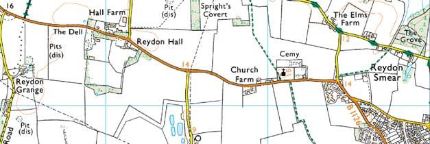
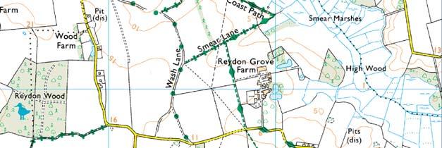
8 4 What is the existing environment at the proposed development site? The Easton Broad Flood Management Project is located at Potter s Bridge, where the B1127 between the villages of Wrentham and Reydon crosses the Easton River, approximately 3km north of Southwold, Suffolk in the East of England (Ordnance Survey grid reference TM , Figure NTS 1). Potter s Bridge The proposed development site is located in the Easton River valley in an area specifically referred to as Easton Broad. The site is set within a gently undulating agricultural landscape. The majority of the site consists of reedbed to the north and south of the Easton River, which flows through the centre of the site to the coast which is about 1km to the east (Figure NTS 2). The proposed development area comprises 2.05 hectares, of which 2 hectares are to the east of the B1127 (Figure NTS 3) and encompasses a 26 metre wide corridor across the valley through the reedbed, parallel with the B1127, plus additional areas of arable land to the north and south. The proposed development site is located within a highly sensitive environment which is covered by a number of national and European designations (Figure NTS 4): Benacre to Easton Bavents SPA: This site is of European importance for its breeding populations of bittern and marsh harrier, two of Britain s rarest breeding birds; 4 Easton Broad Flood Management Project
9 Benacre to Easton Bavents Lagoons SAC: designated for its coastal lagoon habitat; Pakefield to Easton Bavents Site of Special Scientific Interest (SSSI): The site is nationally important for its coastal habitats, nationally scarce or rare plants, scarce breeding birds (including bittern, marsh harrier, little tern, water rail and bearded tit), and wintering bitterns; Benacre National Nature Reserve (NNR); Suffolk Heritage Coast; and Suffolk Coast and Heaths Area of Outstanding Natural Beauty (AONB). The site and surrounding area include habitats of importance for nature conservation, including reedbed and hedgerows, which support a number of protected or rare species, including otter, water vole, reptiles, and the narrow mouthed whorl snail, as well as the birds species for which the SPA and SSSI are designated. Easton Broad Flood Management Project 5
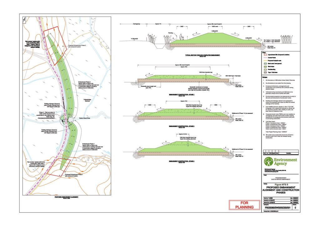
10 5 What does the proposed development comprise? The proposed development is illustrated on Figures NTS 5 and 6 and is expected to comprise the works and structures detailed below. Creation of two temporary construction compounds adjacent to the B1127 to the north and south of the reedbed. These will be provided for the duration of the works, and will be used for access, storage of machines and materials, and location of the site office and welfare facilities. They will be surfaced with crushed stone/concrete, which will be removed following completion of the embankment. Topsoil will then be replaced and the area sown with a species rich meadow grassland seed mix. Oak tree to be removed Removal of approximately 185m of hedgerows to provide safe access to the site compounds. These will be replanted once works are complete. Removal of one oak tree. This will be replaced by another oak tree which will be planted as close as possible to the location of the original once works are complete. Construction of a new clay embankment across Easton Broad reedbed (immediately adjacent to B1127). The embankment will be in two sections to the north and south of the Easton River (320 metres and 200m long respectively and 26m wide). The crest of the embankment will be 3.98m high (AOD 1 Above Ordnance Datum) and 4m wide falling to a 3m wide lower berm at 2m (AOD) on both the eastern and western sides. The embankment will be connected to the existing bridge using steel sheet piles which will be 3.68m high (AOD). The eastern wall of Potter s Bridge will be raised to this height with bricks matching the existing wall, making it about 2m high from the road surface. Following completion of the embankment, it will be covered with topsoil and sown with an appropriate grass seed mix. Where reeds do not establish naturally along the lower slope of the embankment, reeds will be planted to help integrate the structure within the existing landscape. Works to the culvert where the Easton River passes under the B1127 at Potter s Bridge including: 1 Ground levels and the heights of structures are often expressed as the height Above Ordnance Datum, which is the level from which altitudes on maps are measured, usually mean sea level. 6 Easton Broad Flood Management Project
11 o provision of a weed screen and hard standing to allow for weed removal (immediately upstream of the bridge), o installation of a water control structure on the upstream side of Potter s Bridge to allow water levels to be controlled in the reedbed upstream of the bridge. The structure will be constructed on a reinforced concrete slab placed on a steel sheet pile foundation, and will be connected to Potter s Bridge by steel sheet pile walls with a reinforced concrete cap. o provision of a secure pedestrian access platform over the structure to allow access to clear the weedscreen and operate the gate. o construction of access platforms either side of the water control structure. These will be raised to the height of the steel sheet pile wingwalls 2 (c m above ground level), and will provide vehicle parking and a machine working area to clear the weedscreen from heavy blockages. These will total c. 500m 2 and will be accessed via a new lay-by to be created adjacent to the B1127 north of Potter s Bridge. o Installation of a fish pass, allowing fish to travel along the Easton River through the new water control structure. o Installation of a new tidal flap, allowing for fish passage, on the downstream side of the bridge. Temporary diversion of the South Cove public footpath around the northern site compound. This footpath will be re-instated on its original route after the works are completed. This will take it over the top of the embankment. Provision of a viewing platform where the South Cove footpath and Suffolk Coast Path crosses the embankment. Provision of a footpath along the bottom of the embankment. This will follow the former route of the Suffolk Coast Path, and will run south from the South Cove Footpath, along the embankment, crossing the Easton River at Potter s Bridge. Provision of interpretation boards providing information on the habitats and species, landscape and history of the Easton Broad. It is proposed to undertake the works over six years during August to February (the exact timing will be dependent on when birds finish breeding and weather conditions) due to the potential for settlement of the embankment during the construction process. 2 Smaller retaining walls connecting Potter s Bridge and the water control structure. Easton Broad Flood Management Project 7
12 6 Consultation In recognition of the sensitive nature of the environment within which the site is located, extensive consultation has been undertaken with statutory bodies and stakeholders from the earliest stages of the Easton Broad Flood Management Project. Consultation undertaken included: Scoping Consultation Document issued (April/May 2011). The purpose of the document was to consult with statutory bodies and stakeholders on the key environmental issues that could require further consideration as part of the Environmental Impact Assessment for the Easton Broad Flood Management Project. Scoping Report Issued (January 2012). The purpose of the report was to confirm the proposed scope of work following feedback on the Scoping Consultation Document. The Scoping Report was issued to Waveney District Council with a request for a scoping opinion. Meeting with Natural England and RSPB (28 March 2012). Public drop-in at Reydon village hall (12 April 2012) to allow members of the public to find out more about the scheme and provide any comments. Meeting with the Suffolk County Council Highways Department (19 April 2012). Throughout the project the Environment Agency have worked particularly closely with Natural England and the RSPB in order to obtain information about the site and ensure that the scheme was designed in such a way as to avoid significant effects on the bird species or habitats for which the SPA, SAC and SSSI are designated. Key areas in which the scheme design has been influenced by consultation are summarised below. The timing of construction works has been designed to avoid effects on breeding birds (especially bittern and marsh harrier), following consultation with the RSPB and Natural England. A footpath is being provided along the lower berm of the new embankment, providing a safe route for pedestrians and allowing the reinstatement of the original route of the Suffolk Coast Path. The proposed footpath and the reinstated South Cove public footpath and Suffolk Coast Path will be fenced to prevent pedestrian access to the top of the embankment, which could disturb birds breeding within the adjacent reedbed. Where the reinstated South Cove public footpath and Suffolk Coast Path will cross the top of the embankment it will be screened to prevent disturbance to birds breeding within the adjacent reedbed. A water control structure at Potter s Bridge has been incorporated into the scheme design following feedback from Natural England to allow better control of water levels within the Easton Valley reedbed. A fish and eel pass will be incorporated into the proposed water control structure at Potter s Bridge to allow fish and eels to travel past the structure. The size of the working platforms adjacent to the water control structure have been minimised to reduce loss of reedbed habitat. Access to the working platforms will be directly off the B1127 for the same reason. Access to the site will be via the north only, following consultation with Suffolk County Council Highways Department, to avoid impacts on buildings within Reydon to the south. 8 Easton Broad Flood Management Project
13 7 What does the Environmental Impact Assessment Process involve? At an early stage in preparing its proposals for the proposed development, the Environment Agency recognised that, given the scale of development proposed and the sensitivity of the surrounding environment, the development required Environmental Impact Assessment under the EIA Regulations. A Scoping Consultation Document was prepared by the Environment Agency in April 2011 to identify the potentially significant environmental effects of the proposed scheme that needed to be assessed further and to outline the approach to undertaking the assessments of these effects. The report enabled statutory and non-statutory organisations and others with an interest in the proposed scheme ( stakeholders ) to comment on the proposed scope of the assessment. A Scoping Report was prepared by the Environment Agency in January 2012, which outlined the work that it was considered, at that time, was needed to assess the potentially significant effects of the proposed development. This report was issued to Waveney District Council (WDC) with a request for a scoping opinion. The scope of the assessment was refined in response to comments received on the Scoping Consultation Document, Waveney District Council s scoping opinion, and also in response to comments received through subsequent consultation, environmental information obtained from further survey and assessment work, and changes that were proposed to the proposed development design. The subsequent Environmental Statement includes an impartial assessment of the predicted environmental effects of the proposed development. To meet the requirements of the EIA Regulations, the assessment focuses on those effects that are potentially significant (both positive and negative), with a comparison being made between the likely environmental conditions in the presence of the proposed development and in its absence (i.e. the baseline situation). The Environmental Statement considers only the effects on the topics set out in Table 7.1, which were scoped into the Environmental Impact Assessment. 7.1 Issues scoped into the Environmental Impact Assessment of the Easton Broads Flood Management Project Environmental Topic Recreation Issue Effects on walkers using the Suffolk Coast Path due to the reinstatement of the path over Potter s Bridge. Effects on users of the Benacre NNR due to the provision of new facilities (a screened viewing platform and interpretation board). Biodiversity Effects on otter. Effects on water vole. Effects on reptiles. Effects on narrow-mouthed whorl snail. Effects on breeding and wintering bittern. Easton Broad Flood Management Project 9
14 Environmental Topic Issue Effects on breeding marsh harrier. Effects on breeding water rail and bearded tit. Effects on breeding bird assemblages of scrub and open water and their margins. Effects on Easton Valley reedbed (all 180ha), through improved management of water levels and enhanced fluvial drainage. Effects on Easton Valley reedbed (130ha) upstream of B1127, as a result of protection of the reedbed from saline intrusion. Landscape and visual impact Effects on landscape character. Effects on recreational users of the Benacre NNR as a result of changes in views. Effects on motorists using the B1127 as a result of changes in views. Water Effects of reduction in tidal flood risk as a result of the increased standard of protection. Effects of residual risk of flooding due to overtopping and/or breaching of the proposed embankment. Effects of potential increase in flood risk from the Easton River due to impedance for flood water flows and loss of floodplain storage arising from construction of the embankment. Effects of reduction in flood risk as a result of improved clearance of blockages at Potter s Bridge due to the installation of a weedscreen. Effects of surface water flood risk due to increased run-off. Effects of decreased flood risk arising from changes to the water level regime of Easton Broad Effects of changes in ground stability as a result of the weight of the embankment Effects of changes in water quality arising from the chemical nature of the materials used to construct the embankment Heritage Assets and Archaeology Effects on the undated embankment carrying the Lowestoft Road (B1127) due to the loss of archaeological information following the construction of hardstanding areas and/or surface levelling. Effects on medieval and Post-medieval land reclamation, including the drainage dykes and sluice structures, due to the loss of archaeological information following the construction of hardstanding areas and/or surface levelling. Effects on Post-medieval monumental features (Potter s Bridge) Effects on deposits of palaeoenvironmental and/or geoarchaeological significance due to loss as a result of ground compaction following embankment construction. Effects on previously unrecorded archaeological activity due to the loss of research materials and unknown assets through construction activity As the various elements of the proposed development will be built over a period of up to six years and then operated indefinitely, it cannot be assumed that existing environmental conditions in the absence of the proposed development will be the same as at present. This reflects changes resulting from human influences, such as new development, or natural processes which have the potential to modify current environmental conditions. Therefore, where existing environmental conditions are likely to change over these six years (for example as a result of coastal erosion), the assessment has predicted these future baseline conditions and the effects of the proposed development have been assessed against these. Where baseline conditions are unlikely to change, the effects of the proposed development are assessed against the existing baseline. Reaching a conclusion about which effects, if any, are likely to be significant is the result of an iterative process that involves the following stages: 10 Easton Broad Flood Management Project
15 1. identifying those effects that may be significant; 2. assessing environmental changes and any consequent effects on people, animal/ plant species or other receptors (for example archaeological remains); 3. determining whether or not these effects are likely to be significant; 4. identifying mitigation measures to avoid, or reduce any adverse effects identified (focussing on those considered to be significant); and 5. assessing the residual effects after implementation of mitigation measures. The findings of the assessment will assist Suffolk Coastal District Council, those that it consults and other stakeholders in coming to a view about whether or not and, if appropriate, how the proposed development should proceed. This decision-making is also part of the EIA process. All mitigation measures identified during the assessment process are included in an Environmental Action Plan, which must be complied with throughout the project, and will ensure that the measures to avoid and reduce environmental effects identified in the Environmental Statement are implemented. Easton Broad Flood Management Project 11

16 8 What are the predicted likely significant effects of the proposed development? The Environmental Statement has assessed the potentially significant effects, whether adverse or beneficial, on the human population (including visual effects and effects due to changes in recreational opportunities), plants and animals, soil, water, air, climate, material assets (such as archaeology or listed buildings - the historic environment ), landscape and the interrelationship between all of these factors. In this section, an overview of the baseline is provided followed by the likely significant effects identified, measures to minimise these effects (mitigation measures) are discussed and the effect with these measures in place (residual effect) is then provided. The results of the assessment are summarised below. 8.1 Recreation South Cove Public Footpath No.8 crosses part of the site immediately to the south of the northern construction compound. At the start of 2012 this footpath also formed part of the inland route of the Suffolk Coast Path, a 50 mile long distance route running between Felixstowe and Lowestoft. From the South Cove Public Footpath No.8 at Potter s Bridge, the Suffolk Coast Path continued southwards on the B1127 Lowestoft Road, before following a further footpath heading west past Smear Farm. However, since the start of 2012 the Suffolk Coast Path inland route has been temporarily diverted away from the Easton Broad and no longer follows this route. The majority of the site lies within the Benacre NNR, which provides recreational opportunities for visitors. Benacre National Nature Reserve 12 Easton Broad Flood Management Project
17 The following likely significant effects were identified. The provision of a footpath along the embankment which will allow the reinstatement of the Suffolk Coast Path along its original route, but in a safer location off the B1127, will have a significant beneficial effect on users of this long distance path. No mitigation is required as this is a beneficial effect. 8.2 Biodiversity The proposed development site is located in an area with a number of nature conservation designations, as set out in section 4. The reedbeds within and adjacent to the site provide habitat for the bird species for which these sites are important, including bittern, marsh harrier, water rail and bearded tit. The site also provides habitat for a number of species which are either protected or which are of nature conservation importance, including otter, water vole, reptiles (slow worm, common lizard and grass snake) and invertebrates (specifically the narrowmouthed whorl snail). The site also contains the following habitats which are a priority for nature conservation; hedgerows and arable field margins. The following likely significant effects were identified. Fragmentation of otter habitat as a result of the new embankment. It is not possible to mitigate for fragmentation of otter habitat by providing, for example, an otter pass under the embankment, as this would allow seawater to pass through the embankment. Disturbance to resting otter due to human activity, noise and vibration during construction. A predevelopment check will be undertaken before commencement of each phase of works to determine whether otters are using any resting places within the site. If an active resting place is found, no works will be undertaken within 50m of this site. As a result there will be no significant effect. Risk of destruction/damage to water vole nests and/or burrows and/or accidental killing or injury of water voles during construction. Measures will be taken to exclude water voles from the area of works. As a result there will be no significant effect. Risk of accidental killing or injury of reptiles during construction. Measures will be taken to exclude reptiles from the area of works. As a result there will be no significant effect. Risk of accidental killing and loss of habitat for narrow-mouthed whorl snail (a UK Biodiversity Action Plan species) due to habitat loss during construction. Vegetation containing snails will be removed from the area of works and scattered in a number of pre-agreed receptor sites. As a result there will be no significant effect. Increased availability of habitat for narrow-mouthed whorl snail due to the creation of the embankment. Improved quality of habitat for narrow-mouth whorl snail due to improved management of water levels in 130ha of reedbed habitat (for up to 50 years). Easton Broad Flood Management Project 13
18 Disturbance of wintering bittern during construction. Bittern are particularly vulnerable to disturbance during freezing weather when feeding conditions are poor. Construction will cease during freezing weather to avoid disturbance to bittern. As a result there will be no significant effect. Protection (for up to 50 years) of 130ha of reedbed habitat for bittern, marsh harrier, water rail, bearded tit, breeding birds for which the Pakefield to Easton Bavents SSSI is designated, otter, water vole and which would otherwise deteriorate in quality and eventually be lost as a result of flooding by seawater. Protection of 130ha of reedbed habitat for up to 50 years by preventing seawater travelling upstream of Potter's Bridge. Improved quality of 130ha of reedbed due to improved management of water levels. After implementation of the mitigation described above, the following residual significant effects are likely. Permanent further fragmentation of otter habitat as a result of the new embankment. Permanent increase in the availability of marginal habitat for narrow-mouthed whorl snail due to the creation of the embankment. Improved quality of habitat for narrow-mouth whorl snail due to improved management of water levels in 130ha of reedbed habitat (for up to 50 years). Protection (for up to 50 years) of 130ha of reedbed habitat for bittern, marsh harrier, water rail, bearded tit, breeding birds for which the Pakefield to Easton Bavents SSSI is designated, otter, water vole and which would otherwise deteriorate in quality and eventually be lost as a result of flooding by seawater. Protection of 130ha of reedbed habitat for up to 50 years by preventing seawater travelling upstream of Potter's Bridge. Improved quality of 130ha of reedbed due to improved management of water levels (for up to 50 years). 8.3 Landscape and visual effects The site is located within an area designated as the Suffolk Coast and Heaths AONB and Heritage Coast and forms part of the rural landscape which separates the settlements of Reydon (approximately 1km to the south) and Wrentham (approximately 2km to the north). Although the landscape surrounding the site is typically pastoral fields, much of the site itself, which is centred on Easton River, is within a localised lowpoint and is wetter than the surroundings resulting in the creation of a reedbed landscape. As such, the site has a very tranquil and remote character. 14 Easton Broad Flood Management Project

19 View of the site from Potter s Bridge Within the site itself, open and expansive views across the reedbeds to the surrounding landscape are possible from the B1127 and from the paths through the Benacre NNR. Despite the open views within the site itself, the site as viewed from the surrounding landscape is well screened. This is due in part to the topography, as the site lies in a low point, with land rising to the north and south, away from the site containing views. Vegetation in the form of overgrown hedgerow and hedgerow trees also plays a key role in containing views and providing screening. The following likely significant effects were identified. Temporary changes to the landscape character of the local area during construction of the embankment. Measures will be implemented to minimise these effects, including appropriate location of contractors compounds and material stock piles, and regular removal of construction related litter. However, effects during construction are still considered to be significant. Permanent changes to the landscape character of the local area immediately following construction of the embankment. Measures will be implemented to minimise these effects, including ensuring that the proposed fencing and gate along the edge of the lay by area to the west of the road are constructed of materials to compliment the landscape. As a result there will be no significant effect. Temporary changes to the views experienced by people using the Benacre NNR during construction of the embankment. Measures will be implemented to minimise these effects, including appropriate location of material stock piles and buildings within contractors compounds. However, effects are still considered to be significant. Permanent changes to the views experienced by people using the Benacre NNR immediately following construction of the embankment, and 15 years after Easton Broad Flood Management Project 15
20 completion. Measures will be implemented to minimise these effects, including; replacement reed planting along the embankment if reeds do not establish naturally; seeding of the embankment with grass seed; cladding of the sheet piling with brick matching the existing Potter s Bridge. As a result there will be no significant effect. After implementation of the mitigation described above, the following residual significant effects are likely. Temporary changes to the landscape character of the local area during construction of the embankment as a result of the presence of construction compounds, machinery and the embankment in construction. Temporary changes to the views experienced by people using the Benacre NNR during construction of the embankment as a result of the presence of construction compounds, machinery and the embankment in construction. 8.4 Water resources and flooding The Easton River flows through the centre of the site, and a number of small drainage ditches are also to be found across the site. The majority of the site is low lying, and water levels are maintained a slightly above ground level throughout the reedbeds. Anecdotal information on historical floods provided by Natural England suggests that the B1127 road floods approximately six to seven times a year from the Easton River, and three to four times over the past decade from the sea. The following likely residual significant effects were identified. Reduced risk of flooding of the reedbed upstream of Potter s Bridge, the Easton River, B1127, footpaths, Potter's Bridge and residential properties and land by the sea due to the creation of the embankment. Reduced risk of flooding of the Easton valley reedbed due to improved control of water levels. No mitigation is required as these are beneficial effects. The scheme is considered to be compliant with the requirements of the Water Framework Directive. 8.5 Historic environment The site is unlikely to be a location for early settlements, due to its location in a lowlying, waterlogged valley. The site is part of an early sea defence embankment and formed a route through the marshes, with links to local villages and market towns, including Easton Bavents. The existing, Post-medieval Potter s Bridge (an undesignated historic asset) is likely to exist on an earlier river crossing point. There is cropmark evidence to suggest that phases of drainage and peat extraction may have begun in the medieval period. Historically, reclaimed marshlands were important pastures, although there is a possibility that the fen peats in the valley bottom have also been extracted. 16 Easton Broad Flood Management Project
 due to the construction of the embankment.")
21 Easton Bavent (Bowen and Hodskinson maps, 1755) The following likely significant effects were identified. Permanent adverse effects on the historic integrity and setting of Potter s Bridge (a Post-medieval monumental feature) due to the construction of the embankment. Measures will be implemented to minimise these effects, including use of matching bricks to face the adjacent piling. As a result there will be no significant effect. Potential loss of unrecorded archaeological activity due to construction activity. To mitigate for this, and archaeological watching brief will be implemented during any excavation. As a result, there will be no significant effect. As a result of implementation of the mitigation described above, there are no predicted residual significant effects after mitigation. 8.6 Cumulative and in-combination effects Cumulative effects The EIA Regulations require that cumulative effects (i.e. the combined effects of the proposed scheme with other developments or environmental changes which will occur during the construction or operation of the proposed scheme) are assessed within an EIA. Cumulative effects have been considered in this ES through the inclusion of other schemes and/or other land use/environmental changes that are likely to happen over the same time period as the proposed scheme within the future baseline for each environmental topic, against which the effects of the scheme are assessed. There are no developments or other schemes which may affect the future baseline. However, environmental changes resulting from the removal of maintenance to the shingle ridge have been considered in the future baseline, and are therefore included in the assessment of effects provided above. Easton Broad Flood Management Project 17
22 In-combination effects Effects on a number of environmental receptors have been assessed in relation to more than one environmental topic. A summary of the significant residual effects which are predicted to occur on these receptors is provided below. Users of Benacre NNR Temporary changes to the views experienced by recreational users of the Benacre NNR during construction of the embankment as a result of the presence of construction compounds, machinery and the embankment in construction. Users of the Suffolk Coast Path Increased safety of walkers using the reinstated Suffolk Coast Path. Reduced risk of flooding by the sea due to construction of the embankment. Users of the B1127 Reduced risk of flooding by the sea due to construction of the embankment. Easton Valley reedbed Protection of 130ha of reedbed habitat for up to 50 years by preventing seawater travelling upstream of Potter's Bridge. Improved quality of 130ha of reedbed due to improved management of water levels (for up to 50 years). Potter s Bridge Reduced risk of flooding by the sea due to construction of the embankment. B1127 and embankment Reduced risk of flooding by the sea due to construction of the embankment. 18 Easton Broad Flood Management Project
23 9 Conclusions The assessment has shown that the following temporary and permanent significant adverse residual effects are likely. Temporary effects: Temporary changes to the landscape character of the local area during construction of the embankment as a result of the presence of construction compounds, machinery and the embankment in construction. Temporary changes to the views experienced by recreational users of the Benacre NNR during construction of the embankment as a result of the presence of construction compounds, machinery and the embankment in construction. Permanent effects: Further fragmentation of reedbed used by otters for foraging and resting as a result of the new embankment. The assessment has shown that the following permanent significant beneficial residual effects are likely. Increased safety of walkers using the reinstated Suffolk Coast Path. Protection of 130ha of reedbed habitat for up to 50 years by preventing seawater travelling upstream of Potter's Bridge. Improved quality of 130ha of reedbed due to improved management of water levels. Protection (for up to 50 years) of 130ha of reedbed habitat for bittern, marsh harrier, water rail, bearded tit, breeding birds for which the Pakefield to Easton Bavents SSSI is designated, otter, water vole and which would otherwise deteriorate in quality and eventually be lost as a result of flooding by seawater. Increased availability of habitat for narrow-mouthed whorl snail (directly affected by the scheme) due to the additional marginal habitat area provided by the creation of the proposed embankment. Improved quality of habitat for narrow-mouth whorl snail (directly and indirectly affected by the scheme) due to improved management of water levels in 130ha of reedbed habitat (for up to 50 years). Reduced risk of flooding of the B1127, footpaths, Potter's Bridge and residential properties and land by the sea. Easton Broad Flood Management Project 19
24 10 Where can more information be found? For more details on this project, please contact the Environment Agency s Project Manager: Adam Thurtle Environment Agency Dragonfly House 2 Gilders Way Norwich NR3 1UB Telephone: Easton Broad Flood Management Project


25
26
27
 Benacre National Nature Reserve (NNR) Special Protection Areas (SPA) Ramsar Sites Note - The Suffolk Coast and Heaths Area of Outstanding Natural Beauty covers the whole of the area shown.")
28 N Benacre to Easton Bavents SPA Outer Thames SPA Key: Site Boundary Pakefield to Easton Bavents Site of Special Scientific Interest (SSSI) Benacre to Easton Bavents Special Areas of Conservation (SAC) Benacre National Nature Reserve (NNR) Special Protection Areas (SPA) Ramsar Sites Note - The Suffolk Coast and Heaths Area of Outstanding Natural Beauty covers the whole of the area shown. Environment Agency Crown copyright All rights reserved. Special licence number Z Kilometres Scale: A3 Easton Broad Flood Management Project Environmental Statement Non-Technical Summary Figure NTS 4 Statutory designations June L56.mxd tugwc
29
30
31
The Moors at Arne Project, Managing Coastal Change
 General Questions What are we doing? The Environment Agency, RSPB and Natural England are working together to adapt approximately 150ha of The Moors at Arne into a diverse wetland habitat. With the sea
Replacement Golf Course Facilities and Residential Development, Churston. Environmental Statement Non-Technical Summary
 Replacement Golf Course Facilities and Residential Development, Churston Environmental Statement Non-Technical Summary July 2011 Reproduced from the Ordnance Survey s map with the permission of the Controller
University Park, Worcester Non Technical Summary December 2011
 University Park, Worcester Non Technical Summary December 2011 Introduction UW Wrenbridge LLP, a Joint Venture Company of the University of Worcester and Wrenbridge Land Ltd (the Applicants ) intend to
BREEDON NORTHERN LIMITED
 Non Technical Summary CONTENTS 1 INTRODUCTION... 1 2 SITE DESCRIPTION... 1 3 DESCRIPTION OF THE DEVELOPMENT... 6 4 NEED FOR THE DEVELOPMENT... 8 5 KEY ISSUES CONSIDERED IN THE ENVIRONMENTAL IMPACT ASSESSMENT...
LAND AT WEST YELLAND. Environmental Statement Non-Technical Summary Welbeck Strategic Land LLP
 LAND AT WEST YELLAND Environmental Statement Non-Technical Summary Welbeck Strategic Land LLP May 2014 Quality Management Issue/revision Issue 1 Revision 1 Revision 2 Revision 3 Remarks Draft FINAL Date
Medmerry Managed Realignment Environmental Statement Non-Technical Summary. Final. Reference number/code IMSO Environment Agency Title
 Medmerry Managed Realignment Environmental Statement Non-Technical Summary Final Reference number/code IMSO001023 Environment Agency Title We are The Environment Agency. It's our job to look after your
Sandwich Town Tidal Defences Environmental Statement Non Technical Summary
 Sandwich Town Tidal Defences Environmental Statement Non Technical Summary Environment Agency Introduction The Environment Agency is proposing to construct a scheme to reduce the risk of tidal flooding
PINEWOODS HOLIDAY PARK: HORSE PADDOCK. Non-Technical Summary
 PINEWOODS HOLIDAY PARK: HORSE PADDOCK June 2014 1 Introduction 1.1 The existing Pinewoods Holiday Park is located approximately 1 km to the north of Wells-nextthe-Sea on the north Norfolk coast. Pinewoods
NON-TECHNICAL SUMMARY
 Proposed Sand and Gravel Extraction and Associated Processing Operations with Restoration to a Mixture of Agriculture and Nature Conservation including Areas of Shallow Water at Hedgeley, Northumberland
Barvills Solar Farm Environmental Statement Non-Technical Summary
 Barvills Solar Farm Environmental Statement Non-Technical Summary 13 March 2015 Produced for Prepared by St John s House Queen Street, Manchester M2 5JB Contents Contents... 2 1 Introduction... 3 1.1 Development
The Place Solar Farm
 The Place Solar Farm Environmental Statement Non-Technical Summary 28 August 2014 Produced for Prepared by St John s House Queen Street, Manchester M2 5JB Contents Contents... 2 1 Introduction... 3 1.1
Request for a Scoping Opinion by Provectus. Proposed Surface Mining of Coal on Land west off the A61, Hill Top Farm, Clay Cross, Derbyshire
 Request for a Scoping Opinion by Provectus Proposed Surface Mining of Coal on Land west off the A61, Hill Top Farm, Clay Cross, Derbyshire January 2012 Contents 1 Introduction & Background... 1 2 Site
SOUTH CAMBRIDGESHIRE DISTRICT COUNCIL. Planning and New Communities Director
 SOUTH CAMBRIDGESHIRE DISTRICT COUNCIL REPORT TO: Planning Committee 9 January 2013 AUTHOR/S: Planning and New Communities Director S/2270/12/FL FEN DRAYTON 850m long flood defence embankment ranging in
NON-TECHNICAL SUMMARY
 NON-TECHNICAL SUMMARY THE HIDE, BISHOP AUCKLAND PROPOSED ECO CHALET DEVELOPMENT NON-TECHNICAL SUMMARY 1 Introduction 1.1.1 This non-technical summary for the (ES) prepared in relation to the proposed eco-chalet
Policy DM19: Development and Nature Conservation
 Avonmouth Wetland Habitat Project October 2010 and December 2011 (the Cresswell study). Policy Links Bristol Local Plan Core Strategy Lead Policy BCS4: Avonmouth and Bristol Port BCS9: Green Infrastructure
Cotswolds AONB Landscape Strategy and Guidelines. June 2016
 Cotswolds AONB Landscape Strategy and Guidelines June 2016 Cotswolds AONB Landscape Strategy and Guidelines Introduction The evolution of the landscape of the Cotswolds AONB is a result of the interaction
Habitat Regulations Assessment (HRA) Screening Determination. May 2017
 Screening Determination. May 2017") Cholsey Parish Council Cholsey Neighbourhood Plan Habitat Regulations Assessment (HRA) Screening Determination May 2017 Cholsey Neighbourhood Plan Page! 1 of! 10 SASR - HRA v1.1 Page Left Intentionally
Cholsey Parish Council Cholsey Neighbourhood Plan Habitat Regulations Assessment (HRA) Screening Determination May 2017 Cholsey Neighbourhood Plan Page! 1 of! 10 SASR - HRA v1.1 Page Left Intentionally
The Town and Country Planning (Environmental Impact Assessment) (Wales) Regulations 2016, Regulation 13 Scoping Opinion
 (Wales) Regulations 2016, Regulation 13 Scoping Opinion") Mr Graham Clark Berrys Newchurch Farm Kinnersley Hereford HR3 6QQ BY EMAIL The Town and Country Planning (Environmental Impact Assessment) (Wales) Regulations 2016, Regulation 13 Scoping Opinion SC/2017/0001
Mr Graham Clark Berrys Newchurch Farm Kinnersley Hereford HR3 6QQ BY EMAIL The Town and Country Planning (Environmental Impact Assessment) (Wales) Regulations 2016, Regulation 13 Scoping Opinion SC/2017/0001
SHORELINE, FLOOD AND COASTAL DEFENCE MANAGEMENT PLANS
 These plans may provide opportunities as well as concern for recreational boating. They are currently being revised and consulted on. This document explains how we can engage in the process. Shoreline,
7 Scoping and Introduction to the Assessments
 7 Scoping and Introduction to the Assessments 7.1 Scope of the assessments 7.1.1 Rule 8 of the TWR makes provision for an applicant to request a scoping opinion from the SoS indicating the information
Town and Country Planning (Environmental Impact Assessment Regulations) 2011 SCOPING OPINION
 2011 SCOPING OPINION") Town and Country Planning (Environmental Impact Assessment Regulations) 2011 SCOPING OPINION Application Site and Description of Development Proposed new quarry at Culham, Oxfordshire Land and Mineral
Town and Country Planning (Environmental Impact Assessment Regulations) 2011 SCOPING OPINION Application Site and Description of Development Proposed new quarry at Culham, Oxfordshire Land and Mineral
Assessment of Landscape, Visual and Natural Character Effects
 Assessment of Landscape, Visual and Natural Character Effects Consent Footprint Amendments Mangamaunu Half Moon Bay Okiwi Bay South Report prepared for: New Zealand Transport Agency and KiwiRail Holdings
BATH QUAYS WATERSIDE PROJECT
 Environmental Statement Non Technical Summary PREPARED FOR Bath & North East Somerset Council 29 August 2014 Details of document preparation and issue: VERSION NO. PREPARED BY REVIEWED BY AUTHORISED FOR
Non-technical summary
 Non-technical summary Introduction NTS.1 is applying for outline planning permission for a residential development of up to 80 dwellings on land at Hambrook, on the northern fringe of Bristol. NTS.2 An
CAIRNGORMS NATIONAL PARK AUTHORITY
 Title: REPORT ON CALLED-IN PLANNING APPLICATION Prepared by: KATHERINE DONNACHIE (SENIOR PLANNING OFFICER, DEVELOPMENT MANAGEMENT) DEVELOPMENT PROPOSED: FULL PLANNING PERMISSION FOR REPLACEMENT BRIDGE
Galloper Wind Farm Limited
 Galloper Wind Farm Eastern Super Grid Transformer Project Environmental Statement Chapter 2 Site Description and Land Use Document Reference GWF/2/2/214 Galloper Wind Farm Limited CONTENTS Page 2 SITE
Managing the coast North Norfolk Shoreline Management Plan 2 Non-technical summary of final plan Old Hunstanton to Kelling Hard
 Managing the coast Non-technical summary of final plan Old Hunstanton to Kelling Hard Contents What is a Shoreline Management Plan? 1 How we developed the plan 2 The partnership 2 Finding the right balance
M4 Corridor around Newport Environmental Statement Volume 3: Appendices
 Environmental Statement Volume 3: Appendices Environmental Statement Volume 3: Appendices At Issue March 2016 CVJV/AAR 3 rd Floor Longross Court, 47 Newport Road, Cardiff CF24 0AD Volume 3: Contents 1
Grantham Southern Quadrant Link Road Environmental Statement
 Grantham Southern Quadrant Link Road Environmental Statement Non Technical Summary Introduction Lincolnshire County Council (LCC) is submitting a planning application for the proposed implementation of
ES 5. Drakelow Park. Environmental Statement. Volume 5: Non Technical Summary. Lead Author Waterman Energy, Environment and Design Ltd
 Drakelow Park ES 5 Environmental Statement Volume 5: Non Technical Summary Lead Author Waterman Energy, Environment and Design Ltd April 2009 Environmental Statement Volume 5: Non-Technical Summary DRAKELOW
Saltmarsh Conference. 8 October in the Suffolk Coast & Heaths Area of Outstanding Natural Beauty
 Saltmarsh Conference 8 October 2015 in the Suffolk Coast & Heaths Area of Outstanding Natural Beauty Conference organised by Haidee Stephens, Suffolk Estuaries Officer Suffolk Coast & Heaths AONB t: 01394
Strategic Environmental Assessment Screening Report. Dublin Port Masterplan Review 2017
 Strategic Environmental Assessment Screening Report Dublin Port Masterplan Review 2017 Table of Contents 1 Introduction... 1 2 Purpose of the Masterplan... 2 3 Task 1.1 Pre-Screening Check... 5 4 Task
Former RAF Sealand Site EIA
 Praxis (Holdings) Ltd. Former RAF Sealand Site EIA Environmental Statement - Non Technical Summary February 2012 in association with P a g e 1 1. Introduction Praxis (Holdings) Ltd. is applying to Flintshire
Settlement Boundaries Methodology North Northumberland Coast Neighbourhood Plan (August 2016)
") Introduction This background paper sets out a methodology for the definition of settlement boundaries in the North Northumberland Coast Neighbourhood Plan. The neighbourhood plan is planning positively
Introduction This background paper sets out a methodology for the definition of settlement boundaries in the North Northumberland Coast Neighbourhood Plan. The neighbourhood plan is planning positively
DEFGH. Crystal Place Park. Environmental Impact Assessment (EIA) Elin Thomas and Emily Low Waterman Environmental
 Elin Thomas and Emily Low Waterman Environmental") DEFGH Crystal Place Park Environmental Impact Assessment (EIA) Elin Thomas and Emily Low Waterman Environmental 10.12.07 EIA Presentation Content What is EIA? Legal Requirements Process Q&A Key Topics
DEFGH Crystal Place Park Environmental Impact Assessment (EIA) Elin Thomas and Emily Low Waterman Environmental 10.12.07 EIA Presentation Content What is EIA? Legal Requirements Process Q&A Key Topics
LAND NORTH OF NETHERHOUSE COPSE, FLEET
 REPORT N O 70020067 LAND NORTH OF NETHERHOUSE COPSE, FLEET ENVIRONMENTAL STATEMENT VOLUME 3:NON-TECHNICAL SUMMARY OF THE ENVIRONMENTAL STATEMENT PUBLIC JUNE 2016 LAND NORTH OF NETHERHOUSE COPSE, FLEET
8.0 Design and Form of Development 43/
 42/ 8.0 Design and Form of Development 43/ Rothwells Farm, Golborne/ Development Statement Figure 7. Site Constraints Key 44/ Site Boundary 360 Bus Route/Stops Existing Trees Underground Water Pipe Sensitive
Wyvern Park Skipton Environmental Statement. Non-technical Summary - April 2015
 Wyvern Park Skipton Environmental Statement Non-technical Summary - April 2015 BWB Consulting Ltd Whitehall Waterfront 2 Riverside Way Leeds LS1 4EH Telephone: +44(0)113 233 8000 Copyright This Report
LAND AT HOWES LANE, BICESTER ENVIRONMENTAL STATEMENT NON-TECHNICAL SUMMARY. March 2017 Our Ref: Q70433
 LAND AT HOWES LANE, BICESTER ENVIRONMENTAL STATEMENT NON-TECHNICAL SUMMARY March 2017 Our Ref: Q70433 Contents 1 INTRODUCTION AND SITE DESCRIPTION... 1 2 EIA METHODOLOGY... 5 3 ALTERNATIVES... 6 4 DESCRIPTION
17 NOVEMBER 2015 PLANNING COMMITTEE. on Cttee Day: 73/73. Land To The Rear Of Brook Farm Rickford Worplesdon, Bagshot Road, Woking, Surrey
 5l 14/0218 Reg d: 27.06.14 Expires:20.11.15 Ward: BR Nei. 17.07.14 BVPI Con. Target: 18 Exp: Number of Weeks On Target? on Cttee Day: 73/73 Y LOCATION: PROPOSAL: TYPE: Land To The Rear Of Brook Farm Rickford
3.1 This evidence is based on the landscape and visual impact assessment included in Chapter 10 and Appendix I of the EIS.
 LANDSCAPE & VISUAL 1 QUALIFICATIONS AND EXPERIENCE 1.1 My name is Raymond Holbeach and I am a Regional Director for RPS Planning & Environment with full responsibility for management of the RPS Belfast
In Title Your Area 10: Lower Boddington to Southam & Offchurch
 LOCAL AREA In Title Your Area 10: Lower Boddington to Southam & Offchurch Find out here about: what is proposed between Lower Boddington and Southam & Offchurch; what this means for people living between
volume 11 environmental assessment section 2 environmental impact assessment Part 4 ha 204/08 scoping of environmental impact assessments
 DESIGN MANUAL FOR ROADS AND BRIDGES volume 11 environmental assessment section 2 environmental impact assessment Part 4 ha 204/08 scoping of environmental impact assessments SUMMARY This Advice Note provides
London Road, Derker. Non Technical Summary. Introduction
 London Road, Derker Non Technical Summary Introduction The Oldham Rochdale Housing Market Pathfinder was set up to tackle longstanding problems of poor quality housing and to provide the framework for
Elvetham Chase, Fleet. Environmental Statement: Non-Technical Summary. November New Fetter Lane London EC4A 1AZ United Kingdom
 Elvetham Chase, Fleet Environmental Statement: Non-Technical Summary November 2016 A Ne w F e tte r P lace 8-10 New Fetter Lane London EC4A 1AZ United Kingdom T +44 (0) 20 7467 1470 F +44 (0) 20 7467 1471
Public Consultation. Land at Monks Farm, North Grove. Welcome
 Welcome Welcome to our public exhibition for development on Land at Monks Farm, orth Grove. Gallagher Estates and Gleeson Strategic Land are preparing an outline planning application for new homes, open
Neighbourhood Planning Local Green Spaces
 Neighbourhood Planning Local Green Spaces Introduction... 2 1. Why green space is important... 4 2. Neighbourhood plans and green space... 6 3. Evidence... 8 Statutory designations... 9 Green space audit...
volume 11 environmental assessment section 2 environmental impact assessment Part 7 ha 218/08
 DESIGN MANUAL FOR ROADS AND BRIDGES volume 11 environmental assessment section 2 environmental impact assessment Part 7 ha 218/08 glossary of terms Used in DMRB Volume 11, Sections 1 and 2 SUMMARY This
South Whitehaven, Cumbria EIA
 South Whitehaven, Cumbria EIA Environmental Statement - Non Technical Summary June 2013 in association with 1. Introduction Story Homes is applying to Copeland Borough Council (CBC) for a new residential
Proposed Residential Development at Church Stile Farm in Cradley, Herefordshire. Hazel Dormouse Surveys
 Proposed Residential Development at Church Stile Farm in Cradley, Herefordshire A report to: Terra Strategic BSL Strategic Ltd. 2 The Courtyard 707 Warwick Road Solihull B91 3DA By: Udall-Martin Associates
Interim Advice Note 76 / 06 ASSESSMENT PART 1 AIMS AND OBJECTIVES OF ENVIRONMENTAL ASSESSMENT. Contents
 Interim Advice Note 76 / 06 VOLUME 11 SECTION 1: ENVIRONMENTAL ASSESSMENT INTRODUCTION PART 1 AIMS AND OBJECTIVES OF ENVIRONMENTAL ASSESSMENT Contents 1. Introduction and Application 2. Aims and Objectives
A303 Stonehenge. Amesbury to Berwick Down Scheme Assessment Report Appendix D CSR and Policy Assessment. Volume 6
 A0 Stonehenge Amesbury to Berwick Down Scheme Assessment Report Appendix D CSR and Policy Assessment Volume 6 September 2017 Appendix D Client Scheme Requirements (CSRs) and Policy Assessment D.1 CSR Assessment
Land at BROOK STREET PROPERTIES TENCREEK FARM, LISKEARD. Environmental Statement: Non-Technical Summary
 BROOK STREET PROPERTIES TENCREEK FARM, LISKEARD Land at Environmental Statement: Non-Technical Summary Introduction Brook Street Properties is applying to Cornwall Council for outline planning permission
Longbridge Town Centre Phase 2 Planning Application
 Longbridge Town Centre Phase 2 Planning Application Non-Technical Summary of the Environmental Statement December 2013 Introduction A full application for Planning Permission has been submitted to Birmingham
Delegated Report. Application Type: Full Planning Permission. Recommendation - Approve subject to conditions. Ward - Wigtown West
 Steve Rogers Head of Planning & Regulatory Services Kirkbank, English Street, Dumfries, DG1 2HS Telephone (01387) 260199 - Fax (01387) 260188 Delegated Report CHANGE OF USE OF PART OF ARTILLERY RANGE TO
Water Vole (Arvicola terrestris)
") Water Vole (Arvicola terrestris) The Water Vole was formerly common along the banks of rivers, streams, ditches, dykes, lakes and ponds throughout mainland Britain. Its decline is thought to be largely
Water Vole (Arvicola terrestris) The Water Vole was formerly common along the banks of rivers, streams, ditches, dykes, lakes and ponds throughout mainland Britain. Its decline is thought to be largely
Statutory and Non-Statutory Designated Sites and Ecology
 Statutory and Non-Statutory Designated Sites and Ecology The National Planning Policy Framework considers the conservation and enhancement of the natural environment in chapter 11 paragraphs 109-119, where
Preliminary Ecological Appraisal
 Preliminary Ecological Appraisal Seminar Outline What is Preliminary Ecological Appraisal (PEA)? What are the main objectives of PEA? Methods of PEA Wildlife legislation and planning policy Examples of
Watford Local Plan Part 2 Publication Stage Environmental Report. Appendix 3: Consultation Comments
 Watford Local Plan Part 2 Publication Stage Environmental Report Appendix 3: Consultation Comments August 2016 Appendix 3 - Responses to Consultation of the Local Plan Part 2 As required by the SEA Directive,
HS2 Environment. Protecting the environment
 HS2 Environment Protecting the environment Approach to mitigation EIA Regulations require an ES to include a description of the measures envisaged in order to avoid, reduce and, if possible, remedy significant
The Trustees of the Standen Estate Land South of Clitheroe Non-Technical Summary
 1 The Trustees of the Standen Estate Land South of Clitheroe Non-Technical Summary 1. Introduction This report summarises the results of an assessment that has been undertaken to determine how a proposed
Salisbury Road, Marlborough. Outline Planning Application Environmental Statement: Non-technical Summary
 Salisbury Road, Marlborough Outline Planning Application Environmental Statement: Non-technical Summary Copyright and Non-Disclosure Notice The contents and layout of this report are subject to copyright
LAND USE SHEET 3 LOWER THAMES CROSSING LOWER THAMES CROSSING STATUTORY CONSULTATION. Main works construction compound
 1 19 1 Sheet 19 19 Sheet 19 Sheet 13 Sheet 13 Sheet 11 Sheet 11 Sheet Sheet 10 11 Sheet Sheet 10 11 a a Sheet 10 Sheet 10 a a a Sheet a5 Sheet 1 Sheet 1 HE540039-CJV-GEN-SZP_GN000000_Z-DR-CX-00304.dwg
LONDON BRIDGE STATION ENVIRONMENTAL STATEMENT NON-TECHNICAL SUMMARY
 LONDON BRIDGE STATION ENVIRONMENTAL STATEMENT NON-TECHNICAL SUMMARY June 2011 1 EXECUTIVE SUMMARY 2 INTRODUCTION CONTENTS Page 2.1 Introduction 4 2.2 The Site 4 3 THE DEVELOPMENT 3.1 What is it? 5 3.2
Land to the North of Main Road, Wybunbury
 Land to the North of Main Road, Wybunbury Environmental Statement Non-Technical Summary November 2014 Land to the North of Main Road, Wybunbury Environmental Statement Non-Technical Summary Prepared on
Potential sources of guidance for EIA opinions and consents for Glastir Woodland Creation schemes
 EIA guidance Potential sources of guidance for EIA s and consents for Glastir Woodland Creation schemes Every Glastir Woodland Creation plan requires an Environment Impact Assessment (EIA) to assess whether
NON TECHNICAL SUMMARY
 NON TECHNICAL SUMMARY INTRODUCTION NTS.1 CEMEX UK Properties Limited is applying for planning permission to South Cambridgeshire District Council (SCDC) for the redevelopment of the former CEMEX cement
Technical note. Option 3a (cyan route) Project: To: A428 Bus Enhancement Scheme. Rid Hollands, Colin Young
 Project: To: A428 Bus Enhancement Scheme. Rid Hollands, Colin Young") Project: A428 Bus Enhancement Scheme To: Rid Hollands, Colin Young Subject: Flood Risk Desktop study From: Liz Hillcoat, Charlotte Nunns Date: 26 Jan 2017 cc: Term Awarded Watercourse Main River Ordinary
Project: A428 Bus Enhancement Scheme To: Rid Hollands, Colin Young Subject: Flood Risk Desktop study From: Liz Hillcoat, Charlotte Nunns Date: 26 Jan 2017 cc: Term Awarded Watercourse Main River Ordinary
TOWN AND COUNTRY PLANNING ACT 1990 (AS AMENDED).
.") FAO: D. Williams Isle of Anglesey County Council Council Offices Llangefni Anglesey LL77 7TW 16 November 2017 DCRM Ref. No: WN0904-QUD-OS-LET-00002_English Dear Mr Williams TOWN AND COUNTRY PLANNING ACT
FAO: D. Williams Isle of Anglesey County Council Council Offices Llangefni Anglesey LL77 7TW 16 November 2017 DCRM Ref. No: WN0904-QUD-OS-LET-00002_English Dear Mr Williams TOWN AND COUNTRY PLANNING ACT
Canal & River Trust response to the Consultation on the Working Draft Environmental Impact Assessment Report
 High Speed Two Phase 2a: West Midlands to Crewe Response to Working Draft Environmental Impact Assessment Report Please find below the response of the Canal & River Trust. The Trust is the guardian of
SPG 1. * the northern and western sections which are open fields used for pasture and grazing;
 SPG 1 1.0 INTRODUCTION This development brief is based on the allocation of the Priors Hall site for employment and countryside recreational purposes in the Corby Borough Local Plan. The brief is intended
Landscape Guidelines. Landscape type: Valley Pasture Character areas: Frome Valley Pasture Stour Valley Pasture. Landscape change
 Landscape type: Valley Pasture Character areas: Frome Valley Pasture Stour Valley Pasture The valley pasture landscape type is found along the lower reaches of the Stour and Frome, formed from alluvial
Rooley Moor Neighbourhood Development Plan
 Rooley Moor Neighbourhood Development Plan Strategic Environmental Assessment (SEA) and Habitats Regulations Assessment (HRA) Screening Report September 2018 1 Contents: 1. Introduction 3 2. Legislative
Summary Note on Landscape and Visual Impact and Mitigation
 East Anglia TWO Offshore Windfarm Appendix 4.4 Summary Note on Landscape and Visual Impact and Mitigation Preliminary Environmental Information Volume 3 Document Reference EA2-DEVWF-ENV-REP-IBR- 000799_004
A38 Derby Junctions. Preliminary Environmental Information Report: Non-Technical Summary
 Preliminary Environmental Information Report: Preliminary Environmental Information Report Report No: P01 S4 September 2018 Table of contents Introduction... 1 The proposed scheme... 2 Scheme details...
UTT/17/2075/FUL - (BERDEN) (Referred to Committee by Councillor Janice Loughlin. Reason: In the Public Interest)
 (Referred to Committee by Councillor Janice Loughlin. Reason: In the Public Interest)") UTT/17/2075/FUL - (BERDEN) (Referred to Committee by Councillor Janice Loughlin. Reason: In the Public Interest) PROPOSAL: LOCATION: APPLICANT: Amendments to the design of a scheme for a 49.99MW battery
UTT/17/2075/FUL - (BERDEN) (Referred to Committee by Councillor Janice Loughlin. Reason: In the Public Interest) PROPOSAL: LOCATION: APPLICANT: Amendments to the design of a scheme for a 49.99MW battery
ABBEY MANOR GROUP/SAINSBURY S SUPERMARKETS LTD
 ABBEY MANOR GROUP/SAINSBURY S SUPERMARKETS LTD Mixed Use Development including Business Park and Foodstore Land at Bunford Park, Bunford Lane, Yeovil Environmental Statement: Non-Technical Report June
Statement of Community Involvement LAND OFF SOUTHDOWN ROAD HORNDEAN, HAMPSHIRE
 LAND OFF SOUTHDOWN ROAD HORNDEAN, HAMPSHIRE CONTENTS Page 1. Introduction 3 2. Pre-application Discussions 4 3. The Consultation Process 5 4. Consultation Feedback 7 5. Responses to Consultation Feedback
17A. Wind Microclimate
 17A. Wind Microclimate 17A.1 Introduction 17A.1.1 17A.1.2 17A.1.3 17A.1.4 This Chapter, which has been prepared by Waterman and BMT, provides further information with regard to the potential wind microclimate
HS2 Hybrid Bill Petitioning. Summary of SMBC Asks 23/09/13. Background
 Summary of SMBC Asks 23/09/13 Background The Council has a developed a significant number of asks and propositions for consideration by HS2 Ltd and Government throughout further development of the HS2
Environmental Impact Assessment
 Environmental Impact Assessment Environmental impact assessment (EIA) is the process of systematically drawing together an assessment of the likely significant environmental effects of a development project.
E16: MAINTENANCE OF LANDSCAPED AREAS
 HIGH SPEED TWO INFORMATION PAPER E16: MAINTENANCE OF LANDSCAPED AREAS This paper outlines the proposed approach to the maintenance of landscaped areas created for HS2 Phase One. It will be of particular
Sustainability Statement. Whitby Business Park Area Action Plan
 Sustainability Statement Whitby Business Park Area Action Plan November 2014 Contents Page 1. Introduction 1 2. Scoping 3 3. Sustainability Appraisal of Options 6 4. Assessment of Draft Area Action Plan
UNCLASSIFIED. Risk of Flooding from Reservoirs - Severn River Basin District
 UNCLASSIFIED Flood Risk Maps Risk of Flooding from Reservoirs - Severn Why have we produced these maps what can they be used for? Under the Flood Risk Regulations Natural Resources Wales have worked in
Cardiff International Sports Village Waterfront Development Volume IV : Non-Technical Summary of the Environmental Statement
 Greenbank Partnerships Ltd October 2012 Cardiff International Sports Village Waterfront Development Volume IV : Non-Technical Summary of the Environmental Statement Environmental Statement - Non Technical
 Skipton Flood Alleviation Scheme Environmental Statement We are the Environment Agency. We protect and improve the environment and make it a better place for people and wildlife. We operate at the place
Welcome to the Public Consultation Exhibition
 Welcome to the Public Consultation Exhibition Today is your opportunity to: Speak to the team Learn more about the project Leave feedback on the plans The Secretary of State for Transport has recognised
HRA PLANNING Chartered Town Planning and Environmental Consultants
 HRA PLANNING Chartered Town Planning and Environmental Consultants Screening Statement for the Purposes of Determining the need for Appropriate Assessment Proposed development of 74 no. residential units
NON TECHNICAL SUMMARY
 CONTENTS Introduction...1 Site Setting and Description...3 Proposed Development...3 Proposed Time Extension...4 Proposed Lateral Extension...4 Improvement of the main access road (Downs Lane)...4 Restoration
ABOUT CALA HOMES CALA HOMES
 WELCOME Welcome to this public consultation event for our proposed development on land to the east of Salisbury Road, in Hungerford. Thank you for taking the time to come along today. Homes and Wates Developments
Archaeology and Planning in Greater London. A Charter for the Greater London Archaeology Advisory Service
 Archaeology and Planning in Greater London A Charter for the Greater London Archaeology Advisory Service THE PURPOSE OF THE CHARTER This Charter sets out how English Heritage will provide archaeological
Kirkcaldy South West. Invertiel and Tyrie Farms. Environmental Statement Non Technical Summary. Volume 1
 Kirkcaldy South West Environmental Statement Non Technical Summary Volume 1 Invertiel and Tyrie Farms August 2010 CALA Homes (East) Ltd and Mactaggart & Mickel Ltd Volume 1 Non Technical Summary Contents
Lower Herne Village Hollamby Estates (2005) Ltd Environmental Statement Non-Technical Summary June 2015 INSERT PICTURE HERE
 Ltd Environmental Statement Non-Technical Summary June 2015 INSERT PICTURE HERE") Environmental Statement Non-Technical Summary June 2015 INSERT PICTURE HERE Table of Contents 1 INTRODUCTION 1 2 SITE LOCATION AND PROPOSED DEVELOPMENT 3 3 THE ASSESSMENT 8 4 CONCLUSIONS 16 5 WHAT HAPPENS
Environmental Statement Non-Technical Summary June 2015 INSERT PICTURE HERE Table of Contents 1 INTRODUCTION 1 2 SITE LOCATION AND PROPOSED DEVELOPMENT 3 3 THE ASSESSMENT 8 4 CONCLUSIONS 16 5 WHAT HAPPENS
Schedule of Planning Applications Committee Date: 23 May Reference: 06/17/0726/F Parish: Hemsby Officer: Mr J Beck Expiry Date:
 Schedule of Planning Applications Committee Date: 23 May 2018 Reference: 06/17/0726/F Parish: Hemsby Officer: Mr J Beck Expiry Date: 22-05-2018 Applicant: Proposal: Site: Mr Gillett Change of use to the
ADDENDUM TO BIOLOGICAL SCOPING SURVEY REPORT, BOTANICAL SURVEY AND WETLAND DELINEATION
 ADDENDUM TO BIOLOGICAL SCOPING SURVEY REPORT, BOTANICAL SURVEY AND WETLAND DELINEATION FOR AVALON INN (APN 069-241-27 & -04) 1201 & 1211 NORTH MAIN STREET FORT BRAGG, CA MENDOCINO COUNTY prepared for:
Wylfa Newydd Project Site Preparation and Clearance
 ENERGY WORKING FOR BRITAIN Wylfa Newydd Project 11. HNP SITE PREP & CLEAR APP (CIR) A4 PORTRAIT + SPINE (ENG)_V1.indd 1 18/05/2018 Contents 1.....1 1.1 Introduction..1 1.2 Proposed development......2 1.3
environmental statement non technical summary (volume 1)
") environmental statement non technical summary (volume 1) July 2014 Notice This document and its contents have been prepared and are intended solely for City of London s information and use in relation
environmental statement non technical summary (volume 1) July 2014 Notice This document and its contents have been prepared and are intended solely for City of London s information and use in relation
Parish of Repton NEIGHBOURHOOD DEVELOPMENT PLAN
 Parish of Repton NEIGHBOURHOOD DEVELOPMENT PLAN BASIC CONDITIONS STATEMENT December 2018 CEF 4 Legal Requirements This statement has been produced by the NDP Working Group on behalf of Repton Parish Council
3. Neighbourhood Plans and Strategic Environmental Assessment
 1. Introduction This report sets out a draft Screening Determination for the Preston Parish Council s Neighbourhood Plan and has been prepared by rth Hertfordshire District Council. The purpose of the
9 Archaeology & Cultural Heritage
 High Clachaig Wind Farm Scoping Report Page 56 9 Archaeology & Cultural Heritage 9.1 Introduction Cultural heritage in this context means the above- and below-ground archaeological resources, built heritage,