LAKE COUNTY REGIONAL TRAIL PROJECTS
|
|
|
- Cory McLaughlin
- 5 years ago
- Views:
Transcription

1

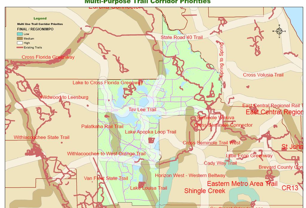
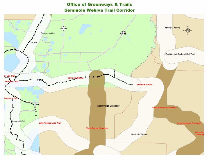
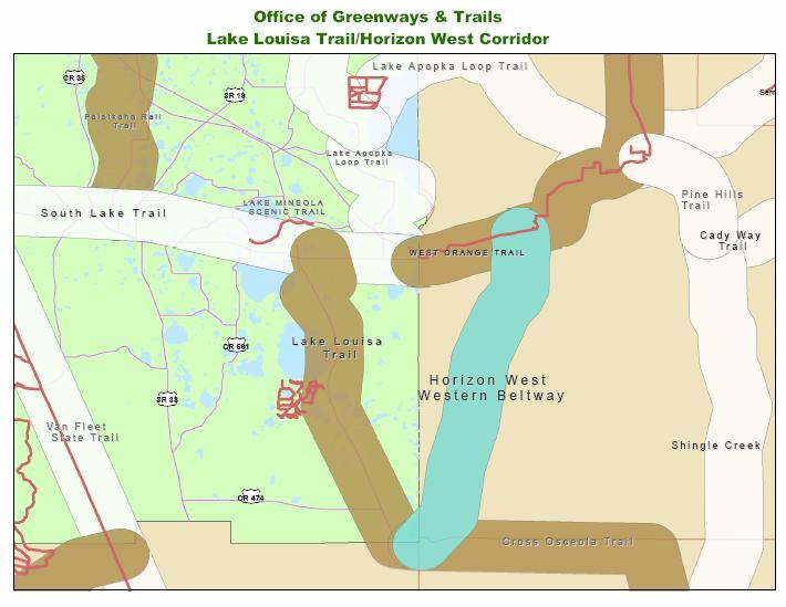
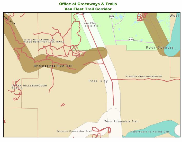
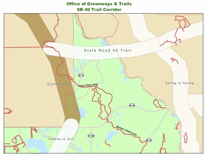
2 LAKE COUNTY REGIONAL TRAIL PROJECTS LAKE APOPKA LOOP TRAIL SOUTH LAKE TRAIL LEESBURG-WILDWOOD TRAIL LAKE-CROSS FLORIDA GREENWAY LAKE LOUISA-HORIZON WEST WEKIVA PARKWAY- SR 46 CORRIDOR SR 40 CORRIDOR VAN FLEET TRAIL-POLK COUNTY
3 OFFICE OF GREENWAYS AND TRAILS DEP STATEWIDE SYSTEM CONNECTING FLORIDA S COMMUNITIES GRANTS TECHNICAL ASSISTANCE
4 RAILS TO TRAILS CONSERVANCY Creating a nationwide network of trails from former rail lines and connecting corridors to build healthier places for healthier people
5 WHAT RTC DOES! RTC promotes policy RTC fights to preserve the TRANSPORTATION ENHANCEMENT PROGRAM RTC defends RAIL BANKING RTC helps catalyze action at the local level RTC provides leadership to the trails and greenway movement
6
7
8
9
10

11 Local Governments Within The Lake Basin Orange County Apopka Ocoee Winter Garden Oakland Lake County Montverde Clermont LAKE COUNTY ORANGE COUNTY
12 Other Agencies East Central Regional Planning Council St. Johns River Water Management District Office of Greenways and Trails, Florida Department of Environmental Protection Orange Audubon Society Green Mountain Scenic Byway Committee Trail Friends, Inc.

13 Greenways & Trails Existing WOT Existing Lake Minneola Scenic Trail Proposed greenways & trails 1 Proposed Recreation & Eco-tourism
14 Recreation & Eco-Tourism Sites 1. Magnolia Park 2. Ocoee City Property 3. Winter Garden Recreation Complex 4. Oakland Nature Preserve 5. Town of Montverde 6. Lake County Proposed Lakefront Preserve 7. Clay Island Park 8. Shorebird Management Area/Nature Center 9. Lake Minneola Urban Waterfront Park (existing)

15 Lake County Lakefront Preserve The park is proposed; location and size is yet to be determined Potential trail location on RR ROW

16 South Lake Trail Phase II Project Location Map N N.T.S. BEGIN STUDY END STUDY LEGEND - Proposed Phase II Alignment -Existing Trail
17 SOUTH LAKE TRAIL PHASE II Planning Partners Lake County Florida Department of Transportation Orange County West Orange Trail - Parks & Recreation City of Clermont City of Minneola Green Mountain Scenic Byway
18
19
20

21
22
23
24

25 SUNCOAST TRAIL
26
27


28 Vision Statement: In the future Polk County and its cities will share a unified system of greenways and blueways thereby enhancing the quality of life for all citizens. Mission Statement: To inspire a cooperative effort promoting the planning, development, and use of greenways and blueways throughout Imperial Polk County and its municipalities based on community input, connectivity, neighborhood compatibility, resource protection, recreation, security, education, and alternative transportation opportunities.
29
30
31


32 Trails Enhancing Our Quality of Life Opportunities for Regional Connectivity Opportunities for Regional Coordination Trails Effects on Property Values, Safety and Crime

33 Opportunities for Regional Connectivity South Lake Trail Phases III & IV and Sumter County 2. Wildwood-Leesburg 3. Leesburg-Marion County

34 Opportunities for Regional Connectivity South Lake Trail Phases III & IV Sumter County Lake County

35 Opportunities for Regional Connectivity Leesburg - Wildwood Trail Sumter County Lake County

36 Opportunities for Regional Connectivity Lake to Cross Florida Greenway Trail Marion County Lake County


37 Opportunities for Regional Coordination Lake/Sumter MPO Joint Planning Agreements (JPA) Inter-local Agreements Office of Greenways & Trails The development of new roadway corridors
38 Office of Greenways and Trails Regional Coordinator, Capeheart Perkins Adopted Visioning Corridors Acquisition Program State buys land for trails Recreational Trails Program (Federally funded competitive Grant Program) Local jurisdiction leases land ( yr. lease)
39 Trails Effects on Property Values The Effect of Greenways on Property Values and Public Safety; The Conservation Fund and Colorado State Parks, State Trails Program (Source: Results of the survey show that "urban trails are regarded as an amenity that helps to attract buyers and to sell property. For residents of single family homes adjacent to a trail: Many sellers believed that the existence of the trail would increase the selling price of their home. 57% of the residents felt that the trail would make the home easier to sell (with 36% saying no effect). 29% of those surveyed were positively influenced by the trail in their decision to buy the home. Results were similarly positive for residents who lived near but not adjacent to the trail..."
40 Trails Effects on Property Values Of the real estate agents interviewed: 73% believed that a home adjacent to a trail would be easier to sell 55% agreed that the home would sell for more than a comparable home from a different neighborhood 82% of real estate agents used the trail as a selling point 100% believed trails are an amenity to the community around it... "No public safety issues could be directly linked to the trail. Only one resident interviewed was concerned with this issue, and none of the officers interviewed believed trails had any effect on public safety...
41 Trails Effects on Property Values, Crime & Safety Brush Creek Trail Property Values and Crime, Santa Rosa, CA; (Source: Michelle Murphy, Sonoma State University) 64% of respondents felt the trail increased the quality of life in the neighborhood, with another 13% saying "no effect" 33% said the trail would make their home easier to sell Of real estate agents: 61% of real estate agents said they use proximity to trails as selling points "The study shows neither increased crime nor decreased property values due to trails. On the contrary, the most overwhelming opinion by residents along the Brush Creek Trail is that the trail/creek has a positive effect on the quality of life in the neighborhood."
42 Trails Effects on Property Values, Crime & Safety Omaha Recreational Trails: (Source: From We were pleased to see another study of the impacts of trails in a neighborhood setting: Omaha Recreational Trails: Their Effect on Property Values and Public Safety. Influence of Trail on Home Purchase or sale Of the respondents who purchased their home after the trail existed, 63.8% indicated that the trail positively influenced their purchase decision. 81% felt that the nearby trail's presence would have a positive effect or no effect on the ease of sale of their homes.
43 Trails Effects on Property Values, Crime & Safety Property Value Surveys (Source: In Boulder (CO) total selling prices increased $4.20 to $10.20 per foot of proximity, beginning at 3200 feet from the greenway (1978). Proximity to Salem (OR) greenbelt parcels - privately owned in this case - added a premium of $1,200 per acre, in comparison to similar properties 1,000 feet or more from the greenbelt (1986). Also in Massachusetts, a 1982 study of Worcester home sales documented a average premium of $2,675 for properties adjacent to park land versus properties 2,000 feet removed. In Dayton (OH), park proximity added 5 percent in one study area and 7.35 percent in another (1985). Similarly, property values declined with distance from Philadelphia's Pennypack Park: from a 33 percent premium for adjacent parcels, to 9 percent at 1,000 feet, and finally to 4.2 percent at 2,500 feet (1974).
44 Trails Effects on Property Values, Crime & Safety Property Value Surveys continued: A 1973 study in Columbus (OH) revealed premiums ranging from 7 to 23 percent for homes facing the park, contrasted with homes a block distant. The City of Seattle (WA) surveyed homeowners and real estate brokers along the 12 mile Burke-Gilman Trail in They found that properties near, but not immediately adjacent to the trail sold for an average premium of 6 percent. Of those interviewed, 60 percent believed that trail adjacency would have a neutral or positive effect on the selling price of their property.
The City shall enhance and improve the accessibility of parks and recreational facilities while protecting their quality. by:
 GOALS, OBJECTIVES AND POLICIES GOAL 1: To provide open space and recreation as an essential element needed for the betterment of the City s character and quality of urban life. The City shall plan for
Northeast Everglades Natural Area
 Northern Palm Beach County Natural Areas Master Plan Northeast Everglades Natural Area August 3, 2006 GLATTING JACKSON KERCHER ANGLIN LOPEZ RINEHART, INC. Community Planning 1 Public Land Partners Agenda
HILLSBOROUGH COUNTY Greenways and Trails Plan Update. Executive Summary. Date
 HILLSBOROUGH COUNTY Greenways and Trails Plan Update Executive Summary Date PURPOSE AND PROJECT OVERVIEW The Hillsborough County Greenways Master Plan (1995) and the City of Tampa s Greenways and Trails
Office of Greenways & Trails Providing Statewide Leadership and Coordination. Southeast Greenways and Trails Summit October 1-3, 2017
 Office of Greenways & Trails Providing Statewide Leadership and Coordination Southeast Greenways and Trails Summit October 1-3, 2017 1 Office of Greenways and Trails The Office of Greenways and Trails
Welcome to the 2018 FRPA Conference!
 Welcome to the 2018 FRPA Conference! Learning Objectives Describe the benefits of regional multipurpose trails Recall Florida s Priority Regional Trails and recognize their general locations across the
Yadkin River Greenway Feasibility Study Fact Sheet Village of Clemmons, Town of Lewisville, Town of Bermuda Run
 Fact Sheet Village of Clemmons, Town of Lewisville, Town of Bermuda Run Project Background The Yadkin River Greenway Feasibility Study is a joint project with the Village of Clemmons, the Town of Bermuda
G. RECREATION AND OPEN SPACE ELEMENT. The following summarizes the Recreation and Open Space Element:
 G. RECREATION AND OPEN SPACE ELEMENT The purpose of the Element is to provide the framework and direction for a comprehensive system of public and private sites for recreation, including, but not limited
ORANGE COUNTY AT A GLANCE
 ORANGE COUNTY AT A GLANCE Urban Land Institute Technical Advisory Panel Alberto Vargas, MArch Planning Division, Manager ORANGE COUNTY PLANNING DIVISION image credit: Google Earth April 23, 2014 2 Urban
This page intentionally blank.
 This page intentionally blank. Parks, Recreation, and Open Space Chapter Relationship to Vision Vision Parks, Recreation and Open Space Chapter Concepts County Government. County government that is accountable
IMPLEMENTING SOMERSET COUNTY S INVESTMENT FRAMEWORK
 IMPLEMENTING SOMERSET COUNTY S INVESTMENT FRAMEWORK SMART CONSERVATION THROUGH SMART GROWTH NJ LAND CONSERVATION RALLY March 22, 2014 Laurette Kratina, PP, AICP, Supervising Planner Somerset County Planning
S.R.7/U.S.441 COLLABORATIVE THE COLLEGE OF CORRIDOR KNOWLEDGE
 S.R.7/U.S.441 COLLABORATIVE THE COLLEGE OF CORRIDOR KNOWLEDGE S.R.7 Corridor : A Sense of Place? ANYWHERE USA SR 7: Civilizing the Corridor Bad rules = Bad development! The SR 7 Collaborative A model for
San Diego River Coalition 2012 Work Plan
 San Diego River Coalition 2012 Work Plan Adopted November 18, 2011 The mission of the San Diego River Coalition is preserve and enhance the San Diego River, its watershed, and its natural, cultural and
Support the implementation of Cape Coral's Comprehensive Plan. Protect and utilize the unique natural resources in the City.
 7.0 OVERVIEW - RECOMMENDATIONS Chapter 7 The preparation of the Cape Coral Parks and Recreation Master Plan spanned a period of approximately 12 months. Plan preparation included the input of a wide range
PARKS. Chapter Introduction
 Chapter 4. PARKS 4.1. Introduction This Parks Element of the 2016 Comprehensive Plan Update provides direction and guidance, based on citizen input, in order to improve and maintain the City s existing
Great Rivers Greenway CLEAN GREEN CONNEC TED T RAILS
 Great Rivers CLEAN GREEN CONNEC TED T RAILS Great Rivers (GRG) was established in 2000 to create a clean, green, connected St. Louis region. Today, many new and exciting projects demonstrate the social,
Get Connected: Balancing Built and Natural Environments for Sustainability
 Get Connected: Balancing Built and Natural Environments for Sustainability The Mid-South Regional Greenprint and Sustainability Plan seeks to connect a network of green space across Shelby County TN, Fayette
6.0 Conclusions & Recommendations
 6.0 Conclusions & Recommendations 75 The research, public outreach and feasibility analysis completed for this study indicate that Trail Alternative #2 (South side of Doctors Creek) is the most comprehensive
RECREATION, OPEN SPACE AND GREENWAYS ELEMENT GOALS, OBJECTIVES, AND POLICIES
 RECREATION, OPEN SPACE AND GREENWAYS ELEMENT GOALS, OBJECTIVES, AND POLICIES GOAL R-1: DEVELOP A RECREATION, OPEN SPACE AND GREENWAYS SYSTEM AS AN INTEGRAL COMPONENT OF AN OVERALL, COUNTY-WIDE ECONOMIC
List of Abbreviations
 List of Abbreviations The Action Plan The Action Plan establishes estimated time frames for implementing the Goals, Objectives and Strategies of the Corridor Management Plan. The Plan is divided into three
The Rocky Mountain Arsenal and the Northeast Greenway Corridor Project:
 The Rocky Mountain Arsenal and the Northeast Greenway Corridor Project: Contamination to Collaboration Presented by Howard Kenison Overview of Presentation Rocky Mountain Arsenal Contamination Litigation,
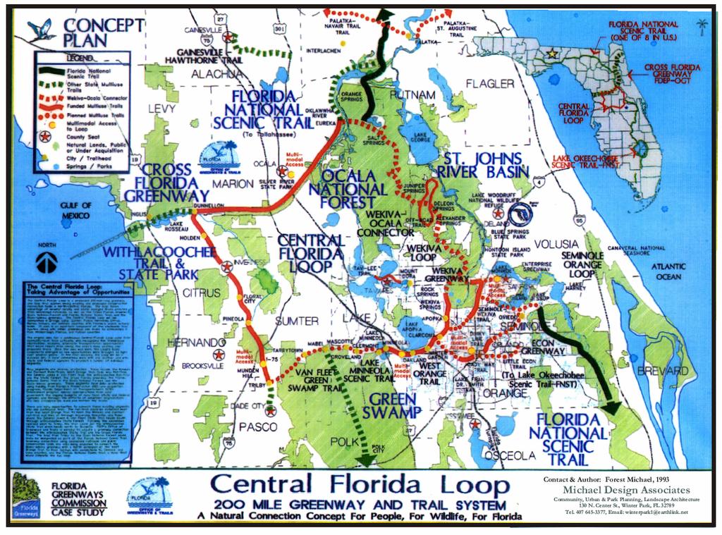
Statewide Greenways Vision
 Greenways Vision The formation of a greenways vision is based on a thorough analysis of the current state of recreation and open space in a region and the existing pressures that threaten it. Lehigh and
PREVIOUS PUBLIC PARTICIPATION BRIEF October 2014
 Comprehensive Planning During the development of the county comprehensive plan, Cultivating Community: A Plan for Union County s Future from 2007 through 2009, and three concurrent multi municipal plans
Planning for Waterfront Communities
 Planning for Waterfront Communities Redevelopment Ready Communities Supplemental Training Program OFFICE OF THE GREAT LAKES Waterfront Community Best Practices and Guidelines New supplemental criteria
Waterfront Land Use Planning Survey! Celebrating 20 years of Partnership
 Waterfront Land Use Planning Survey! Celebrating 20 years of Partnership Waterfront Land Use Planning Survey! 46 respondents 74% Lake Ontario / 26% St Lawrence River 4 Case Studies: Grimsby, Prescott,
UPDATE ON THE INDEPENDENCE BOULEVARD AREA PLAN. Citizen Advisory Group Meeting March 3, 2011
 UPDATE ON THE INDEPENDENCE BOULEVARD AREA PLAN Citizen Advisory Group Meeting March 3, 2011 Purpose: Why are we here? To provide an update on the Independence Boulevard Area Plan 1. Overview of the ULI
RECREATION AND OPEN SPACE ELEMENT GOALS, OBJECTIVES, AND POLICIES
 RECREATION AND OPEN SPACE ELEMENT GOALS, OBJECTIVES, AND POLICIES GOALS, OBJECTIVES AND POLICIES GOAL 1: TO PROVIDE A FULL RANGE OF RECREATIONAL ACTIVITIES THAT ARE ACCESSIBLE, COMPATIBLE AND CONTINUOUS
We d like to thank you for attending this Wekiva Parkway Section 8 Preliminary Design Update hosted by the Florida Department of Transportation.
 We d like to thank you for attending this Wekiva Parkway Section 8 Preliminary Design Update hosted by the Florida Department of Transportation. We will provide you information on the overall project and
ORANGE COUNTY IMPLEMENTING THE FOUR C s
 ORANGE COUNTY IMPLEMENTING THE FOUR C s East Central Florida Corridor Task Force O R A N G E COUN TY P LA N N I N G DIVISION C O M M U N I T Y, E N V I R O N M E N T A L A N D D E V E L O P M E N T S E
Provide and maintain sufficient public parks, recreation facilities, and open space to meet the recreational needs of County residents and visitors.
 (ROS) Goal Provide and maintain sufficient public parks, recreation facilities, and open space to meet the recreational needs of County residents and visitors. OBJECTIVE ROS.01 The County shall acquire,
CHAPTER 7: Transportation, Mobility and Circulation
 AGLE AREA COMMUNITY Plan CHAPTER 7 CHAPTER 7: Transportation, Mobility and Circulation Transportation, Mobility and Circulation The purpose of the Transportation, Mobility and Circulation Chapter is to
Secrest Short Cut and Monroe Expressway Small Area Plan AUGUST 29, 2018
 Secrest Short Cut and Monroe Expressway Small Area Plan AUGUST 29, 2018 Background and Process Monroe Expressway will be open by the end of 2018 Union County and Indian Trail identified a need to revisit
Courthouse Planning Area
 Courthouse Planning Area Current Reality The Courthouse Planning Area is the characterized by expansive suburbanscale residential areas as well as the community resource planned area of athletic, educational,
A District Council of the Urban Land Institute
 A District Council of the Urban Land Institute A District Council of the Urban Land Institute Thank you to our sponsors! Corporate Sponsors: Supporter Sponsors: Friend Sponsor: Thank you to our Community
Delaware River Waterfront Corporation
 Delaware River Waterfront Corporation Delaware River Waterfront Corporation Created in January 2009 to replace Penn s Landing Corporation o Open, accountable, effective leadership o New Board of Directors
Turkey Creek Streamway Corridor
 Turkey Creek Streamway Corridor Turkey Creek Corridor Overview History Watershed Corridor Inventory Coalition Corridor Plan Stages of Development Benefits Funding Turkey Creek History Kansas and Missouri
DRAFT. Waterfronts and Open Spaces. 10 The Riverfront Open Space System
 CHAPTER 4 Waterfronts and Open Spaces 10 The Riverfront Open Space System 12 Planned, proposed and envisioned riverfront recommendations. Figure 4.3.23 The riverfront will become a major new public amenity
Parks and Open Space Preservation and Dedication. January 26, 2016 Fort Worth City Council Pre-Council Meeting Randle Harwood and Richard Zavala
 Parks and Open Space Preservation and Dedication January 26, 2016 Fort Worth City Council Pre-Council Meeting Randle Harwood and Richard Zavala Purpose How does the City of Fort Worth preserve and protect
Plan Policies. Introduction
 Plan Policies Introduction The purpose of the Plan Policies section is to identify the various Governing Body and Planning Commission land use related policy resolutions for use in evaluating development
Potential Green Infrastructure Strategies May 6, 2015 Workshop
 Potential Green Infrastructure Strategies May 6, 2015 Workshop Background The City of Cortland is developing the Tioughnioga Urban Headwaters Green Infrastructure Action Plan with funding from the National
Learning from Other Communities Western Nassau Heritage Preservation Committee Nassau County Planning + Zoning Board May 1, 2018
 Learning from Other Communities Western Nassau Heritage Preservation Committee Nassau County Planning + Zoning Board May 1, 2018 Overview ULI Report References Other Florida Communities Communities Outside
Mississippi Skyway Preliminary Engineering Report
 EXECUTIVE SUMMARY Mississippi Skyway Preliminary Engineering Report CITY OF RAMSEY, MINNESOTA DECEMBER 2014 City of RAMSEY EXECUTIVE SUMMARY Project Need and Intent The Mississippi Skyway pedestrian bridge
THE ETOW A H RIVER CANOE TRAIL
 THE ETOW A H RIVER CANOE TRAIL A collaborative effort between the City of Canton, Cherokee, Dawson and Forsyth Counties Making the dream a reality MATTHEW PATE MANAGER- FORSYTH OUTDOOORS FORSYTH COUNTY
Midtown Greenway to lake street
 Making the connection: Midtown Greenway to lake street May 2016 Design experiment: site amenities, wayfinding, and activities at Cepro, near the Midtown Global Market Recent Greenway Development Highlights
UPPER BRODHEAD CREEK PARADISE CREEK GREENWAY PLAN
 UPPER BRODHEAD CREEK PARADISE CREEK GREENWAY PLAN The Upper Brodhead & Paradise Creeks Greenway Cooperating Municipalities Mount Pocono Borough Paradise Township Barrett Township Price Township Funding
OVERMOUNTAIN VICTORY TRAIL BURKE CALDELL CORRIDOR FEASIBLITY STUDY REQUEST FOR QUALIFICATIONS CALDWELL COUNTY PATHWAYS
 OVERMOUNTAIN VICTORY TRAIL BURKE CALDELL CORRIDOR FEASIBLITY STUDY REQUEST FOR QUALIFICATIONS CALDWELL COUNTY PATHWAYS Caldwell County Pathways along with our co-partners City of Lenoir, Town of Gamewell,
Public Information/Cultural Resources Committee Workshop August 15, Florida Department of Transportation District One
 Public Information/Cultural Resources Committee Workshop August 15, 2012 Florida Department of Transportation District One SR 542 from 1 st Street to E. of Buckeye Loop Road Winter Haven, Polk County FPID#
TABLE OF CONTENTS. Transportation Chapter 1 - Introduction and Purpose of Planning to 1-3. Utilities
 Chapter 1 - Introduction and Purpose of Planning... 1-1 to 1-3 Pennsylvania Municipalities Planning Code (Act 247)...1-1 Previous County Planning Activities...1-1 Objectives of the Plan...1-2 Elements
CCI Concerned Citizens Group, Inc. Report on Community Survey Regarding Future Use of CCI Property after Cleanup July 1, 2005
 CCI Concerned Citizens Group, Inc. Report on Community Survey Regarding Future Use of CCI Property after Cleanup July 1, 2005 Introduction CCI is a 1.5 acre Superfund site at 320 South Blake Street, Olathe,
City of Heath. Town Center Concept
 In the give-and-take of getting projects designed, financed, and approved, the famous refrain from the film Field of Dreams is heard often: if you build it, they will come. From the perspective of the
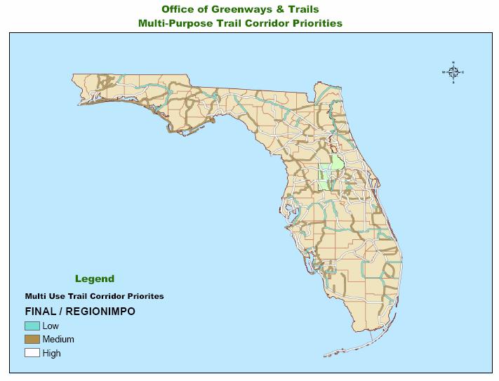
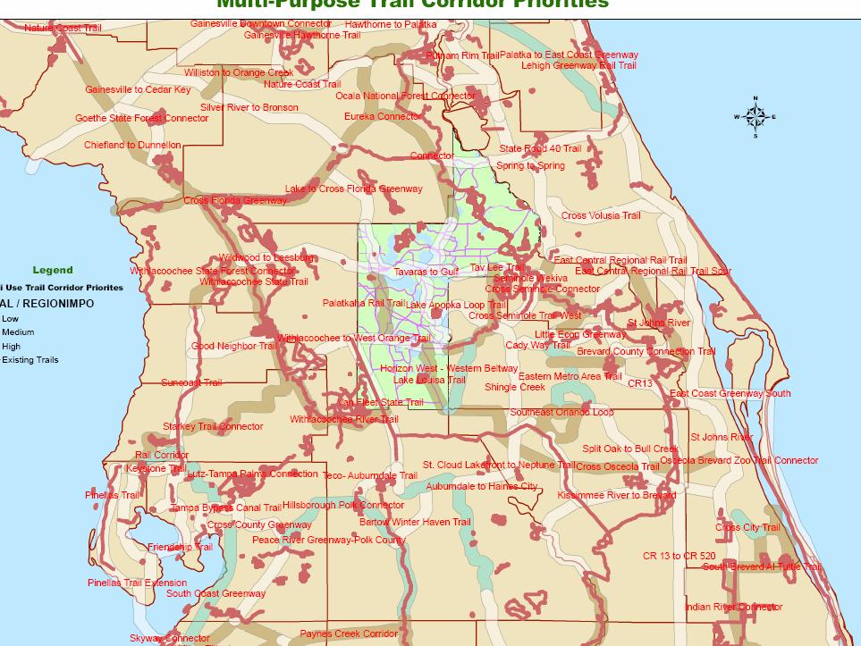
Florida Greenways and Trails System (FGTS) Plan Goals, Strategies and Objectives
 Plan Goals, Strategies and Objectives") Identification and Prioritization of the FGTS The Florida Greenways and Trails System (FGTS) is made up of existing, planned and conceptual trails and ecological greenways that form a connected, integrated
Identification and Prioritization of the FGTS The Florida Greenways and Trails System (FGTS) is made up of existing, planned and conceptual trails and ecological greenways that form a connected, integrated
Washington Pass Overlook
 Washington Pass Overlook The Washington Pass Overlook is located on the Methow Valley Ranger District on the Okanogan-Wenatchee National Forest. The overlook is at the crest of Washington Pass and is part
Subject: City of Richfield Cedar Avenue Corridor Plan Comprehensive Plan Amendment, Review File No
 Committee Report Business Item No. 2017-21 Community Development Committee For the Metropolitan Council meeting of January 25, 2017 Subject: City of Richfield Cedar Avenue Corridor Plan Comprehensive Plan
Working together to leverage limited Funds
 Working together to leverage limited Funds ARAPAHOE COUNTY OPEN SPACES 10 County Budget Conference September 20, 2013 The Power of Partnerships 2013 SORP Conference 5/23/2014 Why Talk About Open Space?
Dwelling Units Max 12 dwelling units per acre/min 8 dwelling units per acre. Development Mix 80% non residential/20% residential
 13. OSTEEN LOCAL PLAN Background: The Osteen Local Plan area is located in southwest Volusia County along the SR 415 corridor between Lemon Bluff Road and Acorn Lake Road and includes 3,990 acres. The
Preliminary Sea Level Rise Case Study: Navarre Beach, FL
 Preliminary Sea Level Rise Case Study: Navarre Beach, FL This publication was funded in part, through a grant agreement from the Florida Department of Environmental Protection, Florida Coastal Management
SONOMA LOCAL AGENCY FORMATION COMMISSION
 For accessibility assistance with any of the following documents, please contact Sonoma LAFCO at (707) 565-2577 or email us at cynthia.olson@sonoma-county.org. SONOMA LOCAL AGENCY FORMATION COMMISSION
The following principles guide the development of goals and strategies to protect and promote these amenities:
 OPEN SPACE/PARKS/TRAILS/RECREATION GOALS/STRATEGIES Cherry Hills Village is a living environment that offers low density development, open areas, public scenic vistas, public trails and public parks. This
ULI St. Louis Technical Assistance Panel
 ULI St. Louis Technical Assistance Panel ULI St. Louis Technical Assistance Panel Sponsored by: Citizens for Modern Transit in partnership with METRO ULI St. Louis Mission Statement The mission of the
The Palisades Interstate Parkway and Henry Hudson Drive designated a New Jersey State Scenic Byway, 2005
 The Palisades Interstate Parkway and Henry Hudson Drive designated a New Jersey State Scenic Byway, 2005 What are scenic byways? How Did Scenic Byways Come About? National Scenic Byways Program Administered
PRELIMINARY REPORT. HIGHWAY 18 CORRIDOR NEIGHBORHOOD PLAN VILLAGE OF DOUSMAN November, 2014
 PRELIMINARY REPORT HIGHWAY 18 CORRIDOR NEIGHBORHOOD PLAN VILLAGE OF DOUSMAN November, 2014 This preliminary report presents the initial recommendations for land use within the Highway 18 corridor along
Project Profile BAR HARBOR
 1 BAR HARBOR The Bar Harbor Master Plan merges community vision with design guidelines to preserve the unique character of Bar Harbor Village. PROJECT SUMMARY Overview: The economic vitality of Bar Harbor
OPEN SPACE CHAPTER 7: OVERVIEW. Preserve open space to protect natural resources, enhance character and provide passive recreation opportunities
 CHAPTER 7: OPEN SPACE OVERVIEW Ridgefield has made tremendous progress permanently preserving areas of town as open space. Open space preservation can serve many important purposes, including: protect
RECREATION AND OPEN SPACE ELEMENT
 RECREATION AND OPEN SPACE ELEMENT Last amended August 19, 2008 Table of Contents Objective Page 5.1 Park system defined... 5-1 5.2 Access to parks and recreational facilities... 5-2 5.3 Recreation and
THE BLACKSTONE VALLEY
 THE BLACKSTONE VALLEY This element exists because it is required that this plan reflect the goals and policies of Rhode Island state guide plan element 131, which can be viewed here: Cultural Heritage
Mendota-Lebanon Hills Greenway Master Plan Executive Summary. August draft for more information visit
 Mendota-Lebanon Hills Greenway Master Plan Executive Summary August 2013 draft for more information visit www.hkgi.com/projects/dakota INTRODUCTION The Mendota-Lebanon Hills Greenway Master Plan portrays
3. VISION AND GOALS. Vision Statement. Goals, Objectives and Policies
 Vision Statement Queen Creek s interconnected network of parks, trails, open spaces and recreation opportunities provide safe and diverse activities and programs that sustain its unique, small town, equestrian
I. STAFF POLICY RECOMMENDATIONS. The following RMP policy strategies are proposed by staff in support of a Scenic Resource Protection Program:
 Policy Consideration: Scenic Resource Protection Program Status: For Consideration by the Highlands Council at September 14, 2006 Work session Date: September 12, 2006 I. STAFF POLICY RECOMMENDATIONS The
DRAFT ROOSEVELT ROAD. District Recommendations. Figure 5.23 The Roosevelt Road Corridor
 CHAPTER 5 Figure 5.23 The Road Corridor Road will develop as a mixed-use corridor, emphasizing regional retail, west of the river and mixed-use development east of the river. KEY RECOMMENDATIONS 1. High
7.0 OPEN SPACE 7.1 OPEN SPACE DEDICATION CHAPTER 7: OPEN SPACE
 7.0 OPEN SPACE The intent of these requirements is to allow for the usage of centrally located unencumbered land as neighborhood open spaces and not to permit the use of leftover or otherwise unusable
Rocky View County Plans
 COUNTY PLAN Guides overall growth and development for the county. INTER-MUNICIPAL DEVELOPMENT PLAN Guides growth and development in an area where the County shares a border with another municipality. -
Prepared for the Citizens of Forsyth County by the City-County Planning Board
 Prepared for the Citizens of Forsyth County by the City-County Planning Board Bryce A. Stuart Municipal Building 100 East First Street, Winston-Salem, NC 27101 336.727.8000 www.cityofws.org/planning www.legacy2030.com
City of Niagara Falls. New York. D Amelio Park Playground
 New York January 2018 Consultation and Review Form Type of Review Required: X Mandatory Consultation Project Registration Number Voluntary Review and/or Endorsement PROJECT SPONSOR INFORMATION Name: City
FOR IMMEDIATE RELEASE Contact: Dyana Koelsch
 FOR IMMEDIATE RELEASE Contact: Dyana Koelsch 401.831.1200 dkoelsch@nharbor.com Revised Gateway Plan Decreases Retail, Adds 70% More Office Space and Improves Entrance to Quonset Business Park Incorporating
Whitemarsh Township Greenway Plan
 Whitemarsh Township Greenway Plan Prepared for: Whitemarsh Township August 16, 2007 Table of Contents Table of Contents... i Introduction... 1 Study Area Setting... 2 Regional Setting... 2 Township Character...
Section 3 INVENTORY OF RECREATION LAND AND FACILITIES
 Photo of Juan Bautista de Anza Park Section 3 INVENTORY OF RECREATION LAND AND FACILITIES Summary of Findings Park Definitions Summary of Recreation Facilities Other Recreation Facilities Nearby Recreation
MEMORANDUM OF UNDERSTANDING REGARDING MANAGEMENT OF THE LAKE MERCED TRACT
 June 24, 2011 Draft MEMORANDUM OF UNDERSTANDING REGARDING MANAGEMENT OF THE LAKE MERCED TRACT THIS MEMORANDUM OF UNDERSTANDING ("MOU"), dated for reference purposes only as of, 2011, is entered into by
Pittsfield Action Plan (West Branch of the Housatonic River)
") An initiative of the Massachusetts Executive Office of Energy and Environmental Affairs in partnership with the City of Pittsfield Pittsfield Action Plan (West Branch of the Housatonic River) The spring
An initiative of the Massachusetts Executive Office of Energy and Environmental Affairs in partnership with the City of Pittsfield Pittsfield Action Plan (West Branch of the Housatonic River) The spring
Visioning Committee Kick-Off Meeting
 Visioning Committee Kick-Off Meeting June 11, 2018 The Team Project management, technical analysis, implementation, report preparation Public engagement, park review Recreation facilities review, operations
TOWN OF BETHLEHEM MEETING SUMMARY LOCAL WATERFRONT REVITALIZATION PROGRAM UPDATE
 TOWN OF BETHLEHEM LOCAL WATERFRONT REVITALIZATION PROGRAM UPDATE MEETING SUMMARY Purpose: LWRP Update Public Workshop #3 Date and Time: October 24, 2017, 6:00 pm - 8:00 pm Location: Town Hall, 445 Delaware
RESOLUTION NO. R Refining the route, profile and stations for the Downtown Redmond Link Extension
 RESOLUTION NO. R2018-32 Refining the route, profile and stations for the Downtown Redmond Link Extension MEETING: DATE: TYPE OF ACTION: STAFF CONTACT: Capital Committee Board PROPOSED ACTION 09/13/2018
Ottawa County Parks, Recreation & Open Space Plan. February, 2006
 2006 Ottawa County Parks, Recreation & Open Space Plan February, 2006 TABLE OF CONTENTS ACKNOWLEDGMENTS.................................................... v PLAN ADOPTION..........................................................vi
Comprehensive Park System Master Plan
 PARKS AND RECREATION Comprehensive Park System Master Plan Citizen Advisory Committee, June 5, 2012 - Meeting Notes Transcription MIG met with the Parks Citizen Advisory Committee on Tuesday, June 5th,
Laberge Group. Town of Coeymans. Draft Comprehensive Plan. Overview of Planning Process
 Draft : Presentation of Goals & Strategies Laberge Group Benjamin H. Syden, A.I.C.P., E.D.P Director in Charge Nicole Allen, A.I.C.P. Senior Planner Anjali Malhotra Planner Presentation Outline Introductions
Greenway. Two Rivers. Design Guidelines and Signage Plan. Broome County. Tioga County. Prepared For: The Binghamton Metropolitan Transportation Study
 Broome County Two Rivers Greenway Design Guidelines and Signage Plan Tioga County Prepared For: The Binghamton Metropolitan Transportation Study Prepared By: 2012 This project is included in the 2011-2012
PARTF Scoring System for Grants
 PARTF Scoring System for Grants The members of the N.C. Parks and Recreation Authority use the PARTF scoring system as one of several tools to select grant recipients. Please provide all of the information
University of Washington Burke Gilman Trail Corridor Study
 Civil Engineering Landscape Architecture Environmental Restoration Planning University of Washington Burke Gilman Trail Corridor Study Dave Rodgers, PE, LEED AP March 10, 2011 Guiding Principles Design
Regarding actual construction when development occurs, the following applicable guidelines are provided to address public safety issues:
 MIAMI-DADE COUNTY DEPARTMENT OF PLANNING AND ZONING General Comments 1. COMMENT: A careful review of the application provided shows that there is likely to be an impact on the Miami-Dade Police Department
EL DORADO COUNTY GENERAL PLAN PARKS AND RECREATION ELEMENT PRINCIPLE INTRODUCTION STATE AUTHORIZATION
 EL DORADO COUNTY GENERAL PLAN PARKS AND RECREATION ELEMENT PRINCIPLE The General Plan must identify the types of governmental services, including parks and recreation facilities, which are necessary to
Isabel Neighborhood Plan: Alternatives
 Isabel Neighborhood Plan: Alternatives Presented by: Lori Parks, Associate Planner February 2, 2015 Agenda 1. Background on BART to Livermore 2. Isabel Neighborhood Plan 3. Alternative Scenarios 4. General
Philadelphia Trail Master Plan
 Philadelphia Trail Master Plan Jeannette Brugger, AICP Philadelphia City Planning Commission April 30, 2013 Delaware Valley Regional Planning Commission 190 N. Independence Mall West, 8 th Floor Philadelphia2035
Open Space and Farmland Preservation
 Vibrant. Green. Connected. Competitive. Open Space and Farmland Preservation Statement of Purpose The purpose of this section of the Plan is to encourage and support the preservation of open space areas
An Ambitious Plan: Transforming the blighted South Platte River and surrounding environment into Denver s greatest natural resource.
 CONNECTING THE PEOPLE TO THEIR RIVER SOUTH PLATTE RIVER VISION IMPLEMENTATION PROGRAM: GRANT-FRONTIER PARK TO OVERLAND POND PARK REACH The South Platte River Vision Implementation Program (River Vision)
DRAFT Civic Center Station Area Plan. Executive Summary
 DRAFT Civic Center Station Area Plan Executive Summary This project is funded in part through the Metropolitan Transportation Commission s Station Area Planning Program. The preparation of this report
Q&A with Jerry Adelmann: The green legacy of Daniel Burnham. By Patrick T. Reardon on Tue., 08/24/ :00 am.
 were made, said Jerry Adelmann, executive director of Openlands. THE BURNHAM BLOG Vision & Theme About the Logo Centennial Committee and Staff Sponsors Newsroom News Coverage Press Releases E-News & Social
Draft Stillwater 2030 Comprehensive Plan- Goals and Policies
 Draft Stillwater 2030 Comprehensive Plan- Goals and Policies Instructions- Review each goal and policy and discuss with group any changes, deletions for additions to the list using your groups pen. Keep
PLANNING FOR COMMUNITY GARDENS IN ANCHORAGE
 PLANNING FOR COMMUNITY GARDENS IN ANCHORAGE Presentation at the Alaska Food Policy Council Conference February 27 th, 2016 Overview I. Community Gardens in Anchorage II. Making the Case for Community Gardens
Examples of Asset Based Approaches to Development. Economic and Community Development Suffield, CT
 Examples of Asset Based Approaches to Development Presented by: Patrick McMahon, Director of Economic and Community Development Suffield, CT Neighborhood Commercial Development Wilson, CT Issues Elevated
Pennsy Greenway Trail
 Town of Schererville Pennsy Greenway Trail DES. #s: 0401062, 1173595 & 1382661 Construction of Pennsy Greenway Trail beginning at Wilhelm Street and continuing northwest along the former Penn Central railroad
TENNESSEE STATE ROUTE 109 CORRIDOR MANAGEMENT AGREEMENT MEMORANDUM OF UNDERSTANDING CORRIDOR MANAGEMENT ALONG STATE ROUTE 109
 TENNESSEE STATE ROUTE 109 CORRIDOR MANAGEMENT AGREEMENT MEMORANDUM OF UNDERSTANDING CORRIDOR MANAGEMENT ALONG STATE ROUTE 109 I. Purpose The purpose of this Agreement is to provide a framework for the
Elm Fork Land Use. Trinity River Corridor Project Committee May 13, 2013
 Elm Fork Land Use Trinity River Corridor Project Committee May 13, 2013 Purpose Discuss Trinity River planned Land Use and Appropriate Compatible Uses, particularly with respect to the Elm Fork Area 2