Planning Board Briefing
|
|
|
- Randolf Wiggins
- 5 years ago
- Views:
Transcription

1 Planning Board Briefing
2 Why Now? The Sector Plan Implementation Chapter States: Before Stage 1 begins, the following must occur: Approval of the Sectional Map Amendment. Approval of the Greater Lyttonsville Design Guidelines.
3 Schedule October 2018-Ongoing: Stakeholder Working Groups December 2018: Planning Board Briefing Early 2019: Release of the Working Draft Early 2019: Community Drop-in hours at the Coffield Center Spring 2019: Planning Board Work Sessions
4 What are Design Guidelines?


5 What are Design Guidelines? Intent Statement Provide more detail on design based on Sector Plan recommendations. Ensure that new projects fit well into the unique and vibrant community character in the area today. Guidelines Provide all stakeholders with a consistent and predictable starting point for reviewing projects. Outline clear intent statements and ways the intent can be achieved. Allow flexibility for creative alternatives that meet the intent. Include design of public improvements and private development. Example Photos and Graphics

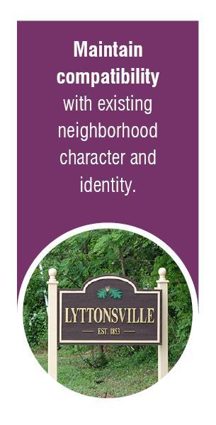
6 How do they relate to the Zoning Ordinance? All C/R projects must: Meet compatibility requirements. Provide required public open space. All C/R projects under Site Plan review must: Substantially conform with the Sector Plan and Design Guidelines.
7 What will these Guidelines include? 1. Introduction Community Design Principles How to Use the Guidelines 2. Areawide Guidelines Streetscape Design Parks and Open Space Design Site and Building Design 3. Site-Specific Guidelines Site Conditions Ped/Bike Circulation Public Open Space Design Building Design
8 Community Design Principles


9 Community Design Issues Barriers to walkability and bikeability such as steep topography, large blocks and incomplete sidewalks. Need for expanded parks and open space particularly as the community grows. Development out of scale with surrounding neighborhoods. Poor transitions between industrial and residential uses, and truck traffic in residential areas. Poor to fair water quality and high impervious cover.
10 Vision The vision of the Greater Lyttonsville Sector Plan is to preserve the integrity of the area s neighborhoods along with their special heritage and character, while strategically encouraging mixed-use development near transit and expanding parks, trails and open space.

11 Community Design Principles:
12 Streetscape Design


13 Sidewalks and Streetscape Character Intent: Create an inviting sidewalk environment for people to connect to their destinations, gather and use transit. Streetscape character should reflect the surrounding context, including building types and neighborhood scale. Planting/ Furnishing Zone Pedestrian Zone Frontage Zone


14 Sidewalks and Streetscape Character Intent: Create an inviting sidewalk environment for people to connect to their destinations, gather and use transit. Streetscape character should reflect the surrounding context, including building types and neighborhood scale. Neighborhood Connector Neighborhood Retail Street Neighborhood Residential Street Industrial/Industrial Mixed-Use Street Ped/Bike Through-Block Connection


15 Enhanced Crossings/ Intersections Intent: Provide safe and comfortable crossings to improve access to transit and make it easier for pedestrians to cross major streets such as East-West Highway and 16th Street.


16 Canopy Corridors Intent: Re-establish contiguous green corridors along bicycle networks linking parks, open space, neighborhoods and destinations.
17 Parks and Open Space Design

18 Parks and Open Space Goals Expand the parks and open space network. Establish an interconnected system of parks and POPS to serve the existing and future residents. Improve public realm in tandem with community design and transportation recommendations.
19 Park Hierarchy For the Sector Plan: Social gathering spaces Active recreation destination Contemplative places An interconnected network of sidewalks and trails to connect parks and public spaces Park Types: Civic Green, Plaza, Urban Greenway, Urban Recreational Park, Local Park For Neighborhoods a neighborhood park or neighborhood green For Blocks a pocket green, or urban recreational parklet For Buildings and Residences private or communal outdoor spaces
 Urban Greenway: Summit Hills Neighborhood Green: Site 9-Light Industrial Area Urban Recreational Park: Summit")
20 Design Guidelines by Park Type Civic Green: WSSC Property and Summit Hills Plaza: Spring Center Local Park: Rosemary-Hills Local Park (expansion) Urban Greenway: Summit Hills Neighborhood Green: Site 9-Light Industrial Area Urban Recreational Park: Summit Hills

21 Parks and Open Spaces Design Elements Guidelines: Context Place Comfort Variety Connections Sustainability Topics: Function/Service Area Main Program Key Features Site Placement Size
22 Site and Building Design


23 After Site and Building Design Topics Compatibility Infill Development Opportunities Relationship between Buildings and Public Spaces Before Methods to Reduce Building Bulk Incremental Improvements to Industrial Sites Historic Signage and Commemorative Art Servicing, Access and Parking


24 Environmental Site Design Toolkit Intent: In a setting with a high amount of impervious cover, these site design strategies contribute to the quality of life and place while providing: open space; parks recreation/play; increased biodiversity; urban greening; and improved air and water quality.
25 Site-Specific Guidelines
26 Site 1: Spring Center Site 2: Summit Hills Site 3: th Street Site 6: Rollingwood Apartments Site 7: Paddington Square Site 9: Light Industrial Area Site 11: WSSC Site Site 12: Claridge House/Friendly Gardens/Storage Yards Site 13b: Vacant Site/Ride On Parking Lot + Rosemary Hills-Lyttonsville Local Park + Capital Crescent Trail
27 Stakeholder Feedback Community Design Principles: Add language about maintaining diversity and enhancing social connections. Public Space: Ensure that public open spaces and public streets on private property are designed to feel open and inviting to all members of the public. Community History: Highlight and celebrate the historic Lyttonsville neighborhood. Facilitate opportunities for existing members of the community to adjust to change and ensure new residents are made aware of the unique and thriving communities there today and their history. Streetscape Design: Prevent truck traffic from cutting through the Lyttonsville neighborhood through traffic calming measures and signage. Unit Sizes: Recommend that new developments include larger units for families, similar to what exists in the area today. Pedestrian Crossings: Lack of crossings makes it hard for pedestrians who have to run across the street. Nice sidewalks alone will not create a complete network. Public Art: Address the potential for public art throughout the plan area to increase vibrancy and provide wayfinding and branding for local businesses.
28 Next Steps Early 2019: Release of the Working Draft Ongoing: Stakeholder Working Groups Early 2019: Community Drop-in hours at the Coffield Center Spring 2019: Planning Board Work Sessions
29 Planning Board Briefing

30 Site 1: Spring Center Constrained site with shallow lot depth. Will be further reduced by the future light rail tracks and Purple Line station. 16 th St difficult to cross to access site.

31 Ped/Bike Circulation Increase sidewalk width along 16 th St, provide separated bike lanes and planting buffer. Provide prominent pedestrian crossing across 16 th St connecting to station. Public Open Space Locate civic open space adjacent to future PL Station with shading, seating and inclusive design for all ages. Building Design Provide active and transparent ground floors lining 16 th St to encourage walkability. Maintain compatibility with Woodside neighborhood through façade articulation and step-backs of the upper floors facing CSX tracks.

32 Site 2: Summit Hills Buildings disconnected from surrounding streets by fencing and surface parking. Steep topography throughout the site. Fenwick Branch piped under parking lot.


33 Ped/Bike Circulation Provide ped/bike pathways through the site to improve connectivity to the future Purple Line Station and proposed open spaces. Public Open Space Provide a civic green urban park to include hardscape elements and lawn areas to serve as a central gathering space. Establish an urban greenway park with daylighting and naturalization of the Fenwick Branch, a paved trail and an adjacent urban recreational park. Building Design Explore opportunities to provide partial redevelopment or infill development to better relate to the street and contribute to the pedestrian environment. URBAN GREENWAY URBAN RECREATIONAL PARK CIVIC GREEN

34 Site 3: 8600 Apartments Building disconnected from 16 th St by a deep setback and surface parking. Fenwick Branch surface stream flows through the rear of the site.


35 Ped/Bike Circulation Connect discontinuous sidewalks. Install a planting buffer and planted frontage zone if ground floor residential, or street activities if commercial. Public Open Space Provide a continuation of the Urban Greenway Park from the Summit Hills site to include daylighting and naturalization of the Fenwick Branch, and also a paved trail. Building Design Consider infill development or redevelopment in the long term to better relate to 16 th St. Provide a base potentially with individual unit entries to frame the street, and use methods to reduce building bulk such as step-backs and articulation.

36 Site 6: Rollingwood Apartments Steep topography along Lyttonsville Rd. No pedestrian connections to Lyttonsville Rd or Rosemary Hills-Lyttonsville park. Abutting single-unit homes.
37 Ped/Bike Circulation Provide pedestrian-oriented streetscape improvements to Lyttonsville Rd and bike lanes. Create pedestrian connections through the site to connect to park/coffield Center and future PL station. Facilitate intersection improvements to discourage truck traffic from entering the Lyttonsville community. Public Open Space Consider potential land swap to provide expanded useable parkland. Potential amenities on new parkland may include: dog park, community open space, expanded play areas and/or other similar facilities.

38 Building Design Encourage new development only on north side of property near future Purple Line Station. Bring any new building up towards Lyttonsville Rd to create a stronger street wall and design massing to relate to pedestrian scale. Maintain compatibility with single-unit homes by limiting height at rear of site.


39 Site 7: Paddington Square Surrounded by single-unit homes Abutting Rosemary Hills-Lyttonsville Park. Only one vehicular access point.


40 Ped/Bike Circulation Improve pedestrian connections through the site and to the park. Public Open Space Expand park space onto site to accommodate additional recreation facilities. Accommodate access easement across parkland to provide a new driveway to site from Lyttonsville Road/Michigan Avenue Building Design Allow midrise development closest to park with attractive frontage: articulation, ground floor entries and upper floor stepbacks to limit visual impact of building bulk from the park. Maintain compatibility with surrounding single-unit homes with townhouse units at a lower height.

41 Site 9: Light Industrial/ Office Area Contains light industrial and office buildings that house commercial and industrial businesses. Compatible building scale along Kansas Ave.

42 Ped/Bike Circulation Improve ped/bike connections through the site and to the CCT. Provide continuous sidewalks around the site Public Open Space Provide a Neighborhood Green to include neighborhood amenities such as play structures, shaded seating and a flexible lawn area. Continue linear green space from site 8a along CCT going NE. Building Design Maintain compatibility with surrounding single-unit residential properties through low-rise development. Continue character of entries along Kansas Ave.

43 Site 11: WSSC Site Primarily surface parking with the WSSC facility. Steep topography along Lyttonsville Pl. Donnybrook Stream piped into in-line SWM pond.


44 Ped/Bike Circulation Provide ped/bike streetscape improvements to Lyttonsville Rd and Pl. Provide wayfinding and public art that incorporates/celebrates the history of the Lyttonsville community. Public Open Space Consider daylighting piped underground stream and incorporate it into proposed open space as a public amenity. Provide a civic green with flexible lawn, shading, fitness equipment and seating. Building Design Place multi-unit/mixed-use buildings closest to future PL station and townhomes on remainder of site.

45 Site 12: Claridge House Friendly Gardens Storage Yards Large vacant parcel and storage yards adjacent to future PL station. Claridge House tower out of scale with low-rise surrounding development.


46 Ped/Bike Circulation Provide ped/bike connections through site to CCT, future PL Station and across to Brookville Rd. Public Open Space Create a linear green space along CCT for expanded activity areas, stormwater management and landscaping adjacent to residential areas. Building Design Ensure compatibility with single-unit homes through increased landscape buffers, setbacks and step-backs of upper floors. Explore partial redevelopment or infill development to better relate to the street and contribute to the pedestrian environment.

47 Site 13b: Vacant Site Ride On Parking Lot Currently a surface parking lot and vacant parcel. Proposed location for the Lyttonsville station maintenance facility.


48 Ped/Bike Circulation Provide on and offsite streetscape improvements to sidewalks along Brookeville Rd and Lyttonsville Pl. Introduce wayfinding and public art to improve Brookeville Rd as a business destination. Building Design Reflect the surrounding industrial character in the design of mixed-use buildings.

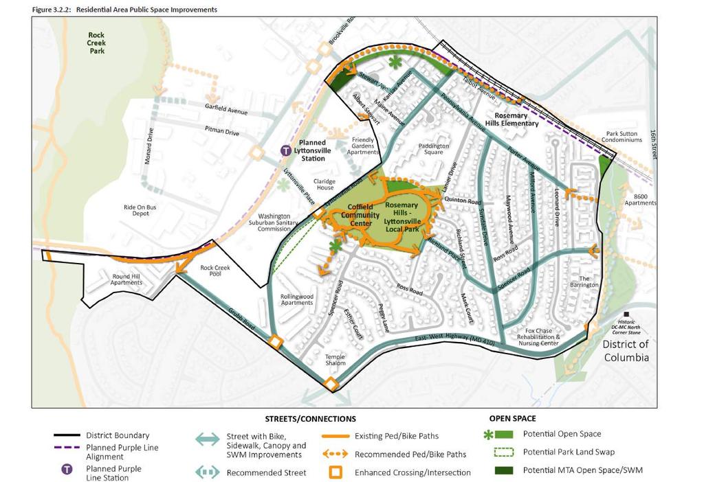
49 Rosemary Hills- Lyttonsville Local Park 17-acre park acquired and built by M- NCPPC Parks in 1962 Gwendolyn E. Coffield Community Center serves as the community focal point.


50 Ped/Bike Circulation Improve bicycle and pedestrian connectivity from the park to neighborhoods. Public Open Space Coordinate with adjacent property owners to expand the park and add new facilities. Building Design Renovate and/or expand the center to meet the recreational and program needs as the community grows.
51
52 Capital Crescent Trail Shared-use path that stretches from Georgetown to Silver Spring in the rail ROW. The paved portion of the trail will be extended from Bethesda to Silver Spring as part of the planned Purple Line project.

53 Ped/Bike Circulation Improve connections from the trail to nearby streets and bikeways. Provide 12 ft typ paved trail with 2 ft unpaved shoulders. Public Open Space Provide landscape buffers and active public open space connected to the trail. Building Design Orient building entries, balconies and transparent ground floors to the trail where feasible to activate the trail and adjacent open spaces.
Greater Lyttonsville Sector Plan Design Guidelines Stakeholder Meeting with Civic Association Leaders October 3, 2018
 Greater Lyttonsville Sector Plan Design Guidelines Stakeholder Meeting with Civic Association Leaders October 3, 2018 ATTENDANCE: Laura Shipman, Planning Department Robert Kronenberg, Planning Department
Community Meeting November 18, 2015
 Top Concerns We ve Heard Use of Urban Road Code Total number of units and effect on schools and transportation Land swaps with Parks Department: how do these benefit the community? Zoning classifications:
DRAFT. 10% Common Open Space
 % OF CHARLOTTE IS CATEGORIZED AS A. LAND USES : Placeholder map displaying location of Place Type GOALS: Accommodate XX% of future growth. Provide a concentration of primarily commercial and civic activity
PUBLIC RIGHT-OF-WAY IN THIS CHAPTER PUBLIC REALM
 PUBLIC RIGHT-OF-WAY This section provides design guidelines for improvements in the public right-of-way. The public right-of-way refers to streets, sidewalks, non-vehicular thoroughfares, parks and greenways
WEST LOOP DESIGN GUIDELINES CHECKLIST
 WEST LOOP DESIGN GUIDELINES CHECKLIST Section 1.0 General Strategies 1.1 DESIGN EXCELLENCE: ENCOURAGE HIGH QUALITY AND INNOVATIVE DESIGN OF NEW BUILDINGS WITHIN THE WEST LOOP WITHOUT BEING PRESCRIPTIVE
APPENDICES DESIGNING PUBLIC SPACES - ENERGIZED PUBLIC SPACES DESIGN GUIDELINES WORKING DRAFT DECEMBER 2018 A1
 APPENDICES DESIGNING PUBLIC SPACES - ENERGIZED PUBLIC SPACES DESIGN GUIDELINES WORKING DRAFT DECEMBER 2018 A1 App.1 Case Studies by Park Types The upcoming (in-progress) online library will house several
Bethesda. Downtown Plan Design Guidelines. Approved July access + mobility. community identity. habitat + health. equity. water.
 Bethesda Downtown Plan Design Guidelines community identity equity habitat + health access + mobility water energy Approved July 2017 THE MONTGOMERY COUNTY PLANNING DEPARTMENT THE MARYLAND-NATIONAL CAPITAL
VILLAGE OF SKOKIE Design Guidelines for Mixed-Use Districts NX Neighborhood Mixed-Use TX Transit Mixed-Use CX Core Mixed-Use
 VILLAGE OF SKOKIE Design Guidelines for Mixed-Use Districts NX Neighborhood Mixed-Use TX Transit Mixed-Use CX Core Mixed-Use TABLE OF CONTENTS CHAPTER 1 SITE DESIGN Purpose 1 CHAPTER 2 SITE DESIGN Streetscape
URBAN DESIGN BRIEF URBAN DESIGN BRIEF 721 FRANKLIN BLVD, CAMBRIDGE August 2018
 URBAN DESIGN BRIEF URBAN DESIGN BRIEF 721 FRANKLIN BLVD, CAMBRIDGE August 2018 DESIGN BRIEF CONTENTS PART A 1.0 INTRODUCTION 2.0 DESCRIPTION & ANALYSIS OF SITE CONTEXT 3.0 DESIGN CONSTRAINTS AND OPPORTUNITIES
Preliminary Recommendations Tk Takoma/Langley Crossroads Sector Plan
 Preliminary Recommendations Tk Takoma/Langley Crossroads Sector Plan Vision is to achieve a Transit Oriented, pedestrian friendly Community that Celebrates and builds upon the cultural Diversity of the
Complete Neighbourhood Guidelines Review Tool
 Complete Neighbourhood Guidelines Review Tool Prepared By: City of Regina Planning Department October 2014 Page 1 of 14 Community Development Review Checklist for Secondary Plans and Concept Plans The
DRAFT Northeast Quadrant of Kipling Avenue and Highway 7 DRAFT AUGUST 29, Goals Land Use. The goals of this Plan are to:
 AUGUST 29, 2017 12.15 Northeast Quadrant of Kipling Avenue and Highway 7 12.15.1 Goals 12.15.2 Land Use The goals of this Plan are to: 12.15.2.1 General Provisions: a) Ensure the development of a compact
A. Background Summary of Existing Challenges and Potential Possibilities. 1. Summary of Existing Assets and Potential Opportunities
 A. Background 1 A Main Street Master Plan Study was performed and completed in October of 2007. The study was initiated to review current land uses and development patterns along Main Street, from Parrish
CHAPTER VIII Implementation
 CHAPTER VIII Implementation VIII. Implementation The vision for the Marlboro Pike Corridor will require that a variety of participants work together to make it a reality. The following action steps outline
Town Center (part of the Comprehensive Plan)
") Town Center (part of the Comprehensive Plan) Mercer Island Town Center Looking North (2014) In 1994, a year-long process culminated in a set of design guidelines and code requirements for the Town Center
Town Center (part of the Comprehensive Plan) Mercer Island Town Center Looking North (2014) In 1994, a year-long process culminated in a set of design guidelines and code requirements for the Town Center
PLAN ELEMENTS WORKSHOP. April 5, 2016
 PLAN ELEMENTS WORKSHOP April 5, 2016 needs more housing. But there is no one-size fits-all solution. Every neighborhood has its own character. In some places, density is not only appropriate it is badly
Clairtrell Area Context Plan
 Clairtrell Area Context Plan March 2005 Urban Development Services City Planning Contents 1. Introduction... 4 2. Development Structure... 6 2.1 Streets... 7 2.1.1 Sheppard Avenue and Bayview Avenue...
R STREET CORRIDOR NEIGHBORHOOD Site Plan and Design Review Supplemental Guidelines Checklist
 R STREET CORRIDOR NEIGHBORHOOD Site Plan and Design Review Supplemental Guidelines Checklist Applicant s Name: Project Address: Phone: Email: Applicant shall fill out the design guidelines checklist for
FUTURE LAND USE ELEMENT
 FUTURE LAND USE ELEMENT GOAL I: To create and sustain a great place to live, play, and prosper Objective 1: The City of Ocala shall incorporate the principles and strategies of the Ocala 2035 Vision into
DRAFT. October Wheaton. Design Guidelines
 October 2011 DRAFT Wheaton Design Guidelines 2 Draft - Design Guidelines - Wheaton Sector Plan Contents 04 Section 1: Introduction 06 Section 2: Context 08 Section 3: Design Guidelines 09 Goal 1: Create
Tonight s Agenda. 7:45 p.m. Next Steps 8:00 p.m. Close
 Community Workshop #3 January 28, 2016 Team Tonight s Agenda 6:00 p.m. Welcome and Introductions! 6:15 p.m. Draft Specific Plan Overview Project Process Update Vision and Objectives Overview Key Findings
At first Work Session on October 22, At second Work Session on November 19, At third Work Session on December 3, 2015
 At first Work Session on October 22, 2015 Staff Reviewed Infrastructure: Transportation Capacity School Capacity Willett Branch Proposed Staging Language At second Work Session on November 19, 2015 Land
VEHICULAR AND PEDESTRIAN CIRCULATION
 This perspective sketch communicates the intended character and quality of a proposed streetscape design. Locate benches near a major intersection where people tend to gather. Seating and lighting provide
Community Design Guidelines. Port Wallace DRAFT
 Community Design Guidelines Port Wallace DRAFT Energy 1 2 3 Nature Movement Connections Built Form DRAFT Layout Energy 1 Nature Community Design Guidelines GREAT COMMUNITIES PROTECT, CELEBRATE, AND CONSERVE
Urban Design Manual PLANNING AROUND RAPID TRANSIT STATIONS (PARTS) Introduction. Station Study Areas
 Introduction. Station Study Areas") 111111 PLANNING AROUND RAPID TRANSIT STATIONS (PARTS) Introduction The ION rapid transit system will link Waterloo, Kitchener and Cambridge through a central transit corridor (CTC). There are a number
111111 PLANNING AROUND RAPID TRANSIT STATIONS (PARTS) Introduction The ION rapid transit system will link Waterloo, Kitchener and Cambridge through a central transit corridor (CTC). There are a number
The Five Components of the McLoughlin Area Plan
 The Five Components of the McLoughlin Area Plan This documents contains the complete language of the five components of the McLoughlin Area Plan: The Vision Statement The Values The Guiding Principles
Derry Green Corporate Business Park
 Town of Milton Derry Green Corporate Business Park Urban Design Guidelines BMI/Pace - June 2010 Draft 3 Prepared by: Brook McIlroy Planning + Urban Design / Pace Architects Suite 300-51 Camden Street Toronto,
Town Center. Block 5 Existing multifamily residential units are expected to remain.
 Area Guidelines Germantown s districts should be developed as distinct communities with unique features that are supported through the guidelines. The guidelines not only help distinguish these districts
The West Vaughan Employment Area Secondary Plan Policies
 Part 2: The West Vaughan Employment Area Secondary Plan Policies 2.1 General Policies It is the policy of Council: 2.1.1. That the West Vaughan Employment Area (the WVEA), identified on Schedule 1, will
URBAN DESIGN BRIEF. 2136&2148 Trafalgar Road. Town of Oakville
 URBAN DESIGN BRIEF 2136&2148 Trafalgar Road Town of Oakville Prepared By: METROPOLITAN CONSULTING INC For 2500674 Ontario Inc November 2016 TABLE OF CONTENTS Page No. 1.0 Introduction/Description of Subject
ELMVALE ACRES SHOPPING CENTRE MASTER PLAN
 ELMVALE ACRES SHOPPING CENTRE MASTER PLAN Contents 1.0 INTRODUCTION... 2 2.0 LOCATION... 2 3.0 EXISTING CONTEXT... 2 4.0 VISION & GUIDING PRINCIPLES... 2 5.0 LAND USE AND BUILT FORM... 4 5.1 St. Laurent
The transportation system in a community is an
 7 TRANSPORTATION The transportation system in a community is an important factor contributing to the quality of life of the residents. Without a sound transportation system to bring both goods and patrons
VISION AND GUIDING DESIGN PRINCIPLES
 pleasure point commercial corridor VISION AND GUIDING DESIGN PRINCIPLES Public Draft November 26, 2018 County of Santa Cruz with assistance from MIG CONTENTS PART I: INTRODUCTION AND VISION... 3 Community
Highland Village Green Design Guidelines
 Highland Village Green Design Guidelines Publishing Information Title Highland Village Green Design Guidelins Author The City of Calgary Status DRAFT - Proposed document subject to changes Additional Copies
FLORIN ROAD CORRIDOR Site Plan and Design Review Guidelines Checklist
 FLORIN ROAD CORRIDOR Site Plan and Design Review Guidelines Checklist Applicant s Name: Project Address: Phone: Email: Applicant shall fill out the design guidelines checklist for all guidelines applicable
The Village. Chapter 3. Mixed Use Development Plan SPECIFIC PLAN
 The Village SPECIFIC PLAN Chapter 3 3.1 INTRODUCTION 3.1.1 Purpose This Chapter describes the development regulations applicable to the Mixed-Use and Transit Center Planning Areas. These form-based regulations
Appendix C: Interim Mixed-Use Evaluation Criteria
 Appendix C: Interim Mixed-Use Evaluation Criteria C-1 Appendix C: Interim Mixed-Use Evaluation Criteria PURPOSE: The implementation of numerous policies contained within the Master Plan hinges on the creation
Lower Merion Commercial Districts Issues and Characteristics Handbook November 2013
 Lower Merion Commercial Districts Issues and Characteristics Handbook November 2013 DRAFT TOWNSHIP-WIDE VISION: To maintain and enhance commercial areas to complement the surrounding high-quality residential
4.9 Mendocino Avenue Corridor Plan Design Guidelines
 4.9 Mendocino Avenue Corridor Plan Design Guidelines The Mendocino Avenue Corridor Plan addresses the area between College Avenue and Steele Lane. Mendocino Avenue is a busy arterial that runs parallel
Figure 3-1: Public Realm Plan
 3 Public Realm Figure 3-1: Public Realm Plan 3.1 Public Realm Concept The public realm concept for the Little Mountain site integrates a clear and accessible movement network with public spaces for social
Wheaton CBD & Vicinity Sector Plan D E S I G N G U I D E L I N E S
 Wheaton CBD & Vicinity Sector Plan D E S I G N G U I D E L I N E S 1 a b s t r a c t This document contains the design guidelines the property owners, community members, and planners should use to implement
Community Workshop September 29, 2014 Visioning Exercise Input
 Community Workshop September 29, 201 Visioning Exercise Input ENHANCED/EMERGING CENTERS OF ACTIVITY Brookville Road Spring Center Coffield Center/Rosemary Hills-Lyttonsville Local Park BROOKVILLE ROAD
I. Introduction. Prior Approvals
 Statement of Justification First National Bank 19790 Crystal Rock Drive, Germantown, Maryland Application for Site Plan and Limited Preliminary Plan Amendment I. Introduction DPH Architecture, for First
Future Five. Design/ Development Guidelines. January 2008 Amended June 08 per City Council motion
 Future Five Design/ Development Guidelines January 2008 Amended June 08 per City Council motion 5-Points Design Guidelines Table of Contents I. Introduction 3 II. Area boundaries 4 III. Review Process
Policies and Code Intent Sections Related to Town Center
 Policies and Code Intent Sections Related to Town Center The Town Center Vision is scattered throughout the Comprehensive Plan, development code and the 1994 Town Center Plan. What follows are sections
GUIDING PRINCIPLES IN THIS CHAPTER
 GUIDING PRINCIPLES The guiding principles and design concepts in this chapter work together with the Chapel Hill 2020 Comprehensive Plan to support new public places that can be enjoyed by all while also
SECTION TWO: Overall Design Guidelines
 SECTION TWO: Overall Design Guidelines This section provides overall design principles and guidelines for the Gardnerville Mixed-use Overlay. They provide criteria for mixed-use places consisting of residential,
PORT WHITBY COMMUNITY
 PORT WHITBY COMMUNITY SECONDARY PLAN UPDATE COMMUNITY IMPROVEMENT PLAN URBAN DESIGN GUIDELINES September 2015 DRAFT PROPOSED AMENDMENT NUMBER # to the Whitby Official Plan PURPOSE: The intent of this Amendment
East Bayshore Road Neighbourhood
 East Bayshore Road Neighbourhood Northridge Property Management Urban Design Brief 3195 East Bayshore Road City of Owen Sound January 2016 East Bayshore Road Neighbourhood Northridge Property Management
The open space system should provide connective elements, relate to natural resources, and enhance the suburban character of the landscape..
 The open space system should provide connective elements, relate to natural resources, and enhance the suburban character of the landscape.. Mixed-use and infill development should maintain or enhance
URBAN DESIGN BRIEF 181 Burloak Drive, Oakville
 URBAN DESIGN BRIEF 181 Burloak Drive, Oakville February 2017 Our File: 1730B 230-7050 WESTON ROAD / WOODBRIDGE / ONTARIO / L4L 8G7 / T: 905 761 5588/ F: 905 761 5589/WWW.MHBCPLAN.COM TABLE OF CONTENTS
B. Blocks, Buildings and Street Networks
 B. Blocks, Buildings and Street Networks Figure IV.4 A rational block pattern with connected streets Introduction The single most important element in the physical and functional integration of mixed use
COMMUNITY DESIGN. GOAL: Create livable and attractive communities. Intent
 COMMUNITY DESIGN Intent An attractive, well-designed County will attract quality development, instill civic pride, improve the visual character of the community, and create a strong, positive image for
Presentation of the Staff Draft. July 17, 2014 SSRVP Team, Area 3
 Presentation of the Staff Draft July 17, 2014 SSRVP Team, Area 3 Presentation Overview Introduction Plan Framework Plan Recommendations Implementation Next Steps and Request for Public Hearing on September
Agenda. 7 Wright Crescent Urban Design Study. Public Meeting and Urban Design Workshop. 1 INTRODUCTION AND BACKGROUND (City of Kingston)
") Urban Design Study Public Meeting and Urban Design Workshop October 02, 2013 Agenda 1 INTRODUCTION AND BACKGROUND (City of Kingston) 2 URBAN DESIGN STUDY PRESENTATION (Antonio Gomez-Palacio, DIALOG) 3
Urban Design Study Public Meeting and Urban Design Workshop October 02, 2013 Agenda 1 INTRODUCTION AND BACKGROUND (City of Kingston) 2 URBAN DESIGN STUDY PRESENTATION (Antonio Gomez-Palacio, DIALOG) 3
Uptown Rideau Street Secondary Plan [Amendment #166, January 12, 2016]
![Uptown Rideau Street Secondary Plan [Amendment #166, January 12, 2016]](/thumbs/76/73760497.jpg "Uptown Rideau Street Secondary Plan [Amendment #166, January 12, 2016]") [Amendment #166, January 12, 2016] The policies of this Secondary Plan are in effect, save and except for the property at 560 Rideau Street, for which there remains a site specific appeal to this Secondary
[Amendment #166, January 12, 2016] The policies of this Secondary Plan are in effect, save and except for the property at 560 Rideau Street, for which there remains a site specific appeal to this Secondary
Cit of Kitchener Ur 6 an Design Manual PARTA. Desi n for _--::
 Cit of Kitchener Ur 6 an Design Manual Date PARTA Year ) Desi n for k Nodes Corridors _--:: Section Page 01 of 12 2 INTRODUCTION Purpose & Application Nodes and Corridors have been identified as key intensification
McCowan Precinct Plan Study Background & Deliverables
 1 DRAFT & WITHOUT PREJUDICE McCowan Precinct Plan Study Background & Deliverables In September, 2011, City Planning (Scarborough District) began a study of an area within the Scarborough Centre, identified
Corridor Transformation Strategy
 Corridor Transformation Strategy County Road 22 Special Planning Area Design Guidelines January 2012 D14-06017 Corridor Transformation Strategy County Road 22 Special Planning Area Corridor Design Guidelines
EXISTING COMPREHENSIVE PLAN
 EXISTING COMPREHENSIVE PLAN Town Center Land Use Element: V. LAND USE POLICIES Town Center Mercer Island's business district vision as described in "Your Mercer Island Citizen-Designed Downtown" was an
Buildings may be set back to create small plazas provided that these setbacks do not substantially disrupt the street wall s continuity.
 6-22 Community Design Street Walls and Street-front Setbacks The siting of buildings will play a critical role in establishing the character and sense of place for the District. Siting buildings at the
Westwood Shopping Center Sketch Plan, Plan # February 23, 2017 Item # 9
 Westwood Shopping Center Sketch Plan, Plan # 320170010 February 23, 2017 Item # 9 Westwood II Site 64,111 s.f. Manor Care site: vacant two story building HOC-Westwood Towers, 15 story tower To be considered
ATTACHMENT A. SILVERDALE DESIGN STANDARDS Amendments to the Waaga Way Town Center Chapter
 ATTACHMENT A SILVERDALE DESIGN STANDARDS Amendments to the Waaga Way Town Center Chapter Chapter 10. Waaga Way Town Center 10.1 Physical Identity Elements & Opportunities The Waaga Way Town Center includes
Bethesda Downtown Plan
 Bethesda Downtown Plan Planning Board Update Connecticut Avenue Location Economic Sustainability Social Environmental Scope Coming Soon! Team Listening, Twitter Outreach We Are Here Engagement Challenge
5.1 Site Plan Guidelines
 5. Community Core Guidelines Development of the Community Core will take place by plan of subdivision and site plan approval. It will occur in a phased manner that will reflect the timing of residential
Gold Line Bus Rapid Transit Transit Oriented Development (BRTOD) Helmo Station Area Plan
 Helmo Station Area Plan") Appendix F Gold Line Bus Rapid Transit Transit Oriented Development (BRTOD) Helmo Station Area Plan Introduction and Purpose of the Plan The Gold Line Bus Rapid Transit facility is an eleven-mile dedicated
Appendix F Gold Line Bus Rapid Transit Transit Oriented Development (BRTOD) Helmo Station Area Plan Introduction and Purpose of the Plan The Gold Line Bus Rapid Transit facility is an eleven-mile dedicated
3.1 community vision. 3.3 required plan elements
 Chapter 3 Community Form 3.1 community vision 3.2 Parks & landscaping concepts 3.3 required plan elements D R A F T 20 Community Form Chapter 3 3.0 Community form 3.1 community vision The Specific Plan
chapter DESIGN GUIDELINES NEW RIVER MASTER PLAN REPORT
 chapter DESIGN GUIDELINES NEW RIVER MASTER PLAN REPORT .76 DESIGN GUIDELINES An Overview design guidelines NEW RIVER MASTER PLAN Design Guidelines can transform the image of a city. Specific, design-based
LOW DENSITY RESIDENTIAL
 LOW DENSITY RESIDENTIAL Corner lots with coach houses to increase diversity, provide unity to the streetscape and increase eyes on the street. Garages and ancillary units accessed via rear lanes. Parking
V. Vision and Guiding Principles
 V. Vision and Guiding Principles The Master Plan for the Powers Ferry Corridor seeks a foundation in the desires of the community. At times, various elements of the community offered opposing viewpoints,
Establish a network of streetscaped vehicle and pedestrian routes that connect within and outside the Plan area.
 This Plan s urban design goals are to create an urban scale, walkable community with connections to transit, parks, and services and with amenities and facilities for residents and employees. The 1992
DOWNTOWN GEORGETOWN PLANNING STUDY
 DOWNTOWN GEORGETOWN PLANNING STUDY Community Workshop #3 Thursday, May 4, 08 The Planning Partnership OVERVIEW OF STUDY, PROCESS & MILESTONES We are here PURPOSE OF THE STUDY To develop a clear vision
Old Town Neighborhoods Plan. Choices Event Wednesday, December 9, 2015
 Old Town Neighborhoods Plan Choices Event Wednesday, December 9, 2015 Agenda 6:00 6:10 p.m. Welcome + Sign In 6:10 6:30 p.m. Presentation 6:30 8:00 p.m. Workshop + Open House Seeking your input on: Neighborhood
New-Cast Mixed-use Development Proposal King Street West, Newcastle, Ontario
 URBAN DESIGN BRIEF New-Cast Mixed-use Development Proposal King Street West, Newcastle, Ontario TABLE OF CONTENTS: 1.0 Executive Summary 2.0 Creating Vibrant and Sustainable Urban Places: Excerpts from
B L A C K D I A M O N D D E S I G N G U I D E L I N E S for Multi-family Development
 B L A C K D I A M O N D D E S I G N G U I D E L I N E S for Multi-family Development Adopted June 18, 2009 This section of the Design and focuses on site planning and design guidance for new multi-family
Mixed Use Centres Development Permit Guidelines
 1 Mixed Use Centres Development Permit Guidelines Area Commercial or Mixed Use development occurring in City Centre, Urban Centre, Neighbourhood Centre, or Institutional Complex land use designations is
Shared Principles and Emerging Plan Directions
 Shared Principles and Emerging Plan Directions Introduction Since the Fairfield Neighbourhood planning process launched in June 2016, we have heard from many residents, businesses, groups and other people
Urban Design Brief. Watson Parkway North & Watson Road North Guelph, Ontario. Prepared by Coletara Development
 Urban Design Brief Watson Parkway North & Watson Road North Guelph, Ontario Prepared by Coletara Development December, 2013 Urban Design Brief, Coletara Development 1 Introduction This Urban Design Brief
Rosslyn Plaza PDSP (SP #422) SPRC Staff Presentation
 SPRC Staff Presentation") Rosslyn Plaza PDSP (SP #422) SPRC Staff Presentation ote Guiding Principles included in this document are taken from the latest working draft of the Guiding Principles dated. The illustrations included
Rosslyn Plaza PDSP (SP #422) SPRC Staff Presentation ote Guiding Principles included in this document are taken from the latest working draft of the Guiding Principles dated. The illustrations included
2.5 Roads. Loading and service areas adjacent to Highway 401 should be screened through architectural walls and/or landscape buffer planting.
 N HIGHWAY OFF RAMP 2.5 Roads A legible road network with a clear hierarchy will help create a connected community, both within and surrounding the Milton Heights. The following section outlines the proposed
Seneca Meadows. Block 4 Locate office, technology, and medical development adjacent to I Screen views of garage structures from I-270.
 Seneca Meadows Seneca Meadows has an industrial park in its southern end and a mixed-use employment area planned for the north end. The district benefits from extensive I-270 visibility, stream valley
FRUITVALE TRANSIT VILLAGE (Phase 2) Residential Project
 Residential Project") FRUITVALE TRANSIT VILLAGE (Phase 2) Residential Project DEVELOPER: SIGNATURE PROPERTIES ARCHITECT: HKIT ARCHITECTS April 23, 2010 TABLE OF CONTENTS 3 Vision 4 Description of Site 5 Guiding Concepts 6
FRUITVALE TRANSIT VILLAGE (Phase 2) Residential Project DEVELOPER: SIGNATURE PROPERTIES ARCHITECT: HKIT ARCHITECTS April 23, 2010 TABLE OF CONTENTS 3 Vision 4 Description of Site 5 Guiding Concepts 6
AMITY STATION Revised Concept Plan Review West Rosemary Street Chapel Hill, NC September 27, 2016
 AMITY STATION Revised Concept Plan Review West Rosemary Street Chapel Hill, NC September 27, 2016 DEVELOPER'S PROGRAM Introduction This is a request for review of a Revised Concept Plan by Chapel Hill
Status Update (2006 vs. Now) Citizen s Advisory Committee February Plan for Prosperity
 Citizen s Advisory Committee February Plan for Prosperity") Status Update (2006 vs. Now) Citizen s Advisory Committee February 2018 Plan for Prosperity 2000 2017 2000 2017 Gardnerville Population 6,000 5,760 5746 5,500 5,000 5,067 5,550 5,165 5,394 5,412 5,250
Status Update (2006 vs. Now) Citizen s Advisory Committee February 2018 Plan for Prosperity 2000 2017 2000 2017 Gardnerville Population 6,000 5,760 5746 5,500 5,000 5,067 5,550 5,165 5,394 5,412 5,250
MONTGOMERY COUNTY PLANNING DEPARTMENT THE MARYLAND-NATIONAL CAPITAL PARK AND PLANNING COMMISSION
 MONTGOMERY COUNTY PLANNING DEPARTMENT THE MARYLAND-NATIONAL CAPITAL PARK AND PLANNING COMMISSION MCPB Item No. Date: 1/26/12 Hanover Shady Grove, Sketch Plan 320120020 Joshua Sloan, Coordinator, Joshua.Sloan@MontgomeryPlanning.org,
City of Farmington. Downtown Plan. Amendment to the 1998 Master Plan Adopted October 11, 2004
 City of Farmington Amendment to the 1998 Master Plan Adopted October 11, 2004 Introduction Planning Background 1 Scope and Components of the Plan Amendment 2 Concept Introduction 3 Plan Concepts 3 Conceptual
Draft Memorandum #1: Goals and Vision for Revitalization
 Keizer Revitalization Plan Draft Memorandum #1: Goals and Vision for Revitalization Submitted to: City of Keizer April 12, 2018 (revised) Prepared By: Angelo Planning Group and Otak, Inc. Project No. 17482.A
Tonight s Agenda. Summary Presentation Open House. Group Discussion Next Steps: online community wide survey
 Community Open House February 22, 2018 Tonight s Agenda Summary Presentation Open House Station 1: Project Overview and Community Input Station 2: Draft Vision and Guiding Principles Station 3: Western,
The Vision. Photo provided by The Minervini Group. 46 Vision, Objectives & Strategies
 Vision, Objectives & Strategies The is the public framework and guide for future development of the Grand Traverse Commons. The establishes public polices for infrastructure, the preservation of natural
Regency Developments. Urban Design Brief. Holyrood DC2 Rezoning
 Regency Developments Urban Design Brief Holyrood DC2 Rezoning Stantec Consulting Ltd. 7-31-2017 1. Overview Regency Developments intends to rezone the lands located at 8510 and 8511 93 Avenue, within the
North Downtown Specific Plan MEMORANDUM
 North Downtown Specific Plan MEMORANDUM MEETING DATE: November 13, 2017 TO: Members of the North Downtown Specific Plan Advisory Committee FROM: Jeanine Cavalli, Senior Planner SUBJECT: Materials for the
ARTICLE 6: Special and Planned Development Districts
 ARTICLE 6: Special and Planned Development Districts 6-10 Traditional Neighborhood Development (TND) District 6-10.10 Purpose and Intent The Traditional Neighborhood Development (TND) District provides
Rock Spring Master Plan Community Meeting #8: Preliminary Recommendations
 Rock Spring Master Plan Community Meeting #8: Preliminary Recommendations July 18, 2016 Ι Walter Johnson High School Andrea Gilles, andrea.gilles@montgomeryplanning.org Ι www.montgomeryplanning.org/community/rockspring/
Westwind Developments Ltd. PIONEER LANDS AREA STRUCTURE PLAN - PROPOSED AMENDMENT
 FEBRUARY 2013 TABLE OF CONTENTS 1.0 BACKGROUND... 1 1.1 Amendment... 1 2.0 LOCATION & CONTEXT... 2 2.1 Land Ownership... 2 3.0 POLICY CONTEXT... 3 3.1 Municipal Development Plan... 3 3.2 Capital Region
Civic Center District
 Civic Center District The Civic Center district is the civic and social heart of Warrenville, containing such public buildings as the City Hall, Warrenville Public Library, Police Station, Park District
BROOKHILL NEIGHBORHOOD MODEL ZONING MAP AMENDMENT PREFACE TO APPLICATION
 BROOKHILL NEIGHBORHOOD MODEL ZONING MAP AMENDMENT PREFACE TO APPLICATION June 15, 2015 Revised: August 1, 2016 I. VISION Brookhill is a proposed community based upon the principles of Albemarle County
Queensborough Eastern Neighbourhood Node. Community Open House
 Queensborough Eastern Community Open House The Vision The Queensborough Eastern will become the heart of eastern Queensborough. Through a sensitive mix of viable commercial and residential areas, the neighbourhood
CHAPTER 3. Design Standards for Business, Commercial, Industrial, Recreational and Institutional Uses
 CHAPTER 3 Design Standards for Business, Commercial, Section Number Title Ordinance Number Date of Ordinance 16-3-1 Applicability 2006-11 2008-04 07-01-08 16-3-2 Uniform Standards for Architectural Design
July 6 th, Re: The Sugarmont Apartments Planned Development. Dear John,
 July 6 th, 2016 Planning Division Community And Economic Development Salt Lake City Corporation c/o John Anderson 451 South State Street, Room 215 Salt Lake City, Utah 84114 Re: The Sugarmont Apartments
Public Consultation Summary: Lakeview Place Making Workshop January 30, 2008.
 Page 1 of 11 Public Consultation Summary: Lakeview Place Making Workshop January 30, 2008. 1.0 Introduction: On January 30, 2008 the City of Mississauga, in conjunction with the consulting team of Brook