Precedent Studies. Hammarby Sjostad, Stockholm: The City of Stockholm s environmental goals for Hammarby Sjöstad:
|
|
|
- Patrick Lawrence
- 5 years ago
- Views:
Transcription
1 Living WithWater


2 Precedent Studies Hammarby Sjostad, Stockholm: Hammarby Sjöstad is Stockholm s biggest urban development project for many years. The area s location as a natural continuation of Stockholm s inner city has helped shape the infrastructure, planning and design of the buildings. The City of Stockholm s environmental goals for Hammarby Sjöstad: - Land usage: sanitary redevelopment, reuse and transformation of old brownfield sites into attractive residential areas with beautiful parks and green public spaces. - Transportation: fast, attractive public transport, combined with carpool and beautiful cycle paths, in order to reduce private car usage. - Building materials: healthy, dry and environmentally sound. - Energy: renewable fuels, biogas products and reuse of waste heat coupled with efficient energy consumption in buildings. - Water & sewage: as clean and efficient as possible both input and output with the aid of new technology for water saving and sewage treatment. - Waste: thoroughly sorted in practical systems, with material and energy recycling maximised wherever possible. GlashusEtt. (n.d.). Hammarby Sjöstad. Retrieved November 01, 2014, from


3 Musée du quai Branly: The Museum du quai Branly opened in 2006, and is the newest of the major museums in Paris. It received 1.3 million visitors in It is both a museum and research centre. The Musee du quai Branly is located in the 7th arrondissement of Paris, on the left bank of the Seine, close to the Eiffel Tower and the Pont de l'alma. The museum complex has four buildings, occupying 30,000 square meters, which, along with the garden, cost 233 million Euros to construct. The buildings: It's most unusual feature is the green wall, or wall of vegetation, composed of living plants, on the north side of the building, facing the Seine. Gardens: The "green wall" of the Branly building is made up of living plants a winding path in the north garden of the Quai Branly museum. The glass wall blocks the noise of traffic on the quai. The gardens were designed by landscape architect Gilles Clement, They were designed to be the exact opposite of a traditional French formal garden; there was no fence, no lawn, no gates, no monumental stairway; instead, Clement composed a tapestry of small gardens, with streams, hills, pools, and groves, using the native French plants and imported plants accustomed to the Paris climate. The gardens contain 169 trees and 72,000 plants On the north side, facing the street along the Seine, the garden is protected by a high double wall of plate glass, which blocks most of the sound from the street. The gardens on the north side practically hide the museum building. Instead of straight paths and a long axis to the entrance, the paths wound through the gardens, with no apparent destination. A notable feature of the Museum garden is the green wall, or wall of vegetation, created by botanist Patrick Blanc. The living wall of greenery covers 800 square meters of the facades of the museum, and 150 square meters of the interior walls. It includes 15,000 plants from 150 different varieties, coming from Japan, China, the Americas and Central Europe. Lomholt, I. (2014, March 6). Musée du quai Branly : Architecture. Retrieved November 1, 2014, from e-architect:

4 1:1250 Location Plan

5 1:500 Ground Floor Plan

6 1:500 South to North Section 1:500 West to East Section

7 Basin Elevation East Elevation

8 3D View of Public Space


9 1:50 Section and Plan of Main Public Space 1:50 Section Line

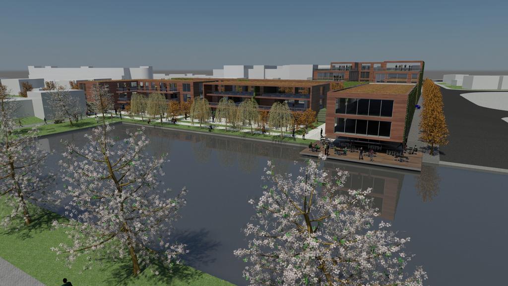

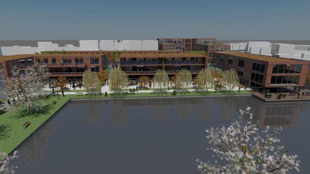
10 Serial Views

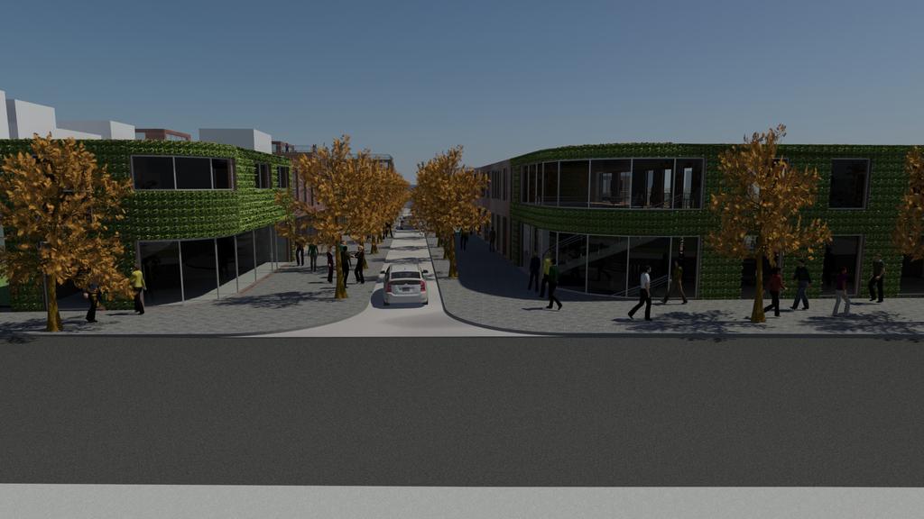
11 Serial Views
12 Flood Risk: The Canal basin would act as a collection point to reduce the likelihood of the water level rising excessively in short period of time. The canal would also alleviate flooding risk by permitting the release of waters through the lock gates downstream. The main access routes are raised well above the canal basin and flood risk height ensuring safe escape and access routes The majority of the development and access to it are designed so that they are at least 600mm above the design flood level Surface Water runoff: Permeable paving to allow infiltration Use native plants with root systems developed to absorb more water, such as Willows and Alder. Rainwater harvesting can be used to store water in the basement areas of building (WC flushing, garden watering, sprinkler systems etc) Green roofs to reduce water runoff. The use of gravel areas around the trees and use of permeable paving to allow infiltration of rain water into the ground Rainwater: 25%-50% will be either green roofs or water harvesting. Heat Island: Shaded public spaces and footpaths (Roof overhangs, trees, pergolas, canopies, etc) Sun-shading devices for southern elevation towards the basin, using verandas and balconies. Green roofs and vegetable walls Cool area around the canal basin provides cooling effect and the access points enable air-flow throughout the development Tinted glass and refective surfaces combined with the correct size and positioning of windows. Public spaces and footpaths are shaded (Roof overhangs, trees, pergolas, canopies, etc) Open water and fountains in public spaces, cascades, plus the cooling effect of the canal basin. Pavement and wall surfaces have low absorption of heat and increased solar reflectivity Passive urban design strategies: Site layout/orientation Accommodation faces both south and east sunlight, high structures overshadow mostly retail units. The balconies/verandas on southern elevation allow the low angle rays of the sun to reach the building in winter See above other strategies for cooling in summer. Energy efficiency: Passive solar design with habitable spaces benefiting from the southern aspect. Maximising the thermal efficiency of building envelopes Thermal mass and the use of external insulation methods Insulation Air tightness, and the use of double flux air exchangers Avoidance of cold bridging Urban and Architectural Sustainability Maximising the thermal efficiency of building envelopes Thermal mass and the use of external insulation methods Insulation Air tightness, and the use of double flux air exchangers Avoidance of cold bridging Minimising use of energy in the buildings Natural illumination and ventilation, etc High risk areas of temperature extremes are modified by water features in the summer and glass walls in the winter Use of light wells and light tubes. Onsite renewable: LZC technologies Solar Photovoltaic supplying electric to the national grid to offset building consumption at peak times Solar panel/thermal water heating Reversible air/air heat pumps to provide both cooling and heating. Biomass fuelled heating or ground or water source (canal basin) heat pump Total site energy produced by Low or Zero Carbon energy technologies will be of: At least 25% Future Renewables: Waste heat produced by retail units/restaurantscan be used as heat source for water heating, or space heating Other sources of biomass/bioenergy Thermochemical solar power Use of waste in a biodigester to provide methane gas. Wind-tunnel effect and weather resilience: Avoid long narrow and straight gaps along the direction of prevailing winds Non-continuous facades (setbacks, pocket spaces, corner spaces, recessions, etc) Podium with setbacks can prevent window downwashing to pedestrian spaces on ground floor Setbacks on high buildings Use of trees and shrubs to shelter and protect from prevailing winds, particularly for building gaps or entrances. Recessed door ways and entrances. Minimse number of doorways on exposed elevations, and provide alternative access points. Ensure that entrances do not create their own funnel effect through the use of double doors, or rotating doorways. Landscaping: Mix of hard and soft landscaping with native species of trees and shrubs Facilitate the presence of wild life with the canal basin providing an attraction for water birds. The green area will connect between the buildings to existing green areas in adjacent developments. Water features throughout the development provide links with the heritage of the canal basin The canal can be stocked with fish to encourage angling. Trees and shrubs can provide nesting places and food for birds.
SCHEDULE 12 TO THE DESIGN AND DEVELOPMENT OVERLAY GLEN WAVERLEY ACTIVITY CENTRE STRUCTURE PLAN
 DD/MM/YY Proposed C120 SCHEDULE 12 TO THE DESIGN AND DEVELOPMENT OVERLAY Shown on the planning scheme map as DDO12. GLEN WAVERLEY ACTIVITY CENTRE STRUCTURE PLAN 1.0 Design objectives DD/MM/YY Proposed
BOROUGH OF HADDONFIELD GREEN DEVELOPMENT PRACTICES CHECKLIST November 15, 2013
 BOROUGH OF HADDONFIELD GREEN DEVELOPMENT PRACTICES CHECKLIST November 15, 2013 The following questions are intended to focus attention and elicit information on the use of various sustainable development
Guidelines. Building. The minimum setback of an attached garage from the lot line shall be 6m. 4. Zoning Provision
 Objectives Create dwellings that are compatible with the neighborhood in scale, function and character Create pedestrian friendly neighborhood Prevent garage dominated streetscape Strengthen the dwelling
TALL BUILDING GUIDELINES
 TALL BUILDING GUIDELINES Urban Design Guidance for the Site Planning and Design of Tall Buildings in Milton May, 2018 A Place of Possibility Contents 1.0 INTRODUCTION 1 1.1 What is a Tall Building? 2
Little Mountain UDP Presentation
 Summary of UDP Evaluation of Dec 2015 Plan Dec 2015 Site Plan Transitional edges work well Central spine and permeability are strong Tree retention is good Establish Big Idea Sameness of built form contributes
CITY OF CLEVELAND GREEN DESIGN GUIDELINES
 CITY OF CLEVELAND GREEN DESIGN GUIDELINES SEPTEMBER 18, 2008 PROJECT COMPLIANCE PATH: 1. Approved master plan 2. Approved design district boundaries 3. Approved district design guidelines, Green design
Reflect the context of New Westminster and unique characteristics such as history, views and topography.
 .0 Design Guidelines 5 6 7 8 9 10 11 12 13 14 15 17 Objectives The City of New Westminster will ensure that new development supports a vibrant, pleasant, and people oriented downtown. The guidelines for
City of Redlands Architectural Guidelines for Non-Residential Development
 14. Building articulation shall be included in the design of building, in order to create a formal entry statement. Avoid this Do this Page 11 15. Give special attention to creating pedestrian scale and
Toronto Complete Streets Guidelines
 Toronto Complete Streets Guidelines 108 110 7.1 Green Infrastructure Design Principles 112 7.2 Context-Sensitive Green Streets 114 7.3 Key Green Street Elements Green infrastructure refers to natural and
Guidelines. Building 1. Zoning Provision Building height limit shall be 11m to the mid point of the roof. 2. Building setbacks see Sample Plan.
 Objectives Create developments that are compatible with the surrounding neighborhood in scale, function and character Minimize impacts on and conflicts with adjacent land uses Promote high quality architecture
Cape Cabarita (Formerly known as the Wellcome Site) Development Control Plan. Date of Adoption: 4 September 2007 Effective Date: 7 March 2008
 Development Control Plan. Date of Adoption: 4 September 2007 Effective Date: 7 March 2008") Cape Cabarita (Formerly known as the Wellcome Site) Development Control Plan Date of Adoption: 4 September 2007 Effective Date: 7 March 2008 Development Control Plan Index 1 INTRODUCTION...3 1.1 LAND TO
Cape Cabarita (Formerly known as the Wellcome Site) Development Control Plan Date of Adoption: 4 September 2007 Effective Date: 7 March 2008 Development Control Plan Index 1 INTRODUCTION...3 1.1 LAND TO
RESIDENTIAL ACTIVITY PERFORMANCE STANDARDS
 Preferred Options Consultation Q&A Sheet RESIDENTIAL ACTIVITY PERFORMANCE STANDARDS What are the key goals for managing the design of residential buildings in the Second Generation Plan (2GP)? The key
The Baileys Planning District portion of the Comprehensive Plan contains site design recommendations for both the Baileys Crossroads Community
 The Baileys Planning District portion of the Comprehensive Plan contains site design recommendations for both the Baileys Crossroads Community Business Center and the Seven Corners Community Business Center.
Design Guide: - Residential Centres
 Design Guide: - Residential Centres Introduction Hamilton City Council wishes to take a stronger and more visionary role in guiding the future development of Hamilton s built environment to ensure that
FRUITVALE TRANSIT VILLAGE (Phase 2) Residential Project
 Residential Project") FRUITVALE TRANSIT VILLAGE (Phase 2) Residential Project DEVELOPER: SIGNATURE PROPERTIES ARCHITECT: HKIT ARCHITECTS April 23, 2010 TABLE OF CONTENTS 3 Vision 4 Description of Site 5 Guiding Concepts 6
FRUITVALE TRANSIT VILLAGE (Phase 2) Residential Project DEVELOPER: SIGNATURE PROPERTIES ARCHITECT: HKIT ARCHITECTS April 23, 2010 TABLE OF CONTENTS 3 Vision 4 Description of Site 5 Guiding Concepts 6
MVRC ARCHITECTURAL DESIGN STATEMENT
 11251 MOONEE VALLEY RACING CLUB MAY 201 CONTENTS 0 Contents Introduction 1 Site Analysis a. Site Features b. Built form Interfaces c. Existing Streetscape d. Site Opportunities and Constraints 2 Masterplan
Wessex Water Operations Centre, Claverton Down
 Wessex Water Operations Centre, Claverton Down SuDS used Basins Green roofs Permeable paving Soakways Swale Benefits Reduced runoff flows entering the surface water sewer. Effective SuDS integration into
RE-INVENTED ENCLAVE. restaurants reducing travel and making the enclaves
 RE-INVENTED ENCLAVE 1 This project takes as its inspiration the many enclaves of walk-up slab buildings that blanket Jinan and much of China. As we learned from our study of Dong-Cang and other enclaves
10 Proposed Redevelopment, Tewkesbury Road, Cheltenham SCHEME EVOLUTION STARBUCKS
 SCHEME EVOLUTION STARBUCKS The proposed Starbucks Drive Thru alongside the proposed food store provides an appropriate mix of uses, suitable for this location. The proposed store is bespoke, designed specifically
Green Infrastructure Overview
 Green Infrastructure Overview Christopher C. Obropta, Ph.D., P.E. obropta@envsci.rutgers.edu Jeremiah Bergstrom, LLA, ASLA jbergstrom@envsci.rutgers.edu February 26, 2016 Water Resources Program NJDEP
(DC1) Direct Development Control Provision DC1 Area 4
 Direct Development Control Provision DC1 Area 4") . General Purpose (DC) Direct Development Control Provision DC Area 4 The purpose of this Provision is to provide for an area of commercial office employment and residential development in support of the
. General Purpose (DC) Direct Development Control Provision DC Area 4 The purpose of this Provision is to provide for an area of commercial office employment and residential development in support of the
LOW DENSITY RESIDENTIAL
 LOW DENSITY RESIDENTIAL Corner lots with coach houses to increase diversity, provide unity to the streetscape and increase eyes on the street. Garages and ancillary units accessed via rear lanes. Parking
CHAPTER 13 DESIGN GUIDELINES
 CHAPTER 13 DESIGN GUIDELINES Section 1300.00 Section 1300.01 Design Guidelines Purpose The purposes of this section are to: A. The purpose of this Section is to establish procedures and standards to serve
City of Vaughan Urban Design Guidelines for Infill Development in Established Low-Rise Residential Neighbourhoods
 City of Vaughan Urban Design Guidelines for Infill Development in Established Low-Rise Residential Neighbourhoods DRAFT - September 2016 Contents 1. Introduction 1 2. Policy Context 3 3. Characteristics
medium desnity housing
 This section updated September 2013 This part of the Plan sets out the assessment criteria for medium density housing. The criteria are designed to give designers and builders flexibility and to provide
Commercial Development Permit Area
 City of Kamloops KAMPLAN Commercial Development Permit Area PURPOSE The purpose of this Development Permit Area (DPA) is to establish objectives and provide guidelines for the form and character of commercial
HICKORY NUT FOREST DESIGN GUIDELINES
 HICKORY NUT FOREST DESIGN GUIDELINES Introduction Hickory Nut Forest is a "net-zero energy", conservation development that is designed to protect and celebrate the property s unique ecology. A conservation
Design Guidelines April 12, 2016
 100 Braid Street 100 BRAID STREET Design Guidelines April 12, 2016 Previous Issues: April 01, 2016 March 11, 2016 March 07, 2016 2 Cover Image: conceptual rendering of proposed development Table of Contents
Part 9 Specific Land Uses - Housing on Small and Narrow Lots
 19 HOUSING ON SMALL AND NARROW LOTS This section of the DCP applies where development for the purpose of a dwelling house, attached dwellings, or semi-detached dwellings is or are proposed in the R2 Low
Duplex Design Guidelines
 Duplex Design Guidelines Adopted by Council May 29, 2006 Prepared By: Table of Contents 1.0 Application and Intent 1 2.0 Areas of Application 2 3.0 Design Principles 3 4.0 Design Guidelines 4 4.1 Site
Building and Site Design Standards
 Commercial Design Standards All Business and Industrial Uses as Described in Section 2234 Requiring Special Permit Review Except Large-Scale Ground Mounted Solar Photovoltaic Installations and Wireless
Green Infrastructure and Low-Impact Development Technologies
 Green Infrastructure and Low-Impact Development Technologies The guiding principles of these technologies is to manage stormwater at their sources using natural means, and establish conditions so that
Park Gate. Dubai, United Arab Emirates
 Park Gate Dubai, United Arab Emirates Park Gate Dubai, United Arab Emirates Park Gate is a 5,000,000 square-foot mixed-use development, including offices, retail and a hotel that creates a visual portal
Urban Design Manual PLANNING AROUND RAPID TRANSIT STATIONS (PARTS) Introduction. Station Study Areas
 Introduction. Station Study Areas") 111111 PLANNING AROUND RAPID TRANSIT STATIONS (PARTS) Introduction The ION rapid transit system will link Waterloo, Kitchener and Cambridge through a central transit corridor (CTC). There are a number
111111 PLANNING AROUND RAPID TRANSIT STATIONS (PARTS) Introduction The ION rapid transit system will link Waterloo, Kitchener and Cambridge through a central transit corridor (CTC). There are a number
Water Cycle ARC-452 DESIGN VI: INTEGRATION A5 ENVIRONMENTAL SYSTEM BURGENER SIMON YANGCHUAN SUN
 Water Cycle ARC-452 DESIGN VI: INTEGRATION A5 ENVIRONMENTAL SYSTEM BURGENER SIMON YANGCHUAN SUN Table of Content Overview Protect and Conserve Water Sustainable Drainage System Green Roof Green Wall Rain
Chapter 13 Residential Areas: Appendices APPENDIX 1 Residential Areas
 Chapter 13 Residential Areas: Appendices Page 1 Chapter 13 Residential Areas: Appendices APPENDIX 1 Residential Areas Design Code for Intensive Housing INTRODUCTION DESIGN ELEMENTS A NEIGHBOURHOOD DESIGN
Buildings may be set back to create small plazas provided that these setbacks do not substantially disrupt the street wall s continuity.
 6-22 Community Design Street Walls and Street-front Setbacks The siting of buildings will play a critical role in establishing the character and sense of place for the District. Siting buildings at the
Rainwater harvesting, the process of collecting and storing rain for future productive use, has entered the lexicon of our infrastructural designers.
 RAINWATER HARVESTING FOR LARGE SITE DEVELOPMENTS S.Vishwanath www.rainwaterclub.org Rainwater harvesting, the process of collecting and storing rain for future productive use, has entered the lexicon of
SEE:
 The Seattle Green Factor is a menu of landscaping strategies that is required for all new development in neighborhood business districts with more than four dwelling units, more than 4, square feet of
The West Vaughan Employment Area Secondary Plan Policies
 Part 2: The West Vaughan Employment Area Secondary Plan Policies 2.1 General Policies It is the policy of Council: 2.1.1. That the West Vaughan Employment Area (the WVEA), identified on Schedule 1, will
What does LEED characterize?
 LEED Certification What does LEED characterize? Leadership in Energy and Environmental Development How was it created? Created by United States Green Building Council (USGBC) in 1998 Developed by architects
Save Money Save The Planet Appeal to mainstream America with functionality and style that fits into the traditional neighborhood
 Photo and Eco-Point Highlights Project Overview: Transform a 2 bedroom 1950s energy inefficient American house into an environmentally sustainable 4 bedroom residence with an expanded eatin Kitchen and
Green Infrastructure and the Urban Forest: Thinking Outside the Planter Box
 Green Infrastructure and the Urban Forest: Thinking Outside the Planter Box James DeRoussel RLA P r o g r a m M a n a g e r W a t e r s h e d M a n a g e m e n t G r o u p Let s put a tree there! What
Courthouse Square Planning & Urban Design Study. Courthouse Square Working Group #13 October 15, 2014
 Courthouse Square Planning & Urban Design Study Courthouse Square Working Group #13 October 15, 2014 1 Courthouse Square Process Working Group Community Courthouse Square Advisory Groups & Civic Associations
Principles for Ecological Landscape Design in Brownfield Business Parks
 Principles for Ecological Landscape Design in Brownfield Business Parks Part of USDA Forest Service research project # 00-JV-11231300-033: Aligning Social and Ecological Drivers of Urban Landscape Change
Smart Growth Development Checklist
 2004 Smart Growth Development Checklist Smart Growth Development Checklist Corporation of the City of New Westminster Guide and manage growth in a manner which is consistent with the principles of sustainable
Air Ventilation Assessment (AVA) System for High Density Planning and Design
 System for High Density Planning and Design") Air Ventilation Assessment (AVA) System for High Density Planning and Design September 2006 PLEA2006 An ideal scene Hong Kong? Who needs to worry about design for city ventilation if we all have a view
Air Ventilation Assessment (AVA) System for High Density Planning and Design September 2006 PLEA2006 An ideal scene Hong Kong? Who needs to worry about design for city ventilation if we all have a view
Proposed for Vic West Neighbourhood Plan. Design Guidelines for Intensive Residential Development - Townhouse and Attached Dwelling
 Proposed for Vic West Neighbourhood Plan Design Guidelines for Intensive Residential Development - Townhouse and Attached Dwelling Design Guidelines for Intensive Residential Development - Townhouse and
Highland Village Green Design Guidelines
 Highland Village Green Design Guidelines Publishing Information Title Highland Village Green Design Guidelins Author The City of Calgary Status DRAFT - Proposed document subject to changes Additional Copies
VEHICULAR AND PEDESTRIAN CIRCULATION
 This perspective sketch communicates the intended character and quality of a proposed streetscape design. Locate benches near a major intersection where people tend to gather. Seating and lighting provide
Architectural Quality 3 Landscape, Site & Climate Change Adaptation
 1 Architectural Quality 3 Landscape, Site & Climate Change Adaptation Landscape & Site Climate Change Adaptation Architectural Quality 3: Landscape, Site & Climate Change Adaptation. Contributors: NTNU
The Connaught Eco Neighbourhood Project. Public Meeting Tuesday, May 22, 2012
 The Connaught Eco Neighbourhood Project Public Meeting Tuesday, May 22, 2012 1 Background 2 Parc de voisinage POB Rivermead Phase I A residential vocation under the master plan A question of integration
F. Driveways. Driveways which provide access to off-street parking or loading from public streets shall comply with the following:
 Section 20.945.040 General Design Standards for Surface Parking Areas. A. Review Authority. Parking lot design and drainage shall be subject to review and approval of the City Transportation Manager. B.
Section Three, Appendix 16C Medium Density Housing, Design Assessment Criteria (Residential 8A zone)
") APPENDIX 16C MEDIUM DENSITY HOUSING, DESIGN ASSESSMENT CRITERIA (RESIDENTIAL 8A ZONE) PURPOSE OF APPENDIX 16C (RESIDENTIAL 8A ZONE) In the Residential 8A Zone the following are defined as restricted discretionary
APPENDIX 16C MEDIUM DENSITY HOUSING, DESIGN ASSESSMENT CRITERIA (RESIDENTIAL 8A ZONE) PURPOSE OF APPENDIX 16C (RESIDENTIAL 8A ZONE) In the Residential 8A Zone the following are defined as restricted discretionary
Cha p t e r 2: Ge n e r a l De s i g n Gu i d e l i n e s
 Downtown Ann Arbor Design Guidelines Cha p t e r 2: Ge n e r a l De s i g n Gu i d e l i n e s This chapter presents general design guidelines for new site plan or PUD projects in downtown Ann Arbor. The
DESIGN GUIDELINES. Oakdene Estate at Ocean Grove Grubb Road, Ocean Grove
 DESIGN GUIDELINES Oakdene Estate at Ocean Grove 162 240 Grubb Road, Ocean Grove TABLE OF CONTENTS INTRODUCTION... 3 1. HOUSE DESIGN APPROVAL PROCESS... 4 1.01 DESIGN PANEL FOR RESIDENTIAL DEVELOPMENT...
Green Infrastructure & Low Impact Development
 Green Infrastructure & Low Impact Development CITY OF COVINGTON STORMWATER MANAGEMENT WHAT IS GREEN INFRASTRUCTURE? Green infrastructure uses vegetation, soils and natural processes to manage water and
Community Gardens Policy Template
 Community Gardens Policy Template This policy template was prepared to guide councils in developing a community gardens policy for their region. This policy should be read in conjunction with the Community
Adelaide Homes Design Guide 3 - Shading
 Adelaide Homes Design Guide 3 - Shading Protecting windows and walls from excessive solar gain in the summer can greatly reduce over-heating. Properly designed retractable or movable shades will provide
Sustainable Stormwater Management through Green Infrastructure. Jersey City Public School #5
 Green Infrastructure Site Evaluation Friday, October 25 th, 2013 Sustainable Stormwater Management through Green Infrastructure Jersey City Public School #5 FORMAT: (15 minutes) An Introduction to Stormwater
Stormwater Runoff and the District of Columbia RiverSmart Homes Defined:
 Stormwater Runoff and the District of Columbia Stormwater runoff is rainwater that flows off impervious surfaces such as rooftops, driveways, roads, sidewalks and sometimes even lawns. Stormwater runoff
APPENDIX 10 THE RESIDENTIAL DESIGN GUIDE FOR DEVELOPMENTS IN RESIDENTIAL ZONES IN SPECIFIED GROWTH AREAS
 THE RESIDENTIAL DESIGN GUIDE FOR DEVELOPMENTS IN RESIDENTIAL ZONES IN SPECIFIED GROWTH AREAS ISTHMUS SECTION - OPERATIVE 1999 Page 1 CONTENTS... PAGE 1.0 INTRODUCTION... 4 1.1 Growth Management Strategy...
SUSTAINABLE LANDSCAPE DESIGN
 Biolandscape Ltd. 5A Willerton Ave I New Lynn I Auckland I New Zealand PO Box 19681 Avondale Auckland 1746 New Zealand 09 620-9027 I 0274 378867 I gilbert@biolandscape.co.nz INFO FACT SHEET No1 SUSTAINABLE
Mixed Use Centres Development Permit Guidelines
 1 Mixed Use Centres Development Permit Guidelines Area Commercial or Mixed Use development occurring in City Centre, Urban Centre, Neighbourhood Centre, or Institutional Complex land use designations is
Design Guidelines - 1 -
 Design Guidelines REAR YARDS Rear yard decks and porches, attached to a garden or garage suite, should be permitted provided minimum rear yard setbacks, separation distances, and necessary site access
3.13. Development Guidelines
 3.3 Landscaping Elements Landscaping should be used to frame and soften structures, define site functions, enhance the quality of the environment, and screen undesirable views. Safety, environmental impacts,
WINDSOR GLEN DESIGN GUIDELINES
 WINDSOR GLEN DESIGN GUIDELINES Adopted by Council, 2006 WINDSOR GLEN REDEVELOPMENT DESIGN GUIDELINES August 2006 1.0 Master Plan Organization For this area of the Coquitlam Town Centre, a mix of high,
Just The Basics: Illicit Discharge. What does it mean to me?
 Just The Basics: Illicit Discharge What does it mean to me? What is an Illicit Discharge? An illicit discharge is the discharge of pollutants or non-storm water materials to storm water drainage systems
Site Planning. 1.0 Site Context. 2.0 Pedestrian Circulation Systems. Pag e 2-23
 The following photographs from throughout the country illustrate key urban design principles. Photographs are provided to illustrate the overall urban design concepts described in Chapter 1 of the Downtown
Transportation. Strategies for Action
 Transportation A major priority for the Overlake Neighborhood is to develop a multimodal transportation system. To achieve this system, a balance has to be found among travel, circulation and access needs;
Urban Water Management and Soils (ESRM 311 & SEFS 507)
") Urban Water Management and Soils (ESRM 311 & SEFS 507) Cougar Mtn Regional Wildland Park & Lakemont Blvd, Bellevue WA Lecture Today Some Urban Water management terms Examples of water management in urban
Urban Water Management and Soils (ESRM 311 & SEFS 507) Cougar Mtn Regional Wildland Park & Lakemont Blvd, Bellevue WA Lecture Today Some Urban Water management terms Examples of water management in urban
39 WALLACEVILLE STRUCTURE PLAN
 39 WALLACEVILLE STRUCTURE PLAN PRECINCT DESCRIPTIONS, INTENTIONS AND OUTCOMES Wallaceville Living Precinct Area A At approximately 13.4ha, this precinct is the largest precinct and the precinct provides
elbridge Core Strategy
 C elbridge Core Strategy Celbridge is designated as a Moderate Growth Town in the RPGs. The County Development Plan reinforces this designation in its settlement strategy. Moderate Growth Towns within
Principles of Sustainability in Green Homes
 Principles of Sustainability in Green Homes TERI Housing, Gwal Pahari Farmhouse, Ghitorni Vertical Green city, Pollachi By: Prof. Charanjit S Shah Abuilt form should not be treated as a mass of brick and
Chapter 10. Passive Cooling Contents
 Chapter 10. Passive Cooling Contents 10.1 Introduction to Cooling 10.2 Historical and Indigenous Use of Passive Cooling 10.3 Passive Cooling Systems 10.4 Comfort Ventilation VS Night Flush Cooling 10.5
B L A C K D I A M O N D D E S I G N G U I D E L I N E S for Multi-family Development
 B L A C K D I A M O N D D E S I G N G U I D E L I N E S for Multi-family Development Adopted June 18, 2009 This section of the Design and focuses on site planning and design guidance for new multi-family
Section Three, Appendix 17C Multiple Unit Housing Design Assessment Criteria
 APPENDIX 17C MULTIPLE UNIT HOUSING DESIGN ASSESSMENT CRITERIA Purpose of Appendix 17C In the Residential 9 Zone the construction and use of multiple household units located within the Multiple Household
Clairtrell Area Context Plan
 Clairtrell Area Context Plan March 2005 Urban Development Services City Planning Contents 1. Introduction... 4 2. Development Structure... 6 2.1 Streets... 7 2.1.1 Sheppard Avenue and Bayview Avenue...
Rainscaping. Rainscaping includes rain gardens, bioswales, combinations of. A guide to local projects in St. Louis
 Rainscaping A guide to local projects in St. Louis Rain garden on South Grand Boulevard in the city of St. Louis. Rainscaping includes rain gardens, bioswales, combinations of plantings, water features,
WATERLOO STATE SIGNIFICANT PRECINCT SUMMARY OF STUDIES
 WATERLOO STATE SIGNIFICANT PRECINCT SUMMARY OF STUDIES Technical studies will be undertaken to inform the master planning process for the Waterloo precinct to develop a Precinct Proposal to redevelop the
STILL CREEK CD-1 GUIDELINES (BY-LAW NO. 6654) Adopted by City Council April 24, 1990
 Adopted by City Council April 24, 1990") $2 City of Vancouver Land Use and Development Policies and Guidelines Community Services, 453 W. 12th Ave Vancouver, BC V5Y 1V4 F 604.873.7344 fax 873.7060 planning@city.vancouver.bc.ca STILL CREEK CD-1
$2 City of Vancouver Land Use and Development Policies and Guidelines Community Services, 453 W. 12th Ave Vancouver, BC V5Y 1V4 F 604.873.7344 fax 873.7060 planning@city.vancouver.bc.ca STILL CREEK CD-1
The open space system should provide connective elements, relate to natural resources, and enhance the suburban character of the landscape..
 The open space system should provide connective elements, relate to natural resources, and enhance the suburban character of the landscape.. Mixed-use and infill development should maintain or enhance
Background Information
 Background Information view at site entrance THE LONDON BOROUGH OF SUTTON As the strategic local authority the Council is working with a range of partners to take forward various development sites in Hackbridge.
Proposed Credit Program
 Proposed Credit Program What is the credit program? The proposed credit program will provide property owners with the opportunity to reduce their annual Stormwater Utility bill by up to 40% by managing
ENVIRONMENTAL PAVING SOLUTIONS
 ENVIRONMENTAL PAVING SOLUTIONS Control Stormwater Runoff Reduce Stormwater Pollutants Enhance Land-Use Planning Reduce Drainage Retention Needs 2 Contents LEED Contributions... 2 Paver Construction...
Site Design. Planning Check List. Looking at the whole site First things first Preparing the plan
 Site Design Site Design Looking at the whole site First things first Preparing the plan Sample Site Plans Adding information to the plan Adding comments from the surveys Adding ideas to the plan A plan
RIVERSIDE DESIGN CD-1 GUIDELINES. Adopted by City Council August 9, 1983
 $1 City of Vancouver Land Use and Development Policies and Guidelines Community Services, 453 W. 12th Ave Vancouver, BC V5Y 1V4 F 604.873.7344 fax 873.7060 planning@city.vancouver.bc.ca RIVERSIDE DESIGN
Gas Stations ottawa.ca
 Urban Design Guidelines for Gas Stations ottawa.ca Ce document est disponible en français sur ottawa.ca. This document is available in French on ottawa.ca. Approved by City Council May 24, 2006 City of
Activity Residential Site Planning
 Activity 2.3.7 Residential Site Planning Introduction When a building is designed apart from a specific site, an opportunity is lost to match the design to the strengths and weaknesses of the site. To
Chapter 27: Urban Environments
 Chapter 27: Urban Environments City Life In the past, the emphasis of environmental action has most often been natural landscapes outside cities. Now it is time to turn more of our attention to city environments.
include playgrounds, sports fields, community gardens and picnic areas.
 DEVELOPMENT PLAN OPEN SPACE SYSTEM OPEN SPACE SYSTEM The neighborhood provides for a range of open space types. The Village Square is an important open space in the neighborhood. It serves as a gathering
UNITARY PLAN. Your Easy Guide to understanding the Residential Standards. Version 35. waste. outlook. landscapes. context. parking
 UNITARY PLAN Your Easy Guide to understanding the Residential Standards waste outlook landscapes height context fencing parking street interface daylight Version 35 June March 2017 2018 The Easy Guide
Use of Best Management Practices
 Use of Best Management Practices Presented at the ANJEC Flood Hazard Workshop Bordentown, NJ March 13, 2008 Stormwater BMPs "a technique, measure or structural control that is used for a given set of conditions
Site design measures. Chapter. This Chapter explains how site design measures can reduce the size of your project s stormwater treatment measures.
 Chapter 4 Site Design Measures This Chapter explains how site design measures can reduce the size of your project s stormwater treatment measures. Site design measures for water quality protection are
Urban Stormwater: Best Practice Environmental Management Guidelines. CSIRO This electronic edition published by CSIRO PUBLISHING, 2006.
 Urban Stormwater: Best Practice Environmental Management Guidelines. Chapter 5 Water Sensitive Urban Design Key references Department of Planning, 1993, Better Drainage: Guidelines for the Multiple Use
page 76 zoogate juvet landscape hotel, Norway. Hotel set in natural surroundings
 page 76 zoogate figure 69. juvet landscape hotel, Norway. Hotel set in natural surroundings Without the recognition that the city is of and within the environment, the wilderness of the wolf and the moose,
Neighborhood Infrastructures Blue Green Infrastructure
 Neighborhood Infrastructures Blue Green Infrastructure Blue green infrastructure refers to the components of the neighborhood fabric that connect habitat, parks and open space while managing stormwater.
Development Control Plan
 Development Control Plan Liberty Grove Development Control Plan Date of Adoption: 4 September 2007 Effective Date: 7 March 2008 Index 1 INTRODUCTION... 3 1.1 NAME OF PLAN... 3 1.2 AREA TO WHICH THIS PLAN
Lake and Stream Restoration Project
 Pre-project Fact Sheet May 2012 Toledo Botanical Garden (TBG) is a 60 acre public garden visited by more than 120,000 people annually. It is located in Toledo, Ohio in the Ottawa River watershed within
At Your Disposal CUP Amendment, Lot 20, Village Service Commercial, at 128 Bastille Dr. (PLN17-208)
") MEMORANDUM Archuleta County Development Services Planning Department 1122 HWY 84 P. O. Box 1507 Pagosa Springs, Colorado 81147 970-264-1390 Fax 970-264-3338 TO: Archuleta County Planning Commission FROM:
MEMORANDUM Archuleta County Development Services Planning Department 1122 HWY 84 P. O. Box 1507 Pagosa Springs, Colorado 81147 970-264-1390 Fax 970-264-3338 TO: Archuleta County Planning Commission FROM: