Roeshot & Burton SANG. Hinton Admiral Estate
|
|
|
- Emory McCarthy
- 5 years ago
- Views:
Transcription


1 Who we are? The Hinton Admiral is the home of the Meyrick family and the Estate today is a 300-year old organisation. The Estate enjoys very diverse land types which range from heathland and river valley of high ecological value through beach and foreshore, woodland and commercial farmland to many forms of built property including a town centre estate on the East Cliff of Bournemouth. Much of the Estate s land and a significant number of its buildings are recognized for their quality through ecological, landscape and heritage designations. Historically, the entirety of Estate fell within the manors and hundreds of Christchurch; but today jurisdiction is exercised by a number of local authorities including the New Forest National Park, New Forest District Council, the Borough of Christchurch and the Borough of Bournemouth. Christchurch underwent rapid urbanisation in the second half of the twentieth century with almost all landowners selling up for development. As a result, today most of the land within the Borough of Christchurch which lies to the east of the River Avon and which remains undeveloped falls within the Estate. Environmental leadership The Estate has taken an active role in building its portfolio of environmental assets, principally the creation and growth of a local clean energy business, which is focused on solar pv and wood chip production. The Estate is also very active in the management of high quality environmental land for the benefit of nature, in particular in its holding on the island of Anglesey where it operates its own in-house environmental management company, Bodorgan Environmental Management. Consequently, the Estate welcomes the opportunity to build its environmental portfolio and to become a major provider of a new type of public access land, the SANG.

 provides a new recreation area for existing users of European sites so that there is no increase in the level of use on the protected European heathland.")


2 What is a SANG? SANG stands for suitable alternative natural greenspace. It is a creation of European environmental law and its purpose is to mitigate the effects of new development on sites of high ecological importance. The principle of SANG is that it provides a suitable alternative natural greenspace for recreational use which both (1) deflects the new population from new housing developments away from protected European heathland sites and (2) provides a new recreation area for existing users of European sites so that there is no increase in the level of use on the protected European heathland. There is growing evidence to show the effects of increased residential development close to lowland heath has led to an increase in wild fires, damaging recreational activities, the introduction of incompatible plants and animals, loss of vegetation and soil erosion and disturbance by humans and their pets, mainly by dogs off lead disturbing ground nesting birds. The Dorset Heaths are a key natural area for birds with the heaths holding a significant proportion of the national populations of 3 bird species listed in the European Birds Directive: the Dartford Warbler 38%, Nightjar 13% and Woodlark 16%. For this reason the Dorset Heaths have been designated as a Special Protection Area under the Directive. Proposed extent of SANG for planning application The new SANGs will have a variety of natural features and are being designed so that local residents will prefer to use the new SANG for recreation rather than the protected heathland sites. In particular, the SANG sites are designed to be attractive to dog walkers who are the most frequent users of the protected heaths. When will the SANG sites be available for use? What housing developments need SANG? SANG provision will be phased in line with the residential development so that reasonable access to the new SANG sites will be available as the new residents arrive in the development. It is proposed that at Roeshot SANG is provided as a series of three sites linked by routes that are wide enough to allow a dog to be taken off the lead. All large sites (40+ dwellings) need to provide SANG close to the new housing to provide an attractive and convenient green space that can be used all year round. The three developments identified in the Christchurch land use plan as needing SANG are: the Christchurch Urban Extension, the Christchurch Allotment site and land south of Burton village. (see map). Woodlark The linear nature of the new neighbourhood at Roeshot (defined by the railway embankment and the A35) is catered for and reflected in the location of SANG sites that offer choice at eastern and western extremes as well as the more central site adjacent to the river Mude. The three SANG sites will be developed in phases in parallel with the pace of new housing development, which could take up to 10 years. Nightjar Dartford - Warbler Typical SANG


3 SANG Masterplan What is proposed? Over 40ha of SANG sites is to be made available for eventual lay out as SANG for public use. The Roeshot SANG suite comprises three main sites:- Central SANG 1. The western site at Burton is close to the village and lies between Hawthorn Road and Salisbury Road. This site will be fully accessible with a small car park for 15 cars. The proposal is also to close the bottom end of Hawthorn Road to vehicular traffic in order to improve the experience of pedestrians, cyclists and horse riders as well as allowing better access to the SANG. temporary/ interchangeable Possible future Eastern SANG 2. The central SANG is adjacent to the river Mude and accessed through the arches below the railway embankment. 3. The eastern SANG is accessed from the bridleway crossing the railway cutting here there are areas either side of the bridleway giving a choice of walking routes. Western SANG The three sites will be connected by SANG links, these are wide areas adjacent to the railway embankment where dogs can safely be let off the lead. The sites will be managed for public use and enjoyment and will be managed by an Estate-employed warden to ensure they remain attractive and functional at all times. The SANG sites will benefit from new paths and significant new tree and shrub planting. Boardwalk at Bytheway SANG Bracknell SANG SANG Car Park Wildflower Meadow Seed Mix


4 Western and Central SANG Possible future temporary/ interchangeable Western SANG Central SANG

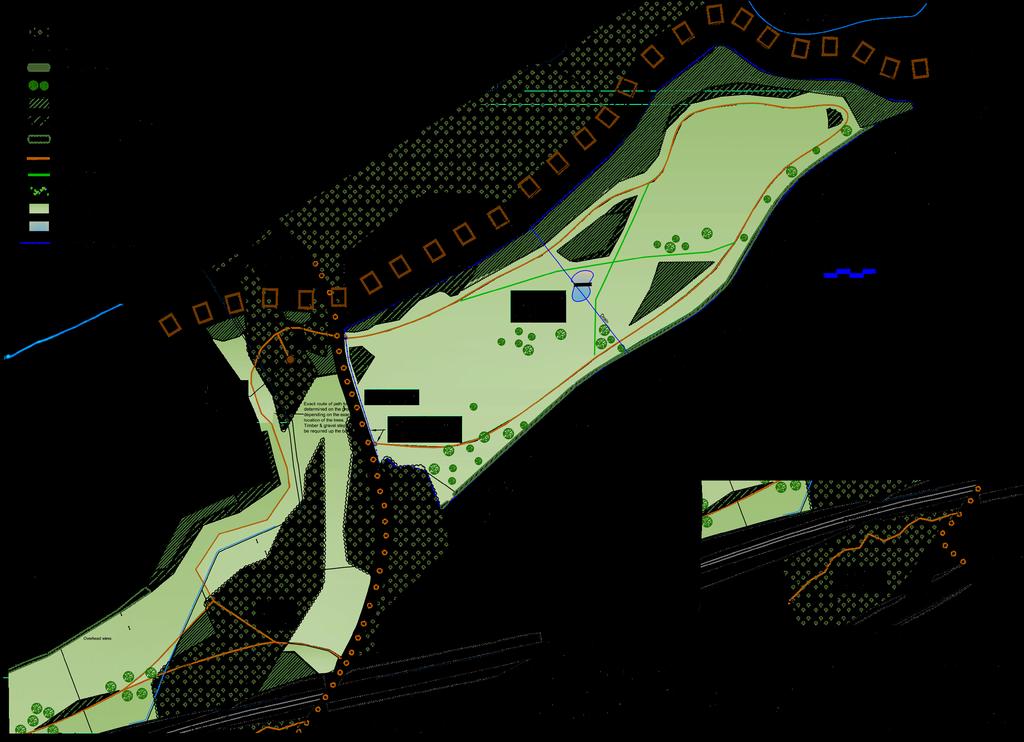
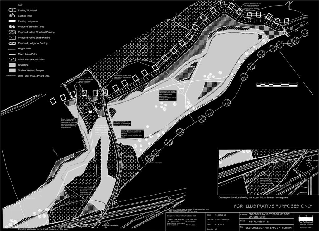
5 Eastern SANG


6 Your Views How will this project happen? Early work to set out the new boundaries of the SANG and plant trees are planned to start before the end of the winter; and a planning application will be made before the end of the year to secure a change of use of the land to Suitable Alternative Natural Greenspace. Following the start of the housing developments at Roeshot, the areas of SANG will be opened to the public in phases. Appropriate communication and publicity about the availability of routes and access points will be made at the right times. In about 10 years the entire project should be complete with all the houses built and all the SANG sites fully operational. How will the SANGs be managed? The Estate will appoint a dedicated team of professionals, including an onsite warden, to manage and maintain the SANG sites. The Estate s SANG team will meet with representatives from the three local authorities and a local representative of Natural England, who advise on biodiversity issues nationally. This will take place on an annual basis to review the performance of the SANGs. It is anticipated that opportunities are likely to arise for participation by local people in the maintenance and management of the SANGs. Local dialogue will be continuous, with the warden as the point of contact, in order to give a responsive service, this means that local issues can be addressed as they arise, with changes being made to management regimes to suit local circumstances where this is possible. Phasing Plan We welcome your comments on the proposals The plans for the SANGs are being finalised ready for submission for planning permission if you have any comments can you please complete a form provided, or send comments with SANG Consultation in the subject box to: Will the s change? are proposing a flexible approach to the areas available for use to suit other operations in the area including mineral extraction and subsequent land restoration. This is shown on the phasing plan adjacent where site A or B either side of the central SANG are interchangeable dependant upon the progress of development and the minerals operation. At all times there will be sufficient SANG available for public use to satisfy the Council that it does provide a suitable alternative so there is no increase in the level of use on the protected heathland sites. roeshot@meyrickestate.com Alternatively please write to SANG Consultation, Estate Office, Hinton, Christchurch BH23 7DU Please ensure your comments are made by 14 October 2015 so they can be taken in to account.
Linden Homes Proposals for land off Ringwood Road, Verwood
 Welcome Welcome to Linden Homes first public exhibition displaying proposals for new homes on land off Ringwood Road in Verwood. Award-winning house builder Linden Homes, part of the Galliford Try Group,
Balcombe Neighbourhood Plan. Habitats Regulations Assessment Screening Report
 Balcombe Neighbourhood Plan Habitats Regulations Assessment Screening Report Produced for Regulation 14 of the Neighbourhood Planning (General) Regulations 2012 17 th July 2015 1.0 Introduction 1.1 This
Slough International Freight Exchange Proposals, Colnbrook+
 Welcome Welcome to this exhibition, which is being held in connection with our proposals for a new freight exchange facility on land to the north of the A4. Please take this opportunity to look at the
Guidelines for the creation of Suitable Alternative Natural Green Space (SANGS)
") Guidelines for the creation of Suitable Alternative Natural Green Space (SANGS) Introduction This document provides guidelines for the type of site that can constitute a Suitable Alternative Natural Green
Guidelines for the creation of Suitable Alternative Natural Green Space (SANGS) Introduction This document provides guidelines for the type of site that can constitute a Suitable Alternative Natural Green
Welcome to our public exhibition
 About our development Welcome to our public exhibition This exhibition gives you the chance to view and comment on our proposals for a new residential development of 165 high-quality homes, along with
Applicant: Mr C Fletcher Agent: Ms B Stala Case Officer: Sally Smith (HBC) Jill Lee (WCC) Ward: Stakes Parish Southwick and Widley
 Jill Lee (WCC) Ward: Stakes Parish Southwick and Widley") Site Address: Berewood Phase 2 Development Site, London Road, Purbrook, Waterlooville Proposal: Reserved Matters Application for landscaping of Phase A of the Town Park (under Condition 6(i)d)), together
Site Address: Berewood Phase 2 Development Site, London Road, Purbrook, Waterlooville Proposal: Reserved Matters Application for landscaping of Phase A of the Town Park (under Condition 6(i)d)), together
1.0 INTRODUCTION. Brantham Industrial Area Regeneration - Factory Lane - Brantham
 1.0 INTRODUCTION Welcome to this exhibition of our proposals for the regeneration of the Brantham Industrial Area located off Factory Lane in Brantham. This presentation will give you an opportunity to
Tāhuhu whakaruruhau ā-taone The sheltering ridge pole
 B2. Tāhuhu whakaruruhau ā-taone - Urban growth and form B2.1. Issues Tāhuhu whakaruruhau ā-taone The sheltering ridge pole Auckland s growing population increases demand for housing, employment, business,
WHITELEY TOWN COUNCIL NORTH WHITELEY DEVELOPMENT SEPTEMBER 2014
 WHITELEY TOWN COUNCIL NORTH WHITELEY DEVELOPMENT SEPTEMBER 2014 Dear Resident This Special Edition of the Whiteley Voice which has been prepared in conjunction with the North Whiteley Consortium is to
WELCOME. Land North of STEVENAGE. We would like to thank you for attending our public exhibition today.
 WELCOME We would like to thank you for attending our public exhibition today. The purpose of this event is to share our proposals and hear your thoughts on our ideas. Members of the project team are on
Welcome to our Public Consultation
 About our development This exhibition gives you the chance to view and comment on our emerging plans for a proposed residential development located on land to the West of Alwyn Road, Rugby. Welcome to
ABOUT CALA HOMES CALA HOMES
 WELCOME Welcome to this public consultation event for our proposed development on land to the east of Salisbury Road, in Hungerford. Thank you for taking the time to come along today. Homes and Wates Developments
Pope s Meadow Open Space Management Plan. for Thames Basin Heaths Special Protection Area (SPA) Mitigation Works
 Mitigation Works") Pope s Meadow Open Space Management Plan for Thames Basin Heaths Special Protection Area (SPA) Mitigation Works CONTENTS 1. Introduction 2. Site Management Statement 3. Site Proposals 4. Site Plan 5. SANG
Pope s Meadow Open Space Management Plan for Thames Basin Heaths Special Protection Area (SPA) Mitigation Works CONTENTS 1. Introduction 2. Site Management Statement 3. Site Proposals 4. Site Plan 5. SANG
DELEGATED REPORT. LOCATION Land At Hawley Common Minley Road Blackwater Camberley Surrey
 DELEGATED REPORT APPLICATION NO. 16/03200/FUL LOCATION Land At Hawley Common Minley Road Blackwater Camberley Surrey PROPOSAL APPLICATION FOR TEMPORARY PLANNING PERMISSION FOR USE OF LAND FOR FILMING AND
10.0 Open Space and Public Realm
 10.0 Open Space and Public Realm 10.0 Open Space and Public Realm The Public Open Space System is comprised of: outdoor spaces available for public use that are either publicly owned (e.g., parks and
SPG 1. * the northern and western sections which are open fields used for pasture and grazing;
 SPG 1 1.0 INTRODUCTION This development brief is based on the allocation of the Priors Hall site for employment and countryside recreational purposes in the Corby Borough Local Plan. The brief is intended
A Growing Community Rural Settlement Areas
 Town of Huntsville Official Plan Review - POLICY BACKGROUND PAPER A Growing Community Rural Settlement Areas BACKGROUND: In addition to the fully municipally-serviced Urban Settlement Area and the Hidden
LAND OFF TOLLBAR WAY, HEDGE END PUBLIC CONSULTATION. Proposed Residential Development
 LAND OFF TOLLBAR WAY, HEDGE END PUBLC CONSULTATON Proposed Residential Development YOUR VEW MATTERS TO US PROPOSED STE AREA Thank you for taking the time to read this information leaflet regarding a proposed
WELCOME. North East Haverhill. The Planning Process
 WELCOME North East The site to the North East of, known as Great Wilsey Park, is identified by St Edmundsbury Borough Council in its Core Strategy as capable of delivering a Sustainable Urban Extension.
Welcome. Proposals for land at Smug Oak Lane BRICKET WOOD
 Proposals for land at Smug Oak Lane BRICKET WOOD Previous Linden Homes and Wates Developments scheme Welcome Welcome to Linden Homes and Wates Developments public exhibition. Working together as joint
Plan Modification to Chapter B2 of the Auckland Unitary Plan(AUP) Operative in part (15 November 2016)
 Operative in part (15 November 2016)") UNITARY PLAN UPDATE REQUEST MEMORANDUM TO FROM Phill Reid Linley Wilkinson DATE 25 September 2018 SUBJECT Plan Modification to Chapter B2 of the Auckland Unitary Plan(AUP) Operative in part (15 November
UNITARY PLAN UPDATE REQUEST MEMORANDUM TO FROM Phill Reid Linley Wilkinson DATE 25 September 2018 SUBJECT Plan Modification to Chapter B2 of the Auckland Unitary Plan(AUP) Operative in part (15 November
Ms C Milton Planning and Regeneration Services Borough of Poole Civic Centre Poole Dorset BH15 2RU By and post 15 March 2010
 Ms C Milton Planning and Regeneration Services Borough of Poole Civic Centre Poole Dorset BH15 2RU By email and post 15 March 2010 Dear Ms Milton Application number: 00/008824/084/P Location: Land south
Wallingford Neighbourhood Plan
 Wallingford Neighbourhood Plan Introduction What is neighbourhood planning? Neighbourhood planning was introduced by the Localism Act 2011 to give local people more influence over how development comes
WELCOME LAND EAST OF TYE LANE, WALBERTON. Above all, it s about people
 WELCOME Welcome to this public exhibition relating to our draft residential proposals for the land east of Tye Lane, Walberton. Today gives you the opportunity to have an active role in shaping these ideas
Biodiversity The number and variety of organisms found within a specified area an important measure of the health and vitality of an area s ecology
 ANNEX B - GLOSSARY Agri-environmental Schemes Agri-environmental Schemes operate at multiple levels; from encouraging traditional farming practices and protecting landscapes to specifying management regimes
PROPOSED RESIDENTIAL DEVELOPMENT LAND AT GREEN LANE, YARM
 PROPOSED RESIDENTIAL DEVELOPMENT LAND AT GREEN LANE, YARM PUBLIC CONSULTATION YOUR VIEW MATTERS TO US LOCATION PLAN Thank you for taking the time to read this information leaflet regarding a proposed residential
Central Lake Ontario Conservation Conservation Lands Master Plan
 Conservation Lands Master Plan Top 13 Frequently Asked Questions 1. What are conservation lands? Where are these conservation lands located in the Central Lake Ontario Conservation watershed? Conservation
WELCOME TO THE NEW WILTON PARK
 WELCOME TO THE NEW WILTON PARK VISION HISTORY OF WILTON PARK TOWARDS A PLANNING APPLICATION Our objective is to create a truly outstanding environment at Wilton Park. At the heart of our proposals is a
Key Principles. 290 Phasing Principles and Programme
 4 Phasing principles and programme 4c The aims of the phasing strategy are to satisfy planning policy requirements and create a sustainable, strong and healthy new community where, from the outset, people
INTRODUCTION. Land south of Bishopswood Lane, Tadley
 0 INTRODUCTION THE SITE Introduction Gladman Developments Ltd. has successfully invested in communities throughout the UK over the past 0 years, developing high quality and sustainable residential, commercial
HS2 Interchange Station Design
 Working on behalf of HS2 Interchange Station Design October 2018 www.hs2.org.uk 1 Interchange Station, Solihull Introduction In February 2018, HS2 Ltd appointed Arup to take forward the design of Interchange
PLANNING COMMITTEE DATE: 07/09/2015 REPORT OF THE SENIOR MANAGER PLANNING AND ENVIRONMENT SERVICE CAERNARFON. Number: 4
 Number: 4 Application Number: C15/0034/37/LL Date Registered: 21/05/2015 Application Type: Full - Planning Community: Llanaelhaearn Ward: Llanaelhaearn Proposal: Location: Summary of the Recommendation:
Agenda Update Sheet. Planning Committee A
 Agenda Update Sheet Planning Committee A Date: 22 nd June 2017 Agenda Section 5: Applications Part I Recommended for Approval ITEM: 1 DM/16/5502 Summary of Consultees Surrey County Council No objection
SOUTH CAMBRIDGESHIRE DISTRICT COUNCIL. Planning and New Communities Director
 SOUTH CAMBRIDGESHIRE DISTRICT COUNCIL REPORT TO: Planning Committee 9 January 2013 AUTHOR/S: Planning and New Communities Director S/2270/12/FL FEN DRAYTON 850m long flood defence embankment ranging in
Chapter 2: OUTLINE PLANNING APPLICATION PROPOSALS. A New Garden Neighbourhood Matford Barton 17
 Chapter 2: OUTLINE PLANNING APPLICATION PROPOSALS A New Garden Neighbourhood Matford Barton 17 2.1. SUMMARY AND STATUS OF THE PROPOSALS 2.1.1. The parameter plans and associated wording in this chapter
ROCHFORD LOCAL DEVELOPMENT FRAMEWORK: Sustainability Appraisal/ Strategic Environmental Assessment. Rochford Core Strategy Preferred Options Document
 ROCHFORD LOCAL DEVELOPMENT FRAMEWORK: Sustainability Appraisal/ Strategic Environmental Assessment Non Technical Summary Rochford Core Strategy Preferred Options Document October 2008 SUSTAINABILITY APPRAISAL
LAND EAST OF SUDBURY ROAD, HALSTEAD PUBLIC CONSULTATION. Proposed Residential Development
 LAND EAST OF SUDBURY ROAD, HALSTEAD PUBLIC CONSULTATION Proposed Residential Development YOUR VIEW MATTERS TO US PROPOSED RESIDENTIAL DEVELOPMENT AREA Thank you for taking the time to read this information
BREEDON NORTHERN LIMITED
 Non Technical Summary CONTENTS 1 INTRODUCTION... 1 2 SITE DESCRIPTION... 1 3 DESCRIPTION OF THE DEVELOPMENT... 6 4 NEED FOR THE DEVELOPMENT... 8 5 KEY ISSUES CONSIDERED IN THE ENVIRONMENTAL IMPACT ASSESSMENT...
3. Neighbourhood Plans and Strategic Environmental Assessment
 1. Introduction This report sets out a draft Screening Determination for the Preston Parish Council s Neighbourhood Plan and has been prepared by rth Hertfordshire District Council. The purpose of the
Appendix 1 Structure plan guidelines
 Appendix 1 Structure plan guidelines This appendix forms part of the regional policy statement [rps]. 1.1. Introduction Structure plans are an important method for establishing the pattern of land use
Carterton Construction Ltd is bringing forward plans for up to 85 new family homes and extra care facilities on land east of Burford.
 Welcome Carterton Construction Ltd is bringing forward plans for up to 85 new family homes and extra care facilities on land east of. We are at the early stages of designing our proposals and have a number
DEFINED VILLAGE CENTRES & NEIGHBOURHOODS
 DEFINED VILLAGE CENTRES & NEIGHBOURHOODS residents in Nanoose Bay support focusing attractive, planned future development in Red Gap Centre and the Area s neighbourhood centres. In addition, the development
New Century Park Welcome
 Welcome 1 Welcome to our public exhibition on the proposals for the New Century Park project which will comprise 70 acres of commercial development, facilitated by a new 1.6 mile access road, improved
Rochford District Council Allocations Development Plan Document: Discussion and Consultation Document Sustainability Appraisal
 Option SWH1 Balanced Communities Option SWH1 1 To ensure the delivery of high quality sustainable communities where people want to live and work Will it ensure the phasing of infrastructure, including
97 Lea Bridge Road, Leyton, E10 7QL London Borough of Waltham Forest December 2015
 97 Lea Bridge Road, Leyton, E10 7QL London Borough of Waltham Forest December 2015 Public Realm and Landscape Proposals LEA BRIDGE ROAD, WALTHAMSTOW Public Realm & Landscape Proposals BDP(90)RPT001 December
University Park, Worcester Non Technical Summary December 2011
 University Park, Worcester Non Technical Summary December 2011 Introduction UW Wrenbridge LLP, a Joint Venture Company of the University of Worcester and Wrenbridge Land Ltd (the Applicants ) intend to
Blackfriars Bridge Municipal Class Environmental Assessment. Public Information Centre #1 November 19 th, 2014
 Blackfriars Bridge Municipal Class Environmental Assessment Public Information Centre #1 November 19 th, 2014 Why are you here tonight? To determine the future requirements of the river crossing at Blackfriars
OKEFORD FITZPAINE NEIGHBOURHOOD PLAN
 OKEFORD FITZPAINE NEIGHBOURHOOD PLAN Dear Parishioner, The Neighbourhood Plan Project Team have prepared this leaflet to summarise the full Neighbourhood Plan document. It provides a summary of the Vision,
BACKGROUND INFORMATION DOCUMENT
 BACKGROUND INFORMATION DOCUMENT PROPOSED UPGRADING OF THE N2 NATIONAL ROAD FROM KRAAIBOSCH TO DIE VLEIE BASIC ENVIRONMENTAL IMPACT ASSESSMENT The South African National Roads Agency Society Limited (SANRAL)
WELCOME GYPSY LANE. Wider Site Location plan. Proposals for the development of LAND OFF FOXLYDIATE LANE WEBHEATH. Proposals for the development of
 WELCOME The developers are preparing an outline planning application for a residential led development and need the community s views in order to develop the proposals further WHAT IS PROPOSED? A high
Welcome to our exhibition
 Welcome to our exhibition housing development A46 Wildmoor Alcester Road Canal Quarter A422 Town Centre housing development Warwickshire-based IM Properties, one of the UK s largest privately owned property
Mapping produced by the Bedfordshire and Luton Biodiversity Recording and Monitoring Centre
 Mapping produced by the Bedfordshire and Luton Biodiversity Recording and Monitoring Centre Chalton Parish Green Infrastructure Plan Methodology In April 2007 Chalton Parish Council were approached with
Billington Parish Green Infrastructure Plan
 Billington Billington Parish Green Infrastructure Plan Methodology Following a presentation to the Annual Parish Meeting, The Greensand Trust was invited to attend the next Parish Council Meeting. The
E16: MAINTENANCE OF LANDSCAPED AREAS
 HIGH SPEED TWO INFORMATION PAPER E16: MAINTENANCE OF LANDSCAPED AREAS This paper outlines the proposed approach to the maintenance of landscaped areas created for HS2 Phase One. It will be of particular
Environment Agency Flood Risk Map for the Village of Bridge
 Environment Agency Flood Risk Map for the Village of Bridge December 2016 21 Objective F. Conserving and Enhancing the Natural Environment The National Planning Policy Framework states that the planning
Welcome to our public consultation
 About our development Welcome to our public consultation This exhibition gives you the chance to view and comment on our proposals for a residential development of up to 187 high-quality homes, along with
LETTER OF OBJECTION LAND TO THE SOUTH WEST OF FORGE GARAGE, HIGH STREET, PENSHURST, KENT, TN11 8BU
 Senior Planning Officer Andrew Byrne Sevenoaks District Council Community & Planning Services PO Box 183 Argyle Road Sevenoaks Kent TN13 1GN 04 November 2011 Your Ref: 11/02258/FUL For the attention of
SOUTH WOKINGHAM STRATEGIC DEVELOPMENT LOCATION PUBLIC CONSULTATION
 01 WELCOME Croudace Homes, Gleeson Strategic Land, Kier Ventures, Lightwood Strategic and Miller Homes are delighted to welcome you to this public exhibition. Proposals for the site have been developing
Hackney A Place for Everyone
 October 2016 Introducing Hackney A Place for Everyone Local Plan 2033 (LP33) A New Local Plan For Hackney What is the Local Plan 2033? The Local Plan will set out a vision for what Hackney will be like
PART 2 SOUTH DOWNS NATIONAL PARK AUTHORITY SECTION 1 SCHEDULE OF APPLICATION RECOMMENDATIONS
 42 PART 2 SOUTH DOWNS NATIONAL PARK AUTHORITY PLANNING COMMITTEE REPORT OF THE SERVICE MANAGER PLANNING DEVELOPMENT Applications to be determined by the council on behalf of the South Downs National Park
Neighbourhood Planning Guidance Local Green Spaces
 Neighbourhood Planning Guidance Local Green Spaces Introduction This guidance note has been produced for communities preparing neighbourhood plans in North Dorset to help them to identify, assess and designate
Land at Rampton Road. Cottenham
 Land at Rampton Road Cottenham Introduction TEP is preparing an outline planning application for 54 dwellings on 6.9 hectares of land adjacent to Rampton Road, Cottenham on behalf of the owners Cambridgeshire
Grantham Southern Quadrant Link Road Environmental Statement
 Grantham Southern Quadrant Link Road Environmental Statement Non Technical Summary Introduction Lincolnshire County Council (LCC) is submitting a planning application for the proposed implementation of
WELCOME. Welcome and thank you for visiting today.
 WELCOME Welcome and thank you for visiting today. Bellway Homes Ltd (Yorkshire) are preparing a reserved matters planning application for a residential development of 293 homes at land North of Yew Tree
North Christchurch Urban Extension 01 Masterplan Context Report (September )
") NORTH CHRISTCHURCH URBAN EXTENSION Whiteleaf North Christchurch Urban Extension 01 Masterplan Context Report (September - 2010) 2 Broadway Malyan 3 NORTH CHRISTCHURCH URBAN EXTENSION 01 Introduction PAGE
NORTH CHRISTCHURCH URBAN EXTENSION Whiteleaf North Christchurch Urban Extension 01 Masterplan Context Report (September - 2010) 2 Broadway Malyan 3 NORTH CHRISTCHURCH URBAN EXTENSION 01 Introduction PAGE
Section 4 - Public Realm & Landscape proposals Landscape Masterplan. Section 4 52
 - Public Realm & Landscape proposals Landscape Masterplan 52 Proposed Masterplan - Green Infrastructure Strategy District Park 4.33 Ha to provide Passive and active recreation with a large play area which
Welcome to our public exhibition
 About Our Scheme Welcome to our public exhibition This exhibition gives you the chance to view and comment upon our emerging proposals for a new residential development of 68 new homes on the site of the
Policy DM19: Development and Nature Conservation
 Avonmouth Wetland Habitat Project October 2010 and December 2011 (the Cresswell study). Policy Links Bristol Local Plan Core Strategy Lead Policy BCS4: Avonmouth and Bristol Port BCS9: Green Infrastructure
REFERENCE: 16/8568/ENQ Received: 25 October 2016 Accepted: 26 October 2016
 LOCATION: Allianz Park, Greenlands Lane, London, NW4 1RL REFERENCE: 16/8568/ENQ Received: 25 October 2016 Accepted: 26 October 2016 WARD(S): Mill Hill APPLICANT: Saracens Copthall Ltd. PROPOSAL: Extension
Colchester Northern Gateway Master Plan Vision Review Draft. July 2016
 Colchester Northern Gateway Master Plan Vision Review Draft July 2016 Contents Introduction 4 Context 8 Purpose of the Report 8 Strategic Position 9 Overview of the Process 11 2012 Master Plan Vision 12
EFDC Draft Local Plan Consultation Theydon Bois Guidance Notes Extended Version
 EFDC Draft Local Plan Consultation Theydon Bois Guidance Notes Extended Version There are nine questions you can respond to in the consultation if you wish. Epping Forest District Council (EFDC) has a
LONGDEN VILLAGE DEVELOPMENT STATEMENT
 LONGDEN VILLAGE DEVELOPMENT STATEMENT 2017-2027 1 Longden Development Statement 2017-2027 15/01/18 1. Background 1.1 Longden Village Longden village is a very rural and traditional community first mentioned
CLEVE PARK, THORNBURY
 CLEVE PARK, THORNBURY Community Planning Day Report Back Broadsheet February 206 A VISION FOR CLEVE PARK Over 0 local people attended the Cleve Park Community Planning Day at Armstrong Hall on Saturday
here today Public exhibition
 Public exhibition here today Find out more about Central England Co-operative and Hawkstone Vale Developments Ltd s redevelopment proposal to bring new retail and community facilities to Wilnecote. The
CENTRAL BEDFORDSHIRE COMMITTED TO WORKING TOGETHER WITH LOCAL COMMUNITIES
 WELCOME Thank you for coming to our consultation event to find out more about our emerging proposals for Hayfield Park, a residential development jointly promoted by the Hayfield Consortium: Martin Grant
Derry City and Strabane District Council Planning Committee Report. Amended layout from approval A/2004/0462/F with reduction from 166 units
 Derry City and Strabane District Council Planning Committee Report COMMITTEE DATE: 1 st February 2017 APPLICATION No: APPLICATION TYPE: PROPOSAL: LOCATION: APPLICANT: AGENT: Full Planning application Amended
Shaping the heart of Stroud - Policy options
 Shaping the heart of Stroud - Policy options Objective Relevant LP policies Policy options (options may be inconsistent and/or conflict with one another) To make the town centre accessible by all modes
Preferred route announcement M25 junction 10/A3 Wisley interchange Improvement scheme
 Preferred route announcement M25 junction 10/A3 Wisley interchange Improvement scheme Winter 2017 Introduction This section of the M25 is of nationally-strategic importance, as it provides vital access
Hammersmith and Fulham Borough council parks department
 Who we are Hammersmith and Fulham Borough council parks department Clean, green and award winning parks and open spaces where residents can relax and enjoy a variety of activities and events in an attractive
LAND USE SHEET 3 LOWER THAMES CROSSING LOWER THAMES CROSSING STATUTORY CONSULTATION. Main works construction compound
 1 19 1 Sheet 19 19 Sheet 19 Sheet 13 Sheet 13 Sheet 11 Sheet 11 Sheet Sheet 10 11 Sheet Sheet 10 11 a a Sheet 10 Sheet 10 a a a Sheet a5 Sheet 1 Sheet 1 HE540039-CJV-GEN-SZP_GN000000_Z-DR-CX-00304.dwg
an Inspector appointed by the Secretary of State for Communities and Local Government
 Appeal Decision Site visit made on 24 October 2017 by Jonathan Price BA(Hons) DMS DipTP MRTPI an Inspector appointed by the Secretary of State for Communities and Local Government Decision date: 22 ND
1 Annexe A Shortlist of sites proposed for the delivery of waste management infrastructure
 1 Annexe A Shortlist of sites proposed for the delivery of waste management infrastructure 1.1 Overview of Sites 1.1.1 Included in this Annexe are a list of proposed sites which would meet the identified
Park Development Framework Area Proposals. Context to Area 2 Ruckholt Road to Coppermill Lane
 Park Development Framework Area Proposals Context to Area 2 Ruckholt Road to Coppermill Lane The defining feature of this area is the broad expanse of marshlands. These provide the context for a diverse
Buckinghamshire Aylesbury Woodlands Advantage Ltd Aerial View from West
 The proposed Aylesbury Woodlands site is located to the east of Aylesbury and is being promoted by Buckinghamshire Advantage, which is the infrastructure delivery arm of Buckinghamshire Thames Valley Local
B - Coalfield River Corridor Landscape Character Type
 B - Coalfield River Corridor Landscape Character Type Landscape Character Type - Coalfield River Corridor The Coalfield River Corridors Landscape Character Type is located in the two converging valleys
Welford-on-Avon Neighbourhood Plan Consultation Event Sunday, 6 April Your name Your address
 Welford-on-Avon Neighbourhood Plan Consultation Event Sunday, 6 April 2014 Your name Your email address Please either: - complete this feedback form and put it in the box before leaving the Memorial Hall
ENVIRONMENTAL AND LANDSCAPE MAPPING
 APPENDIX IV : Environmental and Landscape Mapping ENVIRONMENTAL AND LANDSCAPE MAPPING Calveley Neighbourhood Plan November 2016 ENVIRONMENTAL AND LANDSCAPE MAPPING Calveley Neighbourhood Plan Calveley
Development of land adjacent to Braggs Farm Lane and Rumbush Lane, Dickens Heath. Welcome. Today s exhibition. The proposal site
 Welcome Welcome to this event to discuss the development of land adjacent to Braggs Farm Lane. is currently in the preliminary stages of designing proposals to sensitively develop this site with high-quality
submission_details represented_by_who title age_bracket first_name last_name organisation position_in_organisation withhold_name address_1
 submission_details represented_by_who title age_bracket first_name last_name email organisation position_in_organisation withhold_name address_1 I am making a personal submission 20-29 X Targeting jobs
BEDFORD BOROUGH COUNCIL PLAN IMPLEMENTATION MONITORING REPORT
 BEDFORD BOROUGH COUNCIL PLAN IMPLEMENTATION MONITORING REPORT 2017-18 Summary 1 Progress on local development documents 1 Local development documents adopted in the monitoring period 1st April 2017 31st
Settlement Boundaries Methodology North Northumberland Coast Neighbourhood Plan (August 2016)
") Introduction This background paper sets out a methodology for the definition of settlement boundaries in the North Northumberland Coast Neighbourhood Plan. The neighbourhood plan is planning positively
Introduction This background paper sets out a methodology for the definition of settlement boundaries in the North Northumberland Coast Neighbourhood Plan. The neighbourhood plan is planning positively
6 PORT SYDNEY SETTLEMENT AREA
 Section 6 Port Sydney Page 61 6 PORT SYDNEY SETTLEMENT AREA 6.1 Basis and Principles Village of Port Sydney Waterfront Community Existing Services 6.1.1 Port Sydney is an historic settlement that has developed
Plumpton Neighbourhood Development Plan Revised Pre Submission Document - Regulation 14 Consultation
 REPRESENTATIONS... Plumpton Parish Council Plumpton Neighbourhood Development Plan Revised Pre Submission Document - Regulation 14 Consultation Representations submitted on behalf of: Cala Homes (South
Overview Report. Proposed Development
 Overview Report Proposed Development the construction of a 1km cycle/pedestrian trail including a new footbridge, new car park and entrance road at Drumshanbo Lock and a new pedestrian/cycle road crossing,
LITTLE FRANCE PARK, EDINBURGH
 LITTLE FRANCE PARK, EDINBURGH INTEGRATING ACTIVE TRAVEL ROUTES WITHIN A MASTERPLAN FROM THE OUTSET Location: Implemented: Edinburgh, Scotland 2016 - ongoing CASE STUDY The Little France Park cycling and
ILLUSTRATIVE MASTERPLAN
 ILLUSTRATIVE MASTERPLAN The Development Dairy Crest (Imperial College) The Proposed Development aims to create a new high quality residential neighbourhood, alongside a new public park for White City.
INTRODUCTION. Welcome to the third round of information events on the emerging Yorkshire Energy Park proposals. THE CONSULTANT TEAM WHERE IS THE SITE?
 1 INTRODUCTION Welcome to the third round of information events on the emerging Yorkshire Energy Park proposals. This is the third round of information events that we have undertaken on the project, following
Quantity and Type of Development. POLICY CODE: DP1 Economic Development
 Quantity and Type of Development POLICY CODE: DP1 Economic Development DP1 Sustainable Economic Development Strategic Objectives: 7) To promote a place which is attractive to business, and where local
WEST HORSLEY PARISH COUNCIL. OBJECTION to Long Reach SANG
 WEST HORSLEY PARISH COUNCIL OBJECTION to Long Reach SANG 20 th August, 2016 FOA: Ms Kelly Jethwra, Planning Services, Guildford Borough Council Dear Ms Jethrwa, Reference: Location: Application: 16/P/01459
Community Conservation Workshop. Saranac River Basin Communities
 Community Conservation Workshop Saranac River Basin Communities 2 Community Conservation Program Welcome! We have designed a Community Conservation Program that listens to the needs of community members.