Master Plan Presentation August 12, 2015
|
|
|
- Aubrey Webb
- 5 years ago
- Views:
Transcription

1 Master Plan Presentation August 12, 2015 A vision for tomorrow... May, prepared for: prepared by:

2 SITE LOCATION SITE NTS
 Consider building a physical barrier to discourage pedestrian activity VEHICULAR CIRCULATION (INCOMPLETE) Current conditions inhibits through tra c.")
3 SITE ANALYSIS +/ Ac. RESIDENTIAL HOMES 1 2 RAIL ROAD (SAFETY CONCERNS) Consider building a physical barrier to discourage pedestrian activity VEHICULAR CIRCULATION (INCOMPLETE) Current conditions inhibits through tra c. olice surveillance is challenging. Consider creating a vehicular loop for police to access and easily patrol all areas of the park CREEK / TREE MASS / LEVY The creek is heavily vegetated, overgrown and is hidden behind a levy. The current conditions obstruct views and create an un-welcoming environment. Consider updating the area to open up views to the creek and encourage pedestrian activity. PLAYGROUND The playground is located in an area with low visibility to the public. Consider relocating children activity to a more visible and lively area of the park. 1 2 SOFTBALL FIELD 8 PARKING 9 5 POOL The pool is located within a ood plain and is consistently in need of maintenance. The overall condition of the pool is below average and is in need of renovations. Financial implications may be a factor. Consider replacing the pool with a new swimming facility of another amenity of equal public appeal. 8 8 RESIDENTIAL HOMES MONUMENT The monument / memorial adds a strong aesthetic / attraction to the park. Currently the memorial is enclosed by a fence to reduce vandalism. Consider increasing the police presence and/or relocating the monument to a more visible area of the park. ENTRY POINTS Currently the access points to the park are hidden and/or lack a strong sense of entry. Consider improving entry features to create a welcoming and impactful experience. SHELTER HOUSES / RESTROOMS The restrooms facilities are below public standards and need to be updated. The shelter houses offer a great amenity to the park but mostly used in the warmer months of the year. Consider updating shelter houses to allow or multi-seasonal use. 3 4 PLAY GROUND 5 6 POOL PARKING 2 7 MAIN ENTRY 9 10 BASKETBALL / TENNIS / SKATE PARK The current court conditions are below standards. The users of the courts are typically older kids / young adults / adults and sometimes create an environment that is unsuitable for younger audiences. Consider relocated uses to a more secluded and private area of the park. OVERFLOW PARKING n occasion, ose Ave can be used as over ow parking. Consider adding internal over ow parking areas to reduce the need to park on the residential street. RESIDENTIAL HOMES NOTE: AREA IS PRONE TO FLOODING Consider exploring options to reduce the ooding occurrences and/or the duration of the oods

4 AERIAL VIEW
5 MASTER PLAN

6 MASTER PLAN 1 Existing ball elds to remain. Remove existing deteriorated bleachers and replace with new. 2 Interior elds for over ow parking and alternate sports use Existing shelter converted to 3 season use New splash pad New childrens playground Re-located restroom structure. Monument to remain. Accentuate monument with new pathways and perennial garden Tree lined promenade. Improved main entry erformance green. 11 New band shell and amphitheater. 12 New paths to provide pedestrian circulation throughout the park. 13 Remove levy if possible to open up creek to park.

7 REDESIGNED ENTRY REDESIGNED ENTRY Establishes a new sense of entry and increases pedestrian safety. More noticable - memorable Retains the historic character Improves the landscaping Improved lighting


8 REDESIGNED ENTRY RE-DESIGNED ENTRY Narrow existing roadway slightly to allow more landscape area on each side of entry drive. Install Brick Crosswalks to emphasize main entry and promote pedestrian safety. Widen brick columns to a more appropriate scale for the intersection. Improve the landscaping at entry and down entry drive. Improve lighting at entry. Existing Entry Feature Re-designed Entry Feature
9 ROADS AND PARKING Roads and arking Re- pen traf c through site to allow circulation and surveilance. Re-use existing north/south parking lot. Remove existing wood bollards and replace with concrete curbs and walks. Expand existing parking lot south of driveway near bandshell. rovide additional parking near ball elds. Total increase of approximately 40 spaces. rovide additional landscaping to soften parking areas and to provide shade. Improve parking lot lighting for safety and security.

10 PATHWAY SYSTEM athway System rovides opportunities for walking and jogging throughout and around the site. rovides handicap access to all major areas of the park. Install lighting for pedestrian security in various areas. Opens up walking paths next to the creek. Asphalt / concrete / brick paths in a variety of widths creates a hierarchy of circulation.

11 TREE LINED PROMENADE Tree Lined romenade Becomes the main pedestrian spine of the park. rovides access from both main parking areas to all areas of the park. Emphasises pedestrian circulation and focuses views southward toward the band shell. Could be concrete or brick for additional emphasis. Could sell sponsorships in brick...
12 EXISTING FIELDS Existing Softball elds Existing elds stay in place to retain existing lights / infrastructure. Remove deteriorated concrete stands and replace with modern bleachers and storage space. Repair existing fencing / backstops where necessary. Repair and maintenance can be in partnership with local leagues. Space in center of ball elds can be used for football, soccer, and over ow parking for special events.

13 MONUMENT & GARDEN Monument & Garden Monument stays in place and repaired as necessary. Remove fence and open up views of monument from main drive coming in and surrounding the monument. Establish landscaping / perennial garden surrounding monument and between pedestrian walkways.
14 AMPHITHEATER Amphitheater & Band Shell Construct new band shell for outdoor music, theater, and movies. Band shell to have lighting and electric for evening performances and movies in the park. rovide vehicular access to band shell for delivery / drop-off of equipment. Outdoor lawn area surrounded by pedestrian walkways for ease of access. Speakers and performances to be oriented toward the west away from existing homes. Outdoor lawn area to be graded to ensure good drainage.


15 AMPHITHEATER / BAND SHELL Stone Amphitheater Steps Outdoor erformance Area Stone Amphitheater Steps ermanent / Tent Type Band Shells

16 CREEK ACCESS Creek Access Hire engineer to study feasibility of removing levy. Opens up views and encourages interaction with the creek. Makes a natural feature of the site more accessible. Improves visibility and surveilance of the creek area.

17 SPLASH PAD New Splash ad rovide new splash pad for community use. Through design of the splash pad ensure a distinction between Ted Lewis ark and Mary Crites Virginia. rovide substantial seating / shade opportunities for spectators. Splash pad will be handicap accessible. rovide security lighting / video monitoring to prevent vandalism.
18 NEW PLAYGROUND New layground Moves playground from remote location near the creek to a more accessible and visible location. New location is more easily monitored and is easily accessed with pathways around most of the perimeter. rovide seating and shade opportunities for adults / kids. Opportunity to provide different types of play. Traditional play structures are easly to locate, procure, and install and may be easier to nd grant dollars for. Natural play areas encourage physical activity, coordination, and imagination engaging children more completely.
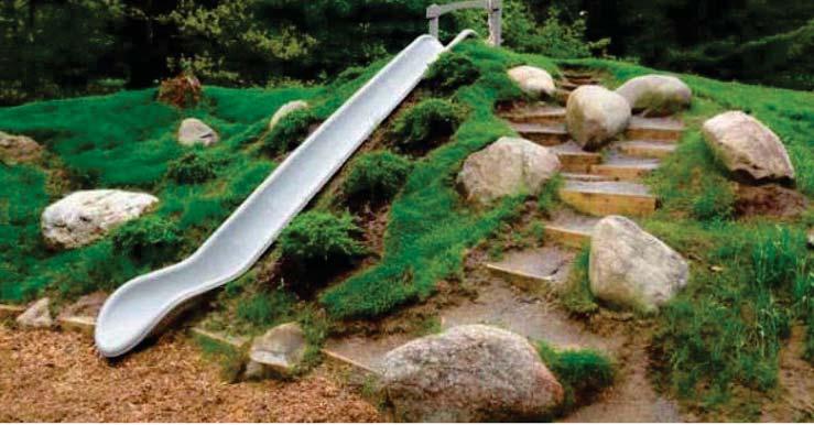
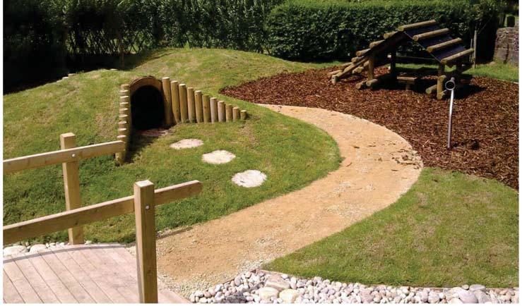
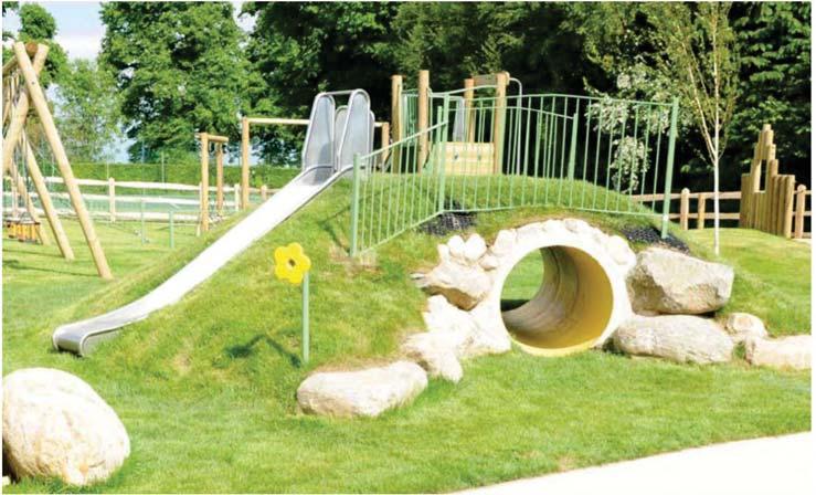
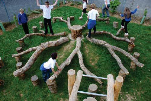
19 NEW PLAYGROUND Natural lay Traditional layground

20 EXISTING SHELTERS Existing Shelters Existing shelters are to remain. Engage an architect to explore converting the larger shelter into a 3 season room for extended season rental. aint and maintain existing shelters as necessary. If replacement becomes necessary, or for a 4th shelter consider locations along the creek.

21 NEW RESTROOMS New Restrooms Remove existing restroom building and re-locate out of the view line of the main road. Construct new restroom building near shelters and more central to the park.
22 Phasing

23 Potential Phasing II I III V IV
24 Phase I Streets and arking Remove third ball eld and associated facilities. Remove gravel and asphalt parking areas outside of the boundaries of new parking to prepare for grading and seeding. Re-Connect Road through the park. Install new parking where indicated. Re-pave or repair existing streets and parking where necessary. Install sidewalks adjacent to paving areas where indicated. I $390,000

25 Phase II North West Quadrant Remove deteriorated concrete stands and other structures needing replacement. Repair or replace any fencing, benches, etc. associated with the ball elds as necessary. rovide new stands / bleachers on the northwestern eld. Repair/upgrade/replace exsting concessions building if desired to improve look or function. rovide new storage if desired for ball eld equipment. Repair / upgrade existing shelter facilities as necessary or desired. II $150,000
26 Phase III North East Quadrant Remove existing tennis courts, skate park, and basketball courts. Re-grade area as necessary to accomodate new construction. Construct new promenade walk along existing parking down to existing road Install new restroom facility and connection to existing sanitary sewer and water lines. Install new sidewalks as indicated on plan. Install new playground and splash pad. Install all landscaping Fine grade and seed areas disturbed during construction. III $570,000

27 Phase IV Southern ark Area Demolish existing pool, pool house, fence, restroom building, and monument fence. Back ll and compact existing pool. Salvage existing parking lot where possible. Re-grade as necessary to accomodate future green and band shell. Install new band shell and stone amphitheater seating. Install new expanded parking area and pathway network. Install new plaza and garden surrounding existing monument. Install landscaping and seed all areas disturbed during construction. IV $810,000

28 Phase V Creek Access Could be done in combination with hase IV. If supported by drainage / hydraulic studies, remove existing levies and re-grade northern bank of creek to allow open views and access to creek. Levy material removed from creek could be used for other areas of the park if desired and if material is acceptable. Fine grade and seed where disturbed. $75,000
29 Phase VI RE-DESIGNED ENTRY Narrow existing roadway slightly to allow more landscape area on each side of entry drive. Install Brick Crosswalks to emphasize main entry and promote pedestrian safety. Widen brick columns to a more appropriate scale for the intersection. Improve the landscaping at entry and down entry drive. Improve lighting at entry. $75,000

30 Total Improvements $2,073,500
Y Sports Complex PROGRAMMING Capitol Improvement Plan. Anticipated/Suggested Improvements. Sedgwick County Park: Sports Complex:
 PROJECT OVERVIEW Location: East of Ridge Road, between 21 st Street and 13 th Street, not including SCZ In conjunction with The Sedgwick County Park Facilities Observation Report Compilation of improvements
Wilbur Young Park. Park Land Established: Developed Acres: 15 acres Undeveloped Acres: 25 acres
 Wilbur Young Park Park Location: 1100 SE Adams Dairy Parkway Park Land Established: 1987 Park Size: 40 acres Developed Acres: 15 acres Undeveloped Acres: 25 acres Park Type: Community Park Amenities: Shelter
VISION PLAN PRESENTATION - SEPTEMBER 28, 2013
 AREAS OF IMPROVEMENT E A POOL HOUSE POOL DECK B B MAIN BUILDING UPPER PLAZAS A D F G C MAJOR BLEACHERS DUGOUTS FIELD MAIN COURTYARD D REGGIE PARK C E SPORT COURT ADA RAMP H F G H TENNIS COURTS KITCHENETTE
Benedict Fountain Park Meeting Notes Wednesday, February 15, 2012
 Benedict Fountain Park Meeting Notes Wednesday, February 15, 2012 ALTERNATIVE #1 Like the big open lawn space in alternative 1. Like cohesiveness of sidewalk walk and play areas shown on alternative 1
City of Los Angeles Department of Public Works
 City of Los Angeles Department of Public Works Environmental Scoping Meeting for the Proposed Sixth Street Park, Arts, River & Connectivity Improvements (PARC) Project May 3, 2017 1 Agenda Introductions
Burrus Old Mill Park
 Burrus Old Mill Park Park Location: 112 NW Woods Chapel Rd. Park Land Established: 1969 Park Size: 14 acres Developed Acres: 14 acres Undeveloped Acres: 0 acres Park Type: Neighborhood Park Amenities:
Blue Springs Park. Park Land Established: Developed Acres: 12 acres Undeveloped Acres: 2 acres
 Blue Springs Park Park Location: 2204 SW South Ave. Park Land Established: 1975 Park Size: 14 acres Developed Acres: 12 acres Undeveloped Acres: 2 acres Park Type: Neighborhood Park Amenities: Softball
ANCHORAGE PARK REPORT CARD Assessing A Park s Appearance, Function, & Condition
 ANCHORAGE PARK REPORT CARD Assessing A Park s Appearance, Function, & Condition Park Name: Is Your Park an A or an F? Your Name: Contact Information Optional: Date: General Instructions: Phone: Email:
Ward Park. Park Land Established: Developed Acres: 9 acres Undeveloped Acres: 4 acres
 Ward Park Park Location: 1000 SW 22 nd St Park Land Established: 1979-80 Park Size: 13 acres Developed Acres: 9 acres Undeveloped Acres: 4 acres Park Type: Neighborhood Park Amenities: 2 Shelters, tennis
30% DRAFT GAINSBORO PARK IMPROVEMENT PROJECT THE CITY OF PLEASANT RIDGE CITY OF PLEASANT RIDGE, OAKLAND COUNTY, MICHIGAN
 LEGAL PROPERTY DESCRIPTION SEE NOTES SHEET FOR LEGAL PROPERTY DESCRIPTIONS THE CITY OF PLEASANT RIDGE GAINSBORO PARK IMPROVEMENT PROJECT CITY OF PLEASANT RIDGE, OAKLAND COUNTY, MICHIGAN 4444 Second Avenue
VEHICULAR AND PEDESTRIAN CIRCULATION
 This perspective sketch communicates the intended character and quality of a proposed streetscape design. Locate benches near a major intersection where people tend to gather. Seating and lighting provide
City of Bonney Lake Allan Yorke Park. MASTER PLAN SUMMARY REPORT June 30, 2016
 City of Bonney Lake Allan Yorke Park MASTER PLAN SUMMARY REPORT June 30, 2016 TABLE OF CONTENTS INTRODUCTION PUBLIC INVOLVEMENT PROCESS MASTER PLAN North Park Central Park South Park East Park Field Development
3.13. Development Guidelines
 3.3 Landscaping Elements Landscaping should be used to frame and soften structures, define site functions, enhance the quality of the environment, and screen undesirable views. Safety, environmental impacts,
ACADEMY AREA CONCEPT PLAN
 ACADEMY AREA Strip ling C hape l Roa d CONCEPT PLAN 7 S2 U Stripling 52 ROADWAYS AND PARKING: ADVENTURE PLAYGROUND AND SPRAYGROUND: Current roadways follow existing drives. It is recommended that the Folds
SOUTHEAST SPORTS COMPLEX MASTER PLAN
 REPORT TO SOUTHGATE NEIGHBORHOOD COUNCIL APRIL 13, 2016 Visioning Process April 30: Stakeholder Meeting with Sports Groups May 5: Stakeholder Meeting with Southgate Land Use Committee May 13: SNC Meeting
Memo Preliminary. City of Miamisburg Parks Site Reconnaissance
 Memo Preliminary To: From: Ms. Rebecca Benna Woolpert, Inc. Date: Subject: City of Miamisburg Parks Site Reconnaissance The consultant team toured the existing Miamisburg Parks to assess current levels
Ohlone College Measure G Project Scope Revisions
 Scope Revisions Current Title Revised Title Current Scope Revised Scope 6101 Relocated Baseball Field Athletic Fields Create new sustainable baseball field with synthetic turf, bleacher seating and batting
The open space system should provide connective elements, relate to natural resources, and enhance the suburban character of the landscape..
 The open space system should provide connective elements, relate to natural resources, and enhance the suburban character of the landscape.. Mixed-use and infill development should maintain or enhance
2. reimagine kings way undercroft as a community space
 2. reimagine kings way undercroft as a community space CLARENDON STREET CLARKE STREET QUEENS BRIDGE STREET MORAY STREET CITY ROAD BALSTON STREET BOYD KINGS WAY POWER STREET KAVANAGH WEST GATE FREEWAY Figure
Long Branch-Wayne Local Park Renovation Project
 Montgomery Parks Long Branch-Wayne Local Park Renovation Project Community Meeting #2 September 20, 2016 Oak View Elementary School 7:00-9:00 PM Welcome / Team Introductions M-NCPPC (Montgomery Parks)
New Park / Entry Court & Plaza Concept Design
 New Park / Entry Court & Plaza Concept Design The SECC Public realm is proposed to have a focus on health, wellness, and community and that site users will include patrons of the neighbourhood. The block
Athletic Facilities Needs Assessment
 PARKS AND RECREATION DEPARTMENT Athletic Facilities Needs Assessment Fiscal Year 2014 PROPOSED Needs Assessment Index 1. Andrew s Fields located at Margate Middle School pg. 2 2. Firefighters Park pg.
R STREET CORRIDOR NEIGHBORHOOD Site Plan and Design Review Supplemental Guidelines Checklist
 R STREET CORRIDOR NEIGHBORHOOD Site Plan and Design Review Supplemental Guidelines Checklist Applicant s Name: Project Address: Phone: Email: Applicant shall fill out the design guidelines checklist for
Appendix E Section 4(f) Evaluation
 Evaluation") Appendix E Section 4(f) Evaluation Appendix E Draft Section 4(f) Evaluation E.1 Introduction This appendix addresses a federal regulation known as Section 4(f), which protects parks, recreation areas,
Appendix E Section 4(f) Evaluation Appendix E Draft Section 4(f) Evaluation E.1 Introduction This appendix addresses a federal regulation known as Section 4(f), which protects parks, recreation areas,
Clarendon Park Framework Plan. Chicago Park District Department of Planning & Development June 7, 2008
 Clarendon Park Framework Plan Chicago Park District Department of Planning & Development June 7, 2008 1 Table of Contents Framework Plan Purpose.3 Radius Map one mile.4 Aerial Map...5 Existing Park Layout.6
TA B L E O F C ON T EN T S
 TA B L E O F C ON T EN T S Introduction 1 Site Analysis 2 EXISTING TREE ANALYSIS 3 Community Outreach 5 PUBLIC WORK SHOP #1 GENERAL PUBLIC 6 PUBLIC WORKSHOP #2 4 TH OF JULY CELEBRATION 9 PUBLIC WORKSHOP
Woods Chapel Park. Park Amenities: Playground, basketball court, single table shelter, small pond and multi-use trail.
 Woods Chapel Park Park Location: 3925 NW Dogwood Park Land Established: 1979 Park Size: 10 acres Developed Acres: 6 acres Undeveloped Acres: 4 acres Park Type: Neighborhood Park Amenities: Playground,
Open Space and Recreational Resources
 Chapter 3: Open Space and Recreational Resources A. INTRODUCTION Under the 2012 City Environmental Quality Review (CEQR) Technical Manual guidelines, open space is defined as publicly accessible, publicly
Appendix A. Park Land Definitions
 Appendix A Park Land Definitions Mini Park May serve specific function for any and all ages, depending on need of the user area. Size range 1-5 acres with optimum size being 3 acres. Service area is sub-neighborhood
Sahuarita District & Phase 1 Master Plan. Town Council December 11, 2017
 Sahuarita District & Phase 1 Master Plan Town Council December 11, 2017 Visioning Study Visioning Process Advisory Group Meetings Community Questionnaire Town Center Case Studies Community Analysis The
Charles P. Johnson and Associates. Annapolis Landscape Architects
 Charles P. Johnson and Associates Annapolis Landscape Architects AGENDA Introduction Project Limits and Scope Site Analysis Opportunities & Constraints Program Goals Image Boards Design Alternatives Pros
The Vision. Photo provided by The Minervini Group. 46 Vision, Objectives & Strategies
 Vision, Objectives & Strategies The is the public framework and guide for future development of the Grand Traverse Commons. The establishes public polices for infrastructure, the preservation of natural
5 DESIGN DEVELOPMENT 5.1 ORGANIZATION OF SPACE. Projects, due to their programmatic adversity and complexity, function as small cities.
 5 DESIGN DEVELOPMENT IN THE ARCHITECTURE OF SPATIAL POSSIBILITY, ARCHITECTURE IS USED TO PROVIDE A SPATIAL FRAMEWORK THAT IS CAPABLE OF ABSORBING CHANGE, ACTING AS A HOLDING STRUCTURE TO DEFINE THE PARK
BRADENTON RIVERWALK EXPANSION MASTER PLAN
 BRADENTON RIVERWALK EXPANSION MASTER PLAN INTRODUCTION & AGENDA Process Update Community Engagement Summary Center for Active Design (CfAD) Recommendations Context and Existing Conditions Master Plan Alternatives
BOARD OF TRUSTEE MEMORANDUM
 1 15 17 2 12 14 19 18 13 11 3 10 6 16 5 4 9 8 7 BOARD OF TRUSTEE MEMORANDUM TO: HONORABLE MAYOR & BOARD MEMBERS FROM: JANET ALUISE, COMMUNITY DEVELOPMENT DIRECTOR DATE: OCTOBER 2, 2012 RE: MASTERPLANNING
Rotary Park / Railroad Lake
 Rotary Park / Railroad Lake Park Location: 600 NW Vesper St. Park Land Established: 1975 Park Size: 12 acres Developed Acres: 12 acres Undeveloped Acres: 0 acres Park Type: Community Park Amenities: 2
North Oakville East Parks Facilities Distribution Plan. November, 2009
 North Oakville East November, 2009 POLICY CONTEXT 1) Purpose a) The purpose of this document is to be a guide for the location, configuration, design and development of the parks system for the North Oakville
Fifth and Detroit Street Design May 2017 Capital Improvements Committee. DOWNTOWN Street Design
 1 Fifth and Detroit Street Design May 2017 Capital Improvements Committee Agenda 2 Review Street Configuration Prior Meeting Review Outreach Synopsis Functional Street Design Refinements Curb Edge, Turning
1999 Approval to replace World War I monument and relocate plaques Approval to rehabilitate the Chase Mill building and surrounding site
 Memorandum PLANNING DIVISION DEPARTMENT OF COMMUNITY AND NEIGHBORHOODS To: Historic Landmark Commission From: Katia Pace, Principal Planner Date: October 26, 2016 Re: Liberty Park Improvements The purpose
SECTION 4 INDIVIDUAL PARKS SURVEY AND ENHANCEMENT RECOMMENDATIONS. Section 4 pg. 24
 SECTION 4 INDIVIDUAL PARKS SURVEY AND ENHANCEMENT RECOMMENDATIONS Section 4 pg. 24 This section describes the existing features of each park within the Community Park District, and makes suggestions on
Preci nct P l ans Figure 56 Campus Aerial Photo, 2008 CAL STATE EAST BAY, HAYWARD CAMPUS MASTER PLAN
 9 Precinct Plans This section contains a detailed discussion of the planning and design concepts for specific areas or precincts of the Cal State East Bay Hayward campus. The Precinct Plans pertain to
29 Bella Fontaine Park
 29 Bella Fontaine Park 9565 Bellefontaine Road St. Louis County Parks Master Plan Planning Zone 2 Visit Date: July 2016 Page 1 129 Bella Fontaine Park 9565 Bellefontaine Road St. Louis County Parks Master
CHAPPLES PARK MASTER PLAN
 CHAPPLES PARK MASTER PLAN Presentation of Preliminary Development Options Public Open House #2 Wednesday November 2 nd, 2016 TONIGHT S AGENDA 1. Welcome & Introductions 2. Presentation by Sierra Planning
Memorial Park Workshop Notes March 20, :30 10:30am
 Memorial Park Workshop Notes March 20, 2012 7:30 10:30am Black Team Veronica, Jeff, Shelly, Pat, Darcey, Gordy, Jeff Strengths River Size/Space Central Location History River Riffles in River View from/going
Hidden Pointe Landscape Master Plan. June, archi terra
 Hidden Pointe Landscape Master Plan June, 2006 t h e archi terra g r o u p 1 Table of Contents Background Purpose and Goals of the Master Plan Master Plan Process Existing Conditions Entrance Hidden Pointe
Binghamton University Construction SUMMER 2012 HIGHLIGHTS
 Binghamton University Construction SUMMER 2012 HIGHLIGHTS Binghamton University Construction Summer 2012 Large and small construction projects were completed during the summer 2012 construction season.
F. Driveways. Driveways which provide access to off-street parking or loading from public streets shall comply with the following:
 Section 20.945.040 General Design Standards for Surface Parking Areas. A. Review Authority. Parking lot design and drainage shall be subject to review and approval of the City Transportation Manager. B.
KEY MAP DEVELOPMENT PERMIT AREA MAP. Sunnymede North Sub-Area Plan
 Richmond Official Community Plan BROADMOOR AREA SUNNYMEDE NORTH SUB-AREA PLAN Bylaw 7100 Schedule 2.6C SUNNYMEDE NORTH SUB-AREA PLAN SUNNYMEDE NORTH SUB-AREA PLAN SUNNYMEDE NORTH SUB-AREA PLAN KEY MAP
FY Capital Improvement Program Parks and Landscaping. 8 - Summary
 PARK PROJECTS FY 211-215 Capital Improvement Program Description FY 21 FY 211 FY 212 FY 213 FY 214 FY 215 1 Restroom Bldgs (Replace or Construct)-Jefferson, McDonald, 5,774,623 4,669,623 1,15, Allendale,
Preliminary Sketch Plan for Fort Hunter Park
 Preliminary Sketch Plan for Fort Hunter Park Public Presentation November 19, 2009 Dauphin County Parks and Recreation 100 Fort Hunter Road Harrisburg, PA 17110 (717) 599-5188 www.dauphinc.org THOMAS COMITTA
SALEM FOREST RIVER PARK PRELIMINARY POOL AREA ASSESSMENT & MASTER PLAN STUDY. For the City of Salem
 SALEM PRELIMINARY POOL AREA ASSESSMENT & MASTER PLAN STUDY For the City of Salem 6-13-17 This process undertaken by Weston & Sampson is to outline preliminary ideas only of what possibilities exist for
Parks, and Recreation & Cultural Arts Master Plan Update
 Parks, and Recreation & Cultural Arts Master Plan Update Community Profile Public Input Summary: Staff Interviews conducted April 14 and 15, 2014 Citizens Workshop - conducted April 15 th and 24 th, May
January 11, New benches installed. Paving of parking lot adjacent to piers and the canoe put-in. Near complete with clean up remaining.
 Project Updates January 11, 2018 CENTERVILLE CHESAPEAKE ARBORETUM BELLS MILL CITY CREEKWOOD SOUTH DEEP CREEK LOCK WORK TO BE PERFORMED/UPDATES Improvements to the parking lot include installation of a
Urban Design Brief 1576 Richmond Street City of London
 Urban Design Brief City of London Treadstone Developments October 31, 2014 Urban Design Brief October 31, 2014 TABLE OF CONTENTS Page No. INTRODUCTION... 1 SECTION 1 LAND USE PLANNING CONCEPT... 1 1.1
CARMODY PARK MASTER PLAN
 the site Smith Reservoir Cottonwood Lake Kendrick Lake Carmody Rec Center Carmody Middle School Pool Court Play Carmody Pond Sanderson Ditch Sports Fields Foothills Ice Arena Open Field why a master plan?
3.2 P - Park District
 3.2 P - Intent - The P: s are established to promote and maintain the development of recreational opportunities within the. The development of new parks or the major expansion of existing parks within
Report or technical documentations of the target areas in Siauliai
 WP 4 Energy Supply Report or technical documentations of the target areas in Siauliai 2011.10.27 Summary of the draft version of technical documentation for two target areas Lieporiai park 1.1. Works basis
II. SINGLE FAMILY RESIDENTIAL
 II. SINGLE FAMILY RESIDENTIAL Castle Rock is made up of numerous individually built houses and subdivision tracts that have been developed during the past century. Some of the tracts are diverse in architectural
urban design Introduction
 ACHIEVE SP RI NGF I ELD.3 Introduction Urban Design Areas Design Areas are areas within Springfield that have a unique and recognizable character that is different from other areas in the community. The
Project Consulting Team:
 THE DOWNTOWN CHERRYVILLE LAND USE + STREETSCAPE MASTER PLAN WAS FUNDED THROUGH THE GENEROUS DONATIONS OF THE FOLLOWING: The Community Foundation of Gaston County ElectriCities of North Carolina The Cherryville
Achieving a Vision. Master Plan 2009 Belknap Campus August 10 11, UofL Belknap Campus Master Plan Update
 Achieving a Vision Master Plan 2009 Belknap Campus August 10 11, 2009 Consultant Team The Campus Studio Ann Arbor Michigan Team Leader Campus Planning Site Design JRA Architects Louisville Kentucky Assistant
City of Kearney Capital Improvement Update October 1, TH STREET AND 17TH AVENUE IMPROVEMENTS
 56TH STREET AND 17TH AVENUE IMPROVEMENTS FUNDING: Bonded ESTIMATED COST: $3,885,000 COMPLETION DATE: Fall 2018 SCOPE OF PROJECT: Widening of 56th Street from 6th Avenue to 19th Avenue, and widening 17th
Community Meeting #2. Cabrillo Playground Renovation A 2008 Clean and Safe Neighborhood Parks Bond Project
 Cabrillo Playground Renovation A 2008 Clean and Safe Neighborhood Parks Bond Project Community Meeting #2 September 22, 2010 District Supervisor Eric Mar Paulina Araica, Project Manager Andy Maloney, Architect
REVISED DRAFT. Malone Memorial Recreational Park and West Street Park Facilities Enhancement Master Plan. Village of Malone, New York.
 West Street Park Salmon River REVISED DRAFT Malone Memorial Recreational Park and West Street Park Facilities Enhancement Master Plan Village of Malone, New York Revised Draft Date: February 24, 2014 DOS
Neighborhood Districts
 NEIGHBORHOOD DISTRICTS SEVEN MAIN DISTRICTS Neighborhood Districts While the Development Plan provides a broad-scale overview of the neighborhood, this section focuses on uses and relationships at the
Buildings may be set back to create small plazas provided that these setbacks do not substantially disrupt the street wall s continuity.
 6-22 Community Design Street Walls and Street-front Setbacks The siting of buildings will play a critical role in establishing the character and sense of place for the District. Siting buildings at the
South East Sports Complex Phase I
 South East Sports Complex Phase I City of Spokane Design Review Board August 29, 2018 (Revised) Objectives 1. Early discussion and collaboration. 2. Provide framework / catalyst for future improvements
Emerson Park Master Plan Update. Public Meeting III August 27, 2014
 Emerson Park Master Plan Update Public Meeting III August 27, 2014 Meeting Agenda: Project Update Presentation of Master Plan Components Discussion and Feedback The Path Forward: Building on the Concept
Focus Groups. 8 Focus Group meetings including 2 with staff, 1 with seniors, and 1 with students
 Project Team Nan Lanahan, Parks & Recreation Jason Gallo, Parks & Recreation Rob Leslie, DEDP John Smolinsky, Planning Board Brent Meredith, Highway Joan Gavrilik, Friends of Parks & Rec MaryLyn Koval,
David Ache, representing Councilmember Hucker s office was present during the first portion of the meeting.
 Long Branch Wayne LP Renovation Project Community Meeting #1 March 8, 2016 Park Staff Present at Community Meeting #1 Lucas Bonney, Project Manager, Park Development Michael Ma, Park Development Tricia
Tel: (705) Fax: (705)
 Fax: (705)") 521 and 525 Essa Road City of Barrie Tel: (705) 812-3281 Fax: (705) 812-3438 Email: INFO@IPSCONSULTINGINC.com 1 5 0 D U N L O P S T R E E T E A S T, S U I T E 2 0 1, B A R R I E O N T A R I O L 4 M 1 B
521 and 525 Essa Road City of Barrie Tel: (705) 812-3281 Fax: (705) 812-3438 Email: INFO@IPSCONSULTINGINC.com 1 5 0 D U N L O P S T R E E T E A S T, S U I T E 2 0 1, B A R R I E O N T A R I O L 4 M 1 B
Standards (R-3) Figure B-11: R-3 Residential Standards Exhibit
 Figure B-11: R-3 Residential Standards Exhibit") Avila Ranch Avila Ranch Specific Plan Development Standards High Medium Density - High Residential Density Residential Lot and Building Lot and Standards Building (R-3) Standards (R-3) EXAMPLES These sketches
Avila Ranch Avila Ranch Specific Plan Development Standards High Medium Density - High Residential Density Residential Lot and Building Lot and Standards Building (R-3) Standards (R-3) EXAMPLES These sketches
VILLAGE OF NORTH SYRACUSE
 VILLAGE OF NORTH SYRACUSE Prepared for: Village of North Syracuse North Syracuse, New York Prepared by: Clough Harbour & Associates LLP 441 South Salina Street Syracuse, New York 13202 November 1, 2006
McDonald s Restaurant - Purcellville Town of Purcellville Special Use Permit Statement of Justification July 24, 2014
 Introduction / Written Statement McDonald s Restaurant - Purcellville McDonald s Corporation is proposing to redevelop the existing McDonald s eating establishment with a drive-through located at 121 N
MADISON MANOR PARK RENOVATIONS
 MADISON MANOR PARK RENOVATIONS COMMUNITY KICK-OFF MEETING MINUTES To: Wilfredo Calderon, Steven Torgerson (AMT), Tom Mitchler, Kevin Stalica, Vincent Verweij, Greg Anselene, Chris Willett, Peter Alchin,
SECTION V: DESIGN GUIDELINE EXAMPLES
 SECTION V: DESIGN GUIDELINE EXAMPLES Introduction The Syracuse Town Center is envisioned as an area that creates a sense of place, a community downtown. As such, the Town Center Committee recommended the
Design Guidelines. Roosevelt. Mike Podowski DPD Design Guidelines Ordinance ATT 13 August 13, 2012 Version #1
 Roosevelt Design Guidelines The Roosevelt Neighborhood Design Guidelines apply within the Neighborhood Boundary. Map 1 2 Map 2 3 Map 3 4 CS1 Natural Systems and Site Features Citywide Guideline: Use natural
Town Center Design Guidelines
 Adopted by City Council on September 18, 2018 Design Theme The Draper Town Center Design Theme is defined as encompassing those architectural design styles that were prevalent in the construction of civic
APPENDIX D: PARKS AND RECREATION ACTION PLAN
 APPENDIX D: PARKS AND RECREATION ACTION PLAN Goals The following goals are specific to the development, maintenance, and operation of the existing parks in the Township, as well as the acquisition and
theme 4 : Penn connects...
 38TH STREET STREETSCAPE WALNUT STREET STREETSCAPE GENERATIONAL BRIDGE LOCUST WALK RESTORATION SHOEMAKER GREEN 34TH STREET STREETSCAPE LOCUST WALK RESTORATION penn park SPRUCE STREET PLAZA HAMILTON WALK
The principal elements of the NTC Strategic Vision plan are as follows.
 The proposed project would improve the NTC site plan, circulation, visitor amenities, and landscaping, and would include construction of two new stadiums to replace the existing Louis Armstrong Stadium
Alexandria Recreation & Education Program (AREP) April 2014
 April 2014") Alexandria Recreation & Education Program (AREP) April 2014 PROPOSITION (AREP RECREATION MILLAGE) VOTE: May 3, 2014! L14-095 - Rapides Parish, City of Alexandria - 6 mills tax, 20 years, 2014-2033, acquiring,
Alexandria Recreation & Education Program (AREP) April 2014 PROPOSITION (AREP RECREATION MILLAGE) VOTE: May 3, 2014! L14-095 - Rapides Parish, City of Alexandria - 6 mills tax, 20 years, 2014-2033, acquiring,
The 17th Avenue Pocket Plaza
 The 17th Avenue Pocket Plaza Supplementary Information to the Application for the City of Calgary Council Innovation Fund February 2017 A Pocket Plaza for 17th Ave We are a group of design-minded citizens
Index to Projects by Project Name
 Index to Projects by Project Name Project # PROJECT NAME PAGE 2134 2119 PR-1109 Clayton Road (Market Street to Oakland Avenue) Sidewalk Repair 911 System Replacement and Dispatch Room Remodel ADA Barrier
1. Parks & Recreation Neighborhood Parks Community Parks Special Use Sites 2. Open Space 3. Trails
 Appendix A: Park Classifications The intent of parks and recreation classifications is to aid in making acquisition and design decisions for park sites, facilities and the organization of recreation space
PEQUITSIDE FARM ONE PROPERTY, MANY USES
 PEQUITSIDE FARM ONE PROPERTY, MANY USES Laura Campbell March 8, 2016 A plan for the public use of a historic estate Introduction At 33 acres, Peuitside Farm is the largest public owned open space in the
MIAMI 21 PUBLIC HEARING-FIRST READING 2009
 General Principles Public access waterfront walkways shall: 1. Feel public. No one should feel as if he or she is intruding on private property. The public should feel welcome and at ease to move along
ATTACHMENT A. SILVERDALE DESIGN STANDARDS Amendments to the Waaga Way Town Center Chapter
 ATTACHMENT A SILVERDALE DESIGN STANDARDS Amendments to the Waaga Way Town Center Chapter Chapter 10. Waaga Way Town Center 10.1 Physical Identity Elements & Opportunities The Waaga Way Town Center includes
AS ADOPTED - JULY 2012
 TBLE OF CONTENTS General Principles Public access waterfront walkways shall: 5 Bulkheads or Seawalls 5 Natural Shorelines 6 Design Standards for Bulkheads or Seawalls 6 Design Standards for Waterfront
open house 3 CITY OF SALEM Downtown Streetscape Plan
 open house 3 Streetscape concepts CITY OF SALEM Downtown Streetscape Plan analysis concepts we are here refined concepts & document Feb 13th 1 2 3 apr 18th KICKOFF OPEN HOUSE Streetscape Work Group Walking
FLORIN ROAD CORRIDOR Site Plan and Design Review Guidelines Checklist
 FLORIN ROAD CORRIDOR Site Plan and Design Review Guidelines Checklist Applicant s Name: Project Address: Phone: Email: Applicant shall fill out the design guidelines checklist for all guidelines applicable
The University District envisions, in its neighborhood
 Envisioning the University District Link Light Rail in Seattle s neighborhoods CIY OF SEALE CONCEP-LEVEL SAION AREA PLANNING RECOMMENDAION RESOLUION # 30165 EXHIBI L Vision 08.2000 he University District
Philip A. Ginsburg, General Manager Toks Ajike, Acting Planning and Capital Program Director
 Date: March 7, 2018 To: Through: From: Subject: Recreation and Park Commission Capital Committee Philip A. Ginsburg, General Manager Toks Ajike, Acting Planning and Capital Program Director Dan Mauer,
City of Naples Parks Master Plan (Draft)
") City of Naples (Draft) CSAB April 12, 2016 OVERVIEW Presentation Outline Overview Needs Assessment Recap Response to Needs Implementation Strategy Questions, Discussion Preserving Naples: A vision plan
City of Naples (Draft) CSAB April 12, 2016 OVERVIEW Presentation Outline Overview Needs Assessment Recap Response to Needs Implementation Strategy Questions, Discussion Preserving Naples: A vision plan
February 27, 2018 City Council Presentation The Crown Jewel Park in the City of Fairfax
 February 27, 2018 City Council Presentation The Crown Jewel Park in the City of Fairfax Master Planning Charge Van Dyck Park s first Master Plan will provide the City with a road map as to how best incorporate
U n i v e r s i t y o f S o u t h C a r o l i n a A i k e n. Land Plan Study
 U n i v e r s i t y o f S o u t h a r o l i n a A i k e n Land Plan Study 06.27.2008 Goals ampus Growth Develop a Land Plan that allows for the orderly expansion of the campus over the next ten years and
Main Street Reconstruction From Ninth Line to Stouffer Street. Town of Whitchurch-Stouffville. Public Information Centre
 Main Street Reconstruction From Ninth Line to Stouffer Street Town of Whitchurch-Stouffville Public Information Centre November 23, 2016 4:30 to 6:00 pm & 7:00 to 8:00 pm 6240 Main Street, Stouffville
OPPORTUNITIES AND CONSTRAINTS - OXBOW PARK ENTRANCE AND PUT-IN
 OPPORTUNITIES AT OXBOW EXISTING WETLANDS Site is undeveloped and we can design a park that works well from the start. SAND BEACH Potential to eliminate invasive species. DEBRIS (CONCRETE, OLD CARS) VEGETATION
City of Plattsburgh DRI: Downtown Streetscapes & Riverfront Access. Downtown Streetscape and Riverfront Access Design
 City of Plattsburgh DRI: Downtown Streetscapes & Riverfront Access Welcome Thank you for coming this evening. Agenda PART I - Project Context The Downtown Revitalization Program Our DRI Projects Other
ROCKTON DOWNTOWN STREETSCAPE MASTER PLAN. Plan Commission Presentation April 10, 2018 Teska Associates Christopher Burke Engineering
 ROCKTON DOWNTOWN STREETSCAPE MASTER PLAN Plan Commission Presentation April 10, 2018 Teska Associates Christopher Burke Engineering AGENDA 1. Project Scope & Schedule 2. Steering Committee & Community