SECTION IV: DEVELOPMENT CONCEPT
|
|
|
- Elvin Scott
- 6 years ago
- Views:
Transcription
1 80 SECTION IV: DEVELOPMENT CONCEPT
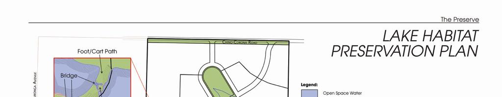
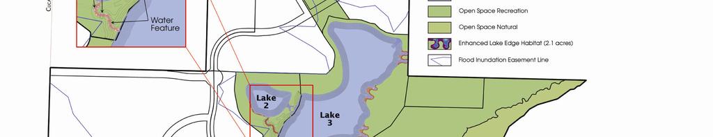
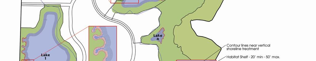
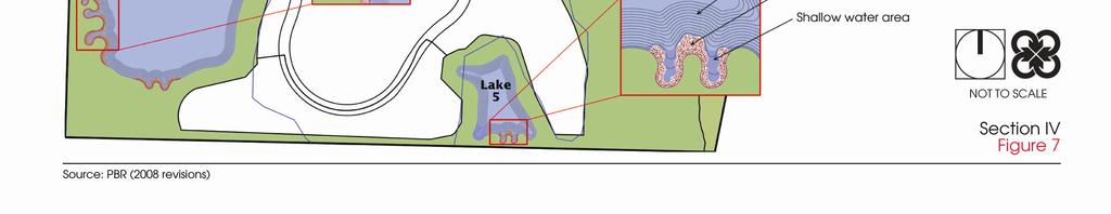
2 Section IV: DEVELOPMENT CONEPT This section provides an overall understanding and rationale for what is envisioned in The Preserve, the intended quality and character of the uses, and the expected level of services and infrastructure to be provided. The purpose of this Chapter is to lay the foundation for the development regulations and guidelines provided in the next Chapter. The following is a general description of the direction and intent of. The Land Use Plan illustrating this concept is shown on Figure 8, Land Use Plan, and a statistical summary of this concept is provided in Table 1, Land Use Plan Statistical Summary. DEVELOPMENT CONCEPT The Preserve is composed of the following main features interwoven into a single, dynamic and unique community: A multi-purpose open space area and community lakes integrated into a large regional open space system centered on the Santa Ana River, A community of distinctive residential neighborhoods, A major regional commercial center, An employment center focused around the Chino Airport, and A diverse community core with a mixture of retail, dining, civic and educational uses. All these features are interconnected by a system of paseos and trails. The following is a brief description of the major features of The Preserve. Multi-Purpose Open Space Feature The area below the 566-foot dam inundation elevation offers one of the most significant and unique open space opportunities in the region. The area below the 566-foot dam inundation elevation is envisioned as a dynamic combination of active and passive recreation, community lakes, habitat and agricultural uses. The active recreational portion may accommodate lighted sports fields and equestrian facilities, while other areas provide for passive recreation, natural habitat and agricultural activities. The Preserve incorporates six different lakes, as seen in Figure 1A, which provide opportunities for active and passive recreational use, as well as habitat preservation. The largest of the lakes, derived from the Prado Dam, is located in the area s regional park and is surrounded by open space used either for recreation or natural habitat preservation. Uses associated with this lake are primarily determined by the operation of the regional park. The remaining five lakes all appear within the Edgewater Neighborhood in the southern portion of The Preserve area. The design of this neighborhood has utilized the opportunities of the 566-foot dam inundation elevation for the creation of the lakes. These lakes, as shown in Figure 7: Lake Habitat Preservation Plan, offer varying degrees of active and passive recreation 28


3 Section IV: DEVELOPMENT CONEPT and habitat opportunities depending on their size and proximity to development. Examples of a Community Core. Lakes 2 and 3, which area in close proximity to homes and/or recreational areas, are subject to much more interaction by residents and visitors. These lakes will therefore accommodate recreational opportunities, such as paddle-boating, fishing, and other activities that do not involve extended human contact with the water (i.e. swimming). Lake edges adjacent to these active areas will also experience more frequent activities from surrounding residents and/or visitors. These lake edges, and the aesthetic opportunities they create, will therefore be accentuated by active multiuse walking/jogging/bicycle trails. Lakes 1, 4, and 5 and their respective lake edges are more secluded due to their adjacency to open space areas and are therefore more suitable for habitat and wildlife protection and passive enjoyment, often from a distance. The habitat areas identified in Figure 7 were chosen due to their separation from conflicting uses. Lake edges adjacent to residences have a greater likelihood of disruption, even from mild passive recreational activities, therefore habitat and wildlife conservation areas are located in areas adjacent to more complimentary open space uses. Community Paseo and Open Space System The Community Paseo and Open Space System is the glue of The Preserve, interweaving the various features of the plan and connecting the entire community with the open space and lakes to the south. The Community Paseo and Open Space System is a system of trails and linear open spaces that connect the major features of The Preserve. The Community Paseo and Open Space System encourages pedestrian access and provides a convenient and viable mobility option to the car. Walking, jogging, bicycling and, in some cases, equestrian are all accommodated along a system that is enhanced by the scenic open spaces and recreational areas located throughout The Preserve. The Community Paseos and Open Space System provides distinctive edges and creates identity for the various components and neighborhoods of the plan. The system components also buffer, or separate, potentially incompatible uses. An example of a mixture of retail on the bottom floor and office or residential on the second floor in a Community Core. 29
4 Section IV: DEVELOPMENT CONEPT In addition to the Community Paseo and Open Space System, parks and recreational amenities are provided for the development area itself. The acreages and assumptions for the parkland acreages are shown on Table 2, Calculation of Adjusted Units. Community Core The Community Core is envisioned as a multi-purpose promenade that serves as the backbone of the community and provides its most prominent expression of uniqueness. It is in effect a main street in the time-honored tradition of the American small town. The Community Core provides a rich mixture of entertainment, commercial, civic, cultural, educational, religious and residential uses culminating with Main Street s direct connection with one of the plan s most unique open space features the Edgewater Community Lakes. The Community Core is envisioned as an idyllic main street with a mix of uses, themed landscaping, street furniture, textured paving and tasteful signage. To stimulate pedestrian use, the Community Core is envisioned as a unique street scene with vibrant uses that invite exploration, such as cafes and outdoor dining. Uses allowed in the Community Core include a mixture of commercial, retail, office, entertainment and residential uses. It is anticipated that commercial uses will be concentrated in the central part of the core with educational and higher density residential uses focused on the two ends of the core. The Community Core accommodates neighborhood and community serving commercial uses, such as: supermarkets, bookstores, restaurants and cafes; entertainment uses, such as theaters or a community playhouse; cultural uses, such as a museum; as well as satellite civic uses, such as a satellite city hall, police substation or recreation department. Offices would ideally be located on the second or third floors above the commercial uses. Residential uses could be located on the second or third floors above commercial uses in the Community Core. The Community Core also accommodates a learning center in conjunction with an elementary and/or junior high school and parks. The Learning Center may consist of a shared and co -located school, day care, library, satellite civic uses, community center, fire station and recreational facilities. Places of worship will also be encouraged and accommodated as part of the focus of community life. If not treated properly, Pine Avenue, which is a major thoroughfare, could divide the Community Core and The Preserve into two halves. In order to unify the Community Core and community, careful consideration of the connection across Pine Avenue is necessary. To this end, a special analysis of Pine Avenue is presented in the Mobility Section, Section V. This is essential to reconcile two important but incompatible needs: regional movement along Pine Avenue and the calmer local focus of Main Street. The greatest concentrations of residential densities are located within one-half mile of the Community Core. This provides the necessary density to help maintain a viable downtown core and maximize convenient access to shops and services without automobile use. In addition, special consideration must also be given to the connectivity to and from the Edgewater neighborhood and its distinctive open space amenities. Edgewater residences and community lakes are all located just south of Chino-Corona Road, connecting south of 30
5 31


6 Section IV: DEVELOPMENT CONEPT Main Street. Multi-use trials and The Preserve s Community Paseo system encourage the mobility of people from the Community Core south to the Edgewater Neighborhood, and vice versa. Euclid Regional Commercial Center The Euclid Regional Commercial Center stretches along Euclid Avenue between Kimball and Pine Avenues. This Center is envisioned as an area of intensive business, retail, office and entertainment uses, providing an employment and commercial base for the region. The Euclid Regional Commercial Center capitalizes on the strategic location of The Preserve by providing a regional employment base that is intended to improve the jobs-housing balance for the City and the western Inland Empire. The Regional Commercial Center is allowed to expand and intensify as this regionally strategic location captures increased business activity. The intent is that uses on this site would develop as early as possible yet expand and adjust as the economic attractiveness of this strategically located area increases. The depth of the Regional Commercial designation provides property owners and developers the flexibility to respond to market trends with innovative designs and uses. The Euclid Commercial Center is proposed to partially extend below the 566-foot dam inundation elevation. Due to the potentially high value of the land, this use could finance the necessary replacement of lost flood capacity in the Prado Flood Basin. It is important to note that the inundation elevation in much of this area would be very shallow and require a relatively small amount of volume offset. In order to allow development within the inundation area, the City and developer will be required to work with the U.S. Army Corps of Engineers. Airport Related Business/Industrial Area The Chino Airport provides an economic opportunity. To capitalize upon this opportunity and utilize the property impacted by the airport s noise and safety zones, a vibrant and diverse business and industrial area is provided. The Light Industrial and Airport Related designations allow for office, manufacturing, business park and other uses compatible with the Chino Airport. 32
7 Section IV: DEVELOPMENT CONEPT These uses, located along Kimball Avenue, would interact with the Euclid Regional Commercial Center and Chino Airport as that facility takes on a more diversified air transportation role. Residential Neighborhoods A broad range of housing types, each with a unique sense of place and identity, are strategically located among these major features. A diversity of residential neighborhoods offering a variety of densities, housing types and price ranges is accommodated in The Preserve. The rich mixture of housing designations provides the opportunity for a fine grain blend of choices to appeal to many market and economic segments. Higher density residences, such as multi-family structures, townhomes and garden apartments, are located in and adjacent to the Community Core, Euclid Regional Commercial Center and Kimball Avenue, and in the southern portion of the plan adjacent to the Edgewater Community Lakes. This provides the opportunity for access to employment and service uses as well as convenient live-work opportunities. Lower-density residential uses are mainly located on the eastern portion of The Preserve, south of Pine Avenue, and within the southern portion of the Edgewater Neighborhood. Estate Residential uses are located in the southern portion of the developed area. Guiding Development Principles The following principles are the fundamental, intent statements that drive every project and use within The Preserve. These principles are so important to the future character of The Preserve that every individual project/ application must comply with the intent of each of the following principles. Project approval can only occur if a finding is made to that effect. There is to be a broad range of housing products, designs and types in every residential project to create diversity and character. Finding: The project contributes directly to a broad range of housing types and opportunities. The Preserve is intended to be a vibrant and diverse community with a wide variety in the design of structures. Finding: The project is characterized by design features that contribute to the quality and variety of the living environment. The Community Core is the heart and soul of The Preserve. The intended high quality and character of the Community Core must be maintained. Finding: The project contributes to and does not detract from the character and viability of the Community Core. The intent of the land use plan and its basic land use patterns must be preserved. Finding: The project implements and is consistent with the land use concept in the plan. 33

8 74.68 ac ac ac ac ac 5.53 ac ac ac Section IV Figure 8 34
9 DEVELOPMENT CONCEPT TABLE 1 LAND USE PLAN STATISTICAL SUMMARY Adjusted Average Density 3 Gross Ac. * Adjusted Units 1 Sq. Ft. 2 DU/Ac FAR Density Range 4 Residential Designations Estate Residential du/ac Low Density Residential , du/ac Medium Density Residential ,392 5, du/ac 7 High Density Residential , du/ac High Density Residential du/ac High Density Residential du/ac Community Core-16 (55% of Designation) du/ac Community Core-30 (55% of Designation) du/ac Residential Subtotal 1, ,946 Business Designations Neighborhood Commercial , , N.A. Regional Commercial N.A. Regional Commercial (70%) , N.A. Office (15%) , N.A. Open-Space-Rec. (15%) Airport Related Light Industrial (55%) ,841, N.A. Business Park (20%) , N.A. Office (10%) , N.A. Commercial (10%) , N.A. Hotel (5%) , N.A. Light Industrial ,156, N.A. Community Core MU Commercial (20%) , N.A. MU Office (15%) , N.A. MU Public Facilities (10%)
10 DEVELOPMENT CONCEPT TABLE 1 LAND USE PLAN STATISTICAL SUMMARY Adjusted Gross Ac. * Adjusted Units 1 Sq. Ft. 2 Average Density 3 Density Range 4 Community Core DU/Ac FAR MU Commercial (20%) , MU Office (15%) , MU Public Facilities (10%) 2.45 Business Subtotal ,233,311 10,265,981 See next page for notes. Open Space Designations Agriculture Open Space-Water Ag/Open Space-Natural Open Space Recreation Open Space-Natural 1, Open Space Subtotal 2, Other Designations Public Facilities Women's Institute Chino Airport R.O.W Other Subtotal Totals 5, ,976 11,946 10,233,311 10,265,981 * Adjusted gross acres is the gross project acreage excluding the acreage devoted to major, secondary, and collector street rights-of-way, easements for major utilities, and land for City parks and schools. 1 Residential unit assumption is based on adjusted gross acres, including an adjustment to include the acreage required for parks and schools. For purposes of parks and schools assumptions, the unadjusted number of units, based simply on adjusted gross acres times the average density factor for each residential designation, is 12,377 dwelling units. Sites designated to accommodate the City's Regional Housing Need Allocation, per the General Plan Housing Element, do not have an adjustment to exclude the acreage for parks, in order to comply with Section of the Government Code. 2 Non-Residential square footage assumption based on adjusted gross acres. 3 Average density is the target density. Individual project densities may vary within the Maximum Density range stated in this table. 4 Provides the density ranges within each residential land use designation. 5 Estate Residential includes the assumption of one 10-acre elementary school. 6 Community Core 16 Commercial includes the assumption of 15-acre K-8 school and one 10-acre elementary school. Community Core 16 Residential uses are included in residential designations at the top of Table 1. 7 The Density range may be expanded to 6 to 14 dwelling units per acre if approved through a Master Plan and with a minimum of 60 acres (See Section VII) 36
11 DEVELOPMENT CONCEPT TABLE 2 CALCULATION OF ADJUSTED UNITS Land Use Designation Residential Designation Adjusted Gross Average Density Acres 1 Factor Park Requirements (acres) 2 School Assumptions (acres) 3 Adjusted Units Estate Residential Low Density Residential ,223 Medium Density Residential ,392 5,362 High Density Residential ,671 High Density Residential High Density Residential Community Core 16 Residential Community Core 30 Mixed Use Resi Non-Residential Designation Community Core 16- MU Public Airport Related Open Space- Recreational Totals 1, ,946 1 Adjusted gross acres is the gross project acreage excluding the acreage devoted to major, secondary, and collector street rights-of-way, easements for major utilities, and land for City parks and schools.. 2 Based on the City s standard of 3 acres per 1,000 population for all residential units within the Specific Plan. Persons per dwelling unit are estimated at 3.4 persons (Department of Finance, January 2000). Acres are allocated based on Conceptual Parks and Schools Plan (Figure 16). 3 One 10-acre elementary school and one 15-acre K-8 school are assumed within the Community Core 16 designation. One 10-acre elementary school is assumed within the Estate Residential designation. 37
Additional information about land use types is given in Chapter 5. Design guidelines for Centers and Neighborhoods are given in Chapter 7.
 4. Place Types Introduction In Albemarle County s Development Areas, the Neighborhood is the fundamental unit of community planning. The County s Neighborhood Model, an adopted part of the Comprehensive
4 C OMMUNITY D ISTRICTS
 4 C OMMUNITY D ISTRICTS N ew development in the Area will include many different types of land uses, including a destination retail area that attracts people from all over the region; recreation opportunities
Bourne Downtown Site Planning
 Prepared for: The Town of Bourne, MA In Cooperation with: Bourne Financial Development Corporation Prepared by:, Inc. June 24, 2009 Table of Contents Introduction and Summary... 1 Site Existing Conditions...
Policies and Code Intent Sections Related to Town Center
 Policies and Code Intent Sections Related to Town Center The Town Center Vision is scattered throughout the Comprehensive Plan, development code and the 1994 Town Center Plan. What follows are sections
CHAPTER 3 VISION, GOALS, & PLANNING PRINCIPLES. City of Greensburg Comprehensive Plan. Introduction. Vision Statement. Growth Management Goals.
 CHAPTER 3 VISION, GOALS, & PLANNING PRINCIPLES Introduction The Greensburg Comprehensive Plan is intended as a working community document. A combination of long and short-term goals, this document is intended
Visioning Statement and Guiding Principles
 Visioning Statement and Guiding Principles Planning for the Future The General Plan The General Plan represents Woodland's shared vision of the future and defines a path to lead the community toward its
As is referenced in the site analysis, the current site access is along Loggers Lane and on to Galbraith Avenue.
 4.12 Archaeological Assessment The land above sea level at the Oceanfront was created over the last 100 years by the fill from dredging of the Mamquam Blind Channel, the Cattermole Slough and the Squamish
DRAFT Land Use Chapter
 Stevens Creek Urban Village DRAFT 1 18 17 Land Use Chapter INTRODUCTION This Land Use Chapter describes how the Stevens Creek Urban Village will accommodate the growth that is planned for it in the Envision
Westbound: A One-day Exploration of Growth
 Westbound: A One-day Exploration of Growth Frog Pond Area 2018 UGB Expansion Proposal June 13, 2018 Growing Out: UGB Asks Four cities submitted proposals to expand greater Portland s urban footprint by
SECTION 3 PROJECT DESCRIPTION
 SECTION 3 PROJECT DESCRIPTION 3.1 PROJECT LOCATION The Preserve planning area is located in the extreme southwestern corner of San Bernardino County, approximately 37 miles east of Los Angeles and 20 miles
VICTORIA DOWNTOWN DEVELOPMENT PLANNING
 VICTORIA DOWNTOWN DEVELOPMENT PLANNING A Vision & Guide for the Future Downtown Victoria thrives as a center for the community, offering a great mix of entertainment, culture, business, and recreational
Glenborough at Easton Land Use Master Plan
 Land Use Framework November 30, 2007 2.0 LAND USE FRAME- WORK 2.1 LAND USE HISTORY and Setting Glenborough at Easton is located on property that was used for mining in the 19th and 20th centuries and rocket
and services The protection and conservation of environmentally significant and sensitive natural heritage features and functions.
 6. Land Use 6.0 Preamble A healthy and livable city is one in which people can enjoy a vibrant economy and a sustainable healthy environment in safe, caring and diverse neighbourhoods. In order to ensure
3.1 Existing Land Use
 3.0 Land Use This strategy has been developed taking into account the position of the Town of Sidney as the economic center of the Saanich Peninsula. It acknowledges existing land use patterns in the downtown
Mariposa Lakes. Planned Community. Project Overview. Stockton, CA
 Planned Community Stockton, CA Project Overview March 2007 Summary of Proposed Community is a master-planned community proposed for development on approximately 3,810 acres in southeast Stockton. In 2004,
3.0 LAND USE PLAN. 3.1 Regional Location. 3.2 Existing Conditions Existing Uses. Exhibit Regional Location Map
 3.0 LAND USE PLAN 3.1 Regional Location The Anaheim Resort Specific Plan (ARSP) area is located in the City of Anaheim, which is 35 miles southeast of downtown Los Angeles and 7 miles northwest of Santa
Neighborhood Districts
 NEIGHBORHOOD DISTRICTS SEVEN MAIN DISTRICTS Neighborhood Districts While the Development Plan provides a broad-scale overview of the neighborhood, this section focuses on uses and relationships at the
Concord Community Reuse Project Goals and Guiding Principles. Overarching Goals (OG)
") Concord Community Reuse Project Goals and Guiding Principles Overarching Goals (OG) No priority is implied by the order of presentation of the goals and guiding principles. Overarching goals for the Concord
Concord Community Reuse Project Goals and Guiding Principles Overarching Goals (OG) No priority is implied by the order of presentation of the goals and guiding principles. Overarching goals for the Concord
3. VISION AND GOALS. Vision Statement. Goals, Objectives and Policies
 Vision Statement Queen Creek s interconnected network of parks, trails, open spaces and recreation opportunities provide safe and diverse activities and programs that sustain its unique, small town, equestrian
Mark-up of the effect of the proposed Bronte Village Growth Area OPA No.18 on the text of section 24, Bronte Village, of the Livable Oakville Plan
 Mark-up of the effect of the proposed Bronte Village Growth Area OPA No.18 on the text of section 24, Bronte Village, of the Livable Oakville Plan Notes: This document is provided for information purposes
Gold Line Bus Rapid Transit Transit Oriented Development (BRTOD) Helmo Station Area Plan
 Helmo Station Area Plan") Appendix F Gold Line Bus Rapid Transit Transit Oriented Development (BRTOD) Helmo Station Area Plan Introduction and Purpose of the Plan The Gold Line Bus Rapid Transit facility is an eleven-mile dedicated
Appendix F Gold Line Bus Rapid Transit Transit Oriented Development (BRTOD) Helmo Station Area Plan Introduction and Purpose of the Plan The Gold Line Bus Rapid Transit facility is an eleven-mile dedicated
CHAPTER 1. Ms. Guajardo s Class - Central Elementary CH 1 1
 INTRODUCTION CHAPTER 1 Ms. Guajardo s Class - Central Elementary CH 1 1 1.1 SETTING South Centre City is a linear corridor south of Downtown Escondido paralleling Centre City Parkway and South Escondido
17.11 Establishment of Land Use Districts
 17.11 Establishment of Land Use Districts 17.11.010 Purpose. To promote the health, safety, and general welfare of City residents and those who come to South Salt Lake to work, exchange commerce and recreate.
APPENDIX C SPECIAL PLANNING AREAS
 SPECIAL PLANNING AREAS There are five Special Planning Areas (SPAs) on the Land Use Diagram (Figure LU-2). The SPAs are areas with significant new growth potential that require more detailed subsequent
ELMVALE ACRES SHOPPING CENTRE MASTER PLAN
 ELMVALE ACRES SHOPPING CENTRE MASTER PLAN Contents 1.0 INTRODUCTION... 2 2.0 LOCATION... 2 3.0 EXISTING CONTEXT... 2 4.0 VISION & GUIDING PRINCIPLES... 2 5.0 LAND USE AND BUILT FORM... 4 5.1 St. Laurent
Chapter 5: Recreation
 Chapter 5: Recreation Introduction and Setting Recreational opportunities within Nevada County are varied, ranging from public parks with intensively used active recreational facilities, to vast tracts
Metro. Activity Center Design Guidelines. Recommendations For Developing Focused, Mixed-Use Commercial/Residential Centers
 Metro Activity Center Design Guidelines Recommendations For Developing Focused, Mixed-Use Commercial/Residential Centers Metro Activity Centers What is a MAC? Legacy, the adopted guide for the future growth
Chapter 4. Linking Land Use with Transportation. Chapter 4
 Chapter 4 Linking Land Use with Transportation Chapter 4 59 Chapter 4 Linking Land Use with Transportation Community Design and Transportation Program Introduction Since the 1950s, the predominant development
Vision Statement for the Town of Flower Mound Master Plan The Town of Flower Mound Master Plan furthers the established community based vision to:
 Vision Statement for the The furthers the established community based vision to: Preserve the country atmosphere and natural environment that makes Flower Mound a unique and desirable community; Mitigate
3.0 URBAN DESIGN. December 6, OVERVIEW
 Urban Design 3.0 URBAN DESIGN December 6, 2007 3.1 OVERVIEW The highly urban character of Easton Place is defined by the overall design of the community. The following sections provide an overview of the
12600 S Existing Conditions
 STUDY AREA BOUNDARY Study Area Boundary Study Area Context The District Riverton Meadows Vista Station Mountain View Village Market Center 2 Mile Radius 12600 S Existing Conditions 12600 S is a river of
Chapter 6--Urban Design
 6.1 Introduction... 6-1 6.1.1 Background & Scope... 6-1 6.1.2 Relationship to State Law... 6-2 6.1.3 Relationship to Other General Plan Chapters... 6-2 6.2 Guiding Principles... 6-2 6.3 Urban Design Guidelines...
2.0 AREA PLANS. Lakeside Business District. Lakeside Business District Land Use Categories:
 Lakeside Business District Lakeside Business District Land Use Categories: Campus Commercial Campus Commercial means a mixture of uses which includes corporate offices, office parks, hotels, commercial,
Westwind Developments Ltd. PIONEER LANDS AREA STRUCTURE PLAN - PROPOSED AMENDMENT
 FEBRUARY 2013 TABLE OF CONTENTS 1.0 BACKGROUND... 1 1.1 Amendment... 1 2.0 LOCATION & CONTEXT... 2 2.1 Land Ownership... 2 3.0 POLICY CONTEXT... 3 3.1 Municipal Development Plan... 3 3.2 Capital Region
Small Area Plan. South Gateway
 Small Area Plan Adopted May 12, 2008 South Gateway Purpose. The South Gateway Small Area Plan defines the City s expectations for the future of the southern entrance to the City at Interstate 85 and Highway
3.1 community vision. 3.3 required plan elements
 Chapter 3 Community Form 3.1 community vision 3.2 Parks & landscaping concepts 3.3 required plan elements D R A F T 20 Community Form Chapter 3 3.0 Community form 3.1 community vision The Specific Plan
2.0 THE PLATINUM TRIANGLE VISION
 2.0 THE PLATINUM TRIANGLE VISION The envisions an exciting future for the area surrounding Angel Stadium of Anaheim, the Honda Center and The Grove of Anaheim. 2.1 Planning Principles In order to further
Sahuarita District & Phase 1 Master Plan. Town Council December 11, 2017
 Sahuarita District & Phase 1 Master Plan Town Council December 11, 2017 Visioning Study Visioning Process Advisory Group Meetings Community Questionnaire Town Center Case Studies Community Analysis The
Technical Appendix L, University Community Plan Town Center
 Technical Appendix L, University Community Plan Town Center Table of Contents L.1 Executive Summary L.2 Merced County University Community Plan, 2004 Findings L.2.1 Visioning L.2.2 UCP Goals, Objectives
Former Rockcliffe Airbase Community Design Plan Guiding Design Vision and Principles December 4, 2013
 APPENDIX 5 - Guiding Design Vision and Principles Former Rockcliffe Airbase Community Design Plan Guiding Design Vision and Principles December 4, 2013 Vision Statement The redevelopment of the former
THEMES, VISION, + PRINCIPLES
 CHAPTER 2: THEMES, VISION, + PRINCIPLES This page intentionally left blank. 20 VISION DRAFT AUGUST 2018 2 2 THEMES, VISION, + GUIDING PRINCIPLES The Key Themes, Vision, and Guiding Principles presented
4.1.3 LAND USE CATEGORIES
 4.1.3 LAND USE CATEGORIES a. City Center District The City Center District incorporates the existing character and mix of uses in downtown Belmont to encourage redevelopment and new development in keeping
City of Nogales General Plan
 Open Space, Parks, Recreation and Trails City of Nogales General Plan Residents of Nogales place a high priority in the development of a comprehensive system of open space, parks, recreation and trails
4- PA - LD - LIVELY DOWNTOWN. LD - Background
 4- PA - LD - LIVELY DOWNTOWN LD - Background The downtown has been the service centre for the community since the city s inception and the area continues to supply people with their personal services,
North Oakville East Parks Facilities Distribution Plan. November, 2009
 North Oakville East November, 2009 POLICY CONTEXT 1) Purpose a) The purpose of this document is to be a guide for the location, configuration, design and development of the parks system for the North Oakville
A Growing Community Rural Settlement Areas
 Town of Huntsville Official Plan Review - POLICY BACKGROUND PAPER A Growing Community Rural Settlement Areas BACKGROUND: In addition to the fully municipally-serviced Urban Settlement Area and the Hidden
6 PORT SYDNEY SETTLEMENT AREA
 Section 6 Port Sydney Page 61 6 PORT SYDNEY SETTLEMENT AREA 6.1 Basis and Principles Village of Port Sydney Waterfront Community Existing Services 6.1.1 Port Sydney is an historic settlement that has developed
Description of Preferred Alternative
 Chapter 2 Description of Preferred Alternative 2.1 Introduction This chapter of the programmatic Sammamish Town Center Sub-area Plan Final EIS provides a more detailed description of the Preferred Alternative
The transportation system in a community is an
 7 TRANSPORTATION The transportation system in a community is an important factor contributing to the quality of life of the residents. Without a sound transportation system to bring both goods and patrons
The Five Components of the McLoughlin Area Plan
 The Five Components of the McLoughlin Area Plan This documents contains the complete language of the five components of the McLoughlin Area Plan: The Vision Statement The Values The Guiding Principles
The Village. Chapter 3. Mixed Use Development Plan SPECIFIC PLAN
 The Village SPECIFIC PLAN Chapter 3 3.1 INTRODUCTION 3.1.1 Purpose This Chapter describes the development regulations applicable to the Mixed-Use and Transit Center Planning Areas. These form-based regulations
4.9 Mendocino Avenue Corridor Plan Design Guidelines
 4.9 Mendocino Avenue Corridor Plan Design Guidelines The Mendocino Avenue Corridor Plan addresses the area between College Avenue and Steele Lane. Mendocino Avenue is a busy arterial that runs parallel
Appendix C: Interim Mixed-Use Evaluation Criteria
 Appendix C: Interim Mixed-Use Evaluation Criteria C-1 Appendix C: Interim Mixed-Use Evaluation Criteria PURPOSE: The implementation of numerous policies contained within the Master Plan hinges on the creation
Today Land & People. Northeast Nampa Gateway District. Employment. Land Use Characteristics. Demographics. Current Zoning
 Today Land & People Employment Major employers include Saint Alphonsus, the College of Western Idaho, the Auto Mall, Sorrento Lactalis and Walmart. 3,004 jobs in 2010 (COMPASS-CIM 2040 TAZ data) 4,345
III. Design Principles
 III. Design Principles The design of Bay Meadows Phase II has been guided by a series of Urban Design Principles. These principles, informed by consultant site analysis, City staff recommendations, and
Community Overview - SECTION 1
 Community Overview - SECTION 1 Introduction 1.0 Introduction Overview The Preserve presents an opportunity to create a unique place in time, one that welcomes you home and away from life's everyday stress
REQUEST FOR QUALIFICATIONS
 REQUEST FOR QUALIFICATIONS VILLAGE OF HAMBURG COMPREHENSIVE ZONING/LAND USE REGULATIONS UPDATE Prepared By: Village of Hamburg 100 Main Street Hamburg, New York 14075 Village of Hamburg RFQ Page 1 of 10
LAND USE ELEMENT. Purpose. General Goals & Policies
 LAND USE ELEMENT Purpose This Land Use Element contains the goals and policies necessary to support the City s responsibility for managing land resources and guiding development through implementing regulations,
Master Zoning Plan for the Northeast Property. in El Paso, Texas. Approved August Master Zoning Plan for the Northeast Property. City of.
 El Paso, Texas in El Paso, Texas Prepared for: City of Prepared by: Texas Kimley-Horn and Associates, Inc. 12700 Park Central Drive Suite 1800 Dallas, Texas 75251 Tel: (972) 770-1300 Approved August 2008
MALL REVITALIZATION CASE STUDIES
 MALL REVITALIZATION CASE STUDIES DECEMBER 9, 2012 MALL REVITALIZATION OVERVIEW Introduction Sample Case Studies prepared for Lacey Woodland District Steering Committee as it considers strategies to revitalize
Section 2 Study Area
 Study Area Section 2 Study Area 2-1 Purpose This section describes the study area of the Update and discusses the existing and future land uses within the study area. 2-2 Location The study area, as shown
To ensure that resources will be available to provide a consistent level of public services to the community.
 Future Land Use Plan The land use plan is one of the most prominent chapters in the Stillwater Comprehensive Plan. It provides a visual representation of what the community is expected to look like in
GENERAL PLAN AND ENVIRONMENTAL IMPACT REPORT
 City of Menifee HEARING DRAFT GENERAL PLAN AND ENVIRONMENTAL IMPACT REPORT City Council November 2013 PURPOSE OF MEETING Overview of GP Process Overview of required and optional GP elements Receive direction
SECTION I: VISION. The Preserve Specific Plan
 SECTION I: VISION 1 This page intentionally left blank. VISION Section I The following is the vision for The Preserve adopted by the Chino City Council. A special environment has taken shape where once
DEVELOPMENT FRAMEWORK POST 2030 LAND USE PLAN INTRODUCTION
 INTRODUCTION Oak Grove s Comprehensive Plan identifies a future Metropolitan Urban Service Area (MUSA). The Metropolitan Council does not anticipate extending utilities to this area prior to 2030. The
3.0 PROJECT DESCRIPTION
 3.0 PROJECT DESCRIPTION 3.1 BACKGROUND Under California law (Government Code Section 65300 et seq.), every city and county is required to have a general plan. The general plan is to be comprehensive and
Planning Districts INTRODUCTION
 INTRODUCTION To facilitate detailed examination of development prospects for all areas of the community, Delano has been divided into 14 planning districts. The location of these planning districts is
FRUITVALE TRANSIT VILLAGE (Phase 2) Residential Project
 Residential Project") FRUITVALE TRANSIT VILLAGE (Phase 2) Residential Project DEVELOPER: SIGNATURE PROPERTIES ARCHITECT: HKIT ARCHITECTS April 23, 2010 TABLE OF CONTENTS 3 Vision 4 Description of Site 5 Guiding Concepts 6
FRUITVALE TRANSIT VILLAGE (Phase 2) Residential Project DEVELOPER: SIGNATURE PROPERTIES ARCHITECT: HKIT ARCHITECTS April 23, 2010 TABLE OF CONTENTS 3 Vision 4 Description of Site 5 Guiding Concepts 6
Colchester Northern Gateway Master Plan Vision Review Draft. July 2016
 Colchester Northern Gateway Master Plan Vision Review Draft July 2016 Contents Introduction 4 Context 8 Purpose of the Report 8 Strategic Position 9 Overview of the Process 11 2012 Master Plan Vision 12
Department of Community Development. Planning and Environmental Review Division Revised Notice of Preparation
 Department of Community Development Michael J. Penrose, Acting Director Divisions Building Permits & Inspection Code Enforcement County Engineering Economic Development & Marketing Planning & Environmental
Mendota Heights 2040 Comprehensive Plan Draft Vers
 4 Parks and Trails The City of Mendota Heights boasts a variety of recreational and open space opportunities. Few cities can claim access to regional trails, riverside and lakeside parks, scenic bluffs
BURTON STATION STRATEGIC GROWTH AREA PLAN UPDATE PUBLIC MEETING 3/26/18
 BURTON STATION STRATEGIC GROWTH AREA PLAN UPDATE PUBLIC MEETING 3/26/18 1 WHERE WE ARE? 2 PRIMARY OBJECTIVES OF THE PLAN UPDATE 1. Update the land use designation for Burton Station Village to reflect
Page 1 of 19 URBAN DESIGN FRAMEWORK FOR BOLTON STREET WATERFORD
 Page 1 of 19 URBAN DESIGN FRAMEWORK FOR BOLTON STREET WATERFORD 1.0 Introduction: The relocation of the City Council stores and depot from Bolton Street creates an exciting opportunity for development
Dwelling Units Max 12 dwelling units per acre/min 8 dwelling units per acre. Development Mix 80% non residential/20% residential
 13. OSTEEN LOCAL PLAN Background: The Osteen Local Plan area is located in southwest Volusia County along the SR 415 corridor between Lemon Bluff Road and Acorn Lake Road and includes 3,990 acres. The
EXECUTIVE SUMMARY DRAFT CHAPTER 1 INTRODUCTION EXECUTIVE SUMMARY
 CHAPTER 1 EXECUTIVE SUMMARY INTRODUCTION Through the joint efforts of the City of Tulsa planning staff and the Land Services division of Indian Nations Council of Governments (INCOG), the Berryhill Land
Corridor Vision. 1Pursue Minnehaha-Hiawatha Community Works Project. Mission of Hennepin County Community Works Program
 1Pursue Minnehaha-Hiawatha Community Works Project Minnehaha-Hiawatha Community Works is a project within the Hennepin Community Works (HCW) program. The mission of the HCW program is to enhance how the
Welcome. Walk Around. Talk to Us. Write Down Your Comments
 Welcome This is an information meeting introducing the applications for proposed redevelopment of the Yorkdale Shopping Centre site at 3401 Dufferin Street and 1 Yorkdale Road over the next 20+ years,
178 Carruthers Properties Inc.
 178 Carruthers Properties Inc. Planning Rationale for 178 Carruthers Avenue Site Plan Control Application June 2014 Table of Contents 1.0 Introduction 2.0 Overview of Subject Property 3.0 Current Zoning
ELK GROVE GENERAL PLAN VISION
 2-1 CHAPTER 2: 2-2 CREATING OUR The Community Vision for Elk Grove, expressed through a Vision Statement and a series of Supporting Principles, is a declaration of the kind of community that Elk Grove
Brampton. Secondary Plan. Review. Bram West. A New Direction in Planning & Public Consultation
 Brampton Bram West Secondary Plan Review A New Direction in Planning & Public Consultation Introduction The Bram West Secondary Plan Review offers an important opportunity for the community to define a
VISION, GOALS & CONCEPT DIAGRAM 2.0
 CHAPTER 2.0 2.1 Vision Creation Process 2.2 City Center Vision Statement, Goals and Objectives 2.3 Individual Zone Visions 2.4 Steps in City Building 2.5 Urban Form Concept Diagram for City Center VISION,
V. Vision and Guiding Principles
 V. Vision and Guiding Principles The Master Plan for the Powers Ferry Corridor seeks a foundation in the desires of the community. At times, various elements of the community offered opposing viewpoints,
PINE CURVE REZONING. BACKGROUND Purchased as two parcels in 2001 and 2002
 BACKGROUND Purchased as two parcels in 2001 and 2002 WHAT THE PROJECT IS AND IS NOT A Rezoning establishes the land use standards for Annexed and Zoned Greater Downtown District Historic Center September
Appendix I-A3 DENAIR COMMUNITY PLAN
 Appendix I-A3 DENAIR COMMUNITY PLAN Adopted by the Stanislaus County Board of Supervisors DECEMBER 15, 1998* *A technical update removing reference to the former Stanislaus County Redevelopment Agency
ARTICLE 6: Special and Planned Development Districts
 ARTICLE 6: Special and Planned Development Districts 6-10 Traditional Neighborhood Development (TND) District 6-10.10 Purpose and Intent The Traditional Neighborhood Development (TND) District provides
EcoVerde MADISON TO DOWNTOWN TO BEACH. Legend Highway Major Connection Major Street Local Street Proposed Access. Response to Tropicana Field RFP
 EcoVerde TO BEACH 275 16th Street North 16th Street South 13th Street North 13th Street South 11th Street North 11th Street South 1st Avenue North Central Avenue 1st Avenue South TO DOWNTOWN 2nd Avenue
Section 9 NEIGHBORHOOD DESIGN
 Section 9 NEIGHBORHOOD DESIGN City of Lancaster Comprehensive Plan D u n k i n, S e f k o & A s s o c i a t e s, I n c. NEIGHBORHOOD DESIGN INTRODUCTION There are many ways in which a neighborhood can
LAND USE OVERVIEW WHAT YOU WILL FIND IN THIS CHAPTER
 LAND USE WHAT YOU WILL FIND IN THIS CHAPTER Information about the City s expected population and employment growth. Description and capacity of existing and future land use designations. Policies that
Overview of the Plan. The Building Blocks of Centers, Neighborhoods and Network INTERNAL DRAFT
 Overview of the Plan 4 East Davidson Ramah Church Rd June Washam Rd Bradford District Park Bradford Shearer Rd Campus District NC 73 Davidson-Concord North Rocky River This Master Plan projects an approximate
A Neighborhood (Residential, Employment, or Mixed Use) has two components: a Center and a walkable area surrounding the Center.
 has two components: a Center and a walkable area surrounding the Center.") 6INFO SHEET There are two Place Types in the Neighborhood Model: Places organized around a Center, called Neighborhoods, and Places without a Center, called Districts. The Neighborhood Model focuses on
6INFO SHEET There are two Place Types in the Neighborhood Model: Places organized around a Center, called Neighborhoods, and Places without a Center, called Districts. The Neighborhood Model focuses on
Establishment of Zoning Districts
 CHAPTER 6 Establishment of Zoning Districts 6. Section 601 Zoning by Districts: In accordance with the provisions of LUDMA that allows the Council to divide the area of the Town into Zoning Districts,
CONTENTS 8.0 LAND USE 8.1 GENERAL LAND USE 8.2 RESIDENTIAL 8.3 MIXED USE 8.4 COMMERCIAL 8.5 EMPLOYMENT LANDS
 8-2 Land Use 8.0 LAND USE CONTENTS 8.1 GENERAL LAND USE 8.1.1 Uses provided for in all Land Use Designations 8.1.2 Uses prohibited in Hazardous Lands, Hazardous Sites and Special Policy Areas 8.1.3 Uses
Land Use element LAND USE POLICY AREAS ESTATE AND RURAL RESIDENTIAL AREAS/RURAL SHELDON AREA OLD TOWN ELK GROVE
 Land Use element Land Use is often considered the heart of the General Plan. The statement of future land uses describes how the City believes it should develop in the future where housing, shopping, open
Arlington, Virginia is a worldclass
 EXECUTIVE S U M M A RY Arlington maintains a rich variety of stable neighborhoods, quality schools and enlightened land use policies, and received the Environmental Protection Agency s highest award for
CITY OF COLWICH COMPREHENSIVE PLAN LAND USE LAND USE 1
 LAND USE LAND USE 1 WHAT YOU WILL FIND IN THIS CHAPTER: Discussion of today s conditions and tomorrow s projections Discussion of challenges and opportunities Discussion of the environmental quality goals,
2. Form and Character. 2.1 Introduction. 2.2 The Downtown Addition Plan. 2.1 Introduction
 2.1 Introduction 2.1 Introduction This section of the Specific Plan describes and illustrates the desired form, character and uses of the Downtown Addition and explains the underlying design principles.
Chapter 1.0 Introduction
 Chapter 1.0 Introduction 1.1 Background The North Metro commuter rail line is part of the RTD FasTracks regional transit system expansion program to build more than 100 miles of rail transit throughout
Economy Vision Statements: Social Wellbeing Vision Statements: Natural Environment Vision Statements:
 Economy Vision Statements: 1. Our business environment makes us a region of choice for new employers as we encourage entrepreneurship and have a vibrant, diversified and resilient regional economy. 2.
Lehigh Acres Land Development Regulations Community Planning Project
 Lehigh Acres Land Development Regulations Planning Effort Summary In July, 2010 Commissioner Frank Mann invited the Lehigh Acres community to start discussing how to achieve their recently adopted community
Parks, Open Space and Trails
 Introduction Parks have often been referred as the lungs of our cities, cleansing the air of pollutants and particulate matter. Parks are also gathering places for families and community. They offer spaces