Ted Perkins, Hydraulic Engineer US Army Corps of Engineers, Seattle District 8/9/2007
|
|
|
- Meagan Wheeler
- 6 years ago
- Views:
Transcription

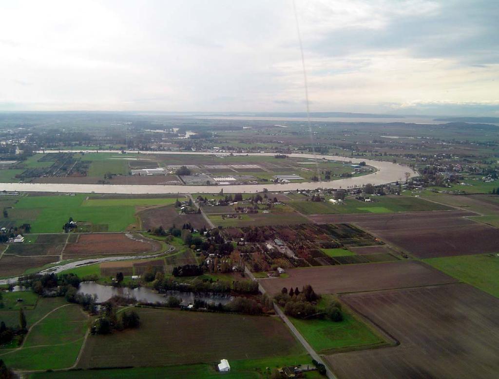
1 Skagit River Revised Flood Insurance Study Levee Scenario Discussion Ted Perkins, Hydraulic Engineer US Army Corps of Engineers, Seattle District 8/9/2007
2 Skagit Levee Failure Scenarios Challenges of Defining Levee Failures FEMA Regulations Implementation of Regulations Comparison to Actual Observations


3 Past Skagit River Levee Failures

4 Isolated Levee Failures

5 Systemwide Levee Failures

6 General FEMA Levee Failure Policy
7 General FEMA Levee Failure Policy If the subject levee does not meet the requirements stated in Section of the NFIP regulations, as verified by the RPO, the Mapping Partner shall recompute the 1-percent-annualchance flood elevations as if the levee did not exist. (page H-11) H
8 One Levee System
9 General FEMA Levee Failure Policy The above procedures for the determination of BFEs and regulatory floodways also apply to the conditions where levees exist on both sides of the stream. In these cases, the evaluation shall include the possibility of simultaneous levee failure, failure of only the left side, and failure of only the right side, and shall consider simultaneous levee failure for both the BFE and regulatory floodway computations. The Mapping Partner shall contact the RPO for guidance on the evaluation of levee systems under these circumstances. (page H-12) H
10 Levees on Both Sides of the River
11 Levees Inundated
12 General FEMA Levee Failure Policy For levee systems where an area of land may be totally or partially surrounded by levees or where two or more flooding sources join that have levees on both sides of the stream, the Mapping Partner that is performing the analysis shall contact the RPO before proceeding with any analyses for levee failures. For these complex situations, the flood hazard in the area that would have been protected by the non-failed levee(s) must be based on selection of failure scenarios that yield the highest BFE or flood hazard. (page H-12) H
13 Surrounded by Levees
14 Levee Scenarios
15 All Levees Intact

16 All Levees Intact
17 Right Bank Levees Removed Burlington to Samish and Padilla Bays Dark Blue Area
18 Right Bank Levees on Mainstem and North Fork Skagit River Removed While All Other Levees Remain Intact

19 Right Bank Levees on Mainstem and North Fork Skagit River Removed While All Other Levees Remain Intact

20 Right Bank Levees Removed Flowpaths
21 Flowpath 1 Burlington Area (Page 60) FEDERAL EMERGENCY MANAGEMENT AGENCY SKAGIT COUNTY, WA FLOOD PROFILES SKAGIT RIVER DELTA, OVERBANK FLOW PATH LEGEND 500-YEAR FLOOD YEAR FLOOD 50-YEAR FLOOD GROUND ELEVATION CROSS SECTION LOCATION OVERBANK FLOWPATH DISTANCE IN FEET ABOVE POINT OF BIFURCATION TO FLOW PATHS 2 AND 3 01P ELEVATION (FEET NAVD 88) (AND UNINCORPORATED AREAS) PULVER ROAD FLOW SPLIT TO FLOW PATHS 2 AND 3 I-5 BURLINGTON NORTHERN RAILROAD S ANACORTES AVENUE N GARDNER ROAD & E FAIRHAVEN AVE START OF OVERBANK FLOWPATH 1 AT RM


22 Levee Failures 1917
23 Levee Failures 1917
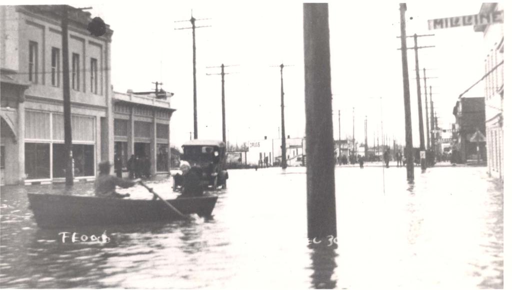
24 Burlington 1917


25 Levee Failures 1909 and 1921

26 Levee Failures 1909

27 Levee Failures 1921
28 Newspaper Documentation Burlington Concrete Herald 12/17/1921 The entire city of Burlington was flooded to a depth of from three to five feet Concrete Flow = 240,000 cfs Skagit County Courier 12/2/1909 The water broke the dykes guarding Burlington and almost the entire town was flooded. In the residence districts the water was over eight feet deep in places. Concrete Flow = 260,000 cfs
29 FEDERAL EMERGENCY MANAGEMENT AGENCY SKAGIT COUNTY, WA FLOOD PROFILES SKAGIT RIVER DELTA, OVERBANK FLOW PATH Flowpath 2 Samish Area (Page 61) LEGEND YEAR FLOOD YEAR FLOOD 50 - YEAR FLOOD GROUND ELEVATION CROSS SECTION LOCATION STREAM DISTANCE IN FEET FROM SAMISH BAY 02P ELEVATION (FEET NAVD 88) (AND UNINCORPORATED AREAS) 30 SAMISH BAY SUNSET ROAD FIELD ROAD ALLEN WEST ROAD 20 10
30 Newspaper Documentation Samish Mount Vernon Argus 12/15/1921 In some of the houses in the Samish flats water was 6 or 7 feet and the occupants were forced to move to the second story. Concrete Flow = 240,000 cfs
31 Left Bank Levees Removed Mount Vernon to Stanwood Brown Area

32 Left Bank Levees on Mainstem and South Fork Skagit River Removed While All Other Levees Remain Intact

33 Left Bank Levees on Mainstem and South Fork Skagit River Removed While All Other Levees Remain Intact

34 Left Bank Levees on Mainstem and South Fork Skagit River Removed While All Other Levees Remain Intact
35 FEDERAL EMERGENCY MANAGEMENT AGENCY SKAGIT COUNTY, WA FLOOD PROFILES SKAGIT RIVER, OVERBANK FLOW PATH Flowpath 5 Conway Area (Page 67) LEGEND YEAR FLOOD YEAR FLOOD 50 - YEAR FLOOD GROUND ELEVATION CROSS SECTION LOCATION STREAM DISTANCE IN FEET FROM LEVEE AT STILLAGUAMISH RIVER 08P ELEVATION (FEET NAVD 88) (AND UNINCORPORATED AREAS) 30 SKAGIT COUNTY LINE MILLTOWN ROAD CONWAY FIR ISLAND ROAD W JOHNSON ROAD
36 Levee Failures 1951

37 Levee Failures 1951

38 Conway 1951
39 Newspaper Documentation Conway Mount Vernon Argus 12/15/1951 Conway residents declared the 1951 flood was two feet, 10 inches below the 1921 inundation in their community... Concrete Flow = 139,000 cfs Mount Vernon Flow = 144,000 cfs
40 Fir Island Red, Pink and Light Blue Areas
41 Fir Island Levees Removed While All Other Levees Remain Intact

42 Fir Island Levees Removed While All Other Levees Remain Intact
43 South Fork Skagit River Right Bank Levee Removed While All Other Levees Remain Intact
44 South Fork Skagit River Right Bank Levee Removed While All Other Levees Remain Intact
45 North Fork Skagit River Left Bank Levees Removed While All Other Levees Remain Intact
46 North Fork Skagit River Left Bank Levees Removed While All Other Levees Remain Intact

47 Fir Island Flowpath
48 Flowpath 4 Fir Island Area (Page 65) FEDERAL EMERGENCY MANAGEMENT AGENCY SKAGIT COUNTY, WA FLOOD PROFILES SKAGIT RIVER, OVERBANK FLOW PATH LEGEND YEAR FLOOD YEAR FLOOD 50 - YEAR FLOOD GROUND ELEVATION CROSS SECTION LOCATION STREAM DISTANCE IN FEET ABOVE COASTAL LEVEE AT SKAGIT BAY 06P ELEVATION (FEET NAVD 88) (AND UNINCORPORATED AREAS) COASTAL LEVEE AT SKAGIT BAY MANN ROAD FIR ISLAND ROAD POLSON ROAD MOORE ROAD START OF FLOW PATH 4 FIR ISLAND AT SPLIT INTO TWO FORKS 10


49 Fir Island 1949 Flood

50 Fir Island 1990 Flood

51 Fir Island 1990 Flood
52 Newspaper Documentation Fir Island Seattle Times 11/13/1990 Seattle Times 11/13/1990 Workers have punched a hole in a dike to drain flooded Fir Island but water from the raging North Fork of the Skagit River is filling the island faster than the water can leave Water is reportedly as deep as 10 feet That break sent a wall of water 10 feet high over fertile farm land Waves were 8 to 10 feet high He estimates he has 9 to 10 feet of water at his house. Concrete Flow = 149,000 cfs Mount Vernon Flow = 142,000 cfs
53 Big Bend Area Yellow Area
54 All Left Bank Levees Removed with Right Bank Levees Intact
55 All Left Bank Levees Removed with Right Bank Levees Intact

56 Big Bend Flow Path
57 FEDERAL EMERGENCY MANAGEMENT AGENCY SKAGIT COUNTY, WA FLOOD PROFILES SKAGIT RIVER, OVERBANK FLOW PATH Flow Path 6 Big Bend OVERLAND DISTANCE IN FEET FROM LOWER BEND TO RIVERSIDE BRIDGE LEGEND YEAR FLOOD YEAR FLOOD 50 - YEAR FLOOD 1984 FIS 100-YEAR GROUND ELEVATION CROSS SECTION LOCATION P ELEVATION (FEET NAVD 88) (AND UNINCORPORATED AREAS) 20 RE-ENTRY AT RM 13.8 I-5 RIVERSIDE DRIVE START OF FLOW PATH 6
58 1917 Levee Failures

59 1917 Levee Failures
60 Newspaper Documentation Big Bend North Mount Vernon Burlington Journal 1/4/1918 The Riverside district south of the river on the Pacific highway to Mt. Vernon s limits suffered The highway was under from two to ten feet of water Mount Vernon Herald 1/3/1918 The Riverside section was badly hit, in some places as much as fifteen feet of water covered the ranch property. Concrete Flow = 220,000 cfs
61 Base Flood Elevation Map
62 Questions/Comments/Concerns?
Appendix E Preliminary Location Hydraulic Study
 Appendix E Prepared for: State of Alaska Department of Transportation and Public Facilities Prepared by: HDR Alaska, Inc. 2525 C Street, Suite 305 Anchorage, Alaska 99503 February 2014 This page intentionally
Lower Meramec Multi-Jurisdictional Floodplain Management Plan Public Involvement (Results of Early Public Engagement) 27 June 2018
 27 June 2018") Lower Meramec Multi-Jurisdictional Floodplain Management Plan Public Involvement (Results of Early Public Engagement) 27 June 2018 Public Involvement Summary: The planning process includes opportunities
Lower Meramec Multi-Jurisdictional Floodplain Management Plan Public Involvement (Results of Early Public Engagement) 27 June 2018 Public Involvement Summary: The planning process includes opportunities
Fisher Slough Tidal Marsh Restoration Project Scaling Down the Restoration Planning & Analysis Framework to Evaluate Project Alternatives
 Fisher Slough Tidal Marsh Restoration Project Scaling Down the Restoration Planning & Analysis Framework to Evaluate Project Alternatives Project Sponsor/Partners The Nature Conservancy Dike District #3
8.5 FLOODING. Environmental Setting
 8.5 FLOODING This section evaluates flooding impacts associated with the proposed General Plan, including whether implementing the plan will: (1) permit the construction of housing within a 100-year Flood
MEMORANDUM. September 10, 2018
 September 10, 2018 MEMORANDUM TO: Chad Bird, City of Decorah FROM: Larry Weber and Dan Gilles, Iowa Flood Center, IIHR Hydroscience & Engineering COPY TO: Dana Werner, St. Paul District Corps of Engineers,
KYTC and NFIP: Bridging Floodplain Management and Design KAMM CONFERENCE AUGUST 25, 2015
 KYTC and NFIP: Bridging Floodplain Management and Design KAMM CONFERENCE AUGUST 25, 2015 KYTC STATEWIDE DRAINAGE DESIGN Provide Drainage Design Services on an as needed basis: Perform hydraulic analysis
Existing Conditions and Environmental Consequences Floodplains
 3.9 Environmental Consequences 3.8 3.8.1 WHAT ARE FLOODPLAINS? are low-lying areas adjacent to rivers, streams, and other waterbodies that are susceptible to inundation (flooding) during rain events. These
What Can We Do to Reduce the Impact of Floods? Joe Barron, P.E. Fletcher Group, Inc. 148 River St. Suite 220 Greenville, S.C.
 What Can We Do to Reduce the Impact of Floods? Joe Barron, P.E. Fletcher Group, Inc. 148 River St. Suite 220 Greenville, S.C. 29601 1 Historical highlights of flood management attempts 1726 first New Orleans
NAI Principles In Gwinnett County
 NAI Principles In Gwinnett County By Cornelius Ani, LSIT, CFM Contributors: Adena Fullard, P.E., CPSWQ Rudresh Bihalli, P.E., CFM Ken Kagy, P.E., CPESC, CPSWQ Ligia Negru, M. Sc., CFM Maja Radovic, CPESC,
Santa Cruz River Master Plan. Presented to the Arizona Floodplain Management Association Spring Conference June 8-10, 2011
 Santa Cruz River Master Plan Presented to the Arizona Floodplain Management Association Spring Conference June 8-10, 2011 Introduction Who is FICO? 2 Project Team Kimley-Horn and Associates, Inc. River
September 7, Mr. Brant Gary Director of Public Works City of Bellaire 7008 S. Rice Avenue Bellaire, Texas 77401
 September 7, 2016 Mr. Brant Gary Director of Public Works City of Bellaire 7008 S. Rice Avenue Bellaire, Texas 77401 Re: City of Bellaire, Texas FY 2016 Drainage Study Dear Mr. Gary: ARKK Engineers, LLC
CRITICALFACILITIESASSESSMENT IN SOUTHEASTERN CONNECTICUT STRATEGIES FOR ALL HAZARDS RESILIENCE
 CRITICALFACILITIESASSESSMENT IN SOUTHEASTERN CONNECTICUT STRATEGIES FOR ALL HAZARDS RESILIENCE Presented by: David Murphy, P.E., CFM, Milone & MacBroom, Inc. October 25, 2017 Agenda Project Background
NYC DEP s Approach to Flood Mitigation: The Local Flood Analysis (LFA) Process
 Process") NYC DEP s Approach to Flood Mitigation: The Local Flood Analysis (LFA) Process Milone & MacBroom, Inc. Jenabay Sezen, EIT Connecticut Association of Floodplain Managers October 25, 2016 Agenda Introduction
NYC DEP s Approach to Flood Mitigation: The Local Flood Analysis (LFA) Process Milone & MacBroom, Inc. Jenabay Sezen, EIT Connecticut Association of Floodplain Managers October 25, 2016 Agenda Introduction
WARSAW WAL-MART EXPANSION FLOODPLAIN EVALUATION STUDY
 WARSAW WAL-MART EXPANSION FLOODPLAIN EVALUATION STUDY BERGMANN ASSOCIATES NOVEMBER 20, 2008 (revised June 8, 2009) TOWN OF WARSAW, WYOMING COUNTY, NEW YORK Memorandum To: Jack Buholtz, PE From: Kenneth
AGENCY: Federal Emergency Management Agency, DHS. SUMMARY: Flood hazard determinations, which may include additions or
 This document is scheduled to be published in the Federal Register on 05/15/2014 and available online at http://federalregister.gov/a/2014-11139, and on FDsys.gov 1 Billing Code 9110-12-P DEPARTMENT OF
WEATHER IT TOGETHER Building Resilience. The Annapolis Model for Cultural Resource Hazard Mitigation Planning
 WEATHER IT TOGETHER Building Resilience The Annapolis Model for Cultural Resource Hazard Mitigation Planning Weather It Together A Public / Private Partnership Weather It Together is the Annapolis model
LEGAL & POLICY ANALYSIS TO SUPPORT RESILIENCE MEASURES. CEEL Tasks
 LEGAL & POLICY ANALYSIS TO SUPPORT RESILIENCE MEASURES William R. Rath, Esq. Legal Research Fellow Center for Energy & Environmental law University of Connecticut School of Law 860-570-5058 William.Rath@
MEMORANDUM AGENDA ITEM #IV.C
 MEMORANDUM AGENDA ITEM #IV.C DATE: NOVEMBER 27, 2017 TO: FROM: COUNCIL MEMBERS STAFF SUBJECT: LOCAL GOVERNMENT COMPREHENSIVE PLAN PROPOSED AND ADOPTED AMENDMENT CONSENT AGENDA Pursuant to Section 163.3184,
City of Elmhurst. Comprehensive Flood Plan. City of Elmhurst. City Council Meeting September 15, 2014
 City of Elmhurst City of Elmhurst Comprehensive Flood Plan City Council Meeting September 15, 2014 City of Elmhurst Presentation Overview Study Background Study Methodology Analysis of Three Additional
Small Town Sustainable Stormwater Solutions
 Small Town Sustainable Stormwater Solutions Kathryn Hamilton, RLA, ASLA Westmoreland Conservation District PA/DE ASLA Annual Meeting April 8-9, 8 2011 Urban, Industrial, Residential, Agricultural Flooding,
Floodplain Discipline Report
 Floodplain Discipline Report Duportail Street Bridge Project Benton County, Washington Prepared for: Federal Highway Administration 711 South Capitol Way, Suite 501 Olympia, WA 98501 Washington State Department
3.7. NEW JERSEY % 6.3% 2.0. Completed Yes Procedural Recommen dation
 C OST E FFICIENT C LIMATE A DAPTATION IN THE N ORTH A TLANTIC 135 3.7.1. LITTLE SILVER, NJ 3.7. NEW JERSEY Population Density Form of Government Category CRS Rating 2226/ sq. mi. Borough Suburban Bayfront
NOTICE OF PREPARATION
 NOTICE OF PREPARATION To: All Interested Parties Subject: Notice of Preparation of an Environmental Impact Report From: City of Petaluma Address: 11 English Street, Petaluma, CA 94952-2610 Contact: Heather
PICAYUNE STRAND RESTORATION PROJECT
 PICAYUNE STRAND RESTORATION PROJECT An accelerated design/build restoration of the world s largest sub-division US ARMY CORPS OF ENGINEERS JACKSONVILLE DISTRICT Golden Gate Estates Map showing grid of
Riparian Buffer on the Bushkill Creek. Policies
 Riparian Buffer on the Bushkill Creek Riparian buffers provide numerous benefits to landowners and the community by protecting groundwater recharge areas, providing flood control, providing stormwater
Project Location. Jay and Patty Baker Park and Gordon River Greenway Connector Bridge. Naples Beach Golf Club. Gordon River. East. Naples.
 Gordon River Project Location Naples Beach Golf Club East Naples Naples Naples Bay Evergreen Golf and Country Club and Gordon River Greenway Connector Bridge Gordon River Greenway CONNECTOR BRIDGE AND
Understanding Drainage Options What s Feasible and Legal. February 2019
 Understanding Drainage Options What s Feasible and Legal February 2019 Outline for the Presentation Do you need a permit? Does common law apply? Does local government approve it? Will my neighbor allow
Welcome. Northern Segment of Hwy 100 I-90 to South of Madison Street Meeting Goals:
 Welcome Northern Segment of Hwy 100 I-90 to South of Madison Street Meeting Goals: - Review Environmental Assessment - Share Preferred Alternative -Receive Public Comments 2003 EA Preferred Alternative
PROJECT SCOPE OF WORK CITY OF TOWN AND COUNTRY STORMWATER PROGRAM
 PROJECT SCOPE OF WORK CITY OF TOWN AND COUNTRY STORMWATER PROGRAM Project Name: 362 Featherstone Dr Project ID Number: 27-3 Problem: Anecdotal evidence suggests a natural spring exists in the backyard
Empowering Local Action for Coastal Resilience in Massachusetts. Bruce K. Carlisle MA Office of Coastal Zone Management
 Empowering Local Action for Coastal Resilience in Massachusetts Bruce K. Carlisle MA Office of Coastal Zone Management Context Coastal communities continue to face both chronic and acute storm surge, erosion,
AGENCY: Federal Emergency Management Agency, DHS. SUMMARY: Flood hazard determinations, which may include additions or
 This document is scheduled to be published in the Federal Register on 08/18/2016 and available online at http://federalregister.gov/a/2016-19659, and on FDsys.gov 1 Billing Code 9110-12-P DEPARTMENT OF
Hydrology And Floodplain Analysis 5th Edition Solution
 We have made it easy for you to find a PDF Ebooks without any digging. And by having access to our ebooks online or by storing it on your computer, you have convenient answers with hydrology and floodplain
1. Project Description
 To: By: Checked By: Jimmy Vilce, E.I. (FOT istrict 1 Project Manager) Jennifer Nunn, P.E. (The Balmoral Group) Lori Stanfill, P.E. (The Balmoral Group) Memorandum ate: July 10, 2018 Subject: In May of
Nevada Floodplain Management Program
 Nevada Floodplain Management Program Mt Rose Highway-NHP February 2017 - Courtesy NWS Reno East Fork Carson River January 2017 Douglas County, NV - Courtesy Courtney Walker I 15, Overton 9/10/14 Rye Patch
Structural Project (stream daylighting) Property Protection (elevation) PREVENTION NATURAL RESOURCE PROTECTION STRUCTURAL PROJECTS PUBLIC EDUCATION
 Property Protection (elevation) PREVENTION NATURAL RESOURCE PROTECTION STRUCTURAL PROJECTS PUBLIC EDUCATION") NEW MITIGATION GOALS, STRATEGIES, ACTIONS PREVENTION STRUCTURAL PROJECTS NATURAL RESOURCE Structural Project (stream daylighting) PROPERTY PUBLIC EDUCATION EMERGENCY SERVICES Property Protection (elevation)
NEW MITIGATION GOALS, STRATEGIES, ACTIONS PREVENTION STRUCTURAL PROJECTS NATURAL RESOURCE Structural Project (stream daylighting) PROPERTY PUBLIC EDUCATION EMERGENCY SERVICES Property Protection (elevation)
WASHINGTON COUNTY OREGON
 WASHINGTON COUNTY OREGON LONG RANGE PLANNING DIVISION North Bethany Subarea Stream Corridors: Existing Regulations In Oregon, there is a distinct difference between the land use rules that apply in rural
AGENCY: Federal Emergency Management Agency, DHS. SUMMARY: Flood hazard determinations, which may include additions or
 This document is scheduled to be published in the Federal Register on 07/27/2016 and available online at http://federalregister.gov/a/2016-17739, and on FDsys.gov 1 Billing Code 9110-12-P DEPARTMENT OF
FLOODPLAIN USE PERMIT APPLICATION COMMUNITY DEVELOPMENT DEPARTMENT W. Ten Mile Road Novi, MI (248)
") FLOODPLAIN USE PERMIT APPLICATION COMMUNITY DEVELOPMENT DEPARTMENT 45175 W. Ten Mile Road Novi, MI 48375 (248) 347-0415 Office Use Only Permit Number: Date Issued: Processed By: Type of Permit: Date: Project
FLOODPLAIN USE PERMIT APPLICATION COMMUNITY DEVELOPMENT DEPARTMENT 45175 W. Ten Mile Road Novi, MI 48375 (248) 347-0415 Office Use Only Permit Number: Date Issued: Processed By: Type of Permit: Date: Project
MUNICIPAL RESILIENCE PLANNING ASSISTANCE PROJECT
 MUNICIPAL RESILIENCE PLANNING ASSISTANCE PROJECT William R. Rath, Esq. Legal Research Fellow Center for Energy & Environmental law University of Connecticut School of Law 860-570-5058 William.Rath@ UConn.edu
G A R Y G R E E N L I N K APPENDIX A
 G A R Y G R E E N L I N K M A S T E R P L A N 1 American Bridge Property data American Bridge Property Manager 2 Little Calumet-Galien River Watershed Study Applied Ecological Services, Inc. 3 Final Assessment
City of Norfolk Coastal Flood Mitigation Program. March 13, 2013
 City of Norfolk Coastal Flood Mitigation Program March 13, 2013 Topics Brief overview of Norfolk s Coastal Flood Program Data-driven analysis and decision making City-wide vulnerability, project concepts,
17.1 INTRODUCTION CONTEXT CONCLUSIONS
 CHAPTER 17. FLOODPLAIN 17.1 INTRODUCTION 17.1.1 CONTEXT A floodplain is part of an extensive drainage and filtration system and water cycle that serves to contain flood waters from storms. Floodplain areas
Chesapeake Bay Critical Area Conservation Plan
 The Maryland-National Capital Park and Planning Commission Prince George s County Planning Department Development Review Division 301-952-3530 Note: Staff reports can be accessed at www.mncppc.org/pgco/planning/plan.htm.
Turkey Creek Streamway Corridor
 Turkey Creek Streamway Corridor Turkey Creek Corridor Overview History Watershed Corridor Inventory Coalition Corridor Plan Stages of Development Benefits Funding Turkey Creek History Kansas and Missouri
Floodplain Technical Memorandum
 Southeast Extension Project Lincoln Station to RidgeGate Parkway Prepared for: Federal Transit Administration Prepared by: Denver Regional Transportation District May 2014 Table of Contents Page No. Chapter
The Effects of Woody Vegetation on Levees
 The Effects of Woody Vegetation on Levees Maureen K. Corcoran Assistant Technical Director, Water Resources Infrastructure Vicksburg, MS 26 February 2010 US Army Corps of Engineers Problem Statement What
BASS PONDS, MARSH, & WETLAND HABITAT RESTORATION PROJECT
 FACT SHEET BASS PONDS, MARSH, & WETLAND HABITAT RESTORATION PROJECT MINNESOTA VALLEY NATIONAL WILDLIFE REFUGE, MINNESOTA ENVIRONMENTAL MANAGEMENT PROGRAM LOCATION Three areas located on the Minnesota Valley
PROJECT SCOPE OF WORK CITY OF TOWN AND COUNTRY STORMWATER PROGRAM
 PROJECT SCOPE OF WORK CITY OF TOWN AND COUNTRY STORMWATER PROGRAM Project ID Number: 25-5 Problem: Stormwater collected from the neighborhood upstream is released at 9 Muirfield Lane and flows west toward
Lincoln 270. City of Lincoln. Stormwater Management Plan. April 2, 2013
 Lincoln 270 City of Lincoln Stormwater Management Plan April 2, 2013 # 2005.48 Prepared By: Civil Engineering Solutions, Inc. 590 E Street Lincoln, Ca 95648 (916) 645 5700 1.0 Background: The project site
NORTH KINGSTOWN PILOT PROJECT May 9, 2016 North Kingstown Town Council
 Engaging RI Local Governments in Hazard Mitigation and Coastal Resilience NORTH KINGSTOWN PILOT PROJECT May 9, 2016 North Kingstown Town Council Teresa A. Crean, AICP University of Rhode Island Coastal
U.S. Army Corps of Engineers, Los Angeles District Prado Basin Project Updates
 U.S. Army Corps of Engineers, Los Angeles District Prado Basin Project Updates Host: Inland Empire Utilities Agency January 19, 2017 10:00 a.m. Purpose: To provide project overviews and updates to regional
Rhode Island Shoreline Change Special Area Management Plan
 Rhode Island Shoreline Change Special Area Management Plan Draft Document Outline REVISED 10/12/2017 VOLUME 1 Executive Summary & How to Use this Document (Draft by Dec 2017) 1. Introduction (Revised draft
Shoreline Master Program Town of La Conner, Washington
 Shoreline Master Program Town of La Conner, Washington Department of Ecology approval effective Adopted September 24, 2013 by Town of La Conner Ordinance No.1106 Amended May 13, 2014 by Town of La Conner
South Bismarck Watershed Model Update and Stormwater Improvement Project
 Preliminary Engineering Report Bismarck Tribune South Bismarck Watershed Model Update and Stormwater Improvement Project City of Bismarck, ND January 2017 14.105.0046 1.0 Executive Summary The focus of
Northern Branch Corridor DEIS December 2011
 16 Floodplains 161 Chapter Overview 1611 Introduction The flowing chapter identifies floodplains found within the Northern Branch Corridor in accordance with Executive Order 11988, Floodplain Management
Arroyo Grande Creek Flood Control Channel Vegetation Management: A Photo Series
 Arroyo Grande Creek Flood Control Channel Vegetation Management: A Photo Series The Way It Was For several decades, all vegetation growth was discouraged in the AG Creek flood control channel, as shown
Draft Rhode Island Stormwater Design and Installation Standards Manual
 Draft Rhode Island Stormwater Design and Installation Standards Manual Summary The May 2009 Public Review Draft version of the RI Stormwater Design and Installation Standards Manual consists of approximately
Hazard Mitigation Planning. Association of New Jersey Environmental Commissions Workshop Edison, New Jersey October 20, 2012
 Hazard Mitigation Planning Association of New Jersey Environmental Commissions Workshop Edison, New Jersey October 20, 2012 Mitigation Planning NJ Hazard Mitigation Plan? What is the status of the HMP
PURPOSE: The purpose is to provide commercial facilities in the Vancouver and Clark County vicinity.
 US Army Corps of Engineers Seattle District Joint Public Notice Application for a Department of the Army Permit and a Washington Department of Ecology Water Quality Certification and/or Coastal Zone Management
Improvement of the Atlantic Coast of New York City,
 Improvement of the Atlantic Coast of New York City, Rockaway Inlet to Norton Point Project at Sea Gate Meeting Purpose The U.S. Army Corps of Engineers, the New York State Department of Environmental Conservation,
Growing Community Gardens A Partnership Between WSU Skagit County Extension Master Gardeners and Local Community Gardens
 Growing Community Gardens A Partnership Between WSU Skagit County Extension Master Gardeners and Local Community Gardens Growing Community Gardens provides education on sustainable gardening practices
PCE PRELIMINARY DRAINAGE ANALYSIS REPORT FOR WESTWOOD MIXED USE NEIGHBORHOOD PROJECT 772 NORTH FOREST ROAD TOWN OF AMHERST, ERIE COUNTY, NEW YORK
 PCE PRELIMINARY DRAINAGE ANALYSIS REPORT FOR WESTWOOD MIXED USE NEIGHBORHOOD PROJECT 772 NORTH FOREST ROAD TOWN OF AMHERST, ERIE COUNTY, NEW YORK MAY 19, 2014 Prepared By: Timothy M. Lavocat, P.E., CFM
Chapter 5: Recreation
 Chapter 5: Recreation Introduction and Setting Recreational opportunities within Nevada County are varied, ranging from public parks with intensively used active recreational facilities, to vast tracts
Virginia Pilot. Climate Change Vulnerability and Risk Assessments of Transportation Infrastructure Hampton Roads, Virginia Implementation Pilot
 Virginia Pilot Climate Change Vulnerability and Risk Assessments of Transportation Infrastructure Hampton Roads, Virginia Implementation Pilot Yao-Jan Wu Andres Clarens Tanveer Hayat Brian Smith Jose Gomez
Planning for Historic/Cultural Resources Coastal Resiliency in Connecticut. Presented to CAFM s 3 rd Annual Conference
 Planning for Historic/Cultural Resources Coastal Resiliency in Connecticut Presented to CAFM s 3 rd Annual Conference October 25, 2016 Agenda Introduction and Project Overview Background Historic and Cultural
Hydraulic analysis marks start of rebuilding after bridge collapse
 Hydraulic analysis marks start of rebuilding after bridge collapse By Tawny Quast The remains of the I-35W Bridge shortly after the collapse. On August 1, 2007, the I-35W bridge over the Mississippi River
City of Meriden Harbor Brook Flood Control Project Overview
 City of Meriden Harbor Brook Flood Control Project Overview Updated August 2013 OVERVIEW The center of Meriden, including the HUB site is the low point of the town which is ringed by basalt ridges. Running
Chapter 5: Natural Resources and Environment
 NATURAL RESOURCES AND ENVIRONMENT 5-1 5 Chapter 5: Natural Resources and Environment BACKGROUND AND INTENT Urban expansion represents the greatest risk for the future degradation of existing natural areas,
APPENDIX E. Flood Plain Management
 APPENDIX E Flood Plain Management The Comprehensive Plan incorporates policies of the City s Drainage and Flood Plain Management Plans with the long-term goals of the City. This Appendix provides an overview
Table of Contents G.1.a Water Resources - Surface Water - Drainage
 Table of Contents G.1.a Water Resources - Surface Water - Drainage 1. INTRODUCTION... 1335 2. ENVIRONMENTAL SETTING... 1335 a. Regional Hydrology... 1335 b. Local Hydrology... 1337 c. On-site Hydrology...
Peoria Riverfront Development (Ecosystem Restoration) Upper Mid-sized Island Critical Restoration Project (September 2011)
 Upper Mid-sized Island Critical Restoration Project (September 2011)") Peoria Riverfront Development (Ecosystem Restoration) Upper Mid-sized Island Critical Restoration Project (September 2011) Description The Corps of Engineers, Rock Island District (District) and the Illinois
Peoria Riverfront Development (Ecosystem Restoration) Upper Mid-sized Island Critical Restoration Project (September 2011) Description The Corps of Engineers, Rock Island District (District) and the Illinois
The Napa River Flood Protection Project
 The Napa River Flood Protection Project Creating Flood Protection and Restoring Geomorphic and Biological Processes Jeremy Sarrow, Napa County Flood Control & Water Conservation District June 2, 2014.
SOILS BACKYARD CONSERVATION
 SOILS 2015.03.25 BACKYARD CONSERVATION WORKING LANDSCAPES PLLC Working Landscapes PLLC offers landscape architectural and irrigation design services, with an emphasis on sustainable technologies and techniques.
Coastal Planning in Texas. Tony Williams Senior Director of Planning Coastal Resources Division Texas General Land Office
 Coastal Planning in Texas Tony Williams Senior Director of Planning Coastal Resources Division Texas General Land Office e The Texas General Land Office (GLO) and the Texas Coast Since 1836: Manager of
Russ J. Joffrion, P.E. Whitney Thompson, P.E.
 A Case Study and Logistics Review on the Design and Construction of the Bayou Dupont Mississippi River Sediment Marsh Creation Project Jefferson and Plaquemines Parishes, LA Russ J. Joffrion, P.E. Whitney
ALDI STORE #17 EXPANSION LAND DEVELOPMENT PLAN
 STORE #17 EXPANSION LAND DEVELOPMENT PLAN 190 W. LINCOLN HIGHWAY, WEST WHITELAND TOWNSHIP COUNTY OF CHESTER, PENNSYLVANIA PROJECT CONTACTS GOVERNMENTAL APPROVAL AGENCIES TOWNSHIP OF WEST WHITELAND 101
Physical Map Revision Flood Insurance Study
 Physical Map Revision Flood Insurance Study Collin County, Texas Over the Shoulder Review Meeting Draft Floodplain Mapping 1 October 26, 2011 Presentation Overview Introductions and Sign in Meeting Purpose
Site Option 3: Te Matai
 Site Option 3: Te Matai Location Napier Drain looking south east Description The Te Matai growth option is located between the existing residential boundary (Ruamahanga Crescent) Napier Road (State Highway
West London Dyke, April 1947 Flood. Forks of the Thames, July 2000 Flood. Source: UTRCA
 This Public Information Centre is the 1 st of 2. Its purpose is to inform the public and to receive input with regards to the West London Dyke Master Repair Plan. The following panels describe the history,
3.0 Cumulative Scenario and Methodology. 3.0 Cumulative Scenario and Methodology
 3.0 Cumulative Scenario and Methodology Under the CEQA Guidelines, a cumulative impact consists of an impact which is created as a result of the combination of the project evaluated in the environmental
City of Elmhurst. City of Elmhurst. Storm Sewer System Workshop November 22, 2010
 City of Elmhurst City of Elmhurst Storm Sewer System Workshop November 22, 2010 1 City of Elmhurst Watershed divide (green dashed line) through Elmhurst Area east of divide drains to Addison Creek Area
Richton Park Western Development Corridor Green Infrastructure Development Plan August 18, 2017
 Richton Park Western Development Corridor Green Infrastructure Development Plan August 18, 2017 Conservation Design Forum Geosyntec Consultants 403 W. St. Charles Road 1420 Kensington Road, Suite 103 Lombard,
13. PRELIMINARY PLAT NO MILLS FARM - Vicinity of the southeast corner of 159 th Street and Quivira Road
 13. corner of 159 th Street and Quivira Road 1. APPLICANT: HNTB Corporation is the applicant for this request. 2. REQUESTED ACTION: The applicant is requesting approval of a preliminary plat for a 383-lot
-MENDOCINO COUNTY PLANNING AND BUILDING SERVICES- DIVISION II OF TITLE 20--COASTAL ZONING CODE
 CHAPTER 20.504 VISUAL RESOURCE AND SPECIAL TREATMENT AREAS Sec. 20.504.005 Applicability. Sec. 20.504.010 Purpose. Sec. 20.504.015 Highly Scenic Areas. Sec. 20.504.020 Special Communities and Neighborhoods.
Poisoned Park? How Exide s Lead Contamination Risks Frisco s Grand Park
 Frisco City Hall has big plans to transform Stewart Creek into a Grand Park with lots of water features for kids to play in. Poisoned Park? How Exide s Lead Contamination Risks Frisco s Grand Park But
Overall Map. Chicago. St. Louis. Summit. Joliet. Dwight. Pontiac. Bloomington-Normal Lincoln. Springfield. Carlinville. Alton EXPERIENCE IT YOURSELF.
 Overall Map Summit Chicago Bloomington-Normal Lincoln New Station Planned New Station Planned Dwight Pontiac Joliet Pedestrian overpass and second platform planned Higher speed service began in this section
City of Waco Stormwater Management Regulations
 1.0 Applicability: City of Waco Stormwater Management Regulations These regulations apply to all development within the limits of the City of Waco as well as to any subdivisions within the extra territorial
6.1. INTRODUCTION 6.2. EXISTING CONDITIONS
 Chapter 6: Stormwater Management 6.1. INTRODUCTION This Chapter describes the current drainage patterns on the Project Site, the stormwater management system that is proposed as part of the Proposed Project,
What Planners Do. Heather Wade, Coastal Planning Specialist Texas Sea Grant
 What Planners Do Heather Wade, Coastal Planning Specialist Texas Sea Grant What Planners Do Seminar Series Department of Landscape Architecture and Urban Planning College of Architecture ABOUT ME B.S.
Wisconsin downtown action council Downtown project case study profile
 Wisconsin downtown action council Downtown project case study profile Project Name Onalaska Waterfront Project Location City of Onalaska Project Type (check all that apply) g Residential g Commercial g
University Parkway Corridor Plan. Public Workshop Sept. 18, 2017
 University Parkway Corridor Plan Public Workshop Sept. 18, 2017 AGENDA 1. Overview of Process 2. Study Area 3. Components of the Plan 4. What We Know 5. What We Have Heard 6. Tonight s Input 7. Next Steps
Village of Forest Park. July 27, Sewer Separation Evaluation
 Village of Forest Park July 27, 2015 Sewer Separation Evaluation Presentation Overview Study Background Historic Nature of Forest Park Drainage Scale of Flooding Problem Forest Park Sewer System Background
SAFARI Meeting Minutes July 10, 2015 AWSMP Office, 3130 State Route 28, Shokan, NY :00am to 12:00pm
 SAFARI Meeting Minutes July 10, 2015 AWSMP Office, 3130 State Route 28, Shokan, NY 12464 10:00am to 12:00pm Members Present: Brent Gotsch, CCEUC Mark Carabetta, MMI Don Brewer, Shandaken Planning Board
Chapter V-Transportation
 Town of Vernon 2026 Smart Growth Plan Chapter V-Transportation DEVELOPMENT OBJECTIVES Transportation System Objective - To provide an integrated transportation system which, through its location, capacity,
City of Shady Cove Riparian Ordinance Ordinance XXX
 1 Updated October 8, 2015 City of Shady Cove Riparian Ordinance Ordinance XXX This language is to be located in Chapter 155 of the Shady Cove Code of Ordinances. This will affect property inside city limits,
Northern Branch Corridor SDEIS March 2017
 14. Water Quality 14.1. Chapter Overview 14.1.1. Introduction This section discusses changes to the potential for activities associated with the development and operation of the Preferred Alternative to
Subject: Source Evaluation Task 2.3 Dry Weather Flows from MS4 Outfalls (2011 Dry Season)
") Memorandum To: From: Rick Whetsel, SAWPA CDM Date: Subject: Source Evaluation Task 2.3 Dry Weather Flows from MS4 Outfalls (2011 Dry Season) Study Purpose In Spring 2011, the TMDL Task Force and CDM initiated
Memorandum To: From: Rick Whetsel, SAWPA CDM Date: Subject: Source Evaluation Task 2.3 Dry Weather Flows from MS4 Outfalls (2011 Dry Season) Study Purpose In Spring 2011, the TMDL Task Force and CDM initiated
V/Jy(Ls(_vtf. City of Richmond. Report to Committee CS To:
 To: City of Richmond Community Safety Committee Report to Committee Date: August 12, 2016 From: John McGowan. Fire Chief, Richmond Fire-Rescue File: 09-5000-01 /2016-Vol 01 Re: Richmond Fire-Rescue Monthly
DIAC Engineering Practice References Index (March 2017 v1.1)
") DIAC Engineering Practice s Index (March 2017 v1.1) CDA ICOLD OTHERS I Controls APEGBC CDA ICOLD MAC OTHERS Inspection 2h 7q Instrumentation 6a, 6g Performance review 2k Emergency preparedness 2l 3f 7a
DIAC Engineering Practice s Index (March 2017 v1.1) CDA ICOLD OTHERS I Controls APEGBC CDA ICOLD MAC OTHERS Inspection 2h 7q Instrumentation 6a, 6g Performance review 2k Emergency preparedness 2l 3f 7a
 BOARD OF ALDERMEN REGULAR SESSION MINUTES COMMUNITY BUILDING JULY 9, 2015 223 E. BAY STREET SOUTHPORT, N.C. PRESENT: ABSENT: STAFF PRESENT: Mayor Robert D. Howard Aldermen Mary Ellen Poole, Buddy Barnes,