The Progress of Rehabilitation. Neil Dale
|
|
|
- June Hudson
- 5 years ago
- Views:
Transcription

1 The Progress of Rehabilitation Neil Dale
2 History Prior to Sept 1990 some mining leases had restore or rehabilitate conditions, others didn t. Sept 1990 May 1995 shall undertake rehabilitation to satisfaction of the Minister. The requirements were defined in EMOS. From May 1995 to January 2001 EMOS was statutory requirement. Post 2001 rehabilitation should comply with Rehabilitation Guideline & EA conditions Original mine site EOs willing to have a go Conducted many trials
3 Out of pit slope Elevated landform Low wall Final void Highwall Open Cut Problem Areas OUTSIDE SLOPES SPOIL LOW WALL SLOPES HIGHWALLS Flood Level
4 Challenges Dispersive material Final Land Use Grazing Bushland / native ecosystem Four general rehabilitation goals: site safety site stability avoidance of adverse impacts off site and ability to sustain an agreed land use


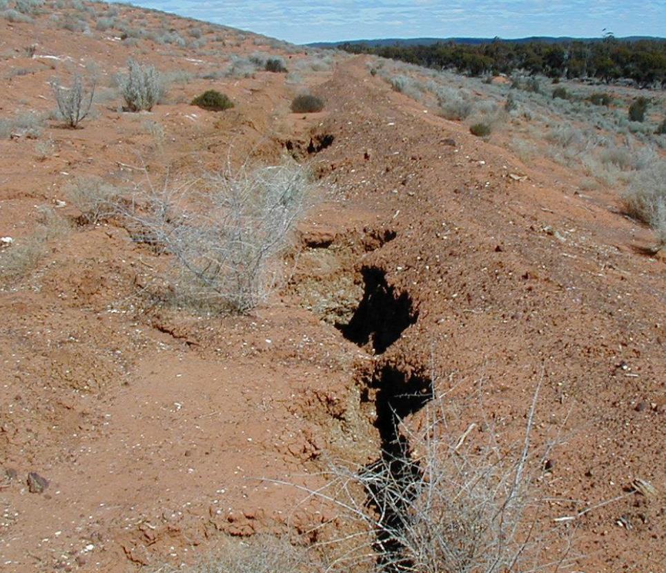
5 Unstable and/or dispersive material
6 Rehabilitation Strategies for Dispersive Spoil in Order of Increasing Risk Rank Strategy Comments Provisos 1 Bury under other spoil Do not locate dispersive spoil at toe of low wall 2 Cover with at least a metre of rocky spoil Select cover material that is able to store and release infiltration without allowing free water to contact the dispersive spoil 3 Topsoil and grass cover (some trees might be introduced later) Select slope angle to avoid sliding failure along the soil/spoil interface when wet. Provide measures to assist erosion control until grass is established. Not Recommended for Tertiary Spoil 4 Trees and shrubs without continuous grass/ground cover High risk of gully erosion 5 Landforms with plateau or batter ponds Ponds only poorly establish vegetation, and allow water to enter landform
7 Contour Banks / benches Contour banks are earthen structures constructed across slopes, at intervals down the slope. They intercept run-off and safely channel it into stable waterways. Their function is to reduce slope length and to intercept runoff before it concentrates into an erosive force. Contour banks play an important role in acting as sediment traps. Up to 80% of the soil moved from a contour bay may be deposited in the contour bank channel.


8 Learn from agriculture?

9 Former contour banks

10 Ponded landforms
11 Successes Australian subsidence case studies in areas of undulating topography and well drained soils have shown negligible effects on broad-acre cropping (wheat, soya beans, lucerne and pasture) and viticulture production. Progressive rehabilitation signed off for initial LW panels at Kestrel returned to grazing. Creek diversions completed according to 2002 ACARP guidelines (adopted by DNRM) heading toward relinquishment. Examples of successful spoil rehabilitation.


12 Creek Diversion


13 Wheat in winter & millet in summer provide rapid ground cover, which is eventually replaced by perennial grasses Spoil Rehab - 3 months & 15 months

14 Final Outer Slope
15 Failures Failure to learn from mistakes. Still constructing engineering structures for final landforms Structures still failing Knowledge sharing and mentoring. Most of the old heads from 80s & 90s gone Wiki ACARP project, may be too little, too late Re-inventing the wheel. Still see sites planned around mining only, then rehabilitation is an add-on. Eg final void located next to diversion only protected by levee.
16 Rehabilitation Progress? The total Bowen Basin coal area disturbed until 2006 was 95,600 ha, of which 26,700 ha had been rehabilitated (DERM 2007). (28%) Currently 156,200 ha disturbed (coal), 29,200 ha rehabilitated. (19%) Total Rehab Liability (coal) - $4.9B ($38.5k/ha) FA after discounts - $4.4B
17 Where to from here Historic rehabilitation (pre 2001) must be evaluated against requirements in place when rehabilitation was completed. If there is an identified objective (eg low intensity grazing) evidence must be provided how objective has been achieved Progressive signoff Progressive Rehabilitation Advisory Committee Evidence that completion criteria met Risk assessment What components at risk of failure Likelihood of failure Consequence of failure
18 Acknowledgements Various ACARP projects CQMRG presentations Gil Fletcher Rob Loch
Urban Conservation Practice Physical Effects ESTABLISHMENT, GROWTH, AND HARVEST NUTRIENT MANAGEMENT
 NOT WELL 800 - Urban Stormwater Wetlands A constructed system of shallow pools that create growing conditions for wetland plants to lessen the impacts of stormwater quality and quantity in urban areas.
PERMANENT SEEDING. Overview of Sedimentation and Erosion Control Practices. Practice no. 6.11
 Overview of Sedimentation and Erosion Control Practices Practice no. 6.11 PERMANENT SEEDING Permanent vegetation controls erosion by physically protecting a bare soil surface from raindrop impact, flowing
Guiding Landowners in Stream Restoration. The Science, Practice & Art of Restoring Native Ecosystems 2015
 Guiding Landowners in Stream Restoration The Science, Practice & Art of Restoring Native Ecosystems 2015 January 24, 2015 Guiding Landowners in Stream Restoration January 24, 2015 Agenda 1Watershed Planning
WQ-23 MOUNTAINOUS AND STEEP SLOPE SITES
 Greenville County Technical Specification for: WQ-23 MOUNTAINOUS AND STEEP SLOPE SITES 1.0 Mountainous and Steep Slope Sites 1.1 Description The geographic locations of portions of Greenville County are
Plan Review Checklist
 Plan Review Checklist FOR EROSION AND SEDIMENT CONTROL PLANS _ Minimum Standards - All applicable Minimum Standards must be addressed. All minimum Standards must be adhered to during the entire project
FINAL AND TEMPORARY REHABILITATION PRINCIPLES. BLOOMFIELD GROUP REPORT 2013 Rix s Creek
 Rix s Creek Lane Singleton NSW 2330 AUSTRALIA PO Box 4 East Maitland NSW 2323 T: 61 2 6578 8888 F: 61 2 6571 1066 ABN 25 003 824 244 FINAL AND TEMPORARY REHABILITATION PRINCIPLES BLOOMFIELD GROUP REPORT
Vegetated Filter Strips and Buffers
 3.15 Sediment Control Description: Buffer strips (existing vegetation) and filter strips (planted vegetation) are sections of vegetated land adjacent to disturbed areas. They are designed with low slopes
4.6. Low Impact and Retentive Grading
 4.6. Low Impact and Retentive Grading Low Impact Grading techniques focus on utilizing existing topography during Site layout to minimize cost. Proposing structures, roads, and other impervious surfaces
Post mine land use plan
 Post mine land use plan Baralaba Coal Mine ML 5065, ML 5580, ML 5581, ML 5582, ML 5590, ML 80157, ML 80169 and ML 80170 Prepared for Cockatoo Coal Limited 8 April 2013 Level 2, 66 Hunter Street Sydney
Land Formation. Field Development
 Land Formation California Rice Production Workshop, v15 Field Development Field development refers to configuring the field shape, surface slope and installation of water control structures to optimize
2017 Iowa FFA Soil Judging CDE Exam
 2017 Iowa FFA Soil Judging CDE Exam 1. Landscape positions vary in soil composition and makeup. What landscape position would be characterized by having strata and lenses of different textures in the profile:
SOIL EROSION AND SEDIMENT CONTROL
 SOIL EROSION AND SEDIMENT CONTROL SECTION 1: AUTHORITY, TITLE AND PURPOSE 11. STATUTORY AUTHORIZATION This ordinance is adopted pursuant to the provisions of the Federal Water Pollution Control Act 86
Slope Stability in Harris County
 Slope Stability in Harris County Slope Stability in Harris County Slope Stability in Harris County Overview of slope stability. Conditions, causes, and types of slope failures. HCFCD geotechnical investigation
SECTION 6. Routine Maintenance Activity Details
 SECTION 6 Routine Maintenance Activity Details 80. DEBRIS REMOVAL When Deadfall, and other objects, such as shopping carts, tires, appliances, and mattresses have accumulated in the drain. Why To prevent
CHAPTER 4. SPECIAL CONDITION EROSION CONTROL MEASURES
 CHAPTER 4. SPECIAL CONDITION EROSION CONTROL MEASURES 4.1 INFILTRATION BASIN AND TRENCH Figure 4.1. Infiltration basin and trench (Source: Department of Civil, Construction, and Environmental Engineering,
14 Visual Amenity 14-1
 Visual Amenity 14 CONTENTS 14 Visual Amenity 14.1 14.1 Introduction Introduction 14.2 14.2 Project Setting Project Setting 14.3 14.3 Project Overview Project Overview 14.4 14.4 Viewing Locations Viewing
WQ-07 INFILTRATION TRENCH
 Greenville County Technical Specification for: WQ-07 INFILTRATION TRENCH 1.0 Infiltration Trench 1.1 Description Infiltration Trenches are excavations filled with stone to create an underground reservoir
SOIL EROSION COMBATING IS ESSENTIAL IN ORDER TO CONSERVE OUR VALUABLE SOIL RESOURCES
 SOIL EROSION COMBATING IS ESSENTIAL IN ORDER TO CONSERVE OUR VALUABLE SOIL RESOURCES A. Introduction - Land is also a precious resource. Land is needed for agriculture and occupation. Land is under pressure
Banking on Natural Fibers Products made from coir and jute play a key role in stabilizing a restored stream for a commercial stream mitigation bank.
 Banking on Natural Fibers Products made from coir and jute play a key role in stabilizing a restored stream for a commercial stream mitigation bank. By Greg Northcutt When White Creek Mitigation, LLC,
Key elements : Filter Strips must be designed within parameters required by the Fort Wayne s Development Standards/Criteria Manual.
 4.4. Filter Strips Filter Strips are densely vegetated lands that treat sheet flow storm water from adjacent pervious and impervious areas. They function by slowing runoff, trapping sediment and pollutants,
Zoning Ordinance Chapter 10
 CHAPTER 10 - WASHES SECTION 10.0 GENERAL: A. The purpose of this Ordinance is to establish standards for development in or near Major and Minor Washes as defined in Appendix A Glossary of Terms and Definitions
Caribbean Area PO Box San Juan, PR Page Topics
 Caribbean Area PO Box 364868 San Juan, PR 00936-4868 IBM Plaza 654 Muñoz Rivera Ave. Suite 604 Hato Rey, PR 00918-4123 Page Topics Guide to Erosion and Sediment Control in Urban Areas Erosion and Sedimentation
7. SITE DESIGN, RETAINING
 7. SITE DESIGN, RETAINING WALLS AND DETENTION 99 CASTLE ROCK DESIGN CASTLE ROCK DESIGN 100 7. SITE DESIGN, RETAINING WALLS AND DETENTION Overview and Goals These guidelines apply to all residential, commercial,
Pits 1 & 3 Questions. 7. Subsurface: Texture (5 pts) A. Coarse B. Moderately course C. Medium D. Fine E. Very Fine
 A. Coarse B. Moderately course C. Medium D. Fine E. Very Fine") Minnesota Soils Scorecard Questions for Pits 1-4 Scantron # 105481 Use your soils scorecard to fill out the answers on your scantron Bubble in the front side of the sheet for Pit 1 (# 1-45) and Pit 2 (#51-95)
Minnesota Soils Scorecard Questions for Pits 1-4 Scantron # 105481 Use your soils scorecard to fill out the answers on your scantron Bubble in the front side of the sheet for Pit 1 (# 1-45) and Pit 2 (#51-95)
Design Considerations for Open Channel and Detention Pond Design. Howard Redfearn, City of Mansfield
 Design Considerations for Open Channel and Detention Pond Design Howard Redfearn, City of Mansfield Previous Experience/Criteria/Maintenance Issues New Criteria Discussion Overview Where is Mansfield?
Homeowners Guide to Stormwater BMP Maintenance
 Homeowners Guide to Stormwater BMP Maintenance What You Need to Know to Take Care of Your Property Rain Barrel Dry Well Rain Garden Pervious Asphalt Porous Pavers City of El Monte Stormwater BMP Management
Pennsylvania Stormwater Best Management Practices Manual. Chapter 1. Introduction and Purpose
 Pennsylvania Stormwater Best Management Practices Manual Chapter 1 Introduction and Purpose Chapter 1 Introduction and Purpose 1.1 Purpose of this Manual 1 1.2 How to Use this Manual...1 1.3 Overview
Low Gradient Velocity Control Short Term Steep Gradient [1] Channel Lining Medium-Long Term Outlet Control Soil Treatment Permanent
![Low Gradient Velocity Control Short Term Steep Gradient [1] Channel Lining Medium-Long Term Outlet Control Soil Treatment Permanent](/thumbs/77/74849271.jpg "Low Gradient Velocity Control Short Term Steep Gradient [1] Channel Lining Medium-Long Term Outlet Control Soil Treatment Permanent") Grass Linings DRAINAGE CONTROL TECHNIQUE Low Gradient Velocity Control Short Term Steep Gradient [1] Channel Lining Medium-Long Term Outlet Control Soil Treatment Permanent [1] May be used on short, steep
Grass Linings DRAINAGE CONTROL TECHNIQUE Low Gradient Velocity Control Short Term Steep Gradient [1] Channel Lining Medium-Long Term Outlet Control Soil Treatment Permanent [1] May be used on short, steep
2018 Iowa FFA Soil Judging CDE Exam 1. Landscape positions characterizes the location of the soil on the landscape and identifies potential risks.
 2018 Iowa FFA Soil Judging CDE Exam 1. Landscape positions characterizes the location of the soil on the landscape and identifies potential risks. Which landscape position is considered the floodplain
Clearing and Soil Management Plan
 Rev Document Number Author Approver / BFO Approver Signature Issue Date Review Date Page 1 OP-PLN-00051 N Rubbo Manager and Approvals 02/12/2016 02/12/2017 1 of 17 TABLE OF CONTENTS 1 Purpose and scope...3
ST. MARY S SOIL CONSERVATION DISTRICT (SMSCD) AND DPW&T CONCEPT EROSION AND SEDIMENT CONTROL AND STORMWATER MANAGEMENT GUIDELINES AND CHECKLIST
 AND DPW&T CONCEPT EROSION AND SEDIMENT CONTROL AND STORMWATER MANAGEMENT GUIDELINES AND CHECKLIST") St. Mary s Soil Conservation District 26737 Radio Station Way, Suite B Leonardtown, MD 20650 Phone: 301-475-8402 ext. 3 Fax: 301-475-8391 www.stmarysscd.com St. Mary s County Government Department of Public
St. Mary s Soil Conservation District 26737 Radio Station Way, Suite B Leonardtown, MD 20650 Phone: 301-475-8402 ext. 3 Fax: 301-475-8391 www.stmarysscd.com St. Mary s County Government Department of Public
2016 Annual Inspection Report
 2016 Annual Inspection Report for Compliance with the Coal Combustion Residuals Rule (40 CFR Part 257) Hayden Station 13125 U.S. Highway 40 Hayden, Colorado 81638 January 18, 2017 Table of Contents Certification...
PLAN SUBMITTER'S CHECKLIST
 Page 1 of 8 PLAN SUBMITTER'S CHECKLIST FOR EROSION AND SEDIMENT CONTROL PLANS Please fill in all blanks and reference the plan sheets/pages where the information may be found, where appropriate, or write
2014 Iowa FFA Soil Judging CDE Exam
 2014 Iowa FFA Soil Judging CDE Exam 1. Landscape position is one aspect of evaluating the surface features of a certain tract of land. Identifying the correct landscape position will indicate: a. If the
Landscaping Management Plan. Woodlawn Mechanical Biological Treatment Facility. Veolia Environmental Services Australia Pty Ltd
 Landscaping Management Plan Woodlawn Mechanical Biological Treatment Facility Veolia Environmental Services Australia Pty Ltd May 2014 THIS PAGE INTENTIONALLY LEFT BLANK Landscaping Management Plan Page
VEGETATED SLOPE STABILIZATION DESCRIPTION APPLICABILITY. Advantages
 4.2-d VEGETATED SLOPE STABILIZATION Alternative Names: Willow Wattles, Live Bundles, Fascines, Live Staking, Joint Planting, Branch Packing, Brush Layering, and Brush Matting DESCRIPTION Vegetated slope
Town of Essex Small Site Erosion Control Guide
 Town of Essex Small Site Erosion Control Guide Why do we need to protect against erosion? Water Quality: Erosion and the transport of sediment and pollutants impacts the water quality of nearby streams
Draft Rhode Island Stormwater Design and Installation Standards Manual
 Draft Rhode Island Stormwater Design and Installation Standards Manual Summary The May 2009 Public Review Draft version of the RI Stormwater Design and Installation Standards Manual consists of approximately
RAIN GARDEN ILLINOIS URBAN MANUAL PRACTICE STANDARD. (feet) CODE 897 DEFINITION
 CODE 897 DEFINITION") ILLINOIS URBAN MANUAL PRACTICE STANDARD RAIN GARDEN (feet) CODE 897 Source: Kendall County Soil and Water Conservation District DEFINITION Rain gardens are small, shallow, flat bottomed depressions constructed
ILLINOIS URBAN MANUAL PRACTICE STANDARD RAIN GARDEN (feet) CODE 897 Source: Kendall County Soil and Water Conservation District DEFINITION Rain gardens are small, shallow, flat bottomed depressions constructed
IOWA FFA STATE SOILS CDE SATURDAY, OCTOBER 13, 2007 AMES, IOWA
 IOWA FFA STATE SOILS CDE SATURDAY, OCTOBER 13, 2007 AMES, IOWA 1. Moderately sloping has what percent slope: a. 9-14% b. 2-5% c. 5-9% d. over 14% 2. Which of the following horizons is the loose underlying
Vegetated Filter Strips and Buffers
 3.15 Sediment Control Description: Buffer strips (existing vegetation) and filter strips (planted vegetation) are sections of vegetated land adjacent to disturbed areas. They are designed with low slopes
Surface Coal Mining and Reclamation in ND. Guy Welch ND Public Service Commission
 Surface Coal Mining and Reclamation in ND Guy Welch ND Public Service Commission Surface Coal Mines in North Dakota Approximately 1500 acres are disturbed each year History of Reclamation in ND First surface
ARTICLE VI: SITE PLAN REVIEW
 Section 6.01 - Site Plan Review (All Districts) ARTICLE VI: SITE PLAN REVIEW Site plans give the Planning commission an opportunity to review development proposals in a concise and consistent manner. The
Presentation to Parks and Open Space Advisory. Committee September 22, 2016
 Flood Planning & Preliminary Design Services for South St. Vrain Creek Restoration at Hall Ranch Presentation to Parks and Open Space Advisory Prepared for: Boulder County, Colorado Committee September
The Nature of Soil Soil Conservation Sustainable Ag.
 Chapter 6 & 7 The Nature of Soil Soil Conservation Sustainable Ag. Climate Soil Forming Factors Parent material Organisms Topography Time Value of Soil Soil is under appreciated Condition of soil affects
Land Capability Class
 Guide for Applying Conservation Treatments for Land Evaluation (5/23/2011) LAND TREATMENT After examining and determining the physical features of the soil profile, one can determine the land capability
Design Around Waterways and Wetlands
 Design Around Waterways and Wetlands NL Green Economy Conference Newleef-2014 NEIA, St. John s, NL October 9-10 th, 2014 Wade Lewis Amherst, Nova Scotia, w_lewis@ducks.ca DUC conserves, restores and manages
Non-Metallic Mining Reclamation Checklist
 Eau Claire County DEPARTMENT OF PLANNING AND DEVELOPMENT Eau Claire County Courthouse, Rm. 1510 721 Oxford Avenue Eau Claire, Wisconsin 54703-5481 (715) 839-4741 f Housing & Community Development 839-6240
Chapter 11 Site Rehabilitation and Stabilization
 Chapter 11 Site Rehabilitation and Stabilization Chapter 11 Layout: Part 1 - Page 131 Planning Site Rehab Part 2 - Page 132 Controlling Runoff and Capturing Sediment Part 3 - Page 133 Rehab for Crossings
Infiltration basin under normal conditions, with generous grassed area for water soakage (Source: WSUD in the Sydney Region)
") Practice Notes Infiltration basin under normal conditions, with generous grassed area for water soakage (Source: WSUD in the Sydney Region) Water sensitive development involves simple design and management
Practice Notes Infiltration basin under normal conditions, with generous grassed area for water soakage (Source: WSUD in the Sydney Region) Water sensitive development involves simple design and management
Rangeland Health (Rangeland only)
") Chapter 20 Rangeland Health (Rangeland only) 20.1 Overview This chapter covers data elements relating to Rangeland Health. Rills Infiltration and Runoff Waterflow patterns Compaction Layer Pedestals and/or
Chapter 20 Rangeland Health (Rangeland only) 20.1 Overview This chapter covers data elements relating to Rangeland Health. Rills Infiltration and Runoff Waterflow patterns Compaction Layer Pedestals and/or
TOWNSHIP OF LOGAN SOIL & FILL IMPORTATION AND PLACEMENT APPLICATION SUBMITTAL CHECKLIST
 TOWNSHIP OF LOGAN SOIL & FILL IMPORTATION AND PLACEMENT APPLICATION SUBMITTAL CHECKLIST Applications: 5 copies of application - Applicant will reproduce the copies at his/her costs. The Township Clerk
The Restoration of Reading Creek & Model Stream Buffer Ordinances/ Zoning Regulations for Alabama Streams
 The Restoration of Reading Creek & Model Stream Buffer Ordinances/ Zoning Regulations for Alabama Streams Charlene LeBleu, AICP, ASLA, Associate Professor of Landscape Architecture Auburn University Auburn,
RIAWA Revegetation Planning Workshop. Mine Closure Planning. By Suellen Davey 18 April
 RIAWA Revegetation Planning Workshop Mine Closure Planning By Suellen Davey 18 April 2007 www.doir.wa.gov.au Closure Plan Guidelines DoIR aim to release Draft Closure Plan Guidelines by July 07 for general
Department of Agriculture. Conservation Service. United States. Natural Resources REVISED 8/26/16
 GENERAL NOTES: SYMBOL LEGEND 1. All work shall comply with the constriction specifications, drawings, project-specific quality assurance plan and other contract requirements. 2. All notes on the drawings
Appendices: Glossary. General Terms. Specific Terms. Low Impact Development Approaches Handbook
 67 67 General Terms Specific Terms 66 Low Impact Development Approaches Handbook The vocabulary of low impact development is evolving, and many terms are used interchangeably and to describe the same or
Erosion Control and Re-spread Depths
 Erosion Control and Re-spread Depths Jay M. Volk, Ph.D. Environmental Manager, BNI Coal jvolk@bnicoal.com 701-794-8734 My Time With You Today: Myself and BNI Coal, who we are Soil Erosion Land Management
Rule D Wetland and Creek Buffers
 Rule D Wetland and Creek Buffers 1 Policy It is the policy of the Board of Managers to ensure the preservation of the natural resources, recreational, habitat, water treatment and water storage functions
Urban Water Management and Soils (ESRM 311 & SEFS 507)
") Urban Water Management and Soils (ESRM 311 & SEFS 507) Cougar Mtn Regional Wildland Park & Lakemont Blvd, Bellevue WA Lecture Today Some Urban Water management terms Examples of water management in urban
Urban Water Management and Soils (ESRM 311 & SEFS 507) Cougar Mtn Regional Wildland Park & Lakemont Blvd, Bellevue WA Lecture Today Some Urban Water management terms Examples of water management in urban
Alberta policy and regulations for grassland reclamation criteria, evolution of the criteria from the 1995 version to today
 Alberta policy and regulations for grassland reclamation criteria, evolution of the criteria from the 1995 version to today Jody Spady on behalf of Reclamation Criteria Advisory Group (RCAG) Native Prairie
Why Control and Prevent Erosion?
 Mark Risse, Rills are often obvious on steep or unprotected banks. Development of soil crust reduces infiltration, causing more runoff and erosion. This rill could easily turn into a gully if erosion is
STORMWATER SITE PLAN INSTRUCTIONS AND SUBMITTAL TEMPLATE Medium and Large Projects
 DEPARTMENT OF COMMUNITY DEVELOPMENT 621 Sheridan Street, Port Townsend, WA 98368 Tel: 360.379.4450 Fax: 360.379.4451 Web: www.co.jefferson.wa.us/communitydevelopment E-mail: dcd@co.jefferson.wa.us STORMWATER
SECTION 5: REACH RECOMMENDATIONS/MAPS
 SECTION 5: REACH RECOMMENDATIONS/MAPS This section describes areas of concern and provides specific recommendations for each project reach. Locations of stormwater drains were from GIS coverage supplied
Town of Vershire Road Erosion Inventory Report
 Town of Vershire Road Erosion Inventory Report Taylor Valley Road. Photo taken by TRORC staff. Prepared by: 128 King Farm Road Woodstock, VT 05091 Inventory and report funded by the Vermont Agency of Transportation
MARBLE RIVER WIND POWER PROJECT Agricultural Protection Measures
 MARBLE RIVER WIND POWER PROJECT Siting Considerations 1. Locate access roads and, to the extent allowed by local laws, wetlands and topography, individual wind turbines and other structures along field
When planning stormwater management facilities, the following principles shall be applied where possible.
 2.0 Principles When planning stormwater management facilities, the following principles shall be applied where possible. 2.0.1 Drainage is a regional phenomenon that does not respect the boundaries between
MAIN ROADS Western Australia COALFIELDS HIGHWAY PROJECTS ROADSIDE REVEGETATION MANAGEMENT
 MAIN ROADS Western Australia COALFIELDS HIGHWAY PROJECTS ROADSIDE REVEGETATION MANAGEMENT Presentation - South West Region - Alan Grist, Project Manager, Environment (November 2015) Protecting and enhancing
12/7/2007. Christopher B. Burke Engineering West, Ltd Aux Sable Creek Watershed Plan Update 1
 The ABC s of BMP s Aux Sable Watershed Plan St. Charles, IL Why are BMP s Important Best Management Practices (BMPs) developed as a set of practices which help to achieve goals of the Clean Water Act and
In 1983, the town evacuated and purchased by government for $36 million
 1 2 3 4 5 6 7 8 9 Introduction to Environmental Geology, 5e Chapter 17 Soil and Environment Weathering: summary in haiku form Rocks brought to surface decompose to sediment and that's weathering. Case
Erosion & Sediment Control Plan Application Form & Checklist
 Erosion & Sediment Control Plan Application Form & Checklist GENERAL INFORMATION Application Date: Project Address: Tax Map / Parcel Number(s): PROPERTY OWNER / DEVELOPER Firm Name: Contact Person: Title:
Poisoned Park? How Exide s Lead Contamination Risks Frisco s Grand Park
 Frisco City Hall has big plans to transform Stewart Creek into a Grand Park with lots of water features for kids to play in. Poisoned Park? How Exide s Lead Contamination Risks Frisco s Grand Park But
River Corridor Overlay Zone (RCOZ) Article 5
 Article 5") River Corridor Overlay Zone (RCOZ) Article 5 The site is in one of two designated districts. The first is the CBD (central business district) River District, which recognizes the urban character and unique
River Corridor Overlay Zone (RCOZ) Article 5 The site is in one of two designated districts. The first is the CBD (central business district) River District, which recognizes the urban character and unique
STATE TAX COMMISSION OF MISSOURI ASSESSOR MANUAL
 STATE TAX COMMISSION OF MISSOURI ASSESSOR MANUAL CHAPTER: REVISION DATE: 10/1/2008 Page 1 of 18 7.3 The purpose of this section of the Assessor s Manual is to supplement the State Tax Commission s published
Urban Planning and Land Use
 Urban Planning and Land Use 701 North 7 th Street, Room 423 Phone: (913) 573-5750 Kansas City, Kansas 66101 Fax: (913) 573-5796 Email: planninginfo@wycokck.org www.wycokck.org/planning To: From: City Planning
Effects of Erosion. Grades 6-8
 Effects of Erosion Grades 6-8 This activity was designed as a companion for the song Don t Treat Mother Earth Like Dirt. Background The song Don t Treat Mother Earth Like Dirt is all about respecting and
Shelbyville, KY Stormwater Best Management Practices. Section 2 EROSION PREVENTION AND SEDIMENT CONTROL PLAN
 Section 2 EROSION PREVENTION AND SEDIMENT CONTROL PLAN 2.1 Requirements The City of Shelbyville, KY will require an Erosion Prevention and Sediment Control (EPSC) Plan for most types of development construction.
Urban Water Management (ESRM 311 & SEFS 507) Cougar Mtn Regional Wildland Park & Lakemont Blvd, Bellevue WA
 Cougar Mtn Regional Wildland Park & Lakemont Blvd, Bellevue WA") Urban Water Management (ESRM 311 & SEFS 507) Cougar Mtn Regional Wildland Park & Lakemont Blvd, Bellevue WA Lecture Today Urban Water management terms Examples of water management in urban areas Field
Urban Water Management (ESRM 311 & SEFS 507) Cougar Mtn Regional Wildland Park & Lakemont Blvd, Bellevue WA Lecture Today Urban Water management terms Examples of water management in urban areas Field
Managing Erosion. What is erosion? Types of erosion. A guide for managing and preventing erosion on your farm
 Managing Erosion A guide for managing and preventing erosion on your farm A gully at Greta West fenced and revegetated approximately 15 years ago with a mix of native trees and shrubs. The waterway is
New Development Stormwater Guidelines
 New Development Stormwater Guidelines CITY OF MOUNTLAKE TERRACE Table of Contents Introduction... 2 Ecology s Minimum Requirements for stormwater management... 2 Description of the 9 Minimum Requirements...
Mature basalt volcanic soils
 MANAGING NORTHLAND SOILS Mature basalt volcanic soils 8.1.2 Soil types in this group Kerikeri friable clay (KE) Kerikeri friable clay with large boulders (KEb) Matarau friable clay (MC, MCH*) Matarau friable
MONROE COUNTY PROPOSED RECLAMATION PLAN
 MONROE COUNTY PROPOSED RECLAMATION PLAN SITE NAME: Purpus Quarry GENERAL INFORMATION: Operator Name/Address: The Kraemer Company, LLC 820 Wachter Avenue P.O. Box 235 Plain, Wisconsin 53577 (608) 546-2255
Erosion Control for Home Builders in the. City of Jacksonville
 Erosion Control for Home Builders in the City of Jacksonville Eroding construction sites are a leading cause of water quality problems in Jacksonville. For every acre under construction, about a dump truck
Chapter 131 GENERAL REFERENCES
 Chapter 131 STREAM CORRIDOR PROTECTION ZONE 131-1. Objectives. 131-2. Definitions. 131-3. Establishment of the Stream Corridor Protection Zone. 131-4. Uses permitted. 131-5. Uses expressly prohibited.
Operation Maintenance and Repair Plan Rain Garden
 Operation Maintenance and Repair Plan Property Owner / Operator Unit wall system Minimum 1 Repair, replace, reset, soil mix and mulch to remove gullies when erosion is evident. Replenish soil mix and mulch
Chapter 1: General Program Information
 Chapter 1: General Program Information 1.1 Introduction The Montgomery County Stormwater Management Resolution (#03-1-5) was adopted by the County Board of Commissioners on January 22, 2003. The purpose
CITY OF KELOWNA MEMORANDUM. Date: June 20, 2001 File No.: Z City Manager Planning and Development Services Department
 CITY OF KELOWNA MEMORANDUM Date: June 20, 2001 File No.: Z00-1033 To: From: City Manager Planning and Development Services Department Subject: APPLICATION NO. Z00-1033 OWNER: ELDORADO RANCH LTD. AT: JIM
OFFICE CONSOLIDATION By-law Number 30-92
 OFFICE CONSOLIDATION By-law Number 30-92 A by-law to protect and conserve topsoil within the City of Brampton WHEREAS the Topsoil Preservation Act, R.S.O. l99o, chapter T.12, provides that Councils of
Buffer Zone (BZ) Stream Protection. The width and plant composition of a buffer zone will determine its effectiveness.
 Stream Protection. The width and plant composition of a buffer zone will determine its effectiveness.") Buffer Zone (BZ) Figure BZ-1 Buffer Zone in Agricultural Area Practice Description A buffer zone is a strip of plants adjacent to land-disturbing sites or bordering streams, lakes, and wetlands that provides
Buffer Zone (BZ) Figure BZ-1 Buffer Zone in Agricultural Area Practice Description A buffer zone is a strip of plants adjacent to land-disturbing sites or bordering streams, lakes, and wetlands that provides
APPENDIX F: EXTERNAL APPROVALS
 1.0 RESPONSIBILITIES When the City is constructing the Park or Open Space Development lands (OPTION I), after the subdivision construction process is completed by the Developer, Open Space Development
Soil Erosion and Sediment Control
 PDHonline Course C188 (3 PDH) Soil Erosion and Sediment Control Instructor: John Poullain, PE 2012 PDH Online PDH Center 5272 Meadow Estates Drive Fairfax, VA 22030-6658 Phone & Fax: 703-988-0088 www.pdhonline.org
Project: Developer/Designer: Reviewer: I. Narrative: 1. Project Description: Describes the nature and purpose of the land disturbing activity.
 City of Charlottesville, Virginia Erosion and Sediment Control Plan Review Checklist 610 East Market Street, Charlottesville, VA 22902 Telephone 434-970-3182; Fax 434-970-3359 Project: Developer/Designer:
Gloucester County PLAN SUBMITTER'S CHECKLIST
 Page 1 of 9 Gloucester County PLAN SUBMITTER'S CHECKLIST FOR EROSION AND SEDIMENT CONTROL PLANS Please fill in all blanks and please reference the plan sheets/pages where the information may be found,
ARROW BOWEN PIPELINE ENVIRONMENTAL MANAGEMENT PLAN OUTLINE SOIL MANAGEMENT PLAN
 APPENDIX J ARROW BOWEN PIPELINE ENVIRONMENTAL MANAGEMENT PLAN OUTLINE SOIL MANAGEMENT PLAN Contents 1 Introduction... 1 1.1 Purpose of the Soil Management Plan... 1 1.2 Project description... 1 1.3 Legislation
EROSION & SEDIMENT CONTROL
 EROSION & SEDIMENT CONTROL 1 EROSION & SEDIMENT CONTROL Effective Soil & Water Protection Whether you want to prevent soil erosion caused by rain, water and wind, or protect waterways from inevitable build
County of Fairfax, Virginia
 County of Fairfax, Virginia To protect and enrich the quality of life for the people, neighborhoods, and diverse communities of Fairfax County DATE: July 16, 2007 TO: SUBJECT: All Architects, Attorneys,
Weston s Wetlands, Stormwater, & Open Space
 Weston s Wetlands, Stormwater, & Open Space Weston s Wetlands, Stormwater, & Open Space Conservation Commission Role and Responsibilities Laws that protect wetlands What residents can do to protect wetlands
LYNWOOD QUARRY. Earth Bund Options Environmental Impact Analysis FINAL
 LYNWOOD QUARRY Earth Bund Options Environmental Impact Analysis FINAL October 2014 LYNWOOD QUARRY Earth Bund Options Environmental Impact Analysis FINAL October 2014 Prepared by on behalf of Holcim (Australia)
Sediment and Particulate Control
 Sediment and Particulate Control April 14, 2016 In Collaboration With Pepe Lopez, Luis Girado & Orlando Diaz Everglades Research and Education Center BMP PTS DESCRIPTION NUTRIENT CONTROL : MINIMIZE MOVEMENT
ADDENDUM TO BIOLOGICAL SCOPING SURVEY REPORT, BOTANICAL SURVEY AND WETLAND DELINEATION
 ADDENDUM TO BIOLOGICAL SCOPING SURVEY REPORT, BOTANICAL SURVEY AND WETLAND DELINEATION FOR AVALON INN (APN 069-241-27 & -04) 1201 & 1211 NORTH MAIN STREET FORT BRAGG, CA MENDOCINO COUNTY prepared for:
Reclamation Success Best Management Practices. Pinedale Field Office. Joseph Debebe PhD. Natural Resource Specialist PFO 04/30/2014
 Reclamation Success Best Management Practices Pinedale Field Office Joseph Debebe PhD. Natural Resource Specialist PFO 04/30/2014 Objective Identifying factors necessary for reclamation success at different