Lakeshore Habitat Restoration in the Northern Highlands Ecological Landscape
|
|
|
- Marian Blair
- 6 years ago
- Views:
Transcription

1 Lakeshore Habitat Restoration in the Northern Highlands Ecological Landscape WAL Conference April 6,2017 Mike Meyer, NOVA Ecological Services, Arbor Vitae, WI Dan Haskell, Chris Webster, Alex Bales, David Flaspoher Michigan Technological University, Houghton, MI. Patrick Goggin, Wisconsin Lakes Partnership, Stevens Point, WI. Carolyn Scholl & Quita Sheehan, Vilas Co. Land and Water, Eagle River, WI


2

3

4

5 Photo by: D. Haskell

6


7 LAKESHORE HABITAT ZONE LAKE HABITAT ZONES
 are too high!")
8 Research Findings (1990s) Current Wisconsin Shoreland Management Rules (NR 115) do not protect critical fish and wildlife habitat Shoreline development densities (52 homes/mile) are too high!
 Wetlands 23:")
9 From: Elias, JE and Meyer, MW (2003) Wetlands 23:
:277-284.")
10 From: Woodford, JE and Meyer, MW (2002) Biological Conservation. 110(2):
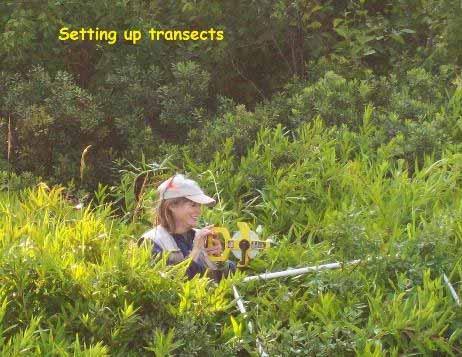
 Biological Conservation 107: 1-11. Source: Wisconsin Dept.")
11 Shoreland bird trends From: Lindsay, AR et al. (2002) Biological Conservation 107: Source: Wisconsin Dept. of Natural Resources


12 Furbearer Abundance and Diversity Lower on Developed Lakes From: Relationship between Carnivore Distribution and Landscape Features in the Northern Highlands Ecological Landscape of Wisconsin. Haskell et al American Midland Naturalist.
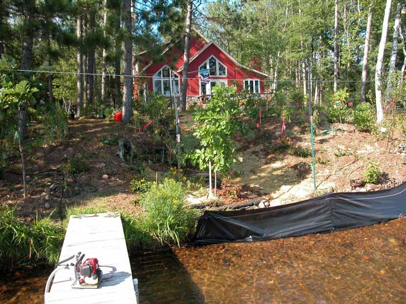
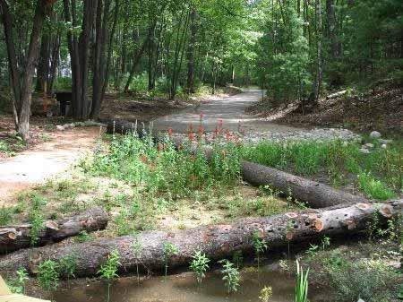
13 Lakeshore Habitat Restoration uses native trees, shrubs, and groundcover, along with natural and biodegradable materials (biologs, delta-lock bags, sediment logs, soil lifts, woody material), to mitigate development impacts by reducing lakeshore erosion and improving aquatic and wildlife habitat quality from OHWM to >10 meters inland.


14 Lakeshore habitat restorations (>2000 meters of shoreland) occurred on 5 developed lakes in Vilas County at which long-term wildlife and habitat monitoring was implemented. Before After
15 Measures of Success Lakeshore Habitat Restoration will be considered a successful management practice if 10-year postplanting survey results demonstrate: Increased native plant abundance and diversity Improved wildlife habitat quality Increased wildlife abundance and diversity Reduced surface water and nutrient run-off Best Management Practices - Survival and growth of restored native vegetation and erosion control effectiveness is also monitored to develop cost/effective management recommendations in the Northern Highlands

16
17
18 Five Lakeshores restored and matched with reference lakeshores High Development: Found Moon Lost LSG Crystal Low Development: Escanaba Jag White Sand Star Starrett Lakes were paired by: Surface size Water Chemistry Lake Type (drainage, seepage, spring) Substrate

19 Targeted lakeshores for restoration within NHEL


20 Vegetation plot location using GIS Moon Lake Control & Restored Jag Lake Reference Control Restored Reference Maps created by B. Fevold


21 Establishing habitat plots Landowners contacted for permission 10 x 10 m plots set up adjacent to shoreline for long term monitoring Plots approx. 50 m apart Data collected concurrently on matched sites
 40,000 ground cover plants (100 spp.")
 15,000 m of fence (deer exclosure) Plant density based on WI")
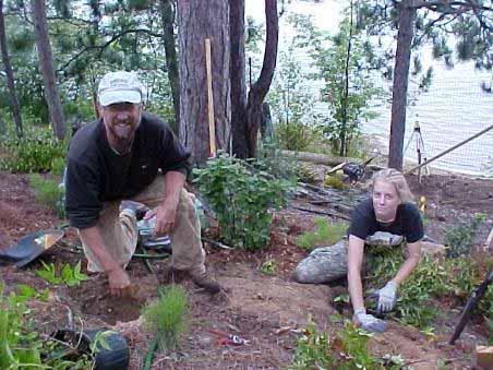
22 Restoration Efforts 26 private properties on Found, Moon, Lost, LSG Lakes & Crystal (public) 40,000 ground cover plants (100 spp.) 8,000 shrubs (30 spp.) 800 trees (20 spp.) 15,000 m of fence (deer exclosure) Plant density based on WI BioTech Note 1 Photos by D. Haskell

 to estimate the percent")

23 Methods: Habitat measurements made prior & post restoration activities Live saplings and shrub > 30 cm in height but having <5 cm DBH Visional Obstruction Density (VOD) to estimate the percent cover at four different height categories (0 0.3 m, m, 1 2 m, 2 3 m) Woody Habitat (logs & snags) Photos: D. Haskell


24 Results: sapling and shrub stem density increased Photos: D. Haskell


25 Results: VOD (0 1m) increased significantly at restored sites Photos: D.Haskell


26 Results: Logs increased on restored sites Photos: D. Haskell
27 Nonmetric Multi Dimensional Scaling Ordination shows restored plots becoming more like reference plots over time Reference lakes showed little change in habitat features Restored lakeshores displayed longer vectors & movement towards reference conditions This increase in similarity was associated with increasing similarity in visual obstruction and shrub and sapling density among treatments and reference lakes
28 Summary These results suggest that changes in understory habitat conditions associated with restoration treatments may increase the similarity of habitat features for understory dwelling wildlife. Large structural changes (tree density, size, and diversity) will require more time, but improving understory conditions and diversity are a requisite first step.


29 Recommendations for habitat Future restoration consider increasing sapling densities comparable to references sites Augmentation of woody habitat Long term monitoring of restoration should be part of the restoration plan and strategies to further this goal should be tested. restoration

30 Adding Downed Woody Material (DWM) to Lakeshore Restorations Haskell et al Variation in soil temperature, moisture, and plant growth with addition of downed woody material on lakeshore restoration sites. Restoration Ecology 20:

31 Removal of DWM on Sandy Soils Photo by: D. Kloepfer


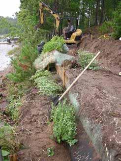
32 Woody Material Test Plots 25% DWM Coverage 0% DWM Coverage 50% DWM Coverage Photos by Dan Haskell
33 Soil Moisture Results July: n = 25/treatment 0% DWM plots had higher % change in moisture. (P = <0.001) August: n = 34/treatment 0% DWM plots had higher % change in moisture. (P = <0.001) Change in Soil Moisture (%) Woody Material Coverage (%)
34 Difference Between High & Low Soil Temp June: 0% DWM plots had a greater difference in temp. (P = 0.005) July: 0% DWM plots had a greater difference in temp. (P = <0.001) August: 0% DWM plots had a greater difference in temp. (P = <0.001) Temperature (C )
35 Shrub Change in Canopy Volume (%) Snowberry (Symphoricarpos albus): negative growth in 0% DWM (P = 0.015) Sweet Fern (Comptonia peregrine): no significant difference (P = 0.264) Change in Canopy Volume (%) DWM Coverage (%)

36 Discussion DWM DWM lessened daily variation in soil temp and moisture DWM can improve growth of plants The addition of DWM should be considered in restoration project May take decades for DWM to occur naturally on human altered sites WOOD IS GOOD


37 Tree and Shrub comparison study > bare root gravel culture plants versus 3-5 gallon containers Bare root is grown in an experimental gravel culture medium that is wellwatered Paired with container stock of same species Planted in same shoreland area Marked/tagged for long-term monitoring Pairs were followed 4-5 years for growth rates and survival Will gravel culture materials be a more cost effective source for plantings with similar results as containerized plants?


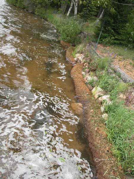
38 Results: Hardwood GC vs CT Growth Rates Haskell et al. In press. Restoring hardwood trees to lake riparian areas using three planting treatments. Restoration Ecology (accepted Feb.21, 2017) Photos by D. Haskell


39 Results: Hardwood GC vs CT Survival Photo by D. Haskell Survival of GC Hardwoods after four years


40 Evaluation of Active vs. Passive Lakeshore Habitat Restoration: Crystal Lake Campground Lakeshore Restoration Project
41


42 Passive Restoration With Fence and Irrigation After Before


43 Active Restoration with Fence & Irrigation After Before

44 Crystal Lake Results If Seed Bank present a natural recovery can be efficient If a shrub component is desired than active restoration may be needed Irrigation & Fence should be used Saplings per hectare Saplings per hectare A B Control with F&I Control, No F&I Planting with F&I Planting, No F&I 8000 C Shrubs per hectare


45 Preliminary ordination analysis shows both passive and active restoration result in similar lakeshore habitat improvement over time provided presence of a viable seed bank, deer fencing, and irrigation. Photos by D. Haskell
46 Bioengineering Techniques For Erosion Control Biologs EnviroLok Bags Coconut Erosion Mat Sediment Logs Tree Drops Water Retention Ponds (Rain Gardens)

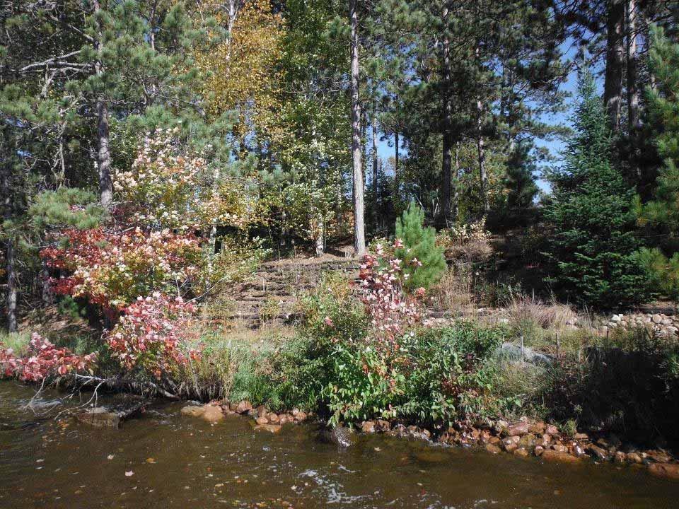
47 Installation of Bio-Logs Photos by: D. Haskell


48 Bio-logs One Year Later Photos by: D. Haskell


49 Erosion control method > biologs / Enviro-lok bags

50 EnviroLok Bags Photos A & B: before EnviroLok bags were installed. Photos C & D: after EnviroLok were installed on Moon Beach during the spring and summer of 2009.

51 EnviroLok Bags 2011

52 Erosion Before Photo by D. Haskell

53 Erosion After


54 Erosion control method > soil lifts


55

56
57


58

59
60 Wisconsin Lakeshore Restoration Project Conclusion Restoration increases habitat structure The addition of DWM positively influence plants Gravel Culture plants can be used in restoration projects Natural recovery can be a cost effective alternative Bioengineering reduces erosion Bridges gap between property owners and agency personnel Provides ecological and aesthetic value


61 Before / after photos > Found Lake


62 Before / after photos > North Lakeland Discovery Center 2009


63


64 Shoreland numbers for Wisconsin 47,162,014 meters of shoreline on our inland lakes (data from WDNR Hydro IV database on 1:24,000 sources) or over 29,304 miles Shoreland restoration needs to be an available option for any Wisconsin landowner willing to give it a try

65 Next Step 2017 Neighbor to Neighbor Education and Outreach in Vilas County

66 Private sector partners are now ready to offer solutions to neighbors with lakeshore habitat restoration needs in the Northern Highlands.

67 Acknowledgements Funding: WDNR, WDATCP, VCLWD, WSO, ESC, GSC Moon Beach Campers MTU Faculty, staff, and students Moon, Found, Lost, Little St. Germain property owners North Lakeland Discover Center Bird Club B. Hanson, P. Goggin, C. Scholl, M. Wagner, S. Dehne, T. Dalton, J. Wilson, G. Milanoski, M. Sheehan Field Tech: D. Drekich, C. Mehls, D. McGary, T. Armstrong, M, Pytleski, A. Komar, M. Ferge. J. Links, E. Delcamp, M. Boehmeer, E. Bowen, Quita, K. Merical, S. Simestad, A. Nachel, A. Bowen, C. Waas, K. Merical, N. Comar, K. Kelly, K. Genther, J. Hunter, J. Wheeler, C. Dexler, E.Collins, A Sharpe, A. Van Wagner, G. Brammer GIS: M. Woodford, B. Fevold UW-Trout & Kemp Research Stations Trout Lake WDNR Forestry Headquarters: S. Peterson, C. Hardin Marshfield Clinic Research Foundation Private Businesses: Hanson Garden Village, MK Landscaping, Wildwood Landscaping, Integrity Landscaping, Waldmann Construction, Green Lawn irrigation


68 Questions? NOVA Ecological Services Michigan Tech


69 Lessons learned > landowners Written agreements, photographs, and detailed property maps are a key tool for working with landowners undertaking restoration projects Landowner maintenance of projects are vital to restoration success over the long-term Finding willing landowners to participate in the lakeshore restoration process is a continuing issue


70 Lessons learned > plantings and watering Drought conditions through most of first season and part of the 2 nd year as well Some difficulty with access to water had to pump from lake which made it more costly and time intensive The amount of time and resources needed to have adequate watering take place was underestimated Difficult site conditions harsh exposure, sugar sand soil, steep slopes (up to 45 )


71 Lessons learned > deer/rabbit browse protection - fencing & repellents Protection of plants for 3-5 years with temporary fencing and repellents is essential to establishment of the native plantings

 can")
72 Lessons learned > costs Preliminary cost breakdowns are between ~$50 and $100 per linear foot of restored buffer back 35- feet Costs in part dependent on the amount of involvement from landowners, staff labor support, who does the design work, erosion control installation, plantings, fence building, and watering regime over time Fencing and erosion control techniques can be costly and logistically challenging County cost-share programs and WDNR Lake Grant Program (lake protection/healthy Lakes) can assist
73 Lessons learned > working with nurseries & contractors Building local expertise with nurseries and contractors for effective shoreland buffer designs and installations will be a continued priority

 2) Somewhere in presentation: acknowledgment of the amount of")
. 0780 photo is Hvam 2013.")
74 Lessons learned > working with nurseries & contractors The importance of having enough native plant material available through local nurseries. Native, yet will tolerate tough conditions (hot, dry, sugar sand, shade, browsers) 2) Somewhere in presentation: acknowledgment of the amount of engineering expertise needed to design the installation some of the methods ( bag walls, geogrid lifts, etc) photo is Hvam Photo Krum 2013
75 Lessons learned in the art and science of intelligent tinkering on lakeshores: Landowners are essential to any restoration strategy; without willing lakeshore property owners, opportunities for rehabilitating lakeshore habitat are minimal. Within the Northern Highlands, we found interest low among lake property owners. Finding local, on-lake champions of lakeshore rehabilitation work like lake association officers or master gardeners can make for effective peer-to-peer learning and project buy-in. Two lakes involved with this project had less success with securing landowners because no effective local lake champion could be found to make the case for recruiting suitable lakeshore property owners. Natural resource educators, contractors, planners, and other consultants to these landowners need to be hands-on with their assistance. They must openly communicate with landowners to understand their vision for their lakeshore properties on access points, view corridors, plant selection, storage needs, landscaping preferences, and other facets of the project. For example, we need to meet landowners where their landscape values are, whether they champion a messy look closer to a wild lakeshore or a tidy aesthetic that might accentuate drifts of plants, delineated edgings, and lower growing native vegetation. Incorporating ecological design principles of water infiltration, retention, reuse, and flow control into our strategies with landowners pays dividends. This includes low impact development (LID) approaches and practices that are targeted to reduce runoff of water and pollutants like rain gardens and barrels, permeable pavements, green roofs, living walls, infiltration planters, drain systems, water bars, brush bundles, gutters, and cisterns. Finding erosion control solutions for landowners to challenges from ice heave and wave action are critical to success. This fact often brings willing landowners to the table for doing shoreland rehabilitation so we need to make sure we address these concerns effectively. Innovative advances in erosion control materials that meet state standards and codes can be found by partnering with land and water conservation departments, consultants, and others. Shoreland zoning and other regulatory instruments alone are not enough to protect lakeshore habitat. Lakes with minimum frontage lake lots at 200 feet versus 100 feet (or less) withstand the stressors of human disturbance more positively. Holistic and inclusive lake community partnerships can support lakeshore restoration work of all kinds. Be open to possible project helpers like lake organizations, scouting groups, master gardeners, churches and other community organizations. Lakeshore rehabilitation projects are good for local economies and small business owners. Expenditures from these lake projects provide income to area contractors, nurseries, landscapers, erosion control specialists, and others employed in facets of the work.
76 Select native plant species that are proven work horses, namely sedges, grasses, and rushes. These soil-holding plants are important to the goal of restoring ecological functions to lakeshore areas and they can persist throughout the transition zone from upland areas to near-shore locations with wet feet. Upland species can be a challenge to get established without proper maintenance. The soil condition, aspect, and slopes shouldbe considered when generating a plant list. Maintenance is a vital part of the process (i.e., monitoring for ample watering regimes; invasive species control needs; browse protection systems like spray deterrents, temporary fencing, or motion-sensory sprinkler plans; proper dock storage; etc.). Degradation of lakeshore habitat cover is the most important stressor of lakes. At present, voluntary restoration of lakeshore habitat will likely have only a modest influence on watershed health. Even mandatory mitigation requirements wrapped up in local shoreland rules may only marginally increase participation. But when politically possible, shoreland rules or zoning that require lakeshore habitat conservation and restoration can perhaps provide the greatest benefit in the long term. Understanding more deeply and clearly the barriers landowners confront in ultimately accepting the practice of lakeshore habitat restoration and devising marketing strategies that utilize this information may also pay dividends in the future. Few wildlife survey results illustrate clear relations to restoration activities two to five years post restoration. It could be that: (1) the scale of restoration is too small to affect change; (2) it is too early to anticipate change given the lack of development of habitat on the restored sites; (3) our survey techniques to date are not sensitive to real changes that may have occurred for birds, frogs, and small mammals; and/or (4) new surveys need to be implemented to measure change that occurs at the scale of our lakeshore restorations. Additional surveys need to be implemented to measure change that more likely occurs at the scale of our lakeshore restorations (e.g., pollinators; soil microbes/arthropods; soil chemistry; fine woody material; root growth and depth; etc.).
77 Lessons learned / emerging conclusions / transferability A holistic partnership involving a myriad of agencies, people and talents is crucial to our success; A formalized and significant watering regime during the first growing season initially took a lot of time and effort (I.E., portable pumps; drought conditions; sugar-sand soils; water sources; etc.) increased emphasis has been put on watering systems, planning, and long-term maintenance; Preliminary cost breakdowns are ~$50 to $100 per linear foot of restored buffer back 35 feet depending on the involvement level of the landowners, staff support, planting labor, watering, etc. Biocontrol and erosion control techniques can be costly and logistically challenging; Landowners are vital to making this partnership work over the ten-year period of the study; Creating a reliable funding mechanism for the ten-year duration of the study between multiple agencies is an ongoing hurdle to overcome; Finding willing landowners to participate in the lakeshore restoration process is a continuing concern; We know that 200 ft. [or greater] lot sizes typically provide landowners with enough room to live on the lake comfortably while still maintaining adequate wildlife habitat and suitable water quality; Fencing native plantings is crucial to allowing the plants the opportunity to establish viable roots that can resist heavy browsing pressure from deer, rabbits, and other critters; Building local expertise with contractors and nurseries for effective shoreland buffer designs and installations will be a priority into the future; A higher diversity of mammals is being detected on low-development lakes when compared to high-development lakes--coyotes were the most numerous species detected with the majority encountered on low-development lakes--white-tailed deer and red fox were more abundant on high-development lakes--high-development lakes are having a negative effect on the mammal community in this area; Baseline data for bird and small mammal community diversity and abundance and on vegetation structure is being collected over the long-term study; and Peer-to-peer educational techniques and communication methods can be an effective strategy for fostering behavior change and achieving project buy-in by shoreland property owners engaged in the study.
Natural Shoreline Landscapes on Michigan Inland Lakes. Introduction. Workshop for Property Owners. Photo by Jane Herbert
 Natural Shoreline Landscapes on Michigan Inland Lakes Workshop for Property Owners Introduction Photo by Jane Herbert MSU is an affirmative action, equalopportunity employer. Michigan State University
Quita Sheehan Conservation Specialist Vilas County Land and Water Conservation Dept.
 Quita Sheehan Conservation Specialist Vilas County Land and Water Conservation Dept. Toe erosion Upland erosion and lack of vegetation Lake management planning County objectives (including ATCP 50) Protect
Natural Shorelines. for Inland Lakes. A Landowner s Guide to using. to STABLIZE SHORELINES, Michigan s inland lakeshore.
 Natural Shorelines for Inland Lakes A Landowner s Guide to using NATURAL MATERIALS to STABLIZE SHORELINES, IMPROVE WATER QUALITY and ENHANCE WILDLIFE HABITAT along Michigan s inland lakeshore. Natural
A comparison of Traditional and Prefabricated Encapsulated Soil Lifts
 A comparison of Traditional and Prefabricated Encapsulated Soil Lifts Jane Herbert, Senior Extension Educator 2014 Wisconsin Lakes Convention Background on shoreline erosion control in MI KBS Shoreline
Deb Grube, Sr. Zoning Officer
 Deb Grube, Sr. Zoning Officer Wisconsin Department of Natural Resources Administrative Code NR 115 under the authority of Wisconsin Statute 59.692, establishes and provides that shoreland zoning regulations
Introduction to Low Impact Development. Fred Milch. East Central Florida Regional Planning Council
 Introduction to Low Impact Development Fred Milch East Central Florida Regional Planning Council Low Impact Development (LID) Low impact development (LID) is a term used to describe a land planning and
Shoreland restoration plans / plant choices / establishment tips / maintenance
 Shoreland restoration plans / plant choices / establishment tips / maintenance Landscaping at the water s edge: ecological designs for water quality and habitat improvement workshop April 14, 2009 / On
Upper St. Croix & Eau Claire Rivers Watershed. Bony Lake
 Upper St. Croix & Eau Claire Rivers Watershed Bony Lake Bony Lake DNR Lake Protection - Project Partners: Grant Awarded July 2007 Bony Lake Residents-Grant Oversight Committee WI DNR Bayfield County LWCD
Nick Sigmund, Sr. Zoning Officer
 Nick Sigmund, Sr. Zoning Officer Wisconsin Department of Natural Resources Administrative Code NR 115 under the authority of Wisconsin Statute 59.692, establishes and provides that shoreland zoning regulations
NATURAL LAKE & STREAMBANK PROTECTION & NATURAL BUFFERS. By Sam Martin, Water Management Specialist, Pine SWCD
 NATURAL LAKE & STREAMBANK PROTECTION & NATURAL BUFFERS By Sam Martin, Water Management Specialist, Pine SWCD Natural Lake & Streambank Protection & Natural Buffers Lakeshore & Streambank Erosion Projects
A Final Report Prepared by: Dan Haskell School of Forest Resources and Environmental Science Michigan Technological University Houghton, MI
 Developing Best Management Practices and Evaluating the Ecological and Water Quality Benefits. A Final Report Prepared by: Dan Haskell School of Forest Resources and Environmental Science Michigan Technological
Lake Nokomis Shoreline Enhancement Project
 Lake Nokomis Shoreline Enhancement Project Community Meeting 2 February 13, 2018 Agenda Current Problems Project Goals Project Status Existing Conditions Community Input Draft Schematic Design Long-term
FirstLight Power Shoreline Management Manual Sustainable Shoreline Designs: From Long Island to Lake Erie Webinar Series
 FirstLight Power Shoreline Management Manual Sustainable Shoreline Designs: From Long Island to Lake Erie Webinar Series Presented by Jason Williams, PLA, NCI February 19, 2017 Introduction Lakes (impoundments)
Wisconsin Dept. of Transportation November 2017
 Wisconsin Dept. of Transportation November 2017 Jennifer Gibson WisDOT Environmental Coordinator Mike Helmrick WisDOT Environmental Coordinator Background on compensatory wetland mitigation Site purpose
Shoreland Zoning. Kay Lutze Shoreland Zoning Policy Coordinator
 Shoreland Zoning Kay Lutze Shoreland Zoning Policy Coordinator Kay.Lutze@wisconsin.gov Purposes of shoreland zoning include Prevent and control water pollution Protect spawning grounds, fish and aquatic
RAIN GARDEN ILLINOIS URBAN MANUAL PRACTICE STANDARD. (feet) CODE 897 DEFINITION
 CODE 897 DEFINITION") ILLINOIS URBAN MANUAL PRACTICE STANDARD RAIN GARDEN (feet) CODE 897 Source: Kendall County Soil and Water Conservation District DEFINITION Rain gardens are small, shallow, flat bottomed depressions constructed
ILLINOIS URBAN MANUAL PRACTICE STANDARD RAIN GARDEN (feet) CODE 897 Source: Kendall County Soil and Water Conservation District DEFINITION Rain gardens are small, shallow, flat bottomed depressions constructed
Worksheet #14 Water Runoff Management
 Water Runoff Management Use this worksheet to assess how well your property minimizes the potential for water runoff and property damage.. Why should you be concerned? What can you do? Rural runoff, also
Wisconsin NRCS Direct Volume Method Bank Recession Rate Categorizations
 2 Executive Summary The City of Ramsey contracted the Anoka Conservation District to complete an inventory of riverbank condition along the entire 5.8 miles of City that border the Mississippi River. The
Use of Best Management Practices
 Use of Best Management Practices Presented at the ANJEC Flood Hazard Workshop Bordentown, NJ March 13, 2008 Stormwater BMPs "a technique, measure or structural control that is used for a given set of conditions
ADDENDUM TO BIOLOGICAL SCOPING SURVEY REPORT, BOTANICAL SURVEY AND WETLAND DELINEATION
 ADDENDUM TO BIOLOGICAL SCOPING SURVEY REPORT, BOTANICAL SURVEY AND WETLAND DELINEATION FOR AVALON INN (APN 069-241-27 & -04) 1201 & 1211 NORTH MAIN STREET FORT BRAGG, CA MENDOCINO COUNTY prepared for:
The scope of the plan will focus on the Prospect Heights Slough and Hillcrest Lake as one entity.
 Plan for Prospect Heights Natural Resources Commission Plan for Improved Public Access and Enjoyment of the Prospect Heights Slough and Hillcrest Lake July 23, 2018 The City Council has requested the Natural
Juneau Watershed Partnership
 Juneau Watershed Partnership Native Plant Resource Center Final Report A Partners for Fish and Wildlife Project Prepared for: U.S. Fish and Wildlife Service For Grant #F11C00552 Prepared by: The Juneau
Funding: Department of Water Resources Proposition 84. River-Friendly Landscaping Turf Buy Back Program
 Funding: Department of Water Resources Proposition 84 River-Friendly Landscaping Turf Buy Back Program Outline Introduction River Friendly Landscaping Overview Turf Buy Back Program Program Components
Section 3 Non-Structural BMPs
 3.1 Stream Buffers A stream buffer or stream setback is a designated area around a stream, lake, or wetland left in a natural, densely vegetated state so as to protect the receiving water quality and provide
Waiwhakareke Restoration Plantings: Establishment of Monitoring Plots
 Waiwhakareke Restoration Plantings: Establishment of Monitoring Plots 25-6 E. Grove, B. Paris and B.D. Clarkson Centre for Biodiversity and Ecology Research The University of Waikato Private Bag 315 Hamilton
The Development of Riparian Stream Buffers in Greensboro, NC
 The Development of Riparian Stream Buffers in Greensboro, NC Why our stream banks have grown up? Presented by: Peter Schneider, Water Quality Supervisor City of Greensboro Stormwater Management Division
Community Conservation Workshop. Lake Placid
 Community Conservation Workshop Lake Placid 2 Community Conservation Program Welcome! We have designed a Community Conservation Program that listens to the needs of community members. We are conducting
Rocky Areas Project Guidance HABITAT
 Rocky Areas Project Guidance HABITAT Introduction Rocky habitats are surface areas dominated by exposed rock, such as mountain peaks, inland cliffs, buttes and rocky outcrops. In many cases, rocky areas
5.0 Storm Water Landscape Guidance Introduction
 5.0 Storm Water Landscape Guidance Introduction Landscaping is a critical element to improve both the function and appearance of storm water management practices. Integrated storm water landscapes can
Principles for Ecological Landscape Design in Brownfield Business Parks
 Principles for Ecological Landscape Design in Brownfield Business Parks Part of USDA Forest Service research project # 00-JV-11231300-033: Aligning Social and Ecological Drivers of Urban Landscape Change
Rain Gardens. A Welcome Addition to Your Landscape
 Rain Gardens A Welcome Addition to Your Landscape Where Does The Rainwater Go? Naturally, forests provide a way for rainwater to percolate into the soil, filtering pollutants while trees are allowed to
Bioengineering Shoreline Protection
 Insert Company Logo Here (first slide only) Bioengineering Shoreline Protection Agrecol LLC Evansville WI rob.walker@agrecol.com A little about Agrecol 1,100 acres in production in SC WI Produce 3.5 million
Stormwater Standards. Clackamas County Service District No. 1. Planting Guide for Buffers
 Stormwater Standards Clackamas County Service District No. 1 APPENDIX B Planting Guide for Buffers Table of Contents Appendix B - Planting Guide for Buffers... Page B.1 General... 1 B.1.1 Introduction...
Stream Restoration: Working with Nature?
 Stream Restoration: Working with Nature? Greg Jennings, PhD, PE jenningsenv@gmail.com Ecosystem Restoration activities that initiate or accelerate the recovery of ecosystem health, integrity, and sustainability
Stream Restoration: Working with Nature? Greg Jennings, PhD, PE
 Stream Restoration: Working with Nature? Greg Jennings, PhD, PE jenningsenv@gmail.com Ecosystem Restoration activities that initiate or accelerate the recovery of ecosystem health, integrity, and sustainability
Client #: Dawson /91. NRCS Tract #(s): Location: Fleming Memorial Park Field #(s): Program(s): Urban Project Name: Date:
: Location: Fleming Memorial Park Field #(s): Program(s): Urban Project Name: Date:") Natural Resource Stewardship Plan Jackson Soil and Water Conservation District 89 Alder Street Central Point, Oregon 97502 Ph. (541) 664-1070 www.jswcd.org Client Name: Elisa Dawson, City of Rogue River
Natural Resource Stewardship Plan Jackson Soil and Water Conservation District 89 Alder Street Central Point, Oregon 97502 Ph. (541) 664-1070 www.jswcd.org Client Name: Elisa Dawson, City of Rogue River
PEOPLE, WATER, AND WILDLIFE: BLUE PRINCIPLES FOR RIVER DESIGN
 PEOPLE, WATER, AND WILDLIFE: BLUE PRINCIPLES FOR RIVER DESIGN Category One: People Protecting and Enhancing the Quality of Life Role of the Chicago River People and the River For many, the connection between
Green Infrastructure Project Guidance
 OTHER OPTIONS Green Infrastructure Project Guidance Stakeholder Informed Introduction Green infrastructure is an approach to mitigating environmental challenges using vegetation, soils and natural processes
BEST MANAGEMENT PRACTICES Herb Robert (Geranium robertianum) (Family Geraniaceae Geranium Family)
 (Family Geraniaceae Geranium Family)") JEFFERSON COUNTY NOXIOUS WEED CONTROL BOARD 380 Jefferson Street Port Townsend WA 98368 360 379-5610 Ext. 205 noxiousweeds@co.jefferson.wa.us BEST MANAGEMENT PRACTICES Herb Robert (Geranium robertianum)
JEFFERSON COUNTY NOXIOUS WEED CONTROL BOARD 380 Jefferson Street Port Townsend WA 98368 360 379-5610 Ext. 205 noxiousweeds@co.jefferson.wa.us BEST MANAGEMENT PRACTICES Herb Robert (Geranium robertianum)
Boardman River Watershed VILLAGE OF KALKASKA. WATER QUALITY ACTION PLAN Fall 2009
 Boardman River Watershed VILLAGE OF KALKASKA WATER QUALITY ACTION PLAN Fall 2009 Partners: The Watershed Center Grand Traverse Bay Northwestern Michigan College - Great Lakes Water Studies Institute Grand
Southeast Michigan Council of Governments
 Southeast Michigan Council of Governments SEMCOG Green Infrastructure Activities Regional Green Infrastructure Vision GLRI Green Streets EPA Technical Assistance MDOT Grants Green Infrastructure Vision
River Restoration Practices:
 River Restoration Practices: Comparison of British Columbia and Central European Practices by David Matsubara and Dave Murray Add Map of North America VANCOUVER, Wa. Add Map of Vancouver OUTLINE Introduction
Stop Losing Ground to Erosion. Kimberly Laframboise Ecologist Michalski Nielsen Associates limited
 Stop Losing Ground to Erosion Kimberly Laframboise Ecologist Michalski Nielsen Associates limited Forms of Erosion Surface erosion Sheet erosion Wind erosion Wave action Mass-movement erosion Slips, earth
Applied Ecological Services, Inc. Sustainable Solutions for Over 30 Years.
 Applied Ecological Services, Inc. Sustainable Solutions for Over 30 Years. Landfills Can Mitigate and Restore Riparian Impacts on Their Property Jason Dremsa, Construction Manager Applied Ecological Services,
Milwaukee River Watershed Fish Passage Program. Making Connections Across Our Watershed
 Milwaukee River Watershed Fish Passage Program Making Connections Across Our Watershed 2 71 st Annual Upper Midwest Fish & Wildlife Conference Wednesday, December 15, 2010 Milwaukee River Watershed Fish
BEST MANAGEMENT PRACTICES Spurge Laurel(Daphne laureola) (Family Thymelaeaceae Daphne Family)
 (Family Thymelaeaceae Daphne Family)") JEFFERSON COUNTY NOXIOUS WEED CONTROL BOARD 380 Jefferson Street, Port Townsend WA 98368 360 379-5610 Ext. 205 noxiousweeds@co.jefferson.wa.us BEST MANAGEMENT PRACTICES Spurge Laurel(Daphne laureola) (Family
JEFFERSON COUNTY NOXIOUS WEED CONTROL BOARD 380 Jefferson Street, Port Townsend WA 98368 360 379-5610 Ext. 205 noxiousweeds@co.jefferson.wa.us BEST MANAGEMENT PRACTICES Spurge Laurel(Daphne laureola) (Family
Karen A. Duhring Marine Advisory Scientist Center for Coastal Resources Management Virginia Institute of Marine Science College of William & Mary
 Karen A. Duhring Marine Advisory Scientist Center for Coastal Resources Management Virginia Institute of Marine Science College of William & Mary March 20, 2009 Low-Impact Shoreline Stabilization Cumulative
Design Around Waterways and Wetlands
 Design Around Waterways and Wetlands NL Green Economy Conference Newleef-2014 NEIA, St. John s, NL October 9-10 th, 2014 Wade Lewis Amherst, Nova Scotia, w_lewis@ducks.ca DUC conserves, restores and manages
Stockbridge Bowl Watershed Survey Conducted by the BRPC, SBA and Town of Stockbridge June 2012
 Stockbridge Bowl Watershed Survey Conducted by the BRPC, SBA and Town of Stockbridge June 2012 This project has been financed with Federal Funds from the Environmental Protection Agency (EPA) to the Massachusetts
Guiding Landowners in Stream Restoration. The Science, Practice & Art of Restoring Native Ecosystems 2015
 Guiding Landowners in Stream Restoration The Science, Practice & Art of Restoring Native Ecosystems 2015 January 24, 2015 Guiding Landowners in Stream Restoration January 24, 2015 Agenda 1Watershed Planning
Washtenaw County Conservation District 7203 Jackson Rd Ann Arbor MI Phone: (734) x 5 Fax: (734) Web:
 x 5 Fax: (734) Web:") Washtenaw County Conservation District 7203 Jackson Rd Ann Arbor MI 48103-9506 Phone: (734) 761-6721 x 5 Fax: (734) 662-1686 Web: www.washtenawcd.org STEPS IN BUILDING A POND The following list has been
Washtenaw County Conservation District 7203 Jackson Rd Ann Arbor MI 48103-9506 Phone: (734) 761-6721 x 5 Fax: (734) 662-1686 Web: www.washtenawcd.org STEPS IN BUILDING A POND The following list has been
WETLAND SOD u Bare Root Wetland Plants u Deep Rooted Willows u Coir Logs u Native Trees & Shrubs u Habitat Islands u Custom Growing
 WETLAND SOD u Bare Root Wetland Plants u Deep Rooted Willows u Coir Logs u Native Trees & Shrubs u Habitat Islands u Custom Growing 2009 PROJECT HIGHLIGHTS The following 10 projects highlight the interesting
Study Area Map. Wasatch Hollow Open Space Restoration, Use, & Management Plan. Legend. Harrison Ave East. Roosevelt East.
 Harrison Ave Roosevelt Emerson «4 «5 Rosecrest 1900 East «3 1800 East Wasatch Hollow Open Space Restoration, Use, & Management Plan Study Area Map Legend «2 «1 Potential Access Location Emigration Creek
Glencoe Elementary School Parking Lot Retrofit 825 SE 51 st Street
 Glencoe Elementary School Parking Lot Retrofit 825 SE 51 st Street Project Summary Project Type: Technologies: Institutional parking lot retrofit demonstration project Vegetated infiltration swale with
Minnesota Department of Natural Resource - Natural Resource Guidance Checklist Conserving Natural Resources through Density Bonuses
 Minnesota Department of Natural Resource - Natural Resource Guidance Checklist Conserving Natural Resources through Density Bonuses NRDB Why Use Density Bonuses & This Checklist Local units of government
Guidelines for planting within the 100 Ft. Buffer
 CAPE COD COOPERATIVE EXTENSION PO Box 367 Barnstable, MA 02630 508 375-6690 (www.capecodextension.org) Guidelines for planting within the 100 Ft. Buffer Introduction: The Barnstable County Extension Service
Appendix 16 Guideline for native revegetation plantings
 Appendix 16 Guideline for native revegetation plantings 16.1. Introduction These guidelines explain what specific information is needed for native revegetation plantings, why the information is necessary
Linking Ecological Restoration and Economic Recovery at a Great Lakes Area of Concern: Muskegon Lake, MI. Heather Braun Great Lakes Commission
 Linking Ecological Restoration and Economic Recovery at a Great Lakes Area of Concern: Muskegon Lake, MI Heather Braun Great Lakes Commission Why Here? Restoration in urban centers: Muskegon Lake AOC Why
Guide to Naturalizing a Lakefront Shoreline. September 2010
 Guide to Naturalizing a Lakefront Shoreline September 2010 Retaining walls and non-vegetated shorelines are a very common sight on shore-line properties in Alberta. These urbanized shorelines have a huge
Conserving Illinois North Shore Ravines
 Conserving Illinois North Shore Ravines Rebecca Grill, Natural Areas Manager, Park District of Highland Park, rgrill@pdhp.org Jeff Boeckler, Principal Water Resource Specialist, Northwater Consulting,
319 Grant: Baker Creek & Centenary Creek Restoration Initiative
 319 Grant: Baker Creek & Centenary Creek Restoration Initiative Objectives: Overview of Watershed Characteristics: Discussion of Project Tasks: Discussion of Watershed Management Plan: Presented by: Erich
Community Conservation Workshop. Saranac River Basin Communities
 Community Conservation Workshop Saranac River Basin Communities 2 Community Conservation Program Welcome! We have designed a Community Conservation Program that listens to the needs of community members.
Habitat Improvements to the Motor Island Shoreline in the Upper Niagara River, NY: A Collaborative Approach
 Habitat Improvements to the Motor Island Shoreline in the Upper Niagara River, NY: A Collaborative Approach Edward Alkiewicz 1, Stephen Schoenwiesner 1, Jeff Gerlach 1, Morris Perot 2, Scott Ault 2, Mark
Toronto Complete Streets Guidelines
 Toronto Complete Streets Guidelines 108 110 7.1 Green Infrastructure Design Principles 112 7.2 Context-Sensitive Green Streets 114 7.3 Key Green Street Elements Green infrastructure refers to natural and
TRCA Field Staking Protocol December 2016
 Page 1 of 6 TRCA Field Staking Protocol December 2016 This Protocol describes TRCA staff s current practice for field staking the physical top of bank, the physical toe of slope, and the limit of existing
Two Sides of the Green Infrastructure Coin. Jaren Hiller, PE, LEED AP Nathan Guequierre
 Two Sides of the Green Infrastructure Coin Jaren Hiller, PE, LEED AP Nathan Guequierre May 5, 2016 Background Citywide Stormwater Planning WinSLAMM Analysis No Control Existing Conditions Proposed Conditions
A Cooperative Effort Between:
 Lake Shamineau Shoreline Assessment August 2007 A Cooperative Effort Between: Morrison County Planning and Zoning Morrison Soil and Water Conservation District Minnesota Department of Natural Resources
As a homeowner in the Pacific Northwest, you
 Archival Copy. For current information, see the OSU Extension Catalog:https://catalog.extension.oregonstate.edu Taking Care of streams in Eastern Washington, A Homeowner s Guide to Riparian Areas PNW 557
2.1 Principles & Objectives
 Designing With The Landform 2.1 Principles & Objectives Land planning which integrates the natural features of a site (i.e., designing with the landform ) into the site design is a major component of the
Landowner's Guide to the Lower St. Croix Riverway. Protect. Restore. Celebrate. stcroixriverassociation.org
 Landowner's Guide to the Lower St. Croix Riverway Protect. Restore. Celebrate. stcroixriverassociation.org Cover and page spread photographs by Craig Blacklock. For more information on how to be a river
PERMANENT SEEDING. Overview of Sedimentation and Erosion Control Practices. Practice no. 6.11
 Overview of Sedimentation and Erosion Control Practices Practice no. 6.11 PERMANENT SEEDING Permanent vegetation controls erosion by physically protecting a bare soil surface from raindrop impact, flowing
Green Infrastructure. NYS Department of Environmental Conservation
 Green Infrastructure Green infrastructure is an interconnected network of natural areas and open spaces that sustains ecosystems. Benedict, M.A. and E.T. McMahon. 2006. Green Infrastructure Linking Landscapes
Options for Managing Coastal Erosion. Presentation by: Ashley Sprague
 Options for Managing Coastal Erosion Presentation by: Ashley Sprague Shoreline stabilization methods Armouring - Boulders/rockwalls most common method of erosion control in Nova Scotia Concerns: - Accelerate
Stormwater Management for Homeowners Fact Sheet 6: Buffers
 Publication SPES-14P Stormwater Management for Homeowners Fact Sheet 6: Buffers Laurie J. Fox, Research Associate, Horticulture, Virginia Tech Daniel J. Robinson, Graduate Student, Biological Systems Engineering,
St. Croix County Shoreland Overlay Zoning Districts. Public Hearing Community Development Committee December 19, 2013
 St. Croix County Shoreland Overlay Zoning Districts Public Hearing Community Development Committee December 19, 2013 Timeline CDC Review October 17 Public Information Meeting October 29 (6:00-8:00 pm)
POST-FIRE RESTORATION Dos and Don ts
 POST-FIRE RESTORATION Dos and Don ts USDA Natural Resources Conservation Service The NRCS/RCD office is located at: 744 LA GUARDIA ST BLDG A SALINAS, CA 93905-3354 (831) 424-1036 (NRCS) (831) 424-1036
Exploring the water s edge: shoreland habitat, biodiversity, and restoration opportunities
 Exploring the water s edge: shoreland habitat, biodiversity, and restoration opportunities 5.4 restoration ecology basics and getting to solutions 6.0 defining lakeshore habitat restoration 6.1 project
Green Infrastructure and Low-Impact Development Technologies
 Green Infrastructure and Low-Impact Development Technologies The guiding principles of these technologies is to manage stormwater at their sources using natural means, and establish conditions so that
Coquitlam River Riparian Planting
 Coquitlam River Riparian Planting Year Four Year Four Report, March 2016 Prepared for: Fish and Wildlife Compensation Program Prepared by: Watershed Watch Salmon Society and the Kwikwetlem First Nation
Retrofitting Low Impact Development (LID) for Stormwater at Sacramento State. City of Sacramento Sacramento State Facilities Management
 for Stormwater at Sacramento State. City of Sacramento Sacramento State Facilities Management") Retrofitting Low Impact Development (LID) for Stormwater at Sacramento State City of Sacramento Sacramento State Facilities Management Project Background Campus Storm Drain System Drain Inlet - Campus
Retrofitting Low Impact Development (LID) for Stormwater at Sacramento State City of Sacramento Sacramento State Facilities Management Project Background Campus Storm Drain System Drain Inlet - Campus
Riparian Buffer and Upland Restoration With Woody Species. Dan Salas Delaware Riverkeeper Network
 Riparian Buffer and Upland Restoration With Woody Species Dan Salas Delaware Riverkeeper Network What s a buffer good for? Sediment Filtration Chemical Filtration Stormwater Infiltration Bank Stabilization
Sustainable Storm Water Management
 Incorporating Water Management into the Community Planning Process August 16, 2012 Sustainable Storm Water Management Samantha Brown Environmental Engineer SD1 SD1 s Service Area CVG Airport SD1 Service
2.0 Welcome, 2.1 training introduction, 2.2 review of training objectives, 2.3 facility logistics, and 3.0 Attendee introductions
 2.0 Welcome, 2.1 training introduction, 2.2 review of training objectives, 2.3 facility logistics, and 3.0 Attendee introductions Patrick Goggin Lakes Specialist UW-Stevens Point / UW Extension Lakes/WI
Rain Garden Presentation. April 11, 2016
 Rain Garden Presentation April 11, 2016 Mark St.Charles, Supervisor Green Oak Charter Township 2000 present Green Oak ZBA Chairperson 1992-2000 MDEQ Certified Storm Water Operator since 1995 Green Oak
Article 6 Tree Protection
 Article 6 Tree Protection 8.1 Purpose 8.2 Applicability 8.2.1 General Provisions 8.2.2 Exemptions 8.3 Permitting Procedure 8.4 Planting Procedure 8.5 Performance Guarantee Required for Belated Planting
SUPPORTING DOCUMENT STORMWATER POLLUTION PREVENTION PLAN (SWPPP) NARRATIVE
 NARRATIVE") SUPPORTING DOCUMENT STORMWATER POLLUTION PREVENTION PLAN (SWPPP) NARRATIVE Please complete this narrative form and submit with your SWPPP drawings. Refer to Kitsap County Stormwater Design Manual Vol.
SUPPORTING DOCUMENT STORMWATER POLLUTION PREVENTION PLAN (SWPPP) NARRATIVE Please complete this narrative form and submit with your SWPPP drawings. Refer to Kitsap County Stormwater Design Manual Vol.
2012 Saginaw Bay Watershed Conference
 2012 Saginaw Bay Watershed Conference March 16, 2012 Russ Beaubien, P.E., CFM Low Impact Development Fundamentals Summary LID overview Education on LID Fundamentals of LID Examples of LID practices Other
WHITE HOUSE FARM FOUNDATION 1917 Kauffmans Mill Rd. Luray, VA Summary Report 2016
 WHITE HOUSE FARM FOUNDATION 1917 Kauffmans Mill Rd. Luray, VA 22835 www.whfarmfoundation.org Summary Report 2016 Mission Statement: To enrich individuals with knowledge of and involvement with our natural
Storm Water Quality and Shoreline Restoration Improvements - Grant Funding Request City of Mound Carlson Park Bolton & Menk Project No.
 September 15, 2016 Brett Eidem Cost Share Grant Administrator Minnehaha Creek Watershed District 15320 Minnetonka Boulevard Minnetonka, MN 55345 RE: Storm Water Quality and Shoreline Restoration Improvements
Sustainable Sites. hblanarc.ca. RDN Workshop June 25, David Reid, FCSLA, Landscape Architect, Environmental Designer
 Sustainable Sites RDN Workshop June 25, 2011 David Reid, FCSLA, Landscape Architect, Environmental Designer hblanarc.ca Surrey ESA Networks & linear corridors ESA Network: Develop with Care SITE Hub >10
Landscape Design. earth-wise guide to. earth-wise guide to
 earth-wise guide to earth-wise guide to Landscape Design The purpose of this fact sheet is to provide background information on creating a green garden for either the do-it-yourselfer of for those working
Is a Riparian Restoration Still Viable After 100-year Storm Events Alter the Original Design?
 Is a Riparian Restoration Still Viable After 100-year Storm Events Alter the Original Design? Sarah Spear Cooke, Ph.D. Seattle, Washington Presentation Outline Introduction The site pre-restoration Restoration
Potomac Headwaters Leaders of Watersheds Spring 2019 Application
 Potomac Headwaters Leaders of Watersheds Spring 2019 Application Educating future generations of environmental stewards through classroom education and on the ground conservation practices at schools.
A Review of Green Infrastructure Projects Implemented in the Grand Traverse Region
 A Review of Green Infrastructure Projects Implemented in the Grand Traverse Region Sarah U Ren Program Director The Watershed Center of Grand Traverse Bay 231-935-1514, suren@gtbay.org Our Mission: The
Table of Contents INTRODUCTION APPLICATION. Document No.: WRG 5A-8 Publication Date: 10/4/2012
 MINNESOTA WETLAND RESTORATION GUIDE PLANTING UPLAND TREES AND SHRUBS TECHNICAL GUIDANCE DOCUMENT Document No.: WRG 5A-8 Publication Date: 10/4/2012 Table of Contents Introduction Application Other Considerations
Wise Watering Practices: Trees and Shrubs
 Wise Watering Practices: Trees and Shrubs KATHY ZUZEK UMN EXTENSION, HORTICULTURE 1 WATERING ESTABLISHED TREES AND WATERING NEWLY PLANTED TREES AND Where to water How to water When to water How much water
City of Stoughton Erosion Control Permit Application (effective 2/6/2018)
") City of Stoughton Erosion Control Permit Application (effective 2/6/2018) Incomplete applications will not be accepted Project Name: Address of subject property: Landowner Name(s): Applicant Name: Landowner
City of Stoughton Erosion Control Permit Application (effective 2/6/2018) Incomplete applications will not be accepted Project Name: Address of subject property: Landowner Name(s): Applicant Name: Landowner
2017 Summer Projects
 2017 Summer Projects Mission: The Anchorage Park Foundation builds healthy parks and healthy people by mobilizing public support and financial resources for Anchorage parks, trails and recreation opportunities.
Once Upon a Gravel Pit: Reconnecting Floodplain through Aggregate Extraction
 Once Upon a Gravel Pit: Reconnecting Floodplain through Aggregate Extraction 5 th International Conference on Natural Channel Systems September 26, 2016 1 The Story of Snyder s Flats Historical influences
Restoration of Richmond Beach Saltwater Park, Shoreline, WA
 Restoration Highlights Society for Ecological Restoration Northwest Chapter RH No.9, October 2015 Restoration of Richmond Beach Saltwater Park, Shoreline, WA By Tony Sharrah Project Team Members from the