Cottage Grove. Conservation Area. Character Appraisal
|
|
|
- Laureen York
- 5 years ago
- Views:
Transcription


1 Positive People - Positive Leadership - Positive Partnerships Cottage Grove Conservation Area Character Appraisal Consideration of Proposal to Designate Grove Avenue and Park Road Chilwell as a Conservation Area. 2008
2 1.0 Introduction Contents 2.0 Historical Development and Signifi cance 3.0 Character Appraisal 4.0 The Implications of Designation fro Broxtowe Borough Council 5.0 Details 6.0 Bibliography
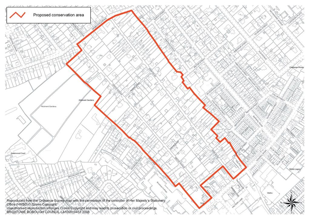
3 1.0 Introduction Grove Avenue lies to the west of central Beeston, just inside Chilwell parish, and runs northwest from the Beeston to Chilwell High Road, up to Bramcote Avenue. It is approximately 600 metres in length. Running roughly parallel with Grove Avenue is Park Road, 100 metres to the east. The two roads are linked by North Drive and Cedar Road, which divide the enclosed area into three rectangular blocks of approximately similar area. The topography is fl at and there are no far-reaching views. The area today is residential, comprising housing of various dates, from Victorian detached and semi-detached villas to modern detached properties. The oldest building appears to be the Hop Pole Inn (b. 1847), which is at the edge of the proposed conservation area. A few cottages of dark brown local brick, dating from about 1850, are apparent but the majority of the properties fall within the period 1870 s to 1930 s. There are a few bungalows and one three storey house but most of the properties are of two storeys. Almost all of the buildings are set back from the road in leafy gardens. Tall, mature trees, some pollarded, line both sides of the street for much of its length. There are two commercial premises to the top of the avenue, a car garage and a plate glass window fi tting company. Location of the Conservation Area Ordnance Survey
4 two
5 2.0 Historical Development & Significance The area appears as undeveloped land on the parliamentary enclosure map of 1809 and seems to have remained undeveloped until the mid 19 th century. After the Nottingham Enclosure Act of 1845, the area was acquired by the Labourers Friend Society under the agency of Rev. James Orange. 1 Rev. Orange was an energetic local campaigner on behalf of the poor. He published the pamphlet A Plea for the Poor in 1841, in which he put forward a Cottage Garden Plan to help provide an additional source of food and income for textile workers in Nottinghamshire. Planned originally in 1846 as an allotment scheme for working men, much in line with other similar schemes in the 1840s, The Cottage Grove Estate was laid out in Orange s plan was to acquire land that could provide each working family with an allotment of a quarter of an acre, which would contain a two storey cottage with four rooms and a front and back door. A quarter of an acre, Orange calculated, was the best size for supplementing industrial occupation, and should support a small family for about thirteen weeks. 3 The fi nancial backing for the Cottage Grove Estate came from nonconformist Nottingham businessmen. At a very late stage the scheme was changed from rented allotments to freehold land plots, which gave working men the vote in county elections. The fi rst such Freehold Land Society was formed in Birmingham in September 1847, and the Cottage Grove was the fi rst in Nottingham, and probably one of the fi rst half dozen in England. It fed naturally into the building society movement, and working men who bought a plot and then wanted to build a house turned to the Nottingham Benefi t Building Society formed in January 1849, also with backing from James Orange. The scheme was only partially successful in its original inception, but the area continues to exhibit a gardenlike appearance, and the Cottage Grove represents an important heritage site within Broxtowe and Nottinghamshire more generally. 2 When viewed on a map the Cottage Grove area has a distinct character which differs from the surrounding developments. It has a clear linear grain, and its piecemeal architectural development and form contrasts quite strongly with the neighbouring regimented scale and layout of Imperial Road, Cumberland Avenue and Gladstone Street. On the OS 25 1 st edition map (sheet 41.12), dated 1885, the area is marked as Cottage Grove and none of the roads are named. There is development no further than North Drive and very few buildings to the west of Grove Avenue, which appears as enclosed agricultural land with a complex of greenhouses at the High Road end. The plot sizes appear very regular and might be of the quarter of an acre stipulated by Orange. The buildings within the plots vary in their positioning and orientation however, and no obvious pattern of planned development is apparent. The OS 25 2 nd edition, dated 1901, has the area still marked as Cottage Grove. The four roads of the grove are called West Gate (Grove Avenue), East Gate (Park Road), North Gate (North Drive) and South Gate (Cedar Road). Development has begun to the west of Grove Avenue and already many of the plots have been sub-divided, so the planned allotment garden character was already being lost by the late 19 th century. 1 Church, 1960, p Prof. Beckett 3 Ibid., pp. 76-7


6 3.0 Character Appraisal The predominant character is of intimate enclosure and separation from the surrounding area. The main factors which contribute to this feeling are: a large number of tall, mature trees; narrow streets with no footpaths; and leafy gardens with tall and thick privet hedging at the road side. Although there is no greatly dominant architectural style or continuity to the housing, the majority of the houses are late 19 th to early 20 th century in date, many with fi ne detailing. The second most dominant housing is of the inter-war period. These buildings sit well with the older dwellings and share their scale and layout, being set back from the road within leafy gardens. The overriding feeling when walking the street is of being in a quiet garden suburb or large linear village. There are a few older dwellings, perhaps of the 1850s or 60s which have a very village-like quality to them. Number 24 in particular illustrates the way the Grove might have looked if James Orange s Cottage Garden Plan had come to fruition. A village-like character is evident also in the two very narrow back lanes that link Grove Avenue to Park Road. These are Cedar Road and North Drive, and they contribute greatly to the distinctive character of the area, despite the haphazard and largely unsympathetic development which has occurred along them. The low level of road markings and traffi c signage has further helped to engender a more village-like, rather than urban character to the area. The appearance of the narrow roads is however harmed by the presence of many parked vehicles, particularly to the southern end of the street. New Development Two examples of new build illustrate that an attempt has been made by residents to retain the character of Grove Avenue, despite it not being a conservation area. Number 48 is a Victorian building which has had two large extensions. Unfortunately the proportions for the windows are wrong, and the tile hanging


7 five uncharacteristic for the area, but work of some quality has been done. A completely new build nearby has referenced many of the characteristic features of the 19 th century housing, but again the proportions are not quite right. treatments. The fi rst fi fty metres or so has become very urbanised. The northern entrance, off Bramcote Avenue, however, is largely in-keeping with the character of the area. Only some tall, close-boarded fencing disrupts the view. Erosive factors In addition to the commercial developments at the southern end of the street, and the car-parking and traffi c use, there are a few other issues that have eroded the historic character and appearance of Grove Avenue. These examples illustrate that there is an appreciation of the historic character and appearance of the area by the residents and gives weight to it being potentially successful as a conservation area. Entrances to the Street Front boundary treatments Many of the front boundaries, which were probably of privet hedging originally, have been replaced with a variety of uncharacteristic materials, or have been removed altogether. Hard Landscaping Many of the properties have had their front gardens replaced with hard standing, often in the form of block-paving, to accommodate car parking. This has tended to change the character of the area to a more urban appearance, and has gone hand in hand with front boundary loss. The leafy, residential character of Grove Avenue has been eroded greatly at its southern entrance, off the High Road, by commercial developments and unsympathetic border


8 six Conclusion Replacement doors, windows, and roof coverings Some of the properties have had their doors and windows replaced with UPVC, aluminium or stained timber items which have harmed the character of the historic buildings. Also, concrete tiles have been used to replace the characteristic plain tile or slate on some of the houses. Street lamps and telephone posts The concrete or steel street lamp posts used throughout the area do not enhance the character or appearance, although their impact is mitigated substantially by the presence of the tall trees. A galvanised telephone post, however, erodes the historic quality of the street at the entrance to Dale Lane. Section 69 of the Planning (Listed Buildings and Conservation Areas) Act 1990 states that conservation areas should be any areas of special architectural or historic interest the character or appearance of which it is desirable to preserve or enhance. Planning Policy Guidance note 15 further states: It is the quality and interest of areas, rather than of individual buildings, which should be the prime consideration in identifying conservation areas 4 Cottage Grove fulfi ls these broad criteria and more specifi cally the particular elements highlighted below, which are described in PPG 15 paragraphs 4.2 & 4.4 and repeated in guidance given by English Heritage 5 :- historic layout of property boundaries and thoroughfares characteristic materials hard and soft surfaces vistas along streets and between buildings historical development relationship of buildings, trees and other green features 4 Planning Policy Guidance 15: Planning and the Historic Environment, para Guidance on the Management of Conservation Areas 2006
9 4.0 The Implications of Designation English Heritage states that: It is essential for all the departments within the local authority to understand the signifi cance of designation and to work corporately to ensure that development control decisions are appropriate to the historic context and that street management does not damage the historic fabric or appearance of conservation areas. 6 Management Issues Much of what makes up the special character of Grove Avenue is the greenness of the streetscape. Trees can be given Tree Preservation Orders and are protected under conservation area designation. Hedges are not, however. An article 4 direction may be necessary to conserve the privet hedging border treatments to the street frontages which contribute greatly to the particular character of the area. Such a direction would also preserve the intimate nature of the street by preventing the opening up caused by front boundary loss to allow for wider property access. Vehicular use and extensive on-street parking, particularly at the High Road end, is having a negative effect on the character of the narrow streets. Pedestrian and cycle access is hampered and hazardous. The issue of managing access and vehicular use will likely become a high priority in conserving the character and appearance of the area. Further work As part of a more thorough character appraisal, the following work should be undertaken before or closely following designation, in order to inform management priorities: A photographic record of each building within the designated area to act as a benchmark for assessing rate of change and enforcement issues. This should be repeated at regular intervals (e.g. every 5 years). An analysis of the buildings to clarify which make a positive, negative or neutral contribution to the special interest of the area. A photographic survey of the quality and extent of survival of historic boundary treatments within the designated area. A survey of potential enforcement issues and enhancement opportunities. The Proposed Conservation Area Boundary The most logical and manageable route for the conservation area boundary to take, would be that described below and illustrated in Map 1 To follow the rear boundaries of the properties of both Grove Avenue and Park Road and some of the frontages of High Road (to include the Hop Pole Inn) and Bramcote Avenue. The whole area within this boundary should be designated as Cottage Grove Conservation area. 6 Ibid., para 3.6
10 Character Details and Appearance 5.0 Details Historic Architectural Details A distinctive linear layout of roads and settlement plots. Important local history value. Narrow roads with minimal roadmarkings and signage. Mature trees bordering the roads. Privet hedging bordering the roads. Restricted views provide an intimate feeling of enclosure. Medium to large mature gardens with tall trees and shrubs. Garden suburb/village-like appearance. One and two storey semi-detached or detached properties. Approximately 60% of the housing is late Victorian to early Edwardian. Approximately 25% of the housing is interwar (c s). Approximately 15% of the housing is late 20 th century. Red plain tile or slate roof coverings. Decorative ridge tiles. Predominant red machine-cut facing brick, some local brown brick. Blue brick or stone banding to walls. Ornate brick and terracotta eave details, string courses and chimney details. Buff coloured crown chimney pots. Stone lintels, cills and bay windows, some ornate. Round-arched door and window openings with keystone details. Rubbed brick to window and door openings. Variety of box-sash timber window designs, predominantly two over two. Stained glass details. Decorative painted railings. Sandstone boundary walling. Gravel driveways.
11 6.0 Bibliography Barley, M An Early Garden Suburb. Nottinghamshire Heritage 22 Church, R. A James Orange and the Allotment System in Nottingham, Transactions of the Thoroton Society of Nottinghamshire 64, Department of Communities and Local Government Planning Policy Guidance 15: Planning and the Historic Environment English Heritage 2006 Guidance on the Management of Conservation Areas Other work consulted Cooper, M The Beeston Story. Nottingham, Notts CC Leisure Services Cossons, A Early Enclosures in Beeston, Transactions of the Thoroton Society of Nottinghamshire 62, 1-10 Cossons, A Beeston and Stapleford in the Past, Beeston and Stapleford Offi cial Guide. Beeston and Stapleford Urban District Council Professor John Beckett (pers comm) Maps consulted 1809 Parliamentary Enclosure Map 1885 OS 25 1 st edition, sheet OS 25 2nd edition, sheet OS 25, sheet OS 25, sheet 41.12
12 This report has been produced by Broxtowe Borough Council Planning Department and Nottinghamshire County Council Building Conservation Team
Conservation Area Designation, amendments and Review
 Conservation Area Designation, amendments and Review Location: Any area largely confined to Park Road and St. James Avenue which includes the following properties: St. James Church, St. James Road; No.
STRENSALL RAILWAY BUILDINGS CONSERVATION AREA APPRAISAL. In association with Strensall with Towthorpe Parish Council
 STRENSALL RAILWAY BUILDINGS CONSERVATION AREA APPRAISAL In association with Strensall with Towthorpe Parish Council CONTENTS Page 1 Introduction 2 2 Location and Context 3 3 Topography and Setting 4 4
MATURE SUBURBS RESIDENTIAL DEVELOPMENT GUIDELINES
 MATURE SUBURBS RESIDENTIAL DEVELOPMENT GUIDELINES DRAFT FEBRUARY 2005 BIRMINGHAM CITY COUNCIL 1 Introduction Mature Suburbs Residential Development Guidelines - Interim Supplementary Planning Advice -
Conservation Area Designation, amendments and Review
 Conservation Area Designation, amendments and Review Location: No.s 37-49 (odd) Twickenham Road Date Assessed: January 2018 Adjacent Conservation Area Significance: Teddington Lock CA. The Teddington Lock
UPPER GORDON ROAD TO CHURCH HILL, CAMBERLEY CONSERVATION AREA
 Introduction This leaflet explains the purpose of conservation areas and the implication of their designation for residents, property owners and the Council. It provides you with a plan of the area and
Land Adj. 63 Sunny Bank Road, Sutton Coldfield, Birmingham, B73 5RJ
 Committee Date: 11/07/2013 Application Number: 2013/03520/PA Accepted: 20/05/2013 Application Type: Full Planning Target Date: 15/07/2013 Ward: Sutton Vesey Land Adj. 63 Sunny Bank Road, Sutton Coldfield,
Lancaster Conservation Area Appraisal. Character Area 8. Cathedral
 Lancaster Conservation Area Appraisal Character Area 8. Cathedral March 2013 118 3.8 Character Area 8. Cathedral 3.8.1. Definition of Special Interest "This character area is distinctive for the fine group
Character Appraisal Zone 1: Charlotteville. i Topography, Views and Vistas
 Conservation Area Study and 3 Zone 1: Charlotteville For boundaries, please refer to Map 2 in the Appendices at the rear of this document. Charlotteville has a strong identity distinct from other parts
SOUTH CAMBRIDGESHIRE DISTRICT COUNCIL. Executive Director (Operational Services) Corporate Manager (Planning and New Communities)
 Corporate Manager (Planning and New Communities)") SOUTH CAMBRIDGESHIRE DISTRICT COUNCIL REPORT TO: Planning Committee 12 January 2011 AUTHOR/S: Executive Director (Operational Services) Corporate Manager (Planning and New Communities) Notes: S/1848/10
SOUTH CAMBRIDGESHIRE DISTRICT COUNCIL REPORT TO: Planning Committee 12 January 2011 AUTHOR/S: Executive Director (Operational Services) Corporate Manager (Planning and New Communities) Notes: S/1848/10
National Character Area 70 Melbourne Parklands
 Summary The are a landscape of rolling farmland, parkland and woodland on the northern flanks of the ridge between Burton upon Trent and Swadlincote. The land slopes down to the River Trent, which borders
Friends Meeting House, Broughton. Meeting House Lane, Little Broughton, Cockermouth, CA13 0YQ. National Grid Reference: NY
 Friends Meeting House, Broughton Meeting House Lane, Little Broughton, Cockermouth, CA13 0YQ National Grid Reference: NY 07832 31740 Statement of Significance The modest building has medium significance
Conservation Area Designation, amendments and Review
 Conservation Area Designation, amendments and Review Location: Are area largely confined to Cowley Road and North Warpole Way and incorporating the following properties: No.s 2-120 (even) & 61 123 (odd)
Design Brief. Proposed housing development, White Horse Lane, Trowse FOR. Norfolk Homes
 Design Brief Proposed housing development, White Horse Lane, Trowse FOR Norfolk Homes JOB NO: 10.2812.030 DATE: September 2010 1 Site The Village of Trowse is situated approximate 2 kilometers South East
4.3 Dudley Area Plan. Introduction. History and Existing Character. Desired Future Character for Dudley
 4.3 Dudley Area Plan Introduction The suburb of Dudley has developed as a result of various circumstances including its topography, history and mineral resources. Dudley development has been identified
Purpose of the Variation: The purpose of an ACA is to protect and enhance the special character of the ACA by:
 To the Lord Mayor and Report No. 202/2017 Members of Dublin City Council Report of the Assistant Chief Executive Proposed Draft Variation (No. 2) of Dublin City Development Plan 2016 2022 Designating Hollybrook
Warren Farm, Ampthill
 1 Welcome The developers of the Warren Farm site, Bloor Homes and Connolly Homes, are holding this exhibition on the emerging Design Codes for the development prior to their formal submission to Central
Sunday's Well Proposed Architectural Conservation Area
 1 Sunday's Well Proposed Architectural Conservation Area D A E C B F Old City Gaol Saint Vincent s RC Church Saint Albert s Former Good Shepherd Convent Boundary of Area Sunday's Well is an area located
DESIGN & ACCESS STATEMENT
 DESIGN & ACCESS STATEMENT Land to the South East of the A495, Bronington Erection of 31 Dwellings (27 dwellings and 4 bungalows including 4 Affordable Dwellings), Realignment and Improvements to A495 (including
BUILDING PLOT ADJACENT TO 21 NOTTINGHAM ROAD, BOTTESFORD LEICESTERSHIRE NG13 0AP GUIDE PRICE 120, Market Place Bingham Nottingham NG13 8AR
 11 Market Place Bingham Nottingham NG13 8AR Tel: (01949) 87 86 85 bingham@hammondpropertyservices.com BUILDING PLOT ADJACENT TO 21 NOTTINGHAM ROAD, BOTTESFORD LEICESTERSHIRE NG13 0AP Selected as the best
31 South Mardy. Exploring Abergavenny
 31 South Mardy Exploring Abergavenny Cover: St Teilo s Road 2 south mardy EXPLORING ABERGAVENNY For several years the Abergavenny and District Civic Society has been studying the streets, spaces and buildings
STATEMENT OF OBJECTION TO THE PROPOSED DEVELOPMENT OF LAND AT CHURCH CLIFF DRIVE FILEY
 STATEMENT OF OBJECTION TO THE PROPOSED DEVELOPMENT OF LAND AT CHURCH CLIFF DRIVE FILEY You will be aware that Scarborough borough council have adopted a new local plan that includes land at Church Cliff
CALA HO ME S WELCOME
 WELCOME Welcome to this public consultation event for our proposed residential development of 56 high quality homes on land to the north east of Station Road in Earls Colne. Thank you for taking the time
Doncaster Christ Church Conservation Area
 Doncaster Christ Church Conservation Area Review June 2017 www.doncaster.gov.uk/conservationareas Doncaster Christ Church Conservation Area Review Since the appraisal was finalised in February 2011, the
Derry City and Strabane District Council Planning Committee Report
 Derry City and Strabane District Council Planning Committee Report COMMITTEE DATE: 23 rd March 2016 APPLICATION No: APPLICATION TYPE: PROPOSAL: LOCATION: APPLICANT: LA11/2015/0395/F Residential Development
Section Three, Appendix 17C Multiple Unit Housing Design Assessment Criteria
 APPENDIX 17C MULTIPLE UNIT HOUSING DESIGN ASSESSMENT CRITERIA Purpose of Appendix 17C In the Residential 9 Zone the construction and use of multiple household units located within the Multiple Household
Character Area 9. Residential: South West
 Lancaster Conservation Area Appraisal Character Area 9. Residential: South West March 2013 128 3.9 Character Area 9. Residential: South West 3.9.1. Definition of Special Interest "This character area is
DESIGN & ACCESS STATEMENT
 . DESIGN & ACCESS STATEMENT Site Adjacent to The Manor House, Upper Street,, Kingsdown, Deal, Kent. DESIGNS ARCHITECTURE + PLANNING CONTENTS Design and Access Statement Introduction Site and Location Planning
Section Three, Appendix 16C Medium Density Housing, Design Assessment Criteria (Residential 8A zone)
") APPENDIX 16C MEDIUM DENSITY HOUSING, DESIGN ASSESSMENT CRITERIA (RESIDENTIAL 8A ZONE) PURPOSE OF APPENDIX 16C (RESIDENTIAL 8A ZONE) In the Residential 8A Zone the following are defined as restricted discretionary
APPENDIX 16C MEDIUM DENSITY HOUSING, DESIGN ASSESSMENT CRITERIA (RESIDENTIAL 8A ZONE) PURPOSE OF APPENDIX 16C (RESIDENTIAL 8A ZONE) In the Residential 8A Zone the following are defined as restricted discretionary
L 4-1. Heritage Report: Reasons for Heritage Designation. Kodors House. 35 Rosedale Avenue West
 L 4-1 Brampton Heritage Board Date: January 17, 2012 Heritage Report: Reasons for Heritage Designation Kodors House 35 Rosedale Avenue West December 2011 1 L 4-2 Profile of Subject Property Municipal Address
14.0 BUILT FORM DESIGN CRITERIA
 14.0 BUILT FORM DESIGN CRITERIA CORPORATION OF THE TOWN OF CARLETON PLACE DEVELOPMENT PERMIT BY-LAW 123 124 CORPORATION OF THE TOWN OF CARLETON PLACE DEVELOPMENT PERMIT BY-LAW 14.1 MISSISSIPPI DISTRICT
SETTLEMENT ASSESSMENT PROFORMA
 SETTLEMENT ASSESSMENT PROFORMA Surveyors(s):Clare Sheridan Character Area: Park Estate = Midland Rd, Severn Rd, Festival Rd, Park Rd, Willow Rd, Rylands Rd. Date: Feb Weather: cloudy Look through all the
26 Park West Exploring Abergavenny
 26 Park West Exploring Abergavenny Cover: Park Avenue 2 park west EXPLORING ABERGAVENNY For several years the Abergavenny and District Civic Society has been studying the streets, spaces and buildings
Case Studies; Meitheal Clusters Applied to Villages and Rural Settlements
 Case Studies; Meitheal Clusters Applied to Villages and Rural Settlements 23.3.9 (ii) Case Studies, Meitheal Clusters applied to villages and rural settlments Fig 22.3.12 Cluster site plan; church opposite
7.1 Area 1: Haslemere Conservation Area
 7.1 Area 1: Haslemere Conservation Area Detailed map of Haslemere Town Conservation Area as of 2006 Crown copyright and database right 2011 Ordnance Survey LA100025451 27 The Conservation Area is characterised
Lincoln Townscape Assessment. St George's Inherited Character Area Statement
 Lincoln Townscape Assessment St George's Inherited Character Area Statement September 2008 Page 2 of 18 Table of Contents Page Overview 2 Historical Development 3 Urban form 4 Views 10 Condition of Buildings
Lincoln Townscape Assessment. Sherbrooke Inherited Character Area Statement
 Lincoln Townscape Assessment Sherbrooke Inherited Character Area Statement June 2008 Page 2 of 15 Table of Contents Page Overview 2 Historical Development 3 Urban form 4 Views 8 Condition of Buildings
Chapter 8: BEACH SOUTH OF ATLANTIC AVENUE NEIGHBORHOOD PLANNING AREA ANALYSIS
 Chapter 8: BEACH SOUTH OF ATLANTIC AVENUE NEIGHBORHOOD PLANNING AREA ANALYSIS The Beach South of Atlantic Avenue Neighborhood Planning Area includes the parcels adjacent to S Fletcher Avenue from Atlantic
5 Gratton Terrace London NW2 6QE. Reference: 17/5094/HSE Received: 4th August 2017 Accepted: 7th August 2017 Ward: Childs Hill Expiry 2nd October 2017
 Location 5 Gratton Terrace London NW2 6QE Reference: 17/5094/HSE Received: 4th August 2017 Accepted: 7th August 2017 Ward: Childs Hill Expiry 2nd October 2017 Applicant: WSD (Gratton) Ltd Proposal: The
INTRODUCTION CURRENT APPLICATION
 05/01805/FUL & 05/01807/LBC ERECTION OF A SINGLE DWELLING HOUSE WITH ANCILLARY ACCOMMODATION AT Flamingo Zoological Gardens, Olney Road, Weston Underwood FOR Mr A J Crowther (as amended by letter dated
Wide asphalt driveway abutting school property. garage built with incompatible materials, too close to park. incompatible fencing materials
 Wide asphalt driveway abutting school property incompatible fencing materials garage built with incompatible materials, too close to park Lack of plantings as a buffer between private property and open
Draft Part 11 Heritage Area Plans West Wallsend / Holmesville
 TABLE OF CONTENTS: PART 1 WEST WALLSEND / HOLMESVILLE HERITAGE AREA PLAN... 3 1.1 INTRODUCTION... 3 1.2 BACKGROUND... 3 1.3 LAND TO WHICH THIS PLAN APPLIES... 3 PART 2 WEST WALLSEND / HOLMESVILLE HERITAGE
Historic England Advice Report 26 August 2016
 Case Name: Kingsland Castle Case Number: 1435892 Background Historic England has been asked to review the scheduling for Kingsland Castle. The land on which the monument lies is understood to be for sale.
Parish Derry Slopes ITM Coordinates ; NG Coordinates C House B1 and farm buildings B2; Registered Garden L061
 Asset Ref No. HB/01/27/018A-C, Ballyarnett & Farm; Registered Historic Garden L061 Heritage Type Location Protection Status Condition Ownership (if known) Built Post-Medieval house & farm OS 6-inch map
8. Camberwell 8.1. Camberwell Area Vision
 8. 8.1. Area Vision 8.1.1. is: Centred on a medieval village centre which has become a thriving modern town centre surrounded by residential streets laid out in the Georgian era; Linked by rail to central
Welcome. Land adjacent Sandy Lane WALTHAM CHASE THE PROPOSED SITE
 Land adjacent Sandy Lane WALTHAM CHASE Existing Linden Homes developments Welcome Welcome to Linden Homes Southern s ( Linden ) public exhibition about its proposals for a range of high-quality homes for
NATIONAL REGISTER OF HISTORIC PLACES MULTIPLE PROPERTY DOCUMENTATION FORM CONTINUATION SHEET ASSOCIATED PROPERTY TYPES
 Section F, Page 1 ASSOCIATED PROPERTY TYPES Six common property types are identified with the 48 cemeteries surveyed in the Town of Southampton. These six property types are identified as being associated
Site north of Hattersley Road West (east of Fields Farm Road), Hattersley
, Hattersley") Application Number 17/00982/REM Proposal Site Applicant Recommendation Reason for report Application for the approval of reserved matters (means of access, landscaping, layout, scale and appearance) relating
Application Number 17/00982/REM Proposal Site Applicant Recommendation Reason for report Application for the approval of reserved matters (means of access, landscaping, layout, scale and appearance) relating
Fairstead, Hitchin Road, Stevenage, Hertfordshire SG1 3BJ
 Fairstead, Hitchin Road, Stevenage, Hertfordshire SG1 3BJ 17 Hitchin Road, Old Town, Stevenage, SG1 3BJ 835,000 Five bedroom detached period residence occupying a substantial plot within the hear of the
Morgan s Subdivision Historic District Character-defining Features
 Morgan s Subdivision Historic District Character-defining Features DISTRICT DESCRIPTION This small addition, designed as a neighborhood for those wishing to move east from Capitol Hill, was predominantly
Ascot, Sunninghill and Sunningdale Neighbourhood Plan Highlights Summary
 Ascot, Sunninghill and Sunningdale Neighbourhood Plan Highlights Summary This is a Highlights Summary of what is included in the Neighbourhood Plan, including a list of all the policies in it with a brief
Character Area 1: Town Core
 Character Area 1: Town Core Map S 354 Copyright Cotswold District Council 109 Character Area 1: Town Core Key Characteristics 355 356 357 358 359 360 361 362 363 364 365 366 367 368 369 370 Copyright Cotswold
PDP DESIGN & ACCESS STATEMENT
 PDP The Planning & Design Partnership Planning.. Architecture.. Interiors.. Landscape The Chicory Barn Studio, The Old Brickyards, Moor Lane, Stamford Bridge York, The East Riding Of Yorkshire, YO41 1HU.
DRAFT CONSERVATION AREA APPRAISAL CHAILEY GREEN DESIGNATED
 DRAFT CONSERVATION AREA APPRAISAL CHAILEY GREEN DESIGNATED 16.06.76 DRAFT CHAILEY GREEN CONSERVATION AREA APPRAISAL 1 SUMMARY 1.1 Key Positive Characteristics 1.2 Recommendations 2 INTRODUCTION 2.1 The
Duplex Design Guidelines
 Duplex Design Guidelines Adopted by Council May 29, 2006 Prepared By: Table of Contents 1.0 Application and Intent 1 2.0 Areas of Application 2 3.0 Design Principles 3 4.0 Design Guidelines 4 4.1 Site
Lincoln Townscape Assessment. Boultham Park Inherited Character Area Statement
 Lincoln Townscape Assessment Boultham Park Inherited Character Area Statement January 2008 Page 2 of 12 Table of Contents Page Overview 2 Historical Development 2 Urban form 3 Views 5 Condition of Buildings
Part 11 Heritage Area Plans West Wallsend / Holmesville
 TABLE OF CONTENTS: PART 1 WEST WALLSEND / HOLMESVILLE HERITAGE AREA PLAN... 3 1.1 INTRODUCTION... 3 1.2 BACKGROUND... 3 1.3 LAND TO WHICH THIS PLAN APPLIES... 3 PART 2 WEST WALLSEND / HOLMESVILLE HERITAGE
Reference: 16/1447/FUL Received: 7th March 2016 Accepted: 7th March 2016 Ward: East Finchley Expiry 2nd May 2016
 Location 374B Long Lane London N2 8JX Reference: 16/1447/FUL Received: 7th March 2016 Accepted: 7th March 2016 Ward: East Finchley Expiry 2nd May 2016 Applicant: Ms Katrin Hirsig Proposal: Single storey
GREAT WESTERN SQUARE & ENVIRONS
 GREAT WESTERN SQUARE & ENVIRONS Draft Architectural Conservation Area Report Character Appraisal and Policy Framework 20 1 Architectural Conservation Area Report: GREAT WESTERN SQUARE & ENVIRONS Draft
Exploring Abergavenny
 11 Majors Barn36 Ysguborwen Exploring Abergavenny 2 ysguborwen EXPLORING ABERGAVENNY For several years the Abergavenny and District Civic Society has been studying the streets, spaces and buildings of
Purpose of the Variation: The purpose of an ACA is to protect and enhance the special character of the ACA by:
 To the Lord Mayor and Report No. 201/2017 Members of Dublin City Council Report of the Assistant Chief Executive Proposed Draft Variation (No. 1) of Dublin City Development Plan 2016 2022 Designating Haddon
Historical Value As evidence of Quaker heritage in Wells extending over three hundred years, the meeting house has high historical value.
 Friends Meeting House, Wells-next-the-Sea Quaker Yard, Church Street, Wells-next-the-Sea, Norfolk, NR23 1HZ National Grid Reference: TF 91978 43092 Statement of Significance The building has high significance
DESIGN & ACCESS STATEMENT. REVISION A Residential Development, Neon Social Club, Nairn Street, Jarrow.
 DESIGN & ACCESS STATEMENT. REVISION A Residential Development, Neon Social Club, Nairn Street, Jarrow. The following Design & Access Statement is in support of a Full Planning Application for a residential
Baker Historic District
 DISTRICT DESCRIPTION This is a historically middle-class neighborhood in the South Side, an area annexed by Denver in 1883, consisting of more than 20 tightly interwoven residential subdivisions. The earliest
NORFOLK RURAL SCHOOLS SURVEY
 1 Name of school Photo reference Thelveton Public Elementary School Thelveton 1-6 Grid Reference TM1615 8083 Is the building listed? No School Address The Old School House Norwich Road Thelveton Diss IP21
16. Peckham Peckham Area Vision
 16. 16.1. Area Vision 16.1.1. is: A lively town centre providing a range of daytime and night time activities on Rye Lane including a Library, a Leisure Centre and many independent retailers which specialise
Evidential value The meeting house site is likely to have low archaeological potential and the building has low evidential value.
 Friends Meeting House, Colwyn Bay 21 Erskine Road, Colwyn Bay, LL29 8EU National Grid Reference: SH 85406 78739 Statement of Significance The 1899 meeting house is an attractive late Victorian building
Design and Access Statement. Redevelopment of Marcris House, Coopersale Lane, Theydon Boise to provide 11 new apartments.
 Design and Access Statement for Redevelopment of Marcris House, Coopersale Lane, Theydon Boise to provide 11 new apartments Prepared by ISL Architecture For Chigwell Homes Ltd dated October 2015 1 Introduction
A detached 2 bedroom bungalow situated in a quiet neighbourhood on the outskirts of Ipplepen within easy walking distance of the village centre.
 13 Market Street, Newton Abbot, Devon TQ12 2RL. Tel: 01626 353881 Email: newtonabbot@rendells.co.uk REF: DRN00564 The Spinney 2 Orchard Drive, Ipplepen Newton Abbot, Devon TQ12 5QP A detached 2 bedroom
DACORUM GOLDEN PARSONAGE Great Gaddesden Brief Description Principal Building: Approach: Stable block other utilitarian buildings: Walled Garden:
 HERTFORDSHIRE GARDENS TRUST LOCAL LIST: DACORUM Present Name of Site GOLDEN PARSONAGE Historic Name (if known) Parish/Town Great Gaddesden National Grid Reference of Principal Building: TL051 125 Present
MID SUFFOLK DISTRICT COUNCIL DEVELOPMENT CONTROL COMMITTEE A - 09 November (1) The application site is owned by Mid Suffolk District Council.
 The application site is owned by Mid Suffolk District Council.") MID SUFFOLK DISTRICT COUNCIL DEVELOPMENT CONTROL COMMITTEE A - 09 November 2016 I AGENDA ITEM NO APPLICATION NO PROPOSAL SITE LOCATION SITE AREA (Ha) APPLICANT RECEIVED EXPIRY DATE 1 2776/16 Erection of
MID SUFFOLK DISTRICT COUNCIL DEVELOPMENT CONTROL COMMITTEE A - 09 November 2016 I AGENDA ITEM NO APPLICATION NO PROPOSAL SITE LOCATION SITE AREA (Ha) APPLICANT RECEIVED EXPIRY DATE 1 2776/16 Erection of
ARCHITECTURAL GUIDELINES
 ARCHITECTURAL GUIDELINES 1. Introduction. The development of Raithby Vines adjacent to the village of Raithby has the overall goal of integrating the new residential units into the existing village, while
Persimmon Homes Thames Valley Date received: 2 nd April week date(major): 2 nd July 2014 Ward: Nascot
: 2 nd July 2014 Ward: Nascot") PART A Report of: DEVELOPMENT MANAGEMENT SECTION HEAD Date of Committee: 26 th June 2014 Site address: Rounton, 28, Nascot Wood Road Reference Number: 14/00497/REM Description of Development: Reserved
PART A Report of: DEVELOPMENT MANAGEMENT SECTION HEAD Date of Committee: 26 th June 2014 Site address: Rounton, 28, Nascot Wood Road Reference Number: 14/00497/REM Description of Development: Reserved
SOUTH CAMBRIDGESHIRE DISTRICT COUNCIL. Planning and New Communities Director
 SOUTH CAMBRIDGESHIRE DISTRICT COUNCIL REPORT TO: Planning Committee 5 June 2013 AUTHOR/S: Planning and New Communities Director S/0747/13/FL HISTON Construction of Car Park at Histon Baptist Church, Station
Status of Supplementary Planning Guidance OLD WOKING CONSERVATION AREA Character Appraisal and design Guidance
 Status of Supplementary Planning Guidance OLD WOKING CONSERVATION AREA Character Appraisal and design Guidance Status This Planning Guidance which is supplementary to Policy BE9 of the Woking Borough Local
THE AVENUES HERITAGE CONSERVATION DISTRICT STUDY BUILDING INVENTORY SHEET
 THE AVENUES HERITAGE CONSERVATION DISTRICT STUDY BUILDING INVENTORY SHEET Issued by the Arts, Culture & Heritage Division of the City of Peterborough with ERA Architects Inc. Thank you for agreeing to
HERITAGE STATEMENT AND IMPACT ASSESSMENT HILLBARK FARMHOUSE FRANKBY
 HILLBARK FARMHOUSE HERITAGE STATEMENT AND IMPACT ASSESSMENT HILLBARK FARMHOUSE FRONT ENTRANCE CONTENTS Executive summary 1.0 INTRODUCTION 1.1. Background to the report 1.2. Purpose of the Report 2.0 SIGNIFICANCE
6. Design and Architectural Guidance
 6. Design and Architectural Guidance The following Design Guidelines are proposed to apply to all areas of Haslemere. They are intended to enhance and maintain the character and scale of the area. Principles
Main Road, Sheepy Magna Atherstone, Warwickshire, CV9 3QU. Asking Price 369,950
 Main Road, Sheepy Magna Atherstone, Warwickshire, CV9 3QU Asking Price 369,950 **A GENEROUS EXTENDED THREE BEDROOMED TRADITIONAL DETACHED BUNGALOW ** This superb bungalow benefits from a garage offering
Infill Residential Design Guidelines
 Infill Residential Design Guidelines Adopted March 23, 2004 Amended September 10, 2013 City of Orange Community Development Department Planning Division Phone: (714) 744-7220 Fax: (714) 744-7222 www.cityoforange.org
24 Park Crescent. Exploring Abergavevnny
 24 Park Crescent Exploring Abergavevnny Cover: Park Crescent and the Blorenge 2 park crescent EXPLORING ABERGAVENNY For several years the Abergavenny and District Civic Society has been studying the streets,
WINDSOR GLEN DESIGN GUIDELINES
 WINDSOR GLEN DESIGN GUIDELINES Adopted by Council, 2006 WINDSOR GLEN REDEVELOPMENT DESIGN GUIDELINES August 2006 1.0 Master Plan Organization For this area of the Coquitlam Town Centre, a mix of high,
Report Author/Case Officer: Joanne Horner Contact Details:
 APP 04 Application Number: 16/00140/FUL Other Two storey side extension to existing dwelling and formation of hard standing to provide parking for number 54 (Resubmission of withdrawn application 15/02852/FUL)
 01227 752617 gatehouse@foundationproperty.co.uk Honeysuckle Cottage, Brooke Street, Ash CT3 2NP foundationproperty.co.uk Honeysuckle Cottage, Brooke Street, Ash CT3 2NP Charming Detached Victorian Cottage
4 Grafton Road Brigstock
 4 Grafton Road Brigstock 4 GRAFTON ROAD BRIGSTOCK NN14 3EY A43 Junction 2.5 miles Corby to St Pancras 1 hour 10 minutes Station 4 miles Corby 4 miles. Thrapston 5.5 miles (all distances are approximate)
1 THE OLD VICARAGE MANOR ROAD F GORING ON THAMES F OXFORDSHIRE
 1 THE OLD VICARAGE MANOR ROAD F GORING ON THAMES F OXFORDSHIRE 1 THE OLD VICARAGE MANOR ROAD F GORING ON THAMES F OXFORDSHIRE Pangbourne on Thames 5 miles F Reading 10 miles F Newbury 13 miles F Oxford
History of the Cranley Road Area. What is The Cranley Road Area
 History of the Cranley Road Area. What is The Cranley Road Area The Cranley Road Area lies to the east of Guildford. It was originally developed as large Victorian villas by the 4 th Earl of Onslow. It
15 Lansdown Exploring Abergavenny
 15 Lansdown Exploring Abergavenny Cover: Lansdown Road 2 lansdown EXPLORING ABERGAVENNY For several years the Abergavenny and District Civic Society has been studying the streets, spaces and buildings
Bramble Cottage Bicker. Boston, Lincolnshire, PE20 3DP 450,000
 Bramble Cottage Bicker Boston, Lincolnshire, PE20 3DP 450,000 A Grade II Listed detached cottage full of character and on a plot of approximately 0.43 acre, subject to survey. Set in a pleasant village
Land off Nursery Road / Church Street, Lozells, Birmingham, B19. Erection of 5 no. dwellings and retention of area of public open space.
 Committee Date: 08/08/2013 Application Number: 2013/03635/PA Accepted: 14/06/2013 Application Type: Full Planning Target Date: 09/08/2013 Ward: Lozells and East Handsworth Land off Nursery Road / Church
DESIGN & ACCESS STATEMENT
 DESIGN & ACCESS STATEMENT January 2016 Contents Introduction section 1 Section 1 - Introduction Section 2 - Assessment Section 3 - Involvement Section 4 - Evaluation Section 5 - Design Section 6 - Layout
B L A C K D I A M O N D D E S I G N G U I D E L I N E S for Multi-family Development
 B L A C K D I A M O N D D E S I G N G U I D E L I N E S for Multi-family Development Adopted June 18, 2009 This section of the Design and focuses on site planning and design guidance for new multi-family
9 Fosterville. Exploring Abergavenny
 9 Fosterville Exploring Abergavenny EXPLORING ABERGAVENNY For several years the Abergavenny and District Civic Society has been studying the streets, spaces and buildings of Abergavenny and Mardy outside
The Cedars THE CAUSEWAY 8 GREAT HORKESLEY 8 COLCHESTER
 The Cedars THE CAUSEWAY 8 GREAT HORKESLEY 8 COLCHESTER The Cedars The Causeway, Great Horkesley, Colchester CLASSIC PERIOD COUNTRY HOUSE WITH SELF CONTAINED ANNEXE, SUPERB GARDENS & PADDOCKS ON THE EDGE
Architectural Inventory Form (page 1 of 5)
") OAHP1403 Rev. 9/98 COLORADO CULTURAL RESOURCE SURVEY (page 1 of 5) Official eligibility determination (OAHP use only) Date Initials Determined Eligible- NR Determined Not Eligible- NR Determined Eligible-
OAHP1403 Rev. 9/98 COLORADO CULTURAL RESOURCE SURVEY (page 1 of 5) Official eligibility determination (OAHP use only) Date Initials Determined Eligible- NR Determined Not Eligible- NR Determined Eligible-
GUIDELINES REPLACEMENT HOUSING GUIDELINES LOCATION INTRODUCTION URBAN DESIGN GUIDELINES
 Replacement housing in the former City of North York will be consistent with the following urban design guidelines. They provide a framework for residential re-development in the former City of North York
URBAN DESIGN BRIEF New Street Burlington, ON
 3225-3237 New Street Burlington, ON MARCH 2017 Prepared for: Royal Living Development Group Inc. Prepared by: adesso design inc. 218 Locke Street South, 2nd Floor Hamilton, ON L8P 4B4 t. 905.526.8876 3225-3237
BRAEBOURNE CODSALL STAFFORDSHIRE
 BRAEBOURNE CODSALL STAFFORDSHIRE BRAEBOURNE SANDY LANE CODSALL SOUTH STAFFORDSHIRE WV8 1EJ An elegant period residence of Victorian origin with a beautiful principal elevation, extensive and flexible accommodation
BLACKHEATH SQUASH CLUB Blackheath Sports Club, Rectory Field, Charlton Road, London, SE7 7EY. Planning, Design and Access Statement
 Planning, Design and Access Statement Revised: 28 th Jan 2016 Peter Pendleton & Associates Ltd Introduction Planning permission will be sought for a refurbishment of existing courts and extension to provide
Derry City and Strabane District Council Planning Committee Report
 Derry City and Strabane District Council Planning Committee Report COMMITTEE DATE: 29 th November 2017 APPLICATION No: APPLICATION TYPE: PROPOSAL: LOCATION: APPLICANT: AGENT: LA11/2016/0854/O Outline Shared
HERITAGE COUNTS 2017 East of England
 HERITAGE COUNTS 2017 East of England Introduction Heritage Counts 2017 is the sixteenth annual survey of the state of England s historic environment. This Regional Report is prepared by Historic England