Prepared for Metrolinx by:
|
|
|
- Bruno Terry
- 5 years ago
- Views:
Transcription

1

2 Prepared for Metrolinx by:
3 Acknowledgements Metrolinx Mobility Hub Project Team Ian Griffiths Lisa Salsberg Daniel Haufschild Leslie Woo Joshua Engel-Yan Marcus Bowman Consulting Firms Urban Strategies Inc. McCormic Rankin Corporation Cushman & Wakefield Swerhun Facilitation and Decision Support Community Liaison Group Patrick Saavedra Barbara Stone Marabelle McTavish Barbara Spyropoulos Robyn Hoogendam Robert Caplan Ross Bonomo Lise Dube Wady Dyson Father Schuyler Brown Fidenzio Salvatori Elected Officials Councillor Frances Nunziata Councillor Frank Di Giorgio MPP Laura Albanese MP Mike Sullivan Technical Advisory Committee Metrolinx James Hartley Adriana Trujillo Randal Dreise David Veights Franca DiGiovanni Sampson Ho Frank Altomare Metrolinx RTI Consultants Chris Haylock Grant Wood Andrew Harper Jim Berry Tam Tran City of Toronto Richard Beck Greg Byrne Edna Cuvin Jack Krubnik Lou Moretto Hans Riekko Garvin Tom TRCA Beth Williston Caroline Mugo TTC Bill Dawson
4
5 Table of Contents Summary 4 Enhancing Access 87 1 Introduction Enhancing Access for Pedestrians and Cyclists 4.2 Supporting Access by Vehicles Overview 1.2 The Mobility Hub Study process Implementation and Partnerships 93 2 Background 2.1 Planned Transit Improvements 2.2 The Mount Dennis Community 2.3 The Opportunity The Changing Market Over Time 5.2 Key Partners for Implementation 5.3 Next Steps 6 Summary of Key Directions Key Directions 3.1 Five Focus Areas 3.2 The Kodak Lands 3.3 Eglinton Avenue 3.4 Weston Road 3.5 Black Creek Triangle 3.6 Black Creek Business Park 3.7 The Opening Day and Long Term Vision Built Form and Land Use 6.2 Mobility 6.3 Public Realm 6.4 EPR Addendum Issues

6 Summary The Mount Dennis Mobility Hub Study establishes a long-term vision for the Mount Dennis Station and surrounding lands of a higher-density, mixed use environment connected by an expanded pedestrian and cycling network. Key elements of the long-term vision include: 1. A multi-modal station that provides seamless connections between light rail, heavy rail, and bus transit, centered around the re-purposed historic Kodak Building; 2. The transformation of Eglinton into a greenway connecting the two valleys and extending the Humber trail network east to the new community centre and beyond; 3. The revitalization of Weston Road as the principal community and retail spine, centred upon a new station and green plaza space and supported by new development; 4. New mixed-use development on the Black Creek Triangle site which relates positively to Keelesdale Park and the Station and preserves for a new GO entrance and connection between Weston Road and the community centre; 5. An economically vibrant and pedestrian-friendly Black Creek Business Area that benefits from the new Maintenace and Storage Facility (MSF), with more amenities, more economic activity, and an enhanced image; and 6. High quality streets, public spaces and transit facilities throughout the mobility hub. Fergy Brown Park Multi Use Path Eglinton Flats The Long Term Vision


 Office")


7 BCBA Open Space Black Creek Business Area Valley Restoration and Storm Water Management MSF Mount Dennis Park Primary Station Entrance Kiss n Ride Kodak #9 (Community / Office Uses) Office Development Pedestrian Promenade and Multi-Use Trail New GO Connection Coronation Park Mixed Use Development York Community Centre Keelesdale Park Eglinton Avenue Retail Main Street Black Creek Drive Weston Road Neighbourhood Street Connections Weston Road and Black Creek Drive


8 Achieving the long-term vision won t happen over night, but over the long-term, following the introduction of light rail transit (LRT) and the gradual improvement in real estate market. The following report presents a series of strategies and actions for Metrolinx, the City, community members and other organizations to help achieve the Mount Dennis Mobility Hub vision over time. Stage 1: Opening Day The completion of the Eglinton Crosstown LRT (the Crosstown) in 2020 will result in a number of improvements to the Mount Dennis Station Area. In addition to improved accessibility, the Eglinton Corridor will be enhanced with new streetscaping, a multi-use path extension and wider sidewalks along the north side of the street. Stage 1: Opening Day Stage 2: Residential Market and Main Street Improvements In the shorter term people will be attracted to the area by good transit access and lower housing costs in comparison to other parts of the city. This change will be reflected in improvements to the existing housing stock and may result in some smaller 2-3 storey infill housing and townhouse developments. The increase in housing demand, coupled with new residents interested in urban living but priced out of other neighbourhoods is expected to result in an improvement to the retail market along Weston Road. This may lead to a re-occupation of vacant storefronts as residents look for new amenities and services. Stage 2: Residential Market and Main Street Improvements

9 Stage 3: New Residential Development As residential demand increases and new uses begin to open up along Weston Road the residential market may improve to a point where it becomes viable for higher density forms of development. This would most likely occur first within the Black Creek Triangle area south of Eglinton Avenue and/or at the entrance to the station off of Weston Road where there is good visibility and access. Stage 3: New Residential Development Stage 4: Higher Density Residential Development and Office As the residential market continues to improve over time, it will be possible to attract even higher density forms of development. This will help to increase activity levels and will be important to encouraging new retail uses in and around the station area. It is only once the area has developed an attractive urban environment with diverse housing choices, new retail, restaurant and entertainment uses that the area may see interest from office tenants. If the Crosstown line is extended further west and the bus terminal is no longer needed, the site has been designed to allow the extension of Photography Drive north and the creation of a new development parcel on the bus terminal site which would be suitable for more intense development. Stage 4: Higher Density Residential Development and Office

10 10 Mount Dennis Mobility Hub Study

11 Introduction 1 Chapter 1 Introduction 1
.")


 line; The location of a future GO Train Station along the GO Kitchener commuter rail line; and The")
12 1.1 Mount Dennis has been identified as one of 51 Mobility Hubs in The Big Move: the Transit Plan for the Greater Toronto and Hamilton Area (GTHA). Mobility Hubs are significant transit stations because of the level of transit service planned for them and the development potential around them. They are intended to be connected places, where different modes of movement are seamlessly connected and there are opportunities to integrate concentrations of living, working, or playing. Mount Dennis is planned to be: Overview The terminus station of phase 1 of the Eglinton Crosstown Light Rail Transit (LRT) line; The location of a future GO Train Station along the GO Kitchener commuter rail line; and The location of a 15 bay Toronto Transit Commission (TTC) bus terminal. The 51 Mobility Hubs identified within the Big Move 2 Mount Dennis Mobility Hub Study The 51 Mobility Hubs identified within the Big Move

13 The Eglinton Crosstown LRT The Eglinton Crosstown LRT (the Crosstown) will run along Eglinton Avenue through the geographic centre of the city, resulting in a 60% increase in transit travel speeds across the corridor. The first phase, which is planned to be built by 2020 will connect Mount Dennis Station in the west with Kennedy in the east. The Mount Dennis station in relationship to key transit corridors Chapter 1 Introduction 3
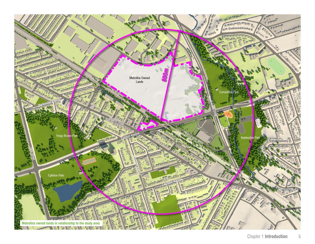
14 The Mobility Hub Study The Mount Dennis Mobility Hub Study focuses on the lands within an 800m radius of the new station. The study presents options for how the new station can best serve the Mount Dennis community and provide seamless, easy connections between LRT, regional rail, local bus services and the surrounding area. The document is intended to be used by a variety of stakeholders including Metrolinx, the City of Toronto, community groups and other organizations to help them to coordinate their activities to create a more transitsupportive station area. On lands owned by Metrolinx, the study will establish a long-term vision for surrounding areas and provide specific recommendations for how the design of the station can help to support broader objectives for the study area. For lands outside of Metrolinx ownership, the study will provide guidance to the City of Toronto so that the City can: Consider updating their zoning and land use policy framework prior to completion of the station; and Respond to development proposals with concrete recommendations that support a wider vision for the station area. By proposing specific public realm improvements, including better pedestrian and cycling connections, the Mobility Hub Study will help to prioritize investments in new or improved infrastructure to be undertaken by the City, Metrolinx or in partnership with other agencies/ organizations. The six key objectives for the Mobility Hub Study are to: Assist in the development of a fully integrated transit station that facilitates transfers between rail and bus services, and the surrounding area; Identify opportunities to re-purpose the Kodak building by integrating the building within the station and designing the station to support access to the building by other users; Identify opportunities and priorities for public realm and streetscaping improvements; Identify opportunities to enhance pedestrian/cyclist connectivity; Explore the potential for transit oriented development on lands adjacent to the Metrolinx property; and Assist in the development of the phasing and implementation of mobility hub components. 4 Mount Dennis Mobility Hub Study

15


16 1.2 The Mobility Hub Study Process Metrolinx began the Mount Dennis Mobility Hub Study in June of Two committees participated in the production of the Study: a Technical Advisory Committee, which consisted of representatives of the TTC, the Metrolinx Station Design Team and Environmental Assessment Team and GO Transit Staff; and a Community Advisory Committee, made up of members of the Mount Dennis community and key stakeholders. Key Stages in The Process As part of the Mobility Hub Study, Metrolinx hosted public engagement activities at four different points in the process. The first Public Open House was held in the summer of 2012 to introduce the study process and the planned transit improvements. A second Public Open House was held on December 12, It focused on the current conditions in the study area and presented the consultant team s preliminary analysis of the opportunities for improvement in the area surrounding the station. Attendees provided suggestions and offered a number of priorities for public realm improvements and station design. A week after the second Public Open House, Metrolinx, in collaboration with the City of Toronto, hosted an Economic Development workshop. This focused on leveraging transit investment to provide local job opportunities. The workshop was well-attended and marked the beginning of an ongoing working relationship between Metrolinx and the City of Toronto focused on local job training and provision. The third Public Open House was held on April 10, The Open House provided an opportunity for the public to see the final recommendations for development and public realm improvements in the lands around the station. Comments arising from this Open House have informed the final Mobility Hub Study document. Complimentary Initiatives The Mount Dennis Mobility Hub Study was completed in coordination with a number of other initiatives currently underway in Mount Dennis, including: improvements to the GO Transit Kitchener Rail Corridor (Metrolinx), providing infrastructure required to support expanded GO Transit service and the Union-Pearson Express; an addendum to the Environmental Project Report (EPR) for the Eglinton Crosstown LRT (Metrolinx); and Eglinton Connects (City of Toronto), a planning study undertaken in partnership with Metrolinx to develop an urban design and public realm vision for the Eglinton corridor. 6 Mount Dennis Mobility Hub Study

17 Key Stages in the process and complimentary initiatives Chapter 1 Introduction 7

18 8 Mount Dennis Mobility Hub Study

19 Background 2 Chapter 2 Background 9
20 2.1 Planned Transit Improvements As a Phase 1 terminus station on the Crosstown LRT, Mount Dennis station is being designed to support access to a wide range of transit services. The surrounding area will also be the home to a Maintenance and Storage Facility (MSF) which will serve the vehicles for the Crosstown. The diagram on page 11 illustrates the major new planned infrastructure that will be introduced to the Mount Dennis area as part of the construction of the Crosstown. Mount Dennis Station will have two main entrances. The primary entrance (1) will be on the northeast corner of Weston Road and Eglinton Avenue and will open onto a new park space created at the intersection. The secondary station entrance (2) will be on the north side of Eglinton Avenue, just east of the existing rail overpass. The new station will connect to a 15 bay bus terminal (3) and a Passenger Pick-up and Drop-off (PPUDO) area (4) located immediately north of Eglinton Avenue. Passengers will connect to the station along a dedicated pedestrian concourse through Kodak building No. 9, which will be preserved and incorporated into the station design as an important point of transfer between the various transit services. Mount Dennis station will also connect to a new GO Transit stop (5). The GO Transit Kitchener Rail corridor intersects with the Crosstown at Mount Dennis and the station is being designed to provide a direct connection to a new GO platform. GO Transit anticipates that the new platforms will open with Mount Dennis Station in The platforms are being designed to accommodate UP Express trains in the future. An important component of Mount Dennis Station is the Maintenance and Storage Facility (MSF), which will service the light rail vehicles using the Crosstown. The MSF (6) will be located on land formerly owned by the Kodak Company, directly north of Eglinton between Black Creek Drive and the CN Rail Corridor. Metrolinx purchased the Kodak site because its size could accommodate the servicing and cleaning of trains and the provision of track maintenance facilities. The MSF is being designed to store approximately 160 cars (54 trains), to allow for the future expansion of the Crosstown service over time. 10 Mount Dennis Mobility Hub Study
 GO Transit Platforms")
 Bus Terminal Eglinton Avenue")
 Primary Station Entrance")

21 (6) Maintenance and Storage Facility Coronation Park (5) GO Transit Platforms Weston Road LRT Station (4) Passenger Pick-up and Drop-off (3) Bus Terminal Eglinton Avenue Kodak Building No 9 Black Creek Drive York Community Centre (1) Primary Station Entrance (2) Secondary Station Entrance The planned transit facilities Photography Drive Chapter 2 Background 11
22 2.2 The Mount Dennis Community The Mount Dennis neighbourhood is a diverse community experiencing a number of challenges including lower than average household incomes and education attainment rates, a struggling main street and poor real estate market. Despite these challenges, the area benefits from active and engaged residents, elected officials who are working to secure neighbourhood investment and a unique natural setting located between two valley systems. The People Mount Dennis is a culturally diverse community with a high percentage of first-generation Canadians. Although there is sustained commitment to improving the number and quality of jobs in the area, the average household income remains lower than the rest of Toronto and the area has been designated a Priority Neighbourhood for social and capital investment. Rents and property values in Mount Dennis remain lower than the rest of the city, however the neighbourhood provides a good mix of housing options, from single-family detached homes to high-rise residential buildings. 28% of residents in Mount Dennis use public transit, which is provided by buses along Weston Road and Eglinton Avenue. The Built Environment Centred along Weston Road, Mount Dennis is bound to the east and west by park lands associated with the Humber River and Black Creek valley systems. These contain a mix of active and passive recreational uses in a wooded setting. In addition to these open space amenities, a new York Community Centre is being built at Black Creek Drive and Eglinton Avenue. Weston Road is predominantly low-rise in scale. The street has had a predominantly retail focus, although in recent years there has been an increase in conversion to residential uses, particularly new townhomes. Running to the east and parallel to Weston Road is the GO/CPR rail corridor, which forms the eastern boundary to Mount Dennis s residential neighbourhoods. The neighbourhood is comprised predominantly of single detached housing interspersed with small walkup apartments. Several high-rise residential buildings are located adjacent to the rail corridor and just east of Eglinton Flats. Eglinton Avenue is an important east-west connection through the Mount Dennis community. While much of the street to the east of the neighbourhood can be characterized as main street, west of Keele, Eglinton Avenue is characterized predominantly as a wide avenue with larger setbacks, no retail and a more natural setting. The two largest areas of undeveloped land in Mount Dennis are located between the rail corridor and Black Creek Drive on either side of Eglinton Avenue. To the north are the Kodak Lands, a former industrial site. These lands are owned by Metrolinx and will be used for LRT infrastructure including the MSF and station. To the south is the Black Creek Triangle. It is currently the site of a large No Frills grocery store and a proposed gasoline bar. It also contains a small piece of City-owned land at the western corner of the site. The Black Creek Business Area, north of the Kodak Lands, is comprised of a mix of warehouse, office uses and light manufacturing and retail uses. Although the area has shifted from a predominantly manufacturing focus towards more warehousing, it remains a successful local employment area. 12 Mount Dennis Mobility Hub Study

23 The Real Estate Market Conditions A component of the Mobility Hub study process was to examine the current real estate market conditions to assess how these might change with the introduction of new public transit to the area and assess the likelihood of attracting new development. Mount Dennis property values and rents per square foot are comparatively lower than the rest of the city. This makes it difficult to attract new investment as developers are more likely to focus efforts in areas with higher rates of return. Residential Currently, houses in Mount Dennis have an average resale price of $284,000 at an average of $220 per square foot (psf). It is estimated that it may be possible to achieve a condominium sale price of $270 psf for a new building in Mount Dennis, compared to an average of $554 psf in the City of Toronto and $491 psf in North York. Given these prices, the most realistic form of development over the short- to medium-term (0-15 years) is wood-frame 2 to 4 storey townhouse or stacked townhouse development. It is estimated that a resale price of $425 psf would be required to support mid-rise construction of between 5 and 8 storeys. While it is expected that the new station will help to enhance the market, achieving an increase of this magnitude is expected to occur over the longer term (15-25 years). Office There is currently no office market in Mount Dennis. A comparative analysis against similar locations in the city suggests that it might be likely to attract rents of between $13 and $14 psf following the completion of the LRT. This is approximately half of what would be required to turn a profit. The viability of office over the long term (15-25 years) will depend on the ability to create an attractive urban environment offering diverse housing choices or retail, restaurant, entertainment and fitness amenities that will support employee recruitment and retention. Retail In comparison with other areas of the city, a higher percentage of people are traveling outside the area to meet their retail needs. A large number of Mount Dennis residents shop at the Crossroads Mall (at Weston Road & 401) and at the big box retail centers located at Weston Road and St. Clair Avenue. Although the options presented by these large-format retail centres are appealing, Mount Dennis residents have expressed a desire to see more retail along Weston Road. Eglinton Flats Ray Avenue Weston Road Black Creek Business Area Industrial The relatively low heights of many of the buildings in the Black Creek Business Area means that the area is no longer attractive to new industrial users. Because of this, the area is slowly shifting toward a focus on storage and light manufacturing. This area may also be viable as a retail employment area, offering discount pricing within a warehouse environment however, this would need to be consistent with existing policy and may need to be considered as a component of a comprehensive policy review. Former Kodak Lands Eglinton Avenue Black Creek Drive Black Creek Triangle Coronation Park Keelesdale Park Aerial of the Mount Dennis community Chapter 2 Background 13


24 A view of Eglinton Avenue looking east from Photography Drive illustrating the more natural characteristic of the street west of Keele 6 lanes of traffic and dedicated turning lanes create an unfriendly crossing at Black Creek Drive and Eglinton Avenue 12 The Black Creek Triangle between Black Creek Drive and Eglinton is a large site with potential for redevelopment over time The large retaining wall and narrow sidewalks along the north side of Eglinton Avenue creates an inhospitable environment for pedestrians Narrow sidewalks beneath the rail corridor and Photography Drive add to the inhospitableness of Eglinton Avenue 14 Mount Dennis Mobility Hub Study


25 Weston Road is comprised predominantly of low-rise mixed use main street buildings In recent years investment in streetscaping has helped to enhance the image of the street In recent years a poor market has resulted in the conversion of older retail uses to townhouse development along Weston Road The Mount Dennis neighbourhood is comprised primarily of single family detached dwellings Several high-rise residential buildings are located adjacent to the rail corridor and just 3 east of Eglinton Flats Older warehouse spaces in the Black Creek Business Park are not conducive for re-use as new warehouse or office spaces Chapter 2 Background 15
26 2.3 Transit The Opportunity Despite the challenges facing the neighbourhood, the completion of the Crosstown and the development of Mount Dennis Station has the potential to catalyze change within the community. investment alone may not have a significant impact on Mount Dennis, but when combined with sustained investment in the community, it can help strengthen existing neighbourhoods, provide a new mix of people and uses in the community and support local jobs. Strengthening Existing Neighbourhoods When complete, the Crosstown will enable residents of Mount Dennis to get to the Yonge Street subway in just 18 minutes. The relatively low housing prices in Mount Dennis, when combined with investments in new community facilities and improved transit access will create conditions that can lead to an increase in demand for existing neighbourhood housing. As the value of existing houses rises, the residential market will eventually improve the viability and quality of retail on Weston Road. Over the longer term, with continued investment in the areas streets and open spaces, new forms of higher density housing may be viable. This will help to increase the diversity of the existing neighbourhood, providing a greater mix of housing types and transforming underutilized sites into more active, inviting places over time. Supporting Jobs While the Maintenance and Storage Facility may provide a number of local jobs, the real gain for the Mount Dennis community in the short term will come from the reduced commute times and expanded access to employment opportunities throughout the rest of the city. This is particularly important in Mount Dennis given the notable percentage of residents who rely on transit. In addition to providing enhanced transit service, Metrolinx has committed to working with the City of Toronto Economic Development division to discuss economic development initiatives such as opportunities for employment training and job creation during the construction of the Crosstown. In the longer term, employment opportunities will come from the strengthening of the real estate market and increased ability for small business creation along the Weston Road main street. While the existing building stock in the Black Creek Business Area may no longer be appropriate for large industrial uses, the increased profile resulting from the LRT and the return of a workforce to the Kodak Lands will help to strengthen the Black Creek Business Area by supporting its transition to a light warehousing destination with ancillary retail, small scale employment uses and supporting services 16 Mount Dennis Mobility Hub Study
27 Attracting New People and Uses The increased profile and enhanced accessibility provided by the Crosstown line will help to attract new people and uses to the Mount Dennis Community. This will lead to more activity on the streets which will in turn increase the safety of the surrounding neighbourhoods. An increase in the number of people in Mount Dennis will have a positive effect on local shops as new people, with different backgrounds begin demanding a broader variety of retail. In the short-term, opportunities for new retail and uses will be most evident at or around the station. Over the longer term opportunities will occur as softer sites throughout the neighbourhood are redeveloped. Visitors will be able to take the Crosstown to Mount Dennis, whose proximity to the Black Creek and Humber River valley systems and new civic destinations, such as the new York Community Centre, will attract people who may never have thought to visit the community before. Enhancing the Setting Mount Dennis benefits from outstanding parks and natural areas. The new station will directly improve the connections between these areas while setting the stage for future enhancement of green spaces throughout the neighbourhood. Two of the significant park systems in Mount Dennis, the Humber River and Black Creek, have been separated for years by the CN rail corridor. As part of station development, Eglinton Avenue, which connects these two parks, will be improved with widened sidewalks on the north side of the street and new street trees. This will help to enhance the park-like setting along Eglinton Avenue and link the two valleys while creating a safer, more pleasant pedestrian environment. In addition to enhancements along Eglinton Avenue, an opportunity will exist at the site of the station entrance at Weston Road to create a new station related open space. Together these improvements will help to enhance the setting and image of the neighbourhood and compliment other initiatives along Weston Road, in the valleys and throughout the neighbourhood. Chapter 2 Background 17

28 18 Mount Dennis Mobility Hub Study

29 Key Directions 3 Chapter 3 Key Directions 19


30 3.1 The Five Focus Areas The Mount Dennis neighbourhood is a diverse area with a range of settings, each of which have unique challenges and opportunities. In order to respond to these distinct environments, the Mobility Hub Study divided the station area into 5 key areas of focus. The following section provides an overview of the 5 focus areas outlining the current condition and future opportunities. These are followed by a series of area-specific strategies aimed at achieving the vision for each area and supporting transit ridership over the long-term. Each strategy is supported by a range of graphic imagery and precedent pictures. These are illustrative for the purpose of providing meaning and a possible visual interpretation of an outcome that the strategy and the actions hope to achieve. 1. The Kodak Lands 2. Eglinton Avenue 3. Weston Road 4. The Black Creek Triangle 5. The Black Creek Business Area Mount Dennis Mobility Hub Study

31
Prepared for Metrolinx by:
 Mount Dennis Mobility Hub Study August 2013 Prepared for Metrolinx by: Acknowledgements Community Liaison Group Patrick Saavedra Barbara Stone Marabelle McTavish Barbara Spyropoulos Robyn Hoogendam Robert
Mount Dennis Mobility Hub Study Public Meeting December 12 th, :30pm 9:30pm York Memorial Collegiate, Cafeteria 2690 Eglinton Avenue West
 Mount Dennis Mobility Hub Study Public Meeting December 12 th, 2012 6:30pm 9:30pm York Memorial Collegiate, Cafeteria 2690 Eglinton Avenue West MEETING SUMMARY On December 12 th, 2012, over 89 people participated
WELCOME and introduction
 1 WELCOME and introduction Mobility Hub Locations within Burlington STUDY OVERVIEW STUDY OBJECTIVES The City of Burlington is developing four Area Specific Plans, one for each of Burlington s Mobility
Port Credit Local Advisory Panel October 20 th Meeting
 Port Credit Local Advisory Panel October 20 th Meeting Focus Of This Evening s Meeting: 1. Hurontario Main Street Higher Order Transit Study 2. Port Credit Mobility Hub & GO Station Parking Structure Study
3.1. The Kodak Lands. The Kodak Lands Today. 22 Mount Dennis Mobility Hub Study
 Industry Street 3.1 The Kodak Lands Ray Avenue Coronation Park The Kodak Lands Today The Kodak Lands are a large parcel of land east of the rail corridor between, Industry Street and Black Creek Drive.
Trafalgar Road Corridor Planning Study Open House
 Trafalgar Road Corridor Planning Study Open House June 24, 2013 6:30-8:30 p.m. Oakville & Trafalgar Rooms Overview The Livable Oakville Plan identifies the lands along Trafalgar Road, between the QEW and
Don Mills Crossing Study and Celestica Lands Development Application Community Meeting, Open House, and Breakout Discussions
 Consultation Summary Don Mills Crossing Study and Celestica Lands Development Application Community Meeting, Open House, and Breakout Discussions This report is not intended to provide a verbatim transcript
QUEEN-RIVER SECONDARY PLAN
 34 QUEEN-RIVER SECONDARY PLAN 34. QUEEN RIVER SECONDARY PLAN 1. INTRODUCTION The Queen-River area is approximately 6.4 hectares and is located at the eastern edge of the Downtown as shown on Map 34-1.
Welcome. Walk Around. Talk to Us. Write Down Your Comments
 Welcome This is an information meeting introducing the applications for proposed redevelopment of the Yorkdale Shopping Centre site at 3401 Dufferin Street and 1 Yorkdale Road over the next 20+ years,
ELMVALE ACRES SHOPPING CENTRE MASTER PLAN
 ELMVALE ACRES SHOPPING CENTRE MASTER PLAN Contents 1.0 INTRODUCTION... 2 2.0 LOCATION... 2 3.0 EXISTING CONTEXT... 2 4.0 VISION & GUIDING PRINCIPLES... 2 5.0 LAND USE AND BUILT FORM... 4 5.1 St. Laurent
1.0 Purpose of a Secondary Plan for the Masonville Transit Village
 Report to Planning and Environment Committee To: Chair and Members Planning & Environment Committee From: John M. Fleming Managing Director, Planning and City Planner Subject: Masonville Transit Village
Public Open House #1
 Public Open House #1 TONIGHT S AGENDA Welcome Project Overview The Big Picture The Station Area The Analysis Thoughts about Future Change Breakout Group Discussions Summation / Next Steps Project Overview
4- PA - LD - LIVELY DOWNTOWN. LD - Background
 4- PA - LD - LIVELY DOWNTOWN LD - Background The downtown has been the service centre for the community since the city s inception and the area continues to supply people with their personal services,
Urban Design Manual PLANNING AROUND RAPID TRANSIT STATIONS (PARTS) Introduction. Station Study Areas
 Introduction. Station Study Areas") 111111 PLANNING AROUND RAPID TRANSIT STATIONS (PARTS) Introduction The ION rapid transit system will link Waterloo, Kitchener and Cambridge through a central transit corridor (CTC). There are a number
111111 PLANNING AROUND RAPID TRANSIT STATIONS (PARTS) Introduction The ION rapid transit system will link Waterloo, Kitchener and Cambridge through a central transit corridor (CTC). There are a number
1.3 TRANSIT VISION 2040 FROM VISION TO ACTION THEME 1: PUTTING TRANSIT AT THE CENTRE OF COMMUNITIES. Fully integrate transit with community planning
 TRANSIT VISION 2040 FROM VISION TO ACTION TRANSIT VISION 2040 defines a future in which public transit maximizes its contribution to quality of life with benefits that support a vibrant and equitable society,
DRAFT DRAFT DRAFT DRAFT
 # 19 EXPAND GREEN AND OPEN SPACES AND COMMUNITY FACILITIES IN TANDEM WITH NEW DEVELOPMENT The role of Eglinton will change in the coming years, along with the intensity of activity and land uses. As more
John M. Fleming Managing Director, Planning and City Planner. Old East Village Dundas Street Corridor Secondary Plan Draft Terms of Reference
 Report to Planning and Environment Committee To: From: Subject: Chair and Members Planning & Environment Committee John M. Fleming Managing Director, Planning and City Planner Old East Village Dundas Street
UTSC SECONDARY PLAN COMMUNITY OPEN HOUSE
 WELCOME TO THE UTSC SECONDARY PLAN COMMUNITY OPEN HOUSE 1 Welcome to the first Community Open House for the UTSC Secondary Plan. Hosted by the University of Toronto Scarborough (UTSC), the following panels
Transit-supportive development and city-building
 Photo: Michael Hiemstra (CC BY 2.0) Transit-supportive development and city-building Brief 3: Tools for building infrastructure and policy conditions Building the policy and infrastructure conditions Municipalities
PART 1. Background to the Study. Avenue Study. The Danforth
 The Danforth 1.1/ Study Purpose & Key Municipal Goals 1.2/ The Local Advisory Committee 1.3/ The Project Team 1.4/ Study Process/Summary of Method 1.5/ Summary of Consultation 1.1 Study Purpose and Key
Create Policy Options Draft Plan Plan Approval. Public Consultation Events. Phase 2
 Background Grandview-Woodland Community Plan In the spring of 2012, the City of Vancouver embarked on a comprehensive community planning program in the Grandview-Woodland neighbourhood. The process has
The Master Plan Framework
 The Master Plan Framework The East Harbour Master Plan advances the development of 60 acres of former industrial lands east of the Don River. The Master Plan outlines a vision for a vibrant, transit-oriented
PUBLIC OPEN HOUSE HURONTARIO-MAIN CORRIDOR SECONDARY PLAN
 PUBLIC OPEN HOUSE HURONTARIO-MAIN CORRIDOR SECONDARY PLAN Tuesday, February 28, 2012 6pm 9pm 1 st Floor Atrium, City Hall 2 Wellington Street West, Brampton 1 POLICY FRAMEWORK The 2006 Provincial Growth
Welcome to the Oakridge Centre Open House
 Welcome to the Oakridge Centre Open House Why is the City hosting this event? This open house is to inform you of a rezoning application submitted to the City of Vancouver to amend the existing CD-1 (Comprehensive
Eglinton West LRT Update
 Eglinton West LRT Update Community Consultation Update May 16, 2016 Background Rapid transit along Eglinton Ave between Kennedy Station and Pearson Airport was included in the Metrolinx Regional Transportation
Town Center (part of the Comprehensive Plan)
") Town Center (part of the Comprehensive Plan) Mercer Island Town Center Looking North (2014) In 1994, a year-long process culminated in a set of design guidelines and code requirements for the Town Center
Town Center (part of the Comprehensive Plan) Mercer Island Town Center Looking North (2014) In 1994, a year-long process culminated in a set of design guidelines and code requirements for the Town Center
Coordinated Transit Planning in Toronto SmartTrack GO RER Scarborough Relief Line Waterfront Transit
 Coordinated Transit Planning in Toronto SmartTrack GO RER Scarborough Relief Line Waterfront Transit Public Information Centres February 2016 Transportation Planning Section City Planning Division Toronto
844 Don Mills Road & 1150 Eglinton Avenue East - Official Plan Amendment Application - Preliminary Report
 STAFF REPORT ACTION REQUIRED 844 Don Mills Road & 1150 Eglinton Avenue East - Official Plan Amendment Application - Preliminary Report Date: July 10, 2014 To: From: Wards: Reference Number: Planning and
SECTION ONE: INTRODUCTION. introduction
 introduction 1 INTRODUCTION Since it was first established in 1843 as a trading post for the Hudson s Bay Company, Victoria has evolved into a Provincial capital city that is recognized across Canada and
YONGE STEELES CORRIDOR SECONDARY PLAN. Young + Wright / IBI Group Architects Dillon Consulting Ltd. GHK International (Canada) Ltd.
 Ltd.") PART A: PREAMBLE 1.0 PURPOSE The purpose of this Secondary Plan is to provide a development framework for intensification of the Yonge/ Steeles corridor including the north side of Steeles Avenue West
PART A: PREAMBLE 1.0 PURPOSE The purpose of this Secondary Plan is to provide a development framework for intensification of the Yonge/ Steeles corridor including the north side of Steeles Avenue West
Midtown Greenway Land Use and Development Plan Executive Summary
 Midtown Greenway Land Use and Development Plan Executive Summary Introduction The Midtown Greenway Land Use and Development Plan sets policy direction for land use and development in the Midtown Greenway
Report to: Development Services Committee Report Date: April 24, 2017
 SUBJECT: Cornell Rouge National Urban Park Gateway - Report on Design Charrette and Next Steps PREPARED BY: Lilli Duoba, MES, MCIP, RPP, Manager, Natural Heritage (ext. 7925) REVIEWED BY: Marg Wouters,
4780 Eglinton Avenue West - Zoning By-law Amendment and Draft Plan of Subdivision Applications - Preliminary Report
 STAFF REPORT ACTION REQUIRED 4780 Eglinton Avenue West - Zoning By-law Amendment and Draft Plan of Subdivision Applications - Preliminary Report Date: May 29, 2014 To: From: Wards: Reference Number: Etobicoke
C. Westerly Creek Village & The Montview Corridor
 C. Westerly Creek Village & The VISION Community Vision When the goals of the city are achieved Westerly Creek Village, a distinctive community defined by Montview Boulevard and Westerly Creek, is a strong
McCowan Precinct Plan Study Background & Deliverables
 1 DRAFT & WITHOUT PREJUDICE McCowan Precinct Plan Study Background & Deliverables In September, 2011, City Planning (Scarborough District) began a study of an area within the Scarborough Centre, identified
This Review Is Divided Into Two Phases:
 Semiahmoo Town Centre Review The purpose of this review: To review the Semiahmoo Town Centre Concept Plan, originally approved in 1993, to ensure that this centre will continue to serve the needs of South
[PLANNING RATIONALE] For Site Plan Control and Lifting of Holding Zone By-Law 101 Champagne Avenue. May 23, 2014
![[PLANNING RATIONALE] For Site Plan Control and Lifting of Holding Zone By-Law 101 Champagne Avenue. May 23, 2014](/thumbs/75/71599615.jpg "[PLANNING RATIONALE] For Site Plan Control and Lifting of Holding Zone By-Law 101 Champagne Avenue. May 23, 2014") [PLANNING RATIONALE] For Site Plan Control and Lifting of Holding Zone By-Law 101 Champagne Avenue May 23, 2014 Contents 1.0 Introduction... 2 2.0 Site Context... 2 2.1 Adjacent Uses... 2 Figure 1: Site
[PLANNING RATIONALE] For Site Plan Control and Lifting of Holding Zone By-Law 101 Champagne Avenue May 23, 2014 Contents 1.0 Introduction... 2 2.0 Site Context... 2 2.1 Adjacent Uses... 2 Figure 1: Site
SCARBOROUGH SUBWAY EXTENSION. Scarborough Subway Extension. Final Terms of Reference
 Scarborough Subway Extension Final Terms of Reference 1 1.0 Introduction and Background 1.1 Introduction Toronto City Council recently confirmed support for an extension of the Bloor-Danforth Subway from
North Fair Oaks Community Plan Summary and Information
 North Fair Oaks Community Plan Summary and Information WHAT IS THE NORTH FAIR OAKS COMMUNITY PLAN? The North Fair Oaks Community Plan is part of the San Mateo County General Plan, and establishes policies
Speers Road Corridor Study. Livable Oakville (Official Plan) Council Sub Committee March 20, 2017
 Council Sub Committee March 20, 2017") Speers Road Corridor Study Livable Oakville (Official Plan) Council Sub Committee March 20, 2017 Overview 1) Study Purpose & Background 2) Study Area 3) Policy Context and Plan Review 4) Speers Road Corridor
Speers Road Corridor Study Livable Oakville (Official Plan) Council Sub Committee March 20, 2017 Overview 1) Study Purpose & Background 2) Study Area 3) Policy Context and Plan Review 4) Speers Road Corridor
5 TOWN OF MARKHAM OFFICIAL PLAN AMENDMENT NO. 144 MILLIKEN MAIN STREET SECONDARY PLAN
 5 TOWN OF MARKHAM OFFICIAL PLAN AMENDMENT NO. 144 MILLIKEN MAIN STREET SECONDARY PLAN The Planning and Economic Development Committee recommends the following: 1. The communication from Brendan O Callaghan,
WELCOME. The Yonge-Eglinton area has experienced significant growth and change in the last decade.
 WELCOME DID YOU KNOW? MIDTOWN IS REPRESENTED BY 3 CITY COUNCILLORS: WARD 16 EGLINTON-LAWRENCE WARD 22 ST. PAUL S WARD 25 DON VALLEY WEST Midtown in Focus: Building a Livable Yonge-Eglinton The Yonge-Eglinton
CITY OF CHARLOTTESVILLE, VIRGINIA CITY COUNCIL AGENDA
 CITY OF CHARLOTTESVILLE, VIRGINIA CITY COUNCIL AGENDA Agenda Date: December 16, 2013 Action Required: Adoption of Resolution Presenter: Staff Contacts: Title: James E. Tolbert, AICP, Director of NDS James
CONTENTS 8.0 LAND USE 8.1 GENERAL LAND USE 8.2 RESIDENTIAL 8.3 MIXED USE 8.4 COMMERCIAL 8.5 EMPLOYMENT LANDS
 8-2 Land Use 8.0 LAND USE CONTENTS 8.1 GENERAL LAND USE 8.1.1 Uses provided for in all Land Use Designations 8.1.2 Uses prohibited in Hazardous Lands, Hazardous Sites and Special Policy Areas 8.1.3 Uses
38 Queen s University Campus Master Plan Part 1
 38 Queen s University Campus Master Plan Part 1 46 The Campus at the City Scale Chapter 4 The Campus at the City Scale 39 Queen s is an urban University centrally located in Kingston. Decisions made by
770 Don Mills Road and 805 Don Mills Road - Official Plan Amendment and Zoning By-law Amendment Application Preliminary Report
 REPORT FOR ACTION 770 Don Mills Road and 805 Don Mills Road - Official Plan Amendment and Zoning By-law Amendment Application Preliminary Report Date: To: From: Wards: June 22, 2018 North York Community
8 Oak Street - Official Plan and Zoning By-law Amendment Application - Preliminary Report
 STAFF REPORT ACTION REQUIRED 8 Oak Street - Official Plan and Zoning By-law Amendment Application - Preliminary Report Date: March 17, 2014 To: From: Wards: Reference Number: Planning and Growth Management
Animating the Rideau Canal December 2013
 Executive Summary Animating the Rideau Canal December 2013 Why study the Rideau Canal? The Rideau Canal has been an important part of Ottawa throughout its history, and has shaped and been shaped by the
FORMER CANADIAN FORCES BASE (CFB) ROCKCLIFFE SECONDARY PLAN. Official Plan Amendment XX to the Official Plan for the City of Ottawa
 ROCKCLIFFE SECONDARY PLAN. Official Plan Amendment XX to the Official Plan for the City of Ottawa") FORMER CANADIAN FORCES BASE (CFB) ROCKCLIFFE SECONDARY PLAN Official Plan Amendment XX to the Official Plan for the City of Ottawa 1 INDEX THE STATEMENT OF COMPONENTS PART A THE PREAMBLE PAGE Purpose...
FORMER CANADIAN FORCES BASE (CFB) ROCKCLIFFE SECONDARY PLAN Official Plan Amendment XX to the Official Plan for the City of Ottawa 1 INDEX THE STATEMENT OF COMPONENTS PART A THE PREAMBLE PAGE Purpose...
Making Transit Oriented Development Work For Boonton, NJ
 Making Transit Oriented Development Work For Boonton, NJ Bloustein School of Planning and Public Policy Studio Dan Burton Loannie Dao Webster Slater Brandon Williams Ian Watson Maria Laham Nicola Mammes
AGINCOURT SECONDARY PLAN
 1 AGINCOURT SECONDARY PLAN 1. AGINCOURT SECONDARY PLAN The following policies and principles apply to the area herein referred to as Agincourt, as outlined on Map 1-1. 1. GENERAL POLICIES 1.1 This Secondary
Planning and Growth Management Committee. Chief Planner and Executive Director, City Planning
 PG5.3 STAFF REPORT ACTION REQUIRED Planning Study for the Weston Road and Black Creek Drive Area and Site Specific Official Plan and Zoning By-law Amendment Application for 955, 965 and 969 Weston Road
Chapter 1: Introduction
 Chapter 1: Introduction The Penn Avenue Community Works Corridor Vision and Implementation Framework presents an integrated communitybased vision and a coordinated, long-term implementation framework for
MOBILITY HUB GUIDELINES 2012 TAC Sustainable Urban Transportation Award Submission BACKGROUND MOBILITY HUB GUIDELINES
 MOBILITY HUB GUIDELINES 2012 TAC Sustainable Urban Transportation Award Submission BACKGROUND Rapid population growth, increasing congestion, and years of under investment in transit in the Greater Toronto
Agenda. 7 Wright Crescent Urban Design Study. Public Meeting and Urban Design Workshop. 1 INTRODUCTION AND BACKGROUND (City of Kingston)
") Urban Design Study Public Meeting and Urban Design Workshop October 02, 2013 Agenda 1 INTRODUCTION AND BACKGROUND (City of Kingston) 2 URBAN DESIGN STUDY PRESENTATION (Antonio Gomez-Palacio, DIALOG) 3
Urban Design Study Public Meeting and Urban Design Workshop October 02, 2013 Agenda 1 INTRODUCTION AND BACKGROUND (City of Kingston) 2 URBAN DESIGN STUDY PRESENTATION (Antonio Gomez-Palacio, DIALOG) 3
and services The protection and conservation of environmentally significant and sensitive natural heritage features and functions.
 6. Land Use 6.0 Preamble A healthy and livable city is one in which people can enjoy a vibrant economy and a sustainable healthy environment in safe, caring and diverse neighbourhoods. In order to ensure
Implementation Guide Comprehensive Plan City of Allen
 Implementation Guide 2030 Comprehensive Plan City of Allen DRAFT 2015 Implementation Guide Allen 2030 Comprehensive Plan INTRODUCTION The Comprehensive Plan serves as a guide for the growth and development
Ivywild On The Creek PRELIMINARY CREEK DISTRICT MASTER PLAN
 Ivywild On The Creek PRELIMINARY CREEK DISTRICT MASTER PLAN Introduction: Rejuvenating an extraordinary Creekside neighborhood THE CREEKSIDE DISTRICT The Ivywild On The Creek Neighborhood District Master
The West Vaughan Employment Area Secondary Plan Policies
 Part 2: The West Vaughan Employment Area Secondary Plan Policies 2.1 General Policies It is the policy of Council: 2.1.1. That the West Vaughan Employment Area (the WVEA), identified on Schedule 1, will
City of Toronto. Emery Village Transportation Master Plan
 City of Toronto Emery Village Transportation Master Plan May 2009 Emery Village Transportation Master Plan Toronto, ON May 2009 Consulting Inc. 100 York Blvd., Suite 300 Richmond Hill, ON L4B 1J8 Tel:
JANUARY 19, 2011 CENTRAL AVENUE-METRO BLUE LINE TRANSIT-ORIENTED DEVELOPMENT IMPLEMENTATION PROJECT COMMUNITY FORUM
 CENTRAL AVENUE-METRO BLUE LINE TRANSIT-ORIENTED DEVELOPMENT IMPLEMENTATION PROJECT COMMUNITY FORUM JANUARY 19, 2011 THE MARYLAND-NATIONAL CAPITAL PARK AND PLANNING COMMISSION PRINCE GEORGE S COUNTY PLANNING
This report presents the draft Don Mills Crossing Secondary Plan for public consultation.
 PG30.6 REPORT FOR ACTION Don Mills Crossing - Proposals Report Date: May 17, 2018 To: Planning and Growth Management Committee From: Chief Planner and Executive Director, City Planning Division Wards:
LAKEVIEW LOCAL ADVISORY PANEL. THE COPORATION OF THE CITY OF MISSISSAUGA THURSDAY, NOVEMBER 18, 2010
 LAKEVIEW LOCAL ADVISORY PANEL THE COPORATION OF THE CITY OF MISSISSAUGA www.mississauga.ca/lakeviewportcreditreview THURSDAY, NOVEMBER 18, 2010 MISSISSAUGA SENIORS CENTRE LUCY TURNBALL ROOM (1389 Cawthra
Corridor Vision. 1Pursue Minnehaha-Hiawatha Community Works Project. Mission of Hennepin County Community Works Program
 1Pursue Minnehaha-Hiawatha Community Works Project Minnehaha-Hiawatha Community Works is a project within the Hennepin Community Works (HCW) program. The mission of the HCW program is to enhance how the
Eglinton Connects Planning Study Phase 1 (Part 2) Implementation Report
 Implementation Report") STAFF REPORT ACTION REQUIRED Eglinton Connects Planning Study Phase 1 (Part 2) Implementation Report Date: July 24, 2014 To: From: Planning and Growth Management Committee Chief Planner and Executive Director,
STAFF REPORT ACTION REQUIRED Eglinton Connects Planning Study Phase 1 (Part 2) Implementation Report Date: July 24, 2014 To: From: Planning and Growth Management Committee Chief Planner and Executive Director,
CHAPTER 5: GUIDING PRINCIPLES
 CHAPTER 5: GUIDING PRINCIPLES The following 10 principles were developed based on public consultation, planning policy and the background analysis conducted during Phase 1. The Guiding Principles significantly
URBAN DESIGN BRIEF. 2136&2148 Trafalgar Road. Town of Oakville
 URBAN DESIGN BRIEF 2136&2148 Trafalgar Road Town of Oakville Prepared By: METROPOLITAN CONSULTING INC For 2500674 Ontario Inc November 2016 TABLE OF CONTENTS Page No. 1.0 Introduction/Description of Subject
The Allen District. Community Consultation Meeting #1. Presented for Local Advisory Committee Monday, May 2, 2016
 The Allen District Community Consultation Meeting #1 Presented for Local Advisory Committee Monday, May 2, 2016 Presenters William Bryck President & CEO Build Toronto Pino Di Mascio Partner Urban Strategies
New Westminster Downtown Parking Strategy Public Open House #1 September 13, 2012
 New Westminster Downtown Parking Strategy Public Open House #1 September 13, 2012 The City is preparing a strategy for parking in Downtown New Westminster. The study team and a group of key stakeholders
Downtown Streetscape Manual & Built Form Standards
 City of Guelph Downtown Streetscape Manual & Built Form Standards July 2014 Prepared by Brook McIlroy Inc. in association with Unterman McPhail Associates and McCormick Rankin Inc. City of Guelph Downtown
The University District envisions, in its neighborhood
 Envisioning the University District Link Light Rail in Seattle s neighborhoods CIY OF SEALE CONCEP-LEVEL SAION AREA PLANNING RECOMMENDAION RESOLUION # 30165 EXHIBI L Vision 08.2000 he University District
CREATE A VIBRANT MIXED-USE COMMUNITY
 CREATE A VIBRANT MIXED-USE COMMUNITY Land Use Public Realm Plan Built Form Heritage Tell us what you think! Place a sticky note here or leave us a comment form LAND USE The land use framework of this Secondary
About Momentum Midland
 About Momentum Midland Achieving a community s full potential in terms of economic development and quality of life is critically important to its long term sustainability. Core to achieving this is a vibrant
GO Station Mobility Hubs: Draft Precinct Plans. Committee of the Whole July 12, 2018
 GO Station Mobility Hubs: Draft Precinct Plans Committee of the Whole July 12, 2018 Purpose of this Workshop Present Draft Precinct Plans for the 3 GO Station Mobility Hubs Continue the conversations that
Hockessin Community Redevelopment Plan
 Hockessin Community Redevelopment Plan 3.1 Introduction The Community Redevelopment Plan for the Village of Hockessin is the result of the people s vision for a distinct village center that serves as the
Queensborough Eastern Neighbourhood Node. Community Open House
 Queensborough Eastern Community Open House The Vision The Queensborough Eastern will become the heart of eastern Queensborough. Through a sensitive mix of viable commercial and residential areas, the neighbourhood
Mark-up of the effect of the proposed Bronte Village Growth Area OPA No.18 on the text of section 24, Bronte Village, of the Livable Oakville Plan
 Mark-up of the effect of the proposed Bronte Village Growth Area OPA No.18 on the text of section 24, Bronte Village, of the Livable Oakville Plan Notes: This document is provided for information purposes
St. Clair Avenue West Area Transportation Master Plan
 1 (Between Keele Street and Old Weston Road) Public Information Centre 1 December 2, 2015 2 Welcome Welcome to the first Public Information Centre for the St. Clair Avenue West Area. The panels will present
burlington mobility hubs study Downtown Burlington Mobility Hub
 burlington mobility hubs study Downtown Burlington Mobility Hub Draft Precinct Plan Workbook PIC #3, September 7, 2017 downtown mobility hub objectives City staff and their consultants are proposing an
Tyvola & Archdale Transit Station Area Plan. May 15, 2008
 Tyvola & Archdale Transit Station Area Plan First Public Meeting May 15, 2008 Presentation Outline 1. Purpose and Process 2. Station Area Overview 3. Plan Recommendations Vision Land Use Transportation
The transportation system in a community is an
 7 TRANSPORTATION The transportation system in a community is an important factor contributing to the quality of life of the residents. Without a sound transportation system to bring both goods and patrons
Public Open House. YWCA, 87 Elm Street December 2nd, 2017, 10 a.m. 2 p.m.
 Public Open House YWCA, 87 Elm Street December 2nd, 2017, 10 a.m. 2 p.m. 1 A 25-Year Downtown Plan A blueprint for future growth and infrastructure in the heart of Toronto Ensuring growth contributes positively
Bloor St. W. Rezoning - Preliminary Report
 STAFF REPORT ACTION REQUIRED 1638-1644 Bloor St. W. Rezoning - Preliminary Report Date: April 1, 2008 To: From: Wards: Reference Number: Toronto and East York Community Council Acting Director, Community
Public Consultation Summary: Lakeview Place Making Workshop January 30, 2008.
 Page 1 of 11 Public Consultation Summary: Lakeview Place Making Workshop January 30, 2008. 1.0 Introduction: On January 30, 2008 the City of Mississauga, in conjunction with the consulting team of Brook
178 Carruthers Properties Inc.
 178 Carruthers Properties Inc. Planning Rationale for 178 Carruthers Avenue Site Plan Control Application June 2014 Table of Contents 1.0 Introduction 2.0 Overview of Subject Property 3.0 Current Zoning
Relief Line Project Assessment
 Relief Line Project Assessment Public Information Centre April 5, 2017 Tonight s Meeting PURPOSE To review the preferred alignment for the Local Segment. AGENDA 6:30 Open House 7:00 Presentation / Discussion
CONTENTS 2.0 A FRAMEWORK FOR SUSTAINABLE GROWTH 2.1 MANAGING SUSTAINABLE GROWTH THE VISION TO GOALS AND OBJECTIVES 2.3 MARKHAM STRUCTURE
 2 A Framework for Sustainable Growth 2.0 A FRAMEWORK FOR SUSTAINABLE GROWTH CONTENTS 2.1 MANAGING SUSTAINABLE GROWTH THE VISION TO 2031 2.2 GOALS AND OBJECTIVES 2.2.1 Protecting the Natural Environment
2.0 A FRAMEWORK FOR SUSTAINABLE GROWTH CONTENTS
 2-2 A Framework for Sustainable Growth 2.0 A FRAMEWORK FOR SUSTAINABLE GROWTH CONTENTS 2.1 MANAGING SUSTAINABLE GROWTH THE VISION TO 2031 2.2 GOALS AND OBJECTIVES 2.2.1 Protecting the Natural Environment
Eglinton Avenue East & 50 Thermos Road - Official Plan Amendment Application Preliminary Report
 STAFF REPORT ACTION REQUIRED 1966 2050 Eglinton Avenue East & 50 Thermos Road - Official Plan Amendment Application Preliminary Report Date: March 15, 2016 To: From: Wards: Reference Number: Scarborough
The Five Components of the McLoughlin Area Plan
 The Five Components of the McLoughlin Area Plan This documents contains the complete language of the five components of the McLoughlin Area Plan: The Vision Statement The Values The Guiding Principles
ARLINGTON COUNTY, VIRGINIA
 ARLINGTON COUNTY, VIRGINIA County Board Agenda Item Meeting October 15, 2005 DATE: September 28, 2005 SUBJECT: Request to Advertise the adoption of the 2005 Clarendon Sector Plan C. M. RECOMMENDATION:
The Cambie Corridor 2015 Fall workshop series. What we heard WORKSHOP OUTLINE
 The Cambie Corridor 2015 Fall workshop series W 16 AVE Area 5 CAMBIE CORRIDOR Phase 3 What we heard ovember 21, 2015, 9am-noon, 1:30-4:30pm Peretz Centre 89 Participants* WORKSHOP OUTLIE Introductions
13 THORNHILL YONGE STREET STUDY IMPLEMENTATION CITY OF VAUGHAN OPA 669 AND TOWN OF MARKHAM OPA 154
 13 THORNHILL YONGE STREET STUDY IMPLEMENTATION CITY OF VAUGHAN OPA 669 AND TOWN OF MARKHAM OPA 154 The Planning and Economic Development Committee recommends the adoption of the recommendations contained
MALL REVITALIZATION CASE STUDIES
 MALL REVITALIZATION CASE STUDIES DECEMBER 9, 2012 MALL REVITALIZATION OVERVIEW Introduction Sample Case Studies prepared for Lacey Woodland District Steering Committee as it considers strategies to revitalize
Key Themes and Responses May 2016
 King and Victoria Transit Hub and Waterloo Street Pedestrian Access Key Themes and Responses May 2016 The following summarizes what Regional staff heard about the King Victoria Transit Hub and Waterloo
City-Initiated Official Plan and Zoning By-law Amendments, Yonge-Eglinton Centre Focused Review Final Report
 STAFF REPORT ACTION REQUIRED City-Initiated Official Plan and Zoning By-law Amendments, Yonge-Eglinton Centre Focused Review Final Report Date: January 5, 2009 To: From: Planning and Growth Management
1 INTRODUCTION Purpose Project Background PROJECT CONTEXT Background The Capital City Downtown Plan...
 Attachment 3 Contents CONTENTS 1 INTRODUCTION... 3 Purpose... 3 Project Background... 3 2 PROJECT CONTEXT... 9 Background... 9 The Capital City Downtown Plan... 9 The LRT Expansion Plan - LRT Downtown
Tyvola & Archdale Transit Station Area Plan. June 5, 2008
 Tyvola & Archdale Transit Station Area Plan Second Public Meeting June 5, 2008 Presentation Outline 1. Purpose and Process 2. Station Area Overview 3. Plan Recommendations 4. Comments Received and Proposed
Agincourt Mall Planning Framework Review Status Report
 STAFF REPORT ACTION REQUIRED Agincourt Mall Planning Framework Review Status Report Date: May 16, 2018 To: From: Scarborough Community Council Director, Community Planning, Scarborough District Wards:
1071 King Street West Zoning Amendment Application - Preliminary Report
 STAFF REPORT ACTION REQUIRED 1071 King Street West Zoning Amendment Application - Preliminary Report Date: August 9, 2012 To: From: Wards: Reference Number: Toronto and East York Community Council Director,