Detailed Site Assessment Requirements
|
|
|
- Ella Curtis
- 5 years ago
- Views:
Transcription

1 Directive PNG018 November 2015 Revision 1.0 Governing Legislation: Act: The Oil and Gas Conservation Act Regulation: The Oil and Gas Conservation Regulations, 2012 Order: 251/18
2 Record of Change Revision Date Description 0 November November 2015 Update to facilitate IRIS implementation in Acknowledgements Special thanks to all Government of Saskatchewan staff and oil & gas licensee representatives who contributed to and supported the development of this document: Lorne Veitch, Ministry of Agriculture Rick Stilling, Ministry of Environment Trevor McMorris, Matrix Solutions Inc. Kurt Jones, W3M Land Management Inc. Mark Gilchrist, W3M Land Management Inc Members of CAPP November 2015 Page 2 of 46
3 Contents 1. Introduction Background Governing Legislation Definitions Reclamation Criteria - Cultivated Lands Site Assessment Sampling Scheme Lease Controls Minimal Disturbance Lease Access Landscape Surface Soil Quantity, Distribution and Quality Topsoil Additions Quantity and Distribution of Replaced Surface Soil Quantity and Distribution of Replaced Surface Soil for Sites After June 19, Quantity and Distribution of Replaced Surface Soil for Sites Predating June 19, Quality of Replaced Surface Soil Soil Tolerance Vegetation Use of Non-native Species Timing of Vegetation Assessments Annual Crops Perennial Crops Vegetation Assessment Criteria Reclamation Criteria - Grasslands Site Assessment Sampling Scheme Landscape Surface Soil Quantity, Distribution and Quality Topsoil Additions Quantity and Distribution of Replaced Surface Soil Quality of Replaced Surface Soil Soil Tolerance November 2015 Page 3 of 46
4 3.4 Vegetation Use of Non-native Species Timing of Assessment Vegetation Assessment Criteria Reclamation Criteria Peatlands Site Assessment Sampling Scheme Landscape Vegetation Use of Non-native Species Timing of Vegetation Assessment Vegetation Assessment Criteria Reclamation Criteria Forested Lands Changes to Land Use and Applicability of Assessment Criteria References Appendix A - Root, Permeability, and Aeration restriction indicators Appendix B DSA Example November 2015 Page 4 of 46
5 1. Introduction As per The Oil and Gas Conservation Regulations, 2012 (OGCR), upon abandonment of a well or decommissioning of a facility the licensee must undertake activities that will result in reclamation of the associated site. Note that reclamation as defined in section 2(jj) of the OGCR, includes two objectives: 1) Decontamination and remediation of the site which includes: excavating, removing, sequestrating, encapsulating, immobilizing, attenuating, degrading, processing or treating the contaminants in the soil or water in a manner so that, in the opinion of the minister, the contaminants no longer pose a threat or risk to human health, public safety, property or the environment; and 2) Re-contouring and restoration of the site which includes: landscaping, replacing or replenishing the topsoil and re-vegetating the surface of the soil so that it is compatible with its surroundings. The focus of this document is with respect to the second part of the reclamation definition or the physical restoration of the site once it has been decontaminated and remediated. This document establishes the Detailed Site Assessment (DSA) requirements, to be used by the third party consultants, within Saskatchewan as set out by the Ministry of Energy and Resources (ER) under the Acknowledgement of Reclamation (AOR) Program. As part of the AOR application the third party consultant is required to complete the DSA Form (available on Saskatchewan.ca) to provided evidence that the site meets the criteria requirements in this Directive. An example of a completed DSA Form is provided in Appendix B. As mentioned in the AOR Requirements Directive, a passing DSA is a required component of the AOR application within Saskatchewan. The licensee is expected, within reason, to work with the landowner towards a solution for issues that may exist, until a passing DSA is achieved. 1.1 Background The restoration of abandoned well sites and associated facilities in Saskatchewan is the responsibility of the licensee. The intent of this document is to provide the licensee with restoration criteria that will ensure the consistent quality of restoration throughout industry resulting in reclaimed sites which are stable and have little risk of impaired capability. It is important to recognize that restoration is impacted by construction practices, by operational management during the life cycle of the site and by practices used during the decommissioning, remediation and restoration processes. Proper soil conservation, prevention of contamination and timely remediation of contamination issues during the life of the site will result in a more successful restoration of the site at the end of its production life cycle. Successful site reclamation will result in a site that is consistent in terms of land usage and vegetation with that of the surrounding area. Therefore, in the evaluation of the assessment criteria (landscape, soil, vegetation) the data and observations collected should be compared to suitably selected control locations on adjacent or surrounding lands. In certain circumstances it November 2015 Page 5 of 46
6 is acceptable to find representative control land farther from the site, however, the reasons for doing this must be explained in the application. Topsoil Salvage and Storage Prior to site construction the topsoil should be stripped at the site and salvaged in a location that is away from potential disturbances (i.e. traffic routes, natural drainage, slopes, etc.). Topsoil stockpiles should be protected from wind and rain through the use of suitable seeding and other measures as necessary. All contamination must be treated or removed prior to the completion of a DSA. Specific criteria for the assessment and remediation of contaminants (i.e. salts, metals, sterilants, organic chemicals) can be located within the SPIGEC 4 Upstream Contaminated Sites Remediation Guideline (available on Saskatchewan.ca). Note: the DSA accompanying the AOR application should be conducted after the minimum required monitoring period has passed; where soils were left in place at a site which had salinity and/or sodicity concentrations which triggered monitoring criteria as specified in SPIGEC 4. AOR applications will be rejected if the DSA is incomplete and/or non-compliant. NOTE: If some parameters within the DSA fail to meet the requirements outlined in this document, the third party consult may still recommend the DSA passes, however, reasonable and detailed justification for doing so must be provided within the DSA. The following sections describe the minimum acceptable assessment density and level of detail required within the DSA. On sites with a great deal of variability, or sites where justification for deviation from the criteria is submitted, more detail is required. 1.2 Governing Legislation The requirements outlined in this Directive are based on The Oil and Gas Conservation Act (OGCA) and the OGCR. Licensees should consult these documents in conjunction with this Directive. It is the responsibility of all licensees, as specified in the legislation, to be aware of and to ensure compliance with these requirements through the life-cycle of any well or facility licensed in Saskatchewan. 1.3 Definitions Anomaly A result at an assessment location that does not appear representative of the entire grid being evaluated. If an anomaly is encountered, a step-out assessment procedure may be used to see if the location is anomalous or representative of the grid. Ecosite a recurring site or stand level representation of ecosystems having a relatively homogeneous combination of soil, site, and vegetation characteristics. Forage Perennial agronomic species grown for the purpose of feed. Justifications Explanation of why a site should be approved for an AOR if some of the criteria have not been met. This information must be included in the Detailed Site Assessment. November 2015 Page 6 of 46
7 One Full Growing Season Is the vegetation assessment timing for grasslands, cultivated (perennial) lands or peatlands; which includes an over-wintering period and a minimum of 12 months after initial seeding. For example, a lease was abandoned and reclaimed in October 2010, it was then seeded in May 2011 and the crop runs one full growing cycle in 2011 (i.e. seeding, growing months, harvested). Therefore the earliest a DSA could be conducted for this lease would be within the growing season of 2012 (i.e. June). Organic Matter (OM) The organic fraction of the soil includes plant and animal residues at various stages of decomposition, cells and tissues of soil organisms and substances synthesized by the soil population. It is usually determined on soils that have been sieved through a 2.0-mm sieve. (Canada Department of Agriculture, 1976) Peat Unconsolidated soil material consisting largely of un-decomposed or only slightly decomposed organic matter; mainly derived from mosses or sedges. (Canada Department of Agriculture, 1976) Public Lands Land of the Crown in the Right of Saskatchewan; includes provincial forests. Site means, when used in relation to a well, structure test hole, oil shale core hole or facility, the site of the well, structure test hole, oil shale core hole or facility and the area immediately adjacent to that site. Step-Out Assessment When an anomaly is encountered at an assessment location, the third party consultant may opt to conduct a step-out assessment to determine if it is representative of the whole grid or not. A step-out consists of assessing a minimum of an additional 3 locations. These additional locations will be less than 10 m from the original point in a triangular shape around it. Surface Soil The uppermost mineral/organic material valued as a growing medium. Surface soil is typically salvaged at the time of lease preparation to be used in the future reclamation of the site. 2. Reclamation Criteria - Cultivated Lands Cultivated land includes any land that has been ploughed to prepare a seed bed at some point in time and has a well-defined ploughed surface including cultivated peat soils. The cultivated land criteria apply to lands under continuous and rotational cropping systems and hay land. The following provides a summary of the criteria upon which the DSA is to be conducted: Landscape: drainage, erosion, contour, stability, gravel & rocks, debris. Soil: surface soil quantity, distribution and quality (% admixing/texture/strength/ aggregate size), topsoil and subsoil profiles. Vegetation: plant (species/health/height/density), bare areas, weeds (species/type/density). 2.1 Site Assessment Sampling Scheme In general, sites are to be assessed by establishing a suitable assessment grid (as described in the following sections); followed by measuring/observing the various assessment criteria within November 2015 Page 7 of 46
8 2.1.1 Lease each grid. The results are compared to suitably selected controls located on lands surrounding or adjacent to the site. Note that the term site as defined in the OGCR is not constrained to the boundaries of the lease, but rather includes any areas beyond the lease boundaries that were impacted by the operations at the site. Therefore, grids should be designed to include these impacted areas beyond the lease boundaries; unless these areas were previously reclaimed and received the approval of the ministry. NOTE: An assessment is not required on areas of the lease or access that have received an Exemption from Reclamation issued by ER or were authorized by the landowner(s) to be left in place as an improvement (i.e. access road, cement pad, etc.). For a standard 100 m x 100 m lease, the lease assessment should be conducted using 9 grids (each approximately 33 m x 33 m) and the edge of the lease assessment area should match up to the lease boundary, as shown in Figure 1. The assessment grid and grid size should be adjusted to evenly cover the entire lease and account for odd size leases, for example: If the lease is < 40 m x 40 m, then 3 grids should be used. If the lease is 40 m x 40 m, then 4 grids, each at 20 m x 20 m should be used. If the lease is 80 m x 80 m, then 4 grids, each at 40 m x 40 m should be used. If the lease is 110 m x 110 m, then 9 grids, each at 37 m x 37 m should be used. If the lease is 120 m x 120 m, then 9 grids, each at 40 m x 40 m should be used. If the lease is > 120 m x 120 m, then 9 grids, each at 50 m x 50 m should be used. If the lease is > 150 m x 150 m, then 16 grids, each at > 38 m x > 38 m should be used. 100 m step-out 0 m 33 m 100 m assessment location control location well center step-out assessment location Figure 1. Assessment locations within an approximate 33 m x 33 m assessment grid on a 100 m x 100 m lease. Soil and vegetation data are collected at each assessment location. In general, the assessment location will be in the middle of each grid, however, adjustments should be made or additional locations assessed when the following locations are known: well centre, sump, flare pit, tank storage area, entrance to lease, historical spill areas or areas of concern noted in either the Phase I or Phase II ESA s. November 2015 Page 8 of 46
9 When an anomaly is encountered at a lease assessment location, the third party consultant may opt to conduct a step-out assessment to determine if the anomaly is representative of the entire grid. The step-out assessment process consists of assessing three additional locations which can be up to 10 m from the original point in a triangular shape around it, as shown in Figure 1. The data for the original assessment location, along with the individual step-out data must be reported on the step-out portion of the DSA form. The average of the step out data, denoted as SO #, should then be transferred into the lease assessment table in place of the original assessment point data and used when assessing the criteria requirements for that particular grid Controls In the evaluation of the assessment criteria (landscape, soil, vegetation) the data and observations collected should be compared to suitably selected control locations on adjacent or surrounding lands. Care should be taken when selecting these locations to ensure that they are representative of the average conditions that exist on the surrounding lands with respect to the various evaluation criteria. In particular, the quantity and quality of vegetation may be used as a primary indicator for determining the suitability of control locations. A minimum of eight control sites (two on each side of the disturbed area) must be assessed to provide comparisons for the disturbed area (100 m x 100 m lease situation). In some cases, eight control sites may not adequately represent the natural variability of the surrounding lands and the third party consultant must use their professional judgement. Where control site characteristics vary significantly, the third party consultant may use relevant controls to represent portions of the site. It must be clearly documented which controls represent which assessment points. Minimum control requirements for different lease sizes: If the lease is < 40 m x 40 m, then 3 control points should be used. If the lease is 40 m x 40 m, then 3 control points should be used. If the lease is 80 m x 80 m, then 4 control points should be used. If the lease is 110 m x 110 m, then 8 control points should be used. If the lease is > 120 m x 120 m, then a minimum of 8 control points should be used. If the lease is > 150 m x 150 m, then a minimum of 16 control points should be used. Controls can be averaged to determine required replacement depth. If controls are variable, relevant controls can be compared to portions of the lease. Highlight the portion of the lease each control represents on the DSA Sketch (as shown in Figure 2). If controls are highly variable and the Minimum Replacement Depth (MRD) cannot be achieved, the third party consultant may qualify results based on control variability. Figure 3 shows a generic control situation that is most common for most upstream oil and gas sites in Saskatchewan. November 2015 Page 9 of 46
10 Note: Access roads must still be assessed as per section assessment location control location well center common characteristics Figure 2. Example of a site that has variability in topography, soils and land management. Two grid sampling points are represented by a specific control sample point. This must be documented in the DSA form. NOTE: High variability sites may require addition sample points and control sites to properly assess the site. Note: Access roads must still be assessed as per section Figure 3. This is a generic control sample situation where the topography, soil characteristics and land management are consistent throughout the entire site. This is typical of the majority of sites encountered in Saskatchewan. In this situation the eight controls would be averaged together in the assessment Minimal Disturbance Lease assessment location control location well center Where construction practices have minimized the level of disturbance on a lease a reduction in sampling intensity can be justified. On minimally disturbed sites the undisturbed and disturbed areas must be delineated and a minimum of three samples from each area (disturbed, undisturbed and control) should be taken, as shown in Figure 4. November 2015 Page 10 of 46
11 Note: Access roads must still be assessed as per section assessment location control location well center disturbed area undisturbed area Access Figure 4. Example of a minimally disturbed site. The minimum sampling requirement is three assessment locations on the disturbed portion of the lease, three assessment locations on the undisturbed portion of the lease and three control assessment locations off-lease. For the access, associated with the lease, the assessment shall be conducted on a paired assessment basis (one on the access and one in a control area). The assessment locations should be adjusted so they are representative of disturbed and control areas, but must also address variability. Assessment points should be adjusted so that the access approach areas are inspected. At a minimum the access should be assessed as follows: For an access roads 100 m in length, examine a minimum of two paired assessment points. If the topography is variable, more assessment points shall be used. For an access >100 m in length, assessment points should be located at intervals no more than 100 m apart. For example, for a 500 m road, a minimum of five assessment points would be required but they may not necessarily be evenly spaced. If the topography is variable, more assessment points should be used. 2.2 Landscape Landscape criteria will be assessed by comparing the site with adjacent land. Differences between the site and the adjacent land must not interfere with normal land use and not show a negative impact on or off-site. Landscape criteria are assessed by looking at the site as a whole rather than individual assessment points. It is necessary to do this from several vantage points on the site. While evaluation of landscape criteria can be somewhat subjective, the DSA should contain a discussion of each landscape parameter defined in Table 1 to make it clear that each of these criteria were considered. November 2015 Page 11 of 46
12 Table 1. DSA landscape parameters for cultivated lands. Drainage Site drainage should be consistent with the original patterns, directions and capacity or be compatible with the surrounding landscape. Erosion Contour Stability Gravel and Rocks Debris Facilities or features left in place (i.e. clay pads) must not negatively impact drainage. No more soil erosion (i.e. rills, gullies or blowouts) than on adjacent land allowed. Contour and roughness must conform and blend with adjacent contours or be consistent with present or intended land use. No visible evidence of slope movement, slumping, subsidence, or tension cracks allowed greater than on adjacent landscape. May not be piled, windrowed or concentrated in one area. Gravel (<10 cm): No more than an increase of 10% in surface cover is allowed. Rocks (>10 cm): No increase in surface cover is allowed. No industrial or domestic debris allowed. 2.3 Surface Soil Quantity, Distribution and Quality Soil quantity, soil quality and admixing percent are to be included in the DSA soils assessment for each assessment location. The DSA soil assessment should be conducted as follows: If the control surface soil is 15 cm deep, then the DSA soil assessments may be done after cultivation; or If the control surface soil is <15 cm deep, then the DSA soil assessments must be done after cultivation of the site has occurred, however, the third party consultant may wish to assess depth of replaced surface soil before cultivation in order to ensure adequate soil is replaced Topsoil Additions There may be situations where additional topsoil is required at a site. In these cases, topsoil from another source with similar chemical and physical properties to the site and surrounding lands can be used provided the landowner is notified and in agreement. The addition of topsoil must be documented within the DSA (i.e. date of application, source, volume, etc.). NOTE: Amendments (peat, manure, etc.) are not considered a replacement for topsoil and must be documented in the DSA when applied as part of the remediation and reclamation of the site. A minimum waiting period of two years is required following the use of an amendment before conducting the DSA that will be submitted with the AOR application. November 2015 Page 12 of 46
13 2.3.2 Quantity and Distribution of Replaced Surface Soil The criteria regarding the quantity and distribution of surface soil differs depending on whether the site was initiated before or after the implementation of the AOR process on June 19, The following sections provide the criteria requirements for both site situations Quantity and Distribution of Replaced Surface Soil for Sites After June 19, 2007 This section outlines the criteria required when the following conditions apply to the site: The well finished drill date is on or after June 19, 2007; or The facility licence date is on or after June 19, 2007; or The site prepared date (for built not drilled sites) is on or after June 19, Surface Soil Quantity Criteria: The Average Replacement Depth (ARD) is the overall average soil depth of the lease assessment locations and must be equal to or greater than 85% of the average control soil depths associated with the lease. i.e. ARD or average lease depth (cm) average control depth (cm) x 0.85 Access road soil depths are assessed on a paired basis by comparing the soil depth at the access assessment location to the corresponding paired control soil depth. If the soil depth at the access assessment location is equal to or greater than 85% of the corresponding paired control, then the access assessment location passes. i.e. Each access depth (cm) corresponding paired control depth (cm) x 0.85 Lease Surface Soil Distribution Criteria: While the average replacement soil depth over the entire lease must be at least 85% of the average control depth, at any individual lease assessment location, the Minimum Replacement Depth (MRD) may be as low as 68% of the average control depth for the lease location to pass. i.e. Each lease depth (cm) MRD or (average control depth (cm) x 0.68) Quantity and Distribution of Replaced Surface Soil for Sites Predating June 19, 2007 This section outlines the criteria required when the following conditions apply to the site: The well finished drill date is before June 19, 2007; or The facility licence date is before June 19, 2007; or The site prepared date (for built not drilled sites) is before June 19, Surface Soil Quantity Criteria: The Average Replacement Depth (ARD) is the overall average soil depth of the lease assessment locations and must be equal to or greater than 60% of the average control soil depths associated with the lease. i.e. ARD or average lease depth (cm) average control depth (cm) x 0.60 Access road soil depths are assessed on a paired basis by comparing the soil depth at the access assessment location to the corresponding paired control soil depth. If the soil depth at the November 2015 Page 13 of 46
14 access assessment location is equal to or greater than 60% of the corresponding paired control, then the access assessment location passes. i.e. Each access depth (cm) corresponding paired control depth (cm) x 0.60 Lease Surface Soil Distribution Criteria: While the average replacement soil depth over the entire lease must be at least 60% of the average control depth, at any individual lease assessment location, the Minimum Replacement Depth (MRD) may be as low as 50% of the average control depth for the lease location to pass. i.e. Each lease depth (cm) MRD or (average control depth (cm) x 0.50) Quality of Replaced Surface Soil At each assessment location, with the exception of the soil profile assessment, the third party consultant will document the soil quality parameters (defined in Table 2) within the DSA. The soil quality parameters should be assessed after cultivation. When compared with representative controls (i.e. from similar depths with similar light and moisture conditions), the lease and access assessment locations must meet the criteria defined in Table 2 for the assessment location to pass. Table 2. DSA soil quality parameters for cultivated lands. Admixing % Texture Remain in the same class (0 to 30%, >30% to 60%, and >60%) or lower class of admixing when compared to controls. Remain in the same texture class (within the dark lines) when compared to controls. The Soil Texture Classes Triangle was taken from the Government of Canada, Agriculture and Agri-Food Canada, 2011, Soil Strength Remain in the same class (friable; firm; and hard) when compared to controls. November 2015 Page 14 of 46
15 Soil Aggregate Size Soil Profile Assessment Remain in the same class (<2 cm, 2 cm to 5 cm, and >5 cm to 10 cm) when compared to controls. No soil aggregates greater than 10 cm are allowed unless similar size soil aggregates are present in the control soil. NOTE: When more than one horizon is mixed to make up the minimum requirement for salvaged soil, the control for the quality comparison must be a mix of the salvaged soil horizons. Assessment Depth Soils will be assessed to a depth of 50 cm on a grid basis on-site, with appropriate offsite measurements (controls). The assessment depth may need to be deeper than 50 cm in order to successfully identify the restriction; however, the assessment depth does not need to continue below 1 m. If a soil limitation (i.e. root restrictions) occurs before the required assessment depth of 50 cm is reached than the assessment is not required to advance any deeper into the soil, however, the assessment depth measurement must be reported in the DSA. Restriction Assessment The process restriction parameters are: Water permeability. Vertical root elongation. Soil aeration. Compaction For the locations assessed, document in the DSA the topsoil and subsoil process restriction parameters as either restrictive or non-restrictive as compared to the control. NOTE: a restrictive soil profile is a FAILED class parameter if the representative controls are non-restrictive. Professional judgment should be used to determine whether parameters are restrictive to root growth and establishment. For more details on assessing process restrictions refer to Appendix A. NOTE: Since root elongation is being assessed, soil profile assessment should be done at the same time as the vegetation assessment. Lease and Control Assessments Soil profile assessments will be conducted at every second assessment location on and off the lease. For example, a 100 m x 100 m lease would require a total of 8 soil profile assessments. (4 on-site assessment locations and 4 off-site control locations). NOTE: If the following five locations (well centre, sump, flare pit, tank storage area and entrance to lease) on the lease are known, then lease soil profile assessments will be conducted at these five locations. If these five locations are not known, then soil profile assessments will be conducted at every second assessment location on the lease as mentioned above. Access Roads and Paired Control Assessments Soil profile assessments are to be carried out on each paired assessment location. For example, a 500 m access road would require a total of 10 soil profile assessments (5 access assessment locations and the 5 paired control locations). November 2015 Page 15 of 46
16 2.3.4 Soil Tolerance A summary of the passing soil depth quantity and distribution criteria is provided below: Sites After June 19, 2007 Sites Before June 19, 2007 Average Lease Each Access Location Each Lease Location 85% of average control 85% of paired control 68% of Average control 60% of average control 60% of paired control 50% of average control NOTE: The replacement depth of any individual lease or access assessment location should never be less than 30% of the control soil depth. If this situation exists on a site further reclamation of the site and subsequent passing DSA would be required. It is recognized that it may be difficult to meet the soil criteria (defined above) across the entire site; especially where salvage topsoil was minimal. Therefore, to account for this, it is acceptable that one of the grids may vary from the desired soil outcome. This means a single grid location within the DSA can fail by soil depth, soil quality, or a combination of these for a maximum of one grid failure on the entire site (which is comprised of the lease and access road). NOTE: Within a single grid it is acceptable to fail in one or more of the soil quality parameters listed in Table 2. NOTE: For smaller lease sizes (i.e. 40 m x 60 m) the tolerance criteria still apply even though fewer grids are assessed and a single grid failure would mean a greater percentage of the disturbed area is below the target criteria in comparison to a larger site. This is acceptable as it is recognized that there is less overall disturbance to the land by using the smaller lease size and credit is given to operators who attempt to minimize disturbance. The following examples illustrate acceptable soil quantity, distribution and quality tolerances: Example #1: If the average control soil depth is 18 cm for a lease with a finished drill date on or after June 19, 2007 and the 98m long access road paired controls are (AC1=20 cm and AC2=19 cm), then: Surface Soil Quantity Criteria: The Average Replacement Depth (ARD) of the lease must be 18 cm x 0.85 = 15.3 cm; for the lease to pass. The replacement depth at the first access assessment location (A1) must be 20 cm x 0.85 = 17 and the replacement depth at the second access assessment location (A2) must be 19 cm x 0.85 = 16.2; for each access grid to pass. NOTE: If A1 < 20 cm x 0.30 = 6 cm or A2 <19 cm x 0.30 =5.7 cm, then further reclamation work is required. Lease Surface Soil Distribution Criteria: November 2015 Page 16 of 46
17 The replacement depth at each lease assessment location must be 18 cm x 0.68 = 12.2 cm; for each lease grid to pass. NOTE: If any lease assessment locations is < 18 cm x 0.30 = 5.4 cm, then further reclamation work is required. Soil Tolerance: In the case where the soil quantity, distribution and quality are not found to pass for every grid within the lease and access only one the following variations would be acceptable for DSA submission: Only one lease grid may fail soil depth (i.e. soil depth between 5.4 cm and 12.2 cm) and not fail the any of the soil quality parameters; or Only one access grid may fail soil depth (i.e. soil depth at A1 between 6 cm and 17 cm or soil depth at A2 between 5.7 cm and 16.2 cm) and not fail any of the soil quality parameters; or Only one lease or access grid may fail soil depth and the same grid may also fail in one or more of the soil quality parameters (i.e., only one grid in total is affected); or All lease and access grids pass soil depth (i.e lease grids 12cm and A1 17, A2 16.2cm) and only one grid within either the lease or access may fail in one or more of the soil quality parameters. Example #2: If the average control soil depth is 18 cm for a lease with a finished drill before June 19, 2007 and the 98m long access road paired controls are (AC1=20 cm and AC2=19 cm), then: Surface Soil Quantity Criteria: The Average Replacement Depth (ARD) of the lease must be 18 cm x 0.60 = 10.8 cm; for the lease to pass. The replacement depth at the first access assessment location (A1) must be 20 cm x 0.60 = 12 and the replacement depth at the second access assessment location (A2) must be 19 cm x 0.60 = 11.4; for each access grid to pass. NOTE: If A1 < 20 cm x 0.30 = 6 cm or A2 <19 cm x 0.30 =5.7 cm, then further reclamation work is required. Lease Surface Soil Distribution Criteria: The replacement depth at each lease assessment location must be 18 cm x 0.50 = 9 cm; for each lease grid to pass. NOTE: If any lease assessment locations is < 18 cm x 0.30 = 5.4 cm, then further reclamation work is required. Soil Tolerance: In the case where the soil quantity, distribution and quality are not found to pass for every grid within the lease and access only one the following variations would be acceptable for DSA submission: Only one lease grid may fail soil depth (i.e. soil depth between 5.4 cm and 9 cm) and not fail the any of the soil quality parameters; or Only one access grid may fail soil depth (i.e. soil depth at A1 between 6 cm and 12 cm or soil depth at A2 between 5.7 cm and 11.4 cm) and not fail any of the soil quality parameters; or Only one lease or access grid may fail soil depth and the same grid may also fail in one or more of the soil quality parameters (i.e., only one grid in total is affected); or November 2015 Page 17 of 46
18 All lease and access grids pass soil depth (i.e lease grids 9 cm and A1 12, A2 11.4cm) and only one grid within either the lease or access may fail in one or more of the soil quality parameters. 2.4 Vegetation Vegetation parameters, along with bare areas and weeds/undesirable plants, must be assessed at each assessment location and documented within the DSA. Vegetation must be present at the time of the assessment. No special management practices, not consistent with those used on the control area, are allowed on the disturbed area that would affect the vegetation results. Fertilizer and/or amendment applications will be considered consistent with the control area if: the landowner applied fertilizer and/or an amendment to the site as part of his/her normal management practice; or the licensee applied fertilizer and/or an amendment to the site to bring it up to the same nutrient levels as the control soils (based on lab fertility analyses). NOTE: Fertilizer and/or amendment additions must be documented within the DSA (i.e. type, application rate, quantity, etc.) if applied during remediation and/or reclamation of the site Use of Non-native Species Non-native species can be used where their benefits to site properties are known and the species are part of a plan to improve a site. For example, the use of agronomic annuals can be used for erosion control on recently restored sites. However, these species cannot be persistent and must not contribute to the vegetation criteria. The overall objective of the DSA standard is to ensure well/facility sites have been reclaimed properly and are compatible with the surrounding area. Leaving non-native species on-site would not meet this objective Timing of Vegetation Assessments The timing of the DSA vegetation assessment will vary depending on the type of cultivated crop (annual or perennial) at the site. Further clarification is provided in the following sections. NOTE: Where fertilizer and/or an amendment has been applied, by the licensee, as part of the remediation and reclamation of the site, a minimum waiting period of two years is required before conducting the DSA that will be submitted with the AOR application Annual Crops For annual crops, without fertilizer or amendment addition, the vegetation assessment should be conducted when the crop is fully headed out. It is acceptable to conduct the vegetation assessment in the same year as the one in which reclamation was completed provided the crop is fully headed out at the time of assessment. Please be advised that it is also acceptable for the vegetation to be assessed on sites where the crop has been cut but not removed if and only if all measurements can be accurately measured and documented. November 2015 Page 18 of 46
19 Please be advised that in the situation where fully headed out crop data is not available due to annual harvest then stubble data may be assessed, however, it must be accompanied by a passing DSA soil assessment and the AOR application must include the signed Landowner(s) Acknowledgement Form (referred to in the AOR Directive) to provide further proof that the site production is satisfactory and no vegetation issues are evident at the site. If a signed landowner(s) acknowledgement is not obtained the vegetation assessment portion of the DSA is required when the crop is fully headed out to be considered a passing DSA for AOR submission Perennial Crops For perennial crops (includes most forage crops), without fertilizer or amendment addition, the vegetation assessment should be conducted after a minimum of one full growing season which includes an over-wintering period and a minimum of twelve months from time of seeding Vegetation Assessment Criteria At each assessment location, the third party consultant will document the vegetation parameters (defined in Table 3) within the DSA. The vegetation assessments are based on a visual comparison between the site (lease and access) and the representative controls therefore vegetation must be present at the time of assessment. When compared with representative controls, the lease and access assessment locations must meet the criteria defined in Table 3 for the assessment location to pass. NOTE: The lease and access must pass all of the criteria defined in Table 3 to be considered an acceptable DSA within an AOR application submission. Table 3. DSA vegetation parameters for cultivated lands. Plant Species Composition Re-vegetation species and species composition should be compatible with control vegetation or meet reasonable land management objectives. NOTE: Weeds and undesirable plants cannot contribute to the plant vegetation. Plant Health Plant health must be equal to or better than the control vegetation. Plant health should be documented within the DSA as either poor, fair, good or excellent. Ideally, plants should be healthy; characteristics to look for are vigour, height, colour, disease-free and vegetation quality. NOTE: Evidence of stressed vegetation should be documented within the DSA and must be comparable to the control vegetation. Where there is evidence of stressed vegetation, a description along with photographic evidence must be supplied in the DSA to demonstrate both on-site and off-site effects are comparable. Plant Height Plant height must be equal to or greater than 80% of the control vegetation. each lease location (average control x 0.80); and each access location (corresponding paired control x 0.80). NOTE: At each assessment location the third party consultant shall document the average crop height (expressed in cm) by measuring a minimum of 10 plants. November 2015 Page 19 of 46
20 Plant Density Plant density must be equal to or greater than 80% of the control vegetation. each lease location (average control x 0.80); and each access location (corresponding paired control x 0.80). NOTE: At each assessment location the third party consultant shall document the plant density of live/desirable/healthy plants. NOTE: The crop type, growth phase and other factors will affect the easiest method of measuring plant density; therefore, the results may be expressed in plants, stems or tillers per square meter or linear meter, or percentage cover for the representative area. The measurement methodology must be documented in the DSA and must be consistent across all assessment locations and controls. Bare Area Weeds & Undesirable Plants The bare area refers to the areas with exposed soil that are devoid of vegetation; areas between seed rows are not included in this definition. The bare area percent should not be greater than 10% as compared to the control. each lease location average control + 10%; and each access location corresponding paired control + 10%. NOTE: It is important to ensure the grid size is consistent across all assessment locations and controls as the results are to be expressed as % bare area over the entire assessment grid. Weeds are to be managed on all lands as per The Weed Control Act which is regulated by the Ministry of Agriculture. NOTE: Once a weed species has been identified at a site, please refer to the Minister s Order Designating Prohibited, Noxious and Nuisance Weeds (Weed List) to determine the type of weed and potential action required under The Weed Control Act and ER s criteria as defined below: Weed & Undesirable Plant Species Composition Weeds and undesirable plant species identified on-site must also be present in the offsite controls; otherwise the on-site weed and/or undesirable plant species must be removed. NOTE: The presence of weeds/undesirable plants may or may not have been directly influenced by well/facility activity. The third party consultant must ensure that the control samples are representative of the surrounding area. If no weed species are present at an assessment location enter "not applicable" in the weed species column and 0 in the weed density column to indicate the weed assessment was conducted. Weed & Undesirable Plant Species Type Depending on the species type identified, ER s requirements differ as follows: Prohibited Weeds must be eradicated on-site to prevent their movement out of the area; Noxious Weeds must be contained and controlled on-site and any isolated infestations found on-site must be eradicated. Nuisance Weeds and Undesirable Plants must be controlled on-site. Weed & Undesirable Plant Density No prohibited weeds are allowed on-site. The density of noxious/nuisance weeds and undesirable plants on-site must be less than or equal to that found on the controls. average lease average control; and each access location corresponding paired control. NOTE: The density results may be expressed in weeds per square meter or linear meter, or percentage cover for the representative area. The measurement methodology must be documented in the DSA and must be consistent across all November 2015 Page 20 of 46
21 assessment locations and controls. 3. Reclamation Criteria - Grasslands Grasslands include lands that are permanently grassed that include a native component. Native grasslands commonly present a mixture of different native grass species, forbs (flowering/broad-leaved species), shrubs (woody species) and tree species, whereas tame grasslands produce agronomic seeded grass and legume species such as timothy and alfalfa. When constructing a grasslands site, minimal disturbance of native grassland is recommended. Where disturbance occurs surface soil must be salvaged for replacement. At the time of reclamation, the salvaged soil should be replaced as evenly as possible across the site and the use of native species is encouraged to re-vegetate native grassland. Modified grasslands have a percentage of both native and tame species and are to be assessed under grassland criteria. For grasslands that have been cultivated/seeded to agronomic species and the land use goal is to be managed as tame forage for hay or pasture; assessment should be conducted under the cultivated land criteria provided in section 2. The following provides a summary of the criteria upon which the DSA is to be conducted: Landscape: drainage, erosion, contour, stability, gravel & rocks, debris. Soil: surface soil quantity, distribution and quality (% admixing/texture/strength/ aggregate size), topsoil and subsoil profiles. Vegetation: plant (species/health/density), bare areas, weeds (species/type/density). 3.1 Site Assessment Sampling Scheme In general, sites are to be assessed by establishing a suitable assessment grid followed by measuring/observing the various assessment criteria within each grid. The results are compared to suitably selected controls located on lands surrounding or adjacent to the site. Note that the term site as defined in the OGCR is not constrained to the boundaries of the lease, but rather includes any areas beyond the lease boundaries that were impacted by the operations at the site. Therefore, grids should be designed to include these impacted areas beyond the lease boundaries; unless these areas were previously reclaimed and received the approval of the ministry. NOTE: An assessment is not required on areas of the lease or access that have received an Exemption from Reclamation issued by ER or were authorized by the landowner(s) to be left in place as an improvement (i.e. access road, cement pad, etc.). The sampling scheme for grasslands is the same as previously defined for cultivated land. Therefore, for grasslands assessments please refer to the lease (section 2.1.1), controls (section 2.1.2), minimal disturbance lease (section 2.1.3) and access (section 2.1.4) cultivated land schemes. November 2015 Page 21 of 46
22 3.2 Landscape Landscape criteria will be assessed by comparing the site with adjacent land. Differences between the site and the adjacent land must not interfere with normal land use and not show a negative impact on or off-site. Landscape criteria are assessed by looking at the site as a whole rather than individual assessment points. It is necessary to do this from several vantage points on the site. While evaluation of landscape criteria can be somewhat subjective, the DSA should contain a discussion of each landscape parameter defined in Table 4 to make it clear that each of these criteria were considered. Table 4. DSA landscape parameters for grasslands. Drainage Site drainage should be consistent with the original patterns, directions and capacity or be compatible with the surrounding landscape. Erosion Contour Stability Gravel and Rocks Debris Facilities or features left in place (i.e. clay pads) must not negatively impact drainage. No more soil erosion (i.e. rills, gullies or blowouts) than on adjacent land allowed. Contour and roughness must conform and blend with adjacent contours or be consistent with present or intended land use. No visible evidence of slope movement, slumping, subsidence, or tension cracks allowed greater than on adjacent landscape. May not be piled, windrowed or concentrated in one area. Gravel (<10 cm) plus rock (>10 cm): No more than an increase of 20% in surface cover is allowed. No industrial or domestic debris allowed. Woody debris (roots, slash, etc.) must not interfere with adjacent or normal land use. No large woody debris and no woody debris (roots and slash) that could be removed with a brush rake is allowed. 3.3 Surface Soil Quantity, Distribution and Quality Soil quantity, soil quality and admixing percent are to be included in the DSA soils assessment for each assessment location Topsoil Additions Grasslands topsoil addition criteria are the same as previously defined for cultivated lands, therefore, please refer to section of the cultivated land topsoil addition criteria. NOTE: Amendments (peat, manure, etc.) are not considered a replacement for topsoil and must be documented in the DSA when applied as part of the remediation and reclamation of the site. A minimum waiting period of two years is required following the use of an amendment before conducting the DSA that will be submitted with the AOR application. November 2015 Page 22 of 46
23 3.3.2 Quantity and Distribution of Replaced Surface Soil The criteria regarding the quantity and distribution of surface soil differs depending whether the site was initiated before or after the implementation of the AOR process on June 19, Grasslands quantity and distribution of surface soil criteria are the same as previously defined for cultivated lands, therefore, please refer to section (for sites after June 19, 2007) and/or section (for sites predating June 19, 2007) Quality of Replaced Surface Soil At each assessment location, with the exception of the soil profile assessment, the third party consultant will document the soil quality parameters (defined in Table 5) within the DSA. When compared with representative controls (i.e. from similar depths with similar light and moisture conditions), the lease and access assessment locations must meet the criteria defined in Table 5 for the assessment location to pass. Table 5. DSA soil quality parameters for grasslands. Admixing % Texture Remain in the same class (0 to 30%, >30% to 60%, and >60%) or lower class of admixing when compared to controls. Remain in the same texture class (within the dark lines) when compared to controls. Soil Strength Soil Aggregate Size The Soil Texture Classes Triangle was taken from the Government of Canada, Agriculture and Agri-Food Canada, 2011, Remain in the same class (friable; firm; and hard) when compared to controls. Remain in the same class (<2 cm, 2 cm to 5 cm, and >5 cm to 10 cm) when compared to controls. No soil aggregates greater than 10 cm are allowed unless similar size soil aggregates are present in the control soil November 2015 Page 23 of 46
24 Soil Profile Assessment NOTE: When more than one horizon is mixed to make up the minimum requirement for salvaged soil, the control for the quality comparison must be a mix of the salvaged soil horizons. Assessment Depth Soils will be assessed to a depth of 50 cm on a grid basis on-site, with appropriate offsite measurements (controls). The assessment depth may need to be deeper than 50 cm in order to successfully identify the restriction; however, the assessment depth does not need to continue below 1 m. If a soil limitation (i.e. root restrictions) occurs before the required assessment depth of 50 cm is reached than the assessment is not required to advance any deeper into the soil, however, the assessment depth measurement must be reported in the DSA. Restriction Assessment The process restriction parameters are: Water permeability. Vertical root elongation. Soil aeration. Compaction For the locations assessed, document in the DSA the topsoil and subsoil process restriction parameters as either restrictive or non-restrictive as compared to the control. NOTE: a restrictive soil profile is a FAILED class parameter if the representative controls are non-restrictive. Professional judgment should be used to determine whether parameters are restrictive to root growth and establishment. For more details on assessing process restrictions refer to Appendix A. NOTE: Since root elongation is being assessed, soil profile assessment should be done at the same time as the vegetation assessment. Lease and Control Assessments Soil profile assessments will be conducted at every second assessment location on and off the lease. For example, a 100 m x 100 m lease would require a total of 8 soil profile assessments. (4 on-site assessment locations and 4 off-site control locations). NOTE: If the following five locations (well centre, sump, flare pit, tank storage area and entrance to lease) on the lease are known, then lease soil profile assessments will be conducted at these five locations. If these five locations are not known, then soil profile assessments will be conducted at every second assessment location on the lease as mentioned above. Access Roads and Paired Control Assessments Soil profile assessments are to be carried out on each paired assessment location. For example, a 500 m access road would require a total of 10 soil profile assessments (5 access assessment locations and the 5 paired control locations) Soil Tolerance A summary of the passing soil depth quantity and distribution criteria is provided below: November 2015 Page 24 of 46
25 Average Lease Each Access Location Each Lease Location Sites After June 19, 85% of average control 85% of paired control 68% of Average control 2007 Sites Before June 19, % of average control 60% of paired control 50% of average control NOTE: The replacement depth of any individual lease or access assessment location should never be less than 30% of the control soil depth. If this situation exists further reclamation of the site and subsequent passing DSA would be required. It is recognized that it may be difficult to meet the soil criteria (defined above) across the entire site; especially where salvage topsoil was minimal. Therefore, to account for this, it is acceptable that one of the grids may vary from the desired soil outcome. This means a single grid location within the DSA can fail by soil depth, soil quality, or a combination of these for a maximum of one grid failure on the entire site (which is comprised of the lease and access road). NOTE: Within a single grid it is acceptable to fail in one or more of the soil quality parameters listed in Table 5. NOTE: For smaller lease sizes (i.e. 40 m x 60 m) the tolerance criteria still apply even though fewer grids are assessed and a single grid failure would mean a greater percentage of the disturbed area is below the target criteria in comparison to a larger site. This is acceptable as it is recognized that there is less overall disturbance to the land by using the smaller lease size and credit is given to operators who attempt to minimize disturbance. Please refer to the examples provided in section which illustrate acceptable soil quantity, distribution and quality tolerances. 3.4 Vegetation Vegetation parameters, along with bare areas and weeds/undesirable plants, must be assessed at each assessment location and documented within the DSA. Vegetation must be present at the time of the assessment. No special management practices, not consistent with those used on the control area, are allowed on the disturbed area that would affect the vegetation results. Fertilizer and/or amendment applications will be considered consistent with the control area if the landowner applied fertilizer and/or an amendment to the site as part of his/her normal management practice; or the licensee applied fertilizer and/or an amendment to the site to bring it up to the same nutrient levels as the control soils (based on lab fertility analyses). NOTE: On public lands, it is expected that native species will not be fertilized unless approval from the appropriate governing body is received. Fertilizer and/or amendment additions must be documented within the DSA (i.e. type, application rate, quantity, etc.) if applied during remediation and/or reclamation of the site Use of Non-native Species November 2015 Page 25 of 46
26 Non-native species can be used where their benefits to site properties are known and the species are part of a plan to improve a site. For example, the use of agronomic annuals can be used for erosion control on recently restored sites. However, these species cannot be persistent and must not contribute to the vegetation criteria. The overall objective of the DSA standard is to ensure well/facility sites have been reclaimed properly and are compatible with the surrounding area. Leaving non-native species on-site would not meet this objective Timing of Assessment For grasslands, without fertilizer or amendment addition, the vegetation assessment should be conducted after a minimum of one full growing season which includes an over-wintering period and a minimum of twelve months from time of seeding. On sites where fertilizer and/or an amendment has been applied, by the licensee, as part of the remediation and reclamation of the site, a minimum waiting period of two years is required before conducting the DSA that will be submitted with the AOR application Vegetation Assessment Criteria At each assessment location, the third party consultant will document the vegetation parameters (defined in Table 6) within the DSA. The vegetation assessments are based on a visual comparison between the site (lease and access) and the representative controls therefore vegetation must be present at the time of assessment. When compared with representative controls, the lease and access assessment locations must meet the criteria defined in Table 6 for the assessment location to pass. NOTE: The lease and access must pass all of the criteria defined in Table 6 to be considered an acceptable DSA within an AOR application submission. Table 6. DSA vegetation parameters for grasslands. Plant Species Composition Plant Health Re-vegetation species and species composition should be compatible with control vegetation or meet reasonable land management objectives. NOTE: Weeds and undesirable plants cannot contribute to the plant vegetation. Plant health must be equal to or better than the control vegetation. Plant health should be documented within the DSA as either poor, fair, good or excellent. Ideally, plants should be healthy; characteristics to look for are vigour, height, colour, disease-free and vegetation quality. NOTE: Evidence of stressed vegetation should be documented within the DSA and must be comparable to the control vegetation. Where there is evidence of stressed vegetation, a description along with photographic evidence must be supplied in the DSA to demonstrate both on-site and off-site effects are comparable. November 2015 Page 26 of 46
27 Plant Density Plant density must be equal to or greater than 80% of the control vegetation. each lease location (average control x 0.80); and each access location (corresponding paired control x 0.80). NOTE: At each assessment location the third party consultant shall document the plant density of live/desirable/healthy plants. NOTE: The species type, growth phase and other factors will affect the easiest method of measuring plant density; therefore, the results may be expressed as percentage cover for the representative area (lump all plant species together into a single density value and note any observable differences in species composition). The measurement methodology must be documented in the DSA and must be consistent across all assessment locations and controls. Bare Area The bare area refers to the areas with exposed soil that are devoid of vegetation; areas between seed rows are not included in this definition. The bare area percent should not be greater than 10% as compared to the control. each lease location average control + 10%; and each access location corresponding paired control + 10%. NOTE: It is important to ensure the grid size is consistent across all assessment locations and controls as the results are to be expressed as % bare area over the entire assessment grid. Weeds & Undesirable Plants Weeds are to be managed on all lands as per The Weed Control Act which is regulated by the Ministry of Agriculture. NOTE: Once a weed species has been identified at a site, please refer to the Minister s Order Designating Prohibited, Noxious and Nuisance Weeds (Weed List) to determine the type of weed and potential action required under The Weed Control Act and ER s criteria as defined below: Weed & Undesirable Plant Species Composition Weeds and undesirable plant species identified on-site must also be present in the offsite controls; otherwise the on-site weed and/or undesirable plant species must be removed. NOTE: The presence of weeds/undesirable plants may or may not have been directly influenced by well/facility activity. The third party consultant must ensure that the control samples are representative of the surrounding area. If no weed species are present at an assessment location enter "not applicable" in the weed species column and 0 in the weed density column to indicate the weed assessment was conducted. Weed & Undesirable Plant Species Type Depending on the species type identified, ER s requirements differ as follows: Prohibited Weeds must be eradicated on-site to prevent their movement out of the area; Noxious Weeds must be contained and controlled on-site and any isolated infestations found on-site must be eradicated. Nuisance Weeds and Undesirable Plants must be controlled on-site. Weed & Undesirable Plant Density No prohibited weeds are allowed on-site. The density of noxious/nuisance weeds and undesirable plants on-site must be less than or equal to that found on the controls. average lease average control; and each access location corresponding paired control. NOTE: The density results may be expressed in weeds per square meter or linear November 2015 Page 27 of 46
28 meter, or percentage cover for the representative area. The measurement methodology must be documented in the DSA and must be consistent across all assessment locations and controls. 4. Reclamation Criteria Peatlands Peatlands are areas of land with a naturally accumulated layer of peat. Peat is an unconsolidated soil material consisting largely of un-decomposed or only slightly decomposed organic matter; mainly derived from mosses or sedges. Peatlands also include functioning bogs or fens. When constructing a site in peatlands, the requirements for salvaging surface soil and subsequent reclamation may differ as follows: Deep Peat (>40 cm) surface soil salvage is not required as the pad will likely be constructed over the peat. If the land is potentially arable no salvage is required but pad removal may be required at the time of site reclamation. Thin Peat (<40 cm) surface soil salvage required (minimum 15 cm depth to maximum depth of 40 cm or to the mineral soil contact). If surface soil has been salvaged, replace what is available as evenly as possible across the site at the time of reclamation. Peatlands that have not been cultivated, and may or may not be treed, are to be assessed under the peatlands criteria. Whereas, all cultivated peat soils shall be assessed under the cultivated land criteria provided in section 2. The following provides a summary of the criteria upon which the DSA is to be conducted: Landscape: drainage, erosion, contour, stability, gravel & rocks, debris. Vegetation: plant (species/health/density), bare areas, weeds (species/type/density). 4.1 Site Assessment Sampling Scheme Peatlands do not have a defined sampling scheme. In general, the landscape criteria are assessed by looking at the site (lease and access) as a whole. Both landscape and vegetation criteria are assessed from several vantage points on the site and compared to the lands surrounding or adjacent to the site. NOTE: An assessment is not required on areas of the lease or access that have received an Exemption from Reclamation issued by ER or were authorized by the landowner(s) to be left in place as an improvement (i.e. access road, cement pad, etc.). 4.2 Landscape Landscape criteria will be assessed by comparing the site with adjacent land. Differences between the site and the adjacent land must not interfere with normal land use and not show a negative impact on or off-site. Landscape criteria are assessed by looking at the site as a whole rather than individual assessment points. It is necessary to do this from several vantage points on the site. While evaluation of landscape criteria can be somewhat subjective, the DSA should contain a November 2015 Page 28 of 46
29 discussion of each landscape parameter defined in Table 7 to make it clear that each of these criteria were considered. Table 7. DSA landscape criteria for peatlands. Drainage Site drainage should be consistent with the original patterns, directions and capacity or be compatible with the surrounding landscape. Erosion Contour Stability Gravel and Rocks Debris Facilities or features left in place (i.e. clay pads) must not negatively impact drainage or adjacent forest growth. No more soil erosion (i.e. rills, gullies or blowouts) than on adjacent land allowed. Contour and roughness must conform and blend with adjacent contours or be consistent with present or intended land use. No visible evidence of slope movement, slumping, subsidence, or tension cracks allowed greater than on adjacent landscape. May not be piled, windrowed or concentrated in one area. No industrial or domestic debris allowed. Woody debris (roots, slash, etc.) must not interfere with adjacent or normal land use. No large woody debris and no woody debris (roots and slash) that could be removed with a brush rake is allowed without prior approval from landowner (private and public). 4.3 Vegetation Vegetation parameters, along with bare areas and weeds/undesirable plants, must be assessed at each assessment location and documented within the DSA. Vegetation must be present at the time of the assessment. No special management practices, not consistent with those used on the control area, are allowed on the disturbed area that would affect the vegetation results. Fertilizer and/or amendment applications will be considered consistent with the control area if: the landowner applied fertilizer and/or an amendment to the site as part of his/her normal management practice; or the licensee applied fertilizer and/or an amendment to the site to bring it up to the same nutrient levels as the control soils (based on lab fertility analyses). NOTE: Fertilizer and/or amendment additions must be documented within the DSA (i.e. type, application rate, quantity, etc.) if applied during remediation and/or reclamation of the site Use of Non-native Species Non-native species can be used where their benefits to site properties are known and the species are part of a plan to improve a site. For example, the use of agronomic annuals can be used for erosion control on recently restored sites. However, these species cannot be persistent and must not contribute to the vegetation criteria. The overall objective of the DSA standard is November 2015 Page 29 of 46
30 to ensure well/facility sites have been reclaimed properly and are compatible with the surrounding area. Leaving non-native species on-site would not meet this objective Timing of Vegetation Assessment For peatlands, without fertilizer or amendment addition, the vegetation assessment should be conducted after a minimum of one full growing season which includes an over-wintering period and a minimum of twelve months from time of seeding. On sites where fertilizer and/or an amendment has been applied as part of the remediation and reclamation of the site, a minimum waiting period of two years is required before conducting the DSA that will be submitted with the AOR application Vegetation Assessment Criteria At each assessment location, the third party consultant will document the vegetation parameters (defined in Table 8) within the DSA. The vegetation assessments are based on a visual comparison between the site (lease and access) and the representative controls therefore vegetation must be present at the time of assessment. When compared with representative controls, the lease and access assessment locations must meet the criteria defined in Table 8 for the assessment location to pass. NOTE: The lease and access must pass all of the criteria defined in Table 8 to be considered an acceptable DSA within an AOR application submission. Table 8. DSA vegetation parameters for peatlands. Plant Species Composition Plant Health Re-vegetation species and species composition should be compatible with control vegetation or meet reasonable land management objectives. NOTE: Weeds and undesirable plants cannot contribute to the plant vegetation. Plant health must be equal to or better than the control vegetation. Plant health should be documented within the DSA as either poor, fair, good or excellent. Ideally, plants should be healthy; characteristics to look for are vigour, height, colour, disease-free and vegetation quality. NOTE: Evidence of stressed vegetation should be documented within the DSA and must be comparable to the control vegetation. Where there is evidence of stressed vegetation, a description along with photographic evidence must be supplied in the DSA to demonstrate both on-site and off-site effects are comparable. Plant Density Plant density must be equal to or greater than 80% of the control vegetation. each lease location (average control x 0.80); and each access location (corresponding paired control x 0.80). NOTE: At each assessment location the third party consultant shall document the plant density of live/desirable/healthy plants. NOTE: The species type, growth phase and other factors will affect the easiest method of measuring plant density; therefore, the results may be expressed in plants, stems or tillers per square meter or linear meter, or percentage cover for the representative area (lump all plant species together into a single density value and note any observable differences November 2015 Page 30 of 46
31 in species composition). The measurement methodology must be documented in the DSA and must be consistent across all assessment locations and controls. Bare Area The bare area refers to the areas with exposed soil that are devoid of vegetation; areas between seed rows are not included in this definition. The bare area percent should not be greater than 10% as compared to the control. each lease location average control + 10%; and each access location corresponding paired control + 10%. NOTE: It is important to ensure the grid size is consistent across all assessment locations and controls as the results are to be expressed as % bare area over the entire assessment grid. Weeds & Undesirable Plants Weeds are to be managed on all lands as per The Weed Control Act which is regulated by the Ministry of Agriculture. NOTE: Once a weed species has been identified at a site, please refer to the Minister s Order Designating Prohibited, Noxious and Nuisance Weeds (Weed List) to determine the type of weed and potential action required under The Weed Control Act and ER s criteria as defined below: Weed & Undesirable Plant Species Composition Weeds and undesirable plant species identified on-site must also be present in the off-site controls; otherwise the on-site weed and/or undesirable plant species must be removed. NOTE: The presence of weeds/undesirable plants may or may not have been directly influenced by well/facility activity. The third party consultant must ensure that the control samples are representative of the surrounding area. If no weed species are present at an assessment location enter "not applicable" in the weed species column and 0 in the weed density column to indicate the weed assessment was conducted. Weed & Undesirable Plant Species Type Depending on the species type identified, ER s requirements differ as follows: Prohibited Weeds must be eradicated on-site to prevent their movement out of the area; Noxious Weeds must be contained and controlled on-site and any isolated infestations found on-site must be eradicated. Nuisance Weeds and Undesirable Plants must be controlled on-site. Weed & Undesirable Plant Density No prohibited weeds are allowed on-site. The density of noxious/nuisance weeds and undesirable plants on-site must be less than or equal to that found on the controls. average lease average control; and each access location corresponding paired control. NOTE: The density results may be expressed in weeds per square meter or linear meter, or percentage cover for the representative area. The measurement methodology must be documented in the DSA and must be consistent across all assessment locations and controls. 5. Reclamation Criteria Forested Lands Public Lands (Provincial Forests) November 2015 Page 31 of 46
32 Any leases located on provincial forested lands are required to follow the reclamation criteria of the provincial governing entity that manages the land(s), such as the Ministry of Environment (ENV) or the Ministry of Agriculture (AGR). Once reclamation is completed, all that is required by ER is a submission of the release/approval verifying that the forested lands have been reclaimed to the satisfaction of ENV or AGR. There is no DSA component within the AOR application for these sites. Private lands For leases located on private lands the reclamation and DSA will be handled on a site by site basis. The licensee is required to submit a reclamation site plan prepared by a third party consultant for approval by ER before commencing any reclamation activity on the site. Once approved, the licensee will complete the reclamation as outlined in the submitted plan and will complete a DSA after a timeframe specified by ER. As the DSA criteria are site specific for private forested lands ER will prescribe the DSA criteria when necessary. 6. Changes to Land Use and Applicability of Assessment Criteria In some cases it may be acceptable that the endpoint land use for a reclaimed site may differ from that of the surrounding area. For example, a reclaimed site located within a forested area may be reclaimed to a pond or may be cultivated for grazing or crops or may be reclaimed to provide for other future industrial/commercial land uses. In these situations, the applicable endpoint land use criteria should be used for the reclamation assessment. However, it is recognized that representative controls may not be available for proper evaluation of a successful reclamation. In these instances professional judgement with supporting rationale should be supplied in the DSA along with written landowner approval. NOTE: For provincial forested lands, preapproval from ENV is required before any changes to land are completed. NOTE: On sites where proposed development is requested (i.e. residential/commercial) as a change in land use, approval will be required from the registered landowner, ER and the Rural Municipality (RM) who governs the area before proceeding. 7. References Glossary of Terms in Soil Science. Research Branch, revised Canada Department of Agriculture, Ottawa. Publication Alberta Environment, Reclamation Criteria for Wellsites and Associated Facilities for Cultivated Lands, Alberta Environment, Edmonton, Alberta Alberta Environment, Reclamation Criteria for Wellsites and Associated Facilities 1995 Update, Alberta Environment, Edmonton, Alberta November 2015 Page 32 of 46
33 Appendix A - Root, Permeability, and Aeration restriction indicators Commonly observed indicators of root, permeability and aeration restriction indicators. Vertical Root Elongation Restriction Indicators Presence of root mats and bunches Presence of flattened and highly branched roots Presence of horizontal roots Presence of exped roots Presence of soil layers or abrupt texture or structure transitions Absence of roots within or below reconstructed profile zones Presence of dense and massive soil structure Absence of roots within soil aggregates Presence of early maturing crop with reduced height and density In mixed pasture or haylands, uneven distribution of species Uneven crop height and density in cropland Water Permeability Restriction Indicators Presence of surface ponding Presence of surface vehicle (equipment) ruts Presence of stratified or abrupt moisture changes within the soil profile Presence of dense, massive or layered structure (compaction) Presence of flooded (yellow or stunted) crop conditions Presence of abrupt texture or structure transitions Soil Aeration Restriction Indicators Presence of dense, massive or layered soil structure (compaction) Presence of reduced pore size and pore space Presence of brownishred ped surfaces Presence of sour odours November 2015 Page 33 of 46

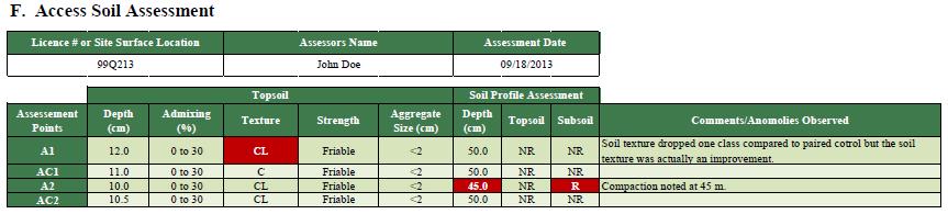
34 Appendix B DSA Example November 2015 Page 34 of 46

35 November 2015 Page 35 of 46

36 November 2015 Page 36 of 46

37 November 2015 Page 37 of 46

38 November 2015 Page 38 of 46

39 November 2015 Page 39 of 46

40 November 2015 Page 40 of 46

41 November 2015 Page 41 of 46

42 November 2015 Page 42 of 46

43 November 2015 Page 43 of 46

44 January 2018 Page 44 of 46

45 November 2015 Page 45 of 46

46 November 2015 Page 46 of 46
Alberta policy and regulations for grassland reclamation criteria, evolution of the criteria from the 1995 version to today
 Alberta policy and regulations for grassland reclamation criteria, evolution of the criteria from the 1995 version to today Jody Spady on behalf of Reclamation Criteria Advisory Group (RCAG) Native Prairie
ALBERTA TRANSPORTATION POST-DISTURBANCE ASSESSMENT GUIDE FOR BORROW EXCAVATIONS. Dec 2013 Edition
 ALBERTA TRANSPORTATION POST-DISTURBANCE ASSESSMENT GUIDE FOR BORROW EXCAVATIONS Dec 2013 Edition - ii - ACKNOWLEDGEMENTS This guide supersedes the document entitled Alberta Transportation Post-Disturbance
UBC Technical Guidelines Section Edition Planting Preparation Page 1 of 6
 Page 1 of 6 1.0 GENERAL 1.1 Scope.1 This guideline addresses the materials, and equipment necessary for the supply, placement, and amendment of the growing medium. 1.2 Related Work:.1 Section 32 93 00
SITE TOPSOIL & FINISH GRADING
 CITY OF BRAMPTON LANDSCAPE SPECIFICATIONS SECTION 02911-1 PART 1 GENERAL 1.1 Related Work.1 Section 02311 Site Grading.2 Section 02315 Excavating, Trenching, & Backfilling.3 Section 02906 Planting of Trees,
Soil Organic Matter. Organic Carbon and Nitrogen. What Factors Influence the Amount of SOM? What is Soil Organic Matter? Why is SOM Important?
 Soil Organic Matter Organic Carbon and Nitrogen Analysis of soil organic matter (SOM), conducted on the AESA Soil Quality Benchmark sites, has revealed some significant differences in the per cent of organic
Loam: About 40% sand, 40% silt, 20% clay. Mixture of pore sizes to balance water retention and aeration. Considered the best soil for growing crops.
 Soil Characteristics Soil is formed from a combination of two Primary sources: Weathering of Parent Rock ( ) = material introduced by plants, animals, and decomposers Minor sources: Nutrients incorporated
Reclamation Success Best Management Practices. Pinedale Field Office. Joseph Debebe PhD. Natural Resource Specialist PFO 04/30/2014
 Reclamation Success Best Management Practices Pinedale Field Office Joseph Debebe PhD. Natural Resource Specialist PFO 04/30/2014 Objective Identifying factors necessary for reclamation success at different
ARROW BOWEN PIPELINE ENVIRONMENTAL MANAGEMENT PLAN OUTLINE SOIL MANAGEMENT PLAN
 APPENDIX J ARROW BOWEN PIPELINE ENVIRONMENTAL MANAGEMENT PLAN OUTLINE SOIL MANAGEMENT PLAN Contents 1 Introduction... 1 1.1 Purpose of the Soil Management Plan... 1 1.2 Project description... 1 1.3 Legislation
Getting the Most out of Your Strawberry Soil Test Report. General Information
 gardening.cornell.edu Getting the Most out of Your Strawberry Soil Test Report 1. Be certain your soil ph is in the optimal range. 2. Add a nitrogen (N) source at the recommended rate and time. 3. Add
2018 Iowa FFA Soil Judging CDE Exam 1. Landscape positions characterizes the location of the soil on the landscape and identifies potential risks.
 2018 Iowa FFA Soil Judging CDE Exam 1. Landscape positions characterizes the location of the soil on the landscape and identifies potential risks. Which landscape position is considered the floodplain
EC-11 COMPOST. Greenville County Technical Specification for. 1.0 Compost. 1.1 Description
 Greenville County Technical Specification for EC-11 COMPOST 1.0 Compost 1.1 Description This specification covers compost produced from various organic by-products, for use as an infill material for sediment
SECTION AMENDED TOPSOIL
 SECTION 02486 AMENDED TOPSOIL PART 1 - GENERAL 1.01 SUMMARY A. Work described in this section includes requirements for soil amendments, soil preparation, preparation and finish grading of turf restoration
Methods, approaches, and procedures to minimize active agricultural land impacts during pipeline construction, surface restoration, and pipeline
 Agricultural Impact Minimization Plan Methods, approaches, and procedures to minimize active agricultural land impacts during pipeline construction, surface restoration, and pipeline operation. PennEast
Examining soils in the field. Examining soils in the field. Environment Agency thinksoils examining soils in the field
 Examining soils in the field thinksoils Examining soils in the field Environment Agency thinksoils examining soils in the field 31 Examining soils in the field 32 Environment Agency thinksoils examining
The Nature of Soil Soil Conservation Sustainable Ag.
 Chapter 6 & 7 The Nature of Soil Soil Conservation Sustainable Ag. Climate Soil Forming Factors Parent material Organisms Topography Time Value of Soil Soil is under appreciated Condition of soil affects
HORT 102: Soil Properties. Cultivated Plants: Lecture 15. [Teresa Koenig] Slide #: 1 Slide Title: Intro Information Slide
![HORT 102: Soil Properties. Cultivated Plants: Lecture 15. [Teresa Koenig] Slide #: 1 Slide Title: Intro Information Slide](/thumbs/76/74082590.jpg "HORT 102: Soil Properties. Cultivated Plants: Lecture 15. [Teresa Koenig] Slide #: 1 Slide Title: Intro Information Slide") HORT 102: Soil Properties Cultivated Plants: Lecture 15 [Teresa Koenig] Slide #: 1 Slide Title: Intro Information Slide Title: Lecture 15 Soil Properties Speaker: Teresa Koenig Created by: Teresa Koenig,
HORT 102: Soil Properties Cultivated Plants: Lecture 15 [Teresa Koenig] Slide #: 1 Slide Title: Intro Information Slide Title: Lecture 15 Soil Properties Speaker: Teresa Koenig Created by: Teresa Koenig,
Soil Reclamation and Site Reinstatement
 APPENDIX 6 Soil Reclamation and Site Reinstatement Purpose To undertake soil reclamation, erosion protection, Site restoration and reinstatement, taking into account natural processes, operational requirements
THE TENNESSEE VEGETABLE GARDEN
 THE BACKYARD SERIES BACKYARD VEGETABLES W 346-A THE TENNESSEE VEGETABLE GARDEN SITE SELECTION AND SOIL TESTING Natalie Bumgarner, Assistant Professor and UT Extension Residential and Consumer Horticulture
SECTION FINE GRADING AND SOIL PREPARATION
 SECTION 32 90 00 PART 1 GENERAL 1.01 SECTION INCLUDES A. Examination. B. Preparation. C. Subsoil Preparation. D. Placing Topsoil. E. Soil Tests. F. Coordination of Soil Amendments. G. Fine Grading. H.
2014 Iowa FFA Soil Judging CDE Exam
 2014 Iowa FFA Soil Judging CDE Exam 1. Landscape position is one aspect of evaluating the surface features of a certain tract of land. Identifying the correct landscape position will indicate: a. If the
Methods, approaches, and procedures to minimize active agricultural land impacts during pipeline construction, surface restoration, and pipeline
 Agricultural Impact Minimization Plan Methods, approaches, and procedures to minimize active agricultural land impacts during pipeline construction, surface restoration, and pipeline operation. PennEast
Land Capability Class
 Guide for Applying Conservation Treatments for Land Evaluation (5/23/2011) LAND TREATMENT After examining and determining the physical features of the soil profile, one can determine the land capability
This section covers the planting of seed, sod, trees and vegetation.
 Tender 1, 2017 Page 1 of 5 1. INTENT This section covers the planting of seed, sod, trees and vegetation. 1.1 REFERENCES Agriculture and Agri-Food Canada; The Canadian System of Soil Classification, Third
Environmental Protection Guidelines for Transmission Lines
 Alberta Environment R&R/11-03 Environmental Protection Guidelines for Transmission Lines GENERAL This Guideline replaces Conservation and Information Letter 95-2 and the 1994 Guide for Transmission Lines.
a. Section includes planting soils specified by composition of the mixes.
 SECTION 32 9113 SOIL PREPARATION PART 1 - GENERAL 1.1 RELATED DOCUMENTS A. Drawings and general provisions of the Contract, including General and Supplementary Conditions and Division 01 Specification
2.1.4 Roof Downspout Rain Gardens
 2008 SWMM, 2010 Revision City of Tacoma 2.1.4 Roof Downspout Rain Gardens Purpose and Definition Bioretention areas are shallow stormwater retention facilities designed to mimic forested systems by controlling
SECTION PLANTING SOIL for SOIL CELLS. This specification defines material and performance requirements for soils which are to be used
 This specification defines material and performance requirements for soils which are to be used within the Silva Cell system. The SPECIFICATION EDITOR must select the type of soil appropriate to each particular
2016 Iowa FFA Soils Evaluation CDE Exam
 2016 Iowa FFA Soils Evaluation CDE Exam 1. Which of the following is true regarding soil horizons? a. A horizon is darker in color and has more organic matter b. B horizon is darker in color and has more
Well Abandonment Requirements
 Well Abandonment Requirements Directive PNG015 November 2015 Revision 1.0 Governing Legislation: Act: The Oil and Gas Conservation Act Regulation: The Oil and Gas Conservation Regulations, 2012 Record
Soil Resources. Soil Horizons
 Soil Resources Soil Uppermost layer of earth s crust that supports plants, animals and microbes Soil Forming Factors Parent Material Time Climate Organisms Topography Soil Composition Mineral Particles
MARBLE RIVER WIND POWER PROJECT Agricultural Protection Measures
 MARBLE RIVER WIND POWER PROJECT Siting Considerations 1. Locate access roads and, to the extent allowed by local laws, wetlands and topography, individual wind turbines and other structures along field
Surface Coal Mining and Reclamation in ND. Guy Welch ND Public Service Commission
 Surface Coal Mining and Reclamation in ND Guy Welch ND Public Service Commission Surface Coal Mines in North Dakota Approximately 1500 acres are disturbed each year History of Reclamation in ND First surface
ATTACHMENT A BIORETENTION SOIL SPECIFICATION
 1.00 BIORETENTION SOIL ATTACHMENT A BIORETENTION SOIL SPECIFICATION Bioretention soil shall achieve an initial infiltration rate of at least 8-inch per hour nor more than 20 inches per hour in situ and
2017 Iowa FFA Soil Judging CDE Exam
 2017 Iowa FFA Soil Judging CDE Exam 1. Landscape positions vary in soil composition and makeup. What landscape position would be characterized by having strata and lenses of different textures in the profile:
Vegetation Management
 Vegetation Management GENERAL CONSTRUCTION PRACTICE Best practice vegetation management involves giving appropriate consideration to the following issues. Not all the issues will be relevant on every site.
Section Seeding
 Section 02936 Seeding PART 1 - GENERAL 1.01 SECTION INCLUDES A. Fertilizing. B. Seeding. C. Hydroseeding. D. Mulching. E. Maintenance. F. Sodding. 1.02 RELATED WORK A. Documents affecting work of this
Infiltration. Keep Water Where it Falls. Frank Franciosi Novozymes
 Keep Water Where it Falls Frank Franciosi Novozymes Defined refers to the movement of water into the soil layer. The rate of this movement is called the infiltration rate. If rainfall intensity is greater
4.6. Low Impact and Retentive Grading
 4.6. Low Impact and Retentive Grading Low Impact Grading techniques focus on utilizing existing topography during Site layout to minimize cost. Proposing structures, roads, and other impervious surfaces
Soil is formed by various processes and originates from parent material.
 Soils and sediments usually contain organic matter from decayed vegetation. A majority of the organic matter is humic substances. o Humic substances are naturally formed from the decomposition of vegetation.
Soil Management: the basis of sustainable agriculture
 Soil Management: the basis of sustainable agriculture FAB-465 Lecture 11 Lecture Outline Soil Formation Soil Structure/Texture Indicators of Soil Health or Fertility Soil Conservation Practices 1 Soil
Evaluating Hay and Pasture Stands by Dennis Brown
 The fluctuation of the wet spring of 2010 to the severe drought in the fall and now a long cold winter may result in poor hay and pasture stands this spring. Plants may be killed or weakened, leaving barren
SECTION VI. (Sub-section 241) Grassing. 1. Scope of Work General Sprigging Sodding thru 241-3
 Grassing. 1. Scope of Work General Sprigging Sodding thru 241-3") SECTION VI (Sub-section 241) Grassing Article Page 1. Scope of Work 241-1 2. General 241-1 3. Sprigging 241-1 4. Sodding 241-1 thru 241-3 5. Soil Amendments 241-3 6. Non Grassed Areas 241-4 7. Topsoil
SECTION VI (Sub-section 241) Grassing Article Page 1. Scope of Work 241-1 2. General 241-1 3. Sprigging 241-1 4. Sodding 241-1 thru 241-3 5. Soil Amendments 241-3 6. Non Grassed Areas 241-4 7. Topsoil
NORTH HARRIS COUNTY REGIONAL WATER AUTHORITY STANDARD SPECIFICATION. Section SODDING
 Section 02922 PART 1 GENERAL 1.01 SUMMARY This Section includes the following: A. Restoration of existing lawn areas disturbed by construction shall be by installation of new sod. B. Planting of sod within
Land Formation. Field Development
 Land Formation California Rice Production Workshop, v15 Field Development Field development refers to configuring the field shape, surface slope and installation of water control structures to optimize
Chapter 15 Soil Resources
 Chapter 15 Soil Resources Overview of Chapter 15 What is Soil? Soil Horizons Nutrient Cycling Soil Properties and Major Soil Types Soil Problems Soil Conservation and Regeneration Soil Uppermost layer
Soil Requirements of. Healthy Urban Trees
 Soil Requirements of Healthy Urban Trees Healthy Urban Soil Trees require adequate supply of uncompacted, well aerated, and moist soil in order to thrive. These soil conditions enable tree roots to obtain
Iowa FFA Soil Career Development Event 2008
 Iowa FFA Soil Career Development Event 2008 1. In Iowa, corn suitability ratings for soil mapping units specifies a. natural weather conditions b. surface and subsurface drainage installed where needed
SECTION TURF AND GRASSES
 SECTION 32 92 00 TURF AND GRASSES PART 1: GENERAL 1.01 DESCRIPTION Restore all disturbed grass and landscaped areas to conditions equal to or better than before the work began and to the satisfaction of
Introduction to Environmental Science. Soil Characteristics. Chapter 11 Soil
 Chapter 11 Soil Soil Characteristics It s more than dirt Most soils are 100s of years old Weathering breaks down parent rock Soil Separates (particle types) Sand (largest) Silt Clay (smallest) Plants contribute
Components of Soil. Humus: (a carbon sink) Dark brown or black color indicates high nitrogen content.
 Dark brown or black color indicates high nitrogen content.") Components of Soil Humus: (a carbon sink) Dark brown or black color indicates high nitrogen content. Inorganic Soil Components: Particle Size: Clay- Very fine Silt- Fine Sand- Medium Gravel- Large Discuss
Components of Soil Humus: (a carbon sink) Dark brown or black color indicates high nitrogen content. Inorganic Soil Components: Particle Size: Clay- Very fine Silt- Fine Sand- Medium Gravel- Large Discuss
Managing Soils in Rangelands. Jerry Daigle
 Managing Soils in Rangelands Jerry Daigle State Soil Scientist Alexandria, LA What is Rangeland? Land on which the native vegetation is predominantly: grasses grass-like plants forbs shrubs Photo by Gary
5.1 Introduction to Soil Systems IB ESS Mrs. Page
 5.1 Introduction to Soil Systems IB ESS Mrs. Page 2015-2016 I Am Soil Thinking Routine: See, Think, Wonder Look at the following images. For each image write down what you see Then write down what you
SECTION SOIL PREPARATION
 SECTION 329113 SOIL PREPARATION PART 1 - GENERAL 1.1 SUMMARY A. Section Includes: 1. Components of planting mediums. 2. Testing and certification of components. 3. Mixing of planting mediums. 4. Transporting
SECTION LANDSCAPE
 1 SECTION 02900 LANDSCAPE PART 1 GENERAL 1.1 Summary A. This section contains requirements relating to lawns, trees, shrubs, flowering plants and ground covers including site preparation, material installation
Toronto District School Board Church Street Junior Public School
 Playing Field Turfgrass Assessment and Recommendations Toronto District School Board Church Street Junior Public School Tuesday, November 24, 2015 David Smith, P.Ag. Rob Witherspoon, M.Sc. 550 Musquash
Project: Developer/Designer: Reviewer: I. Narrative: 1. Project Description: Describes the nature and purpose of the land disturbing activity.
 City of Charlottesville, Virginia Erosion and Sediment Control Plan Review Checklist 610 East Market Street, Charlottesville, VA 22902 Telephone 434-970-3182; Fax 434-970-3359 Project: Developer/Designer:
A&L Canada Laboratories Inc.
 A&L Canada Laboratories Inc. 2136 Jetstream Rd, London ON N5V3P5 Tel: (519) 457-2575 Fax: (519) 457-2664 SOIL SAMPLING GUIDE SOIL SAMPLING PROCEDURES The intention of the following information is to aid
ALBERTA TRANSPORTATION GUIDE TO RECLAIMING BORROW EXCAVATIONS. December 2013 Edition
 ALBERTA TRANSPORTATION GUIDE TO RECLAIMING BORROW EXCAVATIONS December 2013 Edition ACKNOWLEDGEMENTS This guide supersedes the document entitled Alberta Transportation Guide to Reclaiming Borrow Excavations
The following general requirements will be met for all planter box installations:
 Greenville County Technical Specification for: WQ-25 PLANTER BOX 1.0 Planter Box 1.1 Description Planter boxes are designed to capture and temporarily store stormwater runoff. Planter Boxes are intended
Overview of Chapter 14
 14 Soil Resources Overview of Chapter 14 The Soil System Soil Properties and Major Soil Types Environmental Problems Related to Soil Soil Conservation and Regeneration Soil Uppermost layer of earth s crust
A. Install all temporary erosion control measures (in accordance with MNDOT General Conditions 2573) prior to site disturbance.
 prior to site disturbance.") The language provided in these specifications is meant to serve as a reminder and provide a generic example of the type of language that should be provided in final construction documents. This language
The language provided in these specifications is meant to serve as a reminder and provide a generic example of the type of language that should be provided in final construction documents. This language
EDULABZ. Ans. (b) 7. The soft, porous layer with a good water-retaining capacity forms the
 7. The soft, porous layer with a good water-retaining capacity forms the") 3 SOIL I. Multiple choice questions: Tick ( ) the correct choice. 1. The process of soil formation is called (a) conservation (b) weathering (c) erosion (d) none Ans. (b) 2. Soil profile consists of (a)
3 SOIL I. Multiple choice questions: Tick ( ) the correct choice. 1. The process of soil formation is called (a) conservation (b) weathering (c) erosion (d) none Ans. (b) 2. Soil profile consists of (a)
Establish plants outdoors
 Establish plants outdoors Note: This section is in two parts Prepare ground for establishing plants CONTENTS Part 1 Page Number Preparing the area...2 Soils and growing media...3-4 Clearing the site...5
UNIFIED FACILITIES GUIDE SPECIFICATIONS
 USACE / NAVFAC / AFCEC / NASA UFGS-02 66 00 (February 2010) ----------------------------- Preparing Activity: USACE Superseding UFGS-02 66 00 (April 2006) UNIFIED FACILITIES GUIDE SPECIFICATIONS References
SOIL SAMPLING PROCEDURES
 SOIL SAMPLING PROCEDURES Soil Sampling The method and procedure for obtaining soil samples vary according to the purpose of sampling. Analysis of soil samples may be needed for engineering and agricultural
Sports Field Audit Report 7th Brigade Park Cricket Field 2
 Sports Field Audit Report 7th Brigade Park Cricket Field 2 Sampling Date: 3/04/2014 Address: Delaware Street, Chermside Region: North Field Size: 0.8 ha Irrigation: No Technigro Australia Pty Ltd PO Box
REQUIREMENTS FOR LANDS TO BE CONVEYED TO THE CITY. The Owner will be responsible to ensure that all lands which will be transferred to the City for
 APPROVED BY COUNCIL FEBRUARY 15, 1994 CITY OF BE CONVEYED TO THE CITY The Owner will be responsible to ensure that all lands which will be transferred to the City for parkland, drainage or boulevard purposes
SOIL EROSION COMBATING IS ESSENTIAL IN ORDER TO CONSERVE OUR VALUABLE SOIL RESOURCES
 SOIL EROSION COMBATING IS ESSENTIAL IN ORDER TO CONSERVE OUR VALUABLE SOIL RESOURCES A. Introduction - Land is also a precious resource. Land is needed for agriculture and occupation. Land is under pressure
Plan Review Checklist
 Plan Review Checklist FOR EROSION AND SEDIMENT CONTROL PLANS _ Minimum Standards - All applicable Minimum Standards must be addressed. All minimum Standards must be adhered to during the entire project
SECTION SODDING
 SECTION 02924 SODDING PART 1 GENERAL 1.01 SUMMARY A. Repair lawns and grassed rights of way damaged or removed during the construction of the pump station. 1.02 RELATED WORK A. Clearing and Grubbing -
SOILS OF SAGE-GROUSE HABITAT: DEGRADATION AND RESTORATION. Jay Norton Extension Soil Scientist, Dept. of Ecosystem Science & Management
 SOILS OF SAGE-GROUSE HABITAT: DEGRADATION AND RESTORATION Jay Norton Extension Soil Scientist, Dept. of Ecosystem Science & Management OVERVIEW Soils of quality sage-grouse habitat; Effects of chronic
SUPPORTING DOCUMENT POST-CONSTRUCTION SOIL QUALITY AND DEPTH WORKSHEET
 SUPPTING DOCUMENT POST-CONSTRUCTION SOIL QUALITY AND DEPTH WKSHEET For Department of Ecology Stormwater BMP T5.13 This submittal worksheet will help determine what soil amendments are needed to meet the
SECTION 808 PLANTING TREES, SHRUBS AND OTHER PLANTS
 SECTION 808 PLANTING TREES, SHRUBS AND OTHER PLANTS 808.1 Description. This work shall consist of furnishing and planting material in the locations designated on the plans or established by the engineer.
A. Contractor shall provide product data for each type of product indicated.
 31 13 00 SELECTIVE TREE AND SHRUB REMOVAL AND TRIMMING SECTION 1 GENERAL 1.1 SUMMARY A. This section includes general protection and pruning of existing trees and plants that are affected by execution
SOIL DATA: Avondale. in Allen, TX. This information was taken from NRCS web soil survey of Collin County, Texas.
 SOIL DATA: Avondale in Allen, TX This information was taken from NRCS web soil survey of Collin County, Texas. United States Department of Agriculture Soil Conservation Service in cooperation with Texas
Soil Issues in Urban Farming
 Soil Issues in Urban Farming Stephanie Murphy, Ph.D. Director of Soil Testing Rutgers/NJAES Topics Soil quality Soil testing Risks posed to urban farmers/consumers high levels of lead Ways to mitigate
UNIVERSITY OF WISCONSIN SYSTEM SOLID WASTE RESEARCH PROGRAM
 UNIVERSITY OF WISCONSIN SYSTEM SOLID WASTE RESEARCH PROGRAM Artificial Topsoil Mix Prepared with Papermill Fiber Residuals And Subsoil for Stabilization of Non-Metallic Mine Sites 2005 Dr. Richard Wolkowski
Eco new farmers. Module 2 Soil and Nutrient Cycling. Section 1 Soils and soil fertility
 Eco new farmers Module 2 Soil and Nutrient Cycling Section 1 Soils and soil fertility Module 2 Soil and Nutrient Cycling Section 1 - Soils and soil fertility www.econewfarmers.eu 1. Introduction You will
ORDINANCE NO AN ORDINANCE AMENDING THE CODE OF ORDINANCES OF THE CITY OF
 ORDINANCE NO. 07-03- 15-08 AN ORDINANCE AMENDING THE CODE OF ORDINANCES OF THE CITY OF CORINTH, BY ADDING A CHAPTER 158 " XERISCAPE PRACTICE AND PRINCIPALS "; PROVIDING THAT THIS ORDINANCE SHALL BE CUMULATIVE
The Unit is designed for candidates wishing to develop their knowledge of soils who are starting a career in the horticulture industry.
 National Unit specification: general information Unit code: H1JA 11 Superclass: SL Publication date: May 2012 Source: Scottish Qualifications Authority Version: 01 Summary Candidates who achieve this Unit
GUIDE: Restoration Assessment Form Preface Instructions
 GUIDE: Restoration Assessment Form March 24, 2006 Developed by Kerry Hecker and Chet Neufeld Last Mountain Lake National Wildlife Area and Migratory Bird Sanctuary Environment Canada- Canadian Wildlife
CHECKLIST BMPs for FIELD NURSERIES REGULATIONS, SITE SELECTION, WATER MANAGEMENT
 CHECKLIST BMPs for FIELD NURSERIES REGULATIONS, SITE SELECTION, WATER MANAGEMENT Regulations For information on the Wetlands Protection Act or the Water Management Act, contact the Massachusetts Department
LAWN RENOVATION & OVERSEEDING
 LAWN RENOVATION & OVERSEEDING A healthy established lawn is able to out-compete many weeds and withstand a certain amount of pressure from disease and insect attack as well as drought. You can help maintain
AGRICULTURAL LAND CLASSIFICATION AND SOIL PHYSICAL CHARACTERISTICS BIRCH PIT, NEAR COLCHESTER ESSEX
 AGRICULTURAL LAND CLASSIFICATION AND SOIL PHYSICAL CHARACTERISTICS BIRCH PIT, NEAR COLCHESTER ESSEX AGRICULTURAL LAND CLASSIFICATION AND SOIL PHYSICAL CHARACTERISTICS SEMI-DETAILED SURVEY BIRCH PIT, NEAR
Pipeline Reclamation at the Williston Research Extension Center - NDSU. Austin Link Agronomy Research Specialist
 Pipeline Reclamation at the Williston Research Extension Center - NDSU Austin Link Agronomy Research Specialist Reclaiming a 36 Pipeline with Crop Rotations Introduction May 15 th, 2015, installation of
5.0 Storm Water Landscape Guidance Introduction
 5.0 Storm Water Landscape Guidance Introduction Landscaping is a critical element to improve both the function and appearance of storm water management practices. Integrated storm water landscapes can
Wisconsin Contractors Institute Continuing Education
 Wisconsin Contractors Institute Continuing Education Erosion & Sediment Control Course # 12775 2 hours Wisconsin Contractors Institute N27 W23953 Paul Road, Suite 203 Pewaukee, WI 53072 Website: www.wicontractorsinstitute.com
SECTION TOPSOIL AND SEEDING
 SECTION 13400 TOPSOIL AND SEEDING DECEMBER 2015 TOPSOIL AND SEEDING Page 1 1 GENERAL... 2 DESCRIPTION... 2 RELATED SECTIONS... 2 JOB CONDITIONS... 2 INSPECTION... 2 2 PRODUCTS... 3 SEEDING PRODUCT DELIVERY,
C-10. Disconnected Impervious Surface
 C-10. Disconnected Impervious Surface Design Objective Disconnected Impervious Surface (DIS) is the practice of directing stormwater runoff from built-upon areas to properly sized, sloped and vegetated
BEST MANAGEMENT PRACTICES Spurge Laurel(Daphne laureola) (Family Thymelaeaceae Daphne Family)
 (Family Thymelaeaceae Daphne Family)") JEFFERSON COUNTY NOXIOUS WEED CONTROL BOARD 380 Jefferson Street, Port Townsend WA 98368 360 379-5610 Ext. 205 noxiousweeds@co.jefferson.wa.us BEST MANAGEMENT PRACTICES Spurge Laurel(Daphne laureola) (Family
JEFFERSON COUNTY NOXIOUS WEED CONTROL BOARD 380 Jefferson Street, Port Townsend WA 98368 360 379-5610 Ext. 205 noxiousweeds@co.jefferson.wa.us BEST MANAGEMENT PRACTICES Spurge Laurel(Daphne laureola) (Family
Urban Conservation Practice Physical Effects ESTABLISHMENT, GROWTH, AND HARVEST NUTRIENT MANAGEMENT
 NOT WELL 800 - Urban Stormwater Wetlands A constructed system of shallow pools that create growing conditions for wetland plants to lessen the impacts of stormwater quality and quantity in urban areas.
Mature basalt volcanic soils
 MANAGING NORTHLAND SOILS Mature basalt volcanic soils 8.1.2 Soil types in this group Kerikeri friable clay (KE) Kerikeri friable clay with large boulders (KEb) Matarau friable clay (MC, MCH*) Matarau friable
This definition is from the Soil Science Glossary (Soil Science Society of America).
.") What is Soil? This definition is from the Soil Science Glossary (Soil Science Society of America). soil - (i) The unconsolidated mineral or organic material on the immediate surface of the earth that serves
What is Soil? This definition is from the Soil Science Glossary (Soil Science Society of America). soil - (i) The unconsolidated mineral or organic material on the immediate surface of the earth that serves
Huntington Stormwater Utility
 Huntington Stormwater Utility Stormwater Management & Sediment and Erosion Control Requirements for Construction Sites Authorized by Huntington City Code Articles: 971, 970, 930, 935, 955, Revised April
THE PHYSICAL SIDE OF SOIL THE PHYSICAL SIDE OF SOIL THE PHYSICAL SIDE OF SOIL. Dr. Marty Petrovic Department of Horticulture Cornell University
 THE PHYSICAL SIDE OF SOIL Dr. Marty Petrovic Department of Horticulture Cornell University THE PHYSICAL SIDE OF SOIL THE PHYSICAL SIDE OF SOIL Physics 1 Principles of Water Movement and Drainage Normal
EARTH SCIENCE CONCEPTS -Geologic time scale
 EARTH SCIENCE CONCEPTS -Geologic time scale -Plate Tectonics -Earthquakes *result of vibrations (often due to plate movement) deep in the Earth that release energy *often occur at transform boundaries
Name. There are three main types of soils called textures. They are: sand, silt, and clay. Sand has the largest particles and clay has the smallest.
 Introduction Name What Soil is: Soil is a natural body made up of minerals (rock), organic (living and dead) materials, air, and water. Soil has living and dead parts in it. There are three main types
STATE TAX COMMISSION OF MISSOURI ASSESSOR MANUAL
 STATE TAX COMMISSION OF MISSOURI ASSESSOR MANUAL CHAPTER: REVISION DATE: 10/1/2008 Page 1 of 18 7.3 The purpose of this section of the Assessor s Manual is to supplement the State Tax Commission s published
CHAPTER 4: GENERAL LANDSCAPING STANDARDS 4.1 ALL PLANT STOCK 4.2 TREES
 CHAPTER 4: GENERAL LANDSCAPING STANDARDS This chapter describes plant material minimum standards that apply to landscaping both on private property (on-site) and within the public right-of-way (off-site).
CHAPTER 26 LANDSCAPING (Chapter added in its entirety 05-08)
") CHAPTER 26 LANDSCAPING (Chapter added in its entirety 05-08) 26.01 DESCRIPTION AND PURPOSE. Landscaping is an important element of the use, development and preservation of land, and a significant factor
CHAPTER 26 LANDSCAPING (Chapter added in its entirety 05-08) 26.01 DESCRIPTION AND PURPOSE. Landscaping is an important element of the use, development and preservation of land, and a significant factor