Conserv"ation Awareness Contests
|
|
|
- Moses Joseph
- 6 years ago
- Views:
Transcription


1 A Guide for Conserv"ation Awareness Contests in Hawaii University of Hawaii Cooperative Extension SelVice Club Circular 179 Updated 1993
2 A Guide for Conservation Awareness Contests in Hawaii Edited By Saku Nakamura, Soil Scientist USDA Soil ConselVation Service, Honolulu Deborah J. Ward, County Extension Agent University of Hawaii Cooperative Extension SClVice, Hilo Haruyoshi Ikawa, Soil Scientist University of Hawaii Department of Agronomy and Soil Science, Honolulu In Coopcration With Hawaii Association of ConsclVation Districts James Nobriga, Chairman, ConselVation Awarcness Committee, Wailuku Hawaii State Department ofeducation, Occupational Development Section Ken Kajihara, Vo-Tech Education Specialist in Agriculture Education, Honolulu April 1993 This publication is an update of A Guide for Land Judging in Hawaii by Wade W. McCall Cooperative Extension SelVice, University of Hawaii, Club Circular 179.
3 Contents Introduction Judging Land PART I: Physical Features of the Soil The Soil Profile Physical Properties PART II: Major Factors Affecting Land Use PART III: Land Capability Classification Land Suitable for Cultivation Land Not Suitable for Cultivation PART IV: Recommended Conservation Practices Practices for Cropland and Orchard Practices for Pasture Practices for Woodland Practices for Recreation and Wildlife Practices for Cropland, Orchard, Pasture, or Woodland PART V: Judging Land for Homesites Factors Important in Evatuating Homesites Scorecard

4 A Guide for Conservation Awareness Contests in Hawaii Introduction Land is a many-splendored thing. Nothing so completely surrounds us in our day-to-day life. But, like so many things important to life, land goes unnoticed until we learn to appreciate it. Participants in conservation awareness contests have the opportunity to learn about the land and to value its usefulness. By learning how to judge land, we will begin to understand what controls the use of land, why some types of land can be used for growing food crops while others are better used for forest or pasture. We will also learn what can be done to make land more valuable. After the fun of the contest is over, you will have a sense of appreciation of the land that will stay with you all your life. You will understand why land is one of Hawaii's most important resources. If you find the subject interesting, you may even want to pursue a career as a soil scientist, soil conservationist, agronomist, or a county agent. You don't have to be an expert to take part in conservation awareness contests, and you can have lots of fun. Anyone, both boys and girls, can join in. Judging Land Land can be judged somewhat like animals or farm crops. In judging beef animals, we look for signs that tell us the animal's capacity to produce meat, such as depth of the body, topline, and smoothness. In judging crops, we look at the color of the crop, we note its size and its shape. Similarly, when judging land, we look for clues that tell us how well the land can produce crops or be used for other purposes. Soil characteristics, climate, topography or "lay of the land"-these are clues to soil capability. Most of all though, we examine the soil (not dirt, but soil) to detennine 3 characteristics that control the land's capability. This guide is divided into five parts that follow the procedures in a conservation awareness contest. PART I: Physical Features of the Soil. In this section we look at the land and examine soil properties that can be judged by our physical senses. Some of these properties are texture, slope, depth, penneability (ability for water and air to move through the soil), and erosion. PART II: Major Factors Affecting Land Use. In this section we select the soil properties at a site that is important enough to influence land use. Factors other than soil properties including rainfall, elevation, wind velocity, and flooding are also considered. PART III: Land Capability Classification. In this section we classify the land according to its potential for agricultural use. The soil at each selected site is placed in one of eight land capability classes. The land capability class will determine the highest, most intensive, safe use ofthe land. PART IV: Recommended Conservation Practices. In this section we choose conservation practices to protect the land. PART V: Judging Land for a Homesite. In this section we evaluate the land for a homesite in terms of limitations of the soils for urban uses. PART I: Physical Features of the Soil In Hawaii our soils are fonned from lava rocks, volcanic ash and cinders, coral sand, and organic matter. These materials are affected by climate and other soil fonning factors that cause weathering or decomposition and form soil. Through the weathering process the soils develop characteristic soil profiles.


.")

5 The SoiI Profi Ie What is a "soil profile?" When we look beneath the surface of the soil, we can see layers that differ in color, physical properties, chemical composition, and biological characteristics. These layers are called "horizons." When we slice through the soil vertically through all its horizons, we have a cross section of the soil called a soil profile (Figure 1). A soil profile has three major layers. The first and uppennost layer is the topsoil, or "A" horizon. Figure 1. The soil profile shows the layers ofthe soil. Each layer may vary in color and texture. Where erosion has occurred, the surface layer or topsoil may be missing. 4
6 This layer contains most of the organic material that is in the soil. It is the best part of the soil for soil organisms to grow, for chemical activity to take place, and for plants to grow. If the land is faimed, the topsoil is the layer that the plow turns. This is the soil that is lost first when erosion occurs. The second layer in the soil profile is the subsoil, or "B" horizon. This layer has less organic matter than the "A" horizon and water does not usually pass through as readily. The subsoil may have an accumulation of minerals that are deposited there as they are leached from the "A" horizon. The subsoil is an important part of the soil because it contains nutrients and water for plant growth. This layer is where we might find a hardpan, or a compacted layer, that restricts root growth and water movement. The third layer and lowest layer in the soil profile is the parent material or "C" horizon. It is the least weathered of all the horizons, and it usually contains fragments of weathered rocks. In Hawaii the parent material or "C" horizon could be from a'a or pahoehoe lava, volcanic ash or cinders, or from coral. The "c" horizon is not judged in our contests, even though we recognize its importance, especially for deep rooted plants. Physical Properties If you look at the Hawaii Conservation Awareness Score Card, you will see Part I is called "Physical Features." Six soil features important in land judging are listed: (1) Surface texture (2) Subsoil texture (3) Permeability (4) Soil depth (5) Slope (6) Erosion (1) and (2) Surface and Subsoil Texture Texture is a very important property of the soil. It affects the ability of the soil to hold water (water-holding capacity); it affects the movement of air and water through the soil (peimeability); and it affects the ability of the soil to retain nutrients for plants. Soil texture also affects the ease of cultivation and the erodibility of the soil. What do we mean by texture? When talking about soil, texture refers to the proportion of sand-, silt-, and clay-size particles in the soil. Figure 2 shows the sizes of sand, silt, and clay in relation to././~\ }:~',:~~..:';,~:'~: :i:!{: ~.~:~~ :~:.:.,,.;... -'",..,. Figure 2. Relative sizes ofsand, silt, and clay (shown left to right). The proportion ofthese vary in each soil and is referred to as soil texture. Sand may be as much as 2,000 times the size ofclay and 400 times the size ofsilt. Clay influences the soil character to the greatest extent. 5
7 each other. When judging land, we determine texture by rubbing a small amount of moist soil in the hand. Use your thumb and fingers to rub and feel the soil particles. The soil should be moist to make it easier to estimate the amount of sand, silt, and clay. Sand feels gritty when rubbed; silt feels smooth and buttery when moist; and clay is sticky when wet and fomls a flexible "ribbon" when squeezed between thumb and forefinger. For convenience, texture classes are placed in broad texture groupings as illustrated in Table 1. In land judging we will use the four category groupings (sandy, loamy, clayey, and very clayey) shown in the left column. Sandy soils are loose and the individual sand grains can be readily seen or felt. When rubbed between thumb and forefinger, it feels gritty. Squeezed when dry, it will fall apart as pressure is released. When moist, a mold may be formed which is unstable and crumbles as the soil is handled. Loamy soils have a slightly gritty, smooth or velvety feel when moist. Squeezed when nearly dry, it forms a mold that will bear careful handling. The mold formed by squeezing when moist can be handled freely, without breaking. When the moistened soil is squeezed out between thumb and forefinger, it will not "ribbon". Clayey soils are quite sticky when wet. They form hard lumps or clods when dry. When the moist soil is squeezed out between thumb and forefinger, it will fonn a short "ribbon" which will Four-Category Group Six-Category Group Texture Classes Sandy Coarse textured soils Sands Loamy sands Loamy Moderately coarse Sandy loam textured soils Fine sandy loam Medium textured soils Moderately fine textured soils Very fine sandy loam Loam Silt loam Silt Clay loam Sandy clay loam Clayey Fine textured soils Silty clay loam Sandy clay Silty clay Very clayey Very fine textured soils Clay Table 1. The categories ofsoil texture. Thefour-category group in the left column will be used in the Conservation Awareness Contest. 6
8 tend to break or the ribbon will bend downward. Very clayey soils fonn very hard lumps or clods \vhen dry and are very sticky when wet. When the moist soil is squeezed out between thumb and forefinger, it will fonn a long ribbon which will support itself. The moist soil can easily be molded to fonn different shapes. For the contest, detennine texture of both the surface and the subsoil from samples provided in containers. (3) Permeability Penneability refers to the ability of the soil to transmit air and water. It is expressed as inches per hour of water movement through the soil. Both air and water must move freely in the surface layer and subsoil for plants to grow well. Soils with good penneability usually have about 25 percent air space and 25 percent water storage space. Two soil properties that have most to do with penneability are texture and structure. The amount of organic matter in the soil and presence of alternating layers of contrasting textures in the soil profile also affect penneability. A soil can have different permeability in the topsoil and in the subsoil. The penneability class of the whole soil, however, is based on the least penneable of the two layers. For the contest, detennine penneability class based on texture of the least penneable layer, either the topsoil or subsoil (Table 2). Permeability Soil Texture Remarks Slow Very clayey <0.2 inches/hour; affects irrigation application and surface runoff Moderate Clayey, Loamy 0.2 to 6 inches/hour; favorable for agricultural uses Rapid Sandy >6 inches/hour; frequent application is needed if irrigated Table 2. Soil Permeability Classes. For the Conservation Awareness Contest, permeability is based on texture of the least permeable layer in the soil profile. For example, ifthe soil texture is very clayey in either the topsoil or subsoil, then permeability ofthe soil is slow. 7
9 A f'v c 0 Figure 3. Examples of soil structure: A. Prismatic B. Columnar C. Blocky D. Subangular blocky E. Platy F. Granular Structure Granular Blocky Subangular blocky Prismatic Columnar Platy Single grain (No real structure) Massive (No real structure) Remarks Sphere-like or rounded aggregates; no flat or contact faces with adjoining aggregates; commonly occurs in the surface layer; most favorable for air and water movement Block-like aggregates with more or less six-faced surfaces; generally sharp or angular edges caused by pressure from surrounding aggregates; commonly occurs in the subsoil Like blocky structure except flat faces have rounded edges and comers Prism-like structure with vertical axis longer than the horizontal axis and with flat or pointed top surface Like prismatic structure except top surface is rounded Plate-like or thin horizontal plates or leaflets; aggregates overlap each other; commonly occurs in the surface layer Individual soil particles do not stick together, but exist as a separate panicle or grain; occurs in sandy soils; easily eroded by wind and water Commonly occurs in very clayey soils; lacks aggregation and occurs as a dense mass; difficult to manage Table 3. The types ofsoil structure. 8
10 Soil Structure Soil structure is the shape and arrangement of soil particles into larger units or aggregates (Figure 3 and Table 3). Soil structure is not judged in conselvation awareness contests; however, we should know about this property because it affects permeability and the use and management of the soil. Soil structure should be observed in the soil profile because the structure may not be easily recognized in the sample container. We determine the type of structure by observing the shape of the aggregates in the soil and by breaking them apart along the natural lines of breakage or separation (cleavage). The common types of structure in Hawaiian soils are granular (round), blocky, and subangular blocky (blocklike). Less common are platy and prismatic. Also found in our soils are two conditions that are called structureless because they do not form aggregates. These are the single grain and massive soils. (4) Soil Depth Soil depth is the combined thickness of the surface layer and the subsoil plus any parent material that is easily penetrated by roots. It is the depth to any layer that restricts roots, generally bedrock (the solid rock under the soil), a "hardpan" such as an ironstone sheet, or a water table (Table 4). Depth is an important soil property. It determines the volume of soil available for plant roots, the total amount of water held in the soil, and the supply of nutrients available to plants. Depth Class Depth Remarks Deep 40 inches or more Favorable depth for all crops Moderately deep 20 to 39 inches Sufficient depth for most commonly grown crops Shallow 10 to 19 inches Difficult to use machinery to cultivate; low water storage capacity; need frequent applications if irrigated Very shallow Less than 10 inches Difficult or impossible to cultivate Table 4. Soil depth to bedrock, hardpan, or water table. 9
11 (5) Slope Slope, or "lay of the land", has a tremendous effect on water runoff, erosion, and use of machinery for fanning. To judge land, we consider three aspects of slope-steepness, length, and regularity or uniformity. Steepness is measured in percent (Table 5). We can measure percent slope by using a hand level or a slope finder. We can also detennine steepness of the slope by estimating the difference in elevation over a 100-foot horizontal distance. In the conservation awareness contest, you may use the slope finder. Steepness influences how fast water will run off the land. Suppose you had land with little or no vegetative cover. By doubling the percentage of slope, you increase the speed of the water runoff four times. You also increase the cutting power of the water (its erosive power) 64 times! Water runoff not only means loss of soil by erosion. It also means loss of water that should be stored in the soil for crop use or for replenishing our ground water supply. You should consider the length of slope when selecting the best use for the land and when recommending conservation practices. Remember that long slopes collect a lot of water and increase erosion. The lower part of the slope is the hardest hit by erosion. You should choose conservation practices such as strip cropping, diversions, and terraces to reduce slope lengths. These practices are suitable for long slopes but are impractical on short, irregular slopes. Irregular slopes-knobs, hills, water channels, and low spots are the most difficult to fann. Water tends to collect in certain areas and fonn gullies. On irregular slopes, strip cropping or crop rotation with grasses and legumes is effective. Contouring and terracing is often impossible on irregular slopes. Slope Class Percent Remarks Slope Nearly level ato 2 Land with a to 2 feet elevation change in 100 feet Gently sloping 3 to 7 Land with 3 to 7 feet elevation change in 100 feet Strongly sloping 8 to 14 Land with 8 to 14 feet elevation change in 100 feet Moderately steep 15 to 24 Land with 15 to 24 feet elevation change in 100 feet Steep 25 to 39 Land with 25 to 39 feet elevation change in 100 feet Very steep 40 to 69 Land with 40 to 69 feet elevation change in 100 feet Extremely steep 70+ Land with 70 or more feet elevation change in 100 feet Table 5. Slope. 10


 ofsoil were lost in one rain when the slopes were bare.")
12 (6) Erosion Erosion is the loss of soil caused by water or wind (Figures 4 and 5). Water erosion occurs when raindrops beat the surface of the soil and runoff water carries soil particles away. The loosened soil particles can seal the soil surface, to increase water runoff. Sheet, rill, and gully erosion are three fonns of erosion by water. Sheet erosion is the more-orless unifonn removal of soil from an area without fonnation of conspicuous water channels. Rill erosion is the removal of soil through cutting of many small channels up to a foot deep. Gully erosion is the vertical cutting of the soil by concentrated water flow. Gullies are channels deeper than one foot. Wind erosion occurs primarily in low rainfall areas where the vegetation is sparse and does not provide enough cover to protect the soil. Loamy and sandy soils are more susceptible to wind Figure 4. Erosion on steep slopes where 500 tons (approximately 3 inches) ofsoil were lost in one rain when the slopes were bare. Slopes must be protected to prevent soil erosion. Figure 5. Very severe erosion caused by the combination ofwind and water. Note the depth ofthe soil removed as indicated by the soil pedestal. 11
13 erosion than clayey soils. Wind erosion can be identified by "blowouts" where the soil has been swept away, and by dunes where the windblown material is deposited. Blowouts are oval-shaped areas that point in the direction of the wind. Other signs of past erosion are exposed roots, exposed lighter colored subsoil and rock fragments that normally occur below the surface layer, and accumulation of sediment downslope of eroded areas. On the farm or ranch the effects of soil erosion include loss oftopsoil and plant nutrients, and sedimentation of fields, ponds, and streams. Reduced plant vigor and crop yield can be the result of severe erosion. Soil erosion affects not only the site where the soil was removed, but also where the dust or sediment is deposited. Sediment can clog drainage ditches, and pollute streams, beaches and coastal waters. In land judging we determine the degree of past erosion by the amount of soil lost (Table 6). Calculate the percent of surface soil loss by comparing the present thickness of the topsoil with the original thickness as given on the contest condition sheet. Example to calculate percent loss: Thickness of original topsoil is 10 inches (given on condition sheet). Thickness of present topsoil is 7 inches (measured by contestant). [ ( 10-7 )] X 100 = 30% soil loss or 10 moderate erosion Degree of Erosion Original Remarks Topsoil Removed None to slight <25% Little or no evidence of soil loss; small amount of sheet and rill erosion may have occurred; there are no gullies Moderate 25 to 75% Surface layer may have rock fragments and light colored material from the subsoil; there may be few spots where the surface layer is completely removed; there may be rills, shallow gullies, and exposed roots Severe 75% or more Part of the subsoil has been removed; presence ofdefinite pattern of waterways or blowouts; may have gullies, many of which are not crossable by farming implements Very severe About 100% Most of the subsoil has been removed; may have deep gullies or severe blowouts; not suited for cultivation without extensive reclamation; very difficult to revegetate Table 6. Erosion. 12

14 PART II: Major Factors Affecting Land Use The farmer or rancher should know the properties of the soils on his farm or ranch and the important factors that affect the use of the land. He should have such information as rainfall, availability of irrigation water, soil ph and fertility, wind conditions, and flood hazard. Then he can properly manage the land for efficient production year after year. For the contest, there will be a condition sheet that gives the conditions for judging the land. When judging land, we look for faults that limit land use. If you think the area being judged has limitations in any of the factors listed below, check the appropriate items on the Score Card. If there are no major faults, check "none." (1) Surface texture. If texture ofthe topsoil is very clayey or sandy, it is a problem. Very clayey soils are difficult to cultivate because they are very sticky when wet and very hard when dry. Sandy soils are loose and do not hold water well for plants, resulting in the need for frequent irrigation. (2) Permeability. Permeability is a problem if it is rapid or slow. (Note: For the contest, permeability of the soil is based on texture of the least permeable layer, either the topsoil or subsoil.) Permeability affects application rates for irrigation. Slowly permeable soils let water through so slowly that they are prone to more runoff, and ponding may occur in low areas. Rapidly permeable soils take in water so fast that furrow irrigation cannot be used, and fertilizer and pesticides leach more rapidly. (3) Soil depth. An adequate soil depth is needed for effective rooting. Soil depth is a major factor if it is less than 20 inches. (4) Slope. Slope is a major factor when it is 8 percent or more. (5) Erosion. Severely eroded and very severely eroded soils present major problems for growing plants. They have lost most of the topsoil and a large part of the subsoil. With the topsoil 13 gone, they are low in fertility. These soils are susceptible to more erosion if cultivated. (6) Wetness. Wetness or poor drainage indicates the presence of excess water in the soil. It is a problem if the soil has a water table within 4 feet of the surface. (A water table is the level of groundwater in the soil below which the soil is wholly saturated with water.) Wetness is also a problem if there is no water table but the soil remains wet for long periods as evidenced by presence of mottles (variegated colors of gray, and reddish brown due to reduced oxygen). Excess water reduces the amount of oxygen in the soil and affects root growth. (7) Rainfall. Rainfall is part of climate, however, it is important enough that it is considered as a separate factor. Rainfall is a problem if there is too little, too much, or if it is poorly distributed throughout the year. It is a problem if annual rainfall is less than 50 inches, more than 175 inches, or if there is less than 2 inches per month for 2 or more consecutive months. Low rainfall and poor distribution can be overcome with irrigation. Therefore, if there is low or poor distribution of rainfall, but irrigation water is available, do not mark rainfall as a problem. (8) Elevation and Climate. In Hawaii, climate is generally associated with elevation. At certain elevations, lack of enough sunlight due to cloud cover restricts the growth of crops. At higher elevations, the temperatures may be too low for best growth of crops. If elevation is 3,000 feet or more, if there is cloud cover more than 30 percent of the time, or if average temperature is less than 50 degrees Fahrenheit, it is considered a major problem. (9) Wind. In many parts of Hawaii, strong winds cause serious crop damage, excessive soil moisture loss, and discomfort to animals and people. In extreme cases, it causes soil erosion. Windbreaks and special cultivation methods are used to control wind damage. Wind is considered a factor if average velocities are greater than 20 miles per hour or if gusts are greater than 40 miles per hour. Wind does not affect land capability because it can be controlled with windbreaks.


 Use of machinery for cultivation will be very difficult or impractical.")


15 (10) Flooding. Floods can wash out crops or drown them. It can cover the land with sand, gravel, or stones and reduce the value of the land for agricultural use. Flooding is a major problem if it occurs more often than once in two years. (11) Stoniness or Rock outcrop. This is a problem if 25 percent or more of the surface area is covered with stones or rock outcrop. (Stones here, refer to rock fragments of all sizes, although technically, stones are rock fragments 10 to 24 inches in diameter. Rock outcrop is exposed solid bedrock.) Use of machinery for cultivation will be very difficult or impractical. Only certain crops that require little or no cultivation can be grown on these soils (Figure 6). (12) Salinity. Salinity refers to the salt content of the soil. Salinity is a problem if the soil has more than 0.2 percent salt. In Hawaii, the problem is usually confined to low coastal areas. (13) None. Mark "none" on the score card if none of the factors above is a major problem. PART III: Land Capability Classification The land capability classification is a grouping of soils primarily for agricultural uses. There are eight capability classes. Class I soils are the best and Oass VIII the poorest. Soils in Oasses I through IV are suitable for sustained use for cultivated crops. Soils in Classes V through VIII generally are not suited for cultivation. How do you know the capability class for the land? Use the guide in Table 7 to determine the best land class possible based on all the soil factors. Figure 6. Extremely stony soils are used to grow coffee in Kona. 14
16 Best Best Soil Factor Land Soil Factor Land Class Class Possible Possible Surface Texture Wetness Very clayey II Not saturated for long periods I Clayey, Loamy I Excessively wet (water table >4 f1.) III Sandy III Excessively wet (water table 1-4 ft) IV Excessively wet (water table <1 ft) V Permeability Slow II Rainfall Moderate I <20 inches VI* Rapid III 20 to 49 inches IV* 50 to 174 inches I Soil Depth 175 inches or more III (to bedrock or hardpan; see wetness Poor distribution IV* factor for depth to water table) *Class I if irrigation water available. Deep (40 inches or more) I Moderately deep (20 to 39 inches) II Elevation and Climate Shallow (10 to 19 inches) III Elevation <3000 feet I Very shallow (0 to 9 inches) VII Elevation 3000 feet or more III Rock outcrop VIII Cloud cover>30 percent ofthe time III Average temperature <50 degrees F. III Slope Nearly level (0 to 2%) I Flooding Gently sloping (3 to 70/0) II None to occ~ional (once in 2 yr. orless) I Strongly sloping (8 to 14%) III Frequent (more than once in 2 years) III Moderately steep (15 to 24%) IV Steep (25 to 39%) VI Stoniness or Rock outcrop Very steep (40 to 690/0) VII <25 percent I Extremely steep (70% or more) VIII 25 to 60 percent VI >60 percent VII Erosion >85 percent rock outcrop VIII None to slight erosion I Moderate II Salinity Severe 111* Non-saline «0.20/0 salt) I Very severe VII Moderately saline (0.2 to 0.4% salt) III *Oass IV ifstrongly sloping (8-14%) or Strongly saline (>0.4% salt) VI Oass VI ifmoderately steep (15-24%) Table 7. Guide to determine land capability classes in flawaii. This is a general guide for the Conservation Awareness Contest. 15


 that they are only suitable for wildlife or recreation.")

17 The land capability system tells what the highest intensity of land use can be without risk of soil damage. The highest use is cultivated crops for Classes I through IV. They may also be suited for orchard, pasture, or woodland, but the highest use is cultivated crops. Classes V through VIII are generally not suited for cultivated crops because of severe erosion hazards or soil properties that severely affect cultivation. Class V lands are nearly level and have little or no erosion hazard, but they may be excessively wet and best suited for pasture. Classes VI and VII are generally best suited for pasture. If rainfall and soil depth are adequate, they may also be used for certain orchard crops and for forest. Class VIII lands are too steep or have too severe soil problems (bare rock for example) that they are only suitable for wildlife or recreation. Present use is not a factor in deteitilining land capability. Figure 7 shows land capability classes on a landscape in Hawaii. Land Suitable for Cultivation Class I. Class I lands have few limitations that restrict their use. The soils are productive or potentially productive. They are suitable for intensive crop production and can grow a wide variety of plants. These lands have nearly level slopes (0 to 2 percent slopes). Class II. Class II lands have some limitations that reduce the choice of plants and require moderate conservation practices. The practices are easy to apply. These lands have gentle slopes (3 to 7 percent slopes) if all other factors are favorable. Other factors that can place soils in this Figure 7. Land capability classification is based upon the most intensive, safe use. ofthe soil for agricultural purposes. Class I through Class IV lands are best suitedfor cultivated crops. Class V through Class VII lands are best suitedfor pasture and range. Class VIII land is best suitedfor wildlife and recreation. 16

18 class are very clayey surface texture, slow permeability, moderate depth, and moderate erosion. Class III. Class III lands have limitations that reduce the choice of plants and require special conservation practices. Their limitations are more pronounced than Class II, and conservation practices are more difficult to apply and maintain. These lands have moderate slopes (8 to 14 percent slopes) if all other factors are favorable. Other factors that can place soils in this class are sandy surface texture, rapid ~nneability, shallow depth, severe erosion, wetness, high rainfall, adverse elevation and climate, flooding and salinity. Class IV. Class IV lands have limitations that reduce the choice of crops and require very careful management. Conservation practices are morc difficult to apply than on Class III lands. A combination of practices are usually needed. These include green manure or cover crops, mulching, contour fanning, terraces, and diversions. These lands are strongly sloping (15 to 24 percent slopes) if all other factors are favorable. Other factors that can place soils in this class are erosion, wetness, and low or poor distribution of rainfall Land Not Suitable for Cultivation Class V. Class V lands have little or no erosion hazard, but they have limitations that restrict their use to perennial vegetation, such as grazing, woodland, wildlife or recreation. The soils may be nearly level (0 to 2 percent slopes), but the water table may be so near the surface that the soils are always wet and drainage is impractical. These lands are best used for grass production and grazing. They may also be used for forestry or wildlife. Class VI. Class VI lands have limitations that restrict their use to a pennanent vegetative cover. Pasture is considered the highest safe use for the land. It can also be used safely for orchards if there is enough rainfall and a good vegetative cover is maintained. Woodland, wildlife, or recreation are other possible uses. These lands have steep slopes (25 to 39 percent slopes) if all other factors are favorable. Other factors that can place soils in this class are low rainfall, stoniness, and salinity. Class VII. Class VII lands have very severe limitations that restrict their use largely to pasture, woodland, and wildlife. Pasture is the highest safe use for this capability class. These lands may have very steep slopes (40 to 69 percent slopes), very shallow depth, very severe past erosion, or extreme stoniness or rock outcrop (Note: Certain soils on the Big Island are in Class VII because of extreme stoniness, but are suitable for orchard crops such as macadamia, coffee, and papaya as shown in Figure 6.) Class VIII. Class VIII lands have very severe limitations and cannot be used for commercial plant production. The highest safe use for this capability class is recreation or wildlife. These lands have extremely steep slopes (70 percent or more), or have 85 percent or more rock outcrops. PART IV: Recommended Conservation Practices Erosion can occur when the soil is disturbed or plant cover is removed. It can occur as a result of ordinary farm and ranch operations such as plowing, grazing, and harvesting of crops. Sediment from eroding fields can bury the land below and can pollute streams, beaches, and coastal waters. The best way to protect the soil from eroding is to provide a good covering for the soil Vegetation protects the soil from the beating and eroding effects of raindrops and slows or prevents water runoff. Mulches in the [onn of sugarcane bagasse, grass clippings, or other plant residue can also be used to provide soil cover. Structural measures such as diversions, terraces and grassed waterways can be used to control and convey runoff water. There are also management practices such as managing grazing, fanning across the slope or on the contour, and use of irrigation water. Usually a 17


19 Figure 8. Grassed waterways are used to convey runoff water fromfie/ds. The lining ofgrass prevents gully formation. Figure 9. Windbreaks are needed to protect crops. They may be planted windbreaks or mechanical structures such as a saran fence. 18
 In part IV of the Conservation Awareness Score Card, select conservation practices that apply to a specific land use.")
20 combination of practices are needed to effectively control erosion. (Note: Fanners and ranchers can obtain advice on selecting conservation practices on their land from the Soil Conservation Service.) In part IV of the Conservation Awareness Score Card, select conservation practices that apply to a specific land use. Unless otherwise informed, the land use will be the highest safe use as determined by the land capability class. For the purpose of this contest, the highest safe use is cultivated crops for classes I through IV; pasture for classes V through VII; and wildlife and recreation for class VIII. (As an alternative, judges may select a specific land use such as orchard or woodland). The practices to be chosen are divided into five major categories: (1) Practices for cropland and orchard, (2) Practices for pasture, (3) Practices for woodland, (4) Practices for recreation and wildlife, and (5) Practices for either cropland and orchard, pasture, or woodland. The conservation practices listed on the Score Card are described below: Practices for Cropland and Orchard 1. Use soil conserving or soil improving crop every fourth or fifth year. This practice is needed on Class I land. Soil conserving crop (cover crop) is a grass, small grain, or legume crop that is grown to protect the soil between periods of regular crop production, or that is grown between trees in an orchard. A close seeded crop, such as wheat and alfalfa, is generally regarded as a soil conserving crop. Soil improving crop (green manure crop) is a crop that is grown to be plowed into the soil at an early stage of maturity to increase soil organic matter. Organic matter improves structure, fertility, and water holding capacity of the soil. Fast-growing legumes and grasses are used. Legumes are preferred because they have the ability to take nitrogen from the air for plant use, and they increase nitrogen content of the soil. Well-known legumes are soybeans, peas, beans and clovers. 'Tropic sun' sunn hemp (crotalaria, a legume), ryegrass, and oats are green manure crops commonly used in Hawaii. The amount of time the soil is occupied by the soil conserving or soil improving crop should increase as the erosion hazard increases. 2. Use soil conserving or soil improving crop every third or fourth year. This practice is needed on Class II land. 3. Use soil conserving or soil improving crop every second year. This practice is needed on Class III land. 4. Use soil conserving or soil improving crop every year. This practice is needed for Class IV land. 5. Return crop residue to the soil. All parts of the plant not harvested as a crop should be left in the field. This means that you do not bum the residues or remove such material from the soil. Leaves, stems, and other crop residue help to conserve moisture, reduce erosion, and add organic matter to improve the soil. This practice is needed on all cropland and orchard. 6. Establish grassed waterways. Grassed waterways are natural or man-made water courses that are shaped and planted with a suitable grass (Figure 8). The grass-protected waterways convey concentrated flows and prevent formation of gullies. Grassed waterways are needed on cropland and orchards at outlets of terraces and diversions or in natural drains or swales to carry concentrated flows. Maximum slope for use of this practice is 20 percent. If slopes are steeper the high velocity of water will erode a grassed waterway, so a rock- or concrete-lined channel may be needed. 7. Establish recommended windbreaks for erosion control and crop protection. Windbreaks help to reduce physical damage to crops, reduce soil moisture loss, and reduce wind erosion. Trees or shrubs may be planted, or windbreaks may be constructed from various materials (Figure 9). Windbreaks reduce the force of the wind and provide protection to crops for a distance 19


21 Figure 10. Contour farming is an excellent method ofpreventing and controlling soil erosion. Allfarming operations are done on the contour. Figure 11. Irrigation water management. Drip irrigation is an effective way to apply water where it is needed. 20

22 equal to five times or more the height of the tallest part of the windbreak. Windbreaks are needed on all cropland and orchards since damaging winds can occur even where average wind velocities are low. Windbreaks are also needed to protect urban and recreational areas. 8. Cross-slope or contour farming. In cross-slope farming all plowing, planting and other farming operations are done across the slope of the land, rather than up and down hill. In contour fanning, all operations follow the contours as close as possible. Figure 10 shows contour fanning, an excellent method of controlling soil erosion. This practice is needed on all cropland and orchards with slopes greater than one percent. 9. Construct and maintain diversions or terraces. Diversions and terraces are constructed across the slope to divert or store surface runoff water instead of permitting it to flow uninterrupted down the slope. Diversions and terraces are similar except diversions are constructed to handle greater flows of water. They are used on cropland and orchards to break the flow of water down long slopes. Diversions and terraces are not recommended on soils that are shallow (less than 20 inches deep) or very stony (rock fragments cover more than 25 percent of the surface); also on irregular slopes or on slopes 25 percent or more. There should be a place to safely discharge the water from diversions and terraces. For the contest, diversions and terraces are needed on slopes 3 to 24 percent and where slope lengths are 200 feet or more. Assume that there is an adequate outlet for safe disposal of the water. This practice should be chosen even if there is an existing terrace or diversion on the land. 10. Irrigation water management. This refers to the use and management of irrigation water on cropland and orchards (Figure 11). Water should be applied at rates and amounts that will not cause significant erosion or water loss through surface runoff or deep percolation. Irrigation should be timed to avoid leaching of recently applied fertilizer and pesticide. Factors that must be considered are water holding capacity and penneability of the soil. This practice is needed where rainfall is a problem because of low amounts or poor distribution and where irrigation water is available. 11. Use animal manure. Manure from fann livestock applied to the surface or mixed into the soil is an excellent soil management practice as well as an excellent method of disposing of this material. Manure adds organic matter, nitrogen, and other plant nutrients to the soil. Avoid excessive use that could pollute streams or the groundwater. This practice is needed on all cropland and orchards where manure is available. 12. Use green manure crops. A green manure crop is grown specifically to add organic matter to the soil (Figure 12). It can be used between vegetable crop rotations to improve the condition ofthe soil. It can also be used prior to planting a perennial crop, such as orchards. Fast-growing legumes and gra~ses are used. Legumes are preferred because they have the ability to take nitrogen from the air for plant use, and they increase nitrogen content ofthe soil. The organic matter improves soil structure, increases water holding capacity, makes the soil easier to plow and cultivate, and increases the ability ofthe soil to retain plant nutrients. This practice is needed on all cropland and orchards (see practices 1 through 4). Practices for Pasture 13. Establish recommended grasses and legumes. This practice applies to pasture land where the present grasses or legumes should be replaced by improved species (Figure 13). 14. Manage grazing for erosion control. Grazing at an intensity which maintains adequate residues for soil and plant protection is considered proper pasture use. This includes deferred grazing, rotation grazing and proper placement of water facilities, salt and minerals. This practice is needed for all pasture lands. 15. Control noxious plants. Plants such as lantana, cactus, gorse, christmasberry, guava, and sourgrass are undesirable or noxious because they spread rapidly and compete with desirable grasses and legumes. These noxious plants can completely 21


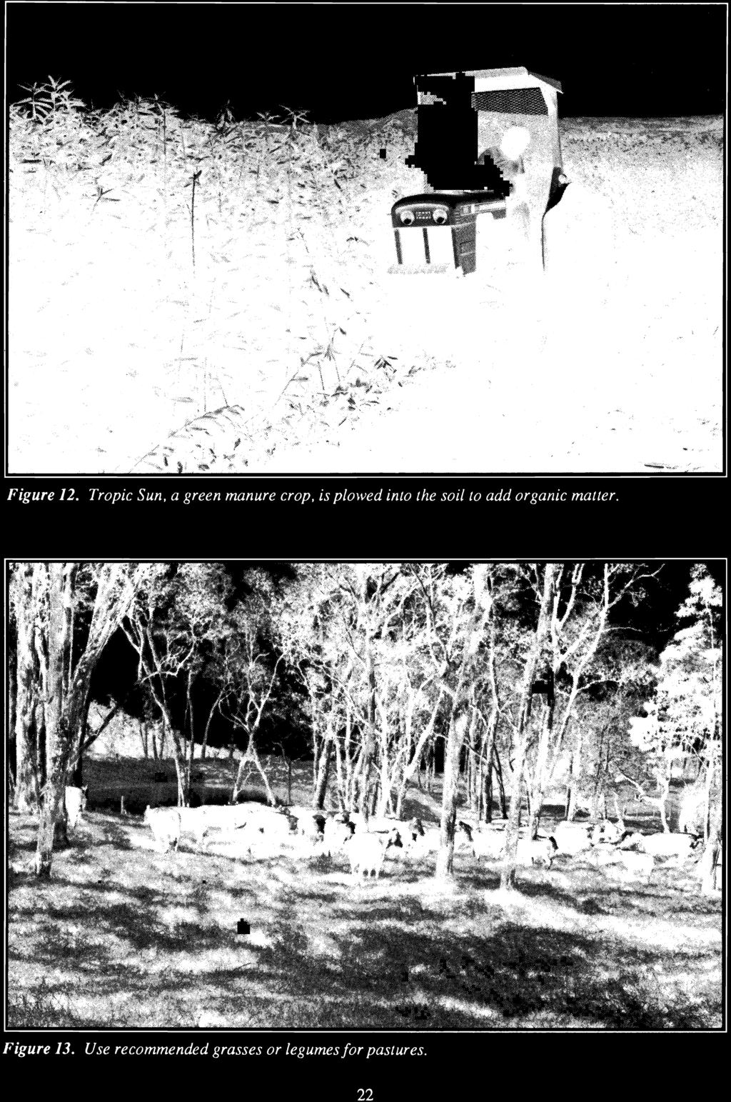
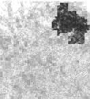
23 Figure 12. Tropic Sun, a green manure crop, is plo}ved into the soil to add organic matter. Figure 13. Use recommended grasses or legumesfor pastures. 22


.")


24 cover a pasture if left uncontrolled. They should be destroyed by mechanical, chemical or biological means. This practice is needed on all pasture land to ensure a full stand of quality forage. 16. Improve and maintain water facilities such as pipelines, catchments, reservoirs, and tanks for livestock. There are areas in the state where it is necessary to pump water to high elevations for livestock use. To reduce costs, catchments or rainsheds can be used to collect water. During drought years you may get into trouble unless adequate storage is provided. Tanks, lined reservoirs, and earthen ponds are used to store water. Earthen ponds are feasible on only a few Hawaiian soils because most soils are very porous and difficult to compact. This practice is needed on all pasture land. 17. Establish windbreaks or shelterbelts for animal protection. Shelterbelts are windbreaks that are planted to break up large expanses of pasture to provide protection for animals (Figure 14). Animals are seriously affected by high or continuous winds. Where pasture areas are exposed to winds, protection for animals must be provided. This practice is needed where wind is a major problem. Practices for Woodland 18. Plant adapted trees. This practice applies to land used for woodland. Trees are planted for commercial wood products, erosion control, or watershed protection. Trees to be planted should be adapted to the soil and climate of the site. The State Division of Forestry and Wildlife makes recommendations for suitable adapted trees. 19. Protect trees from burning and grazing. Fire and grazing animals can damage trees or completely destroy woodlands or forests. Fences should be used to protect trees susceptible to grazing damage. Firebreaks (barriers of cleared land) should be constructed to control fires on planted forests. Figure 14. Shelterbelts are needed for animal protection in areas exposed to high or continuous winds. The shelterbelt breaks up large expanses ofpasture and provides protection. 23


25 Figure 15. Mature trees should be harvested periodically on a selective basis. Figure 16. Developing trails, signs, trash receptacles, etc., are means ofincreasing recreational opportunities. 24

26 20_ Hgrve~t tree~ ~Jectively. Mature commercial and cull trees should be harvested periodically on a selective basis. This allows desired trees to develop and improves the forest stand (Figure 15). Practices for Recreation and Wildlife 21. Wildlife Habitat Improvement. This practice involves planting offood and cover plants for desired wildlife species. This is a means of providing land with possibilities of recreation such as hunting. This practice is needed for areas to be used for wildlife and recreational purposes. 22. Improve water facilities for wildlife and recreation. This includes pipelines or catchments, storage facilities such as tanks, or reselvoirs, and protected drinking facilities. This practice is needed for areas to be used for wildlife and recreational purposes. 23. Develop recreational facilities such as access road, trails, shelters, and campsites. Income-producing recreation is a rapidly growing land use. People like an area that is easily accessible, yet dissimilar to their everyday surroundings. Access roads and trails provides this access. Shelters and campsites provide facilities for use by the public. All facilities should be planned to fit into the environment to maintain the aesthetic value of these areas (Figure 16). This practice is needed for all areas to be used for recreational purposes. Practices for Cropland, Orchard, Pasture, or Woodland 24. Control flooding. Construct flood control structures, such as dikes, and levees. Rood control structures should be designed and constructed according to the anticipated stream flow and the level ofprotection desired. This practice is needed for cropland and orchards where flooding is a major problem. Rood control structures are used to protect crops or high use areas and generally are not used on pasture land. 25. Install and maintain a drainage system. Where the soil remains wet for long periods, excess ground or surface water is removed by installing open ditches, tile drains, pumping stations, levees, floodgates and other structures. Removal ofexcess water will improve growing conditions for most plants and will improve tillage and halvesting operations. This practice is needed for cropland and pasture land where wetness is a problem except on class V land. 26. Apply lime or soil amendments according to soil test. ph or soil reaction is a tenn used to indicate the level of acidity (low ph) or alkalinity (high ph) in the soil The ph of Hawaii soils generally range from 4.0 to 8.0, but commonly are on the acid side, between 4.5 and 6.5. A ph between 6.6 and 7.3 is considered neutral Plants, including cultivated crops and pasture grasses and legumes grow best within a certain ph range. If the soil test shows the soil is too acid (ph below 6.0), lime should be applied to raise the ph. Lime is thoroughly mixed in the plow layer before planting the crop. Crushed coral is the cheapest and the most commonly used liming material in Hawaii. Dolomite, hydrated lime, and calcium silicate can also be used. If the soil is too alkaline (ph above 8.0), sulfur or a similar acid forming amendment can be applied to reduce the ph to a more favorable level. You can test for ph with a ph kit available in garden shops. Or you can have ph and nutrients tested by the University of Hawaii Cooperative Extension SelVice for a small fee. 27. Fertilize \vith nitrogen, phosphorus and! or potassium. If the soil test results are low or moderate for any of these nutrients, fertilizer will be needed for cropland, pasture, and orchards. Experimental work by the University of Hawaii Agricultural Experimental Station and the U.S. Forest SelVice has shown that these nutrients will also increase tree growth in forests or woodlands. 28. Fertilizer or soil amendments not needed. If the soil test shows high levels for all three major plant nutrients (nitrogen, phosphorus, and potassium), fertilizer is not needed. IfpH is between 6.0 and 8.0, soil amendments are not needed. 25
.")

27 PART V: Judging Land for Homesites A home is a major investment for most people. Individual families and communities can avoid construction and maintenance problems if a study of soil conditions is made before construction begins (Figure!7). Soil information can be used to predict potential problems on planned or existing homesites. Before building or buying a home, here are some questions that should be considered. 1. Is there a flood hazard? Avoid homes in a flood plain. 2. Is drainage so poor that standing water or wetness is a problem? 3. Does the soil have high shrink-swell properties that can damage building foundations, driveways, underground utilities, and other structures? 4. Does slope and unstable soil make erosion and soil movement major problems? 5. Is the soil acid or saline that pipes corrode easily and require frequent replacement? 6. Was grading and soil removal extensive? Was the surface soil replaced? 7. Are the soil properties favorable for lawn grasses, shrubs, trees, flowers, and vegetables without extensive soil modification? 8. Is the land located in a lava flow high hazard zone? In judging land for homesites, the soil properties important for urban uses are considered. Many of the properties considered in agriculture are also important for urban uses. Although the soil properties are the same, use caution since a different set of criteria is used to evaluate urban uses. Assume that water is available when you rate the soil for homesites. Figure 17. Knowledge ofsoil conditions is essential to properly planfor urban development. 26

28 ing ing Soils have limitations in use depending on their inherent properties. In urban evaluations, the soils are rated as having slight, moderate, or severe limitations as follows: Slight limitations-soils have properties favorable for the intended use. Good performance and low maintenance can be expected. Moderate limitations-soils have properties moderately favorable for the intended use. Limitations may be overcome or modified by special planning, design, or maintenance. Severe limitations-soils have one or more properties unfavorable for the intended use. Limitations are difficult and expensive to modify or overcome. A severe rating does not mean the soil cannot be used for the intended use. It means more work needs to be done to overcome the soil limitations. This increases the cost of development which must be considered when evaluating the site. Limitation ratings will be made for three homesite uses shown below. Ratings for other uses, including septic tank absorption fields, sewage lagoons and playgrounds, can be made but are not included in this contest. Foundations for buildings-this rating reflects the suitability of the soil to support buildings. Some important soil properties that affect building foundations are slope, shrink-swell potential, depth to water table, and flooding. Lawns, shrubs, and gardens-this rating reflects the suitability of the soil for growing lawns, shrubs, trees, vegetable gardens, or other plantings. The important soil properties are those that affect establishment and maintenance of plantings. They include surface texture, permeability, stoniness, water table and past erosion. Shallow excavations-this rating reflects the ease of digging trenches or holes in the soil to a depth of 5 feet. Excavations are made for uses such as cemeteries, septic tank filter fields, buildfoundations, and underground utilities includsewerlines, pipelines, and cables. Important characteristics affecting shallow excavations depth to bedrock, texture, slope, stoniness, and soil are floo"ding. Factors Important in Evatuating Homesites 1. Surface texture. Only texture of the surface soil is needed on the Homesite Scorecard. (Note, however, that texture of the subsoil is needed to determine permeability, see 2 below). Very clayey-severe limitations for foundations and for lawns, shrubs, and gardens; and moderate limitations for shallow excavations. Special planning and design is required for all types of foundations. The soil is sticky when wet, hard when dry and difficult to manage when used for growing plants. Clayey-slight limitations for all three uses. Loamy-slight limitations for all three uses. Sandy-moderate limitations for all three uses. May require addition of organic matter or fine soil material to improve moisture and nutrient holding capacity for plants. Soil blowing may be a problem when the soil is bare during construction. 2. Permeability. This refers to the rate of water and air movement through the soil. (Note: For the contest, permeability of the soil is based on texture of the least permeable layer, either the topsoil or subsoil. If only one sample is provided base permeability on it). Slow permeability-very clayey texture, water movement less than 0.2 inches per hour. Moderate limitations for foundations and lawns, shrubs and gardens; slight limitations for shallow excavations. Irrigation of plants must be done at low application rates. Moderate permeability--clayey or loamy texture, water movement between 0.2 to 6 inches per hour. Slight limitations for all three uses. Rapid permeability-sandy texture, water movement greater than 6 inches per hour. Slight limitations for foundations. Moderate limitations for lawns, shrubs and gardens due to frequent need for water and plant nutrients. Slight limitations for shallow excavations. 27


29 3. Soil Depth. This refers to depth from the surface of the soil to bedrock. Deep--depths 40 inches or more. Slight limitations for all three uses. Moderately deep-depths between 20 inches and 39 inches. Slight limitations for foundations, lawns, shrubs, and gardens. Moderate limitation for shallow excavations. Shallow--depths between 10 and 19 inches. Slight limitations for foundations. Moderate limitations for lawns, shrubs, and gardens. Severe limitations for shallow excavations. Very shallow--depths less than 10 inches. Slight limitations for foundations. Severe limitations for lawns, shrubs, and gardens and for shallow excavations. 4. Slope. The steepness of the land or the change in elevation in 100 feet of distance expressed in percent. Nearly level-o to 2 percent slo~s. Slight limitations for all three uses. Gently.sloping-3 to 7 percent slopes. Slight limitations for all three uses. Strongly sloping-8 to 14 percent slopes. Moderate limitations for all three uses. Moderately steep-is to 24 percent slopes. Severe limitations for all three uses. Steep to extremely steep-25 percent slopes or steeper. Severe limitations for all three uses. Generally not recommended for building sites. Very expensive and difficult to modify for urban use. 5. Erosion. Loss of surface soil increases the cost of landscaping. Gullies increase the cost of leveling and filling for urban use. Determine degree of erosion as in the agricultural section. None, slight, or moderate erosion-generally slight limitations for all three uses. Severe erosion-moderate limitations for foundations, and lawns, shrubs and gardens. Slight limitations for shallow excavations. Requires leveling, replacement of topsoil and use of fertilizer for satisfactory plant growth. Very severe-severe limitations for all three urban uses. 6. Shrink-swell potential. Soils shrink and swell with changes in moisture content. The potential for soils to shrink and swell depends on the kind and amount of clay minerals present. Soils that shrink and swell the most have high amounts of clays that expand and contract greatly (montmorillonite clays). When these soils dry out, they shrink, leaving large deep cracks on the surface (Figure 18). When they become wet (after irrigation or rain) they expand and the cracks close. Expansion and contraction of the soils can contribute to soil creep or landslides in sloping areas. Movement of the soil can severely damage building foundations, streets, sidewalks, retaining walls, and underground utilities (Figure 19). Low shrink-swell-sandy and loamy soils; and clayey soils that do not have many surface cracks as wide as 1/4 inch and more than 3 inches deep when dry. Slight limitations for all three uses. Moderate shrink-s,vell--clayey soils that have many surface cracks 1/4 inch wide or wider and more than 3 inches deep when dry. Moderate limitations for foundations. Slight limitations for lawns, shrubs, and gardens, and for shallow excavations. Figure 18. Large cracks in high shrink-swell soil. 28


 interferes with urban")


30 High shrink-swell-very clayey soils; these soils commonly have many surface cracks 1/4 inch wide or wider and more than 3 inches deep when dry. Severe limitations for foundations. Moderate limitations for shallow excavations. Slight limitations for lawns, shrubs, and gardens. 7. Stoniness. Rock fragments of all sizes on the surface and in the surface layer. The amount of stones (percent by volume) interferes with urban uses as follows: oto 2 percent-slight limitations for all three uses. 3 to 14 percent-slight limitations for foundations; moderate limitations for lawns, shrubs, and gardens and for shallow excavations. 15 percent or more--slight limitations for foundations; severe limitations for lawns, shrubs, and gardens and for shallow excavations. 8. Water table. The upper surface of groundwater or the level below which the soil is wholly saturated with water. Depth to the water table may change during different seasons of the year. A high degree of mottling in the soil (variegated colors of browns, yellows and grays due to poor aeration) may indicate the level of the water table. A pennanent water table near the soil surface results in wet soils, poor plant growth and poor conditions for construction. For the contest, measure depth from the soil surface to the water level at the time of the contest. Deep---no water table at depths of 40 inches or more. Slight limitations for all three uses. Figure 19. Severe damage to buildings, pavement, underground utilities, and landscaping caused by soil creep on a high shrink-swell soil. 29


31 Moderately deep--water table at depths between 20 and 39 inches. This imposes moderate limitations for foundations and shallow excavations but slight limitations for lawns, shrubs, and gardens. Shallow-water table at depths less than 20 inches. Severe limitations for all three uses. 9. Flooding. Hoods may occur once in a great while, but when they do occur, they can cause severe damage (Figure 20). When an area is converted to urban use, runoff may increase by 75 percent or more, thereby greatly increasing the danger of flooding. A site is likely to flood if it is in a low position on the landscape, it is adjacent to streams, the soil has evidence of being laid down by water, or there are records of past flooding. For the contest, the frequency of flooding will be given on the condition sheet. No flooding-no indications of past flooding. Consider greater runoff due to urban development in the area. If no flooding, then slight limitation for all uses. Occasional flooding-over a long term average, floods occur once in two years or less often. Severe limitations for foundations and shallow excavations, and slight limitations for lawns, shrubs and gardens. If flooding is by sea water, however, there is severe limitations also for lawns, shrubs and gardens. Frequent flooding-over a long term average, floods occur more often than once in two years. Severe limitations for all uses. These areas should not be developed. 10. Final evaluation. This is the overall suitability of the site for the urban uses being considered. It is based on the worst degree of limitation for the planned use and is determined as follows: Slight limitations-all factors slight. Moderate Iimitations-one or more factors moderate and none severe. Severe Iimitations-one or more factors severe. Figure 20. Flooding can occur along streams and low lying areas. Damage to homes and property can be very costly. 30
2018 Iowa FFA Soil Judging CDE Exam 1. Landscape positions characterizes the location of the soil on the landscape and identifies potential risks.
 2018 Iowa FFA Soil Judging CDE Exam 1. Landscape positions characterizes the location of the soil on the landscape and identifies potential risks. Which landscape position is considered the floodplain
Land Capability Classifications
 Land Capability Classifications Unit: Soil Science Problem Area: Basic Principles of Soil Science Student Learning Objectives. Instruction in this lesson should result in students achieving the following
Iowa FFA Soil Career Development Event 2008
 Iowa FFA Soil Career Development Event 2008 1. In Iowa, corn suitability ratings for soil mapping units specifies a. natural weather conditions b. surface and subsurface drainage installed where needed
2016 Iowa FFA Soils Evaluation CDE Exam
 2016 Iowa FFA Soils Evaluation CDE Exam 1. Which of the following is true regarding soil horizons? a. A horizon is darker in color and has more organic matter b. B horizon is darker in color and has more
4H HPS 101 Land Judging In Oklahoma
 4H HPS 101 Land Judging In Oklahoma Extension 4-H MEMBER S GUIDE Oklahoma Cooperative Extension Service Division of Agricultural Sciences and Natural Resources Oklahoma State University 1 Table of Contents
The Nature of Soil Soil Conservation Sustainable Ag.
 Chapter 6 & 7 The Nature of Soil Soil Conservation Sustainable Ag. Climate Soil Forming Factors Parent material Organisms Topography Time Value of Soil Soil is under appreciated Condition of soil affects
Pits 1 & 3 Questions. 7. Subsurface: Texture (5 pts) A. Coarse B. Moderately course C. Medium D. Fine E. Very Fine
 A. Coarse B. Moderately course C. Medium D. Fine E. Very Fine") Minnesota Soils Scorecard Questions for Pits 1-4 Scantron # 105481 Use your soils scorecard to fill out the answers on your scantron Bubble in the front side of the sheet for Pit 1 (# 1-45) and Pit 2 (#51-95)
Minnesota Soils Scorecard Questions for Pits 1-4 Scantron # 105481 Use your soils scorecard to fill out the answers on your scantron Bubble in the front side of the sheet for Pit 1 (# 1-45) and Pit 2 (#51-95)
Land Judging and Homesite Evaluation Guidebook
 Land Judging and Homesite Evaluation Guidebook Kansas State University Agricultural Experiment Station and Cooperative Extension Service INTRODUCTION The study of land and its wise use should be important
2017 Iowa FFA Soil Judging CDE Exam
 2017 Iowa FFA Soil Judging CDE Exam 1. Landscape positions vary in soil composition and makeup. What landscape position would be characterized by having strata and lenses of different textures in the profile:
IOWA FFA STATE SOILS CDE SATURDAY, OCTOBER 13, 2007 AMES, IOWA
 IOWA FFA STATE SOILS CDE SATURDAY, OCTOBER 13, 2007 AMES, IOWA 1. Moderately sloping has what percent slope: a. 9-14% b. 2-5% c. 5-9% d. over 14% 2. Which of the following horizons is the loose underlying
Land Capability Class
 Guide for Applying Conservation Treatments for Land Evaluation (5/23/2011) LAND TREATMENT After examining and determining the physical features of the soil profile, one can determine the land capability
A GUIDE FOR LAND JUDGING IN MICHIGAN. D. L. Mokma, E. Dersch and D. Kesselring
 A GUIDE FOR LAND JUDGING IN MICHIGAN D. L. Mokma, E. Dersch and D. Kesselring Michigan State University in cooperation with the Michigan Chapter of the Soil and Water Conservation Society The study of
2014 Iowa FFA Soil Judging CDE Exam
 2014 Iowa FFA Soil Judging CDE Exam 1. Landscape position is one aspect of evaluating the surface features of a certain tract of land. Identifying the correct landscape position will indicate: a. If the
Land Judging in West Virginia
 Guide 406R-LJ Revised 2017 Land Judging in West Virginia A program of WVU Extension Service 4-H and Agriculture and Natural Resources extension.wvu.edu/youth-family/youth-evaluation/landjudging Land Judging
2012 FINAL SOILS AREA 2 Envirothon Questions Answer KEY
 2012 FINAL SOILS AREA 2 Envirothon Questions Answer KEY Questions 1-6 to be answered at the soil pit: 1. Soil scientists categorize soils by drainage classes. What is the drainage class of the soil at
STATE TAX COMMISSION OF MISSOURI ASSESSOR MANUAL
 STATE TAX COMMISSION OF MISSOURI ASSESSOR MANUAL CHAPTER: REVISION DATE: 10/1/2008 Page 1 of 18 7.3 The purpose of this section of the Assessor s Manual is to supplement the State Tax Commission s published
Team number Page 1 of Canon Envirothon Soils Station Test. Soils and Climate Change
 Team number Page 1 of 9 2006 Canon Envirothon Soils Station Test Soils and Climate Change There are many kinds of soil on the surface of the earth. The kind of soil that is present at a given location
1 Describe the concept of soil texture and its importance. 2 Determine the texture of a soil sample.
 Interest Approach Provide students with various samples of soil. One sample should be nearly all sand, one nearly all clay, and one nearly all silt. Ask students to determine how the samples differ. Would
1. Position (2 pts.) 2. Parent Material (2 pts.) 3. Slope Characteristics (2 pts.) 4. Surface Stoniness or Rockiness (2 pts.)
 2. Parent Material (2 pts.) 3. Slope Characteristics (2 pts.) 4. Surface Stoniness or Rockiness (2 pts.)") Maryland Envirothon SOILS Exam Guidance Information (revised 2017) Objective: To test students' knowledge and awareness of basic soil science and its application in wise land-use planning and therefore
Maryland Envirothon SOILS Exam Guidance Information (revised 2017) Objective: To test students' knowledge and awareness of basic soil science and its application in wise land-use planning and therefore
Lesson 1: Identifying Texture in Soil
 Lesson 1: Identifying Texture in Soil 1 Clods Loam Peds Permeability Soil structure Soil texture Soil workability Textural triangle Water-holding capacity 2 I. A. Soil texture is the fineness or coarseness
2016 Area 3 Envirothon Muskingum County Soils Test ANSWER KEY
 2016 Area 3 Envirothon Muskingum County Soils Test ANSWER KEY 1. The majority of the bedrock in Muskingum County is. a. sedimentary bedrock b. glacial bedrock c. igneous bedrock d. metamorphic bedrock
Using Land Capability Classifications
 Lesson C7 2 Using Land Capability Classifications Unit C. Plant and Soil Science Problem Area 7. Soil Erosion and Land Management Lesson 2. Using Land Capability Classifications New Mexico Content Standard:
Loam: About 40% sand, 40% silt, 20% clay. Mixture of pore sizes to balance water retention and aeration. Considered the best soil for growing crops.
 Soil Characteristics Soil is formed from a combination of two Primary sources: Weathering of Parent Rock ( ) = material introduced by plants, animals, and decomposers Minor sources: Nutrients incorporated
Mature basalt volcanic soils
 MANAGING NORTHLAND SOILS Mature basalt volcanic soils 8.1.2 Soil types in this group Kerikeri friable clay (KE) Kerikeri friable clay with large boulders (KEb) Matarau friable clay (MC, MCH*) Matarau friable
Examining soils in the field. Examining soils in the field. Environment Agency thinksoils examining soils in the field
 Examining soils in the field thinksoils Examining soils in the field Environment Agency thinksoils examining soils in the field 31 Examining soils in the field 32 Environment Agency thinksoils examining
Introduction to Environmental Science. Soil Characteristics. Chapter 11 Soil
 Chapter 11 Soil Soil Characteristics It s more than dirt Most soils are 100s of years old Weathering breaks down parent rock Soil Separates (particle types) Sand (largest) Silt Clay (smallest) Plants contribute
AND Homesite Judging in North Dakota
 DBC618 (Revised) Land AND Homesite Judging in North Dakota A handbook of instruction for 4-H and FFA participants in the North Dakota Land and Homesite Judging Contest in preparation for a lifetime of
A Guide for High School Land Judging Contests
 NATURAL RESOURCES ASSESSMENTS Soil Evaluations in Washington State A Guide for High School Land Judging Contests August 2014 PURPOSES OF LAND JUDGING CONTEST Land judging serves as a tool to teach youth
Unit II Soil Management
 Unit II Soil Management Lesson 2: Using Soil Survey Manuals Soil survey manuals provide useful information for grassland management. Soil scientists evaluate the soil for chemical and physical properties,
HORT 102: Soil Properties. Cultivated Plants: Lecture 15. [Teresa Koenig] Slide #: 1 Slide Title: Intro Information Slide
![HORT 102: Soil Properties. Cultivated Plants: Lecture 15. [Teresa Koenig] Slide #: 1 Slide Title: Intro Information Slide](/thumbs/76/74082590.jpg "HORT 102: Soil Properties. Cultivated Plants: Lecture 15. [Teresa Koenig] Slide #: 1 Slide Title: Intro Information Slide") HORT 102: Soil Properties Cultivated Plants: Lecture 15 [Teresa Koenig] Slide #: 1 Slide Title: Intro Information Slide Title: Lecture 15 Soil Properties Speaker: Teresa Koenig Created by: Teresa Koenig,
HORT 102: Soil Properties Cultivated Plants: Lecture 15 [Teresa Koenig] Slide #: 1 Slide Title: Intro Information Slide Title: Lecture 15 Soil Properties Speaker: Teresa Koenig Created by: Teresa Koenig,
LAND JUDGING AND SOIL EVALUATION
 LAND JUDGING AND SOIL EVALUATION June 1998 W. J. Edmonds, P. J. Thomas, T. W. Simpson, and J. C. Baker Virginia Polytechnic Institute and State University Department of Crop and Soil Environmental Sciences
Soil Notes. General Soil Information
 Soil Notes General Soil Information Definition Soil relatively thin surface layer of the Earth s crust consisting of mineral and organic matter that is affected by agents such as weather, wind, water,
Horner-McLaughlin Woods: Soil Types
 Horner-McLaughlin Woods: Soil Types Not present at HMW Adrian Muck Conover Loam 0-4% Slopes Houghton Muck Miami Loam 2-6% Slopes Miami Loam 6-12% Slopes Miami Loam 12-18% Slopes t 0 0.125 0.25 Miles Mary
SOIL EROSION COMBATING IS ESSENTIAL IN ORDER TO CONSERVE OUR VALUABLE SOIL RESOURCES
 SOIL EROSION COMBATING IS ESSENTIAL IN ORDER TO CONSERVE OUR VALUABLE SOIL RESOURCES A. Introduction - Land is also a precious resource. Land is needed for agriculture and occupation. Land is under pressure
THE SCORE CARD. Observed Soil Properties. Interpretive Soil Properties
 Rev. 07/18/2008 Jim Doolittle Doug Malo Tom Schumacher Plant Science Department SDSU and Kent Cooley Lance Howe Bruce Kunze Jim Millar Walt Schaefer Dan Shurtliff Steve Winter USDA Natural Resources Conservation
4/23/2018. Soil John Wiley & Sons, Inc. All rights reserved. Lecture 14
 Lecture 14 Soil Lecture 14 1. The Soil System 2. Soil Properties and Major Soil Types 3. Environmental Problems Related to Soil 4. Soil Conservation and Regeneration 1 The Soil System Soil Uppermost layer
DIRT! APES Laboratory Activity
 Name: Part I: Soil Texture DIRT! APES Laboratory Activity Can one determine the texture of soil by examining the particles found in a particular sample? The purpose of this activity is to determine the
Instructions on Land Judging in Mississippi
 Instructions on Land Judging in Mississippi Soil is the basic natural resource used by humans to meet the needs of life. It is the extremely thin but precious skin covering the geologic portion of the
Soil Resources. Soil Horizons
 Soil Resources Soil Uppermost layer of earth s crust that supports plants, animals and microbes Soil Forming Factors Parent Material Time Climate Organisms Topography Soil Composition Mineral Particles
Recommended Resources: The following resources may be useful in teaching this lesson:
 Unit E: Basic Principles of Soil Science Lesson 4: Understanding Soil Texture and Structure Student Learning Objectives: Instruction in this lesson should result in students achieving the following objectives:
 *2301001* Pit #1 ontestant #1 Team #1 alifornia DE - Soil and Land Evaluation Group: 1 ontestant: 1 SURFE SOIL (Fill in ONE bubble for each item). D 1. OLOR (5) 2. TEXTURE (5) 3. GRVEL ND ROK (3) 4. THIKNESS
Guide for Applying Conservation Treatments for Land Evaluation (Last updated by Erika Hill, NARD) LAND TREATMENT
 LAND TREATMENT") Guide for Applying Conservation Treatments for Land Evaluation (Last updated 8-14-2018 by Erika Hill, NARD) LAND TREATMENT After examining and determining the physical features of the soil profile, one
Guide for Applying Conservation Treatments for Land Evaluation (Last updated 8-14-2018 by Erika Hill, NARD) LAND TREATMENT After examining and determining the physical features of the soil profile, one
Soil testing Page 1. Contrary to what is widely believed, the colour of the soil reveals very little about its fertility.
 Soil testing Page 1 Soil The Basics Soil is the uppermost surface of the earth, which has been slowly transformed by decomposition due to the effects of weather, vegetation and human activities. The parent
4-H Land Judging in Kentucky
 COOPERATIVE EXTENSION SERVICE UNIVERSITY OF KENTUCKY COLLEGE OF AGRICULTURE, LEXINGTON, KY, 40546 4BA-08MG 4-H Land Judging in Kentucky David Ditsch, Lloyd Murdock, Bill Thom, Monroe Rasnake, and Greg
Soil Characteristics. Soil Science 101
 Craig R. Miller Parks & Open Space Manager www.cpnmd.org Soil Characteristics There are several ways to describe soil. Understanding the characteristics of soil helps the gardener amend soil. Urban soil
Section 1. Judging the soil pit (questions 1-4)
") CONNECTICUT ENVIROTHON 2009 SOILS QUESTIONS Please select the best response to the following questions. There are 25 questions; each question is worth 4 points. Section 1. Judging the soil pit (questions
CONNECTICUT ENVIROTHON 2009 SOILS QUESTIONS Please select the best response to the following questions. There are 25 questions; each question is worth 4 points. Section 1. Judging the soil pit (questions
CHECKLIST BMPs for FIELD NURSERIES REGULATIONS, SITE SELECTION, WATER MANAGEMENT
 CHECKLIST BMPs for FIELD NURSERIES REGULATIONS, SITE SELECTION, WATER MANAGEMENT Regulations For information on the Wetlands Protection Act or the Water Management Act, contact the Massachusetts Department
Soils in the Field. Agronomy 105 1
 Agronomy 105 1 Soils in the Field Objectives Soil pores and water quality Soil texture and plant available water Tile drainage The Revised Universal Soil Loss Equation Definitions Field Trip Study Guide
Soil Interpretations Erosion and Sedimentation Control Planning and Design Workshop
 Soil Interpretations Erosion and Sedimentation Control Planning and Design Workshop Presented by Richard Brooks Presentation prepared by Kristin May Resource Soil Scientists USDA-Natural Resources Conservation
DELHI PUBLIC SCHOOL TAPI
 DELHI PUBLIC SCHOOL TAPI CLASS VII SUBJECT: SCIENCE Ch 9- SOIL Subjective Type Exercises A. Very Short Answer Questions 1. What is weathering? Ans: The process of breaking down of rocks by the action of
THE TENNESSEE VEGETABLE GARDEN
 THE BACKYARD SERIES BACKYARD VEGETABLES W 346-A THE TENNESSEE VEGETABLE GARDEN SITE SELECTION AND SOIL TESTING Natalie Bumgarner, Assistant Professor and UT Extension Residential and Consumer Horticulture
3 PHYSICAL PROPERTIES
 3 PHYSICAL PROPERTIES 3.1 Introduction Physical properties are those which deal with aspects of the material that are related to the bulk properties of the material. In other words, if chemical properties
DO YOU KNOW YOUR SOILS? (Rev. 10/11)
") DO YOU KNOW YOUR SOILS? (Rev. 10/11) Circle all the correct answers. 1. What is the layer normally present on the surface of the soil in cropped fields? a. O c. Ap e. B g. R b. A d. E f. C 2. Available
DO YOU KNOW YOUR SOILS? (Rev. 10/11) Circle all the correct answers. 1. What is the layer normally present on the surface of the soil in cropped fields? a. O c. Ap e. B g. R b. A d. E f. C 2. Available
Soil Texture = %Sand, Silt & Clay in a soil.
 Soils Soil Texture = %Sand, Silt & Clay in a soil. Soil texture is the single most important physical property of the soil. Knowing the soil texture alone will provide information about: 1) water flow
Land Judging and Homesite Evaluation in Florida 1
 CR 242 Land Judging and Homesite Evaluation in Florida 1 J.H. Herbert, Jr., R.B. Brown and E.A. Hanlon, Jr. 2 1. This document is CR242, a circular developed by the Soil and Water Science Department, Florida
Homework Activity Jar Test for Soil Texture
 Homework Activity Jar Test for Soil Texture Background: 1. What is soil? 2. What natural factors influence the formation of soil? 3. How will the depth of each horizon in your soil profile affect your
ENVIROTHON SOILS GUIDE. based on a team problem-solving concept. For this reason, some questions may require
 1 ENVIROTHON SOILS GUIDE This guide contains the information that teachers and students need to compete in the soils portion of the Tennessee Envirothon. Answers to contest questions will come directly
EXPERIMENT 6 PREPARATION OF LAND CAPABILITY CLASS MAP
 EXPERIMENT 6 PREPARATION OF LAND CAPABILITY CLASS MAP Structure 6.0 Objectives 6.1 Intnxluction 6.2 Experiment 6.21 Deciding Factors for Land Capability 6.2.2 Requirements 6.23 Procedure 6.3 Observations
There are different types of weathering weathering and weathering. Both types work together to change Earth s surface.
 Weathering effects Classifying Sediment The surface processes that break down rock are called. Weathering breaks rock into smaller and smaller pieces. Tiny moss plants, earthworms, wind, rain, and even
2011 Wisconsin Envirothon Soils and Land Use Exam
 2011 Wisconsin Envirothon Soils and Land Use Exam USE THE OCONTO COUNTY SOIL SURVEY TO ANSWER QUESTIONS 1-4 The Pensaukee River Wetland Complex is a mixture of state (Pensaukee Wildlife Area) and privately
Chapter 15 Soil Resources
 Chapter 15 Soil Resources Overview of Chapter 15 What is Soil? Soil Horizons Nutrient Cycling Soil Properties and Major Soil Types Soil Problems Soil Conservation and Regeneration Soil Uppermost layer
5.1 Introduction to Soil Systems IB ESS Mrs. Page
 5.1 Introduction to Soil Systems IB ESS Mrs. Page 2015-2016 I Am Soil Thinking Routine: See, Think, Wonder Look at the following images. For each image write down what you see Then write down what you
In 1983, the town evacuated and purchased by government for $36 million
 1 2 3 4 5 6 7 8 9 Introduction to Environmental Geology, 5e Chapter 17 Soil and Environment Weathering: summary in haiku form Rocks brought to surface decompose to sediment and that's weathering. Case
Overview of Chapter 14
 14 Soil Resources Overview of Chapter 14 The Soil System Soil Properties and Major Soil Types Environmental Problems Related to Soil Soil Conservation and Regeneration Soil Uppermost layer of earth s crust
Learning Objectives Part 1. Chapter 4 Soil Physical Properties. Soil Physical Properties. Color. Physical properties part 1
 Learning Objectives Part 1 Chapter 4 Soil Physical Properties Know what color tells you about a soil Describe the concept of soil texture and its importance Use the textural triangle to determine a soil
SOIL DATA: Avondale. in Allen, TX. This information was taken from NRCS web soil survey of Collin County, Texas.
 SOIL DATA: Avondale in Allen, TX This information was taken from NRCS web soil survey of Collin County, Texas. United States Department of Agriculture Soil Conservation Service in cooperation with Texas
LANDPKS TEACHING MANUAL
 LANDPKS TEACHING MANUAL IMPLICATIONS FOR LAND DEGRADATION and RESTORATION FOR THE LandPKS LandInfo MODULE Contents: A description of LandPKS application indicators Indicators and how they impact land degradation
Land Judging. in North Dakota
 DBC618 (Revised) Land Judging in North Dakota Dave Franzen Professor of Soil Science and NDSU Extension Soil Specialist NDSU Extension Service This publication is intended for 4-H and FFA youth participating
WEATHERING AND SOIL FORMATION. 8th Grade- Mr. Stelma
 WEATHERING AND SOIL FORMATION 8th Grade- Mr. Stelma WEATHERING EFFECTS The surface processes that break down rock are called weathering. Weathering breaks rock into smaller and smaller pieces. Tiny moss
Understanding Soils. 1. What is Soil? 2. What does soil do for us?
 Understanding Soils 1. What is Soil? Soil: (i) The unconsolidated mineral or organic material on the immediate surface of the earth that serves as a natural medium for the growth of land plants. (ii) The
Land Judging. in North Dakota
 DBC618 (Revised) Land Judging in North Dakota Dave Franzen Professor of Soil Science and NDSU Extension Soil Specialist NDSU Extension Service This publication is intended for 4-H and FFA youth participating
2014 Envirothon Georgia Soil Study Guide
 2014 Envirothon Georgia Soil Study Guide In addition to materials in this document, 2014 Georgia Envirothon contestants are responsible for materials found in the following documents: From The Surface
EARTH SCIENCE CONCEPTS -Geologic time scale
 EARTH SCIENCE CONCEPTS -Geologic time scale -Plate Tectonics -Earthquakes *result of vibrations (often due to plate movement) deep in the Earth that release energy *often occur at transform boundaries
SOIL BASICS & CONSERVATION
 SOIL BASICS & CONSERVATION What Is Soil? Soil is a mix of eroded rock, minerals, water, air, living things, and decaying matter. Ecosystem Services of Soil Provides nutrients for plants Provides support
Soil Physical Properties
 Soil Physical Properties ESRM 311 SEFS 507 Some examples of mineral soil development eg, Rock Weathering Types of Weathering Physical/Mechanical Chemical Biological Photo by D Vogt CO 2 + H 2 O H 2 CO
Agricultural Science II Soil Science Soil Structure 50 minutes
 Student Outcome Course Unit Lesson Estimated Time Agricultural Science II Soil Science Soil Structure 50 minutes Explain the importance of soil structure. Learning Objectives 1. Explain the term soil structure
Soil aggregates-significance-soil consistency-soil crusting
 Soil aggregates-significance-soil consistency-soil crusting Soil aggregates Soil aggregates are clumps of soil particles that are held together by moist clay, organic matter (such as roots), by organic
 Soils Soil is one of the world's most important natural resources. Together with air and water it is the basis for life on planet earth. Most of our food depends on soil - it is where we find the plants
S-33 Revised May Minnesota Land ROGER S. HARRIS. /J U N I V E. R S I T Y 0 F M I N N E S 0 T A -H~ c~ geludce U.S. DEPARTMENT OF AGRICULTURE
 S-33 Revised May 1958 Minnesota Land ROGER S. HARRIS /J U N I V E. R S I T Y 0 F M I N N E S 0 T A -H~ c~ geludce U.S. DEPARTMENT OF AGRICULTURE Judging Minnesota Land Roger S. Harris O UNDERSTAND IS TO
Lesson 1: Recognizing the Characteristics of Soils and the Soil Requirements for Fruit and Nut Crops
 Lesson 1: Recognizing the Characteristics of Soils and the Soil Requirements for Fruit and Nut Crops 1 Mineral matter Organic matter Pore spaces Tilth Hygroscopic water Soil aeration 22 I. Soil is a layer
Soil resources in upper Basho Valley.
 Soil resources in upper Basho Valley. Åge A. Nyborg, 2007 Norwegian Forest and Landscape Institute. Soil management challenges in Upper Basho Valley Low nutrient content, low organic matter content, deficient
Soil characteristics that influence nitrogen and water management
 Section C Soil characteristics that influence nitrogen and water management Soil characteristics vary across the landscape Soils vary from one field to another, and often within the same field. Soil differences
Soil Structure, Density, and Porosity. Laboratory #4
 Soil Structure, Density, and Porosity Laboratory #4 Objectives Understand the concept of soil structure and how it differs from soil texture. Understand how soil structure influences other soil properties.
Lawn and Yard Care Choices
 SYSTEM (n) Interacting and interdependent parts that form a whole. Whether you choose an exceptional lawn, low input lawn, conversion of lawn, or a combination of types Lawn and Yard Care Choices Thank
PERMANENT SEEDING. Overview of Sedimentation and Erosion Control Practices. Practice no. 6.11
 Overview of Sedimentation and Erosion Control Practices Practice no. 6.11 PERMANENT SEEDING Permanent vegetation controls erosion by physically protecting a bare soil surface from raindrop impact, flowing
Raingardens. Conserving and Protecting Water L
 L-5482 08-08 Raingardens Justin Mechell, Extension Assistant, and Bruce Lesikar, Extension Program Leader for Biological and Agricultural Engineering,The Texas A&M University System A raingarden is an
2/10/2011. Arizona FFA Soil CDE Reference
 Arizona FFA Soil CDE Reference 1 Soil On the first soils in the first season of the Earth, individualization began. Separated now by solid matrix instead of by the shifting waters of the sea, organisms
Soil Maps for Production Agriculture. Jarrod O. Miller, Extension Agronomist
 Soil Maps for Production Agriculture Jarrod O. Miller, Extension Agronomist Origination of Soil Mapping Originally mapped by Division of Soils Federal Bureau of Soils Soil Conservation Service (SCS) started
EDULABZ. Ans. (b) 7. The soft, porous layer with a good water-retaining capacity forms the
 7. The soft, porous layer with a good water-retaining capacity forms the") 3 SOIL I. Multiple choice questions: Tick ( ) the correct choice. 1. The process of soil formation is called (a) conservation (b) weathering (c) erosion (d) none Ans. (b) 2. Soil profile consists of (a)
3 SOIL I. Multiple choice questions: Tick ( ) the correct choice. 1. The process of soil formation is called (a) conservation (b) weathering (c) erosion (d) none Ans. (b) 2. Soil profile consists of (a)
Unit 5: Soil - Stages of Soil formation
 Biology Form 3 Page 68 Ms. R. Buttigieg Unit 5: Soil - Stages of Soil formation Soil is the layer of material covering parts of the land, the home of many organisms and the area from which land plants
Area 3 Envirothon Soils Questions Key
 Area 3 Envirothon Soils Questions Key 1. Soil aeration is the exchange of air in soil with air from the atmosphere. When a soil is well aerated, the air within the soil is very similar to the atmosphere
a. OVERALL PROFILE DEPTH: Assess the depth to the first restrictive layer, which can be a tree root, a rock or an
 OBSERVING SOIL PROCEDURE Using a shovel, soil probe, or soil auger, collect a soil profile. (Go as deep as you can with the equipment). Arrange the soil you remove from the ground on newspaper or in a
Understanding Soil Texture and Structure
 Lesson C6 4: Understanding Soil Texture and Structure Unit C. Plant and Soil Science Problem Area 6. Basic Principles of Soil Science Lesson 4. Understanding Soil Texture and Structure Learning Goal: Understand
Topoclimate Southland Soil Technical Data Sheet No. 8. Sobig
 This Technical Data Sheet describes the typical average properties of the specified soil. It is essentially a summary of information obtained from one or more profiles of this soil that were examined and
Why Control and Prevent Erosion?
 Mark Risse, Rills are often obvious on steep or unprotected banks. Development of soil crust reduces infiltration, causing more runoff and erosion. This rill could easily turn into a gully if erosion is
Soil Characteristics. Soil Science 101
 Craig R. Miller Parks & Open Space Manager www.cpnmd.org Soil Characteristics There are several ways to describe soil. Understanding the characteristics of soil helps the gardener amend soil. Urban soil
FFA Rural Soil CDE. Items necessary for soil judging. FFA Land Judging Contest 2015
 FFA Rural Soil CDE FFA Land Judging Contest 2015 Changes are coming to the Soil Judging Career Development Event (CDE), starting in the upcoming school year, to better reflect today s challenges with soil.
Soils and Land Use Test
 SOIL PROPERTIES Total Score /50 1) List two of the five main functions of soil. (2 points) Habitat for organisms, Engineering medium, Filters and stores water, Anchor for plants, Cycles nutrients 2) Small
Topoclimate Southland Soil Technical Data Sheet No Waiau
 This Technical Data Sheet describes the typical average properties of the specified soil. It is essentially a summary of information obtained from one or more profiles of this soil that were examined and
Do Now: From which materials do you think soil is made? Are all soils the same? Think of some ways that they are different?
 Do Now: From which materials do you think soil is made? Are all soils the same? Think of some ways that they are different? Basics Soil is a major component of the biosphere It contains solids, liquids