PARK & PORTLAND: VISION FOR DEVELOPMENT
|
|
|
- August Chambers
- 5 years ago
- Views:
Transcription
1
 in the most accessible and visible sector of")


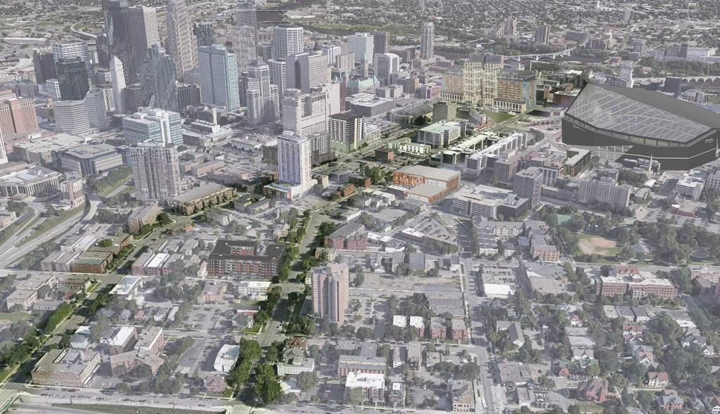
2 2025 PLAN EAST TOWN DEVELOPMENT GROUP East Town is a thriving district of 120 square blocks (300 acres) in the most accessible and visible sector of Downtown Minneapolis. It is bounded by the Minneapolis Central Business District on the west, the Mississippi riverfront to the north, Interstate-35W to the east, and Interstate-94 to the south. The East Town Development work group was formed by the Minneapolis Downtown Council - Downtown Improvement District and the East Town Business Partnership and includes more than 60 organizations and 100 leaders representing businesses, nonprofits, elected officials, universities, and neighborhoods. This inter-disciplinary group advances the development goals of Intersections: The Downtown 2025 Plan and hosts monthly strategic presentations ranging from planning and design to projects and critical path with a special focus on diverse housing growth.

3 TABLE OF CONTENTS 1 Introduction, Goals & Stakeholders 2 Study Area & Context 3 Land Use 4 Zoning 5 Building Height 6 Circulation & Transit 7 Recommendations for Development 8 Vision 9 Opportunity Sites 10 Resources

4 EXECUTIVE SUMMARY EAST TOWN IS THRIVING! East Town is within a period of great growth and transition. Continued efforts of strong planning and neighborhood engagement will help guide the growth to continue building the area into a strong cohesive neighborhood. Over the past decade plus many citizens, elected officials, business community members, developers, designers, and students have collaborated to complete multiple urban studies within the recently branded East Town, primarily focusing on the Elliot Park Neighborhood and Downtown East Neighborhood. This document provides an update of the current status of East Town, builds upon the previous studies and master planning that have been completed, and identifies opportunities for development. CONTRIBUTERS TO SOURCE MATERIAL BKV Group City of Minneapolis Community Planning & Economic Development (CPED) Downtown Minneapolis Neighborhood Association (DMNA) Downtown East Elliot Park (DEEP) East Town Business Partnership Elliot Park Neighborhood, Inc. (EPNI) Hennepin County Metro Transit Minneapolis Downtown Council - Downtown Improvement District (DID) GOALS INCREASE RESIDENTIAL DEVELOPMENT in terms of attraction, distribution & density, variety of types and diversity of residents. STRENGTHEN PARK & PORTLAND CORRIDORS AS CONNECTORS with an increased density in mixed-use development that recognizes preservation, circulation, accessibility, sustainability, safety, new retail/entertainment districts, street-level experience, owner-occupied housing, neighborhood character and balances economic vitality with environment, livability and quality of life. EXPAND AND IMPROVE THE PUBLIC REALM (in order to attract work/live/ play residents, diverse developments and innovation-based businesses) by focusing on green space, hardscapes, streetscaping, transit/vehicle/pedestrian patterns, infrastructure and sustainable environments. CREATE A WEBSITE PLATFORM in a centralized/accessible location that includes assessment of previous Studies/Data, Layer Maps (existing and envisioned), Opportunities/Goals/Guidelines, Stakeholder Feedback and Implementation Plan. RELEVANT STAKEHOLDERS Aeon Augustana Care Developers Guthrie Theater Foundation HCMC Kraus-Anderson North Central University McKnight Foundation Metro Transit Minnesota Sports Facilities Authority (MSFA) Minnesota Historical Society Star Tribune Thrivent Financial University of Minnesota Valspar Wells Fargo 1 INTRO, GOALS, AND STAKEHOLDERS

5 NORTH LOOP Mississippi R. NIC. IS./ EAST BANK St. Anthony Main MARCY HOLMES COMO CHARACTER ZONES Traveling through East Town on Park or Portland Avenue, one encounters a variety of zones. The zones described here are not official designations, but have been identified for the purpose of this study. SUMNER - GLENWOOD HARRISON LOWRY HILL Sculpture Garden at The Walker LOWRY HILL EAST Walker Art Center LORING PARK WHITTIER Target Field Target Center Minneapolis Convention Center STEVENS SQ./ LORING HGTS. Minneapolis Institute of Art (MIA) DOWNTOWN WEST Government Plaza The Armory WEST PHILLIPS ZONE 2 DOWNTOWN EAST THE COMMONS EAST TOWN ZONE 3 HIGH DENSITY Study Area Boundary ELLIOT PARK ZONE 4 MEDIUM DENSITY Portland Ave Park Ave ZONE 1 MILL DISTRICT VENTURA VILLAGE MIDTOWN PHILLIPS U.S. Bank Stadium Guthrie Theater Gold Medal Park CEDAR-RIVERSIDE Hiawatha Ave EAST PHILLIPS UNIV. U of M West Bank SEWARD Dinkytown UNIVERSITY U of M East Bank N ZONE 1 MILL DISTRICT The Mill District is a unique historic area on the Mississippi River, characterized by destinations such as the Guthrie Theater, the Mill City Museum, and Mill Ruins Park. ZONE 2 THE COMMONS The defining features of this zone are The Commons park, the new Wells Fargo Towers on the north side, the U.S. Bank Stadium to the east, and the Armory to the west. ZONE 3 HIGH DENSITY Currently comprised of a mix of mid- and highrise buildings and a large number of surface parking lots, this portion of East Town has great potential to become a more vibrant, high density area with a distinctly urban feel. ZONE 4 MEDIUM DENSITY Flanked on both sides by parks and connected by local streets, this area just north of the Interstate is primarily residential and allows for retail opportunities to serve its residences. LEGEND East Town Boundary Study Area Boundary Neighborhood Boundary Landmarks Parks 2 STUDY AREA AND CONTEXT MAP

6 LEGEND Residential Mixed Use Commercial Municipal/ Institutional Office/ Corporate Parks and Open Space Parking Ramp Surface Parking LRT Blue Line LRT Green Line LRT Station The Armory ZONE 3 HIGH DENSITY 5th Ave S ZONE 2 THE COMMONS Portland Ave ZONE 1 MILL DISTRICT The Commons Park Ave Washington Ave Chicago Ave S 7th St S 6th St Mill Ruins Park U.S. Bank Stadium Mississippi River Gold Medal Park LAND USE ZONE 1 MILL DISTRICT Many of the historic buildings in this district have been restored and turned into market rate housing. There have also been several additional mixed use and apartment buildings built in this area over the last decade, and at least one or two more are in the works. ZONE 2 THE COMMONS The Commons has a rich mix of land use surrounding the newly implemented park, varying from commercial, mixed use and residential developments to institutional and office buildings. ZONE 3 HIGH DENSITY This zone is characterized by mid and highrise mixed use buildings and a large number of surface parking lots. The HCMC campus makes up the east side of the zone. Minneapolis Convention Center ZONE 4 MEDIUM DENSITY Portland Ave Park Ave Chicago Ave S 8th St Elliot Park 11th Ave S ZONE 4 MEDIUM DENSITY This portion of Elliot Park is mainly a residential zone, with a plethora of low rise apartments and some single family homes. Franklin Steele Park N 3 LAND USE MAP

7 B4S-2: Downtown Service District High density mixed use neighborhood. Height Limit: N/A Min. FAR: 2.0 Max. FAR: 8.0 Setbacks: Front yard: 25 Side yard: 5 + 2X (X= # of floors) Rear yard: Equal to min. side yard OR2 - High Density Office District Mixed use environment of moderate to high density + large office use + small scale retail to service surroundings. Height Limit: 4 stories, or 56 Min. FAR: N/A Max. FAR: 2.5 Setbacks: Front yard: 15 Interior side: 5 + 2X (X= # of floors) Corner side: 8 + 2X (X= # of floors) Rear yard: 5 + 2X (X= # of floors) B4N: Downtown Neighborhood District High density neighborhood with a variety of goods and services to support downtown living. Height Limit: 10 stories, or 140 Min. FAR: 2.0 Max. FAR: N/A Setbacks: Front yard: 25 Side yard: 5 + 2X (X= # of floors) Rear yard: equal to Min. side yard OR3 - Institutional Office Residence District Mixed use very high density dwellings + large office & small scale retail Height Limit: 6 stories, or 84 Min. FAR: N/A Max. FAR: 3.5 Setbacks: Front yard: 15 Interior side: 5 + 2X (X= # of floors) Corner side: 8 + 2X (X= # of floors) Rear yard: 5 + 2X (X= # of floors) R6: Multiple Family District High Density apartments, institutional and public services may be allowed Height Limit: 6 stories, or 84 Min. FAR: N/A Max. FAR: 3.0 Setbacks: Front yard: 15 Interior side: 5 + 2X (X= # of floors) Corner side: 8 + 2X (X= # of floors) Rear yard: 5 + 2X (X= # of floors) C1 - Neighborhood Commercial District Small scale retail compatible with adjacent residential uses. Height Limit: 2.5 stories, or 35 Max. FAR: 1.7 Setbacks: Front yard: 25 Interior side: 5 + 2X (X= # of floors) Corner side: 25 Rear yard: 5 + 2X (X= # of floors) 4 ZONING MAP
8 LEGEND 1-2 Stories 3-4 Stories 5-7 Stories 8-15 Stories 16+ Stories Parks and Open Space LRT Blue Line LRT Green Line LRT Station The Armory ZONE 3 HIGH DENSITY 5th Ave S ZONE 2 THE COMMONS Portland Ave ZONE 1 MILL DISTRICT The Commons Park Ave Washington Ave Chicago Ave S 7th St Mississippi River Mill Ruins Park U.S. Bank Stadium S 6th St Gold Medal Park BUILDING HEIGHT ZONE 1 MILL DISTRICT Most of the buildings in the Mill District are between 4 and 7 stories, with the exception of the Mill City Museum building, which is taller. ZONE 2 THE COMMONS While U.S. Bank Stadium and the Wells Fargo Towers are some of the tallest in the neighborhood, the openness of The Commons makes the area lively and expansive. ZONE 3 HIGH DENSITY Though not high density yet, due to its proximity to downtown, this area has the most potential for density and height. ZONE 4 MEDIUM DENSITY The Minneapolis Public Housing Authority s 17 story residential high rise is an anomaly in terms of height in this area. ZONE 4 MEDIUM DENSITY Portland Ave Park Ave Chicago Ave S 8th St Elliot Park 11th Ave S Franklin Steele Park 5 BUILDING HEIGHT MAP
9 LEGEND Primary street Secondary street LRT Blue Line LRT Green Line LRT Station Off-street bike trail On-street bike lane Parks and Open Space Nicollet Mall Station Government Plaza Station ZONE 2 THE COMMONS ZONE 1 MILL DISTRICT S 4th St Washington Ave S 3th St S 2nd St Mississippi River Mill Ruins Park Gold Medal Park CIRCULATION & TRANSIT PARK & PORTLAND AVE CORRIDOR Park & Portland Avenues are county owned one way pairs, and major connectors running the length of East Town. South of 5th Street, they both consist of three lanes of traffic, with a single on-street bike lane and two lanes of parking. At The Commons, they narrow to accommodate the pedestrian oriented streetscape, then widen again near Washington Avenue. North of Washington, they both are local two-way streets. S 12th St S 11th St Minneapolis Convention Center Franklin Steele Park to I-35W South ZONE 4 MEDIUM DENSITY from I-35W North ZONE 3 HIGH DENSITY E Grant St E 14th St S 10th St S 9th St Portland Ave E 14th St E 15th St E 16th St E 17th St Park Ave The Commons Elliot Ave Chicago Ave U.S. Bank Stadium Station Elliot Park 10th Ave S S 7th St S 8th St U.S. Bank Stadium 11th Ave S S 6th St 11th Ave S to Downtown St. Paul Hiawatha Bike Trail Hiawatha Ave Other major connectors include the Chicago Ave, which runs parallel to Park & Portland, and South 6th, 7th, and 8th Streets, all one ways moving traffic either into or out of downtown, connecting with I-94 and Hiawatha Avenue. 9th and 10th Streets connect Elliot Park to downtown and I-35W. LIGHT RAIL East town is well connected to the Light Rail Transit system, with U.S. Bank Stadium receiving both the Blue Line from Mall of America, and the Green Line from downtown St. Paul. BUS A plethora of regional and local bus routes run through East Town see metrotransit.org for more information. 6 CIRCULATION & TRANSIT MAP


10 ZONE 1 - MILL DISTRICT Summary: Portland and Park Avenue connect to West River Parkway at the north end of East Town in the Mill District. The district is many attractions like the Guthrie, the Stone Arch Bridge and the Mill City Museum. Guidelines: Strengthen connection to the Mississippi River. Link to Water Works project. Promote recreational use of St. Anthony Lock & Dam. Strong urban presence and retail along Washington Avenue. 7 RECOMMENDATIONS FOR DEVELOPMENT


11 ZONE 2 - THE COMMONS Summary: The Commons Park, Wells Fargo Towers, and the US bank Stadium are a distinctive features of Zone 2. Guidelines: Strong urban presence and retail along Washington Avenue. Relate to The Commons Park. Respect sun access to The Commons Park. Promote extension of Central Business District. 7 RECOMMENDATIONS FOR DEVELOPMENT


12 ZONE 3 - HIGH DENSITY Summary: This unique zone consists of a mixture of high rise residences and historic brownstones. The large number empty lots allows for many development opportunities. Guidelines: Improve pedestrian experience by widening sidewalks and using plantings as buffers. Transition to high-rise mixed-use developments while also preserving the historic urban fabric. Establish integrated corridors that connect blocks. Create a public realm that ensures the safety, livability, and vitality of pedestrian-oriented neighborhoods. Explore more opportunities for neighborhood park spaces. Work with HCMC on upgrading pedestrian realm and encourage future pedestrian access at 7th and 8th street. Connect to skyway system, while providing clear and frequent access between the skyway and the street. Opportunity to develop Centennial Commons as a neighborhood node (see Elliot Park Neighborhood Master Plan). 7 RECOMMENDATIONS FOR DEVELOPMENT
 on Portland Avenue between South 6th and 7th Streets.")
13 ZONE 3 - HIGH DENSITY STREET SECTION PORTLAND AVE. & S 7TH ST. ZONE 3 - HIGH DENSITY This street section shows two examples of potential mixed use developments on Sites 6 & 7 (see Opportunity Sites Map) on Portland Avenue between South 6th and 7th Streets. These types of buildings help support the Intersections 2025 goal of doubling downtown s residential population, and simultaneously provides retail and entertainment. 80 R.O.W. Developers should collaborate with the City and County to improve the public realm between the curb and building face. Sidewalks should be 6-8 wide minimum, with added mixed pedestrian zones where additional activity can happen. Raised bike lanes encourage bikers who might not be comfortable with on-street riding. Trees and boulevard plantings give pedestrians security from traffic, reduce sound, and beautify the streetscape. PORTLAND AVENUE 7 RECOMMENDATIONS FOR DEVELOPMENT


14 ZONE 4 - MEDIUM DENSITY Guidelines: Foster a more livable community through focus on the pedestrian experience, public open spaces, and the scale and character of new developments. Encourage diversity through mixed-income housing and mixed demographics. Maintain historic fabric through preservation, adaptive re-use, and infill development at opportunity sites. Increase bus services and provide better bus shelters. New development should respect scale, height and rhythm of historic surroundings. Residential use strongly encouraged with some neighborhood commercial mixed in. Summary: The character of this zone consists of one and two story residences. Park Avenue has some small commercial buildings as well as a 19 story high rise owned by the Minneapolis Public Housing Authority. 7 RECOMMENDATIONS FOR DEVELOPMENT
 introduces a mixed use program into a mostly residential area of Elliot Park.")
15 ZONE 4 - MEDIUM DENSITY STREET SECTION PARK AVE. & E 14TH ST. ZONE 4 - MEDIUM DENSITY The upcoming development of 1400 Park (shown) introduces a mixed use program into a mostly residential area of Elliot Park. In addition to adding 240 apartment units to the neighborhood, the retail component adds vibrancy and activity. A landscape buffer, widened sidewalk, and boulevard plantings enhance the surrounding residential context and give pedestrians a sense of comfort and safety. The addition of a bike lane on Park Avenue would help connect residents with nearby amenities and additional transit and bike trails. 80 R.O.W. PARK AVENUE 7 RECOMMENDATIONS FOR DEVELOPMENT
 of 15th presents a great opportunity for additional residential or institutional development.")
16 ZONE 4 - MEDIUM DENSITY STREET SECTION E 15TH ST. & CHICAGO AVE. ZONE 4 - MEDIUM DENSITY Shown here is a cut through East 15th Street looking west. The site to the right (north) of 15th presents a great opportunity for additional residential or institutional development. Providing ample space for sidewalk and boulevards gives pedestrians a sense of security, and 10 drive lanes with parallel parking on both sides gives cars enough width to travel, but keeps speeds reasonable and traffic noise down for residents. 62 R.O.W. E 15TH STREET 7 RECOMMENDATIONS FOR DEVELOPMENT


17 AREA PRECEDENT American Academy of Neurology Village Green Apartments Walk-ups Nice Ride, The Commons Park Station The Horn Monument - US bank Stadium Plaza Grant Park Townhomes Village Green Apartments 8 VISION
18 Recently Completed In Construction Proposed LEGEND ZONE 1 MILL DISTRICT Mississippi River Mill Ruins Park St. Anthony Falls Lock & Dam OPPORTUNITY SITES ZONE 1 MILL DISTRICT Most of the opportunity sites in the Mill District have already been capitalized on, with two additional projects upcoming. Approved by City Opportunity Sites Opportunity to restore street grid ZONE 2 THE COMMONS 1 Washington Ave 2 Gold Medal Park ZONE 2 THE COMMONS Though this area is already teeming with development, there are some prime opportunity sites available. LRT Blue Line LRT Green Line LRT Station Minneapolis Convention Center ZONE 4 MEDIUM DENSITY 12 ZONE 3 HIGH DENSITY Portland Ave Park Ave 5th Ave S Portland Ave The Commons 22 Chicago Ave Park Ave Chicago Ave Elliot Park S 7th St S 8th St U.S. Bank Stadium S 6th St A 16B th Ave S 3 11th Ave S ZONE 3 HIGH DENSITY There are several opportunity sites here, including Centennial Commons, a site at the geographic center of Elliot Park that has been a topic of discussions in several masterplanning efforts (#16A & #16B). Site #5 is another extraordinary opportunity, as the entire city block there is currently covered with surface parking and nothing else. ZONE 4 MEDIUM DENSITY There is some opportunity for development in this medium-density zone of Elliot Park. Multifamily residential and mixed-use developments would be particularly well suited for this primarily residential area. Franklin Steele Park 9 OPPORTUNITY SITES


19 SITE 1 SITE Portland Ave. S Owner: 500 South Third St. Prop. LLC Surface parking 0.5 acres B4S-2 Downtown Service District 240 Park Ave. S Owner: 240 Park Ave S LLC Surface parking 0.75 acres B4N Downtown Neighborhood District SITE rd St. S Owner: 820 Morris TPKE Surface parking 0.66 acres SITE th St. S (2.51 Acres) Owner: Hennepin County County Building SITE Chicago Ave. (2.38 Acres) Owner: Hennepin County Vikings Longhouse + Hennepin County Medical Examiner SITE th St. S (0.54 Acres) Owner: Thrivent Financial Surface Parking - Thrivent East Lot #202 B4S - Downtown Service District 9 OPPORTUNITY SITES
 Owner: Hennepin County Surface")
 Owner: Thrivent Financial Surface")


 Owner: HCMC HCMC Parking Ramp SITE")
20 SITE Portland Ave S (0.11 Acres) Owner: Hennepin County Surface Parking SITE 8 SITE th St. S (0.63 Acres) Owner: Thrivent Financial Surface Parking - Thrivent Smith Lot # Portland Ave. S (0.22 Acres) Owner: 1103 Properties LLC Surface Parking SITE Portland Ave S. (1.14 Acres) Owner: Norwest Properties Inc. Wells Fargo Bank + Drive Through SITE th St S. (1.18 Acres) Owner: HCMC HCMC Parking Ramp SITE th Street S. #1 (0.4 Acres) Owner: Roee V reinberg & Zhen Zhang Good Year Smith Bros. Service Inc. 9 OPPORTUNITY SITES
 Owner: Kensington Investments LII LLC Surface")
 Owner: Hennepin Healthcare System HCMC - AOSC")
 Owner: Plumbers Local No 15 Plumbers Union")
 Owner: Aires LLC Single Family Homes + Surface")
 Owner: Centennial Place Properties Surface")

21 SITE th Ave S (0.59 Acres) Owner: Kensington Investments LII LLC Surface Parking - Kingston Lot #183 SITE S 10th S (0.62 Acres) Owner: Hennepin Healthcare System HCMC - AOSC Project Office SITE th St. S (0.42 Acres) Owner: Plumbers Local No 15 Plumbers Union Building SITE 16A (CENTENNIAL COMMONS) th St. S (0.15 Acres) Owner: Aires LLC Single Family Homes + Surface Parking SITE 16B (CENTENNIAL COMMONS) 901 Centennial PL (0.73 Acres) Owner: Centennial Place Properties Surface Parking C - Neighborhood Commercial District SITE Portland Ave S (0.29 Acres) Owner: PDJ LLC Surface Parking Lot 0.29 acres R6 - Multiple Family District 9 OPPORTUNITY SITES
 Owner: DPD Investments LLC Surface Parking + Ziebart OR2")
 Owner: North Central University Not occupied C1 -")
 Owner: North Central University Surface Parking Lot OR3 -")
 Owner: Minnesota Teen Challenge Inc Surface Parking Lot")
 Owner: Mcknight Market Property LLC Elliot Park")

22 SITE th St E (0.12 Acres) Owner: DPD Investments LLC Surface Parking + Ziebart OR2 - High Density Office Residence District SITE th S E (0.14 Acres) Owner: North Central University Not occupied C1 - Neighborhood Commercial District SITE Chicago Ave S (0.41 Acres) Owner: North Central University Surface Parking Lot OR3 - Institutional Office Residence District SITE th St. E (0.23 Acres) Owner: Minnesota Teen Challenge Inc Surface Parking Lot R6 - Multiple Family District SITE 22 SITE Chicago Ave S. (0.25 Acres) Owner: Mcknight Market Property LLC Elliot Park Grocery + Parking Lot C1 - Neighborhood Commercial District 1619 Chicago Ave S. (0.32 Acres) Owner: Belawski Brothers Alex Used Car + Parking Lot C1 - Neighborhood Commercial District 9 OPPORTUNITY SITES
 Owner: Timeshare System LLC Surface")


 Owner: George A Wright Et Al Surface")
23 SITE th Ave S (5.24 Acres) Owner: Timeshare System LLC Surface Parking + Minnesota Sports Facilities Authority SITE th St. S (0.13 Acres) Owner: N C D A Evans Free Ch Et Al Surface Parking SITE th Ave S (1.75 Acres) Owner: Elliot Park Farm LLC Surface Parking SITE th St. S (0.70 Acres Site 27 added with Site 28) Owner: Bethlehem Baptist Church Of Minneapolis Surface Parking SITE th St. S (0.21 Acres) Owner: George A Wright Et Al Surface Parking B4N - Downtown Neighborhood Distric SITE th St S (1.16 Acres) Owner: Hennepin Faculty Associates Surface Parking 9 OPPORTUNITY SITES
 Owner: Bethesda Missionary Baptist")
 Owner: Bethlehem Baptist Church")
24 SITE th St. S (0.11 Acres) Owner: Bethesda Missionary Baptist Church Current Use SITE th St. S (0.21 Acres) Owner: Bethlehem Baptist Church Surface Parking 9 OPPORTUNITY SITES
25 RESOURCES Intersections: Downtown 2025 Plan Elliot Park Neighborhood Master Plan A Developers Guide to Transit Orientated Development (TOD) Portland Avenue Residential Corridor Public Realm Vision Study Major Development Projects in Downtown Minneapolis Downtown Public Realm Framework East Downtown Pedestrian Realm Augmentation Study Downtown East: The Next Generation Park and Portland Study Area Elliot Park Urban Design Guidelines: The Centennial Commons 2013 The Loring Park Master Plan DEEP 2100 A Guide for Future Residential Development in Elliot Park Neighborhood Minneapolis East Downtown Parking Lot Study Downtown East & Elliot Park: Economic Development and Redevelopment Analysis 10 RESOURCES
Corridor Vision. 1Pursue Minnehaha-Hiawatha Community Works Project. Mission of Hennepin County Community Works Program
 1Pursue Minnehaha-Hiawatha Community Works Project Minnehaha-Hiawatha Community Works is a project within the Hennepin Community Works (HCW) program. The mission of the HCW program is to enhance how the
BROOKLYN PARK / 85TH AVE LRT STATION CDI DEVELOPMENT GUIDELINES DRAFT
 August 2018 Page intentionally left blank The Brooklyn Park Library adjacent to the 85th Ave LRT Station Area. OVERVIEW The Blue Line LRT Extension / Bottineau corridor offers a unique opportunity to leverage
Elliot Park 2. Neighborhood Master Plan. Historical Perspective
 Elliot Park 2 Neighborhood Master Plan Historical Perspective August 2002 Early History Development patterns and the growth of Minneapolis largely grew out of the city s historical response to its geography.
DRAFT ROOSEVELT ROAD. District Recommendations. Figure 5.23 The Roosevelt Road Corridor
 CHAPTER 5 Figure 5.23 The Road Corridor Road will develop as a mixed-use corridor, emphasizing regional retail, west of the river and mixed-use development east of the river. KEY RECOMMENDATIONS 1. High
THE NEIGHBORHOOD TODAY
 THE NEIGHBORHOOD TODAY CORE AREA VISION How are we Good Urbanism A Site s DNA thinking about Elements of great Unique elements urban communities embedded in a place the site and design? ELEMENTS LIKE:
Midtown Greenway Land Use and Development Plan Executive Summary
 Midtown Greenway Land Use and Development Plan Executive Summary Introduction The Midtown Greenway Land Use and Development Plan sets policy direction for land use and development in the Midtown Greenway
Elliot Park 4. Neighborhood Master Plan. The Master Plan
 Elliot Park 4 Neighborhood Master Plan August 2002 Why Master Plan? Construction cranes signal new growth downtown as the backdrop to this smaller scale, quiet neighborhood. Do nothing or plan for the
Hopkins. Development Guidelines May Overview. Sponsored by: Blake Road Corridor Collaborative City of Hopkins
 Hopkins Blake Road LRT Station Area Development Guidelines May 2015 Sponsored by: Blake Road Corridor Collaborative City of Hopkins Overview Hopkins is a dynamic community of over 17,000 residents located
ROBBINSDALE LRT STATION CDI DEVELOPMENT GUIDELINES
 August 2018 OVERVIEW The City of Robbinsdale has a prime-opportunity site in the middle of the 13 mile stretch of the Bottineau LRT corridor / Blue Line extension. Robbinsdale offers a prominent, vital,
Corridor Background. Defining the Corridor Study Area. Lake Street. 38th Street. 46th Street
 1 Corridor Background Defining the Corridor Study Area Minnehaha Avenue (CSAH 48) and Hiawatha Avenue (MN 55) are parallel diagonal roadways, approximately three blocks apart, that provide two direct arterial
Long Lost Allies? Walking Advocates & Business District Organizations. Matt Kazinka Lake Street Council. Shaina Brassard Seward Redesign
 Long Lost Allies? Walking Advocates & Business District Organizations Shaina Brassard Seward Redesign Rob Hanson West Broadway Business and Area Coalition Matt Kazinka Lake Street Council Jamie Schumacher
Robbinsdale LRT Station. CDI Development Guidelines. August Overview
 Robbinsdale LRT Station August 2018 Overview The City of Robbinsdale may have the coolest opportunity site along the 13 mile stretch of the Bottineau LRT corridor / Blue Line extension. Located a block
Tyvola & Archdale Transit Station Area Plan. June 5, 2008
 Tyvola & Archdale Transit Station Area Plan Second Public Meeting June 5, 2008 Presentation Outline 1. Purpose and Process 2. Station Area Overview 3. Plan Recommendations 4. Comments Received and Proposed
Subarea 4 Indian Creek. Vision The combination of park networks and transportation amenities make Subarea 4 the greenest hub in the Corridor.
 indian creek 180 extends south from 101st Street to I-435. The I-435 and Metcalf intersection is one of the primary intersections in the Kansas City Metro Area. The area includes several residential neighborhoods
St. Louis Park Wooddale LRT Station Site development guidelines
 St. Louis Park Wooddale LRT Station Site development guidelines November 2013 OVERVIEW St. Louis Park s convenient location as a neighbor to Minneapolis means you re only minutes away from some of the
THE 355/270 CORRIDOR:
 THE 355/270 CORRIDOR: Strategic Ideas for Sustaining a Livable Work Place Project Summary ACCESS LIFE DESIGN HEALTH WORK Montgomery County Planning Department The Maryland-National Capital Park and Planning
Status Report: MD 355 Project
 Status Report: MD 355 Project OCTOBER 2006 M-NCPPC MONTGOMERY COUNTY PLANNING DEPARTMENT Summary of Community Comments, and break to the Results of the MD 355 Participation Session Brookside Gardens -
Table of Contents. Elm Avenue Improvement Plan City of Waco, Texas. Introduction 1. Existing Context 1 Figure 1 2.
 Table of Contents Introduction 1 Existing Context 1 Figure 1 2 Plan Guidelines 3 Future Urban Form 4 The West-End 4 Main Street 6 The East-End 7 Figure 2 9 Public Improvement Recommendations 7 General
C. Westerly Creek Village & The Montview Corridor
 C. Westerly Creek Village & The VISION Community Vision When the goals of the city are achieved Westerly Creek Village, a distinctive community defined by Montview Boulevard and Westerly Creek, is a strong
Urban Design Manual PLANNING AROUND RAPID TRANSIT STATIONS (PARTS) Introduction. Station Study Areas
 Introduction. Station Study Areas") 111111 PLANNING AROUND RAPID TRANSIT STATIONS (PARTS) Introduction The ION rapid transit system will link Waterloo, Kitchener and Cambridge through a central transit corridor (CTC). There are a number
111111 PLANNING AROUND RAPID TRANSIT STATIONS (PARTS) Introduction The ION rapid transit system will link Waterloo, Kitchener and Cambridge through a central transit corridor (CTC). There are a number
NORTH LAKE SPECIFIC PLAN AREA
 NORTH LAKE SPECIFIC PLAN AREA June 21, 2018 WELCOME Workshop Agenda Introduction Provide information about the program and introduce the team Background Information Share information about the North Lake
Equitable Growth Through TOD Planning
 Equitable Growth Through TOD Planning Community Meeting # 2 November 2017 Goals Objectives Extend investment from downtown Connect neighborhoods physically and economically Enhance places based on local
Complete Neighbourhood Guidelines Review Tool
 Complete Neighbourhood Guidelines Review Tool Prepared By: City of Regina Planning Department October 2014 Page 1 of 14 Community Development Review Checklist for Secondary Plans and Concept Plans The
Unique. Livable. Connected. Sustainable. Anticipate and Manage Change. Variety of Housing Choices. Enhanced Arterial Corridors
 Neighborhood Vision The Old Town Neighborhoods are Unique, Livable, Connected, and Sustainable. As mature, established neighborhoods, many of the ideas and opportunities expressed by stakeholders in support
Town Center. Block 5 Existing multifamily residential units are expected to remain.
 Area Guidelines Germantown s districts should be developed as distinct communities with unique features that are supported through the guidelines. The guidelines not only help distinguish these districts
burlington mobility hubs study Downtown Burlington Mobility Hub
 burlington mobility hubs study Downtown Burlington Mobility Hub Draft Precinct Plan Workbook PIC #3, September 7, 2017 downtown mobility hub objectives City staff and their consultants are proposing an
Sub Area 2: Downtown Overland Park
 Downtown 132 2.12 encompasses over 600 acres and extends between 71st Street and 87 th Street including Downtown Overland Park. The area is home to several individual historic sites and structures, including
Gold Line Bus Rapid Transit Transit Oriented Development (BRTOD) Helmo Station Area Plan
 Helmo Station Area Plan") Appendix F Gold Line Bus Rapid Transit Transit Oriented Development (BRTOD) Helmo Station Area Plan Introduction and Purpose of the Plan The Gold Line Bus Rapid Transit facility is an eleven-mile dedicated
Appendix F Gold Line Bus Rapid Transit Transit Oriented Development (BRTOD) Helmo Station Area Plan Introduction and Purpose of the Plan The Gold Line Bus Rapid Transit facility is an eleven-mile dedicated
This Review Is Divided Into Two Phases:
 Semiahmoo Town Centre Review The purpose of this review: To review the Semiahmoo Town Centre Concept Plan, originally approved in 1993, to ensure that this centre will continue to serve the needs of South
The University District envisions, in its neighborhood
 Envisioning the University District Link Light Rail in Seattle s neighborhoods CIY OF SEALE CONCEP-LEVEL SAION AREA PLANNING RECOMMENDAION RESOLUION # 30165 EXHIBI L Vision 08.2000 he University District
Subarea 5 Southern Gateway. Vision. Mobility The proposed street network will create developable blocks that are scaled appropriately for the area.
 southern gateway 194 Southern Gateway extends south of I-435 to 123 rd Street and includes the area past the Blue Valley Parkway division. This area is adjacent to major office centers such as the College
Blue Line LRT Extension
 v e Noble Pkwy Noble Pkwy Xerxes Ave N Shingle Creek Penn Ave N Penn Ave N Fremont Ave N Lyndale Ave N S Washington Ave University Ave NE Blue Line LRT Extension LIGHT RAIL PLATFORM AND STATION DESIGN
Planning Board Briefing
 Planning Board Briefing Why Now? The Sector Plan Implementation Chapter States: Before Stage 1 begins, the following must occur: Approval of the Sectional Map Amendment. Approval of the Greater Lyttonsville
Chapter 1: Introduction
 Chapter 1: Introduction The Penn Avenue Community Works Corridor Vision and Implementation Framework presents an integrated communitybased vision and a coordinated, long-term implementation framework for
2.0 THE PLATINUM TRIANGLE VISION
 2.0 THE PLATINUM TRIANGLE VISION The envisions an exciting future for the area surrounding Angel Stadium of Anaheim, the Honda Center and The Grove of Anaheim. 2.1 Planning Principles In order to further
Embrace Green Urban Space:
 1 Embrace Green Urban Space: Parks/Green Space as Vital to Urban Livability Jenna Fletcher The Trust for Public Land LUAC November 15, 2012 2 The Trust for Public Land conserves land for people to enjoy
Vision & Land Use. Discussion. Historic Preservation Plan. Foggy Bottom Campus Plan:
 Vision & Land Use Foggy Bottom Campus Plan: 2006-2025 Historic Preservation Plan Discussion Community Meeting Presentation August 2, 2006 Presentation Format Overview Sherry Rutherford, GW Foggy Bottom
PLAN ELEMENTS WORKSHOP. April 5, 2016
 PLAN ELEMENTS WORKSHOP April 5, 2016 needs more housing. But there is no one-size fits-all solution. Every neighborhood has its own character. In some places, density is not only appropriate it is badly
35W Bridge Area: A Response. The Urban Land Institute An Advisory Services Panel December 4 7, 2007
 35W Bridge Area: A Response The Urban Land Institute An Advisory Services Panel December 4 7, 2007 The Urban Land Institute A nonprofit research and education organization. Nearly 40,000 members, worldwide
Animating the Rideau Canal December 2013
 Executive Summary Animating the Rideau Canal December 2013 Why study the Rideau Canal? The Rideau Canal has been an important part of Ottawa throughout its history, and has shaped and been shaped by the
Seneca Meadows. Block 4 Locate office, technology, and medical development adjacent to I Screen views of garage structures from I-270.
 Seneca Meadows Seneca Meadows has an industrial park in its southern end and a mixed-use employment area planned for the north end. The district benefits from extensive I-270 visibility, stream valley
Small Area Plan. South Gateway
 Small Area Plan Adopted May 12, 2008 South Gateway Purpose. The South Gateway Small Area Plan defines the City s expectations for the future of the southern entrance to the City at Interstate 85 and Highway
DRAFT. October Wheaton. Design Guidelines
 October 2011 DRAFT Wheaton Design Guidelines 2 Draft - Design Guidelines - Wheaton Sector Plan Contents 04 Section 1: Introduction 06 Section 2: Context 08 Section 3: Design Guidelines 09 Goal 1: Create
ELMVALE ACRES SHOPPING CENTRE MASTER PLAN
 ELMVALE ACRES SHOPPING CENTRE MASTER PLAN Contents 1.0 INTRODUCTION... 2 2.0 LOCATION... 2 3.0 EXISTING CONTEXT... 2 4.0 VISION & GUIDING PRINCIPLES... 2 5.0 LAND USE AND BUILT FORM... 4 5.1 St. Laurent
LEED-ND 101: Practical Strategies for Achieving Sustainability Goals. Travis Parker Lakewood Planning Director
 LEED-ND 101: Practical Strategies for Achieving Sustainability Goals Travis Parker Lakewood Planning Director Metro Vision Idea Exchange Oct 11, 2012 West Corridor Stations West Corridor Overview West
Mary Hills Nature Area. Roadway Lighting. The Minneapolis Clinic of Neurology Courage Kenny Rehabilitation Institute
 PUBLIC REALM IMPROVEMENTS Mary Hills Nature Area Enhanced Programming Glenview Terrace Valley View Roadway Lighting Enhanced Streetscape Trail Lighting / Roadway Lighting Wayfinding Public Art The Minneapolis
A Plan for the Heart of the Region: Tukwila, WA
 : Tukwila, WA 1 The Plan orchestrates the Restructuring of a 1,000-acre Regional Shopping Area into a Social and Symbolic for the Region. REGIONAL CONTEXT Downtown Seattle (Metropolitan ) 20 miles Bellevue
Building out the Regional Growth Strategy in Surrey: a Strong Centre & a Connected Transit City
 Building out the Regional Growth Strategy in Surrey: a Strong Centre & a Connected Transit City Surrey in the Metro Vancouver Region Regional Growth Strategy identifies Surrey as a major provider of housing
FRUITVALE TRANSIT VILLAGE (Phase 2) Residential Project
 Residential Project") FRUITVALE TRANSIT VILLAGE (Phase 2) Residential Project DEVELOPER: SIGNATURE PROPERTIES ARCHITECT: HKIT ARCHITECTS April 23, 2010 TABLE OF CONTENTS 3 Vision 4 Description of Site 5 Guiding Concepts 6
FRUITVALE TRANSIT VILLAGE (Phase 2) Residential Project DEVELOPER: SIGNATURE PROPERTIES ARCHITECT: HKIT ARCHITECTS April 23, 2010 TABLE OF CONTENTS 3 Vision 4 Description of Site 5 Guiding Concepts 6
Northwest commuter rail station US 36 BRT. Westminster Station
 Northwest commuter rail station Westminster Station US 36 BRT Westminster Center US 36 & Church Ranch Broomfield Flatiron/96 th St. US 36 & McCaslin Table Mesa Boulder Junction 13-month effort that will
West Broadway Transit Study Initial Screening of Alternatives Memo
 West Broadway Transit Study Initial Screening of Alternatives Memo 5/22/2015 Prepared by the SRF Consulting Group Team for Table of Contents Purpose... 1 Methodology... 1 Screening... 5 Screening Criteria...
Stakeholders Advisory Working Groups (SAWGs) Smart Growth and TOD Land Use (#11) SAWG Meeting
 Smart Growth and TOD Land Use (#11) SAWG Meeting") Presentation - Part II Tappan Zee Bridge/I-287 Corridor Project July 21, 2010 Slide 1. David Kooris (Regional Plan Association) welcomed members of the Land Use Stakeholders Advisory Working Groups (SAWGs)
Presentation - Part II Tappan Zee Bridge/I-287 Corridor Project July 21, 2010 Slide 1. David Kooris (Regional Plan Association) welcomed members of the Land Use Stakeholders Advisory Working Groups (SAWGs)
Urban Planning and Land Use
 Urban Planning and Land Use 701 North 7 th Street, Room 423 Phone: (913) 573-5750 Kansas City, Kansas 66101 Fax: (913) 573-5796 Email: planninginfo@wycokck.org www.wycokck.org/planning To: From: City Planning
Historic Preservation Preserve, restore or adaptively re-use historic structures and landscapes.
 Checklist for New Construction Developers of building projects in the Loring Park Neighborhood are encouraged to pursue the standards that are identified below. For large projects requiring special allowances,
CHAPTER 5: GUIDING PRINCIPLES
 CHAPTER 5: GUIDING PRINCIPLES The following 10 principles were developed based on public consultation, planning policy and the background analysis conducted during Phase 1. The Guiding Principles significantly
LAND PARK COMMUNITY PLAN
 LAND PARK Community Plan Part Three : COMMUNITY PLAN AREAS AND SPECIAL STUDY AREAS SACRAMENTO 2030 GENERAL PLAN Contents Community Location...3-LP-3 Community Vision...3-LP-4 Community Profile...3-LP-4
University Avenue District
 University Avenue District UPDATE ON THE OPPORTUNITY 07.8.15 1 University Avenue District The new century nexus of live, work, learn, research, and engage. An intentional partnership of developers, businesses,
Sheridan Boulevard S TAT I O N A R E A P L A N S H E R I D A N B O U L E VA R D S TAT I O N A R E A P L A N
 Sheridan Boulevard S TAT I O N A R E A P L A N 1 City of Lakewood Adopted November, 2006 S H E R I D A N B O U L E VA R D S TAT I O N A R E A P L A N The Vision The City of Lakewood s overall vision is
East Central Area Plan
 East Central Area Plan Steering Committee Meeting March 8 th, 2018 CHUN Tears McFarlane House Vision Statement Development Opportunities Analysis Vision Elements 1. Equitable, Affordable and Inclusive
City of Tacoma Planning and Development Services
 Agenda Item E-1 City of Tacoma Planning and Development Services To: Planning Commission From: Elliott Barnett, Planning Services Division Subject: Tacoma Mall Regional Center Subarea Plan and EIS Meeting
Stadium Village Public Realm and Connectivity Study
 City of Minneapolis Stadium Village Public Realm and Connectivity Study Prepared for Hennepin County, City of Minneapolis, University of Minnesota and the Prospect Park Neighborhood March 2012 Stadium
Mill Woods Town Centre Proposed Rezoning LDA
 Mill Woods Town Centre Proposed Rezoning LDA15 0649 The City of Edmonton has received an application for rezoning and an amendment to the Mill Woods Station Area Redevelopment Plan (ARP) for the Mill Woods
A. Background Summary of Existing Challenges and Potential Possibilities. 1. Summary of Existing Assets and Potential Opportunities
 A. Background 1 A Main Street Master Plan Study was performed and completed in October of 2007. The study was initiated to review current land uses and development patterns along Main Street, from Parrish
SQUAMISH 2010 AND BEYOND COMMUNITY VISION
 Our plan has been imagined and created to be both pragmatic and visionary. At the core of the strategy is a consideration of the highway s role and its impact on the community. First and foremost in creating
Planning for TOD Implementation at a Corridor Scale
 Planning for TOD Implementation at a Corridor Scale Catherine Cox Blair, Reconnecting America Presentation to DRCOG and the Sustainable Communities Initiative May 14, 2012 What is Reconnecting America?
Welcome to the Oakridge Centre Open House
 Welcome to the Oakridge Centre Open House Why is the City hosting this event? This open house is to inform you of a rezoning application submitted to the City of Vancouver to amend the existing CD-1 (Comprehensive
Regency Developments. Urban Design Brief. Holyrood DC2 Rezoning
 Regency Developments Urban Design Brief Holyrood DC2 Rezoning Stantec Consulting Ltd. 7-31-2017 1. Overview Regency Developments intends to rezone the lands located at 8510 and 8511 93 Avenue, within the
City of Farmington. Downtown Plan. Amendment to the 1998 Master Plan Adopted October 11, 2004
 City of Farmington Amendment to the 1998 Master Plan Adopted October 11, 2004 Introduction Planning Background 1 Scope and Components of the Plan Amendment 2 Concept Introduction 3 Plan Concepts 3 Conceptual
Clairtrell Area Context Plan
 Clairtrell Area Context Plan March 2005 Urban Development Services City Planning Contents 1. Introduction... 4 2. Development Structure... 6 2.1 Streets... 7 2.1.1 Sheppard Avenue and Bayview Avenue...
Land Use. Hardware Street Vendor Mixed-Use
 Land Use Definition Land Use is the way a piece of real estate is utilized. Existing, proposed, and adopted land uses all play a role in the planning process. Once a land use plan is adopted, the next
Public Open House #1
 Public Open House #1 TONIGHT S AGENDA Welcome Project Overview The Big Picture The Station Area The Analysis Thoughts about Future Change Breakout Group Discussions Summation / Next Steps Project Overview
1.0 VISION STATEMENT. December 6, PRINCIPLES
 Vision Statement Lincoln Regional Airport 1.0 VISION STATEMENT 1.1 City LOCATION of AND OVERVIEW The Easton Lincoln Place Land Use Master Plan identifies the principles, goals, policies, and standards
REGIONAL ACTIVITY CENTER
 DRAFT REGIONAL ACTIVITY CENTER 70 EAST BENCH MASTER PLAN DRAFT 06 Introduction The East Bench Regional Activity center is comprised of large educational, research, medical, and employment centers. These
MEETING PURPOSE AND OVERVIEW
 MEETING PURPOSE AND OVERVIEW On February 23, 2012, the City of Elk Grove hosted the first of two community workshops related to the Southeast Policy Area. The workshop was held from 6:00 8:30 p.m. in the
Chapter 1.0 Introduction
 Chapter 1.0 Introduction 1.1 Background The North Metro commuter rail line is part of the RTD FasTracks regional transit system expansion program to build more than 100 miles of rail transit throughout
Agenda. 7 Wright Crescent Urban Design Study. Public Meeting and Urban Design Workshop. 1 INTRODUCTION AND BACKGROUND (City of Kingston)
") Urban Design Study Public Meeting and Urban Design Workshop October 02, 2013 Agenda 1 INTRODUCTION AND BACKGROUND (City of Kingston) 2 URBAN DESIGN STUDY PRESENTATION (Antonio Gomez-Palacio, DIALOG) 3
Urban Design Study Public Meeting and Urban Design Workshop October 02, 2013 Agenda 1 INTRODUCTION AND BACKGROUND (City of Kingston) 2 URBAN DESIGN STUDY PRESENTATION (Antonio Gomez-Palacio, DIALOG) 3
01 the vision NEW LYNN IS WAITING FOR THE GREAT LEAP FORWARD
 [A] FRAMEWORK 01 the vision 02 the framework 03 urban design principles 04 c o n t e x t 05 issues a n d o p p o r t u n i t i e s 06 creating a t.o.d. 07 key recommendations 08 seven strategic areas of
CONTEXT: the Highway, the River + the Railroads run through us.
 CONTEXT: the Highway, the River + the Railroads run through us. I-25 36 In the past they have divided us, now we have an opportunity to unite us. I-76 I-270 I-76 CSU I-25 LEGEND Cut + Cover River North
DRAFT Land Use Chapter
 Stevens Creek Urban Village DRAFT 1 18 17 Land Use Chapter INTRODUCTION This Land Use Chapter describes how the Stevens Creek Urban Village will accommodate the growth that is planned for it in the Envision
hermitage town center
 hermitage town center A Community Vision prepared by Strada for The City of Hermitage and The Mercer County Regional Planning Commission January 2007 table of contents introduction 3 design principles
OVERVIEW OF PLANS FOR THE JEFFERSON COUNTY COUNTRYSIDE FARM In the Context of Quality Place Characteristics
 OVERVIEW OF PLANS FOR THE JEFFERSON COUNTY COUNTRYSIDE FARM In the Context of Quality Place Characteristics By Steve Grabow, Professor and Community Development Educator University of Wisconsin-Extension,
Subregion 4 Central Avenue-Metro Blue Line Corridor Transit-Oriented Development (TOD) Implementation Project. Community Meeting April 27, 2011
 Implementation Project. Community Meeting April 27, 2011") Subregion 4 Central Avenue-Metro Blue Line Corridor Transit-Oriented Development (TOD) Implementation Project Community Meeting April 27, 2011 Overview Introduction to Subregion 4 TOD Implementation Program
Subregion 4 Central Avenue-Metro Blue Line Corridor Transit-Oriented Development (TOD) Implementation Project Community Meeting April 27, 2011 Overview Introduction to Subregion 4 TOD Implementation Program
38 Queen s University Campus Master Plan Part 1
 38 Queen s University Campus Master Plan Part 1 46 The Campus at the City Scale Chapter 4 The Campus at the City Scale 39 Queen s is an urban University centrally located in Kingston. Decisions made by
GUIDELINES. Transit Oriented Development. Approved by Edmonton City Council on February 15, 2012 in tandem with City Policy C565
 Transit Oriented Development GUIDELINES Prepared by the City of Edmonton Sustainable Development and Transportation Services Departments Approved by Edmonton City Council on February 15, 2012 in tandem
Promoting Economic Development Through Upfront SEPA Review: Lessons from South Downtown Tacoma
 Promoting Economic Development Through Upfront SEPA Review: Lessons from South Downtown Tacoma 1 This session will focus on the City of Tacoma s South Downtown Subarea Plan and associated Non-Project SEPA
The Urban Core: Downtown Lincoln
 The 'P' Street corridor linking The Urban Core: Downtown Lincoln the Haymarket District to the Antelope Valley Parkway is a place of many possibilities. What are the conditions & attributes that will successfully
Chapter 4. Linking Land Use with Transportation. Chapter 4
 Chapter 4 Linking Land Use with Transportation Chapter 4 59 Chapter 4 Linking Land Use with Transportation Community Design and Transportation Program Introduction Since the 1950s, the predominant development
U T D N o r t h C a m p u s T O D and D o w n t o w n D e n t o n T O D
 U n i v e r s i t y o f T e x a s a t D a l l a s C i t y o f R i c h a r d s o n U T D N o r t h C a m p u s T O D and D o w n t o w n D e n t o n T O D Rick Leisner, AICP Assistant Director of Development
Lehigh Acres Land Development Regulations Community Planning Project
 Lehigh Acres Land Development Regulations Planning Effort Summary In July, 2010 Commissioner Frank Mann invited the Lehigh Acres community to start discussing how to achieve their recently adopted community
chapter DESIGN GUIDELINES NEW RIVER MASTER PLAN REPORT
 chapter DESIGN GUIDELINES NEW RIVER MASTER PLAN REPORT .76 DESIGN GUIDELINES An Overview design guidelines NEW RIVER MASTER PLAN Design Guidelines can transform the image of a city. Specific, design-based
YONGE STEELES CORRIDOR SECONDARY PLAN. Young + Wright / IBI Group Architects Dillon Consulting Ltd. GHK International (Canada) Ltd.
 Ltd.") PART A: PREAMBLE 1.0 PURPOSE The purpose of this Secondary Plan is to provide a development framework for intensification of the Yonge/ Steeles corridor including the north side of Steeles Avenue West
PART A: PREAMBLE 1.0 PURPOSE The purpose of this Secondary Plan is to provide a development framework for intensification of the Yonge/ Steeles corridor including the north side of Steeles Avenue West
2. Form and Character. 2.1 Introduction. 2.2 The Downtown Addition Plan. 2.1 Introduction
 2.1 Introduction 2.1 Introduction This section of the Specific Plan describes and illustrates the desired form, character and uses of the Downtown Addition and explains the underlying design principles.
the west loop HOME TO 5,000 NEW DOGS
 the west loop the west loop HOME TO 5,000 NEW DOGS the west loop HOME TO 5,000 NEW DOGS AND 20,000 NEW RESIDENTS outline: the west loop now the vision how do we get there? opportunity LEVERAGE TRANSIT
Atlanta BeltLine Subarea 3 Master Plan Update
 Atlanta BeltLine Subarea 3 Master Plan Update April 14, 2018 Workshop Meeting 1 22 miles, connecting 45 neighborhoods 22 MILES of transit 46 MILES of streetscapes and complete streets 33 MILES of urban
4 Park Planning and Design
 4 Park Planning and Design Park Constellations Elliot Gateway/Mills Loring North Loop Commons Twins Minneapolis Park & Recreation Board Downtown Service Area Master Plan 4-1 PROJECT APPROACH REFERENCE
The Five Components of the McLoughlin Area Plan
 The Five Components of the McLoughlin Area Plan This documents contains the complete language of the five components of the McLoughlin Area Plan: The Vision Statement The Values The Guiding Principles
Planning for TOD Implementation at a Corridor Scale
 Planning for TOD Implementation at a Corridor Scale Bill Sadler, Reconnecting America Presentation to Gold Line Corridor Working Group July 2, 2013 What is Reconnecting America? Reconnecting America is
DOWNTOWN RESIDENTIAL DISTRICT DEVELOPMENT OPPORTUNITES
 DOWNTOWN RESIDENTIAL DISTRICT DEVELOPMENT OPPORTUNITES Out of all the areas in Downtown Painesville, this district provides the greatest opportunity for change with the vacation of Lake East Hospital.
Welcome. Green Line LRT. Beltline Alignment Options. Stay engaged! Follow the Green Line story at calgary.ca/greenline
 Welcome Green Line LRT Beltline Alignment Options Stay engaged! Follow the Green Line story at calgary.ca/greenline Green Line LRT Why are we here? Our Challenge Determine the best alignment in the Beltline.
Further input invited as Colchester Growth Strategy nears final phase
 IUE 3 / NOVEMBER 2015 Further input invited as Colchester Growth trategy nears final phase trathcona County is seeking public feedback as it enters the final phase of work on a Growth Management trategy