Town of East Gwillimbury Parking Lot & Drive-Through Urban Design Guidelines Background Report
|
|
|
- Morgan Heath
- 5 years ago
- Views:
Transcription


1 Town of East Gwillimbury Parking Lot & Drive-Through Urban Design Guidelines Background Report May, 2018
2
3 TABLE OF CONTENTS 1. INTRODUCTION AND RATIONALE Pedestrian Amenities EXISTING DRIVE-THROUGHS IN EAST GWILLIMBURY 2.1 CIBC Drive-Through Facility - Northeast Corner of Green Lane and Yonge Street 2.2 Real Canadian Superstore Pharmacy - Southwest Corner of Green Lane and Yonge Street 2.3 TD Bank Drive-Through Facility - Southwest Corner of Green Lane and Yonge Street 2.4 Swiss Chalet Drive-Through - Southeast Corner of Green Lane and Yonge Street 3. EXISTING PARKING LOTS IN EAST GWILLIMBURY 3.1 Northeast Quadrant of Green Lane East and Yonge Street 3.2 Southwest Quadrant of Green Lane West and Yonge Street Green Lane East (GO Station) Highway 48 (Foodland) 4. APPLICABLE POLICY FRAMEWORK AND GUIDELINES 4.1 Provincial Policy 4.2 Regional Policy 4.3 Municipal Policy 5. DRIVE-THROUGH FACILITIES - MUNICIPAL BEST PRACTICES 5.1 City of Markham 5.2 Town of Oakville 5.3 City of Toronto Landscaping 7. SURFACE PARKING LOTS - MUNICIPAL BEST PRACTICES 7.1 City of Markham 7.2 Town of Oakville 7.3 City of Toronto 7.4 City of Mississauga 7.5 City of Ottawa 7.6 City of Kingston 2.7 Town of Caledon 8. SURFACE PARKING LOTS - SUMMARY OBSERVATIONS 8.1 Sustainable Urbanism 8.2 Regulatory Approaches 8.3 Context 8.4 The Public Realm 8.5 Vehicular and Pedestrian Traffic 8.6 Sustainable Development 8.7 Safety, Comfort and Pedestrian Access 8.8 Pedestrian Amenities 8.9 Landscaping City of Mississauga City of Ottawa City of Kingston Town of Caledon DRIVE-THROUGH FACILITIES - SUMMARY OBSERVATIONS 6.1 Sustainable Urbanism 6.2 Regulatory Approaches 6.3 Context 6.4 The Public Realm 6.5 Vehicular and Pedestrian Traffic 6.6 Functional Stacking Sustainable Development Safety, Comfort and Pedestrian Access 22
4 LIST OF FIGURES Figure 2.1a CIBC Drive-Through Facility Figure 2.1b Aerial of CIBC Drive-Through Facility Figure 2.2a Real Canadian Superstore Pharmacy Drive-Through Figure 2.3a TD Bank Drive-Through Figure 2.3b Aerial of TD Bank Drive-Through Figure 2.4a Rear of Swiss Chalet Drive-Through Figure 3.1a Northeast Quadrant - Gateway Arch Figure 3.1b Northeast Quadrant - Coloured Pavement Figure 3.1c Northeast Quadrant - Shops Along Green Lane East Figure 3.1d - Northeast Quadrant - Shops Along Yonge Street Figure 3.2a Southwest Quadrant - Gateway Feature Figure 3.2b Southwest Quadrant - Aerial of Parking Lot Figure 3.3a Aerial of GO Station Parking Lot Figure 3.4a Aerial of Foodland Parking Lot LIST OF APPENDICIES APPENDIX A - Town of East Gwillimbury Drive-Through Inventory APPENDIX B - Town of East Gwillimbury Parking Lot Inventory 31 32
5 01 INTRODUCTION AND RATIONALE The Parking Lot and Drive-Through Urban Design Guidelines Background Report (background report) has been undertaken on behalf of the Town of East Gwillimbury as part of a study to prepare a set of design guidelines that will implement the design of parking lots and drive through facilities.. The Parking Lot and Drive-Through Urban Design Guidelines (Design Guidelines) will supplement design policies outlined in the Town s Official Plan and promote safe, accessible, pedestrian supportive, visually appealing and sustainable development. The Design Guidelines will apply Town-wide and will be applicable to development applications that are implementing surface parking and drive-through facilities. The background report provides the following: Analysis of sample existing drive-through and parking lot inventory Applicable policy framework (provincial, regional, municipal) Case studies Observations for the design of drive-through facilities and parking lots Drive-through facilities remain prevalent within the GTA and East Gwillimbury. However, concerns have been expressed about potential adverse impacts, which should be reduced or eliminated. Impacts may include but are not limited to: pedestrian safety; traffic and circulation; noise; air pollution; and built form/ site layout configuration. Drive-through facilities can generate noise from idling cars, car stereos and placing of orders at the order box. This matter is further amplified when a drive-through facility is located immediately adjacent residential uses. An additional issue that may arise with drive-through facilities is when the built form format does not support a pedestrian and transitsupportive streetscape. Parking is an essential component for most land uses. For example, in an urban setting with lower densities, retailers often rely on surface parking. Surface parking lots can be designed for safe vehicular and pedestrian circulation while meeting the parking needs of a specific development. Parking lots are often visually unappealing with large asphalt surfaces, limited landscaping and lack of appropriate buffering from the street. Parking lots also contribute to environmental issues such as the urban heat island effect and often are not designed to absorb stormwater runoff. Appropriate landscaping and site layouts and low impact development (LID) measures are often called for to achieve well-designed and more sustainable parking lots. Both provincial and municipal policies identify the importance of compact, sustainable communities. Provincial legislation such as the Places to Grow Growth Plan promote healthy, livable and safe communities and low impact development (LID) measures that can be applied to drive-through facility and parking lot design. The Town of East Gwillimbury Official Plan also refers to the use of LID measures for parking and loading areas such as pervious paving to reduce both stormwater runoff and the heat island effect. This background report will serve as the foundation for further elaboration on goals and objectives related to drive-through facility and parking lot design. The research and analysis compiled in this background report will also be used in the creation of Design Guidelines applicable to parking lots and drive-through facilities in the Town of East Gwillimbury. BACKGROUND REPORT 1


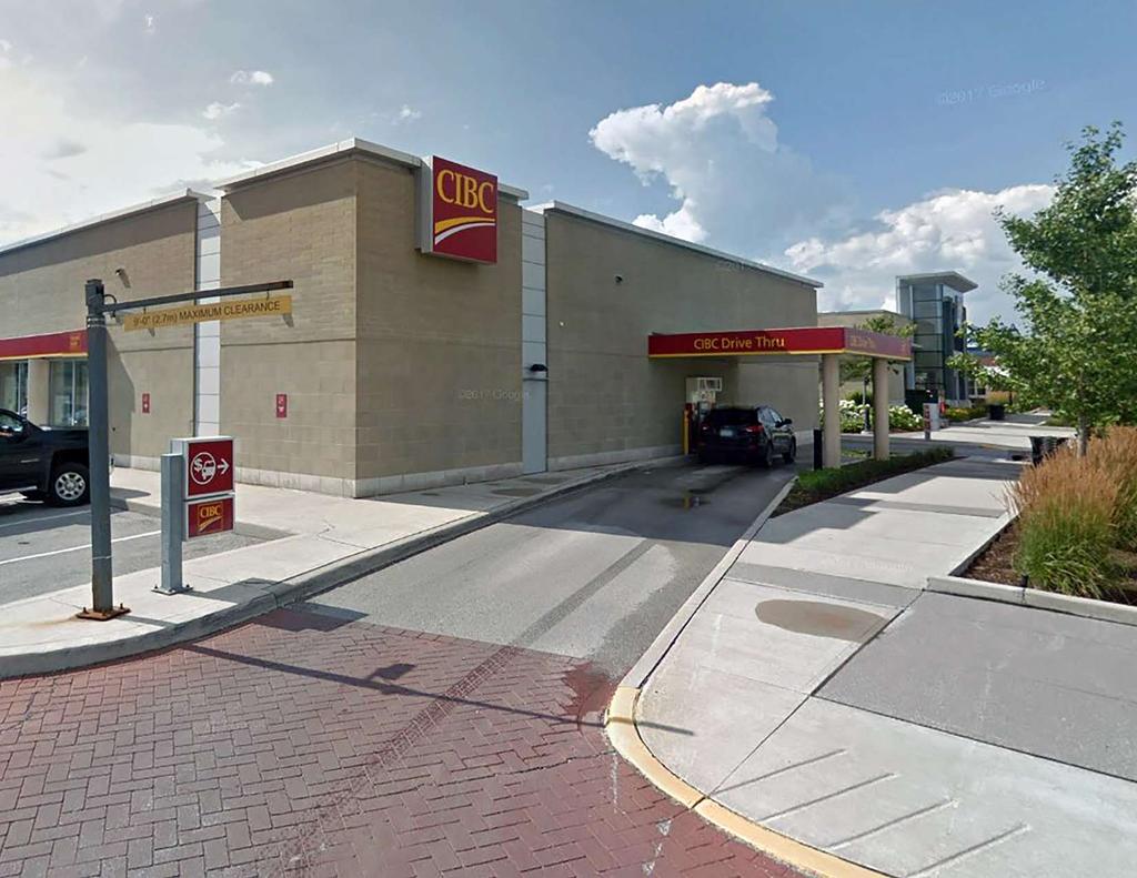
6 02 EXISTING DRIVE-THROUGHS IN EAST GWILLIMBURY The following analysis assesses select examples of drive-through facilities and surface parking lots within the Town. This analysis is not intended to be a comprehensive review, but is an overview that discusses features associated with drive-through facilities and surface parking lots. Drive-through facilities currently found within the Town consist of the following uses: restaurants, gas stations offering coffee/fast food, banks, and a pharmacy. Key features of well-designed drive-through facilities include: buildings placed adjacent to public streets to provide a pedestrian supportive environment; façade treatment of buildings with main entrances and fenestration that address the street; stacking lane configuration that does not interfere with an appropriate street-building relationship; walkways that connect the parking areas with main building entrances for pedestrian safety and avoids conflicts with the stacking lane; appropriate buffering adjacent sensitive land uses such as residential; landscaping to reduce the total area of asphalt wherever possible. A full inventory of the existing drive-through facilities can be found attached in Appendix A. The building is set close to the street edge and includes glazing and architectural features. A pedestrian access from the sidewalk is connected to the main entrance of the bank. Landscaping is provided along Yonge Street and the north side of the building to act as a buffer from the parking located at the rear of the building. Figure 2.1a - CIBC Drive-Through Facility 2.1 CIBC Drive-Through Facility - Northeast Corner of Green Lane and Yonge Street BANK The CIBC drive-through facility contains one stacking lane located at the rear of the building. Some landscaping is provided adjacent to the stacking lane to screen from the surrounding parking lot. YONGE STREET Figure 2.1b - Aerial of CIBC Drive-Through Facility 2 BACKGROUND REPORT


7 2.2 Real Canadian Superstore Pharmacy - Southwest Corner of Green Lane and Yonge Street This large retail supermarket, which houses the pharmacy, is set back significantly from Yonge Street. A large surface parking lot separates the building from the street. The relatively short stacking lane is located at the west side of the building and has minimal landscape buffering to separate the stacking lane from the parking lot. 2.3 TD Bank Drive-Through Facility - Southwest Corner of Green Lane and Yonge Street The bank is set back from Yonge Street with the stacking lane for the drivethrough component wrapping in front of the building. Landscaping is provided along the street frontage and accommodates a slight change in grade. The main entrance to the bank is located at the rear of the building and faces the large parking lot. Figure 2.2a - Real Canadian Superstore Pharmacy Drive-Through Figure 2.3a - TD Bank Drive-Through Figure 2.3b - Aerial of TD Bank Drive-Through BACKGROUND REPORT 3

8 2.4 Swiss Chalet Drive-Through - Southeast Corner of Green Lane and Yonge Street The restaurant is located within a large commercial centre which contains a large surface parking lot. It is setback from Yonge Street and the stackinglane wraps around the building separating it from the street. The main building entrance is located at the rear and the servicing and loading areas are visible from the street. Landscaping along the street frontage provides some screening. Figure 2.4a - Rear of Swiss Chalet Drive-Through 4 BACKGROUND REPORT


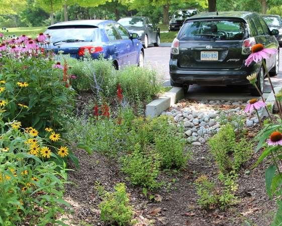
9 03 EXISTING PARKING LOTS IN EAST GWILLIMBURY The majority of large surface parking lots that have been reviewed in this section are primarily concentrated around the Yonge Street and Green Lane intersection. Three plazas are located at the northeast, southeast and southwest quadrant of the Yonge Street and Green Lane intersection. Other surface parking lots are found in Holland Landing and Mount Albert. Each plaza contains several retailers and surface parking to accommodate customers and tenants. The plaza incorporates some landscaping in the parking lot and along site perimeters. The colored pavement used to denote pedestrian crosswalks appears to be made up of permeable pavement. Key features of well-designed surface parking lots include: appropriately landscaped edges and boundaries, including public streets; appropriate spacing for landscape islands, corridors or roundabouts to break up large surface parking lots; buildings located close to the street; well delineated pedestrian routes leading to building entrances; and sustainable measures to reduce heat island effect and surface runoff. A listing of surface parking lots can be found attached as Appendix B. Figure 3.1a - Northeast Quadrant - Gateway Arch 3.1 Northeast Quadrant of Green Lane East and Yonge Street This commercial plaza utilizes decorative paving and landscaping to denote a central interior corridor within the parking lot, while also using decorative paving to delineate some pedestrian walkways. A gateway arch (figure 3.1a) was erected to enhance the driving aisle that runs east and west through the centre of the plaza. Parallel parking has been implemented between two buildings located in the centre of the site to create a tighter street cross section and provide a more pedestrian oriented configuration. A small roundabout has also been implemented within the parking lot to ease vehicle access between an adjacent retail development. Figure 3.1b - Northeast Quadrant - Coloured Pavement BACKGROUND REPORT 5


 on the southern portion of the site. A gateway feature (Figure 3.2a) is used to identify the urban corner condition.")

10 Along Green Lane, stores are placed close to the street edge to help establish a pedestrian-oriented urban context (Figure 3.1c). The grade difference between the street and the plaza provide a particular condition. Entrances to the stores are connected to a pedestrian sidewalk along Green Lane. Along Yonge Street, the stores are set close to the street edge and pedestrian walkways are connected to the public sidewalk (Figure 3.1c). Similar to the Green Lane frontage, the grade difference between the street and the plaza creates a particular condition. 3.2 Southwest Quadrant of Green Lane West and Yonge Street This large commercial plaza at the Southwest corner of Green Lane West and Yonge Street contains some buildings along the street frontages and some buildings (including the Real Canadian Superstore) on the southern portion of the site. A gateway feature (Figure 3.2a) is used to identify the urban corner condition. The feature adds visual interest and provides pedestrian connectivity to the retail facilities within the plaza. Some landscaping is provided to delineate sections of the large surface parking lot that is located centrally within in the plaza. Centrally located pedestrian walkways provide some connectivity between the buildings and the parking areas. Figure 3.1c - Northeast Quadrant - Shops Along Green Lane East Figure 3.2a - Southwest Quadrant - Gateway Feature Figure 3.1d - Northeast Quadrant - Shops Along Yonge Street 6 BACKGROUND REPORT Figure 3.2b - Southwest Quadrant - Aerial of Parking Lot

 The retail building is located behind a row of parking spaces that front onto Highway 48.")
11 Green Lane East (GO Station) 845 Green Lane East (Go Station) incorporates a train and bus terminal, bus bays and shelters, storm water management ponds, passenger pick up, and a large surface parking lot. The parking lot does not contain a significant amount of landscaping except for an island in the middle that separates the parking lot into two sections. Some walkways are located within the perimeter and provide access to the main train and bus terminal. The parking lot uses permeable paving for the commuter drop off and pick up area and bus bays Highway 48 (Foodland) The retail building is located behind a row of parking spaces that front onto Highway 48. A majority of the surface parking lot is located at the north side of the property. Some landscaping is provided along the street frontage. The corners of the parking lot entrance contain flower beds, low- lying rocks and shrubs as well as a low tree that partially screens parking from the street. The interior of the parking lot does not contain landscaped islands and there are no clearly delineated walkways from parking to the store. The landscaping along Green Lane East consists of low-lying shrubs and trees that are spaced widely apart. The Nokiidaa Bike Trail is connected to the train and bus station area through a walkway. Figure 3.4a - Aerial of Foodland Parking Lot Figure 3.3a - Aerial of Go Station Parking Lot BACKGROUND REPORT 7
12 04 APPLICABLE POLICY FRAMEWORK AND GUIDELINES 4.1 Provincial Policy Provincial Policy Statement The Provincial Policy Statement (PPS) encourages the formation of strong healthy communities and the optimization of land, resources and public investment in infrastructure and public service facilities. It notes that development within settlement areas shall allow for intensification, redevelopment and a compact form. The PPS promotes efficient development and land use patterns that do not cause environmental, public health and/ or safety concerns. It also requires meeting the needs of pedestrians and facilitating pedestrian and non-motorized movement, including but not limited to walking and cycling. Development and land use patterns that conserve biodiversity and are cognizant of the impacts of a changing climate are encouraged. SUMMARY COMMENTS: The policies relating to healthy, livable and safe communities and addressing the needs of pedestrians are the most relevant to the design of surface parking lots and drive-through facilities. The Design Guidelines will maintain consistency with this framework by promoting pedestrian supportive streetscapes and by incorporating low impact development measures The Places to Grow Growth Plan The Places to Grow Growth Plan sets out policies related to achieving prosperous communities through management of growth. For Transit Corridors and Station Areas as well as Employment land uses, the plan notes that surface parking should be kept to a minimum. In lieu of parking, active transportation networks and a transit-supportive built form are envisioned for employment areas. Incorporation of impact development and green infrastructure is also discussed to help address climate change. Large-scale developments through their respective planning channel (site plan, secondary plan, etc.) will be supported by a stormwater management plan that discusses an integrated treatment approach to reduce stormwater flows and dependence on stormwater ponds. SUMMARY COMMENTS: These policies pertaining to the design of surface parking lots and drivethrough facilities include the integration of green infrastructure and low impact development to achieve complete communities. The Design Guidelines will maintain consistency with this framework by promoting pedestrian supportive streetscapes and incorporating low impact development measures The Greenbelt Plan The Greenbelt Plan contains policies concerning the protection of agricultural land, natural heritage and water resource systems, providing a range of economic and social activities associated with rural communities and mitigating climate change. General policies specific to the Protected Countryside provide direction on non-agricultural and recreational uses as well as a sub-section discussing infrastructure. Through the utilization of green infrastructure and increasing resilience of infrastructure, municipalities can reduce the need for repairs or replacement arising from extreme weather events. 8 BACKGROUND REPORT
13 SUMMARY COMMENTS: The policies pertaining to infrastructure are the most applicable to the design of parking lots and drive-through facilities. Infrastructure is a fundamental component of economic well-being, human health and quality of life. Through the utilization of green infrastructure such as permeable surfaces and street trees, drive-through facilities and surface parking lots can be made more resilient against climate change Lake Simcoe Protection Plan The Lake Simcoe Protection Plan outlines policies related to the protection of the Lake Simcoe watershed including reducing the discharge of pollutants to the lake and its associated tributaries. It encourages environmentally sustainable land and water uses as well as development practices. If located in a settlement area, existing and expansions, applications for development or site alteration should amongst other criteria avoid or reduce the impact of urban run-off into receiving streams, lakes and wetlands. SUMMARY COMMENTS: The Design Guidelines will address the Lake Simcoe Protection Plan by promoting reduced stormwater runoff volume and pollutant loadings from any major development involving drive -through facilities or large surface parking lots Parking Lot Design Guidelines to Promote Salt Reduction The Parking Lot Design Guidelines to Promote Salt Reduction is a document prepared for the Lake Simcoe Region Conservation Authority. The document provides direction on recommended practices to reduce salt use on the new development of institutional and commercial parking lots within the Lake Simcoe Watershed. It also has general applicability to all paved parking/roadway areas that use salt. Four primary design features are discussed as well as other design features that can be incorporated into the design of parking lots to reduce salt. Through effective grading and stormwater collection, melt water from high traffic areas and/or snow piles can be directed to strategically placed stormwater collection infrastructure (such as a vegetated swale) so that no salt application is needed. Locating snow storage piles in low-traffic areas, downgradient from high traffic parking lot areas minimizes the risk of melt water drainage across high-traffic areas where it might refreeze. The layout and location of sidewalks and pedestrian walkways can also reduce the amount of salt used. Pedestrian walkways should be user-friendly and designed with appropriate width (1.5m) that would enable them to be plowed and reduce the need for chemical snow removal methods. Landscaping features such as landscaped islands reduce the amount of salt application required because it decreases the amount of paved surface. Additionally, swales, bio- retention, and landscaped islands with curb cut inlets can collect and retain melt water runoff. Other design features discussed include the following: Permeable Pavers, Seasonally-Closed Parking Areas, Shaded Canopies, Brine Holding Tanks for Anti-icing and Pre-wetting, Conductive Pavement on Walkways and Entrances. SUMMARY COMMENTS: This document is applicable to the design of parking lots and drive-through facilities. Through adopting best practices for salt reduction such as mentioned in the document, the concentration of chloride associated with salting of paved areas could be reduced. 4.2 Regional Policy York Region Official Plan The Regional Official Plan sets out relevant urban design policies related to healthy and sustainable communities. The Official Plan encourages the development of walkable communities, well-integrated retail and discusses heat island mitigation measures through installing light-coloured pavement. The Official Plan requires retail to be walkable, transit-supportive and integrated into communities and pedestrian networks with high- quality urban design. BACKGROUND REPORT 9
14 SUMMARY COMMENTS: The document provides general guidance applicable to parking lot and drivethrough facility design. It promotes walkability and emphasizes pedestrian supportive design. The Official Plan encourages the use of light-coloured paving materials in addition to providing shade trees and green and/or white roofs to mitigate the local heat island effect York Region Transit-Oriented Development Guidelines The York Region Transit-Oriented Development (TOD) Guidelines encourage the provision of a development form that has a sufficient density to support transit use, while providing the necessary built form characteristics to ensure a strong pedestrian-oriented environment, and an appropriate fit with the existing and emerging contexts. The document discusses six themes that provide specific guidance on how to achieve transit-oriented development. The themes consist of Pedestrians, Parking, Land Use, Built Form, Connections and Implementation. SUMMARY COMMENTS: While the guidelines are intended for the application of York Region s urban structure consisting of Regional Centres linked by Regional Corridors and served by public transit, they are also applicable to the design of parking lots and drive-through facilities. Specific guidelines for consideration in the design of parking lots include provision of accessible and safe connections and compact buildings with façades and main entrances oriented to the street York Region Sight Triangle Manual Design Guidelines and Standards for Sight Triangles The Sight Triangle Manual provides design direction and standards regarding enhancements within the public right of-way, specifically to sight triangles. Sight triangles, located at road intersection quadrants, require unobstructed visibility for safe vehicular movement between streets, driveways or alleys. Sight triangles can be enhanced with the following elements: Architectural features, decorative paving, planting & landscape features, site furnishings and 10 BACKGROUND REPORT accent lighting. To proceed with landscaping on a daylight triangle, minimum requirements relating to safety, context and maintenance should be satisfied. The safety requirement discusses conformance to AODA standards, maintaining driver and pedestrian visibility and permitted landscaping and architectural triangles that do not obstruct views of luminaires, traffic signals and other elements. To fulfill the maintenance requirement, plans for landscaping on daylight triangles should include areas for future traffic signal controllers, utility cabinets or gas regulating stations. SUMMARY COMMENTS: Landscaping on sight triangles presents an opportunity to enhance the public realm and provide additional screening of surface parking lots. The guidelines and illustrations provided in the document indicate treatments of varying sizes of sight triangles. 4.3 Municipal Policy Town of East Gwillimbury Consolidated Official Plan (June 2010) The Town of East Gwillimbury Official Plan establishes urban and public realm design guidelines for development within the Town. The Official Plan contains general guidelines for drive-through facilities and designations permitting and prohibiting drive-through facilities. It also contains policies pertaining to the design of parking lots. Drive-Through Facilities Drive-through facilities are permitted within the Centres designation of the Official Plan (Section ). If the zoning by-law does not permit drivethrough facilities, a zoning by-law amendment is required. If a zoning by-law amendment is required, the proposed drive-through facility application will need to demonstrate conformity with the criteria outlined in Section vii. The proposed drive-through facility must not prevent the planned function and intensification for a site, negatively impact pedestrianization and transit supportiveness, conform with Urban and Public Realm Design policies, and
15 adhere to a high standard of urban planning and design. Drive-through facilities are also allowed within the Village Core Area contingent upon adherence to criteria specified in Section For proposed drivethrough facilities within the Village Core Area, the application must demonstrate conformity with the town s Design Guidelines and urban and public realm design policies as set out in Section 3.3. Additionally, the drive-through facility must not impact the character of the existing and planned streetscape, contribute to an attractive streetscape and maintain a safe and efficient movement of pedestrians. Section 3.3 outlines urban and public realm design policies. The policies consist of the following: specific direction for the public realm; gateways, edges and landmarks; urban design policies for institutional, commercial and industrial development; and community design. The Sharon Village Core Area is envisioned as a community with a heritage character and does not permit drive-through facilities Town of East Gwillimbury Urban Design Guidelines Until Council adopts the Design Guidelines, Section 3.3 of the Official Plan that outlines Urban and Public Realm Design policies, should be referred to. Drive-through facilities must conform to the Town s Urban Design Guidelines amongst other requirements outlined in Section (vii) and (i) of the Town s Official Plan East Gwillimbury Community Areas The Town of East Gwillimbury consists of six Community Areas. Except for Rural Area, every Community Area has a secondary plan or is in the process of establishing one. The communities of Holland-Landing River Drive Park, Sharon, Queensville and Mount Albert are existing secondary plan areas with established policy and zoning by-laws in place. Items relevant to the subject study are summarized below. Green Lane Corridor The Green Lane West Secondary Plan was approved in The Town is currently preparing a Secondary Plan for the Green Lane Corridor, which will determine detailed land uses for this area and implement the vision of the Town s Official Plan. In the Official Plan, the Green Lane Corridor is envisioned as a mixed-use and transit-supportive built form. Major Local Centres are identified as consisting of the highest densities of residential and/or population-related employment opportunities. A draft Official Plan Amendment (OPA) has been prepared that outlines detailed direction regarding development in the Green Lane Corridor. Policies include designating a portion of the one of the Major Local Centres (at 2nd Concession and Green Lane) as a priority for office development, promoting housing affordability and sustainable measures. Sustainable measures include using stormwater management ponds only when LID options aren t feasible and protecting the existing tree canopy. The draft OPA establishes Pedestrian Oriented Retail Priority Areas within the existing Green Lane Secondary Plan boundary. Developments located within a Pedestrian Oriented Retail Priority Area shall front the street and provide ground floor fenestration. SUMMARY COMMENTS: With specific relevance to this background review, the Draft OPA sets out policies for building locations and pedestrian oriented streetscapes and requires urban design guidelines to be prepared. BACKGROUND REPORT 11
16 Holland Landing River Drive Park The Holland Landing Urban Design Guidelines outline policies that will allow for new development consistent with the existing residential areas and natural heritage character of the village. Buildings should be designed with a local traditional-based theme that comprises of materials and colours that are complementary to the character of the community. The Guidelines discuss parking in the following sections: Site Planning and Design; Pedestrian Circulation; Vehicular Access, Parking, and Servicing; Parking; Internal Road Landscape Buffers; Landscape Areas; Street and Site Lighting and Commercial Blocks. The Holland Landing Architectural Control Guidelines address the architectural character of Holland Landing. The guidelines outline examples of acceptable streetscapes, building massing, parking and landscaping. Landscaping consisting of both hard and soft materials should be provided to enhance motor courts and parking areas in addition to landscape buffers, focal courts within the site, entrances and neighbourhood streets. Plant material utilized should be draught tolerant and perennial with seasonal variation. An option remains to use native and/or non-invasive plant materials. SUMMARY COMMENTS: These guidelines address the design of buildings and parking lots. It requires locating buildings close to the street to reinforce the street edge, locating parking between or behind buildings and providing a landscape buffer to parking/service areas along street line. There is no direct reference made to drive-through facilities, however, the document provides guidance regarding the design of parking lots and landscaping. Surface parking areas between low-rise buildings and the street is prohibited. When permitted, it should be screened with either landscaping and/ or architectural elements. If the parking area is large, the lot should be broken up with landscaped parking islands. Queensville The Queensville Community Plan Urban Design Guidelines provide direction on design principles and elements that reinforce the vision for the area. The guidelines require the parking areas at the sides or rear of buildings. Reduced impacts of parking areas through site configuration, landscaping and grading are emphasized. Landscaping along the street edges, pedestrian safety and comfort through designated major routes in parking lots through the use differentiated paving materials, and appropriate lighting are recommended. SUMMARY COMMENTS: This document does not contain guidelines directly applicable to drive-through facilities. However, standards address streetscape elements such as lighting and signage as well as landscape design. Design guidelines for Employment Areas Industrial and Commercial require developments to reduce surface parking areas by encouraging joint access driveways and building setbacks to permit appropriate landscaping. To achieve pedestrian safety, different paving patterns and materials are to be used. Sharon The Sharon Village Urban Design Guidelines envision a transit-supportive, compact built form to reinforce the existing built heritage and natural systems found within the village. It promotes sustainable development and pedestrian scaled neighbourhoods and streets. The Sharon Village Architectural Control Guidelines reinforce design principles discussed in the Sharon Village Urban Design Guidelines and provide more detailed criteria. Design criteria include buildings adjacent the street edge with prominent windows, site parking that does not dominate street frontages, landscaped medians, and signage that is incorporated into the building or landscape design. The guidelines note that drive-through facilities are not permitted. 12 BACKGROUND REPORT
17 SUMMARY COMMENTS: The Sharon Village Urban Design Guidelines discuss the design of parking areas in Section 4.1.3, Mixed Use/Commercial. Along the street edge facing the Civic Centre, development should reinforce a Main Street character including through the provision of minimal parking (no more than 50% of street frontage). The guidelines also discuss internalized parking within the site as much as possible. The Architectural Control Guidelines further elaborate on streetscapes and buildings to support a comfortable pedestrian-scaled street zone and an attractive public realm. Mount Albert Mount Albert is located at the southeast boundary of East Gwillimbury. The primary land use within Mount Albert is Low Density Residential but also consists of Medium Density Residential, Institutional and Environmental Protection Area. SUMMARY COMMENTS: Mount Albert does not have any urban design or architectural control guidelines specific to the Community Area. Rural Area The Rural Area within East Gwillimbury consists of mostly Provincial Greenbelt and Oak Ridges Moraine land. Permitted uses include estate residential areas, protected natural environment and agricultural uses. SUMMARY COMMENTS: The Rural Area does not have any urban design or architectural control guidelines specific to the Community Area Thinking Green! Development Standards (February 2012) The Thinking Green! Development Standards is a program that is in the form of a checklist, used by the Town to assess development applications. There are separate checklists for Secondary Plans/Community Design Plans, Draft Plan of Subdivision and Site Plans. SUMMARY COMMENTS: Thinking Green! Standards relevant to the design of parking lots and drivethrough design guidelines include: landscaping and/or trees are to be provided to reduce the heat island effect; and permeable pavement and high-albedo materials are to be used for 25% of the site s non-roof hardscape. Optional requirements applicable for flat-roofed buildings note the use of heat island reduction measures for a higher percentage of a building s roof area East Gwillimbury Streetscape and Public Realm Design Standards, Draft (August 2015) The Streetscape and Public Realm Design Standards are a guiding framework that build upon the Town s Official Plan and consolidates urban design objectives noted in various Secondary Plans. The document establishes general themes for each Community Area as well as customized streetscape and public realm features for areas of prominence within each area. A road hierarchy and accompanying streetscape characteristics for each type of road are also discussed in the document. These characteristics include, a consistent tree lawn along commercial frontages and roadway intersection pavements that may include colour for Major Local Collector Roads. Additionally, detailed guidance is provided within the document, regarding the layout of roads with varying conditions such as varying Right of Ways and roads containing medians. BACKGROUND REPORT 13
18 SUMMARY COMMENTS: This document does not identify specific criteria for drive-through facilities or parking lots as private developments. It provides guidelines pertaining to the design of streetscapes in the town. When combined with a high quality public realm, the development of criteria for high quality buildings and open spaces for drive-throughs and parking lots will help create a unified higher standard for the Town East Gwillimbury Sustainable Policy and Criteria Discussion Paper The Sustainable Policy and Criteria Discussion Paper provides direction on the components of sustainability - social, environmental and economic. The document assesses various criteria and standards relevant to sustainable development to determine what policies can be further strengthened as well as criteria and standards that should be incorporated into the Town s Official Plan and Sustainable Development Evaluation System. Social sustainability within the town includes the formation of complete communities that are walkable, well designed, etc. and diverse inviting communities that are safe, establish a sense of community and have cultural heritage. Environmental Sustainability consists of: natural environment; energy and supply use; efficient buildings; sustainable transportation; water supply and conservation; municipal solid waste; and management and reduction. Economic sustainability is based upon employment and mixed- use corridors, rural economy and agriculture, East Gwillimbury University, and tourism. SUMMARY COMMENTS: Social and environmental sustainability are the most relevant to the design of surface parking areas and drive-through facilities. The incorporation of Crime Prevention Through Environmental Design (CPTED) principles is encouraged for new development including that parking lots are observable from buildings and streets. Signage and symbolic barriers should be used to direct vehicular and pedestrian traffic. Parking criteria, as a component of Environmental Sustainability Sustainable Transportation, encourage the joint use of parking structures as well as that surface parking lots shall include features including but not limited to pedestrian links, bioswales, permeable pavement (min. 50%) and landscaped islands East Gwillimbury Zoning By-law 97-50, as amended As per municipal staff s recommendation in 2016, Zoning By-law will be repealed and replaced. At the time of the writing of this review, Zoning By-law was still in force as the zoning by-law was in draft form. Zoning by-law sets out parking space requirements based on the type of building/use. For parking area surfaces in commercial or industrial zones, it should be made up of crushed stone or gravel. Parking areas should also be illuminated appropriately and adhere to the ingress/egress requirements. The following sections identify the references made to drive-through facilities in zoning by-law The references in the brackets refer to the relevant section of the original document. A fast food restaurant is defined as a building/structure that sells preprepared or rapidly prepared food directly to the customer within or outside the building including a drive-through pickup window(s). (Section 3.197) Drive-through facilities are permitted in a Commercial Business Park (C6) zone (Section 26.1) SUMMARY COMMENTS: Zoning By-law does not contain detailed standards for drive-through facilities and parking lots. The design of parking lots is not discussed in extensive detail and some policies, such as the material of parking area surfaces are inconsistent with LID measures that many municipalities are incorporating into parking lots. The location of where drive-through facilities are permitted is identified in the by-law. However, it does not discuss different types of drive-through facilities such as banks, pharmacies, etc. 14 BACKGROUND REPORT
19 4.3.8 East Gwillimbury Draft Zoning By-law (May 2017) The Draft Zoning By-law was reviewed by Meridian Planning Consultants. The Draft Zoning By-law sets out specific provisions for parking lot and drive-through facilities. Section 5 of the Draft Zoning By-law discusses parking and loading standards. It discusses the following but not limited to: general parking provisions, surface treatment, size of parking spaces, parking area setback from buildings, width of parking aisles, width of access ramps and driveways to a parking area or garage, permitted locations for parking spaces, and landscaping in parking areas. The following sections summarize the relevant drive-through facility design guidelines. Drive-through service facility is defined as the use of land, buildings or structures including stacking lanes to provide or dispense products or services through an attendant or automated machine, to customers remaining in motor vehicles (Section 3.0) Where drive-through service facilities are permitted, provisions of this section apply (Section 5.15): Stacking lanes are required, must be exclusive of other aisle requirements and parking/loading space Minimum required number of ingress spaces and egress spaces based on restaurant, motor vehicle washing establishment or financial institution and all other uses Ingress spaces must be located and calculated from entrance of stacking lane to product pick-up window Egress spaces must be located after service product pick-up window or dispensing machine Stacking spaces should be minimum width of 3.0m and length of 6.0m Stacking lanes must be located a minimum of 15.0m from any Residential Zone boundary No stacking lanes, order boxes, or wall openings associated with a drive-through service facility can be located in any minimum required yard, or in front of a wall facing the front or exterior side lot line unless all of the components of a drive-through service facility are located a minimum of 10m from the front and exterior lot lines. Drive-through facilities for a financial institution and restaurant are permitted in a Mixed Use Seven (MU7) Zone (Section 6.1) Drive-through facilities for a financial institution and restaurant are permitted in a Commercial Corridor (C1) zone and Community Commercial (C3) zone (Section 8.1) SUMMARY COMMENTS: The Draft Zoning By-law regulates the design of drive-through facilities as well as surface parking areas. For parking lots, the By-law includes detailed requirements regarding paving materials parking spaces and driveways must use. Surfaces are to be treated with hardscaped materials such as concrete, asphalt, interlocking brick, etc. that can be used in all seasons and allow for infiltration of surface water. Additionally, if parking areas contain 20 parking spaces or more, 5 percent of that area must contain landscaping East Gwillimbury Transportation Master Plan The Transportation Master Plan discusses the development of a sustainable transportation system for the town. The plan notes that a sustainable initiative the town can pursue with the Region of York is a Traffic Demand Management (TDM) strategy including a municipal parking strategy that would clarify parking standards. Additionally, development review guidelines are recommended that would ensure urbanized areas have appropriate pedestrian and cycling facilities. At the time of writing of the plan, there was no formal TDM program in place. BACKGROUND REPORT 15
20 East Gwillimbury Engineering Standards and Design Criteria The Engineering Standards and Design Criteria are a series of guidelines for roads and services associated with land development projects in the Town of East Gwillimbury. The document discusses stormwater management policies as well as provides standards for urban stormwater conveyance systems. Various forms of urban stormwater conveyance systems can include swales, manholes and catchbasins. Bioswales are an example of a stormwater conveyances system that utilizes low impact development within parking lots. SUMMARY COMMENTS: When incorporating low-impact development measures into the design of parking lots and drive-through facilities, this document will be referred to as it provides applicable standards. 16 BACKGROUND REPORT
21 05 DRIVE-THROUGH FACILITIES MUNICIPAL BEST PRACTICES To establish best practices, various other municipal Official Plan policies, Zoning by-law provisions and design guidelines regarding drive-through facilities were reviewed. This review of sample municipalities provides a comparative framework for the preparation of the Design Guidelines for the Town of East Gwillimbury. 5.1 City of Markham The City of Markham has provisions within its Official Plan, Zoning By-law as well as specific Design Guidelines regarding the design of drive-through facilities. Within the City of Markham Official Plan, drive-through service facilities are identified as a specific use policy. Standards for drive- through service facilities are provided and differ based on the land use designation where the facility is located in. The Official Plan also denotes land where drive-through facilities are not permitted. The Town of Markham Drive-through Facilities Design Guidelines apply citywide. The guidelines are organized based on characteristics of drive-through facilities such as site size, stacking & queuing lanes, etc. The Markham Zoning By-law contains further provisions regarding the design of drive-through facilities within New Urban Areas in the municipality. It identifies site-specific policies where drive-through service facilities are prohibited as well as standards for queuing lanes and setbacks. 5.2 Town of Oakville The Livable Oakville Plan is applicable for all lands within the municipality except for lands in the North Oakville East and West Secondary Plan Area. The Official Plan references the drive-through urban design guidelines and requires developments to conform to it. The North Oakville East Secondary Plan prohibits drive-through uses for restaurants and financial institutions in the Trafalgar Urban Core Area. The North Oakville West Secondary Plan document makes no reference to drivethrough facilities. The Livable by Design Manual - Urban Design Direction for Oakville provides design direction pertaining to the following: public realm, built form and site development. This document did not provide any specific policies for drivethrough facilities. Livable by Design Manual - Site Design and Development Standards for Oakville discusses specific standards related to soft landscape, hardscape, service facilities and streetscape. Section 2.8, Greening Surface Parking and Other Site Areas discusses how drive- through facilities should be arranged. A continuous landscape area should be provided to separate stacking lanes from any aisles, driveways or parking spaces. Landscaping provided should include hedges, shrubs, perennial plantings (combination or separate). The Drive-through Facilities Urban Design Study and Guidelines provide urban design direction specific criteria. Different types of facilities and their respective characteristics are discussed. The guidelines are organized based on locational criteria; site access, vehicular and pedestrian traffic; stacking lanes; site size; relationship to adjacent uses; and landscaping. BACKGROUND REPORT 17
22 Zoning By-law applies to lands south of Dundas Street and north of Highway 407. It is partially in force as the plan is under appeal. Drive-through facilities are generally permitted within different Commercial zones when they are abutting a major arterial road. They are prohibited on lots within certain Employment zones that abut a Residential Zone. 5.3 City of Toronto The City of Toronto Official Plan does not explicitly mention drive-through facilities. The Zoning By-law identifies the definition of a drive-through facility and the designations in which they are permitted. Drive-through facilities are not permitted in zones containing residential permissions. Where they are permitted, they must be set back 30.0 metres from residential designations. The City of Toronto Urban Design Guidelines for Sites with Drive-Through Facilities (Draft, 2005) reinforce existing zoning by-laws and provide direction for Site Plan Applications for drive-through facilities. The guidelines do not apply if the drive-through facility is not a permitted land use for that area. The guidelines provide detailed direction the design of stacking lanes, parking, building articulation, and pedestrian safety, amenity and circulation. 5.4 City of Mississauga The City of Mississauga Official Plan restricts drive-through restaurants from main street commercial areas such as in Streetsville and Port Credit. The zoning provisions and guidelines set standards for stacking lanes, access, setbacks, noise and signage. A setback of 20.0 m from the stacking lane to any residential zone is required. Anti-litter signage should be incorporated into the site, visible to vehicles in stacking lanes and parking areas. Other standards include that a minimum 3 m landscaped island abutting the stacking lane is provided. The Drive-thru Stacking Lanes, Design Reference Note is used by staff in evaluation of development applications. It sets standards and suggested configurations, based on the associated use and location of the drive-through facility. The document also permits flexibility in the interpretation of these guidelines depending on individual site conditions and context. Zoning By-law outlines where drive-throughs are permitted within Commercial and Employment Zones. 5.5 City of Ottawa The City of Ottawa Official Plan contemplates urban design as a key component of the built environment. Section 2.5.1, Building Liveable Communities discusses the importance of built form, open spaces and infrastructure as integral components of communities that should all have a high degree of urban design. Section 4.11, Urban Design and Compatibility as relates to drivethrough facilities, requires attention to traffic, vehicular access, lighting, noise and air quality. The City of Ottawa Zoning By-law defines a drive-through facility as a separate land use. Locations of where the use can be allowed are regulated as well in keeping with their Official Plan policy. Drive-through facilities are not permitted in the (MD) Mixed Downtown Zone, (LC) Local Commercial and (TM) Traditional Mainstreet Zones. Additionally, queuing lanes are not permitted within 3 metres of a lot line abutting a residential zone. Furthermore, where a queuing line, drive-through window or order board is located 3 metres or more from a residential zone but is still within a yard abutting a residential zone, it must be screened from view from that residential zone by an opaque screen with a minimum height of 1.5m. 18 BACKGROUND REPORT
URBAN DESIGN BRIEF URBAN DESIGN BRIEF 721 FRANKLIN BLVD, CAMBRIDGE August 2018
 URBAN DESIGN BRIEF URBAN DESIGN BRIEF 721 FRANKLIN BLVD, CAMBRIDGE August 2018 DESIGN BRIEF CONTENTS PART A 1.0 INTRODUCTION 2.0 DESCRIPTION & ANALYSIS OF SITE CONTEXT 3.0 DESIGN CONSTRAINTS AND OPPORTUNITIES
Urban Design Manual 2.0 DRIVE-THROUGH FACILITIES. Background. Urban Design Challenges
 222221 2.0 DRIVE-THROUGH FACILITIES Background In recent years, drive-through facilities have grown significantly in popularity with drive-through restaurants, in particular, being established on numerous
Complete Neighbourhood Guidelines Review Tool
 Complete Neighbourhood Guidelines Review Tool Prepared By: City of Regina Planning Department October 2014 Page 1 of 14 Community Development Review Checklist for Secondary Plans and Concept Plans The
URBAN DESIGN BRIEF. 2136&2148 Trafalgar Road. Town of Oakville
 URBAN DESIGN BRIEF 2136&2148 Trafalgar Road Town of Oakville Prepared By: METROPOLITAN CONSULTING INC For 2500674 Ontario Inc November 2016 TABLE OF CONTENTS Page No. 1.0 Introduction/Description of Subject
Urban Design Manual PLANNING AROUND RAPID TRANSIT STATIONS (PARTS) Introduction. Station Study Areas
 Introduction. Station Study Areas") 111111 PLANNING AROUND RAPID TRANSIT STATIONS (PARTS) Introduction The ION rapid transit system will link Waterloo, Kitchener and Cambridge through a central transit corridor (CTC). There are a number
111111 PLANNING AROUND RAPID TRANSIT STATIONS (PARTS) Introduction The ION rapid transit system will link Waterloo, Kitchener and Cambridge through a central transit corridor (CTC). There are a number
Gas Stations ottawa.ca
 Urban Design Guidelines for Gas Stations ottawa.ca Ce document est disponible en français sur ottawa.ca. This document is available in French on ottawa.ca. Approved by City Council May 24, 2006 City of
The West Vaughan Employment Area Secondary Plan Policies
 Part 2: The West Vaughan Employment Area Secondary Plan Policies 2.1 General Policies It is the policy of Council: 2.1.1. That the West Vaughan Employment Area (the WVEA), identified on Schedule 1, will
Official Plan Review: Draft Built Form Policies
 PG.30.1 REPORT FOR ACTION Official Plan Review: Draft Built Form Policies Date: May 15, 2018 To: Planning and Growth Management Committee From: Chief Planner and Executive Director, City Planning Division
DRAFT Northeast Quadrant of Kipling Avenue and Highway 7 DRAFT AUGUST 29, Goals Land Use. The goals of this Plan are to:
 AUGUST 29, 2017 12.15 Northeast Quadrant of Kipling Avenue and Highway 7 12.15.1 Goals 12.15.2 Land Use The goals of this Plan are to: 12.15.2.1 General Provisions: a) Ensure the development of a compact
Clairtrell Area Context Plan
 Clairtrell Area Context Plan March 2005 Urban Development Services City Planning Contents 1. Introduction... 4 2. Development Structure... 6 2.1 Streets... 7 2.1.1 Sheppard Avenue and Bayview Avenue...
lot flankage Y street 16m 6m landscape strip for large site 3m landscape strip for small medium site
 Commercial General Commercial Objectives Create developments compatible with adjacent land uses in scale, function and character Define a consistent and attractive street edge with quality landscaping,
URBAN DESIGN BRIEF 181 Burloak Drive, Oakville
 URBAN DESIGN BRIEF 181 Burloak Drive, Oakville February 2017 Our File: 1730B 230-7050 WESTON ROAD / WOODBRIDGE / ONTARIO / L4L 8G7 / T: 905 761 5588/ F: 905 761 5589/WWW.MHBCPLAN.COM TABLE OF CONTENTS
13 THORNHILL YONGE STREET STUDY IMPLEMENTATION CITY OF VAUGHAN OPA 669 AND TOWN OF MARKHAM OPA 154
 13 THORNHILL YONGE STREET STUDY IMPLEMENTATION CITY OF VAUGHAN OPA 669 AND TOWN OF MARKHAM OPA 154 The Planning and Economic Development Committee recommends the adoption of the recommendations contained
5.1 Site Plan Guidelines
 5. Community Core Guidelines Development of the Community Core will take place by plan of subdivision and site plan approval. It will occur in a phased manner that will reflect the timing of residential
2136 & 2148 Trafalgar Road Town of Oakville Region of Halton
 PLANNING JUSTIFICATION REPORT 2136 & 2148 Trafalgar Road Town of Oakville Region of Halton Zoning By-Law Amendment Application 2500674 Ontario Inc. November 2016 Table of Contents Page 1.0 Location/Summary
178 Carruthers Properties Inc.
 178 Carruthers Properties Inc. Planning Rationale for 178 Carruthers Avenue Site Plan Control Application June 2014 Table of Contents 1.0 Introduction 2.0 Overview of Subject Property 3.0 Current Zoning
1.0 PLANNING MARKHAM S FUTURE CONTENTS
 1-1 Planning Markham s Future 1.0 PLANNING MARKHAM S FUTURE CONTENTS 1.1 THE PURPOSE OF THE OFFICIAL PLAN 1.2 THE MARKHAM CONTEXT 1.3 THE REGULATORY CONTEXT 1.3.1 Province of Ontario 1.3.2 York Region
URBAN DESIGN BRIEF Gordon Street City of Guelph. Prepared on behalf of Ontario Inc. March 25, Project No. 1507
 URBAN DESIGN BRIEF 1131 Gordon Street City of Guelph Prepared on behalf of 1876698 Ontario Inc. March 25, 2016 Project No. 1507 423 Woolwich Street, Suite 201, Guelph, Ontario, N1H 3X3 Phone (519) 836-7526
F. Driveways. Driveways which provide access to off-street parking or loading from public streets shall comply with the following:
 Section 20.945.040 General Design Standards for Surface Parking Areas. A. Review Authority. Parking lot design and drainage shall be subject to review and approval of the City Transportation Manager. B.
VEHICULAR AND PEDESTRIAN CIRCULATION
 This perspective sketch communicates the intended character and quality of a proposed streetscape design. Locate benches near a major intersection where people tend to gather. Seating and lighting provide
Proposed for Vic West Neighbourhood Plan. Design Guidelines for Intensive Residential Development - Townhouse and Attached Dwelling
 Proposed for Vic West Neighbourhood Plan Design Guidelines for Intensive Residential Development - Townhouse and Attached Dwelling Design Guidelines for Intensive Residential Development - Townhouse and
Toronto Complete Streets Guidelines
 Toronto Complete Streets Guidelines 108 110 7.1 Green Infrastructure Design Principles 112 7.2 Context-Sensitive Green Streets 114 7.3 Key Green Street Elements Green infrastructure refers to natural and
East Bayshore Road Neighbourhood
 East Bayshore Road Neighbourhood Northridge Property Management Urban Design Brief 3195 East Bayshore Road City of Owen Sound January 2016 East Bayshore Road Neighbourhood Northridge Property Management
B L A C K D I A M O N D D E S I G N G U I D E L I N E S for Multi-family Development
 B L A C K D I A M O N D D E S I G N G U I D E L I N E S for Multi-family Development Adopted June 18, 2009 This section of the Design and focuses on site planning and design guidance for new multi-family
Derry Green Corporate Business Park
 Town of Milton Derry Green Corporate Business Park Urban Design Guidelines BMI/Pace - June 2010 Draft 3 Prepared by: Brook McIlroy Planning + Urban Design / Pace Architects Suite 300-51 Camden Street Toronto,
Mark-up of the effect of the proposed Bronte Village Growth Area OPA No.18 on the text of section 24, Bronte Village, of the Livable Oakville Plan
 Mark-up of the effect of the proposed Bronte Village Growth Area OPA No.18 on the text of section 24, Bronte Village, of the Livable Oakville Plan Notes: This document is provided for information purposes
FORMER CANADIAN FORCES BASE (CFB) ROCKCLIFFE SECONDARY PLAN. Official Plan Amendment XX to the Official Plan for the City of Ottawa
 ROCKCLIFFE SECONDARY PLAN. Official Plan Amendment XX to the Official Plan for the City of Ottawa") FORMER CANADIAN FORCES BASE (CFB) ROCKCLIFFE SECONDARY PLAN Official Plan Amendment XX to the Official Plan for the City of Ottawa 1 INDEX THE STATEMENT OF COMPONENTS PART A THE PREAMBLE PAGE Purpose...
FORMER CANADIAN FORCES BASE (CFB) ROCKCLIFFE SECONDARY PLAN Official Plan Amendment XX to the Official Plan for the City of Ottawa 1 INDEX THE STATEMENT OF COMPONENTS PART A THE PREAMBLE PAGE Purpose...
Duplex Design Guidelines
 Duplex Design Guidelines Adopted by Council May 29, 2006 Prepared By: Table of Contents 1.0 Application and Intent 1 2.0 Areas of Application 2 3.0 Design Principles 3 4.0 Design Guidelines 4 4.1 Site
Regency Developments. Urban Design Brief. Holyrood DC2 Rezoning
 Regency Developments Urban Design Brief Holyrood DC2 Rezoning Stantec Consulting Ltd. 7-31-2017 1. Overview Regency Developments intends to rezone the lands located at 8510 and 8511 93 Avenue, within the
Attachment 1 TOWN OF NEW TECUMSETH. Manual for the Preparation of an Urban Design Report
 Attachment 1 TOWN OF NEW TECUMSETH Manual for the Preparation of an Urban Design Report July 2010 TABLE OF CONTENTS Background, Policy Framework and the Preparation of Urban Design Reports 1. Introduction
4.0 Design Guidelines For The Village Centre. South fields Community Architectural Design Guidelines Town of Caledon
 4.0 Design Guidelines For The Village Centre 4.0 Design Guidelines for the Village Centre The Village Centre is the focal point of the entire South Fields Community and is designed as a traditional commercial
Urban Design Brief December 23, 2015 Southside Construction Group Official Plan & Zoning By-Law Amendment
 Urban Design Brief Proposed Official Plan & Zoning By-Law Amendment 3244, 3263 and 3274 Wonderland Road South Southside Group December 23, 2015 TABLE OF CONTENTS Page No. INTRODUCTION... 1 SECTION 1 LAND
Urban Design Guidelines for Large-Format Retail
 Urban Design Guidelines for Large-Format Retail May 2006 Compte tenu de la nature de ce document, il n'est disponible qu'en anglais. La Ville pourra, sur demande, traduire ce document au complet ou en
PORT WHITBY COMMUNITY
 PORT WHITBY COMMUNITY SECONDARY PLAN UPDATE COMMUNITY IMPROVEMENT PLAN URBAN DESIGN GUIDELINES September 2015 DRAFT PROPOSED AMENDMENT NUMBER # to the Whitby Official Plan PURPOSE: The intent of this Amendment
Sharon Village Urban Design Guidelines
 Sharon Village Urban Design Guidelines February, 2010 SHARON Malone Given Parsons Ltd. NAK Design Group MMM Group [This page intentionally left blank] Table of Contents 1.0 Introduction 1-1 1.1 The Role
I. Introduction. Prior Approvals
 Statement of Justification First National Bank 19790 Crystal Rock Drive, Germantown, Maryland Application for Site Plan and Limited Preliminary Plan Amendment I. Introduction DPH Architecture, for First
Arterial Mainstreets ottawa.ca
 Urban Design Guidelines for Development along Arterial Mainstreets ottawa.ca Ce document est disponible en français sur ottawa.ca. This document is available in French on ottawa.ca. Approved by City Council
Urban Design Brief to 1557 Gordon Street & 34 Lowes Road West
 Urban Design Brief 1533 to 1557 Gordon Street & 34 Lowes Road West Reid s Heritage Homes Ltd. & 883928 Ontario Ltd. and RHH Property Management Ltd. City of Guelph Zoning By-law Amendment November 2017
The Corporation of the TOWN OF MILTON
 Report to: From: Chair & Members of the Administration & Planning Standing Committee W.F. Mann, Director of Planning and Development Date: April 16, 2012 PD 022-12 (Z19/11) Subject: Technical Report Proposed
Westwind Developments Ltd. PIONEER LANDS AREA STRUCTURE PLAN - PROPOSED AMENDMENT
 FEBRUARY 2013 TABLE OF CONTENTS 1.0 BACKGROUND... 1 1.1 Amendment... 1 2.0 LOCATION & CONTEXT... 2 2.1 Land Ownership... 2 3.0 POLICY CONTEXT... 3 3.1 Municipal Development Plan... 3 3.2 Capital Region
appendix and street interface guidelines
 appendix five: building and street interface guidelines appendix 5 building and street interface guidelines BOULEVARDS Boulevards are generally characterized by higher levels of traffic movement at higher
Official Plan Review
 Official Plan Review Summary Report - The Built Environment August 2014 Part 1: Introduction Planning for a healthy, prosperous and sustainable community is an important goal for our municipality. From
WELLINGTON STREET WEST COMMUNITY DESIGN PLAN
 36 3.CDP POLICIES 37 Wellington Street West CDP Vision Statement 38 3.1 Introduction 3.1.1 Purpose The development of buildings and public spaces is influenced by a variety of factors over time. City of
5 TOWN OF MARKHAM OFFICIAL PLAN AMENDMENT NO. 144 MILLIKEN MAIN STREET SECONDARY PLAN
 5 TOWN OF MARKHAM OFFICIAL PLAN AMENDMENT NO. 144 MILLIKEN MAIN STREET SECONDARY PLAN The Planning and Economic Development Committee recommends the following: 1. The communication from Brendan O Callaghan,
New-Cast Mixed-use Development Proposal King Street West, Newcastle, Ontario
 URBAN DESIGN BRIEF New-Cast Mixed-use Development Proposal King Street West, Newcastle, Ontario TABLE OF CONTENTS: 1.0 Executive Summary 2.0 Creating Vibrant and Sustainable Urban Places: Excerpts from
Highland Village Green Design Guidelines
 Highland Village Green Design Guidelines Publishing Information Title Highland Village Green Design Guidelins Author The City of Calgary Status DRAFT - Proposed document subject to changes Additional Copies
10 COPE DRIVE. May 08, 2018 Planning Rationale and Design Brief. Site Plan Control
 10 COPE DRIVE May 08, 2018 Planning Rationale and Design Brief Site Plan Control Prepared for: Taggart Realty Management 225 Metcalfe Street, Suite 708 Ottawa, ON K2P 1P9 taggart.ca Prepared by: Fotenn
North Oakville East Parks Facilities Distribution Plan. November, 2009
 North Oakville East November, 2009 POLICY CONTEXT 1) Purpose a) The purpose of this document is to be a guide for the location, configuration, design and development of the parks system for the North Oakville
A. Background Summary of Existing Challenges and Potential Possibilities. 1. Summary of Existing Assets and Potential Opportunities
 A. Background 1 A Main Street Master Plan Study was performed and completed in October of 2007. The study was initiated to review current land uses and development patterns along Main Street, from Parrish
CONTENTS 8.0 LAND USE 8.1 GENERAL LAND USE 8.2 RESIDENTIAL 8.3 MIXED USE 8.4 COMMERCIAL 8.5 EMPLOYMENT LANDS
 8-2 Land Use 8.0 LAND USE CONTENTS 8.1 GENERAL LAND USE 8.1.1 Uses provided for in all Land Use Designations 8.1.2 Uses prohibited in Hazardous Lands, Hazardous Sites and Special Policy Areas 8.1.3 Uses
[PLANNING RATIONALE] For Site Plan Control and Lifting of Holding Zone By-Law 101 Champagne Avenue. May 23, 2014
![[PLANNING RATIONALE] For Site Plan Control and Lifting of Holding Zone By-Law 101 Champagne Avenue. May 23, 2014](/thumbs/75/71599615.jpg "[PLANNING RATIONALE] For Site Plan Control and Lifting of Holding Zone By-Law 101 Champagne Avenue. May 23, 2014") [PLANNING RATIONALE] For Site Plan Control and Lifting of Holding Zone By-Law 101 Champagne Avenue May 23, 2014 Contents 1.0 Introduction... 2 2.0 Site Context... 2 2.1 Adjacent Uses... 2 Figure 1: Site
[PLANNING RATIONALE] For Site Plan Control and Lifting of Holding Zone By-Law 101 Champagne Avenue May 23, 2014 Contents 1.0 Introduction... 2 2.0 Site Context... 2 2.1 Adjacent Uses... 2 Figure 1: Site
CONTENTS 6.1 URBAN DESIGN
 6-2 Urban Design and Sustainable Development 6.0 URBAN DESIGN AND SUSTAINABLE DEVELOPMENT CONTENTS 6.1 URBAN DESIGN 6.1.1 General Policies 6.1.2 The Public Realm 6.1.3 Streets and Blocks 6.1.4 Streetscapes
KANATA CENTRUM 255 KANATA AVENUE OFFICIAL PLAN AMENDMENT ZONING BY-LAW AMENDMENT
 KANATA CENTRUM 255 KANATA AVENUE OFFICIAL PLAN AMENDMENT ZONING BY-LAW AMENDMENT JUNE 2015 PREPARED BY: FOTENN Consultants Inc. 223 Mcleod Street Ottawa, ON K2P OZ8 (613) 730-5709 PREPARED FOR: Kanata
6 Growth Management Challenges and Opportunities
 6 Growth Management Challenges and Opportunities The Town has established a goal of attaining a 50% participation rate with respect to employment opportunities versus residential population. The Town s
Cit of Kitchener Ur 6 an Design Manual PARTA. Desi n for _--::
 Cit of Kitchener Ur 6 an Design Manual Date PARTA Year ) Desi n for k Nodes Corridors _--:: Section Page 01 of 12 2 INTRODUCTION Purpose & Application Nodes and Corridors have been identified as key intensification
THE CITY OF VAUGHAN BY-LAW BY-LAW NUMBER A By-law to adopt Amendment Number 1 to the Official Plan of the Vaughan Planning Area.
 THE CITY OF VAUGHAN BY-LAW BY-LAW NUMBER 015-2014 A By-law to adopt Amendment Number 1 to the Official Plan of the Vaughan Planning Area. NOW THEREFORE the Council of the Corporation of the City of Vaughan
4. INDUSTRIAL 53 CASTLE ROCK DESIGN
 4. INDUSTRIAL 53 CASTLE ROCK DESIGN CASTLE ROCK DESIGN 54 4. INDUSTRIAL Overview Well-designed and attractive industrial centers are the product of blending economic realities with both functional and
AIRPORT BUSINESS PARK
 PIER MAC PETROLEUM INSTALLATION LTD. AIRPORT BUSINESS PARK DEVELOPMENT APPLICATIONS March 2003 4.1 Airport Business Park Development Permit Area 4.1.1 Justification/Design Concept The design concept envisioned
Urban Design. in the City of Kitchener. MUDR Presentation May 2010
 Urban Design in the City of Kitchener MUDR Presentation May 2010 Highlights Direction: long term commitment to urban design in Kitchener Themes: density, mixed use, community focal points, transit, accessibility
Community Design Plan
 Gardena General Plan 2006 Authority While the is not a required element of a General Plan, it is included because improving the community appearance and image is paramount to the overall quality of life
PUBLIC OPEN HOUSE HURONTARIO-MAIN CORRIDOR SECONDARY PLAN
 PUBLIC OPEN HOUSE HURONTARIO-MAIN CORRIDOR SECONDARY PLAN Tuesday, February 28, 2012 6pm 9pm 1 st Floor Atrium, City Hall 2 Wellington Street West, Brampton 1 POLICY FRAMEWORK The 2006 Provincial Growth
Bel-Air Lexus Automobile Service Station
 Bel-Air Lexus Automobile Service Station Design Brief 443-447 McArthur Avenue Ottawa April 30, 2015 14-1299-MCA Site Details Application: Site Plan Control Legal Description and Municipal Addresses: 443
Design Guidelines and Standards for Sight Triangles. Sight Triangle MANUAL
 Design Guidelines and Standards for Sight Triangles Sight Triangle MANUAL Table of Contents 1.0 Introduction..............................................7 1.1 Key Terms..............................
150 Eighth Street Zoning By-law Amendment Application Preliminary Report
 REPORT FOR ACTION 150 Eighth Street Zoning By-law Amendment Application Preliminary Report Date: March 27, 2019 To: Etobicoke York Community Council From: Director, Community Planning, Etobicoke York District
11.4 Highway 400 North Employment Lands Secondary Plan APPROVED BY THE ONTARIO MUNICIPAL BOARD ON NOVEMBER 21, 2011
 11.4 Highway 400 North Employment Lands Secondary Plan APPROVED BY THE ONTARIO MUNICIPAL BOARD ON NOVEMBER 21, 2011 11.4.1 General 11.4.1.1. as approved by the Ontario Municipal Board on November 21, 2011,
City of Vaughan Urban Design Guidelines for Infill Development in Established Low-Rise Residential Neighbourhoods
 City of Vaughan Urban Design Guidelines for Infill Development in Established Low-Rise Residential Neighbourhoods DRAFT - September 2016 Contents 1. Introduction 1 2. Policy Context 3 3. Characteristics
Welcome. Walk Around. Talk to Us. Write Down Your Comments
 Welcome This is an information meeting introducing the applications for proposed redevelopment of the Yorkdale Shopping Centre site at 3401 Dufferin Street and 1 Yorkdale Road over the next 20+ years,
LOW DENSITY RESIDENTIAL
 LOW DENSITY RESIDENTIAL Corner lots with coach houses to increase diversity, provide unity to the streetscape and increase eyes on the street. Garages and ancillary units accessed via rear lanes. Parking
ELMVALE ACRES SHOPPING CENTRE MASTER PLAN
 ELMVALE ACRES SHOPPING CENTRE MASTER PLAN Contents 1.0 INTRODUCTION... 2 2.0 LOCATION... 2 3.0 EXISTING CONTEXT... 2 4.0 VISION & GUIDING PRINCIPLES... 2 5.0 LAND USE AND BUILT FORM... 4 5.1 St. Laurent
FLORIN ROAD CORRIDOR Site Plan and Design Review Guidelines Checklist
 FLORIN ROAD CORRIDOR Site Plan and Design Review Guidelines Checklist Applicant s Name: Project Address: Phone: Email: Applicant shall fill out the design guidelines checklist for all guidelines applicable
Lambeth Main Street Streetscape Improvements
 Lambeth Main Street Streetscape Improvements Open House October 5th, 2017 Agenda 1. Introduction 2. Project Background 3. Context 4. Project Objectives 5. Design Principles & Approach 6. Streetscape Design
QUEEN-RIVER SECONDARY PLAN
 34 QUEEN-RIVER SECONDARY PLAN 34. QUEEN RIVER SECONDARY PLAN 1. INTRODUCTION The Queen-River area is approximately 6.4 hectares and is located at the eastern edge of the Downtown as shown on Map 34-1.
TABLE OF CONTENTS 1.0 INTRODUCTION... 3
 TABLE OF CONTENTS 1.0 INTRODUCTION... 3 1.1. BACKGROUND... 3 1.2. THE PROPOSAL... 5 2.0 EXISTING POLICY FRAMEWORK... 5 2.1. PROVINCIAL POLICY STATEMENT (PPS)... 5 2.2. CITY OF LONDON OFFICIAL PLAN (OP)...
PROPOSED REDEVELOPMENT OF THE GLEN ABBEY GOLF CLUB. STREETSCAPE DESIGN STUDY (excerpt from the Urban Design Brief) TOWN OF OAKVILLE.
 TOWN OF OAKVILLE.") PROPOSED REDEVELOPMENT OF THE GLEN ABBEY GOLF CLUB STREETSCAPE DESIGN STUDY (excerpt from the Urban Design Brief) TOWN OF OAKVILLE OCTOBER, 2016 for 2.4.2 STREETS Streets are the single largest component
PROPOSED REDEVELOPMENT OF THE GLEN ABBEY GOLF CLUB STREETSCAPE DESIGN STUDY (excerpt from the Urban Design Brief) TOWN OF OAKVILLE OCTOBER, 2016 for 2.4.2 STREETS Streets are the single largest component
Wide asphalt driveway abutting school property. garage built with incompatible materials, too close to park. incompatible fencing materials
 Wide asphalt driveway abutting school property incompatible fencing materials garage built with incompatible materials, too close to park Lack of plantings as a buffer between private property and open
T O W N O F A J A X URBAN DESIGN GUIDELINES FOR MOTOR VEHICLE GAS BARS / SERVICE CENTRES
 T O W N O F A J A X URBAN DESIGN GUIDELINES FOR MOTOR VEHICLE GAS BARS / SERVICE CENTRES June 2006 Table of Contents TABLE OF CONTENTS... 1 1.0 INTRODUCTION... 2 1.1 Purpose... 2 1.2 Organization of the...
SCHEDULE 'A' TO BY-LAW as Amended by AMENDMENT NO. 90 TO THE WHITBY OFFICIAL PLAN
 SCHEDULE 'A' TO BY-LAW 6413-10 as Amended by 6553-11 AMENDMENT NO. 90 TO THE WHITBY OFFICIAL PLAN SECTION A: GROWTH PLAN CONFORMITY PURPOSE: LOCATION: BASIS: The purpose of this Amendment is to: conform
Urban Design Guidelines Townhouse and Apartment Built Form
 Urban Design Guidelines Townhouse and Apartment Built Form Town of Wasaga Beach Table of Contents 1. Introduction 1.1. Purpose 1.2. Urban Design Principles 1.3. Application of Guidelines 2. Site Design,
and services The protection and conservation of environmentally significant and sensitive natural heritage features and functions.
 6. Land Use 6.0 Preamble A healthy and livable city is one in which people can enjoy a vibrant economy and a sustainable healthy environment in safe, caring and diverse neighbourhoods. In order to ensure
URBAN DESIGN BRIEF REPORT
 URBAN DESIGN BRIEF REPORT PREPARED FOR 2568401 ONTARIO INC NEW GASBAR, CONVENIENCE STORE & CARWASH DEVELOPMENT @ 1509 FANSHAWE PARK ROAD WEST LONDON, ONTARIO GAMA ENGINEERING INC. PROJECT NUMBER 1669 PREPARED
Hockessin Community Redevelopment Plan
 Hockessin Community Redevelopment Plan 3.1 Introduction The Community Redevelopment Plan for the Village of Hockessin is the result of the people s vision for a distinct village center that serves as the
Urban Design Guidelines for Gas Stations
 Urban Design Guidelines for Gas Stations May 2006 Compte tenu de la nature de ce document, il n'est disponible qu'en anglais. La Ville pourra, sur demande, traduire ce document au complet ou en partie.
COMPLETE GREEN STREET CHECKLIST
 COMPLETE GREEN STREET CHECKLIST This document was developed to dissect the structure of an urban street and explore opportunities to make our streets more complete while also integrating green street strategies.
McCowan Precinct Plan Study Background & Deliverables
 1 DRAFT & WITHOUT PREJUDICE McCowan Precinct Plan Study Background & Deliverables In September, 2011, City Planning (Scarborough District) began a study of an area within the Scarborough Centre, identified
CONTENTS 2.0 A FRAMEWORK FOR SUSTAINABLE GROWTH 2.1 MANAGING SUSTAINABLE GROWTH THE VISION TO GOALS AND OBJECTIVES 2.3 MARKHAM STRUCTURE
 2 A Framework for Sustainable Growth 2.0 A FRAMEWORK FOR SUSTAINABLE GROWTH CONTENTS 2.1 MANAGING SUSTAINABLE GROWTH THE VISION TO 2031 2.2 GOALS AND OBJECTIVES 2.2.1 Protecting the Natural Environment
141 GEORGE STREET PLANNING RATIONALE
 141 GEORGE STREET PLANNING RATIONALE MINOR ZONING BY-LAW AMENDMENT NOVEMBER 2, 2016 PLANNING RATIONALE 223 McLeod Street Ottawa, ON K2P 0Z8 613.730.5709 fotenn.com INTRODUCTION FOTENN Consultants is acting
PUBLIC RIGHT-OF-WAY IN THIS CHAPTER PUBLIC REALM
 PUBLIC RIGHT-OF-WAY This section provides design guidelines for improvements in the public right-of-way. The public right-of-way refers to streets, sidewalks, non-vehicular thoroughfares, parks and greenways
COMMUNITY DESIGN. GOAL: Create livable and attractive communities. Intent
 COMMUNITY DESIGN Intent An attractive, well-designed County will attract quality development, instill civic pride, improve the visual character of the community, and create a strong, positive image for
WEST LOOP DESIGN GUIDELINES CHECKLIST
 WEST LOOP DESIGN GUIDELINES CHECKLIST Section 1.0 General Strategies 1.1 DESIGN EXCELLENCE: ENCOURAGE HIGH QUALITY AND INNOVATIVE DESIGN OF NEW BUILDINGS WITHIN THE WEST LOOP WITHOUT BEING PRESCRIPTIVE
2418 KHALSA GATE, OAKVILLE URBAN DESIGN BRIEF APPLICATION FOR ZONING BY-LAW AMENDMENT. Prepared for: Golden Arch Tech Investment Corporation
 APPLICATION FOR ZONING BY-LAW AMENDMENT Prepared for: Golden Arch Tech Investment Corporation NOVEMBER 2015 I TABLE OF CONTENTS INTRODUCTION... 1 SECTION 1... 2 Contextual Analysis... 2 Oakville Official
Corridor Transformation Strategy
 Corridor Transformation Strategy County Road 22 Special Planning Area Design Guidelines January 2012 D14-06017 Corridor Transformation Strategy County Road 22 Special Planning Area Corridor Design Guidelines
YONGE STEELES CORRIDOR SECONDARY PLAN. Young + Wright / IBI Group Architects Dillon Consulting Ltd. GHK International (Canada) Ltd.
 Ltd.") PART A: PREAMBLE 1.0 PURPOSE The purpose of this Secondary Plan is to provide a development framework for intensification of the Yonge/ Steeles corridor including the north side of Steeles Avenue West
PART A: PREAMBLE 1.0 PURPOSE The purpose of this Secondary Plan is to provide a development framework for intensification of the Yonge/ Steeles corridor including the north side of Steeles Avenue West
PLANNING JUSTIFICATION REPORT
 PLANNING JUSTIFICATION REPORT 55 DELHI STREET CITY OF GUELPH PREPARED FOR: VESTERRA PROPERTY MANAGEMENT PREPARED BY: LABRECHE PATTERSON & ASSOCIATES INC. SCOTT PATTERSON, BA, CPT, MCIP, RPP PRINCIPAL,
*** DRAFT 2 FOR PUBLIC REVIEW ***
 6.7 The area is generally bounded by the Red Hill Valley Parkway to the west, Lake Avenue to the east, the Queen Elizabeth Way (QEW) to the north, and by the properties just south of Queenston Road to
ARTICLE 6: Special and Planned Development Districts
 ARTICLE 6: Special and Planned Development Districts 6-10 Traditional Neighborhood Development (TND) District 6-10.10 Purpose and Intent The Traditional Neighborhood Development (TND) District provides
URBAN DESIGN BRIEF New Street Burlington, ON
 3225-3237 New Street Burlington, ON MARCH 2017 Prepared for: Royal Living Development Group Inc. Prepared by: adesso design inc. 218 Locke Street South, 2nd Floor Hamilton, ON L8P 4B4 t. 905.526.8876 3225-3237
CHAPTER 3. Design Standards for Business, Commercial, Industrial, Recreational and Institutional Uses
 CHAPTER 3 Design Standards for Business, Commercial, Section Number Title Ordinance Number Date of Ordinance 16-3-1 Applicability 2006-11 2008-04 07-01-08 16-3-2 Uniform Standards for Architectural Design
URBAN DESIGN BRIEF 305, 309, & 315 SOUTHDALE ROAD WEST LONDON ONTARIO
 URBAN DESIGN BRIEF 305, 309, & 315 SOUTHDALE ROAD WEST LONDON ONTARIO CARVEST PROPERTIES LTD. December 2013 Section 1 - Land Use Planning Context 1.1 Subject Lands The subject lands are located immediately
CITY OF VAUGHAN EXTRACT FROM COUNCIL MEETING MINUTES OF SEPTEMBER 26, 2017
 Item 6, Report No. 31, of the Committee of the Whole, which was adopted without amendment by the Council of the City of Vaughan on September 26, 2017. 6 SITE DEVELOPMENT FILE DA.17.027 2523360 ONTARIO
Uptown Rideau Street Secondary Plan [Amendment #166, January 12, 2016]
![Uptown Rideau Street Secondary Plan [Amendment #166, January 12, 2016]](/thumbs/76/73760497.jpg "Uptown Rideau Street Secondary Plan [Amendment #166, January 12, 2016]") [Amendment #166, January 12, 2016] The policies of this Secondary Plan are in effect, save and except for the property at 560 Rideau Street, for which there remains a site specific appeal to this Secondary
[Amendment #166, January 12, 2016] The policies of this Secondary Plan are in effect, save and except for the property at 560 Rideau Street, for which there remains a site specific appeal to this Secondary