ORCHARD STATION SUBAREA: AN INTRODUCTION
|
|
|
- Amy Bridges
- 5 years ago
- Views:
Transcription


1
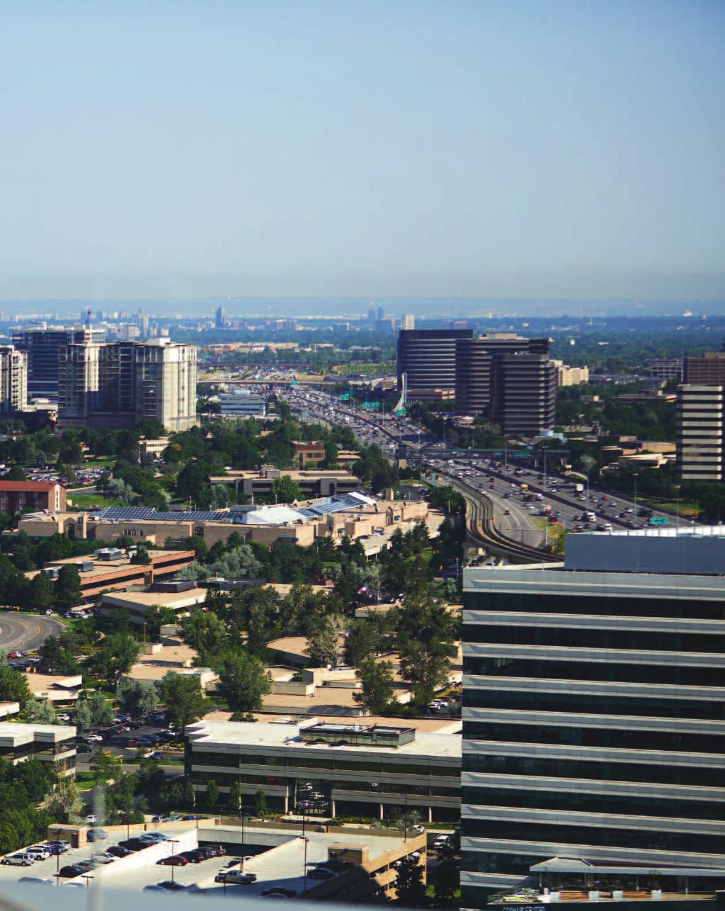
2 ORCHARD STATION SUBAREA: AN INTRODUCTION Since the advent of light rail, Greenwood Village has been presented with development and redevelopment opportunities to revitalize the I-25 Corridor. The Village s light rail station areas (Arapahoe and Orchard) provided opportunities to create mixed use town centers that promote a sense of place by integrating residential, commercial, and retail uses in order to provide efficient connections for residents and workers served by transit. The Village Center area around Arapahoe Station has been actively developing since the opening of light rail and only a handful of infill parcels remain to achieve full build-out. The Orchard Station area, which is more challenging because it requires redevelopment, only begun to generate significant interest from developers within the last two years. Beginning in 2014, several developers expressed interest, and in some cases, introduced conceptual plans or even development proposals to redevelop the area in proximity to the Orchard Light Rail Station also known as the Orchard Station Subarea. The recent interest in redeveloping this area has encouraged the Village to further study the feasibility of creating an Orchard Station Subarea in the Comprehensive Plan to establish a vision. In an effort to create a vision that guides redevelopment of this area, City Council has initiated a collaborative effort with residents to consider an amendment to the Village s Comprehensive Plan for the Orchard Station Subarea. The proposed Orchard Station Subarea is comprised of approximately 60 acres (44.4 excluding the Landmark) and is located north of Orchard Road and west of I-25 in the vicinity of the Orchard Light Rail Station. An amendment to the Comprehensive Plan would guide future redevelopment of aging buildings and infrastructure, and create a place that will complement the existing energy of the adjacent Landmark development. At the June 11, 2016 City Council work session, City Council discussed and identified some key policy questions to be presented and studied with residents to shape City Council s future decision designating the appropriate uses of land for this highly desired area that will benefit the Village for many years to come. What is the vision for the area? What will this area look like? How will people get around? What kind of community or environment do we want to foster or create? How will traffic and schools be impacted? What s the economic value to the community? What type of development is appropriate to create a sense of community? How much green space should be allocated? What mix of uses is best to drive this area to be a vibrant place? Can we create a dynamic, energized area to live, work, shop, and dine? In October 2016, City Council scheduled four district public education, information, and input meetings to be held in January 2017 to provide information and solicit input from citizens on the Orchard Station Subarea. Residents are invited to attend one of four district meetings to learn about the proposed amendment for the Orchard Station Subarea and provide comments and suggestions related to what they would like to see in a redevelopment plan for this area. ORCHARD STATION SUBAREA DISTRICT PUBLIC EDUCATION, INFORMATION, AND INPUT MEETINGS All meetings will begin at 6:30 p.m. DISTRICT 1 Councilmembers Freda Miklin and Dave Bullock Wednesday, January 18, 6:30 to 8:30 p.m. Aspen Academy 5859 South University Boulevard DISTRICT 2 Councilmembers Leslie Schluter and Darryl Jones Thursday, January 19, 6:30 to 8:30 p.m. Curtis Ballroom at Comedy Works 5345 Landmark Place DISTRICT 3 Councilmembers Steve Moran and George Lantz Tuesday, January 24, 6:30 to 8:30 p.m. Highline Community Church 6160 South Wabash Way DISTRICT 4 Councilmembers T.J. Gordon and Tom Bishop Thursday, January 26, 6:30 to 8:30 p.m. Campus Middle School Cafeteria 4785 South Dayton Street PG. 2 GV NEWSLETTER JANUARY 2017
 and is located north of Orchard Road and west of I-25 in the vicinity of the Orchard Light Rail Station.")
3 ORCHARD STATION SUBAREA BOUNDARY The Orchard Station Subarea as proposed is 60 acres (including the 15.6-acre Landmark parcel) and is located north of Orchard Road and west of I-25 in the vicinity of the Orchard Light Rail Station. The goal of the subarea is to guide future redevelopment in proximity to the Orchard Light Rail Station. JANUARY 2017 GV NEWSLETTER PG. 3

4 GOVERNMENT A PLANNED CITY IS A SUCCESSFUL CITY Managing future land use and development of the Village begins with Village planning in order to keep Greenwood Village a great place to live and work. Effective planning represents a broad vision to guide how future development will occur, where, when, and how the community wants to set the stage for how the Village will function and look decades from now. Development in the Village is not just a result of work that happens, but is guided by community values, goals, and priorities. The Village works to pursue high quality development while maintaining the community s value system regarding appearance, protection of the natural environment, and safety of the built environment. ABOUT THE COMPREHENSIVE PLAN The Village s planning vision is outlined in the Comprehensive Plan. The purpose of the Comprehensive Plan is to set forth the goals and policies of the Village and to provide guidance to decision makers concerning the future growth and development of the Village. The Comprehensive Plan contains a statement of overall goals, as well as specific goals and policies related to land use, transportation, housing, open space, environment, utilities, parks, recreation, and growth. Essentially, the Comprehensive Plan describes not only where development should take place, but what kind of development, what it should be, and how it fits into the overall landscape of the community. The planning areas of the Comprehensive Plan depict recommended land uses and current zoning. Seven planning areas for residential neighborhoods on the east and west side of the Village are defined, as well as two commercial planning areas for the I-25 Corridor and Arapahoe Road. continued on page 6 PG. 4 GV NEWSLETTER JANUARY 2017

5 JANUARY 2017 GV NEWSLETTER PG. 5

6 continued from page 4 Each of the planning areas includes a description of existing conditions, objectives, and policies for each specific planning area. In commercial areas, along both sides of I-25, objectives of the Comprehensive Plan are directed at ensuring new development and redevelopment is compatible with adjacent uses and neighborhoods, while maintaining high quality development standards. For residential, the objectives are related to each unique residential area in the Village. The I-25 Corridor Planning Area generally includes the areas of the I-25 CORRIDOR PLANNING AREA PG. 6 GV NEWSLETTER JANUARY 2017


7 Village south of Belleview Avenue, west of Yosemite Street, north of Arapahoe Road, and east of Quebec Street. In addition, half of the Denver Technological Center, Greenwood Plaza, and office and mixed-use centers are located within this planning area. The concept of the Corridor Planning Area is to design and develop a mix of commercial, institutional or civic, residential, and open public gathering spaces that attract and serve people, and help create a unique Village identity. SUBAREAS Subareas can also be illustrated in the Village s Comprehensive Plan as geographic areas within a community that may present the opportunity to create a greater vision for development that generally brings people together to a common place for a variety of activities. Typically, subareas affect a number of property owners and define how each parcel of land within the area should be developed encouraging property owners to work together and build a vision for a cohesive and connected development. Subarea planning prevents piecemeal development plans where each parcel of land is developed on its own and not part of a broader vision. Currently, there is one subarea of the Corridor Planning Area the Village Center which includes the area on both sides of I-25, adjacent to the Arapahoe Light Rail Station. Initially planned in 2000 for a transitoriented mixed-use project featuring retail stores, office buildings, residential living units, and cultural and entertainment facilities, the Village Center Subarea and its 45 acres is becoming a successful office development adjacent to the Arapahoe Light Rail Station. On the west side of I-25, the Village Center includes a new, three-building modern office campus and the iconic Plaza Tower One building energized by a common outdoor plaza with ground level restaurants. The plazas boast three dramatic water features which are set to music and lighting displays along with ample space to accommodate various types of events. In addition, the daily function of the plaza provides a pedestrian connection through a grand staircase from the office towers to the onsite light rail stop. On the east side of I-25, the Village Center Subarea will include an office building, a five-star hotel, and the light rail station parking garage. The vision for the Village Center Subarea was accomplished through a partnership between the Village and each property owner to have a unique identity while maintaining a cohesive development. The Village s past experience indicates this kind of public/private partnership is an important ingredient to the success of a significant and ambitious development or redevelopment effort. Village Center Station JANUARY 2017 GV NEWSLETTER PG. 7

8 ORCHARD STATION SUBAREA: CURRENT LANDSCAPE The Orchard Station Subarea as proposed is 60 acres (including the 15 acre Landmark parcel) and is located north of Orchard Road and west of I-25 in the vicinity of the Orchard Light Rail Station. The goal of the subarea is to guide future redevelopment in proximity to the Orchard Light Rail Station. CURRENT ZONING While the Comprehensive Plan outlines the Village s vision, it is the zoning and development entitlements that create the allowance for development to occur. In the case of the Orchard Station Subarea, the current zoning and entitlements do not match up to the vision for the Subarea. The properties are currently in two different zone districts, Town Center (TC) and Business Professional (B-1), and development is governed by the Greenwood Plaza Master Development Plan, developed in 1977 when the office park was first created. The Greenwood Plaza Master Development Plan outlines development standards related to height, setbacks, coverage on the lot, and density. The TC Zone District allows for a mix of land uses, including office, residential, and supporting retail and service uses, as well as other related uses. The B-1 Zone District allows office and supporting uses. The intent of the TC Zone District is to include areas at a scale sufficient to allow master planning of activity centers and located adjacent to I-25 and related transit facilities. The TC District should be interconnected with transit stations, parks, open space, plazas, and bicycle and pedestrian paths to de-emphasize the use of automobiles. PG. 8 GV NEWSLETTER JANUARY 2017
9 EXISTING CONDITIONS AND CURRENT DEVELOPMENT POTENTIAL No. Parcel Address Parcel Size Existing Development Potential Conditions Based on Zoning Acres Building Building Square Footage Square Footage Greenwood Plaza Boulevard (Eidos Building) 1.1 9,191 57, Greenwood Plaza Boulevard (vacant) , Greenwood Plaza Boulevard (vacant Century Communities) , Greenwood Plaza Boulevard (Woodside Plaza) , , , 7860, 7880, 7900 Berry Place , , Greenwood Plaza Boulevard , , Greenwood Plaza Boulevard , , Greenwood Plaza Boulevard (Haynes Mechanical Building) ,280 33, Dorado Place (Copic Building) , , Orchard Road (Marilyn Hickey Ministries) , ,684 Public Streets Totals: ,494 2,284,141 The table outlines each parcel in the Orchard Station Subarea depicting existing conditions and what is allowed to be built today according to the zoning and the Greenwood Plaza Master Development Plan. The table shows the acreage for each parcel (not including The Landmark, which is already developed) and then a comparison of the current building square footage (shown as gross floor area), to the allowed building square footage. The total current building square footage in the Orchard Station Subarea, not including Landmark, is 850,494 square feet. The total allowed to be developed under the current zoning is 2.28 million square feet. JANUARY 2017 GV NEWSLETTER PG. 9
10 ORCHARD STATION SUBAREA: THE PLANNING PROCESS Over the past 18 months, the Village has committed resources to study the feasibility of developing a vision for the Orchard Station Subarea. The Village hired a team of consultants to supplement staff s skills, expertise, and facilitate the planning process. The consultants, through several meetings, conducted 11 study sessions and public open houses. The purpose of the meetings was to acquire input from City Council, Planning & Zoning Commission, residents, businesses, and staff. The consultants provided expert findings, recommendations, and offered concepts for the area. Having consultants facilitate the planning of the Orchard Station Subarea offered valuable external perspectives and resources to facilitate collaboration and discussions. SUMMARIZED CHRONOLOGY OF THE ORCHARD STATION SUBAREA PLANNING PROCESS 2008: Initial Planning Effort Began 2011: City Council and Planning & Zoning Commission Review of Orchard Station Subarea 2014: Multiple Developer Inquiries Received February/April 2015: Developers Submit Informal Development Proposals July 2015: Consultant Team Hired by Village to Study Redevelopment Opportunities and Impacts July 27, 2015: Joint Study Session with City Council and Planning & Zoning Commission August 10, 2015: Subarea Property Owner Input Meeting August 17, 2015: Joint Study Session with City Council and Planning & Zoning Commission September 16, 2015: Community Open House to Obtain Input from Residents September 21, 2015: Joint Study Session with City Council and Planning & Zoning Commission November/December 2015: Meeting with Eight Developers on Subarea Plan January 5, 2016: Planning & Zoning Commission Study Session January 25, 2016: Joint Study Session with City Council and Planning & Zoning Commission March 16, 2016: Second Community Open House to Obtain Input from Residents April 18, 2016: City Council Study Session April 19 and May 3, 2016: Planning & Zoning Commission Study Sessions June 11, 2016: City Council Work Session June 21, 2016: Planning & Zoning Commission Study Session July 18, 2016: City Council Study Session July 19, 2016: Planning & Zoning Commission Public Hearing September 6, 2016: Planning & Zoning Commission Study Session September 20, 2016: Planning & Zoning Commission Public Hearing October 3, 2016: City Council Meeting October 18, 2016: Planning & Zoning Commission Hearing Continued PG. 10 GV NEWSLETTER JANUARY 2017
11 DETAILED CHRONOLOGY OF THE ORCHARD STATION SUBAREA PLANNING PROCESS 2008 First Initial Planning Effort Began The first major planning effort for the Orchard Station Subarea was initiated by City Council due to the advent of light rail presenting development and redevelopment opportunities along the I-25 Corridor. Action: City Council approved an amendment to the Comprehensive Plan that established policies for redevelopment. The amendment included a goal and policy framework for both the Orchard Station Subarea and the Village Center Subarea including fiscal impacts, traffic impacts, land use, building intensity, building height and massing, architecture and design, and view impacts. The amendment stated that no residential units would be allowed in the Orchard Station Subarea. Instead, new residential units were targeted for the Village Center Subarea adjacent to the Arapahoe Road Light Rail Station City Council And Planning & Zoning Commission Review Of Orchard Station Subarea Due in large part to the recession and the relatively high cost of redevelopment, the 2008 amendment generated little interest from the development community for the Orchard Station Subarea. The Planning & Zoning Commission reviewed the 2008 Comprehensive Plan amendments and made recommendations to City Council. Action: Recommended by the Planning & Zoning Commission and approved by City Council, the Orchard Station Subarea was removed from the Comprehensive Plan. The Village Center Subarea, which was actively being developed between 2008 and 2011, was retained in the Comprehensive Plan. ECONOMIC CONDITIONS AND MARKET GENERATE INTEREST 2014 Multiple Developer Inquires Received Greenwood Village was approached by multiple developers inquiring about the redevelopment potential of the area within and surrounding the Orchard Light Rail Station. Action: Staff provided information to City Council regarding the development inquiries, the existing Comprehensive Plan, and the Master Development Plan in place for the area. No policy discussion occurred or decisions were made by City Council during this time. FEBRUARY APRIL 2015 Developers Submit Informal Development Proposals To The Village Two developers, Alberta and Century Communities, presented their development plans for parcels within the Orchard Station Subarea. Action: Staff and developers continued discussions regarding the development concepts presented and how proposed development would conform to the Village s Comprehensive Plan. In addition, as a result of concerns about considering development proposals without an established vision in the Comprehensive Plan, the City Council shifted discussion into a broader view of the potential to redevelop the entire Orchard Station area. The idea of developing an Orchard Station Subarea was revisited. JULY 2015 Consultant Team Hired By Village To Study Redevelopment Opportunities And Impacts City Council directed staff to retain planning, economic, and transportation consultants to assist in developing the Orchard Station Subarea Plan to guide redevelopment opportunities in light of the proximity to the light rail station, exposure to I-25, and existing underutilized buildings. Action: The consultants retained by the Village to facilitate planning of the Orchard Station Subarea included MIG/Winston (MIG), Economic & Planning Systems (EPS), and Felsburg Holt & Ullevig (FHU), collectively referred to as the Consultant Team. JULY 27, 2015 Joint Study Session To Introduce Orchard Station Subarea City Council and Planning & Zoning Commission members were presented with an introduction to the Orchard Station Subarea. Several policy questions were discussed including establishing a vision for the area; promoting redevelopment opportunities; discussing ideas for a mix of uses the Village would want to promote in the area; and the potential to create a dynamic energized area. The proposed boundary of the Orchard Station Subarea was also discussed. Action: City Council directed staff to continue with the study of creating an Orchard Station Subarea. AUGUST 10, 2015 Subarea Property Owner Input Meeting Introduction of the subarea was presented to approximately 25 commercial property owners and generally positive feedback was received for the plan. continued on page 12 JANUARY 2017 GV NEWSLETTER PG. 11

12 SCENARIO A (AS PRESENTED ON AUGUST 17, 2015) AUGUST 10, 2015 continued from page 11 Action: Key points included favorable comments about having residential units, the need to differentiate the subarea from other station areas, and the value of having redevelopment intensity at or near the light rail station. Concerns were expressed about current pedestrian traffic and access impacting subarea properties. AUGUST 17, 2015 Joint Study Session With City Council And Planning & Zoning Commission The Consultant Team presented an overview of the Orchard Station Subarea Plan as a Comprehensive Plan amendment to the Corridor Planning Area; a vision for the Subarea; and establishing a basis for a possible future master plan for the subarea. Presentations also included discussion related to existing town center case studies and their defining elements for success; traffic modeling including trip generation rates for daily trips; and traffic impacts based on hypothetical examples of single uses (office, retail, restaurant, and residential), mixed use, and mixed use with mass transit. PG. 12 GV NEWSLETTER JANUARY 2017
13 SCENARIO B (AS PRESENTED ON AUGUST 17, 2015) Revenue impacts to the Village were presented based on different uses and estimated Village expenditures related to costs for Village services to support the Orchard Station Subarea (e.g. police, snow removal, etc.). Place making with a right balance/mix of uses was discussed for the Orchard Station Subarea and how the Village could activate the area with people and not cars mitigating traffic impacts and shared parking opportunities. The idea of residential and apartment units was presented and compared to existing high-end apartment units in the Denver metro area. Three development scenarios (A,B,C) were presented based on guiding principles. Alternative height regulation scenarios were also presented. Action: City Council gave direction to consultants and staff to pursue a Subarea Plan similar in scope to Scenario B (with some of the road network elements of Scenario C) based on guiding principles to create a vibrant town center; leverage the rail station; balance residential, retail, continued on page 14 JANUARY 2017 GV NEWSLETTER PG. 13

14 SCENARIO C (AS PRESENTED ON AUGUST 17, 2015) continued from page 13 office and hospitality uses; protect and enhance the Landmark and important views; emphasize parks, greenways, and public space; and differentiate the Orchard Station Subarea from other local and regional station areas. PG. 14 GV NEWSLETTER JANUARY 2017


15 RADIAL HEIGHT REGULATION The Greenwood Plaza Master Development Plan currently regulates height based upon a radial height plane map that uses the Triad buildings as the highest point and then gets lower as you move away from the Triad. I-25 HEIGHT PLANE CONCEPT The Consultant Team derived that the concept of a height plane with the tallest buildings along I-25 and then getting lower to match the existing building heights along Quebec Street makes more sense to apply to redevelopment in the Orchard Station Subarea. JANUARY 2017 GV NEWSLETTER PG. 15


16 NEEDLE TOWERS HEIGHT CONCEPT The Consultant Team further derived that a few taller tower buildings could penetrate the I-25 Height Plane. The tower buildings would be similar in height to the Landmark condominium towers and the effect would maintain view corridors between the tower buildings. SEPTEMBER 16, 2015 Community Open House To Obtain Input From Residents Content and results of the study sessions with City Council and the Planning & Zoning Commission were presented to citizens, including a conceptual plan for the Orchard Road interchange to mitigate traffic impacts from the subarea. Input expressed by citizens included improving pedestrian connections from Greenwood Hills to Orchard Station; increasing the amount of parking at Orchard Station; the potential use of the area as a festival site (e.g. Cherry Creek Arts Festival); the desire for high-end mixed use development for the site; the need to limit the height of residential buildings; reconfiguring the loop road around the Triad; the desire for high quality construction in all buildings; the desire for residential properties to be Greenwood Village quality and be to-own, not to-rent units. In addition, comments were received regarding adequate setbacks from Orchard Road; public green space; the desire for buildings to be higher near I-25 and shorter near residential neighborhoods; the desire to allow buildings above 15 stories near I-25; and the sentiment that height is not the issue, instead focus on the quality of the design. In addition, the overcrowding of schools as a result of the Subarea was expressed. Action: Input received from citizens attending the community open house was shared with City Council and the Planning & Zoning Commission on September 21, SEPTEMBER 21, 2015 Joint Study Session With City Council And Planning & Zoning Commission The Consultant Team presented members with a recap of preliminary scenarios, a summary of the public open house, and a refined redevelopment concept plan along with impacts to economics and traffic. In an effort for Greenwood Village to create a center that will distinguish itself from other local and regional station areas, the Consultant Team recommended a development program using input from City Council and the Planning & Zoning Commission based on the following guiding principles: create a vibrant town center; leverage the light rail station; balance residential, retail, office, and hospitality uses; protect and enhance the Landmark and important views; and emphasize parks, greenways, and public space. Action: City Council directed staff to pursue planning around City Council s preferred development scenario (Scenario B Modified) based on the guiding principles recommended by the Consultant Team. PG. 16 GV NEWSLETTER JANUARY 2017

 JANUARY 2017 GV")
17 SCENARIO B MODIFIED CITY COUNCIL PREFERRED OPTION (AS PRESENTED ON SEPTEMBER 21, 2015) JANUARY 2017 GV NEWSLETTER PG. 17


18 SCENARIO B MODIFIED CITY COUNCIL PREFERRED OPTION (AS PRESENTED ON SEPTEMBER 21, 2015) NOVEMBER/ DECEMBER 2015 Meeting With Eight Developers On Subarea Plan Staff presented the draft Orchard Station Subarea concept plan to local reputable developers to ascertain their comments and suggestions on the Plan s feasibility. Some major comments from developers included the preference for a residential neighborhood to the south of the Landmark; the preference for office buildings and a hotel adjacent to the station and the highway; the opinion that traffic helps create vibrancy it should be routed through the development; the preference for retail to be concentrated adjacent to Orchard Road; and the opinion that incorporating the station within an office and/or hotel building is a good idea that could differentiate the station. Action: Overall, the developer group gave positive feedback to the draft Subarea plan; and reinforced this location as a unique opportunity for Greenwood Village to create a mixed use development at this location. JANUARY 5, 2016 Planning & Zoning Commission Study Session Due to the appointment of new commission members, an overview of the Orchard Station Subarea Plan was presented to update the new commission on a timeline of events leading up to work to date on the plan. Action: New Planning & Zoning Commissioners now had the same background on the Orchard Station Subarea Plan as tenured Commissioners. JANUARY 25, 2016 Joint Study Session With City Council And Planning & Zoning Commission Due to the November 2015 election of five new City Councilmembers, four of whom previously served on the PG. 18 GV NEWSLETTER JANUARY 2017


19 Planning & Zoning Commission, an overview of the Orchard Station Subarea refined concept plan was provided reaffirming City Council and Planning & Zoning Commission s vision for the area. Summaries of the community open house, City Council and Planning & Zoning Commission direction from previous sessions, and developer feedback were presented. The consultants also presented findings on why a residential component was important to the overall subarea plan as well as, an initial traffic assessment. Key discussion points surrounded the approximate land use mix to fit the community s vision, the potential for the development to be optimized by including housing, the preferred approach to building height, and the appropriateness of the proposed density. Action: In summary, some major comments that were expressed by Councilmembers and Commission members included the need to take advantage of the opportunity, and continued interest in protecting and better leveraging DTC and the Landmark development. There was some desire for preliminary concepts to include a main street feel that was walkable and connects to the light rail station and the Landmark. The discussion of housing revolved around high quality and a high proportion of ownership. MARCH 16, 2016 Second Community Open House To Obtain Input From Residents Interested citizens had the opportunity to provide comments on the draft Orchard Station Subarea plan at a second community open house hosted by the Village s Consultant Team. The main concerns expressed by residents included increased traffic generated from the development, residential units, building heights and views, design, and aesthetics. Action: Based on the study and input on the Orchard Station Subarea to date, staff prepared the initial draft of the Comprehensive Plan amendment text. APRIL 18, 2016 City Council Study Session City Council was presented with the first draft of the Comprehensive Plan amendment text for the Orchard Station Subarea including policies addressing land use; transportation; image, identity and quality of life; and open space. An overview of the Orchard Road Interchange traffic analysis and concept plan components were presented along with more information on the fiscal impacts of the Orchard Station Subarea. Scenario B Modified Action: City Council directed staff to proceed with refining the draft of the Orchard Station Subarea plan as an amendment to the Comprehensive Plan. APRIL 19, 2016 AND MAY 3, 2016 Planning & Zoning Commission Study Sessions The Planning & Zoning Commission was presented with the first draft of a Comprehensive Plan amendment for the Orchard Station Subarea. An overview of the Orchard Road Interchange traffic analysis and concept plan components were presented along with more information on the fiscal impacts of the Orchard Station Subarea. The Planning & Zoning Commission conducted a detailed review and discussion of the draft subarea plan over the course of two study sessions. Action: The Planning & Zoning Commission provided feedback on changes to the draft Comprehensive Plan amendment for the Orchard Station Subarea. JUNE 11, 2016 City Council Work Session The full day work session began with a presentation by Innovation Pavilion regarding the demographics of continued on page 20 SCENARIO B MODIFIED CITY COUNCIL PREFERRED OPTION Square Feet Office 1,230,000 Retail 120,000 Lodging 125,000 Residential Condo 1,150,000 Residential Townhomes 300,000 (960 Residential Units) Total Square Feet: 2,925,000 JANUARY 2017 GV NEWSLETTER PG. 19
20 continued from page 19 employees that are sought by businesses in and around the Denver Technological Center. Next, a panel discussion was moderated by the Village s planning and design consultants which included metro Denver developers. Lastly, a facilitated discussion with City Council occurred to further explore the vision for the Orchard Station Subarea. To conclude the meeting, some Councilmembers and staff went on a driving tour of the Subarea and viewed the area from upper floors of the Landmark building. Action: City Council discussed the vision for the Orchard Station Subarea and identified key policy issues to be presented and studied to help plan for future development of the area. JUNE 21, 2016 Planning & Zoning Commission Study Session A redlined draft of the Orchard Station Subarea Plan was presented by staff to the Planning & Zoning Commission. The Planning & Zoning Commission conducted a detailed review and discussion of the draft subarea plan. The Commission also discussed changes to the proposed subarea boundary to exclude property that is unlikely to redevelop in the near term, including the Triad buildings, the Doubletree Hotel, and developed parcels to the south and west. They also discussed including the Landmark as an example of the vision for the subarea. Action: The Planning & Zoning Commission revised the draft Orchard Station Subarea text and boundary map. JULY 18, 2016 City Council Study Session This study session served as preview to City Council of the Planning & Zoning Commission hearing scheduled for the next evening. Staff presented an overview of the proposed Orchard Station Subarea text and boundary map and summarized work to date on the subarea planning process. Discussion focused around the Orchard Station vision; proposed subarea boundary; and organization of the plan into four general categories applicable to the Subarea including: land use; transportation; image, identity, and quality of life; and public space. Action: City Council did not direct staff to make any additional changes to the draft Orchard Station Subarea plan before the Planning & Zoning Commission public hearing. JULY 19, 2016 Planning & Zoning Commission Public Hearing Staff presented a draft plan of the Orchard Station Subarea amendment, as well as a rezoning application to bring the entire Orchard Station Subarea into the same zone district. The rezoning application required rezoning a number of properties from Business Professional (B-1) to Town Center (TC). Town Center is the Village s mixed-use district and therefore, was the best fit to match the vision for the Orchard Station Subarea. As part of the presentation, the Comprehensive Plan was discussed related to corridor land use; transportation; image, identity, and quality of life; and public space. Action: After public testimony and Commission deliberation, the Commission did not forward a recommendation to City Council to approve the subarea plan. The Commission requested additional time to get more public input on the proposed amendments. SEPTEMBER 6, 2016 Planning & Zoning Commission Study Session The Commission discussed the proposed Orchard Station Subarea plan with staff and made additions/ deletions to the proposed amendments. Action: The Commission directed staff to schedule another public hearing on the Orchard Station Subarea Plan amendments to the Comprehensive Plan. SEPTEMBER 20, 2016 Planning & Zoning Commission Public Hearing The Planning & Zoning Commission hosted a public hearing for citizens to provide input on the amendments to the Comprehensive Plan for the Orchard Station Subarea. Action: The Commission postponed its deliberations on the draft Orchard Station Subarea, and continued the public hearing to October 18, OCTOBER 3, 2016 City Council Meeting At the Council meeting, City Council discussed a motion regarding the outcome of the Planning & Zoning Commission s public hearing on the proposed amendment for the Orchard Station Subarea. Action: City Council approved a motion stating, If the Planning and Zoning Commission makes a recommendation to City Council to adopt an amendment to the Comprehensive Plan for the Orchard Station Subarea, public education, information, and input meetings will be held in each Council District before the plan is heard and voted upon by City Council. OCTOBER 18, 2016 Planning & Zoning Commission Public Hearing Continued The Planning & Zoning Commission continued the public hearing from September 20th regarding the proposed amendment to the Village s Comprehensive Plan to create the Orchard Station Subarea. Action: The Planning & Zoning Commission recommended approval to City Council of the Orchard Station Subarea as an amendment to the Comprehensive Plan. PG. 20 GV NEWSLETTER JANUARY 2017
21 ORCHARD STATION SUBAREA RECOMMENDATION BY THE PLANNING & ZONING COMMISSION ON OCTOBER 18, 2016 The Greenwood Village community desires an identifiable center in the Corridor Planning Area that serves as a social gathering place for all Greenwood Village residents. The Orchard Light Rail Station presents an opportunity to explore and evaluate options for transit-oriented redevelopment that can achieve the vision of a gathering place for the Village. In order to attract the best workers, employers are seeking work environments with more amenities, activity, and experiences. The redevelopment of the subarea is an opportunity to both create a community gathering place and continue to attract high quality employers and jobs to Greenwood Village. The primary goal of the Orchard Station Subarea is to create a vibrant, active focal point that leverages the existing light rail stop. The Village believes that this will best be accomplished by the development of a balanced mix of uses, including office, residential, hospitality, and retail. The first phase of this balanced mix of uses was established with the Landmark development at the northern edge of the subarea. The Orchard Station Subarea Plan seeks to build upon and enhance the success of Landmark. Orchard Station should be unique when compared to transit-oriented development within the Denver RTD system in terms of both user experience and visual character. At the same time, all aspects of the built environment should be of the highest quality to ensure that the subarea is reflective of Greenwood Village design values. The greatest emphasis on the experience, character, and quality should be found in a network of great public spaces, streetscapes, parks, plazas, and greenways. Any public space can be well-designed, but it only becomes truly great when it attracts and is activated by people on a regular basis. The Orchard Station Subarea should be activated by a balanced mix of workers and residents in the area to ensure vitality and safety within a comfortable environment. The public spaces within Orchard Station should address key qualities of successful public spaces: access and linkages, amenities, sense of place, uses and activities, and opportunities to socialize. The goals, objectives, and policies of the Corridor Planning Area shall generally apply to the Orchard Station Subarea. However, when a goal, objective, or policy of this subarea is in conflict with the Corridor Planning Area, the subarea plan shall prevail. The use of the term public space throughout the subarea plan applies to spaces intended for the enjoyment and use of the public regardless of ownership or management. LAND USE 1a. The subarea shall contain an appropriate mix of uses to include office, retail, and hospitality, with the potential for residential. Civic uses should also be considered if they would make a positive contribution to the vibrancy of the subarea. Office and retail uses should be balanced with residential to ensure a positive revenue benefit to the Village. 1b. The zoning of the subarea should allow the prescribed mix of uses. 1c. Ground floors adjacent to public spaces should incorporate combinations of uses, including retail, restaurants, and bars, amenities, and architectural design that activate the public space. Where active ground floor uses are desired but not immediately marketable, buildings should be designed so that ground floors can be converted to those uses in the future. 1d. The development of the subarea shall be phased to generally balance the pace of commercial and residential uses. 1e. Residential use within the subarea may consist of a variety of multifamily housing densities and unit types. For sale housing is strongly preferred. 1f. The focus of land use intensity and activity should be the transit station. TRANSPORTATION 2a. Redevelopment of the subarea should support and leverage the existing transit service. 2b. Proposed development shall provide mitigation for impacts on the transportation network as determined by a traffic impact study. Development intensity shall be limited by the roadway network capacity, as enhanced by proposed infrastructure improvements. 2c. Development proposals should include a comprehensive and progressive plan for transportation demand management (TDM). This plan should include strategies to maximize incentives for using transit and other alternative modes of transportation among the people who will live, work, and shop within the subarea. 2d. The subarea shall include a continuous network of pedestrian and bicycle ways of a size and quantity to fully meet the needs of anticipated pedestrian and bicycle activity. The network shall make appropriate connections at the perimeter of the subarea and continued on page 22 JANUARY 2017 GV NEWSLETTER PG. 21
22 continued from page 21 ensure easy access to the light rail station. 2e. Redevelopment of the subarea should include a finer grain of streets and blocks to enhance vehicular and pedestrian connectivity. The large block pattern that was established with initial development of the subarea should be broken down into smaller blocks with additional streets. 2f. Streets, whether public or private, should be designed to accommodate different modes of transportation and to support active street life. The use of the term public space throughout this plan is intended to apply to streets. 2g. Developers should seek opportunities to incorporate wayfinding elements into the design and detailing of both buildings and public spaces. The goal is to provide navigation markers to the public in order to ease wayfinding and minimize the use of signage. IMAGE, IDENTITY, AND QUALITY OF LIFE 3a. A variety of densities are anticipated with redevelopment of the subarea and therefore it should exhibit the best qualities of form and character. 3b. Building setbacks, height and mass should be appropriately designed for the Village setting and provide good transitions between land use intensity. 3c. The impacts of the height and massing of new buildings shall be considered in development proposals in the subarea. In order to fully understand and appreciate view impacts, proposed development shall be required to model the impacts of the development on properties within the view plane from multiple vantage points. Taller buildings should be separated from one another to avoid the appearance of a wall of buildings adjacent to I-25. Building heights should be compatible with existing buildings along the Corridor. Development adjacent to The Landmark residential towers should preserve existing views. 3d. Design and construction within the subarea should minimize the impact of highway traffic noise within both interior and exterior environments. 3e. Design and detailing of building ground floors and public spaces should encourage activity and vibrancy. 3f. Development proposals for individual parcels should demonstrate how they fit into a cohesive plan for the overall subarea. 3g. Where parking structures are visible to public spaces, the visual impact of the structure should be mitigated by wrapping the structure with active uses, screening the structure, and/or employing alternative creative design techniques. 3h. Architectural and landscape design within the subarea should be of the highest quality. Architecture should be functional, wellconstructed, emotionally resonant, timeless, and beautiful. Architectural materials for buildings and public spaces should be authentic with a high degree of durability. 3i. Site planning, architecture, and landscape design should strive to create comfortable microclimates in public spaces throughout the subarea. 3j. Refer development applications to Cherry Creek School District and consider the District s comments in development decisions to maintain the high quality of education. 3k. Ensure that new development is designed in a manner that is respectful of and compatible with the natural environment. New development is encouraged to use sustainable development technologies. PUBLIC SPACE 4a. The subarea should contain a variety of high quality public spaces that vary in size, use, and experience. They should include a combination of more natural softscape spaces and hardscape courts, plazas, and promenades. 4b. The size and configuration of public spaces should be suitable for a variety of activities, including, but not limited to, performances, markets, exhibits, and celebrations. 4c. Public spaces should be located in a strategic and purposeful manner. The location and design of public spaces should encourage use by residents, workers, shoppers, and transit riders. Public spaces should be connected to one another by trails and well-designed sidewalks with high quality pedestrian furnishings and amenities. 4d. Public space should be provided in an amount that is appropriate for the Subarea. The vast majority of open space shall include areas that are usable and effective for the usage described in this section. 4e. Public space amenities should be evenly distributed and connected to each other by clear pedestrian promenades that promote easy wayfinding throughout the subarea. 4f. Public spaces should be enhanced with public art and/or other visual amenities. 4g. Public spaces should be made comfortable and desirable places to spend time by ensuring they are safe and clean, and contain a variety of seating options. PG. 22 GV NEWSLETTER JANUARY 2017

23 THE CONSULTANT TEAM MIG/WINSTON MIG/Winston (MIG) was the lead consultant for the Village and is a national planning and design firm. MIG was retained to conduct a planning process to explore the creation of a subarea plan for Orchard Station as an amendment to the Comprehensive Plan. The process would include documentation and analysis of existing conditions, presentations and work sessions with the Planning & Zoning Commission and City Council, public open houses, and production of land use and concept plans. MIG also produced a high level 3D conceptual model of the Orchard Road Subarea to assess appropriate height, massing, transitions to existing development and neighborhoods, and views. Additionally, a land use concept plan was created recommending a general development program. ECONOMIC AND PLANNING SYSTEMS (EPS) EPS was hired by the Village to provide an economic and market framework for redevelopment of the subarea. This When development is proposed in Greenwood Village, the Village must address the effects of traffic on neighborhoods, while promoting easy access to and from the Village s commercial areas. Development applications must undergo a transportation analysis to ensure measures are in place to move traffic generated from the development in and out of the Village in the most efficient and least impactful manner. There are several layers of transportation planning in the Village that study and implement traffic measures at the regional, local and project levels. The Village s Comprehensive Plan guides land use decisions and sets the overarching goals of the Village to guide development and growth that is expected in the future. In addition, the Comprehensive Plan provides broad goals related to transportation. The Village s Transportation Plan, adopted in 1999, develops objectives and projects that achieve the transportation goals of the Comprehensive Plan. These objectives include future roadway improvements, new pedestrian and bicycle facilities, and opportunities to participate in regional transportation solutions like the included insight on development trends and forecasts for office, retail, and high density development over the next 10 years for the South I-25 Corridor. Forecasts for development within the Orchard Station Subarea would be provided based on land availability including vacant and redevelopment sites. In addition, EPS would provide redevelopment and financing requirements of the recommended plan and implementation options. FELSBURG, HOLT AND ULLEVIG (FHU) FHU, one of the Village s primary transportation consultants over the past 20 years, was tasked with developing and evaluating alternative roadway network configurations providing traffic projections for alternative land use plans and determining the amount of traffic that Orchard Road can realistically absorb given the necessary roadway improvements to support the final Orchard Station Subarea plan. Roadways improvements would include expansion of the Orchard Road and I-25 Interchange. TRANSPORTATION AND TRAFFIC: A PRIMARY CONCERN Arapahoe Road/I-25 interchange reconstruction project. Both the Comprehensive and Transportation Plans help the Village guide land use decisions by connecting land use with the transportation infrastructure. JANUARY 2017 GV NEWSLETTER PG. 23
24 TRANSPORTATION GOALS ESTABLISHED IN COMPREHENSIVE PLAN 1. Because traffic management is a critical concern of the Village, the Transportation Plan should be aggressively implemented; the tenets of the plan should be rigorously applied to new development. In order to understand the full impacts and implications of development staff will continue to assess traffic impacts based on an impact radius considered appropriate. Level of Service (LOS) standards shall not be the sole determinant of whether to mitigate a traffic impact resulting from a development. LOS should continue to be one factor in determining appropriate exactions and dedications expected from a development. Impact assessments should consider the net difference between the market occupancy of an existing building compared to what is proposed. 2. Protect the Village s residential neighborhoods by minimizing the incursion of commercial and transient traffic into residential neighborhoods. 3. Accommodate anticipated commercial development by facilitating commercial traffic flow along arterial streets supported by other means of transportation. 4. Provide convenient access to the Village s residential neighborhoods for local traffic. 5. Encourage non-motorized travel throughout the Village by providing safe, convenient/bicycle routes. 6. Minimize non-local traffic around the Village s public areas such as schools and neighborhood parks. 7. Encourage implementation of mass transit systems and other alternatives to single occupant vehicles. 8. Maintain designated truck routes 2011 IDENTIFIED POTENTIAL ROADWAY WIDENIN throughout the Village using size and weight limitations. 9. Provide convenient and safe bicycle access to all Village recreation areas and schools from all part of the Village. 10. Street and traffic impacts adjacent to a proposed development should PG. 24 GV NEWSLETTER JANUARY 2017
25 G REFER TO PAGE 31 be addressed subject to the traffic impact assessment discussion noted above. 11. The Village should strengthen working relationships with adjacent municipalities to address traffic issues of mutual concern. 12. To make certain that new development does not adversely impact the quality and character of the Village, the exaction and continued on page 26 JANUARY 2017 GV NEWSLETTER PG. 25

26 2011 IDENTIFIED INTERSECTION DELAYS REFER TO PAGE 31 continued from page 25 dedication impact radius should include infrastructure improvements consistent with the proximity and proportionally requirements of the law and the unique circumstances of each development. 13. Seek grade separated crossings of busy roadways for bicycles and pedestrians to improve safety and enhance access, especially to the light rail stations. CORRIDOR PLANNING AREA TRANSPORTATION GOALS IN COMPREHENSIVE PLAN Goals/Objectives Promote pedestrian and bike linkages to and throughout the planning area. Promote connectivity of Village and neighborhood pedestrian facilities by providing pedestrian and vehicle crossings over I-25 and other busy roadways. Provide for integration of multiple modes of transportation at transportation centers. Provide for safe, pedestrian accessibility in the construction/reconstruction of major interchanges. Improve connections within the planning area to regional mass transit. Improve planning area accessibility through high quality circulator bus service. Minimize traffic congestion on the periphery of the planning area. Policies Promote land use patterns, parking policies, and traffic management methods that support transit, and efficient roadway system, and bicycle and pedestrian travel. Provide an interconnected network of narrow, tree-lined streets that tie into the surrounding neighborhoods, allowing convenient and safe automobile, pedestrian, and bicycle travel from one end of the Corridor Planning Area to another. Promote structured parking lots to reduce land devoted to surface parking lots Require existing surface parking to continued on page 28 PG. 26 GV NEWSLETTER JANUARY 2017
27 CHERRY CREEK SCHOOLS: PLANNING FOR THE FUTURE Submitted by Cherry Creek School District A question we ve been getting a lot lately is, how does the Cherry Creek School District plan for and manage growth in our schools? First of all, we don t determine growth. That s the purview of cities and counties. What we do is monitor growth and plan for changes we project based on several factors. We begin by meeting with city and county planners, developers and home builders. We also work with a company called Metro Study, a data-driven consultant that compiles data from a variety of sources, including birth and death rates, residents new to Colorado and people leaving the state. The Cherry Creek School District Planning & Interagency Relations then analyzes all of the data and makes projections for enrollment at each of our 63 schools. That information is presented to our Long Range Facility Planning Committee (LRFPC), which is composed of two residents from each director district and five at-large community members appointed by the Cherry Creek School District Board of Education, along with resident representatives of the Home Builders Association and area Realtors. The committee also includes a member of the school board and staff from schools and the district s Facility Support Services department. The LRFPC is tasked with coming up with a one-year, threeyear or five-year plan to manage the projected growth. There are several ways that the school district can manage new enrollment and fill empty seats at schools with lower enrollment. In areas of increasing enrollment, the district can ask voters to approve a bond issue to fund construction of new schools or an expansion of existing buildings, adjust boundaries for newer students, add mobile classrooms or change to a yearround calendar, which allows schools to operate with just 75% of its enrollment in classes at one time. In schools where enrollment is decreasing because of aging neighborhoods, principals can accept students from other schools in the district, or admit students from other school districts. When students come to Cherry Creek Schools from other school districts, the funding from the state follows them. But if there is a renewed demand for the seats from students living within the school s boundaries, out-ofboundary students must return to their home schools or districts. The size and growth of a school do not impact class size. Principals use a staffing formula to hire the number of teachers needed to maintain district-determined class sizes. At the request of the City of Greenwood Village, the district looked at the potential impact of the proposed Orchard Station mixed use development. For example, using national standards, the total impact of 1,000 high-rise/mid-rise multi-family units is approximately 200 total students. The impact of 100 townhomes is approximately 50 total students. Assuming development occurs in Orchard Station simultaneously over a seven to fifteen year period, the annual impact upon the Cherry Creek District is estimated to average 25 students. Based upon available capacities at Greenwood Elementary, West Middle, and Cherry Creek High schools, they could easily accommodate new students resulting from development occurring on both parcels. The average annual impact per grade would be two students. The chart below shows the number of seats available at schools on the west side of the district. School Capacity Current in Available in boundary boundary enrollment seats Cherry Creek High School 3,735 3, West Middle School 1,590 1, Greenwood Elementary School Heritage Elementary School Homestead Elementary School ,394 The first priority of the Cherry Creek School District now is what it has always been to provide the best possible education opportunities for all students to succeed. Our planning process has enabled us to do that throughout our history and we will continue to use the best tools available to plan for the future. JANUARY 2017 GV NEWSLETTER PG. 27

28 CONSULTANT IDENTIFIED RECOMMENDED IMPROVEMENTS continued from page 26 be broken up into smaller lots and permit vehicles to park along the streets, providing a buffer between the pedestrians on sidewalks and moving automobiles. Promote the redevelopment of existing parking surface lots with buildings and structured parking. Reduce the parking ratio requirements for new developments and encourage joint-use parking PG. 28 GV NEWSLETTER JANUARY 2017

29 lots and structures with staggered peak demands that will efficiently serve retail, office, public and entertainment uses, thus reducing the amount of land required for separate parking for each land use. Promote the RTD call-n-ride areas for servicing the DTC, Greenwood Plaza, the Village Center, and other surrounding office and retail development to each other and to continued on page 30 JANUARY 2017 GV NEWSLETTER PG. 29

30 CONSULTANT IDENTIFIED RECOMMENDED IMPROVEMENTS continued from page 29 the existing Arapahoe park-n-ride, the Ulster/Tufts Transfer Station, and the Orchard and Arapahoe Light Rail Stations. Encourage shared parking when peak periods of demand are staggered for adjacent uses. Encourage parking structures, with wrap-around retail, wherever possible within the district. Discourage parking areas between primary, front building facades and the street. AREA PLANNING In 2009, the Village completed the I-25 Corridor Transportation Plan, a study for the two commercial areas in the Village along the I-25 Corridor. In 2011, a study was completed on the south I-25 Corridor. Both of these studies further refined the Village s Transportation Plan for specific areas of the Village to identify potential transportation improvements based on future land use demands in the area. Transportation Impact Study Process While the Comprehensive and Transportation Plans and area studies look at the Village or larger areas of the Village when a development is considered, a detailed analysis of transportation is required. Transportation planning in the Village requires a transportation impact study (TIS) for proposed development. A TIS is a study which assesses the effects that a development s traffic will have on the overall transportation system and the community. The study assesses the traffic impacts of a proposed development, and determines necessary improvements to accommodate the new development minimizing impacts to the Village transportation network and neighborhoods. The study also evaluates the existing traffic within the Village and its surrounding communities. The Village generally requires TIS studies if the proposed development generates more than 100 trips per day or more than 40 trips during peak hours; proposes new access for an arterial street, indicates safety/capacity concerns; and/or has the potential to impact adjacent neighborhoods. PG. 30 GV NEWSLETTER JANUARY 2017

31 ORCHARD STATION SUBAREA TRANSPORTATION ANALYSIS TO DATE As changes to the Comprehensive Plan in the Orchard Station Subarea are considered, a high level traffic analysis was conducted by the Consultant Team and reviewed by staff. A mix of land uses was assumed in the Orchard Station Subarea, and the traffic that was created by these uses was added to the existing and estimated future traffic volumes on the surrounding roadway network. Based on previously identified improvements in 2009 and 2011, the Consultant Team refined the transportation system improvements for the Orchard Station Subarea. Initial Findings And Recommendations In order to maintain a functional transportation system, potential improvements were identified for the Orchard Road Corridor from Quebec Street to DTC Boulevard/Yosemite Street, and improvements to the Orchard and I-25 Interchange. Based on high level analysis, additional development could be accommodated with the potential improvements to the transportation system. The key analysis related to the subarea plan is the impact of mixed use development on traffic. The existing roadway network is near or at capacity during the peak hours (rush hour in morning and evening), while the remaining hours of the day have adequate capacity to accommodate additional traffic. By developing the area with multiple land uses that produce traffic at different times and in different patterns than a single use, and implementing appropriate roadway improvements, it was determined that additional new development in the area could be accommodated. As development projects are submitted to the Village, a more detailed traffic impact study analysis will be conducted to determine the impact of individual developments on transportation and improvements to accommodate any increased traffic. JANUARY 2017 GV NEWSLETTER PG. 31


32 6060 South Quebec Street Greenwood Village, Colorado Ron Rakowsky greenwoodvillage.com MAYOR AND CITY council DISTRICT 1 DISTRICT 2 DISTRICT 3 DISTRICT 4 Freda Miklin fmiklin@ greenwoodvillage.com Leslie Schluter lschluter@ greenwoodvillage.com Steve Moran smoran@ greenwoodvillage.com T.J. Gordon tgordon@ greenwoodvillage.com Dave Bullock dbullock@ greenwoodvillage.com Darryl Jones djones@ greenwoodvillage.com George Lantz glantz@ greenwoodvillage.com Tom Bishop tbishop@ greenwoodvillage.com
Town Center (part of the Comprehensive Plan)
") Town Center (part of the Comprehensive Plan) Mercer Island Town Center Looking North (2014) In 1994, a year-long process culminated in a set of design guidelines and code requirements for the Town Center
Town Center (part of the Comprehensive Plan) Mercer Island Town Center Looking North (2014) In 1994, a year-long process culminated in a set of design guidelines and code requirements for the Town Center
Policies and Code Intent Sections Related to Town Center
 Policies and Code Intent Sections Related to Town Center The Town Center Vision is scattered throughout the Comprehensive Plan, development code and the 1994 Town Center Plan. What follows are sections
Corridor Planning Area
 Corridor Planning Area PLANNING AREA DESCRIPTION Planning Area Boundaries The Corridor planning area generally includes the areas of the Village south of Belleview Avenue, west of Yosemite Street, north
City of Farmington. Downtown Plan. Amendment to the 1998 Master Plan Adopted October 11, 2004
 City of Farmington Amendment to the 1998 Master Plan Adopted October 11, 2004 Introduction Planning Background 1 Scope and Components of the Plan Amendment 2 Concept Introduction 3 Plan Concepts 3 Conceptual
Review of Opportunity Area C Draft Comprehensive Plan and Draft BOS Follow-On Motions. Special Working Group Meeting March 4, 2015
 Review of Opportunity Area C Draft Comprehensive Plan and Draft BOS Follow-On Motions Special Working Group Meeting March 4, 2015 The slides that follow identify where the draft Comprehensive Plan has
1.0 Purpose of a Secondary Plan for the Masonville Transit Village
 Report to Planning and Environment Committee To: Chair and Members Planning & Environment Committee From: John M. Fleming Managing Director, Planning and City Planner Subject: Masonville Transit Village
TO: Denver Planning Board FROM: Analiese Hock, Senior City Planner DATE: March 13, 2018 RE:
 Community Planning and Development Planning Services 201 W. Colfax Ave., Dept. 205 Denver, CO 80202 p: 720.865.2915 f: 720.865.3052 www.denvergov.org/cpd TO: Denver Planning Board FROM: Analiese Hock,
ARLINGTON COUNTY, VIRGINIA
 ARLINGTON COUNTY, VIRGINIA County Board Agenda Item Meeting October 15, 2005 DATE: September 28, 2005 SUBJECT: Request to Advertise the adoption of the 2005 Clarendon Sector Plan C. M. RECOMMENDATION:
EXISTING COMPREHENSIVE PLAN
 EXISTING COMPREHENSIVE PLAN Town Center Land Use Element: V. LAND USE POLICIES Town Center Mercer Island's business district vision as described in "Your Mercer Island Citizen-Designed Downtown" was an
4.1.3 LAND USE CATEGORIES
 4.1.3 LAND USE CATEGORIES a. City Center District The City Center District incorporates the existing character and mix of uses in downtown Belmont to encourage redevelopment and new development in keeping
The transportation system in a community is an
 7 TRANSPORTATION The transportation system in a community is an important factor contributing to the quality of life of the residents. Without a sound transportation system to bring both goods and patrons
Urban Planning and Land Use
 Urban Planning and Land Use 701 North 7 th Street, Room 423 Phone: (913) 573-5750 Kansas City, Kansas 66101 Fax: (913) 573-5796 Email: planninginfo@wycokck.org www.wycokck.org/planning To: From: City Planning
Welcome to Greenwood Village Corporate Capital of Colorado
 Welcome to Greenwood Village Corporate Capital of Colorado Greenwood Village Setting Incorporated: 1950 Land Area: 8.4 sq. miles + / - Budget $35M Debt $0 Reserve $20M Population Daytime: 50,000 Residents:
THAT the attached Terms of Reference for the Thornhill Centre Street Study be approved.
 COMMITTEE OF THE WHOLE AUGUST 18, 2003 THORNHILL CENTRE STREET STUDY PLANNING FILE: 15.92 Recommendation The Commissioner of Planning recommends: THAT the attached Terms of Reference for the Thornhill
Executive Summary. NY 7 / NY 2 Corridor
 Executive Summary NY 7 / NY 2 Corridor Transportation and Land Use Study December 2005 Prepared for: Town of Colonie Capital District Transportation Committee Prepared by: Introduction: Land use decisions
A. WHAT IS A GENERAL PLAN?
 I. Introduction A. WHAT IS A GENERAL PLAN? A general plan is the planning guideline for the future of a city. It contains goals and policies which regulate urban development, the protection of the natural
CITY OF PUYALLUP. Background. Development Services
 CITY OF PUYALLUP Development Services 333 South Meridian Puyallup WA 98371 To: City Council From: Katie Baker, AICP, Planning Division Re: South Hill Neighborhood Plan Adoption Date: (Meeting date: February
Silver Line CPAM UPDATE. Transportation and Land Use Committee October 14, 2016
 Silver Line CPAM UPDATE Transportation and Land Use Committee October 14, 2016 Purpose Recap Project History and Map Changes Provide Overview of CPAM Components Discuss Transportation Impacts Discuss Fiscal
Chapter 1.0 Introduction
 Chapter 1.0 Introduction 1.1 Background The North Metro commuter rail line is part of the RTD FasTracks regional transit system expansion program to build more than 100 miles of rail transit throughout
Denton. A. Downtown Task Force
 2 Public Involvement Early and ongoing public involvement was solicited so that the public had ample opportunity to help direct the DTIP s concepts and implementation strategies. The residents of Denton
DALY CITY VISIONING PROCESS COMMUNITY WORKSHOP 3 MAY 8, 2008
 DALY CITY VISIONING PROCESS COMMUNITY WORKSHOP 3 MAY 8, 2008 PROCESS General Plan - a statement of the community s values, vision and aspirations for now and into the future... Timeframe LONG TERM - 2030
CHAPTER 7: Transportation, Mobility and Circulation
 AGLE AREA COMMUNITY Plan CHAPTER 7 CHAPTER 7: Transportation, Mobility and Circulation Transportation, Mobility and Circulation The purpose of the Transportation, Mobility and Circulation Chapter is to
2.0 THE PLATINUM TRIANGLE VISION
 2.0 THE PLATINUM TRIANGLE VISION The envisions an exciting future for the area surrounding Angel Stadium of Anaheim, the Honda Center and The Grove of Anaheim. 2.1 Planning Principles In order to further
MALL REVITALIZATION CASE STUDIES
 MALL REVITALIZATION CASE STUDIES DECEMBER 9, 2012 MALL REVITALIZATION OVERVIEW Introduction Sample Case Studies prepared for Lacey Woodland District Steering Committee as it considers strategies to revitalize
Table of Contents. Elm Avenue Improvement Plan City of Waco, Texas. Introduction 1. Existing Context 1 Figure 1 2.
 Table of Contents Introduction 1 Existing Context 1 Figure 1 2 Plan Guidelines 3 Future Urban Form 4 The West-End 4 Main Street 6 The East-End 7 Figure 2 9 Public Improvement Recommendations 7 General
Introduction. Chapter 1. Purpose of the Comprehensive Plan Plan Organization Planning Process & Community Input 1-1
 Chapter 1 Introduction Lakewood 2025: Moving Forward Together Purpose of the Comprehensive Plan Plan Organization Planning Process & Community Input 1-1 Purpose of the Comprehensive Plan The Comprehensive
Welcome. Comprehensive Plan & Transportation Plan Open House November 7, 2012
 Welcome Comprehensive Plan & Transportation Plan Open House November 7, 2012 Agenda Proposed future land use plan Comprehensive Plan strategies Traffic forecasts Future traffic operations Possible future
Gold Line Bus Rapid Transit Transit Oriented Development (BRTOD) Helmo Station Area Plan
 Helmo Station Area Plan") Appendix F Gold Line Bus Rapid Transit Transit Oriented Development (BRTOD) Helmo Station Area Plan Introduction and Purpose of the Plan The Gold Line Bus Rapid Transit facility is an eleven-mile dedicated
Appendix F Gold Line Bus Rapid Transit Transit Oriented Development (BRTOD) Helmo Station Area Plan Introduction and Purpose of the Plan The Gold Line Bus Rapid Transit facility is an eleven-mile dedicated
CITY CLERK. Parkland Acquisition Strategic Directions Report (All Wards)
") CITY CLERK Clause embodied in Report No. 10 of the, as adopted by the Council of the City of Toronto at its meeting held on November 6, 7 and 8, 2001. 10 Parkland Acquisition Strategic Directions Report
CITY CLERK Clause embodied in Report No. 10 of the, as adopted by the Council of the City of Toronto at its meeting held on November 6, 7 and 8, 2001. 10 Parkland Acquisition Strategic Directions Report
Scope of Services. River Oaks Boulevard (SH 183) Corridor Master Plan
 Corridor Master Plan") Scope of Services River Oaks Boulevard (SH 183) Corridor Master Plan PROJECT AREA The project area consists of the River Oaks Boulevard (SH 183) corridor bounded by SH 199 at the northern end and the Trinity
Scope of Services River Oaks Boulevard (SH 183) Corridor Master Plan PROJECT AREA The project area consists of the River Oaks Boulevard (SH 183) corridor bounded by SH 199 at the northern end and the Trinity
Westwind Developments Ltd. PIONEER LANDS AREA STRUCTURE PLAN - PROPOSED AMENDMENT
 FEBRUARY 2013 TABLE OF CONTENTS 1.0 BACKGROUND... 1 1.1 Amendment... 1 2.0 LOCATION & CONTEXT... 2 2.1 Land Ownership... 2 3.0 POLICY CONTEXT... 3 3.1 Municipal Development Plan... 3 3.2 Capital Region
TEMPLE MEDICAL & EDUCATION DISTRICT
 City of Temple, Texas TEMPLE MEDICAL & EDUCATION DISTRICT 1 Description. The City of Temple joined in partnership with key public and private entities to jointly promote education and medical activities
Draft Cary Community Plan Review Part 3: Shop, Engage, Serve, Special Area Plans, Other Updates. October 27, 2015 Police Department Training Room
 Draft Cary Community Plan Review Part 3: Shop, Engage, Serve, Special Area Plans, Other Updates Committee for the Future October 27, 2015 Police Department Training Room AGENDA 1. Welcome and Call to Order
City Council Special Meeting AGENDA ITEM NO. C.
 City Council Special Meeting AGENDA ITEM NO. C. DATE: 01/04/2019 TO: Honorable Mayor and City Council Members SUBJECT: Transit Villages Specific Plan project Study Session (Development Services Director
Prosperity Hucks Area Plan. Transportation and Planning Committee May 11, 2015
 Prosperity Hucks Area Plan Transportation and Planning Committee May 11, 2015 Presentation Outline 1. Background and Location 2. Community Dialog Process 3. Activity Center Recommendations 4. Wedge Recommendations
Staff Report to the North Ogden City Planning Commission
 Staff Report to the North Ogden City Planning Commission SYNOPSIS / APPLICATION INFORMATION Application Request: Concept review on a legislative application to rezone land located at approximately 1750
WELLINGTON STREET WEST COMMUNITY DESIGN PLAN
 36 3.CDP POLICIES 37 Wellington Street West CDP Vision Statement 38 3.1 Introduction 3.1.1 Purpose The development of buildings and public spaces is influenced by a variety of factors over time. City of
REQUEST Current Zoning: O-15(CD) (office) Proposed Zoning: TOD-M(CD) (transit oriented development mixed-use, conditional)
 (office) Proposed Zoning: TOD-M(CD) (transit oriented development mixed-use, conditional)") Rezoning Petition 2016-117 Zoning Committee Recommendation January 4, 2017 REQUEST Current Zoning: O-15(CD) (office) Proposed Zoning: TOD-M(CD) (transit oriented development mixed-use, conditional) LOCATION
Rezoning Petition 2016-117 Zoning Committee Recommendation January 4, 2017 REQUEST Current Zoning: O-15(CD) (office) Proposed Zoning: TOD-M(CD) (transit oriented development mixed-use, conditional) LOCATION
Ivywild On The Creek PRELIMINARY CREEK DISTRICT MASTER PLAN
 Ivywild On The Creek PRELIMINARY CREEK DISTRICT MASTER PLAN Introduction: Rejuvenating an extraordinary Creekside neighborhood THE CREEKSIDE DISTRICT The Ivywild On The Creek Neighborhood District Master
S A C R A M E N T O C O U N T Y JACKSON HIGHWAY & GRANT LINE EAST VISIONING STUDY
 JACKSON HIGHWAY & GRANT LINE EAST S A C R A M E N T O C O U N T Y P L A N N I N G D E P A R T M E N T SUMMARY AND WORKBOOK November 19, 2008 History of the Visioning Study Sacramento County has two growth
Preliminary Plan Framework: Vision and Goals
 Preliminary Plan Framework: Vision and Goals Draft: May 2015 Introduction Since the Town of Milliken s comprehensive plan was last updated in 2010, the community was heavily impacted by the 2013 flood,
Urban Design Manual PLANNING AROUND RAPID TRANSIT STATIONS (PARTS) Introduction. Station Study Areas
 Introduction. Station Study Areas") 111111 PLANNING AROUND RAPID TRANSIT STATIONS (PARTS) Introduction The ION rapid transit system will link Waterloo, Kitchener and Cambridge through a central transit corridor (CTC). There are a number
111111 PLANNING AROUND RAPID TRANSIT STATIONS (PARTS) Introduction The ION rapid transit system will link Waterloo, Kitchener and Cambridge through a central transit corridor (CTC). There are a number
V. Vision and Guiding Principles
 V. Vision and Guiding Principles The Master Plan for the Powers Ferry Corridor seeks a foundation in the desires of the community. At times, various elements of the community offered opposing viewpoints,
Metro. Activity Center Design Guidelines. Recommendations For Developing Focused, Mixed-Use Commercial/Residential Centers
 Metro Activity Center Design Guidelines Recommendations For Developing Focused, Mixed-Use Commercial/Residential Centers Metro Activity Centers What is a MAC? Legacy, the adopted guide for the future growth
DENVER DESIGN DISTRICT GDP
 DENVER DESIGN DISTRICT GDP Urban Design Standards and Guidelines November 17, 2008 Amended February 3, 2016 City and County of Denver CF Property Management, Inc. C/O Denver Design District - Starboard
WELCOME and introduction
 1 WELCOME and introduction Mobility Hub Locations within Burlington STUDY OVERVIEW STUDY OBJECTIVES The City of Burlington is developing four Area Specific Plans, one for each of Burlington s Mobility
Staff Report and Recommendation
 Community Planning and Development Planning Services 201 W. Colfax Ave., Dept. 205 Denver, CO 80202 p: 720.865.2915 f: 720.865.3052 www.denvergov.org/cpd TO: City Council Neighborhoods and Planning Committee
2035 General Plan Update and Belmont Village Specific Plan. Joint Study Session with the City Council and Planning Commission April 12, 2016
 2035 General Plan Update and Belmont Village Specific Plan Joint Study with the City Council and Planning Commission April 12, 2016 Agenda 1. Welcome and Introductions 2. General Plan Update Status of
Sheridan Boulevard S TAT I O N A R E A P L A N S H E R I D A N B O U L E VA R D S TAT I O N A R E A P L A N
 Sheridan Boulevard S TAT I O N A R E A P L A N 1 City of Lakewood Adopted November, 2006 S H E R I D A N B O U L E VA R D S TAT I O N A R E A P L A N The Vision The City of Lakewood s overall vision is
ARTICLE 6: Special and Planned Development Districts
 ARTICLE 6: Special and Planned Development Districts 6-10 Traditional Neighborhood Development (TND) District 6-10.10 Purpose and Intent The Traditional Neighborhood Development (TND) District provides
hermitage town center
 hermitage town center A Community Vision prepared by Strada for The City of Hermitage and The Mercer County Regional Planning Commission January 2007 table of contents introduction 3 design principles
1 Welcome! UBC Okanagan Master Plan Update - Open House
 1 Welcome! UBC Okanagan Master Plan Update - Open House UBC is updating the Master Plan for the Okanagan Campus. The purpose of today s Open House is to: Present the draft 2015 Master Plan Answer any questions
3.1 community vision. 3.3 required plan elements
 Chapter 3 Community Form 3.1 community vision 3.2 Parks & landscaping concepts 3.3 required plan elements D R A F T 20 Community Form Chapter 3 3.0 Community form 3.1 community vision The Specific Plan
Implementation Guide Comprehensive Plan City of Allen
 Implementation Guide 2030 Comprehensive Plan City of Allen DRAFT 2015 Implementation Guide Allen 2030 Comprehensive Plan INTRODUCTION The Comprehensive Plan serves as a guide for the growth and development
Further input invited as Colchester Growth Strategy nears final phase
 IUE 3 / NOVEMBER 2015 Further input invited as Colchester Growth trategy nears final phase trathcona County is seeking public feedback as it enters the final phase of work on a Growth Management trategy
Sahuarita District & Phase 1 Master Plan. Town Council December 11, 2017
 Sahuarita District & Phase 1 Master Plan Town Council December 11, 2017 Visioning Study Visioning Process Advisory Group Meetings Community Questionnaire Town Center Case Studies Community Analysis The
Secrest Short Cut and Monroe Expressway Small Area Plan AUGUST 29, 2018
 Secrest Short Cut and Monroe Expressway Small Area Plan AUGUST 29, 2018 Background and Process Monroe Expressway will be open by the end of 2018 Union County and Indian Trail identified a need to revisit
PINE CURVE REZONING. BACKGROUND Purchased as two parcels in 2001 and 2002
 BACKGROUND Purchased as two parcels in 2001 and 2002 WHAT THE PROJECT IS AND IS NOT A Rezoning establishes the land use standards for Annexed and Zoned Greater Downtown District Historic Center September
CPD Rules and Regulations. Arapahoe Square Zoning and Design Standards/Guidelines
 CPD Rules and Regulations Arapahoe Square Zoning and Design Standards/Guidelines Denver Planning Board May 4 th, 2016 Sponsor & Community Partners Sponsored by Albus Brooks, Council District 9 Developed
Steering Committee Meeting
 Neighborhood Planning Initiative NPI EAST CENTRAL AREA PLAN Steering Committee Meeting November 9, 2017 6:00PM 8:00PM Tears McFarlane House East Central Area Plan Steering Committee Meeting 11/9/17 AGENDA
December 1, 2014 (revised) Preliminary Report -- Thomas Jefferson Site Evaluation
 Preliminary Report -- Thomas Jefferson Site Evaluation") December 1, 2014 (revised) TO: FROM: RE Arlington County Board Thomas Jefferson Site Evaluation Working Group by Carrie Johnson, Chair Preliminary Report -- Thomas Jefferson Site Evaluation The Thomas
December 1, 2014 (revised) TO: FROM: RE Arlington County Board Thomas Jefferson Site Evaluation Working Group by Carrie Johnson, Chair Preliminary Report -- Thomas Jefferson Site Evaluation The Thomas
178 Carruthers Properties Inc.
 178 Carruthers Properties Inc. Planning Rationale for 178 Carruthers Avenue Site Plan Control Application June 2014 Table of Contents 1.0 Introduction 2.0 Overview of Subject Property 3.0 Current Zoning
City of Long Beach. creating vibrant and exciting places
 City of Long Beach creating vibrant and exciting places Land Use Element Urban Design Element Overview of the two draft General Plan elements Discuss areas of change Economic goals of the plans Case study
SPECIFIC PLAN Requirements
 CITY OF LANCASTER PLANNING DEPARTMENT 44933 Fern Avenue, Lancaster, California 93534 (661) 723-6100 SPECIFIC PLAN Requirements Purpose The purpose of a specific plan is to provide for the logical development
VISION, GOALS & CONCEPT DIAGRAM 2.0
 CHAPTER 2.0 2.1 Vision Creation Process 2.2 City Center Vision Statement, Goals and Objectives 2.3 Individual Zone Visions 2.4 Steps in City Building 2.5 Urban Form Concept Diagram for City Center VISION,
Silverdale Regional Center
 Silverdale Regional Center Vision for Silverdale Regional Center The Silverdale Regional Center Plan (Plan) will guide the evolution of the Silverdale Regional Center from a collection of strip malls and
Small Area Plan. South Gateway
 Small Area Plan Adopted May 12, 2008 South Gateway Purpose. The South Gateway Small Area Plan defines the City s expectations for the future of the southern entrance to the City at Interstate 85 and Highway
Broken Arrow Comprehensive Plan Update Public Workshop Meeting #3 January 23,
 Broken Arrow Comprehensive Plan Update Public Workshop Meeting #3 January 23, September 25,2018 2018 26 April 2016 AGENDA 1. Status Presentation - Charrette Recap - Proposed Vision Framework - Preliminary
MINUTES OF THE TOWN COUNCIL MEETING SEPTEMBER 1, 2016
 MINUTES OF THE TOWN COUNCIL MEETING SEPTEMBER 1, 2016 Town Council Meeting 09/20/16 Item #1 The Town Council of the Town of Los Gatos conducted a Special Meeting on Thursday, September 1, 2016, at 6:00
PART 1. Background to the Study. Avenue Study. The Danforth
 The Danforth 1.1/ Study Purpose & Key Municipal Goals 1.2/ The Local Advisory Committee 1.3/ The Project Team 1.4/ Study Process/Summary of Method 1.5/ Summary of Consultation 1.1 Study Purpose and Key
S C O P E O F W O R K A P R I L
 white flint 2 sector plan S C O P E O F W O R K A P R I L 2 0 1 2 MONTGOMERY COUNTY PLANNING DEPARTMENT M-NCPPC MontgomeryPlanning.org 1 white flint 2 sector plan Scope of Work abstract This scope of work
At first Work Session on October 22, At second Work Session on November 19, At third Work Session on December 3, 2015
 At first Work Session on October 22, 2015 Staff Reviewed Infrastructure: Transportation Capacity School Capacity Willett Branch Proposed Staging Language At second Work Session on November 19, 2015 Land
3.0 URBAN DESIGN. December 6, OVERVIEW
 Urban Design 3.0 URBAN DESIGN December 6, 2007 3.1 OVERVIEW The highly urban character of Easton Place is defined by the overall design of the community. The following sections provide an overview of the
PORT WHITBY COMMUNITY
 PORT WHITBY COMMUNITY SECONDARY PLAN UPDATE COMMUNITY IMPROVEMENT PLAN URBAN DESIGN GUIDELINES September 2015 DRAFT PROPOSED AMENDMENT NUMBER # to the Whitby Official Plan PURPOSE: The intent of this Amendment
LUNDY S LANE COMMUNITY IMPROVEMENT PLAN STUDY
 PUBLIC INFORMATION MEETING #2 October 12, 2016 LUNDY S LANE COMMUNITY IMPROVEMENT PLAN STUDY AGENDA 5:00 to 5:30pm: Open House 5:30 to 6:15pm: Presentation 6:15 to 7:00pm: Individual paced workshop with
Atlanta BeltLine Subarea 3 Master Plan Update
 Atlanta BeltLine Subarea 3 Master Plan Update April 14, 2018 Workshop Meeting 1 22 miles, connecting 45 neighborhoods 22 MILES of transit 46 MILES of streetscapes and complete streets 33 MILES of urban
CHAPTER 3 VISION, GOALS, & PLANNING PRINCIPLES. City of Greensburg Comprehensive Plan. Introduction. Vision Statement. Growth Management Goals.
 CHAPTER 3 VISION, GOALS, & PLANNING PRINCIPLES Introduction The Greensburg Comprehensive Plan is intended as a working community document. A combination of long and short-term goals, this document is intended
SUBJECT: Waterfront Hotel Planning Study Update TO: Planning and Development Committee FROM: Department of City Building. Recommendation: Purpose:
 Page 1 of Report PB-23-18 SUBJECT: Waterfront Hotel Planning Study Update TO: Planning and Development Committee FROM: Department of City Building Report Number: PB-23-18 Wards Affected: 2 File Numbers:
Silver Line CPAM UPDATE. Transportation and Land Use Committee October 20, 2016
 Silver Line CPAM UPDATE Transportation and Land Use Committee October 20, 2016 Purpose General Summary of TLUC Discussion Review of TLUC Recommended Transportation Other TLUC Recommendations Next Steps
Citizen Comment Staff Response Staff Recommended Revision Planning Committee
 Citizen Comment Staff Response Staff Recommended Revision Planning Committee Area No. 1: Owner desires retail land uses. Area No. 1a: Owner of two small parcels adjacent to Area No. 1 desires retail land
Wadsworth Boulevard S TAT I O N A R E A P L A N
 Wadsworth Boulevard S TAT I O N A R E A P L A N City of Lakewood Adopted November, 2006 The Vision The City of Lakewood s overall vision is to transform the area around the light rail station into a mixed-use
CITY OF FARGO PARKING RAMP SITE EVALUATION
 CITY OF FARGO PARKING RAMP SITE EVALUATION EXECUTIVE SUMMARY Helenske Design Group (architect) and Carl Walker Inc (Parking Consultant) were retained by the City of Fargo to complete a downtown parking
MAYFIELD WEST SECONDARY PLAN PHASE 2
 MAYFIELD WEST SECONDARY PLAN PHASE 2 Public Open House #3 February 25, 2010 Draft Preferred Land Use Scenario TOWN OF CALEDON PLANNING & DEVELOPMENT DEPARTMENT Open House Agenda TOWN OF CALEDON 1. Welcome
This Review Is Divided Into Two Phases:
 Semiahmoo Town Centre Review The purpose of this review: To review the Semiahmoo Town Centre Concept Plan, originally approved in 1993, to ensure that this centre will continue to serve the needs of South
Transportation. Strategies for Action
 Transportation A major priority for the Overlake Neighborhood is to develop a multimodal transportation system. To achieve this system, a balance has to be found among travel, circulation and access needs;
PLAN ELEMENTS WORKSHOP. April 5, 2016
 PLAN ELEMENTS WORKSHOP April 5, 2016 needs more housing. But there is no one-size fits-all solution. Every neighborhood has its own character. In some places, density is not only appropriate it is badly
Plan Overview. Manhattan Area 2035 Reflections and Progress. Chapter 1: Introduction. Background
 Plan Overview The Manhattan Urban Area Comprehensive Plan (the Comprehensive Plan) is a joint planning initiative of the City of Manhattan, Pottawatomie County, and Riley County. The 2014 Comprehensive
Illustration of Eastlake Farmer s Cooperative Grain Elevator. Chapter 5: implementation 5-1
 Illustration of Eastlake Farmer s Cooperative Grain Elevator Chapter 5: implementation 5-1 chapter 5: implementation Introduction The Eastlake Subarea Plan includes a wide range of recommendations intended
DRAFT PLAN PRESENTATION
 DRAFT PLAN PRESENTATION 1.23.2018 AGENDA Process Project Schedule Results from Visioning Workshop Draft Plan Highlights Concept Plans Feedback Next Steps PROJECT SCHEDULE KICK-OFF WORKSHOP August 29 th
Workshop 3. City of Burlington Waterfront Hotel Planning Study. September 14, The Planning Partnership
 Workshop 3 City of Burlington Waterfront Hotel Planning Study September 14, 2017 The Planning Partnership The Waterfront Hotel Planning Study 01 The Brant & Lakeshore Planning Study will establish a Strategic
Planning Commission Report
 Planning Commission Report To: From: Subject: Planning Commission Meeting: January 6, 2016 Agenda Item: 8-B Planning Commission David Martin, Planning & Community Development Director Introduction to the
DOMINION BOULEVARD CORRIDOR STUDY AND ECONOMIC DEVELOPMENT STRATEGIC PLAN A MODEL FOR CHESAPEAKE S FUTURE
 DOMINION BOULEVARD CORRIDOR STUDY AND ECONOMIC DEVELOPMENT STRATEGIC PLAN A MODEL FOR CHESAPEAKE S FUTURE Overview I. Draft Plan Process II. Draft Plan Overview a. Market Analysis b. Master Land Use Plan
CITY OF CHARLOTTESVILLE, VIRGINIA CITY COUNCIL AGENDA
 CITY OF CHARLOTTESVILLE, VIRGINIA CITY COUNCIL AGENDA Agenda Date: December 16, 2013 Action Required: Adoption of Resolution Presenter: Staff Contacts: Title: James E. Tolbert, AICP, Director of NDS James
GENERAL PLAN AND ENVIRONMENTAL IMPACT REPORT
 City of Menifee HEARING DRAFT GENERAL PLAN AND ENVIRONMENTAL IMPACT REPORT City Council November 2013 PURPOSE OF MEETING Overview of GP Process Overview of required and optional GP elements Receive direction
2040 LUP is a part of the Comprehensive Plan and carries the same legal authority. Economic Challenges
 1.1. Guiding Anchorage s Growth Where will new residents settle over the next two decades? Where will people work, shop, and play? Will there be enough room to grow? How will Anchorage look? Will growth
Town Center. Block 5 Existing multifamily residential units are expected to remain.
 Area Guidelines Germantown s districts should be developed as distinct communities with unique features that are supported through the guidelines. The guidelines not only help distinguish these districts
MAIN STREET ECONOMIC DEVELOPMENT STRATEGY
 MAIN STREET ECONOMIC DEVELOPMENT STRATEGY A PATHWAY TO A BETTER POUGHKEEPSIE DRAFT Working Paper #2: Planning Strategies Submitted December 1 st, 2015 to the City of Poughkeepsie LAND USE LAW CENTER PACE
Hockessin Community Redevelopment Plan
 Hockessin Community Redevelopment Plan 3.1 Introduction The Community Redevelopment Plan for the Village of Hockessin is the result of the people s vision for a distinct village center that serves as the
CITY OF WESTERVILLE, PLANNING AND DEVELOPMENT. BASSEM BITAR / (614) /
 /") Staff Report Meeting Date: September 21, 2016 Case #: PC 2016-17 WESTERVILLE PLANNING COMMISSION Request: Applicant: Staff Liaison: RECOMMEND TO CITY COUNCIL FOR ITS FURTHER ACTION THE IMAGINE WESTERVILLE
Staff Report Meeting Date: September 21, 2016 Case #: PC 2016-17 WESTERVILLE PLANNING COMMISSION Request: Applicant: Staff Liaison: RECOMMEND TO CITY COUNCIL FOR ITS FURTHER ACTION THE IMAGINE WESTERVILLE
City Of Sparks Planning Commission Item
 Page 1 of 12 City Of Sparks Planning Commission Item Meeting Date: May17, 2012 Subject: PCN12009, Public Hearing, Consideration and possible action on a Master Plan Amendment and Rezoning request to change